

FINAL
BASIN MANAGEMENT ACTION PLAN
for the Implementation of Total Maximum Daily Loads adopted by the
Florida Department of Environmental Protection in the
Rainbow Springs Basin Management Area
for
Rainbow Springs Group and Rainbow Springs Group Run
prepared by the
Division of Environmental Assessment and Restoration Water Quality Restoration Program
Florida Department of Environmental Protection Tallahassee, FL 32399
in cooperation with the
Rainbow Springs Basin Management Action Plan Working Group
December 2015
FINAL Basin Management Action Plan: Rainbow Springs Group and Rainbow Springs Group Run, December 2015
Page ii of xiv
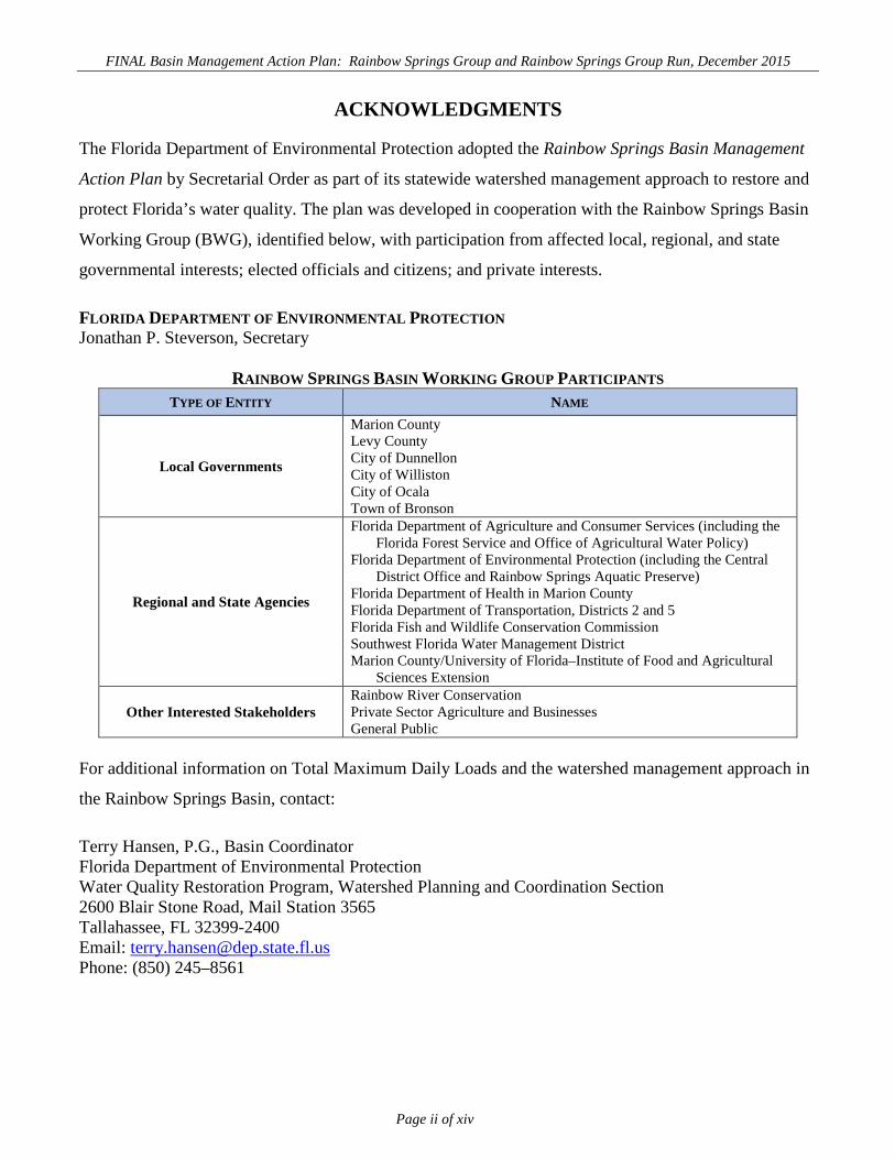
ACKNOWLEDGMENTS
The Florida Department of Environmental Protection adopted the Rainbow Springs Basin Management
Action Plan by Secretarial Order as part of its statewide watershed management approach to restore and
protect Florida’s water quality. The plan was developed in cooperation with the Rainbow Springs Basin
Working Group (BWG), identified below, with participation from affected local, regional, and state
governmental interests; elected officials and citizens; and private interests.
FLORIDA DEPARTMENT OF ENVIRONMENTAL PROTECTION Jonathan P. Steverson, Secretary
RAINBOW SPRINGS BASIN WORKING GROUP PARTICIPANTS TYPE OF ENTITY NAME
Local Governments
Marion County Levy County City of Dunnellon City of Williston City of Ocala Town of Bronson
Regional and State Agencies
Florida Department of Agriculture and Consumer Services (including the Florida Forest Service and Office of Agricultural Water Policy)
Florida Department of Environmental Protection (including the Central District Office and Rainbow Springs Aquatic Preserve)
Florida Department of Health in Marion County Florida Department of Transportation, Districts 2 and 5 Florida Fish and Wildlife Conservation Commission Southwest Florida Water Management District Marion County/University of Florida–Institute of Food and Agricultural
Sciences Extension
Other Interested Stakeholders Rainbow River Conservation Private Sector Agriculture and Businesses General Public
For additional information on Total Maximum Daily Loads and the watershed management approach in
the Rainbow Springs Basin, contact:
Terry Hansen, P.G., Basin Coordinator Florida Department of Environmental Protection Water Quality Restoration Program, Watershed Planning and Coordination Section 2600 Blair Stone Road, Mail Station 3565 Tallahassee, FL 32399-2400 Email: [email protected] Phone: (850) 245–8561

FINAL Basin Management Action Plan: Rainbow Springs Group and Rainbow Springs Group Run, December 2015
Page iii of xiv
TABLE OF CONTENTS
ACKNOWLEDGMENTS ....................................................................................................................... II LIST OF ACRONYMS AND ABBREVIATIONS .............................................................................. VI SUMMARY .......................................................................................................................................... VIII CHAPTER 1 : CONTEXT, PURPOSE, AND SCOPE OF THE PLAN ............................................. 1
1.1 Background ............................................................................................................................. 3 1.2 Total Maximum Daily Load ................................................................................................... 4 1.3 Regional Setting of the Rainbow Springs Basin Management Area .................................. 5 1.4 BMAP Assumptions and Considerations............................................................................ 13 1.5 BMAP Development Process ............................................................................................... 14 1.6 Pollutant Reductions ............................................................................................................. 14
CHAPTER 2 : NITROGEN SOURCES AND FUTURE GROWTH ................................................ 16 2.1 Nitrogen Source Inventory and Loading Tool ................................................................... 16
2.1.1 Ground Water Recharge and Land Use...................................................................... 17 2.1.2 Estimating Nitrogen Inputs to the Land Surface......................................................... 17 2.1.3 Estimated Load to the UFA......................................................................................... 20
2.2 Estimating Changes in Potential Loading to the UFA ...................................................... 22 2.3 Additional Verified Impaired Waterbodies........................................................................ 22 2.4 Managing Pollutant Loads from Future Growth .............................................................. 23
2.4.1 Marion County ............................................................................................................ 23 2.4.2 City of Dunnellon ........................................................................................................ 26
2.5 Protection of Surface Water and Ground Water Resources through Land Conservation .......................................................................................................................... 26
CHAPTER 3 : REGULATORY LINKS AND RESEARCH STRATEGIES ................................... 29 3.1 Regulatory Links to BMAP Enforcement .......................................................................... 29
3.1.1 ERP ............................................................................................................................. 29 3.1.2 NPDES Municipal Separate Storm Sewer System (MS4) Stormwater Program ........ 29 3.1.3 Urban Nonpoint Sources............................................................................................. 30
3.2 Agricultural BMP Implementation ..................................................................................... 30 3.2.1 Agricultural BMPs ...................................................................................................... 32 3.2.2 BMP Enrollment ......................................................................................................... 35 3.2.3 Agricultural BMP Load Reduction Estimates............................................................. 39 3.2.4 FDACS OAWP Role In BMP Implementation and Follow-Up .................................. 39 3.2.5 OAWP Implementation Assurance Program .............................................................. 40 3.2.6 Florida Forest Service Role in BMP Implementation and Monitoring ...................... 41
3.3 SWFWMD Springs 2013–17 Management Plan ................................................................ 42 3.4 Other Research Efforts......................................................................................................... 43
CHAPTER 4 : NITROGEN LOADING SOURCE MANAGEMENT STRATEGIES ................... 46 4.1 Management Efforts Focused on Rainbow River .............................................................. 46
FINAL Basin Management Action Plan: Rainbow Springs Group and Rainbow Springs Group Run, December 2015
Page iv of xiv
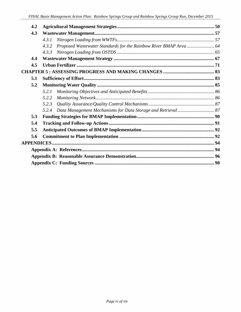
4.2 Agricultural Management Strategies .................................................................................. 50 4.3 Wastewater Management ..................................................................................................... 57
4.3.1 Nitrogen Loading from WWTFs.................................................................................. 57 4.3.2 Proposed Wastewater Standards for the Rainbow River BMAP Area ....................... 64 4.3.3 Nitrogen Loading from OSTDS .................................................................................. 65
4.4 Wastewater Management Strategy ..................................................................................... 67 4.5 Urban Fertilizer .................................................................................................................... 71
CHAPTER 5 : ASSESSING PROGRESS AND MAKING CHANGES ........................................... 83 5.1 Sufficiency of Effort .............................................................................................................. 83 5.2 Monitoring Water Quality ................................................................................................... 85
5.2.1 Monitoring Objectives and Anticipated Benefits ........................................................ 86 5.2.2 Monitoring Network .................................................................................................... 86 5.2.3 Quality Assurance/Quality Control Mechanisms ....................................................... 87 5.2.4 Data Management Mechanisms for Data Storage and Retrieval ............................... 87
5.3 Funding Strategies for BMAP Implementation ................................................................. 90 5.4 Tracking and Follow-up Actions ......................................................................................... 91 5.5 Anticipated Outcomes of BMAP Implementation ............................................................. 92 5.6 Commitment to Plan Implementation ................................................................................ 92
APPENDICES ......................................................................................................................................... 94 Appendix A: References ................................................................................................................ 94 Appendix B: Reasonable Assurance Demonstration.................................................................. 96 Appendix C: Funding Sources ..................................................................................................... 98
FINAL Basin Management Action Plan: Rainbow Springs Group and Rainbow Springs Group Run, December 2015
Page v of xiv
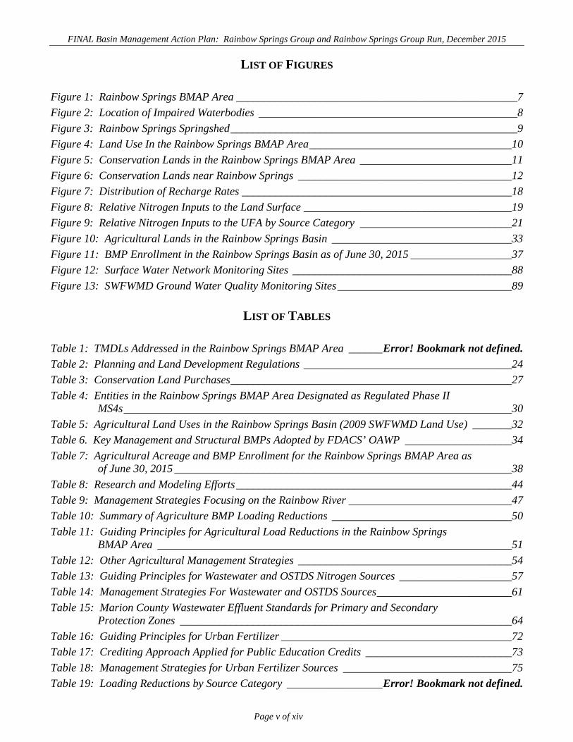
LIST OF FIGURES
Figure 1: Rainbow Springs BMAP Area __________________________________________________7 Figure 2: Location of Impaired Waterbodies ______________________________________________8 Figure 3: Rainbow Springs Springshed ___________________________________________________9 Figure 4: Land Use In the Rainbow Springs BMAP Area ____________________________________10 Figure 5: Conservation Lands in the Rainbow Springs BMAP Area ___________________________11 Figure 6: Conservation Lands near Rainbow Springs ______________________________________12 Figure 7: Distribution of Recharge Rates ________________________________________________18 Figure 8: Relative Nitrogen Inputs to the Land Surface _____________________________________19 Figure 9: Relative Nitrogen Inputs to the UFA by Source Category ___________________________21 Figure 10: Agricultural Lands in the Rainbow Springs Basin ________________________________33 Figure 11: BMP Enrollment in the Rainbow Springs Basin as of June 30, 2015 __________________37 Figure 12: Surface Water Network Monitoring Sites _______________________________________88 Figure 13: SWFWMD Ground Water Quality Monitoring Sites _______________________________89
LIST OF TABLES
Table 1: TMDLs Addressed in the Rainbow Springs BMAP Area ______ Error! Bookmark not defined. Table 2: Planning and Land Development Regulations _____________________________________24 Table 3: Conservation Land Purchases __________________________________________________27 Table 4: Entities in the Rainbow Springs BMAP Area Designated as Regulated Phase II
MS4s _____________________________________________________________________30 Table 5: Agricultural Land Uses in the Rainbow Springs Basin (2009 SWFWMD Land Use) _______32 Table 6. Key Management and Structural BMPs Adopted by FDACS’ OAWP ___________________34 Table 7: Agricultural Acreage and BMP Enrollment for the Rainbow Springs BMAP Area as
of June 30, 2015 ____________________________________________________________38 Table 8: Research and Modeling Efforts _________________________________________________44 Table 9: Management Strategies Focusing on the Rainbow River _____________________________47 Table 10: Summary of Agriculture BMP Loading Reductions ________________________________50 Table 11: Guiding Principles for Agricultural Load Reductions in the Rainbow Springs
BMAP Area _______________________________________________________________51 Table 12: Other Agricultural Management Strategies ______________________________________54 Table 13: Guiding Principles for Wastewater and OSTDS Nitrogen Sources ____________________57 Table 14: Management Strategies For Wastewater and OSTDS Sources ________________________61 Table 15: Marion County Wastewater Effluent Standards for Primary and Secondary
Protection Zones ___________________________________________________________64 Table 16: Guiding Principles for Urban Fertilizer _________________________________________72 Table 17: Crediting Approach Applied for Public Education Credits __________________________73 Table 18: Management Strategies for Urban Fertilizer Sources ______________________________75 Table 19: Loading Reductions by Source Category _________________ Error! Bookmark not defined.

FINAL Basin Management Action Plan: Rainbow Springs Group and Rainbow Springs Group Run, December 2015
Page vi of xiv
LIST OF ACRONYMS AND ABBREVIATIONS
AWT Advanced Wastewater Treatment BMAP Basin Management Action Plan BMP Best Management Practice BWG Basin Working Group CASTNET Clean Air Status and Trends Network CDD Community Development District CoA Census of Agriculture CR County Road department Florida Department of Environmental Protection DRA Drainage Retention Area EPA United States Environmental Protection Agency ERP Environmental Resource Permitting F.A.C. Florida Administrative Code FAR Florida Administrative Record FDACS Florida Department of Agriculture and Consumer Services FDOH Florida Department of Health FDOT Florida Department of Transportation FFL Florida-Friendly Landscaping F.S. Florida Statutes FWRA Florida Watershed Restoration Act FYN Florida Yards and Neighborhoods GIS Geographic Information System in/yr Inches Per Year IFAS Institute of Food and Agricultural Sciences lbs/yr Pounds Per Year LID Low Impact Development mi2 Square Miles MGD Million gallons Per day mg/L Milligrams Per Liter MS4 Municipal Separate Storm Sewer System NADP National Atmospheric Deposition Program NNC Numeric Nutrient Criteria NO3-N Nitrate as Nitrogen NOI Notice of Intent NPDES National Pollutant Discharge Elimination System NRCS Natural Resources Conservation Service NSI Nitrogen Source Inventory NSILT Nitrogen Source Inventory and Loading Tool

FINAL Basin Management Action Plan: Rainbow Springs Group and Rainbow Springs Group Run, December 2015
Page vii of xiv
OAWP Office of Agricultural Water Policy OFW Outstanding Florida Water OSTDS Onsite Sewage Treatment and Disposal System PSA Public Service Announcement RRLA Rapid-Rate Land Application SCADA Supervisory Control and Data Acquisition SPOZ Springs Protection Overlay Zone SR State Road SRF State Revolving Fund SRWMD Suwannee River Water Management District STORET Storage and Retrieval (database) SW Southwest SWFWMD Southwest Florida Water Management District SWIM Surface Water Improvement and Management TDR Transfer of Development Rights TMDL Total Maximum Daily Load TN Total Nitrogen TVR Transfer of Vested Rights UCF University of Central Florida UF University of Florida UFA Upper Floridan Aquifer USDA United States Department of Agriculture USGS United States Geological Survey WAFR Wastewater Facility Regulation WBID Waterbody Identification WMP Watershed Management Program WWTP Wastewater Treatment Plant WWTF Wastewater Treatment Facility

FINAL Basin Management Action Plan: Rainbow Springs Group and Rainbow Springs Group Run, December 2015
Page viii of xiv
SUMMARY
This document describes the management priorities for the first phase of the Rainbow Springs Basin
Management Action Plan. The Rainbow Springs BMAP was developed over a two-year period
beginning in July 2013. It addresses nutrient impairment in Rainbow Springs Group and Rainbow
Springs Group Run (Rainbow River), which were verified as impaired under the Florida Watershed
Restoration Act (FWRA) (Chapter 403.067, Florida Statutes [F.S.]) and the Impaired Surface Waters
Rule (IWR) (Chapter 62-303, Florida Administrative Code [F.A.C.]). This BMAP was developed in
conjunction with the Silver Springs BMAP, and many of the restoration efforts will benefit both springs.
The BMAP documents more than 97 management actions that have been or will be undertaken by local,
regional, state, or private entities, as funds are made available, to reduce the amount of nitrogen
released into the upper Floridan aquifer (UFA), the source of flow in Rainbow Springs and the Rainbow
River. These actions address all the major source categories that contribute nitrogen loading to the UFA
(agriculture, land application of wastewater, onsite sewage treatment and disposal systems [OSTDS],
urban fertilizer, and drainage wells). Reducing the amounts of nitrogen entering the UFA will help
achieve the water quality standards and designated uses established by the Florida Department of
Environmental Protection. Rainbow Springs Group and Rainbow Springs Group Run are designated as
Class III, suitable for recreational use and for the propagation and maintenance of a healthy, well-
balanced population of fish and wildlife. They are also designated as Outstanding Florida Waters
(OFWs).
An important part of the BMAP process for Rainbow Springs is the participation and commitment of
local stakeholders in the process. Local governments, water management districts (WMDs), state
agencies, agricultural interests, environmental interests, other private interests, as well as departmental
District Offices provided valuable information and input.
The BMAP process enhanced communication and cooperation among basin stakeholders that will have
benefits beyond the BMAP. That enhanced interaction and communication will allow the BMAP to
support the initiation of three management efforts, whose outcomes will be improved coordination
between stakeholders and the identification of solutions that will result in further reductions in nitrogen
loading to the UFA. These three management efforts comprise the OSTDS 9-1-1 Strategy (wastewater
management, stormwater education and outreach effort, and small farms equine outreach effort).

FINAL Basin Management Action Plan: Rainbow Springs Group and Rainbow Springs Group Run, December 2015
Page ix of xiv
RAINBOW SPRINGS MANAGEMENT AREA The Rainbow Springs BMAP area is located in western Marion County and eastern Levy County. The
BMAP area approximates the extent of the ground water capture area determined by the Southwest
Florida Water Management District (SWFWMD). It includes the surface drainage area for Rainbow
River.
The area contributing recharge, or the ground water contributing area, to Rainbow Springs varies
significantly from year to year in response to climatic conditions. Estimates of the location of the
contributing area depend on amount of rainfall, seasonality, and the density of measuring wells. In any
given year, the eastern portion of the BMAP area may contribute flow to Silver Springs. For these
reasons, the BMAP area does not coincide with any particular year’s potentiometric surface.
The eastern boundary of the BMAP area coincides with the western extent of the Silver Springs BMAP
area at Interstate (I) 75 in Marion County. I-75 is also the boundary separating the St. Johns River
Water Management District (SJRWMD) from the SWFWMD.
TOTAL MAXIMUM DAILY LOAD The TMDL adopted for Rainbow Springs Group, and Rainbow Springs Group Run in 2013 sets a target
concentration of 0.35 milligrams per liter (mg/L) of nitrate (NO3 as N) and requires an 82% reduction in
nitrate concentration for each of the impaired waterbodies. The waterbodies to which this TMDL
applies are identified by their unique waterbody identification (WBID) numbers as well as common
name and consist of Rainbow Springs Group (WBID 1320A) and Rainbow Springs Group Run (WBID
1320B). These waterbodies were considered nutrient impaired because of an imbalance of flora and
fauna evidenced by excessive algal growth and smothering of submerged aquatic vegetation. The
excessive algal growth was correlated with elevated levels of nitrate contributed from ground water.
RAINBOW SPRINGS BMAP The BMAP represents a commitment by stakeholders to restore water quality to Rainbow Springs and
Rainbow River. Stakeholders recognize that no one management action will restore water quality and
agree that the entire BMAP area should be considered when identifying loading reduction management
actions. This decision was based on the acknowledgment that, based on their impacts, all stakeholders
have a proportionally shared responsibility in restoring Rainbow Springs and the Rainbow River.
Management actions identified for the first phase of the BMAP constitute sufficient efforts that should
result in improved water quality. This BMAP provides for phased implementation under Subparagraph

FINAL Basin Management Action Plan: Rainbow Springs Group and Rainbow Springs Group Run, December 2015
Page x of xiv
403.067(7)(a)1, F.S., and this adaptive management process will continue until the TMDL is met. The
phased BMAP approach allows for incrementally reducing loadings through the implementation of
management actions, while simultaneously monitoring and conducting studies to better understand water
quality dynamics (sources and response variables) in each impaired waterbody. In subsequent five-year
management cycles, progress will be evaluated and adjustments made or new projects added, as needed,
to meet the TMDL.
Phased implementation is particularly important in ground water systems because of “legacy” nitrogen
already in ground water. A legacy source contributes to the continuing rise in nitrate concentrations, but
the source entered the aquifer as a result of past land use practices. The response of ground water–
driven systems to changes in land use or practices is typically slower than surface water–driven systems
and can be on the order of years or decades. This lag time in response to reductions in nitrate loading by
changes in practices is one of the factors that should be considered when evaluating the success of
management actions.
Detailed allocations with specified reductions in total nitrogen (TN) loading could not be assigned to
each stakeholder for this first BMAP phase, because of the uncertainty associated with the fate and
transformation of nitrogen in the UFA. If information becomes available that provides a better
understanding of ground water movement and impacts to its quality as well as the fate and
transformation of nitrogen, the findings will be applied during the second BMAP phase.
Guiding Principles were developed with stakeholder input to provide defined expectations for the
management of TN loadings from wastewater, stormwater, and agricultural sources. The purpose of
these principles is to encourage stakeholders to apply technologies and management strategies that
reduce nitrogen loading and to consider areas of high recharge and potential high loading as priorities
for retrofit opportunities. These Guiding Principles are intended as recommendations and as a guide for
future project selection and focusing of efforts that support the implementation of the BMAP.
NITROGEN SOURCE INVENTORY LOADING TOOL (NSILT) The ddepartment developed the NSILT to provide a BMAP-areawide evaluation of the potential sources
of TN loading to the UFA, to provide stakeholders with information on the comparative importance of
different sources, and to assist in the selection and targeting of projects to reduce nitrogen loading. The
NSILT provides the best available assessment of where nitrogen is currently being applied in the BMAP
area relative to aquifer recharge rates.

FINAL Basin Management Action Plan: Rainbow Springs Group and Rainbow Springs Group Run, December 2015
Page xi of xiv
The NSILT is a GIS- and spreadsheet-based tool that provides estimates of the relative contribution of
nitrogen from the following sources:
Agricultural and nonagricultural (urban) fertilizers.
Livestock waste (predominantly horses and cattle).
OSTDS.
Wastewater land application.
Atmospheric deposition.
The results of the NSILT indicate that an estimated 1.34 million pounds of nitrogen (lbs-N) enter the
UFA annually. This represents approximately 11% of the annual input at the land surface, which is
estimated to be 11.9 million lbs-N. The majority of the load entering the UFA, 67%, is from high-
recharge areas. Agricultural commodities contribute the greatest potential loading to the UFA, each
providing 67% of the annual estimated contribution of nitrogen to the UFA. OSTDS contribute 19% of
the annual estimated contribution. Urban fertilizer contributes 6% of the annual estimated contribution
of nitrogen to the UFA through both infiltration to ground water and stormwater runoff.
MANAGEMENT ACTIONS Stakeholder management actions, including more than 96 specific projects identified in this BMAP, will
reduce nitrogen loading to the UFA. These management actions are categorized as follows:
Stormwater Structural Best Management Practices (BMPs).
Agricultural BMPs.
Regulations, Ordinances, and Guidelines.
Special Studies and Planning Efforts.
Education and Outreach Efforts.
Basic Stormwater Management Program Implementation.
Conservation Land Acquisition.
OSTDS Conversion.

FINAL Basin Management Action Plan: Rainbow Springs Group and Rainbow Springs Group Run, December 2015
Page xii of xiv
Wastewater System Upgrade and Improved Management and Infrastructure
Management, Maintenance, and Repair.
Projects are identified that address each of the nitrogen source categories evaluated in the NSILT.
Chapter 4 lists project details. Projects identified for agricultural sources are in addition to the required
commodity-specific BMPs. Loading reductions were calculated based on the nitrogen load to the land
surface and not the UFA.
This BMAP proposes three specific initiatives (listed as projects) to continue efforts to reduce nitrogen
loading in the basin, find better methods for reducing and managing nitrogen loads, and, as noted above,
address the largest sources identified by the NSILT. Local municipal stormwater and wastewater utility
managers provided input and guidance to the department in the development of these initiatives. The
initiatives are as follows:
OSTDS and other wastewater issues are addressed through the wastewater
management project OSTDS 9-1-1 Strategy (R071), which will engage local
government and private utilities as well as community and environmental interests to
develop a strategy that addresses the large loading from OSTDS. This project is also
considering BMAP area–specific effluent standards for WWTFs in an effort to
provide more consistency between facilities. This project will be a combined effort
with Silver Springs.
Stormwater Public Education Coordination, Project B036, provides public education
and outreach coordination and consistency among stakeholders related to stormwater
impacts on springs.
An outreach program will be implemented for the Small Farm Equine BMP Manual
(Project B012) in collaboration with the Florida Department of Agriculture and
Consumer Services (FDACS), Marion County, University of Florida–Institute of
Food and Agricultural Sciences (UF–IFAS), and other stakeholders.
ANTICIPATED OUTCOMES OF BMAP IMPLEMENTATION Through the implementation of the wastewater, stormwater education, and small farm equine BMP
initiatives, other projects and activities listed in this BMAP, and future NSILT source assessment,
stakeholders expect the following outcomes:

FINAL Basin Management Action Plan: Rainbow Springs Group and Rainbow Springs Group Run, December 2015
Page xiii of xiv
Decreased concentration of nitrate in Rainbow Springs Group and Rainbow Springs
Group Run.
Decreased loading of nitrogen to the UFA.
Improved coordination and communication between state and local governments and
between all levels of government and the community.
Improved project selection and targeted project implementation through the use of the
Guiding Principles and the NSILT.
Enhanced public awareness and understanding of the impacts of nitrogen loading on
Rainbow Springs Group and Rainbow Springs Group Run.
BMAP COST Costs were provided, when available, for the management actions identified in the BMAP, consisting of
an estimated total cost of more than $97 million. These costs include a substantial investment made to
improve wastewater treatment (about $43 million) and the projected cost for purchase of conservation
lands ($47 million) for water quality protection. The funding sources for the projects range from local
contributions to legislative appropriations. Stakeholders will continue to explore new sources of funding
to ensure that the activities listed in this BMAP can be achieved at the necessary level of effort.
BMAP FOLLOW-UP The department and stakeholders will continue to track projects and other implementation efforts, as
well as monitor water quality in TMDL waterbodies, to ensure that the BMAP is carried out and to
measure its effectiveness. As needed, the NSILT may be updated in the future to reflect new
information about sources and to evaluate nitrogen management efforts. New information and
refinements to source loadings that result from ongoing research will be incorporated into the second
phase of the BMAP to the extent possible.
Stakeholders will meet at least annually to discuss implementation issues, consider new information, and
determine other management actions needed for waterbodies that are not projected to meet their
TMDLs. Each stakeholder responsible for implementing management actions as part of the BMAP will
complete an annual report for submittal to the department. The report will track the implementation
status of any management actions listed in the BMAP and document additional projects undertaken to
further water quality improvements in the basin. Additional projects are expected with the
implementation of the wastewater initiative and stormwater education and outreach initiative.

FINAL Basin Management Action Plan: Rainbow Springs Group and Rainbow Springs Group Run, December 2015
Page xiv of xiv
As part of the BMAP, a strategy was developed for monitoring water quality based on existing surface
and ground water monitoring stations, maintained by the SWFWMD, to determine if water quality is
improving and the TMDL is being met.
Observations of water quality conditions will be reported to stakeholders and the general public at least
annually as part of the BMAP reporting process. Water quality data will be used to support the adaptive
management process, assess projects, and identify the need for new projects.
COMMITMENT TO THE BMAP The management actions outlined in this BMAP as well as the proposed management initiatives provide
sufficient direction for this BMAP to achieve reductions in nitrogen loading to Rainbow Springs Group
and Rainbow Springs Group Run. The Guiding Principles and BMAP initiatives will help to define
additional management actions that will further improve water quality in Rainbow Springs Group and
Rainbow Springs Group Run.

FINAL Basin Management Action Plan: Rainbow Springs Group and Rainbow Springs Group Run, December 2015
Page 1 of 96
Chapter 1: CONTEXT, PURPOSE, AND SCOPE OF THE PLAN
The Rainbow Springs Basin Management Action Plan was developed between March 2013 and August
2015. It addresses nutrient impairment in Rainbow Springs Group (waterbody identification [WBID]
number 1320A) and Rainbow Springs Group Run (WBID 1320B), also referred to as the Rainbow
River, both of which were verified as impaired under the Florida Watershed Restoration Act (FWRA)
(Chapter 403.067, Florida Statutes [F.S.]) using the methodology in the Identification of Impaired
Surface Waters Rule (Chapter 62-303, Florida Administrative Code [F.A.C.]). These waters were
considered nutrient impaired because of excessive algal growth correlated to elevated levels of nitrate
contributed from ground water. A TMDL was adopted for these waterbodies in 2013 (Table 1). The
TMDL sets a target concentration of 0.35 milligrams per liter (mg/L) of nitrate as nitrogen (NO3-N) for
the spring discharge and Rainbow River to restore water quality.
The decline in water quality in Rainbow Springs and the Rainbow River results from nitrogen loads
applied to the land surface from agricultural activities, wastewater disposal, and urban land uses and
from nitrogen loads applied below the land surface from OSTDS. Part of this loading is a product of
historical land use practices complicating the restoration of these waterbodies.
The BMAP documents the management actions that have been or will be undertaken by local, regional,
state, or private entities to reduce the amount of nitrogen released into the upper Floridan aquifer (UFA),
which is the source of flow in Rainbow Springs and Rainbow River. Reducing the amount of nitrogen
entering the UFA will help achieve water quality standards and designated uses established by the
Florida Department of Environmental Protection. Rainbow Springs and the Rainbow River are
designated as Class III waterbodies (i.e., suitable for recreational use and for the propagation and
maintenance of a healthy, well-balanced population of fish and wildlife). They are also designated as
Outstanding Florida Waters (OFWs).
An important result of the BMAP process for Rainbow Springs has been the level of local stakeholder
participation and commitment. The BMAP process enhanced communication and cooperation among
basin stakeholders that will have benefits beyond the BMAP. Their management actions will reduce
nitrogen load to the UFA. These management actions are categorized as follows:
Structural Best Management Practices (BMPs) – Quantifiable and Unquantifiable
Load Reductions.

FINAL Basin Management Action Plan: Rainbow Springs Group and Rainbow Springs Group Run, December 2015
Page 2 of 96
Agricultural BMPs.
Restoration and Water Quality Improvement Projects.
Regulations, Ordinances, and Guidelines.
Special Studies and Planning Efforts.
Education and Outreach Efforts.
Basic Stormwater Management Program Implementation.
Conservation Land Acquisition/BMP Land Acquisition.
Wastewater Infrastructure Management, Maintenance, Repair, and Upgrade.
The department developed a Nitrogen Source Inventory and Loading Tool (NSILT) in support of the
BMAP decision-making process. The NSILT was developed from extensive review of literature on
nitrogen sources and migration/transformation to the aquifer and eventually to Rainbow Springs.
Various stakeholder groups also provided valuable insight into activities contributing nitrogen, such as
fertilization practices and cattle- and horse-grazing activities. The NSILT provides the best available
assessment of where the nitrogen is currently being applied in the BMAP area, and is thus contributing
to continuing elevated nitrogen concentrations in Rainbow Springs and Rainbow River. The NSILT is
intended as a tool to assist stakeholders and department in identifying locations where future projects
will have the greatest impact in reducing nitrogen loads.
This BMAP provides for phased implementation under Paragraph 403.067(7)(a)1, F.S. The
management strategies and adaptive management approach described in the BMAP will address
nitrogen reductions needed to meet the TMDL. This adaptive management process will continue until
the TMDL targets, or water quality standards are met.
A phased implementation is particularly important in ground water systems because of the potential for
“legacy” nitrogen in ground water. A legacy source contributes to the continuing rise in nitrate as
nitrogen (NO3-N) concentrations in Rainbow Springs but entered the aquifer as a result of past land
activities or practices that are no longer in use. The response of ground water–driven systems to
changes in land use or practices is typically much slower than in surface water–driven systems, with
sub-surface transport often occurring on the order of years or decades.
FINAL Basin Management Action Plan: Rainbow Springs Group and Rainbow Springs Group Run, December 2015
Page 3 of 96
The adoption as a phased BMAP allows for the implementation of projects designed to achieve
incremental reductions from current land uses and practices, assess and control the growth of nitrogen
loads as a result of projected future land use changes, while simultaneously monitoring discharge at
Rainbow Springs and the aquifer throughout the BMAP area to identify changes in NO3-N
concentrations. Subsequent five-year management cycles will evaluate progress and make adjustments
or add new projects, as needed, to meet the applicable water quality standards.
1.1 BACKGROUND
The Rainbow Springs BMAP has been developed as part of the department’s TMDL Program, which is
authorized by the FWRA (see Section 403.067, F.S., Establishment and Implementation of Total
Maximum Daily Loads). The department implements the FWRA using a watershed management
approach that includes a five-year rotating basin cycle. Each year of the cycle represents a different
activity for the waters in a given basin group, as follows: initial basin assessment, strategic monitoring,
analysis and TMDL development, BMAP development, and BMAP implementation. At the end of each
five-year, five-phase cycle, a new cycle begins for each group of basins in which additional waters may
be identified for TMDL establishment and implementation.
TMDLs are water quality targets for waterbodies that the department has identified as impaired for
specific pollutants. TMDLs, which the department adopts by rule, establish the maximum amount of
specific pollutants that a waterbody can assimilate while maintaining water quality standards, indicated
by designated uses.
TMDLs may be implemented through BMAPs, which contain strategies to reduce and prevent pollutant
discharges through various cost-effective means. Section 403.067, F.S., contains provisions that guide
the development of BMAPs and other TMDL implementation approaches.
Stakeholder involvement is critical to the success of the TMDL implementation program and varies with
each phase of implementation to achieve different purposes. The BMAP development process is
structured to achieve cooperation and consensus among a broad range of interested parties. Under
statute, the department invites stakeholders to participate in the BMAP development process and
encourages public participation to the greatest extent practicable. The department must hold at least one
noticed public meeting in the basin to discuss and receive comments during the planning process.
Stakeholder involvement is essential to develop, gain support for, and secure commitments to implement
the BMAP.

FINAL Basin Management Action Plan: Rainbow Springs Group and Rainbow Springs Group Run, December 2015
Page 4 of 96
1.2 TOTAL MAXIMUM DAILY LOAD
The TMDL for Rainbow River and Rainbow Springs was adopted in May 2013 (Chapter 62-304,
F.A.C.) and is listed in Table 1. The TMDL was based on multiple lines of evidence which concluded
that nitrate concentration was the primary factor causing the impairment due to an imbalance of flora
and fauna. The concentration of nitrate needed to restore ecological balance was determined by
examining the relation between concentration and response of attached forms of algae (periphyton). At
higher nitrate concentrations, periphyton produce more biomass for each incremental increase of nitrate
compared with the periphyton response at lower nitrate concentrations.
TABLE 1: TMDLS ADDRESSED IN THE RAINBOW SPRINGS BMAP AREA NA = No data 1 Load allocation for nonpoint sources (fertilizer, domestic wastewater from onsite sewage treatment and disposal systems (OSTDS) and wastewater application sites, animal waste, atmospheric deposition, and stormwater discharges to ground water).
WBID PARAMETER TMDL (MG/L)
TMDL %
REDUCTION
WASTELOAD ALLOCATION
FOR WASTEWATER
WASTELOAD ALLOCATION FOR
NATIONAL POLLUTANT DISCHARGE
ELIMINATION SYSTEM (NPDES) STORMWATER %
REDUCTION
LOAD ALLOCATION
% REDUCTION1
MARGIN OF
SAFETY Rainbow
Springs Group (WBID 1320A)
Nitrate as a monthly average
0.35 82% NA 82% 82% Implicit
Rainbow Springs Group
Run (WBID 1320B)
Nitrate as a monthly average
0.35 82% NA 82% 82% Implicit
A change point analysis was done that identified the point along a gradient of increasing nitrate
concentration when the algae respond with increased biomass. This change point concentration was
used to set the TMDL targeted level of nitrate. The change point analysis determined that the nitrate
concentration at which excessive algal growth occurs was between 0.378 and 0.629 mg/L, with 95%
confidence. Thus the TMDL target concentration was set just below this range. The TMDLs may be
reevaluated, modified, and readopted if the underlying science or data for a system changes and new
targets are found to be appropriate. Complete details of the process to set the TMDL target can be found
in the Final nutrient TMDL report for Rainbow Springs and Rainbow Springs Group Run (Holland and
Hicks 2013).

FINAL Basin Management Action Plan: Rainbow Springs Group and Rainbow Springs Group Run, December 2015
Page 5 of 96
1.3 REGIONAL SETTING OF THE RAINBOW SPRINGS BASIN MANAGEMENT AREA
The Rainbow Springs Group is one of the largest spring groups in Florida by magnitude, discharging an
average flow of 705 cubic feet per second (456 million gallons per day [mgd]). The spring group is the
main source of flow for the 5.7-mile spring run known as the Rainbow River. The spring group and the
river have significant habitat and recreational value, including swimming, kayaking, and canoeing from
the head springs and tubing on the river. Rainbow Springs has been a tourist destination since the 1920s
and continues to have economic significance to north-central Florida. Since the 1990s the head springs
have been part of Rainbow Springs State Park.
The Rainbow Springs BMAP area (Figure 1) is located in western Marion County and eastern Levy
County. Rainbow Springs Group and Rainbow Springs Group Run are segments of the Rainbow River
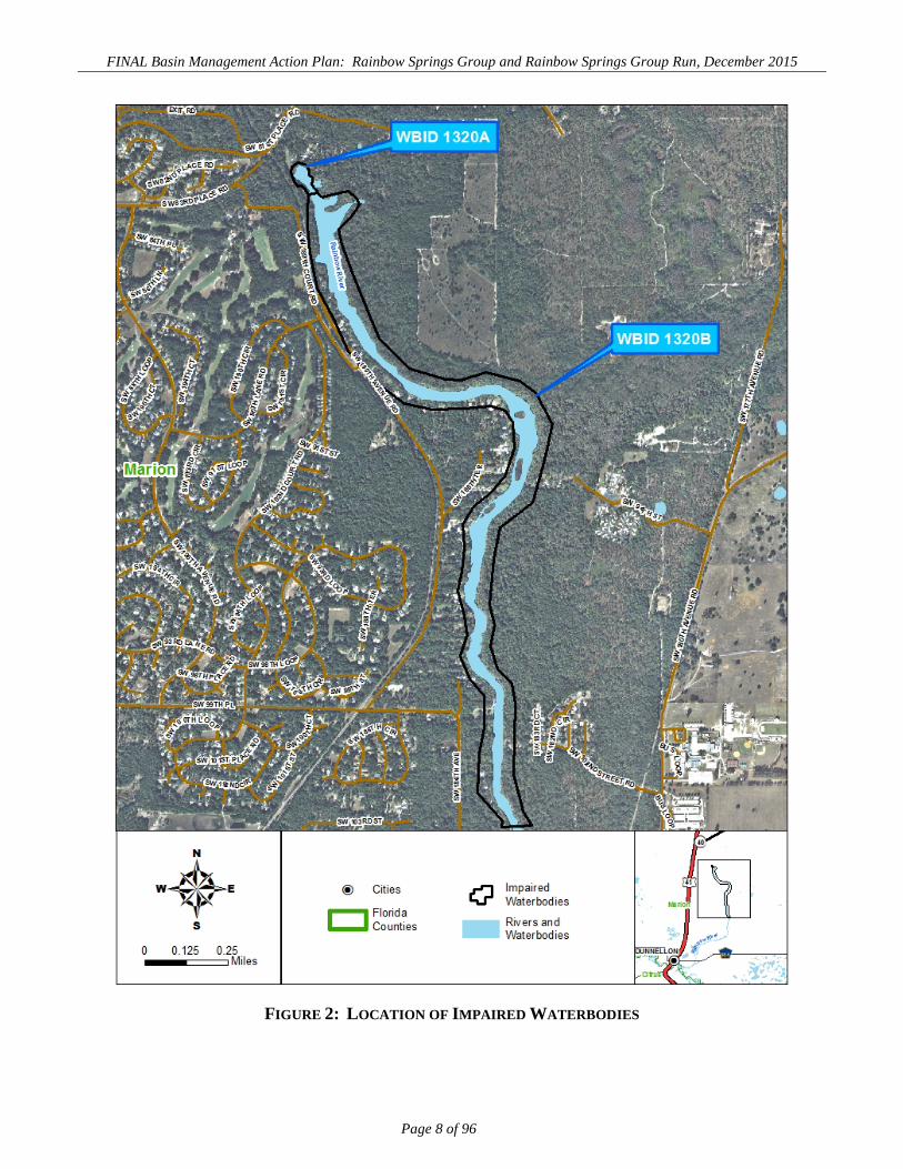
designated as WBIDs 1320A and 1320B, respectively (Figure 2). Flow in the Rainbow River is
primarily from the spring discharge of ground water, consisting of a surficial aquifer, with a confining
unit in places and the underlying carbonate aquifer, the UFA. There are no significant surface tributaries
to the impaired segments of the Rainbow River. Consequently, the surface watershed of the Rainbow
Spring and River system is very limited. The UFA is recharged from rainfall falling onto karst terrain in
the BMAP area. A description of the karst terrain in north-central Florida is contained in the TMDL
report (Holland and Hicks 2013).
The 679-square-mile (mi2) BMAP area is primarily (65% or 442 mi2) located in western Marion County,
with the remainder (35% or 237 mi2) in eastern Levy County. It includes a portion of the city of Ocala,
city of Dunnellon, and city of Williston. The western and southern BMAP boundary generally follows
the ground water contributing area delineated by the Southwest Florida Water Management District
(SWFWMD) (Jones et al. 1996), which tends to follow major county roads in Levy and Marion
Counties. The area contributing recharge, the springshed, to Rainbow Springs Group and Group Run
may vary significantly from year to year in response to climatic conditions.
A comparison of the SWFWMD delineation of the Rainbow springshed and various Silver Springs
potentiometric springshed delineations indicated that an area of southeastern Alachua and western
Marion Counties could, in any given year, contribute to a different spring due to variations in the
potentiometric surface of the UFA. Figure 3 shows the area where the springshed can overlap. The
eastern boundary of the BMAP area coincides with the western extent of the Silver Springs BMAP area

FINAL Basin Management Action Plan: Rainbow Springs Group and Rainbow Springs Group Run, December 2015
Page 6 of 96
at Interstate 75 in Marion County to avoid duplication of effort. Similarly, the northern boundary was
set at the Alachua County line to avoid duplication of effort.
Land use (Figure 4) varies significantly in the BMAP area. Agricultural land use (40%) is the largest
group of land uses, followed by residential (27%) and forest (27%), which includes silviculture land
uses. The water quality problems in Rainbow Springs and the Rainbow River result from nitrogen loads
applied to the land surface from agricultural, commercial, residential, and other land uses. Conservation
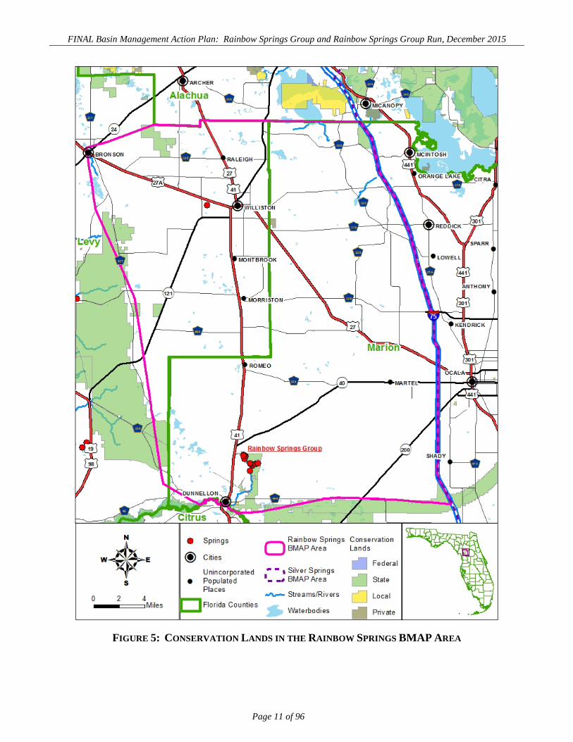
land in the BMAP area (Figure 5) includes part or all of several state-owned tracts, most notably
Rainbow Springs State Park, which includes the head springs and much of the east bank of the Rainbow
River (Figure 6).

FINAL Basin Management Action Plan: Rainbow Springs Group and Rainbow Springs Group Run, December 2015
Page 7 of 96
FIGURE 1: RAINBOW SPRINGS BMAP AREA
FINAL Basin Management Action Plan: Rainbow Springs Group and Rainbow Springs Group Run, December 2015
Page 8 of 96
FIGURE 2: LOCATION OF IMPAIRED WATERBODIES

FINAL Basin Management Action Plan: Rainbow Springs Group and Rainbow Springs Group Run, December 2015
Page 9 of 96
FIGURE 3: RAINBOW SPRINGS SPRINGSHED

FINAL Basin Management Action Plan: Rainbow Springs Group and Rainbow Springs Group Run, December 2015
Page 10 of 96
FIGURE 4: LAND USE IN THE RAINBOW SPRINGS BMAP AREA
FINAL Basin Management Action Plan: Rainbow Springs Group and Rainbow Springs Group Run, December 2015
Page 11 of 96
FIGURE 5: CONSERVATION LANDS IN THE RAINBOW SPRINGS BMAP AREA

FINAL Basin Management Action Plan: Rainbow Springs Group and Rainbow Springs Group Run, December 2015
Page 12 of 96
FIGURE 6: CONSERVATION LANDS NEAR RAINBOW SPRINGS

FINAL Basin Management Action Plan: Rainbow Springs Group and Rainbow Springs Group Run, December 2015
Page 13 of 96
1.4 BMAP ASSUMPTIONS AND CONSIDERATIONS
The water quality benefits of BMAP implementation are based on a number of fundamental assumptions
and considerations, as follows:
Project Collection Period – Project information collected from 2000 to 2015 was
considered for inclusion in the BMAP.
Unquantified Project Impacts – Some of the management strategies contained in
this BMAP cannot currently be quantified with regard to the reductions in nitrogen
they might achieve, e.g., maintenance of wastewater collection systems. However,
because of their positive project impact, it is assumed that these strategies will help
reduce pollutant loads, and estimates of loading reductions may be determined at a
later date.
Source Identification – The NSILT represents an effective way to estimate the
current total nitrogen (TN) load and sources based on the best available information;
however, it does have uncertainty associated with it. The estimated loading to ground
water must also account for both an attenuation factor within the soil column and the
rate of ground water recharge. These rates are averages and can vary substantially,
adding a degree of uncertainty to the loading estimates.
Legacy Sources – Land uses not currently active in the basin may still be affecting
the nitrate concentration of Rainbow Springs. Historical commercial fertilizer sales
data and agricultural land use indicate that there may be a lag between nitrogen input
to ground water and discharge from Rainbow Springs. Because this delay is not well
understood, projects implemented since 2000 are included in the BMAP in addition to
future projects.
Implementation Schedule – BMAP implementation will be a long-term process.
The adaptive management approach used for this BMAP requires regular follow-up
to ensure that management strategies are carried out and that their incremental effects
are assessed. This type of approach acknowledges that there is some uncertainty
associated with the outcomes of proposed management strategies. As each five-year
iteration is completed and more information is gathered, additional management

FINAL Basin Management Action Plan: Rainbow Springs Group and Rainbow Springs Group Run, December 2015
Page 14 of 96
strategies to achieve the TMDLs will be developed or existing strategies refined to
better address the sources of nitrogen loading.
1.5 BMAP DEVELOPMENT PROCESS
In July 2013, the department convened the first of a series of public stakeholder meetings.
Representatives from local, regional, state, business, and community interests provided input during the
development of the NSILT and BMAP. The BMAP process was structured to achieve cooperation and
consensus among a broad range of interested parties, with the intent of engaging local stakeholders in a
coordinated and collaborative manner to address the reduction of nutrients needed to meet water quality
standards in Rainbow Springs. Stakeholders are listed in the Acknowledgments section.
All stakeholder meetings held in the basin were noticed in the Florida Administrative Record (FAR) and
on the department’s website. Public comment from interested citizens was solicited during stakeholder
meetings. A public workshop presenting the BMAP as proposed for adoption, was held on October 8,
2015; the workshop was advertised in the Riverland News and Ocala Star Banner newspapers.
1.6 POLLUTANT REDUCTIONS
The TMDL addressed by this BMAP requires a 82% reduction in nitrate concentration in Rainbow
Springs and Rainbow Springs Run. To aid in the identification of nitrogen sources, the department
developed the NSILT to provide a BMAP-areawide evaluation of the potential sources of TN loading to
the UFA, to provide stakeholders with information on the comparative importance of different sources,
and assist in the selection and targeting of projects to reduce nitrogen loading. Unlike a TMDL
developed for a surface waterbody, this TMDL does not explicitly identify an allowable loading that
supports water quality standards and criteria.
The BMAP area and NSILT include the area of potential overlap between the Silver Springs and
Rainbow Springs springsheds in western Marion County. Individual projects in this area have the
potential to benefit both springs, and many strategies and initiatives are expected to be implemented
across an entire jurisdiction (e.g., across all of Marion County). Because both springs have similar
impairments and required load reductions, projects and initiatives benefiting both springs are identified
in both BMAPs.
Guiding Principles are presented to provide defined expectations for the management of TN loadings
from wastewater, stormwater, and agriculture sources. They were developed with stakeholder input.

FINAL Basin Management Action Plan: Rainbow Springs Group and Rainbow Springs Group Run, December 2015
Page 15 of 96
The purpose of the principles is to encourage stakeholders to apply technologies and management
strategies that reduce nitrogen loading and to consider areas of high recharge and potential high loading
as priorities for retrofit opportunities. Chapter 4 presents these principles in more detail. The Guiding
Principles do not supercede local, water management district (WMD), or state regulations but are
intended as a guide for future project selection and focusing of efforts that support the implementation of
the BMAP.
Detailed allocations with specified reductions in TN loading were not assigned to each stakeholder for
this first BMAP phase, because of the uncertainty associated with the fate and transformation of nitrogen
in the UFA. The TMDL requires a percent reduction in the concentration of nitrate in the discharge
from Rainbow Springs and does not translate directly to a nitrogen loading to the springs from different
land uses. Unlike a TMDL developed for a surface waterbody, this TMDL does not identify an
allowable loading that supports water quality standards and criteria. Instead, the NSILT was developed
to provide a BMAP-areawide evaluation of the potential sources of nitrogen loading to the UFA, provide
stakeholders with information on the comparative importance of different sources, and assist in the
selection and targeting of projects that reduce nitrogen loading. Guiding principles have been developed
that encourage stakeholders to apply technologies that reduce nitrogen loading and to consider areas of
high recharge and potential loading for retrofit opportunities. These are discussed in Chapter 4.
FINAL Basin Management Action Plan: Rainbow Springs Group and Rainbow Springs Group Run, December 2015
Page 16 of 96
Chapter 2: NITROGEN SOURCES AND FUTURE GROWTH
Most identified nitrogen sources for Rainbow Springs are nonpoint in nature and dispersed throughout
the BMAP area. Nitrogen applied over a broad area at or just below the land surface infiltrates through
the soil to the aquifer where it is applied, or in retention ponds or topographic low points where nitrogen
has been transported by stormwater runoff or via ground water seepage. Wastewater treatment applied
through sprayfields or rapid infiltration basins (RIBs) also constitutes nonpoint source pollution. This is
different from a point source of nitrogen, where pollutant sources may be traced to a specific facility or
outfall. In addition, nitrogen in organic form may undergo nitrification to nitrate during infiltration
under aerobic soil conditions.
This chapter discusses the nitrogen source inventory developed to estimate the sources of nitrogen
applied at the land surface, and just below the land surface in the case of OSTDS. The NSILT evaluates
existing nitrogen loading data from various sources, along with information from studies and input from
stakeholders. It was developed to assist stakeholders in identifying and planning future nutrient
reduction efforts for this BMAP. Finally, the chapter discusses the relationship of the BMAP to other
impaired waterbodies, as well as the management of pollutant sources from future growth and the role of
land conservation in protecting spring water quality.
2.1 NITROGEN SOURCE INVENTORY AND LOADING TOOL
The NSILT is a geographic information system- (GIS-) and spreadsheet-based tool that provides
estimates of the relative contribution of nitrogen from various sources, including the following:
Agricultural and nonagricultural fertilizers.
Livestock waste.
Wastewater land applications.
OSTDS.
Atmospheric deposition.
The NSILT was provided as a tool for the development and implementation of the BMAP to identify
areas where nitrogen source reduction efforts could be focused to achieve the most beneficial and cost-
effective effect on water quality. Other loading models, developed by stakeholders, may also provide
similar benefits.

FINAL Basin Management Action Plan: Rainbow Springs Group and Rainbow Springs Group Run, December 2015
Page 17 of 96
This section of the BMAP contains a summary of the NSILT. A detailed discussion of the NSILT
methods, results and supporting references are documented in a separate report (Eller and Katz, 2015).
The general approach of the NSILT in the BMAP area was to characterize ground water recharge,
identify categories of land use that are potential nitrogen sources, estimate nitrogen input at the land
surface, and finally calculate the estimated nitrogen load to the UFA. Nitrogen loadings expressed in
this document are calculated as TN and expressed as pounds nitrogen per year. The nitrogen input at the
land surface is not the equivalent of the amount of nitrogen (load) delivered to the UFA. Nitrogen input
at the land surface is attenuated by varying biological and geochemical processes as well as variations in
the rate of recharge to the aquifer that affect the estimated nitrogen loading to the UFA.
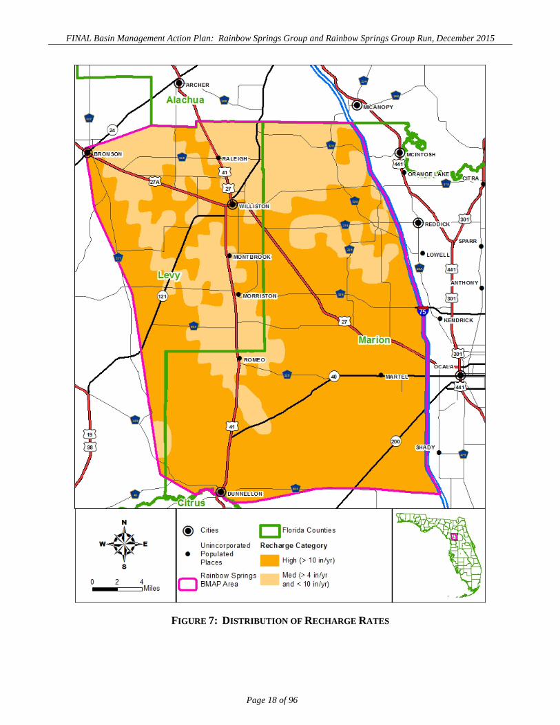
2.1.1 GROUND WATER RECHARGE AND LAND USE The NSILT characterized recharge (Figure 7) based on numerical modeling done by the United States
Geological Survey (USGS). The recharge rates were then aggregated into two recharge categories:
medium recharge (4.0 to 9.9 inches per year [in/yr]), and high recharge (10.0 in/yr or greater).
Information on land use in the BMAP area was developed using data from the SWFWMD, Suwannee
River Water Management District (SRWMD), and county property appraisers. The latter provided
detailed information on specific agricultural practices and agricultural land use classifications.
2.1.2 ESTIMATING NITROGEN INPUTS TO THE LAND SURFACE Nitrogen load to the land surface was estimated for each of the source categories and was further
categorized by recharge category. Eller and Katz (2015) provide a full discussion of the methods and
source references used to develop the estimates. An estimated 11.9 million pounds of nitrogen per year
(lbs-N/yr) are applied at the land surface. Figure 8 shows the percent contribution of nitrogen load
applied to the land surface in the BMAP area by source category.
2.1.2.1 Atmospheric Deposition Atmospheric deposition rates (wet and dry) were estimated for the BMAP area. The wet deposition rate
was estimated using the Bradford Forest (FL03) and Chassahowitzka National Wildlife Refuge (FL05)
monitoring stations of the National Atmospheric Deposition Program (NADP). Dry deposition rate was
estimated from the Indian River Lagoon (IRL141) monitoring station of the Clean Air Status and Trends
Network (CASTNET). The resulting rate (summation of the wet and dry rates) was multiplied by land
area (in this case the recharge area) to estimate nitrogen load.
FINAL Basin Management Action Plan: Rainbow Springs Group and Rainbow Springs Group Run, December 2015
Page 18 of 96
FIGURE 7: DISTRIBUTION OF RECHARGE RATES

FINAL Basin Management Action Plan: Rainbow Springs Group and Rainbow Springs Group Run, December 2015
Page 19 of 96
FIGURE 8: RELATIVE NITROGEN INPUTS TO THE LAND SURFACE
2.1.2.2 Wastewater Land Applications Nitrogen load from each of the 37 wastewater treatment facilities (WWTFs) in the BMAP area was
estimated by multiplying an average TN concentration by average yearly flow. Average TN
concentrations and flow were taken from reported data to the department’s Wastewater Facility
Regulation (WAFR) database. One complete year of reporting (2012–13) was used to develop the
annual averages. Facilities—typically smaller ones (<0.1 million gallons per day [mgd]) without any
reporting data—were assumed to have a TN concentration of 8.97 milligrams per liter (mg/L) and an
annual flow of 50% of the permitted capacity. If the facility reported NO3-N instead of TN
concentration, it was assumed that NO3-N represented 38.5% of the TN. For this calculation, the NO3-N
value is divided by 0.385, resulting in an estimated TN concentration.
FINAL Basin Management Action Plan: Rainbow Springs Group and Rainbow Springs Group Run, December 2015
Page 20 of 96
2.1.2.3 OSTDS The nitrogen load from OSTDS was estimated using a rate of 9.9 lbs-N/person per year. The number of
persons per OSTDS was developed from census data in Marion and Levy Counties. The number of
OSTDS was estimated from a 2009 Florida department of Health (FDOH) model, except for Marion
County, which provided data based on GIS analysis of property appraiser and utility services area
information. The majority of OSTDS were located in Marion County.
2.1.2.4 Livestock Operations Nitrogen load from livestock waste was subdivided into the load from horses, cattle, and other animals.
Countywide numbers of livestock were determined from the 2012 United States Department of
Agriculture (USDA) Census of Agriculture (CoA) for Marion and Levy Counties. Other livestock
include chickens, goats, hogs, sheep, and turkeys. Beef cow-calf operations comprise most of the cattle
industry in the BMAP area. Based on a literature review, a calf produces approximately 20% of the
nitrogen that its mother produces. The average residence time for calves in the basin is 183 days.
The overall nitrogen contribution from horse manure was calibrated based on manure handling practice
information provided by the University of Florida–Institute of Food and Agricultural Sciences (UF–
IFAS), specific to Marion County, as required by county ordinance. Pasture fertilization is also included
for inputs from livestock operations. Fertilization rates can vary widely from year to year; however,
estimates of the average annual fertilizer applications to pasture were developed based on information
received through meetings with the Marion County Cattlemen’s Association, UF–IFAS, and Florida
Farm Bureau.
2.1.2.5 Other Agricultural and Nonagricultural Fertilizer County property appraiser data were used to determine the types of crops grown in the BMAP area. The
total amount of fertilizer and nitrogen content was estimated from FDACS’ countywide data and applied
based on UF–IFAS recommended rates. The nitrogen load in the BMAP area from urban sources was
determined based on the area of the total countywide urban land uses in the BMAP area. Urban land
uses were primarily residential lawns and golf courses.
2.1.3 ESTIMATED LOAD TO THE UFA Nitrogen inputs to the land surface in a given year are not equivalent to the estimated nitrogen loading to
the UFA. The estimated loading to ground water must also account for both an attenuation factor within
the subsurface and the annual rate of ground water recharge.

FINAL Basin Management Action Plan: Rainbow Springs Group and Rainbow Springs Group Run, December 2015
Page 21 of 96
The results of the NSILT estimate that 1.34 million pounds of nitrogen enters the UFA annually. This
represents approximately 11% of the loading at the land surface. The majority of the load, 78%, is from
high-recharge areas. Figure 9 shows the breakdown, by percent, of nitrogen reaching the UFA by land
use category. OSTDS and the aggregate contribution of agricultural commodities contribute the greatest
potential loading, providing 19% and 67% of the annual estimated contribution of nitrogen to the UFA,
respectively. Urban fertilizer contributes 6% of the annual estimated contribution of nitrogen to the
UFA through both infiltration to ground water and stormwater runoff.
FIGURE 9: RELATIVE NITROGEN INPUTS TO THE UFA BY SOURCE CATEGORY

FINAL Basin Management Action Plan: Rainbow Springs Group and Rainbow Springs Group Run, December 2015
Page 22 of 96
2.2 ESTIMATING CHANGES IN POTENTIAL LOADING TO THE UFA
The NSILT was developed as a tool for the department’s evaluation of the contribution of different
source categories to nitrogen loading to the UFA under different land use scenarios. As changes in land
use occur in the basin, the NSILT will be useful for estimating potential loading to the UFA. If
necessary, or as new data become available, a reevaluation of the NSILT will be initiated. This
reevaluation will provide the department and stakeholders with a new estimate of the distribution of
loading by source categories and their comparative contribution to overall loading to the UFA. It will
also help identify any changes in the contribution of categories of sources from the previous NSILT
evaluation.
Changes in the distribution of sources are expected with time as different nitrogen loading reduction
management actions are implemented, population growth results in shifts between types of land use
(particularly between urban and agriculture land uses), and business practices change within specific
land use categories. Along with surface and ground water monitoring data, the NSILT evaluation will
help the department and stakeholders identify the direction to be taken during the second and future
phases of the BMAP.
2.3 ADDITIONAL VERIFIED IMPAIRED WATERBODIES
Rainbow Springs is a ground water–dominated system. The BMAP area contains surface waters that
may be evaluated separately for impairment, possibly from other pollutants. The BMAP area of a
nearby surface water may also overlie the BMAP area for Rainbow Springs, due to the extended area
included because of the influence of ground water.
Rainbow Springs and Rainbow River are part of the Withlacoochee Basin, a Group 4 basin. These
basins were assessed in 2010 and will be reassessed in 2016. Rainbow Springs Group and Rainbow
Springs Group Run are currently the only verified impaired waters in the Withlacoochee Basin. The
2016 assessment could result in the addition of other waters.
Furthermore, on November 30, 2012, the United States Environmental Protection Agency (EPA)
approved the department’s numeric nutrient criteria (NNC) for rivers, streams, lakes, and some
estuaries. In January 2014, a federal judge granted the EPA’s motion to discontinue federal rulemaking
and allow the department to implement its NNC. Future evaluations for impairments in the basin will be
based on the state’s NNC, which set a concentration of 0.35 mg/L of nitrate as the criterion for springs,
the same as the concentration target for the Rainbow Springs and Rainbow Springs Group Run TMDL.

FINAL Basin Management Action Plan: Rainbow Springs Group and Rainbow Springs Group Run, December 2015
Page 23 of 96
2.4 MANAGING POLLUTANT LOADS FROM FUTURE GROWTH
Local land development regulations, comprehensive plans, local codes, incentives, BMPs, and
Environmental Resource Permit (ERP) requirements provide mechanisms for protecting water resources
and reducing the impact of new development as other land use changes as they occur. They are the
primary mechanisms available to address additional nitrogen loadings from urban and agricultural
growth. Future agricultural operations are subject to the same requirements as existing operations with
regard to the implementation of FDACS-adopted BMPs. Chapter 3 provides a further discussion of the
FDACS’ enrollment program. The Rainbow Springs BMAP recognizes the local protections described
in this section (Table 2) as an important component of the BMAP and encourages local governments to
further strengthen these local watershed protection frameworks.
2.4.1 MARION COUNTY Marion County’s Spring Protection Resolution was passed in 2005, and the resulting development
standards were included in subsequent updates to the land development code (Marion County 2013).
Standards included effluent concentration limits for WWTFs, lot size restrictions for OSTDS in new
developments, OSTDS maintenance requirements, ground water recharge requirements, and stormwater
management standards encouraging low impact development (LID). The Marion County fertilizer
ordinance was passed in 2008, and its provisions were subsequently incorporated in its land
development code. Provisions included fertilizer content standards, allowable application rates,
“fertilizer free” zones, and certification standards for commercial applicators.
Future nitrogen loadings may be added from properties with vested development rights. Such
developments are not subject to the most current land development regulations. For example, OSTDS
tank density that is not permissible under current land development regulations may be possible in these
developments. Thus, they have the potential become future sources of nitrogen. Marion County has
enacted a Transfer of Vested Rights (TVR) program to address these developments (see Table 2 for
details).

FINAL Basin Management Action Plan: Rainbow Springs Group and Rainbow Springs Group Run, December 2015
Page 24 of 96
TABLE 2: PLANNING AND LAND DEVELOPMENT REGULATIONS PROJECT
TYPE PROJECT NUMBER PROJECT TITLE LEAD ENTITY PROJECT DESCRIPTION
START DATE STATUS
Planning R070 2013-2017 Springs Management Plan SWFWMD
The district’s Springs Management Plan summarizes the vision, issues, and solutions that the district will address over the next five years to manage and protect springs. Through strategic investments and partnerships, the district is implementing projects to conserve and restore the ecological
balance of Florida’s spring systems, thereby supporting regional economies and quality of life. This Plan lays out a general restoration strategy, an
overview of the goals and issues, and a list of proposed projects.
2013 Ongoing
Planning B001
Marion County Transfer of
Development Rights (TDR)
Marion County Growth Services
The TDR Program is designed to protect natural resources, especially those listed in Policy 1.1.2 of the Conservation Element of the Marion County Comprehensive Plan and locally important and prime farmlands within
Marion County. These resources include, but are not limited to, the preservation of high water recharge and underground drainage basins, springs, karst areas, sinkholes, sinks, sinkhole ponds, and other karst
features. The land from which development rights are transferred is subject to a conservation easement. Article 3 of the Land Development Code
defines the TDR program and eligible sending and receiving areas.
2000 Ongoing
Planning B002 Marion County
Transfer of Vested Rights (TVR)
Marion County Growth Services
The TVR Program is designed to minimize the dense development of vested properties without central water and sewer systems, and/or other supporting infrastructure, and thereby protect natural resources especially those listed
in Policy 1.1.2 of the Conservation Element of the Marion County Comprehensive Plan, encourage and enhance the development of larger
parcels, reduce the county's inventory of vested properties, and permit the county to better plan for future growth. The land from which vested rights are transferred is subject to a conservation easement. Article 3 of the Land
Development Code defines the TVR program and eligible sending and receiving areas.
2000 Ongoing
Planning B003 Marion County Hamlet Design
Option
Marion County Growth Services
Comprehensive Plan Future Land Use Element Policy 2.1.13 establishes the Hamlet Development Option designed to provide for clustered low-density
development patterns in the Rural designated lands while requiring permanent open spaces reserved from development and some increased
additional urban services (e.g., central water, central sewer, designed/constructed stormwater systems) that comply with Marion
County's design and development standards, including Springs Protection. Article 3 of the Land Development Code generally defines the Hamlet
design provisions.
2000 Ongoing

FINAL Basin Management Action Plan: Rainbow Springs Group and Rainbow Springs Group Run, December 2015
Page 25 of 96
PROJECT TYPE
PROJECT NUMBER PROJECT TITLE LEAD ENTITY PROJECT DESCRIPTION
START DATE STATUS
Planning B004 Marion County Rural
Community Land Use Designation
Marion County Growth Services
Comprehensive Plan Future Land Use Element Policy 2.1.18 establishes the Rural Community future land use designation to provide for clustered
urban-density development patterns in the Rural designated lands while requiring permanent open spaces reserved from development and complete urban services (e.g., central water, central sewer, and designed/constructed
stormwater systems) that comply with Marion County's design and development standards, including Springs Protection. Article 3 of the Land
Development Code will generally define the Rural Community design provisions.
2000 Ongoing
Planning B005
Marion County Community
Redevelopment Area Program
Marion County Growth Services
Comprehensive Plan Future Land Use Element Objective 2.2 establishes specific limited density and specialized design standards for wetland and
floodplain areas slated for development. Articles 5 and 6 of the Land Development Code set forth the specific design and development criteria
related to the applicable areas.
2000 Ongoing
Regulation or
Ordinance R001 River Protection
Corridors City of
Dunnellon
The City of Dunnellon River Protection Corridor Areas for both the Rainbow and Withlacoochee River. The corridor extends 150 feet from the ordinary high-water line and implements specific development standards for
new development and for construction on existing lots with vested development rights after 2008.
2008 Ongoing
Regulation or
Ordinance B006
Marion County Springs Protection
Zones
Marion County Growth Services
Comprehensive Plan Future Land Use Element Objective 7.2 establishes the SPOZ and identifies the extent of the Primary and Secondary Zones along with other design and development standards. Articles 5 and 6 of the Land Development Code set forth the specific design and development criteria
related to the applicable SPOZ. Originally Resolution 05-R-106 establishing springs protection zones and development standards.
2005 Ongoing
Regulation or
Ordinance B007 Marion County
Irrigation Ordinance
Marion County Office of the
County Engineer
Water Conservation for Landscape Irrigation. Sets an enforceable irrigation schedule and rates of irrigation for Marion County. It also identifies
efficient irrigation systems that are exempt from the schedule. 2008 Ongoing
Regulation or
Ordinance B008 Marion County
Fertilizer Ordinance
Marion County Office of the
County Engineer
Florida Friendly Fertilizer Use on Urban Landscapes. Regulates the proper use of fertilizers by any applicator; requires the proper training of
commercial and institutional fertilizer applicators; establishes training and licensing requirements; specifies allowable fertilizer application rates and methods, fertilizer-free zones, low-maintenance zones, and exemptions. It requires the use of BMPs that provide specific management guidelines to
minimize negative secondary and cumulative environmental effects associated with the misuse of fertilizers. The 2008 ordinance has now been
included in the latest Land Development Code.
2008 Ongoing

FINAL Basin Management Action Plan: Rainbow Springs Group and Rainbow Springs Group Run, December 2015
Page 26 of 96
2.4.2 CITY OF DUNNELLON The city of Dunnellon (2012) designated river protection corridor areas for both the Rainbow and
Withlacoochee River in the city’s land development code. These corridors extend 150 feet from the
ordinary high water line and implement specific development standards for new development and for
construction on existing lots with vested development rights. Restrictions for new development include
the development of a habitat management plan, design standards for river access, prohibitions on
seawalls, and the requirement to hook up to central water and sewer. For property with vested
development rights after 2008 (lots of record), buffers are required and the direct discharge of
stormwater runoff is prohibited.
2.5 PROTECTION OF SURFACE WATER AND GROUND WATER RESOURCES THROUGH LAND CONSERVATION
Maintaining land at lower intensity uses through land purchases or easements for conservation and
recreational use is one strategy for reducing water quality impacts to Rainbow Springs, the UFA, and
Rainbow River. Rainbow Springs State Park encompasses the Rainbow Springs Group and a large
portion of the east bank of the Rainbow River. Other land acquisition opportunities have been identified
in the BMAP area. Table 3 lists these acquisition targets that have been added to the Florida Forever
projects list since 2000. A large portion of the Carr Farm/Price’s Scrub and a small portion of the
Rainbow River Corridor have been acquired. The project costs are taken from the project Florida
Forever descriptions.

FINAL Basin Management Action Plan: Rainbow Springs Group and Rainbow Springs Group Run, December 2015
Page 27 of 96
TABLE 3: CONSERVATION LAND PURCHASES N/A = Not applicable
PROJECT NUMBER
PROJECT TITLE
LEAD ENTITY PROJECT DESCRIPTION
PROJECT PARTNERS
START DATE
COMPLETION DATE
COST OF PURCHASE
R002 Rainbow
River Corridor
Department - Division
of State Lands
The Rainbow River Corridor project is designed to protect most of the undeveloped or minimally developed
private land remaining along the Rainbow River. The southern parcels would bring a remaining large portion of undeveloped shoreline along the eastern side of the river into state ownership, and provide a connection to the southern end of Rainbow Springs State Park. The public acquisition of these lands will prevent further
development and conflicting land uses that could further degrade the ecological value of this area. In addition,
the potential restoration of altered habitats would help restore and maintain water quality and habitat along one of Florida’s largest spring-run streams. Thirty-two acres were acquired for Blue Run of Dunnellon Park (R013) in
2008.
City of Dunnellon,
Marion County,
Rainbow River Conservation
2007 32 acres acquired $3,200,000
R066 South Goethe
Department - Division
of State Lands
This addition provides a corridor from Goethe State Forest to the Marjorie Harris Carr Cross-Florida
Greenway State Recreation and Conservation Area along the Withlacoochee River and also forms a linkage to the Etoniah Cross-Florida Greenway Florida Forever project. One of the primary concepts of this project is to protect
the Withlacoochee River’s watershed by connecting Goethe State Forest with the greenway. Another stated goal of the project is provide a significant buffer along the southern boundary of the forest while eventually
enhancing the forest and its associated habitat through restoration.
N/A 2006 0 acres acquired
$11,574,303

FINAL Basin Management Action Plan: Rainbow Springs Group and Rainbow Springs Group Run, December 2015
Page 28 of 96
PROJECT NUMBER
PROJECT TITLE
LEAD ENTITY PROJECT DESCRIPTION
PROJECT PARTNERS
START DATE
COMPLETION DATE
COST OF PURCHASE
R067 Bear Hammock
Department - Division
of State Lands
Acquiring the Bear Hammock project in southern Marion County would meet the state goals of enhanced
coordination of land-acquisition efforts by making a conservation link that fills a gap among several other
properties. One goal of state conservation is to preserve areas of at least 50,000 acres, and Bear Hammock
provides a connector between Goethe State Forest and the Marjorie Harris Carr Cross-Florida Greenway, creating a continuity of more than 200,000 acres.
N/A 2008 0 acres acquired
$32,576,529
R068 Carr Farm/
Price’s Scrub
Department - Division
of State Lands
The Carr Farm/Price’s Scrub in southwestern Alachua County and northwestern Marion County includes scrub, upland mixed forest, scrubby flatwoods, wet flatwoods, depression marsh, marsh lake, and sinkhole lake. This
scrub is one of the northernmost examples of the community in peninsular Florida. Nine hundred and
sixty-two acres, located in Marion County, have been acquired to date.
Office of Greenways and Trails
2001 962 acres acquired $2,061,144

FINAL Basin Management Action Plan: Rainbow Springs Group and Rainbow Springs Group Run, December 2015
Page 29 of 96
Chapter 3: REGULATORY LINKS AND RESEARCH STRATEGIES
The BMAP requires the implementation of specific management strategies by local government entities
and agricultural producers in the basin. This chapter describes the regulatory framework that applies to
the entire Rainbow Springs BMAP area and enforces the implementation of management strategies.
The management strategies are discussed in Chapter 4. The understanding of how loading of nitrogen
applied to the land surface travels to and impacts the UFA and Rainbow Springs is not well understood.
An overview of the research efforts to better understand the fate and transport of nitrogen is included in
this chapter.
3.1 REGULATORY LINKS TO BMAP ENFORCEMENT
3.1.1 ERP Activities that exceed SWFWMD’s permitting thresholds for stormwater must be authorized by an ERP
(Chapters 40D-4 through 40D-400, F.A.C.) that incorporates both stormwater treatment and the
mitigation of any wetland impacts. To obtain an ERP where existing ambient water quality does not
meet state water quality standards, an applicant must demonstrate that the proposed activity will result in
a net improvement in the parameters that do not meet standards.
3.1.2 NPDES MUNICIPAL SEPARATE STORM SEWER SYSTEM (MS4) STORMWATER PROGRAM The NPDES stormwater program regulates discharges to surface waters for several entities in the basin.
The basic requirements of this program serve as a foundation for the stormwater management efforts of
the basin’s communities. Phase I of the program addressed large and medium MS4s located in
incorporated places and counties with populations of 100,000 or more, as well as specific industrial
activities. Phase II addresses additional sources, including small MS4s. All of the MS4s in the BMAP
area are Phase II. Nonpoint source discharges of stormwater to ground water are addressed as nonpoint
sources in this BMAP.
Under a generic permit, the operators of regulated Phase II MS4s must develop a Stormwater
Management Program that includes BMPs, with measurable goals, to effectively implement the
following six minimum control measures: public education and outreach, public
participation/involvement, illicit discharge detection and elimination, construction site runoff control,
postconstruction runoff control, and pollution prevention/good housekeeping. Table 4 lists local
governments and other entities in the BMAP area that are currently designated as Phase II MS4s.

FINAL Basin Management Action Plan: Rainbow Springs Group and Rainbow Springs Group Run, December 2015
Page 30 of 96
The generic permit (Paragraph 62-621.300[7][a], F.A.C.) also states, “If a TMDL is approved for any
waterbody into which the Phase II MS4 discharges, and the TMDL includes requirements for control of
stormwater discharges, the operator must review its Stormwater Management Program for consistency
with the TMDL allocation. If the Phase II MS4 is not meeting its TMDL allocation, the operator must
modify its Stormwater Management Program to comply with the provisions of the TMDL
Implementation Plan applicable to the operator in accordance with the schedule in the Implementation
Plan.” The infiltration of stormwater runoff into ground water is addressed as nonpoint source loading
in this BMAP.
TABLE 4: ENTITIES IN THE RAINBOW SPRINGS BMAP AREA DESIGNATED AS REGULATED PHASE II MS4S
PERMITTEE MS4 PERMIT NUMBER Marion County FLR04E021 City of Ocala FLR04E046
City of Dunnellon FLR04E154 Florida Department of Transportation (FDOT) District 5 FLR04E024
3.1.3 URBAN NONPOINT SOURCES Paragraph 403.067(7)(b)2.f, F.S., prescribes the pollutant reduction actions required for nonagricultural
pollutant sources that are not subject to NPDES permitting. These “non-MS4” sources must also
implement the pollutant reduction requirements detailed in a BMAP. The city of Williston, the town of
Bronson, and Levy County are the entities that may be responsible for reducing nonpoint sources in the
BMAP area.
Failure by a nonpoint source to reduce loadings, as required in a BMAP, can result in enforcement
action by the department under Paragraph 403.067(7)(b)2(h), F.S. The department can designate an
entity as a regulated Phase II MS4 if its discharges are determined to be a significant contributor of
pollutants to surface waters of the state in accordance with Rule 62-624.800, F.A.C. The designation of
an entity as a Phase II MS4 can occur when a TMDL has been adopted for a waterbody or segment into
which the entity discharges the pollutant(s) of concern. If an entity is designated as a regulated Phase II
MS4, it is subject to the conditions of the Phase II MS4 Generic Permit.
3.2 AGRICULTURAL BMP IMPLEMENTATION
Commercial agricultural nonpoint sources in a BMAP area are required by state law (Subsection
403.067[7], F.S.) either to implement FDACS-adopted BMPs or to conduct water quality monitoring

FINAL Basin Management Action Plan: Rainbow Springs Group and Rainbow Springs Group Run, December 2015
Page 31 of 96
prescribed by the department or SWFWMD, to demonstrate compliance with water quality standards.
Failure either to implement BMPs or conduct monitoring may bring enforcement action by the
department or SWFWMD. The implementation of FDACS-adopted, department-verified BMPs in
accordance with FDACS rule provides a presumption of compliance with state water quality standards.
Pursuant to Paragraph 403.067(7)(c), F.S., the implementation of FDACS-adopted, department-verified
BMPs in accordance with FDACS rule provides a presumption of compliance with state water quality
standards. In addition, growers who implement BMPs may be eligible for cost-share from FDACS, the
SWFWMD, or others. Through the Office of Agricultural Water Policy (OAWP), the Florida Forest
Service, and Division of Aquaculture, FDACS develops, adopts, and assists producers in implementing
agricultural BMPs to improve water quality and water conservation.
The breakdown of agricultural land uses in the Rainbow Springs BMAP area, according to 2009
SWFWMD land use data, is shown in Table 5. Figure 10 shows the approximate location of these
agricultural lands. The primary agricultural land use in the Rainbow Springs basin is cow/calf (pasture).
Other agricultural land uses include horse farms (specialty farms), row crops, and nurseries. Many of
the horse farms are likely to be small, noncommercial hobby farms; however, the FDACS BMP
Program’s equine manual is intended for commercial operations. These noncommercial hobby farms
are encouraged to read and implement practices from the department’s BMP manual, Small Scale Horse
Operations: Best Management Practices for Water Resource Protection in Florida (Department
October 2013).
Land use data are helpful as a starting point for estimating agricultural acreage and developing BMP
implementation strategies; however, there are inherent limitations. The time of year when land use data
are collected (through aerial photography) affects the accuracy of photo interpretation and can result in
inappropriate analysis of the data and hamper decision making. Another limitation is that the specific
agricultural activity being conducted is not always apparent. For example, some acreage under the
improved pasture classification may be used for cattle grazing, some may consist of forage grass that is
periodically harvested and sold for hay, and/or some may comprise a fallow vegetable field awaiting
planting. Operations that may fall into this land use category fertilize at different rates (e.g., hay
operations and some other commodities typically fertilize at or below rates recommended by UF–IFAS;
therefore, it is meaningful for the purposes of evaluating potential nutrient impacts to identify specific
land uses on a property rather than assuming that operations and present conditions are uniform across a
specific land use. Because of error in the collection and characterization of land use data and changes in

FINAL Basin Management Action Plan: Rainbow Springs Group and Rainbow Springs Group Run, December 2015
Page 32 of 96
land use over time, land use acreage estimates are subject to adjustment, as discussed later in this
section.
TABLE 5: AGRICULTURAL LAND USES IN THE RAINBOW SPRINGS BASIN (2009 SWFWMD LAND USE) - = Empty cell/no data
LAND USE CODE CODE DESCRIPTION TOTAL ACRES
2100 Cropland and Pastureland 90,343.7 3100 Herbaceous (Rangeland) 71.5 3200 Shrub and Brushland 1,043.3 3300 Mixed Rangeland 1,519.0 2140 Row Crops 10,816.4 2200 Tree Crops 37.1 2400 Nurseries and Vineyards 1,484.4 2300 Feeding Operations 196.6 2500 Specialty Farms 43,618.8 2600 Other Open Lands - Rural 28,169.2 2540 Tropical Fish Farms 27.9
- Total 177,328.0
3.2.1 AGRICULTURAL BMPS BMPs are individual or combined practices determined through research, field testing, and expert review
to be the most effective and practicable means for improving water quality, taking into account
economic and technological considerations. FDACS has authority for establishing agricultural BMPs
through the Florida Forest Service (Silviculture BMP Program), Division of Aquaculture (Aquaculture
Certification Program), and OAWP (all other agricultural BMP programs).
The OAWP BMPs fall into two categories: structural and management. Structural BMPs involve the
installation of structures or changes to the land and are usually more costly. They include water control
structures, fencing, and tailwater recovery systems, among other things. Management BMPs, such as
nutrient and irrigation management, comprise the majority of the practices. Nutrient management
addresses fertilizer type, amount, placement, and application timing, and includes practices such as soil
and tissue testing to determine crop nutrient needs, application methods, correct fertilizer formulations,
and setbacks from water resources. Irrigation management is the maintenance, scheduling, and overall
efficiency rating of irrigation systems. In most areas of the state, FDACS-funded Mobile Irrigation Labs
are available to evaluate irrigation system efficiency and provide recommendations to producers to
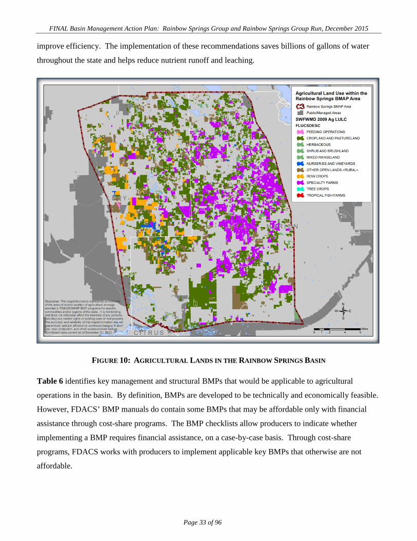
FINAL Basin Management Action Plan: Rainbow Springs Group and Rainbow Springs Group Run, December 2015
Page 33 of 96
improve efficiency. The implementation of these recommendations saves billions of gallons of water
throughout the state and helps reduce nutrient runoff and leaching.
FIGURE 10: AGRICULTURAL LANDS IN THE RAINBOW SPRINGS BASIN
Table 6 identifies key management and structural BMPs that would be applicable to agricultural
operations in the basin. By definition, BMPs are developed to be technically and economically feasible.
However, FDACS’ BMP manuals do contain some BMPs that may be affordable only with financial
assistance through cost-share programs. The BMP checklists allow producers to indicate whether
implementing a BMP requires financial assistance, on a case-by-case basis. Through cost-share
programs, FDACS works with producers to implement applicable key BMPs that otherwise are not
affordable.

FINAL Basin Management Action Plan: Rainbow Springs Group and Rainbow Springs Group Run, December 2015
Page 34 of 96
For assistance with enrolling in the FDACS’ BMP Program or with obtaining cost-share funds,
interested producers should contact OAWP staff. Information on the BMP manuals and field staff
contact information is available online. Printed BMP manuals can be obtained in the local extension
office at county agricultural extension centers USDA Natural Resources Conservation Service (NRCS)
offices, or by contacting OAWP field staff.
TABLE 6. KEY MANAGEMENT AND STRUCTURAL BMPS ADOPTED BY FDACS’ OAWP DETERMINING NUTRIENT NEEDS Soil and Tissue Testing: Used to base fertilizer applications on plant needs and available nutrients in the soil; helps prevent the overapplication of fertilizer. Nutrient Budgeting: Adjustment of fertilizer regime to account for other nutrient sources, such as biosolids, legumes, manure, and nutrient-laden irrigation water; helps prevent the overapplication of fertilizer. MANAGING NUTRIENT APPLICATION Precision Application of Nutrients: Use of specialized equipment for precise placement of nutrients on targeted areas at specified rates; reduces total amount used and prevents stray applications. Equipment Calibration/Maintenance: Ensures proper functioning of equipment; prevents misapplication or over-application of fertilizer materials. Split Fertilizer Applications: Multiple applications timed with optimal growth stages; allows plants to assimilate nutrients more efficiently; reduces nutrient loss in leaching and runoff. Fertigation: Application of fertilizer through irrigation water; allows for direct nutrient application to the crop root zone and more efficient assimilation by plants, reducing nutrient loss in leaching and runoff. Controlled-Release Fertilizer: Use of fertilizer formulations that have a controlled nutrient release curve; reduces nutrient loss to leaching and runoff. Fertilizer Application Setbacks from Waterbodies (wetlands, watercourses, sinks, springs, etc.): Establishes a zone where no fertilizer will be applied; reduces nutrient loadings to waterbodies. MANAGING IRRIGATION Irrigation Scheduling: Planning when to irrigate to reduce water and nutrient losses, based on available soil moisture content, evapotranspiration levels, recent rainfall, and time of day. Monitoring Soil Moisture and Water Table: Use of devices that measure the water table level and the amount of water in the soil; is a key component of proper irrigation scheduling. Tailwater Recovery: Use of down-gradient catchment ponds to trap irrigation tailwater to be reused on cropland; reduces offsite transport of nutrients and conserves water. TREATMENT AND EROSION CONTROL Filter Strips: Vegetated strips of land designed to reduce nutrients and sediments in surface water runoff from fields, pastures, and livestock high-intensity areas before it reaches downstream waterbodies. Vegetative Buffers: Establishment of riparian and/or wetland buffers to attenuate and assimilate nutrient- or sediment-laden surface flows coming from cropped/grazed areas. Ditch Maintenance and Retrofits: Use of rip rap, sediment traps, staging structures, and permanent vegetative bank cover to minimize erosion and transport of nutrient-laden sediments. LIVESTOCK MANAGEMENT (APPLICABLE TO COW/CALF AND EQUINE OPERATIONS) Manure Management: Appropriate storage and disposal of animal waste. Alternative Water Sources: Use of upland livestock watering ponds and/or water troughs; minimizes manure deposition in waterbodies. Rotational Grazing: Movement of cattle to different grazing areas on a planned basis; prevents concentrated waste accumulations and denuding of pasture areas. May involve fencing. High-Intensity Areas Location: Siting of cowpens, supplemental feed areas, etc., away from waterbodies to minimize nutrient loadings.

FINAL Basin Management Action Plan: Rainbow Springs Group and Rainbow Springs Group Run, December 2015
Page 35 of 96
OPERATIONS MANAGEMENT Fertilizer Storage: Proper location/storage of bulk fertilizer products to prevent nutrient loadings. Fertilizer Mix/Load: Use of appropriate dedicated or temporary mix/load areas located away from waterbodies to prevent nutrient loading. Employee Training: Training provided to farm workers on how to implement BMPs. Record Keeping: Proper record keeping provides accountability in the implementation of BMPs, and assists the producer in making nutrient and irrigation management decisions.
3.2.2 BMP ENROLLMENT Table 7 summarizes the land use data figures for agriculture in the BMAP area, the acreages associated
with commodity types addressed by OAWP BMP manuals, and the acres enrolled in BMP programs.
Figure 11 shows a map of the acres enrolled in BMPs as of June 30, 2015.
Based on aerial imagery and local staff observations, FDACS adjusted these figures to reflect the current
agricultural land use acreage more accurately. Approximately 28,000 acres were placed in the “Other
Open Lands – Rural” land use category, which is grouped with the agricultural land use classifications.
This classification is assigned when the land is in a rural area but the use cannot be determined, and so
acreage in this category may or may not be in active agricultural production. The review of aerial
imagery in the BMAP area shows that some of the land in this category may be pasture associated with
potential cow/calf ranching operations, but some smaller tracts are located in subdivisions/residential
areas or natural areas.
More significantly, however, several large row crop operations are in this classification, meaning that
row crop acreage is underrepresented in the land use data for the basin. Acreage in this category known
to be in row crop production was transferred to the row crop category in Table 7, but the row crop
acreage is likely still underrepresented. At this time, FDACS staff are unable to estimate the amount of
acreage that may be in production versus acreage that is likely not in production in this category.
However, it is assumed that some of the acreage is no longer in production.
It is important to understand that, even if all targeted agricultural operations are enrolled, not all of the
acreage listed as agriculture in Table 7 will be included in enrollment figures. The Notices of Intent
(NOIs) document the estimated total number of acres where applicable BMPs are implemented, not the
entire parcel acreage. This is because land use data can contain nonproduction acres (such as buildings,
parking lots, and fallow acres) that will not be counted on the NOIs submitted to FDACS. There also
may be significant amounts of acreage that do not need to be enrolled, such as lands that are not actively
involved in commercial agriculture (operations conducted as a business). These areas are often low-

FINAL Basin Management Action Plan: Rainbow Springs Group and Rainbow Springs Group Run, December 2015
Page 36 of 96
density residential uses on large parcels of grassed land, or land that was but is no longer in commercial
agricultural production. This information frequently is impossible to discern in the photo interpretation
process used to generate land use data. Local government or department BMPs may address these
noncommercial sources.
Agricultural enforcement for BMAP actions is based on the FWRA, which states that nonpoint source
dischargers who fail either to implement the appropriate BMPs or conduct water quality monitoring
prescribed by the department or a WMD that demonstrates compliance with water quality standards may
be subject to enforcement action by either of those agencies. All agricultural nonpoint sources in the
BMAP area are statutorily required either to implement FDACS-adopted BMPs or to conduct water
quality monitoring that demonstrates compliance with state water quality standards. As of June 30,
2015, 127 producers in the Rainbow Springs Basin had submitted NOIs to OAWP covering about
69,815 acres to implement FDACS-adopted BMPs. This represents 77 row/field crop, 24 equine, 23
cow/calf, and three specialty fruit/nut operations. No producers are conducting water quality monitoring
in lieu of implementing BMPs at this time.
FDACS’ field staff are focusing on enrolling commercial equine and cow/calf operations in this region
and will continue to do so. The availability of cost-share funds is expected to have a significant impact
in increasing equine BMP implementation in both the Rainbow and Silver Springs BMAP areas. In the
2015-16 fiscal year, FDACS plans to contract with the Marion Soil and Water Conservation District to
distribute up to $250,000 in cost-share funds to agricultural producers in the region. Staff will also work
to enroll other agricultural operations in the basin. FDACS will report annually to the department on its
progress in contacting and enrolling producers, including the number of operations and acres enrolled.
In conducting outreach to producers, FDACS will work with the soil and water conservation districts,
resource conservation and development councils, county extension staff, and others to convey the
statutory imperative for agriculture to implement BMPs, as well as the benefits to the environment and
producers.

FINAL Basin Management Action Plan: Rainbow Springs Group and Rainbow Springs Group Run, December 2015
Page 37 of 96
FIGURE 11: BMP ENROLLMENT IN THE RAINBOW SPRINGS BASIN AS OF JUNE 30, 2015

FINAL Basin Management Action Plan: Rainbow Springs Group and Rainbow Springs Group Run, December 2015
Page 38 of 96
TABLE 7: AGRICULTURAL ACREAGE AND BMP ENROLLMENT FOR THE RAINBOW SPRINGS BMAP AREA AS OF JUNE 30, 2015
N/A = Not applicable. 1 FDACS staff-adjusted acreage for purposes of enrollment is based on a review of more recent aerial imagery in the basin and local staff observations. 2There is no enrollment in the citrus manual at this time in the Rainbow Springs BMAP area
2009 SWFWMD LAND USE 2009 ACRES FDACS-ADJUSTED
ACRES1 RELATED FDACS BMP PROGRAMS ACREAGE ENROLLED
RELATED NOIS
Cropland and Pastureland (2100) and Rangeland (3100, 3200, 3300) 92,977.5 92,977.5 Cow/Calf, Future (Hay) 23,886.9 23
Row Crops 10,816.4 10,816.43 Vegetable/Agronomic Crops 44,708.6 77
Tree Crops 37.1 37.1 Specialty Fruit and Nut, Citrus3 80.2 3
Nurseries and Vineyards 1,484.4 1,484.4 Nurseries 0.0 N/A
Specialty Farms 43,618.8 43,618.8 Equine 1,139.4 24
Feeding Operations 196.6 196.6 Conservation Plan Rule 0.0 N/A
Other Open Lands – Rural 28,169.2 N/A Enrollment may not be needed N/A N/A
Aquaculture 27.9 N/A (FDACS Aquaculture Division) N/A N/A
Total 177,328.0 149,130.9 N/A 69,815.1 127

FINAL Basin Management Action Plan: Rainbow Springs Group and Rainbow Springs Group Run, December 2015
Page 39 of 96
3.2.3 AGRICULTURAL BMP LOAD REDUCTION ESTIMATES Due to inaccuracies in the 2009 land use data and to changes in land use since 2009, agricultural
loadings may be less than perceived. However, there are no detailed allocations in this BMAP, and so
the total estimated load or required reductions for agriculture are not defined. Consequently, an
estimated average load reduction percentage was derived for agriculture in this basin, based on an
averaged range of expected reductions for agricultural BMPs in Florida.
Percentages represent the relative amount of nitrogen reduction expected for “typical” agricultural BMP
implementation, which includes nutrient management, stormwater retention, limited wetland
retention/restoration, and rotational livestock grazing practices, as applicable to the commodity and
operation. A BMP average efficiency of 30% is applied to the acreage enrolled in the Rainbow Springs
BMAP area. Agricultural BMP implementation in the Rainbow Springs BMAP area is anticipated to
reduce agricultural loadings of nitrogen for row crops, cow/calf, citrus, nurseries, fruit/nut, and equine
operations.
The region is expected to continue shifting from agricultural to residential land uses, which will reduce
the agricultural load further. More precise information will be incorporated into the next iteration of the
TMDL and/or the BMAP. If the department plans to develop an estimate of agricultural loadings in the
future, the refinement of a basin- and commodity-specific agricultural loading/reduction model should
be considered.
3.2.4 FDACS OAWP ROLE IN BMP IMPLEMENTATION AND FOLLOW-UP The OAWP works with producers to submit NOIs to implement the BMPs applicable to their operations,
provides technical assistance to growers, and distributes cost-share, as available, to eligible producers
for selected practices. The OAWP follows up with growers through written surveys and site visits, to
evaluate the level of BMP implementation and record keeping, identify areas for improvement, if any,
and discuss cost-share opportunities, among other things.
When the department adopts a BMAP that includes agriculture, it is the agricultural producer’s
responsibility to implement BMPs adopted by FDACS to help achieve load reductions. If land use
acreage corrections and BMP implementation do not fully account for the current agricultural load
reduction allocation, it may be necessary to develop and implement cost-assisted field- and/or regional-
level treatment options that remove nutrients from farms and other nonpoint sources. In that case,

FINAL Basin Management Action Plan: Rainbow Springs Group and Rainbow Springs Group Run, December 2015
Page 40 of 96
FDACS will work with the department and the SWFWMD to identify appropriate options for achieving
further agricultural load reductions.
The FWRA requires that, where water quality problems are demonstrated despite the proper
implementation of adopted agricultural BMPs, FDACS must reevaluate the practices, in consultation
with the department, and modify them if necessary. Continuing water quality problems will be detected
through the BMAP monitoring component and other department and SWFWMD activities. If a
reevaluation of the BMPs is needed, FDACS will also include the SWFWMD and other partners in the
process.
3.2.5 OAWP IMPLEMENTATION ASSURANCE PROGRAM The OAWP formally established its Implementation Assurance (IA) Program in 2005 in the Suwannee
River Basin as part of the multiagency/local stakeholder Suwannee River Partnership. In 2007, the
OAWP initiated the IA Program in the Lake Okeechobee watershed and launched a standardized follow-
up program for the remaining areas of the state in 2013, beginning with the Ridge citrus and Indian
River citrus BMPs. Because of program-specific needs, the follow up process for each of these three
components was different. In early 2014, the OAWP began to streamline the IA Program to ensure
consistency statewide and across commodities and BMP manuals. This effort resulted in the
development of a single IA site-visit form, which is currently used by OAWP staff.
The current IA Program consists of two key components—mail-out surveys and site visits. Mail-out
surveys are developed by OAWP staff, in conjunction with commodity experts. This component of the
IA Program was born out of the recognition that OAWP staff resources are limited; therefore, visits to
each of the enrolled producers across the state were not possible in a short/contemporary time frame.
All enrolled producers are mailed these surveys and are asked to fill out the surveys and return them to
OAWP staff.
Site visits, the second component, are conducted by OAWP field staff and technicians as workload
allows. For the visits, field staff and technicians use a standard form (noncommodity or BMP manual
specific) that was developed in 2014. The form focuses on nutrient-management, irrigation-
management, and water-resource protection BMPs that are common to all of the adopted BMP manuals.
The paper forms are submitted to OAWP staff and compiled into a spreadsheet, and the data are reported
annually in reports such as this one. From 2007–14, the OAWP conducted over 1,200 site visits.
However, it is difficult to compare data collected prior to the implementation of the single IA site-visit

FINAL Basin Management Action Plan: Rainbow Springs Group and Rainbow Springs Group Run, December 2015
Page 41 of 96
form developed in 2014 because of regional differences (e.g., different forms and information asked) in
administering the IA Program.
In late 2014, the OAWP commenced efforts to revise and restructure its current IA Program, and these
efforts are ongoing. The OAWP expects to increase its site visits in the future.
3.2.6 FLORIDA FOREST SERVICE ROLE IN BMP IMPLEMENTATION AND MONITORING FDACS’ Florida Forest Service silviculture BMP program is responsible for the development,
implementation, and monitoring of silviculture BMPs across the state. Silviculture BMPs are applicable
to all bona fide ongoing forestry operations. However, silviculture BMPs are not intended for use on
tree removal or land clearing operations that are associated with a planned land use change to a
nonforestry objective. The current 2008 Silviculture BMP Manual (Florida Forest Service 2008)
contains 150 individual BMPs in 14 categories. Silviculture BMPs are both based on structural
improvements (forest roads, stream crossings, etc.) and management improvements (pesticide and
fertilizer application, special management zones, etc.). The Silviculture BMP NOI Program began on
February 11, 2004. As of August 2014, 15,983.1 acres had been signed up under the silviculture BMP
NOI in the Rainbow Springs Basin.
Since 1981, the Florida Forest Service has monitored silviculture operations for compliance with BMPs
by conducting biennial surveys. Surveys are conducted on both public and private silviculture
operations with on-the-ground evaluations of randomly selected sites where recent silviculture
operations have taken place. The 2013 Silviculture BMP Implementation Survey Report included sites
from both Marion and Levy Counties. Data for these counties were collected from 12 different
silviculture operations. The overall silviculture BMP compliance for these two counties in 2013 was
100%.
An important aspect of silviculture BMPs is that they have been proven effective. A multiyear study
conducted by the Florida Forest Service with assistance from the department looked at the effectiveness
of silviculture BMPs in protecting aquatic ecosystems during silviculture operations, including clear-cut
harvesting, intensive mechanical site preparation, machine planting, postplanting herbicide treatments,
and a forest fertilization treatment. Silviculture BMP effectiveness was evaluated using water chemistry
analysis, habitat assessment, and the Stream Condition Index (a biological assessment methodology
developed for Florida stream ecosystems). The study concluded that silviculture BMPs were effective at

FINAL Basin Management Action Plan: Rainbow Springs Group and Rainbow Springs Group Run, December 2015
Page 42 of 96
protecting aquatic habitat in nearby streams with no evidence of impacts or impairments to the
designated beneficial use of the streams (Vowell 2001; Vowell and Frydenborg 2004).
In cooperation with the University of Florida, the Florida Forest Service is also assisting with two more
research projects to evaluate the effectiveness of silviculture BMPs for forest fertilization. One study,
completed in November 2013, examined the effectiveness of forest fertilization BMPs for protecting
ground water from nutrient leaching. Study results showed that the ground water concentrations of
ammonium, total Kjeldahl nitrogen , and TP observed for wells monitored in the fertilization treatment
area did not increase compared with prefertilization baseline levels or distant control wells (Minogue et
al. 2013). An ongoing study that looks at the effectiveness of forest fertilization BMPs for protecting
nearby surface waters was initiated in 2012 and is expected to be completed in 2017.
More information on silviculture BMPs and FDACS’ Florida Forest Service Silviculture BMP Program
is available online.
3.3 SWFWMD SPRINGS 2013–17 MANAGEMENT PLAN
The SWFWMD’s Springs Management Plan (SWFWMD 2013) summarizes the vision, issues, and
Surface Water Improvement and Management (SWIM) plan revisions that over the next five years will
be implemented to manage and protect springs. The plan is focused on understanding natural variability
while mitigating impacts caused by human activity where practical. Through strategic investments and
partnerships, the SWFWMD is implementing projects to conserve and restore the ecological balance of
spring systems. The plan is a road map that is consistent with the SWFWMD’s Strategic Plan and
builds on previous plans such as the Springs Coast Comprehensive Watershed Management Plan
(SWFWMD 2001) and the Springs Coast Initiative (SWFWMD 2002), as well as more than 20 years of
districtwide expertise designing and implementing projects and monitoring activities. This plan is a
living document with adaptive management at its core. The plan lays out a general restoration strategy,
an overview of the goals and issues, and a list of proposed projects for the five-year period from 2013–
17.
In 2014, the SWFWMD—together with local, regional, and state partners—formed the Springs Coast
Steering Committee, whose first goal is to develop comprehensive conservation and management plans
tailored for each of the five first-magnitude spring systems, beginning with Rainbow Springs. These
plans will identify issues, solutions, and specific management actions for each spring system, including
FINAL Basin Management Action Plan: Rainbow Springs Group and Rainbow Springs Group Run, December 2015
Page 43 of 96
water quality improvement projects to reduce nitrogen loading from sources identified in the BMAP.
The plan is available on the SWFWMD WaterMatters website.
3.4 OTHER RESEARCH EFFORTS
Table 8 lists other research and modeling efforts that have been completed or proposed. Marion County
initiated a countywide watershed management program (WMP). This program is being carried out in
cooperation with the SWFWMD in the Rainbow Springs BMAP area. The WMP develops detailed
hydrologic and hydraulic models that identify floodplains and areas of diminished level of service due to
road flooding. A detailed pollutant loading model is also produced to identify the locations of
significant stormwater pollutant loading to surface waters and ground water (i.e., via sinkholes, recharge
in natural depressions, and retention ponds). Conceptual capital projects are identified in the WMP to
address water quality and flooding level-of-service concerns. The WMP results may also be used in the
land development review process.
The city of Dunnellon completed the Dunnellon WMP, in cooperation with the SWFWMD, in 2004.
The plan identified floodplain areas in the city and also stormwater outfalls where discharge to the
Rainbow and Withlacoochee Rivers was a water quality concern.
Marion County also completed a Floridan aquifer vulnerability assessment in 2007. The assessment is
more detailed and locally specific than the state aquifer vulnerability maps. Maps generated from that
assessment are used to guide development actions and reduce impacts to ground water.

FINAL Basin Management Action Plan: Rainbow Springs Group and Rainbow Springs Group Run, December 2015
Page 44 of 96
TABLE 8: RESEARCH AND MODELING EFFORTS PROJECT
TYPE PROJECT NUMBER PROJECT TITLE LEAD ENTITY PROJECT DESCRIPTION
PROJECT PARTNERS
START DATE
COMPLETION DATE
Data Collection
B034 Marion
County WMP
Marion County Office of the County
Engineer
WMPs will be completed countywide and are used to identify and address Marion County water quality issues. The WMPs will include the creation and
maintenance of a comprehensive geodatabase for Marion County storm sewer system data, watershed
boundaries, and hydrologic features countywide.
SWFWMD 2003 Ongoing
Studies B035
Marion County Aquifer
Vulnerability Assessment
Marion County Office of the County
Engineer
Identify vulnerable areas of aquifer. Project provides a scientifically defensible water resource management and protection tool that will facilitate the planning of
human activities to help in minimizing adverse impacts on ground water quality. Aquifer vulnerability maps are displayed in classes of relative vulnerability (one
area is more vulnerable than another). The maps benefit local government, planners, and developers in
guiding growth into more appropriate areas (e.g., ground water recharge areas) and improve site
selection for expanding existing or establishing new wellfields. Benefits: Identifies areas where the aquifer
is vulnerable to pollution. Potential for future management of activities in those areas to reduce
pollution of ground water.
None 2007 2007
Studies R022 Dunnellon
WMP City of
Dunnellon
The Dunnellon WMP developed a hydrologic and hydraulic model and water quality treatment
recommendations for nine stormwater discharge outfalls to the Rainbow and Withlacoochee Rivers.
Marion County,
SWFWMD 2004 2004
Studies R023
WR01 Rainbow
River Phosphate
Mine Pit Feasibility
Study
SWFWMD Feasibility study to assess restoration alternatives in the lower Rainbow River and adjacent phosphate mine pits. None 2014 2015

FINAL Basin Management Action Plan: Rainbow Springs Group and Rainbow Springs Group Run, December 2015
Page 45 of 96
PROJECT TYPE
PROJECT NUMBER PROJECT TITLE LEAD ENTITY PROJECT DESCRIPTION
PROJECT PARTNERS
START DATE
COMPLETION DATE
Studies R070
2013–17 Springs
Management Plan
SWFWMD
The district’s Springs Management Plan summarizes the vision, issues, and solutions that the district will address over the next five years to manage and protect springs.
Through strategic investments and partnerships, the district is implementing projects to conserve and restore the ecological balance of Florida’s spring
systems, thus supporting regional economies and quality of life. The plan lays out a general restoration
strategy, an overview of the goals and issues, and a list of proposed projects.
None 2013 2017
FINAL Basin Management Action Plan: Rainbow Springs Group and Rainbow Springs Group Run, December 2015
Page 46 of 96
Chapter 4: NITROGEN LOADING SOURCE MANAGEMENT STRATEGIES
This chapter presents projects to reduce nitrogen loads in the Rainbow Springs BMAP area. Individual
project summaries are presented by source category. Project descriptions include projects completed
since 2000, in addition to projects to be implemented in the future. This period corresponds with an
increase in awareness by local governments and community interests of the impacts of elevated nitrate
concentrations in Rainbow Springs. Many of these projects are ongoing activities of existing programs,
e.g., street sweeping, but their continuation is important for the management of pollutant loads to the
UFA.
Projects anticipated to be implemented over the five-year period covered by the BMAP include fully
funded projects, planned projects, and conceptual projects. Project numbers designated with an R are
applicable to only Rainbow Springs, while projects designated with a B apply to both Rainbow and
Silver Springs. Planned projects typically lack either sufficient funds or have not yet entered the design
phase. They may not be identified in an agency’s current adopted budget but may be identified in near-
term budget planning documents (e.g., a capital improvement plan). Projects categorized as conceptual
do not currently have committed funding but will be considered as funds become available. Planned and
conceptual projects are priorities for securing adequate funding during the first phase of the BMAP.
The BMAP projects and activities represent a considerable local, regional, and state investment in a
multifaceted approach to water quality protection and restoration. Responsible entities submitted these
management strategies to the department with the understanding that the strategies would be included in
the BMAP, thus requiring each entity to implement the proposed strategies in a timely manner and
perform any required operations or maintenance. However, projects and activities are meant to be
flexible enough to allow for changes that may occur over time. Any change in listed projects and
activities, or the deadline to complete these actions, must first be approved by the department.
Substituted strategies must result in equivalent or greater nutrient reductions than expected or an
equivalent benefit from the original strategies.
4.1 MANAGEMENT EFFORTS FOCUSED ON RAINBOW RIVER
Management strategies that have been or will be undertaken by stakeholders are not limited to reducing
nutrient loads to the UFA. Table 9 lists the 12 projects identified by stakeholders that primarily protect
the Rainbow River and thus directly address the TMDL for the river. The projects address stormwater
runoff, primarily from public facilities such as roads.

FINAL Basin Management Action Plan: Rainbow Springs Group and Rainbow Springs Group Run, December 2015
Page 47 of 96
TABLE 9: MANAGEMENT STRATEGIES FOCUSING ON THE RAINBOW RIVER PROJECT
TYPE PROJECT NUMBER PROJECT TITLE
LEAD ENTITY PROJECT DESCRIPTION PROJECT PARTNERS
START DATE STATUS
COMPLETE DATE
Urban Structural
BMP R003
Blue Cove Emergency Overflow Project
City of Dunnellon
Project to construct a retention pond with a control structure and pipe
conveyance system to treat and convey flood overflows from Blue Cove to the Rainbow River. Prior to construction
overflows, sheet flowed through residential neighborhood to the river.
SWFWMD 2000 Complet
e 2011
Urban Structural
BMP R004
Datesman Park Overflow
Parking Lot Improvement
City of Dunnellon
Project retrofitted a car and boat trailer overflow parking lot with pervious pavers
and a stormwater retention pond. None 2000
Complete
2010
Urban Structural
BMP R012
CR 484 Stormwater
Retrofit, Phase 1
Marion County
Office of the County Engineer
Construction of a bioretention area and collection system to treat runoff from
bridge spanning the Rainbow River. SWFWMD 2009
Complete
2010
Urban Structural
BMP R013
CR 484 Stormwater
Retrofit, Phase 2
Marion County
Office of the County Engineer
Construction of a wet detention pond to treat runoff discharged into the Rainbow
River from CR 484. SWFWMD 2011
Complete
2012
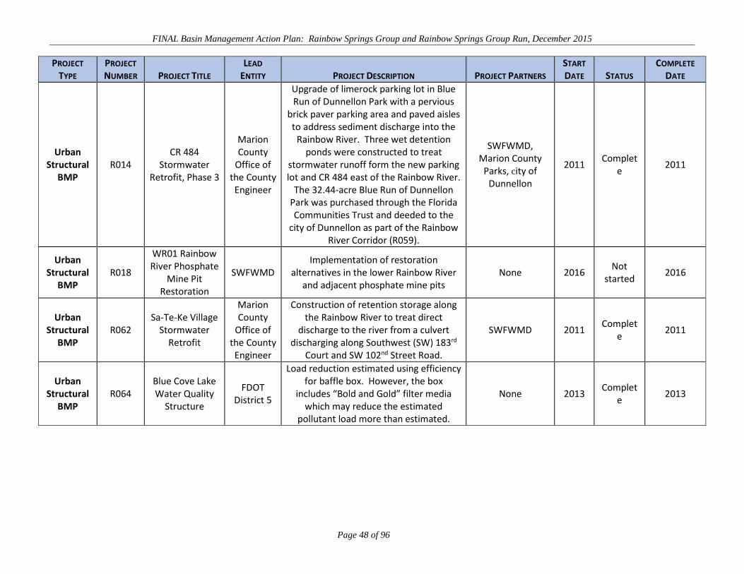
FINAL Basin Management Action Plan: Rainbow Springs Group and Rainbow Springs Group Run, December 2015
Page 48 of 96
PROJECT TYPE
PROJECT NUMBER PROJECT TITLE
LEAD ENTITY PROJECT DESCRIPTION PROJECT PARTNERS
START DATE STATUS
COMPLETE DATE
Urban Structural
BMP R014
CR 484 Stormwater
Retrofit, Phase 3
Marion County
Office of the County Engineer
Upgrade of limerock parking lot in Blue Run of Dunnellon Park with a pervious
brick paver parking area and paved aisles to address sediment discharge into the
Rainbow River. Three wet detention ponds were constructed to treat
stormwater runoff form the new parking lot and CR 484 east of the Rainbow River.
The 32.44-acre Blue Run of Dunnellon Park was purchased through the Florida Communities Trust and deeded to the
city of Dunnellon as part of the Rainbow River Corridor (R059).
SWFWMD, Marion County
Parks, city of Dunnellon
2011 Complet
e 2011
Urban Structural
BMP R018
WR01 Rainbow River Phosphate
Mine Pit Restoration
SWFWMD Implementation of restoration
alternatives in the lower Rainbow River and adjacent phosphate mine pits
None 2016 Not
started 2016
Urban Structural
BMP R062
Sa-Te-Ke Village Stormwater
Retrofit
Marion County
Office of the County Engineer
Construction of retention storage along the Rainbow River to treat direct
discharge to the river from a culvert discharging along Southwest (SW) 183rd
Court and SW 102nd Street Road.
SWFWMD 2011 Complet
e 2011
Urban Structural
BMP R064
Blue Cove Lake Water Quality
Structure
FDOT District 5
Load reduction estimated using efficiency for baffle box. However, the box
includes “Bold and Gold” filter media which may reduce the estimated
pollutant load more than estimated.
None 2013 Complet
e 2013
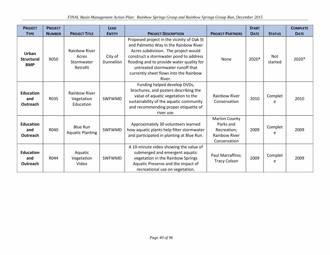
FINAL Basin Management Action Plan: Rainbow Springs Group and Rainbow Springs Group Run, December 2015
Page 49 of 96
PROJECT TYPE
PROJECT NUMBER PROJECT TITLE
LEAD ENTITY PROJECT DESCRIPTION PROJECT PARTNERS
START DATE STATUS
COMPLETE DATE
Urban Structural
BMP R050
Rainbow River Acres
Stormwater Retrofit
City of Dunnellon
Proposed project in the vicinity of Oak St and Palmetto Way in the Rainbow River
Acres subdivision. The project would construct a stormwater pond to address flooding and to provide water quality for
untreated stormwater runoff that currently sheet flows into the Rainbow
River.
None 2020* Not
started 2020*
Education and
Outreach R035
Rainbow River Vegetation Education
SWFWMD
Funding helped develop DVDs, brochures, and posters describing the
value of aquatic vegetation to the sustainability of the aquatic community and recommending proper etiquette of
river use.
Rainbow River Conservation
2010 Complet
e 2010
Education and
Outreach R040
Blue Run Aquatic Planting
SWFWMD Approximately 30 volunteers learned
how aquatic plants help filter stormwater and participated in planting at Blue Run.
Marion County Parks and
Recreation; Rainbow River Conservation
2009 Complet
e 2009
Education and
Outreach R044
Aquatic Vegetation
Video SWFWMD
A 10-minute video showing the value of submerged and emergent aquatic vegetation in the Rainbow Springs
Aquatic Preserve and the impact of recreational use on vegetation.
Paul Marraffino; Tracy Colson
2009 Complet
e 2009

FINAL Basin Management Action Plan: Rainbow Springs Group and Rainbow Springs Group Run, December 2015
Page 50 of 96
4.2 AGRICULTURAL MANAGEMENT STRATEGIES
Overall agricultural production contributes 67% of the loading to the UFA. Cattle and horse farms
provide 47% of the loading of nitrogen to the UFA. In addition to the implementation of BMPs for
appropriate agricultural commodities, additional activities are proposed to address the loading from
agriculture.
Agricultural sources combined contribute an estimated 9,519,891 lbs-N/yr at the land surface. Table 10
lists loading reduction estimates for individual agricultural source categories. Currently 46.8% of the
identified agricultural acreage is covered by a NOI from FDACS (Table 6). An efficiency of 30% is
assumed for each BMP and when applied to the acreage signed up under each BMP Program yields an
estimated total loading reduction of 754,375 lbs-N/yr or 7.9 % at the land surface.
The largest contribution of loading to the land surface comes from cattle farms (Table 10). Cattle
operations in the BMAP area are mainly cow-calf operations for the production of beef cattle. Calves
were assumed to have an average residence time in the BMAP area of 183 days, based on input from
stakeholders. Pasture fertilization is part of horse farm and cattle farm nitrogen loading.
TABLE 10: SUMMARY OF AGRICULTURE BMP LOADING REDUCTIONS 1Calculated as percent acreage covered by NOI (Table 7) times source loading to land surface times 30% efficiency.
AGRICULTURAL SOURCE
LOADING TO LAND SURFACE
(LBS-N/YR) BMP PROGRAM
ESTIMATED LOADING REDUCTION AT LAND
SURFACE1 Horse Farms 3,027,527 Equine 23,725 Cattle Farms 5,225,877 Cow/Calf 402,775
Miscellaneous Livestock 173,572 Conservation Plan Rule No acreage covered
Fertilizer, Crops 1,092,915 Vegetable/Agronomic Crop; Citrus; Specialty Fruit/Nut and Nursery 327,875
Agricultural loadings of nitrogen and phosphorus are associated primarily with fertilization, irrigation,
and manure disposal practices. Nutrients from fertilization and animal manure can find their way into
water resources through irrigation or stormwater runoff, and can be carried in sediments that are
transported through runoff. As set out in Paragraph 403.067(7)(c), F.S., agricultural producers in a
BMAP area must either implement FDACS-adopted BMPs or monitor their water quality, to
demonstrate compliance with state water quality standards. Producers in the Rainbow Springs BMAP
area have so far chosen to implement BMPs.

FINAL Basin Management Action Plan: Rainbow Springs Group and Rainbow Springs Group Run, December 2015
Page 51 of 96
While there are FDACS BMP manuals for eight different commodity groups (including forestry), each
manual addresses the principles of nutrient management, irrigation management, sedimentation and
erosion control, and water resources protection. FDACS developed a set of Guiding Principles for
agricultural producers based on recommended BMP practices. Table 11 lists the Guiding Principles
related to the implementation of BMPs in each of these key categories.
Table 12 lists other agriculture-related management strategies under way or proposed for the Rainbow
Springs BMAP area. The Marion County Clean Farms Initiative (Project B010) was designed to assist
Marion County farmowners and managers with the implementation of BMPs, and to recognize them for
their cooperative efforts. As a result of the Initiative, the Farm Outreach Coordinator position was
created. The coordinator is responsible for the Water Quality Education and Equine Farm BMP
Program (Project B011), which is an ongoing effort of the UF–IFAS Extension Service in Marion
County. The department recently published the Small Equine BMP Manual.
TABLE 11: GUIDING PRINCIPLES FOR AGRICULTURAL LOAD REDUCTIONS IN THE RAINBOW SPRINGS BMAP AREA
Nutrient Management – o Producers should strive to achieve the most appropriate combination of nutrient source, amount,
placement, and application timing, based on crop needs, soils, and weather conditions, to increase
the availability of nutrients to the crop and decrease the potential for runoff or leaching of nutrients
to the environment.
o On animal operations, such as cow/calf and equine, producers also should ensure the proper
management of manure, either through application/spreading onsite at agronomic rates or
appropriate disposal offsite.
Irrigation Management – Producers should, to the extent feasible, do the following: o Maximize irrigation system efficiency, based on system design specifications, through proper
maintenance and use.
o Manage the frequency, timing, and amount of irrigation applications to target water delivery to the
plant root zone.
o Incorporate the use of simple but effective irrigation management tools, such as soil moisture
sensors, rain gauges, and on-site or online weather station data, etc.
o If one is available, consult with a Mobile Irrigation Lab regarding potential ways to increase
irrigation system efficiency and improve irrigation management.
Sedimentation and Erosion Control – Producers should maintain vegetation in areas prone to erosion, to hold soil and decrease the velocity of irrigation and stormwater runoff.

FINAL Basin Management Action Plan: Rainbow Springs Group and Rainbow Springs Group Run, December 2015
Page 52 of 96
Water Resources Protection – Producers should employ buffers, swales, and/or setbacks to reduce the potential for pollutant discharges to water resources.
A new effort in the Rainbow and Silver Springs BMAP areas is an outreach program featuring the new
manual and directed towards small, typically noncommercial (hobby) horse farms. The new manual
provides a set of manure management and nutrient reduction BMPs that are appropriate for hobby farms.
Hobby farms are numerous in the basin, and may have issues with manure storage and disposal, denuded
areas, etc., but not the acreage to resolve these issues. It is typically not appropriate or possible for
hobby farms to enroll under FDACS’ Equine BMP Program. A joint outreach and education effort
between local government, the department, and UF–IFAS is under development to address these
operations.
An outreach strategy for the equine hobby farms is expected to be completed during the first phase of
the BMAP, and implementation will be an ongoing effort. Initial steps will focus on identifying ways to
reach the target audience, identifying and engaging agencies with existing outreach programs, and
developing outreach materials to supplement the new department manual. A method of assessing
program effectiveness with regard to the BMPs implemented on hobby farms and the amount of acreage
involved also will be developed, possibly using existing programs.
In addition to signing up producers for a BMP NOI, FDACS has focused its priorities and increased its
activity in the BMAP area in the following manner:
BMP Enrollment – The OAWP will focus its BMP enrollment efforts on high-
recharge areas. Staff and contractors will identify active commercial agricultural
operations through grower associations, information on county agricultural tax
classifications, field staff knowledge, and other means. The OAWP will attempt to
ensure that all producers are aware of their statutory obligation to implement BMPs,
through letters, emails, workshops, brochures, and/or other means. Staff/contractors
will assist producers in selecting the appropriate BMPs, with emphasis on nutrient
management, irrigation management, sediment/erosion control, water resources
protection, and record keeping.
With funding targeted toward springs protection, FDACS will be providing BMP
cost-share for the Rainbow Springs BMAP area.

FINAL Basin Management Action Plan: Rainbow Springs Group and Rainbow Springs Group Run, December 2015
Page 53 of 96
To help focus cost-share expenditures and BMP implementation follow-up, FDACS
will review its rule-adopted cow/calf and equine BMPs to identify the practices likely
to have the greatest nutrient load reduction benefits.
FDACS is considering hiring an additional BMP technician to increase focus on BMP
enrollment in springs-related basins, including Rainbow Springs.
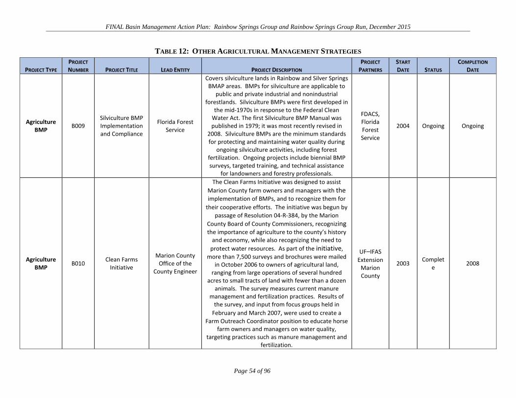
FINAL Basin Management Action Plan: Rainbow Springs Group and Rainbow Springs Group Run, December 2015
Page 54 of 96
TABLE 12: OTHER AGRICULTURAL MANAGEMENT STRATEGIES
PROJECT TYPE PROJECT NUMBER PROJECT TITLE LEAD ENTITY PROJECT DESCRIPTION
PROJECT PARTNERS
START DATE STATUS
COMPLETION DATE
Agriculture BMP B009
Silviculture BMP Implementation and Compliance
Florida Forest Service
Covers silviculture lands in Rainbow and Silver Springs BMAP areas. BMPs for silviculture are applicable to
public and private industrial and nonindustrial forestlands. Silviculture BMPs were first developed in
the mid-1970s in response to the Federal Clean Water Act. The first Silviculture BMP Manual was published in 1979; it was most recently revised in
2008. Silviculture BMPs are the minimum standards for protecting and maintaining water quality during
ongoing silviculture activities, including forest fertilization. Ongoing projects include biennial BMP surveys, targeted training, and technical assistance
for landowners and forestry professionals.
FDACS, Florida Forest Service
2004 Ongoing Ongoing
Agriculture BMP B010 Clean Farms
Initiative
Marion County Office of the
County Engineer
The Clean Farms Initiative was designed to assist Marion County farm owners and managers with the implementation of BMPs, and to recognize them for
their cooperative efforts. The initiative was begun by passage of Resolution 04-R-384, by the Marion
County Board of County Commissioners, recognizing the importance of agriculture to the county’s history
and economy, while also recognizing the need to protect water resources. As part of the initiative,
more than 7,500 surveys and brochures were mailed in October 2006 to owners of agricultural land,
ranging from large operations of several hundred acres to small tracts of land with fewer than a dozen
animals. The survey measures current manure management and fertilization practices. Results of
the survey, and input from focus groups held in February and March 2007, were used to create a
Farm Outreach Coordinator position to educate horse farm owners and managers on water quality,
targeting practices such as manure management and fertilization.
UF–IFAS Extension
Marion County
2003 Complete 2008
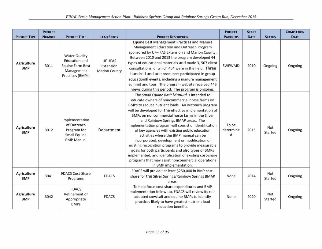
FINAL Basin Management Action Plan: Rainbow Springs Group and Rainbow Springs Group Run, December 2015
Page 55 of 96
PROJECT TYPE PROJECT NUMBER PROJECT TITLE LEAD ENTITY PROJECT DESCRIPTION
PROJECT PARTNERS
START DATE STATUS
COMPLETION DATE
Agriculture BMP B011
Water Quality Education and
Equine Farm Best Management
Practices (BMPs)
UF–IFAS Extension
Marion County
Equine Best Management Practices and Manure Management Education and Outreach Program
sponsored by UF–IFAS Extension and Marion County. Between 2010 and 2013 the program developed 44
types of educational materials and made 3, 507 client consultations, of which 464 were in the field. Three hundred and one producers participated in group
educational events, including a manure management summit and tour. The program website received 446
views during this period. The program is ongoing.
SWFWMD 2010 Ongoing Ongoing
Agriculture BMP B012
Implementation of Outreach Program for Small Equine BMP Manual
Department
The Small Equine BMP Manual is intended to educate owners of noncommercial horse farms on
BMPs to reduce nutrient loads. An outreach program will be developed for the effective implementation of
BMPs on noncommercial horse farms in the Silver and Rainbow Springs BMAP areas. The
implementation program will consist of identification of key agencies with existing public education
activities where the BMP manual can be incorporated, development or modification of
existing recognition programs to provide measurable goals for both participants and also types of BMPs
implemented, and identification of existing cost-share programs that may assist noncommercial operations
in BMP implementation.
To be determine
d 2015 Not
Started Ongoing
Agriculture BMP B041 FDACS Cost-Share
Programs FDACS FDACS will provide at least $250,000 in BMP cost-
share for the Silver Springs/Rainbow Springs BMAP areas.
None 2014 Not Started Ongoing
Agriculture BMP B042
FDACS Refinement of Appropriate
BMPs
FDACS
To help focus cost-share expenditures and BMP implementation follow-up, FDACS will review its rule-
adopted cow/calf and equine BMPs to identify practices likely to have greatest nutrient load
reduction benefits.
None 2020 Not Started Ongoing

FINAL Basin Management Action Plan: Rainbow Springs Group and Rainbow Springs Group Run, December 2015
Page 56 of 96
PROJECT TYPE PROJECT NUMBER PROJECT TITLE LEAD ENTITY PROJECT DESCRIPTION
PROJECT PARTNERS
START DATE STATUS
COMPLETION DATE
Agriculture BMP B043
Technical Agriculture Committee
UF–IFAS Extension
Marion County
Formation of a technical agriculture committee consisting of representatives from local interest
groups, local government, WMDs, and state agencies. The purpose of the group is to ensure consistent and accurate information for pollutant
load contributions associated with agricultural uses and evaluate effectiveness of BMPs.
Local interests; local and
state agencies;
WMDs
2016 Not Started 2020

FINAL Basin Management Action Plan: Rainbow Springs Group and Rainbow Springs Group Run, December 2015
Page 57 of 96
4.3 WASTEWATER MANAGEMENT
WWTFs and OSTDS are the two sources of nitrogen loading from wastewater considered in the NSILT.
Wastewater sources of nitrogen occur from both centralized and decentralized (package plants)
treatment plants. The results of the NSILT indicate that OSTDS account for 19% of nitrogen loading to
the UFA, while WWTFs (both large centralized facilities and small package plants) account for 2%.
Stakeholders having responsibilities for managing or regulating wastewater collection and disposal
agreed to a set of Guiding Principles (Table 13) as a mechanism to aide future actions and the selection
of projects to address wastewater sources. The Guiding Principles are proposed for the use of utility
stakeholders, both public and private, who operate wastewater treatment and collection systems and the
state agencies with regulatory authority over or water quality interests related to WWTFs and OSTDS.
TABLE 13: GUIDING PRINCIPLES FOR WASTEWATER AND OSTDS NITROGEN SOURCES
Utility stakeholders are encouraged to implement technology that maximizes nitrogen removal
from effluent when upgrading, replacing, or constructing new facilities in areas of high recharge, as
indicated by the NSILT or other similar analysis.
Operators of package plants in Marion County will comply with applicable county codes to
decommission these facilities when they cannot be replaced or practically upgraded to meet
applicable effluent standards and where better centralized facilities are available, particularly in
areas of high recharge and with high nitrogen effluent concentrations. Package plants in Levy
County, but located in the BMAP area, are encouraged to do the same.
FDOH and utility stakeholders are encouraged to participate with the department on developing
strategies for providing alternative effluent treatment to areas currently with dense concentrations
of septic tanks and package plants. The following factors may be considered: o Definition of dense concentration of OSTDS and package plants.
o Identification of priority areas for centralized sewer expansion.
o Development of financial assistance programs for construction of infrastructure and
individual connections to such infrastructure.
4.3.1 NITROGEN LOADING FROM WWTFS In the Rainbow Springs BMAP area, treated effluent containing nitrogen from WWTFs is discharged to
sprayfields, RIBs or percolation ponds, or used for irrigation water (reuse). Throughout the BMAP area,
WWTFs contribute 2% of the potential loading of total nitrogen to ground water. Although those
percent contributions are smaller than the contributions from OSTDS or agriculture, discharge location
and level of treatment of wastewater can be important factors to consider when addressing loadings to

FINAL Basin Management Action Plan: Rainbow Springs Group and Rainbow Springs Group Run, December 2015
Page 58 of 96
the UFA. Additionally, addressing the nitrogen loading from OSTDS could include increasing the
volume of effluent treated and disposed of by WWTFs.
There are 37 WWTFs located within the Rainbow Springs BMAP boundary that were used for the
evaluation of nitrogen loading in the NSILT (Eller and Katz 2015). Of that number only six facilities
discharge more than 100,000 gallons of treated effluent per day. Four of these facilities were also
estimated to contribute more than 1,000 kg-N (2,204.62 lbs-N) annually between 2012 and 2013. The
larger municipal WWTFs are operated by Marion County Utilities, city of Ocala, city of Williston, and
the On Top of The World Development (Bay Laurel Community Development District).
Most of the remaining WWTFs, except for four operated by the city of Dunnellon, are package plants
and typically serve mobile home parks, residential properties, commercial property, and schools where
central sewer is not available. Additionally, there are 18 permitted industrial wastewater discharges and
two permitted residuals application site in the BMAP area that were not included in the NSILT because
wastewater effluent limits are not applicable to these facilities.
The volume of wastewater discharged by a WWTF is not a complete indicator of the impact of nitrogen
loading and concentration contributed by that plant on the UFA. Smaller facilities can contribute large
amounts of nitrogen loading compared with the volume of wastewater produced or have high estimated
concentrations of nitrogen in their effluent. Noncompliance with permit conditions is a periodic
problem for a number of the smaller facilities. In areas where small facilities are aggregated, the impact
to the UFA is magnified. Because of the small volume of wastewater treated at these facilities, there are
few cost-effective options available to improve treatment besides connection to larger utilities.
Required monitoring varies between facilities and not all report the same type of data, resulting in
inconsistencies in the data collected for WWTFs. For larger facilities, the annual effluent input to the
land surface was estimated using the average TN concentration and the reported (not permitted capacity)
discharge (volume), but this information was not always available for smaller facilities. Smaller
WWTFs (by volume <0.1 mgd) are not required to monitor and report effluent concentrations, and
therefore not all these facilities had available data, while others reported NO3-N concentrations in the
effluent instead of TN. For these facilities, the TN concentration was estimated at 8.97 mg/L, based on a
2009 cooperative study with the department and Water Reuse Foundation of 40 domestic WWTFs
across the state.

FINAL Basin Management Action Plan: Rainbow Springs Group and Rainbow Springs Group Run, December 2015
Page 59 of 96
Also, some facilities for some years reported NO3-N rather than TN for their effluent concentrations.
For these, the department estimated TN concentrations by extrapolating from the NO3-N data (assuming
the NO3-N concentration was 38.5% of the TN). Additionally, smaller facilities are not required to
report the actual discharge volume, and the nitrogen input was estimated assuming that the plant was
discharging effluent at 50% of its permitted design capacity.
There are 10 projects identified that address wastewater management (Table 14 provides details). They
fall into the following strategies or categories: wastewater collection system maintenance, wastewater
service area expansion to connect package plants to central sewer, reuse, and system upgrades or
improvements to effluent treatment to improve its quality.
Operational improvements to the Bay Laurel Center Community Development District WWTF serving
the On Top of The World development have resulted in a significant reduction in effluent TN
concentration since implementation in 2013, compared with pre-2013 levels.
The wastewater coordination efforts (Projects R052 and R054) between Marion County Utilities and the
city of Dunnellon have resulted in a conceptual plan to replace the existing city of Dunnellon WWTFs
with a single WWTF that meets the advanced wastewater treatment (AWT) standard for TN. The
required collection system infrastructure would also allow five package plants to be connected to the
new plant. At this time the plan is dependent on funding being available.
Overall, the projects would remove an estimated 17,811 lbs-N/yr, or about 27.7%, of the potential
nitrogen loading to the land surface from WWTFs based on current flows. This does not include the
load reduction from reuse projects. The reuse of effluent is used to offset fertilizer application in urban
areas. Load reductions from reuse projects are included in the urban fertilizer source category.
Marion County (2013) has adopted as part of its local land development code requirements (Article 6
Technical Standards and Requirements, Division 16. Wastewater Facilities) for WWTFs and effluent
quality that are currently applicable within unincorporated Marion County. The code identifies two
protection zones, a Primary Protection Zone that approximates the 10-year ground water capture zone
and a Secondary Protection Zone that includes all the remaining area of Marion County. Six facilities
are located in the county’s Primary Protection Zone.
Pursuant to the code, new or expanded WWTFs since August 1, 2009, are subjected to minimum TN
effluent quality standards, depending on discharge volume and type of treatment and which protection

FINAL Basin Management Action Plan: Rainbow Springs Group and Rainbow Springs Group Run, December 2015
Page 60 of 96
zone they are located in. Table 15 summarizes the standards set forth in the code. Existing facilities are
not required to modify operations to meet the code and continue to be permitted in the same manner.
By January 1, 2019, the Marion County code requires existing WWTFs currently using rapid-rate land
application (RRLA) or RIBs to either connect to a central sewer system that does not utilize RRLA, or
meet a standard of 10 mg/L TN and convert to a slow-rate land application system or a public access
reuse system. The code provides for waivers for RIB disposal systems unable to meet the code
requirements.
In unincorporated Marion County, the code requires facility operators to test effluent for nitrate and TN
concentrations monthly for facilities discharging greater than 0.1 mgd and quarterly sampling for
facilities discharging less than 0.1 mgd.
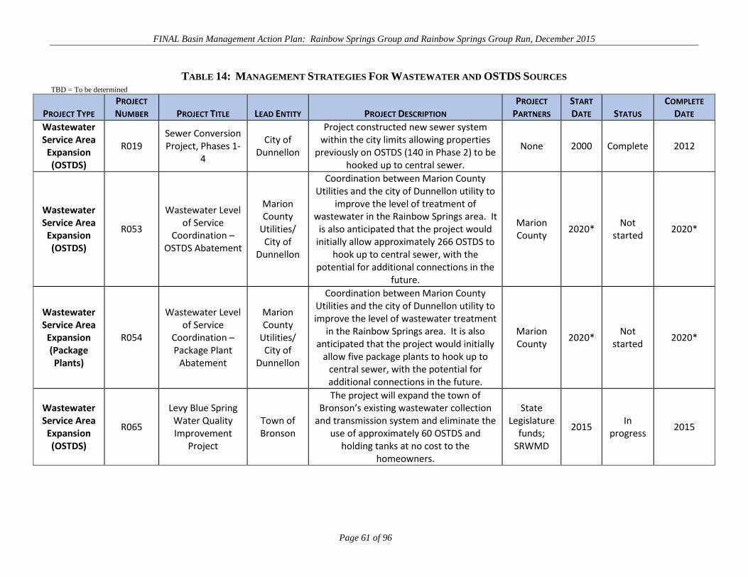
FINAL Basin Management Action Plan: Rainbow Springs Group and Rainbow Springs Group Run, December 2015
Page 61 of 96
TABLE 14: MANAGEMENT STRATEGIES FOR WASTEWATER AND OSTDS SOURCES TBD = To be determined
PROJECT TYPE PROJECT NUMBER PROJECT TITLE LEAD ENTITY PROJECT DESCRIPTION
PROJECT PARTNERS
START DATE STATUS
COMPLETE DATE
Wastewater Service Area
Expansion (OSTDS)
R019 Sewer Conversion Project, Phases 1-
4
City of Dunnellon
Project constructed new sewer system within the city limits allowing properties
previously on OSTDS (140 in Phase 2) to be hooked up to central sewer.
None 2000 Complete 2012
Wastewater Service Area
Expansion (OSTDS)
R053
Wastewater Level of Service
Coordination – OSTDS Abatement
Marion County
Utilities/ City of
Dunnellon
Coordination between Marion County Utilities and the city of Dunnellon utility to
improve the level of treatment of wastewater in the Rainbow Springs area. It
is also anticipated that the project would initially allow approximately 266 OSTDS to
hook up to central sewer, with the potential for additional connections in the
future.
Marion County
2020* Not
started 2020*
Wastewater Service Area
Expansion (Package Plants)
R054
Wastewater Level of Service
Coordination – Package Plant
Abatement
Marion County
Utilities/ City of
Dunnellon
Coordination between Marion County Utilities and the city of Dunnellon utility to improve the level of wastewater treatment
in the Rainbow Springs area. It is also anticipated that the project would initially
allow five package plants to hook up to central sewer, with the potential for additional connections in the future.
Marion County
2020* Not
started 2020*
Wastewater Service Area
Expansion (OSTDS)
R065
Levy Blue Spring Water Quality Improvement
Project
Town of Bronson
The project will expand the town of Bronson’s existing wastewater collection
and transmission system and eliminate the use of approximately 60 OSTDS and
holding tanks at no cost to the homeowners.
State Legislature
funds; SRWMD
2015 In
progress 2015

FINAL Basin Management Action Plan: Rainbow Springs Group and Rainbow Springs Group Run, December 2015
Page 62 of 96
PROJECT TYPE PROJECT NUMBER PROJECT TITLE LEAD ENTITY PROJECT DESCRIPTION
PROJECT PARTNERS
START DATE STATUS
COMPLETE DATE
Wastewater Service Area
Expansion (Planning)
R071 OSTDS 9-1-1
Strategy Departmen
t/FDOH
Develop a strategy for addressing OSTDS and other wastewater management issues.
Goal is to enhance communication and coordination among utilities and agencies.
Local utilities,
SJRWMD, SWFWMD, and other interested
parties
2015 Not
started 2018
Wastewater System
Upgrade R020
P301 Feasibility Phase -
Wastewater Disposal
Treatment Wetlands
SWFWMD Siting and feasibility assessment for
treatment wetlands to polish wastewater treatment plant (WWTP) effluent.
None 2014 In
progress 2015
Wastewater System
Upgrade R052
Wastewater Level of Service
Coordination – System Upgrade
Marion County
Utilities/ city of
Dunnellon
Coordination between Marion County Utilities and the city of Dunnellon utility to improve the level of wastewater treatment in the Rainbow Springs area. The project
would improve the existing level of treatment provided by the existing four
city treatment facilities by constructing a new facility that meets AWT standards.
Marion County
2020* Not
started 2020*
Wastewater System
Upgrade R055
P301 Design and Permitting Phase -
Wastewater Disposal
Treatment Wetlands
SWFWMD Design and permitting of treatment wetland(s) to polish WWTP effluent. None 2020*
Not started
2020*

FINAL Basin Management Action Plan: Rainbow Springs Group and Rainbow Springs Group Run, December 2015
Page 63 of 96
PROJECT TYPE PROJECT NUMBER PROJECT TITLE LEAD ENTITY PROJECT DESCRIPTION
PROJECT PARTNERS
START DATE STATUS
COMPLETE DATE
Wastewater System
Upgrade R056
P301 Implementation
Phase - Wastewater
Disposal Treatment Wetlands
SWFWMD Construction of treatment wetland(s) to
polish WWTP effluent. None 2020* Not
started 2020*
Wastewater System
Upgrade R057
Rio Vista WWTP Decommissioning
City of Dunnellon
Planned project will decommission the Rio Vista WWTP and convert an existing lift
station to pump wastewater to the Rainbow Springs Plant.
None 2014 Complete 2015
Wastewater System
Upgrade R072
Operational Improvements
Bay Laurel Center CDD
Operational staff have begun utilizing oxidation-reduction potential probes and cyclic aeration to provide denitrification.
None 2013 Ongoing Ongoing
Reuse Project R073 Public Access
Reuse Bay Laurel
Center CDD
The project was for the design and construction of a reclaimed water system,
including a pumping, storage, and distribution main that will provide
reclaimed water for irrigation at the On Top of the World and Candler Hills Golf
Courses.
None 2008 Complete 2010
Wastewater Collection
System Maintenance
R058 Rio Vista
Collection System Maintenance
City of Dunnellon
Companion project to the Rio Vista WWTP decommissioning. The collection system is subject to high infiltration into the system after storm events, resulting in overflows
from the plant holding pond.
None 2014 Complete 2015
Wastewater Collection
System Maintenance
R059
Supervisory Control and Data
Acquisition (SCADA)
Installation
City of Dunnellon
Planned phased project for installation of SCADA at city WWTPs followed by
installation at lift stations. None 2020*
Not started
2020*

FINAL Basin Management Action Plan: Rainbow Springs Group and Rainbow Springs Group Run, December 2015
Page 64 of 96
TABLE 15: MARION COUNTY WASTEWATER EFFLUENT STANDARDS FOR PRIMARY AND SECONDARY PROTECTION ZONES
Primary Protection Zone
DESIGNED AVERAGE DAILY FLOW (MGD)
RRLA EFFLUENT DISPOSAL SYSTEM
SLOW-RATE LAND
APPLICATION EFFLUENT DISPOSAL SYSTEM
PUBLIC ACCESS REUSE
EFFLUENT DISPOSAL SYSTEM
Greater than 0.5 mgd 3 mg/L 3 mg/L 10 mg/L Less than 0.5 mgd and greater than or equal to
0.01 mgd 3 mg/L 6 mg/L 10 mg/L
Less than 0.01 mgd 10 mg/L 10 mg/L 10 mg/L
Secondary Protection Zone
DESIGNED AVERAGE DAILY FLOW (MGD)
RRLA EFFLUENT DISPOSAL SYSTEM
SLOW-RATE LAND
APPLICATION EFFLUENT DISPOSAL SYSTEM
PUBLIC ACCESS REUSE
EFFLUENT DISPOSAL SYSTEM
Greater than or equal to 0.5 mgd 3 mg/L 3 mg/L 10 mg/L Less than 0.5 mgd but greater than or equal to
0.1 mgd 3 mg/L 6 mg/L 10 mg/L
Less than 0.1 mgd but greater than or equal to 0.01 mgd 6 mg/L 6 mg/L 10 mg/L
Less than 0.01 mgd 10 mg/L 10 mg/L 10 mg/L
4.3.2 PROPOSED WASTEWATER STANDARDS FOR THE RAINBOW RIVER BMAP AREA To provide regulatory consistency across the BMAP area, and to further improve wastewater
management to protect Rainbow Springs and River, the department will require the following in any
new or existing permit unless the facility can demonstrate reasonable assurance that the reuse or land
application of effluent (as specified in Appendix B) would not cause or contribute to a violation of the
0.35 mg/L nitrate concentration established by the Rainbow Springs TMDL. Should the department
concur with the reasonable assurance demonstration request, the TN effluent requirements established
here may be modified or waived. Based on currently available data and analysis, these effluent
limitation requirements are appropriate to protect ground water quality and prevent contribution to water
quality impairment in Rainbow Springs and Rainbow River.
Effluent standards are as follows:
1. Require the reporting of effluent discharge for TN.

FINAL Basin Management Action Plan: Rainbow Springs Group and Rainbow Springs Group Run, December 2015
Page 65 of 96
2. Require at least quarterly sampling of effluent discharge for TN.
3. In the Marion County Primary Protection Zone, apply the effluent standards set
forth in Table 15 as an annual average to all new and existing WWTFs that have
a permitted nutrient discharge.
4. Outside the Marion County Primary Protection Zone, apply an effluent standard
no greater than 6 mg/L TN as an annual average or discharge to a public reuse
system with an effluent standard of 10 mg/L TN as an annual average to all new
and existing WWTFs that have a permitted nutrient discharge and permitted
capacity of 10,000 gallons per day or greater.
5. Outside the Marion County Primary Protection Zone, WWTFs with a permitted
nutrient discharge and a permitted capacity less than 10,000 gallons per day
(gpd) apply an effluent standard no greater than 10 mg/L TN as an annual
average.
6. New effluent standards would take effect at the time of permit renewal or no
later than five years after BMAP adoption, whichever is sooner.
All WWTFs in Marion County using RRLA as a primary wastewater disposal method are required by
county code to investigate the practicality of increasing treatment (i.e., nitrogen removal), connecting to
a central sewer system, or converting to a slow-rate land application system or public access reuse
system. WWTFs in Levy County, located in the BMAP area, are encouraged to do the same.
4.3.3 NITROGEN LOADING FROM OSTDS OSTDS contribute 19% of the overall loading of TN that potentially enters the UFA across the entire
BMAP area. This makes OSTDS significant contributors to TN loading to the UFA. A total of 21,772
OSTDS were identified in the BMAP area, the vast majority (16,236 or 75%) of which are located in
Marion County. The remaining 5,536 OSTDS are in Levy County. Approximately 8% of OSTDS are
located in the Rainbow Springs Primary Protection Zone, as defined by Marion County.
Over 16,000 OSTDS are located in high-recharge areas. There are 4,568 OSTDS located in medium-
and high-density residential areas (>2 dwelling units per acre). Another 453 OSTDS are located in other
urban land uses. Combined, this represents 23% of OSTDS, over 90% of which are in high-recharge

FINAL Basin Management Action Plan: Rainbow Springs Group and Rainbow Springs Group Run, December 2015
Page 66 of 96
areas. In contrast, 13,374 OSDTS, or 61% of the total OSTDS in the BMAP area, are located in low-
density residential land uses. Nearly 70% of these are located in high-recharge areas.
Three service area expansion projects listed in Table 14 ( R019, R053, and R065) begin to address the
loading from OSTDS. Collectively, these projects will reduce the nitrogen loading from OSTDS by
11,140 lbs-N/yr, or 2.1% of the loading calculated at the land surface without attenuation. Project B040
is not included in the reduction; this conceptual project would allow material from pumped OSTDS to
be treated in the central sewer system in lieu of land application.
The city of Dunnellon has completed a Sewer Conversion Project, R019, that expanded sewer service
within the city limits, resulting in 140 OSTDS being connected to centralized sewer. The Levy Blue
Spring Water Quality Improvement, R065, is currently under way and will connect 60 OSTDS to city
centralized sewer. The project is a cooperative effort with the city of Bronson, SRWMD, and
department.
One of the projects, R053, is part of the wastewater coordination efforts between Marion County
Utilities and the city of Dunnellon. This conceptual plan would replace the existing city of Dunnellon
WWTFs with a single WWTF that meets AWT standards. The required collection system infrastructure
would also allow 266 OSDTS to be connected to the new plant. The collection system infrastructure
could also potentially be used to connect other areas currently being served by OSTDS to the new
WWTF in the future. At this time the plan is dependent on funding availability.
Local codes and permitting authority vary in the BMAP area. Current statutory language (Section
381.00655, F.S.) requires the owner of a properly functioning OSTDS to connect to sewer within 365
days of notification that central sewer is available for connection.
Under Marion County Land Development Code (Section 6.14.3, Onsite Waste Treatment and Disposal
Systems), activities that require a repair or modification permit from FDOH in Marion County for new,
modified, or repaired OSTDS are required to meet a minimum 24-inch separation between the bottom of
the drainfield and the estimated wettest season water table. This applies to all development, including
those OSTDS installed before 1983. New development in unincorporated Marion County is required to
connect to central sewer. Only vested developments may obtain OSTDS permits.
Technologies that are currently in use for nitrogen reduction are similar to secondary and advanced
secondary WWTFs. They include an aeration treatment step and generally an element of recirculation to
FINAL Basin Management Action Plan: Rainbow Springs Group and Rainbow Springs Group Run, December 2015
Page 67 of 96
increase nitrogen reduction. Several studies have indicated that such technologies can reduce nitrogen
concentration in the effluent of OSTDS by 50% to 70%. Currently, FDOH is working to develop
nitrogen reduction strategies for OSTDS, but this effort will most likely not be completed before the
BMAP is adopted. The preliminary results of field testing done at active home sites shows a 90% to
95% reduction of total nitrogen. FDOH is also characterizing nitrogen removal from effluent in the soil
underneath OSTDS and in the shallow ground water, as well as developing a nitrogen fate and transport
model that can be applied in conditions specific to Florida.
With financial support from the department, limited testing of three different alternative treatment
methods was performed at the University of Central Florida (UCF) Stormwater Academy. Design
methods included the use of a sand filter, an experimental bioabsorptive media filter (trademarked as
Bold and Gold), and a subsurface upflow wetland. The bioabsorptive media filter obtained a 70%
reduction in TN (Chang et al. 2011). Additionally, the department is evaluating the effectiveness of
drainfield amendments on the denitrification process. Any new OSTDS product or technology requires
approval by FDOH prior to installation.
FDOH updated the Florida Water Management Inventory starting in 2014 with the stated goal of
documenting and mapping the wastewater treatment method and source of drinking water for 6 million
improved land parcels in the state. The inventory was last completed in 2009. Marion County and
Alachua County are pilot counties for the inventory.
4.4 WASTEWATER MANAGEMENT STRATEGY
As population grows in the watershed, the question of how to address and direct the impacts of
wastewater disposal becomes more important. A more coordinated planning effort is needed. OSTDS
are one component of wastewater disposal but are also one of the more difficult sources of nitrogen
loading to the UFA to address. Solutions are complex and frequently controversial. Connection to
central sewer systems is sometimes considered the main option for addressing this source. However,
several factors, such as the cost-effectiveness of the sewering project and available WWTF capacity,
need to be considered. Conversely, OSTDS do provide needed wastewater treatment in areas where
central sewer is not economically feasible or practical.
There are other wastewater management concerns in the Rainbow Springs BMAP area besides OSTDS.
Some of the small WWTFs evaluated under the NSILT contribute large loadings of nitrogen relative to
the size of their discharge, and so there is a need to develop better solutions for poorly performing

FINAL Basin Management Action Plan: Rainbow Springs Group and Rainbow Springs Group Run, December 2015
Page 68 of 96
WWTFs. Local government regulations applicable to wastewater management, including effluent
quality standards, vary between jurisdictions.
The wastewater coordination efforts between Marion County Utilities and the city of Dunnellon
(Projects R052, R053, and R054) have resulted in a conceptual framework to address wastewater issues
in the immediate vicinity of Rainbow Springs. However, wastewater management concerns extend
throughout the BMAP area.
Given the complexity and scope of the issues related to OSTDS and other wastewater management
issues, the best course of action was to use the BMAP process to more fully develop an integrated
wastewater management strategy applicable to the entire BMAP area. Project R071, OSTDS 9-1-1
Strategy, will be initiated within three months after the adoption of the BMAP and completed no later
than 30 months after initiation. The primary purpose of this project is to identify effective, financially
feasible strategies that address the current and future nitrogen loading from OSTDS as well as other
wastewater sources. The project goal is enhanced coordination and communication among utilities, the
public, and responsible agencies in the Rainbow Springs BMAP area that results in the better
management of nitrogen from wastewater sources. The timing of the implementation of project
components may change, depending on legislative mandates and allowances or other unforeseen
extenuating circumstances interfering with that schedule.
The basic elements that the strategy will address include (but are not limited to) BMAP area–specific
wastewater effluent standards, the prioritization of geographic areas of concern, upgrades to existing
treatment systems, connection to central sewer, alternative solutions to central sewer, and education and
outreach. An effective public education and outreach component will strengthen the overall wastewater
management strategy.
The department, with assistance from Marion County and FDOH, will facilitate the organization of an
Advisory Committee with representation from vested interests such as private and public utilities, local
governments, community development districts (CDDs), homeowners, Rainbow River Conservation,
businesses, and other interested parties. Because a portion of the Rainbow Springs BMAP area includes
a ground water contributing area that overlaps with the Silver Springs ground water contributing area,
and Marion County is affected by the requirements for both springs’ BMAPs, this committee will be a
joint committee with Silver Springs.

FINAL Basin Management Action Plan: Rainbow Springs Group and Rainbow Springs Group Run, December 2015
Page 69 of 96
The Advisory Committee will, as part of the BMAP implementation of Project R071, OSTDS 9-1-1
Strategy, build on existing utility management plans and studies to develop agreed-on priorities for
connecting OSTDS to central sewer and to develop solutions for areas where central sewer is not
feasible. The three main objectives of the Advisory Committee are to (1) collect and evaluate existing
plans, priorities, and studies to build a framework with priority projects for funding and identify missing
parts or conflicts in that framework; (2) develop a wastewater management plan that includes the
identification and development of projects that reduce nitrogen loadings from wastewater including
OSTDS; and (3) develop a public education plan that at a minimum provides area residents with reliable
and understandable information about the impacts of nitrogen loading on Rainbow Springs and proper
and effective wastewater management.
The project is intended to supplement and support local efforts to improve wastewater management and
not delay their implementation. Local stakeholders are encouraged to submit projects that address
needed wastewater improvements for financial support or initiation at any time during Project R071.
Completed studies and existing ordinances provide direction for the scope of the project. Public
education and outreach is identified by stakeholders as a priority component of this project, and efforts
will begin upon its initiation. The expected project outcome is a management plan that will be used to
identify actions and projects that local utilities can implement before the start of the second phase of the
BMAP.
The three objectives that this project will address as part of its overall management strategy are outlined
below with expected deliverables and general time frames:
Objective 1: Data Collection
Finalize project definition and scoping.
Update the OSTDS geographic distribution map and database for the BMAP area.
Update WWTF location, level of treatment information, and facility-related
information.
Compile and update existing or planned wastewater utility jurisdictions and their
wastewater collection infrastructure data.
Compile and summarize existing ordinances, statutes, and studies related to OSTDS
and wastewater management in the BMAP area.
FINAL Basin Management Action Plan: Rainbow Springs Group and Rainbow Springs Group Run, December 2015
Page 70 of 96
Deliverable: These tasks will be completed as soon as possible and no later than one
year after project initiation and will generate a refined project scope as well as drafts of
an OSTDS geographic map and database, a sewer collection system database, and the
compilation of existing ordinances and results of studies for the BMAP area that can be
shared between participating stakeholders and used for decision making.
Objective 2: Analysis and Prioritization
Identify and prioritize locations where wastewater loadings from WWTFs and
OSTDS are a concern for water quality in the UFA or surface waters and should be
addressed.
Identify and prioritize potential actions that remediate the effects of wastewater on the
quality of ground water or surface water.
Identify and prioritize locations where the connection of OSTDS to central sewer is
the preferred and appropriate management strategy.
Identify potential funding sources for proposed actions.
Deliverable: Analysis and prioritization will be completed as soon as possible and no
later than the end of the 30-month project. The products of this element are a
Management Plan for wastewater and agreement among cooperating entities on
projects/actions that meet the implementation requirement of the management plan.
Projects will be initiated as funding becomes available based on the prioritization agreed
upon by the cooperating entities but no later than five years from BMAP adoption.
Objective 3: Public Education and Outreach
Compile information about existing education and outreach efforts in the BMAP
area—in particular, what has been successful and what are the strengths and
weaknesses of these efforts.
Coordinate BMAP area outreach efforts with state level OSTDS education and
outreach initiatives.
Design an outreach effort that explains to landowners proper wastewater
management, including, but not limited to, how an OSTDS works; the proper
maintenance of an OSTDS; the impacts of fats, oil, and grease (FOG) on collection

FINAL Basin Management Action Plan: Rainbow Springs Group and Rainbow Springs Group Run, December 2015
Page 71 of 96
systems; potential impacts to ground water and surface water quality; and where and
why OSTDS should be upgraded to a better treatment system or removed.
Information collected from existing education and outreach efforts as well as
information obtained from Objectives 1 and 2 will be helpful for designing the
outreach effort.
Deliverable: The compilation of existing program information and drafting of education
outreach effort will be completed within one year after project initiation. The entire
public education and outreach program will be finalized by the end of the 30-month
project. Implementation of education and outreach efforts will be ongoing throughout the
duration of the project.
4.5 URBAN FERTILIZER
There is limited surface water drainage in the BMAP area, and nitrogen washed off the land surface in
stormwater runoff enters ground water via percolation through drainage retention areas, sinkholes,
stormwater ponds, or natural areas where runoff collects. Nitrogen from fertilizer can also infiltrate into
ground water directly where it is applied.
Stormwater managers agreed to a set of Guiding Principles summarized in Table 16 as a mechanism to
direct future actions and the selection of projects to address stormwater sources. These principles
include recommendations for source control. They are intended to supplement and support the
implementation of the Rainbow Springs BMAP.
The nitrogen loading contribution from urban fertilizer was calculated from urban land uses, including
residential, commercial, parks and recreational areas, and golf courses. The NSILT identifies urban
fertilizer as contributing about 6% of the nitrogen loading to the UFA.
Four categories of management actions were identified that reduce the impacts of urban fertilizer.
Management categories include installing structural BMPs to reduce the loading from urban stormwater,
operating and maintaining structural BMPs (such as cleaning), sweeping streets, and public education
and outreach.

FINAL Basin Management Action Plan: Rainbow Springs Group and Rainbow Springs Group Run, December 2015
Page 72 of 96
TABLE 16: GUIDING PRINCIPLES FOR URBAN FERTILIZER
Stormwater
Stakeholders are encouraged to implement, where feasible, emerging stormwater treatment
technologies or innovative implementations of more established technologies that offer improved
nitrogen treatment efficiency over typical stormwater treatment practices, in new facilities or as
retrofits of existing facilities in areas of high nitrogen load. The department may be able to
provide guidance in stormwater management technology and financial support through grants.
To focus efforts in areas of high nitrogen loading, stakeholders are encouraged to use the NSILT
or develop their own methods to determine areas of high nitrogen loading.
To focus efforts in areas of high nitrogen loading, stakeholders are encouraged to develop
decision-making processes to prioritize potential stormwater retrofit projects. These prioritization
processes can be included in the BMAP as projects. The following factors are provided as
guidance: o The feasibility of improving the treatment of nitrogen over what is currently provided by existing
facilities or the absence of facilities.
o The potential reduction in nitrogen versus cost ($/lbs/yr or similar method),
o The location of the project in a high-recharge area as identified in the nitrogen source inventory (NSI) or
other similar analysis.
Source Control
Stakeholders are encouraged to participate in public outreach and education programs that make
information available to residents in urban areas regarding methods they can take to reduce
nitrogen sources and protect Rainbow Springs. Efforts that are not communitywide should be
directed towards areas of high loading.
Stakeholders are encouraged to consider implementing ordinances and regulations that address the
overapplication of nitrogen from fertilizer in urban areas, including golf courses.
o Operators of golf courses should implement the practices in the department’s BMP manual for golf
courses.
o Operators of golf courses and other entities, such as homeowner associations, using reuse water should
learn how to properly adjust the fertilizer application rate to account for nitrogen supplied through reuse
water.
Total reductions for education and outreach were calculated by applying an approach that allows up to a
6% credit based on the total urban fertilizer loading, provided that specific program elements are
present. Table 17 outlines this approach. Urban fertilizer loading was apportioned to entities based on
the percent area of urban land in their jurisdiction contributing to the overall loading, as calculated by
the NSILT.

FINAL Basin Management Action Plan: Rainbow Springs Group and Rainbow Springs Group Run, December 2015
Page 73 of 96
TABLE 17: CREDITING APPROACH APPLIED FOR PUBLIC EDUCATION CREDITS ACTIVITY PERCENT CREDIT
Florida Yards and Neighborhood (FYN) Program 3% Local Codes and Ordinances 2% total for all four
Landscaping 0.5% Irrigation 0.5% Fertilizer 0.5% Pet Waste Management 0.5%
Public Service Announcement (PSA) 0.25% Informational Pamphlets 0.25% Website 0.25% Inspection Program and Call-In Number for Illicit Discharges 0.25%
Table 18 summarizes 44 projects to address the reduction in nitrogen loading from urban fertilizer.
Overall, the management actions undertaken in the BMAP area will reduce nitrogen loading to the land
surface by 41,771 lbs-N/yr, or about 7.3% of the loading calculated at the land surface without
attenuation.
Stormwater managers agreed to include only those dry retention structural BMPs that were retrofits to
better nitrogen removal technologies or located on soils that provided a net removal of nitrogen—largely
poorly drained soils. The largest measurable single reduction in nitrogen loading from a single project
was achieved by FDOT (10,285 lbs-N/yr) through the cessation of fertilizer use on the medians and
rights-of-way of state-maintained roadways in Marion County. The reuse of effluent from the WWTF in
the On Top of the World development reduced nitrogen load 6,025 lbs-N/yr by offsetting the use of
fertilizer. The reduction from fertilizer cessation in Levy County will be quantified later.
Marion County has completed stormwater management projects that utilize bioabsorptive media to
reduce nitrogen loading and have other projects planned for the first BMAP phase. Project R063
proposes the use of a patented bioabsorptive media, Bold and Gold, to enhance nitrogen removal under
three priority drainage retention areas (stormwater ponds).
Education and outreach activities comprise 28 projects. Their contribution to the loading reduction was
estimated based on applying appropriate education credits for each entity to the land surface loading
from urban fertilizer in the BMAP area, based on the crediting approach outlined in Table 17. Those
local entities with MS4 permits have education and outreach as one of the requirements of their permits.
Overall, the credits obtained by all education and outreach activities are greater than any other
management category.

FINAL Basin Management Action Plan: Rainbow Springs Group and Rainbow Springs Group Run, December 2015
Page 74 of 96
There is support among stormwater managers in both the Rainbow Springs and Silver Springs BMAP
areas for a more coordinated education and outreach approach for spring-related materials. The
formation of a public education coordination team facilitated by Marion County and consisting of
representatives from local government, state agencies, WMDs, and local interest groups is proposed to
meet this interest (Project B036). The coordination team will be a joint effort between both BMAP
areas. The purpose of the group would be to ensure that citizens are provided with consistent and
accurate information about the impacts of stormwater runoff on spring water quality as well as advice on
protecting and restoring Rainbow Springs. The project will maximize outreach efforts among
coordination team members and enhance communication between team members.

FINAL Basin Management Action Plan: Rainbow Springs Group and Rainbow Springs Group Run, December 2015
Page 75 of 96
TABLE 18: MANAGEMENT STRATEGIES FOR URBAN FERTILIZER SOURCES TBD = To be determined.
PROJECT TYPE PROJECT NUMBER PROJECT TITLE LEAD ENTITY PROJECT DESCRIPTION
PROJECT PARTNERS
START DATE STATUS
COMPLETE DATE
Urban Structural
BMP R011
Village of Rainbow Springs
Stormwater Retrofit
Marion County Office of the County
Engineer
Retrofit of an existing drainage retention area with aerobic filtration cells for conversion of TN to nitrate and an
infiltration cell lined with Bold and Gold for nitrate removal. The project also
includes a stormwater wetland to treat runoff discharged into the Section 16 lake.
SWFWMD 2014 Complete 2015
Urban Structural
BMP R015
Rainbow Springs
Country Club Estates
Stormwater Retrofit
Marion County Office of the County
Engineer
Expansion and conversion of an existing retention pond to a wetland/wet
retention pond to enhance nitrate removal from runoff generated from the
county road, a golf course, and residential land uses.
SWFWMD 2012 Complete 2012
Urban Structural
BMP R016
Rainbow Park Unit 8
Stormwater Retrofit
Marion County Office of the County
Engineer
Construction of three wet detention ponds to provide treatment of runoff prior
to discharge to a relic karst feature and isolated surface wetlands.
SWFWMD 2012 Complete 2013
Urban Structural
BMP R017
Rolling Hills unit 5
Stormwater Retrofit
Marion County Office of the County
Engineer
Construction of an interconnected system of four retention ponds and one wet retention ponds to treat stormwater runoff from roads, residential, and
agricultural land uses.
SWFWMD 2012 Complete 2013

FINAL Basin Management Action Plan: Rainbow Springs Group and Rainbow Springs Group Run, December 2015
Page 76 of 96
PROJECT TYPE PROJECT NUMBER PROJECT TITLE LEAD ENTITY PROJECT DESCRIPTION
PROJECT PARTNERS
START DATE STATUS
COMPLETE DATE
Urban Structural
BMP R051
Bold and Gold Stormwater Retrofits in
Rainbow Springs BMAP
Area
Marion County Office of the County
Engineer
Project proposes $1,400,000 through fiscal year 2019 for retrofit of county-
owned drainage retention areas (DRAs) in the Rainbow Springs BMAP area. The
number and location of DRAs retrofitted will depend on several factors, including
potential load reductions, land availability, and location in priority focus areas
identified in the BMAP. The project is currently in the preliminary scoping stages
and is identified in the adopted 2014 Stormwater Implementation Plan.
None 2015 Planned 2019
Urban Structural
BMP R063
Rainbow Springs 5th
Replat Stormwater
Retrofit
Marion County Office of the County
Engineer
This project will retrofit three drainage retention areas in Rainbow Springs 5th Replat with the nitrogen-reducing Bold
and Gold media. It is estimated that this retrofit will prevent 250 pounds of TN
from reaching the aquifer annually.
None 2016 Not
started 2016
Urban Structural
BMP B022
State Road (SR) 40 Design
Project-Pond 3
FDOT District 5
238719-1, SR 40 from County Road (CR) 328 to SW 80th Ave (CR 225A) - Pond
3/Dry Retention-Closed basin in poorly drained soils
Not Applicable 2014 In
progress 2020
Urban Structural
BMP B023
SR40 Design Project-Pond 4
FDOT District 5
238719-1, SR 40 from CR 328 to SW 80th Ave (CR 225A) - Pond 4/Dry Retention-
Closed basin in poorly drained soils Not Applicable 2014
In progress
2020
Urban Structural
BMP B024
SR40 Design Project-Pond 5
FDOT District 5
238719-1, SR 40 from CR 328 to SW 80th Ave (CR 225A) - Pond 5/Dry Retention-
Closed basin in poorly drained soils Not Applicable 2014
In progress
2020
Urban Structural
BMP B025
SR40 Design Project-Pond 6
FDOT District 5
238719-1, SR 40 from CR 328 to SW 80th Ave (CR 225A) - Pond 6/Dry Retention-
Closed basin in poorly drained soils Not Applicable 2014
In progress
2020
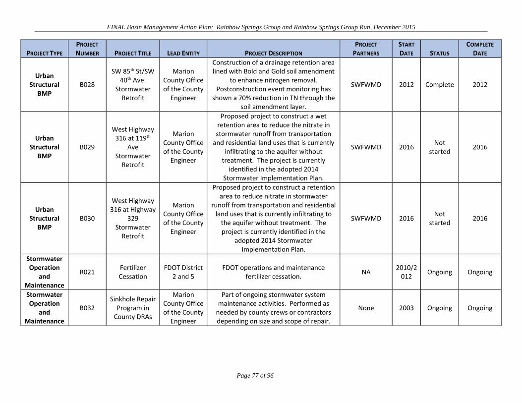
FINAL Basin Management Action Plan: Rainbow Springs Group and Rainbow Springs Group Run, December 2015
Page 77 of 96
PROJECT TYPE PROJECT NUMBER PROJECT TITLE LEAD ENTITY PROJECT DESCRIPTION
PROJECT PARTNERS
START DATE STATUS
COMPLETE DATE
Urban Structural
BMP B028
SW 85th St/SW 40th Ave.
Stormwater Retrofit
Marion County Office of the County
Engineer
Construction of a drainage retention area lined with Bold and Gold soil amendment
to enhance nitrogen removal. Postconstruction event monitoring has
shown a 70% reduction in TN through the soil amendment layer.
SWFWMD 2012 Complete 2012
Urban Structural
BMP B029
West Highway 316 at 119th
Ave Stormwater
Retrofit
Marion County Office of the County
Engineer
Proposed project to construct a wet retention area to reduce the nitrate in stormwater runoff from transportation
and residential land uses that is currently infiltrating to the aquifer without
treatment. The project is currently identified in the adopted 2014
Stormwater Implementation Plan.
SWFWMD 2016 Not
started 2016
Urban Structural
BMP B030
West Highway 316 at Highway
329 Stormwater
Retrofit
Marion County Office of the County
Engineer
Proposed project to construct a retention area to reduce nitrate in stormwater
runoff from transportation and residential land uses that is currently infiltrating to
the aquifer without treatment. The project is currently identified in the
adopted 2014 Stormwater Implementation Plan.
SWFWMD 2016 Not
started 2016
Stormwater Operation
and Maintenance
R021 Fertilizer Cessation
FDOT District 2 and 5
FDOT operations and maintenance fertilizer cessation. NA
2010/2012
Ongoing Ongoing
Stormwater Operation
and Maintenance
B032 Sinkhole Repair
Program in County DRAs
Marion County Office of the County
Engineer
Part of ongoing stormwater system maintenance activities. Performed as
needed by county crews or contractors depending on size and scope of repair.
None 2003 Ongoing Ongoing

FINAL Basin Management Action Plan: Rainbow Springs Group and Rainbow Springs Group Run, December 2015
Page 78 of 96
PROJECT TYPE PROJECT NUMBER PROJECT TITLE LEAD ENTITY PROJECT DESCRIPTION
PROJECT PARTNERS
START DATE STATUS
COMPLETE DATE
Street Sweeping
B033
Street Sweeping of
Marion County Roads
Marion County Office of the County
Engineer
Sweeping of Marion County–maintained roads. Sweeping of roads with curb and gutter is completed nine times per year. Benefits: Remove debris, sediment, and
potential pollutants from streets. Prevent entry into storm sewer system.
None 2003 Ongoing Ongoing
Education and
Outreach R024
Efficient Irrigation
Workshops SWFWMD
Community presentations on efficient irrigation practices.
Florida Irrigation Society
2005 Complete 2005
Education and
Outreach R025
Florida-Friendly Landscaping Coordinator
SWFWMD
University of Florida (UF) Florida-Friendly Landscaping™ (FFL) Program educates
homeowners about how to design, install, and maintain healthy landscapes that use
a minimum of water, fertilizer, and pesticides. SWFWMD funds programs in 11 of its 16 counties in partnership with county governments and the university.
UF, Marion County
2004 Complete 2013
Education and
Outreach R026
Restoring Our Springs! media
campaign SWFWMD
Public service advertising to promote SWFWMD’s “Restoring Our Springs!”
media campaign. Advertising will be in Citrus, Hernando and Marion Counties and will direct people to "Join us in the
community effort to restore our springs."
None 2014 Complete 2014
Education and
Outreach R027
Newspaper in Education: Springs in
west-central Florida
SWFWMD
An in-depth look at springs in west-central Florida through a Newspaper in Education
produced by the Tampa Bay Times. Distributed to middle school students in
Citrus, Hernando, and Marion Counties as well as Tampa Bay Times and Citrus
County Chronicle readers.
None 2013 Complete 2014

FINAL Basin Management Action Plan: Rainbow Springs Group and Rainbow Springs Group Run, December 2015
Page 79 of 96
PROJECT TYPE PROJECT NUMBER PROJECT TITLE LEAD ENTITY PROJECT DESCRIPTION
PROJECT PARTNERS
START DATE STATUS
COMPLETE DATE
Education and
Outreach R028
Crystal River/King's
Bay/Rainbow River Public
Service Advertising
SWFWMD
Messaging on how residents can help protect the quality of local springs through the proper application of fertilizer. Social
research was used to help develop messages.
None 2007 Complete 2011
Education and
Outreach R029
Crystal River/King's
Bay/Rainbow River Outreach
Coordinator
SWFWMD
Education effort to reduce water quality impacts from landscaping and other
homeowner practices—such as overfertilization and leaky OSTDS—that increase nitrates in springs. Targeted
homeowners, landscape professionals, retail outlets, OSTDS maintenance companies, and others. Included
education effort titled "You want your lawn green, not your water. Don't
overfertilize."
None 2008 Complete 2011
Education and
Outreach R030
Marion County Springs Festival
Sponsorship SWFWMD
Event to educate the public on the protection of Marion County's springs and other water resources. Event alternates between Rainbow Springs State Park and
Silver Springs State Park.
None 2006 Complete 2014
Education and
Outreach R031
Marion County Master
Gardeners Spring Festival Sponsorship
SWFWMD
Festival supporting FFL outreach and education, including a focus on water conservation, watersheds, and water
quality.
None 2000 Complete 2011
Education and
Outreach R032
Springs Awareness
Week - Springs Neighborhood
Challenge
SWFWMD
A one-day workshop taught participants about water quality issues specific to
Rainbow Springs and Crystal River/Kings Bay. Proper fertilizer application was a
main focus of the workshop.
Howard T. Odum Florida
Springs Institute
2011 Complete 2011

FINAL Basin Management Action Plan: Rainbow Springs Group and Rainbow Springs Group Run, December 2015
Page 80 of 96
PROJECT TYPE PROJECT NUMBER PROJECT TITLE LEAD ENTITY PROJECT DESCRIPTION
PROJECT PARTNERS
START DATE STATUS
COMPLETE DATE
Education and
Outreach R033
Get Out and Explore Marion County Springs
SWFWMD
Guided canoe trip, hiking trip, and water quality demonstration to educate
residents about aquatic ecology, karst geology, native and invasive plants, water sampling, and human impacts to springs.
Marion County UF–IFAS
Extension Office
2012 Complete 2012
Education and
Outreach R034
Marion County Earth Day
SWFWMD This one-day event educated Marion
County residents about springs and water quality protection.
Marion County UF–IFAS
Extension Office
2011 Complete 2011
Education and
Outreach R035
Microirrigation workshops
SWFWMD
Through three educational workshops and the distribution of microirrigation kits, this
project educated homeowners living in 55+ communities about FFL principles and
the benefits of using microirrigation.
Marion County Office of the
County Engineer
2011 Complete 2011
Education and
Outreach R037
Soil Analysis by UF
SWFWMD
Up to 200 soil analysis tests were conducted as part of the Crystal River/King's Bay/Rainbow River Watershed Education Project.
UF–IFAS 2010 Complete 2010
Education and
Outreach R038
Best Management
Practices Awareness Campaign
SWFWMD
This project educated equine enthusiasts on the importance of protecting water resources to ensure water quality by
utilizing proper manure management, fertilization techniques, and water
conservation practices.
Marion Soil and Water
Conservation District
2010 Complete 2010
Education and
Outreach R039
Florida-Friendly Landscaping
Expo SWFWMD
This project encouraged Marion County homeowners to reduce water use by
incorporating FFL principles.
Marion County UF–IFAS
Extension Office
2010 Complete 2010
Education and
Outreach R041
Storm drain markers
SWFWMD Storm drain markers will be purchased to
conduct storm drain marking events in Marion County.
Rainbow River Conservation; Boy Scouts of
America
2009 Complete 2009

FINAL Basin Management Action Plan: Rainbow Springs Group and Rainbow Springs Group Run, December 2015
Page 81 of 96
PROJECT TYPE PROJECT NUMBER PROJECT TITLE LEAD ENTITY PROJECT DESCRIPTION
PROJECT PARTNERS
START DATE STATUS
COMPLETE DATE
Education and
Outreach R042
Community Landscape/ Irrigation
Evaluation Specialist
SWFWMD
Consultant evaluated 10 locations in five counties, including Marion, and made
recommendations for water conservation in community landscapes and irrigation.
None 2009 Complete 2009
Education and
Outreach R043
Rainbow River Springshed
Tour SWFWMD
An educational program to inform local officials, homeowners, retail store
managers and lawn care providers of how fertilizer impacts the local springshed.
None 2009 Complete 2009
Education and
Outreach R045
Florida Friendly Demonstration Garden at the
Dunnellon Library
SWFWMD
FFL Demonstration Garden was installed to educate visitors to the Dunnellon
Library about the benefits of FFL principles.
Friends of the Dunnellon
Library 2009 Complete 2009
Education and
Outreach R047
Transferring Development
Rights for Watershed Protection
SWFWMD
Through a series of five workshops, landowners, developers, and citizens were educated about the TDR Program and the Farmland Preservation Area in Northwest
Marion County.
Marion County Citizens
Coalition, Inc. 2007 Complete 2007
Education and
Outreach R048
FYN Program -Color in the Landscape
Spring Festival
SWFWMD This FFL festival provided information
workshops on practices.
Marion County UF–IFAS
Extension Office
2006 Complete 2006
Education and
Outreach R049
Splash! grants to teachers in
Marion County SWFWMD
Various water resources grants; most projects were directly related to
education about Rainbow Springs.
Marion County School District 2007 Complete 2013
Education and
Outreach R050
Dunnellon High School Legacy
Program SWFWMD
The program taught students basic land management techniques. Students also educated the community, including the promotion of springshed protection. In
2007, educational signage about watershed protection was placed in kiosks
at drop-in and take-out tubing sites at Rainbow River State Park.
Marion County School District 2004 Complete 2007
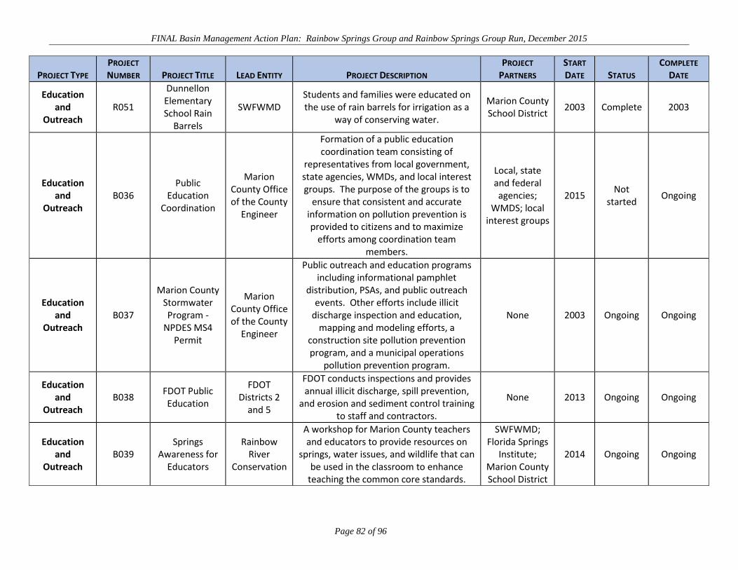
FINAL Basin Management Action Plan: Rainbow Springs Group and Rainbow Springs Group Run, December 2015
Page 82 of 96
PROJECT TYPE PROJECT NUMBER PROJECT TITLE LEAD ENTITY PROJECT DESCRIPTION
PROJECT PARTNERS
START DATE STATUS
COMPLETE DATE
Education and
Outreach R051
Dunnellon Elementary School Rain
Barrels
SWFWMD Students and families were educated on the use of rain barrels for irrigation as a
way of conserving water.
Marion County School District 2003 Complete 2003
Education and
Outreach B036
Public Education
Coordination
Marion County Office of the County
Engineer
Formation of a public education coordination team consisting of
representatives from local government, state agencies, WMDs, and local interest groups. The purpose of the groups is to
ensure that consistent and accurate information on pollution prevention is provided to citizens and to maximize
efforts among coordination team members.
Local, state and federal agencies;
WMDS; local interest groups
2015 Not
started Ongoing
Education and
Outreach B037
Marion County Stormwater Program -
NPDES MS4 Permit
Marion County Office of the County
Engineer
Public outreach and education programs including informational pamphlet
distribution, PSAs, and public outreach events. Other efforts include illicit
discharge inspection and education, mapping and modeling efforts, a
construction site pollution prevention program, and a municipal operations
pollution prevention program.
None 2003 Ongoing Ongoing
Education and
Outreach B038
FDOT Public Education
FDOT Districts 2
and 5
FDOT conducts inspections and provides annual illicit discharge, spill prevention,
and erosion and sediment control training to staff and contractors.
None 2013 Ongoing Ongoing
Education and
Outreach B039
Springs Awareness for
Educators
Rainbow River
Conservation
A workshop for Marion County teachers and educators to provide resources on
springs, water issues, and wildlife that can be used in the classroom to enhance
teaching the common core standards.
SWFWMD; Florida Springs
Institute; Marion County School District
2014 Ongoing Ongoing
FINAL Basin Management Action Plan: Rainbow Springs Group and Rainbow Springs Group Run, December 2015
Page 83 of 96
Chapter 5: ASSESSING PROGRESS AND MAKING CHANGES
This chapter summarizes the goals of this BMAP and outlines the steps stakeholders will take to track
progress in implementing projects and observing the results of those projects in BMAP waterbodies. It
also summarizes information about grants or loans available for the implementation of projects.
5.1 SUFFICIENCY OF EFFORT
The BMAP represents a “sufficient effort” or commitment by stakeholders to restore water quality to
Rainbow Springs and the Rainbow River. It is recognized by stakeholders that no one management
action will restore water quality in Rainbow Springs and the Rainbow River. Stakeholders agreed that
the entire BMAP area should be considered when identifying loading reduction management actions.
This decision was based on the acknowledgment that all stakeholders have a shared responsibility in
restoring Rainbow Springs and the Rainbow River and should have at least a minimal level of
involvement in the restoration process.
Load reductions at the land surface are expected to reduce nitrate concentrations in Rainbow Springs.
Existing monitoring efforts in the springs and Rainbow River will be used to support the progress made
toward achieving the TMDL target nitrate concentration. This chapter also discusses a process for
communicating progress information among the Basin Working Group (BWG) members.
Sufficiency of effort is evaluated in several ways. The first is ensuring that all potential source
categories of TN loading identified in the NSILT are addressed with projects and, second, ensuring that
stakeholders located in the BMAP area participate in the BMAP process. This BMAP summarizes the
number of projects, the TN sources that they address, and project status. Conservation lands were not
explicitly evaluated with the NSILT, but were included as projects because stakeholders agreed that they
are an important tool for protecting water quality and preventing some future loading.
There are projects completed or under way as well as planned or conceptual projects for each of the
source categories. Table 19 summarizes the pounds of nitrogen loading removed by the management
actions proposed for each source category. The percent reduction in loading is calculated from the
nitrogen loading applied at the land surface and not at the top of the UFA. The greatest reductions in
nitrogen loading are achieved by reducing agricultural and urban fertilizer sources; however, all source
categories have contributed nitrogen loading reductions.

FINAL Basin Management Action Plan: Rainbow Springs Group and Rainbow Springs Group Run, December 2015
Page 84 of 96
TABLE 19: LOADING REDUCTIONS BY SOURCE CATEGORY 1 Includes credit for education and outreach efforts by stakeholders and reuse of effluent from WWTFs.
2 Currently 46.8% of acreage covered by a NOI. 3 Number of agriculture projects represents activities that are in addition to BMP enrollment.
SOURCE CATEGORY
NUMBER OF PROJECTS
ADDRESSING SOURCE
TN LOADING REDUCTION (LBS-N/YR)
TN LOADING AT LAND SURFACE
(LBS-N/YR) PERCENT
REDUCTION Urban Fertilizer1 44 41,771 493,558 8.5%
Wastewater 10 17,811 64,216 27.7% OSTDS 4 11,140 526,687 2.1%
Agriculture2 7 3 754,375 9,519,891 7.9%
The second evaluation of sufficiency considers the number of projects that will result in large loading
reductions, address sources close to the springs, or pursue innovative technologies that produce larger
reductions for the specific project type than typically expected. These types of projects are
representative of a long-term commitment to improving the water quality of Rainbow Springs and the
Rainbow River, and they support the Guiding Principles outlined in the BMAP. The projects meeting
these criteria are as follows:
The wastewater coordination efforts (Projects R052, R053, and R054) between
Marion County Utilities and the city of Dunnellon have resulted in a conceptual
framework to improve WWTFs nearest the springs to AWT standards for TN and
connect the package plants nearest the springs to a new treatment plant. The
necessary collection system infrastructure would connect 266 OSTDS to centralized
sewer, with the potential for many more to be connected in the future.
Marion County has completed projects that utilize bioabsorptive media to reduce
nitrogen loading and has other projects planned for the first BMAP phase. Project
R063 proposes the use of a patented bioabsorptive media, Bold and Gold, to enhance
nitrogen removal under three priority drainage retention areas (stormwater ponds). In
addition, Marion County has proposed funds for future projects through 2019 (Project
R051).
FDACS is targeting cost-share funding for springs protection with an emphasis on
enrolling agricultural operations in high-recharge areas, and Marion County supports
the Clean Farms Initiative and Water Quality Education and Equine Farm BMPs
outreach (Projects B010, B041, and B011). FDACS will review its rule-adopted

FINAL Basin Management Action Plan: Rainbow Springs Group and Rainbow Springs Group Run, December 2015
Page 85 of 96
cow/calf and equine BMPs to identify the practices likely to have the greatest nutrient
load reduction benefits (Project B043).
The final measure of sufficiency is considered if the BMAP has next steps or a path forward, so that
management actions to reduce nitrogen loading continue and strengthen as the BMAP process moves
into later phases. An initiative (listed as a project) was created to address each of the major
anthropogenic sources, as follows:
OSTDS and other wastewater issues are addressed through the wastewater
management project OSTDS-9-1-1 Strategy, Project R071.
Public Education Coordination, Project B036, addresses public education and
outreach related to stormwater impacts.
The implementation of an outreach program for the Small Farm Equine BMP Manual
(Project B012) in collaboration with FDACS, Marion County, and other stakeholders.
Guiding principles developed for the source categories of wastewater—OSTDS, urban fertilizer, and
agriculture—cover all the anthropogenic sources. These principles support the three BMAP initiatives
described above and provide guidance for the BMAP process. Although these principles are not
requirements, they do provide stakeholders with recommended outcomes for management actions.
The management actions outlined in this BMAP, as well as the proposed management initiatives,
provide sufficient direction for this BMAP to reduce nitrogen loading to Rainbow Springs and the
Rainbow River. The Guiding Principles and BMAP initiatives help to define additional management
needs that support the restoration of water quality in Rainbow Springs and the Rainbow River.
Monitoring plans outlined in Section 5.2 and the SWFWMD Springs Initiative provide for additional
information and advancement of knowledge about the system to allow for adaptive changes to the
management actions outlined in this BMAP and the initiation of additional actions as supported by data.
5.2 MONITORING WATER QUALITY
The existing SWFWMD monitoring network will support the evaluation of progress made toward
achieving the TMDL target nitrate concentration of 0.35 mg/L. The sampling locations identified in this
chapter represent the minimum requirements needed to achieve this purpose. The monitoring strategy
includes the following two distinct sampling networks:

FINAL Basin Management Action Plan: Rainbow Springs Group and Rainbow Springs Group Run, December 2015
Page 86 of 96
Surface Water Network – Purpose is to evaluate the water quality of Rainbow
Springs and the Rainbow River and identify and track changes.
Ground Water Network – Purpose is to evaluate changes in ground water quality in
the Rainbow Springs BMAP area as well as the response of the aquifer to different
land uses.
5.2.1 MONITORING OBJECTIVES AND ANTICIPATED BENEFITS The water quality monitoring objective is to assess the impact of the management strategies undertaken
by stakeholders to reduce nitrogen inputs to the UFA and Rainbow River. The monitoring goals are as
follows:
1. Identify and track changes in nitrate concentration in Rainbow Springs (at the
spring discharge) and the Rainbow River to determine if TMDL targets are being
achieved.
2. Identify and track changes in nitrate concentration in the Floridan aquifer at
specific well locations to estimate progress made towards achieving the TMDL
target concentration at Rainbow Springs.
The monitoring will allow stakeholders and the department to determine if the rise in nitrate (as
nitrogen) concentration in the impaired WBIDs is being reversed and to adjust management strategies
accordingly. Monitoring data will be reviewed with the stakeholders at annual meetings.
5.2.2 MONITORING NETWORK The SWFWMD maintains water quality monitoring stations (Figure 12) in the impaired segments that
will provide data to assess the surface water changes. Ground water monitoring wells (Figure 13) in the
BMAP area are also maintained by the SWFWMD, which performs sample collection and processing.
These efforts will be used as the ground water monitoring component of the BMAP. The department
anticipates that the SWFWMD will be able to support these monitoring efforts through the five-year
BMAP cycle.
Any station modifications or the presence of unusual conditions should be noted in the field notes
associated with specific sampling events. Every effort should be made to communicate this information
to other stakeholders to support the accuracy of future trend analyses.
FINAL Basin Management Action Plan: Rainbow Springs Group and Rainbow Springs Group Run, December 2015
Page 87 of 96
The surface water quality data will be the primary component of the monitoring program. Ground water
data from the SWFWMD or other agencies, if available, may also be used in the assessment of the
stakeholders’ management strategies if such data are useful.
5.2.3 QUALITY ASSURANCE/QUALITY CONTROL MECHANISMS The collection of both ambient and performance-based water quality data will be conducted in a manner
consistent with the department’s standard operating procedures (SOPs) for quality assurance/quality
control (QA/QC). The most current version of these procedures can be downloaded from the
department’s SOP website. All stakeholders contributing data in support of the BMAP agree to follow
these SOPs.
QC measures and field procedures have been implemented by the SWFWMD. Sample chain of custody
is maintained at all times. Laboratories performing analyses of the collected samples have the necessary
QC procedures in place to ensure accurate test results.
5.2.4 DATA MANAGEMENT MECHANISMS FOR DATA STORAGE AND RETRIEVAL Data collected through the above activities will need to be tracked, compiled, and analyzed to be useful
in support of the BMAP. The Florida Storage and Retrieval (STORET) database will serve as the
primary resource for storing data and providing access for all stakeholders. Stakeholders have agreed to
upload data to STORET in a timely manner, after the appropriate QA/QC checks have been completed.
STORET uploads are only appropriate for data that is representative of ambient conditions.
Performance-based data collected as part of a localized source identification project, BMP investigation,
or similar activity are not representative of ambient water quality conditions. These data will not be
uploaded into the STORET database.

FINAL Basin Management Action Plan: Rainbow Springs Group and Rainbow Springs Group Run, December 2015
Page 88 of 96
FIGURE 12: SURFACE WATER NETWORK MONITORING SITES

FINAL Basin Management Action Plan: Rainbow Springs Group and Rainbow Springs Group Run, December 2015
Page 89 of 96
FIGURE 13: SWFWMD GROUND WATER QUALITY MONITORING SITES

FINAL Basin Management Action Plan: Rainbow Springs Group and Rainbow Springs Group Run, December 2015
Page 90 of 96
5.3 FUNDING STRATEGIES FOR BMAP IMPLEMENTATION
The management strategies and associated projects presented in this BMAP require adequate funding for
their implementation. The BMAP requires that stakeholders secure their own funding for a project;
however, numerous federal, state, and local programs provide grants or loans for water quality
improvement. This section provides an overview of state, WMD, and local funding sources. Appendix
C contains more complete descriptions and information on where to find additional funding for state and
federal resources.
Local governments provide funding through assessments of value of property or through fees or
assessments collected for specific services. Stormwater assessment fees are generated by Marion
County and Ocala to support their stormwater management programs. Many of the stormwater
improvement projects adopted with the BMAP by these entities are funded through these locally
generated fees.
The department makes available grants and loans for wastewater, drinking water, and stormwater
management through different provisions of the Clean Water Act and also state funding sources. The
Clean Water State Revolving Fund (SRF) Loan Program provides low-interest loans to local
governments to plan, design, and build or upgrade wastewater, stormwater, and nonpoint source
pollution prevention projects. The Drinking Water SRF loan program provides low-interest loans to
local governments and certain private utilities to plan, design, and build or upgrade drinking water
systems. Discounted assistance for small communities may be available.
The Small Community Wastewater Facilities Grants Program provides grants to fund the construction
of wastewater facilities in municipalities with 10,000 or fewer people and per capita income levels
below Florida’s average per capita income. The program is linked to the Clean Water SRF Loan
Program outlined above and is highly competitive.
Florida’s Section 319 Grant Program administers funds received from the EPA to implement projects or
programs that reduce nonpoint sources of pollution. Projects or programs must benefit Florida’s
priority watersheds (impaired waters); eligible activities include the demonstration and evaluation of
urban and agricultural stormwater BMPs, stormwater retrofits, and public education.
Florida’s Water Quality Restoration Grants administered by the department are awarded three times a
year (March, July, and November) and are available to local governments and WMDs. The program

FINAL Basin Management Action Plan: Rainbow Springs Group and Rainbow Springs Group Run, December 2015
Page 91 of 96
prioritizes stormwater retrofit projects to benefit impaired waters, using similar selection criteria as the
Section 319 Grant Program listed above.
Periodically, the legislature may solicit applications directly for Community Budget Issue Request
projects, including water projects, in anticipation of upcoming legislative sessions. This process is an
opportunity to secure the legislative sponsorship of project funding through the state budget. Other
programs at both the state and local level offer the possibility of water infrastructure funding. Florida
Department of Economic Opportunity Small Cities Community Development Block Grant Program
funds are available annually for water and sewer projects that benefit low- and moderate-income
persons. Monies also may be available for water and sewer projects that serve a specific “job-creating
entity,” as long as most of the jobs created are for people with low or moderate incomes.
The WMDs offer financial assistance through a cost-share program for water conservation, alternative
water supply development, water quality/nutrient loading, and water resource development. To be
eligible for the SWFWMD cooperative funding initiative, the project should support one of the district’s
strategic initiatives, which for this BMAP is primarily Water Quality and Natural Systems.
5.4 TRACKING AND FOLLOW-UP ACTIONS
BMAP implementation will be a long-term process. Significant unknowns remain regarding nutrient
sources for Rainbow Springs and the steps needed to remediate them, as well as the fate and transport of
nitrogen in the UFA. It is recognized that additional projects and initiatives will be required.
The department will track projects and other implementation efforts and monitor water quality in TMDL
waterbodies to ensure that the BMAP is carried out and to measure its effectiveness. Key components
of adaptive management are tracking implementation, monitoring water quality and pollutant loads, and
holding periodic BWG meetings to share information and expertise. The department will request, as
part of the tracking of projects, that stakeholders provide information regarding new projects for
inclusion in the BMAP. The FWRA requires that the plan be revised, as appropriate, in collaboration
with basin stakeholders.
Adaptive management measures include the following:
Procedures to determine whether additional restoration actions are needed.
Determining whether and when plan components need to be revised.

FINAL Basin Management Action Plan: Rainbow Springs Group and Rainbow Springs Group Run, December 2015
Page 92 of 96
Descriptions of the BWG’s role after BMAP completion.
5.5 ANTICIPATED OUTCOMES OF BMAP IMPLEMENTATION
Through the implementation of the stormwater education, wastewater, and small farm equine BMP
initiatives, other projects and activities listed in this BMAP and future NSILT source assessment,
stakeholders expect the following outcomes:
Decreased concentration of nitrate in Rainbow River and Rainbow Springs Group
Run.
Decreased loading of nitrogen to the UFA.
Improved coordination and communication among state and local governments and
among all levels of government and the community.
Improved project selection and targeted project implementation through the use of the
Guiding Principles and use of the NSILT.
Enhanced public awareness and understanding of the impacts of nitrogen loading on
Rainbow Springs and Rainbow Springs Group Run.
5.6 COMMITMENT TO PLAN IMPLEMENTATION
While the BMAP is linked by statute to permitting and other enforcement processes that affect
individual entities, successful implementation requires that local stakeholders willingly and consistently
work together to achieve the adopted TMDLs. This collaboration fosters the sharing of ideas,
information, and resources. On a practical level, BMAP implementation also depends on adequate
resources and necessary authorizations. The management strategies contained in the BMAP are either
under way or are planned in good faith. Current and future actions are contingent on necessary funding
and approvals for their initiation and/or continuation.
Stakeholder members have made commitments to address the following actions:
Follow the Guiding Principles when developing new projects and continue to use an
equitable and cost-effective, coordinated, comprehensive watershed management
approach that applies the best available science to achieve TMDL-related pollutant
load reductions and water quality improvements within a stakeholder’s authority.

FINAL Basin Management Action Plan: Rainbow Springs Group and Rainbow Springs Group Run, December 2015
Page 93 of 96
Seek necessary approvals and funding to implement consensus management
strategies identified in the BMAP and implement those actions as required approvals
and funding are secured.
Track the implementation of management strategies for which a BWG member is
responsible to ensure that the BMAP is carried out.
Inform the department and the BWG of any permanent obstacles to carrying out
management strategies for which they are responsible, including technical, funding,
and legal obstacles.
Conduct water quality monitoring (if applicable) according to the monitoring
strategy.
Continue to communicate and coordinate actions and funding across agencies and
community groups with regard to BMAP implementation.

FINAL Basin Management Action Plan: Rainbow Springs Group and Rainbow Springs Group Run, December 2015
Page 94 of 96
APPENDICES
APPENDIX A: REFERENCES
Chang, N. et al. 2011. On-site sewage treatment and disposal systems evaluation for nutrient removal.
Florida Department of Environmental Protection Project #WM 928. Orlando, FL: Stormwater
Management Academy, University of Central Florida.
City of Dunnellon. 2013. Code of ordinances. Tallahassee, FL: Municipal Code Corporation.
Eller, K.T., and B.G. Katz. 2015. Nitrogen Source Inventory and Loading Tool for the Rainbow
Springs BMAP contributing area. Tallahassee, FL: Florida Department of Environmental
Protection.
Florida Department of Environmental Protection. October 2013. Small scale horse operations: Best
management practices for water resources protection in Florida. Tallahassee, FL: Florida
Department of Environmental Protection.
Florida Forest Service. 2008. Silviculture best management practices. Tallahassee, FL: Florida
Department of Agriculture and Consumer Services.
Holland, K. and R.D. Hicks. 2013. Nutrient TMDL for Rainbow Springs Group and Rainbow Springs
Group Run (WBIDs 1320A and 1320B). Tallahassee, FL: Florida Department of Environmental
Protection.
Jones, G.W. et al. 1996. Origin of nitrate in ground water discharging from Rainbow Springs, Marion
County, Florida. Southwest Florida Water Management District.
Marion County. 2013. Land development code. Tallahassee, FL: Municipal Code Corporation.
Minogue, P.J. et al. September 13, 2013. Effectiveness of silviculture best management practices for
forest fertilization in pine straw production to protect water quality in Florida: Four-year
monitoring results and interpretation. Gainesville, FL: University of Florida–Institute of Food and
Agricultural Sciences, North Florida Research and Education Center.
Southwest Florida Water Management District (SWFWMD). 2001. 2013–2017 springs management
plan. Brooksville, FL: Southwest Florida Water Management District.
FINAL Basin Management Action Plan: Rainbow Springs Group and Rainbow Springs Group Run, December 2015
Page 95 of 96
———. 2002. Springs Coast comprehensive watershed management plan. Brooksville, FL: Southwest
Florida Water Management District.
———. 2013. Springs Coast initiative. Brooksville, FL: Southwest Florida Water Management
District.
Vowell, J.L. 2001. Using stream bioassessment to monitor best management practice effectiveness.
Forest Ecology and Management 143: 237–244.
Vowell, J.L., and R.B. Frydenborg. 2004. A biological assessment of best management practice
effectiveness during intensive silviculture and forest chemical application. Water, Air, and Soil
Pollution, Focus 4 297–307.

FINAL Basin Management Action Plan: Rainbow Springs Group and Rainbow Springs Group Run, December 2015
Page 96 of 96
APPENDIX B: REASONABLE ASSURANCE DEMONSTRATION
Those WWTFs which are permitted by the department on or before the date of BMAP adoption and
which have not already achieved permit limitations equal to or more stringent than those required in
Section 4.3.2, shall be given an opportunity to make a demonstration that reasonably assures the reuse or
land application project would not cause or contribute to a violation of the 0.35 mg/L nitrate
concentration established by the Rainbow Springs and Rainbow River TMDLs. The permittee shall
submit this request to the appropriate department Regulatory District Office - Wastewater Program staff
prior to or at the time of permit application. The demonstration shall be based on relevant water quality
data, physical circumstances, or other credible information, and shall include at a minimum the
information required in either paragraph (a) or (b) below:
(a) Monitoring data from ground water well(s) sampling based on a department approved
ground water monitoring plan, showing the annual median value (a minimum of four
quarterly samples) for nitrate to be less than or equal to 0.35 mg/L at each demonstration
well. The demonstration well shall be located within the flow path of the Floridan aquifer
from the effluent reuse or land application site to Rainbow Springs, with the well depth of
15 to 20 feet below the depth of saturation within the Floridan aquifer. For facilities with a
permitted capacity of less than 100,000 gpd, ground water data must be provided from at
least one demonstration well. For facilities with a larger permitted capacity, ground water
data must be provided from multiple demonstration wells, which must be placed using flow
gradient data obtained from three local piezometers to define flow gradient. This data will
dictate placement of the demonstration wells. The demonstration well(s) is to be located as
proximate to the reuse or land application site as practicable. The demonstration shall
include monitoring well information which indicates the presence or absence of karst
conduits within the monitoring well’s intersection of the ground water flow pattern. If this
information indicates the presence of karst conduits within the monitoring well’s
intersection of the ground water flow pattern, additional information to that noted in this
paragraph may be necessary for a final determination of the necessary TN effluent limit.
The demonstration well(s) for rapid infiltration basin reuse or land application sites are to
be located as proximate to the site as practicable without compromising the reuse or land
application site integrity. The demonstration well(s) for spray irrigation reuse or land
application sites is to be located along the downgradient border within the spray irrigation
area.
FINAL Basin Management Action Plan: Rainbow Springs Group and Rainbow Springs Group Run, December 2015
Page 97 of 96
(b) Site specific information as necessary to make a demonstration of no contribution of nitrate
at a concentration of 0.35 mg/L to the Floridan aquifer at a demonstration target depth of 15
to 20 feet below the depth of saturation within the Floridan aquifer. This demonstration may
include factors such as:
o Dilution.
o Site-specific geological conditions.
o Research/studies, including dye tracer tests.
o Ground water transport modeling.
The demonstration will be jointly reviewed by appropriate staff from the following department
programs: Central District Office or Southwest District Office as appropriate – Wastewater Program,
Florida Geological Survey (FGS), and Division of Environmental Assessment and Restoration. If the
department’s review results in concern that the reuse or land application site effluent is reaching karst
conduits, additional information to that noted in paragraphs (a) or (b) above may be necessary for a final
determination of the necessary TN effluent limit. The final decision of demonstration of reasonable
assurance will be made by the appropriate District Director in conjunction with input from staff in the
department’s FGS and the Division of Environmental Assessment and Restoration.
If the TN final effluent limit as described is modified or waived subsequent to the demonstration of
reasonable assurance, the permit shall include effluent monitoring requirements for TN and ground
water monitoring requirements from the Floridan aquifer for nitrate as nitrogen. At each permit
renewal, the demonstration of reasonable assurance shall be reviewed by the department programs
previously identified in the joint review to reasonably assure the reuse or land application would not
cause or contribute to a violation of the 0.35 mg/L nitrate concentration established by the Rainbow
Springs and Rainbow River TMDLs. This review shall include the original data obtained during the
initial demonstration as well as any new data that has been obtained since permit issuance.

FINAL Basin Management Action Plan: Rainbow Springs Group and Rainbow Springs Group Run, December 2015
Page 98 of 96
APPENDIX C: FUNDING SOURCES
A BMAP must identify feasible funding strategies for implementing the management strategies
presented. This appendix provides a list of potential funding sources.
The Clean Water State Revolving Fund (SRF) Loan Program provides low-interest loans to local
governments to plan, design, and build or upgrade wastewater, stormwater, and non-point source
pollution prevention projects. Certain agricultural best management practices may also qualify for
funding. Discounted assistance for small communities is available. Interest rates on loans are below
market rates and vary based on the economic wherewithal of the community. The Clean Water SRF is
Florida’s largest financial assistance program for water infrastructure.
The Drinking Water SRF Loan Program provides low-interest loans to local governments and certain
private utilities to plan, design, and build or upgrade drinking water systems. Discounted assistance for
small communities may be available. Interest rates on loans are typically 40% below market rates.
The Small Community Wastewater Facilities Grants Program provides grants to fund the
construction of wastewater facilities in municipalities with 10,000 or fewer people and per capita
income levels below Florida’s average per capita income. A local match is required. The program is
linked to the Clean Water SRF loan program outlined above, and is highly competitive.
Florida’s Section 319 Grant Program administers funds received from EPA to implement projects or
programs that reduce non-point sources of pollution. Projects or programs must benefit Florida’s
priority watersheds (“impaired waters”), and local sponsors must provide at least a 40% match or in-
kind contribution. Eligible activities include the demonstration and evaluation of urban and agricultural
stormwater BMPs, stormwater retrofits, and public education.
Funding for projects related to the implementation of Total Maximum Daily Load determinations may
be available through periodic legislative appropriations to the department. When funds are available,
the program prioritizes stormwater retrofit projects to benefit impaired waters, somewhat along the lines
of the Section 319 grant program listed above.
The Florida Legislature may solicit applications directly for Community Budget Issue Request
projects, including water projects, in anticipation of upcoming legislative sessions. This process is an
opportunity to secure legislative sponsorship of project funding through the state budget. The
Legislature may coordinate applications with the department. In other years, the Legislature will not

FINAL Basin Management Action Plan: Rainbow Springs Group and Rainbow Springs Group Run, December 2015
Page 99 of 96
solicit projects but may include them in the budget in any event. You are advised to contact your local
legislative delegation to determine whether there are opportunities available to fund your project.
Information on contacting Senators and Representatives is available online.
There are a number of other programs at both the state and federal levels that offer the possibility of
water infrastructure funding. These include the following:
Florida Department of Economic Opportunity Small Cities Community Development Block Grant
Program – Funds are available annually for water and sewer projects that benefit low- and moderate-
income persons. Monies also may be available for water and sewer projects that serve a specific “job-
creating entity” as long as most of the jobs created are for people with low or moderate incomes.
Florida Rural Water Association Loan Program – This program provides low-interest bond or bank
financing for community utility projects in coordination with the department’s SRF programs discussed
above. Other financial assistance may also be available. For more information, look for the links to
“Funding” and “Long-Term Financing” on the website.
Enterprise Florida – Enterprise Florida’s program is a resource for a variety of public and private
projects and activities, including those in rural communities, to facilitate the creation, capital
investment, and strengthening and diversification of local economies by promoting tourism, trade, and
economic development. The various Enterprise Florida programs and financial incentives are intended,
among other things, to provide additional financial assistance to enable communities to better access
other infrastructure funding programs. Contact information is available from the “Contact Us” link at
the top of the page on the website.
Florida’s five regional WMDs also offer financial assistance for a variety of water-related projects, for
water supply development, water resource development, and surface water restoration. Assistance may
be provided from ad valorem tax revenues or from periodic legislative appropriations for Alternative
Water Supply Development and SWIM projects. The amount of funding available, matching
requirements, and types of assistance may vary from year to year. For information on funding
opportunities, contact the WMD with jurisdiction in your area—a map and links to each of the districts
are available online.
United States Department of Commerce Economic Development Administration Public Works and
Development Facilities Program – The program provides funding to help distressed communities in
FINAL Basin Management Action Plan: Rainbow Springs Group and Rainbow Springs Group Run, December 2015
Page 100 of 96
economic decline revitalize, expand, and upgrade their physical infrastructure to attract new industry,
encourage business expansion, diversify local economies, and generate or retain long-term, private
sector jobs and investment. The program focuses on redeveloping existing infrastructure.
United States Department of Agriculture Rural Development Rural Utilities Service Guaranteed and
Direct Loans and Grants – This program provides a combination of loans and grants for water,
wastewater, and solid waste projects to rural communities and small incorporated municipalities. Some
nonprofit entities also may be eligible.
Congress’s State and Tribal Assistance Grant Program provides the opportunity to secure
Congressional sponsorship of project funding, including water project funding, through the annual
federal budget process. The program’s stated purpose is to strengthen state, local governments, and
tribal abilities to address environmental and public health threats while furthering environmental
compliance. You may want to consider contacting your Representatives or Senators for assistance in
pursuing funding
Grants.gov –. This is the official federal website for information on more than 1,000 federal grant
programs. The site includes an automatic email notification system for keeping apprised of federal
grant opportunities.
Catalog of Federal Domestic Assistance – This provides a database of all federal programs available
to state and local governments; public, quasipublic, and private profit and nonprofit organizations and
institutions; specialized groups; and individuals. A variety of sources of niche funding may be
appropriate to your situation. There are also private funding sources (endowments, private trusts, etc.)
that may, on occasion, fund water-related projects; a variety of sources to investigate these
opportunities are available on the web.
Florida Resource Directory – This provides a searchable directory of information about and links to
many state and federal programs with resources available to help local communities. Funding for water-
related projects is just one of many types of assistance identified.
If you are interested in disaster relief, your first contacts should be Florida’s Division of Emergency
Management or your county emergency management agency; the process for securing disaster-related
infrastructure assistance begins at the Federal Emergency Management Agency at 1–800–621–
FEMA (3362).


