
Date
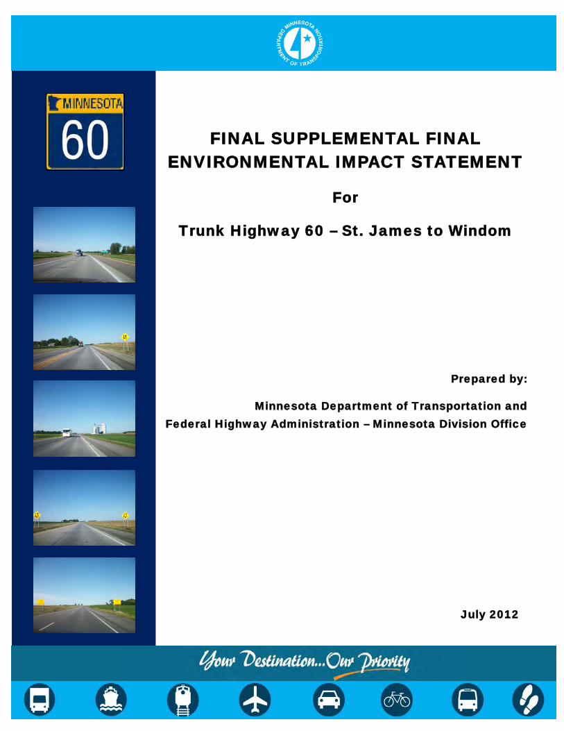
FINAL SUPPLEMENTAL FINAL
ENVIRONMENTAL IMPACT STATEMENT
For
Trunk Highway 60 – St. James to Windom
Prepared by:
Minnesota Department of Transportation and Federal Highway Administration – Minnesota Division Office
July 2012

Highway 60 FINAL Supplemental FEIS Minnesota Department of Transportation Page i July 2012
Notice to Reader
The Federal Council on Environmental Quality (CEQ) Regulations for implementing the National Environmental Policy Act (40 CFR 1500-1508) place heavy emphasis on reducing paperwork, avoiding unnecessary work, and producing documents that are useful to decision makers and the public. With these objectives in mind, this Final Supplemental Final Environmental Impact Statement (SFEIS) was prepared as a “Condensed Final EIS”. This approach avoids repetition of material from the Highway 60 Draft SFEIS by incorporating, by reference, the Draft SFEIS. Thus, a condensed Final EIS is typically a shorter document than under the traditional approach; however, it does afford the reader a complete overview of the project and its impacts on the human and natural environment.
The crux of this approach is to briefly reference and summarize information from the Highway 60 Draft SFEIS that has not changed, and to focus the Final SFEIS discussion on changes in the project’s setting, impacts, technical analysis, and mitigation measures that have occurred since the Draft SFEIS document was circulated. In addition, this condensed Final SFEIS identifies the Highway 60 Preferred Alternative, explains the basis for its selection, describes coordination efforts, includes agency and public comments, provides responses to these comments, and presents any findings or determinations required by law or regulation.
An additional hard copy of the Highway 60 Draft SFEIS is not being provided to those parties that received a copy of the Draft SFEIS when it was circulated in November 2011. Copies of the Draft SFEIS and all supporting documents are included in the CD ROM at the back of this SFEIS, and are available on the project web site at www.dot.state.mn.us/d7/projects/hwy60stjames/ or by special request to MnDOT District 7 in Mankato, Minnesota.
Highway 60 FINAL Supplemental FEIS Minnesota Department of Transportation Page ii July 2012
Table of Contents
Page 1.0 EXECUTIVE SUMMARY .................................................................................. 1
1.1 Background Information: Process Leading to the Creation of this Document ................................................................................................. 1
1.2 Purpose of the Final SFEIS ...................................................................... 1
1.3 Description of the Proposed Action ........................................................... 3
1.4 Purpose and Need of the Highway 60 Project .......................................... 3
1.5 Alternatives ............................................................................................... 4
Preferred Alternative ................................................................................. 4
1.6 Potential Environmental Effects ................................................................ 4
1.7 Project Cost and Funding Source ............................................................. 7
1.8 Permits, Approvals, and Concurrence ...................................................... 7
1.9 Project Coordination ................................................................................. 8
1.10 Project Schedule ....................................................................................... 8
1.11 Other Major Proposed Actions by Others ................................................. 8
1.12 Areas of Unresolved or Controversial Issues ............................................ 8
2.0 PURPOSE AND NEED FOR PROPOSED ACTION ........................................ 9
2.1 Project Background................................................................................... 9
2.2 Description of Project ................................................................................ 9
2.3 Responsible Governmental Units............................................................ 10
2.4 Purpose of the Supplemental Final Environmental Impact Statement .... 10
2.5 Purpose and Need for Proposed Action .................................................. 11
Project Purpose ...................................................................................... 11
Project Need ........................................................................................... 11
3.0 ALTERNATIVES ............................................................................................ 13
3.1 Preferred Alternative ............................................................................... 14
What Reasons Lead to the Identification of the Preferred Alternative? ... 14
Description of Preferred Alternative ........................................................ 15
4.0 SOCIAL, ECONOMIC, AND ENVIRONMENTAL IMPACTS ANALYSIS ....... 18
4.1 What are the Social and Community Impacts? ....................................... 18
Right-of-Way and Relocation .................................................................. 18
Economic Environment ........................................................................... 20
Traffic Assessment ................................................................................. 21
Benefit-Cost Analysis .............................................................................. 21
Social and Community Environment ....................................................... 21
Land Use ................................................................................................ 22
Highway 60 FINAL Supplemental FEIS Minnesota Department of Transportation Page iii July 2012
Parks and Public Recreational Areas ..................................................... 22
Section 4(f) and Section 6(f) Properties .................................................. 23
Pedestrian and Bicycle Movements ........................................................ 23
Environmental Justice ............................................................................. 24
Transit Services ...................................................................................... 24
Utilities ................................................................................................. 24
Contaminated Properties ........................................................................ 26
Cultural Resources ................................................................................. 27
4.2 What are the Natural Environment Impacts? .......................................... 27
Noise ................................................................................................. 27
Air Quality ............................................................................................... 28
Water Quality and Surface Water Drainage ............................................ 28
Floodplains and Water Body Modifications ............................................. 30
Wetlands ................................................................................................. 31
Geology/Groundwater ............................................................................. 41
Vegetation ............................................................................................... 42
Fish and Wildlife ..................................................................................... 43
State/Federal Threatened and Endangered Species .............................. 44
Prime and Statewide Important Farmland............................................... 45
Visual Quality .......................................................................................... 46
Indirect Impacts ...................................................................................... 47
Cumulative Potential Effects ................................................................... 48
4.3 What are the Construction Impacts? ....................................................... 49
Traffic Congestion ................................................................................... 49
Traffic Detours ........................................................................................ 49
Economic (Business Access) .................................................................. 50
Construction Noise ................................................................................. 50
Water Quality and Soil Erosion ............................................................... 51
Borrow or Excess Material ...................................................................... 51
Utility Disruption ...................................................................................... 52
Farmland Impacts ................................................................................... 52
Relationship Between Local Short-Term Uses of Man’s Environment and the Maintenance and Enhancement of Long-Term Productivity ...... 52
Irreversible and Irretrievable Commitment of Resources ........................ 54
5.0 PERMITS AND APPROVALS ........................................................................ 55
6.0 WHO RECEIVED COPIES OF THE FINAL SFEIS? ...................................... 55 6.1 Federal Agencies .................................................................................... 55
6.2 State Agencies/Organizations ................................................................. 56
6.3 Local Agencies/Organizations ................................................................ 56
Highway 60 FINAL Supplemental FEIS Minnesota Department of Transportation Page iv July 2012
6.4 Other ................................................................................................. 56
7.0 PROJECT COORDINATION AND PUBLIC INVOLVEMENT ........................ 56
7.1 Public Open Houses/Public Hearings ..................................................... 57
7.2 Agency/Public Coordination .................................................................... 57
7.3 Project Mailings ...................................................................................... 57
7.4 Project Web Page ................................................................................... 57
8.0 RESPONSE TO COMMENTS ON THE DRAFT EIS ...................................... 58
8.1 Opportunities for Public Comment and Guidelines for Responding to Comments .............................................................................................. 58
8.2 Agency and Public Comments and Responses ...................................... 59
List of Tables Table 1 – Impact Summary ........................................................................................ 5
Table 2 – Project Cost1 Summary .............................................................................. 7
Table 3 – Potential Right-of-Way Acquisition ........................................................... 19
Table 4 – Agricultural Drainage Ditch Impacts ......................................................... 31
Table 5 – Potential Wetland Impacts by Draft SFEIS Alternatives and Design Options ..................................................................................................... 34
Table 6 – Preferred Alternative Summary of Wetland Characteristics ..................... 37
Table 7 – Summary of Direct Farmland Impacts ...................................................... 45
Table 8 – Typical Construction Equipment Noise Levels at 50 feet ......................... 50
List of Figures Figure 1 – Project Location Map ................................................................................ 2Figure 2 – Highway Typical Sections ........................................................................ 16
List of Appendices Appendix A – Preliminary Layout Sheets – Preferred Alternative Appendix B – Project Green Sheets
Highway 60 FINAL Supplemental FEIS Minnesota Department of Transportation Page v July 2012
List of Final SFEIS Acronyms B/C – Benefit-Cost
BMPs – Best Management Practices
CEQ – Council on Environmental Quality
CR – County Road
CSAH – County and State Aid Highway
dBA – A-weighted Decibel
EIS – Environmental Impact Statement
EPA – Environmental Protection Agency
ESA – Environmental Site Assessment
FEIS – Final Environmental Impact Statement
FEMA – Federal Emergency Management Agency
FHWA – Federal Highway Administration
FIRM – Flood Insurance Rate Map
IRC – Interregional Corridor
LGU – Local Government Unit
MEPA – Minnesota Environmental Policy Act
MnDOT – Minnesota Department of Transportation
MNDNR – Minnesota Department of Natural Resources
MPCA – Minnesota Pollution Control Agency
MSAT – Mobile Source Air Toxics
NEPA – National Environmental Policy Act
NHPA – National Historic Preservation Act
NPDES – National Pollutant Discharge Elimination System
NRCS – Natural Resource Conservation Service
NRHP – National Register of Historic Places
OHW – Ordinary High Water RDC – Regional Development Commission RGU – Responsible Governmental Unit ROD – Record of Decision SFEIS – Supplemental Final Environmental Impact Statement SHPO – State Historic Preservation Office WMA- Wildlife Management Area
Highway 60 FINAL Supplemental FEIS Minnesota Department of Transportation Page 1 July 2012
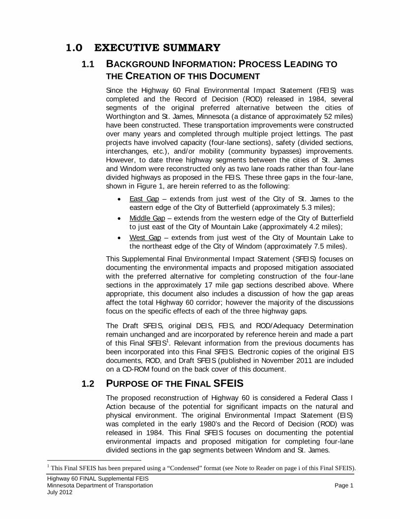
1.0 EXECUTIVE SUMMARY 1.1 BACKGROUND INFORMATION: PROCESS LEADING TO
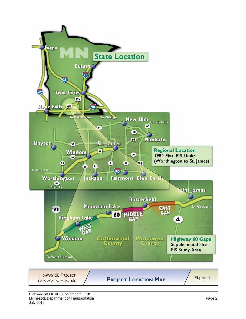
THE CREATION OF THIS DOCUMENT Since the Highway 60 Final Environmental Impact Statement (FEIS) was completed and the Record of Decision (ROD) released in 1984, several segments of the original preferred alternative between the cities of Worthington and St. James, Minnesota (a distance of approximately 52 miles) have been constructed. These transportation improvements were constructed over many years and completed through multiple project lettings. The past projects have involved capacity (four-lane sections), safety (divided sections, interchanges, etc.), and/or mobility (community bypasses) improvements. However, to date three highway segments between the cities of St. James and Windom were reconstructed only as two lane roads rather than four-lane divided highways as proposed in the FEIS. These three gaps in the four-lane, shown in Figure 1, are herein referred to as the following:
• East Gap
•
– extends from just west of the City of St. James to the eastern edge of the City of Butterfield (approximately 5.3 miles); Middle Gap
•
– extends from the western edge of the City of Butterfield to just east of the City of Mountain Lake (approximately 4.2 miles); West Gap
This Supplemental Final Environmental Impact Statement (SFEIS) focuses on documenting the environmental impacts and proposed mitigation associated with the preferred alternative for completing construction of the four-lane sections in the approximately 17 mile gap sections described above. Where appropriate, this document also includes a discussion of how the gap areas affect the total Highway 60 corridor; however the majority of the discussions focus on the specific effects of each of the three highway gaps.
– extends from just west of the City of Mountain Lake to the northeast edge of the City of Windom (approximately 7.5 miles).
The Draft SFEIS, original DEIS, FEIS, and ROD/Adequacy Determination remain unchanged and are incorporated by reference herein and made a part of this Final SFEIS1
1.2 PURPOSE OF THE FINAL SFEIS
. Relevant information from the previous documents has been incorporated into this Final SFEIS. Electronic copies of the original EIS documents, ROD, and Draft SFEIS (published in November 2011 are included on a CD-ROM found on the back cover of this document.
The proposed reconstruction of Highway 60 is considered a Federal Class I Action because of the potential for significant impacts on the natural and physical environment. The original Environmental Impact Statement (EIS) was completed in the early 1980’s and the Record of Decision (ROD) was released in 1984. This Final SFEIS focuses on documenting the potential environmental impacts and proposed mitigation for completing four-lane divided sections in the gap segments between Windom and St. James.
1 This Final SFEIS has been prepared using a “Condensed” format (see Note to Reader on page i of this Final SFEIS).
Highway 60 FINAL Supplemental FEIS Minnesota Department of Transportation Page 2 July 2012
Figure 1– Project Location Map
Highway 60 FINAL Supplemental FEIS Minnesota Department of Transportation Page 3 July 2012
This SFEIS has been prepared as part of the federal National Environmental Policy Act (NEPA) and Minnesota Environmental Policy Act (MEPA) environmental review processes to fulfill requirements of both 42 USC 4321 et seq. and Minnesota Statute 116D. Consistent with state and federal environmental review requirements, a draft version of the SFEIS was circulated for public comment on November 14, 2011. The Draft SFEIS comment period expired on January 4, 2012, and public hearings were held on December 13, 2011 (in Windom, Cottonwood County, MN) and December 15, 2011 (in Butterfield, Watonwan County, MN). The Final SFEIS and ROD will be issued consistent with state and federal environmental review process requirements.
1.3 DESCRIPTION OF THE PROPOSED ACTION The Minnesota Department of Transportation (MnDOT), in cooperation with the Federal Highway Administration (FHWA), proposes completion of the expansion of Highway 60 in Cottonwood and Watonwan Counties, to a four-lane divided highway.
1.4 PURPOSE AND NEED OF THE HIGHWAY 60 PROJECT The purpose of the Highway 60 project is to continue implementation of transportation system improvements, by addressing the three remaining two-lane roadway sections along Highway 60 between Windom and St. James.
The needs that led to initiation of the 1983 Highway 60 EIS were included in the Draft SFEIS and included:
• Substandard Design Elements • Local and Regional Roadway Significance • System Linkages • Present and Projected Traffic Demand • Safety • Modal Interrelationships • Economic and Social Considerations
The needs for the three gap segments have not changed substantially from those stated in the original EIS, but have been refined to provide updated information regarding the current needs of the highway corridor, especially focusing on the three gap segments. Each of these needs is described further in the Draft SFEIS Section 2.5 – Purpose and Need for Proposed Action. The refined need components include: • Corridor Role in the Transportation System – Policies and Priorities
- Interregional Corridor (IRC) System - Significant Freight Corridor
• Enhanced System Continuity • Safety • Additional Considerations
- Social Demand – Public Input Regarding Transportation Priorities
Highway 60 FINAL Supplemental FEIS Minnesota Department of Transportation Page 4 July 2012
- Access Management Policies - Environmental Considerations
1.5 ALTERNATIVES The Highway 60 Draft SFEIS, approved November 2011, considered only the three gap segments of Highway 60 between Windom and St. James. The potentially feasible and prudent alternatives for improving the gap segments of Highway 60 include: • Alternative 1 – No-Build Alternative.
• Alternative 2 – Constructing a four-lane expressway.
The East and Middle Gap segments considered a single build alternative (Alternative 2) that would expand the two-lane highway section to a rural four-lane section by adding an additional set of lanes to the south of the existing travel lanes. The West Gap segment would primarily widen the existing highway to the north. In addition, the West Gap segment included design options in Bingham Lake and near Clear Lake that were considered to avoid and/or minimize social, economic, or environmental impacts. An evaluation and screening process of the design options was included in the Draft SFEIS.
Preferred Alternative Following the Draft SFEIS comment period, a review of the Draft SFEIS analysis and the public and agency comments was conducted. Based on the comments and supporting analysis, Alternative 2 (construct four-lane expressway) with the Clear Lake “Full” design option and Bingham Lake “Widen North” design option was identified as the Preferred Alternative. The Bingham Lake “Widen North” design option was modified to shift the alignment slightly south near the intersection of Cottonwood County Road 2 in order to reduce impacts on Wetland #25 located north of Highway 60. These design options were identified for reasons including, but not limited to, the following:
• The design options meet the overall project purpose and need;
• The Clear Lake “Full” design option will minimize the potential for snow drifting and icy roadway conditions, which can result in run off the road and injury crashes. This option does not require safety barriers (guardrail), which can act as a snow traps and limit snow storage;
• The Bingham Lake design option balances potential social, economic, and environmental impacts on local infrastructure, commercial properties, and wetlands.
Section 3.1 of this Final SFEIS contains a more detailed discussion on the Preferred Alternative identification process.
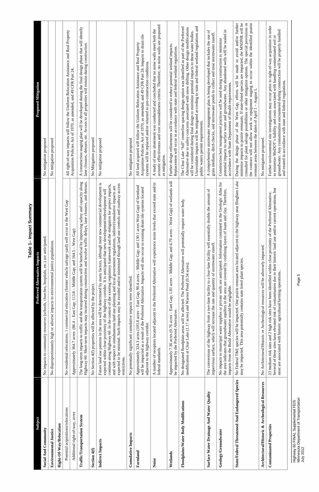
1.6 POTENTIAL ENVIRONMENTAL EFFECTS A summary of the potential beneficial and adverse effects associated with the Preferred Alternative is presented in Table 1 (on the following page).
Hig
hway
60
FIN
AL
Sup
plem
enta
l FEI
S M
inne
sota
Dep
artm
ent o
f Tra
nspo
rtatio
n
Pag
e 5
July
201
2
Tabl
e 1–
Impa
ct S
umm
ary
Subj
ect
Pref
erre
d A
ltern
ativ
e Im
pact
s Pr
opos
ed M
itiga
tion
Soci
al A
nd C
omm
unity
N
o im
pact
s to
com
mun
ity re
sour
ces (
scho
ols,
chur
ches
, hos
pita
ls, e
tc.)
are
antic
ipat
ed.
No
miti
gatio
n pr
opos
ed
Envi
ronm
enta
l Jus
tice
No
disp
ropo
rtion
atel
y hi
gh o
r adv
erse
impa
cts t
o en
viro
nmen
tal j
ustic
e po
pula
tions
. N
o m
itiga
tion
prop
osed
Rig
ht-O
f-W
ay/R
eloc
atio
n
Pote
ntia
l acq
uisi
tions
/relo
catio
ns
No
resi
dent
ial r
eloc
atio
ns; 1
com
mer
cial
relo
catio
n (f
orm
er v
ehic
le sa
lvag
e ya
rd) w
ill o
ccur
in th
e W
est G
ap
All
right
-of-
way
impa
cts w
ill fo
llow
the
Uni
form
Rel
ocat
ion
Ass
ista
nce
and
Rea
l Pro
perty
A
cqui
sitio
n Po
licie
s Act
of 1
970,
as a
men
ded,
and
49
CFR
Par
t 24.
A
dditi
onal
righ
t-of-
way
, acr
es
App
roxi
mat
ely
364.
7 ac
res
(86.
4 –
East
Gap
; 113
.8 –
Mid
dle
Gap
; and
164
.5 –
Wes
t Gap
)
Traf
fic/T
rans
port
atio
n Sy
stem
Th
e lo
ng-te
rm im
pact
s to
traff
ic a
nd th
e tra
nspo
rtatio
n sy
stem
will
be
bene
ficia
l by
impr
ovin
g sa
fety
and
cap
acity
alo
ng
Hig
hway
60.
Sho
rt-te
rm im
pact
s may
incu
rred
dur
ing
cons
truct
ion
and
invo
lve
traff
ic d
elay
s, la
ne c
losu
res,
and
deto
urs.
A
con
stru
ctio
n st
agin
g pl
an w
ill b
e de
velo
ped
durin
g th
e fin
al d
esig
n ph
ase
that
will
iden
tify
lane
clo
sure
s, de
tour
s, et
c. A
cces
s to
all p
rope
rties
will
rem
ain
durin
g co
nstru
ctio
n.
Sect
ion
4(f)
No
Sect
ion
4(f)
pro
perti
es w
ill b
e af
fect
ed b
y th
e pr
ojec
t. N
o M
itiga
tion
prop
osed
Indi
rect
Im
pact
s Fu
ture
land
use
pat
tern
s in
the
area
will
be
dete
rmin
ed b
y m
any
fact
ors,
alth
ough
mos
t new
com
mer
cial
dev
elop
men
t is
expe
cted
with
in c
lose
pro
xim
ity o
f the
hig
hway
cor
ridor
. It i
s ant
icip
ated
that
new
dev
elop
men
t/red
evel
opm
ent w
ill
cont
inue
alo
ng H
ighw
ay 6
0. In
the
cont
ext o
f the
exi
stin
g re
gula
tory
fram
ewor
k an
d th
e m
itiga
tion
for p
roje
ct im
pact
s, an
d w
ith re
spec
t to
sim
ulta
neou
s lan
d us
e pl
anni
ng a
nd lo
cal g
over
nmen
t reg
ulat
ions
, ind
irect
/cum
ulat
ive
impa
cts a
re
expe
cted
to b
e m
inim
al. S
uch
impa
cts m
ay b
e av
oide
d an
d/or
min
imiz
ed th
roug
h la
nd u
se c
ontro
ls a
nd ro
adw
ay a
cces
s re
stric
tions
.
No
miti
gatio
n pr
opos
ed
Cum
ulat
ive
Impa
cts
No
pote
ntia
lly si
gnifi
cant
cum
ulat
ive
impa
cts w
ere
iden
tifie
d.
No
miti
gatio
n pr
opos
ed
Farm
land
A
ppro
xim
atel
y 32
4.3
acre
s (10
3.8
acre
s – E
ast G
ap; 9
0.4
acre
s – M
iddl
e G
ap; a
nd 1
30.1
acr
es W
est G
ap) o
f far
mla
nd
will
be
impa
cted
as a
resu
lt of
the
Pref
erre
d A
ltern
ativ
e. Im
pact
s will
als
o oc
cur t
o ex
istin
g dr
ain
tile
syst
ems l
ocat
ed
adja
cent
to th
e hi
ghw
ay c
orrid
or.
All
land
acq
uire
d w
ill fo
llow
the
Uni
form
Rel
ocat
ion
Ass
ista
nce
and
Rea
l Pro
perty
A
cqui
sitio
n Po
licie
s Act
of 1
970,
as a
men
ded,
and
49
CFR
Par
t 24.
Impa
cts t
o dr
ain
tile
syst
ems w
ill b
e re
plac
ed a
nd/o
r ret
urne
d to
pre
-con
stru
ctio
n co
nditi
ons.
Noi
se
A n
umbe
r of r
ecep
tors
loca
ted
adja
cent
to th
e Pr
efer
red
Alte
rnat
ive
will
exp
erie
nce
nois
e le
vels
that
exc
eed
stat
e an
d/or
fe
dera
l sta
ndar
ds.
A st
udy
of n
oise
aba
tem
ent w
as c
ondu
cted
and
con
clud
ed th
at n
o no
ise
wal
ls m
eet b
oth
the
acou
stic
effe
ctiv
enes
s and
cos
t rea
sona
blen
ess c
riter
ia. T
here
fore
, no
nois
e w
alls
are
pro
pose
d as
miti
gatio
n.
Wet
land
s A
ppro
xim
atel
y 7.
36 a
cres
(0.7
6 ac
res –
Eas
t Gap
; 1.8
1 ac
res –
Mid
dle
Gap
; and
4.7
9 ac
res –
Wes
t Gap
) of w
etla
nds w
ill
be im
pact
ed b
y th
e Pr
efer
red
Alte
rnat
ive.
Fu
rther
des
ign
refin
emen
ts w
ill b
e co
nsid
ered
to re
duce
pot
entia
l wet
land
impa
cts.
Rep
lace
men
t will
occ
ur in
acc
orda
nce
with
stat
e an
d fe
dera
l wet
land
regu
latio
ns.
Floo
dpla
ins/
Wat
er B
ody
Mod
ifica
tions
N
o de
sign
ated
floo
dpla
in a
reas
will
be
affe
cted
. The
Pre
ferr
ed A
ltern
ativ
e w
ill p
oten
tially
requ
ire w
ater
bod
y m
odifi
catio
n at
Cle
ar L
ake
(1.1
7 ac
res)
and
War
ren
Pond
(0.3
4 ac
res)
. Th
e C
lear
Lak
e “f
ull”
cen
terli
ne sp
acin
g de
sign
opt
ion
was
iden
tifie
d as
par
t of t
he P
refe
rred
A
ltern
ativ
e du
e to
safe
ty c
once
rns a
ssoc
iate
d w
ith sn
ow d
riftin
g. O
ther
des
ign
mod
ifica
tions
w
ill b
e co
nsid
ered
dur
ing
final
des
ign
to m
inim
ize
pote
ntia
l im
pact
s to
thes
e w
ater
bod
ies.
Una
void
able
impa
cts w
ill b
e m
itiga
ted
acco
rdin
g to
stat
e an
d fe
dera
l wet
land
regu
latio
ns a
nd
publ
ic w
ater
s per
mit
requ
irem
ents
.
Surf
ace
Wat
er D
rain
age
And
Wat
er Q
ualit
y Th
e co
nver
sion
s of t
he h
ighw
ay fr
om a
two-
lane
faci
lity
to a
four
-lane
faci
lity
will
ess
entia
lly d
oubl
e th
e am
ount
of
impe
rvio
us su
rfac
e, w
hich
will
incr
ease
the
rate
and
qua
ntity
of s
torm
wat
er ru
noff
. A
com
preh
ensi
ve st
orm
wat
er m
anag
emen
t pla
n is
bei
ng d
evel
oped
that
incl
udes
the
use
of
gras
s med
ians
, ditc
h ch
ecks
, and
stor
mw
ater
pon
ds to
col
lect
and
trea
t sto
rmw
ater
runo
ff.
Geo
logy
/Gro
undw
ater
N
o im
pact
s to
mun
icip
al w
ater
supp
lies o
r priv
ate
wel
ls a
re a
ntic
ipat
ed. I
nfor
mat
ion
cont
aine
d in
the
Geo
logi
c A
tlas f
or
the
area
indi
cate
s tha
t gro
undw
ater
aqu
ifers
in th
e ar
ea a
re c
over
ed b
y co
nfin
ing
laye
rs o
f loa
m a
nd c
lay.
The
refo
re,
impa
cts f
rom
the
Bui
ld A
ltern
ativ
e w
ould
be
negl
igib
le.
Con
stru
ctio
n be
st m
anag
emen
t pra
ctic
es w
ill b
e us
ed d
urin
g co
nstru
ctio
n to
min
imiz
e po
tent
ial i
mpa
cts t
o su
rfac
e w
ater
and
gro
undw
ater
. Any
aba
ndon
ed w
ells
will
be
seal
ed in
ac
cord
ance
with
Sta
te D
epar
tmen
t of H
ealth
requ
irem
ents
.
Stat
e/Fe
dera
l Thr
eate
ned
And
End
ange
red
Spec
ies
No
Fede
ral T
&E
spec
ies w
ill b
e im
pact
ed. O
ne p
rairi
e re
mna
nt a
rea
loca
ted
adja
cent
to th
e hi
ghw
ay n
ear B
ingh
am L
ake
may
be
impa
cted
. Thi
s are
a po
tent
ially
con
tain
s sta
te li
sted
pla
nt sp
ecie
s.
Dur
ing
the
desi
gn p
hase
of
the
Wes
t G
ap,
effo
rts w
ill b
e m
ade
to a
void
and
/or
furth
er
min
imiz
e im
pact
s to
pra
irie
rem
nant
s. If
sta
te-li
sted
spec
ies
are
impa
cted
, the
MN
DN
R w
ill b
e co
nsul
ted
for
plan
t sal
vage
pos
sibi
litie
s or
oth
er m
itiga
tion
optio
ns. T
he s
peci
al p
rovi
sion
s in
th
e co
ntra
ct w
ill n
ot a
llow
wor
k or
equ
ipm
ent
stag
ing
to o
ccur
with
in t
he i
dent
ified
pra
irie
rem
nant
are
as b
etw
een
the
date
s of A
pril
1 –
Aug
ust 1
.
Arc
hite
ctur
al/H
istor
ic &
Arc
heol
ogic
al R
esou
rces
N
o A
rchi
tect
ural
/His
toric
or A
rche
olog
ical
reso
urce
s will
be
adve
rsel
y im
pact
ed.
No
miti
gatio
n pr
opos
ed.
Con
tam
inat
ed P
rope
rtie
s 23
med
ium
risk
site
s and
2 h
igh
risk
site
s hav
e be
en id
entif
ied
with
in c
lose
pro
xim
ity o
f the
Pre
ferr
ed A
ltern
ativ
e.
Seve
ral o
f the
se si
tes h
ave
elev
ated
risk
of c
onta
min
atio
n du
e to
thei
r his
toric
land
use
and
/or c
urre
nt o
pera
tions
, but
m
ost a
re a
ssoc
iate
d w
ith h
isto
ric a
gric
ultu
ral/f
arm
ing
oper
atio
ns..
Furth
er e
nviro
nmen
tal s
ite in
vest
igat
ions
may
occ
ur p
rior t
o rig
ht-o
f-w
ay a
cqui
sitio
n in
ord
er
to m
inim
ize
MnD
OT’
s lia
bilit
y an
d co
sts a
ssoc
iate
d w
ith h
andl
ing
cont
amin
ated
soil
or
grou
ndw
ater
. Any
con
tam
inat
ion
enco
unte
red
durin
g co
nstru
ctio
n w
ill b
e pr
oper
ly h
andl
ed
and
treat
ed in
acc
orda
nce
with
stat
e an
d fe
dera
l reg
ulat
ions
.
Hig
hway
60
FIN
AL
Sup
plem
enta
l FEI
S M
inne
sota
Dep
artm
ent o
f Tra
nspo
rtatio
n
Pag
e 6
July
201
2
Page
Int
entio
nally
Lef
t Bl
ank
Highway 60 FINAL Supplemental FEIS Minnesota Department of Transportation Page 7 July 2012
Social, economic, and environmental impact avoidance and minimization measures have been explored to the greatest extent possible without compromising the safety of travel throughout the Highway 60 corridor. For additional information regarding the impacts shown in Table 1, the reader is referred to Section 4.0 of this Final SFEIS document and Section 4.0 of the Draft SFEIS.
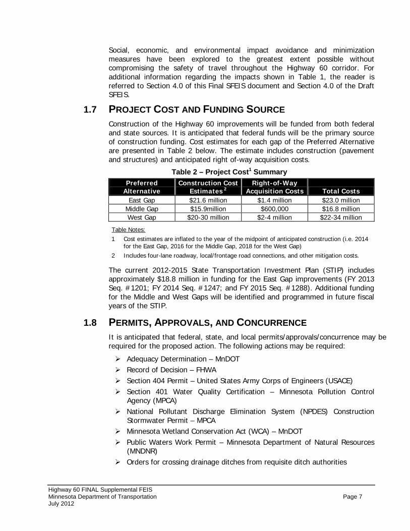
1.7 PROJECT COST AND FUNDING SOURCE Construction of the Highway 60 improvements will be funded from both federal and state sources. It is anticipated that federal funds will be the primary source of construction funding. Cost estimates for each gap of the Preferred Alternative are presented in Table 2 below. The estimate includes construction (pavement and structures) and anticipated right of-way acquisition costs.
Table 2 – Project Cost1 Summary Preferred
Alternative Construction Cost
Estimates 2 Right-of-Way
Acquisition Costs Total Costs East Gap $21.6 million $1.4 million $23.0 million
Middle Gap $15.9million $600,000 $16.8 million West Gap $20-30 million $2-4 million $22-34 million
1 Cost estimates are inflated to the year of the midpoint of anticipated construction (i.e. 2014 for the East Gap, 2016 for the Middle Gap, 2018 for the West Gap)
Table Notes:
2 Includes four-lane roadway, local/frontage road connections, and other mitigation costs.
The current 2012-2015 State Transportation Investment Plan (STIP) includes approximately $18.8 million in funding for the East Gap improvements (FY 2013 Seq. #1201; FY 2014 Seq. #1247; and FY 2015 Seq. #1288). Additional funding for the Middle and West Gaps will be identified and programmed in future fiscal years of the STIP.
1.8 PERMITS, APPROVALS, AND CONCURRENCE It is anticipated that federal, state, and local permits/approvals/concurrence may be required for the proposed action. The following actions may be required:
Adequacy Determination – MnDOT Record of Decision – FHWA Section 404 Permit – United States Army Corps of Engineers (USACE) Section 401 Water Quality Certification – Minnesota Pollution Control
Agency (MPCA) National Pollutant Discharge Elimination System (NPDES) Construction
Stormwater Permit – MPCA Minnesota Wetland Conservation Act (WCA) – MnDOT Public Waters Work Permit – Minnesota Department of Natural Resources
(MNDNR) Orders for crossing drainage ditches from requisite ditch authorities
Highway 60 FINAL Supplemental FEIS Minnesota Department of Transportation Page 8 July 2012
1.9 PROJECT COORDINATION MnDOT is committed to public and agency involvement/outreach at all levels in decision-making related to the Highway 60 Project. MnDOT has engaged community organizations; area property owners; business owners; residents; and local, county, regional, state, and federal agencies in the development of the project. See Final SFEIS Section 7.0 – Coordination for additional information. Public involvement activities have included:
Agency Coordination Meetings/Workshops Public Open House Meetings Public Hearings Project Mailings Project Website Updates
Coordination has also occurred with representatives from local, state, and federal agencies to discuss appropriate analysis methodology and mitigation for different resource areas.
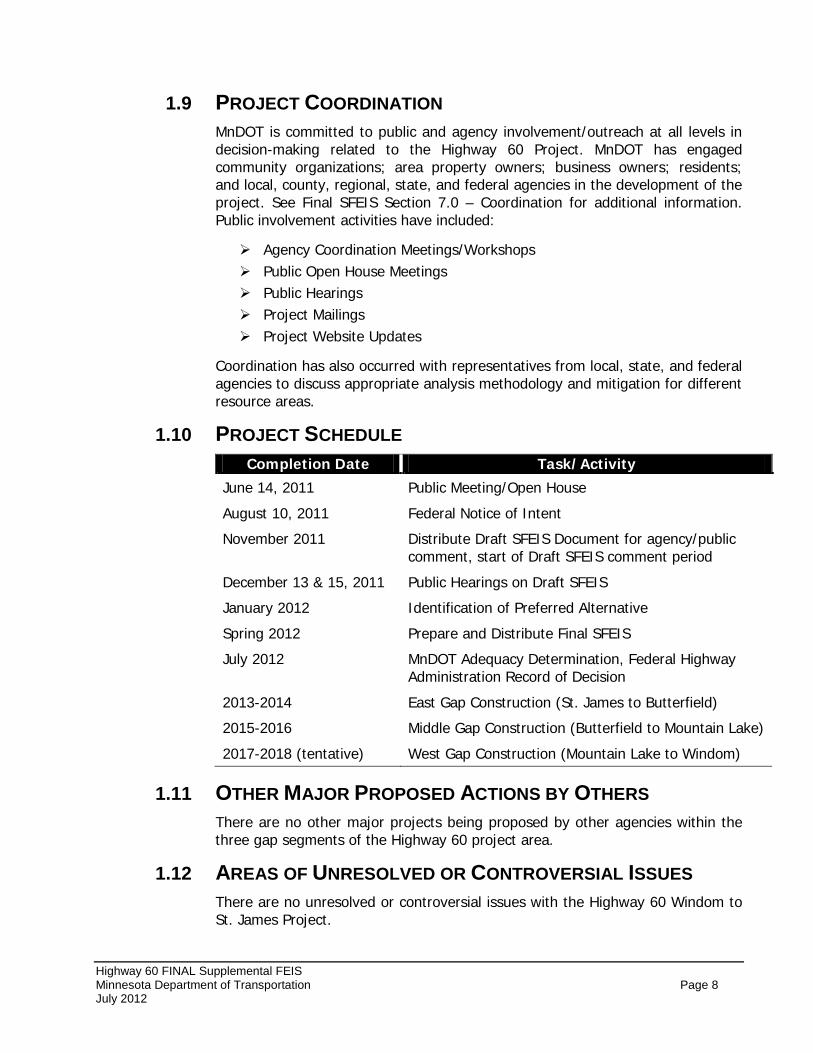
1.10 PROJECT SCHEDULE Completion Date Task/Activity
June 14, 2011 Public Meeting/Open House
August 10, 2011 Federal Notice of Intent
November 2011 Distribute Draft SFEIS Document for agency/public comment, start of Draft SFEIS comment period
December 13 & 15, 2011 Public Hearings on Draft SFEIS
January 2012 Identification of Preferred Alternative
Spring 2012 Prepare and Distribute Final SFEIS
July 2012 MnDOT Adequacy Determination, Federal Highway Administration Record of Decision
2013-2014 East Gap Construction (St. James to Butterfield)
2015-2016 Middle Gap Construction (Butterfield to Mountain Lake)
2017-2018 (tentative) West Gap Construction (Mountain Lake to Windom)
1.11 OTHER MAJOR PROPOSED ACTIONS BY OTHERS There are no other major projects being proposed by other agencies within the three gap segments of the Highway 60 project area.
1.12 AREAS OF UNRESOLVED OR CONTROVERSIAL ISSUES There are no unresolved or controversial issues with the Highway 60 Windom to St. James Project.
Highway 60 FINAL Supplemental FEIS Minnesota Department of Transportation Page 9 July 2012
2.0 PURPOSE AND NEED FOR PROPOSED ACTION 2.1 PROJECT BACKGROUND
Highway 60 is an important northeast-southwest highway that crosses through southwestern Minnesota. This principal arterial highway provides vital links for local traffic, regional traffic, and shipping agricultural goods grown by local producers to regional trade centers such as Worthington, Mankato, the Twin Cities (via Hwy 169), and Sioux City, Iowa (via Hwy 75). Figure 1, located on page 2, illustrates how this important freight corridor connects producers and markets in the intra-state and inter-state transportation system.
The local and regional importance of Highway 60 has been recognized for many years. A Final Environmental Impact Statement (FEIS), dated 1983, was prepared for a 52-mile segment of Highway 60 from St. James to Worthington. Highway 60, including the 52-mile project corridor, falls under the MnDOT classification of a Medium Priority Interregional Corridor (IRC).
The Preferred Alternative concept identified in the original EIS and Record of Decision (ROD) consisted of constructing Highway 60 on new alignment from near St. James to approximately one-half mile southwest of Mountain Lake and to reconstruct on existing alignment from Mountain Lake to Worthington. The initial stages were to provide two-lane reconstruction to modern highway design standards and subsequent stages would provide added capacity with construction to a four-lane expressway. Nearly 35 miles of the Highway 60 corridor between St. James and Worthington has been constructed as a four-lane divided highway including community bypasses at St. James, Butterfield, and Mountain Lake. However, three segments (approximately 17 miles) of the original EIS study limits remain as two-lane highway sections between Windom and St. James.
MnDOT is currently in the process of updating the evaluation of improvements in these two-lane highway gap sections since funding for implementation of roadway improvements was made available in 2008. Given the amount of time that has passed since the 1984 ROD, MnDOT consulted with FHWA to determine the most appropriate course of action to maintain compliance with the National Environmental Policy Act (NEPA). The consultation focused on the specific circumstances of the project, the nature and type of potential impacts, and the need for interagency coordination. Based on this consultation, FHWA determined that a Supplemental Final EIS (SFEIS) must be prepared.
2.2 DESCRIPTION OF PROJECT The Highway 60 project area is located in southwestern Minnesota. The project corridor for the three remaining two-lane gap segments primarily traverses east to west between the cities of St. James and Windom through Watonwan County and Cottonwood County, Minnesota (see Figure 1 on page 2). Within the project area, four-lane highway bypasses have already been constructed near St. James, Butterfield, and Mountain Lake. However, three highway segments between St. James and Windom were built as two lane roadways instead of four-lane, divided
Highway 60 FINAL Supplemental FEIS Minnesota Department of Transportation Page 10 July 2012
highways as proposed in the 1983 Final EIS. These three gaps in the four-lane are herein referred to as the following:
• East Gap
•
– extends from just west of the City of St. James to the eastern edge of the City of Butterfield (approximately 5.3 miles);
Middle Gap
•
– extends from the western edge of the City of Butterfield to just east of the City of Mountain Lake (approximately 4.2 miles);
West Gap
The proposed improvements include expanding these gap segments of Highway 60 to a four-lane divided expressway section. Other improvements will include minor intersection improvements and access management improvements.
– extends from just west of the City of Mountain Lake to the northeast edge of the City of Windom (approximately 7.5 miles).
2.3 RESPONSIBLE GOVERNMENTAL UNITS MnDOT is the Responsible Governmental Unit for the development of and the environmental documentation for the Highway 60 Project. MnDOT is managing the project with the FHWA as a Joint Lead Agency. The contact persons for the project are:
MnDOT District 7 Peter Harff, PE Philip Forst
FHWA
MnDOT District 7 Environmental Specialist 2151 Bassett Drive 380 Jackson Street, Suite 500 Mankato, MN 56001 St. Paul, MN 55101 507.304.6165 651.291.6110 [email protected]
2.4 PURPOSE OF THE SUPPLEMENTAL FINAL ENVIRONMENTAL IMPACT STATEMENT
This Final SFEIS focuses on documenting the environmental impacts and proposed mitigation for completion of the four-lane in the gaps described in Section 2.1 above2
The 1982 DEIS, 1983 FEIS and 1984 ROD/Adequacy Determination remain unchanged and are incorporated by reference herein and made a part of this SFEIS. Relevant information from the previous documents has been incorporated into this SFEIS, as necessary. Electronic copies of the original EIS documents, ROD, and Draft SFEIS (published November 2011) are included on the CD-ROM provided with this Final SFEIS. Combined with the Final SFEIS, these environmental review documents are intended to help public officials and agencies make decisions with a complete understanding of the environmental consequences and proposed mitigation commitments associated with the proposed action.
.
This Final SFEIS has been prepared as part of the federal National Environmental Policy Act (NEPA) and Minnesota Environmental Policy Act
2 This Final SFEIS has been prepared using a “Condensed” format (see Note to Reader on page i of this Final SFEIS).
Highway 60 FINAL Supplemental FEIS Minnesota Department of Transportation Page 11 July 2012
(MEPA) environmental review processes to fulfill requirements of both 42 USC 4321 et seq. and Minnesota Statute 116D. Consistent with state and federal environmental review requirements, the Draft SFEIS was circulated for public comment and two public hearings were held to receive testimony for the public record. This Final SFEIS is also being issued consistent with state and federal environmental review process requirements.
2.5 PURPOSE AND NEED FOR PROPOSED ACTION Project Purpose The purpose of the Highway 60 project is to continue implementation of transportation system improvements in the corridor, by expanding the three remaining sections of two-lane roadway along Highway 60 between St. James and Windom to four lane divided highways.
Project Need A detailed description of the project purpose and need was presented in the Highway 60 Draft SFEIS – Section 2.5, which has been incorporated by reference into this Final SFEIS. The identified Preferred Alternative is consistent with meeting the purpose and need objectives summarized below:
The needs that resulted in initiation of the 1983 Highway 60 EIS included the following:
• Substandard Design Elements - the highway corridor was characterized as having numerous design deficiencies that create safety and mobility concerns.
• Local and Regional Significance of the Highway
• System Linkages – four-lane roadway continuity
• Present and Projected Traffic Demand
• Safety Concerns
• Modal Interrelationships – including freight
• Economic and Social Considerations
The Draft SFEIS, published in November 2011, identified specific needs for transportation system improvements within the three gap segments between Windom and St. James. These need components are summarized below:
• System Continuity – The transportation improvements shall be compatible with adjacent segments of Highway 60.
- With the completion of improvements near Worthington, the three gap segments between Windom and St. James will be the only remaining two-lane sections along Highway 60 between Mankato and the MN/IA border.
Highway 60 FINAL Supplemental FEIS Minnesota Department of Transportation Page 12 July 2012
- The transitions back and forth between two-lane and four-lane highway segments can cause distractions and confusion for drivers.
- Highway 60 has been designated by MnDOT as an Interregional Corridor (IRC), which acknowledges the importance of Highway 60 in enhancing the economic vitality of the state by providing safe, timely, and efficient movement of goods and people between regional trade centers.
- Highway 60 is also considered an important freight corridor because it connects producers and markets in the intra-state, inter-state, and international transportation system. As a result, there has been a heightened demand to maintain mobility along the corridor to accommodate growing freight traffic. Heavy commercial traffic currently makes up approximately 16 to 17 percent of the total daily traffic and seasonal peaks during the spring and fall are even higher.
• Improve Safety – For a 10-year study period (2000 – 2009), the three gap segments had 184 reported crashes (49-East Gap; 59-Middle Gap; 76-West Gap).
- Nearly 40 percent of the crashes were higher severity crashes like head on, ran-off-road, and sideswipe opposite direction crashes. Furthermore, six fatal crashes and 40 personal injury crashes occurred within the 10-year reporting period.
- Certain types of crashes (i.e. sideswipe, head-on, or run off road crashes) may have resulted from the highway’s design features such as a two-lane roadway, transitions between 2-lane to 4-lane, and the frequency of access points.
- Crash locations were reviewed and it was determined that crashes along the gap segments were not concentrated at any particular location(s), which indicates that spot safety improvements may not be effective.
- As a result of public outreach meetings, MnDOT became further aware of the public’s safety concerns along the three gap segments with numerous personal accounts of “near misses” where on several occasions vehicles were observed traveling in the wrong direction between Windom and St. James where the highway transitions back and forth between two-lane and four-lane sections and can be confusing to non-local drivers that may be anticipating a continuous highway section.
- Slower operating characteristics of heavy commercial vehicles and/or agricultural machinery on the two-lane highway sections are another safety concern because motorists tend to take more risks in trying to pass these slower moving vehicles.
Highway 60 FINAL Supplemental FEIS Minnesota Department of Transportation Page 13 July 2012
• Additional Considerations – A number of additional considerations have been identified as important issues in the development and evaluation of improvements to Highway 60 between Windom and St. James.
- Social Demand: MnDOT has benefited from an active and informed set of stakeholders from a variety of sectors, including farming, business, education, and government, as well as the interested public. The Statewide Transportation Policy Plan/District Highway Investment Plan Outreach meetings held in 2008 captured substantial input from the public and local elected officials insisting that additional Highway 60 improvements be completed, including completion of the four-lane corridor concept envisioned in the 1983-4 EIS.
- Access Management: In order to maintain the effective flow of traffic and improve safety conditions along Highway 60, it was determined that access management strategies needed to be considered and implemented where possible. MnDOT's policy for Access Management on the trunk highway system is set forth in the MnDOT Access Management Manual, January 2008. Recommended spacing guidelines are set forth in the guidelines for public street intersections, signal systems, and private driveways.
- Environmental Concerns: While the three gap segments consist primarily of rural land use with limited development a number of important environmental factors were considered including: potential impacts to Clear Lake due to the proximity of the south shoreline of the lake and the Union Pacific Railroad corridor, and prairie remnants that have been identified in several locations between the Union Pacific Railroad corridor and the Highway 60 alignment. Any proposed improvements should consider these potential impacts and consider potential avoidance, minimization, and mitigation options.
3.0 ALTERNATIVES The Highway 60 Draft SFEIS, dated November 2011, considered two alternatives: No-Build Alternative (Alternative 1) and the Build Alternative (Alternative 2). The build alternative was subdivided into the three gap segments (East Gap – St. James to Butterfield; Middle Gap – Butterfield to Mountain Lake, and West Gap – Mountain Lake to Windom). The Build Alternative for the East and Middle Gaps included one option that involved constructing two new travel lanes immediately south of the existing highway alignment. The West Gap Build Alternative included the construction of two additional travel lanes immediately north of existing highway with additional consideration of design options near community of Bingham Lake and along the southern shoreline of Clear Lake
The alternative evaluation and screening process was based on an assessment of how each alternative addresses the purpose and need objectives of the project, as well as an assessment of potential social, economic, and environmental impacts. Following the Draft SFEIS comment period, a review of the public and agency comments was conducted. Based on the comments and supporting analysis in the Draft SFEIS, Alternative 2 – Build Alternative with the Clear Lake
Highway 60 FINAL Supplemental FEIS Minnesota Department of Transportation Page 14 July 2012
“Full” design option and Bingham Lake “Widen North” design option was identified as the Preferred Alternative. The Bingham Lake “Widen North” design option was modified to shift the alignment slightly south near the intersection of Cottonwood County Road 2 in order to reduce impacts on Wetland #25 located north of Highway 60.
3.1 PREFERRED ALTERNATIVE What Reasons Lead to the Identification of the Preferred Alternative? The following list highlights the primary reasons for identifying Alternative 2 with the modified Bingham Lake “Widen North” and the Clear Lake “Full” design options as the Preferred Alternative:
• Provides for safe and efficient travel through the study area by providing a continuous four-lane highway section with improved access and intersection conditions.
• Is consistent with the design of Highway 60 in areas where the corridor has already been converted to a four-lane expressway. The capacity expansion will occur immediately south of the existing highway in the East and Middle Gaps and immediately north of the existing highway in the West Gap.
• The two design options provide a balanced approach in minimizing social, economic, and environmental impacts, while satisfying the overall project purpose and need objectives;
• Inclusion of the modified Bingham Lake “Widen North” Option minimizes potential impacts to operating businesses in the community, reduces impacts on Wetland #25 (north of Highway 60 near County Road 44), and provides an opportunity to clean up a potentially hazardous site (former vehicle salvage business) that if untreated could result in long-term soil and/or groundwater contamination concerns. This modified design option requires the least amount of right-of-way and farmland conversion to accommodate the improvements. Also, it avoids impacts to a sewer lift station located south of Highway 60 near Cottonwood County Road 44 (520th Avenue) and avoids the City’s main sanitary sewer and watermain lines that are located south of Highway 60 and run parallel to the corridor toward Windom.
• The Clear Lake “Full” design option will minimize the potential for snow drifting and icy roadway conditions, which can result in run off the road and injury crashes. This option does not require safety barriers (guardrail), which can act as a snow traps and limit snow storage;
• Alternative 2 with the identified design options has a positive (greater than 1.0) benefit-cost ratio indicating the benefits of the project outweigh the costs.
• Alternative 2 received the greatest amount of public support.
Highway 60 FINAL Supplemental FEIS Minnesota Department of Transportation Page 15 July 2012
Appendix A contains preliminary layout drawings illustrating the Preferred Alternative.
Description of Preferred Alternative The Preferred Alternative (Alternative 2 from the Draft SFEIS), including the Clear Lake “Full” and Bingham Lake “Widen North” design options involves expanding Highway 60 to a continuous four-lane expressway section within the East, Middle, and West Gap sections (see Figure 1). As previously mentioned, the Bingham Lake “widen North” design option was modified to shift the alignment slightly south to minimize potential impacts on Wetland #25 located north of Highway 60.
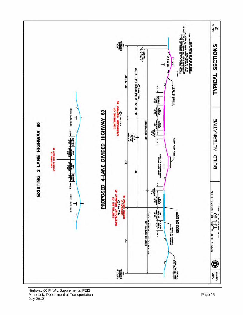
The four lane highway will be completed by constructing two lanes adjacent to the existing highway with 90 feet between centerlines. A 70 mph design speed will be used for designing the improvements and a 65 mph posted speed is anticipated to match the posted speeds on existing four-lane sections of Highway 60. Figure 2 on the following page illustrates a typical highway section that will be used in the East, Middle, and West Gaps, whenever possible. Exceptions to the typical section may occur due to environmental constraints that may reduce the centerline spacing or at certain high volume intersections where greater centerline spacing may be required. Intersections are proposed to be at-grade with two way stop control on the intersecting local roadway approaches. Left and right turn lanes will be provided at all public road intersections. Other improvements include minor reconstruction of cross street intersections and access/driveway modifications.
The east termini of the East Gap is a point where the existing four-lane bypass of St. James tapers to a two-lane section southwest of St. James. The west termini of the East Gap is located at the eastern edge of the four-lane bypass of Butterfield. The length of the East Gap is approximately 5.3 miles.
East Gap
The Preferred Alternative in the East Gap includes the construction of two additional travel lanes immediately south of the existing alignment. The existing roadway would serve westbound traffic and the new lanes would serve eastbound traffic. An additional overpass bridge of the Union Pacific rail line near Butterfield will also be constructed. Minor access modifications and/or closures are proposed to improve safety. Several storm water management ponds are proposed adjacent to the highway to collect and treat runoff from the highway.
The east termini of the Middle Gap is a point where the existing four-lane bypass of Butterfield tapers to a two-lane section located approximately 900-feet west of Watonwan County Road 102. The west termini of the Middle Gap is located at the east end of the four-lane bypass south of Mountain Lake. The Middle Gap extends approximately 4.2 miles.
Middle Gap
Highway 60 FINAL Supplemental FEIS Minnesota Department of Transportation Page 16 July 2012
Figure 2 – Highway Typical Sections
Highway 60 FINAL Supplemental FEIS Minnesota Department of Transportation Page 17 July 2012
The Preferred Alternative in the Middle Gap includes the construction of two additional travel lanes immediately south of the existing alignment. The existing roadway would serve westbound traffic, while the new lanes would serve eastbound traffic. Minor access modifications and/or closures are anticipated in the Middle Gap to further improve safety. Several storm water management ponds are proposed adjacent to the highway to collect and treat runoff from the highway. Access changes and the locations of storm water ponds will be further developed as part of the final design process for the Middle Gap.
The east termini of the West Gap begins where the existing four-lane bypass of Mountain Lake tapers to a two-lane section approximately 750-feet west of Cottonwood County Road 47/560th Avenue. The west termini of the West Gap is located at the northeastern edge of Windom near the intersection of John Caldwell Drive. The length of the West Gap is approximately 7.5 miles.
West Gap
The Preferred Alternative in the West Gap includes the construction of two additional travel lanes immediately north of the existing alignment. The existing roadway would serve eastbound traffic, while the new lanes would serve westbound traffic. The Preferred Alternative through the community of Bingham Lake is a modified “Widen North” design option from the Draft SFEIS. This design option was modified to shift the alignment slightly south near the intersection of Cottonwood County Road 44 in order to reduce impacts on Wetland #25 located north of Highway 60, but yet still avoid commercial business relocations on the south side of the highway corridor.
The Preferred Alternative near Clear Lake includes the “Full” design option from the Draft SFEIS. This design option does result in more fill being placed in Clear Lake, which is further discussed in Section 4.2 – Wetlands of this Final SFEIS. However, this design option will minimize the potential for snow drifting and icy roadway conditions that can result in safety concerns including run off the road and injury crashes. The Clear Lake “Full” design option does not require the use of safety barriers/guardrail that would otherwise be required to meet safety design standards under the “Compressed” option. In rural agricultural areas where there are few objects to block the wind during the winter months, even on a day with clear skies a structure like a linear guardrail can exacerbate snow drifting that can quickly cause unsafe driving conditions. Highway 60 is located along the south shore of Clear Lake in an elevated area and a north wind would drive blowing snow up the slope which would then hit the guardrail and deposit the snow on the roadway.
The modified Bingham Lake “Widen North” and Clear Lake “Full” design options in the West Gap were identified as part of the Preferred Alternative because they balance potential social, economic, and environmental impacts, while satisfying the project purpose and need. Minor access modifications and/or closures are anticipated in the West Gap to further improve safety. Several storm water management ponds are proposed adjacent to the highway to collect and treat runoff from the highway. Access changes and the locations of storm water ponds will be further developed as part of the final design process for the West Gap.
Highway 60 FINAL Supplemental FEIS Minnesota Department of Transportation Page 18 July 2012
The intersection of Cottonwood County Road 2 with Highway 60 occurs in the West Gap near the northeast edge of Bingham Lake. The proposed design at this intersection will be 125 feet between centerlines on Highway 60 to allow trucks to wait comfortably in the median cross over. During the final design process of the Preferred Alternative for the West Gap, MnDOT will determine the appropriate intersection design and geometry that may include center acceleration lanes or a restricted crossing U-turn intersection (RCUT) design. Furthermore, 510th Avenue will be realigned to County Road 2 in order to consolidate intersections and route trucks headed to the POET bio-fuel facility to the widened intersection.
4.0 SOCIAL, ECONOMIC, AND ENVIRONMENTAL IMPACTS ANALYSIS
The purpose of this section is to present an update on the anticipated impacts of the Preferred Alternative on the social, economic, and natural environments, as they differ from the information presented in the Draft SFEIS. For impacts that have not changed, the information is summarized here, and the reader will be referred to the Draft SFEIS. Appendix B includes project Green Sheets that summarize the proposed mitigation for potential project impacts.
4.1 WHAT ARE THE SOCIAL AND COMMUNITY IMPACTS? Right-of-Way and Relocation The amount of right-of-way to be acquired for the Preferred Alternative was calculated by taking the total amount of land within the preliminary right-of-way corridor that falls outside any existing publically-owned (city, county, state) right-of-way. The existing Highway 60 right-of-way in the areas of the three gaps ranges from approximately 150 feet to approximately 185 feet in some rural areas. The majority of the right-of-way corridor is 150 feet. The following design guidelines were used in determining the right-of-way acquisition needs of the Preferred Alternative.
Right-of-way acquisition was calculated by taking the total amount of land within the preliminary right-of-way corridor less any existing right-of-way.
A typical 245 foot right-of-way corridor is proposed in the East Gap and a 290 foot right-of-way is proposed for the Middle and West Gap. The wider distance is to allow for future relocation of the existing lanes farther from the railroad right of way if the need is identified in further design efforts.
A 100-foot right-of-way corridor was assumed for all new/reconstructed county roads, which is typical for new construction on county roads in Cottonwood and Watonwan Counties.
The Preferred Alternative will require approximately 364.7 total acres of new right-of-way to accommodate the proposed improvements. The amount of right-of-way needed by gap is presented in Table 3.
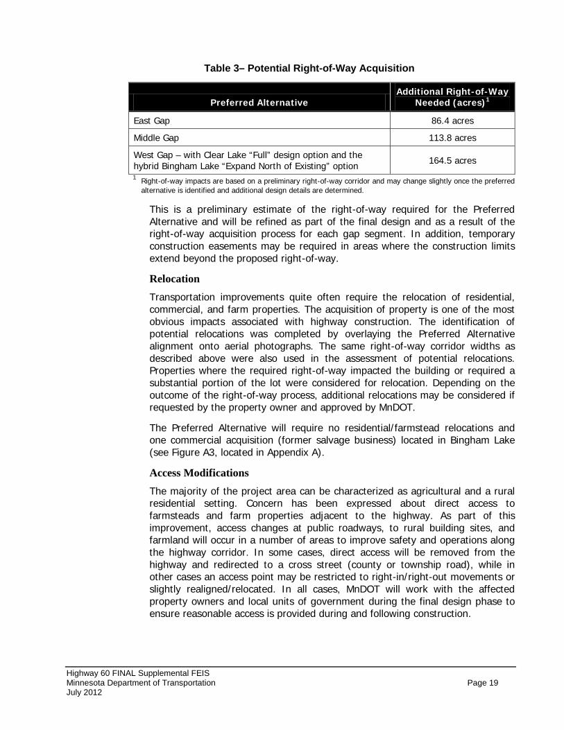
Highway 60 FINAL Supplemental FEIS Minnesota Department of Transportation Page 19 July 2012
Table 3– Potential Right-of-Way Acquisition
Preferred Alternative Additional Right-of-Way
Needed (acres)1
East Gap 86.4 acres
Middle Gap 113.8 acres
West Gap – with Clear Lake “Full” design option and the hybrid Bingham Lake “Expand North of Existing” option 164.5 acres
1 Right-of-way impacts are based on a preliminary right-of-way corridor and may change slightly once the preferred alternative is identified and additional design details are determined.
This is a preliminary estimate of the right-of-way required for the Preferred Alternative and will be refined as part of the final design and as a result of the right-of-way acquisition process for each gap segment. In addition, temporary construction easements may be required in areas where the construction limits extend beyond the proposed right-of-way.
Relocation Transportation improvements quite often require the relocation of residential, commercial, and farm properties. The acquisition of property is one of the most obvious impacts associated with highway construction. The identification of potential relocations was completed by overlaying the Preferred Alternative alignment onto aerial photographs. The same right-of-way corridor widths as described above were also used in the assessment of potential relocations. Properties where the required right-of-way impacted the building or required a substantial portion of the lot were considered for relocation. Depending on the outcome of the right-of-way process, additional relocations may be considered if requested by the property owner and approved by MnDOT.
The Preferred Alternative will require no residential/farmstead relocations and one commercial acquisition (former salvage business) located in Bingham Lake (see Figure A3, located in Appendix A).
Access Modifications The majority of the project area can be characterized as agricultural and a rural residential setting. Concern has been expressed about direct access to farmsteads and farm properties adjacent to the highway. As part of this improvement, access changes at public roadways, to rural building sites, and farmland will occur in a number of areas to improve safety and operations along the highway corridor. In some cases, direct access will be removed from the highway and redirected to a cross street (county or township road), while in other cases an access point may be restricted to right-in/right-out movements or slightly realigned/relocated. In all cases, MnDOT will work with the affected property owners and local units of government during the final design phase to ensure reasonable access is provided during and following construction.
Highway 60 FINAL Supplemental FEIS Minnesota Department of Transportation Page 20 July 2012
Mitigation The design phase of the Preferred Alternative will focus efforts to minimize right-of-way impacts to the extent possible. The needs of each property located adjacent to the Preferred Alternative will be assessed on a case-by-case basis and will occur closer to the time of acquisition and construction. See Draft SFEIS Section 4.1 – Right-of-Way and Relocation for further information.
The Uniform Relocation Assistance and Real Property Acquisition Policies Act of 1970, as amended, and 49 CFR Part 24 provide that assistance be granted to persons, businesses, farms, and non-profit organizations that may be displaced by public improvements, such as this highway project.
MnDOT will provide relocation assistance for persons displaced by the project without discrimination. Advisors are available to explain relocation details, policies, and procedures with potentially displaced individuals. The advisors will work with a displacee in locating comparable replacement property and will work directly with property occupants to assist with their specific relocation plans.
Residential displacees are entitled to advisory services and the reimbursement of some of the costs associated with relocation. These may include moving expenses, replacement housing costs, increased rental or mortgage payments, closing costs, and other valid relocation costs. The replacement dwelling to which a displacee relocates must be “decent, safe, and sanitary”, meaning it must meet all the minimum requirements established by federal regulations and conform to all housing and occupancy codes.
While not expected for the Highway 60 Gaps Project, Last Resort Housing provisions can be implemented to ensure that comparable replacement housing is available to any displacee. These provisions may include increased replacement housing payments or other alternate methods based on reasonable costs.
Relocation assistance will also be made available to businesses, farms, and non-profit organizations. In addition to advisory services, payment may be made for certain expenses pertaining to:
• Moving Costs
• Loss of tangible personal property as a result of relocation or discontinuance of a business
• Eligible reestablishment expenses
• Eligible costs incurred in searching for a replacement site
• Fixed payment in lieu of moving and reestablishment costs
Economic Environment The construction of the Preferred Alternative will impact the economy of the project area by converting agricultural land to highway uses and is anticipated to require the acquisition of one commercial property (former vehicle salvage yard) in Bingham Lake. The improved highway may also attract new development that
Highway 60 FINAL Supplemental FEIS Minnesota Department of Transportation Page 21 July 2012
would compensate for such economic losses. See Draft EIS Section 4.1 – Economic Environment for further discussion.
Indirect impacts to existing businesses may occur as a result of access changes and construction activities including potential traffic delays and detours.
Mitigation Relocation assistance will be provided for all acquired properties. Potential temporary business access impacts during construction will be mitigated by minimizing detours and through the use of signage directing customers to businesses. No other economic mitigation measures are proposed.
Traffic Assessment As discussed in Section 2.5 of this document, and the Traffic Assessment section of the Draft SFEIS, the Preferred Alternative proposes to convert the three remaining two-lane highway segments of Highway 60 to a continuous four-lane divided rural section. The Preferred Alternative will accommodate future traffic volumes adequately and is expected to reduce the number of higher severity crashes (head on, ran-off-road, and sideswipe opposite direction incidents) that are more typical with a two-lane highway. The completion of a continuous four-lane section along Highway 60 will provide a logical, safe, and predictable system for highway users.
Benefit-Cost Analysis A benefit/cost analysis (B/C analysis) was completed for the proposed project in June 2011. The purpose of a benefit/cost analysis (B/C analysis) is to bring all of the direct effects of a transportation investment into a common measure (dollars), and to allow for the fact that benefits accrue over a long period of time while costs are incurred primarily in the initial years of the project. The primary elements that can be monetized for transportation projects are travel time, vehicle operating costs, crash costs, and remaining capital value. Projects are considered cost effective if the B/C ratio is greater than 1.0. The B/C Analysis provides an indication of the economic desirability, but the results must be weighted by decision-makers along with the assessment of other effects and impacts. A B/C Analysis was completed and discussed in Section 4.1 of the Draft SFEIS. The calculated B/C ratio for the Preferred Alternative is 1.36.
Social and Community Environment Information regarding population, housing, and community resources is available in the Draft SFEIS Section 4.1 – Social and Community Environment. The Preferred Alternative is anticipated to have no direct impact on community resources. Proposed access changes along Highway 60 may have minimal effects on how travelers access community resources. However, safe and convenient access will be provided throughout the project area.
Mitigation No mitigation is required since no anticipated directs effects occur as a result of the Build Alternative.
Highway 60 FINAL Supplemental FEIS Minnesota Department of Transportation Page 22 July 2012
Land Use As discussed in Draft SFEIS Section 4.1 – Land Use, the Preferred Alternative will have some impact on land use in the project area. Right-of-way acquisition will impact several rural residential properties and farmsteads. However, only one full acquisition is anticipated as a result of the Preferred Alternative. The proposed improvements will also convert farmland and wetland acreage to transportation uses and there is the potential for the improved four-lane highway section to attract additional development to more urban areas. It is assumed this development would primarily occur within the cities of Bingham Lake, Butterfield, Mountain Lake, St. James, and Windom.
Based on the importance of Highway 60 to the affected communities, the Preferred Alternative is consistent and compatible with existing and future land use plans and maps.
Mitigation Controlling potential land use changes that occur following implementation of the proposed improvements would be accomplished primarily through local government zoning authority and through highway access management. MnDOT has already coordinated with local units of government regarding the project. Furthermore, MnDOT encourages cities in the project area to use smart growth techniques and innovative best management practices for stormwater, such as those listed on the NEPA Stormwater Green Sheet, prepared by the Environmental Protection Agency.
Parks and Public Recreational Areas Parks and public recreational areas are listed and discussed in Draft SFEIS Section 4.1 – Parks and Public Recreational Areas. The Preferred Alternative will have no impacts on existing parks in the study area. However, the Preferred Alternative may impact grant-in-aid snowmobile trails. These Department of Natural Resources (MNDNR) grant-in-aid trails are generally used for recreational purposes during winter months.
The construction of a continuous four-lane highway may affect the current designated routes of grant-in-aid snowmobile trails (Cottonwood and Riverside Trail) since these trails parallel and/or cross over the highway in some locations. However, the route of these trails is fluid and dependent upon landowner agreements. Construction of the Preferred Alternative will not prohibit these trails and they will still be allowed to cross and parallel the highway corridor.
Mitigation Further evaluation of potential impacts to snowmobile trails will be completed during final design and coordination with the MNDNR and other local snowmobile organizations may need to occur to ensure safety conditions for motorist and snowmobile riders is maintained as a result of any changes to the design of the highway and trail alignments/crossing.
Highway 60 FINAL Supplemental FEIS Minnesota Department of Transportation Page 23 July 2012
Section 4(f) and Section 6(f) Properties The Section 4(f) legislation, as established under the Department of Transportation Act of 1966 (49 USC 303, 23 USC 138) and as revised in 2005 by the Safe, Accountable, Flexible, Efficient Transportation Equity Act: A Legacy for Users (SAFETEA-LU) [which included moving Section 4(f) regulations to 23 CFR 774], provides protection for publicly owned parks, recreation areas, public and privately owned historic sites, wildlife, and/or waterfowl refuges from conversion to a transportation use.
Additional protection is provided for outdoor recreational lands under the Section 6(f) legislation (16 USC 4602-8(f) (30)) where Land and Water Conservation funds were used for the planning, acquisition, or development of the property. These properties may be converted to highway use, but only if replacement land of the same fair market value and equal usefulness is made available.
As discussed in the Draft SFEIS Section 4.1 – Section 4(f) and Section 6(f), no Section 4(f) or Section 6(f) resources will be impacted by the Preferred Alternative.
Mitigation No mitigation is proposed since no direct impacts to Section 4(f)/6(f) resources is anticipated.
Pedestrian and Bicycle Movements There are no pedestrian or bicycle facilities currently located along the three two-lane segments of Highway 60. Future regional trail corridors within the Highway 60 study area are shown in the 2010 Trail Corridor Plan, which was prepared by the Southwest Regional Development Commission (RDC) in cooperation with the surrounding local units of government. The Plan identifies a trail corridor south of Highway 60 beginning at Windom and traversing northeast toward Mountain Lake and beyond. A second future trail corridor has been identified running north-south near Bingham Lake. These trail corridors appear to cross Highway 60 near Bingham Lake and Mountain Lake. No funding for these trail corridors has been programmed and the timing of construction has not been scheduled.
The 2001 MnDOT Bicycle Map shows that the majority of Highway 60 between St. James and Windom as having a “Medium Volume” Roadway Suitability Rating with short segments west of St. James and east of Mountain Lake having Low Volume ratings.
The Preferred Alternative will include 10-foot shoulders along Highway 60, which will perpetuate the existing condition and can be used by pedestrians/bicyclists. The Preferred Alternative may improve safety of pedestrians/bicyclists crossing Highway 60 since with the construction of a four-lane divided section, these movements will no longer have to cross both directions of traffic at the same time. The center median can serve as a refuge for pedestrian/bicycle movements where they can cross one direction of traffic at a time. Also, the additional traffic lane in each direction allows vehicles to shy away from cyclists on the shoulder of the highway.
Highway 60 FINAL Supplemental FEIS Minnesota Department of Transportation Page 24 July 2012
Mitigation No mitigation for pedestrian and bicycle movements is anticipated. Coordination with the Southwest RDC will continue to occur to determine the status of the planned trail corridors and whether additional pedestrian/bicycle accommodations are needed along Highway 60.
Environmental Justice The Draft SFEIS included an evaluation of the entire project area for environmental justice issues including the potential effects to identifiable low-income populations. The Draft SFEIS concluded there would be no disproportionately high and adverse effects on minority populations or low-income populations as a result of the proposed alternatives (see Draft SFEIS Section 4.1 – Environmental Justice).
Mitigation No mitigation measures are proposed since no disproportionately high and adverse effects are anticipated on minority and/or low-income populations.
Transit Services Both Cottonwood County and Watonwan County have public transit services available within the project area. These services are limited to dial-a-ride service. In 2010, ridership within both counties was slightly lower than previous years. The MnDOT Office of Transit provides funding for dial-a-ride service operations within both Cottonwood and Watonwan Counties.
The Preferred Alternative will potentially have a positive impact on the quality and efficiency of transit service along the Highway 60 corridor as a result of improved operations. Short-term adverse impacts to transit services may result from construction activities including minor detours or construction delays. See Draft SFEIS Section 4.1 – Transit Services for additional detail of transit options available in the area.
Mitigation As part of the final design phase of each gap, a construction staging plan will be prepared by MnDOT which will be shared with all interested individuals, including transit providers. The staging plan will attempt to minimize disruptions on transit routes and maintain the efficiency of transit service during construction.
Utilities There are several local and regional utility lines and distribution and/or transmission facilities that can be found within the project area. These utilities primarily consist of local electric and telephone distribution lines, natural gas pipelines, and fiber optic communication lines.
Construction of the additional lanes will cause the relocation of certain utilities currently located in or directly adjacent to the current right-of-way. Temporary disruptions in service are possible as a result of these relocations. Furthermore,
Highway 60 FINAL Supplemental FEIS Minnesota Department of Transportation Page 25 July 2012
utility relocations have the potential to result in some environmental impact (farmland disturbance, wetland fill, vegetation clearing, etc.) through work needing to take place outside the highway right-of-way. While MnDOT and FHWA recognize the possibility of such impacts, at this time it is not possible to estimate the nature and magnitude of such future impacts. However, under the State of Minnesota environmental review program (Minnesota Rules 4410.4300) environmental analysis is required for certain utilities. These regulations are currently administered by the Minnesota Department of Commerce and Minnesota Public Utilities Commission. In addition, Minnesota Statutes 85.415 requires utility companies to obtain permits from the MNDNR to cross state owned lands and waters. Such permits include provision for further environmental analysis and the minimization/mitigation of adverse impacts on the environment. It is not known where any rerouted lines may subsequently be relocated.
Within the East Gap there are overhead electric power lines that cross Highway 60 in approximately five locations. In addition, an electric power line parallels the north right-of-way line of Highway 60 from approximately 670th Avenue to 685th Avenue. This line is located on the opposite side of the existing highway from where the new roadway is proposed to be constructed. A natural gas line is also located along the north side of Highway 60 for a short segment within the East Gap.
In the West Gap, a City of Bingham Lake sewer lift station is located in the southwest corner of the Highway 60/Cottonwood County Road 44 intersection. Sanitary sewer and water mainlines are also located immediately south of Highway 60 starting at the western edge of the community (near 510th Avenue) and are located within the highway right-of-way all the way to the City of Windom. Impacts to these City-owned utilities will be avoided with the Preferred Alternative that proposes to widen the highway to the north. Other city utility lines that pass perpendicular under the highway will be identified during the final design process and efforts will be made to minimize potential impacts and disruptions in service.
Overall, no substantial utility relocations and/or impacts are anticipated as a result of the Preferred Alternative.
Mitigation Coordination with utility providers will occur during the final design phase of the project to ensure all utilities within the area are identified, so avoidance and minimization measures can be implemented. Minimization efforts may include minor alignment shifts of the Preferred Alternative or alterations to the typical roadway cross-section. Furthermore, as discussed above, environment analysis under Minnesota Rules 4410.4300 is required for certain utilities and Minnesota Statutes 85.415 requires utility companies to obtain permits in order to cross state owned lands and waters. Such permits may include provisions for further environmental analysis and the minimization of adverse impacts on the environment.
Highway 60 FINAL Supplemental FEIS Minnesota Department of Transportation Page 26 July 2012
Contaminated Properties The presence of potentially contaminated properties (defined as properties where soil and/or groundwater is impacted with pollutants, contaminants, or hazardous materials) is a concern in the development of highway projects because of potential liabilities associated with ownership of such properties, potential cleanup costs, and safety concerns associated with construction personnel encountering unsuspected wastes or contaminated soil or groundwater. The primary step in recognizing and evaluating potentially contaminated properties is completing a Phase I Environmental Site Assessment (ESA).
A Phase I ESA was completed in the spring 2011. The Phase I ESA analysis included a site visit, and a review of reasonably ascertainable federal and/or state records. A complete summary of the sites identified in the Phase I ESA was documented in the Draft SFEIS (see Section 4.1 – Contaminated Properties). The Phase I ESA Report is on file at the MnDOT District Office in Mankato.
According to the Phase I ESA, 23 medium and two high risk sites were identified within close proximity of the Preferred Alternative. Within the East and Middle Gaps, 7 medium risks sites and four medium risks sites have been identified, respectively. The West Gap contains 9 medium risk and 2 high risk sites. Many of these sites are located within 500 feet of the Preferred Alternative.
Since the preparation of the Draft SFEIS, the findings of a more detailed Phase II assessment at one of the high risks sites in the West Gap (former salvage yard in Bingham Lake) have been completed. The detailed site investigations, consisting of soil and groundwater testing, provided MnDOT with a better understanding of the contamination (type, quantity, and location) at the site. Based on the findings of the Phase II assessment, the contamination appears to be contained on-site and the type and level of contaminates is not anticipated to result is extraordinary liabilities associated with ownership or substantial cleanup costs. As a result, the Preferred Alternative includes widening the highway to the north of the existing alignment in the project area adjacent to the former salvage yard business in Bingham Lake.
Mitigation As part of the final design phase and prior to right-of-way acquisition, properties identified as having the greatest potential to directly impact the Preferred Alternative will be further evaluated to determine if extensive liability exists in acquiring property for the highway improvements. Potentially contaminated properties that would be acquired will be drilled and sampled, if necessary, to determine the extent and magnitude of contaminated soil or groundwater. The results of these investigations will be used to avoid and/or minimize potential impacts through design modifications, right-of-way refinements. Construction work will be conducted in compliance with all state and federal laws and regulations.
A plan will be developed by MnDOT for properly handling and treating contaminated soil and/or groundwater. MnDOT will work with the Petroleum
Highway 60 FINAL Supplemental FEIS Minnesota Department of Transportation Page 27 July 2012
Brownfields Program and/or the Voluntary Investigation and Cleanup Programs at the MPCA, as appropriate.
Cultural Resources In compliance with Section 106 of the National Historic Preservation Act (NHPA) of 1966 (36 CFR 800) and Section 4(f) of the Department of Transportation Act of 1966 (49 USC 303, 23 USC 138), a Phase I/II cultural resources investigation of the three gap segments of the Highway 60 corridor was conducted. The Draft SFEIS Section 4.1 – Cultural Resources provided a summary of the reports available for review at the MnDOT District 7 Offices in Mankato, Minnesota.
Based on the findings of the Phase I investigations, a determination was made by MnDOT’s Cultural Resources Unit staff that there are no historic properties adversely affected by the project as it is currently proposed. This determination was included in a letter to the Minnesota SHPO, which concurred with the findings. The MnDOT determination letter and SHPO concurrence letter were included in Appendix B of the Draft SFEIS.
Mitigation Based on the findings of the investigations, no NRHP-eligible historical, architectural, or archaeological sites will be impacted by the Preferred Alternatives. Therefore, no mitigation is necessary.
4.2 WHAT ARE THE NATURAL ENVIRONMENT IMPACTS? Noise A detailed analysis of noise impacts was completed for the three gap segments of Highway 60 and documented in Section 4.2 – Noise of the Draft SFEIS. The objective of the analysis was to quantify the potential impacts of the project improvements using a noise model that considers alignments, locations of receptors, traffic conditions, and topography of the area. The results of the modeling analysis was used to determine the feasibility and cost effectiveness of using noise walls to provide mitigation for any identified impacts on receptors.
The hybrid Bingham Lake design option identified as part of the Preferred Alternative has no change in the impacts or mitigation analysis conducted in the Draft SFEIS. Furthermore, since the Preferred Alternative follows an alignment already studied in the Draft SFEIS, which is herein incorporated by reference, a new detailed analysis of noise impacts was not completed for this Final SFEIS. The remainder of this Noise section summarizes the findings from the previous analysis as it relates specifically to the Preferred Alternative.
For the Highway 60 Gaps Project, future noise levels were determined to exceed both the Federal Noise Abatement Criteria and the State Noise Standards at several noise receptor sites (see Tables 17 through 19 on pages 54-57 of the Draft SFEIS). Therefore, noise abatement measures were included in the analysis. Noise mitigation measures were considered, but none are deemed reasonable and feasible (see Tables 20 though 25 on pages 60-65 of the Draft
Application of State and Federal Regulations
Highway 60 FINAL Supplemental FEIS Minnesota Department of Transportation Page 28 July 2012
SFEIS). Therefore, a Noise Standards Exemption Request will be submitted to the Commissioners of the MPCA. The exemption request document is a means of demonstrating that all reasonably available noise mitigation measures were employed as part of the project.
Traffic noise impacts currently exist and are predicted to increase along the three Highway 60 two-lane segments with or without the proposed improvements. Mitigation in the form of noise barriers was analyzed. No barriers that achieved a 5 dBA reduction were found to be cost-effective; therefore no barriers are proposed with the proposed improvements.
Noise Conclusion
Air Quality Draft EIS Section 4.2 – Air Quality describes the air quality analysis completed for the proposed Highway 60 improvements, including an analysis of the likely Mobile Source Air Toxics (MSAT) emission impacts of this project. The project is not located in an area where conformity requirements apply, and the scope of the project does not indicate that air quality impacts will be expected. Therefore, it has been determined that no further air quality analysis is necessary.
Mitigation No mitigation measures are proposed.
Water Quality and Surface Water Drainage Currently roadway runoff either infiltrates into the grass ditches or eventually flows to area water resources such as wetlands, lakes, and streams/ditches. For a description of the water resources found in the project area, see Draft SFEIS Section 4.2 – Water Quality and Surface Water Drainage. The most common contaminates in highway runoff include sediments, nutrients, heavy metals, oil, grease, and deicing chemicals. However, impacts from erosion and sedimentation will be addressed both during and after construction according to the conditions of a National Pollutant Discharge Elimination System (NPDES) – Construction Stormwater permit.
Based on the preliminary design, the Preferred Alternative will increase the existing impervious surface area by approximately 75 acres, which will result in additional storm water runoff and greater discharge rates. This calculation is important in determining the water quality strategies that have been proposed to ensure compliance with permit requirements. The proposed design of the Preferred Alternative includes grassed swales/ditches and storm water ponds to treat runoff from the highway.
Grassed swales or vegetated ditches are densely vegetated drainage ways with slightly sloped bottoms. The role of the vegetation is to reduce flow velocity and provide sediment settling and infiltration. Typically, tall rigid grasses with extensive root systems are desirable. The grassed swales are proposed to be implemented along the roadside ditches and will provide a substantial amount of
Highway 60 FINAL Supplemental FEIS Minnesota Department of Transportation Page 29 July 2012
treatment by removing total suspended solids, phosphorus and other pollutants from the runoff.
Storm water detention ponds have also been planned at numerous locations along the corridor (see Preferred Alternative mapping located in Appendix A). These wet detention ponds will be used as end of the line runoff control and storm water treatment. Wet detention ponds have been strategically placed in order to capture substantial amounts of roadway runoff from new impervious surface and from existing Highway 60 for treatment. Some of the storm water ponds’ drainage areas include adjacent properties along the project corridor. The impervious surface and drainage areas from these properties are being captured and treated by the ponds. Note the pond sites shown on the Preferred Alternative mapping is based on the preliminary design and specific locations, sizes, and shapes may be altered if deemed necessary during the final design phase of the project.
Other best management practices (BMPs), such as sodding, seeding, erosion control blanket, biorolls, bioengineering, rock ditch checks, etc. will be used on all disturbed areas of the project to reduce sediment and pollutant loading to surface waters. Additional BMPs may be suggested by the MPCA and will be determined as part of the permitting process. Furthermore, several new/replacement culverts and ditches associated with the Preferred Alternative will need to be constructed in order to maintain drainage patterns. If increased capacity is needed for a culvert(s), this could be achieved by larger or multiple culverts, increased grade on culverts, and/or more hydraulically efficient inlets. Any culvert improvements will consider stream slope, erosion potential, upstream and downstream conditions, and watercourse capacity.
MnDOT will maintain the flow of all drainage ditches impacted by the project. During the final design phase, MnDOT hydraulics staff will coordinate with the appropriate ditch authority to the proposed changes to each of these drainage ditch locations and a detailed assessment of drainage patterns, ditch sections, and culvert impacts will be conducted in accordance with Section 404 permitting requirements.
Water quality impacts from the Highway 60 improvements are expected to be minimal in part due to the permitting and mitigation requirements that will be included as part of the Section 404 Permit, Section 401 Water Quality Certification, and NPDES Permit (MN R 100001).
Mitigation As part of the final design phase for the Preferred Alternative, a Storm Water Pollution Prevention Plan (SWPPP), which is required as part of the NPDES Permit, will be prepared that will outline the practices to be used for this project to prevent impacts to the quality of the receiving waters. The SWPPP would be incorporated and made part of the construction documents.
The Preferred Alternative will require permits, including ones from the MPCA and MNDNR which will ensure potential impacts from erosion and sedimentation will not adversely impact water quality. A more detailed discussion of water quality
Highway 60 FINAL Supplemental FEIS Minnesota Department of Transportation Page 30 July 2012
related permit requirements and BMPs was provided in Section 4.2 – Water Quality and Surface Water Drainage of the Draft SFEIS.
Floodplains and Water Body Modifications The most recent Federal Emergency Management Agency (FEMA) Flood Insurance Rate Map (FIRM) for the study area were used in the assessment of potential impacts that was documented in Section 4.2 – Floodplains and Water body Modifications of the Draft SFEIS. According to the assessment it was determined that there are no designated floodplain areas within the Highway 60 study area. Therefore, no impacts to a designated floodplain are anticipated. Improvements within the West Gap segment will require water body modifications, including alterations to the natural boundary of Warren Pond and Clear Lake, requiring fill to be placed below the ordinary high water (OHW) level of these water bodies. Furthermore, the highway improvements in the City of Bingham Lake will likely require the placement of fill material within an open water wetland (Wetland #25) located near the intersection of Highway 60 and County Road 2. However, a modified design option for this area has been identified as part of the Preferred Alternative that more equally spreads the widening of the highway to both the north and side sides of the existing alignment. This design modification was included to balance impacts on the built (commercial property) and Wetland #25. As a result, the potential impacts on Wetland #25 have been minimized. The conceptual layout figures contained in Appendix A depict the location and estimated amount of potential impact on these water resources.
The Preferred Alternative involves widening the roadway to the north in the area of Warren Pond. Because the level of design detail is limited in this area, the potential impacts were calculated based on the proposed right-of-way limits. The proposed right-of-way extends into the southern portion of Warren Pond and approximately 0.34 acres of potential impact is shown (Wetland #30). However, the detailed design phase will define the construction limits, which is expected to reduce and/or avoid potential impacts to Warren Pond.
The Preferred Alternative involves impacts to approximately 1.17 acres of Clear Lake by widening the highway to the north of the existing alignment. As discussed below in the Wetland Section of this Final SFEIS, a Clear Lake “Compressed Centerline Spacing” design option was considered, but eliminated from consideration due to safety concerns associated with this type of design and the need for safety barriers (guardrail structures). Further coordination with the MNDNR and design refinements will be pursued during the final design phase to minimize and/or avoid direct impact to the lake.
This area of southwestern Minnesota has an extensive agricultural drainage ditch system. Agricultural drainage ditches are designed, constructed, and maintained with steep side slopes to minimize their footprint on the agricultural landscape, as well as to facilitate the efficient removal of surface water from farm fields. Agricultural drainage ditches are not designed to develop wetland characteristics and, if constructed in upland for the purpose of draining upland, are not considered wetlands. Depending on their individual characteristics, drainage
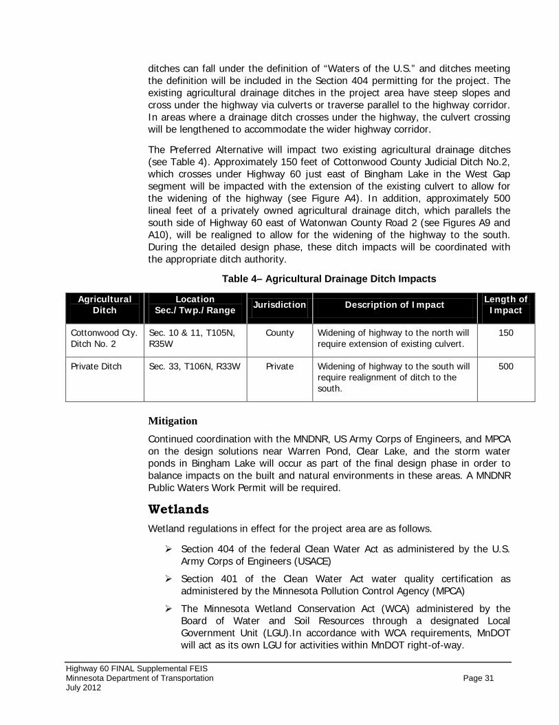
Highway 60 FINAL Supplemental FEIS Minnesota Department of Transportation Page 31 July 2012
ditches can fall under the definition of “Waters of the U.S.” and ditches meeting the definition will be included in the Section 404 permitting for the project. The existing agricultural drainage ditches in the project area have steep slopes and cross under the highway via culverts or traverse parallel to the highway corridor. In areas where a drainage ditch crosses under the highway, the culvert crossing will be lengthened to accommodate the wider highway corridor.
The Preferred Alternative will impact two existing agricultural drainage ditches (see Table 4). Approximately 150 feet of Cottonwood County Judicial Ditch No.2, which crosses under Highway 60 just east of Bingham Lake in the West Gap segment will be impacted with the extension of the existing culvert to allow for the widening of the highway (see Figure A4). In addition, approximately 500 lineal feet of a privately owned agricultural drainage ditch, which parallels the south side of Highway 60 east of Watonwan County Road 2 (see Figures A9 and A10), will be realigned to allow for the widening of the highway to the south. During the detailed design phase, these ditch impacts will be coordinated with the appropriate ditch authority.
Table 4– Agricultural Drainage Ditch Impacts
Agricultural Ditch
Location Sec./Twp./Range Jurisdiction Description of Impact Length of
Impact
Cottonwood Cty. Ditch No. 2
Sec. 10 & 11, T105N, R35W
County Widening of highway to the north will require extension of existing culvert.
150
Private Ditch Sec. 33, T106N, R33W Private Widening of highway to the south will require realignment of ditch to the south.
500
Mitigation Continued coordination with the MNDNR, US Army Corps of Engineers, and MPCA on the design solutions near Warren Pond, Clear Lake, and the storm water ponds in Bingham Lake will occur as part of the final design phase in order to balance impacts on the built and natural environments in these areas. A MNDNR Public Waters Work Permit will be required.
Wetlands Wetland regulations in effect for the project area are as follows.
Section 404 of the federal Clean Water Act as administered by the U.S. Army Corps of Engineers (USACE)
Section 401 of the Clean Water Act water quality certification as administered by the Minnesota Pollution Control Agency (MPCA)
The Minnesota Wetland Conservation Act (WCA) administered by the Board of Water and Soil Resources through a designated Local Government Unit (LGU).In accordance with WCA requirements, MnDOT will act as its own LGU for activities within MnDOT right-of-way.
Highway 60 FINAL Supplemental FEIS Minnesota Department of Transportation Page 32 July 2012
Public Waters Work Permit for wetlands that are designated as Minnesota Department of Natural Resources (MNDNR) Public Waters.
Executive Order 11990 – Protection of Wetlands.
Wetlands within the project area were delineated in the spring 2011 by a certified wetland delineator using the methodology of the Corps of Engineers Wetlands Delineation Manual, 1987, and the Midwest Regional Supplement. A Level 2 Routine Onsite Determination Method (RODM) was used for the delineation. The results of the analysis were summarized in the Draft SFEIS Section 4.2 – Wetlands. In addition the Highway 60 Wetland Delineation Report, was included with the Draft SFEIS on an accompanying CD-ROM as supplemental information.
Areas that are underlain by hydric soil, maintain wetland hydrology and support hydric vegetation were mapped as wetlands. Roadside ditches in areas of historic hydric soil were considered as wetland remnants and mapped as wetlands. Ditches cut through upland (i.e., historically non-wetland) and receiving drainage from upland were mapped as ditches. Areas that were not historically wetlands prior to road construction were not delineated as wetland. There are many such ditches within the project area, particularly along the existing Highway 60, the Union Pacific railroad line and the various connecting and intersecting roadways. These roadside ditches may contain hydric vegetation, however, they were designed and constructed to convey water rather than retain it. Depending on their individual characteristics, drainage ditches can fall under the definition of “Waters of the U.S.” and ditches meeting the definition will be included in Section 404 permitting.
Wetland Jurisdiction
Based on current rules it is anticipated that the following agencies would have jurisdiction over project area wetlands:
• The Unites States Army Corps of Engineers (USACE) regulates all waters of the U.S. including wetlands. Regulated wetlands must meet the criteria of the 1987 Manual and the subsequent regional supplements. Although the USACE does not regulate isolated wetlands, the joint federal/state permit application will be prepared under the assumption that all areas mapped as wetlands are jurisdictional. Depending on their characteristics of flow and connectivity drainage ditches may meet the definition of waters of the U.S.
• The Minnesota Pollution Control Agency (MPCA) also regulates wetlands through two primary mechanisms. The first is through review of the project with regards to compliance with Section 401 of the Clean water Act. This project is anticipated to require a letter of permission from the USACE. The MPCA also regulates wetlands through Minnesota Rules 7050.0186, which attempts to prevent degradation of wetlands and waters, requires sequencing to avoid and minimize impacts, and provides compensatory mitigation if impacts cannot be avoided.
Highway 60 FINAL Supplemental FEIS Minnesota Department of Transportation Page 33 July 2012
• The Minnesota Wetland Conservation Act (WCA) also regulates wetlands, and is administered by MnDOT when impacts occur within its existing and/or proposed right-of-way. The WCA regulates all wetlands, regardless of isolation. The WCA does not have jurisdiction over areas constructed in non-wetland and created for a purpose other than being a wetland, even though such areas may exhibit wetland characteristics (e.g. roadside ditches and stormwater ponds). This process recognizes created areas as incidental, which could include many of the roadside drainage ditches.
• The Minnesota Department of Natural Resources (MNDNR) regulates Public Waters, and is a participant if projects occur within 1,000 feet of a Public Water. The proposed project includes improvements in the area of Clear Lake and Warren Pond, which are both Public Waters and will require a Public Water Work Permit if construction occurs below the ordinary high water level of these wetlands/water bodies. The WCA does not administer jurisdiction over Public waters, although the MNDNR can waive jurisdiction to WCA.
Section 404 of the Clean Water Act requires approval by the U.S. Army Corps of Engineers for discharge of dredged or fill material into waters of the United States. A Section 404 Permit will be applied for and obtained prior to construction. This analysis is to show that the screening and selection process used in the development of this NEPA document have identified the least environmentally damaging practicable alternative consistent with the Section 404(b)(1) guidelines.
Least Environmentally Damaging Practicable Alternative (LEDPA)
The Section 404(b)(1) guidelines state “no discharge of dredged or fill material shall be permitted if there is a practicable alternative to the proposed discharge which would have less adverse impact on the aquatic ecosystem, so long as the alternative does not have other significant adverse environmental consequences.” Furthermore, an alternative is considered practicable if “it is available and capable of being done after taking into consideration cost, existing technology, and logistics in light of overall project purposes.”
The purpose and need statement of the Highway 60 Project is to provide an improved transportation link between Windom and St. James that improves travel safety and enhances system continuity. A continuous four-lane highway will provide a logical, safe, and predictable system for highway users. Furthermore, the crash history of the two-lane sections indicate that nearly 40 percent were of the higher severity crashes like head-on and sideswipe opposite direction incidents. These types of crashes can be substantially reduced with a four-lane divided highway section. A complete description of the purpose and need statement was detailed in Section 2.5 – Purpose and Need for the Proposed Action, of the Draft SFEIS.
The Draft SFEIS evaluated alternatives in a multi-step process which served to eliminate alternatives that would not be considered practicable under Section
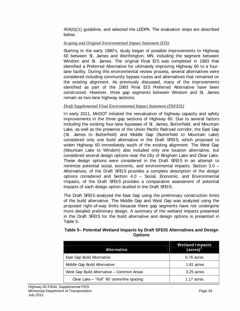
Highway 60 FINAL Supplemental FEIS Minnesota Department of Transportation Page 34 July 2012
404(b)(1) guideline, and selected the LEDPA. The evaluation steps are described below.
Starting in the early 1980’s, study began of possible improvements to Highway 60 between St. James and Worthington, MN, including the segment between Windom and St. James. The original Final EIS was completed in 1983 that identified a Preferred Alternative for ultimately improving Highway 60 to a four-lane facility. During this environmental review process, several alternatives were considered including community bypass routes and alternatives that remained on the existing alignment. As previously discussed, many of the improvements identified as part of the 1983 Final EIS Preferred Alternative have been constructed. However, three gap segments between Windom and St. James remain as two-lane highway sections.
Scoping and Original Environmental Impact Statement (EIS)
In early 2011, MnDOT initiated the reevaluation of highway capacity and safety improvements in the three gap sections of Highway 60. Due to several factors including the existing four-lane bypasses of St. James, Butterfield, and Mountain Lake, as well as the presence of the Union Pacific Railroad corridor, the East Gap (St. James to Butterfield) and Middle Gap (Butterfield to Mountain Lake) considered only one build alternative in the Draft SFEIS, which proposed to widen Highway 60 immediately south of the existing alignment. The West Gap (Mountain Lake to Windom) also included only one location alternative, but considered several design options near the City of Bingham Lake and Clear Lake. These design options were considered in the Draft SFEIS in an attempt to minimize potential social, economic, and environmental impacts. Section 3.0 – Alternatives, of the Draft SFEIS provides a complete description of the design options considered and Section 4.0 – Social, Economic, and Environmental Impacts, of the Draft SFEIS provides a comparative assessment of potential impacts of each design option studied in the Draft SFEIS.
Draft Supplemental Final Environmental Impact Statement (DSFEIS)
The Draft SFEIS analyzed the East Gap using the preliminary construction limits of the build alternative. The Middle Gap and West Gap was analyzed using the proposed right-of-way limits because there gap segments have not undergone more detailed preliminary design. A summary of the wetland impacts presented in the Draft SFEIS for the build alternative and design options is presented in Table 5.
Table 5– Potential Wetland Impacts by Draft SFEIS Alternatives and Design Options
Alternative Wetland Impacts
(acres)1
East Gap Build Alternative 0.76 acres
Middle Gap Build Alternative 1.81 acres
West Gap Build Alternative – Common Areas 3.25 acres
Clear Lake – “Full” 90’ centerline spacing 1.17 acres
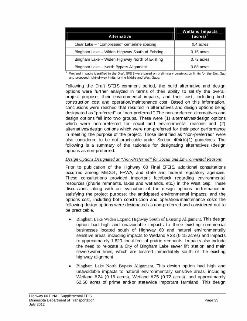
Highway 60 FINAL Supplemental FEIS Minnesota Department of Transportation Page 35 July 2012
Alternative Wetland Impacts
(acres)1
Clear Lake – “Compressed” centerline spacing 0.4 acres
Bingham Lake – Widen Highway South of Existing 0.15 acres
Bingham Lake – Widen Highway North of Existing 0.72 acres
Bingham Lake – North Bypass Alignment 0.88 acres 1 Wetland impacts identified in the Draft SFEIS were based on preliminary construction limits for the East Gap
and proposed right-of-way limits for the Middle and West Gaps.
Following the Draft SFEIS comment period, the build alternative and design options were further analyzed in terms of their ability to satisfy the overall project purpose; their environmental impacts; and their cost, including both construction cost and operation/maintenance cost. Based on this information, conclusions were reached that resulted in alternatives and design options being designated as “preferred” or “non-preferred.” The non-preferred alternatives and design options fell into two groups. These were (1) alternatives/design options which were non-preferred for social and environmental reasons and (2) alternatives/design options which were non-preferred for their poor performance in meeting the purpose of the project. Those identified as “non-preferred” were also considered to be not practicable under Section 404(b)(1) guidelines. The following is a summary of the rationale for designating alternatives /design options as non-preferred.
Prior to publication of the Highway 60 Final SFEIS, additional consultations occurred among MnDOT, FHWA, and state and federal regulatory agencies. These consultations provided important feedback regarding environmental resources (prairie remnants, lakes and wetlands, etc.) in the West Gap. These discussions, along with an evaluation of the design options performance in satisfying the project purpose; the anticipated environmental impacts; and the options cost, including both construction and operation/maintenance costs the following design options were designated as non-preferred and considered not to be practicable.
Design Options Designated as “Non-Preferred” for Social and Environmental Reasons
• Bingham Lake Widen Expand Highway South of Existing Alignment.
•
This design option had high and unavoidable impacts to three existing commercial businesses located south of Highway 60 and natural environmentally sensitive areas, including impacts to Wetland #23 (0.15 acres) and impacts to approximately 1,620 lineal feet of prairie remnants. Impacts also include the need to relocate a City of Bingham Lake sewer lift station and main sewer/water lines, which are located immediately south of the existing highway alignment.
Bingham Lake North Bypass Alignment. This design option had high and unavoidable impacts to natural environmentally sensitive areas, including Wetland #24 (0.16 acres), Wetland #25 (0.72 acres), and approximately 62.60 acres of prime and/or statewide important farmland. This design
Highway 60 FINAL Supplemental FEIS Minnesota Department of Transportation Page 36 July 2012
option would also traverse along the south boundary of the Carpenter Wildlife Management Area (WMA).
Based upon their relative performance on project purpose and need objectives, the following alternatives and design options were identified as non-preferred and are considered not practicable.
Alternatives and Design Options Designated as “Non-Preferred” for Poor Performance in Meeting the Purpose of the Project
• Alternative 1 – No Build.
•
MnDOT concluded that the performance of the No Build Alternative is so low as to characterize this alternative as failing to satisfy essential elements of the Purpose and Need for the highway 60 Project. In particular, Alternative 1 – No Build provides very little benefit on project purpose and need objectives related to safety, capacity, and system continuity.
Clear Lake “Compressed” Centerline Spacing. This design option partially satisfies the purpose and need of the project by enhancing system continuity and improving safety by reducing the chances of head-on crashes through the creation of a continuous four-lane divided highway section. However, this design option does not fully satisfy the overall safety concerns for the corridor. The Clear Lake “Compressed” centerline spacing option requires the use of safety barriers/guardrail. These safety measures would be added between the directional lanes of traffic and on the north side of the westbound lanes. While these structures are effective in prohibiting vehicles from veering off into oncoming traffic they can also exacerbate snow drifting in rural agricultural areas that are more prone to this hazardous condition because of the relatively few objects to block the wind during the winter months. A roadway will typically blow clear during cold windy conditions if there are no obstructions adjacent to the roadway. However, even on a day with clear skies, a structure like a linear guardrail can quickly cause unsafe driving conditions when blowing snow comes in contact with the guardrail and is then deposited on the roadway. Drivers tend to travel at the posted speed limit when, for long stretched of time, there is no snow on the roadway. Then when driving into an area with barriers, drifts are present and surprise the drivers. The snow packed/icy roadway surface results in safety concerns including run off the road and injury crashes. The placement of guardrail also limits the effective and efficient removal of snow (snow storage), which only intensifies the stopping of snow on the roadway.
In the review and assessment of alternatives, MnDOT and FHWA considered the Section 404(b)(1) guidelines in selecting a preferred alternative. In particular, consideration was given to issues of both “practicability” and wetlands impact. Alternative 2 – Build Alternative, with the Clear Lake “Full” and the modified Bingham Lake “Widen North” design options, was designated as “Preferred Alternative” even though it does not have the least amount of wetland impacts.
Designation of “Preferred” Alternative
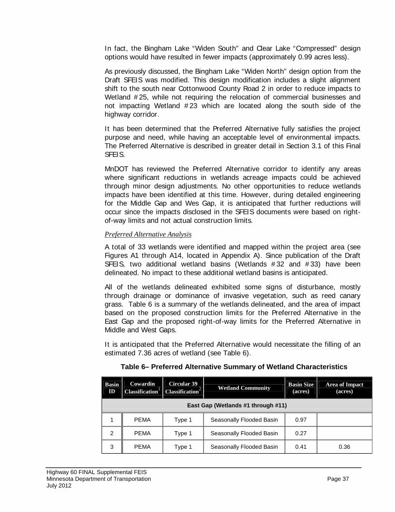
Highway 60 FINAL Supplemental FEIS Minnesota Department of Transportation Page 37 July 2012
In fact, the Bingham Lake “Widen South” and Clear Lake “Compressed” design options would have resulted in fewer impacts (approximately 0.99 acres less).
As previously discussed, the Bingham Lake “Widen North” design option from the Draft SFEIS was modified. This design modification includes a slight alignment shift to the south near Cottonwood County Road 2 in order to reduce impacts to Wetland #25, while not requiring the relocation of commercial businesses and not impacting Wetland #23 which are located along the south side of the highway corridor.
It has been determined that the Preferred Alternative fully satisfies the project purpose and need, while having an acceptable level of environmental impacts. The Preferred Alternative is described in greater detail in Section 3.1 of this Final SFEIS.
MnDOT has reviewed the Preferred Alternative corridor to identify any areas where significant reductions in wetlands acreage impacts could be achieved through minor design adjustments. No other opportunities to reduce wetlands impacts have been identified at this time. However, during detailed engineering for the Middle Gap and Wes Gap, it is anticipated that further reductions will occur since the impacts disclosed in the SFEIS documents were based on right-of-way limits and not actual construction limits.
A total of 33 wetlands were identified and mapped within the project area (see Figures A1 through A14, located in Appendix A). Since publication of the Draft SFEIS, two additional wetland basins (Wetlands #32 and #33) have been delineated. No impact to these additional wetland basins is anticipated.
Preferred Alternative Analysis
All of the wetlands delineated exhibited some signs of disturbance, mostly through drainage or dominance of invasive vegetation, such as reed canary grass. Table 6 is a summary of the wetlands delineated, and the area of impact based on the proposed construction limits for the Preferred Alternative in the East Gap and the proposed right-of-way limits for the Preferred Alternative in Middle and West Gaps.
It is anticipated that the Preferred Alternative would necessitate the filling of an estimated 7.36 acres of wetland (see Table 6).
Table 6– Preferred Alternative Summary of Wetland Characteristics
Basin ID
Cowardin Classification1
Circular 39 Classification2 Wetland Community Basin Size
(acres) Area of Impact
(acres)
East Gap (Wetlands #1 through #11)
1 PEMA Type 1 Seasonally Flooded Basin 0.97
2 PEMA Type 1 Seasonally Flooded Basin 0.27
3 PEMA Type 1 Seasonally Flooded Basin 0.41 0.36
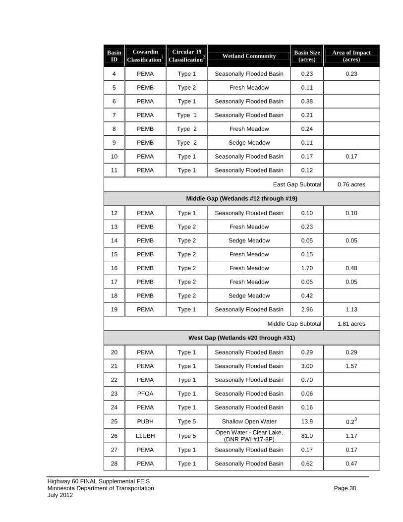
Highway 60 FINAL Supplemental FEIS Minnesota Department of Transportation Page 38 July 2012
Basin ID
Cowardin Classification1
Circular 39 Classification2 Wetland Community Basin Size
(acres) Area of Impact
(acres)
4 PEMA Type 1 Seasonally Flooded Basin 0.23 0.23
5 PEMB Type 2 Fresh Meadow 0.11
6 PEMA Type 1 Seasonally Flooded Basin 0.38
7 PEMA Type 1 Seasonally Flooded Basin 0.21
8 PEMB Type 2 Fresh Meadow 0.24
9 PEMB Type 2 Sedge Meadow 0.11
10 PEMA Type 1 Seasonally Flooded Basin 0.17 0.17
11 PEMA Type 1 Seasonally Flooded Basin 0.12
East Gap Subtotal 0.76 acres
Middle Gap (Wetlands #12 through #19)
12 PEMA Type 1 Seasonally Flooded Basin 0.10 0.10
13 PEMB Type 2 Fresh Meadow 0.23
14 PEMB Type 2 Sedge Meadow 0.05 0.05
15 PEMB Type 2 Fresh Meadow 0.15
16 PEMB Type 2 Fresh Meadow 1.70 0.48
17 PEMB Type 2 Fresh Meadow 0.05 0.05
18 PEMB Type 2 Sedge Meadow 0.42
19 PEMA Type 1 Seasonally Flooded Basin 2.96 1.13
Middle Gap Subtotal 1.81 acres
West Gap (Wetlands #20 through #31)
20 PEMA Type 1 Seasonally Flooded Basin 0.29 0.29
21 PEMA Type 1 Seasonally Flooded Basin 3.00 1.57
22 PEMA Type 1 Seasonally Flooded Basin 0.70
23 PFOA Type 1 Seasonally Flooded Basin 0.06
24 PEMA Type 1 Seasonally Flooded Basin 0.16
25 PUBH Type 5 Shallow Open Water 13.9 0.23
26 L1UBH Type 5 Open Water - Clear Lake, (DNR PWI #17-8P) 81.0 1.17
27 PEMA Type 1 Seasonally Flooded Basin 0.17 0.17
28 PEMA Type 1 Seasonally Flooded Basin 0.62 0.47
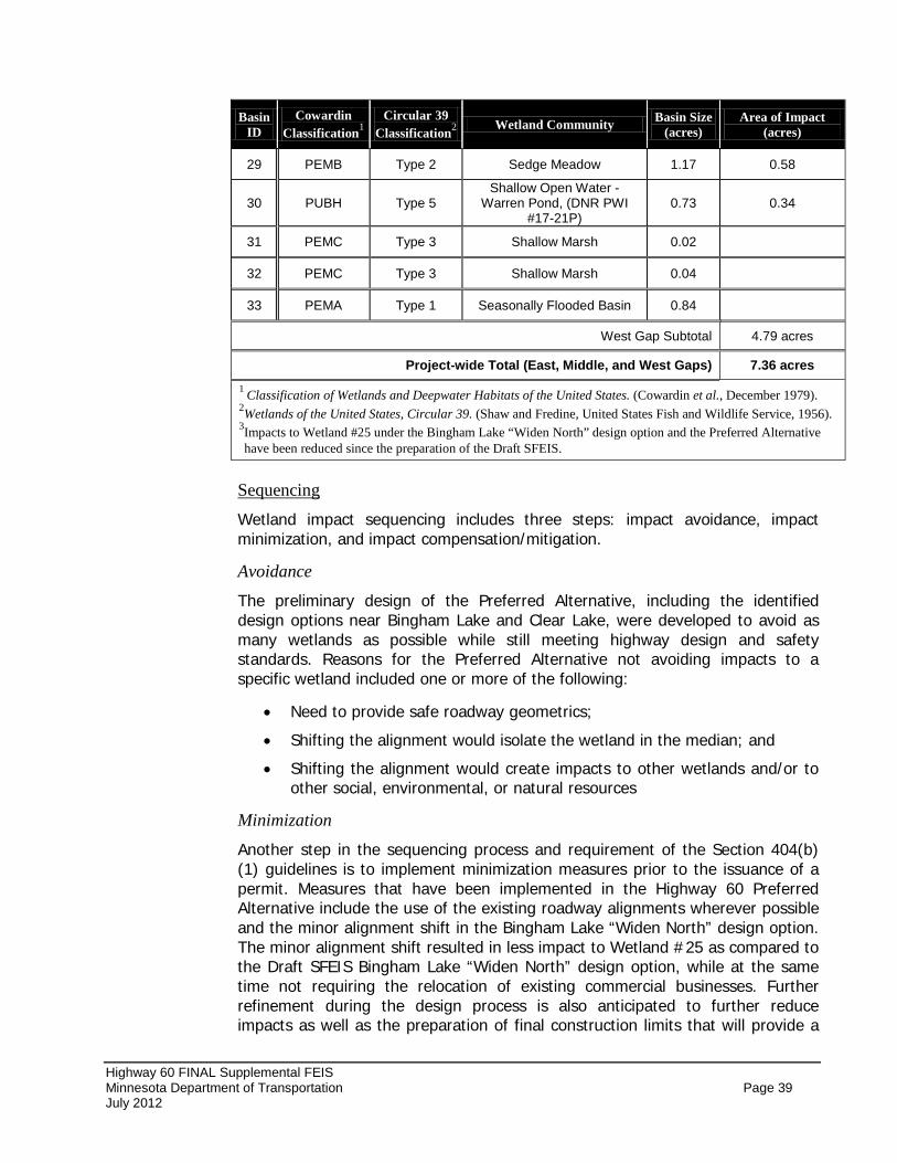
Highway 60 FINAL Supplemental FEIS Minnesota Department of Transportation Page 39 July 2012
Basin ID
Cowardin Classification1
Circular 39 Classification2 Wetland Community Basin Size
(acres) Area of Impact
(acres)
29 PEMB Type 2 Sedge Meadow 1.17 0.58
30 PUBH Type 5 Shallow Open Water -
Warren Pond, (DNR PWI #17-21P)
0.73 0.34
31 PEMC Type 3 Shallow Marsh 0.02
32 PEMC Type 3 Shallow Marsh 0.04
33 PEMA Type 1 Seasonally Flooded Basin 0.84
West Gap Subtotal 4.79 acres
Project-wide Total (East, Middle, and West Gaps) 7.36 acres 1 Classification of Wetlands and Deepwater Habitats of the United States. (Cowardin et al., December 1979). 2Wetlands of the United States, Circular 39. (Shaw and Fredine, United States Fish and Wildlife Service, 1956). 3Impacts to Wetland #25 under the Bingham Lake “Widen North” design option and the Preferred Alternative have been reduced since the preparation of the Draft SFEIS.
Wetland impact sequencing includes three steps: impact avoidance, impact minimization, and impact compensation/mitigation.
Sequencing
Avoidance
The preliminary design of the Preferred Alternative, including the identified design options near Bingham Lake and Clear Lake, were developed to avoid as many wetlands as possible while still meeting highway design and safety standards. Reasons for the Preferred Alternative not avoiding impacts to a specific wetland included one or more of the following:
• Need to provide safe roadway geometrics;
• Shifting the alignment would isolate the wetland in the median; and
• Shifting the alignment would create impacts to other wetlands and/or to other social, environmental, or natural resources
Minimization
Another step in the sequencing process and requirement of the Section 404(b) (1) guidelines is to implement minimization measures prior to the issuance of a permit. Measures that have been implemented in the Highway 60 Preferred Alternative include the use of the existing roadway alignments wherever possible and the minor alignment shift in the Bingham Lake “Widen North” design option. The minor alignment shift resulted in less impact to Wetland #25 as compared to the Draft SFEIS Bingham Lake “Widen North” design option, while at the same time not requiring the relocation of existing commercial businesses. Further refinement during the design process is also anticipated to further reduce impacts as well as the preparation of final construction limits that will provide a
Highway 60 FINAL Supplemental FEIS Minnesota Department of Transportation Page 40 July 2012
more refined level of wetland impacts. Additional design measures that may be incorporated to minimize wetland impacts include:
• Increase in ditch slopes in wetland areas. Increasing the slope of the ditch adjacent to the outside lanes would reduce the footprint of the roadway. The typical rural cross section calls for 1:6 (vertical: horizontal) slopes. Thus, a 1:5 slopes with additional unpaved shoulder widths are strategies to minimize wetland impacts. In many instances, steeper slopes are not acceptable because of the hazard presented to drivers running off the road or hitting guard rail. Also, the slope near culverts will be gentle so as to cover the culvert.
• Reduction in the elevation of the road profile in wetland areas. Lowering the road profile can reduce the footprint of the roadway. This strategy has limited application because the roadway should be at least 5 feet above the water level to prevent water damage to the roadbed, and in some areas, the roadway should be at least 4 feet above the adjacent ground to allow snow to blow off the road to decrease the hazard posed by drifting snow. Also, there must be sufficient cover over culverts.
• Construction of bridges. Bridging over wetlands is applicable only where there are exceptional wetlands because of the cost of bridging and the reduction in safety. Only the area near Clear Lake was considered for bridging to avoid and/or minimize impacts. MnDOT determined that the unknown geotechnical conditions, high construction costs, and maintenance costs of a bridge structure was not an appropriate minimization strategy for this area.
• The use of stormwater ponding areas to pretreat roadway runoff prior to discharging surface water to wetlands and other water resources that may lie outside the highway right-of-way.
In order to minimize water quality impacts to wetlands, water quality treatment best management practices (BMPs) have been designed and incorporated into the preliminary layout (see Water Quality and Surface Water Drainage section in this SFEIS).
A Combined Wetland Permit Application and Replacement Plan will be prepared and submitted for the Preferred Alternative prior to construction of each gap segment. Replacement of lost wetlands functions and values will be in accordance with WCA criteria, MNDNR Public Waters requirements (where applicable), and federal Clean Water Act Section 404 regulations.
Compensation/Mitigation
Replacement acreage for the East Gap improvements will require the use of wetland banking. MnDOT’s existing wetland bank system will provide eligible credits for wetland replacements. There are existing accounts and credits located in Watonwan County that are held by MnDOT. This site is located within the Bank Service Area and will be used for the replacement acreage for the East Gap. The replacement plan for the Middle and West Gaps are not known at this time. Due to the number of years until these gap segments are constructed,
Highway 60 FINAL Supplemental FEIS Minnesota Department of Transportation Page 41 July 2012
additional bank sites could be developed to accommodate the replacement needs of the Middle and West Gaps. Therefore, no specific information on wetland banking sites for the Middle and West Gaps is provided at this time, but will be pursued during the final design phase for each highway segment. Furthermore, if viable replacement sites are identified within the Middle or West Gaps, they will also be pursued as potential mitigation sites, subject to regulatory approval.
Another requirement of the Section 404(b)(1) guidelines prohibits any discharge which will cause or contribute to the significant degradation of the waters of the United States. The Preferred Alternative impacts will not cause or contribute to the significant degradation of waters of the United States and no significant impact to human health or welfare will occur from the proposed impacts to waters of the United States. No significant impact to aquatic ecosystem diversity, productivity and stability, or aquatic ecosystem-dependent wildlife populations will occur from the proposed impacts. In addition, there will be no significant impact to recreational, aesthetic, and economic values of waters of the United States based on the proposed impacts. Additional coordination with environmental review agencies (MNDNR, MPCA, and USACE) during the design and permitting phases of the project will ensure that no significant degradation will occur from the construction of the Preferred Alternative.
No Significant Degradation
This analysis was based on the evaluation completed for the Draft SFEIS, which considered one practicable build alternative (Alternative 2 – Build) and several design options for the City of Bingham Lake and near Clear Lake. Subsequently, the Bingham Lake “Widen South”, Bingham Lake “North Bypass” and Clear Lake “Compressed Centerline Spacing” design options were identified as non-preferred (not practicable) by MnDOT and FHWA after a reevaluation that occurred in preparation of this Final SFEIS. Therefore, this Final SFEIS has identified Alternative 2 with the modified “Widen North” design option and Clear Lake “Full Centerline Spacing” as the least environmentally damaging practicable alternative. Additionally, the Preferred Alternative will cause no violation of other laws and will not cause or contribute to significant degradation of waters of the United States. Lastly, preliminary design plans have been developed to minimize and mitigate unavoidable impacts caused by the Preferred Alternative. These factors show that the identified Preferred Alternative is the LEDPA and meets all Section 404(b)(1) guidelines for the selection of an alternative.
Preliminary LEDPA Determination
Based on the findings of the Wetland Delineation Report, the analysis conducted as part of the Draft SFEIS, and summary above, it has been determined that there are no practicable alternatives to the proposed action, and the proposed action includes all practicable measures to minimize harm to wetlands.
No Practicable Alternative Finding
Geology/Groundwater Impacts to aquifers from construction of the Preferred Alternative will be negligible due to the confining layers of loam to clay loam overlying the aquifers.
Highway 60 FINAL Supplemental FEIS Minnesota Department of Transportation Page 42 July 2012
Since the publication of the Draft SFEIS, additional information has been gathered for the Mountain Lake Wellhead Protection Zone (WPZ) and draft Drinking Water Supply Management Area (DWSMA) for the five municipal wells located within the City. The Middle Gap of the Preferred Alternative will pass through a “very low vulnerability” area of both the WPZ and DWSMA.
Potential minor impacts could occur near areas where streams or other surface waters, such as wetlands, may have connections to surficial sand and gravel aquifers. The Preferred Alternative may also require the abandonment of private wells and impact agricultural drain tile systems as a result of right-of-way acquisitions. For further information, see Draft SFEIS Section 4.2 – Geology/Groundwater.
Mitigation Construction BMPs will be used to minimize potential impacts to surface water and ground water, especially within the designated WPZ and DWSMA located near Windom and Mountain Lake. The abandonment of any wells will be conducted in accordance with Minnesota Department of Health requirements. Continuity of existing farmland drain tile systems will be sustained during and after construction.
Vegetation As discussed in Draft SFEIS Section 4.2 – Vegetation, there are no state or national forestlands, or large tree farms within the project area. Native vegetation can be found in limited areas including areas of remnant prairie, which has been found along several roadside ditches that parallel the Union Pacific railroad tracks. Since the Preferred Alternative primarily widens the highway to the opposite side of the railroad corridor there is a limited potential for impacts to areas of remnant prairie vegetation. One area that may be potentially impacted by the Preferred Alternative is associated with the Bingham Lake “Widen North” design option. This portion of the Preferred Alternative has been modified with a slight southern shift in the alignment in order to reduce impacts to Wetland #25 by approximately 0.5 acres. The result of this alignment shift is a potential impact of approximately 800 lineal feet of an identified prairie remnant located on the west side of Bingham Lake. This impact area was calculated based on the proposed right-of-way for the four-lane expressway section and may be minimized once more detailed construction limits are determined.
Mitigation During the final design process, all efforts will be made to minimize potential impacts on native vegetation. Measures for vegetation protection will be based on the MnDOT Standard Specification for Construction 2572 (Protection and Restoration of Vegetation). In order to protect vegetation that lies outside of the construction limits, special attention will be paid to Construction Specification 2572.3A. Areas mapped as remnant prairie vegetation have been identified and will be avoided to the greatest extent practical. MnDOT will include language into the special provisions of the contract that will not allow work or equipment
Highway 60 FINAL Supplemental FEIS Minnesota Department of Transportation Page 43 July 2012
staging to occur within the identified prairie remnant areas between the dates of April 1-August 1. Furthermore, appropriately locating staging areas that will be needed during the construction phase of the project and the use of protective fencing for sensitive areas within the right-of-way that occur outside the limits of construction are a few best practices that will be used. Mitigation for prairie impacts will also include the use of native prairie seed mixes to revegetate the areas impacted.
As indicated during early coordination with the MNDNR, invasive species are known to exist in the project area. Both Bingham Lake and Mountain Lake have Curly Pondweed. While these lakes are not close enough to the project to be directly impacted, they are close enough for the possibility of temporary water appropriations during construction. Use of water (dust control, etc.) from these two lakes will be prohibited. Purple loosestrife is also known to exist in the Highway 60 road ditch east of the City of Mountain Lake. Construction best management practices will be implemented for the prevention and control of spreading any invasive species in the project area.
MnDOT’s integrated roadside management planning guidelines will assist in minimizing the potential spread of invasive plant species through reestablishment of native plant communities in all disturbed areas as well as routine maintenance of the state highway right-of-way corridor.
Fish and Wildlife See Draft EIS Section 4.2 – Fish and Wildlife for further details on the analysis conducted for potential Fish and Wildlife impacts.
The Preferred Alternative will have minor impacts on fish and wildlife habitat in the three remaining two-lane segments of Highway 60 including impacts to wetlands and associated wildlife habitats.
The Preferred Alternative and associated roadway side slopes will potentially alter the natural shoreline of Warren Pond and Clear Lake and even requiring fill to be placed below the ordinary high water (OHW) level of these water bodies. However, because the level of design detail is limited in the West Gap segment, the potential impacts were calculated based on the proposed right-of-way limits. The proposed right-of-way extends into the southern portion of Warren Pond and approximately 0.34 acres of potential impact is shown (Wetland #30). In the area of Clear Lake, the Preferred Alternative widens the highway to the north and would potentially impact approximately 1.17 acres of Clear Lake. Again, because the level of design detail is limited in the West Gap segment, the potential impacts were calculated based on the proposed right-of-way limits. Coordination with the MNDNR and design refinements will be pursued during the final design phase, which will define the construction limits and is expected to reduce and/or avoid potential impacts to Warren Pond Clear Lake and the associated fish and wildlife habitat.
No existing fish passage concerns have been identified in the project area. The MNDNR has stated their desire to maintain a control structure (stop logs) on the south end of Clear Lake. MnDOT has committed to maintaining this structure.
Highway 60 FINAL Supplemental FEIS Minnesota Department of Transportation Page 44 July 2012
Sequencing/Mitigation Impacts to wetlands and vegetation have been discussed and mitigation proposed is described in each respective section. If requested by MnDNR, appropriate fish passage measures would be implemented in accordance with MnDOT fish passage guidance and standards during the final design phase for implementation during and after construction. MnDOT has been and will continue to closely coordinate with the MNDNR to identify and resolve any fisheries issues that may arise.
State/Federal Threatened and Endangered Species The Draft SFEIS included an assessment of threatened and endangered species (see Draft SFEIS Section 4.2 – State/Federal Threatened and Endangered Species).
Initial correspondence with MNDNR staff occurred in the early planning and design phases of the project. As a result of this coordination and a search of the Natural Heritage Database several prairie remnants along Highway 60 were noted in the project area. A few of these remnants were identified as Sites of Biodiversity and the Sullivant’s Milkweed (Asclepias sullivantii) a state-listed threatened species is known to occur within some of these prairie remnants. A field reconnaissance was conducted in May 2011 to confirm and map the locations of remnant prairies. Impacts to these sensitive resources are anticipated to be minimal because the majority of the construction activities associated with the Preferred Alternative are being proposed along the side of the highway opposite of the Union Pacific Railroad where the prairie remnants have been identified. Based on assessment of the proposed right-of-way needed for the Preferred Alternative, one area associated with the Bingham Lake design option appears to be impacted. The design option identified for this portion of the Preferred Alternative balances impacts on both the north and south sides of the existing alignment. As a result, the modified alignment reduces impacts to Wetland #25, located north of the highway, by approximately 0.5 acres and avoids commercial relocations on the south side of the highway. However, this alignment shift results in approximately 800 lineal feet of impact on an identified prairie remnant. This impact area was calculated based on the proposed right-of-way for the four-lane expressway section and may be minimized once more detailed construction limits are determined.
According to the official County Distribution of Minnesota’s Federally-Listed Threatened, Endangered, Proposed, and Candidate Species
MnDOT’s Office of Environmental Stewardship (OES), in acting as the non-federal representative for the Federal Highway Administration, has made the determination that the Preferred Alternative will not affect federally-listed
list provided by the Service, Cottonwood County is within the distribution ranged of the prairie bush clover (Lespedeza leptostachya), a federally-listed threatened species. According to the Service, there are no known occurrences of federally-listed species in Watonwan County. Critical habitat has not been designated in either of the project counties.
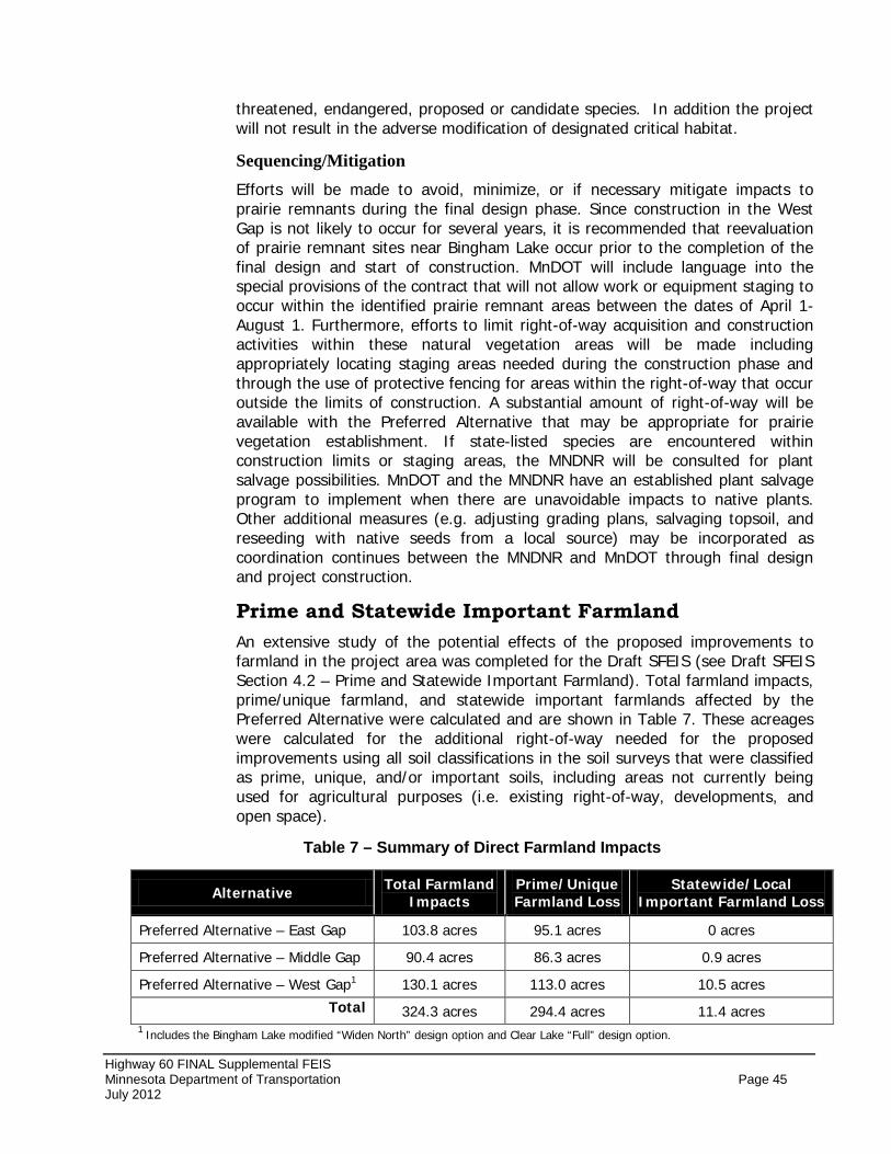
Highway 60 FINAL Supplemental FEIS Minnesota Department of Transportation Page 45 July 2012
threatened, endangered, proposed or candidate species. In addition the project will not result in the adverse modification of designated critical habitat.
Sequencing/Mitigation Efforts will be made to avoid, minimize, or if necessary mitigate impacts to prairie remnants during the final design phase. Since construction in the West Gap is not likely to occur for several years, it is recommended that reevaluation of prairie remnant sites near Bingham Lake occur prior to the completion of the final design and start of construction. MnDOT will include language into the special provisions of the contract that will not allow work or equipment staging to occur within the identified prairie remnant areas between the dates of April 1-August 1. Furthermore, efforts to limit right-of-way acquisition and construction activities within these natural vegetation areas will be made including appropriately locating staging areas needed during the construction phase and through the use of protective fencing for areas within the right-of-way that occur outside the limits of construction. A substantial amount of right-of-way will be available with the Preferred Alternative that may be appropriate for prairie vegetation establishment. If state-listed species are encountered within construction limits or staging areas, the MNDNR will be consulted for plant salvage possibilities. MnDOT and the MNDNR have an established plant salvage program to implement when there are unavoidable impacts to native plants. Other additional measures (e.g. adjusting grading plans, salvaging topsoil, and reseeding with native seeds from a local source) may be incorporated as coordination continues between the MNDNR and MnDOT through final design and project construction.
Prime and Statewide Important Farmland An extensive study of the potential effects of the proposed improvements to farmland in the project area was completed for the Draft SFEIS (see Draft SFEIS Section 4.2 – Prime and Statewide Important Farmland). Total farmland impacts, prime/unique farmland, and statewide important farmlands affected by the Preferred Alternative were calculated and are shown in Table 7. These acreages were calculated for the additional right-of-way needed for the proposed improvements using all soil classifications in the soil surveys that were classified as prime, unique, and/or important soils, including areas not currently being used for agricultural purposes (i.e. existing right-of-way, developments, and open space).
Table 7 – Summary of Direct Farmland Impacts
Alternative Total Farmland Impacts
Prime/Unique Farmland Loss
Statewide/Local Important Farmland Loss
Preferred Alternative – East Gap 103.8 acres 95.1 acres 0 acres
Preferred Alternative – Middle Gap 90.4 acres 86.3 acres 0.9 acres
Preferred Alternative – West Gap1 130.1 acres 113.0 acres 10.5 acres
Total 324.3 acres 294.4 acres 11.4 acres 1 Includes the Bingham Lake modified “Widen North” design option and Clear Lake “Full” design option.
Highway 60 FINAL Supplemental FEIS Minnesota Department of Transportation Page 46 July 2012
The Farmland Protection Policy Act – Farmland Conversion Impact Rating Form (CPA 106) was completed in consultation with NRCS staff and was included in Appendix C of the Draft SFEIS.
The Preferred Alternative will also have direct and indirect impacts on farming operations. There are a number of farm fields that are within the proposed right-of-way limits that would lose cultivated land. The primary farmland impacts created by the Preferred Alternative are the result of widening the highway to accommodate the additional two travel lanes.
The construction of a rural four-lane divided highway will also result in fewer access points than currently exist which may make farming operations and travel between farm fields more difficult in some areas. In general, a reduction in the number of access points may require farm machinery to travel greater distances to cross the highway. The center grass median may also result in greater travel distances for operations that exist on both sides of the highway corridor.
A consideration for farm drainage systems has been included in the preliminary design of the Preferred Alternative. The primary areas of potential impact to field drain tile will result in locations where the new expanded roadway is proposed to be constructed in areas that are currently being farmed. During the final design and right-of-way acquisition phase of the project, MnDOT will discuss potential farm drainage impacts with agricultural landowners. Some drain tile information has already been gathered for the East Gap, but additional information will be requested for the Middle and West Gaps and will be utilized in the final design. The purpose of obtaining this information is to protect the integrity of each field tile drainage system as much as possible, while still allowing for the timely construction of the proposed improvements. In addition, special attention will also be given to construction activities to ensure soil compaction is minimized.
Mitigation Without compromising the design of the Preferred Alternative, all practical measures to minimize harm to prime, unique, and/or statewide important farmlands and overall farm operations have been applied in accordance with the Farmland Protection Policy Act and the Minnesota Agricultural Land Preservation and Conservation Policy Act. Furthermore, safe and efficient access to farmland has been considered as part of the preliminary design of the preferred alternative.
Any acquisition of farmland will be conducted in accordance with the Uniform Relocation Assistance and Real Property Acquisition Policies Act of 1970, as amended. Mn/DOT is committed to reestablishing effective field tile drainage systems. Potential impacts to individual properties will be determined on a case-by-case basis as part of the final design and right-of-way acquisition process.
Visual Quality As described in Section 4.2 – Visual Quality in the Draft SFEIS, the construction of the Preferred Alternative will create visual quality impacts. The Preferred
Highway 60 FINAL Supplemental FEIS Minnesota Department of Transportation Page 47 July 2012
Alternative will have an effect on the existing visual scene and resources for both travelers and neighbors. The improvements will require additional pavement and clearing of some natural areas. The reconstruction and capacity expansion of Highway 60 as a rural four-lane divided expressway will convert farmlands, grasslands, and open space areas to highway right-of-way.
Mitigation No mitigation is required for visual impacts. However, during the final design phase, a corridor landscaping plan will be prepared.
Indirect Impacts See Draft SFEIS Section 4.2 – Indirect Impacts for a complete discussion of indirect impacts associated with the Highway 60 project. Potential short-term and long-term indirect impacts resulting from the Preferred Alternative include:
• Potential for changes in land use patterns resulting from road realignments and/or access changes.
• Short-term economic benefit of increased private sector income during construction; and
• Farmland and agricultural business productivity.
Each of these potential indirect impacts is further discussed below.
Changes in Land Use Patterns
Future land use in the project area is determined by many factors, including the availability of municipal services (sewer and water), environmental amenities, and economic conditions. Construction of a new or improved highway can create conditions that can aid in the change of development patterns. However, highway construction by itself does not cause new development if there are not market forces that support new development and changes in land use. Furthermore, in order for potential land use changes to occur, the development plans have to be consistent with local land use and zoning regulations.
Although new development is expected within the communities along Highway 60, the desire to occupy a particular site may precede the ability to extend orderly municipal services to these sites. Linear development along a highway corridor may result in longer utility lines to service these properties. The desire to occupy these locations can also artificially raise land prices and may affect property values of undeveloped adjoining parcels.
Short-Term Economic Benefits from Construction
Short-term economic benefits from construction include the purchase of local goods and services to construct the proposed transportation improvements. This includes such items as purchase of supplies and construction materials, and payment of skilled labor over the course of one or more construction seasons. The sale of local goods and services to construction workers from outside the community is also a short-term economic benefit.
Highway 60 FINAL Supplemental FEIS Minnesota Department of Transportation Page 48 July 2012
Farmland and Agricultural Business Productivity
The Preferred Alternative would convert farmlands to highway right-of-way and in areas adjacent to the highway may create a higher demand for development. The timeframe of project construction and City/County zoning regulations will determine if, when and where future development may occur.
Mitigation In the context of the existing regulatory framework and the mitigation activities for project impacts, and with respect to simultaneous land use planning and local government regulatory activities, indirect impacts of the project are expected to be minimal. Such potential indirect impacts may be avoided and/or minimized through land use controls and roadway access restrictions.
Cumulative Potential Effects Cumulative potential effects of the project alternatives, including the Preferred Alternative, were previously discussed in Section 4.2 of the Draft SFEIS. Cumulative potential effects are not causally linked to the Preferred Alternative, but are the total effect of past, present, and reasonably foreseeable actions with similar effects in a broader geographic area. The purpose of a cumulative potential effect analysis is to identify impacts that may be minimal when examined within the context of the proposed action, but that may accumulate and become more concerning in combination with a number of actions. Cumulative effects are defined by the Council on environmental Quality (CEQ) as the following:
Cumulative Effects:
As documented in the environmental reviews and analysis, this project will result in direct impacts to the built environment (homes and businesses) and the natural environment (wetlands, vegetation, water quality, and farmland). Some induced development may occur as a result of the Preferred Alternative. The potential for new highway-oriented businesses (convenience stores, gas stations, restaurants) have been accounted for near the communities (Bingham Lake, Butterfield, Mountain Lake, St. James, and Windom. Governmental agencies responsible for regulating land use through planning and zoning processes at the local government level can greatly assist in the protection and minimization of water quality, wetland, and farmland impacts from future developments in the surrounding areas. Specific BMPs and construction techniques should be used to avoid, minimize, and mitigate potential effects that are identified during the permitting and approval processes for individual projects.
“Impacts on the environment that result from the incremental impact of the action when added to other past, present, and reasonably foreseeable future actions regardless of what agency (federal or non-federal) or person undertakes such other actions.” (40 CFR 158.7)
Conclusion Cumulative potential effect may exist in issue areas related to land consumption; land development, wetlands, water quality, farmlands, and vegetation/wildlife habitat. The cumulative potential effects to these resources are typically
Highway 60 FINAL Supplemental FEIS Minnesota Department of Transportation Page 49 July 2012
considered through local and county comprehensive planning efforts, permitting regulations and environmental review processes of NEPA and MEPA. In addition to permitting processes that engage legislation protecting resources such as wetlands, many of these potential cumulative impacts can be avoided or minimized through the continued application and enforcement of land use planning, land development controls (zoning and subdivision ordinances), and roadway access restrictions. Furthermore, local and state resource agencies such as the MNDNR, MPCA, Board of Water and Soil Resources (BWSR), Soil and Water Conservation District (SWCD), and others can work with local jurisdictions to develop resource preservation plans and land use standards that focus on preserving natural and environmental resources. Local development controls could greatly assist in protecting or even enhancing sensitive resources in the study area, if local units of government are willing to implement protective actions and enforce strong land use regulations.
Therefore, in the context of the existing regulatory framework and the mitigation activities for project impacts, and with respect to simultaneous land use planning and local government regulatory activities and implementation of BMPs, the incremental impact on the built environment and the natural environment from the Highway 60 Gaps Project along with the cumulative potential effects from past, present, and reasonably foreseeable projects is not anticipated to result in substantial impacts to any one or combination of resources.
4.3 WHAT ARE THE CONSTRUCTION IMPACTS? Potential environmental effects associated with construction can include traffic congestion, traffic detours, economic (business access), noise, water quality and soil erosion, borrow and excess materials, utility disruption, and farmland impacts. The potential impacts along with applicable mitigation measures for each of these areas are discussed below.
Traffic Congestion Construction of the three highway segments is projected to occur under separate construction lettings with one segment being completed before construction on the next segment begins. As a result, traffic delays, travel difficulty to adjacent properties, and increased congestion within the specific project segments are anticipated to occur only on a short-term or temporary basis. A construction staging plan will be developed for each segment and will be completed during the final design phase of that particular segment. Staging plans will assess potential traffic congestion impacts associated with construction and will attempt to address property access needs, while minimizing the length of construction.
Traffic Detours A construction staging plan will be completed during the final design stage of each highway segment and will identify potential detours. Efforts will be made to minimize disruptions to traffic patterns while maximizing directness of detoured routes. Minor detours may also be needed when traffic is switched over from the old traffic lanes to the new lanes. This would minimize short-term impacts on emergency services (police, fire, and rescue) and transit services throughout the
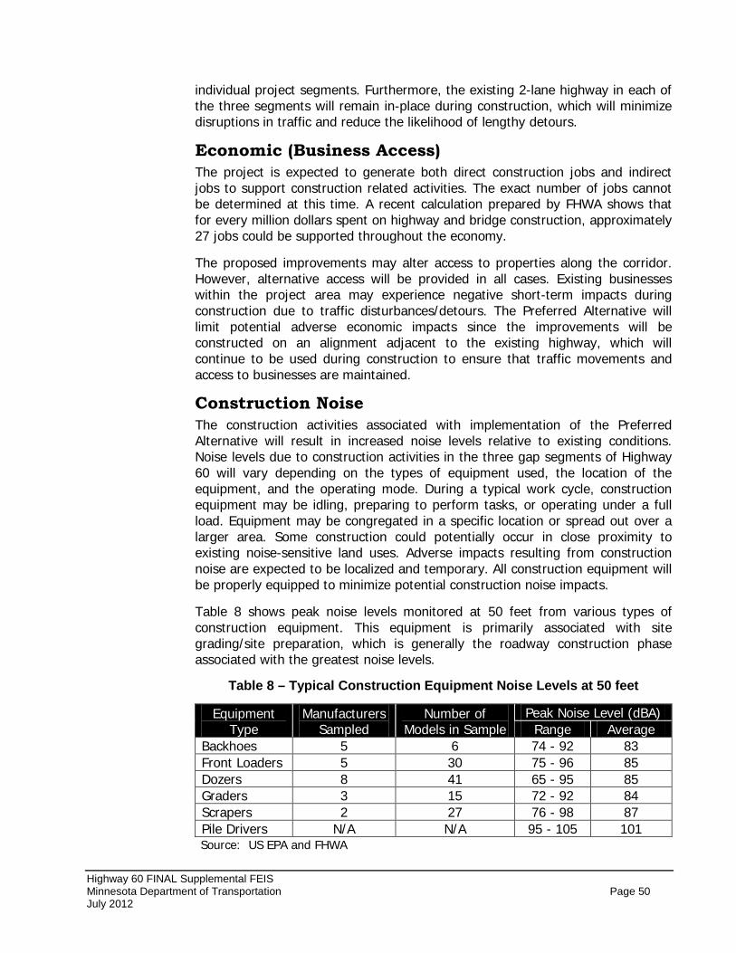
Highway 60 FINAL Supplemental FEIS Minnesota Department of Transportation Page 50 July 2012
individual project segments. Furthermore, the existing 2-lane highway in each of the three segments will remain in-place during construction, which will minimize disruptions in traffic and reduce the likelihood of lengthy detours.
Economic (Business Access) The project is expected to generate both direct construction jobs and indirect jobs to support construction related activities. The exact number of jobs cannot be determined at this time. A recent calculation prepared by FHWA shows that for every million dollars spent on highway and bridge construction, approximately 27 jobs could be supported throughout the economy.
The proposed improvements may alter access to properties along the corridor. However, alternative access will be provided in all cases. Existing businesses within the project area may experience negative short-term impacts during construction due to traffic disturbances/detours. The Preferred Alternative will limit potential adverse economic impacts since the improvements will be constructed on an alignment adjacent to the existing highway, which will continue to be used during construction to ensure that traffic movements and access to businesses are maintained.
Construction Noise The construction activities associated with implementation of the Preferred Alternative will result in increased noise levels relative to existing conditions. Noise levels due to construction activities in the three gap segments of Highway 60 will vary depending on the types of equipment used, the location of the equipment, and the operating mode. During a typical work cycle, construction equipment may be idling, preparing to perform tasks, or operating under a full load. Equipment may be congregated in a specific location or spread out over a larger area. Some construction could potentially occur in close proximity to existing noise-sensitive land uses. Adverse impacts resulting from construction noise are expected to be localized and temporary. All construction equipment will be properly equipped to minimize potential construction noise impacts.
Table 8 shows peak noise levels monitored at 50 feet from various types of construction equipment. This equipment is primarily associated with site grading/site preparation, which is generally the roadway construction phase associated with the greatest noise levels.
Table 8 – Typical Construction Equipment Noise Levels at 50 feet
Equipment Type
Manufacturers Sampled
Number of Models in Sample
Peak Noise Level (dBA) Range Average
Backhoes 5 6 74 - 92 83 Front Loaders 5 30 75 - 96 85 Dozers 8 41 65 - 95 85 Graders 3 15 72 - 92 84 Scrapers 2 27 76 - 98 87 Pile Drivers N/A N/A 95 - 105 101 Source: US EPA and FHWA
Highway 60 FINAL Supplemental FEIS Minnesota Department of Transportation Page 51 July 2012
Elevated noise levels are, to a degree, unavoidable for this type of project. MnDOT will require that construction equipment be properly muffled and in proper working order. While MnDOT and its contractor(s) are exempt from local noise ordinances, it is the practice to require contractors to comply with applicable noise restrictions and ordinances to the extent reasonable. Advanced notice will be provided to affected communities of any planned abnormally loud construction activities. Night construction may sometimes be required to minimize traffic impacts and to improve safety, but construction will be limited to daytime hours as much as possible. Construction is expected to last at least two construction seasons for each gap segment.
Any associated high-impact equipment noise, such as pile driving, pavement sawing, or jack hammering, will be unavoidable with construction of the proposed project. Pile-driving noise is associated with any bridge construction and sheet piling necessary for retaining wall construction. While pile-driving equipment results in the highest peak noise level, as shown in Table 9, it is limited in duration to the activities noted above (e.g., bridge construction). The use of pile drivers will be prohibited during nighttime hours.
Water Quality and Soil Erosion The potential for soil erosion and impacts on water quality are greatest at the time a project requires the removal of vegetation and topsoil for initial clearing, grubbing, and grading activities. Areas adjacent to water resources have the highest potential for adverse impacts. Erosion control measures as suggested by the MPCA will be installed to minimize potential soil erosion impacts from construction activities. These practices may include, but are not limited to, the following, sedimentation basins, silt control devices (silt fences, hay bales), slope drains, and rapid revegetation of exposed construction areas. As part of the final design of the Preferred Alternative an erosion control plan, also known as a Stormwater Pollution Prevention Plan (SWPPP), will be prepared and submitted as part of the NPDES Construction Stormwater permit.
Borrow or Excess Material The selection of borrow material for the construction of the Preferred Alternative will be the responsibility of the construction contractors. Existing gravel/borrow sites, in some instances, are identified in the contract special provisions. Due to the cost of hauling aggregate resources, it is assumed that the potential area of effect would be within close proximity of the corridor. The haul distance could be shorter or longer because it is highly dependent upon the location from the borrow site.
MnDOT has no authority over land use outside the state’s right-of-way. Such matters, including gravel mining, generally fall under the jurisdiction of local units of government as part of land use ordinances. The State of Minnesota has designated local units of government as the RGU for environmental review and analysis of gravel mining operations. Any new sites would be subject to environmental reviews under Minnesota Rule Chapter 4410.4300, Subp. 12 and will require an archaeological survey of the site. At the time of construction, MnDOT will be notifying the Planning and Zoning Department of both
Highway 60 FINAL Supplemental FEIS Minnesota Department of Transportation Page 52 July 2012
Cottonwood County and Watonwan County informing them of the potential gravel needs for the proposed action. The extraction of gravel resources could affect sensitive resources in the area. Both counties have existing land use regulations that ensure appropriate environmental reviews occur for gravel mining requests.
The disposal of excess material will be conducted in accordance with MnDOT specifications, environmental regulations, and according to a project disposal plan that will be prepared by the Contractor and approved by MnDOT.
Utility Disruption Construction activities may result in temporary impacts to local utilities. Coordination and cooperation with the local service providers has been and will continue to be maintained throughout the project development process.
Farmland Impacts Within the study area, construction activities may temporarily disrupt farm operations and/or farm businesses such as planting, growing, and harvesting of crops. Temporary impacts could also result from loss of productivity of croplands directly adjacent to construction activities or loss of customers to a farm-related business during construction of the highway improvements.
Temporary farm-related impacts may include soil compaction from construction equipment, removal and replacement of drain tile, and the removal of crops and topsoil for staging areas and construction. Some loss in yield will occur from soil compaction in these areas or from loss of drain tile efficiencies. Soil compaction impacts are expected to last no more than one to two years following completion of construction and field drain tile systems will be replaced or restored to pre-construction effectiveness.
Relationship Between Local Short-Term Uses of Man’s Environment and the Maintenance and Enhancement of Long-Term Productivity All highway projects require the investment or commitment of some resources found in the existing environment. Short-term refers to the immediate consequences of the project whereas long-term relates to its direct or secondary effects on future generations.
Potential Adverse Use
The materials used in the construction of the project will be unavailable for other uses. These include the construction of non-highway facilities.
Reduction of Energy and Material Resources
In addition to permanent vegetation loss as a result of an expanded highway, construction activities will result in short-term losses of vegetation adjacent to the improvements. If necessary, MnDOT will consider and coordinate plant salvage of important or rare native vegetation that could be affected by the Preferred Alternative. Revegetation design will be coordinated with visual quality,
Loss of Vegetation
Highway 60 FINAL Supplemental FEIS Minnesota Department of Transportation Page 53 July 2012
erosion control, and shoreline and embankment stabilization components of the project to ensure minimal impacts as a result of temporary vegetation loss.
The Preferred Alternative is expected to directly impact wetlands. Due to the scattered distribution of wetlands, the impact on wetlands cannot be completely avoided. See Final SFEIS Section 4.2 Wetlands for a discussion of avoidance and minimization efforts as well as compensatory mitigation commitments. A net gain in wetland acreage is expected as a result of compensatory mitigation.
Loss of Wetlands
The Preferred Alternative has the potential to create temporary impacts on water resources due to the close proximity of drainage ditches, wetlands, and lakes. All practical efforts will be made to minimize impacts on water resources.
Impacts on Water Resources
The construction of the expanded highway will require the acquisition of property and will remove this land from the tax rolls resulting in some short-term loss of property tax revenues. This short-term loss is anticipated to be offset due to the increased value of land served by the improved highway.
Short-Term Economic Impacts
Also, the Preferred Alternative will require at least one business relocation. Such acquisition could affect the tax base for local units of government through a short-term loss in tax revenues. Short-term construction detours may require that typical business relationships be temporarily altered. This may include short-term changes in the conduct of business and trade activities until the highway improvements are fully integrated.
Construction will cause minor traffic delays and short-term inconveniences for motorists in the area. Construction detours and higher levels of congestion may result due to construction activities.
Inconveniences from Construction
Financial commitments to the project include acquisition, relocation, and construction costs. These public dollars will not be available for other uses. In addition, the land converted to highway use represents a reduction in tax base. These costs are to be recovered through more efficient travel and reduced user costs and an increase in the overall tax base due to the improved accessibility and mobility within the project area and region.
Significant Capital Investment
Long-Term Gains in Productivity
A continuous four-lane highway has the ability to accommodate high volumes of traffic and increased volumes of heavy commercial traffic. The presence of free flowing traffic will reduce motorist travel times and fuel consumption, which will reduce the overall cost of travel.
Reduction in Travel Time and Cost of Travel
Highway 60 FINAL Supplemental FEIS Minnesota Department of Transportation Page 54 July 2012
The economic advantage lies in the long-term efficiencies that an improved transportation system will provide. These efficiencies include travel time savings, increased safety, business expansion opportunities, and increased tourism. The Preferred Alternative has some degree of beneficial economic impacts. The travel time savings will be a benefit to trucking companies, shippers, salespeople, tourists, and to commuters going to and from work. The travel time saved by shippers and salespeople will result in reduced costs for businesses, making them more competitive in the marketplace.
Economic Benefit
The construction of a continuous four-lane divided expressway will improve safety for motorists using the highway and will reduce the severity of crashes (i.e., head-on and side-swipe collisions).
Reduction of Crashes
Within the project study area of the three gap segments of Highway 60, there are currently very few stormwater management techniques being practiced. The Preferred Alternative includes stormwater treatment facilities that will collect and treat highway runoff prior to discharging to receiving water bodies.
Improvements in Surface Water Drainage
Irreversible and Irretrievable Commitment of Resources Land Consumption The Preferred Alternative will require the acquisition of undeveloped and developed land for the purpose of roadway construction. Within the foreseeable future, this commitment of property to roadway use is considered irreversible and irretrievable as long as the facility continues to serve the public good. However, if a greater need arises for use of the land or if the highway facility is no longer needed, the land could be converted to another use. At present, there is no reason to believe such a conversion would ever be necessary or desirable.
Social and Cultural Resources The displacement and relocation of residences and other resources (including historic properties) of the built environment (public and private) are considered to be irreversible and irretrievable. No historic property impacts were identified.
Construction Materials The action will result in the commitment of materials such as steel, cement, aggregate, and bituminous. These resources are largely irretrievable except for those items that have some value as salvage and can be recycled. A benefit-cost analysis was completed and presented in the Benefit-Cost Analysis section of the Draft SFEIS. Part of the analysis considered the cost of construction materials as well as the value of material that could be salvaged sometime in the future. Therefore, all construction materials needed for the Preferred Alternative are not considered to be fully irretrievable resources.
Highway 60 FINAL Supplemental FEIS Minnesota Department of Transportation Page 55 July 2012
Financial Resources The improvements will require a considerable amount of federal and state financial commitment. The total cost for constructing the Preferred Alternative is estimated to be approximately $50 million. While these public funds are not directly retrievable, the investment will enhance the safety of the users of Highway 60, the cost of travel along the roadway, and the economic vitality of the region.
Natural Resources The Preferred Alternative will require the commitment of natural resources including the loss of vegetation, wetland functions and values, and other wildlife habitat. The commitment of these resources may in part be irreversible and irretrievable. Avoidance and minimization measures will be incorporated into the final design of the Preferred Alternative. Mitigation measures will be employed in an attempt to counter all remaining impacts.
5.0 PERMITS AND APPROVALS It is anticipated that federal, state, and local permits, approvals, and concurrences will be required as the project proceeds with construction. The following permits/approvals/concurrence will likely be required prior to construction of the proposed action:
SFEIS Adequacy Determination – MnDOT
SFEIS Record of Decision – FHWA
Section 404 Permit – USACE
Section 401 Water Quality Certification – MPCA
National Pollutant Discharge Elimination System (NPDES) Construction Stormwater Permit – MPCA
Minnesota Wetland Conservation Act (WCA) – MnDOT
Public Waters Work Permit – MNDNR
Orders for crossing drainage ditches from requisite ditch authorities
6.0 WHO RECEIVED COPIES OF THE FINAL SFEIS? 6.1 FEDERAL AGENCIES
U.S. Environmental Protection Agency
U.S. Fish & Wildlife Service
U.S. Army Corps of Engineers
Natural Resources Conservation Service/U.S. Department of Agriculture
U.S. Department of Interior
Highway 60 FINAL Supplemental FEIS Minnesota Department of Transportation Page 56 July 2012
6.2 STATE AGENCIES/ORGANIZATIONS Environmental Quality Board Board of Water & Soil Resources Minnesota Department of Public Service Minnesota Department of Commerce Minnesota State Historic Preservation Office Minnesota Department of Natural Resources Legislative Reference Library Minnesota Department of Health Minnesota Department of Agriculture Minnesota Pollution Control Agency
6.3 LOCAL AGENCIES/ORGANIZATIONS City of Bingham Lake City of Butterfield City of Mountain Lake City of St. James City of Windom Cottonwood County Watonwan County Cottonwood County Soil and Water Conservation District Watonwan County Soil and Water Conservation District Butterfield Township
Lakeside Township
Midway Township
Mountain Lake Township
St. James Township
6.4 OTHER Butterfield Library Mountain Lake Library St. James Library Windom Library
7.0 PROJECT COORDINATION AND PUBLIC INVOLVEMENT MnDOT is committed to public involvement at all levels in decision-making related to the Highway 60 Project. MnDOT has engaged area property owners, business owners, residents, and local, county, regional, and state agencies in the
Highway 60 FINAL Supplemental FEIS Minnesota Department of Transportation Page 57 July 2012
development of the project in the past, and this engagement continues as part of the SFEIS process. The public and agency involvement/outreach efforts associated with the SFEIS include the following:
Public Open House Meetings Draft SFEIS Public Hearings Agency Coordination Meetings/Workshops Individual Landowner/Business-Owner Meetings Project Mailings Project Website Updates
7.1 PUBLIC OPEN HOUSES/PUBLIC HEARINGS Since the FEIS was completed in 1984, several coordination meetings have been conducted with each of the affected communities and counties. In July 2008, an open house meeting was held to discuss the ongoing improvements being made to Highway 60 and to listen to public concerns over the remaining two-lane highway sections between St. James and Windom.
On June 14, 2011 an open house was held to provide an update on the project development process and provide information to the public regarding the SFEIS.
During the agency/public comment period for the Draft SFEIS document, MnDOT conduct two public hearings on December 13th and 15th, 2011, to engage project stakeholders and solicit their comments, questions, and concerns.
7.2 AGENCY/PUBLIC COORDINATION MnDOT has regularly involved resource, regulatory agencies, and local units of government in the project development process. Coordination meetings and workshops with the various resource/regulatory agencies and local units of government are anticipated throughout the planning and design phases.
7.3 PROJECT MAILINGS Informational mailings have been periodically prepared and distributed to affected property owners and business owners in the project area with the intent of providing up-to-date project related information.
7.4 PROJECT WEB PAGE A project web page has been established at that provides up-to-date information. The site provides an additional means of distributing information such as new project developments, and planning/design changes. The site is located at: http://www.dot.state.mn.us/d7/projects/hwy60stjames/
Highway 60 FINAL Supplemental FEIS Minnesota Department of Transportation Page 58 July 2012
8.0 RESPONSE TO COMMENTS ON THE DRAFT EIS The following section provides a response to public and agency comments received during the comment period for the Highway 60 Draft SFEIS.
8.1 OPPORTUNITIES FOR PUBLIC COMMENT AND GUIDELINES FOR RESPONDING TO COMMENTS The Draft SFEIS for the Highway 60 Gaps Project was distributed in November 2011 to agencies and organizations on the official distribution list, as well as additional agencies/organizations that had either requested a copy of the document, and/or that could be affected by the proposed project. The comment period for the Draft SFEIS officially closed on January 4, 2012.
Two public hearing/open house meetings were held to receive comments on the proposed project and Draft SFEIS. The hearings were held as follows:
Tuesday, December 13, 2011 3:00 p.m. to 6:00 p.m.
Windom Community Center, 1750 Cottonwood Lake Drive, Windom, MN 56101
Thursday, December 15, 2011 4:00 p.m. to 7:00 p.m.
Butterfield Fire Hall, 103 2nd Street, Butterfield, MN 56120
At the public hearings, attendees were invited to provide comments through one of two ways: written comments and oral statements.
• Written Statements
•
: Attendees were invited to submit written comments on comments sheets provided at the open house or in letter form. Comments could also be submitted via e-mail.
Oral Statements
A total of 16 comment letters were received from private citizens, business representatives, interest groups, agencies, and other government entities during the comment period. One oral statement was given at the Butterfield hearing. All comments are considered part of the Public Hearing Record for the Draft SFEIS.
: Statements were recorded by an audio recorder and electronically documented by a staff member at the meeting.
Consistent with environmental rules, substantive comments are responded to in this Final SFEIS. Written responses have been provided for comments pertaining to analysis conducted for and documented in the Draft SFEIS. Responses have been prepared for statements noting incorrect or unclear information or content requirements. Comments agreeing with the Draft SFEIS, project information, general opinions, statements of fact, or statements of preference were not formally responded to. Written comments are summarized and responded to in Section 8.2. Copies of all government, agency, and organized interest group letters have been included in Section 8.3 of this Final SFEIS.
Highway 60 FINAL Supplemental FEIS Minnesota Department of Transportation Page 59 July 2012
8.2 AGENCY AND PUBLIC COMMENTS AND RESPONSES Copies of comments submitted by governmental agencies, residents, landowners, businesses, or other interest groups are listed below and included on the following pages with “footnote” responses in the margin.
• U.S. Department of Interior
• U.S. Environmental Protection Agency
• Natural Resources Conservation Service
• Minnesota Department of Agriculture
• Minnesota Department of Health
• Minnesota Pollution Control Agency
• City of Bingham Lake
• MN Department of Natural Resources
• Kurt Blomgren
• Elaine Kroeker
• Wes Kroeker
• Paul Tumer
• Mark Redman
• Mike Miller
• Lauren Raney
• Bruce and Lisa Turner
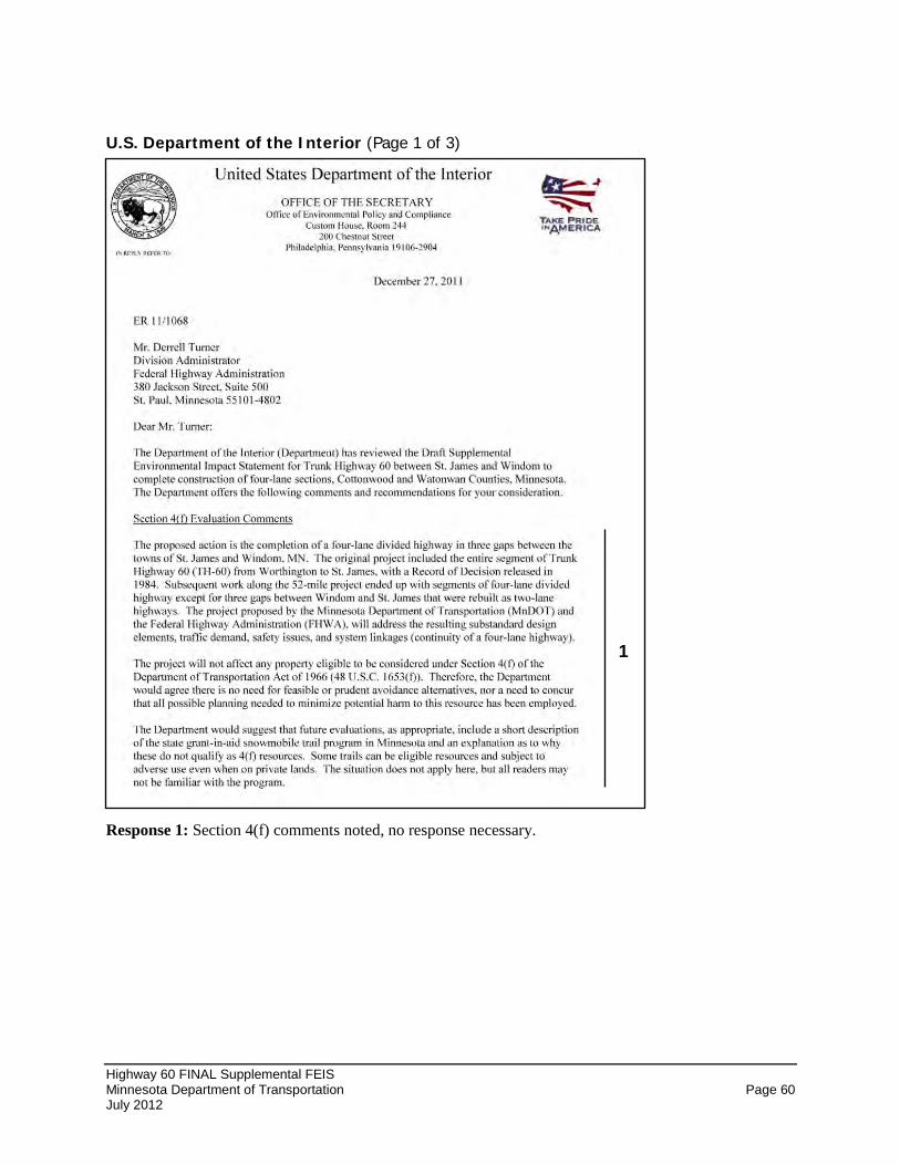
Highway 60 FINAL Supplemental FEIS Minnesota Department of Transportation Page 60 July 2012
U.S. Department of the Interior (Page 1 of 3)
Response 1: Section 4(f) comments noted, no response necessary.
1
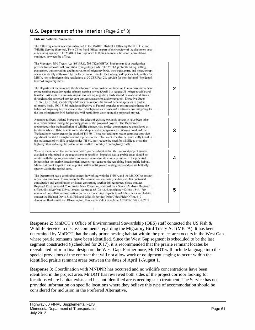
Highway 60 FINAL Supplemental FEIS Minnesota Department of Transportation Page 61 July 2012
U.S. Department of the Interior (Page 2 of 3)
Response 2: MnDOT’s Office of Environmental Stewardship (OES) staff contacted the US Fish & Wildlife Service to discuss comments regarding the Migratory Bird Treaty Act (MBTA). It has been determined by MnDOT that the only prime nesting habitat within the project area occurs in the West Gap where prairie remnants have been identified. Since the West Gap segment is scheduled to be the last segment constructed ((scheduled for 2017), it is recommended that the prairie remnant locates be reevaluated prior to final design on the West Gap. Furthermore, MnDOT will include language into the special provisions of the contract that will not allow work or equipment staging to occur within the identified prairie remnant areas between the dates of April 1-August 1.
Response 3: Coordination with MNDNR has occurred and no wildlife concentrations have been identified in the project area. MnDOT has reviewed both sides of the project corridor looking for locations where habitat exists and has not identified areas needing such treatment. The Service has not provided information on specific locations where they believe this type of accommodation should be considered for inclusion in the Preferred Alternative.
2
3
4
5
Highway 60 FINAL Supplemental FEIS Minnesota Department of Transportation Page 62 July 2012
Response 4: Section 4.2 of the Final SFEIS disclosed potential impacts of the Preferred Alternative on prairie remnants. The preliminary design of the Preferred Alternative has made attempts to avoid and/or minimize impacts to prairie remnants to the greatest extent possible, while balancing impacts to prairie remnants against wetland avoidance (e.g. Clear Lake area) and highway safety. If prairie remnants are impacted as a result of the Preferred Alternative, native prairie seed mixes, appropriate to the site conditions, will be used to revegetate disturbed areas.
Response 5: Coordination contacts noted, no response necessary.
Highway 60 FINAL Supplemental FEIS Minnesota Department of Transportation Page 63 July 2012
U.S. Department of the Interior (Page 3 of 3)
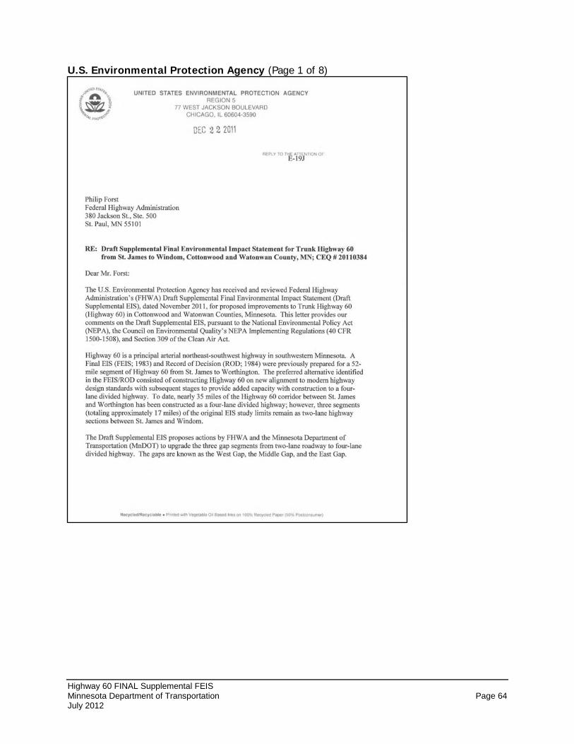
Highway 60 FINAL Supplemental FEIS Minnesota Department of Transportation Page 64 July 2012
U.S. Environmental Protection Agency (Page 1 of 8)
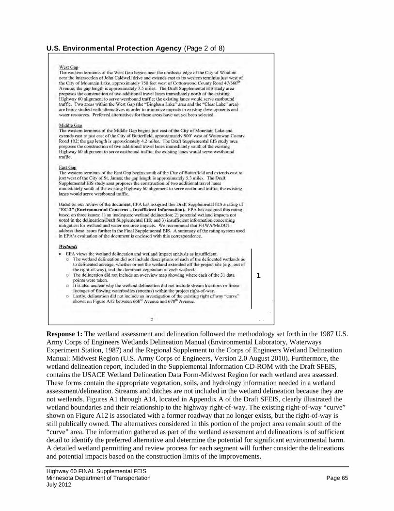
Highway 60 FINAL Supplemental FEIS Minnesota Department of Transportation Page 65 July 2012
U.S. Environmental Protection Agency (Page 2 of 8)
Response 1: The wetland assessment and delineation followed the methodology set forth in the 1987 U.S. Army Corps of Engineers Wetlands Delineation Manual (Environmental Laboratory, Waterways Experiment Station, 1987) and the Regional Supplement to the Corps of Engineers Wetland Delineation Manual: Midwest Region (U.S. Army Corps of Engineers, Version 2.0 August 2010). Furthermore, the wetland delineation report, included in the Supplemental Information CD-ROM with the Draft SFEIS, contains the USACE Wetland Delineation Data Form-Midwest Region for each wetland area assessed. These forms contain the appropriate vegetation, soils, and hydrology information needed in a wetland assessment/delineation. Streams and ditches are not included in the wetland delineation because they are not wetlands. Figures A1 through A14, located in Appendix A of the Draft SFEIS, clearly illustrated the wetland boundaries and their relationship to the highway right-of-way. The existing right-of-way “curve” shown on Figure A12 is associated with a former roadway that no longer exists, but the right-of-way is still publically owned. The alternatives considered in this portion of the project area remain south of the “curve” area. The information gathered as part of the wetland assessment and delineations is of sufficient detail to identify the preferred alternative and determine the potential for significant environmental harm. A detailed wetland permitting and review process for each segment will further consider the delineations and potential impacts based on the construction limits of the improvements.
1
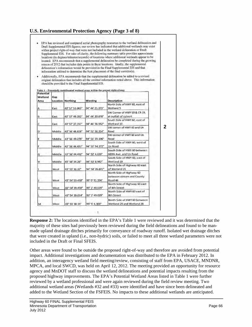
Highway 60 FINAL Supplemental FEIS Minnesota Department of Transportation Page 66 July 2012
U.S. Environmental Protection Agency (Page 3 of 8)
Response 2: The locations identified in the EPA’s Table 1 were reviewed and it was determined that the majority of these sites had previously been reviewed during the field delineations and found to be man-made upland drainage ditches primarily for conveyance of roadway runoff. Isolated wet drainage ditches that were created in upland (i.e., non-hydric) soils, or failed to meet all three wetland parameters were not included in the Draft or Final SFEIS.
Other areas were found to be outside the proposed right-of-way and therefore are avoided from potential impact. Additional investigations and documentation was distributed to the EPA in February 2012. In addition, an interagency wetland field meeting/review, consisting of staff from EPA, USACE, MNDNR, MPCA, and local SWCD, was held on April 12, 2012. The meeting provided an opportunity for resource agency and MnDOT staff to discuss the wetland delineations and potential impacts resulting from the proposed highway improvements. The EPA’s Potential Wetland Areas listed in Table 1 were further reviewed by a wetland professional and were again reviewed during the field review meeting. Two additional wetland areas (Wetlands #32 and #33) were identified and have since been delineated and added to the Wetland Section of the FSFEIS. No impacts to these additional wetlands are anticipated.
2
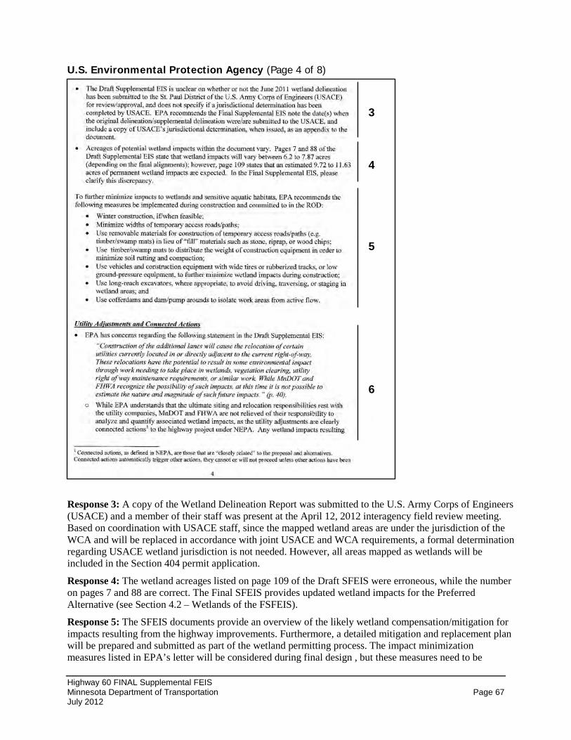
Highway 60 FINAL Supplemental FEIS Minnesota Department of Transportation Page 67 July 2012
U.S. Environmental Protection Agency (Page 4 of 8)
Response 3: A copy of the Wetland Delineation Report was submitted to the U.S. Army Corps of Engineers (USACE) and a member of their staff was present at the April 12, 2012 interagency field review meeting. Based on coordination with USACE staff, since the mapped wetland areas are under the jurisdiction of the WCA and will be replaced in accordance with joint USACE and WCA requirements, a formal determination regarding USACE wetland jurisdiction is not needed. However, all areas mapped as wetlands will be included in the Section 404 permit application.
Response 4: The wetland acreages listed on page 109 of the Draft SFEIS were erroneous, while the number on pages 7 and 88 are correct. The Final SFEIS provides updated wetland impacts for the Preferred Alternative (see Section 4.2 – Wetlands of the FSFEIS).
Response 5: The SFEIS documents provide an overview of the likely wetland compensation/mitigation for impacts resulting from the highway improvements. Furthermore, a detailed mitigation and replacement plan will be prepared and submitted as part of the wetland permitting process. The impact minimization measures listed in EPA’s letter will be considered during final design , but these measures need to be
3
4
5
6
Highway 60 FINAL Supplemental FEIS Minnesota Department of Transportation Page 68 July 2012
determined applicable, practicable, and feasible before they would be included in the Highway 60 Project. The Final SFEIS (see Section 4.2 – Wetlands) contains a description of s currently active wetland bank site that contain credits that are available for use through the MnDOT and BWSR Cooperative Wetland Replacement Program.
Response 6: MnDOT re-reviewed this issue and have determined that due to the limited utilities and wetlands in the project area, MnDOT does not foresee additional wetland impacts resulting from utility relocations.
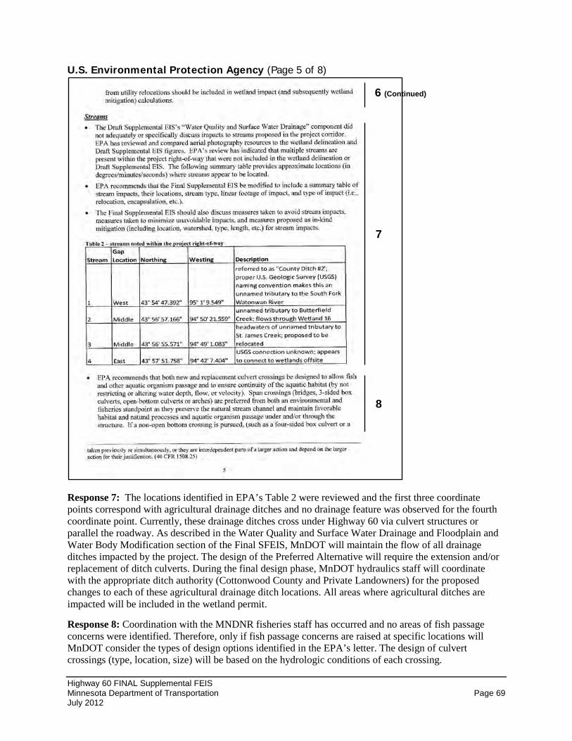
Highway 60 FINAL Supplemental FEIS Minnesota Department of Transportation Page 69 July 2012
U.S. Environmental Protection Agency (Page 5 of 8)
Response 7: The locations identified in EPA’s Table 2 were reviewed and the first three coordinate points correspond with agricultural drainage ditches and no drainage feature was observed for the fourth coordinate point. Currently, these drainage ditches cross under Highway 60 via culvert structures or parallel the roadway. As described in the Water Quality and Surface Water Drainage and Floodplain and Water Body Modification section of the Final SFEIS, MnDOT will maintain the flow of all drainage ditches impacted by the project. The design of the Preferred Alternative will require the extension and/or replacement of ditch culverts. During the final design phase, MnDOT hydraulics staff will coordinate with the appropriate ditch authority (Cottonwood County and Private Landowners) for the proposed changes to each of these agricultural drainage ditch locations. All areas where agricultural ditches are impacted will be included in the wetland permit.
Response 8: Coordination with the MNDNR fisheries staff has occurred and no areas of fish passage concerns were identified. Therefore, only if fish passage concerns are raised at specific locations will MnDOT consider the types of design options identified in the EPA’s letter. The design of culvert crossings (type, location, size) will be based on the hydrologic conditions of each crossing.
6 (Continued)
7
8
Highway 60 FINAL Supplemental FEIS Minnesota Department of Transportation Page 70 July 2012
U.S. Environmental Protection Agency (Page 6 of 8)
Response 9: MnDOT is committed to maintaining the flow of all agricultural drainage ditches located in the project area. As described in the Water Quality and Surface Water Drainage and Floodplain and Water Body Modification section of the Final SFEIS, potential impacts to agricultural drainage ditches are expected to be minimal since the roadway improvements will be constructed immediately adjacent to the existing highway corridor. Specific design details, including new and/or replacement culverts, will be identified as part of the final design.
Response 10: The Preferred Alternative will cross an existing agricultural drainage ditch (Judicial County Ditch No. 2,) located just east of Bingham Lake, which will require an extension of the existing culvert under Highway 60 to allow for the construction of the additional lanes to the north of the existing highway. Another private agricultural drainage ditch, located near Watonwan County Road 2 outside of Butterfield, will be relocated for a distance of approximately 500 lineal feet in order to construct the
8 (Continued)
9
12
11
10
13
Highway 60 FINAL Supplemental FEIS Minnesota Department of Transportation Page 71 July 2012
additional travel lanes immediately south of the existing highway corridor. MnDOT will require that appropriate erosion control and water quality measures be incorporated into any ditch improvements.
Response 11: Several minimization measures and mitigation commitments have been outlined in Section 4.0 of the Draft and Final SFEIS documents. In addition, best management practices for all construction will be followed to minimize potential adverse impacts from the construction of the Preferred Alternative. BMPs and other construction techniques (as listed in the EPA’s letter) will be specified in the stormwater pollution prevention plan (SWPPP) as part of the NPDES permit and included in other required permits.
Response 12: The Final SFEIS contains updated figures in Appendix A that depict the Preferred Alternative and the potential impacts to project area wetlands. Two additional wetland basins (Wetlands #32 and #33) have been delineated since the publication of the Draft SFEIS and the interagency field review meeting held in April 2012.
Response 13: See details in Section 4.2 – Wetlands of the Final SFEIS. Wetland replacement will be provided in accordance with state and federal regulations at the time of final design, project permitting, and construction. Replacement acreage for the East Gap improvements will require the use of wetland banking. MnDOT’s existing wetland bank system will provide eligible credits for wetland replacements. There are existing accounts and credits located in Watonwan County that are held by MnDOT. This site is located within the Bank Service Area and will be used for the replacement acreage for the East Gap. The replacement plan for the Middle and West Gaps are not known at this time. Due to the number of years until these gap segments are constructed, additional bank sites could be developed to accommodate the replacement needs of the Middle and West Gaps. Therefore, no specific information on wetland banking sites for the Middle and West Gaps is provided at this time, but will be pursued during the final design phase for each highway segment.
Highway 60 FINAL Supplemental FEIS Minnesota Department of Transportation Page 72 July 2012
U.S. Environmental Protection Agency (Page 7 of 8)
Response 13: See response on previous page.
Response 14: The identified Preferred Alternative includes Bingham Lake “Widen North” design option with a modification that slightly shifts the alignment to the south near the Highway 60/Cottonwood County Road 2 intersection. This modification was proposed in part to minimize impacts to Wetland #25 located north of Highway 60. However, the result of this alignment shift is a potential minor impact to an identified prairie remnant. The preliminary impact area was calculated based on the proposed right-of-way for the four-lane expressway section. The final design of the Preferred Alternative will attempt to avoid and minimize prairie remnant impacts to the greatest extent possible, while balancing impacts to wetlands and other resources. Mitigation for prairie impacts will include the use of native prairie seed mixes to revegetate the areas impacted. Furthermore, MnDOT will include language into the special provisions of the contract that will not allow work or equipment staging to occur within the identified prairie remnant areas between the dates of April 1-August 1.
Response 15: Comments noted.
13 (Continued)
14
15
Highway 60 FINAL Supplemental FEIS Minnesota Department of Transportation Page 73 July 2012
U.S. Environmental Protection Agency (Page 8 of 8)
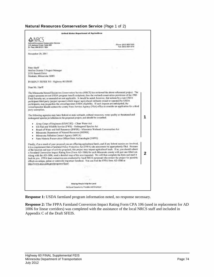
Highway 60 FINAL Supplemental FEIS Minnesota Department of Transportation Page 74 July 2012
Natural Resources Conservation Service (Page 1 of 2)
Response 1: USDA farmland program information noted, no response necessary.
Response 2: The FPPA Farmland Conversion Impact Rating Form CPA 106 (used in replacement for AD 1006 for linear corridors) was completed with the assistance of the local NRCS staff and included in Appendix C of the Draft SFEIS.
1
2

Highway 60 FINAL Supplemental FEIS Minnesota Department of Transportation Page 75 July 2012
Natural Resources Conservation Service (Page 2 of 2)
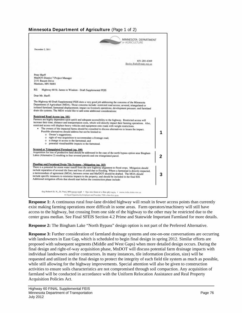
Highway 60 FINAL Supplemental FEIS Minnesota Department of Transportation Page 76 July 2012
Minnesota Department of Agriculture (Page 1 of 2)
Response 1: A continuous rural four-lane divided highway will result in fewer access points than currently exist making farming operations more difficult in some areas. Farm operators/machinery will still have access to the highway, but crossing from one side of the highway to the other may be restricted due to the center grass median. See Final SFEIS Section 4.2 Prime and Statewide Important Farmland for more details.
Response 2: The Bingham Lake “North Bypass” design option is not part of the Preferred Alternative.
Response 3: Further consideration of farmland drainage systems and one-on-one conversations are occurring with landowners in East Gap, which is scheduled to begin final design in spring 2012. Similar efforts are proposed with subsequent segments (Middle and West Gaps) when more detailed design occurs. During the final design and right-of-way acquisition phase, MnDOT will discuss potential farm drainage impacts with individual landowners and/or contractors. In many instances, tile information (location, size) will be requested and utilized in the final design to protect the integrity of each field tile system as much as possible, while still allowing for the highway improvements. Special attention will also be given to construction activities to ensure soils characteristics are not compromised through soil compaction. Any acquisition of farmland will be conducted in accordance with the Uniform Relocation Assistance and Real Property Acquisition Policies Act.
1
2
3
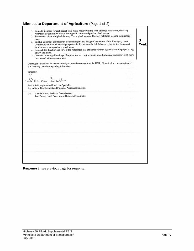
Highway 60 FINAL Supplemental FEIS Minnesota Department of Transportation Page 77 July 2012
Minnesota Department of Agriculture (Page 1 of 2)
Response 3: see previous page for response.
3 Cont.
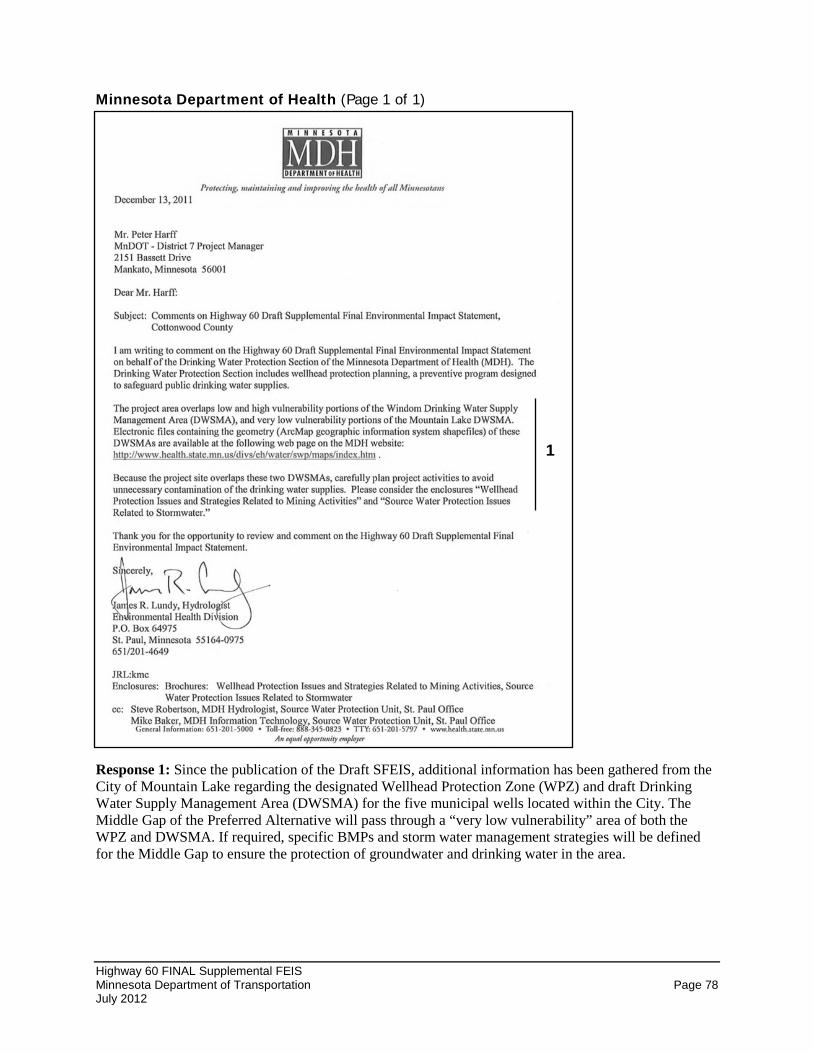
Highway 60 FINAL Supplemental FEIS Minnesota Department of Transportation Page 78 July 2012
Minnesota Department of Health (Page 1 of 1)
Response 1: Since the publication of the Draft SFEIS, additional information has been gathered from the City of Mountain Lake regarding the designated Wellhead Protection Zone (WPZ) and draft Drinking Water Supply Management Area (DWSMA) for the five municipal wells located within the City. The Middle Gap of the Preferred Alternative will pass through a “very low vulnerability” area of both the WPZ and DWSMA. If required, specific BMPs and storm water management strategies will be defined for the Middle Gap to ensure the protection of groundwater and drinking water in the area.
1
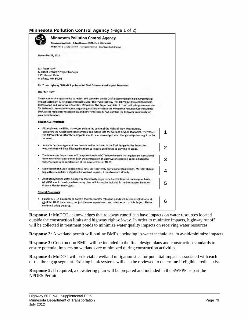
Highway 60 FINAL Supplemental FEIS Minnesota Department of Transportation Page 79 July 2012
Minnesota Pollution Control Agency (Page 1 of 2)
Response 1: MnDOT acknowledges that roadway runoff can have impacts on water resources located outside the construction limits and highway right-of-way. In order to minimize impacts, highway runoff will be collected in treatment ponds to minimize water quality impacts on receiving water resources.
Response 2: A wetland permit will outline BMPs, including in-water techniques, to avoid/minimize impacts.
Response 3: Construction BMPs will be included in the final design plans and construction standards to ensure potential impacts on wetlands are minimized during construction activities.
Response 4: MnDOT will seek viable wetland mitigation sites for potential impacts associated with each of the three gap segment. Existing bank systems will also be reviewed to determine if eligible credits exist.
Response 5: If required, a dewatering plan will be prepared and included in the SWPPP as part the NPDES Permit.
2
5
1
3
4
7
6
1
2
3
4
5
6
Highway 60 FINAL Supplemental FEIS Minnesota Department of Transportation Page 80 July 2012
Response 6: The Final SFEIS shows the greatest extent of impact to farmland. Following a more detailed hydraulics study, which will be conducted during the final design of each segment, some treatment ponds may be moved or shifted, resized, or eliminated. The final configuration will, at a minimum, comply with NPDES permit requirements by providing treatment for the full area of new impervious. MnDOT has and will continue to seek other opportunities to treat additional runoff from existing impervious areas.
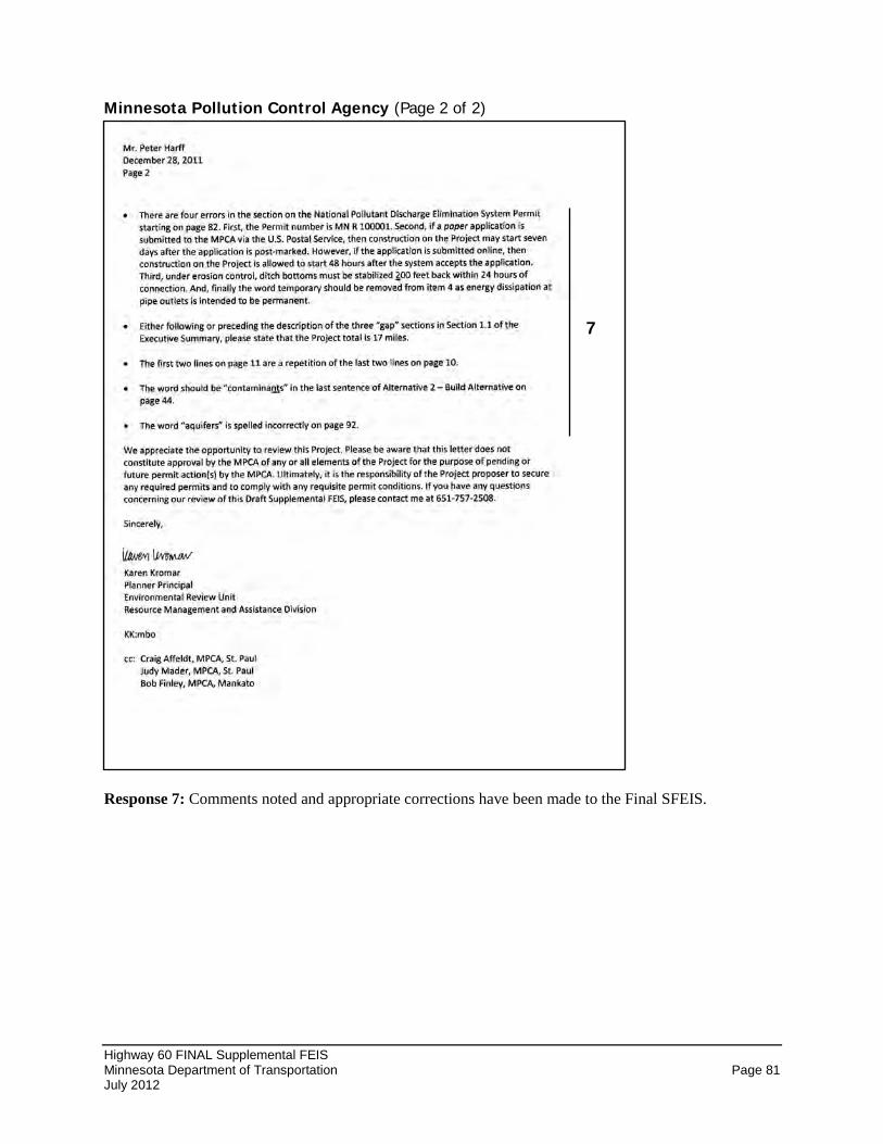
Highway 60 FINAL Supplemental FEIS Minnesota Department of Transportation Page 81 July 2012
Minnesota Pollution Control Agency (Page 2 of 2)
Response 7: Comments noted and appropriate corrections have been made to the Final SFEIS.
8
9 7
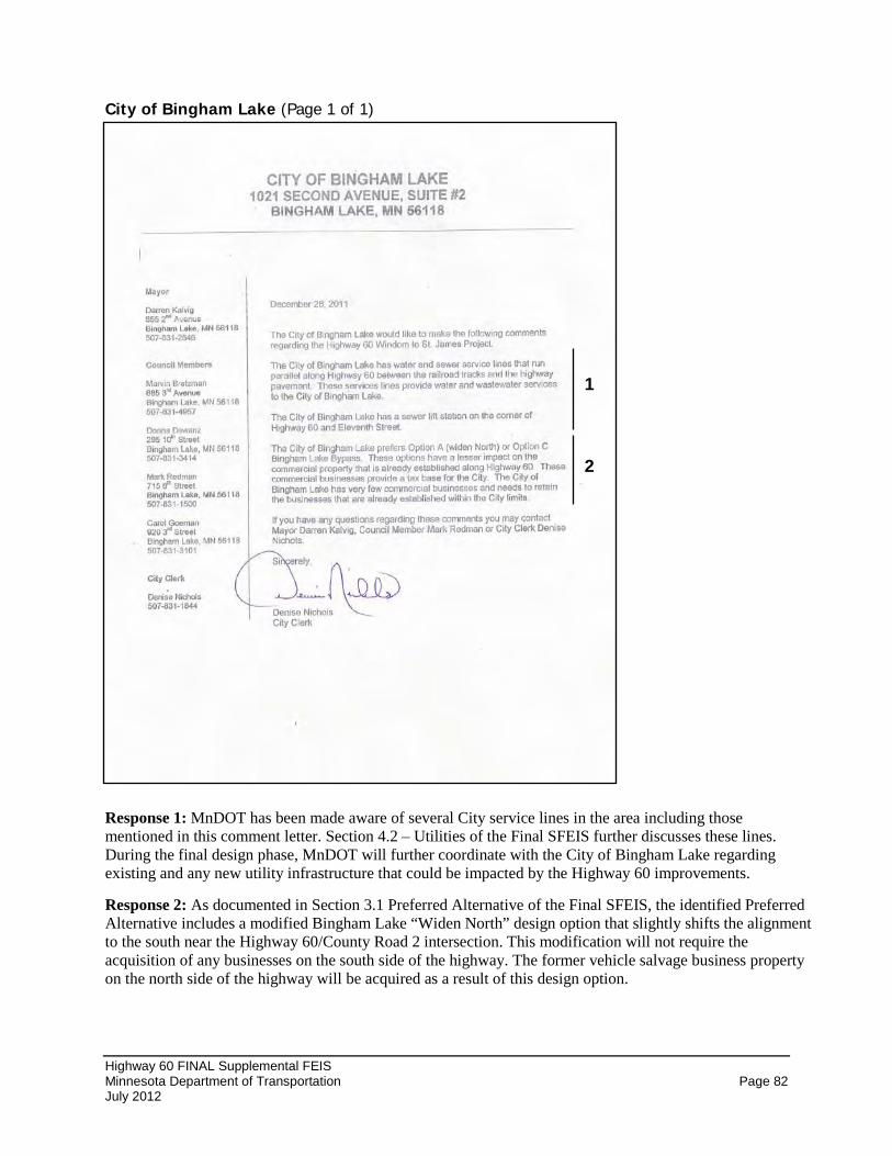
Highway 60 FINAL Supplemental FEIS Minnesota Department of Transportation Page 82 July 2012
City of Bingham Lake (Page 1 of 1)
Response 1: MnDOT has been made aware of several City service lines in the area including those mentioned in this comment letter. Section 4.2 – Utilities of the Final SFEIS further discusses these lines. During the final design phase, MnDOT will further coordinate with the City of Bingham Lake regarding existing and any new utility infrastructure that could be impacted by the Highway 60 improvements.
Response 2: As documented in Section 3.1 Preferred Alternative of the Final SFEIS, the identified Preferred Alternative includes a modified Bingham Lake “Widen North” design option that slightly shifts the alignment to the south near the Highway 60/County Road 2 intersection. This modification will not require the acquisition of any businesses on the south side of the highway. The former vehicle salvage business property on the north side of the highway will be acquired as a result of this design option.
2
1
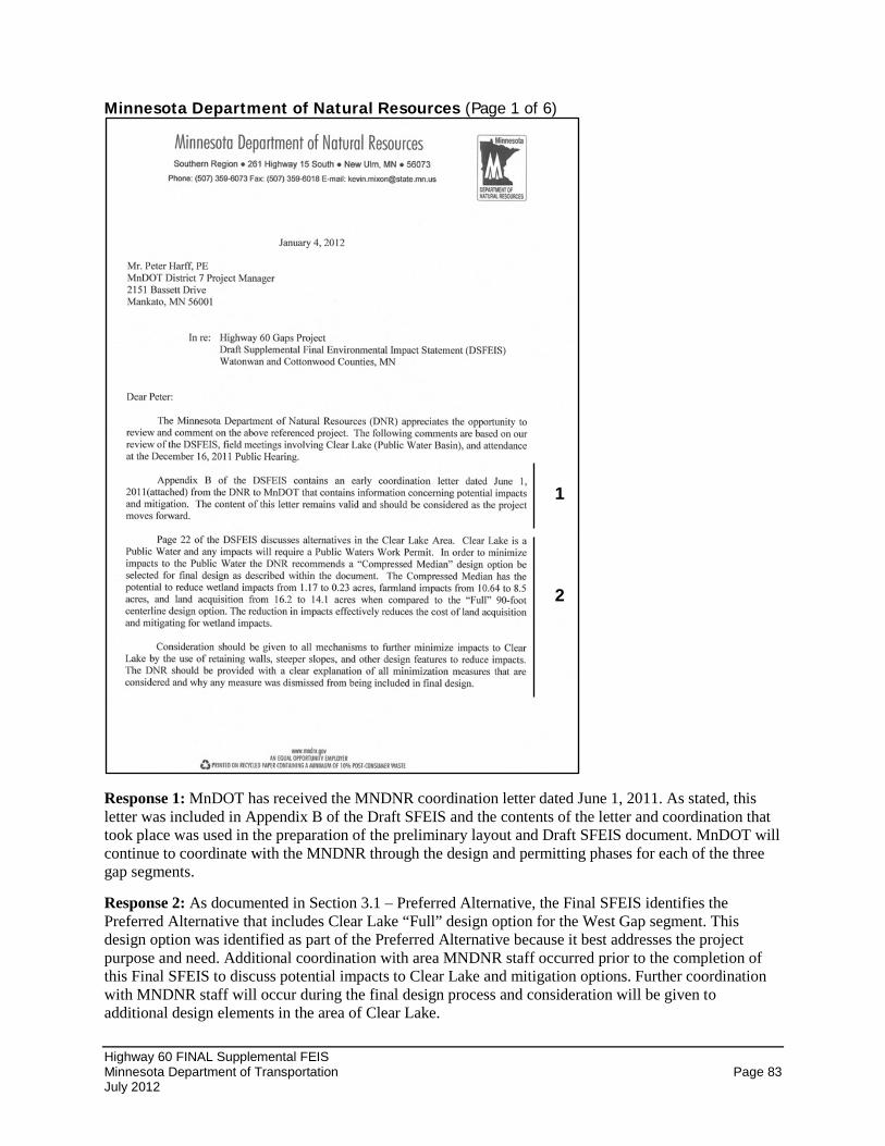
Highway 60 FINAL Supplemental FEIS Minnesota Department of Transportation Page 83 July 2012
Minnesota Department of Natural Resources (Page 1 of 6)
Response 1: MnDOT has received the MNDNR coordination letter dated June 1, 2011. As stated, this letter was included in Appendix B of the Draft SFEIS and the contents of the letter and coordination that took place was used in the preparation of the preliminary layout and Draft SFEIS document. MnDOT will continue to coordinate with the MNDNR through the design and permitting phases for each of the three gap segments.
Response 2: As documented in Section 3.1 – Preferred Alternative, the Final SFEIS identifies the Preferred Alternative that includes Clear Lake “Full” design option for the West Gap segment. This design option was identified as part of the Preferred Alternative because it best addresses the project purpose and need. Additional coordination with area MNDNR staff occurred prior to the completion of this Final SFEIS to discuss potential impacts to Clear Lake and mitigation options. Further coordination with MNDNR staff will occur during the final design process and consideration will be given to additional design elements in the area of Clear Lake.
1
2
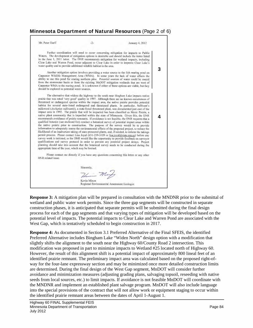
Highway 60 FINAL Supplemental FEIS Minnesota Department of Transportation Page 84 July 2012
Minnesota Department of Natural Resources (Page 2 of 6)
Response 3: A mitigation plan will be prepared in consultation with the MNDNR prior to the submittal of wetland and public water work permits. Since the three gap segments will be constructed in separate construction phases, it is anticipated that separate permits will be submitted during the final design process for each of the gap segments and that varying types of mitigation will be developed based on the potential level of impacts. The potential impacts to Clear Lake and Warren Pond are associated with the West Gap, which is tentatively scheduled to begin construction in 2017.
Response 4: As documented in Section 3.1 Preferred Alternative of the Final SFEIS, the identified Preferred Alternative includes Bingham Lake “Widen North” design option with a modification that slightly shifts the alignment to the south near the Highway 60/County Road 2 intersection. This modification was proposed in part to minimize impacts to Wetland #25 located north of Highway 60. However, the result of this alignment shift is a potential impact of approximately 800 lineal feet of an identified prairie remnant. The preliminary impact area was calculated based on the proposed right-of-way for the four-lane expressway section and may be minimized once more detailed construction limits are determined. During the final design of the West Gap segment, MnDOT will consider further avoidance and minimization measures (adjusting grading plans, salvaging topsoil, reseeding with native seeds from local sources, etc.) to limit impacts. If avoidance is not feasible MnDOT will coordinate with the MNDNR and implement an established plant salvage program. MnDOT will also include language into the special provisions of the contract that will not allow work or equipment staging to occur within the identified prairie remnant areas between the dates of April 1-August 1.
3
4
Highway 60 FINAL Supplemental FEIS Minnesota Department of Transportation Page 85 July 2012
Minnesota Department of Natural Resources (Page 3 of 6)
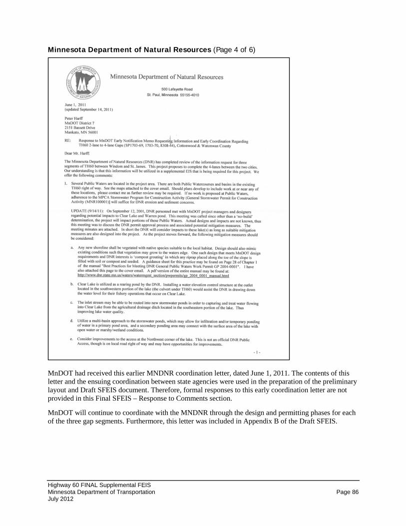
Highway 60 FINAL Supplemental FEIS Minnesota Department of Transportation Page 86 July 2012
Minnesota Department of Natural Resources (Page 4 of 6)
MnDOT had received this earlier MNDNR coordination letter, dated June 1, 2011. The contents of this letter and the ensuing coordination between state agencies were used in the preparation of the preliminary layout and Draft SFEIS document. Therefore, formal responses to this early coordination letter are not provided in this Final SFEIS – Response to Comments section.
MnDOT will continue to coordinate with the MNDNR through the design and permitting phases for each of the three gap segments. Furthermore, this letter was included in Appendix B of the Draft SFEIS.
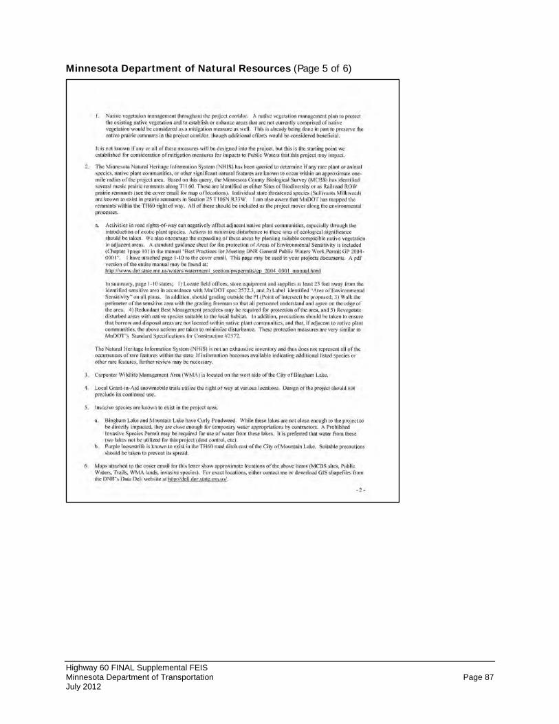
Highway 60 FINAL Supplemental FEIS Minnesota Department of Transportation Page 87 July 2012
Minnesota Department of Natural Resources (Page 5 of 6)
Highway 60 FINAL Supplemental FEIS Minnesota Department of Transportation Page 88 July 2012
Minnesota Department of Natural Resources (Page 6 of 6)
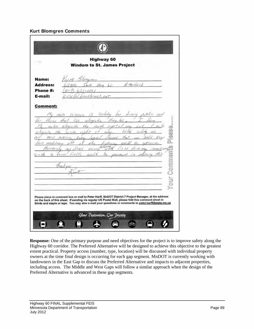
Highway 60 FINAL Supplemental FEIS Minnesota Department of Transportation Page 89 July 2012
Kurt Blomgren Comments
Response: One of the primary purpose and need objectives for the project is to improve safety along the Highway 60 corridor. The Preferred Alternative will be designed to achieve this objective to the greatest extent practical. Property access (number, type, location) will be discussed with individual property owners at the time final design is occurring for each gap segment. MnDOT is currently working with landowners in the East Gap to discuss the Preferred Alternative and impacts to adjacent properties, including access. The Middle and West Gaps will follow a similar approach when the design of the Preferred Alternative is advanced in these gap segments.
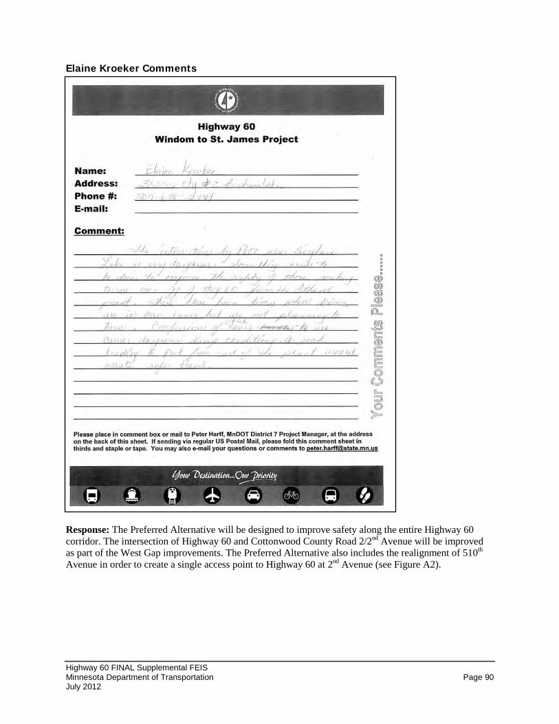
Highway 60 FINAL Supplemental FEIS Minnesota Department of Transportation Page 90 July 2012
Elaine Kroeker Comments
Response: The Preferred Alternative will be designed to improve safety along the entire Highway 60 corridor. The intersection of Highway 60 and Cottonwood County Road 2/2nd Avenue will be improved as part of the West Gap improvements. The Preferred Alternative also includes the realignment of 510th Avenue in order to create a single access point to Highway 60 at 2nd Avenue (see Figure A2).
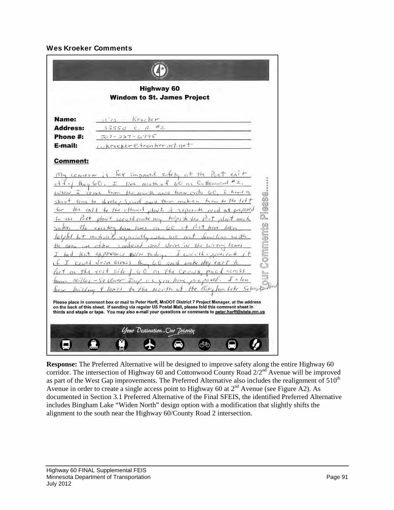
Highway 60 FINAL Supplemental FEIS Minnesota Department of Transportation Page 91 July 2012
Wes Kroeker Comments
Response: The Preferred Alternative will be designed to improve safety along the entire Highway 60 corridor. The intersection of Highway 60 and Cottonwood County Road 2/2nd Avenue will be improved as part of the West Gap improvements. The Preferred Alternative also includes the realignment of 510th Avenue in order to create a single access point to Highway 60 at 2nd Avenue (see Figure A2). As documented in Section 3.1 Preferred Alternative of the Final SFEIS, the identified Preferred Alternative includes Bingham Lake “Widen North” design option with a modification that slightly shifts the alignment to the south near the Highway 60/County Road 2 intersection.
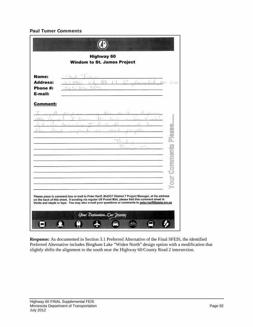
Highway 60 FINAL Supplemental FEIS Minnesota Department of Transportation Page 92 July 2012
Paul Tumer Comments
Response: As documented in Section 3.1 Preferred Alternative of the Final SFEIS, the identified Preferred Alternative includes Bingham Lake “Widen North” design option with a modification that slightly shifts the alignment to the south near the Highway 60/County Road 2 intersection.
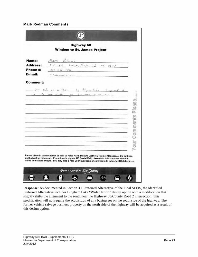
Highway 60 FINAL Supplemental FEIS Minnesota Department of Transportation Page 93 July 2012
Mark Redman Comments
Response: As documented in Section 3.1 Preferred Alternative of the Final SFEIS, the identified Preferred Alternative includes Bingham Lake “Widen North” design option with a modification that slightly shifts the alignment to the south near the Highway 60/County Road 2 intersection. This modification will not require the acquisition of any businesses on the south side of the highway. The former vehicle salvage business property on the north side of the highway will be acquired as a result of this design option.
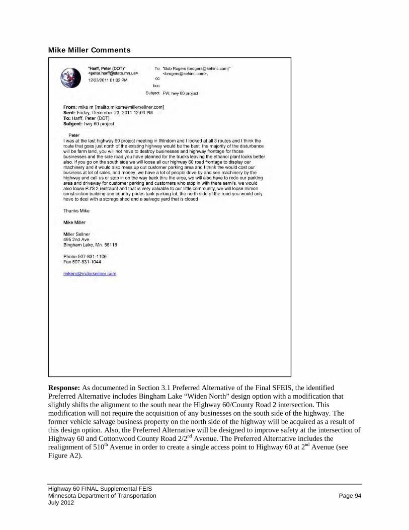
Highway 60 FINAL Supplemental FEIS Minnesota Department of Transportation Page 94 July 2012
Mike Miller Comments
Response: As documented in Section 3.1 Preferred Alternative of the Final SFEIS, the identified Preferred Alternative includes Bingham Lake “Widen North” design option with a modification that slightly shifts the alignment to the south near the Highway 60/County Road 2 intersection. This modification will not require the acquisition of any businesses on the south side of the highway. The former vehicle salvage business property on the north side of the highway will be acquired as a result of this design option. Also, the Preferred Alternative will be designed to improve safety at the intersection of Highway 60 and Cottonwood County Road 2/2nd Avenue. The Preferred Alternative includes the realignment of 510th Avenue in order to create a single access point to Highway 60 at 2nd Avenue (see Figure A2).
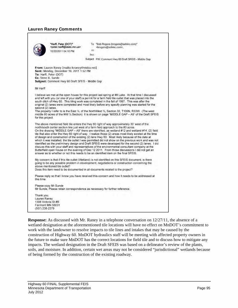
Highway 60 FINAL Supplemental FEIS Minnesota Department of Transportation Page 95 July 2012
Lauren Raney Comments
Response: As discussed with Mr. Raney in a telephone conversation on 12/27/11, the absence of a wetland designation at the aforementioned tile locations will have no effect on MnDOT’s commitment to work with the landowner to resolve impacts to tile lines and intakes that may be caused by the construction of Highway 60. MnDOT hydraulics staff will be meeting with affected property owners in the future to make sure MnDOT has the correct locations for field tile and to discuss how to mitigate any impacts. The wetland designation in the Draft SFEIS was based on a delineator’s review of the plants, soils, and moisture. In addition, certain wet areas may not be considered “jurisdictional” wetlands because of being formed by the construction of the existing roadway.
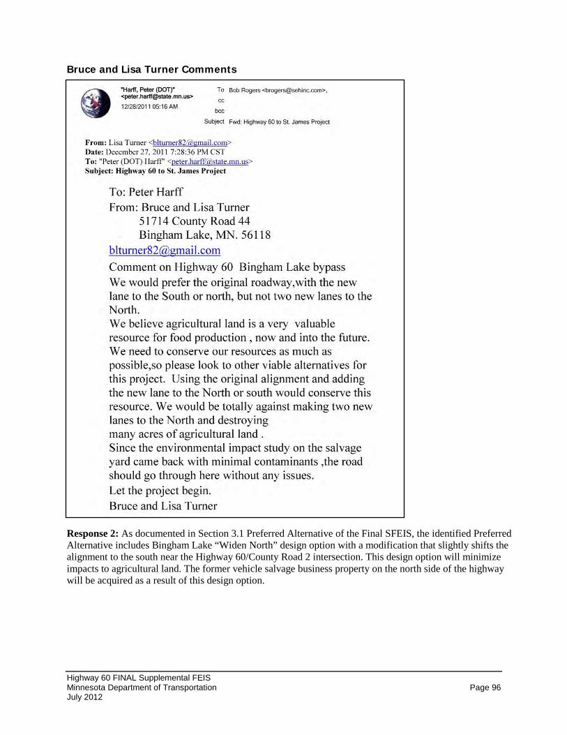
Highway 60 FINAL Supplemental FEIS Minnesota Department of Transportation Page 96 July 2012
Bruce and Lisa Turner Comments
Response 2: As documented in Section 3.1 Preferred Alternative of the Final SFEIS, the identified Preferred Alternative includes Bingham Lake “Widen North” design option with a modification that slightly shifts the alignment to the south near the Highway 60/County Road 2 intersection. This design option will minimize impacts to agricultural land. The former vehicle salvage business property on the north side of the highway will be acquired as a result of this design option.
Appendix A Preliminary Layout Sheets of the Preferred Alternative

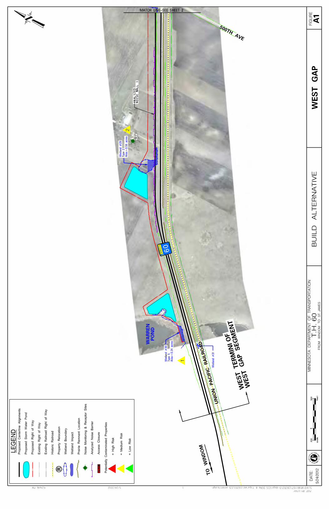
’R
1’
Are
a=
0.5
8 a
cre
sT
ype 2
Wetl
and #
29
Are
a=
0.3
4 a
cre
sT
ype 5
Wetl
and #
30
Wetl
and #
31
5/2
4/2
01
2
cflor
1
M
IN
NE
SOT
A
DEPARTME
NT
OF
TR
ANS
PORTATION
5/24/20124:24:46 PM S:\KO\M\Mnt07\116353\5-dsgn\EIS DGNs & Figures\116353_EIS plnshts.dgn
PLOT BY:
DA
TE
: F
IGU
RE
MIN
NE
SO
TA
DE
PA
RT
ME
NT
OF
TR
AN
SP
OR
TA
TIO
N
FR
OM
WIN
DO
M T
O S
T. JA
ME
S
0
feet
scale
200
500
T
.H. 60
BU
ILD
AL
TE
RN
AT
IVE
1
2
1
2
500TH AVE
TO
WIN
DO
M
UNIO
N PACIFIC RAIL
RO
AD
MIN
NESOTA
60
PO
ND
WA
RR
EN
MATCH LINE-SEE SHEET 2
A1
WE
ST
GA
P
LE
GE
ND
R
CL
OS
E
WEST G
AP SEG
MENT
WEST TER
MINI OF
Access C
losu
re
An
aly
zed
No
ise B
arr
ier
No
ise M
on
ito
rin
g &
Recep
tor
Sit
es
Pra
irie
Rem
nant
Locati
on
Wetl
an
d I
mp
act
Wetl
and B
oundary
Pro
pert
y R
elo
cati
on
His
tori
c R
ail
road
Ex
isti
ng
Rail
road
Rig
ht
of
Way
Ex
isti
ng
Rig
ht
of
Way
Pro
posed R
ight
of
Way
Pro
po
sed
Sto
rm W
ate
r P
on
d
Pro
posed C
ente
rlin
e A
lignm
ents
Pote
nti
all
y C
onta
min
ate
d P
ropert
ies
= L
ow
Ris
k
= M
ed
ium
Ris
k
= H
igh
Ris
k
NO
IS
E W
AL
L 1
AN
AL
YZ
ED
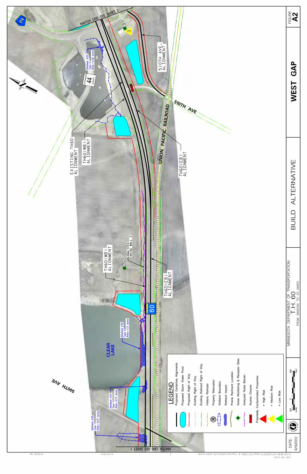
6/1
9/2
01
2
cflor
2
M
IN
NE
SOT
A
DEPARTME
NT
OF
TR
ANS
PORTATION
6/19/20128:44:58 AM S:\KO\M\Mnt07\116353\5-dsgn\EIS DGNs & Figures\116353_EIS plnshts.dgn
PLOT BY:
DA
TE
: F
IGU
RE
MIN
NE
SO
TA
DE
PA
RT
ME
NT
OF
TR
AN
SP
OR
TA
TIO
N
FR
OM
WIN
DO
M T
O S
T. JA
ME
S
0
feet
scale
200
500
T
.H. 60
BU
ILD
AL
TE
RN
AT
IVE
LE
GE
ND
R
CL
OS
EA
ccess C
losure
An
aly
zed
No
ise B
arr
ier
No
ise M
on
ito
rin
g &
Recep
tor
Sit
es
Pra
irie
Rem
nant
Locati
on
Wetl
an
d I
mp
act
Wetl
and B
oundary
Pro
pert
y R
elo
cati
on
His
tori
c R
ail
road
Ex
isti
ng
Rail
road
Rig
ht
of
Way
Ex
isti
ng
Rig
ht
of
Way
Pro
posed R
ight
of
Way
Pro
po
sed
Sto
rm W
ate
r P
on
d
Pro
posed C
ente
rlin
e A
lignm
ents
Pote
nti
all
y C
onta
min
ate
d P
ropert
ies
= L
ow
Ris
k
= M
ed
ium
Ris
k
= H
igh
Ris
k
’R
2’
’B
1’
Are
a=
0.4
7 a
cre
sT
ype 1
Wetl
and #
28
Are
a=
0.2
0 a
cre
sT
ype 5
Wetl
and #
25
Are
a=
0.1
7 a
cre
sT
yp
e 1
Wetl
and #
27
Are
a=
1.1
7 a
cre
sT
ype 5
Wetl
and #
26
33
500TH
AVE
LA
KE
CL
EA
R
UNIO
N PACIFIC RAIL
RO
AD
MIN
NE
SO
TA
510TH AVE
CO
UNTY
COTTO
NW
OO
D
44
COTTONWOOD
COUNTY
2
60
CLOSE
MATCH LINE-SEE SHEET 1MATCH L
INE-SEE
SHEET 3
WE
ST
GA
PA
2
AL
IGN
ME
NT
510T
H A
VE
.
NO
IS
E W
AL
L 2
AN
AL
YZ
ED
AL
IGN
ME
NT
TH
60(W
B)
AL
IGN
ME
NT
TH
60
(E
B)
AL
IGN
ME
NT
EX
IS
TIN
G T
H60
AL
IGN
ME
NT
TH
60
(E
B)
AL
IGN
ME
NT
TH
60(W
B)
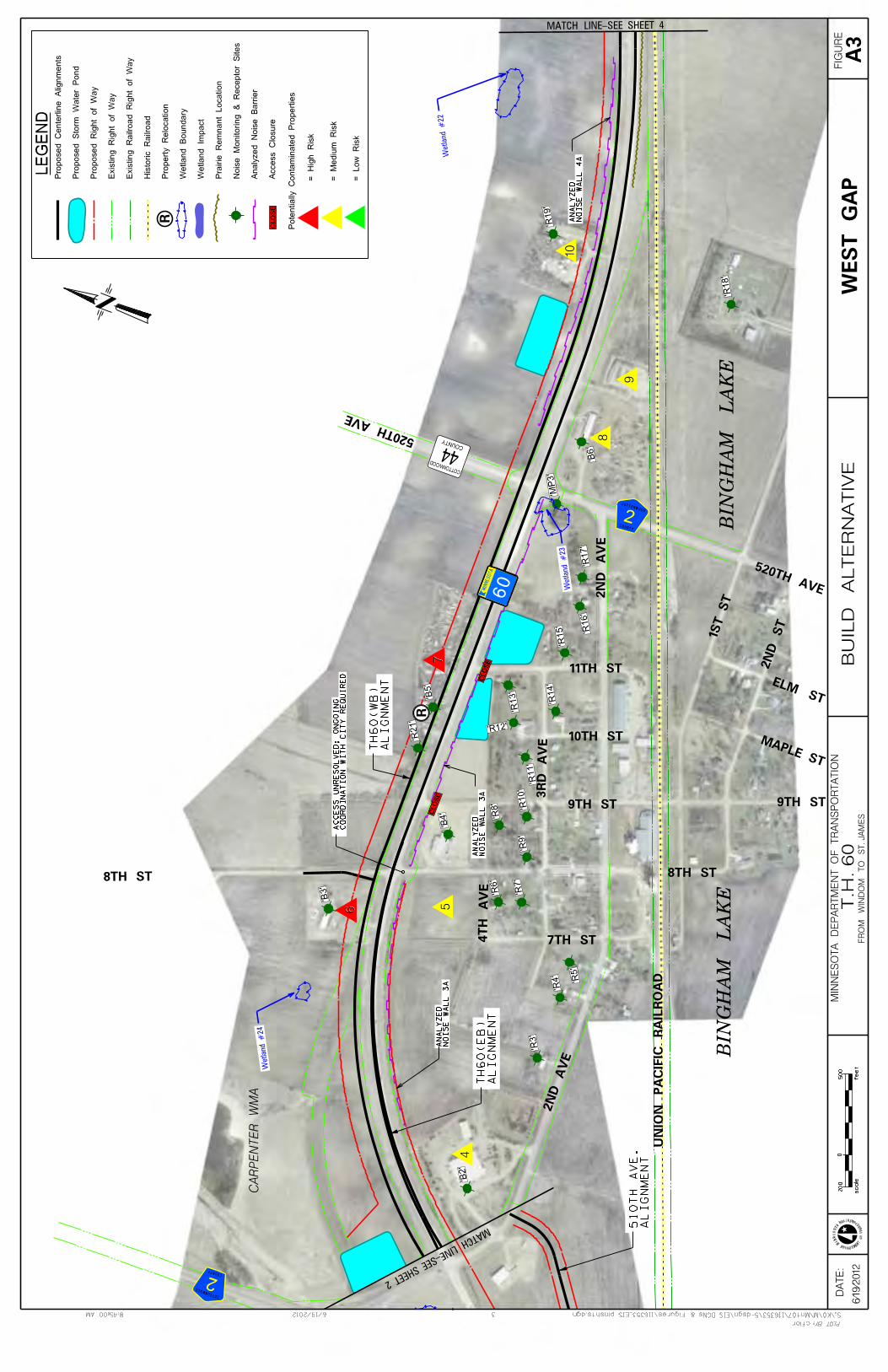
Wetland #24
Wetland #23
Wetland #22
’MP3’
’R3’
’R4’
’R5’
’R6’
’R7’
’R8’
’R9’
’R10’
’R11’
’R12’
’R13’
’R14’
’R15’
’R16’
’R17’
’R18’
’R19’
’R21’
’B2’
’B3’
’B4’
’B5’
’B6’
LE
GE
ND
R
CL
OS
EA
ccess C
losu
re
An
aly
zed
No
ise B
arr
ier
No
ise M
on
ito
rin
g &
Recep
tor
Sit
es
Pra
irie
Rem
nant
Locati
on
Wetl
an
d I
mp
act
Wetl
and B
oundary
Pro
pert
y R
elo
cati
on
His
tori
c R
ail
road
Ex
isti
ng
Rail
road
Rig
ht
of
Way
Ex
isti
ng
Rig
ht
of
Way
Pro
posed R
ight
of
Way
Pro
po
sed
Sto
rm W
ate
r P
on
d
Pro
posed C
ente
rlin
e A
lignm
ents
Pote
nti
all
y C
onta
min
ate
d P
ropert
ies
= L
ow
Ris
k
= M
ed
ium
Ris
k
= H
igh
Ris
k
6/1
9/2
01
2
cflor
3
M
IN
NE
SOT
A
DEPARTME
NT
OF
TR
ANS
PORTATION
6/19/20128:45:00 AM S:\KO\M\Mnt07\116353\5-dsgn\EIS DGNs & Figures\116353_EIS plnshts.dgn
PLOT BY:
DA
TE
: F
IGU
RE
MIN
NE
SO
TA
DE
PA
RT
ME
NT
OF
TR
AN
SP
OR
TA
TIO
N
FR
OM
WIN
DO
M T
O S
T. JA
ME
S
0
feet
scale
200
500
T
.H. 60
BU
ILD
AL
TE
RN
AT
IVE
4
56
7
8
9
10
4
5
8
9
10
7
6
520TH AVE
520TH
AVE
8TH ST 8TH ST
7TH ST
9TH ST
2N
D ST
1ST ST
ELM ST
M APLE ST
2N
D AVE
2N
D A
VE
3RD AVE
4TH AVE
11TH ST
10TH ST
9TH ST
UNIO
N PACIFIC RAIL
RO
AD
MIN
NESOTA
COTTONWOOD
COUNTY
2
COTTONWOOD
COUNTY
2
COUNTY
COTTONWOOD
44
CA
RP
EN
TE
R W
MA
BIN
GH
AM
LA
KE
BIN
GH
AM
LA
KE
60
CLOSE
CLOSE
R
MATCH LINE-SEE SHEET 4
WE
ST
GA
PA
3
MATCH LINE-SEE SHEET 2
AL
IGN
ME
NT
510T
H A
VE
.
NO
IS
E W
AL
L 4
AA
NA
LY
ZE
D
NO
IS
E W
AL
L 3
AA
NA
LY
ZE
D
NO
IS
E W
AL
L 3
AA
NA
LY
ZE
D
AL
IGN
ME
NT
TH
60
(E
B)
AL
IGN
ME
NT
TH
60(W
B)
CO
OR
DIN
AT
IO
N W
IT
H C
IT
Y R
EQ
UIR
ED
AC
CE
SS
UN
RE
SO
LV
ED
; O
NG
OIN
G
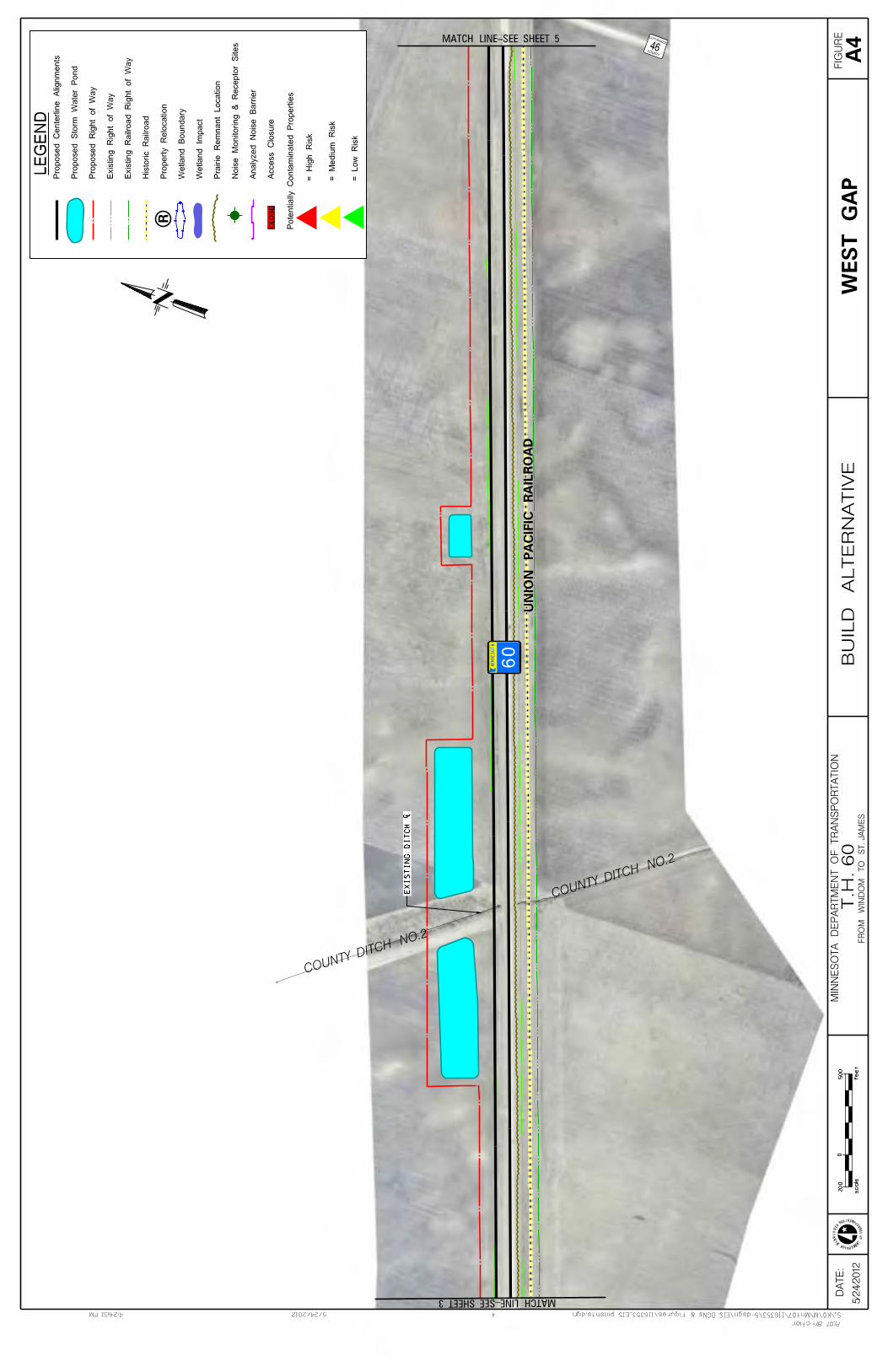
LE
GE
ND
R
CL
OS
EA
ccess C
losu
re
An
aly
zed
No
ise B
arr
ier
No
ise M
on
ito
rin
g &
Recep
tor
Sit
es
Pra
irie
Rem
nant
Locati
on
Wetl
an
d I
mp
act
Wetl
and B
oundary
Pro
pert
y R
elo
cati
on
His
tori
c R
ail
road
Ex
isti
ng
Rail
road
Rig
ht
of
Way
Ex
isti
ng
Rig
ht
of
Way
Pro
posed R
ight
of
Way
Pro
po
sed
Sto
rm W
ate
r P
on
d
Pro
posed C
ente
rlin
e A
lignm
ents
Pote
nti
all
y C
onta
min
ate
d P
ropert
ies
= L
ow
Ris
k
= M
ed
ium
Ris
k
= H
igh
Ris
k
5/2
4/2
01
2
cflor
4
M
IN
NE
SOT
A
DEPARTME
NT
OF
TR
ANS
PORTATION
5/24/20124:24:51 PM S:\KO\M\Mnt07\116353\5-dsgn\EIS DGNs & Figures\116353_EIS plnshts.dgn
PLOT BY:
DA
TE
: F
IGU
RE
MIN
NE
SO
TA
DE
PA
RT
ME
NT
OF
TR
AN
SP
OR
TA
TIO
N
FR
OM
WIN
DO
M T
O S
T. JA
ME
S
0
feet
scale
200
500
T
.H. 60
BU
ILD
AL
TE
RN
AT
IVE
UNIO
N PACIFIC RAIL
RO
AD
MIN
NE
SO
TA
COUNTY
COTTONWOOD46
COUNTY DITCH NO.2
COUNTY DITCH NO.2
60
MATCH LINE-SEE SHEET 5
WE
ST
GA
PA
4
MATCH LINE-SEE SHEET 3
EX
IS
TIN
G D
IT
CH
{
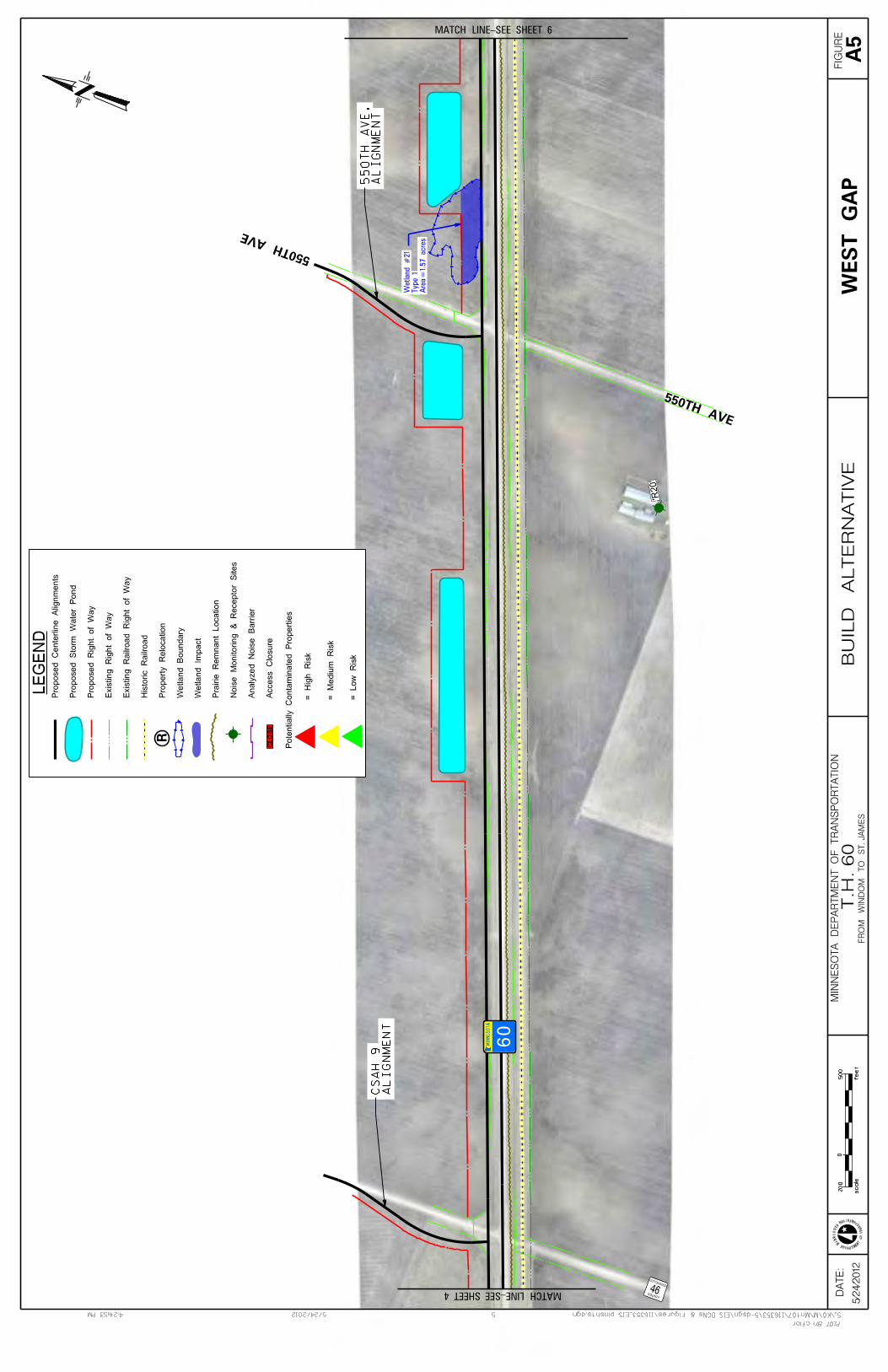
’R20’
Are
a=
1.5
7 a
cre
sT
ype 1
Wetl
and #
21
5/2
4/2
01
2
cflor
5
M
IN
NE
SOT
A
DEPARTME
NT
OF
TR
ANS
PORTATION
5/24/20124:24:53 PM S:\KO\M\Mnt07\116353\5-dsgn\EIS DGNs & Figures\116353_EIS plnshts.dgn
PLOT BY:
DA
TE
: F
IGU
RE
MIN
NE
SO
TA
DE
PA
RT
ME
NT
OF
TR
AN
SP
OR
TA
TIO
N
FR
OM
WIN
DO
M T
O S
T. JA
ME
S
0
feet
scale
200
500
T
.H. 60
BU
ILD
AL
TE
RN
AT
IVE
LE
GE
ND
R
CL
OS
EA
ccess C
losure
An
aly
zed
No
ise B
arr
ier
No
ise M
on
ito
rin
g &
Recep
tor
Sit
es
Pra
irie
Rem
nant
Locati
on
Wetl
an
d I
mp
act
Wetl
and B
oundary
Pro
pert
y R
elo
cati
on
His
tori
c R
ail
road
Ex
isti
ng
Rail
road
Rig
ht
of
Way
Ex
isti
ng
Rig
ht
of
Way
Pro
posed R
ight
of
Way
Pro
po
sed
Sto
rm W
ate
r P
on
d
Pro
posed C
ente
rlin
e A
lignm
ents
Pote
nti
all
y C
onta
min
ate
d P
ropert
ies
= L
ow
Ris
k
= M
ed
ium
Ris
k
= H
igh
Ris
k
MIN
NE
SO
TA
COUNTY
COTTONWOOD46
550TH AVE
550TH
AVE
60
MATCH LINE-SEE SHEET 4
MATCH LINE-SEE SHEET 6
WE
ST
GA
PA
5
AL
IGN
ME
NT
550T
H A
VE
.
AL
IGN
ME
NT
CS
AH
9
Are
a=
0.2
9 a
cre
sT
ype 1
Wetl
and #
20
W
etl
and #
33
5/2
4/2
01
2
cflor
6
M
IN
NE
SOT
A
DEPARTME
NT
OF
TR
ANS
PORTATION
5/24/20124:24:54 PM S:\KO\M\Mnt07\116353\5-dsgn\EIS DGNs & Figures\116353_EIS plnshts.dgn
PLOT BY:
DA
TE
: F
IGU
RE
MIN
NE
SO
TA
DE
PA
RT
ME
NT
OF
TR
AN
SP
OR
TA
TIO
N
FR
OM
WIN
DO
M T
O S
T. JA
ME
S
0
feet
scale
200
500
T
.H. 60
BU
ILD
AL
TE
RN
AT
IVE
LE
GE
ND
R
CL
OS
EA
ccess C
losu
re
An
aly
zed
No
ise B
arr
ier
No
ise M
on
ito
rin
g &
Recep
tor
Sit
es
Pra
irie
Rem
nant
Locati
on
Wetl
an
d I
mp
act
Wetl
and B
oundary
Pro
pert
y R
elo
cati
on
His
tori
c R
ail
road
Ex
isti
ng
Rail
road
Rig
ht
of
Way
Ex
isti
ng
Rig
ht
of
Way
Pro
posed R
ight
of
Way
Pro
po
sed
Sto
rm W
ate
r P
on
d
Pro
posed C
ente
rlin
e A
lignm
ents
Pote
nti
all
y C
onta
min
ate
d P
ropert
ies
= L
ow
Ris
k
= M
ed
ium
Ris
k
= H
igh
Ris
k
11
11
UNIO
N PACIFIC RAIL
RO
AD
MIN
NE
SO
TA
MO
UN
TA
IN L
AK
EC
ITY
OF
MO
UN
TA
IN L
AK
EC
ITY
OF
560TH AVE
60
MATCH LINE-SEE SHEET 5
WE
ST
GA
PA
6
WEST G
AP SEG
MENT
EAST TER
MINI OF
’B7’
Wetl
and #
18
Are
a=
1.1
3 a
cre
sT
ype 1
Wetl
and #
19
5/2
4/2
01
2
cflor
7
M
IN
NE
SOT
A
DEPARTME
NT
OF
TR
ANS
PORTATION
5/24/20124:24:55 PM S:\KO\M\Mnt07\116353\5-dsgn\EIS DGNs & Figures\116353_EIS plnshts.dgn
PLOT BY:
DA
TE
: F
IGU
RE
MIN
NE
SO
TA
DE
PA
RT
ME
NT
OF
TR
AN
SP
OR
TA
TIO
N
FR
OM
WIN
DO
M T
O S
T. JA
ME
S
0
feet
scale
200
500
T
.H. 60
BU
ILD
AL
TE
RN
AT
IVE
LE
GE
ND
R
CL
OS
EA
ccess C
losure
An
aly
zed
No
ise B
arr
ier
No
ise M
on
ito
rin
g &
Recep
tor
Sit
es
Pra
irie
Rem
nant
Locati
on
Wetl
an
d I
mp
act
Wetl
and B
oundary
Pro
pert
y R
elo
cati
on
His
tori
c R
ail
road
Ex
isti
ng
Rail
road
Rig
ht
of
Way
Ex
isti
ng
Rig
ht
of
Way
Pro
posed R
ight
of
Way
Pro
po
sed
Sto
rm W
ate
r P
on
d
Pro
posed C
ente
rlin
e A
lignm
ents
Pote
nti
all
y C
onta
min
ate
d P
ropert
ies
= L
ow
Ris
k
= M
ed
ium
Ris
k
= H
igh
Ris
k
12
12
600TH AVE
600TH AVE
UNIO
N PACIFIC RAIL
RO
AD
MIN
NE
SO
TA
COTTONWOOD
COUNTY
8
COTTONWOOD
COUNTY
8
60
MATCH LINE-SEE SHEET 8
A7
MID
DL
E G
AP
MID
DL
E G
AP
SE
GM
EN
TW
ES
T T
ER
MIN
I O
F
CE
NT
ER
LIN
E T
.H.
60
’R22’
’R23’
Area=0.05 acres
Type 2
Wetland #17
Wetl
an
d #
32
5/2
4/2
01
2
cflor
8
M
IN
NE
SOT
A
DEPARTME
NT
OF
TR
ANS
PORTATION
5/24/20124:24:56 PM S:\KO\M\Mnt07\116353\5-dsgn\EIS DGNs & Figures\116353_EIS plnshts.dgn
PLOT BY:
DA
TE
: F
IGU
RE
MIN
NE
SO
TA
DE
PA
RT
ME
NT
OF
TR
AN
SP
OR
TA
TIO
N
FR
OM
WIN
DO
M T
O S
T. JA
ME
S
0
feet
scale
200
500
T
.H. 60
BU
ILD
AL
TE
RN
AT
IVE
LE
GE
ND
R
CL
OS
EA
ccess C
losu
re
An
aly
zed
No
ise B
arr
ier
No
ise M
on
ito
rin
g &
Recep
tor
Sit
es
Pra
irie
Rem
nant
Locati
on
Wetl
an
d I
mp
act
Wetl
and B
oundary
Pro
pert
y R
elo
cati
on
His
tori
c R
ail
road
Ex
isti
ng
Rail
road
Rig
ht
of
Way
Ex
isti
ng
Rig
ht
of
Way
Pro
posed R
ight
of
Way
Pro
po
sed
Sto
rm W
ate
r P
on
d
Pro
posed C
ente
rlin
e A
lignm
ents
Pote
nti
all
y C
onta
min
ate
d P
ropert
ies
= L
ow
Ris
k
= M
ed
ium
Ris
k
= H
igh
Ris
k
13
13
610TH AVE
610TH AVE
UNIO
N PACIFIC RAIL
RO
AD
MIN
NE
SO
TA
60
MATCH LINE-SEE SHEET 7
MATCH LINE-SEE SHEET 9
A8
MID
DL
E G
AP
NO
IS
E W
AL
L 5
AN
AL
YZ
ED
CE
NT
ER
LIN
E T
.H.
60
’R24’
’R25’
Are
a=
0.1
0 a
cre
sT
ype 1
Wetl
and #
12
Wetl
and #
13
Are
a=
0.0
5 a
cre
sT
ype 2
Wetl
and #
17
Are
a=
0.4
8 a
cre
sT
ype 2
Wetl
and #
16
Are
a=
0.0
5 a
cre
sT
ype 2
Wetl
and #
14
Wetl
an
d #
15
5/2
4/2
01
2
cflor
9
M
IN
NE
SOT
A
DEPARTME
NT
OF
TR
ANS
PORTATION
5/24/20124:24:58 PM S:\KO\M\Mnt07\116353\5-dsgn\EIS DGNs & Figures\116353_EIS plnshts.dgn
PLOT BY:
DA
TE
: F
IGU
RE
MIN
NE
SO
TA
DE
PA
RT
ME
NT
OF
TR
AN
SP
OR
TA
TIO
N
FR
OM
WIN
DO
M T
O S
T. JA
ME
S
0
feet
scale
200
500
T
.H. 60
BU
ILD
AL
TE
RN
AT
IVE
LE
GE
ND
R
CL
OS
EA
ccess C
losure
An
aly
zed
No
ise B
arr
ier
No
ise M
on
ito
rin
g &
Recep
tor
Sit
es
Pra
irie
Rem
nant
Locati
on
Wetl
an
d I
mp
act
Wetl
and B
oundary
Pro
pert
y R
elo
cati
on
His
tori
c R
ail
road
Ex
isti
ng
Rail
road
Rig
ht
of
Way
Ex
isti
ng
Rig
ht
of
Way
Pro
posed R
ight
of
Way
Pro
po
sed
Sto
rm W
ate
r P
on
d
Pro
posed C
ente
rlin
e A
lignm
ents
Pote
nti
all
y C
onta
min
ate
d P
ropert
ies
= L
ow
Ris
k
= M
ed
ium
Ris
k
= H
igh
Ris
k
14
15
14
15
620TH AVE
620TH AVE
UNIO
N PACIFIC RAIL
RO
AD
MIN
NE
SO
TA
WATONWAN
COUNTY 2
WATONWAN
COUNTY
2
60
CL
OS
E
CL
OS
E
MATCH LINE-SEE SHEET 8
MATCH LINE-SEE SHEET 10
A9
MID
DL
E G
AP
RE
AL
IGN
ME
NT
DIT
CH
RE
LO
CA
TIO
ND
RIV
EW
AY
PO
TE
NT
IAL
RE
LO
CA
TIO
ND
RIV
EW
AY
PO
TE
NT
IAL
NO
IS
E W
AL
L 5
AN
AL
YZ
ED
NO
IS
E W
AL
L 6
AN
AL
YZ
ED
NO
IS
E W
AL
L 7
AN
AL
YZ
ED
NO
IS
E W
AL
L 8
AN
AL
YZ
ED
EX
IS
TIN
G D
IT
CH
{
’MP2’
’R26’
’R27’
’R28’
’R29’
’R33’
’R35’
’R36’
’R37’
’R38’
’R39’
’R30’
’R31’
’R32’
’R34’
’B9’
’B10’
’B8’
W
etl
and #
11
5/2
4/2
01
2
cflor
10
M
IN
NE
SOT
A
DEPARTME
NT
OF
TR
ANS
PORTATION
5/24/20124:25:00 PM S:\KO\M\Mnt07\116353\5-dsgn\EIS DGNs & Figures\116353_EIS plnshts.dgn
PLOT BY:
DA
TE
: F
IGU
RE
MIN
NE
SO
TA
DE
PA
RT
ME
NT
OF
TR
AN
SP
OR
TA
TIO
N
FR
OM
WIN
DO
M T
O S
T. JA
ME
S
0
feet
scale
200
500
T
.H. 60
BU
ILD
AL
TE
RN
AT
IVE
LE
GE
ND
R
CL
OS
EA
ccess C
losu
re
An
aly
zed
No
ise B
arr
ier
No
ise M
on
ito
rin
g &
Recep
tor
Sit
es
Pra
irie
Rem
nant
Locati
on
Wetl
an
d I
mp
act
Wetl
and B
oundary
Pro
pert
y R
elo
cati
on
His
tori
c R
ail
road
Ex
isti
ng
Rail
road
Rig
ht
of
Way
Ex
isti
ng
Rig
ht
of
Way
Pro
posed R
ight
of
Way
Pro
po
sed
Sto
rm W
ate
r P
on
d
Pro
posed C
ente
rlin
e A
lignm
ents
Pote
nti
all
y C
onta
min
ate
d P
ropert
ies
= L
ow
Ris
k
= M
ed
ium
Ris
k
= H
igh
Ris
k
16
17
16
17
PRAIRIE AVE
PRAIRIE AVE
PRAIRIE AVE
4TH ST S
UNIO
N PACIFIC RAIL
RO
AD
MIN
NESOTA
WATONWAN
COUNTY5
WATONWAN
COUNTY 5
WATON
WAN
COUNTY
2
60
MATCH LINE-SEE SHEET 9
MATCH LINE-SEE SHEET 11
MID
DL
E G
AP
/ E
AS
T G
AP
RE
AL
IGN
ME
NT
DIT
CH
MID
DLE G
AP SEG
MENT
EAST TER
MINI OF
SEG
MENT
OF EAST G
AP
WEST TER
MINI A
10
8N
OIS
E W
AL
L
AN
AL
YZ
ED
9N
OIS
E W
AL
L
AN
AL
YZ
ED
9N
OIS
E W
AL
L
AN
AL
YZ
ED
NO
IS
E W
AL
L 1
0A
NA
LY
ZE
D
NO
IS
E W
AL
L 1
1A
NA
LY
ZE
D
W
etl
and #
7
Are
a=
0.1
7 a
cre
sT
ype 1
Wetl
and #
10
Wetl
and #
9W
etl
and #
8
5/2
9/2
01
2
cflor
11
M
IN
NE
SOT
A
DEPARTME
NT
OF
TR
ANS
PORTATION
5/29/201211:03:04 AM S:\KO\M\Mnt07\116353\5-dsgn\EIS DGNs & Figures\116353_EIS plnshts.dgn
PLOT BY:
DA
TE
: F
IGU
RE
MIN
NE
SO
TA
DE
PA
RT
ME
NT
OF
TR
AN
SP
OR
TA
TIO
N
FR
OM
WIN
DO
M T
O S
T. JA
ME
S
0
feet
scale
200
500
T
.H. 60
BU
ILD
AL
TE
RN
AT
IVE
LE
GE
ND
R
CL
OS
EA
ccess C
losure
An
aly
zed
No
ise B
arr
ier
No
ise M
on
ito
rin
g &
Recep
tor
Sit
es
Pra
irie
Rem
nant
Locati
on
Wetl
an
d I
mp
act
Wetl
and B
oundary
Pro
pert
y R
elo
cati
on
His
tori
c R
ail
road
Ex
isti
ng
Rail
road
Rig
ht
of
Way
Ex
isti
ng
Rig
ht
of
Way
Pro
posed R
ight
of
Way
Pro
po
sed
Sto
rm W
ate
r P
on
d
Pro
posed C
ente
rlin
e A
lignm
ents
Pote
nti
all
y C
onta
min
ate
d P
ropert
ies
= L
ow
Ris
k
= M
ed
ium
Ris
k
= H
igh
Ris
k
18
18
660th AVE
650TH AVE
UNIO
N PACIFIC RAIL
RO
AD
MIN
NESOTA
WATON
WAN
COUNTY
2
WATONWAN
COUNTY
2
60
MATCH LINE-SEE SHEET 10
MATCH LINE-SEE SHEET 12
EA
ST
GA
P
NO
. 83037
BR
IDG
EE
XIS
TIN
G
A11
11
NO
IS
E W
AL
L
AN
AL
YZ
ED
NO
. 8
30
40
BR
ID
GE
PR
OP
SE
D
’MP1’
’R40’
’R41’
’R42’
W
etl
and #
6
Wetl
and #
5
5/2
9/2
01
2
cflor
12
M
IN
NE
SOT
A
DEPARTME
NT
OF
TR
ANS
PORTATION
5/29/201211:03:05 AM S:\KO\M\Mnt07\116353\5-dsgn\EIS DGNs & Figures\116353_EIS plnshts.dgn
PLOT BY:
DA
TE
: F
IGU
RE
MIN
NE
SO
TA
DE
PA
RT
ME
NT
OF
TR
AN
SP
OR
TA
TIO
N
FR
OM
WIN
DO
M T
O S
T. JA
ME
S
0
feet
scale
200
500
T
.H. 60
BU
ILD
AL
TE
RN
AT
IVE
LE
GE
ND
R
CL
OS
EA
ccess C
losure
An
aly
zed
No
ise B
arr
ier
No
ise M
on
ito
rin
g &
Recep
tor
Sit
es
Pra
irie
Rem
nant
Locati
on
Wetl
an
d I
mp
act
Wetl
and B
oundary
Pro
pert
y R
elo
cati
on
His
tori
c R
ail
road
Ex
isti
ng
Rail
road
Rig
ht
of
Way
Ex
isti
ng
Rig
ht
of
Way
Pro
posed R
ight
of
Way
Pro
po
sed
Sto
rm W
ate
r P
on
d
Pro
posed C
ente
rlin
e A
lignm
ents
Pote
nti
all
y C
onta
min
ate
d P
ropert
ies
= L
ow
Ris
k
= M
ed
ium
Ris
k
= H
igh
Ris
k
670th AVE
660th AVE
660th AVE 361st Lane
MIN
NESOTA
UNIO
N PACIFIC RAIL
RO
AD
UNIO
N PACIFIC RAIL
RO
AD
WATONWAN
COUNTY
1960
CLOSE
MATCH LINE-SEE SHEET 13
MATCH LINE-SEE SHEET 11
EA
ST
GA
P
RE
LO
CA
TIO
ND
RIV
EW
AY
PO
TE
NT
IAL
A12
NO
IS
E W
AL
L 1
2A
NA
LY
ZE
D
’R
43’
’R
44’
’R
45’
’egl66’
Wetland #2
Are
a=
0.3
6 a
cre
sT
ype 1
Wetl
and #
3
Are
a=
0.2
3 a
cre
sT
ype 1
Wetl
and #
4
5/2
4/2
01
2
cflor
13
M
IN
NE
SOT
A
DEPARTME
NT
OF
TR
ANS
PORTATION
5/24/20124:25:06 PM S:\KO\M\Mnt07\116353\5-dsgn\EIS DGNs & Figures\116353_EIS plnshts.dgn
PLOT BY:
DA
TE
: F
IGU
RE
MIN
NE
SO
TA
DE
PA
RT
ME
NT
OF
TR
AN
SP
OR
TA
TIO
N
FR
OM
WIN
DO
M T
O S
T. JA
ME
S
0
feet
scale
200
500
T
.H. 60
BU
ILD
AL
TE
RN
AT
IVE
LE
GE
ND
R
CL
OS
EA
ccess C
losu
re
An
aly
zed
No
ise B
arr
ier
No
ise M
on
ito
rin
g &
Recep
tor
Sit
es
Pra
irie
Rem
nant
Locati
on
Wetl
an
d I
mp
act
Wetl
and B
oundary
Pro
pert
y R
elo
cati
on
His
tori
c R
ail
road
Ex
isti
ng
Rail
road
Rig
ht
of
Way
Ex
isti
ng
Rig
ht
of
Way
Pro
posed R
ight
of
Way
Pro
po
sed
Sto
rm W
ate
r P
on
d
Pro
posed C
ente
rlin
e A
lignm
ents
Pote
nti
all
y C
onta
min
ate
d P
ropert
ies
= L
ow
Ris
k
= M
ed
ium
Ris
k
= H
igh
Ris
k
19
21
20
22
19
20
21
22
685th AVE
680th AVE
MIN
NE
SO
TA
UNIO
N PACIFIC RAIL
RO
AD
60
CL
OS
E
CL
OS
E
MATCH LINE-SEE SHEET 12
MATCH LINE-SEE SHEET 14
EA
ST
GA
P
RE
LO
CA
TIO
ND
RIV
EW
AY
PO
TE
NT
IAL
RE
LO
CA
TIO
ND
RIV
EW
AY
PO
TE
NT
IAL
A13
NO
IS
E W
AL
L 1
2A
NA
LY
ZE
D
NO
IS
E W
AL
L 1
3A
NA
LY
ZE
D
NO
IS
E W
AL
L 1
4A
NA
LY
ZE
D
NO
IS
E W
AL
L 1
5A
NA
LY
ZE
D
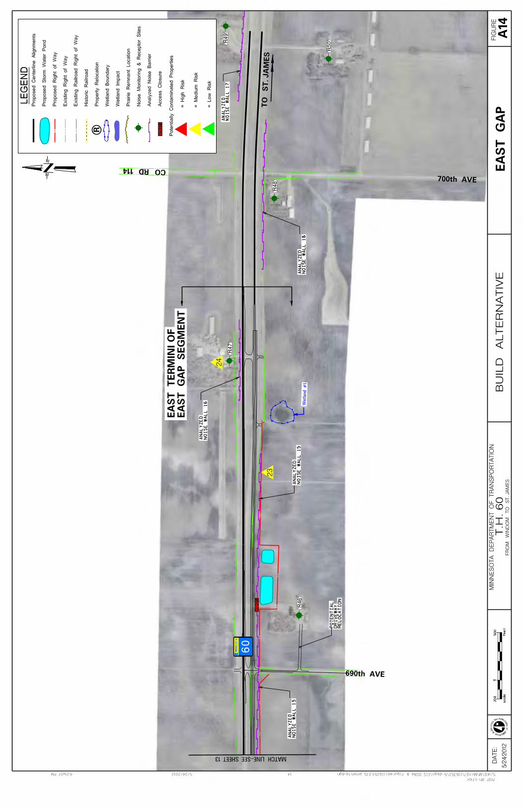
’R46’
’R47’
’R48’
’R49’
’R50’
’egl117’
Wetland #1
5/2
4/2
01
2
cflor
14
M
IN
NE
SOT
A
DEPARTME
NT
OF
TR
ANS
PORTATION
5/24/20124:25:07 PM S:\KO\M\Mnt07\116353\5-dsgn\EIS DGNs & Figures\116353_EIS plnshts.dgn
PLOT BY:
DA
TE
: F
IGU
RE
MIN
NE
SO
TA
DE
PA
RT
ME
NT
OF
TR
AN
SP
OR
TA
TIO
N
FR
OM
WIN
DO
M T
O S
T. JA
ME
S
0
feet
scale
200
500
T
.H. 60
BU
ILD
AL
TE
RN
AT
IVE
LE
GE
ND
R
CL
OS
EA
ccess C
losu
re
An
aly
zed
No
ise B
arr
ier
No
ise M
on
ito
rin
g &
Recep
tor
Sit
es
Pra
irie
Rem
nant
Locati
on
Wetl
an
d I
mp
act
Wetl
and B
oundary
Pro
pert
y R
elo
cati
on
His
tori
c R
ail
road
Ex
isti
ng
Rail
road
Rig
ht
of
Way
Ex
isti
ng
Rig
ht
of
Way
Pro
posed R
ight
of
Way
Pro
po
sed
Sto
rm W
ate
r P
on
d
Pro
posed C
ente
rlin
e A
lignm
ents
Pote
nti
all
y C
onta
min
ate
d P
ropert
ies
= L
ow
Ris
k
= M
ed
ium
Ris
k
= H
igh
Ris
k
23
24
23
24
690th AVE
700th AVE
CO RD 114
MIN
NE
SO
TA
TO ST. JA
MES
60
CL
OS
E
MATCH LINE-SEE SHEET 13
EA
ST
GA
P
RE
LO
CA
TIO
ND
RIV
EW
AY
PO
TE
NT
IAL
EA
ST
GA
P S
EG
ME
NT
EA
ST
TE
RM
INI
OF
A14
NO
IS
E W
AL
L 1
5A
NA
LY
ZE
D
NO
IS
E W
AL
L 1
5A
NA
LY
ZE
D
NO
IS
E W
AL
L 1
6A
NA
LY
ZE
D
NO
IS
E W
AL
L 1
7A
NA
LY
ZE
D
NO
IS
E W
AL
L 1
8A
NA
LY
ZE
D

Appendix B Project Green Sheets

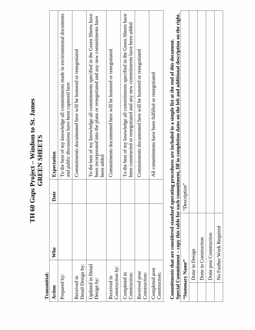
TH
60
Gap
s Pro
ject
– W
indo
m to
St.
Jam
es
GR
EE
N S
HE
ET
S T
rans
mitt
al:
Act
ion
Who
D
ate
Exp
ecta
tion
Prep
ared
by:
To
the
best
of m
y kn
owle
dge
all c
omm
itmen
ts m
ade
in e
nviro
nmen
tal d
ocum
ents
an
d pu
blic
dis
cuss
ions
hav
e be
en c
aptu
red
here
Rec
eive
d in
D
etai
l Des
ign
by:
Com
mitm
ents
doc
umen
ted
here
will
be
hono
red
or re
nego
tiate
d
Upd
ated
in D
etai
l D
esig
n by
:
To
the
best
of m
y kn
owle
dge
all c
omm
itmen
ts sp
ecifi
ed in
the
Gre
en S
heet
s hav
e be
en in
corp
orat
ed in
to th
e pl
ans o
r ren
egot
iate
d an
d an
y ne
w c
omm
itmen
ts h
ave
been
add
ed
Rec
eive
d in
C
onst
ruct
ion
by:
Com
mitm
ents
doc
umen
ted
here
will
be
hono
red
or re
nego
tiate
d
Com
plet
ed in
C
onst
ruct
ion:
To
the
best
of m
y kn
owle
dge
all c
omm
itmen
ts sp
ecifi
ed in
the
Gre
en S
heet
s hav
e be
en c
onst
ruct
ed o
r ren
egot
iate
d an
d an
y ne
w c
omm
itmen
ts h
ave
been
add
ed
Rec
eive
d po
st
Con
stru
ctio
n:
Com
mitm
ents
doc
umen
ted
here
will
be
hono
red
or re
nego
tiate
d
Com
plet
ed p
ost
Con
stru
ctio
n:
All
com
mitm
ents
hav
e be
en fu
lfille
d or
rene
gotia
ted
Com
mitm
ents
that
are
con
side
red
stan
dard
ope
ratin
g pr
oced
ures
are
incl
uded
in a
sim
ple
list a
t the
end
of t
his d
ocum
ent.
Spec
ial C
omm
itmen
t – c
opy
this
tabl
e fo
r ea
ch c
omm
itmen
t, fil
l in
com
plet
ion
date
s on
the
left
and
add
ition
al d
escr
iptio
n on
the
righ
t. “S
umm
ary
Nam
e”
“Des
crip
tion”
D
one
in D
esig
n
D
one
in C
onst
ruct
ion
D
one
post
Con
stru
ctio
n
N
o Fu
rther
Wor
k R
equi
red
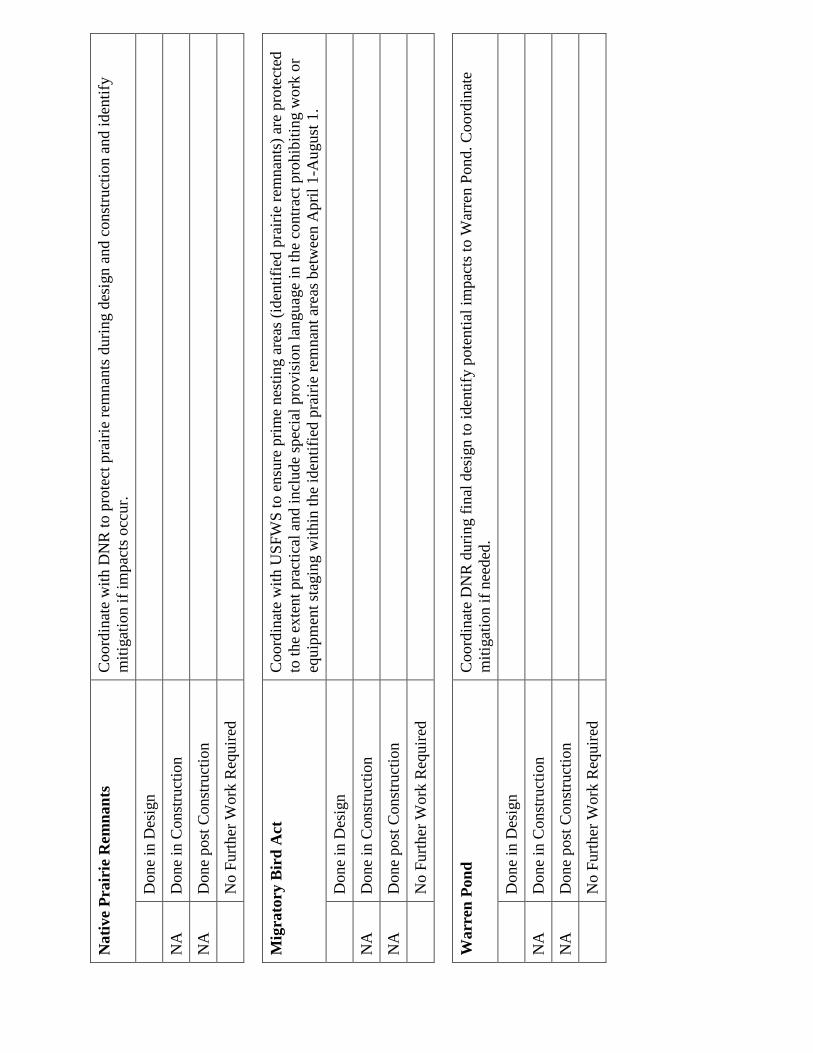
Nat
ive
Prai
rie
Rem
nant
s C
oord
inat
e w
ith D
NR
to p
rote
ct p
rairi
e re
mna
nts d
urin
g de
sign
and
con
stru
ctio
n an
d id
entif
y m
itiga
tion
if im
pact
s occ
ur.
D
one
in D
esig
n
NA
D
one
in C
onst
ruct
ion
NA
D
one
post
Con
stru
ctio
n
N
o Fu
rther
Wor
k R
equi
red
M
igra
tory
Bir
d A
ct
Coo
rdin
ate
with
USF
WS
to e
nsur
e pr
ime
nest
ing
area
s (id
entif
ied
prai
rie re
mna
nts)
are
pro
tect
ed
to th
e ex
tent
pra
ctic
al a
nd in
clud
e sp
ecia
l pro
visi
on la
ngua
ge in
the
cont
ract
pro
hibi
ting
wor
k or
eq
uipm
ent s
tagi
ng w
ithin
the
iden
tifie
d pr
airie
rem
nant
are
as b
etw
een
Apr
il 1-
Aug
ust 1
.
Don
e in
Des
ign
NA
D
one
in C
onst
ruct
ion
NA
D
one
post
Con
stru
ctio
n
N
o Fu
rther
Wor
k R
equi
red
W
arre
n Po
nd
Coo
rdin
ate
DN
R d
urin
g fin
al d
esig
n to
iden
tify
pote
ntia
l im
pact
s to
War
ren
Pond
. Coo
rdin
ate
miti
gatio
n if
need
ed.
D
one
in D
esig
n
NA
D
one
in C
onst
ruct
ion
NA
D
one
post
Con
stru
ctio
n
N
o Fu
rther
Wor
k R
equi
red
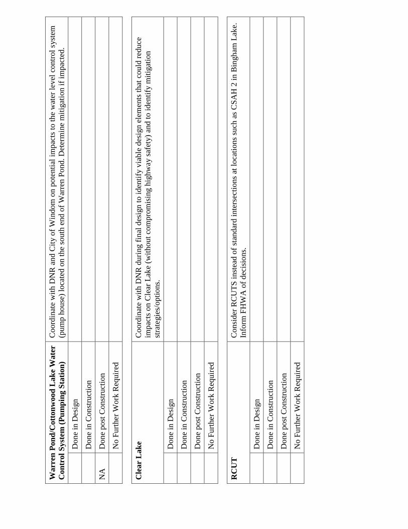
War
ren
Pond
/Cot
tonw
ood
Lak
e W
ater
C
ontr
ol S
yste
m (P
umpi
ng S
tatio
n)
Coo
rdin
ate
with
DN
R a
nd C
ity o
f Win
dom
on
pote
ntia
l im
pact
s to
the
wat
er le
vel c
ontro
l sys
tem
(p
ump
hous
e) lo
cate
d on
the
sout
h en
d of
War
ren
Pond
. Det
erm
ine
miti
gatio
n if
impa
cted
.
Don
e in
Des
ign
D
one
in C
onst
ruct
ion
NA
D
one
post
Con
stru
ctio
n
N
o Fu
rther
Wor
k R
equi
red
C
lear
Lak
e C
oord
inat
e w
ith D
NR
dur
ing
final
des
ign
to id
entif
y vi
able
des
ign
elem
ents
that
cou
ld re
duce
im
pact
s on
Cle
ar L
ake
(with
out c
ompr
omis
ing
high
way
safe
ty) a
nd to
iden
tify
miti
gatio
n st
rate
gies
/opt
ions
.
Don
e in
Des
ign
D
one
in C
onst
ruct
ion
D
one
post
Con
stru
ctio
n
N
o Fu
rther
Wor
k R
equi
red
R
CU
T
Con
side
r RC
UTS
inst
ead
of st
anda
rd in
ters
ectio
ns a
t loc
atio
ns su
ch a
s CSA
H 2
in B
ingh
am L
ake.
In
form
FH
WA
of d
ecis
ions
.
Don
e in
Des
ign
D
one
in C
onst
ruct
ion
D
one
post
Con
stru
ctio
n
N
o Fu
rther
Wor
k R
equi
red
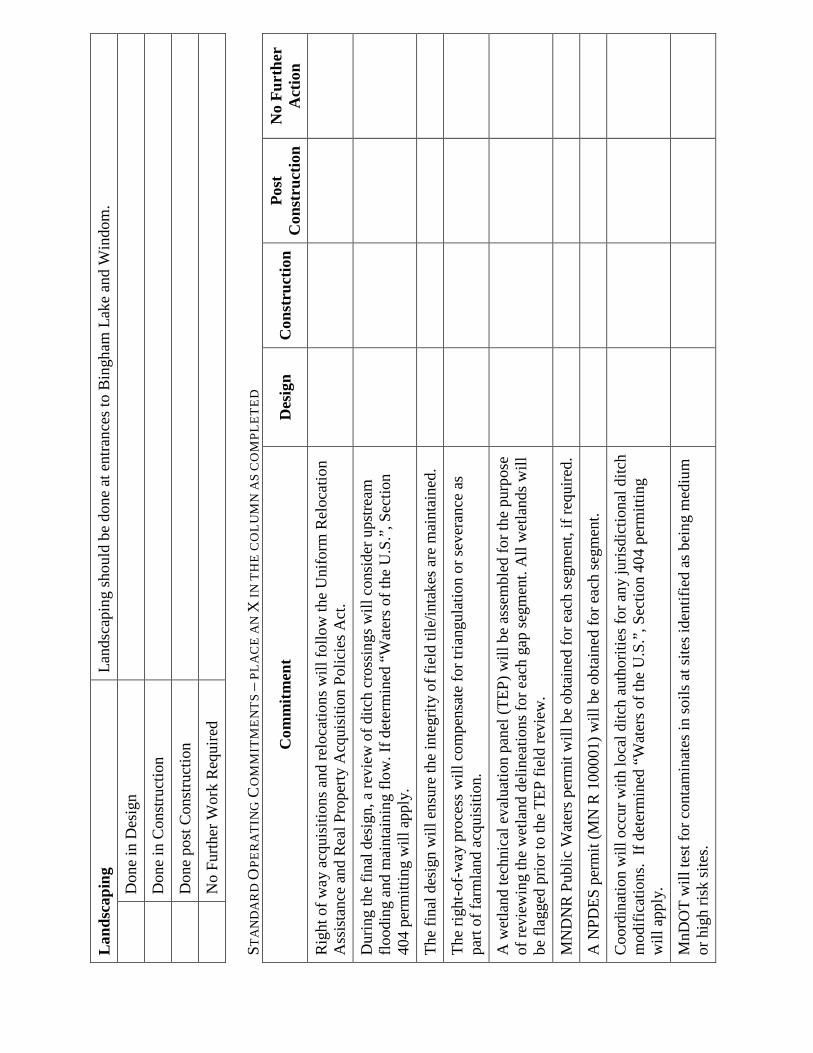
Lan
dsca
ping
La
ndsc
apin
g sh
ould
be
done
at e
ntra
nces
to B
ingh
am L
ake
and
Win
dom
.
Don
e in
Des
ign
D
one
in C
onst
ruct
ion
D
one
post
Con
stru
ctio
n
N
o Fu
rther
Wor
k R
equi
red
ST
AN
DA
RD
OPE
RA
TIN
G C
OM
MIT
ME
NT
S –
PLA
CE
AN
X IN
TH
E C
OL
UM
N A
S C
OM
PLE
TE
D
Com
mitm
ent
Des
ign
Con
stru
ctio
n Po
st
Con
stru
ctio
n N
o Fu
rthe
r A
ctio
n
Rig
ht o
f way
acq
uisi
tions
and
relo
catio
ns w
ill fo
llow
the
Uni
form
Rel
ocat
ion
Ass
ista
nce
and
Rea
l Pro
perty
Acq
uisi
tion
Polic
ies A
ct.
Dur
ing
the
final
des
ign,
a re
view
of d
itch
cros
sing
s will
con
side
r ups
tream
flo
odin
g an
d m
aint
aini
ng fl
ow. I
f det
erm
ined
“W
ater
s of t
he U
.S.”
, Sec
tion
404
perm
ittin
g w
ill a
pply
.
The
final
des
ign
will
ens
ure
the
inte
grity
of f
ield
tile
/inta
kes a
re m
aint
aine
d.
The
right
-of-
way
pro
cess
will
com
pens
ate
for t
riang
ulat
ion
or se
vera
nce
as
part
of fa
rmla
nd a
cqui
sitio
n.
A w
etla
nd te
chni
cal e
valu
atio
n pa
nel (
TEP)
will
be
asse
mbl
ed fo
r the
pur
pose
of
revi
ewin
g th
e w
etla
nd d
elin
eatio
ns fo
r eac
h ga
p se
gmen
t. A
ll w
etla
nds w
ill
be fl
agge
d pr
ior t
o th
e TE
P fie
ld re
view
.
MN
DN
R P
ublic
Wat
ers p
erm
it w
ill b
e ob
tain
ed fo
r eac
h se
gmen
t, if
requ
ired.
A N
PDES
per
mit
(MN
R 1
0000
1) w
ill b
e ob
tain
ed fo
r eac
h se
gmen
t.
Coo
rdin
atio
n w
ill o
ccur
with
loca
l ditc
h au
thor
ities
for a
ny ju
risdi
ctio
nal d
itch
mod
ifica
tions
. If
dete
rmin
ed “
Wat
ers o
f the
U.S
.”, S
ectio
n 40
4 pe
rmitt
ing
will
app
ly.
MnD
OT
will
test
for c
onta
min
ates
in so
ils a
t site
s ide
ntifi
ed a
s bei
ng m
ediu
m
or h
igh
risk
site
s.
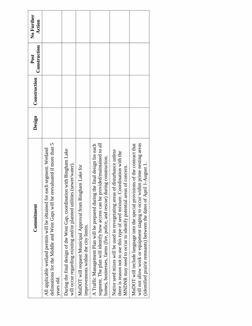
Com
mitm
ent
Des
ign
Con
stru
ctio
n Po
st
Con
stru
ctio
n N
o Fu
rthe
r A
ctio
n
All
appl
icab
le w
etla
nd p
erm
its w
ill b
e ob
tain
ed fo
r eac
h se
gmen
t. W
etla
nd
delin
eatio
ns fo
r the
Mid
dle
and
Wes
t Gap
s will
be
reev
alua
ted
if m
ore
than
5
year
s old
.
Dur
ing
the
final
des
ign
of th
e W
est G
ap, c
oord
inat
ion
with
Bin
gham
Lak
e w
ill o
ccur
rega
rdin
g ex
istin
g an
d/or
pla
nned
util
ities
(sew
er/w
ater
).
MnD
OT
will
requ
est M
unic
ipal
App
rova
l fro
m B
ingh
am L
ake
for
impr
ovem
ents
with
in th
e ci
ty li
mits
.
A T
raff
ic M
anag
emen
t Pla
n w
ill b
e pr
epar
ed d
urin
g th
e fin
al d
esig
n fo
r eac
h se
gmen
t. Th
e pl
an w
ill id
entif
y ho
w a
cces
s can
be
prov
ided
/mai
ntai
ned
to a
ll
hom
es, b
usin
esse
s, fa
rms (
fire,
pol
ice,
and
resc
ue) d
urin
g co
nstru
ctio
n.
Nat
ive
seed
mix
es w
ill b
e us
ed in
reve
geta
ting
area
s of d
istu
rban
ce u
nles
s th
ere
is re
ason
not
to u
se th
is ty
pe o
f see
d m
ixtu
re. C
oord
inat
ion
with
the
MN
DN
R m
ay n
eed
to o
ccur
to id
entif
y po
tent
ial a
reas
of c
once
rn.
MnD
OT
will
incl
ude
lang
uage
into
the
spec
ial p
rovi
sion
s of t
he c
ontra
ct th
at
will
not
allo
w w
ork
or e
quip
men
t sta
ging
to o
ccur
with
in p
rime
nest
ing
area
s (id
entif
ied
prai
rie re
mna
nts)
bet
wee
n th
e da
tes o
f Apr
il 1-
Aug
ust 1
.


