

For Creeks, Drainage and Wastewater Advisory Committee
May 8, 2013
Kathy Minsch, Regional Liaison

Presentation Purpose: Overview of Chinook salmon recovery in
WRIAs 8 and 9 and SPU’s Role
Overview of each salmon plan – goals, key themes, progress to date, key issues
Relevance to Seattle
Future Direction/Looking Ahead

Background of Salmon Planning
Federal government listed Puget Sound Chinook Salmon as threatened 1999
Tri County Salmon planning for watersheds in King, Pierce, Snohomish began 1998 under HB 2496
Local planning in WRIAs 8 and 9 began in 2000 Local salmon plans adopted by WRIAs in 2005 NMFS adopts Puget Sound Chinook Salmon Recovery Plan in
2006 – 10 year plan for 14 watersheds Puget Sound Salmon Recovery Council – regional coordinating
body guiding implementation of 14 salmon plans. Federal, state, tribal and lead entities, environmental community, business

Watersheds and WRIAs Watersheds classified as Water Resource Inventory
Areas (WRIAs)
WRIAs 8 and 9 - SPU lead for City
WRIAs 3, 4, and 7 – SCL lead for City
8 - Cedar River/Sammamish/Lake Washington
9 - Green/Duwamish Rivers
7 - Snohomish River
3/4- lower and upper Skagit River

State of Washington WRIAs

WRIAs 8 & 9 Salmon Recovery Plans
Lake Washington/Cedar/Sammamish Watershed (WRIA 8) Salmon Recovery Plan 2005-2015
Green/Duwamish and Central Puget Sound Watershed (WRIA 9) Salmon Habitat Plan: Making Our Watershed Fit for a King 2005-2015

Common Features Locally driven, collaborative , pro-active
Multi-stakeholders - jurisdictions, tribes, federal and state agencies, non-profits, businesses, citizens
Science-based actions – characterizations/assessments based on VSP parameters =viable salmonid populations
Abundance, productivity, distribution and diversity
10 year plans w/50 year horizon
Adopted by Seattle City Council 2005

Common Features cont. Overarching goal: to restore and protect Chinook,
along w/other salmonids
Focus on CIP habitat acquisition, protection and restoration projects
Multiple beneficial uses e.g. water quality, flooding
Programs and policies – land use, stormwater, public outreach and stewardship
Monitoring /Adaptive Management
3 and 10 year workplans

Common Features cont. Multiple complex funding sources and structure
Interlocal agreements with King County as service provider – dues from each jurisdiction to support teams of staff
State and federal grants through RCO – SRFB, PSAR, ALEA; Ecology, Puget Sound Partnership, EPA, Corps
Local funding sources – King Conservation District, Flood Control District, Conservation Futures, Parks
Local match

WRIA 8 Salmon Recovery Plan
692 square miles includes 2 rivers, 3 large lakes, numerous creeks, Ship Canal and nearshore Puget Sound. Rural, suburban and urban land uses
2 salmon populations – Cedar (highest risk), Sammamish
Goal: Create a healthy environment for fish, wildlife, people
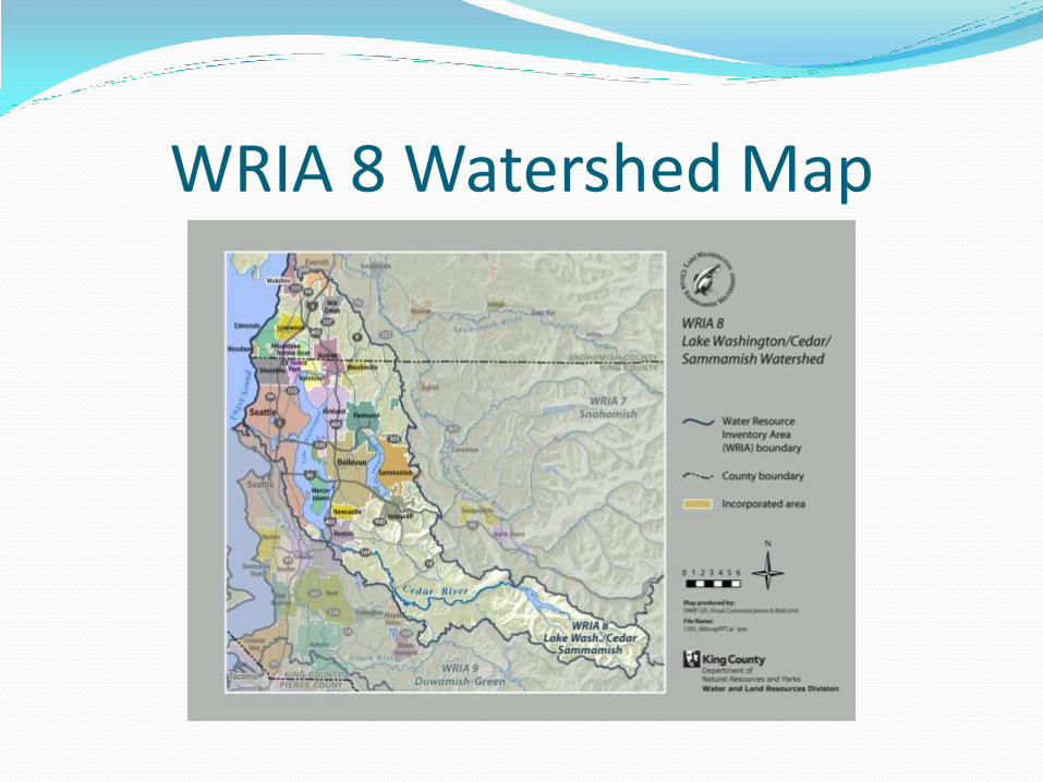
WRIA 8 Watershed Map

WRIA 8 Salmon Recovery Plan
Over 1,200 capital projects and programmatic actions – site specific and watershed wide
Watershed-wide priorities: protecting forests, reducing impervious surfaces, managing stormwater flows, protecting/improving water quality, conserving water, protecting/restoring riparian areas
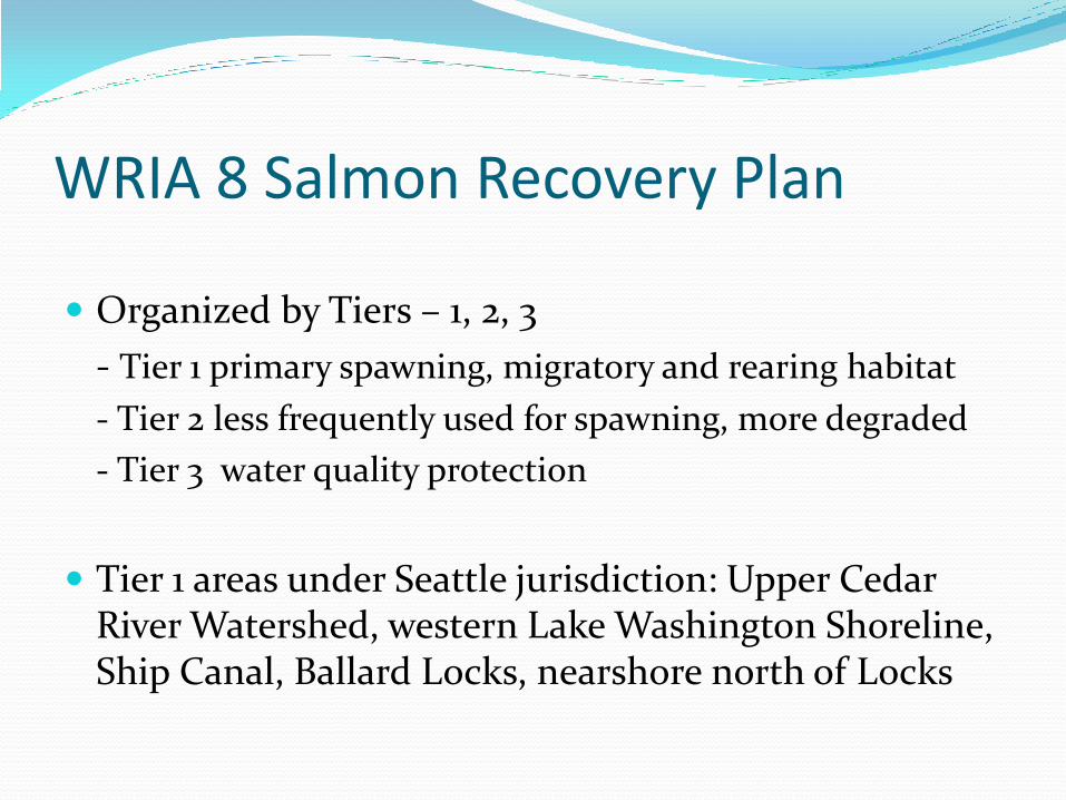
WRIA 8 Salmon Recovery Plan
Organized by Tiers – 1, 2, 3
- Tier 1 primary spawning, migratory and rearing habitat
- Tier 2 less frequently used for spawning, more degraded
- Tier 3 water quality protection
Tier 1 areas under Seattle jurisdiction: Upper Cedar River Watershed, western Lake Washington Shoreline, Ship Canal, Ballard Locks, nearshore north of Locks

WRIA 8 Watershed Map

WRIA 8 Salmon Recovery Plan Salmon Recovery Council – electeds, other
stakeholders
Implementation, Project and Technical committees
27 local governments pay annual dues since 2001 through ILA w/King County. Current ILA 2007-2015.
ILA cost shares calculated by area, assessed value and shoreline. Total slightly over $500K
Seattle dues currently $128K, or about 25% of total. 90% Water LOB, 10% Drainage LOB

Major Seattle Projects Cedar River Watershed Acquisition and Restoration–
e.g. Royal Arch, Belmondo, Rainbow Bend
Cedar River Stewardship in Action w/King County Noxious Weeds, Forterra and Friends of Cedar River – knotweed removal on private lands.
Lake Washington – Mapes and Taylor Creeks
Ship Canal – Salmon Bay Natural Area
Studies and monitoring

Funding for Seattle Projects Leverage HCP w/WRIA funding sources=over $2
million in grants federal, state and local
KCD grants – WRIA, Member Jurisdiction
FCD Cooperative Watershed Management grants
Drainage fees as match for Lake Washington projects

Green Shorelines Program Seattle’s Green Shorelines Guidebook – DPD, Restore
Our Waters. Habitat and water quality
Inspired creation of interagency Green Shorelines Steering Committee - workshops in 2009, major outreach focus in WRIA
Green Shores - $1 million EPA grant DPD w/San Juan County and Sea Grant
Inspired State and PSP focus on incentives for green shorelines – legislation, grants

New Priority: Riparian Stewardship Focus on planting trees and shrubs along river/creek
banks
Based on Land Cover analysis results in 2010 showing higher rate of decrease of forest cover in UGA’s.
Temperature
- TMDLs
- Ecology grant criteria include riparian plantings

Land Cover Analysis WRIA 8

Ed/Outreach
Model programs in Seattle by nonprofit partners
- Seattle Aquarium Beach Naturalist program
- Friends of Cedar River Salmon SEEson, Watershed Report
New priority – communications “Telling the story”

Monitoring/Adaptive Management
Long term – fish in/fish out, status and trends for over 10 years
Implementation and project effectiveness monitoring
Funding difficult to find for both
New adaptive management framework next 2 years – Open Standards

WRIA 9 Salmon Recovery Plan 664 square miles includes 5 subwatersheds - Upper, middle and lower Green River
- Duwamish Estuary Transition Zone
- Marine Nearshore
Rearing, spawning and migratory – juvenile, adults
Goal to restore and protect :
-Freshwater, marine and estuarine habitat :physical, chemical, biological processes
-Habitat connectivity
-Clean water in quantities good for salmon

WRIA 9 Watershed Map

WRIA 9 Salmon Recovery Plan Watershed Ecosystem Forum of electeds and
stakeholders
Implementation/Technical Committee
17 local governments pay annual dues since 2001 through ILA w/King County. Current ILA 2007-2015.
ILA cost shares calculated by area, assessed value and shoreline. Total $381K.
Seattle dues currently $93K or about 25% of total. Drainage LOB.
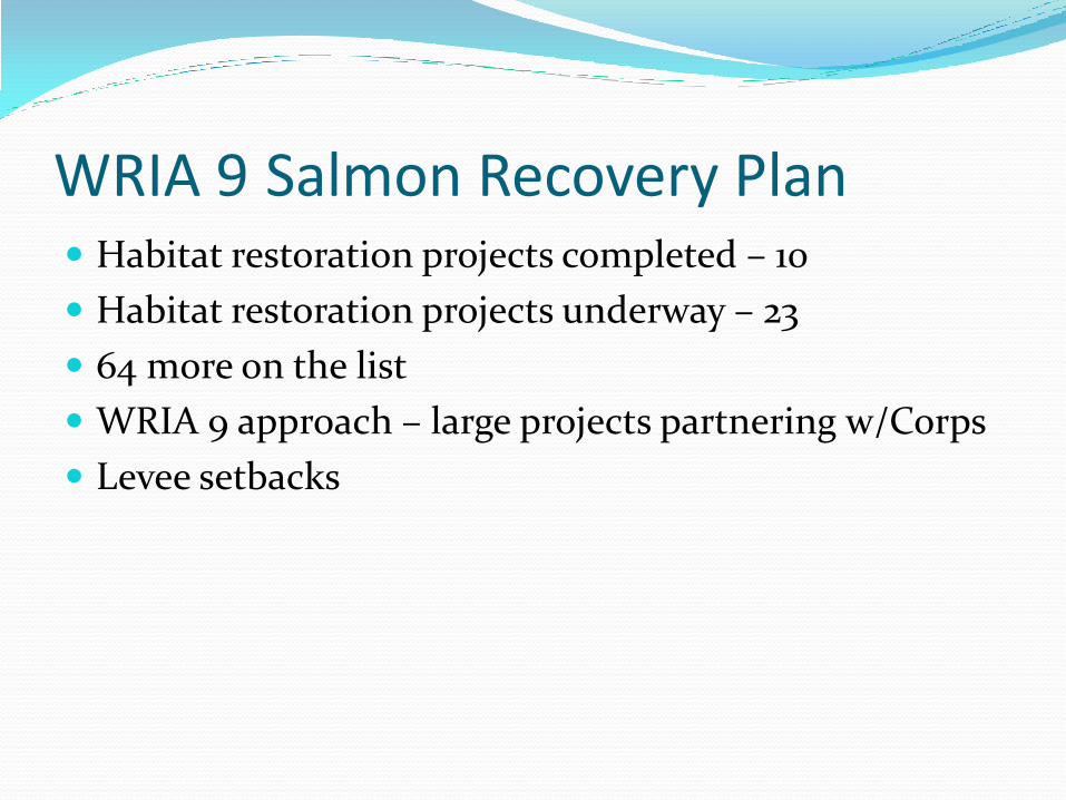
WRIA 9 Salmon Recovery Plan Habitat restoration projects completed – 10
Habitat restoration projects underway – 23
64 more on the list
WRIA 9 approach – large projects partnering w/Corps
Levee setbacks

Seattle Projects Elliott Bay/Nearshore Olympic Sculpture Park Beach Cove in Elliott Bay –
creation and 5 years of monitoring
Seawall Test Panels – installation and monitoring
Shilshole Estuary Studies
WRIA 9 Marine Nearshore Inventory

Seattle Projects Duwamish Hamm Creek purchase
Kellogg Island restoration in Duwamish
Herrings House Park, T-107
Duwamish Chinook Salmon studies
Nature Consortium Duwamish Alive
Seattle contributed $100k to North Wind’s Weir
Bluefields
Superfund mitigation
Duwamish Blueprint

Monitoring/Adaptive Management Status and Trends Report 2005-2010
- Jointly written by ITC (WRIA 9 team, city scientists)
- Riparian condition, armoring, flow
- Identified temperature as critical factor

Monitoring/Adaptive Management Adaptive Management/Monitoring Plan 2013
- Implementation, Effectiveness, and Validation
- Will follow Open Standards Framework
New Monitoring Projects
- Cumulative project effectiveness LG juvenile fish habitat
- Cumulative habitat conditions
New funding for smolt trap – validation monitoring

Opportunities Duwamish Blueprint – habitat restoration
Urban Waters Partnership
Sea Wall
Stormwater retrofit project
Source control

WRIAs 8 & 9:Challenges/Looking Ahead Funding challenges at all levels
Watershed Investment District draft legislation
Renegotiating ILAs
Adaptive Management and Monitoring Framework
10 year plan updates

WRIAs 8 & 9:Challenges/Looking Ahead
Tribal Treaty Rights at Risk – want more focus on land use and regulations to protect from increasing development, not just projects to restore
Climate Change
Ballard Locks repairs


