

DRAFT Eldorado Canyon State Park Management Plan
April 2021

1
ACKNOWLEDGEMENTS
Developing the Eldorado Canyon State Park (ECSP) Management Plan was a collaborative
planning process that would not have been possible without the support of the following staff,
partners and those that participated in the public involvement process.
Management Planning Team
John Carson, Park Manager Jeff Thompson, Resource Stewardship Program Coordinator Kacie Miller, Planning Manager
ECSP Staff
Mike McHugh, Park Resource Technician Dustin Bergman, Ranger Lisa Gill, Senior Ranger
Northeast Region
Windi Padia, Deputy Region Manager
Scott Roush, Deputy Region Manager
Mark Leslie, Region Manager
Ben Plankis, Melissa Mills, Jason Clay, Robin Strelow, Katie Lanter, Mike Quartuch, Jonathan Boydston, Jody Kennedy, Sarah Burton, Matt Schulz and many other CPW staff reviewed draft documents, created maps and web materials, assisted with public meetings and provided support to the planning team.
Major Partners and Stakeholders
Melissa Belmar (Collective Ecological Consulting) and Ellie Wachtel (SE Group) were always willing to help and addressed numerous rounds of edits and questions. SE Group (Gabby Voeller and Tyler Ford) and Keystone Policy Center (Julie Shapiro, Jonathan Geurts, Tori Thompson) were committed to ensuring an open and well run engagement process for all.
The Interagency Team, especially Kacey French, Marni Ratzel and Alex Hyde-Wright provided
valuable insights throughout the planning process and continued a partnership that will
benefit all agencies and stakeholders.
The members of the Task Force were willing to ‘take a seat at the table’, discuss concerns and ideas, listen to each other and understand different viewpoints.
CPW Leadership Team
Dan Prenzlow, Director Reid DeWalt, Assistant Director for Aquatics, Terrestrial and Natural Resources Heather Dugan, Assistant Director for Field Services Justin Rutter, Chief Financial Officer Lauren Truitt, Assistant Director for Information and Education Jeff Ver Steeg, Assistant Director for Research, Policy and Planning Cory Chick, Southwest Region Manager Brett Ackerman, Southeast Region Manager JT Romatzke, Northwest Region Manager Mark Leslie, Northeast Region Manager

1
Table of Contents
1.0 INTRODUCTION
Park Description ........................................................................................................................ 7
Purpose of the Plan ................................................................................................................... 7
Desired Future Conditions ..................................................................................................... 9
Park Goals ........................................................................................................................... 10
Future Plan Updates ............................................................................................................ 11
Public Input .............................................................................................................................. 12
Interagency Team ................................................................................................................ 12
Eldorado Canyon State Park Visitor Use Management Plan Task Force ............................ 12
Public Meetings and Online Comment Form ....................................................................... 13
Visitor Surveys ..................................................................................................................... 14
Influences on Management...................................................................................................... 16
Management Considerations ................................................................................................... 17
2.0 REGIONAL PLANNING CONTEXT
Climate .................................................................................................................................... 19
Physical Setting ....................................................................................................................... 20
Eco-Regional Setting ............................................................................................................... 22
Adjacent Land Use and Land Ownership ................................................................................. 22
Regional Recreation and Tourism Trends, Opportunities and Challenges .............................. 24
3.0 PARK SETTING & RESOURCES
Natural Resources ................................................................................................................... 32
Significant Features ............................................................................................................. 32
Wildlife ................................................................................................................................. 35

2
Vegetation ............................................................................................................................ 40
Sensitive Species ................................................................................................................ 44
Threats to Habitats and Wildlife ........................................................................................... 50
Hydrology ............................................................................................................................. 53
Geology & Soils ................................................................................................................... 54
Cultural Resources & Paleontological Resources .................................................................... 59
Scenic Resources ..................................................................................................................... 59
Recreation Resources .............................................................................................................. 60
Trails .................................................................................................................................... 60
Rock Climbing ...................................................................................................................... 61
Picnicking ............................................................................................................................. 61
Sightseeing and Wildlife Viewing ......................................................................................... 61
Other Recreational Resources ............................................................................................ 62
Interpretation and Environmental Education ......................................................................... 62
Facilities and Infrastructure ................................................................................................... 64
Park Administration and Special Functions ............................................................................. 69
Park Budget and Finances ....................................................................................................... 70
4.0 VISITATION
Access & Parking .................................................................................................................... 74
Visitor Demographics & Patterns ............................................................................................ 76
Visitation Trends ...................................................................................................................... 76
Overall Visitation .................................................................................................................. 76
Length of stay and group size .............................................................................................. 79
Trail Usage .......................................................................................................................... 79

3
Quality of Visitor Experience ................................................................................................... 82
Visitation Capacity ................................................................................................................... 83
5.0 MANAGEMENT ZONES
Description of Management Zones ......................................................................................... 86
6.0 MANAGEMENT STRATEGIES
6.1 Health, Safety & Staffing ................................................................................................... 91
6.2 Natural & Cultural Resource Protection ............................................................................ 92
6.3 Communication (Outreach, Marketing, Environmental Education and Interpretation) ...... 94
6.4 Access and Parking ........................................................................................................... 95
6.4.1 Indicators of Success (Outcomes) .............................................................................. 98
6.4.2 Assessment Tools ...................................................................................................... 99
6.5 Trails and Picnic Area ..................................................................................................... 100
6.6 Other facilities and infrastructure ..................................................................................... 102
Strategies discussed but not recommended ......................................................................... 103
Tables
Chapter 2 Table 1. Mean Temperatures (F) 1978-2016 (WRCC 2016) Table 2. Population Counts and Estimates for Boulder County (CDLA 2020b)
Chapter 3 Table 3. Sensitive Species with Potential to Occur at Eldorado Canyon State Park Table 4. South Boulder Creek Instream Flow Rights Table 5: Geologic Units Present at Eldorado Canyon State Park Table 6. Soils of Eldorado Canyon State Park Table 7. ECSP Trails Table 8. Park Expenses (FY 2016-17 and FY 2017-18) Table 9. General Operating Expenses (FY 2016-17 and FY 2017-18) Table 10. Temporary Employee Expenditure Detail (FY 2016-17 and FY 2017-18)

4
Chapter 4 Table 11. Monthly Percent Increase in Visitation, 2016 vs 2018 Chapter 5 Table 12. Management Zone Classification Scheme and Characteristics Chapter 6 Table 13. Summary of Parking and Access strategies and intended results
Figures
Chapter 2
Figure 1. Average Precipitation Totals at Gross Reservoir from 1978 - 2016 (WRCC 2016)
Chapter 4 Figure 2. ECSP Annual Visitation, 2011-2019 Figure 3. ECSP Monthly Visitation 2016 and 2018 Figure 4. ECSP Annual Trail Usage, 2015–2019 Figure 5. Maps depicting level of use of ECSP’s trails and areas of the park on busy days.
Chapter 6 Figure 6.Advertisement for the 2020 shuttle from Boulder Convention and Visitors Bureau website Figure 7. Trash collected by ECSP staff from ¼ mile of S Boulder Creek in the picnic area, August 2019
Maps
Chapter 2 Map 1. Regional Location of Eldorado Canyon State Park. Map 2. Land Ownership adjacent to Eldorado Canyon State Park
Chapter 3 Map 3. Land Ownership adjacent to and within ECSP Map 4. Significant Natural Resources in ECSP Map 5. Habitat important for mammals in ECSP Map 6. Potential nesting habitat for Peregrine Falcons Map 7. Vegetation communities in ECSP Map 8. Sensitive Species found at ECSP Map 9. Wildlife risk in ECSP Map 10. Soil types found in ECSP Map 11. Existing ECSP Facilities
Chapter 5 Map 12. ECSP Management Zones Map 13. Inner Canyon and Crescent Meadows Management Zones

5
Appendices Appendix A. Task Force Meeting Notes Appendix B. Public Engagement Report Appendix C. Capacity Study Appendix D. Resource Stewardship Plan

6

7
1.0 INTRODUCTION
Park Description
Eldorado Canyon State Park (ECSP) is a well-visited state park thanks to its world-renowned
rock climbing, creekside picnic spots, impressive views, scenic trails, and proximity to a
major population center. Long before the 1978 establishment of Eldorado Canyon State Park
(ECSP), the canyon itself was a draw for people seeking tranquility and recreational pursuits
as well as natural resources for subsistence and livelihoods.
Native Americans are known to have visited the canyon seasonally as part of their annual
patterns of movement. The Mouache Band of the Ute and later Cheyenne and Arapaho
consider this area part of their homelands. Eventually, European homesteaders began logging
and mining operations and later a resort was built for use of the artesian water pools and
other amenities. Climbers began using the canyon around 1950 and now consider the park an
international destination for rock climbing which is unique in the Colorado State Park system.
Today, climbers who frequent the park play an important role in park improvement projects
and promoting the sport of low impact climbing. Recent visitation trends indicate the park is
now well-known for picnicking, hiking and sightseeing.
Purpose of the Plan
The Eldorado Canyon State Park Management Plan (Management Plan) serves as the foremost
guiding document for Eldorado Canyon State Park. The purpose of developing a state park
management plan is to 1) plan for both the public enjoyment and 2) protection of the state
park's resources. The Management Plan provides a conceptual planning framework for setting
management priorities and future management direction for park resources. The
Management Plan also:
● Serves as a guide and policy document for current and future Park staff, partnering agencies, elected officials, and interested members of the public
● Guides management of natural, cultural, and recreational resources
● Provides a framework for monitoring and maintaining resources at Eldorado Canyon State Park
● Identifies Visitor Use Management strategies to enhance user experiences and protect park resources by managing visitor use of and access to the park
● Serves as a guide for future park budget allocations and annual funding requests
Park managers should regularly review the Management Plan to evaluate implementation
progress. This includes annually reviewing the document with staff and providing the
Management Plan to new employees. Park and other CPW staff (e.g., planning, region,
natural resource and capital/region development staff) should update the Management Plan
every 10 years.

8
This Management Plan and its implementation is also an opportunity to support Governor
Jared Polis’ philosophy to build a “Colorado for All.” On August 27, 2020, Governor Polis
signed Executive Order D-2020-175 directing the Department of Personnel & Administration to
advise state agencies in integrating this philosophy into State government’s workplaces,
community engagement, standards of accessibility and more. All agencies, including the
Department of Natural Resources of which CPW is a Division, have equity, diversity and
inclusion goals focusing on hiring, retention, community partnerships and communication.
Over the coming months and years, CPW will use related policies and guidance coming from
these initiatives to refine implementation of strategies in this plan. In addition, the Park’s
Desired Future Conditions and Goals presented in the next section envision Eldorado Canyon
State Park as a place for all Coloradans to enjoy the outdoors.
The plan inputs and proposed management approach resulting from the planning process are
depicted below. The Purpose & Need determined information needed (Plan Inputs) and
informed Park Goals & Desired Future Conditions. The resulting Management Plan and its
implementation will in turn lead to outcomes that support the goals and long-term vision.
Various stakeholders (i.e., local residents, recreation and conservation groups, park visitors
and more) had important but differing views on the increasing visitation to ESCP and the
potential impacts to the community, visitor experience and park resources. These ‘perception
gaps’ needed to be bridged through listening, data gathering and documenting existing
conditions. In addition to the inputs summarized in Chapter 1, Chapters 2-4 detail the park’s
resources (natural, cultural, scenic, recreational, facilities and infrastructure) and visitation
trends. Chapters 5 and 6 explain how CPW used all the information gathered and what actions
will be taken as a result.

9
Relationship to the CPW Strategic Plan
Colorado Parks and Wildlife’s (CPW) Strategic Plan is a useful guide for achieving a broad
range of CPW-wide goals and objectives, while the Management Plan is the primary guidance
document for park-level planning efforts. The Management Plan is consistent with the
following CPW mission, vision and goals.
Mission
CPW’s mission is “to perpetuate the wildlife resources of the state, to provide a quality state
park system, and to provide enjoyable and sustainable outdoor recreation opportunities that
educate and inspire current and future generations to serve as active stewards of Colorado’s
natural resources” (C.R.S. 33-9-101).
Vision
CPW’s vision is to be a national leader in wildlife management, conservation and sustainable outdoor recreation for current and future generations.
Strategic Goals
CPW’s Strategic Plan, finalized in November 2015, provides a roadmap for achieving the
agency’s vision and mission through concrete goals and objectives. The six CPW goals
identified in the Strategic Plan are:
1. Conserve wildlife habitat to ensure healthy sustainable populations and ecosystems
2. Manage state parks for world class outdoor recreation
3. Achieve and maintain financial sustainability
4. Maintain dedicated personnel and volunteers
5. Increase awareness and trust for CPW
6. Connect people to Colorado’s outdoors.
Desired Future Conditions
Desired future conditions are aspirational, qualitative statements, describing the long-term
preferred characteristics of resource conditions and visitor experiences. The following Desired
Future Conditions for the park were developed by CPW with collaborative input from the
Interagency Team and Task Force (these advisory groups assisted with the “visitor use
management” sections of this Management Plan; see “Public Input” for more information).
Visitor Experience
A positive experience in nature for all users includes:
● An inclusive public space where visitors of diverse backgrounds feel a sense of belonging

10
● Optimization of the park’s unique character as part of the broader state park system, for example, as a world-class rock-climbing destination
● Predictable and practical methods of accessing the park that includes multimodal transportation
● Park access that does not create undue negative impact (e.g., noise, traffic congestion) on the local community
● Outdoor experiences that promote physical health and mental well-being
● Well-maintained, functional, and accessible facilities and infrastructure that adequately serve visitor and staff needs
● Trails and picnic areas that will support visitation for at least 50 years with limited impact to geology, soils, wildlife, vegetation, and riparian areas
● Information on how to access the park, where to go, what to do, and the behavior expected is easily accessible for all visitors
● Empowering visitors to act as stewards of the park and feel self-driven to learn and follow park regulations
Resource Conditions
Healthy, resilient and diverse natural resources that have:
● Protection for threatened and endangered species, nesting raptors, other species of conservation interest, rare plant communities and other significant features of the park
● Management based on sound biological and scientific evidence
● Minimized risk from:
○ invasive species, drought, fire, flood and other threats
○ resource degradation in high use areas of the park (e.g., soil loss into South Boulder Creek and trampling of vegetation near the creek and along trails)
○ dust generated by high winds and traffic and exhaust from vehicles waiting at the entrance station or on the roadway
Park Goals
To ensure the management of Eldorado Canyon State Park supports this long-term vision, the ECSP’s Goals are:
1. Protection: Protect and maintain the quality of natural, cultural and scenic resources of the park for future generations.
2. Safety: Provide a wide variety of safe outdoor recreation experiences appropriate for the Front Range/park setting that complement the other goals of the park.

11
3. Climbing: Ensure park resources, staff and partnerships are able to sustain Eldorado Canyon’s unique rock climbing opportunities for local visitors and international travelers.
4. Access: Keep pace with population and recreation trends by improving trip planning information and arrival experiences for visitors, acquiring suitable park lands and minimizing impacts to neighboring communities.
5. Inclusivity: Foster a sense of belonging and connection in all park visitors.
6. Partnerships: Maintain partnerships with other land management, safety and transportation agencies to share information and work collaboratively to address transportation, resource protection and visitor experiences within the public lands in Eldorado Canyon.
7. Staffing: Sustain adequate staffing levels in order to support CPW mission, serve the public’s needs, protect natural and cultural resources, maintain facilities and infrastructure, and support staff well-being and development.
8. Stewardship: Provide volunteer opportunities and environmental education and interpretation programming that instills a sense of stewardship and belonging in park visitors.
Chapters 4-6 of this Plan describes how CPW will address these goals while not outpacing the operational capabilities of the Park and its staff.
Future Plan Updates
The last management plan for ECSP was completed in 2000. The Eldorado Canyon State Park
Management Plan should be updated every 10 years by park and other CPW staff (e.g., CPW
planning, region, natural resource, and capital/region development staff). To ensure that the
Management Plan is a dynamic document that meets the changing needs of the park and park
visitors over time, park managers may supplement the Management Plan with updated
information, provide minor changes to management actions, or add management actions that
help the park meet changes in recreational trends and visitor demands, adapt to changes in
the natural environment, and maintain a high quality visitor experience. In general, park
management plans are to be amended when changes in circumstances are significant enough
to merit updating the plan.
Implementation of this Management Plan will involve continuous evaluation and adjustment
to management strategies (see Chapter 6) which may or may not warrant formal updates.
Examples of when other formal amendments to the plan may be necessary are listed below.
● There are changes to the land base (e.g., additional lands are purchased or portions of the park are sold off)
● Major new facilities or infrastructure are planned for the park
● A policy or directive is instituted that significantly affects park management direction

12
● Major changes to land use occur within or adjacent to the park
● Changes to the management zoning
● Significant environmental stress (i.e., fish kill, drought, etc.)
Public Input
Public input is an important part of the management planning process to understand the
issues and desires of visitors and the impact on nearby communities. CPW contracted with
Keystone Policy Center for assistance in facilitating public input during part of the planning
process. SE Group was a subcontractor hired to conduct a capacity study and develop Visitor
Use Management (VUM) strategies. Initial input related to VUM was gathered June 2019 -
February 2020 via an Interagency Team and a Task Force as well as a visitor intercept survey
in the park, online comment form and public meetings.
A draft of this was plan was…..<placeholder for April-May 2021 public review of the entire draft plan >
Interagency Team
Colorado Parks and Wildlife, Boulder County Parks & Open Space, Boulder County Community
Planning and Permitting, and City of Boulder Open Space and Mountain Parks staff members
met regularly throughout the planning process to share information and coordinate on
potential strategies for visitor use management at the park.
Located in south-central Boulder County, ECSP is part of a broad landscape of publicly-owned
lands in the South Boulder Creek Watershed. The park borders publicly-accessible open space
land owned and managed by the City and by the County. The Interagency Team has a shared
interest in providing access to recreational facilities and managing resource protection and
visitor experience within the public lands in Eldorado Canyon.
Eldorado Canyon State Park Visitor Use Management Plan Task Force
Key public and agency partners participated in the development of the management plan
through the Eldorado Canyon State Park Visitor Use Management Plan Task Force (Task
Force). CPW invited agencies and organizations to participate in the Task Force but each
group selected their own individual representatives and alternates.
The Task Force served as an advisory group and CPW incorporated the Task Force outcomes
into public input opportunities and this Plan. Meetings were held with the Task Force on June
26, 2019; August 5, 2019; October 30, 2019; and February 12, 2020 (Appendix A). Members
also provided feedback to Keystone and CPW in between meetings. The members of the Task
Force included:
● Action Committee for Eldorado
● Boulder Area Trail Coalition
● Boulder Climbing Community
13
● Boulder County Nature Association
● Boulder County Parks & Open Space
● Boulder County Community Planning and Permitting
● Boulder Mountainbike Alliance
● Brown Girls Climb
● City of Boulder Open Space & Mountain Parks
● Colorado Department of Transportation
● Colorado Mountain Club
● Colorado Parks & Wildlife
● Eldorado "Valley" Residents
● Eldorado Artesian Springs, Inc.
● Eldorado Springs - east residents
● Eldorado Springs - Kneale Road (west residents)
● Islamic Center of Boulder
● Rising Routes
● Rocky Mountain Fire
● Rocky Mountain Rescue Group
Public Meetings and Online Comment Form
As a component of the planning process and to inform the drafting of the plan, CPW engaged
members of the public to gather information and feedback on strategies for visitor use
management. CPW used the public meetings and online survey as forums for discussion on
park management issues that have been highlighted in recent years through public comments,
visitor feedback through surveys, park staff experiences, and comments from private
neighborhoods adjacent to the park. The Task Force and Interagency Team provided valuable
insights and suggestions for crafting the meetings and survey.
Members of the public were invited to provide input at two public meetings, held in Boulder
on Monday, September 9, 2019 and Tuesday, September 17, 2019. The agenda of these two
public meetings was the same. The meetings included an informational presentation by CPW,
small group discussions around potential access management scenarios at ECSP, and follow-up
questions on the presented scenarios and additional strategies. An online comment form was
also available to the public from September 9 through September 30, 2019. The online
comment form was available in English and Spanish. The online comment form mirrored the
questions and discussion of the public meetings and the meeting presentation was available
for download as well. A total of 360 members of the public engaged in the planning process
14
through the public meetings and online comment form. Notable takeaways from the public
input include:
● Status quo park access (first come, first served; park entry closes at parking capacity) is not managing traffic flow and parking issues
● Overall, there is high support for a shuttle. Residents of Eldorado Springs & Valley and picnickers were more likely to oppose a shuttle. CPW believes this reflects residents' high level of concern about traffic congestion in town and the fact that picnickers bring a lot of supplies (cooler, food, blankets, etc.) into the park.
● There is a moderate amount of support for reservations. Climbers were more likely to oppose reservations. Individual climbers tend to visit the park frequently.
● There is not support for time restrictions on park visits.
Meeting participants and survey respondents offered a number of alternatives and details for
consideration with any new strategies CPW may implement. See Appendix B for details and an
analysis of input received.
Visitor Surveys
SE Group conducted a visitor intercept survey during summer 2019 to inform the ECSP
Capacity Study (Appendix C). The survey results provided important existing conditions and
visitor experience information to inform the management plan process. Individuals were
surveyed throughout the park as they finished their activity, and 355 survey responses were
collected. Key findings of the Capacity Study are incorporated into Chapter 4 of this plan.
In 2019, CPW began a methods test for surveying visitor satisfaction in Colorado State Parks.
ECSP was one of the ten pilot sites for intercept surveys at the park. The overarching goal of
this effort is to develop and pilot test a new research strategy for measuring state park visitor
use, experiences, satisfaction, and overall economic contribution at all 42 state parks. At
ECSP, in-person (intercept) surveys were conducted at different times of the day and
different days of the week over the course of nearly a year (summer 2019 – spring 2020). Most
visitors asked to participate did so and 745 people were interviewed. A longer online survey
was sent as a follow-up to those who shared their email address and nearly 200 visitors
participated in the online survey.
Key findings include:
Intercept survey responses
• Of those who participated in the intercept survey, most (69%) were from Colorado
and about 84% indicated having between one and four people in their vehicle while
visiting the park. Slightly more than half (54%) had between one and two people in
their vehicle.

15
• Hiking, rock climbing, and walking were the most frequently identified activities
that interviewees intended to do (or had done) during their visit.
Online survey responses
• Sociodemographic data
o On average, respondents were 43 years old (mean) and slightly more than half
(53%) were female.
o In total, 151 respondents self-identified as White/non-Hispanic/Latino; 13 self-
identified as Hispanic/Latino; and 13 self-identified as Asian.
o The number of years respondents have lived in Colorado ranged from less than
1 year to 72 years (mean = 16 years).
• Recreation activities
o Overall, the top five recreation activities that visitors enjoyed at Eldorado
Canyon State Park were: (1) hiking/backpacking (56%), (2) walking/dog walking
(41%), (3) rock climbing (22%), (3) photography (22%), (4) picnicking (13%), and
bird watching (10%).
o When asked what was the one activity respondents were most excited about,
hiking/backpacking (51%), rock climbing (23%) and walking/dog walking (18%)
were the top three.
• Motivations (moderate-to-very important responses combined and indicated below)
o Nearly all respondents identified enjoying scenic views (99%) and
enjoying/spending time in nature (97%) as the most important reasons why they
recreated at Eldorado Canyon State Park.
o Doing the #1 activity that brought them to the park was also important to
about 94% of respondents.
o Exercising/improving physical health and spending time with family/friends
rounded out the top five at 93 and 87%, respectively.
• Management preferences (strongly agree responses indicated below unless
otherwise indicated)
o Park maintenance: More respondents agreed with statements about the park
being well maintained (80%) and the natural environment being protected (73%)
than they did with statements about amenities (e.g., restrooms, picnic tables)
being clean (53%) and in good condition (45%).
The former are important to highlight as they are likely contributing to
visitors’ overall satisfaction rather than some of the more negative
aspects associated with visitors’ arrival experiences (e.g., parking
capacity issues), described below.
o Potential concerns: About two-thirds of respondents were not bothered by
other visitors’ pets (67%) or other visitors themselves (65%).
About 31% agreed with the statement that the park was not crowded.
However, another 25% somewhat agreed with this statement.
16
o Park facilities: More than two-thirds (68%) of respondents agreed that the park
had well designed and maintained trails and about half (48%) agreed that there
were adequate places to rest.
Only 19% agreed that there was adequate parking. This is particularly
challenging because almost all (89%) of respondents entered the park in
a vehicle.
Additionally, more respondents (41%) traveled 26 or more miles to the
park than those who travelled between 1 and 10 miles (24%). Challenges
associated with parking are also highlighted in the park-specific section
below.
About 26% agreed that the park had enough picnic areas/shelters.
o Park personnel/information: Nearly three-quarters (73%) of respondents agreed
that park staff were courteous/friendly and about 65% agreed that staff were
helpful.
• Satisfaction
o The majority (94%) of visitors were satisfied with their most recent experience
at Eldorado Canyon State Park and 89% are likely to visit again in the next 12
months.
• Crowding
o About two-thirds (65%) of respondents felt crowded in parking lots and almost
half (48%) felt crowded along the road. Fewer (23%) felt crowded at picnic
areas and only 11% felt crowded on trails.
o When asked which, if any, of the following actions should be considered by
staff at Eldorado Canyon State Park, more than half (58%) checked “yes” for a
shuttle service to/from the park and 51% checked yes for a picnic area
reservation system.
Influences on Management
Factors that are not entirely under CPW’s control but influence park management include:
● Eldorado Canyon is a ‘box canyon’ with only one way in/out with steep canyon walls.
● There are private communities adjacent to the park including the town of Eldorado Springs.
○ Access to ECSP’s main parcel, the Inner Canyon, is via a privately owned dirt road that passes through Eldorado Springs. CPW has an easement to allow park visitors access to this road.
○ When the park is full, some visitors park illegally in Eldorado Springs. ○ ECSP also provides access to homes past the park on Kneale Road for residents,
emergency services, utilities and other services.
● ECSP is located on Colorado’s Front Range that is experiencing dramatic increases in population. At the same time, outdoor recreation is also growing in popularity.

17
○ High volume recreational opportunities are detrimental to park infrastructure,
they can degrade cultural and natural resources, alter wildlife behavior,
impact public safety, increase staff responsibilities by adding additional
unmanageable challenges, and negatively affect the visitor experience, all of
which strain the limited operational budget. Due to high visitation, small
deficiencies in facilities like roads, buildings, and trails can escalate quickly
into hazardous conditions with significant repair costs.
● Management of adjacent public lands impacts ECSP and vice versa.
○ Nearby Trailheads managed by the City of Boulder often reach capacity and will close during muddy conditions sometimes pushing their visitors to ECSP.
○ ECSP leases sections of City of Boulder land that border the ECSP’s boundaries. These leases are for areas where the only access is via the park and provide management consistency for visitors.
○ Boulder County’s Walker Ranch Loop passes through ECSP (in Crescent Meadows) and Boulder County Open Space and connects to the Eldorado Canyon Trail (in Inner Canyon).
Management Considerations
Management considerations include issues and concerns identified by park staff based on first-hand experience, knowledge, and information gathered from the public.
Some key considerations include:
● Development of park facilities has centered around the Inner Canyon’s road for access
and to minimize disturbance to other areas. The road now functions as a “trail” for
pedestrians and cyclists moving around in the park. In addition to traffic and
pedestrians, there are also climbers (belaying from the road), visitors watching
climbers and loud rushing waters of S. Boulder Creek which make it difficult for
pedestrians to hear approaching vehicles.
● Sharp increases in visitation have led to filling all parking spaces on weekends and
holidays throughout the year. This started as an issue in summer but has now
expanded into other times of the year. In addition, high visitation on weekdays is now
prevalent in the summer months.
○ There are only 4 full-time staff and 7 temporary summer staff.
○ Staff have become “parking attendants” and spend much of their time on busy
days turning cars around and helping people figure out where to park.

18
○ With staff attention focused on parking/traffic conditions and the Visitor
Center location at the far west end of the park, there is limited opportunity for
staff to proactively interact with visitors.
○ High daily visitation levels have had a substantial impact on the visitors’ arrival
experience at ECSP. Visitation levels and arrival rates that exceed the parking
capacity result in the following visitor experience problems:
■ Visitors denied entry to the park
■ Visitors walking long distances to get to their destination within the
park
■ Congestion and backups at the entrance station and on the roadway
within the park
■ Frustration for visitors, neighboring residents and staff
■ Diminished positive ‘sense of arrival’ to begin outdoor experience
● Implementation of the suite of planning documents (e.g., Management Plan and
Resource Stewardship Plan) requires an investment of time, staff and other resources
all of which are limited.
Eldorado Canyon to Walker Ranch Multi-use Connection
CPW participated in multiagency discussions, a feasibility study and public meetings regarding
accommodating bicycles on the trail between Eldorado Canyon State Park and Walker Ranch
Open Space. The ‘influences on management’ and ‘management considerations’ described
above as well as the findings shared throughout this plan indicate that the threshold for
recreational opportunities has been reached in ECSP.
Specifically, with around half a million visitors a year, park operations cannot support
building and maintaining a new segment of trail or exacerbated safety concerns on the
congested park road. Even as CPW works toward decreasing and/or dispersing visitation in the
coming years we will not add the multi-use connection to ECSP.
CPW is committed to the long-term sustainability of the natural and cultural resources and
positive visitor experiences in Colorado’s State Parks. And, CPW will continue to work with
our partners, neighbors and all recreationists to find solutions to the growing demand for
recreation opportunities in the state.

19
2.0 REGIONAL PLANNING CONTEXT
This section provides information on the regional setting in which Eldorado Canyon State Park
is situated. Regional issues or considerations that may influence management of Eldorado
Canyon State Park include climate, proximity of the Park to major population centers and
other geographical considerations, eco-regional issues, adjacent land ownership, and regional
population trends.
Climate
ECSP’s climate and topography play a fundamental role in the distribution of flora and fauna
throughout the park. The Park's climate is highly variable and can rapidly change due to its
close proximity to the Rocky Mountains; severe thunderstorms, high winds, freezing
temperatures, and snowstorms are not uncommon. The Park’s elevation ranges from 5,800
feet at the Park´s main entrance along CO-170 to 8,800 feet at the southern Jefferson County
parcel.
The nearest weather station to Eldorado Canyon State Park is located at Gross Reservoir,
which sits at about 7,960 feet elevation (WRCC 2016). This site sits higher than most of the
park, but is just west of the park and generally represents area trends. Table 1 and Figure 1
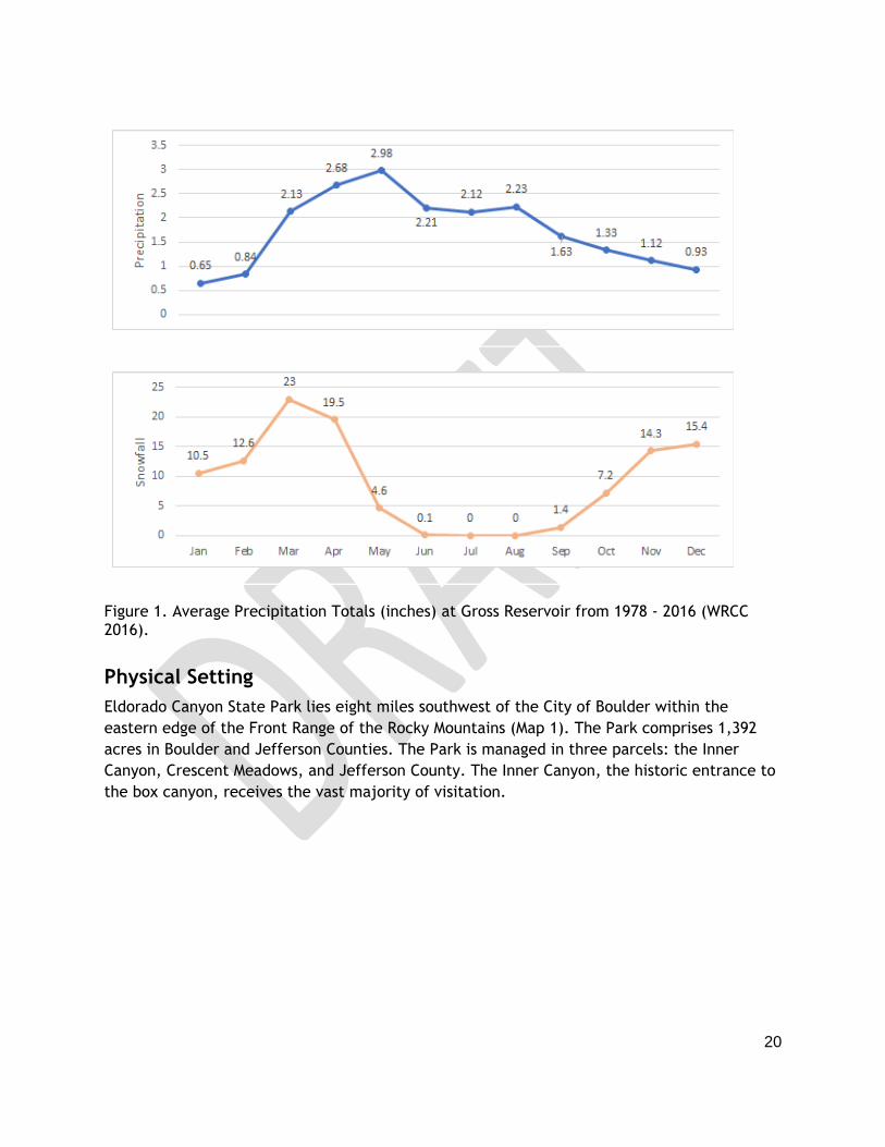
summarize temperature and precipitation data for Gross Reservoir (WRCC 2016).
Table 1. Mean Temperatures (F) 1978-2016 (WRCC 2016).
Jan Feb Mar Apr May Jun Jul Aug Sep Oct Nov Dec Annual
Max 40.5 39.4 48.8 53.8 62.3 74.1 80.7 77.9 71.0 58.0 49.2 39.1 57.9
Mean 29.1 27.7 36.2 40.9 49.0 59.0 65.6 63.0 55.5 44.8 36.9 27.8 44.6
Min 17.6 16.0 23.5 28.0 35.7 43.9 50.5 48.1 40.0 31.6 24.5 16.5 31.3
20
Figure 1. Average Precipitation Totals (inches) at Gross Reservoir from 1978 - 2016 (WRCC 2016).
Physical Setting
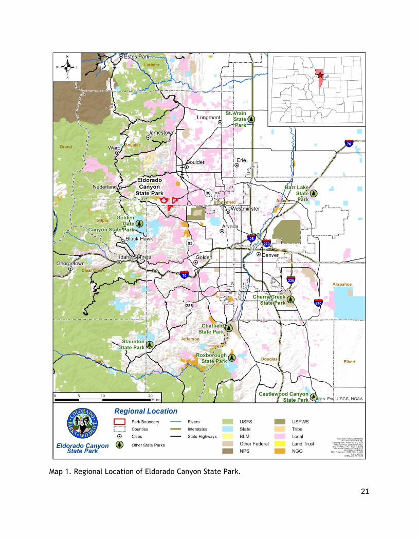
Eldorado Canyon State Park lies eight miles southwest of the City of Boulder within the
eastern edge of the Front Range of the Rocky Mountains (Map 1). The Park comprises 1,392
acres in Boulder and Jefferson Counties. The Park is managed in three parcels: the Inner
Canyon, Crescent Meadows, and Jefferson County. The Inner Canyon, the historic entrance to
the box canyon, receives the vast majority of visitation.
21
Map 1. Regional Location of Eldorado Canyon State Park.

22
Eco-Regional Setting
Eldorado Canyon State Park lies within the St. Vrain subbasin and within the South Boulder
Creek watershed (CPW 2020). Eldorado Canyon State Park occupies multiple ecotones
including higher elevation mixed conifer forests, mid elevation ponderosa pine
forests/meadows, and lower elevation meadows and shrublands (Rocky Mountain Forestry,
LLC. 2017).
Eldorado Canyon State Park provides habitat for many species of wildlife common to the
foothills of the Front Range and provides opportunities for the public to view both wildlife
and outstanding scenery within close proximity of major metropolitan areas. The Park
exemplifies the diversity of vegetation types found in Colorado’s Front Range foothills. This
diversity is attributed to the Park’s varied topography, soils, microclimates, and specifically
to the Park’s location in the ecotone between mixed grass prairie and montane woodland.
Primary habitats for wildlife at Eldorado Canyon include ponderosa pine woodlands, Douglas-
fir forest, mixed foothills shrubland, short and mixed grass prairie, riparian and wetland
communities. Further, the numerous cliffs and rock outcrops provide suitable habitat for cliff-
dwelling bird species and bats. Migration corridors are present along riparian areas of the
waterways within the Park for large mammals such as deer, elk, mountain lions, and bears
and the federally-listed (as threatened) Preble’s meadow jumping mouse. The large expanses
of open space and connectivity of the Park to adjacent protected lands provides contiguous
habitat for many wildlife species (CPW 2020).
Adjacent Land Use and Land Ownership
Eldorado Canyon State Park is located in south central Boulder and northern Jefferson
counties with public and private land bordering the park (Map 2).
The small-unincorporated town of Eldorado Springs is located just outside the entrance to the
Inner Canyon. A few small businesses, including art studios, a construction company, and a
law office are found in Eldorado Springs. There is also Eldorado Springs Resort and Pool,
Eldorado Mountain Yoga and Ashram, a Post Office and fire station.
The Park is surrounded by public lands that are owned and operated by multiple agencies.
The US Forest Service (USFS) manages the Arapaho and Roosevelt National Forest land to the
west of the Crescent Meadows parcel. Boulder County Parks and Open Space (BCPOS) and City
of Boulder Open Space and Mountain Parks (OSMP) manage Walker Ranch Open Space,
Eldorado Mountain, Doudy Draw/Spring Brook/South Mesa, and Marshall Mesa.
Several of these trailheads are on State Highway 170, which then becomes a private road in
the town of Eldorado Springs (CPW has an easement to allow Inner Canyon visitors to access
the park) and finally the road through the park and to private residences on the west side.
Therefore, this road serves as the sole access for multiple trailheads, businesses and
approximately 275 households, the public and commercial facilities of Eldorado Artesian
Springs, Inc. and the Inner Canyon parcel of the park.
23
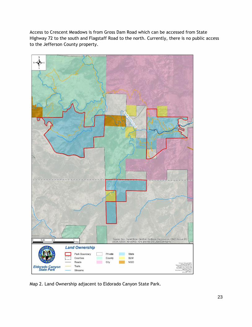
Access to Crescent Meadows is from Gross Dam Road which can be accessed from State
Highway 72 to the south and Flagstaff Road to the north. Currently, there is no public access
to the Jefferson County property.
Map 2. Land Ownership adjacent to Eldorado Canyon State Park.
24
Regional Recreation and Tourism Trends, Opportunities and Challenges
Regional Tourism and Recreation Trends
In 2018, the Colorado Tourism Office (CTO) released its Regional Branding Initiative. This
effort aims to create more cohesive regional identities that promote unique travel
experiences and help generate local marketing strategies. ECSP lies within “Denver and the
Cities of the Rockies” region (Region 8), which covers the north-central portion of Colorado
(CTO 2018). Region 8 receives the highest number of visitors in the state (CTO, 2018) and
contains several "must see" tourist attractions. See the “History” section of CTO’s report for
more context and background on this region.
CTO’s plan includes recommendations for tourism development. The top three are: 1) Create
a destination development plan to manage growth; 2) Avoid becoming generic by shifting to
niche marketing; and 3) Create regional differentiation and strengthen regional offering by
leveraging individual city identities (CTO 2018).
The 2019-2023 Statewide Comprehensive Outdoor Recreation Plan (SCORP) delineates regions
based on CTO’s previous travel management zone and offers valuable insight into the
recreation trends in each region. In the SCORP, ECSP falls into the “North Central” region,
with a small portion of the Park in the “Denver” region (CPW 2019). The North Central region
includes popular, eclectic towns such as Fort Collins, Boulder, Greeley, Idaho Springs and
Estes Park. Recreational activities include camping, hiking, biking, fishing, and boating in the
ample state, federal, and county public land properties. The region is also home to Rocky
Mountain National Park, the Flatirons, Poudre Canyon, and Longs Peak. This region offers a
breadth of outdoor experiences from neighborhood parks to remote wilderness (CPW 2019).
Based on a public survey, the top three recreational activities in the North Central region are:
1) walking, 2) hiking/backpacking, and 3) playground activities. This region generates around
$13.8 billion of direct economic output each year from recreation, and provides the second
highest economic contributions out of all the regions in Colorado (although region sizes must
be considered) (CPW 2019). See the “Economic Value” section of the SCORP for more
information on the North Central region’s contributions.
Colorado saw almost 38 million visitors in 2018. Outdoor travel to Colorado has been growing
each year, despite the relatively flat number of travelers to Colorado and of outdoor travelers
nationally. Hiking/backpacking is the most popular activity on Colorado outdoor vacations
(Longwoods International 2019). The City of Boulder is a popular destination for visitors,
especially those interested in recreation. The City saw 3.3 million visits in 2015, when data
was last collected. The Boulder Convention and Visitors Bureau found that 30% of City
overnight visitors’ trips' purpose was recreation, the highest of any category (BCVB 2016).

25
Regional Recreation Opportunities
Boulder County owns or manages over 100,000 acres of open space. BCPOS also manages over
110 miles of trails. Activities available on these lands include hiking, mountain biking, rock
climbing, horseback riding, camping, and fishing. Boulder County estimated that its Parks and
Open Spaces saw 1.7 million visitors in 2018 (BCPOS 2019). Boulder County Parks and Open
Space manages the Walker Ranch area which adjoins the Crescent Meadows portion of ECSP
and connects to the Inner Canyon portion of the park via the Eldorado Canyon Trail.
Jefferson County Open Space (JCOS) has 56,000 acres with 244 miles of trails and 28 parks.
Activities available include hiking, rock climbing, mountain biking, and horseback riding. JCOS
has approximately 7 million visitors per year (JCOS 2017).
OSMP manages over 46,000 acres with 155 miles of trails in the City of Boulder. Hiking,
mountain biking, rock climbing, and fishing are possible. In 2017, OSMP-managed lands
received an estimated 6.25 million visits, a significant increase from 2005 figures, when
visitation was previously estimated (OSMP 2018). Boulder OSMP land abuts the ECSP Inner
Canyon to the north and east. Both the Fowler and Eldorado Canyon trails continue onto OSMP
land. OSMP’s Doudy Draw, South Mesa, Eldorado Mountain, and Marshall Mesa trailheads are
located to the east of the Park off of Highway 170.
Golden Gate Canyon State Park is the nearest state park to ECSP, located about 10 miles to
the south. This park has 35 miles of trails, with 19 miles open to mountain biking and hiking
and 16 miles designated for hiking only. Other recreational opportunities include picnicking,
camping, horseback riding, hunting, fishing, and some rock climbing options as well. The park
saw about 850,000 visitors over the 2017/18 season and visitation has been increasing.
Just west of the park, the Arapaho and Roosevelt National Forest Boulder Ranger District
includes hundreds of thousands of acres in western Boulder and Gilpin counties. Recreational
opportunities in the National Forest include hiking, mountain biking, camping, rock climbing,
picnicking, nature viewing and boating. The Arapaho and Roosevelt National Forest saw 3.3
million visits (not including downhill skiing) in 2015, making it one of the most visited national
forests in the country (USDA 2015).
Rocky Mountain National Park (RMNP) is located approximately 35 miles north of ECSP and
attracts international visitors, visitors from across the U.S., and visitors from the local region.
RMNP spans 415 square miles and contains over 300 miles of hiking trails and opportunities for
rock climbing, camping, picnicking, and horseback riding. Its climbing areas, primarily Lumpy
Ridge, are popular, but are located further from the metropolitan area than ECSP and other
local climbing areas (RMNP 2020). RMNP received 4.7 million visitors in 2019, and visitation
has been increasing each year (IRMA 2020). In 2020, RMNP began a time-entry permit
reservation system for entry to the park during the busy summer months and to comply with
COVID-19 public health guidelines. The park also has a within park shuttle system.

26
Regional Population Trends
As of 2018 Colorado's population was estimated at 5.7 million. Between 2016-2018 the state’s
population grew by 150,00 residents with most of this growth occurring on the Front Range
(CDLA, 2020a). Colorado’s population is forecasted to continue growing, but at a slower rate
than in recent years due to a slowing economy, slowing birth rates, aging population, and
slowing labor force growth (CDLA 2016).
Population trends and predictions are provided in Table 2 for Boulder County. As of 2018,
Boulder County was the 8th fastest growing county in the State (CDLA 2019). The population of
Boulder County increased by four percent, from 2014 (313,108) to 2018 (325,480) (CDLA
2020b).
Table 2. Population Counts and Estimates for Boulder County (CDLA 2020b).
Year 2014 2015 2016 2017 2018 2020 2025 2030
Population 313,108 319,009 322,285 323,467 325,480 332,134 351,310 370,618
The population of Colorado’s citizens aged 65 and older is growing as a result of aging and in-
migration (Kemp 2014) and those citizens display a strong interest in an active lifestyle and
travel during retirement (CPW 2014). In 2000, people aged 65 and over represented 9.7
percent of the total population of Colorado. By 2010, this percentage had increased to 10.9
percent. Boulder County has seen a similar trend and in 2010 10% of the county’s population
was over 65 years old (US Census Bureau 2010).
Statewide, the Hispanic population has increased by 41.2 percent from 2000-2010 (US Census
Bureau 2011). Within this growing population, the under-18 cohort has outpaced the 18 and
older age group. In Boulder County, the Hispanic population in 2010 was 39,276 which
accounts for 13.3 percent of the county population estimate (US Census Bureau 2010).
Note: Anecdotally we know that many of the visitors from ECSP are from the Denver metro
area - a higher number than many recognized due to the park’s proximity to Boulder. In
addition, a diversity of ethnicities, races and cultures are represented by Park visitors.
Ongoing survey efforts will help to quantify this information and continue to explore why
people visit ECSP and satisfaction with their visit.
Current Regional Challenges
The 2019 SCORP cites population increases and demographic changes are factors to consider
in future management of Colorado’s public lands. Undoubtedly, the quality of life Colorado
offers plays a key role in attracting new residents, however, as the state’s population

27
increases, there are associated challenges to conservation and outdoor recreation. While the
population of Colorado continues to grow, the amount of land available for recreation and
wildlife habitat is finite and as the population grows, the protected lands per capita is
declining. In addition, as the demographics change within the state, outdoor recreation must
be culturally relevant and planners must evaluate the different ways in which people
recreate. Providing the same types of recreation options that we have for many years may not
accommodate the unique needs and interests of different racial and ethnic groups, people
with disabilities, an aging population and more (CPW 2019).
At present, many popular recreational areas in the region are grappling with parking and
access challenges. Many trailhead parking areas in the region fill up on peak days. Some
recreation destinations already have programs in place to address these issues. Examples
include shuttles to the Hessie Trailhead in Boulder County on the National Forest, at RMNP,
and to Chautauqua in the City of Boulder.
Citations
BCPOS. 2019. Boulder County Parks and Open Space, 2018 Parks and Open Space Visitation
Report, July 2019.
BCVB. 206. Boulder Convention and Visitors Bureau, Boulder’s Tourism Economy.
Colorado Department of Local Affairs (CDLA). 2016. Colorado’s 2016 Population & Economic
Overview. Colorado Department of Local Affairs. Available from
https://demography.dola.colorado.gov/crosstabs/2016-overview/ (accessed January 14,
2020).
CDLA. 2019. Population Totals Colorado Counties. Available from
https://demography.dola.colorado.gov/population/population-totals-counties/ (accessed
March 27, 2020).
CDLA. 2020a. Population Totals Colorado and Sub-state Regions. Available from
https://demography.dola.colorado.gov/population/population-totals-colorado-substate/
(accessed March 27, 2020).
CDLA. 2020b. Population Totals for Colorado Counties. Available from
https://demography.dola.colorado.gov/population/population-totals-counties/ (accessed
January 14, 2020).
28
Colorado Parks and Wildlife (CPW). 2014. Statewide Comprehensive Outdoor Recreation Plan.
Colorado Parks and Wildlife, Denver, CO.
CPW. 2019. Statewide Comprehensive Outdoor Recreation Plan. Colorado Parks and Wildlife,
Denver, CO. Available from https://cpw.state.co.us/Documents/Trails/SCORP/Final-
Plan/2019-SCORP-Report.pdf.
CPW. 2020. Eldorado Canyon State Park Stewardship Plan. Colorado Parks and Wildlife.
Colorado Tourism Office (CTO). 2018. Colorado Tourism Office: 2018 Regional Branding
Initiative. Colorado Tourism Office. Available from
https://industry.colorado.com/sites/default/files/Colorado_Identity_MainReport_v12.pdf.
IRMA. 2020. National Park Service Visitor Use Statistics, Rocky Mountain National Park Annual
Park Recreation Visits (1915 – Last Calendar Year), IRMA Portal, www.Irma.nps.gov.
JCOS. 2017. Jefferson County Open Space, 2017 Annual Report: Preservation Progress.
Kemp R. 2014. The Age Wave in Colorado. Available from www.allagewell.com/assets/the-
age-wave-in-colorado.pdf. (accessed January 14, 2020).
Longwoods International. 2019. Colorado Travel Year 2018 Final Report, June 2019.
OSMP. 2018. City of Boulder Open Space and Mountain Parks, 2016-2017 Visitation Estimation
Report.
Rocky Mountain Forestry, LLC. 2017. Forest Management Plan. Eldorado Canyon State Park.
RMNP. 2020. “Plan Your Visit: Things To Do,” Rocky Mountain National Park, www.nps.gov.
US Census Bureau. 2010. Profile of General Population and Housing Characteristics: 2010,
Boulder County. Available from
https://factfinder.census.gov/faces/tableservices/jsf/pages/productview.xhtml?src=CF
(accessed January 20, 2020).
US Census Bureau. 2011. The Hispanic Population: 2010 Census Briefs.
USDA. 2016. USDA Forest Service National Visitor Use Monitoring, Annual Visits With and
Without Downhill Skiing: Arapaho & Roosevelt NF (FY2015),
https://apps.fs.usda.gov/nvum/results/A02010.aspx/FY2015 (accessed March 20, 2020)

29
Western Regional Climate Center (WRCC). 2016. Gross Reservoir Climate Summary. Available
from https://wrcc.dri.edu/cgi-bin/cliMAIN.pl?co3629 (accessed January 21, 2020).

30
3.0 PARK SETTING & RESOURCES
This section provides an overview of the current condition of resources and various ongoing
factors within the park (e.g., visitation, budget, and staffing trends) that affect management
efforts. Included in this section is a detailed description of current land use and land
ownership; park administration and special functions; existing recreation, natural, and
cultural resources; and other information that either directly or indirectly influences
management of Eldorado Canyon State Park. This information provides a contextual
framework for better understanding management needs and constraints.
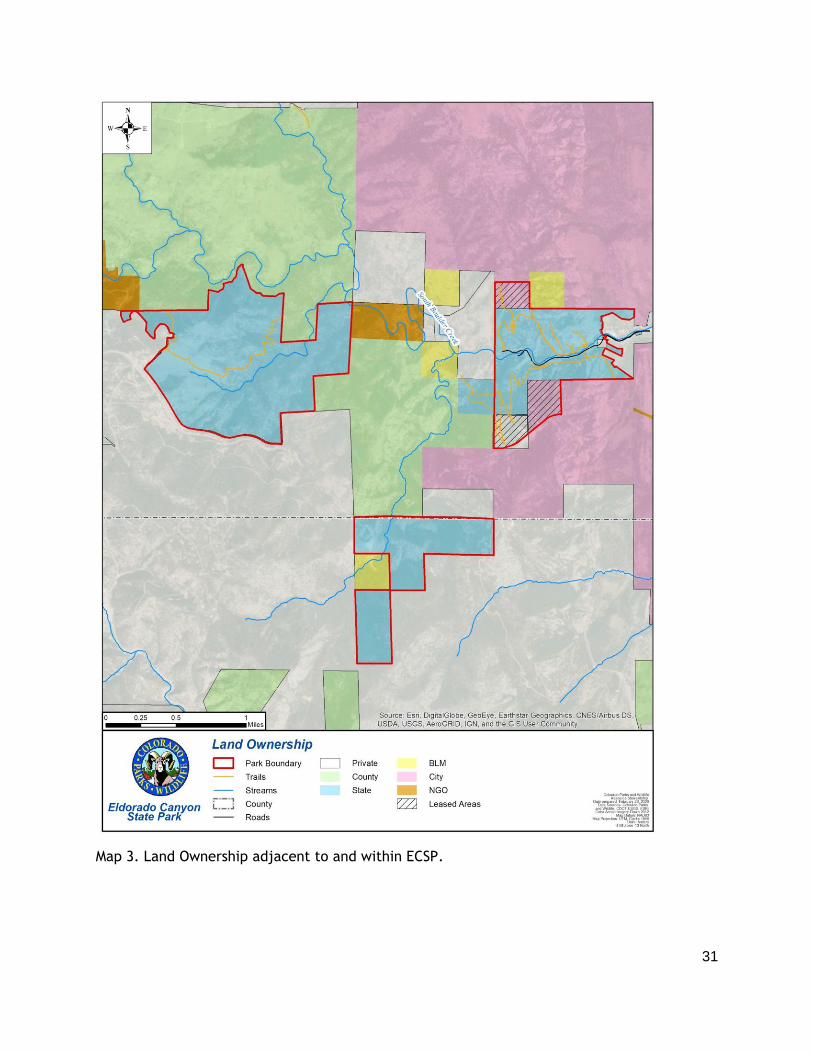
Park Land Ownership
CPW owns most of the property on which ECSP lies (Map 3) including all of the Jefferson
County and Crescent Meadows parcels. For management consistency (e.g., climbing
regulations, trail maintenance, similar visitor experiences), the Park leases two areas within
the Inner Canyon parcel from the City of Boulder. One area is located in the northwest corner
of the Inner Canyon parcel and the other area is the southwest corner of the Inner Canyon
parcel. Additionally, CPW has a lease on the Rattlesnake Gulch trail corridor where it crosses
an area owned by the City of Boulder.
31
Map 3. Land Ownership adjacent to and within ECSP.
32
Natural Resources
Maintaining the core purpose and significance of the Park depends on the condition of its
natural resources. The park elevation ranges from 5,800 feet at the Park´s eastern entrance
along CO-170 to 8,800 feet at the southern boundary of the parcel in Jefferson County. South
Boulder Creek is the most prominent hydrologic feature and was responsible for cutting the
sheer cliffs of Eldorado Canyon during the Front Range uplift. South Boulder Creek originates
on the Continental Divide to the west and flows northeast through the park to Boulder Creek
and eventually to the South Platte River. The park is located in an ecotone between mixed
grass prairie and montane woodland, which lends to the unusually high level of diversity of
plants and animals within the park.
Significant Features
The significant features outlined in this section are rare, unique or important vegetation, wildlife, and water resources found in the park (the full Stewardship Plan and all references for this section can be found in Appendix D).
Significant vegetation resources include:
● Documentation of four rare plant communities in the park.
● Riparian areas, especially along South Boulder Creek that are important for wildlife habitat, erosion and flood control, and water quality.
● Much of the park’s vegetation is considered to be in excellent condition.
Significant wildlife resources include:
● The perennial flow of South Boulder Creek aquatic, wetland, and riparian habitat for several taxa including fish, amphibians, birds, and mammals.
● Several raptor species have been observed in the Park. Golden eagles have been documented to use the cliffs for nesting.
● The sensitive mammal species, Preble’s meadow jumping mouse, has been documented outside of the Park in the past. Habitat for the species exists within the Inner Canyon and Crescent Meadows parcels.
● The park contains excellent bird diversity, including over 82 species being documented. A CNHP-listed species, ovenbird, was documented in 2019.
Significant water resources in the park include:
● South Boulder Creek supports several fish species, as well as species of macroinvertebrates, which improve water quality and are an important link in the food chain.
● The rich riparian soils along South Boulder Creek have high water storage potential, which can reduce the risk of detrimental flooding downstream.
● Water, wetland, and riparian areas that provide important habitat for wildlife as well as game fish species.
The other geophysical (soils and geology) features at the park include:

33
● The variety of soil types and geologic units (see Tables 5 and 6) provide a range of substrates for upland and wetland plant communities and therefore a gamut of associated wildlife species.
● Wetland soils act as a filter between surface and groundwater.
● ECSP’s cliffs and slopes record a remarkable portion of the Earth's geologic history.
The following sections provide more information about some of the key natural resources that occur at Eldorado Canyon State Park. Map 4 highlights several significant natural resources that occur at the park. Raptor nests as well as rare plans and insects are not shown due to data sensitivity. A more extensive description of natural resources is available in the Resource Stewardship Plan (Appendix D).

34
Map 4. Significant Natural Resources in ECSP.

35
Wildlife
Eldorado Canyon State Park provides habitat for many species of wildlife common to the
foothills of the Front Range. Primary habitats for wildlife at ECSP include ponderosa pine
woodlands, Douglas-fir forest, mixed foothills shrubland, short and mixed grass prairie,
riparian and wetland communities. Further, the canyon provides suitable habitat for many
cliff-dwelling bird species and bats.

36
Map 5. Habitat important for mammals in ECSP.

37
Map 6. Potential nesting habitat for Peregrine Falcons (and other nesting raptors).

38
Mammals
Eldorado Canyon State Park contains and connects large tracts of land that provide excellent
habitat for mammals. Several well-vegetated drainages in the park provide links to adjacent
montane and plains habitats for species such as mule deer, elk, black bear, and mountain
lion.
The Park provides ample habitat for elk and mule deer and contains habitat for several
important life events for the two species. CPW Species Activity Mapping (SAM) data identifies
overall range, summer range, and winter range for mule deer and elk within the park. It is
also mule deer ‘severe winter range’, ‘winter concentration area’, and resident population
ranges. Elk ‘severe winter range’ also overlaps with parts of the Park.
Eldorado Canyon State Park falls within the Game Management Unit (GMU) 29 and Data
Analysis Unit (DAU) 27 (for deer) and 38 (for elk). DAU reports can be found in the Appendix
of the Stewardship Plan (CPW 2019a). It is important to note that chronic wasting disease
(CWD) has been documented within GMU 29 (CPW 2019b). CWD is a fatal neurological disease
found in deer, elk and moose. It belongs to a family of diseases caused by prions (misfolded
protein). This particular prion disease attacks the brains of infected deer, elk and moose,
causing the animals to display abnormal behavior, become uncoordinated and emaciated, and
eventually die (CPW 2017).
Black bear and mountain lion are occasionally seen in the park during warmer months. Black
bears are often seen in the Inner Canyon parcel, along South Boulder Creek and in the picnic
area. Mountain lion habitat exists throughout the park, but the Jefferson County parcel
provides the best quality habitat and park staff have noted mountain lion activity in the
parcel. CPW SAM data for black bear and mountain lion indicates their overall range overlaps
with the entire park. Additionally, black bear ‘fall concentration area’ overlaps with the Inner
Canyon parcel.
Bighorn sheep, moose and Canada lynx are uncommon but occasionally documented. A single
bighorn sheep was seen in 2017 and 2018 in the Inner Canyon parcel but their range generally
does not overlap with the park. Moose habitat is sparse in the Park, and the species is unlikely
to occur. However, it is possible moose could travel into the Park considering available
habitat in the surrounding areas, including Gross Reservoir. A moose was documented twice in
2017 at Crescent Meadows by volunteers surveying the parcel for natural resources and in the
Inner Canon by park staff. CPW SAM data for moose ‘overall range’ overlaps with the western-
side of Crescent Meadows. Canada lynx is federally listed as threatened, state listed as
endangered, and is a Tier 1 species in the State Wildlife Action Plan. CPW SAM data shows
Canada lynx range overlapping with Crescent Meadows and parts of the Jefferson County
parcel. The Park provides habitat for the species in coniferous forests and riparian corridors,
however, lynx has not been documented in the Park.
Small mammals commonly found in the park include raccoon, muskrat, beaver, Abert’s
squirrel, and fox squirrel. In addition, habitat for bat species includes rock outcrops in
crevices, cracks, and caves, and in snags and trees in both upland and riparian areas. Several

39
bat species, including many rare or sensitive species, have the potential to occur in the park.
A historic record for Townsend’s big-eared bat exists from 1972 in a distribution of mammals
developed by the Museum of Natural History in Kansas.
Preble’s meadow jumping mouse (PMJM) is a sensitive rodent species that was federally listed
as threatened in 1998. The entire Inner Canyon and Crescent Meadows parcels and the
northern half of the Jefferson County parcel lies within the overall range defined by CPW for
the species. All three parcels support suitable habitat for PMJM and there are positive
trapping records from adjacent areas. Crescent Meadow contains the greatest extent of
suitable habitat due to the healthy stand of mixed grass prairie and shrublands throughout the
parcel.
Birds
ECSP supports a diverse assemblage of migratory and breeding birds, including common
species such as yellow warbler, Stellar’s jay, black-capped chickadee, and American robin.
The Park contains diverse habitats such as wetlands and riparian areas with large cottonwood
trees and dense shrubby understory that attract species such as black-headed grosbeak, song
sparrow, yellow warbler, house wren, and warbling vireo. The park also contains unique cliff
faces and canyons that attract a wide-variety of uncommon species such as white-throated
swift, golden eagle, and prairie falcon. Dense coniferous forests cover much of the park and
provide excellent habitat for a large number of species including western tanager, white-
breasted nuthatch, and red crossbill. The grasslands in the Crescent Meadows provides
important foraging and breeding grounds for numerous species, including mountain bluebird,
vesper sparrow, and lesser goldfinch.
Ample raptor habitat is present in the park along the sheer rock outcrops and in mature
coniferous and deciduous trees in the park. Raptor monitoring has occurred at Eldorado
Canyon State Park since 2006 and there are seasonal closures in the park to protect nesting
raptors. Several species have nested in the park, including golden eagles, turkey vultures,
red-tailed hawk, Cooper’s hawk, sharp-shinned hawk, and prairie falcon. Other species
observed in the park in the past that have not been documented to nest include bald eagle,
rough-legged hawk, and American kestrel.
Based on available habitat, the park could provide habitat for several birds that are tracked
by the Colorado Natural Heritage Program (CNHP). These species are listed in the “Sensitive
Species'' section (Table 3). Bird surveys were completed in 2015 and documented 82 species
of birds from surveying 12 points in the Park. Of the birds observed, 31 were confirmed to be
breeding in the Park (Jones 2015).
Fish
The dominant species in the creek are rainbow and brown trout. Other fish found there
include brook trout, longnose dace, and longnose and white suckers. Many of these fish are
found naturally in South Boulder Creek, others have found their way downstream to the park
from Gross Reservoir where they are stocked by CPW.

40
Invertebrates
Surveys conducted from 2007 through 2013 by volunteers in Crescent Meadows found the
presence of approximately 40 butterfly species. The hops feeding azure, the mottled
duskywing, and Moss’ elfin, are three rare butterflies observed by CNHP. Additionally, Ottoe
skipper and cross-line skipper all have previous occurrence records nearby that are
documented by the CNHP element occurrence data. Park staff see the rare hops feeding
azure butterfly nearly every year in the Inner Canyon parcel where their host plant can be
found. CNHP plans to conduct a survey in the park in 2020 to confirm these findings.
Reptiles and Amphibians
Amphibian and reptile habitat is present within the Park but is very limited. Tributary
drainages such as Rattlesnake Gulch, South Draw, and Johnson Gulch provide riparian habitat
and rocky cliffs, slopes, and outcrops that can host a variety of herptile species. Wetland
habitat is also found along South Boulder Creek and in Crescent Meadows. Noxious weed
infestations occur in both the Inner Canyon riparian areas and in Crescent Meadows,
threatening to displace native vegetation upon which herptile species depend. Riparian areas
subject to high volumes of visitors in the Inner Canyon are highly degraded, exhibiting incised
banks and trampled vegetation. These conditions are poor for herptile species.
Herpetological surveys conducted in 2019 found three species: wandering gartersnake, prairie
lizard, and smooth greensnake (Triece et al. 2019). Other species that could be present in the
park include western tiger salamander, Woodhouse’s toad, eastern yellow-bellied racer,
prairie rattlesnake, and bullsnake. Park staff noted they saw a western tiger salamander near
the Eldorado Canyon Trail along a ridge in 2017. American bullfrog is a non-native species
that could also be present at the Park. Northern leopard frog is a rare species that could
possibly occur in the Park if habitat restoration activities occur in wetlands located in
Crescent Meadows.
Rattlesnake activity is high in the park and some areas provide better habitat such as areas
with open grasslands, semi desert shrubland, riparian zones, and montane woodlands up to
9,500 feet in elevation (COPARC 2018). Park staff have noted that activity is high along the
Fowler Trail.
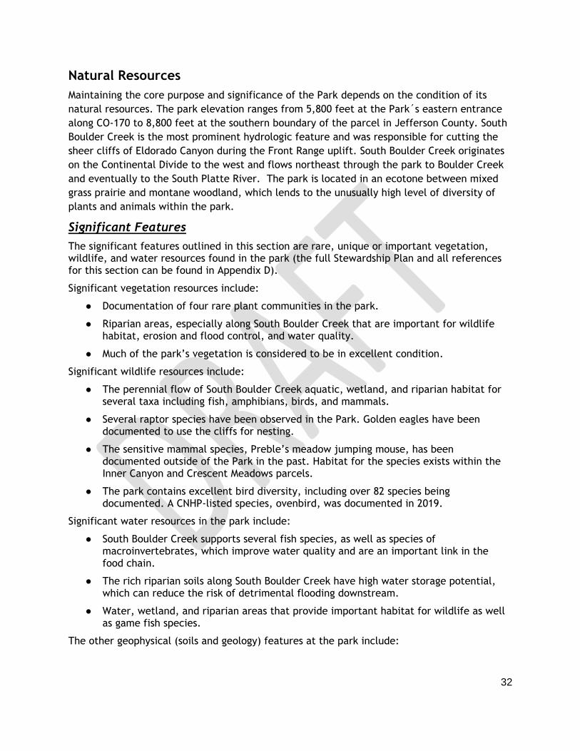
Vegetation
Eldorado Canyon State Park contains 21 distinct vegetation communities as defined by the
National Vegetation Classification System (NVC), including 11 forest and woodland, nine shrub
and herb, and one desert and semi-desert (Map 7). The prominent natural community types in
the Park are Douglas-fir forest, ponderosa pine woodland, mixed grass prairie, and
cottonwood riparian forest. Douglas-fir forests are present on cooler slopes with north and
east aspects and in deeper canyons. The ponderosa pine woodlands occupy warm south-facing
slopes. In addition to ponderosa pine, south-facing slopes are often codominated by Rocky
Mountain juniper with a grassy understory and few shrubs. Mixed grasslands occur in open
areas between stands of trees and in the deeper soils of park meadows. Riparian communities

41
are established along the banks of South Boulder Creek, Rattlesnake Gulch, and portions of
drainages throughout the park.
The vegetation communities are generally in “good” or “excellent” condition as the majority
of the Park does not receive regular visitation from the public due to topography and a lack of
access. Communities adjacent to where infrastructure and trails exist are generally rated to
be in fair to poor condition. Fair and poor ratings have high levels of non-native species,
dense vegetation/poor structure, or trampled vegetation from human use. Fair and poor
vegetation is also concentrated around South Boulder Creek where the public has access and
historically grazed areas. There are ten permanent vegetation monitoring plots around the
park to monitor changes in vegetation over time that were established in 2019. Vegetation
communities, condition, and the plots were identified and evaluated in 2019 (Belmar 2019).
42
Map 7. Vegetation communities in ECSP.

43
Forest Communities
Douglas-fir forests are the most dominant vegetation community at Eldorado Canyon State
Park. Six different forest communities were identified in the park with Douglas-fir as the
dominant species, totaling 1,194 acres. This tree species grows at 6,000 to 9,500 feet in
elevation in rocky soils of moist northern facing slopes; both in pure stands and mixed conifer
forests (COSFS 2020). Many Douglas-fir forested areas contain ponderosa pine, Rocky Mountain
maple, and Rocky Mountain juniper. Limber pine may be mixed in with Douglas-fir and
ponderosa pine at higher elevations in the Jefferson County parcel. The communities
dominated by Douglas-fir include a variety of understories that are composed of shrubs,
herbaceous plants, scree, and rocky boulders. Common plant species associated with
douglas-fir include common juniper, kinnikinnick, creeping barberry, five-petal cliffbush,
Boulder raspberry, Wood’s rose, wax currant, chiming bells, Canada violet, penstemon,
smooth brome, and poison ivy.
Two communities were documented to contain ponderosa pine as the dominant species,
totaling 815 acres. This tree species grows at 6,300 to 9,500 feet in dry, nutrient poor soils in
open park-like stands or in mixed stands with Douglas-fir, Rocky Mountain juniper and spruce
(COSFS 2020). In the park, ponderosa pine was often present with Douglas-fir in many areas,
but often was not dominant when mixed with Douglas-fir. Ponderosa pine was solely dominant
in some areas on drier hillslopes with a relatively open tree layer, low density to absent shrub
layer, and a dense to sparse graminoid understory with scattered forbs and rock. The species
was also found mixed with Rocky Mountain juniper, which often co-dominated when present.
Common plant species associated with ponderosa pine include yucca, prickly pear cactus,
creeping barberry, common juniper, fringed sage, prairie sage, wild buckwheat, yarrow, sun
sedge, cheatgrass, and western wheatgrass.
Deciduous tree forests and communities are also present in the park. Quaking aspen,
narrowleaf cottonwood, eastern cottonwood, box elder, water birch, and green ash were
documented in the park and are found predominantly in riparian and wetland areas. These
habitats are discussed in more detail below. Rocky Mountain maple was present in upland
areas and was always mixed with Douglas-fir, but was often present on cool, moist hillslopes
or near ephemeral drainages.
Wetland and Riparian Communities
A vast majority (nearly 75 percent) of all Colorado wildlife depends in some part on wetland
and riparian areas which are found in the park’s canyon and valley bottoms. These areas also
support two rare riparian vegetation habitats. Riparian and wetland communities comprise
approximately 48 acres within the park, along South Boulder Creek and ephemeral drainages
in all three park parcels. These communities are at the highest risk of further degradation and
reduced condition. Noxious weeds are capable of invading these communities as they are
conducive to many noxious weed species.
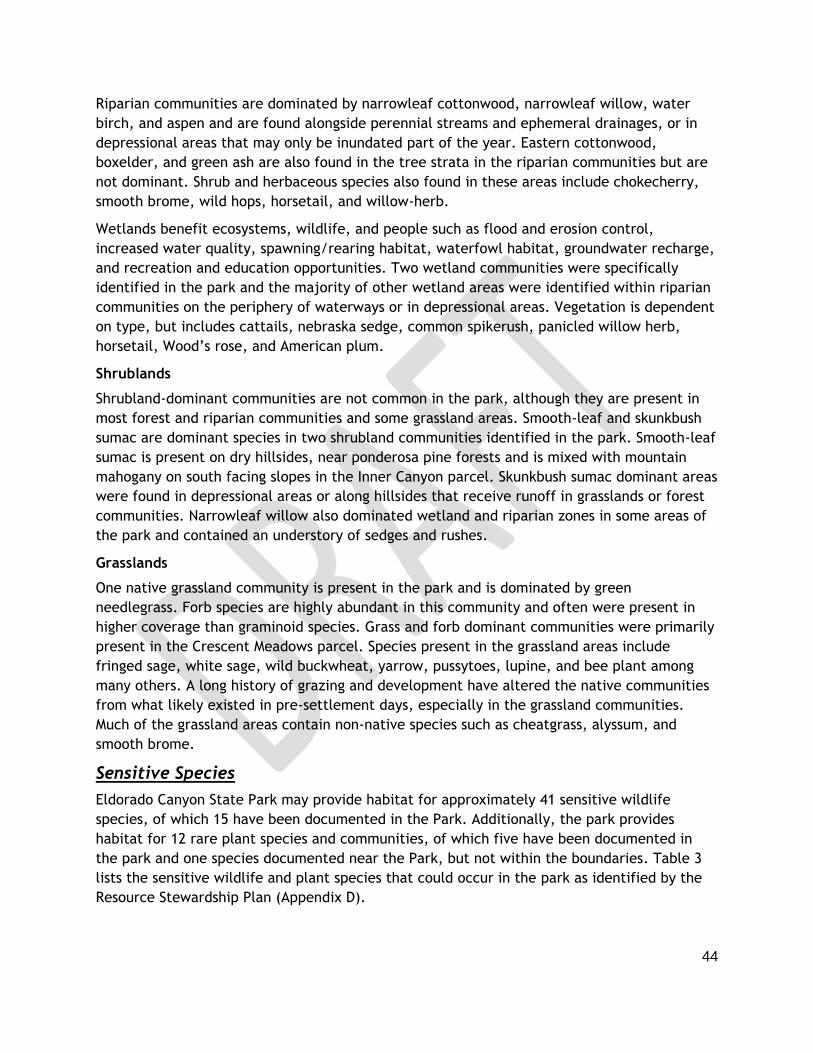
44
Riparian communities are dominated by narrowleaf cottonwood, narrowleaf willow, water
birch, and aspen and are found alongside perennial streams and ephemeral drainages, or in
depressional areas that may only be inundated part of the year. Eastern cottonwood,
boxelder, and green ash are also found in the tree strata in the riparian communities but are
not dominant. Shrub and herbaceous species also found in these areas include chokecherry,
smooth brome, wild hops, horsetail, and willow-herb.
Wetlands benefit ecosystems, wildlife, and people such as flood and erosion control,
increased water quality, spawning/rearing habitat, waterfowl habitat, groundwater recharge,
and recreation and education opportunities. Two wetland communities were specifically
identified in the park and the majority of other wetland areas were identified within riparian
communities on the periphery of waterways or in depressional areas. Vegetation is dependent
on type, but includes cattails, nebraska sedge, common spikerush, panicled willow herb,
horsetail, Wood’s rose, and American plum.
Shrublands
Shrubland-dominant communities are not common in the park, although they are present in
most forest and riparian communities and some grassland areas. Smooth-leaf and skunkbush
sumac are dominant species in two shrubland communities identified in the park. Smooth-leaf
sumac is present on dry hillsides, near ponderosa pine forests and is mixed with mountain
mahogany on south facing slopes in the Inner Canyon parcel. Skunkbush sumac dominant areas
were found in depressional areas or along hillsides that receive runoff in grasslands or forest
communities. Narrowleaf willow also dominated wetland and riparian zones in some areas of
the park and contained an understory of sedges and rushes.
Grasslands
One native grassland community is present in the park and is dominated by green
needlegrass. Forb species are highly abundant in this community and often were present in
higher coverage than graminoid species. Grass and forb dominant communities were primarily
present in the Crescent Meadows parcel. Species present in the grassland areas include
fringed sage, white sage, wild buckwheat, yarrow, pussytoes, lupine, and bee plant among
many others. A long history of grazing and development have altered the native communities
from what likely existed in pre-settlement days, especially in the grassland communities.
Much of the grassland areas contain non-native species such as cheatgrass, alyssum, and
smooth brome.
Sensitive Species
Eldorado Canyon State Park may provide habitat for approximately 41 sensitive wildlife
species, of which 15 have been documented in the Park. Additionally, the park provides
habitat for 12 rare plant species and communities, of which five have been documented in
the park and one species documented near the Park, but not within the boundaries. Table 3
lists the sensitive wildlife and plant species that could occur in the park as identified by the
Resource Stewardship Plan (Appendix D).

45
Species identified as sensitive in this plan may be considered sensitive or at risk according to
various species conservation lists. Lists and conservation rankings considered include the
Federal Endangered Species Act (ESA), NatureServe, CNHP, and the Colorado State Wildlife
Action Plan (SWAP). An explanation of these rankings and statuses are provided below.
At-risk species are identified under U.S. Fish and Wildlife Service’s Endangered Species Act
guidelines:
● Endangered (FE): in danger of extinction throughout a significant portion of its range ● Threatened (FT): likely to become endangered within the foreseeable future
CPW also uses NatureServe’s and CNHP’s conservation status rankings to identify and manage
threatened species (NatureServe 2019; CNHP 2013). The following definitions pertain to
either global or state populations:
● Critically Imperiled (S1, G1): At very high risk of extinction due to very restricted range, very few populations or occurrences, very steep declines, very severe threats, or other factors.
● Imperiled (S2, G2): At high risk of extinction due to restricted range, few populations or occurrences, steep declines, severe threats, or other factors.
● Vulnerable (S3, G3): At moderate risk of extinction due to a fairly restricted range, relatively few populations or occurrences, recent and widespread declines, threats, or other factors.
● Apparently Secure (S4, G4): At fairly low risk of extinction due to an extensive range and/or many populations or occurrences, but with possible cause for some concern as a result of local recent declines, threats, or other factors.
● Secure (S5, G5): At very low risk or extinction due to a very extensive range, abundant populations or occurrences, and little to no concern from declines or threats.
Colorado’s State Wildlife Action Plan (SWAP) identifies Tier 1 and Tier 2 Species of Greatest
Conservation Need (SGCN) for conservation priorities in the state. Tier 1 species are truly of
highest conservation priority in the state, and to which CPW will likely focus resources over
the life of the plan. Tier 2 species remain important in light of forestalling population trends
or habitat conditions that may lead to a threatened or endangered listing status, but the
urgency of such action has been judged to be less (CPW 2015).
Table 3. Sensitive Species with Potential to Occur at Eldorado Canyon State Park.
Common Name Scientific Name Conservation Status Occurrence (most
recent) Federal CNHP CPW
Plants and Communities
Douglas-fir / Kinnikinnick Forest
Pseudotsuga menziesii/Arctostaphylus uva-ursi Forest
G4 / S3 Documented in 2019
Douglas-fir / Rocky Mountain Maple Forest
Pseudotsuga menziesii/Acer glabrum Forest
G4 / S2 Documented in 2019
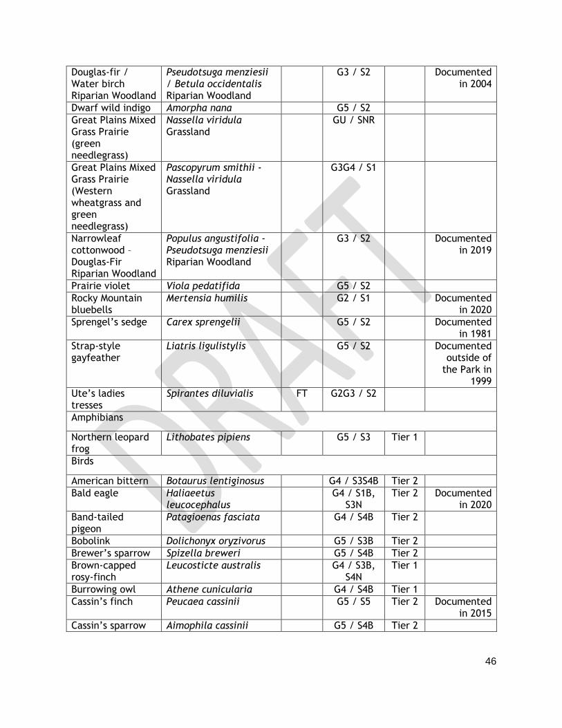
46
Douglas-fir / Water birch Riparian Woodland
Pseudotsuga menziesii / Betula occidentalis Riparian Woodland
G3 / S2 Documented in 2004
Dwarf wild indigo Amorpha nana G5 / S2
Great Plains Mixed Grass Prairie (green needlegrass)
Nassella viridula Grassland
GU / SNR
Great Plains Mixed Grass Prairie (Western wheatgrass and green needlegrass)
Pascopyrum smithii - Nassella viridula Grassland
G3G4 / S1
Narrowleaf cottonwood – Douglas-Fir Riparian Woodland
Populus angustifolia - Pseudotsuga menziesii Riparian Woodland
G3 / S2 Documented in 2019
Prairie violet Viola pedatifida G5 / S2
Rocky Mountain bluebells
Mertensia humilis G2 / S1 Documented in 2020
Sprengel’s sedge Carex sprengelii G5 / S2 Documented in 1981
Strap-style gayfeather
Liatris ligulistylis G5 / S2 Documented outside of
the Park in 1999
Ute’s ladies tresses
Spirantes diluvialis FT G2G3 / S2
Amphibians
Northern leopard frog
Lithobates pipiens G5 / S3 Tier 1
Birds
American bittern Botaurus lentiginosus G4 / S3S4B Tier 2
Bald eagle Haliaeetus leucocephalus
G4 / S1B, S3N
Tier 2 Documented in 2020
Band-tailed pigeon
Patagioenas fasciata G4 / S4B Tier 2
Bobolink Dolichonyx oryzivorus G5 / S3B Tier 2
Brewer’s sparrow Spizella breweri G5 / S4B Tier 2
Brown-capped rosy-finch
Leucosticte australis G4 / S3B, S4N
Tier 1
Burrowing owl Athene cunicularia G4 / S4B Tier 1
Cassin’s finch Peucaea cassinii G5 / S5 Tier 2 Documented in 2015
Cassin’s sparrow Aimophila cassinii G5 / S4B Tier 2

47
Golden eagle Aquila chrysaetos G4 / S3B, S4N
Tier 1 Documented in 2020
Grasshopper sparrow
Ammodramus savannarum
G5 / S3S4B Tier 2
Flammulated owl Otus flammeolus G4 / S4 Tier 2 Documented in 2006
Lark bunting Calamospiza melanocorys
G5 / S4 Tier 2
Lazuli bunting Passerina amoena G5 / S5B Tier 2 Documented in 2017
Lewis’s woodpecker
Melanerpes lewis G4 / S4 Tier 2 Documented in 2015
Loggerhead shrike Lanius ludovicianus G4 / S3S4B Tier 2 Documented in 2017
Mexican spotted owl
Strix occidentalis lucida FT S1B,SUN Tier 2
Northern goshawk Accipiter gentilis G5 / S3B Tier 2
Northern harrier Circus cyaneus G5 / S3B Tier 2
Olive-sided flycatcher
Contopus cooperi G4 / S3S4B Tier 2 Documented in 2015
Ovenbird Seiurus aurocapilla G5 / S2B Documented in 2019
Peregrine falcon Falco peregrinus G4T4 / S2B Tier 2
Prairie falcon Falco mexicanus G5 / S4B, S4N
Tier 2 Documented in 2015
Rufous hummingbird
Selasphorus rufus G5 / SNA Tier 2 Documented in 2020
Virginia’s warbler Oreothlypis virginiae G5 / S5 Tier 2 Documented in 2015
Invertebrates
Cross-line skipper Polites origenes G4G5 / S3
Hops feeding azure
Celastrina humulus G2G3 / S2 Tier 2 Documented in 2020
Moss’s elfin Callophrys mossii schryveri
G4 / S2S3 Tier 2 Documented in 2009
Mottled duskywing Erynnis martialis G3 / S2S3 Tier 2 Documented in 1996
Ottoe skipper Hesperia ottoe G3G4 / S2 Tier 2
Mammals
Abert’s squirrel* Sciurus aberti G5 / S5 Tier 2 Documented in 2020
Black-tailed prairie dog
Cynomys ludovicianus G4/ S3 Tier 2
Canada lynx Lynx canadensis FT G5 / S1 Tier 1
Eastern red bat Lasiurus borealis G2G3 / S2
Fringed myotis Myotis thysanodes G4 / S3 Tier 1

48
Hoary bat Lasiurus cinereus G5 / S5B Tier 2
Little brown myotis
Myotis lucifigus FP G3 / S5 Tier 1
Preble’s meadow jumping mouse
Zapus hudsonius preblei FT G5T2 / S1, ST
Tier 1
Townsend’s Big-eared bat
Corynorhinus townsendii
G4 / S2 Tier 1 Documented in 1972
Tricolored bat Perimyotis subflavus G2G3 / S2
*Species is common in the park but is listed by the SWAP as a Tier 2 species because it is a habitat indicator species.
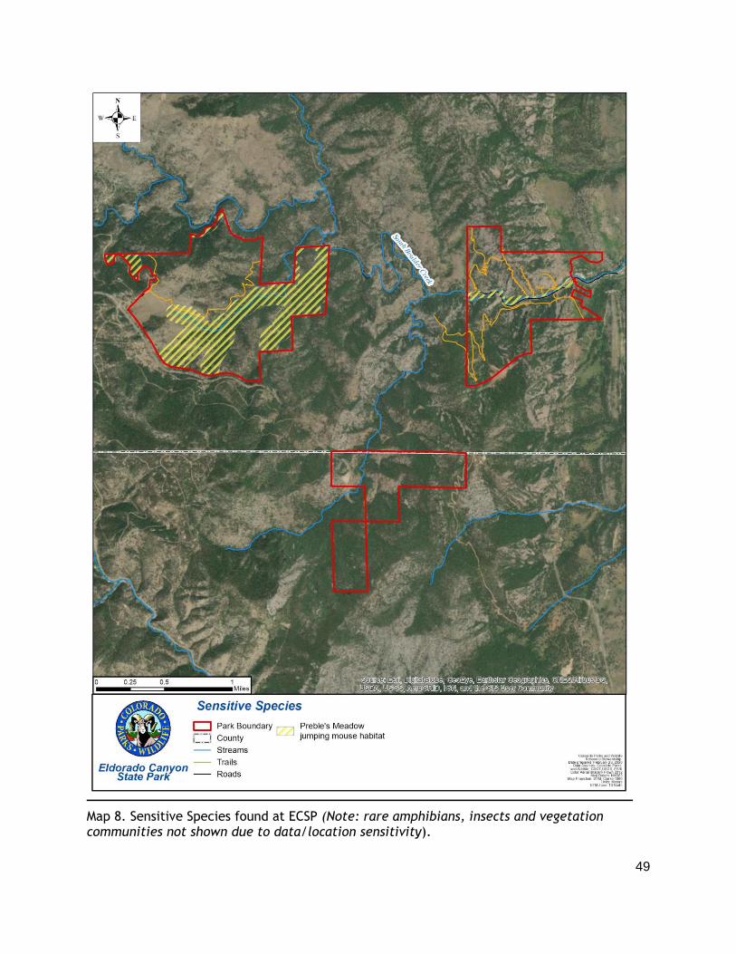
49
Map 8. Sensitive Species found at ECSP (Note: rare amphibians, insects and vegetation communities not shown due to data/location sensitivity).

50
Threats to Habitats and Wildlife
The greatest threat to the park’s natural resources include shifting habitat conditions related
to recreation impacts, severe weather, insects, disease, increased frequency and severity of
fires and noxious weeds. Many species present in the park could be impacted by these
changing environmental conditions, especially rare and imperiled wildlife and plants. Future
monitoring and management decisions should consider the factors described below.
Recreational Impacts on Wildlife
Eldorado Canyon is a popular recreation destination, especially for people from the Front
Range and the Denver metropolitan area, and visitation has increased dramatically over the
past decade. Recreationists have the potential to displace wildlife, cause trail erosion,
impact water quality, and spread noxious weeds. Coloradans are also recreating more year-
round and in more places, meaning wildlife must tolerate direct and indirect human
disturbance for a longer amount of time and over greater geographic areas. Two ways to
mitigate recreational impacts to wildlife are to enforce seasonal closures to protect breeding,
wintering and migratory areas and strategic trail planning that maintains large blocks of
unfragmented habitat.
Forest Insects and Disease
The Park has had small sporadic pockets of insect and disease (I&D) activity over the past two
decades including Douglas-fir beetle/pole beetle, pine engraver beetle (Ips), mountain pine
beetle, and western spruce budworm. Douglas-fir tussock moth has not been found in the
Park but could occur in the future.
Mountain pine beetle (MPB), a native species to Colorado, has historically played a critical
role in the natural renewal process of forest ecosystems. However, due to warmer winters,
drought and previous forestry practices, Colorado forests and others across Western North
America underwent an extreme MPB epidemic in 1996. This outbreak has since wiped out 3.3
million acres of pine forestland in Colorado. MPB carries a fungus that clogs water-
transportation vessels in trees, and rapidly produces larvae that eat away at tree bark.
MPB has been found in pockets on the landscape, primarily at endemic levels in the past at
Eldorado Canyon State Park. During the November 2016 forest inventory, no trees on the Park
were observed with mountain pine beetle infestations, however, new infestations would likely
not be evident until June (Rocky Mountain Forestry LLC 2017). MPB may affect ponderosa pine
and lodgepole pine, both of which are present in the park.
Ips species is another tree beetle that has previously been found in the Park and is likely to be
found again at some point during the next decade given its general presence in Boulder
County forested areas above 6,000 feet.
Dwarf mistletoe in ponderosa pine is more widespread, which can be found in all of the
Park´s three parcels and has been present for decades (Rocky Mountain Forestry LLC 2017).
These small, leafless parasitic flowering plants mostly target lodgepole and ponderosa pine in
Colorado’s forests. By slowly stealing food and water from its host, they slow growth and

51
reduce seed production and wood quality, with the possibility of killing the host tree. In
addition to CSF’s even-aged tree stands, aesthetic practices (e.g. leaving smaller wind-
resistant trees in a cut zone) can also increase the risk of spreading dwarf mistletoe.
Wildfire
Fire is a natural occurrence in healthy forests and grasslands. As part of a natural disturbance
regime, these processes occur in cycles and do not have catastrophic effects on structure or
species composition. The suppression of fire leads to denser forests where wildfires can have
very dramatic impacts. Suppression also leads to change in species composition over time. In
the past few decades, one wildfire spread onto the Crescent Meadows parcel (Walker Ranch
Fire in 2000), and multiple wildfires have occurred in the region around Eldorado Canyon
State Park. These nearby fires support the importance of wildfire hazard reduction (Rocky
Mountain Forestry, LLC. 2017). Map 9 identifies areas with the greatest potential impacts
from a wildfire. The Park wildfire risk ranges from low to high, with most of the Park being
categorized as high wildfire risk but most of the Inner Canyon is at lower risk than the other
parcels (COSFS 2019).
2013 Flood
In September of 2013, large portions of the Colorado Front Range foothills received an
unusual amount of rainfall, with up to 18 inches falling in 10 days in Boulder County. The
highest measured rainfall amounts were similar to the average annual rainfall for the areas
affected. A peak flow estimate for the inactive stream gauge near Eldorado Springs was
determined to be a 50 year flooding event for the area (Yochum 2015).
The flood affected the Park in many ways. The park road near the Milton Boulder, the access
road to the south picnic area near the vehicle bridge, and the picnic area were all severely
damaged. To serve larger groups and confine natural resource damage to smaller areas the
picnic area was reconfigured into ten sites with up to four tables in each. In addition, the
park did not reduce the total number of tables because the number of visitors to the picnic
area is high and the flood insurance requires maintaining the same number of tables. Fish
habitat structures built in South Boulder Creek from 2008-2009 were destroyed or partially
damaged, many of which have not been replaced. As a result of the floods, South Boulder
Creek has required thousands of hours of debris hauling and riparian restoration. Most
climbing access trails were damaged, and repair work on them is ongoing. The Fowler trail
suffered a significant mudslide at its east end that was repaired in 2014. A section of the
Streamside Trail was severely damaged and washed out. The access road to the Jefferson
County parcel sustained severe damage. Two bridges were installed to provide better access
along Rattlesnake Trail and the Picnic Area following the flood event.

52
Map 9. Wildlife risk in ECSP.

53
Noxious Weeds
Plants that are not part of Colorado’s native vegetation are considered exotic species, and
those that outcompete native species are considered noxious weeds. A noxious weed survey
and management plan were completed for the park in 2019 and covered all picnic sites,
trails, roads/roadsides, parking areas and structures managed by CPW. The top five species of
concern are myrtle spurge, bouncing bet, leafy spurge, dalmatian toadflax, and diffuse
knapweed (CPW 2019c). These species pose the most significant threat to the Park at this
time. While some weed species are still widespread in the park, the efforts of park staff are
to be commended given that most weed patches are being kept small and low density. Due to
well-percolating soils and proximity to South Boulder Creek, most invasive mitigation is
mechanical. The low density and small patch sizes in high traffic areas shows excellent
maintenance efforts by the staff.
Vehicles, livestock, foot traffic and use of non-certified weed free seed mixes in the park or
on neighboring properties can introduce noxious weeds
Other Threats
Land development and pollution pose additional challenges for Eldorado Canyon State Park’s
sensitive and vulnerable species. The Park’s past management zones were reconsidered in
this plan to better protect these species and accomplish the desired future vision of the park
(see Chapter 5).
Hydrology
South Boulder Creek is the most prominent hydrologic feature in the park and was responsible
for cutting the sheer cliffs of Eldorado Canyon during the Front Range uplift. South Boulder
Creek originates on the Continental Divide to the west and flows through the Inner Canyon in
a northeasterly direction to Boulder Creek and eventually to the South Platte River. It flows
outside the northern boundary of the Crescent Meadows portion, receiving water from
intermittent drainages, seeps and springs. South Boulder Creek forms the northern boundary
of Crescent Meadows and also bisects the Inner Canyon zone. It flows through the south-
central portion of the Inner Canyon for approximately one mile.
Creek flows are controlled by Gross Dam, which was constructed by Denver Water and is
located approximately one mile west of Crescent Meadows. Creek flows are further affected
by diversion of water via the South Boulder Diversion Canal and on the eastern park boundary
where the cities of Lafayette and Louisville, and the Farmers Reservoir and Irrigation
Company divert water (CDNR 1995).
The Colorado Water Conservation Board owns instream flow (ISF) rights on South Boulder
Creek below Gross Reservoir. These rights are intended to protect fish habitat and to
“…preserve the natural environment to a reasonable degree.” The instream flow rights
through the Inner Canyon were appropriated on December 2, 1980 and are listed below in
Table 4. The ISF means that these flows must be met after all senior water right holders on

54
South Boulder Creek receive their water. These flows cannot be met 100 percent of the time,
but do help with protecting the water resources within the Inner Canyon portion of the park.
Table 4. South Boulder Creek Instream Flow Rights.
Date Instream Flow Rights
May 1 – September 30 15 c.f.s
October 1 – April 30 2 c.f.s
Water levels on South Boulder Creek naturally peak in June, due to snowmelt, and are lowest
in December. The US Geological Survey (USGS) stream gauge on South Boulder Creek in the
Park was deactivated in 1995, but still has historical data records (USGS 2019). Average
annual flow varies, but it is generally around 76 cubic feet per second (c.f.s.) The highest
flow on record was 7,390 c.f.s. and occurred on September 2, 1938. The lowest flow
measured was a no flow recorded October 15, 1932 (CPW 2000). A peak flow estimate for the
stream gauge is 2,120 c.f.s. This was determined to be a 50 year flooding event for the area,
which has about a 2 percent chance of occurring any given year (Yochum 2015).
South Boulder Creek receives water from South Draw, North Draw, Rattlesnake, and Johnson
gulches in the park and acquires a nominal amount of water from several seeps and springs
located throughout the park. There are several water diversions on South Boulder Creek that
are located within the park. The South Boulder Creek Diversion Canal, which is located
between Crescent Meadows and the Inner Canyon, diverts water for municipal purposes in the
Denver area. Three other diversion structures are located in the Inner Canyon. These
diversions are owned by the cities of Lafayette and Louisville and by the Farmers Reservoir
and Irrigation Company.
Geology & Soils
Geology
The canyon, cliffs, slopes and exposed rocks of Eldorado Canyon State Park are an excellent
record of geologic history.
More than 1.7 billion years ago, a sea covered the area with layers of sand and mud on the
bottom. The sand and mud sediments were later deeply buried and transformed by heat and
pressure into rocks called quartzite, gneiss (pronounced nice), and schist. Supremacy Rock
and Quartzite Ridge are made up of the hard, erosion-resistant quartzite. About 1.7 billion
years ago, molten rock (called magma) rose up, from even greater depths in the Earth's crust,
and engulfed the quartzite and gneiss, further changing it. This magma is now called Boulder
Creek granodiorite and Twin Spruce quartz monzonite. Both types of rocks are commonly
called granite. The knobby boulders in Crescent Meadows are made up of Boulder Creek
granodiorite. Later, forces in the Earth’s crust created faults in the crusts. The faults broke
up the rocks and formed areas of crushed rock called shear zones. Two shear zones are

55
present on the west side of Eldorado Peak in the Jefferson County parcel. Finally, another
episode of heat and pressure occurred about 1.4 billion years ago.
There is no evidence of geologic events at Eldorado Canyon from the next 920 million years.
Rock units preserved elsewhere in Colorado indicate shallow seas periodically covered the
area from about 520 to 300 million years ago. The rock record left by these seas in the
vicinity of Eldorado Canyon was removed by erosion during uplift of the Ancestral Rocky
Mountains, about 300 million years ago. The Ancestral Rocky Mountains existed across
present-day New Mexico, Colorado, and Wyoming. The eastern edge of the range was just
west of where Eldorado Canyon is today. Following the formation of the range, large amounts
of sand, gravel, and boulders eroded from the highlands of the ancient mountains by streams
and rivers. The sediments were deposited in large alluvial fans, similar to those found today
on the eastern side of the San Luis Valley in southern Colorado. The deposited sediments are
the red rocks of the Fountain Formation found in the park. If one looks closely, pebbles and
cobbles of quartzite and granite that were eroded from the older, underlying rocks are visible
in the Fountain Formation. Many of the rock climbing crags in the park are carved from the
Fountain Formation, including the Bastille, Wind Tower, Redgarden Wall, West Ridge,
Peanuts, and Rincon Wall. Eventually, the Ancestral Rocky Mountains were worn down and
sand was deposited as sand dunes and shallow, sandy streams. These sediments were
preserved as the reddish-pink sandstones of the Lyons Formation. The Rotwand Wall is made
up of Lyons Sandstone.
East of the Park, there are thicker, younger rocks. These rocks were created through the
burial and compaction of the underlying Fountain and Lyons formation.
About 65 million years ago, the Laramide orogeny event began the uplift of the present day
Rocky Mountains. During this event, the previously flat-lying rocks of the Fountain, Lyons, and
younger formations were tilted up on end, as if one were to lift up one edge of a stack of
books. Similarly tilted rocks are visible all along the east edge of the Front Range at places
like Garden of the Gods, Roxborough State Park, and Red Rocks Park.
By about 45 million years ago, the Rocky Mountains had eroded down to gently rolling hills,
much like the Ancestral Range 250 million years earlier. Vast amounts of sand and gravel
eroded from the mountains washed out to the east, forming the high plains we see today.
About 20 million years ago, uplift began across all of the Rocky Mountains. Streams carved
canyons and valleys into the area. By about 5 million years ago, South Boulder Creek had cut
its present day course. The wetter climate and higher runoff during glacial periods of the past
few hundred thousand years resulted in the present, deep canyon. Glaciers did not extend as
far as Eldorado Canyon. The large boulder field (or talus slope) just south of The Bastille was
probably formed by freezing and thawing of Fountain Formation sandstones during glacial
periods.
Today, Denver Water’s Gross Dam controls the flow of South Boulder Creek, four miles to the
west.

56
Table 6. Geologic Units Present at Eldorado Canyon State Park.
SYM Unit Name Rock Type General Location
KJdr Cretaceous-Jurassic Sandstone Eastern edge of Inner Canyon parcel
Xq Early Proterozoic Granite All 3 parcels
Xp Early Proterozoic Quartzite South side of Jefferson County parcel
@&If Triassic-Pennsylvanian Siltstone Eastern half of Inner Canyon parcel
Soils
According to the custom soil survey report for the Park (NRCS 2019), there are 13 soil types at
Eldorado Canyon State Park, which are listed below in Table 6 and seen in Map 10. As to be
expected, soil types are highly variable in the Park but most are considered highly erosive.
Soils are generally thin and poorly developed on the steep slopes. In most areas of the Park,
soils are sandy, sandy loams, or loams that have a severe erosion hazard. Any potential
development projects will need to be designed appropriately. In addition, when saturated,
these soils result in increased hazards from rockfall. For example, after the 2013 flood, many
larger boulders became exposed along the roadway and are a rockfall hazard. Crescent
Meadows contains alluvium material where the land slopes into a valley and seasonal
waterways form.
Table 6. Soils of Eldorado Canyon State Park.
Map Unit Name
(MUSYM)
Soil Complex Landform Soil Origination (Parent Material)
Erosion Hazard1
BaF Baller stony sandy loam, 9 to 35 percent slopes
Ridges Loamy residuum weathered from sandstone
Severe
Cu Colluvial land Valleys Colluvium Severe
FcF Fern Cliff-Allens Park-Rock outcrop complex, 15 to 60 percent slopes
Mountain slopes, fans, ridges
Mixed loamy alluvium, loamy colluvium and/or residuum weathered from granite
Severe
JrF Juget-Rock outcrop
complex, 9 to 55
percent slopes
Ridges, mountain slopes
Sandy residuum weathered from granite
Severe
PgE Peyton-Juget very gravelly loamy sands, 5 to 20 percent slopes
Mountain slopes, valleys, ridges
Locally transported loamy and/or sandy slope alluvium, sandy residuum weathered from granite
Moderate
Ro Rock outcrop Mountain slopes, cliffs
Mixed Not Rated

57
SmF Sixmile stony loam, 10 to 50 percent slopes
Ridges, hills Loamy residuum weathered from calcareous shale,
Severe
78 Legault-Tolvar-Rock outcrop complex, 50 to 70 percent slopes
Ridges, mountain slopes
Acidic, gravelly, stony, and sandy residuum weathered from igneous and metamorphic rock, and stony, gravelly, and loamy alluvium derived from igneous and metamorphic rock
Severe
138 Rock outcrop, igneous and metamorphic
Mountain slopes
Exposed bedrock, talus, and large boulders of igneous and metamorphic rock
Not Rated
139 Rock outcrop, sedimentary
Terraces, hogbacks, mountains, hillslopes
Exposed bedrock, talus, and large boulders of sandstone and/or mudstone and/or shale and/or conglomerate
Not Rated
141 Rogert, very stony-Herbman-Rock outcrop complex, 30 to 70 percent slopes
Ridges, mountain slopes
Colluvium over residuum weathered from igneous and metamorphic rock
Severe
150 Tolvar very gravelly loamy sand, 15 to 30 percent slopes
Ridges, mountain slopes
Stony, gravelly, and loamy alluvium derived from igneous and metamorphic rock
Severe
167 Ustorthents, cool-Rock outcrop complex, 15 to 50 percent slopes
Ridges, mountain slopes
Noncalcareous, stony, gravelly, and sandy to loamy colluvium and/or residuum weathered from sandstone and exposures of rock outcrop, talus, and large boulders of sedimentary rock
Severe
Source: (NRCS 2019) 1Erosion hazard given for Roads, Trails
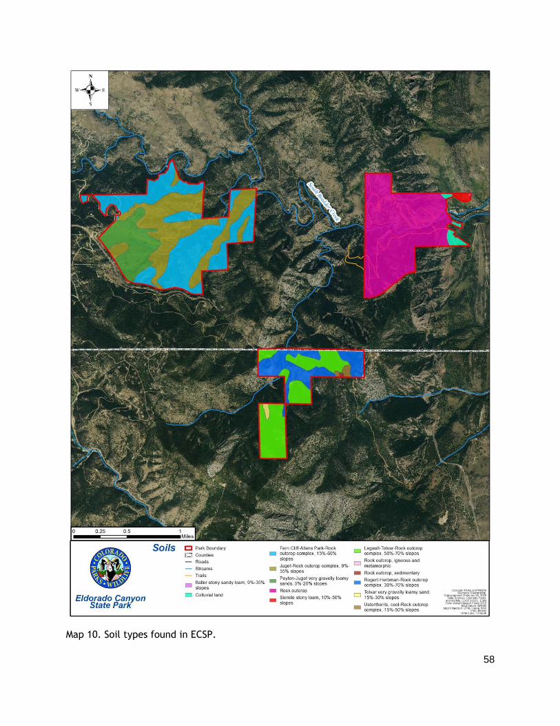
58
Map 10. Soil types found in ECSP.

59
Cultural Resources & Paleontological Resources
From subsistence uses that crafted a landscape of labor, to the shift toward a landscape of leisure dominated by a sprawling luxury resort, to a landscape characterized by outdoor recreation and rock climbing, Eldorado Canyon has been defined by the ways people interacted with the land. As visitors come to the park it is important for them to understand the history of the place that they are enjoying in order to see their connection to this place as only the most recent link in a longer chain of human activity—including Ute, Arapaho, and Cheyenne, Euro-American homesteaders, resort visitors, service industry laborers, and adrenaline-seeking recreationists who came before them.
The park's cultural and historical resources include:
● Remnants of Native American tribes that once inhabited the area and frequented Eldorado Canyon.
● Early European activity in the area consisted of homesteading, ranching, mining, and logging operations. In the 1890's single gauge railway grade was constructed in the canyon, but tracks were never laid; this abandoned grade is now the Fowler Trail. In the early 1900's, the construction of the Moffat Road line, Eldorado Springs Resort, Crag's Mountain Resort, and roadway through the canyon occurred.
● The canyon has a rich and long history as a destination for rock climbing.
Cultural resource surveys were completed in 2006 and 2010 for the Inner Canyon and Crescent
Meadows parcels. Several cultural sites were found in the two parcels and were considered in
the development of this plan. Cultural resource site reassessment surveys were completed in
the spring and summer of 2020 and paleontological surveys were completed in the Fall of
2019. The findings of these surveys and a comprehensive description of this area’s history is
included in the Cultural Resources section of the Stewardship Plan (Appendix D). Appendix D
also addresses potential threats to the cultural resources, interpretive opportunities to
promote cultural resource appreciation with visitors and guidance on minimizing impacts to
resources. Visitors are allowed to explore the remaining foundation of the Crags Hotel.
Nearby signage should indicate that everything should be left in place and photomonitoring
may be helpful to determine if the condition of this area further declines.
Scenic Resources
ECSP is known for its breathtaking vistas and scenic beauty. The Park has been captured as a
backdrop for television commercials, magazine advertisements, store catalogs,
documentaries, and graduation and wedding photographs. A rainbow of wildflowers bloom
throughout the summer, such as the white Canada violet, the blue harebell, orange to red
paintbrush, and the purple lupine (Appendix D).
Scenic areas of particular importance include: 1) Fowler Trail which features amazing views
of the canyon walls; 2) Rattlesnake Gulch Trail which provides exceptional views through the
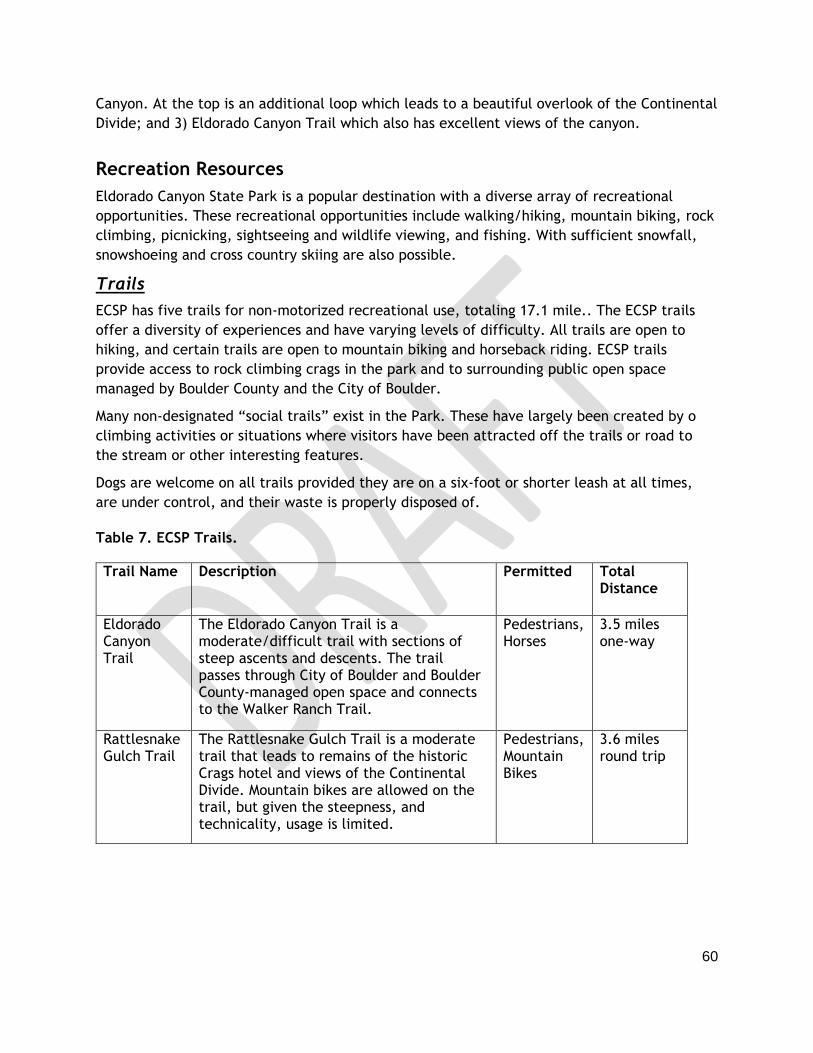
60
Canyon. At the top is an additional loop which leads to a beautiful overlook of the Continental
Divide; and 3) Eldorado Canyon Trail which also has excellent views of the canyon.
Recreation Resources
Eldorado Canyon State Park is a popular destination with a diverse array of recreational
opportunities. These recreational opportunities include walking/hiking, mountain biking, rock
climbing, picnicking, sightseeing and wildlife viewing, and fishing. With sufficient snowfall,
snowshoeing and cross country skiing are also possible.
Trails
ECSP has five trails for non-motorized recreational use, totaling 17.1 mile.. The ECSP trails
offer a diversity of experiences and have varying levels of difficulty. All trails are open to
hiking, and certain trails are open to mountain biking and horseback riding. ECSP trails
provide access to rock climbing crags in the park and to surrounding public open space
managed by Boulder County and the City of Boulder.
Many non-designated “social trails” exist in the Park. These have largely been created by o
climbing activities or situations where visitors have been attracted off the trails or road to
the stream or other interesting features.
Dogs are welcome on all trails provided they are on a six-foot or shorter leash at all times,
are under control, and their waste is properly disposed of.
Table 7. ECSP Trails.
Trail Name Description Permitted Total Distance
Eldorado Canyon Trail
The Eldorado Canyon Trail is a moderate/difficult trail with sections of steep ascents and descents. The trail passes through City of Boulder and Boulder County-managed open space and connects to the Walker Ranch Trail.
Pedestrians, Horses
3.5 miles one-way
Rattlesnake Gulch Trail
The Rattlesnake Gulch Trail is a moderate trail that leads to remains of the historic Crags hotel and views of the Continental Divide. Mountain bikes are allowed on the trail, but given the steepness, and technicality, usage is limited.
Pedestrians, Mountain Bikes
3.6 miles round trip
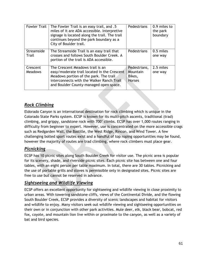
61
Fowler Trail The Fowler Trail is an easy trail, and .5 miles of it are ADA accessible. Interpretive signage is located along the trail. The trail continues beyond the park boundary as a City of Boulder trail.
Pedestrians 0.9 miles to the park boundary
Streamside Trail
The Streamside Trail is an easy trail that crosses and follows South Boulder Creek. A portion of the trail is ADA accessible.
Pedestrians 0.5 miles one way
Crescent Meadows
The Crescent Meadows trail is an easy/moderate trail located in the Crescent Meadows portion of the park. The trail interconnects with the Walker Ranch Trail and Boulder County-managed open space.
Pedestrians, Mountain Bikes, Horses
2.5 miles one way
Rock Climbing
Eldorado Canyon is an international destination for rock climbing which is unique in the
Colorado State Parks system. ECSP is known for its multi-pitch ascents, traditional (trad)
climbing, and grippy, sandstone rock with 700’ climbs. ECSP has over 1,000 routes ranging in
difficulty from beginner to expert. However, use is concentrated on the more accessible crags
such as Redgarden Wall, the Bastille, the West Ridge, Rincon, and Wind Tower. A few
challenging bolted sport routes exist and a handful of top roping opportunities may be found,
however the majority of routes are trad climbing, where rock climbers must place gear.
Picnicking
ECSP has 10 picnic sites along South Boulder Creek for visitor use. The picnic area is popular
for its scenery, shade, and riverside picnic sites. Each picnic site has between one and four
tables, with an eight person per table maximum. In total, there are 30 tables. Picnicking and
the use of portable grills and stoves is permissible only in designated sites. Picnic sites are
free to use but cannot be reserved in advance.
Sightseeing and Wildlife Viewing
ECSP offers an excellent opportunity for sightseeing and wildlife viewing in close proximity to
urban areas. With towering sandstone cliffs, views of the Continental Divide, and the flowing
South Boulder Creek, ECSP provides a diversity of scenic landscapes and habitat for visitors
and wildlife to enjoy. Many visitors seek out wildlife viewing and sightseeing opportunities on
their own or in conjunction with other park activities. Mule deer, elk, black bear, bobcat, red
fox, coyote, and mountain lion live within or proximate to the canyon, as well as a variety of
bat and bird species.

62
Other Recreational Resources
South Boulder Creek is a popular spot for visitors to explore and congregate by. Picnickers
often relax by the water as do other ECSP visitors. Tubing and rafting are not permitted in the
Creek, but kayaking is permitted.
South Boulder Creek is also used for fishing. The creek is an excellent fly-fishing area for
brown and rainbow trout. Because fishing is challenging in ECSP, the fish are typically
abundant and the fishing is good.
Hunting is not allowed in the Inner Canyon portion of the park, but it is allowed in a portion
of Crescent Meadows. Hunting is allowed the Tuesday after Labor Day to March 31, with
archery and black-powder weapons only. The appropriate license and all CPW hunting and
possession limits apply. Colorado Hunting Licenses are available at the ECSP Visitor Center.
Interpretation and Environmental Education
As part of its recreational development, the Park has invested in a range of interpretive
infrastructure, including interpretive displays at the Visitor Center, watchable wildlife signs
near the Visitor Center and the Fowler Trail, and historical signs along the Rattlesnake Gulch
Trail.
Interpretive Opportunities
The following subjects focus on what visitors should know, believe or do while at the park
and/or as a result of their visit. These should be developed into interpretive themes and
messages as part of efforts to update programming and signage in the park. The park
stewardship plan (Appendix D) may be referenced for more information on ECSP’s natural and
cultural resources to aid in program development.
● Unique features of Eldorado Canyon State Park
○ Geology; the history of the unique rock formations in the Inner Canyon. ○ Sensitive ecology; riparian areas, South Boulder Creek, rock formations, and
rare plants and animals. ○ Wildlife awareness and safety; ○ Importance of reducing human-wildlife conflicts.
● Cultural Resources and History
○ Eldorado Canyon’s history of human use started with subsistence then moved through labor, leisure and finally recreation as a primary activity.
○ Native American tribes once inhabited the area and frequented Eldorado Canyon.
○ European settlement of the land; the construction of the railroad that is now the Fowler Trail.
○ The construction of the Moffat Road rail line and its current operation. ○ The Eldorado Springs Resort in the early to mid 1900’s. ○ The Crags Mountain Resort. ○ The history of rock climbing at the park.

63
○ Role of climbing community and boulder county residents in conserving the park.
● Ethical Recreation/Leave No Trace ○ Dispose of waste properly ○ Make your visit part of the solution (practice low impact behaviors) ○ Observe seasonal closures for sensitive wildlife species, including nesting
golden eagles. ○ Know before you go (help avoid the need for rescue) ○ Keep Wildlife Wild (do not approach or feed wildlife) ○ Stick to trails ○ Leave it as you find it
● Climbing ○ Unique opportunity in the Colorado State Park system ○ Attracts climbers from around the world. ○ Role of ACE (Action Committee for Eldorado) as stewards of the climbing access
and routes
● Connection and Belonging ○ Everyone is welcome at ECSP.
■ As CPW works to improve the visitation/capacity issues it will be important to include messaging that all are welcome at the park and not confuse the need to disperse visitation with encouraging all to visit.
○ Eldorado is a treasure for both people and nature - we need your help to keep it that way
○ Eldorado is an integral part of the shared sense of identity and pride in the local community
○ We can't manage alone - partnerships with Boulder County, City of Boulder, Rocky Mountain Rescue, rock climbing groups, etc.
Interpretive Facilities
The Visitor Center is the primary location for interpretative information and events. It
contains interpretive displays, wildlife mounts, window lookouts, and a map of the park
listing the variety of recreation opportunities for visitors. Signage is present at the entrances
of the Inner Canyon and Crescent Meadows parcels, in the Visitor Center, and along the
Fowler and Rattlesnake Gulch Trails. Additionally, seasonal signage is present along the
Streamside trail warning visitors about hazards such as falling ice, poison ivy, and
rattlesnakes. The Visitor Center sells informative products such as natural and cultural
resource books.
Interpretive Programs
A Junior Ranger program is active at the park and provides an educational opportunity for kids
from age six to 12 who are interested in learning about Colorado’s natural resources. The
program features games, activities and crafts, fishing, rock climbing, nature photography,
and archery. The Little Critters program is for kids from three to five, and children read
64
stories, play games, and do crafts all related to the wildlife present at the park. Drum circles
also occur once a month in the summer as a way for people to connect to nature through
music. In recent years, the park’s capacity issues have interfered with the success of the
program due to participants being unable to enter the park due to long lines and congested
roadways. (Note: Due to the COVID-19 pandemic in 2020, the above mentioned interpretive
programs were postponed indefinitely. Instead, programming was focused on roving
interpretation and self-guided junior ranger activity booklets.)
The book sales program is operated through the Colorado Parks and Wildlife retail program.
Field guides, books on the ecology and history of the area, other nature books and postcards
and posters are just some of the items offered at the park visitor center. A small percentage
of gross sales (about $500) is returned to the park in the form of operating budget funds
annually.
Interpretive volunteers are present periodically and a seasonal interpretive intern is typically
hired for three months of the year. These individuals are available when encountered in the
park to provide natural and cultural resource information to visitors. Ideally, the park would
have funding to keep a full time interpreter year-round. Interpretive programs in recent years
have primarily been weekend programs. These programs attract visitors that are already at
the park during the summer months. Services at other times of the year are offered on a
request basis, as staff time is available.
Facilities and Infrastructure
The Park includes the following facilities listed below and shown in Map 11 (not including maintenance shop and house in town). As-built records for most facilities were destroyed in the
past, so estimates for facility areas are provided rather than exact measurements.

65
Map 11. Existing ECSP Facilities.
66
Existing Facilities
Park Office / Visitor Center
The Park office and Visitor Center is located one mile west of the Inner Canyon park entrance
(9 Kneale Road). It contains a bookstore / gift shop, a climbing wall display, a geology
display, and history display. The building also contains a meeting room with an attached patio
for educational trainings or business meetings only. The building serves as the Ranger Station
and offices for park staff. The Visitor Center was built in 2000 and is approximately 3,600
square feet. The Visitor Center also has a well house that was also constructed in the late
1990’s. Drinking water is provided inside the Visitor Center for the public and park staff.
Park Entrance Station
The park entrance station was constructed in 1999 and is approximately 200 square feet. A
new entrance station is planned for construction in the Spring of 2021 and will measure
approximately 240 square feet. The entrance station is staffed only during summer and other
busy times due to budget constraints, inclement weather, and volunteer availability. An iron
ranger (automated kiosk) and interpretive panels are located near the entrance station in the
Inner Canyon parcel for visitors accessing the park when the station is closed.
Park House and Garage
The park house and garage are located at 91 Eldorado Springs Drive and were built in the
1960’s. The garage has two bays for vehicles. Drinking water facilities are available at the
park house and garage for staff. This facility is used for housing for volunteers, seasonal
employees, and full-time employees as needed. The two-bay garage associated with the park
house is used as storage for dry goods, park supplies, OHV's, and some equipment.
Maintenance Facility and Garage
The maintenance facility and garage are located at 103 Eldorado Springs Drive. This facility
was acquired from Denver Water in 1999 and is the central location for all maintenance
operations. The facility consists of a storage yard, parking lot, and two and three-bay
garages.
Well House
The well house is an approximately 50 square foot free-standing, heated structure near the
entrance to the Inner Canyon. The structure is not part of ECSP operations. It is owned and
operated by Eldorado Artesian Springs Inc..
Flush Toilet Facilities
The only flush toilets in the park are located in the Visitor Center. The toilets operate with a
septic tank and leach field. The toilets were built when the Visitor Center was constructed, in
the late 1990’s.
Vault Toilet Facilities
The north picnic area toilets were built in 2014 and records do not exist for when the south
picnic area toilets were constructed. Both facilities are vault toilets. “Devaporative” vault
67
toilets are present in the main lot restroom, which were built in the late 1990’s. The main lot
restroom storage tank isn't exposed to the air - it's a "desiccating" toilet that works by drying
waste material. Overflow effluent is stored in a sealed tank. These lined and sealed vaults are
pumped as needed. All vault toilet facilities have been retrofitted with wildlife deterrent
screens.
Operations and Maintenance
General Park Operations
All of the Park’s major facilities are generally operational year-round. The entrance station is
open as staffing and budget allows. Park passes, registrations and licenses are available for
purchase at the visitor center during staffed hours. When possible and staffing is available,
the Visitor Center is open from 9 until 5 daily, but is open less frequently during the winter
months.
Self-service day passes are also available at the Iron Ranger near the entrance station.
Vehicles
The park has four full-time fleet vehicles. Three are ranger pick-up trucks and one is a dump
truck that is awaiting replacement. Other equipment includes two gas-engine off-highway
vehicles (OHVs) and one golf cart. All state fleet vehicle service is performed off-park by
authorized vendors. Almost all other fabrication and equipment repairs are performed at the
park maintenance facility.
Picnic Sites
Maintenance staff perform the cleaning and maintenance of the Park’s picnic sites daily
during peak season and as-needed during the off-season. Picnic sites are available year-round
on a first-come, first-served basis and are not reservable. Fires are prohibited at site 7 and
sites 9 and 10 do not have park provided grills, so guests must bring their own gas grill.
Roads and Parking Lots
In the Inner Canyon, the Park maintains about one mile of unpaved, gravel road by treating it
with dust suppressant annually and filling pot holes as needed. Crescent Meadows has 200
feet of road leading to a 25-car gravel parking lot. The Jefferson County parcel has an access
road in fair to poor condition that requires 4wd and is impassable in the winter. The public
does not currently have access to this road.
There are just over 200 parking spaces distributed throughout the Park. The largest parking
lots are located at the Visitor Center, the Entrance Station, and at Crescent Meadows.
Additional parking spaces and smaller lots are located at north and south picnic areas, the
Fowler/Rattlesnake Gulch Trailhead, and at the bend in the South Boulder Creek between the
picnic area and the Fowler/Rattlesnake Gulch Trailhead.
Trail Access
Park staff and volunteer groups generally maintain trails.

68
Trash and Waste Disposal
During the busy summer season, trash and recycling dumpsters are emptied weekly. In the
off-season, dumpsters are emptied as needed. OHV's and occasionally pickup trucks are used
to bring trash from visitor facilities to dumpsters.
Rock Climbing Routes
As per the Attorney General's direction, Park staff does not maintain fixed hardware or in any
way maintain climbing routes. Park staff closes roads, trails, and areas as necessary for
volunteer climbers to "trundle" loose blocks that pose a public safety hazard. The Park works
with the Action Committee for Eldorado (ACE), to update and fix climbing hardware.
Fencing and Wayfinding
There is some boundary fence at the west end of the Inner Canyon and within Crescent
Meadows. Most of the fence is privately owned and not well maintained by those owners. The
park owns a few "advisory" fences and gates to inform visitors of nearby private property.
Those advisory fences are maintained by replacing parts as necessary.
Noxious Weeds
The maintenance staff and associated volunteers provide noxious weed management and
control. When budget is available, the park retains contractors for invasive control in
Crescent Meadows. Every five years, the CPW Resource Stewardship Team maps noxious
weeds and updates the park’s Noxious Weed Management Plan.
Information Technology
Much of the Parks’ day-to-day business is currently conducted via web-based programs linked
to external servers for various reporting functions, which require fast, stable internet
connections. These reporting functions include revenue collection, visitation counts,
budgeting and accounting, law enforcement queries, payroll and personnel management.
Most of these administrative tasks are completed by staff working out of the visitor center
and park headquarters. Internet Service is a digital subscriber line (DSL) provided by Century
Link over voice phone lines. The internet service is very low speed in all facilities and limited
bandwidth may be due to distances from Central Offices. The current speed and stability of
internet services at the park is insufficient for current staff needs. The Visitor Center
currently has three laptop computers, four desktop computers, and three IPAWS (CPW’s
license and pass sales system) terminals for staff to use. Cell phone service is intermittent
throughout all parcels of the park.
Utilities
Electrical services are provided by Xcel Energy and provide power to the park house and its
garage, the three bay garage at the maintenance facility, the entrance station, the main lot
restroom facility, the Visitor Center, and the well house. Additionally, solar panels were
installed on the main lot restroom and will eventually be connected for "net metering.
Propane/natural gas is used to heat the Visitor Center, garage, and the park house.
69
Water Supply and Wastewater Treatment
The Visitor Center is served by a well. Its water is filtered and treated with chlorine, and is
tested quarterly to comply with Colorado Department of Public Health and Environment
(CDPHE) standards as a "small" water system. The park house and garage are served by water
from the Eldorado Artesian Springs Company.
Park Administration and Special Functions
Full-time and Seasonal Staffing
As of fall 2020, the Park has four full-time staff members and typically hires eight temporary
employees each summer. There is one Park manager, two Park rangers, and one Park resource
technician in full-time roles. In a typical season there are two temporary rangers, two
temporary entrance booth workers, one visitor center attendant, one interpretive assistant,
two temporary maintenance employees.
Volunteers
In 2019, Eldorado hosted 2,568 hours of office and entrance booth volunteerism, and 3,235
hours of stewardship (facilities, trail, invasives, trash cleanups) volunteerism - the equivalent
of over two full-time staff or 6 six-month seasonal staff. Most office volunteerism is
performed by individuals. Stewardship volunteerism is performed by individual volunteers,
corporate groups, and court-ordered volunteers.
The Action Committee for Eldorado (ACE), a non-profit corporation comprised of climbers
from local and national climbing organizations as well as other volunteers, advises the Park on
applications for new bolt and piton placements by representing views of the local climbing
community. The goal is to preserve the character of existing routes while allowing limited
development of new fixed gear routes. In addition, ACE raises thousands of dollars and
recruits and supervises scores of volunteers to support a wide variety of vital park projects.
Enforcement/Public Safety
Most of the Park violations encountered are considered "petty offenses" and involve dogs off
leash, illegal parking, or unlawful use/entry (camping, entering restricted or closed areas).
Over the past couple of years, the Park has seen a significant increase in drug (marijuana) and
alcohol-related violations. Currently, traffic control/enforcement is where much of staff time
is spent on the weekends during peak visitation (May-September).
MOUs, IGAs or Other Agreements
The Park leases approximately 73 acres adjacent to the Inner Canyon parcel from the City of
Boulder. There are climbing areas on that acreage that are well-served by management from
ECSP. There are two parcels: one encompasses Cadillac Crag and the other contains Upper
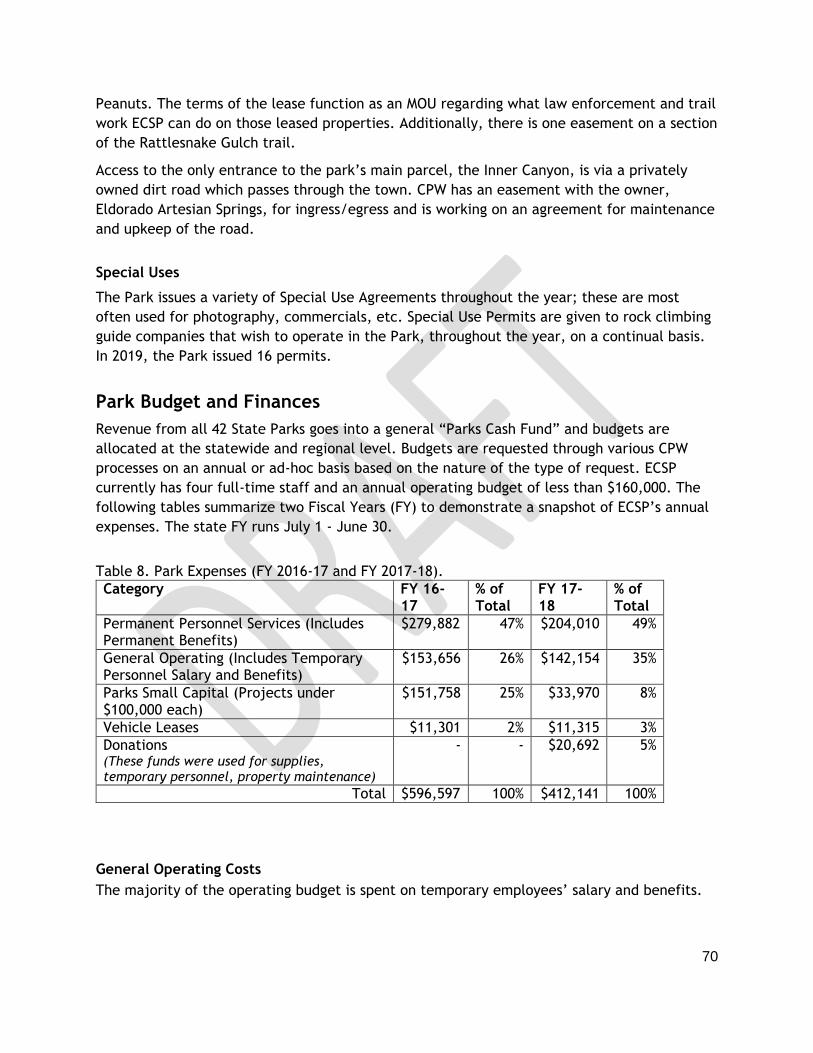
70
Peanuts. The terms of the lease function as an MOU regarding what law enforcement and trail
work ECSP can do on those leased properties. Additionally, there is one easement on a section
of the Rattlesnake Gulch trail.
Access to the only entrance to the park’s main parcel, the Inner Canyon, is via a privately
owned dirt road which passes through the town. CPW has an easement with the owner,
Eldorado Artesian Springs, for ingress/egress and is working on an agreement for maintenance
and upkeep of the road.
Special Uses
The Park issues a variety of Special Use Agreements throughout the year; these are most
often used for photography, commercials, etc. Special Use Permits are given to rock climbing
guide companies that wish to operate in the Park, throughout the year, on a continual basis.
In 2019, the Park issued 16 permits.
Park Budget and Finances
Revenue from all 42 State Parks goes into a general “Parks Cash Fund” and budgets are
allocated at the statewide and regional level. Budgets are requested through various CPW
processes on an annual or ad-hoc basis based on the nature of the type of request. ECSP
currently has four full-time staff and an annual operating budget of less than $160,000. The
following tables summarize two Fiscal Years (FY) to demonstrate a snapshot of ECSP’s annual
expenses. The state FY runs July 1 - June 30.
Table 8. Park Expenses (FY 2016-17 and FY 2017-18).
Category FY 16-17
% of Total
FY 17-18
% of Total
Permanent Personnel Services (Includes Permanent Benefits)
$279,882 47% $204,010 49%
General Operating (Includes Temporary Personnel Salary and Benefits)
$153,656 26% $142,154 35%
Parks Small Capital (Projects under $100,000 each)
$151,758 25% $33,970 8%
Vehicle Leases $11,301 2% $11,315 3%
Donations (These funds were used for supplies, temporary personnel, property maintenance)
- - $20,692 5%
Total $596,597 100% $412,141 100%
General Operating Costs
The majority of the operating budget is spent on temporary employees’ salary and benefits.

71
Table 9. General Operating Expenses (FY 2016-17 and FY 2017-18).
Category FY 16-17 % of Total
FY 17-18 % of Total
Temporary Personnel Services (Salary and Benefits)
$97,297 63% $86,140 61%
Property Repair, Maintenance, Improvements
$18,600 12% $4,990 4%
All Utilities $9,673 6% $11,481 8%
Supplies and Materials $14,926 10% $24,839 17%
Motor Vehicles (Supplies, Maintenance) $3,762 2% $4,715 3%
Equipment (Maintenance, Rental, Repair and Purchase)
$1,131 1% $420 0%
Services (Construction, Repair, IT, Testing, etc.)
$3,022 2% $5,328 4%
Communications (Telephone and Telecommunications)
$4,070 3% $4,179 3%
Other Miscellaneous Expenses $1,175 1% $62 0%
Total $153,656 100% $142,154 100%
Temporary Staff Resources
In addition to Eldorado Canyon State Park’s 4 full-time employees, the Park hires an
additional 8 temporary employees during the summer months as seasonal rangers, gate
attendants, visitor center attendants and maintenance workers.
Table 10. Temporary Employee Expenditure Detail (Salary and Benefits) (FY 2016-17 and FY 2017-18).
Activity FY 16-17
% of Total
FY 17-18 % of Total
Customer Service $32,630 34% $26,101 30%
Organizational Support $31,924 33% $23,361 27%
Law Enforcement $19,384 20% $23,057 27%
Environment & Wildlife Education $12,133 12% $10,043 12%
Park and Trail Recreation $1,226 1% $3,578 4%
Total $97,297 100% $86,140 100%
Large Capital Construction Projects
Large capital construction projects are high-dollar improvements to the Park that are
considered on an annual basis. There have been no recent large capital projects; however,
the entrance station redesign is scheduled to begin in Spring 2021.

72
Citations
Belmar M. 2019. Eldorado Canyon State Park Vegetation Assessment Report. Collective
Ecological Consulting, LLC, Denver, CO.
CDNR. 1995. Wetland Resources of Eldorado Canyon State Park.
CPW. 2000. Eldorado Canyon State Park Management Plan. Colorado Parks and Wildlife.
CNHP. 2013. About the Heritage Network Ranking System. Available from
http://www.cnhp.colostate.edu/about/heritage.asp (accessed November 29, 2017).
CPW. 2015. State Wildlife Action Plan. Colorado Parks and Wildlife. Available from
https://cpw.state.co.us/Documents/WildlifeSpecies/SWAP/CO_SWAP_MainDocOnly.pdf.
CPW. 2017. Colorado Parks & Wildlife - CWD Info & Testing. Available from
http://cpw.state.co.us/learn/Pages/ResearchCWD.aspx (accessed June 26, 2017).
CPW. 2019a. Herd Management (DAU) Plans. Colorado Parks and Wildlife. Available from
https://cpw.state.co.us (accessed October 21, 2019).
CPW. 2019b. About CWD and Adaptive Management. Available from https://cpw.state.co.us
(accessed October 21, 2019).
CPW. 2019c. Eldorado Canyon State Park Weed Management Plan. Colorado Parks and
Wildlife, Denver, CO.
COPARC. 2018. Prairie Rattlesnake. Available from
http://www.coparc.org/prairie_rattlesnake.html (accessed March 12, 2020).
COSFS. 2019. Wildfire Risk Assessment Public Viewer. Available from https://co-
pub.coloradoforestatlas.org/#/ (accessed October 29, 2019).
COSFS. 2020. Colorado’s Major Tree Species. Available from
https://csfs.colostate.edu/colorado-trees/colorados-major-tree-species/ (accessed February
21, 2020).
Jones S. 2015. Eldorado Canyon State Park Breeding and Migratory Bird Survey.
NatureServe. 2019. Global Conservation Status Rank Definitions. Available from
http://explorer.natureserve.org/granks.htm (accessed March 6, 2020).
NRCS. 2019. Custom Soil Resource Report for Boulder County Area, Colorado; and Golden
Area, Colorado, Parts of Denver, Douglas, Jefferson, and Park Counties. US Department of
Agriculture, Natural Resources Conservation Service.
Rocky Mountain Forestry, LLC. 2017. Forest Management Plan.
Triece K, Davenport N, Ehrenberger J. 2019. A Survey of Amphibians, Reptiles, and their
Habitats at Eldorado Canyon State Park. Adaptation Environmental Services, Denver, CO.

73
USGS. 2019. Personal Communication with Alan Duran of the USGS about Stream Gauge
06729500.
Yochum SE. 2015. Colorado Front Range Flood of 2013: Peak Flows and Flood Frequencies. US
Forest Service, National Stream and Aquatic Ecology Center, Fort Collins, CO. Available from
https://www.fs.fed.us/biology/nsaec/assets/yochum_sedhyd-
2015_proceedings_2013cofrontrangeflood.pdf (accessed October 14, 2019).
74
4.0 VISITATION
Significant increases in visitation to ECSP created concerns about the visitor capacity of the
park and impacts to its facilities and resources. ECSP staff perform law enforcement, visitor
services, education, interpretation, maintenance, and natural resource stewardship duties.
However, on the frequent busy days, many or even all staff on duty are needed to manage
parking which keeps them from performing other primary duties.
To assess visitation trends, where and how visitors use ECSP and understand the visitor
experience, CPW collected qualitative and quantitative data via input from the public, staff,
neighbors, park visitors and partner agencies (see Chapter 1).
In addition, a Capacity Study (Appendix C) provided detailed information and analysis of data
from onsite surveys of park visitors, a traffic study, trail counters and other park records. This
study also allows CPW to examine relationships between the existing visitor use and the
condition of the natural resources to identify future monitoring priorities. Visitor use counts
are a factor in the condition of the natural resources, but other factors, such as visitor
behavior and the sensitivity of the resources are key components as well. As most people visit
the Inner Canyon, the Capacity Study focused on that parcel and did not include Crescent
Meadows. Findings from this study are embedded in the following sections but the key
takeaways include:
● While annual ECSP visitation has increased significantly in recent years, the number of
visitors on the park’s busiest days cannot and has not increased significantly due to
the ECSP parking capacity. However, the frequency of these peak, busy days has
increased. The growth in visitation occurred throughout the year, rather than solely as
an increase in summer visitation.
● The limited number of parking spaces makes ECSP access challenging and limits the
number of visitors to the recreational facilities. However, once visitors are in ECSP,
they report a pleasant, relatively uncrowded experience. In a way, the limited parking
capacity of ECSP leads to a positive experience for visitors once they enter.
Access & Parking
Inner Canyon
Access to and from the Inner Canyon portion of ECSP is via the two-lane State Highway 170
and Eldorado Springs Drive, which connect State Highway 93 to the park entrance station.
State Highway 170 is a paved road that extends approximately 3 miles, from its intersection
with State Highway 93 to Eldorado Springs. From the beginning of Eldorado Springs to the
entrance station of ECSP, the road is a narrow, private dirt road.
The ECSP entrance station is a key component to the park’s visitor service operations. The
entrance station is staffed as often as possible with temporary staff and volunteers frequently
running the entrance station. Visitors purchase daily or annual passes, pick-up a park map and

75
ask questions. This may be the only opportunity CPW has for in-person communication with
visitors. During busy periods, ECSP staff count available parking spaces, turn vehicles away,
and instruct visitors on where available spaces are. Managing parking and vehicle circulation
inhibits the staff from performing other duties during those periods.
The limited parking supply in ECSP can lead to vehicles denied entry into the park and/or
extended queues at the entrance station that back up into the town of Eldorado Springs. The
ECSP entrance station is able to process vehicles quickly but has to hold vehicles in a queue
when no spaces are available or as staff assist others in finding a spot. The estimated number
of days in which the demand for parking exceeds the supply and vehicles are turned around
has increased.
There is an ‘iron ranger’ (self-service station) for visitors walking or biking into the park to
purchase passes. Most ECSP visitors enter the park by vehicle, but some visitors (especially
local residents) do enter by walking in or biking in. Walk-in visitors or bike-in visitors are
primarily residents of Eldorado Springs, with some people parking in town and walking in on
busy days or hiking in via the Fowler Trail and parking on Eldorado Springs Drive. Some of the
walk-in visitors may have parked illegally in town using spots intended for residents and
visitors to Eldorado Springs Pool & Event Center.
To reach the ECSP Visitor Center, Eldorado Canyon trailhead, and picnic area, visitors must
travel approximately 1 mile along a narrow one-lane dirt road. Some visitors travel the park
road by vehicle, while others park lower down at ECSP and walk or ride their bikes up to the
Visitor Center area or Fowler trailhead. Some sections of the road are wide enough for two
cars to pass safely but the majority of the road is one lane, frequently requiring vehicles to
pull over to allow oncoming vehicles or large groups of pedestrians to pass. Generally,
vehicles travel slowly through ECSP due to the crowded, mixed-use condition of the roadway.
All trail and road intersections are signed. Park speed limits are posted and monitored by park
rangers as needed. The parking spaces are not delineated, and improper parking can slightly
reduce the number of parking spaces.
Crescent Meadows
Crescent Meadows can be accessed by vehicle or on foot or bike. Vehicular access is from
Gross Dam Road, which is the continuation of Flagstaff Road and connects with Coal Creek
Canyon Road. Crescent Meadows has a small dirt parking lot adjacent to the trailhead. The
Walker Ranch Trail passes through Crescent Meadows. The trail is a loop open to hikers and
mountain bikers, with access from Boulder County Parks and Open Space trailheads and for
hikers, from the Inner Canyon portion of ECSP via the Eldorado Canyon Trail.
In 2020, visitation related to the COVID-19 pandemic (i.e. out of work or working from home
Coloradans spending time outdoors due to business closures) resulted in the “discovery” of
Crescent Meadows; in turn, parking capacity, resource degradation, and public safety
challenges are more commonplace should be considered in future visitation studies. Boulder
County is also planning capital improvement and maintenance projects for the Walker Ranch
trailheads.

76
Visitor Demographics & Patterns
For the first time, it was documented that visitors to the park are primarily from the Denver
Metropolitan Area (Denver Metro) which does not include Boulder County. Of visitors
surveyed, 11% were from the City of Boulder, 11% were from elsewhere in Boulder County,
53% were from the Denver Metro Area, 1% were from elsewhere in Colorado, and 25% were
out-of-state visitors. Of out-of-state visitors, 20% came with a local resident, and the
remaining 80% came independently. On weekends, the breakdown of visitor origin shifts
slightly, with more visitors from the Denver Metro Area and fewer from out-of-state.
Visitor origin correlates to park activity, with Boulder County residents representing a high
percentage of rock climbers and Denver Metro residents a high percentage of picnickers, and
out-of-state visitors a high percentage of sightseers.
The four primary activities that ECSP visitors participate in are hiking, rock climbing,
picnicking, and sightseeing. Of ECSP summer weekend visitors, 46% are hiking, 12% are rock
climbing, 17% are picnicking, and 25% are sightseeing. During the week, the percent of ECSP
visitors picnicking and sightseeing is slightly lower, with the percent hiking slightly higher.
Of all surveyed, 63% had been to ECSP before. Of participants who had visited ECSP before,
49% visit 1 to 3 times per year, 15% visit 4 to 10 times per year, 18% visit 11 to 30 times per
year, and 18% visit more than 30 times per year.
Climbers (91%) and picnickers (88%) were most likely to have visited previously. While
climbers are a small percentage of total summer visitors, individual climbers tend to be avid
users visiting the park most frequently, with 48% of those of surveyed visiting 30+ times per
year and 33% visiting 11 to 30 times per year.
Visitation Trends
Overall Visitation
Visitation has grown across CPW’s Northeast (NE) Region State Parks, although to a lesser
extent than at ECSP. From July 2017- June 2018, the NE Region parks saw 28% growth with
7.45 million visits, up from 5.8 million in 2013-14. In that same period, ECSP visitation grew
by 122%.
Park visitation grew slowly prior to 2017, with an average of approximately 300,000 annual
visitors. In 2017, annual visitation jumped to almost 500,000 annual visitors, and visitation
crossed the 500,000 mark with another strong year of growth in 2018. In 2019, the park had
440,775 visitors. The lower number is likely a result of early summer rains and heavy snows in
late fall 2019.
Figure 2. ECSP Annual Visitation, 2011-2019

77
The highest visitation month at ECSP has been June, with an average of over 71,000 visitors
per month. July and August are the next busiest months, with an average of 65,000 visitors in
each of those months.
The growth in annual visitation has been a result of a significant increase in visitation in each
month of the year, rather than solely a spike in summer visitation. The following table shows
the percent increase each month from 2016 to 2018. The first few months of the year had
higher percent increases from 2016 visitation levels. The summer months did not have the
highest growth, as they started with higher visitation in 2016, and there was little room for
growth on peak days due to the parking supply.
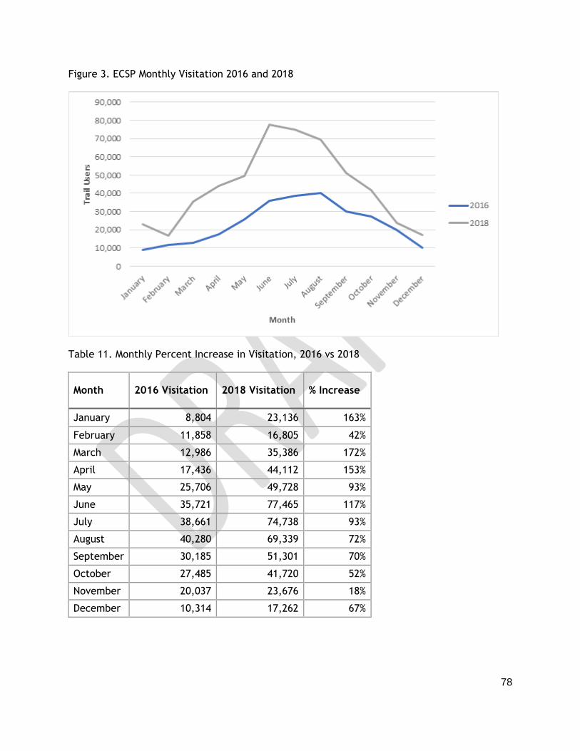
78
Figure 3. ECSP Monthly Visitation 2016 and 2018
Table 11. Monthly Percent Increase in Visitation, 2016 vs 2018
Month 2016 Visitation 2018 Visitation % Increase
January 8,804 23,136 163%
February 11,858 16,805 42%
March 12,986 35,386 172%
April 17,436 44,112 153%
May 25,706 49,728 93%
June 35,721 77,465 117%
July 38,661 74,738 93%
August 40,280 69,339 72%
September 30,185 51,301 70%
October 27,485 41,720 52%
November 20,037 23,676 18%
December 10,314 17,262 67%
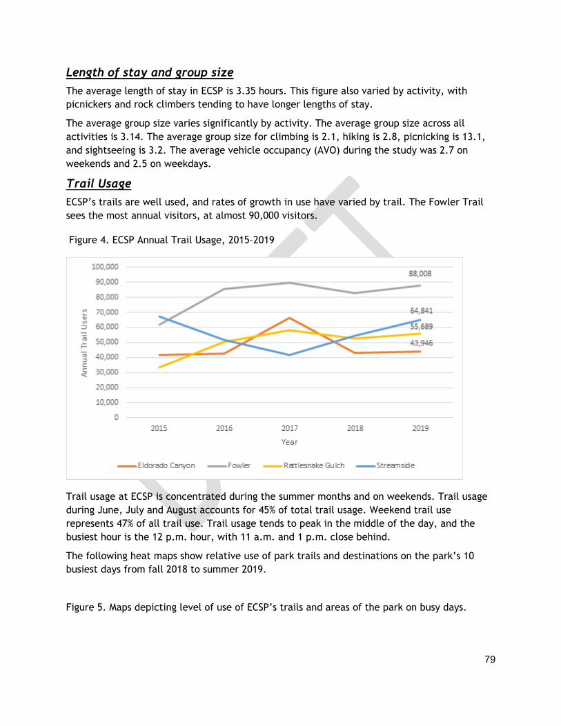
79
Length of stay and group size
The average length of stay in ECSP is 3.35 hours. This figure also varied by activity, with
picnickers and rock climbers tending to have longer lengths of stay.
The average group size varies significantly by activity. The average group size across all
activities is 3.14. The average group size for climbing is 2.1, hiking is 2.8, picnicking is 13.1,
and sightseeing is 3.2. The average vehicle occupancy (AVO) during the study was 2.7 on
weekends and 2.5 on weekdays.
Trail Usage
ECSP’s trails are well used, and rates of growth in use have varied by trail. The Fowler Trail
sees the most annual visitors, at almost 90,000 visitors.
Figure 4. ECSP Annual Trail Usage, 2015–2019
Trail usage at ECSP is concentrated during the summer months and on weekends. Trail usage
during June, July and August accounts for 45% of total trail usage. Weekend trail use
represents 47% of all trail use. Trail usage tends to peak in the middle of the day, and the
busiest hour is the 12 p.m. hour, with 11 a.m. and 1 p.m. close behind.
The following heat maps show relative use of park trails and destinations on the park’s 10
busiest days from fall 2018 to summer 2019.
Figure 5. Maps depicting level of use of ECSP’s trails and areas of the park on busy days.

80
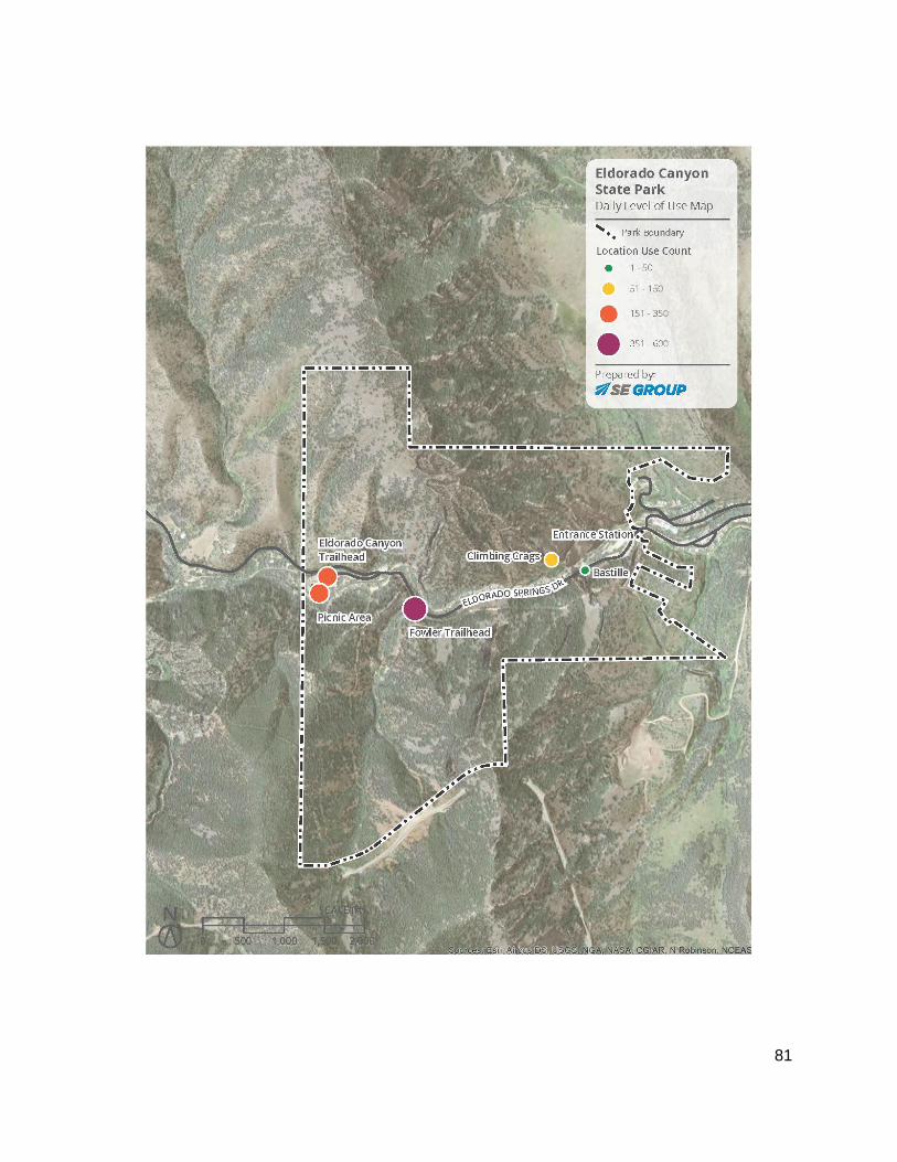
81

82
Quality of Visitor Experience
Overall, visitors rate their experience at ECSP very positively. Of visitors surveyed, 79% rated
their experience as excellent and 18% rated their experience as good (97% overall positive
rating). Experience ratings were slightly lower on weekend days and by visitors who had been
to the park previously. Of weekend visitors, 78% rated their experience as excellent,
compared to 84% of weekday visitors. Of repeat visitors, 77% rated their experience as
excellent, compared to 83% of first-time visitors.
Experience varied slightly by park activity. All (100%) climbers surveyed rated their
experience as excellent or good, compared to 99% of hikers, 96% of picnickers, and 93% of
sightseers. A higher percentage of picnickers rated their experience as good rather than
excellent compared to other activity participants.
The arrival experience of waiting in line, potentially parking away from the desired location
and navigating the busy roadway can be a frustrating way to begin a visitor’s day at the park.
Visitors rate their experience accessing the park lower than overall park experience, but
responses were still fairly positive. Approximately 75% of ECSP visitors on weekend days rated
their accessing experience as good or excellent. Comparatively, 87% of weekday ECSP visitors
rated their accessing experience as good or excellent. On one of the weekend days when
visitors were surveyed, only 22% rated their accessing experience as excellent, compared to
66% on the weekday. Finally, in responding to the survey, many climbers expressed strong
awareness of the access issues and were very interested in the Management Plan process.
On weekends, 5% of visitors said crowding at their activity was an issue, while an additional
24% said their activity was crowded but the crowding did not detract from their experience.
Hiking trail capacity is subjective, and determining factors include trail character, desired
experience, and setting. Visitors’ experience and sense of trail crowding is often influenced
by the regional context and other recent hiking experiences. Of all the activity participants
surveyed at ECSP, hikers were the least likely to state that their activity felt crowded. These
survey responses suggest that the ECSP hiking trails are not at their capacity, from the user
experience perspective, and could accommodate additional hikers before significantly
degrading the user experience.
Feelings of crowding were most prevalent amongst picnickers and climbers at Redgarden and
Bastille crags (which are very accessible and have some of the ‘easier’ routes).
Eldorado Canyon has over a thousand climbing routes, but rock climbers tend to congregate
on a few most accessible crags. Rock climbers tend to have a very positive experience at
ECSP, but many noted crowding issues on a few crags. Like hiking, climbing capacity is also
subjective, although safety can be an important factor. Overall, the climbing opportunities
may not be at capacity, but the survey results suggest that certain crags are approaching
their capacity. Likely, use will continue to be concentrated on those crags in the future and
continued monitoring and strategies to support safer climbing in crowded conditions may be
necessary.

83
The ECSP picnic sites are a popular destination for large groups. The picnic areas see limited
turnover, as length of stay is long, and the demand is concentrated in the middle day. Of
activity participants surveyed at ECSP, picnickers were most likely to say they experienced
crowding and that it was an issue. Given the concentration of demand during the middle of
the day and other factors, the picnic area may be close to its capacity during that time frame
on summer weekend days and holidays.
Visitation Capacity
Factors beyond level of visitation can have a strong impact on the visitor experience and
resources. Visitor capacity, as considered by CPW and established by the federal Interagency
Visitor Use Management Council, is defined as:
“A component of visitor use management, visitor capacity is the maximum amounts and types
of visitor use that an area can accommodate while achieving and maintaining desired resource
conditions and visitor experiences consistent with the purposes for which the area was
established.”
An annual capacity figure was not determined because of the intrinsic nature of park
visitation, with busier and less busy days: it is not reasonable to expect the park could
achieve its capacity each day, nor should it, as slower days provide a different visitor
experience, allow park staff to address maintenance projects and other needs, and help
maintain park resources.
As mentioned earlier, the number of parking spaces does currently limit the number of
visitors at the park at any given time. In addition, CPW can not enforce an exact number of
visitors due to multiple entrances, varying number of people per vehicle, etc. CPW may work
towards setting a daily capacity figure as new strategies to limit the number of vehicles
attempting to access the park are implemented so that the number of visitors does not
continue to grow.
Chapter 6 outlines the management strategies intended to relieve the pressure and impacts
that increased visitation places on the park, the visitor experience and the surrounding
environs.

84
5.0 MANAGEMENT ZONES
CPW’s park management zoning scheme (Table 12) provides a framework for identifying
suitable types of facilities and land uses along with the suggested visitor experience and
management focus. The zone types are used across the state park system, but zoning for each
park is done at the park scale. This allows for the individual parks to protect their most
significant resources and provide unique visitor experiences. Zoning is based on “desired
future conditions” (see Chapter 1) - i.e., beyond the timeframe of this Plan, what should the
park resources, management focus and visitor experience be into the future? Any zone can
incorporate seasonal closures or other temporal needs. Seasonal closures occur at ECSP to
protect nesting raptors.
ECSP staff expertise and the various maps in Chapter 3 (ex., condition and location of natural
resources, existing infrastructure and recreation opportunities) were used to determine
appropriate management zones (Map 12).
Key considerations that were taken into account during the park management zoning process for ECSP include:
❖ Stewardship Plan baseline data including vegetation condition, ecological sensitivity and location of rare species.
❖ Protection of riparian areas (interface between land and water bodies) as important corridors for wildlife movement
❖ Maintaining good and excellent condition of vegetation ➢ Protect rare plants and plant communities ➢ Takes significant staff resources to maintain good and excellent condition of
most vegetative communities. ❖ Use seasonal closures to minimize disturbance to nesting raptors
➢ Consider future seasonal closures during active rattlesnakes months as these are the highest number of “negative” human-wildlife encounters with a safety concern. Staff currently puts out signs when rattlesnakes are active to discourage use of the area (ex., East side of Bastille). The same efforts are made for mountain lion and bear activity.
❖ Maintain “open space” character of Crescent Meadows ➢ No further amenities or development currently planned for this parcel ➢ Unique experience in ECSP to be on a trail further away from main developed
areas ❖ Opportunities for engaging with visitors
➢ Historic structures ➢ Fowler Trailhead
■ Fowler Trail to remain accessible to ADA standards ❖ Climbing opportunities zoned by “popularity,” location relative to sensitive resources
(ex., raptors, crumbly rock faces) and intensity of management needs ➢ Intensity of use for some climbing access and routes varies seasonally

85
Zone
Classification
Visitor Experience Recreation Opportunities Potential Facilities Management Focus
Development
▪ High social
interaction
▪ Low opportunity
for solitude
▪ Low opportunity
for challenge
▪ High-density recreation
▪ Emphasis on providing
opportunities that rely on
motor vehicle access via
roads such as picnicking,
and at some parks could
include RV and tent
camping, and potentially
motorized uses in
designated areas.
▪ Some fishing, boating,
equestrian use, mountain
biking, hiking, and
watchable wildlife may
occur in this zone.
▪ Typically parking areas,
paved or high-use roads,
utilities, group picnic areas,
visitor services, restrooms,
concessions, interpretive
facilities and at overnight
parks, developed camping
areas.
▪ Less typically this could
include marinas, motorized
use areas, and dog off leash
areas at some parks.
▪ Intense management
needs
▪ Manage to provide
sustainable recreation
and aesthetic qualities
▪ Prevent weed spread,
erosion, or other
degradation
▪ Intense fire prevention
mitigation
▪ Revegetate with
natives where possible
or with non-invasive
landscaping
Passive
Recreation
▪ Moderate social
interaction/low
opportunity for
solitude
▪ Moderate degree of
interaction with the
natural
environment
▪ Moderate
opportunity for
challenge
▪ Medium-density recreation
▪ Emphasis on providing
hiking, fishing, equestrian
use, mountain biking and
other dispersed recreation.
▪ Some picnicking or
backcountry camping,
canoeing and other non-
motorized boating,
watchable wildlife,
interpretive opportunities
are likely to occur in this
zone
▪ Typically trails and
interpretive facilities and
individual picnic areas.
▪ Less typically this could
include dirt roads or light
use roads, limited
motorized uses (in larger
parks only), hike-in
campgrounds, or yurts
▪ Minimize utilities to the
extent possible
▪ Moderate to High
management needs
▪ Manage to maintain the
natural character and
provide sustainable
recreation
▪ Actively manage
weeds in order to
eradicate or suppress,
and prevent erosion or
other degradation
▪ High level of fire
prevention
▪ Revegetate with native
species
Natural
▪ Low social
interaction/moderat
e opportunity for
solitude
▪ High degree of
interaction with the
natural
environment
▪ Moderate to high
opportunity for
challenge
▪ Medium- to low-density
recreation.
▪ Emphasis on providing
low impact, non-motorized
and dispersed recreation.
▪ All recreation
opportunities in the
Passive Recreation Zone
are likely to occur here
with the exception that
there be more of an
emphasis on providing
non-motorized dispersed
recreation.
▪ Hunting also permissible at
some parks
▪ Primarily trails and some
interpretive facilities
▪ Minimize utilities to the
extent possible
▪ Moderate to low
management needs
▪ Manage to maintain the
natural character, the
native flora, the
wildlife habitat, and the
ecological functions
▪ Actively manage
weeds for eradication,
prevent erosion or
other degradation
▪ Moderate to high level
of fire prevention
▪ Revegetate with native
species
Protection
▪ Typically
unmodified natural
environment
▪ None, or heavily restricted ▪ None ▪ Least intense
management needs
▪ Preservation of very
sensitive resources or
restriction of visitor
use for legal or safety
reasons.

86
Table 12. Management Zone Classification Scheme and Characteristics
Description of Management Zones
In general, there is a desire not to divide the park up into many small pieces but ensure the key areas are zoned appropriately. Most of the park (93%) is classified as Protection or Natural which reflects the unique features and recreation opportunities found at ECSP.
Key features and descriptions of ECSP zones include:
Development (18.3 acres)
The Inner Canyon’s Development Zone is primarily along the park road, where most park facilities and infrastructure are concentrated to provide access and minimize disturbance to other areas of the park. This zone includes the existing facilities and infrastructure (excluding trails and climbing routes):
● Road ● Visitor Center ● Picnic Areas ● Entrance station ● Parking Areas ● Railroads ● Dam Structure
The parking area at Crescent Meadows and limited access to the Jefferson County parcel are also designated as ‘development’.
Passive Recreation (78.9 acres)
The climbing area on the north side of South Boulder Creek has been zoned “passive” due to the substantial resources required for some climbing areas and emergency access. This area requires the 'moderate to high management focus' of this zone type.
Each trail route, with an 8 meter buffer, is zoned as passive. This buffer accounts for recreation impacts to the surrounding area.
Despite the park’s high visitation, there are sections of ECSP’s longer trails with relatively few people. Preserving this opportunity (i.e., solitude on trails so close to Denver and Boulder) supports the park’s goals to optimize the park’s unique character and provide outdoor experiences that promote mental well-being.
The ruins of the Crag Hotel are included in this zone to allow the Rattlesnake Gulch Trail's 50,000 annual visitors to examine the ruins.
In Crescent Meadows only the trail corridor is considered passive.
Natural (441.5 acres)
● Inner Canyon

87
○ The northwest section of this parcel has climbing routes with lower visitor use, that are more challenging and with crumbly walls. The area beyond these routes to the park’s boundary with private property is not accessible and there are no plans to add any routes in this area. Raptors also use this area for nesting.
○ This zone also includes some areas that have a few social trails and where visitors may be present.
○ South Boulder Creek has been zoned “natural” with a 20 meter buffer to
reflect how the creek itself is managed. Due to existing recreation within the
buffer, the creek is not zoned ‘protection’ but protecting the creek is a high
priority. A rare plant (Sprengel’s sedge) has been documented along the creek.
The associated recreation areas are in other zones (e.g. picnic areas are
“development’’)
● Crescent Meadows
○ The northern portion of this parcel is zoned natural. There are social trails with
scenic views and opportunity for solitude in this section of this parcel.
○ The terrain in this area can be challenging therefore limiting expectations of
increasing visitation.
○ Mule deer winter concentration area is present in the north half of the parcel.
Protection (855.5 acres)
● Jefferson County parcel - CLOSED to public access ○ Except for a private road, only railroad and park staff access this area zoned
for ‘protection’ ○ There are no current plans to begin to allow access or provide recreation
opportunities in this parcel. Any change to management of this area would warrant an update to this Plan.
○ This parcel is surrounded by dense private forest and Boulder County Open Space. While wildfire remains a concern, fuels mitigation is a relatively low priority given the access and slope limitations in the area coupled with the extremely low density of surrounding development and lack of park visitor use.
● Crescent Meadows ○ All portions of the parcel south of the trail is zoned ‘protection.’ ○ There is habitat suitable for Preble’s jumping mouse (federally threatened) ○ This area is in severe winter range for elk. ○ There are wetlands present that are important wildlife habitat and could
provide habitat for the rare species, northern leopard frog. ○ There are sensitive cultural resources in this area ○ Hunting is allowed but only with primitive weapons.
● Inner Canyon: ○ Areas of this parcel near and at the top of the canyon walls where there will
not be trails, climbing access or climbing routes are zoned “protection” ○ These areas are talus fields and have significant rockfall safety concerns. ○ Rock outcrops provide potential nesting substrates for raptors.
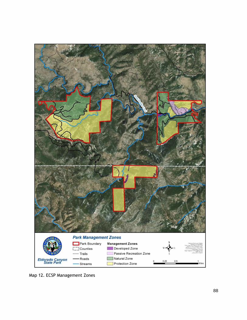
88
Map 12. ECSP Management Zones

89
Map 13. Inner Canyon and Crescent Meadows Management Zones

90
6.0 MANAGEMENT STRATEGIES
This chapter highlights management strategies needed to meet Park Goals and bring about
the Desired Future Conditions outlined in this plan. The implementation of strategies
presented is contingent on the park securing adequate financial and human resources, and
must be considered or weighed within the context of other CPW-wide priorities.
Visitor Use Management (VUM) refers to an iterative process used to address the complexities
of management of visitor access, use and experience while protecting the park’s resources.
Earlier sections of this plan outline ECSP’s visitation trends, visitor behavior, impacts to the
resources and visitor experiences as well as analyze the underlying causes of these trends and
impacts. In addition, the Interagency Team, Task Force and public provided valuable guidance
for developing focus areas and strategies.
Due to the dynamic nature of visitor behavior, recreation trends, population trends, natural
disasters (i.e., fire, flood, drought) and other changing conditions, the Plan addresses the
current state of ECSP and the information available to address the park’s resource needs.
Nationally, increasing visitation to parks is placing additional pressure on many park’s
resources. As CPW, partner agencies and others continue to improve VUM, capacity standards
and best management practices, CPW will update management planning efforts at ECSP.
During the planning process, CPW confirmed that, for staff, visitors, neighbors, the “status
quo” is not sufficient to meet the park resource condition and management goals. In order to
(1) maintain a quality visitor experience, (2) avoid surpassing CPW’s ability to maintain the
high quality resource conditions in the park, and (3) improve working conditions for staff and
volunteers, strategies in the following focus areas are being considered for implementation.
These focus areas are divided into six categories: 6.1. Health, Safety and Staffing, 6.2.
Natural and Cultural Resource Protection, 6.3. Communication, 6.4. Access and Parking, 6.5
Trails and Picnic Area and 6.6 Other Facilities and Infrastructure. Some of these strategies
will be implemented immediately, some will be phased in over the next few years and others
are not anticipated for 5-10 years or more.
Implementation of each strategy will take time and planning as well as require flexibility and
adaptation as they are rolled out. It will be difficult to develop or fully assess future actions
until the impact of near-term actions and changes in visitor behavior and trends can be
observed. Incremental changes, with intent of long-term beneficial cumulative impacts, are
to be expected.
A note on implementation and COVID-19: CPW intended to gather public input on a draft of
this plan in Spring 2020. This was delayed due to the global pandemic. With limitations on
travel, schools, work and other activities coupled with strong support from Governor Polis
for outdoor recreation and our State Parks there were sharp increases in visitation starting
in March 2020. To address this reality and prepare for summer visitation, CPW piloted some
of these management strategies prior to input on and completion of this plan.

91
6.1 Health, Safety & Staffing
CPW provides safe, healthy, accessible facilities and infrastructure to visitors and staff.
Safety is a top priority and a critical factor in all current and future park operations. Key
requirements include (1) relieve staff stress and reduce human resource allocations through
reduced complaints from visitors and reduced visitation pressure during peak use and (2)
provide visitors with consistent education, emergency assistance, enforcement, maintenance
of facilities, roads, trails and environmental protection.
Need: Upgrade and add restroom facilities in high use areas.
Strategy: Add restroom facilities at South picnic, Fowler trail and main lot.
Strategy: Upgrade existing restroom facilities in the Park as dictated by visitor use.
Need: Reduce risk of wildfire.
During times of high fire risk, CPW will reduce potential for fire in the park by managing the use of fire by visitors and establishing procedures for staff to ensure the picnic area is safe to close each evening.
Strategy: Implement park specific fire restrictions such as closure of the picnic area one hour prior to park closure or complete ban of fire in the picnic area.
Need: Increase number of staff
With the existing levels of Park visitation and access issues, the Park’s staff resources are heavily taxed. Consistent staff presence at the park entrance, Visitor Center, on trails, and at Crescent Meadows is needed throughout the year to meet the management goals of this plan. Additional staff could help increase outreach to visitors on trail etiquette and park use, efforts to protect natural resources and support maintenance of trails and facilities.
Strategy: Identify the number and type of employees needed to implement this Plan and sustain operations for the next decade. Reevaluate this staffing plan annually as implementation of strategies progress and needs shift.
Strategy: Identify gaps between existing and required staffing for requesting allocation of funds in each budget cycle.
Need: Increase community engagement
Collaborative projects and volunteers can support critical park operations and cultivate stewardship of the park by addressing issues such as reducing traffic and dust on the road, maintaining trails and climbing routes, protecting natural resources, increasing environmental education and more.
Strategy: CPW staff continues to host and attend local meetings of park neighbors to work collaboratively to find solutions that benefit the park, residents and businesses.

92
Strategy: Staff and volunteers work to foster the development and retention of
volunteers, trail crews, climbing groups and others to support the long-term vision for
the park.
6.2 Natural & Cultural Resource Protection
Protection of natural and cultural resources is in the mission of CPW, required by law, and a
critical component of managing Colorado State Parks. See Chapter 3 and Appendix D for
inventory and condition of the park’s resources.
Need: Implement existing resource management plans
Not all resource protection is related to “visitor use management” and it can be difficult to
tie visitor use directly to the condition of natural resources (e.g., invasive species may be
spread by visitors or through natural disturbances such as flood). Thus it will be important to
fully implement recommendations from ECSP’s Resource Stewardship, Forest Management and
Invasive Weed Management Plans. Some of the key strategies to address impacts of and to
visitors include:
Strategy: Reduce/eliminate invasive plant and animal species. Revegetate using park
specific seed mix.
Strategy: Mitigate wildfire risk and maintain or improve forest health through
management of forested areas of the park.
Strategy: Mitigate stream erosion issues along South Boulder Creek to reduce
significant bank cutting, vegetation loss, and siltation of the stream.
Strategy: Mitigate soil compaction in high use areas like the Picnic Area via plantings
and installation of barriers.
Strategy: Maintain the scenic and natural character of Crescent Meadows through
removal of nonnative grass, restoring to native prairie, protect and restore wetland
and riparian habitats and reduce social trails.
Strategy: Address critical rockfall hazards near the main road (the exposure of large
boulders increased along the stream channel after the 2015 flood)
Strategy: Manage use of recreation resources to protect natural resources (see
Chapter 5: Management Zones and Section 6.5 below)
Strategy: Limit public access to cultural and paleontological resources to preserve
historic artifacts

93
Strategy: Where appropriate, utilize visually appropriate fencing and signage to
inform visitors of safety issues associated with historic structures and promote cultural
resource appreciation.
Figure X. Crags Hotel ruins on Rattlesnake Trail December 2020. Visitors enjoy the
view and exploring this area. Updated signs and possibly a ‘virtual tour’ (this is one of
the few spots in the park with strong cell signal) would help promote the uniqueness
of this site and encourage protection of structures that have been standing for over a
century.
Need: Continue to build a comprehensive knowledge base and an understanding of the
nature, extent and condition of ECSP’s natural and cultural resources.
Monitoring to establish trends in natural resource conditions requires building a robust data
set. Biological inventory data from resource management plans serves as a tool for baseline
inventory for monitoring changes over time. Some of the strategies to evaluate condition of
resources over time include:
Strategy: Revisit established vegetation condition monitoring points every 5 years
Strategy: Identify new wildlife and/or geophysical monitoring points as needed.
Strategy: Conduct migratory and breeding bird surveys at established monitoring
points every 5 years
Strategy: Survey, inventory and assessments of cultural sites for additional
information and to contribute to statewide cultural resource inventory efforts.

94
6.3 Communication (Outreach, Marketing, Environmental Education and Interpretation)
Communication and education is essential to CPW’s mission and successful implementation of
this Plan. Strategic communication planning with further development of audiences, messages
and tools will be part of planning most management strategies. Other key needs include:
Need: Convenient information for trip planning and improved arrival experience
Strategy: Establish and maintain regular hours of operation for the Entrance Gate and Visitor Center to provide consistent customer service
Strategy: Use existing and emerging technology (ex., apps that track visitation trends, variable road signs) and keep website/social media up to date
Strategy: Develop and use consistent and inclusive messages related to:
● best times to visit, ● how to get to the park, ● where to park, ● where not to park and ● what to do if the park is full (i.e., don’t drive through Eldorado Springs if
website/apps/signage indicate the park is full) ● recreation opportunities
Need: Increase face-to-face interactions between visitors and CPW staff beyond the entrance station.
Strategy: Continue ‘roving naturalist’ and other informal programming, especially at Fowler Trailhead where many new visitors spend time
Strategy: Provide information on park use and etiquette at popular trailheads, the picnic area and staging areas for rock climbing.
Need: Maintain and develop new wayfinding, regulatory and interpretive signage
Strategy: Use consistent interpretive themes and messages (see Chapter 3) in programs and on signage
Strategy: Update Visitor Center signage and displays as needed
Strategy: Add signage directing visitors to the Visitor Center from the Streamside Trail
Strategy: Add responsible recreation (e.g., ‘Leave No Trace’) messaging to encourage low impact behaviors such as picking up trash and staying on the trail
Strategy: Add signage regarding proper etiquette for road/trail right-of-way
Need: Strengthen and maintain partnerships
Strategy: Continue coordinated management with neighboring public lands as well as fire and safety agencies
Strategy: Foster collaboration with town/private neighbors, local businesses, conservation and recreation organizations
Strategy: Learn from and contribute to VUM case studies and lessons learned

95
6.4 Access and Parking
Management strategies related to access and parking are considered high priorities to address
the impacts of growing visitation and to ensure other strategies are successful. For example,
providing accessible trip planning information, creating a positive ‘sense of arrival,’ and
dispersing visitation will allow for resource protection, ongoing recreation opportunities, and
increased education programs to be feasible. “Dispersed visitation” refers to managing
visitation levels to lower visitation during peak season/days, preserving periods of lower
visitation (e.g., winter months or spring/fall weekdays) and providing equitable access
opportunities for all visitors.
Due to the high priority of these strategies, this section discusses potential benefits and
concerns along with the requirements and challenges for implementation. Feedback on
effectiveness of these strategies will be essential. Gathering relevant information can be
labor and cost prohibitive, but the indicators considered below are intended to measure
impacts in a manner consistent with park operations. Identification of indicators, tools to
collect data and other planning will occur prior to implementation of each management
strategy.
Need: Trip planning
Strategy: Parking Data Collection Tool
Parking data collection tools (i.e., website or smartphone applications) provide potential visitors with real time information on available parking and share general patterns (e.g., when does the parking typically fill up on a weekend morning). The use of a parking data collection tool will promote the importance of trip planning and checking available resources, potentially discourage visitors from driving to the Park at peak times and ultimately reduce staff resources allocated to monitoring parking spot availability. There would need to be widespread communication about the tool, however, once visitors are aware of this resource they may begin to understand a visit to ECSP requires planning ahead.
Indicators of success include increases throughout busy seasons and annually in (1) awareness of the tools, (2) website views/downloads of application, and (3) number of visitors stating this tool influenced their trip planning and timing of visit.
Strategy: Strategic communication
Information about accessing the park must be consistent, reach a wide audience, and incorporate a variety of tools. This may include outreach through CPW’s website, email lists, social media, press releases, variable electronic signs on Highways 93 and 170, brochures, flyer handouts, and new wayfinding signs. See Section 6.3 for more.
Strategy: Reservations
This strategy intends to provide visitors with “guaranteed access” to the Park, disperse users across the day, and limit vehicles driving up Eldorado Canyon. Following

96
industry standards and ECSP’s general patterns of parking turnover and duration of visits, the number of reservations would allow for visitation around 80% of parking capacity to ensure all those with reservations throughout the day can enter the park. In addition, reservations may be for the peak visitation days (summer weekends and holidays), for windows of entry (ex., a reservation is for entry anytime during a set 2 hour time block) but without limits on visit length, and staggered to allow for both visits planned well in advance and some spur-of-the moment visits.
Reservations will be piloted as soon as it is feasible to do so. CPW is working with the company managing the agency’s licenses and passes to build a reservation system for park entry. This is a significant change to park access that would require a comprehensive communication plan to assist visitors with significant advance planning, limit the number of folks without reservations from driving all the way to the park, dissuade parking in town and more.
Adaptive management would be a key component of this strategy with changes being made based on visitation patterns, demand, and initial performance. For example, if the reservation system is only in place on weekends, other days of the week may become very popular and develop parking and access issues. The reservation system may then need to be expanded to other days and times.
The indicators of success of the reservation system are a measurable decrease in the number of vehicles driving up the canyon, fewer cars turned away for not having a reservation, and more dispersed use through the day and week. These counts are partially a reflection of the efficacy of the communication plan, and the park should aim to decrease with the number over the busy season and annually while increasing the percentage of available reservation slots used.
Strategy: Special Use Permits
Special Use Permits are given to rock climbing guides and educators and companies that wish to operate in the Park, throughout the year, on a continual basis. In 2019, the Park issued 16 permits for commercial operations in the park. These guided trips provide a valuable opportunity for visitors to experience the park in a unique way. CPW may need to limit the number of these agreements and/or when they can be used during busy seasons. CPW will work with permit holders to seek appropriate limitations that benefit the guides, visitors and the park.
Need: Transportation to/from the park without personal vehicles
A shuttle creates a way of accessing the park without a personal vehicle and increases equity for people without cars. A shuttle service can operate in conjunction with existing public transportation by utilizing stops accessible via walking, local buses or personal cars. The shuttle is not intended to increase the number of people or vehicles coming to the park. The park can limit the number of available parking spaces while the shuttle is running and when ridership increases additional spaces can be blocked. To limit exacerbating congestion issues the shuttle will only stop at the main bathrooms just inside the entrance and at the Visitor Center (exceptions will be made for riders needing access to Fowler trailhead which is ADA
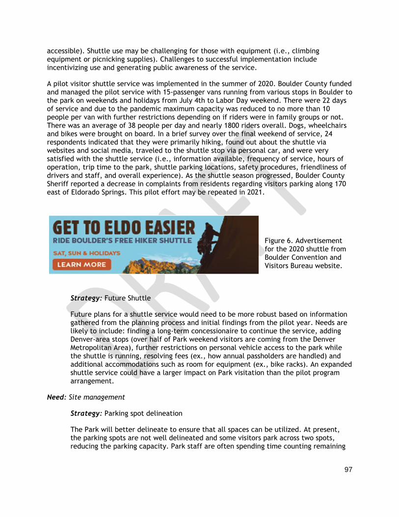
97
accessible). Shuttle use may be challenging for those with equipment (i.e., climbing equipment or picnicking supplies). Challenges to successful implementation include incentivizing use and generating public awareness of the service.
A pilot visitor shuttle service was implemented in the summer of 2020. Boulder County funded and managed the pilot service with 15-passenger vans running from various stops in Boulder to the park on weekends and holidays from July 4th to Labor Day weekend. There were 22 days of service and due to the pandemic maximum capacity was reduced to no more than 10 people per van with further restrictions depending on if riders were in family groups or not. There was an average of 38 people per day and nearly 1800 riders overall. Dogs, wheelchairs and bikes were brought on board. In a brief survey over the final weekend of service, 24 respondents indicated that they were primarily hiking, found out about the shuttle via websites and social media, traveled to the shuttle stop via personal car, and were very satisfied with the shuttle service (i.e., information available, frequency of service, hours of operation, trip time to the park, shuttle parking locations, safety procedures, friendliness of drivers and staff, and overall experience). As the shuttle season progressed, Boulder County Sheriff reported a decrease in complaints from residents regarding visitors parking along 170 east of Eldorado Springs. This pilot effort may be repeated in 2021.
Figure 6. Advertisement for the 2020 shuttle from Boulder Convention and Visitors Bureau website.
Strategy: Future Shuttle
Future plans for a shuttle service would need to be more robust based on information gathered from the planning process and initial findings from the pilot year. Needs are likely to include: finding a long-term concessionaire to continue the service, adding Denver-area stops (over half of Park weekend visitors are coming from the Denver Metropolitan Area), further restrictions on personal vehicle access to the park while the shuttle is running, resolving fees (ex., how annual passholders are handled) and additional accommodations such as room for equipment (ex., bike racks). An expanded shuttle service could have a larger impact on Park visitation than the pilot program arrangement.
Need: Site management
Strategy: Parking spot delineation
The Park will better delineate to ensure that all spaces can be utilized. At present, the parking spots are not well delineated and some visitors park across two spots, reducing the parking capacity. Park staff are often spending time counting remaining
98
usable spots and helping visitors park appropriately. Spot delineation would include lining the spots and putting in wheel stops, requiring upfront labor to mark the spots (and possible repeat efforts over the summer) and some cost. In the future, the Park could consider paving parking areas to make lines permanent.
The indicators of the success of the parking spot delineation would be staff spot checks on whether all parking spaces are or can be utilized and qualitative observations and conversations with staff.
Strategy: Entrance station redesign
The entrance station area is slated for a redesign in spring of 2021. At present, there is a five-vehicle storage capacity leading up to the entrance station and all vehicles (including Kneale Road residents, emergency vehicles, park staff) must wait in the queue. The redesign relocates the station back into the Park to allow for an eight-vehicle queue and creates a bypass lane for Kneale Road residents, Park staff, shuttle buses, and emergency personnel. The new entrance redesign includes a barrier gate arm and provides space for vehicles to be turned around in front of the entrance station when the park is full without the need for staff to direct cars. There will be safer pathways and self-serve kiosks for visitors walking or biking into the park. A few additional parking spaces will be added for staff use. The redesign will also add a fully functioning office to allow gate staff to support other park operations. While the funding has been secured for this project, the short-term challenge will be to facilitate access to the Park during construction.
The indicator of success of the entrance station redesign would be conversations with emergency services providers, Kneale Road residents, and staff to understand the effectiveness of the bypass lane. The length of the queue, and how frequently it exceeds its new capacity, should be observed, but cannot be understood in isolation from the other strategies.
6.4.1 Indicators of Success (Outcomes)
Meaningful indicators were identified based on what seemed feasible for the park to achieve and measure, on planning team and park staff experience, expertise from other agencies with similar issues, data on existing conditions, and scoping of public preferences. CPW will be looking for trends that show increasing progress over time. The National Park Service’s Congestion Management Toolkit encourages setting realistic expectations of the amount of “shift” in visitor use patterns. Many of the strategies under consideration can be expected to result in modest (5-15%) shifts, however, the use of multiple strategies may increase these percentages.
While each strategy may have its own indicators, in combination, the strategies are intended to encourage people to plan ahead and be aware of the parking and access issues at the park and to reduce the number vehicles driving up the canyon at peak times.
Some of the indicators expected to have 5-15% shifts may include:

99
Reduce the number of days when cars are turned around (not allowed entry due to parking capacity)for several hours. In 2019, cars were turned around on approximately 15 days.
Reduce the number of vehicles passing through town that are heading to the park but do not gain entry.
Reduce wait time at entrance station. Vehicle service time at the entrance station already averages under a minute with many under 30 seconds. The average wait times can not be reduced much further but the entrance station redesign and strategies to reduce the number of vehicles attempting entry may improve wait time especially for staff, Kneale Road residents and services for these residents.
Disperse visitation. Dispersing park visitation supports easier access to the park at peak times, without diminishing the revenue generated or increasing total annual visitation. CPW can measure success by the percentage of visitation that occurs on weekends vs. weekdays and percentage of post-2 p.m. arrivals. At present, weekday visitation represents 53% of total visitation. At present, 39% of weekend park vehicles arrive after 2 p.m.
Increase awareness and use of advanced planning tools. Visits to specific webpages and downloads of planning tools are indicators of effectiveness of communications. These should increase over the course over the summer (ex., 10% higher “Planning Your Visit” webpage hits in August vs. June weekend days) and each year. Number of reservation slots booked and shuttle (if implemented) ridership will increase at a faster rate than other indicators.
Maintain visitor satisfaction: During the 2019 summer season, 97% of weekend visitors surveyed rated their experience as good/excellent. CPW will continue to provide a positive experience
Positive qualitative observations, awareness of planning tools, collaborative problem solving with partners and other engagement with stakeholders will continue to provide valuable insights to awareness and effectiveness of management strategies.
6.4.2 Assessment Tools
Assessments to evaluate strategy effectiveness may include: vehicle counts, vehicles turned around counts, visitor surveys, shuttle rider surveys, website viewing analysis, and staff and stakeholder discussions. CPW tracks visitation trends through sales of passes and counters at entrance gates. ECSP already has trail and vehicle counters. Some assessments may only be needed once or twice during a pilot phase while others should occur annually for several years.
Visitor surveys are cost and labor intensive. When possible they should be conducted on peak season weekends to measure awareness of planning tools, communications outreach, and overall park experience and other relevant factors depending on strategies implemented or soon to be implemented. CPW will continue to engage with Eldorado Springs community members, Park staff, park visitors and other key stakeholders to understand the effectiveness of strategies from those perspectives.

100
The efficacy of initial strategies does not necessarily indicate resolution of parking and access issues or the need to implement additional strategies. For example, it is possible that the first strategies to be implemented are successful but additional measures are needed to sufficiently mitigate the issues. Table 13 summarizes what CPW plans to implement initially (i.e., in the next few years).
Table 13. Summary of Parking and Access strategies to be implemented in the next few years
6.5 Trails and Picnic Area
Need: Maintaining trail conditions

101
At present, the trails at the Park are in good condition. However, this requires significant maintenance and staff efforts especially with high park visitation and visitor behavior, such as meandering off trail.
Strategy: Continue to conduct regular, general trail upgrades and invest in the maintenance of the system. Trail upgrades can include but are not limited to trail widening or narrowing, re-routing to improve sustainability and limit erosion, re-shaping the trail tread, and creating bridges, stone walls, and stone paving along trail routes. These upgrades and maintenance efforts have the potential to limit erosion and lessen the impact of human use.
Need: A Trail Plan that supports visitation for the next 50 years and beyond
Strategy: Strategic trail planning should include mapping and assessment of the condition of existing trails, analyze annual maintenance to determine trail needs for upgrades, identify seasonal or other closures to protect wildlife, and closure of any social trails.
Need: The roadway serves a trail through the park
At present, visitors parking near the entrance station or walking into the park must walk along the roadway to reach upper park destinations such as the Fowler Trailhead or the Visitors Center. This is a safety concern and can result in congestion on the roadway where pedestrians and motorists are not separated.
Strategy: An extension of the Streamside Trail towards the Fowler trailhead and visitor center would move hikers and bikers off the roadway, improve public safety, decrease visitor conflict and improve access for search and rescue operations. However, the technical feasibility of building this route is unclear, and such a trail, if feasible, would be very expensive to construct. This extension may require revisiting management zones, considering an elevated (raised off the ground) option, and requirements to protect potential Preble’s jumping mouse habitat. Unintended consequences for climbing access areas should also be considered as the trail extension may increase visitors venturing into the climbing access areas for side hikes. This could cause crowding and/or safety concerns on these can be steep and rugged routes.
Need: The picnic area is in high demand at peak times and the natural resources are damaged from use of this popular amenity.
The designated picnic areas line South Boulder Creek and high use results in bank erosion and trash in the creek.
Strategy: The park may add shelter/shade structures to improve the existing picnic sites and continue to monitor resource conditions around the picnic area.
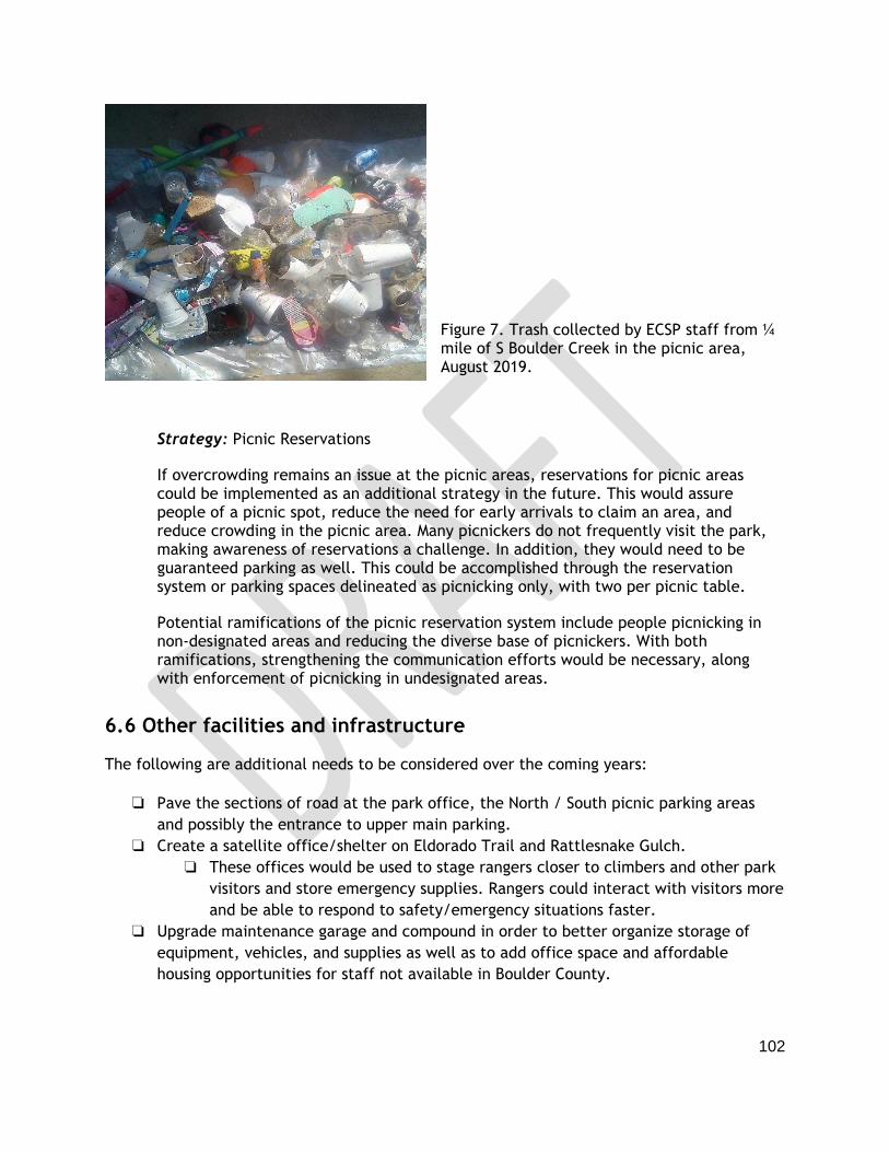
102
Figure 7. Trash collected by ECSP staff from ¼ mile of S Boulder Creek in the picnic area, August 2019.
Strategy: Picnic Reservations
If overcrowding remains an issue at the picnic areas, reservations for picnic areas could be implemented as an additional strategy in the future. This would assure people of a picnic spot, reduce the need for early arrivals to claim an area, and reduce crowding in the picnic area. Many picnickers do not frequently visit the park, making awareness of reservations a challenge. In addition, they would need to be guaranteed parking as well. This could be accomplished through the reservation system or parking spaces delineated as picnicking only, with two per picnic table.
Potential ramifications of the picnic reservation system include people picnicking in non-designated areas and reducing the diverse base of picnickers. With both ramifications, strengthening the communication efforts would be necessary, along with enforcement of picnicking in undesignated areas.
6.6 Other facilities and infrastructure
The following are additional needs to be considered over the coming years:
❏ Pave the sections of road at the park office, the North / South picnic parking areas
and possibly the entrance to upper main parking.
❏ Create a satellite office/shelter on Eldorado Trail and Rattlesnake Gulch.
❏ These offices would be used to stage rangers closer to climbers and other park
visitors and store emergency supplies. Rangers could interact with visitors more
and be able to respond to safety/emergency situations faster.
❏ Upgrade maintenance garage and compound in order to better organize storage of
equipment, vehicles, and supplies as well as to add office space and affordable
housing opportunities for staff not available in Boulder County.

103
❏ Install a water station outside of the Visitor Center so that visitors have a source of drinking water when the Visitor Center is closed.
❏ Consider leasing an additional portion of the Fowler Trail from the City of Boulder (i.e.
the section from the Eastern ECSP boundary to Eldorado Mountain road) in order to
provide a consistent visitor experience on the trail in terms of rules and regulations,
condition of trail, and opportunities to engage in interpretive programming.
❏ Renew leases with the City of Boulder for the Rattlesnake Gulch trail corridor and two
climbing access areas before their 2026 expiration.
❏ Deploy cameras on Jefferson County parcel to study wildlife use of the area
Strategies discussed but not recommended
The following strategies were discussed during the planning process but were ultimately not recommended for inclusion in this plan:
● Relocating the entrance station east of the canyon – This strategy was brought up as a way to process cars before the canyon and stop cars from driving up the canyon if the parking is full. However, this strategy was deemed not feasible due to cost and limited potential locations.
● Towing cars parked illegally in town – This strategy was brought up as a way to stop vehicles from parking illegally in town and walking into the Park. CPW does not have jurisdiction to be involved in towing on Eldorado Springs Drive.
● Allocating entrance by user type – This strategy was brought up as a way to distribute visitors to ensure that none of the activity facilities (picnic areas, hiking trails, climbing crags) exceed their capacity. This strategy was deemed inequitable and not feasible to enforce.
● Paving the entire road in the Park – This strategy was brought up as way to reduce the maintenance requirements on the Park road and create a smoother driving experience. The implementation of this strategy would change the character of the Park and likely encourage drivers to go at higher speeds, making the road situation more dangerous.
● Changing ECSP entrance fees - Several strategies were brought up by the public related to both increasing and decreasing entrance fees. CPW manages a statewide system of parks and entrance fees are critical to supporting the system. The Parks and Wildlife Commission has the authority to review and adjust park pass fees annually but must adhere to certain statutory requirements. Note: There is more flexibility when considering other fees (ex., shuttle or reservation).

104


