

GLONASS system development and use
ROSCOSMOS
State Space
Corporation
December 2-7, 2017
Kyoto, Japan
2
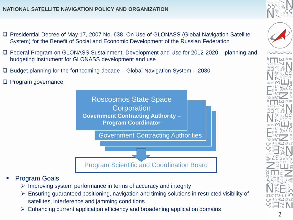
NATIONAL SATELLITE NAVIGATION POLICY AND ORGANIZATION
Presidential Decree of May 17, 2007 No. 638 On Use of GLONASS (Global Navigation Satellite
System) for the Benefit of Social and Economic Development of the Russian Federation
Federal Program on GLONASS Sustainment, Development and Use for 2012-2020 – planning and
budgeting instrument for GLONASS development and use
Budget planning for the forthcoming decade – Global Navigation System – 2030
Program governance:
Government Contracting Authorities
Roscosmos State Space
Corporation Government Contracting Authority –
Program Coordinator
Program Scientific and Coordination Board
Program Goals: Improving system performance in terms of accuracy and integrity
Ensuring guaranteed positioning, navigation and timing solutions in restricted visibility of
satellites, interference and jamming conditions
Enhancing current application efficiency and broadening application domains
3
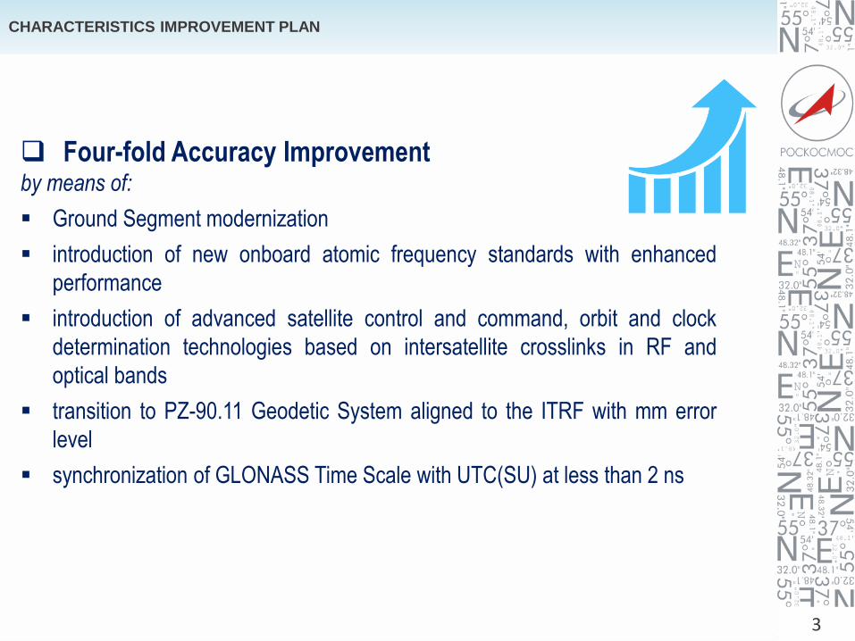
CHARACTERISTICS IMPROVEMENT PLAN
Four-fold Accuracy Improvementby means of:
Ground Segment modernization
introduction of new onboard atomic frequency standards with enhanced
performance
introduction of advanced satellite control and command, orbit and clock
determination technologies based on intersatellite crosslinks in RF and
optical bands
transition to PZ-90.11 Geodetic System aligned to the ITRF with mm error
level
synchronization of GLONASS Time Scale with UTC(SU) at less than 2 ns

GLONASS STATUS (as of 27.11.2017)
AUGMENTATIONS of
ROSCOSMOS
24 stations in Russia
9 stations abroad
Glonass-M
Glonass-K
MEO satellites
REGIONAL, MUNICIPAL
AND PRIVATE STATIONS
NETWORKS
1400 stations are planned
to be integrated together
In total 3 КА
Operational 2 КА
Maintenance 1 КА
GEO satellites
FUNDAMENTAL
FACILITIES
3 Telescopes (32 m)
2 Telescopes (7 m)
3 Correlators
1 Cold-atom Optical
Frequency Reference
64 Astronomic and
Geodetic Network Stations
GROUND CONTROL COMPLEX
2 System Control Centers
8 One-way Reference Stations
3 One-way Reference Information
Processing Systems
5 Uplink Stations
3 Laser Ranging Stations
AUGMENTATIONS of Federal
authorities and state
corporations
FASO Russia – 20
Rosgidromet – 145
Rosreestr – 30
Rosstandart – 5
Mintrans – 220
4The constellation provides global continuous navigation
In total 25
Operational 24
Maintenance 0
Flight testing 1
I II III
1
4
5 13
12
11
23
24
19
20
21
22
3
17
2
701-05
747-04
730+01
8
7
6733-04
745+05
743+06
744+05
742+06
15716+00
736-01
717-07
723-01
721-02
732+03
735+02
754-03
720+03
719+02
731-03
10
755+04
18
16
20
702-069
734+01
751+04
753+00
14752
-07
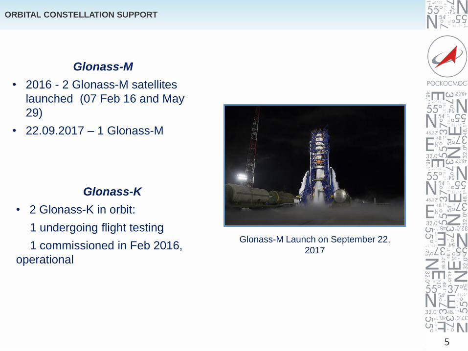
ORBITAL CONSTELLATION SUPPORT
5
Glonass-M
• 2016 - 2 Glonass-M satellites
launched (07 Feb 16 and May
29)
• 22.09.2017 – 1 Glonass-M
Glonass-K
• 2 Glonass-K in orbit:
1 undergoing flight testing
1 commissioned in Feb 2016,
operational
Glonass-M Launch on September 22,
2017
6
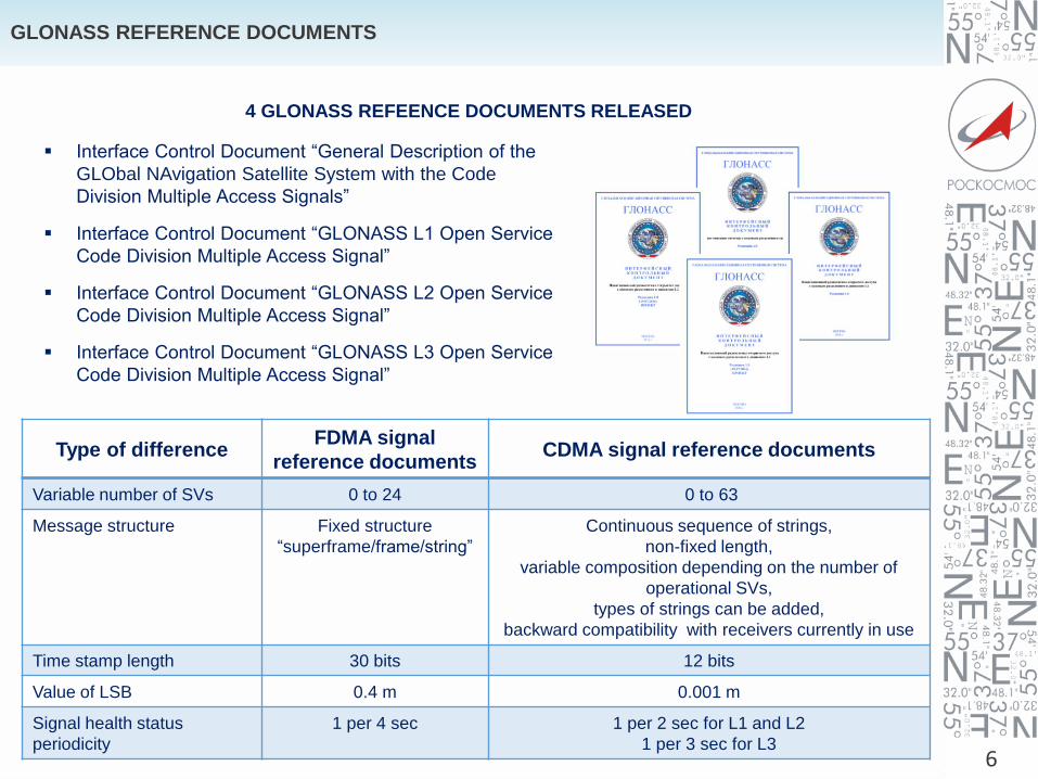
GLONASS REFERENCE DOCUMENTS
4 GLONASS REFEENCE DOCUMENTS RELEASED
Interface Control Document “General Description of the
GLObal NAvigation Satellite System with the Code
Division Multiple Access Signals”
Interface Control Document “GLONASS L1 Open Service
Code Division Multiple Access Signal”
Interface Control Document “GLONASS L2 Open Service
Code Division Multiple Access Signal”
Interface Control Document “GLONASS L3 Open Service
Code Division Multiple Access Signal”
Type of difference FDMA signal
reference documents CDMA signal reference documents
Variable number of SVs 0 to 24 0 to 63
Message structure Fixed structure
“superframe/frame/string”
Continuous sequence of strings,
non-fixed length,
variable composition depending on the number of
operational SVs,
types of strings can be added,
backward compatibility with receivers currently in use
Time stamp length 30 bits 12 bits
Value of LSB 0.4 m 0.001 m
Signal health status
periodicity
1 per 4 sec 1 per 2 sec for L1 and L2
1 per 3 sec for L3

7
GLONASS AUGMENTATIONS
GEO
INTERNET
L1/L3 GLONASS
L1/L5 SBAS
NTRIP
BROADCASTING FACILITIES GNSS CONSTELLATION
DATA PROCESSING FACILITY
Master Center
Back-Up Center
GLOBAL MONITORING NETWORK
All types of augmentations to support
all types of high accuracy services
developed and continue to expand
network densification
space segment modernization
coverage extension

8
GNSS MONITORING AND PERFORMANCE ASSESSMENT SYSTEM
GNSS CONSTELLATION
LASER RANGING STATIONS NETWORK
MONITORING STATIONS NETWORK
Mobile instrumental diagnostics lab
GNSS MONITORING AND PERFORMANCE ASSESSMENT SYSTEM CENTER
INTERNET
SIGNAL CHARACTERISTICS ASSESSMENT FACILITIES
Independent monitoring
and verification of
performance
characteristics against
system requirements
Generating input data to
assess GLONASS
Program KPIs
Measuring user level
GLONASS performance
Providing input data for
GLONASS certificationINFORMATION SHARING SUBSYSTEM
CALCULATION, ANALYSIS AND CONTROL SUBSYSTEM
DATA GENERATION SUBSYSTEM
REFERENCE STATION

GLONASS CIVIL SERVICES
1 BASIC OPEN SERVICE
Navigation in absolute
regime using open
CDMA signalsSPACE SEGMENT
2 SERVICE OF IMPROVED
RELIABILITY AND
ACCURACY
Navigation in absolute
regime using CDMA
signals and
augmentations from
regional and local
augmentation systems
1 mSYSTEM FOR
DIFFERENTIAL
CORRECTION AND
MONITORING
3 RELATIVE NAVIGATION
SERVICE
Navigation in relative
regime using phase
measurements and a
reference receiver
(reference station)
0,03
m
NATIONAL SYSTEM FOR
HIGH-ACCURACY
POSTIONING
4 HIGH-PRECISION
SERVICE
Navigation in absolute
regime using phase
measurements (PPP) on
a commercial basis
0,1
m
HIGH-PRECISION
SYSTEM FOR OBTAINING
THE NAVIGATION AND
EPHEMERIS-AND-TIME
INFORMATION
9
Name UsersCurrent
valueMeans
Marine
Internal water ways
Transport monitoringCommunications
Gonets SC
Express SC
Energetics
Cellular network systems
Aviation
In-port maneuvering
Railroad transport
ERA-GLONASS
Engineering works
Construction
Oil pipeways
Agriculture
Geodesy
Mapping
Dredging operations
Unmanned transport
Road construction
Geodesy
Earth remote
sensingResurs-P SC
GEO-IK SC
Water traffic signs allocation
Recreation
Personal navigation
Daily RMS SISRE, m
www.glonass-iac.ru
10
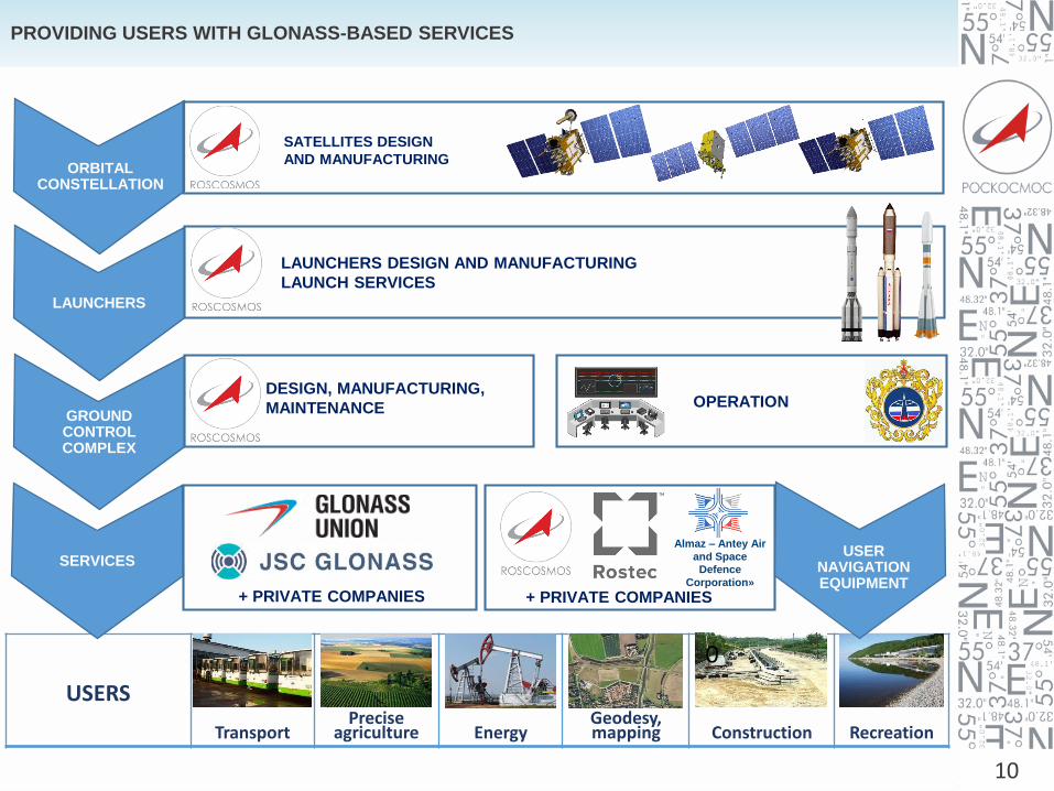
PROVIDING USERS WITH GLONASS-BASED SERVICES
TransportPrecise
agriculture EnergyGeodesy, mapping Construction Recreation
0
USERS
ORBITAL CONSTELLATION
LAUNCHERS
GROUND CONTROL COMPLEX
SERVICES
SATELLITES DESIGN
AND MANUFACTURING
LAUNCHERS DESIGN AND MANUFACTURING
LAUNCH SERVICES
DESIGN, MANUFACTURING,
MAINTENANCE OPERATION
+ PRIVATE COMPANIES
Almaz – Antey Air
and Space
Defence
Corporation»
USER NAVIGATION EQUIPMENT
+ PRIVATE COMPANIES

GROUND ROAD TRANSPORT
• ~2.1 million of cars is GNSS-equipped
• 52 regional navigation-informational
systems
• ERA-GLONASS – plan for 100% coverage
of car fleet in Russia:
up to 42 million onboard GNSS-terminals;
• Platon – all cargo trucks exceeding 12 tons
of gross vehicle weight:
up to 2 million onboard GNSS-terminals;
RAILROAD TRANSPORT
• 14 thousand of rolling stock is GNSS-
equipped
• 49 ground local reference stations for
differential correction to support high-
precision coordinate systems and
shunting
• Over 40 control and correction
stations at the sea and river ports
MARINE TRANSPORT
AIR TRANSPORT
• 94 civil airports equipped with GLONASS
ground-based augmentations systems
(GBAS)
AGRICULTURE
• 3 thousand of agriculture machinery is
GNSS-equipped
ROCKET & SPACE
GLONASS-based technologies have become
primary navigation tool for put-into-orbit
operations of:
• Progress-MS cargo SC;
• Soyuz-MS manned SC;
• Resurs Earth Remote Sensing SC;
• Kanopus Earth Remote Sensing SC.
GLONASS technologies are used at:
• Kondor-E SC;
• Meteor-M SC;
• Bars-M SC and others.
• 6 research and development works aimed
at GLONASS-based soft-, hardware and
complex systems development in
transport industry
KEY GLONASS APPLICATION PROJECTS DURINGGLONASS FEDERAL PROGRAMS REALIZATION IN 2002-2017
11
R&D

STATE EMERGENCY SYSTEM FOR AUTOMOBILE TRANSPORT –ERA-GLONASS
12
ERA-GLONASS – integration of the opportunities provided by telecommunication, navigation, information technologies and microelectronics aimed at people’s life and
health safety
In operation since January 1, 2016, nation-wide
All domestically manufactured or imported vehicles are to be equipped with ERA-GLONASS since
January 1, 2017
30% reduction of time emergency services respond to an accident
347 thousand calls processed, 854 thousand vehicles equipped since start of operation
Social-and-economic effect: saving more than 4 thousand people annually
(an estimation provided that 100% of the Russian vehicle fleet is equipped)
Emergency call is free of charge
Commercial application potential: smart insurance, property and crime protection, traffic monitoring, toll
collection, distant diagnostics and etc.
Accident
Ground
communication
networks
ERA-GLONASS
Operator’s
Regional Center
Emergency
services
COORDINATES
BY GLONASS/GPS
Accident Report by ERA
GLONASS Vehicle
onboard Equipment

13
FEDERAL TOLL COLLECTION SYSTEM FOR COMMERCIAL CARGO TRUCKS –PLATON
PLATON – nation-wide GLONASS/GPS based automatic toll collection system
In operation since November 15, 2015
All trucks over 12 tons
All Federal-owned highways – 50.774 km in total
88% of the total fleet – 330 thousand cargo companies and 900 thousand trucks
registered
32,9 billion rubles collected for road infrastructure support
14
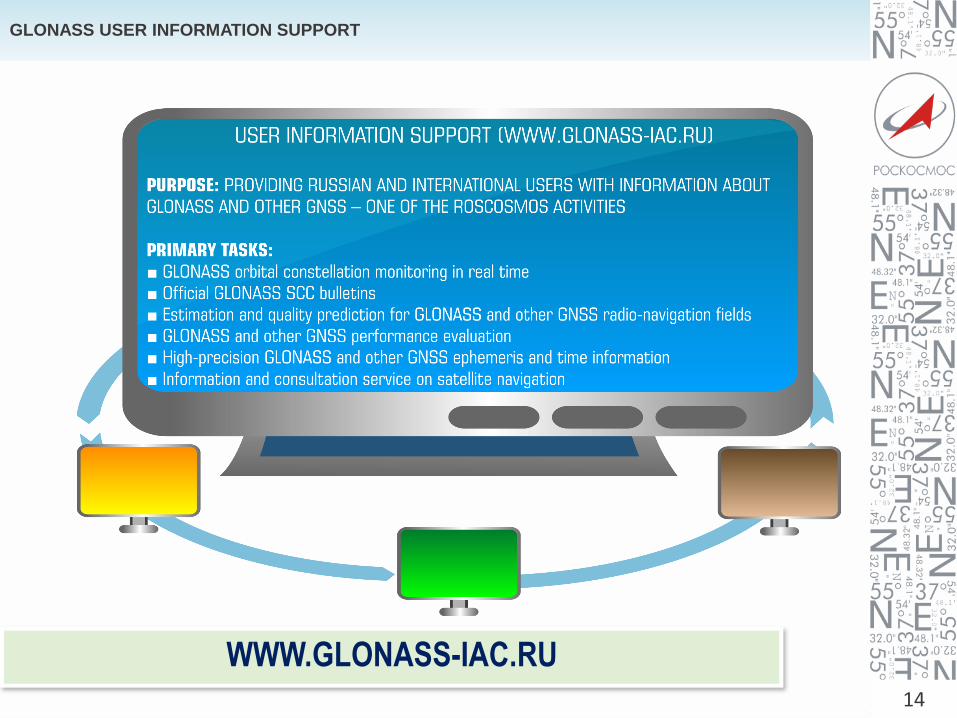
GLONASS USER INFORMATION SUPPORT
WWW.GLONASS-IAC.RU

Thank you for attention!
15


