
GNSS Radio Occultation
Applications for Weather Forecasting
Panagiotis Vergados
Jet Propulsion Laboratory, California Institute of Technology
@ 2017 California Institute of Technology. Government sponsorship acknowledged.
GNSS: Global Navigation Satellite Systems

2 AJM/JPL
Outline
November 15, 2017 JPL/Caltech
Table of Contents Slide No.
-------------------------------------------------------------------------------------------------------
• Introduction to GNSS radio occultation (GNSS RO)................................. (3)
• Weather forecasting benefits.....................................................................(5)
• Hurricane intensity estimation....................................................................(7)
• Other science applications.........................................................................(9)
• COSMIC-2/FORMOSAT-7 Mission......................................................... (10)
• Summary................................................................................................. (13)
PV/JPL
3 AJM/JPL
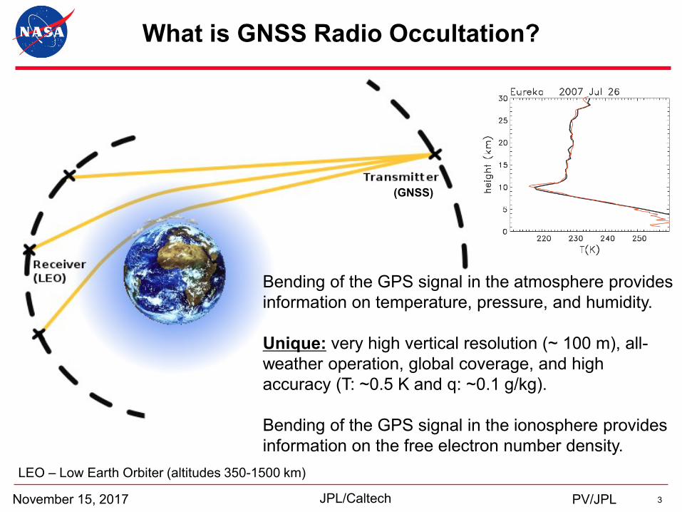
What is GNSS Radio Occultation?
November 15, 2017 JPL/Caltech
Bending of the GPS signal in the atmosphere provides
information on temperature, pressure, and humidity.
Unique: very high vertical resolution (~ 100 m), all-
weather operation, global coverage, and high
accuracy (T: ~0.5 K and q: ~0.1 g/kg).
Bending of the GPS signal in the ionosphere provides
information on the free electron number density.
LEO – Low Earth Orbiter (altitudes 350-1500 km)
PV/JPL
(GNSS)
4 AJM/JPL
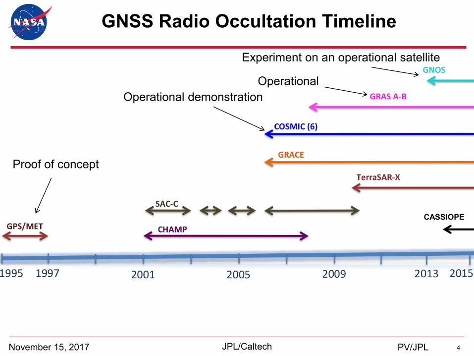
GNSS Radio Occultation Timeline
November 15, 2017 JPL/Caltech
Operational
Experiment on an operational satellite
Operational demonstration
Proof of concept
PV/JPL
CASSIOPE
5 AJM/JPL
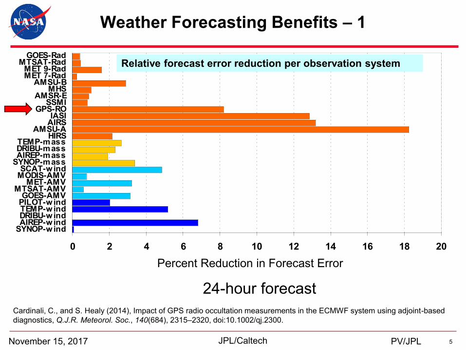
Weather Forecasting Benefits – 1
November 15, 2017 JPL/Caltech
0 2 4 6 8 10 12 14 16 18 20
SYNOP-windAIREP-windDRIBU-windTEMP-windPILOT-windGOES-AMV
MTSAT-AMVMET-AMV
MODIS-AMVSCAT-wind
SYNOP-massAIREP-massDRIBU-massTEMP-mass
HIRSAMSU-A
AIRSIASI
GPS-ROSSMI
AMSR-EMHS
AMSU-BMET 7-RadMET 9-Rad
MTSAT-RadGOES-Rad
FEC %
Relative forecast error reduction per observation system
Percent Reduction in Forecast Error
Cardinali, C., and S. Healy (2014), Impact of GPS radio occultation measurements in the ECMWF system using adjoint-based
diagnostics, Q.J.R. Meteorol. Soc., 140(684), 2315–2320, doi:10.1002/qj.2300.
24-hour forecast
PV/JPL
6 AJM/JPL
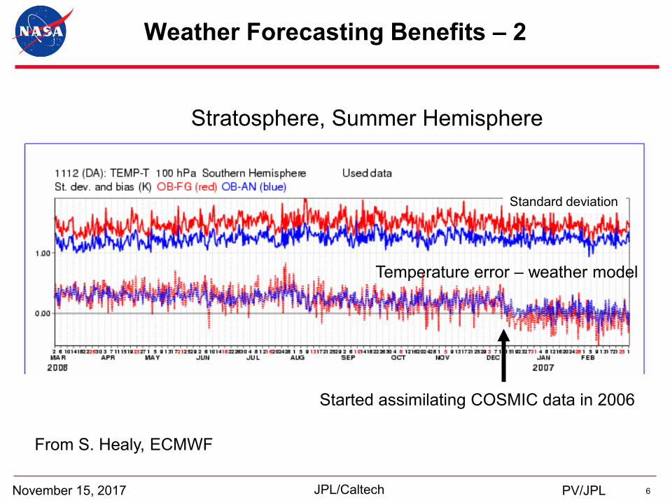
Weather Forecasting Benefits – 2
November 15, 2017 JPL/Caltech
From S. Healy, ECMWF
Started assimilating COSMIC data in 2006
Temperature error – weather model
Standard deviation
Stratosphere, Summer Hemisphere
PV/JPL
7 AJM/JPL
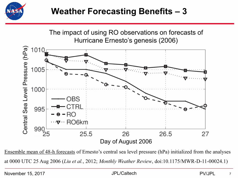
Weather Forecasting Benefits – 3
November 15, 2017 JPL/Caltech
The impact of using RO observations on forecasts of
Hurricane Ernesto’s genesis (2006)
Ensemble mean of 48-h forecasts of Ernesto’s central sea level pressure (hPa) initialized from the analyses
at 0000 UTC 25 Aug 2006 (Liu et al., 2012; Monthly Weather Review, doi:10.1175/MWR-D-11-00024.1)
Centr
al S
ea L
evel P
ressure
(hP
a)
PV/JPL
Day of August 2006
8 AJM/JPL
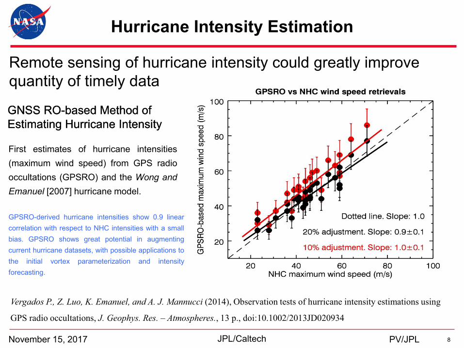
Hurricane Intensity Estimation
November 15, 2017 JPL/Caltech
GNSS RO-based Method of
Estimating Hurricane Intensity
GNSS RO-based Method of
Estimating Hurricane Intensity
GPSRO-derived hurricane intensities show 0.9 linear
correlation with respect to NHC intensities with a small
bias. GPSRO shows great potential in augmenting
current hurricane datasets, with possible applications to
the initial vortex parameterization and intensity
forecasting.
First estimates of hurricane intensities
(maximum wind speed) from GPS radio
occultations (GPSRO) and the Wong and
Emanuel [2007] hurricane model.
Vergados P., Z. Luo, K. Emanuel, and A. J. Mannucci (2014), Observation tests of hurricane intensity estimations using
GPS radio occultations, J. Geophys. Res. – Atmospheres., 13 p., doi:10.1002/2013JD020934
Remote sensing of hurricane intensity could greatly improve
quantity of timely data
PV/JPL
9 AJM/JPL
Science Applications
November 15, 2017 JPL/Caltech
3. Expansion of the tropical belt
01/96
Pre
ssu
re leve
l (h
Pa
)
01/97 01/98 01/99 01/00 01/01 01/02 01/03 01/04 01/05 01/06 01/07 01/08 01/09 01/10
Time, months
1. Climate monitoring
Tem
pera
ture
(K
)
2. Characterizing the
planetary boundary layer
PV/JPL
4. Electron density irregularities
Wavele
ng
th, km
W
avele
ng
th, km
Altitude, km
Auroral
(64–80o)
Polar
(> 80o)
10 AJM/JPL
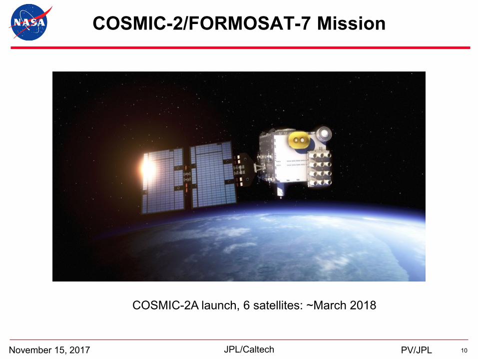
COSMIC-2/FORMOSAT-7 Mission
November 15, 2017 JPL/Caltech
COSMIC-2A launch, 6 satellites: ~March 2018
PV/JPL
11 AJM/JPL
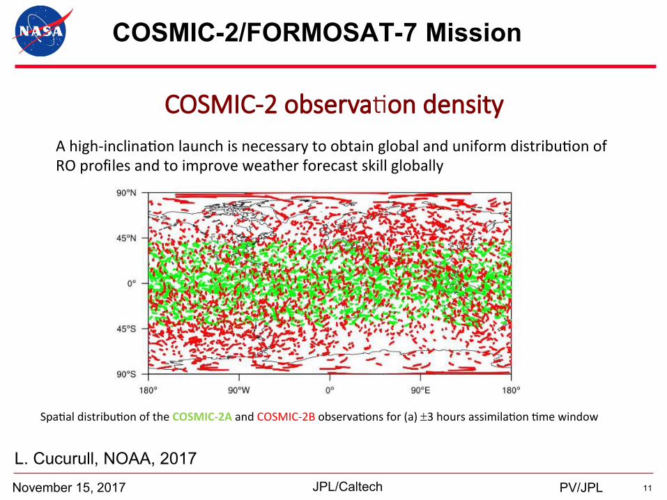
COSMIC-2/FORMOSAT-7 Mission
November 15, 2017 JPL/Caltech
L. Cucurull, NOAA, 2017
PV/JPL
COSMIC-2 observa on density
6
Spa aldistribu onoftheCOSMIC-2AandCOSMIC-2Bobserva onsfor(a)±3hoursassimila on mewindow
Ahigh-inclina onlaunchisnecessarytoobtainglobalanduniformdistribu onofROprofilesandtoimproveweatherforecastskillglobally
12 AJM/JPL
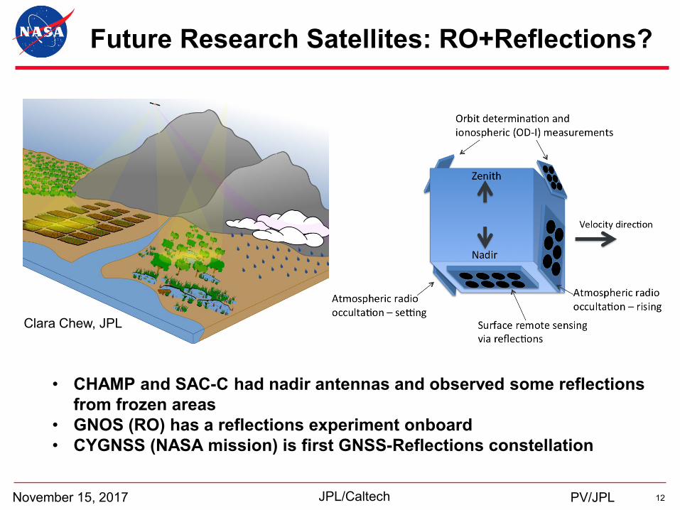
Future Research Satellites: RO+Reflections?
November 15, 2017 JPL/Caltech
Clara Chew, JPL
• CHAMP and SAC-C had nadir antennas and observed some reflections
from frozen areas
• GNOS (RO) has a reflections experiment onboard
• CYGNSS (NASA mission) is first GNSS-Reflections constellation
PV/JPL
13 AJM/JPL
Summary
November 15, 2017 JPL/Caltech PV/JPL
• RO observations have improved weather forecasting, have demonstrated great
potential in extreme weather research, and have provided valuable information in
space weather research.
• Given the success of previous RO missions, future and follow-on missions will
track additional signals of opportunity (beyond the GPS signals).
• Synergistic applications between GNSS-RO and GNSS reflections appear to be a
viable path forward to begin exploring new science applications.
14 AJM/JPL November 15, 2017 JPL/Caltech
jp l .nasa .gov
PV/JPL


