
9/5/2013
1
Ground Water Management in Bangladesh: Policy and Institutional
Arrangement in Bangladesh
Dr. Kazi Matin Ahmed, ProfessorDepartment of Geology
University of Dhaka
National Workshop On Groundwater Management in IWRM Dhaka, Bangladesh Course Contents
• Groundwater Demand and Use• Groundwater Occurrences• Groundwater Development Constraints• Case Studies:
– Arsenic– Dhaka City– Coastal Area
• Existing Policies• Institution and Capacity• Requirements for Management
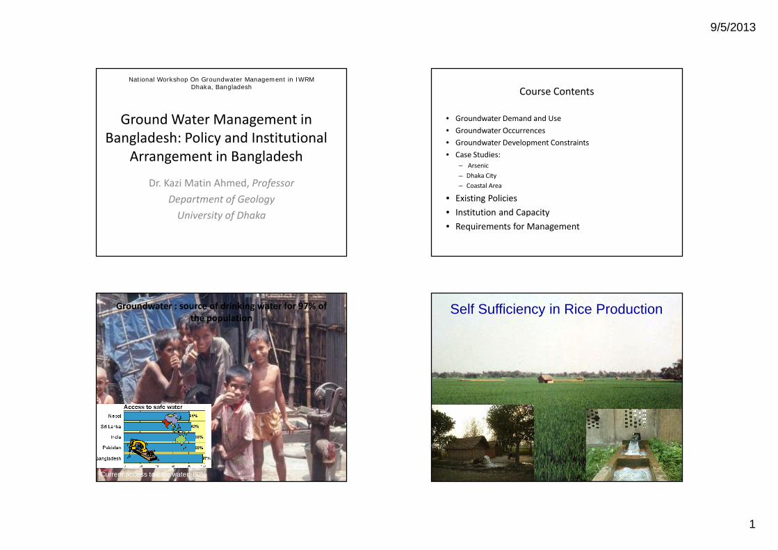
Groundwater : source of drinking water for 97% of the population
Current access to safe water: 80%
Self Sufficiency in Rice Production
9/5/2013
2
Irrigation and Groundwater
0
1000
2000
3000
4000
5000
6000
82-8
384
-85
86-8
788
-89
90-9
192
-93
94-9
596
-97
98-9
900
-01
02-0
304
-05
06-0
7
Irrigation Season
Irri
gat
ed A
rea
('000
Hec
tres
)DTW STW LLP
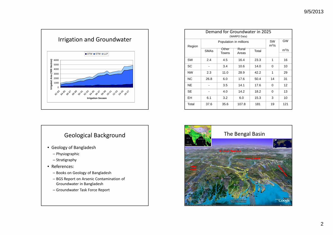
Demand for Groundwater in 2025 (WARPO Data)
RegionPopulation in millions SW
m3/sGW
m3/sSMAsOther Towns
Rural Areas
Total
SW 2.4 4.5 16.4 23.3 1 16
SC - 3.4 10.6 14.0 0 10
NW 2.3 11.0 28.9 42.2 1 29
NC 26.8 6.0 17.6 50.4 14 31
NE - 3.5 14.1 17.6 0 12
SE - 4.0 14.2 18.2 0 13
EH 6.1 3.2 6.0 15.3 3 10
Total 37.6 35.6 107.8 181 19 121
Geological Background
• Geology of Bangladesh– Physiographic– Stratigraphy
• References:– Books on Geology of Bangladesh– BGS Report on Arsenic Contamination of
Groundwater in Bangladesh– Groundwater Task Force Report
Nepal The Bengal Basin
IndianIndianShieldShield
Himalayan MountainsHimalayan Mountains
Shillong MassifShillong Massif
9/5/2013
3
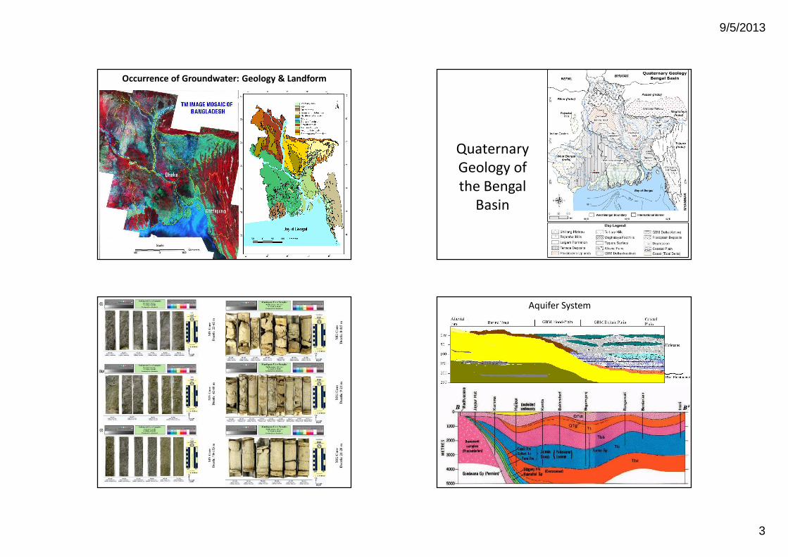
Occurrence of Groundwater: Geology & Landform
Quaternary Geology of the Bengal
Basin
Nature of Aquifers
Sediments
Aquifer System
Workshop on IWRM, Dhaka, 23-27 April
9/5/2013
4
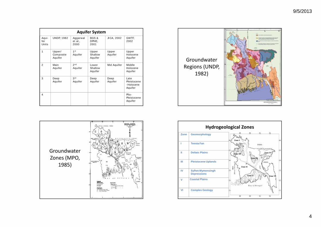
Aquifer SystemAqui-fer Units
UNDP, 1982 Aggarwal et al., 2000
BGS & DPHE, 2001
JICA, 2002 GWTF, 2002
1 Upper/Composite Aquifer
1st
AquiferUpper Shallow Aquifer
Upper Aquifer
Upper Holocene Aquifer
2 Main Aquifer
2nd
AquiferLower Shallow Aquifer
Mid Aquifer Middle Holocene Aquifer
3 Deep Aquifer
3rd
AquiferDeep Aquifer
Deep Aquifer
Late Pleistocene-Holocene Aquifer
4 Plio-Pleistocene Aquifer
Groundwater Regions (UNDP,
1982)
Groundwater Zones (MPO,
1985)
Hydrogeological Zones
89 90 91 92
89 90 91 92
21
22
23
24
25
26
21
22
23
24
25
26Zone I
Zone III
Zone IIIZone IV
Zone VI
Zone II
Zone V
B a y o f B e n g a l
INDIA
IND
IA
(W e
s t
B
e n
g a
l) INDIAA
B
Zone Geomorphology
I Teesta Fan
II Deltaic Plains
III Pleistocene Uplands
IV Sylhet-Mymensingh Depressions
V Coastal Plains
VI Complex Geology

9/5/2013
5
Spatial variability in seasonality and trendsSpatial variability in seasonality and trends
a
b
c
Dhaka
Seasonal groundwater flow Seasonal groundwater flow dynamicsdynamics
v Highest and lowest groundwater levels are observed in September and April respectively
v higher seasonal fluctuations are observed in the Brahmaputra and upper Ganges floodplains
Groundwater levels are referenced to the PWD
Seasonal Seasonal –– trend decompositiontrend decomposition
Original time series
Seasonal component
Trend component
Residual component
Seasonal-Trend decomposition procedure based on Loess (STL)
Declining Water LevelsDeclining Water Levels
9/5/2013
6
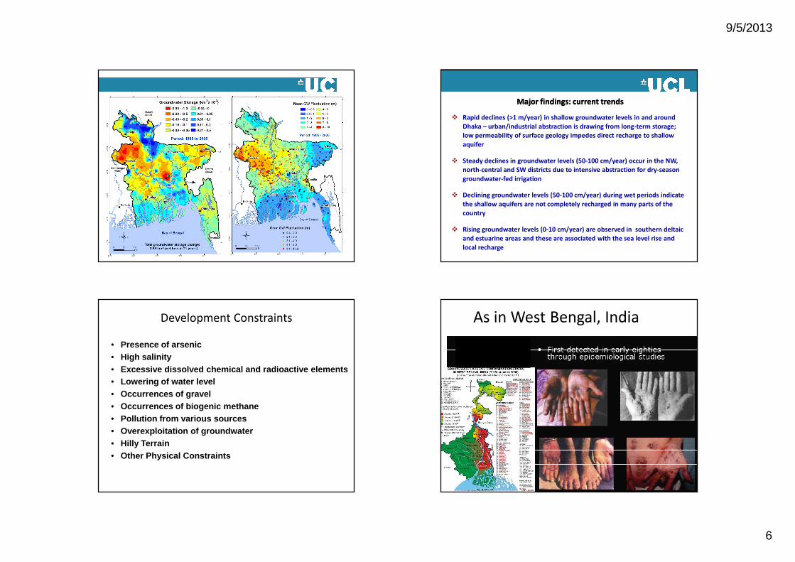
Change in long-term GW storage
Major findings: current trendsMajor findings: current trends
v Rapid declines (>1 m/year) in shallow groundwater levels in and around Dhaka – urban/industrial abstraction is drawing from long-term storage; low permeability of surface geology impedes direct recharge to shallow aquifer
v Steady declines in groundwater levels (50-100 cm/year) occur in the NW, north-central and SW districts due to intensive abstraction for dry-season groundwater-fed irrigation
v Declining groundwater levels (50-100 cm/year) during wet periods indicate the shallow aquifers are not completely recharged in many parts of the country
v Rising groundwater levels (0-10 cm/year) are observed in southern deltaic and estuarine areas and these are associated with the sea level rise and local recharge
Development Constraints
• Presence of arsenic• High salinity• Excessive dissolved chemical and radioactive elements • Lowering of water level• Occurrences of gravel• Occurrences of biogenic methane• Pollution from various sources• Overexploitation of groundwater• Hilly Terrain• Other Physical Constraints
As in West Bengal, India
9/5/2013
7
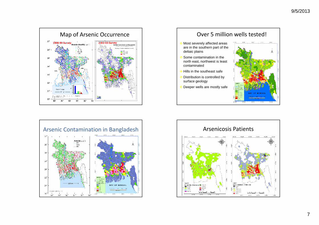
Map of Arsenic Occurrence19981998--99 Survey99 Survey 20022002--03 Survey03 Survey
Over 5 million wells tested!vMost severely affected areas
are in the southern part of the deltaic plains
v Some contamination in the north east, northwest is least contaminated
v Hills in the southeast safe
v Distribution is controlled by surface geology
v Deeper wells are mostly safe
Arsenic Contamination in Bangladesh Arsenicosis Patients
9/5/2013
8
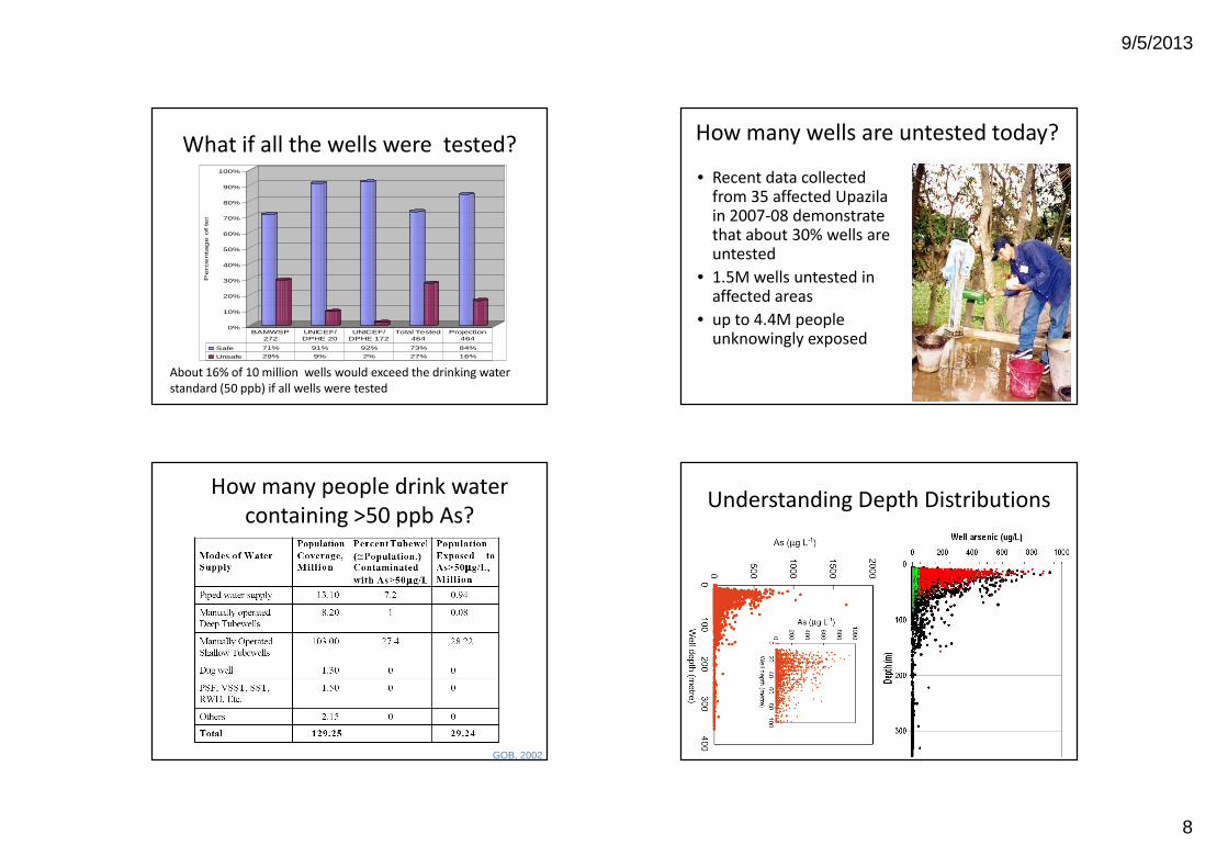
What if all the wells were tested?
About 16% of 10 million wells would exceed the drinking water standard (50 ppb) if all wells were tested
0%
10%
20%
30%
40%
50%
60%
70%
80%
90%
100%
Perc
enta
ge o
f te
ste
d w
ells
Safe 71% 91% 92% 73% 84%
Unsafe 29% 9% 2% 27% 16%
BAMWSP 272
UNICEF/ DPHE 20
UNICEF/ DPHE 172
Total Tested 464
Projection 464
How many wells are untested today?
• Recent data collected from 35 affected Upazila in 2007-08 demonstrate that about 30% wells are untested
• 1.5M wells untested in affected areas
• up to 4.4M people unknowingly exposed
How many people drink water containing >50 ppb As?
GOB, 2002
Understanding Depth Distributions
9/5/2013
9
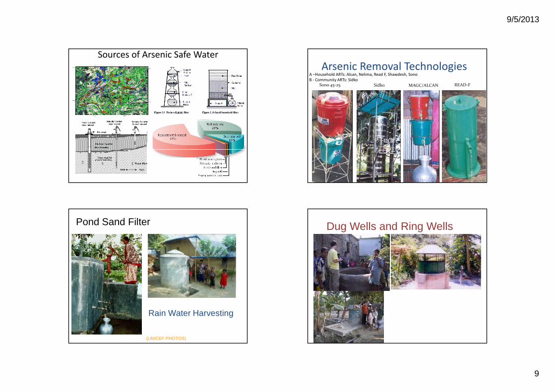
Sources of Arsenic Safe Water
34
READ-F MAGC/ALCANSono 45-25 Sidko
Arsenic Removal TechnologiesA –Household ARTs: Alcan, Nelima, Read F, Shawdesh, SonoB - Community ARTs: Sidko
Pond Sand Filter
(UNICEF PHOTOS)
Rain Water Harvesting
Dug Wells and Ring Wells
9/5/2013
10
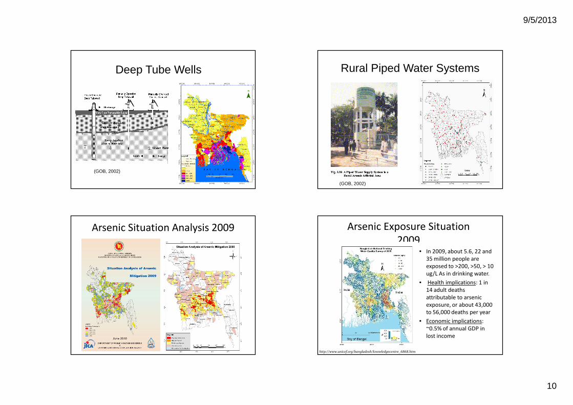
Deep Tube Wells
(GOB, 2002)
Rural Piped Water Systems
(GOB, 2002)
Arsenic Situation Analysis 2009 Arsenic Exposure Situation 2009
• In 2009, about 5.6, 22 and 35 million people are exposed to >200, >50, > 10 ug/L As in drinking water.
• Health implications: 1 in 14 adult deaths attributable to arsenic exposure, or about 43,000 to 56,000 deaths per year
• Economic implications: ~0.5% of annual GDP in lost income
http://www.unicef.org/bangladesh/knowledgecentre_6868.htm
9/5/2013
11
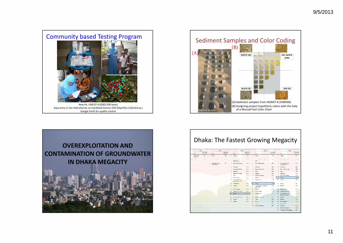
Community based Testing Program
New kit, UNICEF (US$85/300 tests)Data entry in the field directly on handheld Garmin GPS Map76Cx (US$164 ea.)
Google Earth for quality control
Sediment Samples and Color Coding
WHITE (W)
RED (R)BLACK (B)
OFF-WHITE (OW)
(A)(B)
(A) Sediment samples from SASMIT-8 (HARIAN)(B) Assigning project hypothesis colors with the help
of a Munsell Soil Color ChartMozumder et al, 2011
OVEREXPLOITATION AND CONTAMINATION OF GROUNDWATER
IN DHAKA MEGACITY
Dhaka: The Fastest Growing Megacity
UNICEF
9/5/2013
12
UNICEF
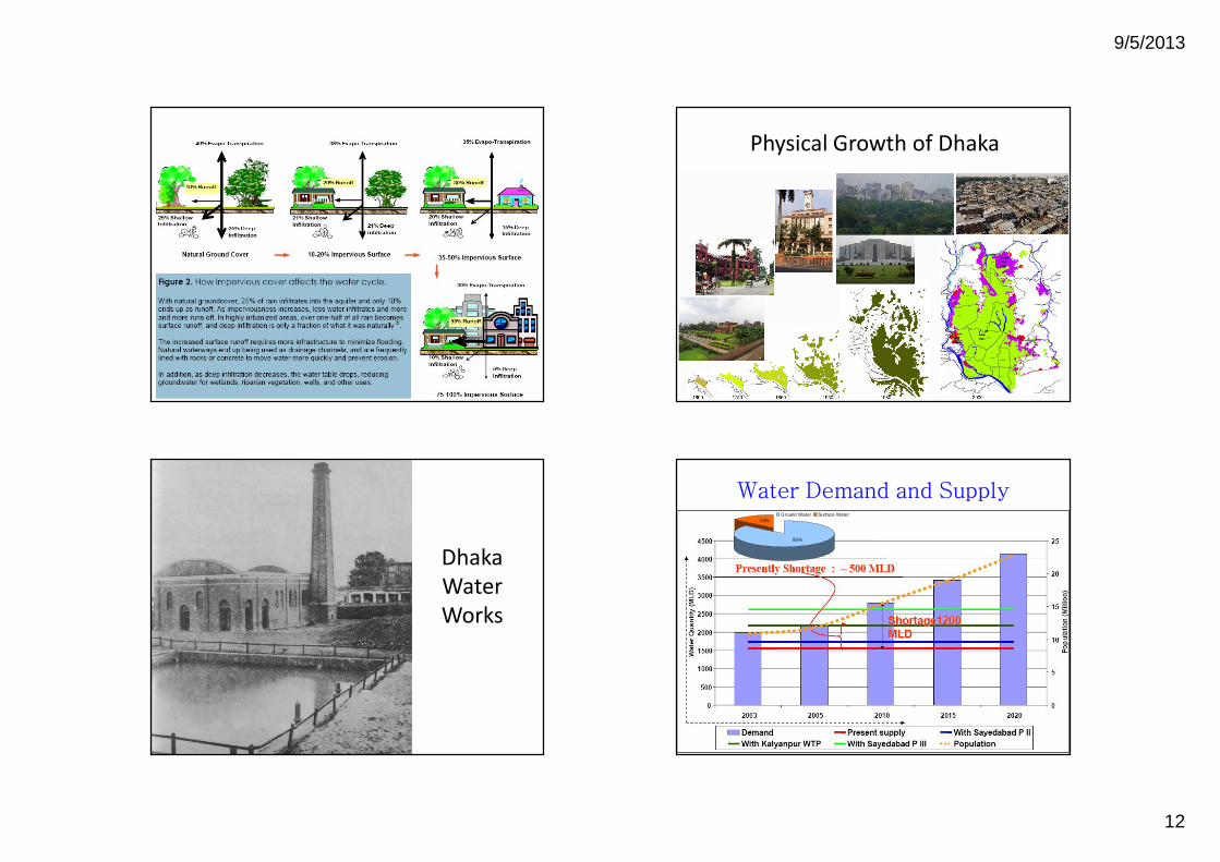
Physical Growth of Dhaka
Dhaka Water Works
14%
86%
Ground Water Surface Water
Water Demand and Supply
9/5/2013
13
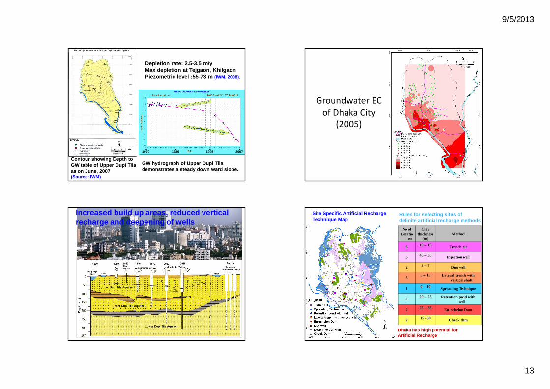
Depletion rate: 2.5-3.5 m/yMax depletion at Tejgaon, Khilgaon Piezometric level :55-73 m (IWM, 2008).
GW hydrograph of Upper Dupi Tila demonstrates a steady down ward slope.
Contour showing Depth to GW table of Upper Dupi Tila as on June, 2007 (Source: IWM)
19801970 1995 2007
Groundwater EC of Dhaka City
(2005)
Increased build up areas, reduced vertical recharge and deepening of wells
No of Locatio
ns
Clay thickness
(m)Method
6 10 – 15 Trench pit
6 40 – 50 Injection well
2 3 – 7 Dug well
35 – 15 Lateral trench with
vertical shaft
1 0 – 10 Spreading Technique
220 – 25 Retention pond with
well
2 25 – 35 En-echelon Dam
2 15 -30 Check dam
Rules for selecting sites ofdefinite artificial recharge methods
Site Specific Artificial Recharge Technique Map
Dhaka has high potential for Artificial Recharge
9/5/2013
14
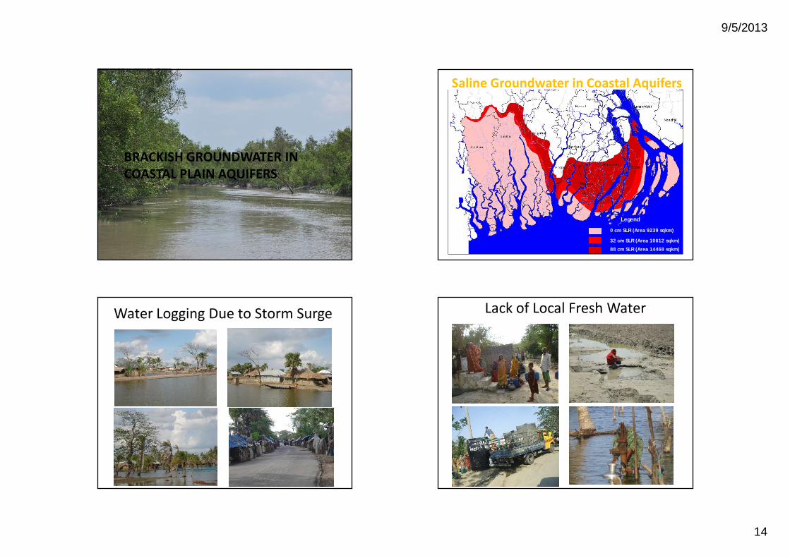
BRACKISH GROUNDWATER IN COASTAL PLAIN AQUIFERS
32 cm SLR (Area 10612 sqkm)
88 cm SLR (Area 14468 sqkm)
0 cm SLR (Area 9239 sqkm)
Legend
Saline Groundwater in Coastal Aquifers
Water Logging Due to Storm Surge Lack of Local Fresh Water
9/5/2013
15
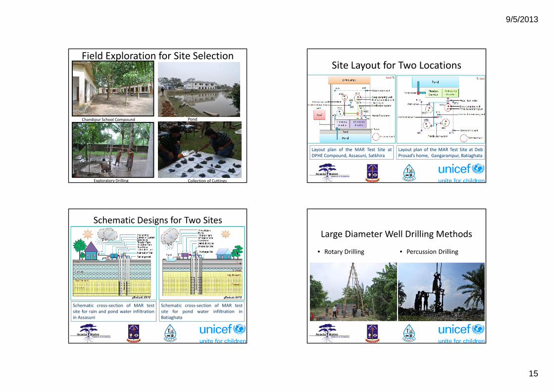
Chandipur School Compound
Collection of CuttingsExploratory Drilling
Pond
Field Exploration for Site SelectionSite Layout for Two Locations
Layout plan of the MAR Test Site atDPHE Compound, Assasuni, Satkhira
Layout plan of the MAR Test Site at DebProsad’s home, Gangarampur, Batiaghata
Schematic Designs for Two Sites
Schematic cross-section of MAR testsite for rain and pond water infiltrationin Assasuni
Schematic cross-section of MAR testsite for pond water infiltration inBatiaghata
Large Diameter Well Drilling Methods
• Rotary Drilling • Percussion Drilling

9/5/2013
16
Installation and Completion of Infiltration Wells Abstraction Sites in Khulna District
Abstraction Sites in Satkhira District Abstraction Sites in Bagerhat Districts

9/5/2013
17
Common Practices: Unmanaged GW Development
• Demand driven planning• Government planning procedure
• Feasibility studies for large projects• Impact assessment not yet common• Public consultation not practiced• Private sector development mostly
uncontrolled
Requirements for Management of GW
C Institutional development
C Policies and practices
CIntegration of water supply and sanitation/waste disposal in land use planning
C Legal aspects
C Research needs
C Government’s role in groundwater management
C Lack of awareness and people’s participation
C Enhancement of Local capabilities
Local Capability• Good set of policies• Many organizations involved in groundwater• Lack of appropriate professionals• Lack of general awareness about groundwater as a
resource• Lack of specific legal framework to protect groundwater
along with monitoring and surveillance• Lack of guidelines for groundwater development
projects• Lack of a body to specifically look into groundwater
issues• Lack of research capabilities
National Policies• National Water Policy (1999): The GoB places increasing emphasis on
the proper management of the country's water resources. It conforms to internationally accepted principles of integrated water resources management, such as laid down in the Dublin-Rio statements.
• National Policy for Safe Water Supply and Sanitation (1998): This policy calls for nationwide access to safe drinking water and sanitation services at an affordable cost (sanitation is defined as sewage disposal, solid waste management and storm water drainage). The objective is to improve public health and produce a safer environment by reducing water-borne disease and contamination of surface water and groundwater.
• National Environment Policy (1992): The policy highlights the need to maintain ecological balance and overall development through protection and improvement of the environment and protect the country against natural disasters. It seeks to identify and regulate activities that pollute and degrade the environment to ensure environmentally sound development in all sectors.
9/5/2013
18
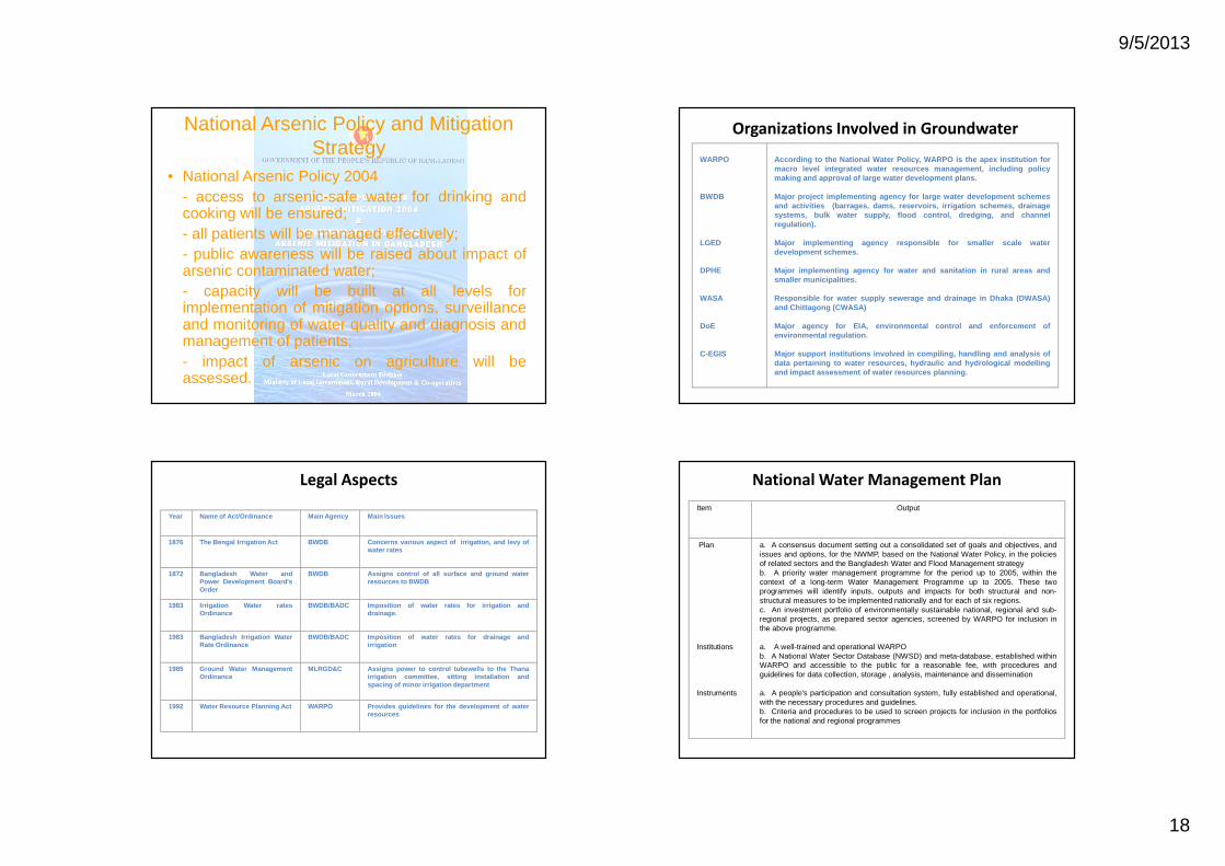
National Arsenic Policy and Mitigation Strategy
• National Arsenic Policy 2004- access to arsenic-safe water for drinking andcooking will be ensured;- all patients will be managed effectively;- public awareness will be raised about impact ofarsenic contaminated water;- capacity will be built at all levels forimplementation of mitigation options, surveillanceand monitoring of water quality and diagnosis andmanagement of patients;- impact of arsenic on agriculture will beassessed.
Organizations Involved in Groundwater
WARPO
BWDB
LGED
DPHE
WASA
DoE
C-EGIS
According to the National Water Policy, WARPO is the apex institution formacro level integrated water resources management, including policymaking and approval of large water development plans.
Major project implementing agency for large water development schemesand activities (barrages, dams, reservoirs, irrigation schemes, drainagesystems, bulk water supply, flood control, dredging, and channelregulation).
Major implementing agency responsible for smaller scale waterdevelopment schemes.
Major implementing agency for water and sanitation in rural areas andsmaller municipalities.
Responsible for water supply sewerage and drainage in Dhaka (DWASA)and Chittagong (CWASA)
Major agency for EIA, environmental control and enforcement ofenvironmental regulation.
Major support institutions involved in compiling, handling and analysis ofdata pertaining to water resources, hydraulic and hydrological modellingand impact assessment of water resources planning.
Legal Aspects
Year Name of Act/Ordinance Main Agency Main Issues
1876 The Bengal Irrigation Act BWDB Concerns various aspect of irrigation, and levy ofwater rates
1872 Bangladesh Water andPower Development Board'sOrder
BWDB Assigns control of all surface and ground waterresources to BWDB
1983 Irrigation Water ratesOrdinance
BWDB/BADC Imposition of water rates for irrigation anddrainage.
1983 Bangladesh Irrigation WaterRate Ordinance
BWDB/BADC Imposition of water rates for drainage andirrigation
1985 Ground Water ManagementOrdinance
MLRGD&C Assigns power to control tubewells to the Thanairrigation committee, sitting installation andspacing of minor irrigation department
1992 Water Resource Planning Act WARPO Provides guidelines for the development of waterresources
National Water Management PlanItem Output
Plan
Institutions
Instruments
a. A consensus document setting out a consolidated set of goals and objectives, andissues and options, for the NWMP, based on the National Water Policy, in the policiesof related sectors and the Bangladesh Water and Flood Management strategyb. A priority water management programme for the period up to 2005, within thecontext of a long-term Water Management Programme up to 2005. These twoprogrammes will identify inputs, outputs and impacts for both structural and non-structural measures to be implemented nationally and for each of six regions.c. An investment portfolio of environmentally sustainable national, regional and sub-regional projects, as prepared sector agencies, screened by WARPO for inclusion inthe above programme.
a. A well-trained and operational WARPOb. A National Water Sector Database (NWSD) and meta-database, established withinWARPO and accessible to the public for a reasonable fee, with procedures andguidelines for data collection, storage , analysis, maintenance and dissemination
a. A people's participation and consultation system, fully established and operational,with the necessary procedures and guidelines.b. Criteria and procedures to be used to screen projects for inclusion in the portfoliosfor the national and regional programmes
9/5/2013
19
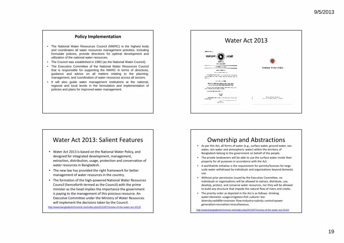
Policy Implementation
• The National Water Resources Council (NWRC) is the highest bodyand coordinates all water resources management activities, includingformulate policies, provide directions for optimal development andutilization of the national water resources.
• The Council was established in 1983 (as the National Water Council).
• The Executive Committee of the National Water Resources Councilthat is responsible for supporting the NWRC in terms of directives,guidance and advice on all matters relating to the planning,management, and coordination of water resources across all sectors.
• It will also guide water management institutions at the national,regional and local levels in the formulation and implementation ofpolicies and plans for improved water management.
Water Act 2013
Water Act 2013: Salient Features
• Water Act 2013 is based on the National Water Policy, and designed for integrated development, management, extraction, distribution, usage, protection and conservation of water resources in Bangladesh.
• The new law has provided the right framework for better management of water resources in the country.
• The formation of the high-powered National Water Resources Council (henceforth termed as the Council) with the prime minister as the head implies the importance the government is paying to the management of this precious resource. An Executive Committee under the Ministry of Water Resources will implement the decisions taken by the Council.
http://www.bangladeshchronicle.net/index.php/2013/07/review-of-the-water-act-2013/
Ownership and Abstractions• As per this Act, all forms of water (e.g., surface water, ground water, sea
water, rain water and atmospheric water) within the territory of Bangladesh belong to the government on behalf of the people.
• The private landowners will be able to use the surface water inside their property for all purposes in accordance with the Act.
• A worthwhile initiative is the requirement for permits/licenses for large scale water withdrawal by individuals and organizations beyond domestic use.
• Without prior permission issued by the Executive Committee, no individuals or organizations will be allowed to extract, distribute, use, develop, protect, and conserve water resources, nor they will be allowed to build any structure that impede the natural flow of rivers and creeks.
• The priority order as depicted in the Act is as follows: drinking water>domestic usage>irrigation>fish culture> bio-diversity>wildlife>instream flow>industry>salinity control>power generation>recreation>miscellaneous.
http://www.bangladeshchronicle.net/index.php/2013/07/review-of-the-water-act-2013/
9/5/2013
20
Management of Water Resources
• Act recognizes the significance for managing all forms of water resources in the context of natural flow of surface water and recharge of groundwater.
• The Act provides the legal framework for development, management, extraction, distribution, usage, protection, and conservation of water resources.
• However, the Act falls short in making a commitment by the government to ensure the quality of water for various beneficial uses.
http://www.bangladeshchronicle.net/index.php/2013/07/review-of-the-water-act-2013/
Groundwater in the Act
• Aquifer definition: Section 2(18) - good• Groundwater definition: Section 2(26) - good• Types of Water: Section 3(1-b) - good• Integrated use of SW, GW and RW: Section
4(2-g) - good• Safe Yield of Aquifers: Section 4(19-2) – good
Conclusions
• Groundwater very important for socio-economic developments
• Resource values not properly appreciated
• Reviews of existing polices and possible integrations
• Institutional reform and capacity building– new body needed
• Legal aspects – groundwater protection regulations under the Water Act 2013
Thank you all!


