
KPA No. HiKeau88 (b) 072305
HE WAHI MO‘OLELO NO KEAUHOU
A ME NA WAHI PANA MA LAILA ē
A COLLECTION OF TRADITIONS, HISTORICAL ACCOUNTS AND KAMA‘ĀINA
RECOLLECTIONS OF KEAUHOU AND ITS STORIED PLACES; WITH NOTES FROM ADJOINING LANDS IN KA‘Ū AND PUNA, ISLAND OF HAWAI‘I
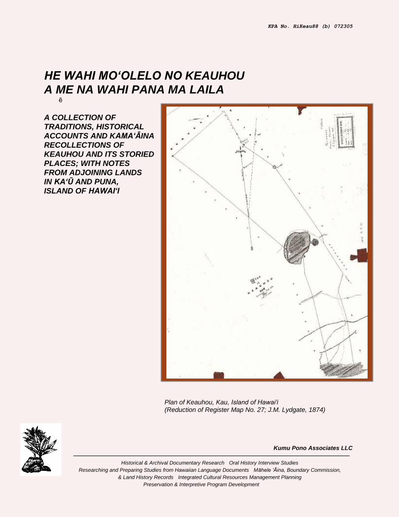
Plan of Keauhou, Kau, Island of Hawai‘i (Reduction of Register Map No. 27; J.M. Lydgate, 1874)
Kumu Pono Associates LLC
Historical & Archival Documentary Research · Oral History Interview Studies
Researching and Preparing Studies from Hawaiian Language Documents · Māhele ‘Āina, Boundary Commission,
& Land History Records · Integrated Cultural Resources Management Planning
· Preservation & Interpretive Program Development
KPA No. HiKeau88 (b) 072305
HE WAHI MO‘OLELO NO KEAUHOU
A ME NA WAHI PANA MA LAILA–
A COLLECTION OF TRADITIONS, HISTORICAL ACCOUNTS AND KAMA‘ĀINA RECOLLECTIONS OF KEAUHOU AND ITS STORIED PLACES; WITH NOTES FROM ADJOINING LANDS IN KA‘Ū AND PUNA, ISLAND OF HAWAI‘I
PREPARED BY
Kepā Maly • Cultural Historian - Resource Specialist
&
Onaona Maly • Researcher
PREPARED FOR
Kamehameha Schools Ulalia Woodside, Land Legacy Resources Manager Land Assets Division, Kamehameha Schools 567 South King Street Honolulu, Hawai‘i 96813
JULY 23, 2005
2005 Kumu Pono Associates LLC
Kumu Pono Associates LLC
Historical & Archival Documentary Research · Oral History Interview Studies
Researching and Preparing Studies from Hawaiian Language Documents · Māhele ‘Āina, Boundary
Commission, & Land History Records · Integrated Cultural Resources Management Planning
· Preservation & Interpretive Program Development
554 Keonaona St. · Hilo, Hawai‘i 96720 · (ph/fax) 808.981.0196 · (e-mail) [email protected]
He Wahi Mo‘olelo no Keauhou Kumu Pono Associates LLC A Collection of Traditions and Historical Recollections of Keauhou at Ka‘ū HiKeau88 (b) 072305:ii
EXECUTIVE SUMMARY AND ACKNOWLEDGEMENTS
The following collection of archival and oral historical records was researched and compiled by Kumu Pono Associates LLC, at the request of Ms. Ulalia Woodside, Land Legacy Resources Manager (Land Assets Division), of Kamehameha Schools. The research focused on two primary sources of information—historical literature, and summary of oral historical interviews with kūpuna and kama‘āina, known to be familiar with the history of Keauhou, and neighboring lands in the Districts of Ka‘ū, Puna, and Hilo, on the island of Hawai‘i. The oral historical component of the study is based upon two historical interviews and a summary of an interview program conducted specifically for Hawai‘i Volcanoes National Park between 1997 to 2000 (Langlas and Waipā, ms. 1997; and Langlas, 2003). The research brings a wide range (though not exhaustive) of historical references into one manuscript, with written accounts dating from the 1820s and oral historical accounts recalling traditions and personal experiences dating from the 1870s. The cultural and natural landscape of Keauhou—an ‘ili (land parcel) within the ahupua‘a (a native land division extending from ocean to mountains) of Kapāpala—is among the most significant land areas in the Hawaiian Islands, as it is the home of Kīlauea, and abode of the goddess Pele. Because of the active volcanic nature of Kīlauea, and its manifestations of Pele and her family, as witnessed the geologic phenomena, the lua o Pele (volcano of Pele) has been a focal point of native traditions and religion; and since western contact, it has been the most frequently visited and written of landscape in the Hawaiian Islands. In the Māhele ‘Āina (Land Division) of 1848, the ‘ili of Keauhou was awarded to Chiefess Victoria Kamāmalu, a granddaughter of Kamehameha I. Following Kamāmalu’s death in 1866, her lands were inherited by her father, Mataio Kekuana‘oa. Kekuana‘oa died in 1868, and his lands were shared between his two surviving children, Lot Kapuaīwa (Kamehameha V), and Ruth Ke‘elikolani—with Keauhou going to Ke‘elikolani. Ke‘elikolani died in 1883, and her lands, including Keauhou, were inherited by her cousin, Bernice Pauahi Bishop. Upon Pauahi’s death in 1884, her lands, including Keauhou, were bequeathed to, and formed the Kamehameha Schools Trust. Lands adjoining Keauhou include—Kapāpala, in Ka‘ū; ‘Āpua, Kahauale‘a and ‘Ōla‘a, in Puna; and Waiākea and Humu‘ula, in Hilo. Except for Kahauale‘a, all lands adjoining Keauhou were retained by Kamehameha III as Crown Lands. The land of Kahauale‘a was awarded to William C. Lunalilo, whose great grandfather was the father of Kamehameha I. From the 1840s till 1916, the ali‘i (or representatives of the ali‘i estate) who held Keauhou, also held Kīlauea. In those years, the land was leased to various parties who entered into several economic ventures on the land. The primary activities being, ranching cattle and goats; harvesting of various native woods and pulu (the fur-like fiber of the native hāpu‘u – tree fern); and the development of the Volcano House, including lodging, “health” facilities, meals, and guided tours. In 1916, the significance of Kīlauea as a geologic feature and research site, and its popularity as a visitor’s destination, led to a land exchange between the Bishop Estate, the Territorial Government, and the United States Department of the Interior, which established the first phase of the Hawaii National Park, later renamed to Hawaii Volcanoes National Park (HAVO). Since 1916, and up to 2004, the park lands have expanded beyond the Kīlauea section of Keauhou and the summit region of Mauna Loa, to include additional lands, mauka and makai. Those actions have taken additional lands in Keauhou, and portions of Kapāpala, ‘Ōla‘a, Kahauale‘a, ‘Āpua, Kea‘au, Pānau, and several lands in Puna—the Kalapana Extension. Most recently, in 2004, a portion of Kahuku, which adjoins the upper lands of the park on Mauna Loa, was added to the park boundaries. In between 1978 to 1983, Kepā Maly worked at Hawai‘i Volcanoes National Park as an interpretive ranger. During those years, his activities focused on interpreting cultural resources—native traditions and practices—and strengthening the cultural facet of interpretation in the park. In the course of his duties, Maly also worked with park superintendent, David Ames in formulating the early policies meant to address the park’s compliance with the American Indian Religious Freedom Act of 1978. During his years at the park, Maly spent a great deal of time speaking with kūpuna and elder kama‘āina of

He Wahi Mo‘olelo no Keauhou Kumu Pono Associates LLC A Collection of Traditions and Historical Recollections of Keauhou at Ka‘ū HiKeau88 (b) 072305:iii
Keauhou, the larger park lands, and neighboring lands. Among those from whom he learned facets of history and practices were: Helen Haleola Pe‘a-Lee Hong, Edith Kanaka‘ole, Kahu John Hauani‘o, Sam and Minnie Kaawaloa, Kaipo Roberts, Pele Hano‘a, Peter and Kahale‘ula Lee, Louis Pao, Lei Pavao, John Ka‘iawe, and Dorothy Barrere—several of whom also worked in the park during those years. The historical-archival documentation, and oral histories shared by people as those cited in this study, provide readers with references to many sites in Keauhou, that under the laws and guidelines associated historic preservation programs, are classed as traditional cultural properties. Elder kama‘āina and cultural practitioners describe, and participate in on-going cultural practices that demonstrate the attachment of native families to traditional sites and practices, as passed down over generations. Among the most significant traditional sites and practices described in historical narratives, and by contemporary practitioners are the following:
• Kīlauea (Kīlauea nui).
• Kīlauea iki and Ka-waha-o-Pele.
• Halema‘uma‘u.
• Kaluapele.
• Pali-kapu-o-Kamohoali‘i.
• Keanakāko‘i.
• Pali-kapu-o-Ka‘auea.
• ‘Uwēkahuna.
• Palialoha or ‘Uwēaloha.
• ‘Ākanikōlea.
• Kamālāuki.
• Mōhai and makana offered to Pele and members of the Pele family.
• Mele sung, and hula performed to honor, and out of respect to Pele and members of the Pele family.
• Remains of departed family members taken to Kīlauea to rejoin ancestors and as a part of deifications rituals.
• Collection of plant materials for lei, ritual, or medicinal purposes—some used as offerings at Kīlauea, others used away from Keauhou.
• Trails in coastal region traveled to access fisheries.
• Trails to the uplands traveled historically to visit Kīlauea, and pay homage to Pele.
• Trails traveled between Keauhou, Keawewai and the Humu‘ula vicinity traditionally—in historic times, primarily in association with ranching activities and recreation.
The voices of our kūpuna—either recorded in historical Hawaiian language newspapers, or in interviews recorded over the last 60 years—are among the most precious resources handed down to us from our past. While the historical and archival records help us understand how we came to be where we are today, the voices of the elders give life to the stories, and demonstrate how practice and history are handed down and made. In the process of conducting the present study, Helen Wong Smith, Ulalia Woodside, and Joanne Williamson of Kamehameha Schools, kindly assisted in providing access to selected documents and cartographic references in the collection of Kamehameha Schools. Helen Wong Smith was particularly patient, and assisted in tracking down several records, which helped to make this study a more complete overview of the history of Keauhou. Ms. Keola Awong, HAVO-Curator, was also very kind, in facilitating access to records and coordinating a HAVO Cultural Advisory Committee meeting.
Māua no me ke aloha kau palena ‘ole — Kepā a me Onaona Maly. O ka mea maika‘i mālama, o ka mea maika‘i ‘ole, kāpae ‘ia!
(Keep the good, set the bad aside!)

He Wahi Mo‘olelo no Keauhou Kumu Pono Associates LLC A Collection of Traditions and Historical Recollections of Keauhou at Ka‘ū HiKeau88 (b) 072305:iv
CONTENTS
INTRODUCTION • 1
Background • 1
Approach to Conducting the Study • 3
Historical Documentary Resources • 3
A CULTURAL-HISTORICAL SYNTHESIS
OF KEAUHOU AND NEIGHBORING LANDS • 6
NATIVE TRADITIONS AND
HISTORICAL NARRATIVES OF KEAUHOU AND VICINITY • 9
Storied Place Names of Keauhou • 9 I. Na Mo‘olelo (Native Traditions and Historical Accounts) • 12 “He Mele i Kilauea” • 12 He Wahi Pū‘olo Iwi • 14 “Volcanic Manifestations—Pele” • 16
Stone for Ko‘i (Adze) Collected at Kīlauea • 19
Battle Between Pele and Kamapua‘a– The Naming of Halema‘uma‘u • 19
Why the ‘Ōhelo is Sacred to Pele • 26
The Explosive Eruption of Kīlauea in 1790 • 31 Kapi‘olani’s Visit to Kīlauea – Breaking the Kapu of Pele (1823) • 32
First Visit by Kamehameha III to Kīlauea (1828) • 33
Chiefess Bernice Pauahi Bishop’s Visit to Kīlauea in 1845 • 33 Historical Accounts of Kīlauea and Attachment to Cultural Landscapes • 34
He Kanikau • 34
The Eruptions, Earthquakes and Tidal Waves of 1868 • 35 “Na Papahi Lei e Kini Kohu Ai” – Lei of Lehua and Pa‘iniu Noted at Kīlauea • 39 “Na Wahi Pana o ko kakou Lua Pele Kaulana” Storied Places of our Famous Volcano (1886) • 40
Place Name Accounts of Keauhou and Kīlauea Recorded in “Kaao Hooniua Puuwai no Ka-Miki” (1915) • 43
The Naming of Uwēkahuna, Ka‘auea and Kahualoa • 44

He Wahi Mo‘olelo no Keauhou Kumu Pono Associates LLC A Collection of Traditions and Historical Recollections of Keauhou at Ka‘ū HiKeau88 (b) 072305:v
The Naming of Pōhakuloa • 45 Pele Arrives in Hawai‘i, and makes Kīlauea her Home– The Naming of Noted Places at Kīlauea • 46
‘Ailā‘au–The Forest Eater • 48 The Explosive Eruption of Kīlauea in 1790– Recorded in the Tradition of Kekūhaupi‘o (1922) • 49 He Mo‘olelo Ka‘ao no Hi‘iaka-i-ka-poli-o-Pele • 51 II. Historical Observations (Accounts Recorded by Foreign Visitors and Residents) • 54
Archibald Menzies Travel through Kapāpala in Ascent of Mauna Loa in 1794 • 54 Kīlauea and Environs Described in the Journal of William Ellis (1823) • 57
Makoa Fears Volcano Gods • 57 Volcanic Activity at Ponahohoa [Kapāpala]. • 58 The Guide Fears Pele. • 58 A Cave Residence at Kapuahi [Kapāpala]. • 61 A Cave Lodging at Keapuana [Kapāpala]. • 61 First View of Kilauea's Fires. • 62 Craters and Active Volcanic Cracks [Keauhou]. • 64 Eating Ohelo Berries. • 65 Native Fears of Pele. • 65 Kilauea Described. • 65 Native Tribute to Pele. • 65 Descending Into Kilauea. • 66 Native Fears of Pele Again. • 68 Fresh Water Encountered. • 68 Exploring North of the Crater [Shelter made for Party]. • 69 The Sulphur Banks. • 69 Flocks of Wild Geese. • 70 More Superstitious Fears of Pele. • 70 Native Traditions Concerning Volcano. • 72 Mythology of the Volcano. • 73

He Wahi Mo‘olelo no Keauhou Kumu Pono Associates LLC A Collection of Traditions and Historical Recollections of Keauhou at Ka‘ū HiKeau88 (b) 072305:vi
Volcano the Abode of the Gods. • 73 Offerings to the Volcano Gods. • 73 Vengeance of the Volcano Gods. • 74 Combat Between Kamapuaa and Pele. • 74 Destruction of Keoua's Army. • 74 The Explosive Eruption of 1790. • 74 Native Visions of the Volcano Gods. • 75 Dimensions of the Crater. • 75 Kilauea-Iki Described. • 78 First Whites to Visit Kilauea. • 79 Description of Approaches to Puna [Traveling through Keauhou and ‘Āpua] • 80 Kapiolani's Visit to Kilauea. • 81 A Controversy with a Priestess of Pele. • 82 Rum Worse Than Pele • 83 Pele Still Dreaded. • 84 Bones Thrown to Pele and the Sharks. • 85
Levi Chamberlain’s Account of Kapi‘olani and Pele’s Priestess (1824) • 85 J.F. Goodrich’s Account of the Missionary Visit in 1823 and Description of Kīlauea in 1825 • 86 Botanist, James Macrae at Kīlauea in 1825 • 91 J.F. Goodrich’s Visit and Description of Kīlauea in 1829 • 94 Gerrit P. Judd’s Description of Kīlauea in 1830 • 97 Titus Coan’s Description of Kīlauea and Encounters with Followers of Pele in 1837 • 98 The Mountain Lands of Keauhou and Kīlauea Described in 1840 • 99 Kilauea and Mauna Loa Visited by the United States Exploring Expedition in 1841 • 101
Gerrit Judd’s Notes on the Wilkes Expedition, and his Brush with Death at Kīlauea (1841) • 121
Titus Coan’s Description of Kīlauea in 1844 • 122 King Kamehameha III Travels to Mauna Kea and Kīlauea in 1846 • 125

He Wahi Mo‘olelo no Keauhou Kumu Pono Associates LLC A Collection of Traditions and Historical Recollections of Keauhou at Ka‘ū HiKeau88 (b) 072305:vii
Chester S. Lyman’s Description of Kīlauea in 1846 • 125 A Trip to Kīlauea in 1847: Lodging Available and a Visitor’s Book Kept by the Native Proprietor • 130 Cheever’s Account of Kapi‘olani’s Journey to Kīlauea, and Observations at Kīlauea in 1850 • 131 Titus Coan’s Letter of January 1851— Coastal lands in Vicinity of Puna-Ka‘ū Boundary Described • 143 Titus Coan’s letter of July 1852—Description of Kīlauea and ascent to Mauna Loa Eruption Site via Keauhou • 143 Rufus Anderson Visits Kīlauea in 1863 • 144 Village on the Shore of Keauhou destroyed on April 2nd, 1868 • 146 Mary S. Whitney Visits Kīlauea in 1871 • 147 Accounts of Kīlauea and Vicinity in Jarves’ “History of the Hawaiian Islands” (1872) • 151
The Nature of Pele and her Family • 151 The Conflict between Pele and Kamapuaa • 152 The Journey of Kapiolani to Kilauea • 152 Historical Sketch of Hawaiian Volcanoes. • 153 The Eruption of 1868. [Affects on the land of Keauhou] • 154 The Earthquake Wave. • 156 The Crater of Kilauea. • 157
Kīlauea and Environs Described by Isabella Bird in 1873 • 162
The Volcano House Described • 166 Henry M. Whitney 1875 The Hawaiian Guide Book-Travel to Kīlauea • 167 Travel to Kīlauea Described in “The Hawaiian Kingdom Statistical and Commercial Directory and Tourists Guide” (1880) • 170 A Geologist’s Description of Kīlauea, the Uplands of Keauhou, and Mauna Loa Ascent in 1882 • 172
Ascent of Mauna Loa Through the Uplands of Keauhou– Observations of the Koa Forest • 194
Professor J.D. Dana and Party at Kīlauea in 1887 • 198 The Tourist’s Guide Through the Hawaiian Islands (Whitney, 1890) • 200 Travel to Kīlauea and Environs in 1913 • 205

He Wahi Mo‘olelo no Keauhou Kumu Pono Associates LLC A Collection of Traditions and Historical Recollections of Keauhou at Ka‘ū HiKeau88 (b) 072305:viii
MĀHELE ‘ĀINA–LAND TENURE
DEFINED IN THE LAND DIVISION • 209
Disposition of Keauhou and Neighboring Lands Recorded in the Buke Mahele of 1848 • 211
BOUNDARY COMMISSION PROCEEDINGS:
KEAUHOU AND NEIGHBORING LANDS (1873-1876) • 214
Resources and Practices Described in Boundary Commission Testimonies • 215 Place Names Cited Along the Boundaries of Keauhou • 215 Ili of Keauhou, Ahupuaa of Kapapala • 218 Ahupuaa of Kapapala • 227 The Ahupuaa of Humuula • 241 The Ahupuaa of Olaa • 246 The Ahupuaa of Waiakea • 249 Ahupuaa of Apua • 250 Ahupuaa of Keaau • 255
GOVERNMENT SURVEYS AND ROADS–
KEAUHOU AND KĪLAUEA VICINITY (1874-1898) • 258
Records of the Government Surveyors • 258 From Native Trails to Government Roads: Kingdom Efforts to Improve Access to and Through Keauhou and Kīlauea 1847-1915 • 267 Volcano House and Keauhou Landing • 271 Road Crews at Namakanipaio Prison Camp • 273
A CHRONOLOGICAL OVERVIEW
OF RESIDENCY AND LAND USE IN KEAUHOU
AND VICINITY (ca. 1848-1937) • 275
Origin of Fee-Simple Title in Keauhou • 275 Lease-hold and Fee-simple Conveyances of Lands in Keauhou (1860-1937) • 275 Records from Selected Conveyances of Lands in Keauhou and Vicinity • 276 The Volcano House and Historical Ledgers • 293 Excerpts from the Volcano House Ledgers (1865-1916) • 302 The Kilauea Military Camp • 315
He Wahi Mo‘olelo no Keauhou Kumu Pono Associates LLC A Collection of Traditions and Historical Recollections of Keauhou at Ka‘ū HiKeau88 (b) 072305:ix
LANDS OF KEAUHOU INCORPORATED INTO FOREST RESERVE AND HAWAII NATIONAL PARK • 321
The Waiākea and ‘Ōla‘a Forest Reserves Bounding Keauhou • 324 Pu‘u Kūlani and Vicinity Described in 1919 • 329 Efforts to Eradicate Goats and Sheep from the Mountain Lands • 330 The Kilauea Forest Reserve (1928) • 331
HAWAII NATIONAL PARK • 335
Hawaii National Park Established on August 1, 1916 • 351 Conveyance of Lands to Formation of Hawaii National Park (1919-1927) • 352 Recollections of Early Days in Hawaii National Park • 370 The Eruption of Halema‘uma‘u in May 1924 • 370 Prayers to Bring About an Eruption (1931) • 374 “The Crater of Kilauea” • 375 “Ka Manu Hawaii” (The Birds of Hawaii) • 376 Haku Mele–Chants and Songs for Kīlauea Made and Offered in Modern Times • 376
KAMA‘ĀINA RECOLLECTIONS • 378
Historic Interviews with Kūpuna • 378 Notes collected by Theodore Kelsey (1920s-1950s) • 378 Louis Kauanoekauikalikokahalaopuna Panui An Account of the Battle Between Pele and Kamapua‘a, And Dividing the Island Between Themselves (January 5, 1951 – with Flora Kaai-Hayes and Homer Hayes) • 379 Traditions of Named Localities on the shore of Keauhou (1959) • 382 Ho‘ohila Kawelo A Family Experience at Kīlauea in ca. 1870 (from notes taken by Kepā Maly in June 1975) • 383 Consultation with the HAVO Cultural Advisory Group (2005) • 385 Overview of Interviews Conducted for Hawai‘i Volcanoes National Park (1996-2000) • 385
REFERENCES CITED • 388

He Wahi Mo‘olelo no Keauhou Kumu Pono Associates LLC A Collection of Traditions and Historical Recollections of Keauhou at Ka‘ū HiKeau88 (b) 072305:x
FIGURES
Figure 1. Ahupua‘a of Keauhou, Ka‘ū Island of Hawai‘i, and Neighboring Lands W.D. Alexander, Territorial Survey (1901) • 2 Figure 2. Annotated Map Depicting Selected Named Localities Around Kīlauea (Compiled from Native Lore and Historical Maps) • 11 Figure 3. “Volcano in the Sandwich Islands” Sketch of Kilauea and Conical Craters, by William Ellis (Edition of 1859) • 67 Figure 4. Reproduction of Wilkes’ Survey of Kilauea in 1841. C.E. Dutton, 1883-Plate X. • 112 Figure 5. Titus Coan’s Map of Kilauea in 1845 • 123 Figure 6. Map of Kilauea in 1846, C.S. Lyman, August, 1846 • 128 Figure 7. The 1877 Volcano House, ca. 1885. • 172 Figure 8. C.E. Dutton’s Plate VIII, The New Lava Lake, Kilauea • 178 Figure 9. The Crater of Kilauea in 1865, by Wm. T. Brigham. C.E. Dutton, 1883 - Plate XI • 186 Figure 10. C.E. Dutton’s Figure 3. “Faults in the northern wall of the caldera at Kilauea” • 187 Figure 11. C.E. Dutton’s Figure 4. “Faults in the western wall of the caldera at Kilauea” • 188 Figure 12. C.E. Dutton’s Plate XII, Poli-o-Keawe, Near Kilauea • 190 Figure 13-a. Palapala Sila Nui Helu 4475 (Royal Patent No. 4475), to Victoria Kamamalu • 212 Figure 13-b. Palapala Sila Nui Helu 4475 (Royal Patent No. 4475), to Victoria Kamamalu • 213 Figure 14. Annotated Copy of “Plan of Keauhou, Kau” Surveyed by J.M. Lydgate, August 1874 (Register Map No. 27). Depicting Approximate Locations of Named Localities Near Boundaries of Keauhou, Ka‘ū (with Place Names Recorded as part of 1886 Survey of Kilauea. Register Map No. 1274, J.S. Emerson, Surveyor) • at end Figure 15. Register Map No. 1274. Triangulation of Kilauea (Emerson and Dodge, 1886) • 262 Figure 16. Sketch of Halemaumau, July 30th, 1894, by Frank S. Dodge (Volcano House Ledger, in Collection of Hawaii Volcanoes National Park) • 264 Figure 17. Ancient ‘Alā Stone Paved Trail to Kīlauea from Ka‘ū (H.T. Stearns, 1924, in Collection of USGS, Denver) • 267 Figure 18. Advertisement for the S.S. Kinau, and Keauhou Route to the Volcano (Thrum 1887) • 272 Figure 19. Map Depicting Roads to the Volcano—Keauhou,
He Wahi Mo‘olelo no Keauhou Kumu Pono Associates LLC A Collection of Traditions and Historical Recollections of Keauhou at Ka‘ū HiKeau88 (b) 072305:xi
Hilo and Ka‘ū Routes (1897) • 273 Figure 20. Milled Koa at Keauhou. (Photo No. 1626.4 “Koa loa,” Blair's operation at Keauhou, Ka‘u. Courtesy of the Lyman House Memorial Museum) • 289 Figure 21. Portion of Kilauea Quadrangle Map (USGS, 1924). Depicting Kīlauea Crater, Boundary between Keauhou and Kapāpala, “Old Koa Mill,” Keauhou Ranch, Trails and Roadways, Named Localities, and Historic Features • 292 Figure 22. Volcano House Hotel of 1866 • 294 Figure 23. Illustration from Volcano House Ledger (May 1887) • 311 Figure 24. Kilauea Military Camp (1923; NARA Collection) • 319 Figure 25. Plan of the Upper Waiakea Forest Reserve; (C.S.F. 3876 Hawaii Territorial Survey, 1922) • 327 Figure 26. Plan of Kilauea Forest Reserve; C.S.F. 4842 (Hawaii Territorial Survey, 1927) • 332 Figure 27. Reduction of Register Map No. 2192 – Upper Boundary of Keauhou (E.D. Baldwin, June 1903) • 336 Figure 28. Showing Tracts Proposed for “Kilauea Volcano National Park,” Island of Hawaii (1911). (HSA Gov 3-2, Hawaii National Park) • 344 Figure 29. Executive Order 81. Kapapala Addition to “Kilauea National Park,” Portion of Kau Desert (October 1920) • 363 Figure 30. Executive Order 83. Keauhou Section of Hawaii National Park (November 1920) • 365 Figure 31. Executive Order 86. Government Lands in Kilauea Section of Hawaii National Park. (1921) • 367 Figure 32. “Explosion 11:15 a.m., May 18, 1924, from Uwekahuna Bluff, Kilauea, Hawaii. It was at the time this picture was taken that T.A. Taylor was killed.” (Photo by K. Maehara, Hilo; in collection of USGS-Denver) (Copy Photo KPA-N293) • 371 Figure 33. Ten-ton block 3,500 feet away from crater of Halemaumau hurled out about 11:15 a.m., May 18, 1924. Tai Sing Loo, O. Emerson and Dr. J. Stokes. 9:30 a.m. May 22, 1924. (H.T. Stearns photo, in collection of USGS-Denver) (Copy Photo KPA-N294) • 372 Figure 34. Reduction of Ranger Brumaghim’s Annotated Map of The Crater of Kilauea • 375
TABLES
Table 1. Storied Place Names of Keauhou • 9 Table 2. Place Names and Features the ‘Ili of Keauhou, at Kapāpala • 216
He Wahi Mo‘olelo no Keauhou Kumu Pono Associates LLC A Collection of Traditions and Historical Recollections of Keauhou at Ka‘ū HiKeau88 (b) 072305:1
INTRODUCTION
Background The following collection of archival and oral historical records was researched and compiled by Kumu Pono Associates LLC, at the request of Ms. Ulalia Woodside, Land Legacy Resources Manager (Land Assets Division), of Kamehameha Schools. This research focuses on two primary sources of information—historical literature, and the results of an oral historical interview program with kūpuna and kama‘āina, known to be familiar with the history of Keauhou and vicinity, in the district of Ka‘ū on the island of Hawai‘i (Figure 1). The research focused on two primary sources of information—historical literature, and observations—in oral histories—of kūpuna and kama‘āina, known to be familiar with the history of Keauhou, and neighboring lands in the Districts of Ka‘ū, Puna, and Hilo, on the island of Hawai‘i. The oral historical component of the study primarily relied upon two historical interviews conducted by, or in the collection of Maly, personal communications with kūpuna, while Maly was employed at Hawai‘i Volcanoes National Park, and a detailed ethnographic study conducted specifically for Hawai‘i Volcanoes National Park (ms. Langlas and Waipā, 1997; Langlas, 2003). As a result, the research herein, brings a significant (though not exhaustive) collection of historical references into one manuscript, with written accounts dating from the 1820s and oral historical accounts recalling traditions and personal experiences dating from the 1970s. The first part of the study includes references to, and extensive excerpts from selected native accounts, including traditions and historical observations; the journals and letters of foreign visitors and residents (1820s to 1950s); land tenure records from the period of the Māhele ‘Āina (ca. 1848-1855); references from lease-hold agreements and fee-simple conveyances between the 1860s to 1930s; and historic survey records and descriptions of the land by native residents and surveyors (ca. 1870-1920). A number of the accounts—both from Hawaiian and English sources—have not been previously available. The combined archival literature covers the period from antiquity to the 1960s. The second part of the study includes selected narratives from oral historical accounts conducted as early as 1950, and provides a summary of an oral history program conducted on behalf of Hawai‘i Volcanoes National Park (ms. Langlas and Waipā, 1997; Langlas, 2003). The personal mo‘olelo (historical accounts) of the interviewees include traditions as handed down in their families; and descriptions of practices and customs of families, covering the period from ca. 1870 to the present-day. The interviewees describe Keauhou and vicinity—from mountain to shore—and express a deep cultural attachment1 with the landscape which sustains them. In all of the accounts cited, the land of Keauhou is most frequently associated with the lua pele (volcano) of Kīlauea, and in many accounts, noted as the home of Pele2, her family and retainers. Many places on the landscape of Kīlauea are named in association with Pele, her shaping of the land, or shaping of the people who have tread upon the land. Kīlauea at Keauhou is a sacred landscape, and referred to in lore as the “‘Āina a ke akua i noho ai” (Land where the goddess dwells). Kūpuna teach us that one must travel this land with respect, and that one must always ask permission before doing so.
1 “Cultural Attachment” embodies the tangible and intangible values of a culture—how a people identify with, and
personify the environment around them. It is the intimate relationship (developed over generations of experiences) that people of a particular culture feel for the sites, features, phenomena, and natural resources etc., that surround them—their sense of place. This attachment is deeply rooted in the beliefs, practices, cultural evolution, and identity of a people. The significance of cultural attachment in a given culture is often overlooked by others whose beliefs and values evolved under a different set of circumstances (cf. James Kent, “Cultural Attachment: Assessment of Impacts to Living Culture.” September 1995).
2 Pele. In the Hawaiian language, when written with a capital P, denotes the name of the goddess Pele; when
written in lower case, it means eruption, volcano, or lava flow.

He Wahi Mo‘olelo no Keauhou Kumu Pono Associates LLC A Collection of Traditions and Historical Recollections of Keauhou at Ka‘ū HiKeau88 (b) 072305:2
Figure 1. Ahupua‘a of Keauhou, Ka‘ū Island of Hawai‘i, and Neighboring Lands W.D. Alexander, Territorial Survey (1901)
He Wahi Mo‘olelo no Keauhou Kumu Pono Associates LLC A Collection of Traditions and Historical Recollections of Keauhou at Ka‘ū HiKeau88 (b) 072305:3
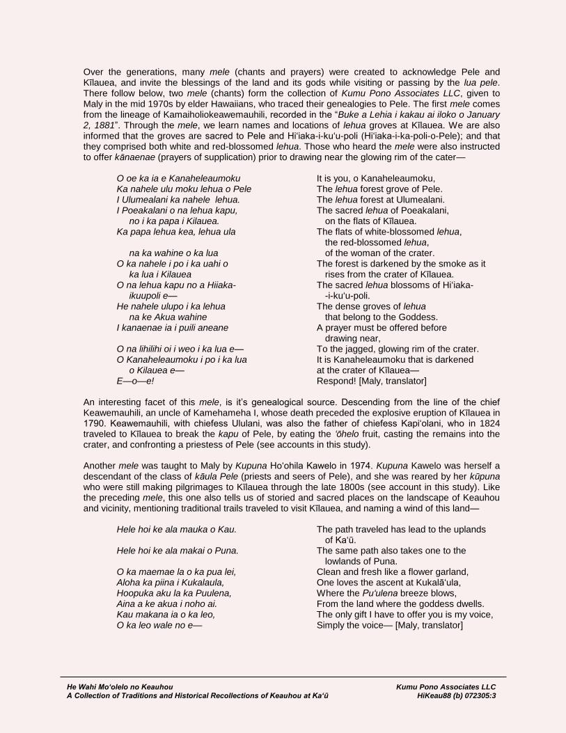
Over the generations, many mele (chants and prayers) were created to acknowledge Pele and Kīlauea, and invite the blessings of the land and its gods while visiting or passing by the lua pele. There follow below, two mele (chants) form the collection of Kumu Pono Associates LLC, given to Maly in the mid 1970s by elder Hawaiians, who traced their genealogies to Pele. The first mele comes from the lineage of Kamaiholiokeawemauhili, recorded in the “Buke a Lehia i kakau ai iloko o January 2, 1881”. Through the mele, we learn names and locations of lehua groves at Kīlauea. We are also informed that the groves are sacred to Pele and Hi‘iaka-i-ku‘u-poli (Hi‘iaka-i-ka-poli-o-Pele); and that they comprised both white and red-blossomed lehua. Those who heard the mele were also instructed to offer kānaenae (prayers of supplication) prior to drawing near the glowing rim of the cater—
O oe ka ia e Kanaheleaumoku It is you, o Kanaheleaumoku, Ka nahele ulu moku lehua o Pele The lehua forest grove of Pele. I Ulumealani ka nahele lehua. The lehua forest at Ulumealani. I Poeakalani o na lehua kapu, The sacred lehua of Poeakalani, no i ka papa i Kilauea. on the flats of Kīlauea. Ka papa lehua kea, lehua ula The flats of white-blossomed lehua, the red-blossomed lehua, na ka wahine o ka lua of the woman of the crater. O ka nahele i po i ka uahi o The forest is darkened by the smoke as it ka lua i Kilauea rises from the crater of Kīlauea. O na lehua kapu no a Hiiaka- The sacred lehua blossoms of Hi‘iaka- ikuupoli e— -i-ku‘u-poli. He nahele ulupo i ka lehua The dense groves of lehua na ke Akua wahine that belong to the Goddess. I kanaenae ia i puili aneane A prayer must be offered before drawing near, O na lihilihi oi i weo i ka lua e— To the jagged, glowing rim of the crater. O Kanaheleaumoku i po i ka lua It is Kanaheleaumoku that is darkened o Kilauea e— at the crater of Kīlauea— E—o—e! Respond! [Maly, translator]
An interesting facet of this mele, is it’s genealogical source. Descending from the line of the chief Keawemauhili, an uncle of Kamehameha I, whose death preceded the explosive eruption of Kīlauea in 1790. Keawemauhili, with chiefess Ululani, was also the father of chiefess Kapi‘olani, who in 1824 traveled to Kīlauea to break the kapu of Pele, by eating the ‘ōhelo fruit, casting the remains into the crater, and confronting a priestess of Pele (see accounts in this study). Another mele was taught to Maly by Kupuna Ho‘ohila Kawelo in 1974. Kupuna Kawelo was herself a descendant of the class of kāula Pele (priests and seers of Pele), and she was reared by her kūpuna who were still making pilgrimages to Kīlauea through the late 1800s (see account in this study). Like the preceding mele, this one also tells us of storied and sacred places on the landscape of Keauhou and vicinity, mentioning traditional trails traveled to visit Kīlauea, and naming a wind of this land—
Hele hoi ke ala mauka o Kau. The path traveled has lead to the uplands of Ka‘ū. Hele hoi ke ala makai o Puna. The same path also takes one to the lowlands of Puna. O ka maemae la o ka pua lei, Clean and fresh like a flower garland, Aloha ka piina i Kukalaula, One loves the ascent at Kukalā‘ula, Hoopuka aku la ka Puulena, Where the Pu‘ulena breeze blows, Aina a ke akua i noho ai. From the land where the goddess dwells. Kau makana ia o ka leo, The only gift I have to offer you is my voice, O ka leo wale no e— Simply the voice— [Maly, translator]

He Wahi Mo‘olelo no Keauhou Kumu Pono Associates LLC A Collection of Traditions and Historical Recollections of Keauhou at Ka‘ū HiKeau88 (b) 072305:4
The mele are shared here in remembrance of the kūpuna who gave them to Maly, and in remembrance of the traditions of respect for the land and the gods therein. They are a reminder to all who journey through this collection, that respect, and speaking of the traditions, are actions that are required at Keauhou. In this way, we also ask permission, prior to telling these traditions and historical accounts.
Approach to Conducting the Study The archival and historical research conducted for this study were performed in a manner consistent with Federal and State laws and guidelines for such studies. Among the pertinent laws and guidelines are the National Historic Preservation Act (NHPA) of 1966, as amended in 1992 (36 CFR Part 800); the Advisory Council on Historic Preservation’s “Guidelines for Consideration of Traditional Cultural Values in Historic Preservation Review” (ACHP 1985); National Register Bulletin 38, “Guidelines for Evaluating and Documenting Traditional Cultural Properties” (Parker and King 1990); the Hawai‘i State Historic Preservation Statue (Chapter 6E), which affords protection to historic sites, including traditional cultural properties of on-going cultural significance; the criteria, standards, and guidelines utilized by the Department of Land and Natural Resources-State Historic Preservation Division (DLNR-SHPD) for the evaluation and documentation of cultural sites (cf. Title 13, Sub-Title 13:275-8; 276:5, 2002); and the November 1997 guidelines for cultural impact assessment studies, adopted by the Office of Environmental Quality Control (which also facilitate the standardized approach to compliance with Act 50 amending HRS Chapter 343; April 26, 2000). A primary objective of the present study was to research and report on documentation that would help readers better understand native Hawaiian customs and practices—and historical events—associated with the land, resources and people of Keauhou. In preparing the archival-historical documentary report for this study, the authors reviewed both published and manuscript references in Hawaiian and English—referencing documentation for the immediate study area, as well as that of neighboring lands. In an effort to further our understanding of the cultural-historical resources, the authors conducted research in several areas which have not received much exposure in past studies. Thus, this study along with other previously conducted studies, provides readers with a detailed overview of native traditions and beliefs of the land and its deities, traditional practices, historic residency, and travel through Keauhou and neighboring lands.
Historical Documentary Resources The documentation from historical literature, was researched in collections of the Hawaii State Archives; the State Survey Division; Bureau of Conveyances; Kamehameha Schools; Bernice Pauahi Bishop Museum; University of Hawai‘i-Hilo, Mo‘okini Library; the National Archives, Library of Congress, and United States Geological Survey Collections (in Denver and Hawai‘i); The Houghton Library, Harvard; and private collections. The records represent findings from research conducted by the authors specifically for this study, as well as materials collected by them over the last 30 years. Review was also made of several manuscripts in the collection of the Hawai‘i Volcanoes National Park, in which were located the historic Volcano House Ledgers (for the years of 1865 to 1916); the Hawaii National Park Nature Notes (for the years 1931-1932); and a historical study, “An Administrative History of Hawaii Volcanoes National Park and Haleakala National Park (F. Jackson, 1972). Excerpts from the first two historical resources noted above, are cited in the study, as they provide first hand accounts of historical interest. The latter historical study, and a draft study titled, “Hawaii Volcanoes National Park Ethnographic Study, Draft Interim Report for Phase I” (ms., Langlas and Waipa 19973) were reviewed, to determine that references important to the present study, were
3 On July 22, 2005, a copy of the final ethnographic study, “Native Hawaiian Use of Hawai‘i Volcanoes National
Park A Historical and Ethnographic Overview (Langlas, 2003) was received from Ms. Keola Awong, of Hawaii

He Wahi Mo‘olelo no Keauhou Kumu Pono Associates LLC A Collection of Traditions and Historical Recollections of Keauhou at Ka‘ū HiKeau88 (b) 072305:5
not overlooked, and to ensure that we would include a wide range of material, not previously cited. While in no way exhaustive in scope, this document includes many references not previously cited, and in some cases not previously translated from their original Hawaiian texts, until the present time. Among the archival resources cited, are: land records by native residents from the Māhele ‘Āina (Land Division of 1848-1855); records of the Boundary Commission (1873-1876); and Bureau of Conveyances (1860-1937); and the writings of several Hawaiian scholars and non-native historians. Readers will find that we have cited extensive, verbatim narratives from original sources in this study. This is done to provide readers with access to a wide range of texts, many of which are otherwise difficult to locate, and to allow those who preceded us to tell their own stories, rather than our paraphrasing them. In this way readers are provided the historical writings in their own context, and the present manuscript may serve as a resource for educational, interpretive, and preservation programs.
Volcanoes National Park (HAVO). From the final study, a brief overview of oral historical documentation has been prepared in this study. Readers needing further information should see the Langlas study.
He Wahi Mo‘olelo no Keauhou Kumu Pono Associates LLC A Collection of Traditions and Historical Recollections of Keauhou at Ka‘ū HiKeau88 (b) 072305:6
A CULTURAL-HISTORICAL SYNTHESIS OF KEAUHOU AND NEIGHBORING LANDS
This synthesis, documenting historical land use and residency in Keauhou and vicinity, has been developed from a collection of detailed records cited in this study. The goal here is to provide readers with a brief introduction into the depth of history and resources of the land. Full citations of the references and accounts cited, follow in later sections of this study, identifiable by topic headings. The land of Keauhou, an ‘ili4 of the ahupua‘a5 of Kapāpala, marks the boundary between the districts of Ka‘ū and Puna. The land extends from the sea to an elevation of more than 9,000 feet above sea level. The natural environment includes fisheries, coastal flats with limited fresh water sources, dry forest zones, volcanic desert and craters, dense rain forests and an alpine zone. Keauhou is most noted for the occurrence of Kīlauea, ka lua o Pele (the volcano), domain of Pele. As such, there was an awe, reverence, and even a fear associated with this land, that permeated every action of man on it. People were not allowed to carelessly travel through the Kīlauea region of Keauhou. Early accounts recorded by both native and foreign writers tell us that prayers and offerings were made by all who passed across the land. Indeed, only a special class of people were apparently allowed into the lua pele at all. Many of the place names associated with the Kīlauea region of Keauhou, bear witness of the gods and goddesses who walked the land, or commemorate some interaction between the deities and the Hawaiian people. Traditional and early accounts document that heiau occurred around Kīlauea, and at other locations in Keauhou. We also learn that bird catchers, canoe makers, and other practitioners frequented various elevational zones of Keauhou, collecting feathers, making canoes, and collecting stone for adze making. Several traditional routes of access are recorded as passing through Keauhou. One trail passed through the coastal lands. Another, passed above the coastal lands up the slopes of Kukalā‘ula, and branched off, allowing travelers to pass below Kīlauea, while traveling to Puna; or to pass near the summit of Kīlauea, and on to the ‘Ōla‘a-Hilo route. Another access passed through the uplands of Keauhou, passing Keawewai, and continuing into Humu‘ula, connecting with the mountain trail between Mauna Loa and Mauna Kea. Within Keauhou, there were also mauka-makai trails near the Keauhou-Kapāpala boundary, and the Keauhou-‘Āpua boundary. Because of the sacred and volcanic nature of Keauhou, it is not surprising that the early records are almost silent on who may have resided in Keauhou. We learn from early missionary records, the names of three people who resided—at least part time—around Kīlauea, and who had been appointed there as priests and priestesses by Kamehameha I. They were Oani (w.), Iaea (k.), and Wahineomao (w.). Another individual by the name of Keliilohi, reported before the Boundary Commission in 1873, that he had been born at Keauhou at the time of the “Okuu” (an epidemic that occurred in 1804). Other than these four names, we have found few other names of native residents of Keauhou in the records viewed.
4 ‘Ili, a native land parcel, being a part of a larger land division. An ‘ili may consist of a small parcel of land, less
than an acre; be composed of several detached parcels at varying elevational or environmental zones; or may, as in the case of Keauhou, be comprised of thousands of acres. By its traditional boundaries, the ‘ili of Keauhou contains 50,740 acres.
5 Ahupua‘a, a traditional land division, embracing environmental zones extending from the ocean fisheries, to the
mountain zones. This form of division provided the tenants of each ahupua‘a with access to most of the resources necessary to sustain and promote life and growth in any given area.

He Wahi Mo‘olelo no Keauhou Kumu Pono Associates LLC A Collection of Traditions and Historical Recollections of Keauhou at Ka‘ū HiKeau88 (b) 072305:7
The missionary communications also provide us with a general description of residency along the coast in the ‘Āpua vicinity, which may be considered as similar to that of coastal Keauhou—it being that there were clusters of houses at sheltered areas along the shore—as at Halapē, where fisher-people and salt-makers lived. A tradition associated with the name, Halapē, also tells us that such crops as ipu (gourds) and ‘uala (sweet potatoes) were planted near the shore. Covered by the shifting sands, they were crushed when visitors unfamiliar with the area passed through the village, thus the name, Hala-pē (Missed and crushed) (cf. Pukui et al., 1974). By the time of the Māhele ‘Āina in 1848, no one submitted claims for kuleana in Keauhou. In fact, no claims were made for the larger ahupua‘a of Kapāpala, and only one claim was made for the neighboring land of ‘Āpua (claimant, Kumauna). The lack of claims in Kapāpala is particularly puzzling, as the earliest foreign accounts of travel through Kapāpala, while on the way to Kīlauea and Mauna Loa, describe several areas of plantations and residences in the ahupua‘a. The first foreigners visited Kīlauea in the company of native guides, in 1823. The early accounts from the 1820s to the 1850s, regularly describe the beliefs, manners, customs, and practices of native Hawaiians that were observed when approaching, and traveling through Kīlauea. It was noted by all, that there was great awe and fear of Pele and the associated volcanic phenomena. While the foreigners made light of the native beliefs and traditions associated with Kīlauea, they also described the region in words of respect, grandeur, and even fear. In the period between 1823 to the mid 1830s, there were still people who resided in Keauhou, in the vicinity of Kīlauea, whose responsibility it was to honor the kapu associated with Pele. In this time, and through the 1850s, other individuals frequented the forests of Keauhou, in pursuit of such resources as koa, ‘iliahi, and various birds—both for feathers and for food. Native testimonies and foreign accounts describe the occurrence of shelters at various locations near Kīlauea, and in the forest and mountain lands where those collectors of resources, and religious practitioners would stay while on the land. Interestingly, the significance of Kīlauea, on the Keauhou landscape also drew people to it who sought to have the remains of loved ones deposited at the volcano. Families with attendants of Pele, coming from all of the islands, and with a familial connection to the Pele line, continued this traditional practice at least through the 1860s, and likely later. In more recent times, individuals who descend from the Pele line, and from the class of kāula Pele (Pele priests and prophets), have had their ashes taken to Kīlauea, in order to rejoin with their ancestors. By the 1840s, as Hawaiian land tenure was being defined in a western context of fee-simple property rights, no native claimants applied to the Board of Commissioners to Quiet Land Titles, for kuleana (land holdings and rights), in the ‘ili of Keauhou. And in January, 1848, the entire ‘ili of Keauhou was claimed by, and awarded to Chiefess Victoria Kamāmalu, in Helu 7713, Palapala Sila Nui 4475, Apana 11, while all the neighboring lands which share substantial boundaries with Keauhou, were retained by King Kamehameha III, as “Aina Lei Alii” (Crown Lands). By 1840, temporary visitor-lodging facilities were constructed on the bluff overlooking Kīlauea. Later, in 1847, just prior to the Māhele ‘Āina, the facilities were built at the bluff known as Ka‘auea—also called Ka pali kapu o Ka‘auea. And the native proprietor kept a book for recording the names and
comments of visitors. A native account, penned in 1861, named the house as “Kamalauki,” perhaps descriptive of a shelter thatched with leaves of the native ‘uki (Machaerina), a native sedge that grows around Kīlauea. In 1863, the first formal lease of Keauhou was granted by Chiefess Kamāmalu and her father, M. Kekūanao‘a, to F.B. Swain. By 1865 the lease had transferred to C.E. Richardson, who with partners, Wm. Reed, Geo. Jones, and L. Kaina, who in addition to further developing ranching and a pulu6 harvesting business at Keauhou, also developed a new a Volcano House. The facility served visitors to the Volcano, and those traveling between Ka‘ū and Hilo or Puna. The growing facilities were made in a mixture of Hawaiian and western architecture. The first, all-wooden
6 Pulu–the down, fur-like material, collected from shoots of the native hāpu‘u (tree ferns).
He Wahi Mo‘olelo no Keauhou Kumu Pono Associates LLC A Collection of Traditions and Historical Recollections of Keauhou at Ka‘ū HiKeau88 (b) 072305:8
Volcano House, was built in 1877, and remains not far from where it was originally built, to the present-day. Between the 1860s to 1880s, the larger land of Keauhou continued to be used in the development of business interests in the form of ranching, collection of pulu, and limited harvesting of native woods. Ranching had the most significant effect on the lands of Keauhou, and continued in areas of the land from the 1860s to the 1980s. The value of Kīlauea as a point of visitor and scientific interest was regularly described by writers from the 1870s to the early 1900s, when in 1903, W.R. Castle, an annexationist7 and frequent visitor to Kīlauea, suggested that the government of the United States should consider formation of a park. Castle suggested that everything from the summit of Mauna Loa, to Kīlauea, and in a narrow strip, to Honolulu in Puna, be incorporated into such a national park. The call was taken up and many individuals, among who were Lorrin A. Thurston8, Thomas Jaggar, and Prince Jonah Kūhiō Kalaniana‘ole. In 1916, agreements between the Territory of Hawaii and the Trustees of the Bishop Estate were being explored, and the lands surrounding Kīlauea and the summit of Mauna Loa, were set aside as a part of Hawaii National Park. While the legislation establishing the park was formally dated August 1, 1916, the actual transfer of the land from Bishop Estate to the Territory of Hawaii did not occur until 1920; and transfer of the land from the Territory to the United States did not occur until 1922. Early in the park’s development, it was realized that the idea of having the two volcanic craters of Kīlauea and Mauna Loa, as separate components of the park, connected via a trail across private and government lands, was not adequate. In the following years, additional sections of Keauhou were acquired from the Bishop Estate for park purposes. In the years leading up to establishment of the National Park, the National Guard of Hawai‘i and the United States Army established a military reserve (Kilauea Military Camp) in Keauhou, for purposes of training, recreation and health. The Volcano House Hotel also secured a lease from the Trustees of the Bishop Estate to develop the Volcano Golf Course. The Trustees also entered into a program of leasing out the Volcano Homestead lots. Ranching, which began in the 1860s on Keauhou, continued in the upper Keauhou region, above Kīlauea, and in the Kuehu (Ainahou) region—near the Keauhou-Puna boundary. In the uplands of Keauhou, a koa logging operation was also started in ca. 1910, with koa harvested until 1993.
7 William R. Castle, a missionary descendant with ties to bullock hunting and lumbering on the island of Hawai‘i,
was among the primary players in the overthrow of the Hawaiian Monarchy in 1893, and promoter of the annexation of Hawai‘i to the United States.
8 Lorin A. Thurston, another missionary descendant, and primary partner in the overthrow and annexation of Hawai‘i.
He Wahi Mo‘olelo no Keauhou Kumu Pono Associates LLC A Collection of Traditions and Historical Recollections of Keauhou at Ka‘ū HiKeau88 (b) 072305:9
NATIVE TRADITIONS AND HISTORICAL NARRATIVES OF KEAUHOU AND VICINITY
This section of the study is divided into two sections, including detailed excerpts from native traditions and historical accounts that tell us of Keauhou, it’s storied and sacred places around Kīlauea, and of neighboring lands. These accounts have been recorded by native historians in Hawaiian, and by foreign writers from 1794 to the 1950s. Some of the narratives have been widely read, while others have been recently translated by Maly from Hawaiian to English. The narratives are divided into two categories— “I. Na Mo‘olelo (Native Traditions and Historical Accounts),” those penned by, or given by Hawaiian writers; and “2. Historical Observations,” those penned by non-Hawaiian writers.
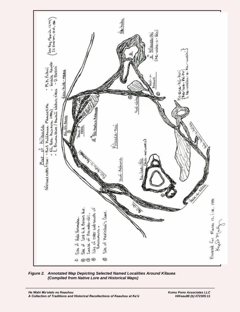
Storied Place Names of Keauhou The place name Keauhou may be literally translated as “The new current or new era” (Pukui et al. 1974), and in this case, is perhaps rooted in the movements of Pele, as the active volcanism periodically creates new landscapes. Keauhou is most famous as the home of Pele, with the craters of Kīlauea nui, Kīlauea iki, Ka lua o Pele, and Halema‘uma‘u. On the landscape of Keauhou, are many wahi pana (storied and sacred places), which stand out in traditions and the recollections of elder kama‘āina. Table 1. provides readers with selected place names, and when possible literal or interpretive translations are provided. Figure 2 is an annotated map prepared in 1989 by Maly, as a part of a cultural landscapes seminar held at Kīlauea on March 17th and 18th, 1989. Most of the place names cited in the Table 1, are cited on the map, and are based upon several historical surveys and manuscripts (those are cited at various locations in this study), and personal communications with Mary Kawena Pukui, Ho‘ohila Kawelo, and Dorothy Barrere.
Table 1. Storied Place Names of Keauhou
‘Akani-a-kōlea or ‘Akani-kōlea
(Steam vents and location of old
hale ho‘omaha – rest house)
Literal: Song or Cry of the plover.
Ha‘a-kula-manu (Sulphur Banks) Literal: Low plains of the birds.
Hale-ma‘uma‘u or Hale-
‘āma‘uma‘u and Hale-maumau.
Literal: Sadleria fern house. The name is interpretively translated
as “House surrounded by ‘āma‘uma‘u ferns” (from account of
Pele’s battle with Kamapua‘a).
Pronounced as “Hale-maumau” (without the glottal break
between the letters a and u), the name is literally translated as
“Everlasting house”. Interpretively, as “House of everlasting fire”.
He‘eia Literally: Washed away.
Holoholo-kōlea or
Holoholo-a-kōlea
Literally: Running place of plovers.
Ka‘auea or Pali-kapu-o-Ka‘auea
(Waldron’s Ledge)
Literally: The steam currents. The sacred cliff of Ka‘auea, named
for the priest Ka‘auea, companion of Kahawali mā.
Kahua-loa Literally: The long field (arena).
Ka-lua-Pele Literally: The volcanic crater; or the pit of Pele.
Kamohoali‘i or
Pali-kapu-o-Kamohoali‘i
Named for the elder brother of Pele. The sacred cliff of
Kamohoali‘i.
Ka-waha-o-Pele or Kīlauea Iki Literally: The mouth of Pele. Little Kīlauea.
Ka-welelau-o-ka-uwahi or
Ke-ana-kā-ko‘i
Literally: The tip of the smoke. The adze-making cave.
Ke-one-loa Literally: The long sandy (or cinder) area.

He Wahi Mo‘olelo no Keauhou Kumu Pono Associates LLC A Collection of Traditions and Historical Recollections of Keauhou at Ka‘ū HiKeau88 (b) 072305:10
Kīlauea Iki Literally: Little Kīlauea.
Kīlauea Nui (Kīlauea) Literally: Big Kīlauea. In 1975 Kupuna Mary Kawena Pukui shared
the following comments regarding the meaning of Kīlauea and
issues regarding “Place Names of Hawai‘i” (Pukui et al., 1974) with
Kepā Maly:
While preparing the book Place Names of Hawai‘i, I
disagreed with the interpretation given by my partners to
some of the place names. We had lengthy discussions
about this, and when discussing Kīlauea, which they had
translated as “Spewing, much spreading”, I suggested
that we did not know the origin of the word, or how the
words had originally been put together into the place
name. There is no specific tradition that has been
handed down that tells us how the name Kīlauea was
given. As a result of this disagreement, we finally settled
on use of the terms “literal” and “interpretive” to
designate the kind of translation being given. (pers.
comm. M.K. Pukui)
Kupuna also observed that she did not concur with the translation
of Kīlauea as given in the book, as it was only a possible meaning
of the words if they were broken a part as “Kī-lau-ea” (ibid.).
Ku-lili-ka-ua Interpretive: Ku of the mist rains.
Lele-kōlea (Lele-a-kōlea) Literally: Plover leap.
Na-huku (Thurston Lava Tube) Literally: The protuberances.
‘Ōhi‘a-o-ka-lani Literally: ‘Ōhia (Metrosideros spp.) of the heavens.
Poli-o-Keawe Literally: Bosom of Keawe.
Uwē-aloha or Pali-aloha
(Byron’s Ledge)
Literally: Cry of love. Interpretive: Cliff of the beloved one
(Lohi‘au).
Uwē-kahuna Literally: Crying priest.
Wahine-kapu Literally: Sacred woman.
He Wahi Mo‘olelo no Keauhou Kumu Pono Associates LLC A Collection of Traditions and Historical Recollections of Keauhou at Ka‘ū HiKeau88 (b) 072305:11
Figure 2. Annotated Map Depicting Selected Named Localities Around Kīlauea (Compiled from Native Lore and Historical Maps)
He Wahi Mo‘olelo no Keauhou Kumu Pono Associates LLC A Collection of Traditions and Historical Recollections of Keauhou at Ka‘ū HiKeau88 (b) 072305:12
I. Na Mo‘olelo (Native Traditions and Historical Accounts) Native traditions for various locations in the land of Keauhou—particularly those in, or in some way associated with Kīlauea—span the Hawaiian collection of knowledge of place, attachment to landscape, and are a means of documenting the spiritual relationship shared by people with the land and creative forces of nature. This section of the study offers readers a collection of native traditions dating from antiquity, to the earliest period of written Hawaiian accounts; and also include narratives from native writers who sought to perpetuate knowledge of past practices and the landscape. The texts document a significant knowledge of the landscape—the natural and cultural forms—respect for, and awe of the gods dwelling about the people; and describe a wide range of spiritual and cultural practices associated with lands of the Keauhou vicinity. The accounts also document the rapid succession of changes in beliefs and practices, and as a result, help us today, to understand traditions and customs of those who share an affiliation with the land. The accounts below, include several from widely read sources, and others which have not been translated until being presented here. We note that at times, the language used by the kūpuna in their accounts is of an older form, or in a context, that may be difficult for readers such as ourselves to understand. We apologize here for any mistakes that may have been made, and note that all sources are cited, thus enabling Hawaiian readers to go directly to original texts, to review them for accuracy of meaning.
“He Mele i Kilauea” On March 21st, 1860, the Hawaiian language newspaper, Ka Hae Hawaii, published a commentary on mele (chants). In the short account, the editor cited a mele for Kīlauea, as an example of the important traditional accounts which were being rapidly lost. The following narrative is a translation of the commentary, and an introduction to the depth of cultural attachment shared between Keauhou, places of Kīlauea, and the people of the land. The introductory words also shed light on the conflict within the Hawaiian mind about that which was handed down from the past, and life in the then present day.
The mele of ancient times are nearly lost, it is difficult to find people who possess an understanding of them. This is something to be deeply regretted, because through such mele, we are able to understand the way of life of those people who came long before us, and to know the histories of various land areas. One way to ensure that the knowledge will not be lost, is to publish the mele in books and perhaps in the newspapers; then the future generations will be able to read them and contemplate them in their minds, while also understanding that our ancestors were mistaken, and that we should not follow them and go astray. We desire to publish the ancient mele and the new mele, those that are of a good nature, and we here ask the people who know the mele, and those who create mele, to bring them up to us, that we might publish them. Write out the words, and explain them, set them in their appropriate columns, so that the publishers may know how to print them. We print below, an ancient mele that was first published in the Nu Hou in the year, 1854, given by Kaleiopaoa to S.M. Kamakau, who gave it to the Nu Hou. Within this mele are some of the names of the lands of Kahiki.
He Mele i Kilauea. A Chant of Kilauea Hulihia ka mauna wela i ke ahi, The mountain is overturned in the heat of the fire, Nopu wela ka uka o Kuianalei, The heat wells to the uplands of Kuianalei, I ke a pohaku puulele e lele mai iuka, The fiery stones fly from the hills, fly from the uplands,

He Wahi Mo‘olelo no Keauhou Kumu Pono Associates LLC A Collection of Traditions and Historical Recollections of Keauhou at Ka‘ū HiKeau88 (b) 072305:13
O ke kakoi ka hookele mai ka lua, It is the hookele adze stone struck from the crater, O ka maiau pololei kani lealea, Made carefully, and ringing with joy, O ka hinihini kani kuamauna, Singing like the land snails on the mountain, O ka mapu leo nui kani kohakoha, The loud voice that strikes out, O Kanakaloa o ka mauna, Of Kanakaloa on the mountain, O Kupulupulu i ka nahele, Kupulupulu in the wilderness, O na ‘kua mai ka waokele, The gods from the forests, O Kulipeenuiaiahua, o Kikealawaopiikea, Kulipeenuiaiahua, and Kikealawaopiikea, O ka uwahi pohina iuka, The smoke darkens the uplands, O ka uwahi mapukea i kai, The white smoke is born to the shore, O ke awa nui i ka mauna, The great awa is on the mountain, O ke pookea i kanahele, The pookea (mysterious ones) of the forest, O ka uwahi noe lehua—e, The smoky, misty lehua blossoms— O ka aina a Pele ma iuka, On the land of Pele and her companions in the uplands, Ua ku ke oka, aia i kai—e, The fragments arise there at the shore—, Pau ae i ka maha laau, Consumed are the clumps of trees, Ka maha ohia loloa o Kaliu, The clumps of long ohia of Kaliu, Ka uka i pohaku e kapu, e kapu, The stony uplands are kapu, kapu, Kapu mai la Puna, ua kulepe ke ahi, The kapu is at Puna, the flames flutter, Ua haiki Puna i Kilauea, Puna is narrowed at Kilauea, Ua ha ka lama i ka luna i Mokuaweoweo, The light breathes on the heights of Mokuaweoweo Ua ha uka i Keahialaka, Breathes upon the uplands of Keahialaka, Aina ae la Moeawakea, The land of Moeawakea, Ke a i kai o Kukalaula, The rocky shore of Kukalaula, A luna au o Pohakuloa, I am above at Pohakuloa, Holo nae ku au nana ilaila, e maliu mai—e, I have travel to stand and look there, to turn there, O ku ike wale aku ia Puna, And look to Puna, I ka papa lohi o Apua, To the long, glistening plain of Apua, He la liliu e nopu wela ka wawae, It is a day of scorching, the heat rises to the feet, A pau na niu o Kula i Kapoho, Consumed are the coconut trees of Kula at Kapoho, Holo ka uwahi maha oo Kuauli, The smoke covers the forehead of Kuauli (Hawaii), Pau o Maolala i ke ahi, Maolala is consumed by the fire, I hia no aa i ka papa, The plains are burned, Pulupulu i ka lau laau, The branches are as tinder, Punia ka lani, haule ka ua loku, The heavens are overcome, the pouring rains fall, Kaa mai ka pouli, wili ka puahiohio, The darkness rolls forth, twisting as in a whirlwind Ke owe la i ka lani, The heavens murmur, Eia Pele mai ka mauna, Here is Pele, from the mountain, Mai ka lua i Kilauea, From the crater at Kilauea, Mai Papalauahi, mai Ooluea, From Papalauahi, from Ooluea, Hiki Malama mahina ka uka o Kaliu, Arriving at Malama, the garden in the uplands of Kaliu, Enaena Puna i ka aina e ke Akua, Puna rages, it is the land of the God, Nihoa ka pali ka lua iuka, Jagged is the cliff around the upland crater, Koea mania kikaha koae, Shuddering and soaring are the koae Lele pauma ka hulu maewaewa, The feathers flutter against the breast,
He Wahi Mo‘olelo no Keauhou Kumu Pono Associates LLC A Collection of Traditions and Historical Recollections of Keauhou at Ka‘ū HiKeau88 (b) 072305:14
Kikaha pouli na ‘kua o ka uka, The gods of the uplands soar in the darkness, Lioliowawau na ‘kua o ka lua, Lioliowawau is for the gods of the crater, Aeae Pele, noho i ke Ahiku, Pele rises, and sits at Ahiku, Kani ke ilalo o ka lua, The bottom of the crater resonates, Kahuli Kilauea me he ama la, Kilauea looks like an outrigger, Kunia Puna, moa wela ke one, Puna is burned, the cinders are hot, Wela Puna, e wela i ke ahi—e, Puna is hot, hot in the fire—, Kina Puna wela i ke ahi—e. Puna is blemished in the heat of the fire—. [Ka Hae Hawaii, March 21, 1860; Maly, translator]
He Wahi Pū‘olo Iwi It has been a tradition of families who traced their lineage to the Pele clan, to take the remains of deceased loved ones to Kīlauea, and other volcanic places associated with Pele. While this practice was mostly hidden after the establishment of the Christian Mission Station in Hawai‘i, it persisted through the 1800s, and in some form, continues through the present day, usually in the form of cremated remains being taken by family members to Kīlauea. In August 1861, K.W. Kawaiahao, a resident of Punahoa-luna, Hilo, wrote a letter to the public, which was published in the native language news paper, Ka Hae Hawaii. While Kawaiahao, observed that it was an “ignorant custom” from “times of darkness,” he described the on-going custom of residents of Puna, ‘Ōla‘a, and other areas, of taking the pū‘olo iwi (bone bundles) to Kīlauea for burial and deification. Kawaiaha‘o wrote:
Ka Hae Hawaii Augate 28, 1861 He Wahi Hana Naaupo. He wahi puolo ka‘u e hooili aku nei ia oe, a nau ia e wehewehe aku i ke alo o ko kaua mau makamaka, e noho ana ma kuaaina a me ke alo alii. Eia ua wahi puolo la. O ka lawe ana o kekahi poe i na iwi kupapau i ka lua o Pele, i mea e hoomana ai ia Pele, i akua no lakou. O ka hana mau keia a kekahi poe e noho nei ma kai o Puna, a me kekahi poe ma Olaa, a me na wahi e ae. Ina he poe mea iwi kupapau. Eia ka lakou. Hele no lakou a kahi o ke kaula Pele, olelo aku lakou ia ia, “He wahi iwi kupapau ka makou la.” Olelo aku la ke kaula Pele ia lakou, “E pii hoi ha kakou i ka lua o Pele, e hookomo i na wahi iwi a oukou.” O ko lakou pane aku la no ia penei, “O ko makou manao no hoi paha ia i hele mai la, e pii pu kakou i ka lua o Pele, e hookomo i na wahi iwi a makou.” Alaila, ninau aku la ke kaula Pele ia lakou, “Ua loaa nae paha na mea e oluolu mai ai ke akua?” Hai aku la lakou ia ia, ua loaa hoi paha ia
Ha Hae Hawaii August 28, 1861 An Ignorant Undertaking. I have a little package to set before you, and you can expose it to the presence of our friends who dwell in the country, and in the presence of the chiefs. Here is the package. That some people are taking the bones of those deceased to the crater of Pele, as a means of worshipping Pele as their god. This is the regular custom of some people who live in the coastal lands of Puna, and some people at ‘Ōla‘a, and other locations. If they have the bones of deceased ones. Here is what they do. They go to the place of the Pele priest, and they tell him, “We have the bones of a deceased one.” The Pele priest tells them, “Let us go up to the crater of Pele, and put your bundle of bones in.” They reply to him thus, “That is the reason we have come, let us go up together to the crater of Pele, and put our bundle of bones in.” The Pele priest then asks them, “Did you perhaps obtain the things necessary to appease the goddess?”
He Wahi Mo‘olelo no Keauhou Kumu Pono Associates LLC A Collection of Traditions and Historical Recollections of Keauhou at Ka‘ū HiKeau88 (b) 072305:15
mau mea, i na mea e oluolu mai ai ke akua. Hai aku ke kaula Pele ia lakou, penei, “Ina ua loaa kahi moa keokeo, he wahi luau no hoi, he puaa paahiwa no hoi, oia na mea e oluolu mai ai ke akua la.” “Ina e loaa keia mau mea ia oukou, alaila pii pu kakou e hookomo i na wahi iwi a oukou.” I aku lakou ia ia, ua loaa ia mau mea ia makou. Pane aku la ke kaula Pele, penei, “Apopo hoi ha kakou pii.” O ko lakou ae mai ia no ia. Noho lakou a kekahi la ae, o ko lakou hoomakaukau iho la no ia e pii, ka pii aku la no ia a hiki i ka lua o Pele, ke kalua iho la no ia i na mea i hoomakaukau ia no ke akua. A pau keia mau mea i ka hana ia, alaila, hoomaka aku la lakou e iho e hookomo i na mea a lakou i lawe aku ai. Ia lakou i hoomaka ai e hele, o ke kaula Pele no mamua e hele ai, mahope aku no ka poe mea iwi kupapau. A makaukau na mea a pau ka ke kae o ka lua; alaila, oli aku la ke kaula Pele ma ka inoa o Pele, a me na ‘lii i hookomo mua ia. A pau ka hana ana a ke kahuna pela, alaila lawe aku la ka poe mea iwi a hookomo, ma kahi a ke kaula Pele i kuhikuhi ai. Pela ka hana ana a kekahi poe e noho nei i keia manawa. Noonoo mai ana oukou la, e ko‘u mau makamaka i na hana naaupo a keia poe. Kainoa paha ua pau ka pouli ma Hawaii nei, eia no ka hele pu nei me ke aupuni o Kristo. Auwe! Aloha ino ka poe hoomau ana ma keia mau hana pouli. Ea, e o‘u mau hoa e noho mai la i ka i-u o ka la, a me ka lauae makani o keia mau mokupuni. E hoi hou anei kakou i na hana o ka pouli? Owau no me ke aloha ia lakou. K.W. Kawaiahao Punahoa-luna, Hilo, H., Aug. 17, 1861.
They respond to him that they have perhaps gotten those things which will appease the goddess. The Pele priest then tells then, “If you have obtained the white chicken, some taro greens, and a black pig, those are the things that will appease the goddess.” “If you have these things, then we will go up and put your bundle of bones in.” They reply, telling him that we have all of those things. The Pele priest then replies, “Tomorrow, we will go up.” They then agree with him. They then wait till the next day, and then they make everything ready for their ascent, and when they arrive at the crater of Pele, they bake all of the things and make them ready for the goddess. When all these things are done, then they begin their descent, to put in all of the things they have brought. When they begin to go, the Pele priest goes first, and there follow after, the people who have the bones. Everything is readied at the edge of the crater; then the Pele priest chants in the name of Pele, and of the ali‘i who have previously been put in there. When the priest has finished these things, the people with the bones of the deceased one, take them to the place where the Pele priest directs them. That is the work of some people who are living at this time. Think, my companions, about the ignorant work of these people. It was thought that this darkness in Hawaii was ended, that we were going into the kingdom of Christ. Alas! Pity the people who continue in these dark ways. Say my friends who dwell in the consecrated sun, and in the myriad breezes of these islands. Should we perhaps return to these dark ways? I am with compassion for them. K.W. Kawaiahao Punahoa-luna, Hilo, H., Aug. 17, 1861. [Maly, translator]
He Wahi Mo‘olelo no Keauhou Kumu Pono Associates LLC A Collection of Traditions and Historical Recollections of Keauhou at Ka‘ū HiKeau88 (b) 072305:16
“Volcanic Manifestations—Pele” Samuel Mānaiakalani Kamakau was one of the preeminent native historians of the mid-nineteenth century. Tied to the Kamehameha household, he was educated at Lahainaluna, and served in the Hawaiian Government in many capacities. During his lifetime, he penned many important traditions and genealogies in native language newspapers and letters. Among the traditions and historical narratives published by Kamakau, were accounts of Kīlauea, Pele, and the traditions, beliefs, and practices associated with the volcanoes and goddess. Kamakau penned a series of articles in 1870 (M.K. Pukui, translator; D. Barrere, editor; 1964) pertaining to religious beliefs and practices associated with Pele and Kīlauea, noting that specific families were possessed of the right to take the remains of deceased ones to Kilauea, where they would become a part of the ‘aumākua realm, even taking body-forms that were manifestations of the geologic phenomena. Kamakau reported that Kīlauea was one of the entry ways to the realm of the ‘aumākua, and that:
…if the pit of Pele at Kilauea was the kuleana of a man and his family, it was known that theirs was an irrevocable kuleana (kuleana hemo ‘ole) to go there…* …Persons with this right, kuleana, in the ‘aumakua realm did not fear death or have any misgivings about dying, for what was death to them, or what was the body but a useless thing to those who had seen before their eyes the glory of the place prepared for them…?” [Kamakau, 1964:50]
Kamakau went on to provide detailed descriptions of this practice, and the signs discerned in the movements of the lava and other natural phenomena associated with it. He also observed that in ancient times, people did not just descend into the crater at Kīlauea—few would venture there:
…For a dead beloved one whom they wished to become a volcanic manifestation (e
lilo i pele) of the crater (luapele) of Kilauea on Hawaii, the Hawaiians would act in this way: They would take to the volcano the bones, hair, fingernails, or some other part of the dead body, sacrifices and offerings for the gods (akua), gifts for the priests and prophets and guardians of the volcano, a pig, ‘awa, and a tapa garment of whatever color the relatives to whom the body belonged chose to be a visible sign to them—whether striped, red and white, or red and black—and they would ascend to the pit of Pele, ka lua o Pele. There they ritually killed the dedicatory pig (ho‘omoe kapu ka pu‘a me ka ho‘ohiki ana, he pua‘a hana) for the dead newcomer, the malihini, to become a
native, a kama‘aina, of Kilauea. If the ritual went well (ina he maika‘i ka ho‘omoe ana), a pouring rain would pelt the uplands and the sounds of thunder would reverberate to the sea, as a sign of consent to the admission (ho‘ohui) of the malihini. In the morning, the pig was roasted, the [page 64] ‘awa was chewed, and all would feast. Then the prophet of Pele, the kaula Pele, and the relatives of the dead, from 10 to 40 as eyewitnesses, would take the corpse and the offerings—a live pig (pua‘a mohai ola) and some ‘awa—to the very center (‘onohi) of the fire, where the fires were quiet and where fiery lava (ahi pele) welled up (hua‘i) instead of tossing about or rolling in great waves. The prophet stood and pleaded (kahoahoa) for the acceptance of the malihini and for his being united with the kama‘aina of the pit, and he recited the ancestry of the dead
one so that his ancestors in the crater of Kilauea would know him as one of them. It was useless to make offerings to them, for they were just the kama‘aina of the place, not the gods. When the ‘awa and the pig were thrown in, they were immediately consumed. When the body of the malihini was thrown in, it was as though it were being fondly lifted by a procession of people and borne tenderly upon fingertips into Halema‘uma‘u, the home of the kama‘aina Chiefess of this place. She, Pele, had
* Ke Au Okoa, October 6, 1870.
He Wahi Mo‘olelo no Keauhou Kumu Pono Associates LLC A Collection of Traditions and Historical Recollections of Keauhou at Ka‘ū HiKeau88 (b) 072305:17
built this place to warm the strangers who came to the mountain through icy mists. The body was borne along for the distance of a chain or two without the tapa that covered it being scorched; then, like a swelling wave, a flame swept over it and the malihini vanished. Some minutes later a flame appeared and billowed, and a column of fire appeared, streaked with whatever color the relatives had chosen to wrap the body in. They would hear the sound of many voices making a din, chanting hula and oli and mele, and the colored column which was the malihini they had brought would move about joyfully. Then the people to whom the malihini belonged would wail and call out the name by which he had been known in life and say, “You live! You live!” The “sign,” ho‘ailona, which the relatives saw was their beloved one; this was the body of their beloved. Should Hawaii be overrun by lava, if they saw the ho‘ailana of their own volcanic spirit (pele) in the fountains of fire, the people had no fear of death—it was their own kama‘aina who surrounded them with fire. If they were within the blazing fires, they would come to no harm; they had their guide, and they could go forward victoriously (hele i ka lanakila) and without harm. Such was the belief of some people about volcanic spirits in the old days. If the corpse was that of a chief, some people divided the body into 40 or more pieces and distributed the little pieces among the districts (moku‘aina) of Hawaii. Those of each district could take their pieces to be made into a pele. There might be 40 or 100 pieces, and so each person might become a “multitude” (lehulehu) of volcanic spirits. The danger in making the body of a high chief, or perhaps a ruler, into so many spirits was that they might burst forth and devastate the land. The kaula Pele, therefore, did not like to do this. Those who did yield to the pleading of certain people and consent to do so were called “destroyers of the land” (ho‘ino ‘aina) and “troublemakers to the kingdom” (ho‘opilikia i ke aupuni). That is the reason why chiefs killed prophets of Pele in the old days, and why the prophets acted in great secrecy. If there was a great eruption that devastated the land, the people became greatly excited and believed that a high chief had been taken into the pit of Pele. The mistaken idea (mana‘o kuhihewa) that many spirits are banded together in the pit of Pele has persisted [page 65] from ancient times to this. It is a place free from all defilement, according to the belief of these people.* Many people wished to become volcanic spirits, and their relatives would make the appeal for them—perhaps because they believed that they would continue to live in the volcanic fires. There were many signs to be seen if one could not become a spirit of the volcano. A person did not become such merely by the making of a great many gifts and offerings; many are the eyewitnesses and prophets who can testify to this. When the prophet and the relatives of the dead one took his bones, hair, fingernails, or his spittle, perhaps, and the prophet made the appeal and threw the bundle into the glowing fire, if the bundle fell into the fire and was thrown back again to the place from which it was thrown without the tapa wrappings being burned, then the prophet would retrieve the bundle and ask what the obstructions (na kumu hihia) were that had caused it to be thrown back. If, when it was thrown a second time into the fire, it vanished into flame, then it had first been returned because of the obstruction that had now been cleared up. But if the bundle broke open and the bones or fingernails or whatever it was scattered, why was this? It was because the person had been spurned. He had no right—no, kuleana—there, and had no relatives in that place. He became a wandering spirit at Kama‘oma‘o, a catcher of dragonflies, a shredder of spiders in the wiliwili grove of Kaupe‘a.
* Ke Au Okoa, March 24, 1870.
He Wahi Mo‘olelo no Keauhou Kumu Pono Associates LLC A Collection of Traditions and Historical Recollections of Keauhou at Ka‘ū HiKeau88 (b) 072305:18
The persons who have a kuleana in Ka lua o Pele are the direct descendants (pulapula pono‘i) of Haumea, Kanehekili, Kaho‘ali‘i, Kanewawahilani, Kauilanuimakehaikalani, Nakoloilani, Kamohoali‘i, Pele, Hi‘iaka, and Namakaokaha‘i. If one of these ‘aumakua is in the family of a person, they are all in his family [as they are related to each other]. Through giving birth in human form, one of them joins a person’s blood to theirs and becomes a kumupa‘a, a “fixed origin”; they are all ‘aumakua. The kuleana does not come by consecrating a spirit to be one’s god (ho‘ola‘a), or by pretending to be possessed by a god (ho‘onohonoho akua) and feigning insanity (ho‘opupule) and speaking in whispers, or by bowing down and worshiping them, as some do, or by calling upon them to come and inspire him as he wishes. Only through the blood lineage (koko i eweewe mai) of the ancestors does the kuleana come. The god recognizes that blood kinship and clings forever to his descendants in the living world. Persons who can claim such birth, even those who live on Oahu or Kauai, or those who have sailed away to foreign lands, have a kuleana in Ka lua o Pele. When persons become volcanic spirits (pele, a i ahi; literally, lava or fire), their ho‘ailona are flames, earthquakes, or tidal waves within these volcanic manifestations (ahi pele). They become the “worker slaves” (kauwa lawelawe) of the earth-devouring spirits (ahi ‘ai honua) of the volcano who direct these “fires” to wherever, they want them to go. The “fires” heed their desires, and from that place to this they are directed by these spirits. When the spirits are angry, they appease their anger and chagrin (lili) by ruining the land and causing death to man. The only way to make them stop is for the ruler himself to take a pig and offer it as a “burnt sacrifice” (mohai kuni) to the gods with his own hand. [page 66] In the old days men feared the volcano; they did not descend into Kilauea as they pleased. Neither did most of the kahu Pele, the attendants of the volcano. Not more than ten of them made the dedications and took care of Ka lua o Pele. But today anyone can go there and descend with the bones or hair of the dead and the gifts that accompany the dedication (mau makana i ho‘ohiki ai no ka pele). From Kauai to Hawaii come visitors with their bones and their gifts and their offerings vowed to Pele (na ‘alana no ka ho‘ohiki no Pele). The principal god among those there is the goddess Pele (o ke kumu o keia akua, he akua wahine o Pele). She has many lesser bodies, each with its own name. So do those called the “younger sisters” (kaikaina) of Pele—the Hi‘iaka sisters—and so do their brothers. Haumea was Pele’s mother, and Kapaliku her father; Namakaokaha‘i was her older sister (kaikua‘ana). These gods came from Kahiki. Some had human forms and some had spirit (akua) forms. Pele and Hi‘iaka, and also Namakaokaha‘i, had both forms, but most of them had only spirit forms and did not take human forms. Pele, Hi‘iaka, Namakaokaha‘i, Kapo, another sister of Pele, and the mo‘o goddesses, Kalamainu‘u, Walinu‘u, and Walimanoanoa, were among the group of gods (pae akua) and the line of goddesses (lalani akua wahine) that reached thousands upon thousands in number. It is said that these gods were not of Wakea’s time; nor were they Kanenuiakea in visible form (kino maoli), that is, Kanenuiakea who made the heaven and the earth. But they had been made into “hosts of heaven,” and had come down in their spirit forms [page 67] The coming of Pele and her companions, and her becoming an akua and an ‘aumakua and a kumupa‘a for the Hawaiian people happened between the time of Paumakua and that of La‘a, or La‘amaikahiki. That was also the time when Kalananu‘uikuamamao, Humu, and Kamaunuaniho came from Kahiki as humans do—that is, by canoe. These became ancestors for the people of Oahu.

He Wahi Mo‘olelo no Keauhou Kumu Pono Associates LLC A Collection of Traditions and Historical Recollections of Keauhou at Ka‘ū HiKeau88 (b) 072305:19
They intermarried (huipu) with others who had also come from Kahiki—the Olopana and Kahiki‘ula families. Olopana and Kahiki‘ula married Hina, the daughter of Kamaunuaniho. Their children were Kahikihonuakele and Kekeleiaiku, and also Haunu‘u, Haulani, Ha‘alokuloku, and Kamapua‘a. The first-mentioned children, Kahikihonuakele and Kekeleiaiku, became ancestors for the people of Oahu and Kauai; when Kamapua‘a lived with (noho ana) Pele, he became an ancestor for those of Hawaii. Because their child brought forth (hanau) real ancestors (kupuna maoli), Pele and Kamapua‘a are called kumupa‘a. Their child was ‘Opelunuikauha‘alilo; this was the child [page 68] born from Pele who became an ancestor of chiefs and people, and his descendants therefore call Pele their kumupa‘a because he was born from her body. She became an ‘aumakua and a kumupa‘a for the descendants born from her body. She was consecrated and made a god (ho‘ola‘a) by persons not related by blood descent; and that is how Pele became an akua for this race. There were no formal prayer rituals (kuili) for her, nor were heiaus erected for her where people bowed down; nor were people taught to worship her—such things were unheard of. Only her actual relatives (po‘e pili kino) commemorated her and observed the kapus of their ancestress. Persons who were inspired by her to prophesy, and others who wanted her as a god, became the kahu, the “administrators,” of Pele. But to people who talk boisterously and deny the mana of the goddess, to them will the goddess show her mana through her “angels,” those who have become volcanic spirits. [Kamakau, 1964:69]
Stone for Ko‘i (Adze) Collected at Kīlauea While describing adze making, and sites from which stone was gathered, Kamakau (1976) noted that Ka lua o Pele at Kīlauea was one of the places that different types of stones were collected. Though not mentioned by name in Kamakau’s narrative, Ka-lua-kā-ko‘i, or Ke-ana-kā-ko‘i, a crater on the eastern side of Kīlauea, is reported as having been an noted area for adze making stones. A short distance upland of Kīlauea, is the place called Pōhakuloa, a famed canoe maker’s site, and above that, koa trees were harvested for canoes to be shaped by the ko‘i (adzes) (see traditions of Pōhakuloa at Keauhou, in this study):
There remain to be mentioned the adzes used by ka po‘e kahiko for shaping the canoe and its parts. They were made of stone, compact water worn basalt, ‘ala—‘ala lelekepue, ‘ala piamakahinu, or ‘ala haumeku ‘olokele. Wherever such stones were to be found the expert stoneworkers went there to examine the quality and the grain of the stones to see which would make good solid adzes. Lae-o-Kala‘au on Molokai was one of the places where the stoneworkers made adzes. Another place was at Ka-lua-o-Pele [Kilauea Crater]; the stones of that place were the ho‘okele and the makai‘a, also called mahikihiki. [Kamakau 1976:122]
Battle Between Pele and Kamapua‘a– The Naming of Halema‘uma‘u During the same period that Kamakau was collecting and publishing his Hawaiian traditions, Abraham Fornander, a foreign resident, married to a woman of ali‘i lineage from Moloka‘i, and who served as the superintendent of schools, was also collecting native traditions. Fornander’s works were all collected and discussed prior to his death in 1887, and the traditions published as the “Fornander Collection of Hawaiian Antiquities and Folk-lore” (1916-1919). In 1919 (Volume V, Part II), we find a tradition of the battle between Kamapua‘a and Pele at Kīlauea published in both Hawaiian and English texts. The account is important for several reasons, among them is that we are given many place name references for locations at Keauhou and around Kīlauea. It is also one of the earliest accounts which gives us the name “Halemaumau,” with an inference of it’s relationship to the ‘āma‘uma‘u (Sadleria) fern, one of the body-forms assumed by Kamapua‘a in his battle with Pele.

He Wahi Mo‘olelo no Keauhou Kumu Pono Associates LLC A Collection of Traditions and Historical Recollections of Keauhou at Ka‘ū HiKeau88 (b) 072305:20
Though Fornander did not record the source (sources) of his account, the theme of the battle between Pele and Kamapua‘a, is one that is frequently discussed in native writings of the 1800s, and was still spoken of with authority by Kupuna Kaua Pānui (oral history of 1951, in this study), and Kūpuna Pukui and Kawelo in the 1970s (personal communications).
CHAPTER IV. THE FOURTH BATTLE, BETWEEN KAMAPUAA AND PELE. Kamapuaa sailed for Hawaii and in due course of time landed in Puna; then he proceeded to Kilauea, where Pele45 and her sisters and brothers were living. When Kamapuaa arrived at Kilauea he went and stood on a point of land called Akanikolea, looking down into the pit, a place kapued by Pele for her own use. It was on this point [page 332] that Kamapuaa made his stand and looked down into the pit, where he saw the Hiiakas. They were Hiiaka, Hiiakaikapuaaneane and Hiiakaikapoliopele, the sisters of Pele, sitting there below on the floor of the pit of Kilauea stringing leis. When Kamapuaa saw them, he chanted these words: On the heights of Puuonioni, The company of women sat. On the heights of Wahinekapu, On the peak of Kilauea. Where sat Papalauahi, For Pele throws her flames in Puna. For the lowlands at Malama are covered with sands, Keeping watch over them, aloha. When Kamapuaa was thus chanting Pele heard it all, but she pretended otherwise. She then rolled herself in a cloak made of mats and laid down by the edge of the fire. She knew all the time that it was Kamapuaa that was chanting up there on Akanikolea. Kamapuaa after a pause chanted again: It is from Puna that I have come And I have seen the women gathering46 noni, Scratching noni, Pounding noni, Marking with noni47,
MOKUNA IV. KAUA EHA A KAMAPUAA ME PELE. Holo mai la o Kamapuaa i Hawaii nei a pae ma Puna, pii aku la ia a hiki i Kilauea. Malaila, o Pele me kona mau kaikaina, a me na kaikunane. O kahi a Kamapuaa i ku ai i luna o Kilauea, o Akanikolea, he wahi kapu loa ia no Pele. Ma laila oia i ku ai a nana i ka lua, e noho ana na Hiiaka. Oia o Hiiaka, Hiiakaikapuaaneane, Hiiakaika- [page 333] poliopele o ko Pele mau kaikaina ia. E kui lei ana lakou i lalo o Kilauea. Oli aku la o Kamapuaa penei: A ka luna i Puuonioni, Noho ke anaina a ka wahine. I ka luna o Wahinekapu, He oioina Kilauea, He noho ana o Papalauahi, Ke lauahi wale la no o Pele ia Puna. Ua one a kai o Malama, E malama ana e, aloha. Ma keia oli ana o Kamapuaa, ua lohe no o Pele, a he hookuli okoa iho no. Owili ae la i ka ahu moena a moe iho la ma ke kae o ke kapuahi, me ka ike no, o Kamapuaa keia e ku nei i luna o Akanikolea. Oli aku la 0 Kamapuaa: Mai Puna hoi au i hele mai nei, Ua ike mai nei hoi au i na wahine kohi noni, Wauwau noni, Pakuikui noni,
45 Pele, goddess of the volcano, and her Hiiaka sisters of which there were eight, and five brothers, who presided
over the destiny of Kilauea. 46 While digging would be a correct rendition for kohi, it does not apply to a fruit that is gathered from the branches
of the tree, not dug from the ground.
47 Noni (Morinda citrifolia), an insipid fruit that was used only in times of great scarcity of food; cultivated as a dye-
plant, and possessing also certain medicinal properties.

He Wahi Mo‘olelo no Keauhou Kumu Pono Associates LLC A Collection of Traditions and Historical Recollections of Keauhou at Ka‘ū HiKeau88 (b) 072305:21
Kapunaiki the long man, It was a long way for him to travel, He was lame, He was stiff. Arise. My greetings to you! Pele then made answer from the bottom of Halemaumau: “I would get up if you were a man; but being a hog I will not get up.” The reason why Pele made this reply was because Kamapuaa had teased her as the woman who was pounding noni. The real meaning being that Pele had red eyes. This was the real meaning of the chant of Ka-mapuaa. After this chant Kamapuaa asked of his gods: “Say, didn't she recognize me, for she said that I was a hog?” The gods replied: “Chant again.” Kamapuaa then chanted: By Makalii48 the leaves of Puna were made bitter, The waters went by, above Kapapala. The heavy rains fell at Hilo, In Hilo and Puna the rains fell! O Pele, let us make our abode there, And string the lehua at Hopoe49. [page 334] You shall string them, I shall wear them. Arise. My greetings to you! The sisters of Pele, Hiiaka and the others, said to her: “Wake up, why keep on lying down, and look at that handsome man standing there on the heights of Akanikolea. Take a look at him, for you can tell on sight whether it is a big man, a small man, a long man, a short man, a good man or a sinful man.” Pele made reply: “That hog that you are mistaking for a man is not a man; that is Kamapuaa the hog grandson of Kamaunuaniho, the son of Kahikiula and Hina.” The sisters again said: “That handsome man standing there on Akanikolea, that you say is a hog ? You are an adept in lying. We have seen hogs in the lowlands of Puna, having the body of a hog, feet of a hog, head of a hog, eyes of a hog, ears of a hog, snout of a hog and everything else that belongs to a hog; but nothing like that fellow with a human form standing there.”
Kakau noni, O Kapunaiki kanaka loa, Ka loa o kanaka, i ka hele ana, Make i ka oopa, I ka maloeloe, E ala, aloha e! Olelo mai o Pele i lalo o Halemaumau: “He ala aku ka hoi ke kanaka, o ka puaa ka la, oia ka mea e ala aku ai.” O ke kumu o keia olelo a Pele, o kela olelo henehene kuamuamu a Kamapuaa i na wahine kui noni. O ke ano o ia, no ka makole o Pele, nolaila kela olelo a Kamapuaa. I aku o Kamapuaa i na ‘kua: “Ea! ua ike ia mai la paha wau, ke olelo mai la, he puaa ka wau.” Olelo rnai na akua: “Oli ia aku.” Ia Makalii lau awaawa o Puna, Hala ka wai mauka o Kapapala, Lani pili o Hilo—e, I Hilo, i Puna kaua e! E Pele e! ilaila kaua e noho ai, Kui ana i ka lehua i Hopoe nei la, [page 335] E kui oe, e lei au, E ala, aloha—e! Olelo aku na kaikaina Hiiaka o Pele: “E ala mai oe e moe loa nei, e nana aku i keia kanaka maikai e ku mai nei i luna o Akanikolea. O oe hoi O ka mea ike i ka nana ana, o ke kanaka nui, o ke kanaka iki, o ke kanaka loa, o ke kanaka poko, o ke kanaka pono, o ke kanaka hewa.” I mai o Pele: “O kela puaa ka oukou e kuhi nei he kanaka, aole kela he kanaka, he puaa kela o Kamapuaa, ka moopuna puaa a Kamaunuaniho, ke keiki a Kahikiula a me Hina.” I aku na kaikaina: “O kela kanaka maikai e ku mai la i luna o Akanikolea, o kau ia e olelo nei he puaa, he oi oe o ka wahahee. Ua ike no makou i ka puaa makai o Puna, he kino puaa, he wawae puaa, he poo puaa, he maka puaa, he pepeiao puaa, he ihu puaa, o na ano a pau o ka puaa he okoa loa, aole e
48 Makalii, in this case the winter season, causing rank growth of all plants. 49 Hopoe was said to be a woman that was turned into stone by Pele in a fit of jealous anger.

He Wahi Mo‘olelo no Keauhou Kumu Pono Associates LLC A Collection of Traditions and Historical Recollections of Keauhou at Ka‘ū HiKeau88 (b) 072305:22
Pele replied: “That is a hog; that is not a human being which you see standing there on Akanikolea.” Kamapuaa said to his gods: “Say, I believe I am recognized by those people.” The gods replied, trying to deceive him: “No, they have not recognized you.” Kamapuaa then again chanted: You do not know that I am Kama. Perchance it is Kama of the mountains that you know, On the top of the mountain, In the forest, In the kindling wood, At the trunk of the tree, Perchance that is the Kama you know50. Pele then replied: “I know you, for you have just come from Kahiki. You have fought Lonokaeho and have killed him, and Kowea became your father-in-law. You have lived with his daughter; you two have a child. When my fire reached out and pinched your eyes you left and came here. That is the reason you have come; to put my fire out and to fight me.” Pele then chanted: Thou art indeed Kama The man of the high cliffs, Of the low lying cliffs, Of the steep cliffs, Of the cliffs of the rolling stones, Where the kalokalo51 birds roam, Making it cold in the uplands of Kaliuwaa, For Hiwa is thine And thou art Kama The hog-son of Hina and her husband, The hog-grandson of Kamaunuaniho. Of your pen, Lelepa, Of your belly, a passenger belly,52 [page 336] Of the cord on your nose, Haleaha53. Thou art Kamapuaa, The buttocks that drop without effort, The nose that is pierced by a cord, The private that joins the belly, The tail that wags behind. Answer, Kama, to your name.
like me kela kino kanaka e ku mai la.” Olelo aku o Pele: “He puaa kela; aole kela he kanaka maoli e ku mai la i luna o Akanikolea.” Olelo aku o Kamapuaa i na ‘kua ona: “E! ike ia mai la paha wau.” Hoole mai na akua ma ke ano hoopunipuni, “Aole oe i ike ia e lakou.” Oli hou o Kamapuaa: Aole oe i ike ia‘u o Kama, O Kama paha i kuahiwi kau i ike, I ke kualono, Ka nahelehele, I ka pulupulu ahi, I ke kumu nei o ka laau, Kau Kama paha ia i ike. Pane mai o Pele: “Ua ike au ia oe mai Kahiki oe i hele mai nei. Kaua mai nei oe me Lonokaeho a make ia oe. Lilo o Kowea he makuahunowai nou. Moe oe me ke kaikamahine ana a loaa ka olua keiki. Kii aku nei kuu ahi a ko maka ohiki. Nolaila oe i hele mai nei e kinai i kuu ahi, a e kaua me a‘u.” Oli mai la o Pele: O Kama hoi paha oe, O kanaka o ka pali ku, O ka pali moe O ka pali ku-hoho O ka pali kaa o ka pohaku, I hehi ia e ka manu kalokalo, Anu ai ka uka o Kaliuwaa, Nou no o Hiwa, O Kama hoi oe, O ke keiki puaa a Hina ma, Moopuna puaa a Kamaunuaniho, O ko pa la, o Lelepa, O ko opu la, o opu ohua, [page 337] O ka aha o ko ihu, o Haleaha, O Kamapuaa oe, O ka lemu helelei wale, O ka ihu i hou ia i ka aha, O ka mai pili i ka opu,
50 This mele of Kamapuaa’s seeks to imply that Pele knew him only in spirit. 51 This likely has reference to some bird traits or habits, there being no known birds of this name whose home at
high elevations, like the koae, or bos’n bird, is in a region of cold temperature. 52 Referring to the Kaliuwaa episode where his forces climbed up his body and escaped. 53 Haleaha, a place in Makua [should be Makao; an Ahupua‘a near Punalu‘u, Ko‘olaupoko]; opposite the Kaliuwaa
valley, near the main road.

He Wahi Mo‘olelo no Keauhou Kumu Pono Associates LLC A Collection of Traditions and Historical Recollections of Keauhou at Ka‘ū HiKeau88 (b) 072305:23
When Pele ended her chanting, Kamapuaa began to chant back a reply. It was by these chants back and forth that the two were led on to do battle. Sore eyed, sore eyed number one54, Who go to the lowlands at Piheka. What food does she eat? That which has been left by the ghosts, The ghosts, the ghosts. Ghosts, are the chiefs of Kona, At Paieie, at Mokuhia, Who goes as far as Panaewa. It is warm, it is warm, It is the warmth that wakes one from sleep. You must wake up, why sleep so long? For the sun is at Ouli. The lowlands are black, are black, With the small fine rain of Hopoe. Strike her, let the woman fly To the lowlands of Makuakeke. Some of the gods are displeased, Some of the gods are deceiving. The swine-eating god has its nose corded. Pele is the goddess that eats swine. Pele grunts and groans. Say, Pele, keep on chiding! Say, Pele, keep on chiding! THE BATTLE BEGINS. With this chant of Kamapuaa Pele became furious and she ordered her sisters and brothers to start the fire. Pele next ordered her brothers that one of them climb above Kamapuaa, the one called Hiiakaluna and the other, Hiiakalalo55, to get under Kamapuaa. When the two were getting near Kamapuaa, in obedience to the command of Pele, Kamapuaa asked of his gods: “Who are these, coming?” “They are the brothers of Pele, Hiiakaluna and Hiiakalalo. If they ever come together we will be killed.” Upon hearing this reply from the gods, Kamapuaa sent his love making god, Lonoikiaweawealoha, to go and make love with the brothers of Pele.56 When the god met the brothers of Pele he cunningly made love to them and they immediately forgot the [page 338] orders of Pele. The two proceeded to the lowlands of Puna, in Malamanui, and lived
O ka huelo kahili mahope, E o—e—Kama i ko inoa. A hooki o Pele i kana oli, oli mai o Kamapuaa i kana oli. Ma keia mau oli kike a laua i hoomaka ai laua e kaua me ka ikaika loa. Makole, makole akahi, Hele i kai o Piheka, Heaha ka ai e ai ai, He lihilihi pau i ke ‘kua. He ‘kua, he ‘kua, He ‘kua na ‘Iii o Kona, A Paieie i Mokuhia. Hele aku a Panaewa, Ikiiki e! Ikiiki e! Ikiiki hoala hiamoe, E ala ae ae e moe loa nei, Aia ka la i Ouli, Uliuli kai e uIi, Ka ua lele huna o Hopoe, E kui e Iele ka wahine I kai o Makuakeke. Hookeekee kahi akua, Hoopunipuni kahi akua, Kuahu ia ke ‘kua ai puaa, O Pele ke ‘kua ai puaa, Uhi—uha—mai ana o Pele, E Pele e! kaukau Ii, E Pele e! kaukau Ii.
HOOMAKA KE KAUA ANA. Ma keia oli a Kamapuaa, ua huhu loa o Pele. Kena aku la ia i na kaikaina a me na kaikunane e hoa ke ahi. Olelo aku o Pele i na kaikunane, e pii i luna kekahi a maluna iho o Kamapuaa, oia o Hiiakaluna, a o kekahi malalo ae, oia o Hiiakalalo. Ia laua i hoo-kokoke mai ai ia Kamapuaa, e like me ka Pele olelo. Ninau ae la o Kamapuaa i na akua ona: “Owai keia mau mea?” “0 na kaikunane o Pele, o Hiiakaluna, o Hiiakalalo. Ina e hui laua mamake kakou.” Mahope o keia lohe ana o Kamapuaa i na akua, hoouna aku la ia i kona akua hoalohaloha, o Lonoikiaweawealoha, e hele aku e hoalohaloha i na kaikunane o Pele. A launa ia me na kaikunane o Pele. Hana aku la ia e like me kona maalea, a pau iho la ko laua manao i ka Pele kauoha. Hele aku la laua
54 Sore or inflamed eyes to which Pele is likened from her fires. The chant throughout is a series of irrtating slurs. 55 This is the first instance where the Hiiaka family name of Pele’s eight sisters is given to any of the brothers, and
is a grave error. 56 A case of love soothing the way.
He Wahi Mo‘olelo no Keauhou Kumu Pono Associates LLC A Collection of Traditions and Historical Recollections of Keauhou at Ka‘ū HiKeau88 (b) 072305:24
there. When the brothers decided to do this Pele was aware of their action, so she or-dered Lonomakua to start the fire. When Kamapuaa saw the fire burning, he chanted these words: The fire by Lonomakua57 Of the woman, Pele. It is burning in the uplands of Puna, By the white snow of Maunakea, The smoke darkens the heaven, Caused by the loud voiced woman58 at Pohakea59. It meets there in the heaven, It is a goddess of many forms, Of changeable forms. The eyes are of Lono. Like unto me the body. Hawaii is coming for me, The prophet with many tears. The forehead of stones is falling, The sound of the round stones is heard60. The axe with the red binding is striking61, The cry of the birds is heard, The voice of many tears62 of Hilo. Kilauea is consumed by fire, The sand takes on heat, It ignites and flies upward, By the devastation of the goddess. Puna is darkened by the bitter rain63, Stifling is the smoke from the pit, The strong offensive smoke of PeIe. My greetings, woman of the pit. Pele made reply: “Yes, that would have been all right, had you come in peace, then I would have treated you peaceably; but since you have come otherwise, it is only by strength that you can get Pele.” Pele then ordered Lonomakua to keep up with the fire; she also ordered the Hiiakas, the Kahoaliis, her uncles and all the gods to keep the fire going. Molten rocks then flew up to heaven; the heaven was as though in flames; the sun looked red and the sky was cloudless. The heat from the fire reached the breast of Kamapuaa and his whole body was encompassed by the fire of Pele; but Kamapuaa was surrounded by his
a noho [page 339] i kai o Puna, i Malamanui. Ma keia mau hana a na kaikunane, ua ike no o Pele. Nolaila, olelo aku la o Pele ia Lonomakua, e hoa ke ahi. A ike o Kamapuaa i ke ahi a Pele e a mai ana, oli aku la ia penei: O ke ahi a Lonomakua la, A ka wahine a Pele, Ke a ala i uka o Puna, I ka hau aiai o Maunakea, I ka uwahi po i ka lani, A ka wahine leo nui i Pohakea, Ke halawai la me ka lani, He akua kino lau, Kino pahaohao, O Lono ka maka, Owau la ke kino, Ke kii mai nei Hawaii ia‘u, I ke kaula waimaka nui, Hiolo ka Iae o ka pohaku, Io io ka leo o ka ala, Kui ke koi aweaweula, U we ka leo o ka manu, Ka leo waimaka nui o Hilo e! Pau Kilauea i ke ahi e! Kunia aku la wela ke one, Ho‘a ke ahi lele i luna, I ka ai inoino a ke ‘kua wahine, Po Puna i ka ua a ka awaawa, Pakui i ka uwahi a ka lua, Hauna i ka uahi a Pele la e, Aloha ka wahine o ka lua. Olelo mai o Pele: “Ae he oiaio ia, ina oe i hele mai nei me ka maikai, alaila he maikai ko onei, nolaila, ma ka ikaika e loaa ai o Pele.” Kena ae la o Pele ia Lonomakua i ke ahi, na Hiiaka, na Kahoalii, na makuakane, na ‘kua a pau loa. Lele ka pohaku i ka lani, paihi luna, owela ka la, kau ao ole ka lewa. Hele ka wela a ke alo o Kamapuaa, puni mai la kona kino i ke ahi a Pele. Aka, o Kamapuaa, ua puni oia i kona mau akua ia Kuliaikekaua. Nolaila, aohe he wela o Kamapuaa i ke ahi a Pele. Aka, ua pouli ka la i ka uwahi a ka wahine, ua nalo wale Kilauea i loko o ke ahi enaena, ua holo ka wela me ka hahana i na moku.
57 Lonomakua as Pele’s agent. 58 Pele. 59 Pohakea, a section of Kilauea. 60 Thunder is frequently referred to as rolling stones in the heavens. 61 This, then, would be the accompanying lightning. 62 Referring to the Hilo rains. 63 Volcanic eruption.

He Wahi Mo‘olelo no Keauhou Kumu Pono Associates LLC A Collection of Traditions and Historical Recollections of Keauhou at Ka‘ū HiKeau88 (b) 072305:25
gods, Kuiliaikekaua and others, so he was protected and was not consumed by the fire of Pele. The sun was, however, darkened by the smoke of the woman, and Kilauea was entirely lost from view through the great heat; and this heat extended to the other islands of the group. Therefore Pele thought that Kamapuaa must be dead, so she caused the fire to be put out, and the fire in Kilauea ceased burning; nothing remained but a few burning spots in the bottom of Halemaumau. [page 340] When at last Pele looked, there stood Kamapuaa on Akanikolea, still alive. Again Pele ordered that the fire be rekindled. As soon as Kamapuaa saw the fire was again burning, he called out for his sister, Keliiomakahanaloa, who carne up in the form of a small cloud from the south, and when it was directly over the pit of Kilauea, a heavy rain fell which filled the pit until it overflowed, putting out the fire of Pele; and the only things that were saved were the fire making sticks. The hog forms of Kama64 then descended into the pit of Kilauea until the whole place was overrun with hogs. Kama-puaa then changed himself into the form of a hog, opened wide its mouth, showing its tusks, and swallowed Halemaumau, taking in Pele, her sisters and brothers, and they were kept within his stomach until Pele and the others were almost dead. But when Lonoikiawewaealoha, the fickle god, the love making and unstable god, saw this he put compassion in the heart of Kamapuaa and his gods and Pele and the others were saved, otherwise Pele would have been killed. Shortly after this, Kamapuaa left Halemaumau, whereupon Pele ordered Lonomakua to again start the fire. Lonomakua then took up the two pieces of wood and began rubbing them together65 and in time the fire was started and the kindling wood was put on, and after a while the pit of Kilauea was again filled. The fire came up until it reached Kamapuaa, who was standing on Akanikolea. He then called for his different supernatural bodies, such as the trees, olomea, hala, the uhaloa and amaumau and these different things began to grow, shutting
Nolaila, manao o Pele ua make o Kamapuaa, hoopau i ka a ana o ke ahi, a pio iho la ke ahi o Kilauea, koe iho la na momoku i lalo o Halemaumau. [page 341] I nana mai ko Pele hana, e ku aku ana no o Kamapuaa i luna o Akanikolea, aole i make. Kena hou o Pele e hoa ke ahi. Ia wa, kahea o Kamapuaa i ke kaikuahine ona ia Keliiomakahanaloa, he wahi ao uuku, e pii mai ana ma Kona mai. O ka hele ia a kupono i luna o Kilauea, o ka iliki iho la no ia o ka ua, piha o Kilauea a hanini, pio ke ahi a Pele. A koe i ka aunaki me ka aulima. Iho na kino puaa o Kama, piha o Kilauea. O ko Kamapuaa kino maoli. Hamana ka waha, keke na niho, komo o Halemaumau i loko o ka waha, komo o Pele me na kaikaina, na kaikunane i loko, kokoke e make o Pele ma. O ke ‘kua malimali, o Lonoikiaweawealoha, holo lua kona manao, hookomo i ke aloha ia Kamapuaa a me na ‘kua ona. Pakele ai o Pele mai make ia Kamapuaa ia kaua ana. Nolaila, haalele 0 Kamapuaa ia Halemaumau. Kena ae la o Pele ia Lonomakua, ke ahi. Hi‘a iho la ke ahi a a no loko o ka aunaki, pulupulu iho la a a, hoa ia iho la a piha hou o Kilauea; pii mai la ke ahi a loaa o Kamapuaa i luna o Akanikolea. Kuu iho la o Kamapuaa i na kino lau ona, oia ka laau, ke olomea, ka hala, uhaloa, ke amaumau, pela laua i kaua ai a loihi ka manawa. Aole i pio, aole i pio. Mahope o keia kaua ana, noho a kane, a wahine iho la laua. Iloko o ia noho ana, ua mahele ia o Hawaii no laua, penei ke ano: Ekolu ia Pele, o Puna, o Kau, o Kona, he mau aina a loa lakou. O Kohala, o Hamakua, o Hilo, no Kamapuaa ia, aohe aa o keia mau aina ekolu. Pela i pau ai ke kaua ana. [Fornander, 1919, Volume V, Part II:343]
64 Abbreviation of Kamapuaa, a not infrequent habit of the race with their names, not restricted to their stories. 65 Hia was the term used for rubbing the two sticks aulima and aunaki together, producing a powder which became
ignited by friction.

He Wahi Mo‘olelo no Keauhou Kumu Pono Associates LLC A Collection of Traditions and Historical Recollections of Keauhou at Ka‘ū HiKeau88 (b) 072305:26
off the fire. This battle was maintained for some time, no one gaining a single advantage. After the battle had been maintained for some days Pele and Kamapuaa lived as husband and wife. During this union the two made a compact, dividing Hawaii into two parts; Pele taking three districts, Puna, Kau and Kona, the districts having the most lava rocks; while Kohala, Hamakua and Hilo went to Kamapuaa; these districts being the ones free of rocks. This ended the war between the two. [Fornander, 1919, Volume V, Part II:342]
Why the ‘Ōhelo is Sacred to Pele Another account collected by Fornander, was given to him by Joseph K. Kahele, Jr., who learned the tradition of “Ka Ohelo” from elders he’d spoken with (Fornander, 1919; Volume V, Part III:576-581). The account is of importance because it tells us how the ‘ōhelo (Vaccinium) plants came to be in Hawai‘i, and that they are the body-form assumed by a deceased sister of Pele. As a result, they are sacred to Pele, and used as the offering by those who would travel to Kīlauea in ancient times (see accounts of Chiefess Kapi‘olani breaking the kapu of Pele in this study). It is of interest to note that as early as August 1823, while Wm. Ellis and party were approaching Kīlauea, the party observed, and was informed that it was kapu to gather and eat ‘ōhelo without first offering some to Pele, and asking permission (Ellis, 1963:162-163).
STORY OF THE OHELO. I do not know what the ohelo is used for, but I do know that it is good to eat. I have seen only one kind of ohelo: the creeping ohelo; the ohelo bush plant1 I have not seen. It is thought the ohelo originated in two places: 1, in Kahiki; 2, here in Hawaii. Therefore let us now consider its being received from Kahiki.2 Kaohelo was a fine-formed woman; her face was good to look upon. Her older sisters were Pele, Hiiaka and Malulani3. Their birthplace and where they lived for a long time was Nuumealani4, a place at the border of Kahiki. While they were living there in harmony, and with love each had for the other, there arrived from Hawaii a man named Aukelenuiaiku5. Upon his arrival there he waged war and conquered the land, and that was why Kaohelo and the others left
HE MOOLELO NO KA OHELO. O na hana a ka ohelo, aole au i ike, o ka‘u mea no nae i ike, he mea ai. Hookahi no nae a‘u ohelo i ike, oia ka ohelo neepapa, o ka ohelo ku i luna, aole au i ike. He elua wahi i manao ia‘i kahi i loaa mai ai ka ohelo: 1, No Kahiki mai; 2, No Hawaii nei iho no. Nolaila, maanei kakou e ike iho ai o kona loaa ana mai mai Kahiki mai. O Kaohelo, he wahine u-i a maikai kona helehelena i ka nana ‘ku, a o kona mau hanau mua, o Pele, o Hiiaka, a me Malulani. O ko lakou nei aina hanau i noho ai hoi a kupa, o Nuumealani, aia no ia wahi Kukuluokahiki. Ia lakou nei hoi e noho ana, me ka oluolu a me ke aloha kekahi i kekahi, a ma i hope iho, holo aku la kekahi kanaka o Hawaii nei, o Aukelenuiaiku kona inoa, a i kona hiki ana ‘ku ilaila, o ke kaua iho ‘la no ia a lilo ka aina ia Aukelenuiaiku; oia ke
1 The ohelo (Vaccinium reticulatum) grows at high elevations, and is familiar to volcano visitors; it produces a
fleshy berry, which in ancient time was held by Hawaiians to be sacred to the fire-goddess Pele as a propitiatory offering. Queen Kapiolani, in her memorable visit to the volcano of Kilauea in 1824 to defy Pele and break down the superstition and dread of her race, among other things [did] eat of these ohelo berries, hitherto held sacred.
2 Kahiki, abroad; foreign. 3 This introduces a new sister in the Pele family. 4 A familiar mythical cloud land supposed to exist to the west, some three days sail from this group. 5 This is a familiar traditionary character from one of the earliest of Hawaiian legends. See Fornander Collection,
pp. 32 et seq. Pt. I.

He Wahi Mo‘olelo no Keauhou Kumu Pono Associates LLC A Collection of Traditions and Historical Recollections of Keauhou at Ka‘ū HiKeau88 (b) 072305:27
their birthplace and came here to Hawaii. When they arrived here Malulani dwelt on Lanai, while Pele and the younger sisters went on to Hawaii. Pele and Hiiaka lived at the volcano of Kilauea, but nobody knew exactly where Kaohelo settled on Hawaii. Yet while so living she bore a son named Kiha. When Kaohelo was nearing death she said to her son, “Should I die, do not bury me at any other place, but take my body to the very navel of your grandmother, right on top of Kilauea; then bury me there.” When Kaohelo died her son took her dead body: that is the creeping part as well as the bush-plant part. The flesh became the creeping vine and the bones became the bush-plant. Pele retained Kaohelo’s head, which became the smouldering fire in the volcano; the rest of the body was thrown over6 to Haleakala, Maui, and to salty Kealia, Oahu; some of it was thrown on Kauai, and some of it was left on Hawaii. When Malulani, living on Lanai, heard of the death of their youngest sister, she came over to get her, thinking that Pele hadn’t kept her; when she arrived she did not find her whole body. It was scattered and lost over the ground, and it was sprouting and growing from the soil. She commenced to gather and bundle it, thinking that that was all, as she wanted to care for it. But some time after, as she went back to Lanai, she saw Kaohelo's body strung and worn as leis by the people; and because she loved her youngest sister very much she hung herself. Kaohelo is one of the gods7 of Pele even unto this day. Malulani and Kao- [page 576] helo died and left Pele and Hiiaka. While they were living together, and because Pele continued the fire whereby Hiiaka could not get enough sleep, she (Hiiaka) said to her older sister, “Why do you kindle the fire? I can't get enough sleep on account of my back being heated by the fire. It is better that we let our younger sister go, and let her find a place of residence.” So Pele then let Kaohelo
kumu o ko Kaohelo ma hele ana mai i Hawaii nei, a haalele aku i ke one hanau. I ko lakou nei hele ana mai, ma Lanai kahi i noho ai o Malulani, o Pele hoi a me na pokii iho i koe ma Hawaii. O Pele nae a me Hiiaka ma ka lua o Pele i Kilauea ko laua wahi i noho ai, o ko Kaohelo wahi i noho ai ma Hawaii, aole i maopopo. I ko ia nei noho ana nae, ua hanau no kana keiki o Kiha ka inoa. Ia laua nei e noho ana a kokoke e make o Kaohelo, kauoha ‘ku ia i kana keiki: “I noho kaua a i make au, mai kanu oe ia‘u ma kahi-e, e lawe oe i kuu kino a ka piko ponoi o ko kupunawahine iluna pono o Kilauea, malaila au e waiho ai.” Ia noho ana o laua nei a make iho ‘Ia o ua o Kaohelo, lawe aku Ia ke keiki i na kino kupapau o ka makuahine, oia hoi ka ohelopapa a me ka ohelo Iaau; o ka ohelopapa nae ka ia [io], o ka ohelo Iaau oia na iwi. O ke poo nae o Kaohelo ka Pele mea i malama‘i, a oia ka Pele e a nei, a o ka nui o ke kino, kiola ia ma Haleakala, i Maui, a ma Kealia paakai, i Oahu, a ma Kauai kekahi, a ma Hawaii iho no hoi. I ka noho ana hoi o Malulani ma Lanai a lohe i ka make o ko lakou pokii, o ke kii no ia me ka manao, aole i malama ia e Pele, i ka hiki ana‘ku, aole nae i loaa okoa kona kino, oiai, ua lele liilii a nalowale iloko o ka lepo, a e kupu ae ana e ulu mai ka lepo ae; o ko ia nei ohi no ia a puolo me ka manao ua pau loa, a lawe la hoi e malama. Aka, i ko ia nei hoi ana a Lanai, noho keia a mahope, ike aku keia i ke kino o Kaohelo, ua kui ia mai e na kanaka i lei a no ka nui loa mai o ke aloha i kona hanau muli, o ke kaawe no ia a make. O Kaohelo no hoi, oia kekahi akua o Pele a hiki i keia wa. Make iho ‘la hoi o [page 577] Malulani laua me Kaohelo, koe ihola o Pele me Hiiaka. I ka noho ana o laua nei, a no ka ho-a mau o Pele i ke ahi, aole hoi he ana o 'ka hiamoe o Hiiaka, oIelo aku ia i kona hanau mua: “Heaha hoi keia ho-a au i ke ahi, aole ka e ana ka hiamoe i ka ka mea o ka wela o ke kua i ke ahi, e aho e hookuu ae i ka pokii o kaua, a nana no hoi e imi aku kona wahi e noho ai.” Ia wa o ka hookuu aku la no ia o
6 This distribution was to localities on the different islands once under volcanic fire. 7 Kaohelo, the ohelo, was not a deity of Pele so much as a supposed specially efficacious propitiatory sacred of-
fering to her, hence, kapued from any other use.
He Wahi Mo‘olelo no Keauhou Kumu Pono Associates LLC A Collection of Traditions and Historical Recollections of Keauhou at Ka‘ū HiKeau88 (b) 072305:28
go. She went along until she arrived in Koolau8, Oahu; Heeia9 was a good-looking man of that time living there, but he had died. When his soul saw her soul they greeted each other as strangers do, and he took her to his home; passing the time pleasantly for a few minutes, Heeia asked Kaohelo, “Where are you traveling to, and where did you come from?” She replied, “Why, Hawaii is our place of residence with my elder sisters, but I died. And because the back of my elder sister, Hiiaka, was heated with fire all the time, she told our eldest sister to send me away, and that is why I have been traveling to find a place where I might dwell.” When Heeia heard these words of love from Kaohelo he was saddened, and his whole body responded with sympathy and love for this woman. So he hastened to say, “Why not then be my wife and let me be your husband?” The idea was pleasing to the beautiful queen from the border of Kahiki, and they lived as man and wife. After they had lived for some time there was born to them a daughter, Waialani, a beautiful and a good woman, better even than her mother. After they had lived together for three years, she told her parents that she would go and bring Malulani from Lanai. This was agreeable to the parents. As she went over to Hawaii, Hiiaka said to Pele, “Say, here comes our niece.” Pele replied, “Whose niece is she? Why should I accord her recognition?” And this matter became a source of serious quarrel between the two. When the niece arrived at the mouth of the crater, at the place called Akanikolea, and looked down, she noticed her aunts quarreling. And because Pele was very angry she lighted the fire which filled the crater. Hiiaka feared the niece might die. So she went to get her brother, Ahuimaiapakanaloa10, living in Nuumealani, the only one who could appease Pele. When the brother arrived the fire subsided. Then the niece went down, and when she noticed the banana11 was ripe she reached out and
Pele ia Kaohelo, o ko ianei hele a ku la no ia a hiki ma Koolau i Oahu, a o Heeia hoi kekahi kanaka u-i oia kau e noho ana malaila, ua make nae hoi. A ike mai la hoi ko iala uhane i ko ianei uhane, aloha malihini iho la laua nei, a hookipa no hoi ma ka hale, luana ihola hoi laua nei no kekahi mau minute, a mahope, ninau mai o Heeia ia Kaohelo: “E hele ana i hea kau huakai, a mai hea mai hoi oe i hele mai ai?” Olelo aku keia: “Ka, o Hawaii ko makou wahi noho me ko‘u mau kaikuaana, ua make nae hoi au, a no ka wela loa o ke kua o kuu kaikuaana opio, oia o Hiiaka i ke ahi, olelo kela i ka hanau mua o maua e hookuke ia‘u, a oia kela hele a‘u e imi i wahi no‘u e noho ai.” A lohe o Heeia i keia mau olelo a Kaohelo i ku i ke aloha mokumokuahua a ka manao e hoo-kaulike iho ai, he mea-e ka lele kupilikii o kona kino holo okoa i ke aloha i keia wahine. O kona olelo koke aku la noia: “E aho hoi ha i wahine oe na‘u a i kane hoi au nau.” Ua maikai ia manao i mua o ke queen oi kelakela o Kukuluokahiki, a noho a kane a wahine ihola laua nei. Ia noho ana hoi o laua nei a mahope mai, hanau ihola ka laua kaikamahine oia o Waialani, he wahine u-i a maikai keia, ua oi ae no hoi kona maikai mamua o kona makuahine. Noho iho la hoi lakou nei a hala na makahiki ekolu, olelo aku keia i na makua e kii ia Malulani ma Lanai. Ua maikai no hoi ia mea i mua o na makua. O ko ianei heIe no ia a hiki i Hawaii, olelo mai o Hiiaka ia Pele: “E, ei ae ke kaikamahine a kaua ke hele mai nei.” Olelo aku o Pele: “Nawai auanei ia kaikamahine, aole paha wau e ike aku iaia?” a ua lilo loa ia mea hoopaapaa loa ma waena o laua. I ka heIe ana ‘ku o ke kaikamahine a ma ka waha o ka lua, o Akanikolea ka inoa oia wahi, i alawa iho ka hana, e hoopaapaa ana na makuahine. A no ka nui ukiuki loa 0 Pele, e ho-a ae ana kela i ke ahi, o ka hele ia a piha ka lua, manao hoi o Hiiaka o make ke kaikamahine, o ke kii no ia i ke kaikunane ia Ahuimaiapakanaloa e noho ana i Nuu-mealani, oia wale no ka mea e oluolu ai o Pele. I ka hiki ana mai o ua kaikunane nei, o
8 Koolau, the windward side and district of the island of Oahu. 9 Heeia, a large division of Koolau, adjoining Kaneohe. 10 Ahui-maia-pakana-loa signifies the “long pendant stem of a bunch of bananas. 11 Women were restricted from eating certain kinds of bananas under priestly rule.

He Wahi Mo‘olelo no Keauhou Kumu Pono Associates LLC A Collection of Traditions and Historical Recollections of Keauhou at Ka‘ū HiKeau88 (b) 072305:29
ate some. Thus she journeyed until she got down to the bottom, the fire meanwhile receding until it disappeared in the mouth of Pele. And when Pele recognized their niece, she said, “I thought you would die, because I did not recognize you, but I see your younger aunt was correct in telling me that you are our niece.” Then Pele again said to the niece: “There is food above.” The niece asked: “What kind of food is it?” The aunt replied: “There is ohelo; it must be ripe now; that is what we are eating.”12 When the niece heard this she went up and saw the ripe ohelo; she grasped and broke some. But when it was broken, blood flowed forth like a human being's. She smelled it and it was stinking, so she left it and went down again. She said to Pele, “I thought it was a' good thing you directed me to get, but when I [page 578] broke it blood flowed out, and when I smelt it, it was stinking.” Pele replied, “Why, that is what we have been eating, but to you it has changed.” When Hiiaka heard what they were talking about she said: “Say, do not eat that thing, because it is the body of your mother; the ohelo which are standing up are the bones, and the creeping ohelo is the flesh.” When Waialani heard this she was sad and sorry because she had eaten of the body of her dear mother, so she said to Pele: “I now vow and I tell you that I will never recognize you until I reach the grave.” That is a Hawaiian way of separating in anger, for one to vow not to speak to the other until death; the only way to rectify this is to kill a pig13 and fix the mat-ter up, then could they recognize each other during life. If that is not done then they keep up this enmity until death. This is customary here in Hawaii; it has been the custom from the olden time to the present day.
ka emi aku la no ia o ke ahi, a iho aku la ua kaikamahine nei, a ike keia i ka pala o ka maia, lalau aku la no keia ai. Pela ka laua nei iho ana a hiki ilalo. O ka emi loa aku la no hoi ia o ke ahi a nalowale iloko o ka waha o Pele. A ike o Pele i ka lakou kaikamahine, olelo aku la ia: “Ua manao au e make ana oe no kuu hoohewahewa ana ku nei, eia ka ua pololei ka ko makuahine opio i olelo mai nei ia‘u, he kaikamahine oe na makou.” Ia wa, olela aku o Pele i ke kaikamahine: “E i ae no ka mea ai i luna.” Ninau mai ke kaikamahine: “Heaha ia mea ai?” Olelo aku la ka makuahine: “He ohelo, ua hele akula ia a pala, o ka makou no hoi ia e ai nei.” Ia lohe ana o ua kaikamahine nei, o ka pii aku la no ia a ike i ka pala o ka ohelo, lalau aku la keia a hahai mai la. I ka hai ana mai, o ke kahe mai la no ia o ke koko e like me ko ke kanaka; honi ae la keia, aole o kana mai o ka pilau, o ko ia nei haalele no ia a hoi ilalo. Olelo aku la keia ia Pele: “Kai no hoi he mea maikai kau i olelo mai nei ia'u, i hahai aku nei kuu hana o [page 579] ke kahe mai no ia o ke koko, i honi ae hai, aole o kana mai o ka pilau.” Olelo mai hoi o Pele: “Ka, o ka makou no hoi ia e ai nei, ia oe aku nei hoi ano-e.” A lohe o Hiiaka no ka laua nei mau olelo, pane mai la hoi ia: “Ka, mai ai oe i kela mea, oiai, o ke kino no ia o ko makuahine, o ka ohelo e ku la i luna oia na iwi, o ka ohelo nenee hoi oia ka i-o.” A lohe o Waialani i keia mea, he mea-e kona kaumaha a me ka luuluu no kona ai ana i ke kino o kona mama aloha, olelo aku la keia ia Pele: “Ke hoohiki nei au ia oe, aole au e ike ana ia oe a hiki i ka lua kupapa‘u.” Oia ka hookaawale ana o ko Hawaii nei, aole e kamailio kekahi i kekahi a hiki i ka wa e make ai, aia wale no a kalua ia ka puaa, a hana ia a pau, alaila ike i ka wa e ola ana, ina aole e hana ia kela mau mea, aia wale no ka palena he make, a he mea keia i maa ia Hawaii nei mai ka wa kahiko mai a hiki paha i keia wa. A mahope iho, o ko laua nei hele mai la no ia me Hiiaka a hiki i Lanai, o ko ia nei kii no ia a ke kino kupapau o Malulani, ua hele a popopo, o ko laua nei hoi no ia a hiki i kahi o na makua, uwe iho la lakou nei a pau, noho
12 0helo berries thrown into the volcano were supposed to be the acceptable offering, originating perhaps from the
fact that their cool nature made it welcome to Pele's parched throat. 13 As a propriatory offering.

He Wahi Mo‘olelo no Keauhou Kumu Pono Associates LLC A Collection of Traditions and Historical Recollections of Keauhou at Ka‘ū HiKeau88 (b) 072305:30
After that, Hiiaka and she came to Lanai; she went and got the corpse of Malulani, which was decomposed; they went back to her parents’ place, where they all wailed. Then they stayed there, the women, the husband and the daughter. After some days Waialani made up small bundles of the body of Malulani which she scattered outside of Heeia, a hill here and a hill there until the place held many hills which are standing even unto this day. And because of the Flood, all these hills were submerged, and appeared as islets, and that is why it is called the sharp coral of Heeia; and it is there—even to the present time as most of you know who have been to the place. While they were living, Heeia took particular notice that Hiiaka14 was a very pretty woman; she had lived at the crater of Kilauea until she became like a wonderful blossom of the mountain; Heeia made up his mind to make Hiiaka his own, which desire was reciprocated. They became husband and wife and lived as peacefully as the still water of Hauola. But poor Kaohelo was sad at heart because the Puulena15 (the cold wind of Kilauea) had gone on to Hilo, gone on to find a mate for it with which to ease its journey during that long travel; she had been left behind by the son of the shadowy precipices16 of Koolau. Because Kaohelo loved her husband very dearly she hanged herself, and thus endeth the story of Kaohelo. That is the story of how Kaohelo came from Kahiki and was spread about here, in Hawaii. [page 580]
ihola lakou nei na wahine, ke kane a me ke kaikamahine. A hala kekahi mau la, o ka puolo liilii no ia o ua o Waialani i ke kino o Malulani a paa, hoolei liilii keia ma waho aku o Heeia, ku aku ana he puu, ku aku ana he puu a kinikini loa lakou e ku la a hiki i keia wa. A no ka hiki ana mai hoi o ke kai a Kahinalii, uhi paa ia iho la ua mau puu liilii nei a ano mokumoku i ka nana‘ku, a nolaila i kapaia‘i o ko-a mokumoku o Heeia a hiki mai i keia la, a ua ike ka hapa nui o kakou i ka hele ana ma ia wahi. Noho ihola hoi lakou nei, a no ka lanakila loa o ka manao o Heeia i ka ike aku ia Hiiaka i ka wahine oi kelakela o ka maikai, ua noho wale kela i ka lua o Kilauea a nohenohea pua i ka wao, o ka pii mai la no ia o ka manao kuko ino iloko ona e launa kino me Hiiaka, a ua hooko ia no nae kona manao. A noho a kane a wahine ihola laua nei me he wai la e lana malie ana i Hauola. O Kaohelo hoi, aole o kana mai ka lauwili pono ole o ka manao, oiai, ua hala ka puulena aia i Hilo, ua imi aku la i hoa kakele nona e la-i ai ma ia kahua loa, ua keku kahi ia iho nae e ke keiki o na pali hauliuli o Koolau. No ka nui loa o ke aloha o Kaohelo i ke kane, kaawe ihola ia a make, a o ka make loa ana ia o Kaohelo ma keia moolelo. Oia ihola na mea a pau e pili ana no ko Kaohelo hele ana mai mai Kahiki mai a laha‘i ma Hawaii nei. [page 581]
14 Hiiaka, the favorite sister of Pele, is also the favorite heroine of Hawaiian story, with possibly one exception,
Hina. 15 The name of this cold wind is figurative of love chilled through, or by desertion. 16 The precipitous Koolau mountain range is poetically referred to as the blue palis, or shady precipices.

He Wahi Mo‘olelo no Keauhou Kumu Pono Associates LLC A Collection of Traditions and Historical Recollections of Keauhou at Ka‘ū HiKeau88 (b) 072305:31
The Explosive Eruption of Kīlauea (1790) Later in Hawaiian history, Kīlauea and Pele played a significant role in the efforts of Kamehameha I, as he was attempting to secure his rule over the island of Hawai‘i. In 1867, Kamakau provided readers with an account of the explosive eruption of Kīlauea, which occurred in 1790, killing many of the warriors of Keōua (Kamehameha’s cousin). Kamakau’s narratives also included a description of the events from an eyewitness—a member of Keōua’s forces—to the eruption. Native accounts of the eruption also reported that a cinder cone formed, and was carried from the uplands of Keauhou to the boundary of ‘Āpua. This hill was in turn carried along the shore by the ocean currents, to the black sand beaches between the Punalu‘u-Wailau vicinity of Ka‘ū. Kamakau (translated in 1961) reported that:
Keoua Kuahu-‘ula heard how Kamehameha had gone to make war against Maui, and how Keawe-ma‘u-hili had aided him to fight the sons of Ka-hekili, contrary to their agreement and dangerous to their independence. Fearing therefore lest the two join forces and fight against him, he made war on Keawe-ma‘u-hili, routing him at the very start… …Kamehameha, who was living on Molokai with his chiefs and fighting men, heard how Keoua had killed Keawe-ma‘u-hili and ravaged Kohala. He loved his people and he said, “Alas! while I have been seeking new children my first-born have been abandoned!” He therefore returned to Hawaii with his counselors and warriors and landed at Kawaihae. Keoua was at Waimea, and Kamehameha proceeded at once to march thither accompanied by Young and Davis, but by the time he reached the place Keoua had retreated towards Hamakua. Kamehameha pursued and caught up with Keoua at Pa‘auhau in Hamakua, where a battle immediately took place in which neither side gave ground, and which resulted in loss on both sides. On Kamehameha’s side the cannon called Lopaka was their refuge; on Keoua’s two men, Uhai and Ka-‘ia‘iaiea, performed great deeds of valor. They caught men up in their arms and when the cannon was fired, as soon as the shot had passed, Ka-‘ia‘iaiea seized the cannon. It was said that without the foreigners the fight would never have ended; no one could have told which side was victorious…+ [page 151] …Keoua retired to Hilo; Kamehameha went back to Waipi‘o and Kohala. At Hilo Keoua divided the land among his chiefs and warriors; the fat mullet of Waiakea and Pi‘opi‘o became theirs. He then set out to return to Ka-‘u by way of Ola‘a past the crater of the volcano and on to Kalanihale at Kapapala, when the division of his army which came up at the rear was completely annihilated by the volcano. This is how it happened: A pillar of sand and rock rose straight up in the air to a height above the summits of Mauna Loa and Mauna Kea, and a flame of fire appeared at its top. It looked as if a little hill were being pushed straight up by a larger one until it burst into masses of sand and rock. Some of these rocks are to be seen today at the edge of the crater and [others] at some distance away. Eruptions continued for some days and many were killed, the bodies of men, women, and children lying unmutilated just as they were when marching. Mona an eyewitness, said that the reason their group escaped was that one of the women was menstruating and so they carried tabu flags, one in front and one behind the marchers. If there had been several hundred in that group none of them would have been hurt. They did not think of Jehovah and give credit to him for their escape! Several cinder cones were heaped up near Kilauea at this time. One cone moved straight down toward the sea at Apua and in less than two weeks reached the sand at Punalu‘u, where Keoua Kuahu-‘ula was staying at the time under tabu. This cinder heap moved along the sand from Apua to the beach at
+ Ka Nupepa Ku‘oko‘a, Apr. 20, 1867.
He Wahi Mo‘olelo no Keauhou Kumu Pono Associates LLC A Collection of Traditions and Historical Recollections of Keauhou at Ka‘ū HiKeau88 (b) 072305:32
Punalu‘u where its progress was barred by the highlands at Punalu‘u, Wailau, and Ninole, and there it remains at Punalu‘u to this day. One of the seers told Keoua that Hi‘iaka, his beloved, was angry at him for leaving Hilo, for she was enjoying the fat mullet of Waiakea. Foolish as they were in the old days, they are much more so in these enlightened times! This strange and marvelous act of God occurred in November, 1790. Keoua was then chief over Ka‘u, Puna, and Hilo… [Kamakau, 1961:152]
This significant event in the history of Keōua Kū‘ahu‘ula and Kamehameha on Hawai‘i is revisited in several accounts cited in this study. The earliest description being recorded in 1823, and the latest cited account, from 1922.
Kapi‘olani’s Visit to Kīlauea – Breaking the Kapu of Pele (1824) One of the famous accounts of Kīlauea, referenced in the writings of both native and foreign writers, is of the journey made by Chiefess Kapi‘olani, daughter of Keawemauhili and Ululani, to Kīlauea. Here, with her attendants, Alapa‘i, a Hawaiian prayer leader, and missionary companions, Kapi‘olani defied the priestess of Pele, and her kapu. Through Kamakau’s writings, we also learn of some of the kapu associated with Pele, and of the reverence previously paid her. Kamakau (1961) reported that Kapi‘olani professed a—
…faith in the word of God, her trust in Him and her belief that the deified gods of her ancestors were worthless. She believed that the earth-consuming and volcanic fires were creations of Jehovah and were nothing to be feared. She was the first Chiefess to go and see the volcano in 1823. Many were the priests of Pele who came to her to warn her not to go down to the pit lest she perish. She replied, “Jehovah is the great God who made heaven and earth and it was He who made the volcano. I am going down to the pit to behold His wondrous work.” Going to the crater was something that was fraught with fear and dread, and all travellers who passed on the trail near the crater did so with gifts, offerings, and prayer chants, without touching any of the foliage and fruit near it lest the cold rains (‘awa) and storms (‘ino) come, and they perish. It was feared and dreaded in ancient times. Ka-pi‘o-lani had no doubt that the power of the gods defied by men had fallen away. The God who held the power was the One who was not created by man and that was the Holy Trinity. When she upheld the name of Jehovah God, she triumphed over the priests of Pele who falsely prophesied her death. Therefore she became famous as the first Chiefess to descend to the crater of Pele. From that time her faith was established that Jehovah was God and King eternal. Therefore she strived for and upheld the righteousness of the great God and the entering into Jesus’ sheepfold. She was one of the first fruits in the church of Jesus here in Hawaii… [Kamakau, 1961:382]
Like the account of the explosive eruption of 1790, this facet of history in the relationship of Pele, her people, and the Christianizing of the larger Hawaiian population, is repeated in several sections of this study—presented by both native and non-native writers. The earliest accounts date from 1823, written by eyewitnesses to the events, with subsequent accounts being repeated, and in some instances embellished through the early 1900s.
First Visit by Kamehameha III to Kīlauea (1828) Kamakau (1961) also reported that in 1828, the young Kamehameha III, King of Hawai‘i, his sacred sister, Nahi‘ena‘ena, and a party of family members, attendants and others, traveled from Hilo to Kīlauea, where the King made his first visit to the lua Pele—
He Wahi Mo‘olelo no Keauhou Kumu Pono Associates LLC A Collection of Traditions and Historical Recollections of Keauhou at Ka‘ū HiKeau88 (b) 072305:33
…The king went with his sister Harriet Nahi-‘ena‘ena and others to pay his first visit to the volcano and spent the night at Wai‘owe‘owe‘ above ‘Oma‘olaulau some distance mauka of Kapu‘euhi. He was preceded, by two days, by a black man (lascar) by the name of Kinikona who had made an oath to leave his hair in the keeping of Pele and who had then joined the king’s party. [Kamakau, 1961:284]
Chiefess Bernice Pauahi Bishop’s Visit to Kīlauea in 1845 In 1845, while a teenager, Chiefess Pauahi made a visit to Kīlauea in the company of some of her relatives, teachers, and attendants. The young chiefess probably never imagined that one day, she would inherit Keauhou, and Kīlauea. Her journal was saved by her husband, Charles Reed Bishop, and later donated to the Bernice Pauahi Bishop Museum. The narrative below, is excerpted from Chiefess Pauahi’s journal, and the date of 1845, based on notes from Charles Reed Bishop:
Journal of a trip to Kīlauea made by Chiefess Bernice Pauahi (ca. 1845, at the age of 15) …In a straight line from Hilo to the volcano it is about 24 miles; but, by the road it is 35 or 36 miles. As soon as we got to the volcano we dismounted from our horses. Some of us went to the sulphur bank and some wandered here and there, & others staid at the house. The next day, Thursday, we all went down into the crater, servants and all. We were about 50 in number. We were very much fatigued, at least I was. I was disappointed some with the appearance, because it looked very different from what I had seen in pictures. The lake was the most wonderful part that I saw. The sulphur bank was also a distinguished place. The lake was not in a very vigorous state of action. In some places we saw the fire boiling, but not on a very grand scale, as it did some few years ago. A little way, from the lake, there was a furnace of a fire. The fire was very hot indeed. The smell of the sulphur was very unpleasant to us, as we were walking in some part of the crater. There were a great many fissures. In some of them I could not see the bottom it was so deep and smoke came out of them. Near the edge of the lake there was some of Pele’s hair. As we were going along we looked for some specimens. About 2 o’clock we ate our dinner in the crater near the spot from where we had started in the morning. After we had eaten our dinner we started for the house. It rained very hard when we were going up, and we were all wet through. We were about an hour in going up. The day before we all went down into the crater, Mr. Coan, Mr. Lyman, & Mr. Douglass tried to go round the outside of the crater, but, they could not, because it was so very long a distance. They did not get home till about 8 o’clock in the night. They lost the way, for a while, and were frightened some. As soon as we got home we changed our clothes and put on some dry ones. After we had eaten our supper we went to bed and slept very comfortably till morning. I was very much fatigued when I got up. Friday 7 o’clock, we started to return to Hilo. Mr. Douglass and his man went down into the crater again for some more specimens. Mr. Andrews left us and went to Kau to preach the following Sunday. We had a pleasant ride from the volcano, of about 4 hours, because the sky was so over cast with clouds that the rays of the sun were not oppressive. We thought of going through, but, on account of the rain and our horses being lame, we staid at the half way house. That night it rained tremendously, and we built a fire in our house. Mr. Coan, Mr. Lyman and Munson did not stop with us, but they went on to the next village, beyond where we stopped… [Bernice Pauahi Journal, in collection of B.P. Bishop Museum]

He Wahi Mo‘olelo no Keauhou Kumu Pono Associates LLC A Collection of Traditions and Historical Recollections of Keauhou at Ka‘ū HiKeau88 (b) 072305:34
Historical Accounts of Kīlauea and Attachment to Cultural Landscapes In addition to the writings of more familiar Hawaiian and foreign writers, people of the land were also contributing accounts to the readership of Hawaiian language newspapers. In their personal accounts, they told of loved ones and travel across the lands of Keauhou, Kīlauea, and storied places on the landscape. They also documented eye-witness accounts of the geological phenomena associated with “ka hana a ka wahine o ka lua” (the work of the woman—of the volcano).
He Kanikau One such expression of attachment to the storied and sacred landscape of Keauhou was published in the Nupepa Kuokoa (Independent Newspaper), on January 1, 1862 (Buke 1, Helu 6). It is in the form of a kanikau (chant of lamentation) for a beloved sister, with whom the author of the kanikau had frequently traveled across Keauhou, to view the wonders of Kīlauea, and other locations in both the Puna and Ka‘ū districts. Excerpts from the kanikau with emphasis on the landscape and place names of Keauhou and vicinity follow below, with a translation by Maly:
He Kanikau no Mrs. Maleka Ii A Song of Lament for Mrs. Maleka Ii. Kanikau aloha keia nou e Maleka, This is a lament of love for you, Maleka, Kuu kaikuahine aloha nui e… My beloved elder sister… …E ake aku ana e hala mai Halape, …Desiring to pass by Halape, moe aku i Keaiwa, and land at Keaiwa Aloha ke alanui mauna e waiho mai la, Loved is the mountain path set there, Ke ala a kaua e hoi ai i ka poli o ka makua, The path traveled by us two, in the bosom of the parent (Pele) Hele aku he loa ka pahoehoe, Traveled by the length of pahoehoe, He ala kekee me na puu kinikini, It is a crooked path with myriad hills
a hiki aku i Pohakau, to reach Pohakau,
E hoolai ana i ke one o Kahualoa, Causing the sands of Kahualoa to quake,
He loa ka piina o Ohiakalani, Long is the ascent to Ohiakalani,
Loaa aku i ka makani o Namakanipaio, Where is found the wind of Namakanipaio, E hooholu mai ana i ka lau o ka nahele, Which causes the leaves of the forest to sway, A luna o Uekahuna kakou, We were at the heights of Uekahuna, ku aku nana i ka lua, peering into the crater, E mahalo ana i ka hana kupanaha a Admiring the wondrous work of ke Akua, the Goddess, E kilohi ana i ka nani o Pele, Gazing upon the glory of Pele, o ka wahine ahi ai honua, the woman whose fires consume the earth, E hoaleawai mai ana ilalo o The lava ripples like water below,
Halemaumau, in Halemaumau,
He mau aku no ka iho'na a hiki i Kaauea, Having frequently descended to Kaauea,
Hoomaha aku i ka hale Kamalauki, Resting at the house, Kamalauki,
E hoopumehana ana i ke ahi a Kukaohialaka, Warmed in the fires of Kukaohialaka, I ka hoopulu ana mai a ka ua awa Moistened in the pouring rains a me ka hau anu o ka mauna, and the cold dew of the mountain, Aloha wale ia mauna anu mehameha Loved is the cold and lonely mountain a kaua e hele ai, that we two have traveled, O ka huli hoi keia i ka Home, From here, returning Home, pau ka ike'na ia kaua, never to be seen again by us, Huli aku ke alo i ka Hikina, The face has turned to the East, Nana’ku i ke kua o ka aina hanau; Looking upon the back of the birth land, I uhiia mai e na ao ua eleele o ka lani, It is obscured by the dark rain clouds in the heavens,
He Wahi Mo‘olelo no Keauhou Kumu Pono Associates LLC A Collection of Traditions and Historical Recollections of Keauhou at Ka‘ū HiKeau88 (b) 072305:35
O kona kahiko nani no ia, They are its adornment, Hoolele hauli wale ka manao i ka hauoli, Overwhelming the thoughts with joy,
Aohe loa o Pohakuloa, i ka uhu a ka manao, It is not far to Pohakuloa, the thoughts groan, E pae aku ana i hala mai o Oma-o-lala… Reaching past Omaolala…
Na Joseph N. Kaapa By Joseph N. Kaapa Waiohinu, Kau, Nowemapa 28, 1861. Waiohinu, Kau, November 28, 1861. [Maly, translator]
The Eruptions, Earthquakes and Tidal Waves of 1868 In March of 1868, there began a series of events on Mauna Loa and Kīlauea, which had a significant impact on communities around the island of Hawai‘i, and even on neighboring islands. Fortunately for the generations that have followed 1868, the likes of such a series of earthquakes, eruptions and tidal waves have not yet been repeated. The following accounts were published in two parts in the native newspaper, Ke Alaula, on May 1, 1868. In the first part of the account, we find references to the land of Keauhou at Kīlauea; a description of some of the kapu formerly associated with the gods therein; and an account of the trip made by Chiefess Kapi‘olani to Kīlauea, where she broke the kapu of Pele. The second part of the narrative describes the “red earth flow” of Keaīwa; and the impacts of the tidal wave and eruptions of Ka‘ū, spanning March 27th to April 2nd, 1868. The following narratives were originally recorded in Hawaiian, and the translations were prepared by Maly.
Ka Lua Pele o Kilauea. Kekahi keia o na Lua Pele kaulana loa o ka honua nei; nolaila i makaikai nui ia keia puka uahi o ka opu o ka honua e na haole a me na kanaka naauao, me ke kahaha a me ka mahalo i ka mana o ka mea nana i hana. Aia o Kilauea ma ka aoao hikina o Mauna Loa, ma Puna, Hawaii. O ka hapa uuku paha o ka poe e lawe nei i ke ALAULA ka i ike i keia ahi pio ole o Hawaii; nolaila, ke hoopuka nei makou he kii e hoikeike ana i ke ano o ka Lua Pele. Aole nae i like ke ano o ka Lua Pele i kekahi makahiki me ko kekahi makahiki mai. I kekahi wa ua nui na loko ahi e lapalapa ana, e paila ana, a e poi ana me he poi'na a ka nalu; a i kekahi wa hookahi wale no loko ahi, a uuku mai ke ahi i ikeia aku. I kekahi wa he nui ka uahi e puka mai ana ma na puu Pele liilii mai o a o o ke kahua o lalo o Kilauea, a i kekahi wa uuku wale no ka uahi i ikeia. Ua manao na kupuna o keia lahui o kahi keia i noho ai kekahi akua wahine, o Pele kona inoa, me ka manao hoi nana no i hana i na mea kupanaha a pau o loko o ka Lua o Kilauea, a nana no i hoohu mai i na pohaku a Pele i kona wa huhu, a ma kahi hoi ana e makemake ai. Ua haawi aku ka lakou na Pele ka mana a me ke ano weliweli o keia mau
The Volcano of Kilauea. This is one of the most famous volcanoes on earth; as a result, many come to visit this smoking pit in the earth, including foreigners and wise men, with awe and admiration for the power of the one who made it. Kilauea is there on the eastern side of Mauna Loa, at Puna, Hawaii. Perhaps only about half of the people who take the ALAULA have seen this Hawaiian fire which does not burn out; therefore we publish here, a picture of the Volcano. The Volcano does not look the same from one year to the next. Sometimes there are many burning lakes with fire leaping about, boiling, and movement like waves; and sometimes there is one lake and only a small eruption to be seen. Sometimes there is much smoke emitting from the fountaining cones there on the flat strata of Kilauea, and other times, only a little bit of smoke to be seen. The ancestors of this nation believed that this was the place where a goddess by the name of Pele dwelled. It was believed that she was the one who made all of the wondrous things in the volcano of Kilauea, the one who caused the lava to erupt at times when she was angry, and to flow where she desired. They attributed to Pele the power, and feared these wondrous

He Wahi Mo‘olelo no Keauhou Kumu Pono Associates LLC A Collection of Traditions and Historical Recollections of Keauhou at Ka‘ū HiKeau88 (b) 072305:36
mea kupanaha a ke Akua Nui i hana ai i mea e ike ai kakou i kona noho Alii ana ma ka honua nei.
Uhai o Kapiolani i ke Kapu a Pele. He kapu loa ka iho ana o na wahine i ka Lua Pele i ka wa kahiko o Hawaii nei. Aole hookahi wahine i iho iloko o na hanauna he nui wale, no ka olelo o na kahuna o Pele e make ka wahine ke iho. I ka huli ana o keia alii wahine o Hawaii i ka pono, imi oia i ka mea e uhai ai i na kapu i hoopilikia i na wahine o kona lahui. I iho la oia, “ina e uhai au i na kapu o Pele, he mea nui ia, a e hoowahawahaia paha na kapu a pau e hooluhi nei i na wahine o kuu lahui.” Hoopaa mai na makamaka iaia, a o kana kane hoi, o Naihe, makau no oia o make kana wahine alii ia Pele, a papa mai iaia aole e hele. Aka, wiwoole kona manao, a paa loa no e hele. Haalele oia ia Kona, a hele i Kau e hele aku i ka Lua Pele. I kona hookokoke ana aku, halawai mai kekahi kahuna o Pele me ia, a papa mai iaia mai hele aku, o make oia. Wehe aku o Kapiolani i kona mau buke, a heluhelu aku i ua kahuna wahahee la i na olelo o ke Akua, a me na pauku no kona mana, a pau ka waha o ke kahuna wahahee. Hele hou aku oia a hiki i Kilauea, a malaila hui me kekahi o na kumu misionari mai Hilo mai, o Mr. Goodrich kona inoa. Alaila iho aku oia me Mr. G. a me kana mau kanaka he kanawalu. Iho loa aku kela a ma ke kae o ka loko ahi, alaila ku iho kela a kamailio mai penei: “O Iehova ko‘u Akua. Nana no i hoa i keia ahi. Aole o'u makau ia Pele. Ina e make au ia Pele, alaila e makau oukou iaia; aka, ina e paulele au ia Iehova, a hoopakele mai oia ia'u i kuu hehi ana i na kapu a Pele, alaila e malama oukou ia Iehova. He lapuwale na akua a pau o Hawaii nei. Nani ka lokomaikai o Iehova i kona hoouna ana i na kumu e hoohuli ia makou mai keia mau akua lapuwale a i ke Akua ola.” Alaila hoolea lakou i ke Akua me kekahi himeni, a noi aku ke alii ia Alapai e pule, a kulou iho lakou a pau imua o Iehova ma kapa o ka loko ahi o Kilauea. Pela i hoohiolo ai keia alii wahine naau koa mamuli o ka pono i na kapu a Pele, kekahi o
things, made by the all powerful God who we know resides and the King of the earth. Kapiolani Breaks the Kapu of Pele. It was forbidden for women to descend into the Volcano in ancient times of Hawaii. Not one woman of many generations went in, as the priests of Pele told them that women would die should they go. When this Chiefess of Hawaii turned to righteousness, she sought a way to break the kapu that was troubling the women of her race. She went in, saying, “If I break the kapu of Pele, it will be a great thing, and perhaps denigrate all the kapu that burden the women of my nation.” Her associates tried to dissuade her, and her husband, Naihe, greatly feared that his wife would be killed by Pele; he forbade her from going. But, her thoughts were fearless, and set to go. She left Kona, traveled to Kau, and went to the Volcano. As she drew near, she met with a priest of Pele, who forbade her to go any further, lest she die. Kapiolani opened her books and began to read to that false prophet, the words of God, and the nature of his power, bringing to an end the words of the false prophet. She continued her journey to Kilauea, and there met with one of the missionaries from Hilo, Mr. Goodrich was his name. So she then went down with Mr. G., and her eighty people in attendance. They descended down the edge of the fire lake, she then stood there and spoke, thus: “Jehovah is my God. It is he who lit these fires. I do not fear Pele. If I should die because of Pele, then you should fear her; but if I have faith in Jehovah, and he saves me as I tread upon the kapu of Pele, then you too should honor Jehovah. The gods of Hawaii are all worthless. The goodness of Jehovah is glorious, that he has sent these teachers to turn us from the worthless gods, to the God of life.” They then rejoiced in God with a hymn, and the Chiefess asked Alapai to lead a prayer. They stood before Jehovah, and the edge of the fire lake of Kilauea. Thus, this brave Chiefess, through righteousness, destroyed the kapu of Pele, one of the false gods, who imprisoned this nation

He Wahi Mo‘olelo no Keauhou Kumu Pono Associates LLC A Collection of Traditions and Historical Recollections of Keauhou at Ka‘ū HiKeau88 (b) 072305:37
na akua wahahee i hoopaahao i na kanaka o keia lahui i na hanauna he nui o ka noho pouli ana. I ka makahiki 1824 keia iho ana o Kapiolani ilooko o ka Lua Pele, a he nui na wahine i iho aku a makaikai i na hana o ka imu ahi hui o ke Akua mai kela wa a hiki mai i keia wa… [Ke Alaula, May 1, 1868]
for many generations, keeping them in darkness. It was in the year 1824 that Kapiolani went down into the Volcano, and since that time to the present, many women have visited the fiery cauldron of God… [Maly, translator]
Ka Hu Ana o ka Pele– Na Olai a me Ke Kaihoee. Ka hu mua ana. Ma ka la 27 o Maraki, Poalima, i ka hora eono o kakahiaka, ua ikeia e ko Kona, a me ko Kau poe ka hu ana o ka Pele a me ka punohu ana o ka uahi maluna o Mauna Loa. Pii pololei aku ka uahi me he kia ao la a luna lilo o ka lewa o ka lani. He hapalua hora mahope iho ikeia ka pii ana o ka uahi ma ka hema ae, me he la e iho ana i Kau. I kakahiaka Poano, Maraki 28, hoomaka mai na olai ma Kona a me Kau, a me na wahi e ae paha o Hawaii. Oia mau olai pinepine ana no a hala na hebedoma elua, a hiki loa mai i ka Poalima, ka la 10 o Aperila, a haalele mai na moku hope ia Hawaii e holo mai i Oahu nei. Iloko o ia mau la ua loaa paha he 1,500 na olai, ke heluia mai ka nui a ka liilii. Ua hanee nui ka Pali Kapu o Keoua ma ke awa ku moku o KeaIakekua, ka Pali o Poohina, ma Kau, ka Pali o Keauhou, ma Puna, na pali o Hamakua, a me na pali ku pii loa o ka mokupuni o Hawaii a puni. Ke olai weliweli loa. Aia ka hora eha o ka auina la o ka Poaha, Aperila 2, he olai ikaika a weliweli loa i hoonauweuwe ia Hawaii, Maui, Molokai a me Oahu. Ma ka aoao hema nae o Hawaii ka ikaika loa. Kulaiia na hale ilalo, olokaaia na pohaku ma na pali, wawahiia na luakini hale pohaku o Kau. Nakaka ae la ka honua ma Kau, a hamama he mawae nui ma ke alanui aupuni ma Kiolakaa, ma Kau. He ikaika loa hoi keia olai ma Puna, Hilo a me Kona, a ma Hamakua a me Kohala ua haalele na kanaka i na hale a hoIo iwaho. Ma Hilo, nahaha na omole a pau o ua hale laau o Kauka Wetemora. Na pa puna, na ipu kukui, a me na mea aniani, pau nui i ka wawahiia. O na kahua pohaku o na hale laau a pau o Hilo, pau i ka nakakaka, hanee iho no kekahi. Na puka uahi uinihepa o kau hale noho, a me na puka
The Eruptions – Earthquakes and Tidal Waves. The first eruption. On the 27th day of March, Friday, at six o’clock in the morning, there was seen by the people of Kona, and the people of Kau, and eruptions plume of smoke atop of Mauna Loa. The smoke rose straight up like a monument in the sky. About a half hour after this, the smoke was seen rising on the south, as if it were descending towards Kau. On the morning of Saturday, March 28th, there began the earthquakes in Kona and Kau, and perhaps at other places on Hawaii. The earthquakes continued with frequency through two weeks, to Friday, the 10th day of April, when the last boat to leave Hawaii sailed to Oahu. In those days, there were perhaps 1,500 earthquakes from the largest counted to the smallest. There was a great landslide at Pali Kapu o Keoua, the boat landing of Kealakekua, at the Poohina Cliff in Kau, on the Keauhou Cliff, at Puna, on the cliffs of Hamakua, and the upright cliffs around the island of Hawaii. The most terrible quake. At four o’clock in the afternoon of Thursday, April 2nd, there was a strong and terrifying quake that shook Hawaii, Maui, Molokai and Oahu. On the south side of Hawaii, it was the strongest. Houses were cast down, stones rolled down the cliff, the stone church in Kau was destroyed. The ground cracked open in Kau, and gaping fissures opened in the government road at Kiolakaa, Kau. The quake was so fearfully strong in Puna, Hilo, Kona, Hamakua, and Kohala, that the people there fled outside of their houses. In Hilo, all of the bottles in the wooden house of Doctor Wetmore were broken. The walls, lamps, and all glass, everything was destroyed. All of the stone foundations of the wooden houses in Hilo were destroyed and fell apart. The smoke stack of my house collapsed, as well as those of Hilo, all were destroyed save at Paukaa.

He Wahi Mo‘olelo no Keauhou Kumu Pono Associates LLC A Collection of Traditions and Historical Recollections of Keauhou at Ka‘ū HiKeau88 (b) 072305:38
uahi o na hale puili ko o Hilo, pau i ka hiolo, koe ko Paukaa.
Ka hu ana o ka Pele lepo ula ma Keaiwa. Palapala mai ko makou makamaka, o Pele Laimana, no ka olai nui o ka Poaha, Aperila 2. Ma Keaiwa paha kahi i ikaika loa ai keia olai. Wahi a Pele Laimana, moe lakou ilalo a hoopaa aku i ka nahelehele, o olokaaia aku lakou. Kulaiia na laau i o a i o, me he la ua hoolauwiliia e ka makani nui. la wa koke ua ike aku lakou i ka hu ana mai he Pele lepo ulaula mauka aku o Keaiwa, a kahe wikiwiki loa aku ekolu paha mile iloko o na minute ekolu paha. Hookahi paha mile ka laula o keia lepo ula i luaiia mai e ka Pele. Pau kekahi mau hale a me na kanaka, na lio, na bipi, a me na kao, i ka uhiia i keia lepo ula, a kanu ola ia a nalo aku lakou. Ka luu ana aku o ka aina iloko o ke kai. Hala ae ke olai nui, a me ka luai ana mai o ka Pele i ka lepo ula, nana koke aku Iakou i kahakai o Punaluu a me Honuapo. Ike aku makou, wahi a Pele Laimana, i ka luu ana aku o ka aina o kahakai maloko o ke kai, a pau aku kekahi mau kau hale, na kanaka a me na holoholona i ke kai. Haalele lakou i ka hale, a hele aku i ke ahua ma kahi o Nahula. Aole emo hiki aku io lakou la ko makou makamaka hoa’loha, o Rev J. Kauhane, a me kona ohana. Ia ahiahi hiki aku kekahi poe, a noho pu me lakou a no ka po. He pule ka lakou hana nui ia po a ao, me ka manao e make ana. Hiki mai he kane, a hai mai no ka make ana o kana wahine a me na keiki i ka Pele. Hai mai he wahine no kona pakele ana; o ke kane ua uhiia i ka lepo ula o Pele. He nui no ke olai ana ia po a no me na leo nui, a me ke kani ana, me he la e kahe ana ka Pele malalo iho o lakou ma ka opu o ka honua… A ao ae ka Poalima, Aperila 3, hiki mai o Kale Richardson mai Kapapala, a hai mai he alanui i hiki ai ia lakou e pakele aku ai makai o ka lepo ula a Pele. Kau koke no lakou i na lio, a holo pu i ka Pele a hiki i Kapapala, a malaila aku i Kilauea, a puka pomaikai aku i Hilo i ka Poaono. O keia lepo ulaula i luaiia mai e ka Pele ma Keaiwa he lepo koekoe ka, aole i wela!
The flow of red earth at Keaiwa. Our friend, F. Lyman has written about the great quake of Thursday, April 2. The quake was perhaps strongest at Keaiwa. Fred. Lyman says they were forced to lay on the ground, holding on to trees to prevent themselves from being tossed about. The trees shook to and fro, as if it were a day of rains and twisting winds. About that time they saw a flow of red earth above Keaiwa, swiftly moving, perhaps three miles a minute. The flow of red earth was perhaps one mile wide, moving as if it were erupted from the volcano. Houses, people, horses, cattle, and goats were consumed, covered and lost in the flow of red earth. They were buried and lost. The land was driven into the ocean. With the passing of the large earthquake and the flow of red earth, they quickly looked to the shore of Punaluu and Honuapo. Fred Lyman said, we then saw the land destroyed by the sea, and there were more houses, people and animals, all having been taken by the sea. They then departed from the house and went to a hillock at the place of Nahula. Shortly thereafter, there arrived our friend Rev. J. Kauhane, and his family. That evening, more people arrived, and they stayed with us for the night. Prayer was the task undertaken that night, with thoughts that they would die. A man arrived, telling us that his wife and child had died in the flow. A woman said that she had escaped, but that her husband had been covered by the flow of red earth. There were many earthquakes that night, with loud voices and sounds, sounding as if the lava was moving in the bowels of the earth beneath them… On the next day, Friday, April 3, Charles Richardson arrived from Kapapala, stating that there was a pathway by which to escape, shoreward of the mud-flow. They all quickly mounted their horses and traveled along the flow to Kapapala, and from there, to Kilauea. By blessings, reaching Hilo on Saturday. This mud-flow at Keaiwa, consisted of cool earth, it was not hot!
He Wahi Mo‘olelo no Keauhou Kumu Pono Associates LLC A Collection of Traditions and Historical Recollections of Keauhou at Ka‘ū HiKeau88 (b) 072305:39
Ka hu ana o ka Pele ma Pakini Kau, Poalua, Aperila 7. I ka hora 6 o ke ahiahi o ka Poalua, Aperila 7, e holo ae ana ke kuna Okepelo makai o Kalae, Kau, a ike aku lakou i ka hu ana mai o ka Pele mauka aku o ka luakini o Kahuku. E lelele ana ke ahi iluna me he wai piula la me ka malamalama nui. Ke kahe koke mai no ia o ke ahi me he muliwai ulaula la ma Pakini. Holo mama loa ke ahi ma ke kula paha o Kamaoa, a iloko o na hora ekolu a me ka hapa puka ke ahi i kai, a kahe aku iloko o ke kai. I ka hoi ana mai o ka poe holoholo moku o Okepelo i ka hora eiwa a me ka hapalua, puka ka Pele i kai. Oia wale iho no ko makou mea i lohe ai no keia hu hope Ioa ana o ka Pele ma Kau. Ua make paha kekahi poe i keia ahi, aole paha. Aloha ino ko Kau mau kanaka! Ua kau mai ke Akua i kona lima ikaika maluna o lakou, a he weliweli kana hana. Ke hu nui nei no ko makou aloha, me ke kulu pu o na waimaka, no ko makou mau hoa‘loha a hoahanau ma Kau… [Ke Alaula, May 1, 1868]
The eruption at Pakini, Kau, Tuesday, April 7. At 6 o’clock in the evening of April 7, the schooner, Okepelo was sailing outside of Kalae, Kau, and they witnessed the eruption in the uplands, above the church of Kahuku. The flames were leaping above like water and with great illumination. The flow and fire moved quickly, forming a basin at Pakini. The flow traveled swiftly onto the plain of Kamaoa, and within three and a half hours, erupted on the shore, flowing into the ocean. When the people sailing on the boat, Okepelo, returned at eight thirty, the eruption was in the sea. That was what we have heard about this last eruption at Kau. Perhaps some people died in the flow, perhaps not. Great love for the people of Kau! God has set his powerful hand above them, and the work is fearsome. Our love pours out to them, and the tears fall for our beloved brethren at Kau… [Maly, translator]
“Na Papahi Lei e Kini Kohu Ai” – The Lei of Lehua and Pa‘iniu Noted at Kīlauea The tradition and culture of lei adornments in native Hawaiian culture span the centuries and all facets of life. Plants and other materials, even words woven (haku) into a mele (chant), are offered to the gods; they can set one free from kapu; ensure success and life; they inspire one to absorb the mana of the god or deity whose body-forms (kinolau), the lei materials represent; they are gifts of aloha; commemorate observances; and serve as personal adornments. In a native text published in the Hawaiian language newspaper, Ko Hawaii Pae Aina, in 1881, readers learn of the significance of garlands of lehua and the pa‘iniu (Astelia spp.), a native lily, for those who travel through the lands of Keauhou and Kīlauea:
Na Papahi Lei e Kini Kohu Ai. (Highly Desirable Lei Adornments.) Greetings to you, Ko Hawaii Pae Aina: May I please offer a fragrant refrain of the desired garlands of these islands, from the islands of the water-drinking birds of Kuhaimoana to Puna, the land where the sweet fragrance dwells. It is free to all, To take the lei and be honored. Lei Lehua. My garland of lehua is made with sixteen blossoms. Each represents a specific place… The blossoms may be gathered from the bosom of Pele, there below Uwekahuna…
He Wahi Mo‘olelo no Keauhou Kumu Pono Associates LLC A Collection of Traditions and Historical Recollections of Keauhou at Ka‘ū HiKeau88 (b) 072305:40
Lei Painiu. While I was standing on the brink of the volcano of Kilauea, I saw the painiu growing there, as if urging me to make a lei of the painiu. But, there are rules to be observed at this place, and I offered a prayer (kalokalo) to the Chiefess of the volcano. Then, I seemed to hear a voice calling to me, thus: “If you gather the painiu, take ten leaves, six for you and four for me. Your lei shall be for me and for you, and you shall be my companion in the place of verdure...” By Ka Hui Mamalahoa, Kalawao, Molokai. Jan. 30, 1881 [Ko Hawaii Pae Aina, February 12, 1881:3; Maly, translator]
From antiquity, such plant materials were gathered by those who passed through this land, and were woven into adorning lei a sign of having been to Kīlauea. This is still practiced by families with ties to Kīlauea, and others who acknowledge the traditions of the land.
“Na Wahi Pana o ko kakou Lua Pele Kaulana” Storied Places of our Famous Volcano (1886) In 1886, several articles appeared in the native newspaper Ku Okoa. The articles were in the form of letters to the paper, the first from “Huli i ka Oiaio” (Seeker of Truth), who asked for help from readers of the paper in understanding the history of Kīlauea, and certain places associated with the volcano. Reply to the questions was made by S.W. Kawai, who had learned the answers from his father-in-law, apparently an elder kama‘āina of the region, with knowledge of the place names, locations of sites, and traditions of Kīlauea and vicinity. The letters in Hawaiian, and accompanying translations prepared by Maly, follow. We note here, that the timing of these communications coincides with the detailed survey of Kīlauea conducted by J.S. Emerson and F.S. Dodge, who produced Register Map No. 1274, “Kilauea Crater Triangulation” in later 1886. See also, later in this study, letters penned by Emerson and Dodge from Kīlauea and the Keauhou environs.
Huli i ka Oiaio. Mr. Lunahooponopono: E oluolu ia mai e kou poe heluhelu neia mau wahi ninau pokole e au hele aku nei no kona mau Haina pololei, e pili ana no na wahi kaulana o ko kakou lua pele ma Kilauea. He pohihihi ke kumu o keia mau ninau a e kaa ia mai ai no keia mau mea no na mea a pau, a pela aku penei: 1 – O wai ka inoa o ka mahele ma ka aoao akau o ka lua kokoke i na kio lepo pele? 2 – Ua pololei anei ka inoa “Kilauea iki” i kapaia i ka lua hohonu ia kokoke me Kilauea ma ka aoao hikina akau, a aole hoi i mamao loa mai ka hale aku? Volcano House. 3 – O ka aoao hea o ka lua kahi i kapa ia ka “Pali-o-Keawe?” 4 – O wai ka inoa o kahi lua pele uuku pili kokoke me Kilauea ma ka hikina hema?
Seeker of Truth. Mr. Editor: If someone of your readers might be so kind to correctly answer these little questions of mine, pertaining to the famous places of our volcano at Kilauea. It is because there is confusion about this, that these questions are set forth here, for everyone. They are such: 1 – What is the name of the division of the crater on the north, close to the lava pools? 2 – Is the name “Kilauea iki” correct for that deep crater near Kilauea on the northeast, and not far from the house? Volcano House. 3 – On what side of the crater is the place called “Pali-o-Keawe?” 4 – What is the name of the little volcanic crater close to Kilauea, on the south east?

He Wahi Mo‘olelo no Keauhou Kumu Pono Associates LLC A Collection of Traditions and Historical Recollections of Keauhou at Ka‘ū HiKeau88 (b) 072305:41
5 – O kahi hea o ka lua ka i kapaia o Halema‘uma‘u, a heaha kona ano? O keia na kumu pohihihi o ka mea kakau, a e oluolu na makamaka kamaaina o ko kakou lua pele kaulana e hoopololei mai. Huli i ka Oiaio [Nupepa Kuokoa Sepetemapa 25, 1886:2]
5 – Where is the crater called Halema‘uma‘u9, and what is it like? So here are the things that are confusing this writer, may a friend and native our famous volcano be so kind as to correct it. Seeker of the Truth. [Nupepa Kuokoa, September 25, 1886:2]
In reply to the letter of “Seeker of the Truth,” S.W. Kawai replied on October 30, 1886:
Ia “Huli i ka Oiaio” I mau wahi hoaiai iki no na ninau a “Huli i ka Oiaio” e pili ana i na wahi pana o ko kakou lua pele kaulana, ke panai aku nei au i keia mau wahi haina me na ninau malalo iho penei: 1 – Owai ka inoa o ka mahele ma ka aoao akau o ka lua &c? Haina: ke kahi hapa ia o Kilauea-nui. 2 – Ua pololei anei ka inoa Kilauea-iki? Haina: ae. 3 – O ka aoao hea o ka lua kahi i kapaia o Pali-o-keawe? Haina: O ka aoao komohana akau o Kilauea-iki, oia hoi ke alanui mua. 4 – Owai ka inoa o kahi lua uuku pili kokoke me Kilauea ma ka hikina hema? Haina: O Kawelelauokauwahi; o ka lua o ka inoa o Kaluakakoi; oiaio maluna. 5 – O kahi hea o ka lua i ka i kapaia o Halema‘uma‘u, a heaha kona ano? Haina: aole he wahi o ka lua i kapaia o Halema‘uma‘u, a o kona ano nae, he o-pu amau ia, a i oleloia he hale no Kamapuaa. Ma ko‘u noonoo ana, aole i pololeiloa ka ninau mua, he ano hemahema iki. E pili ana
To “Seeker of the Truth” To clarify some of the questions asked by “Seeker of the Truth,” pertaining to the noted places at our famous volcano, I am now sending the answers with the questions, thus: 1 – “What is the name of that division on the north of the Pit, &c?” Answer: That is a part of Kilauea nui. 2 – “Is the name Kilauea iki correct?” Answer: yes. 3 – “What side of the crater is named Pali-o-Keawe (Keawe’s precipice)?” Answer: It is the northwest side of Kilauea iki, it is the old trail. 4 – “What is the name of the small crater close to Kilauea, on the southeast side?” Answer: Ka-welelau-o-ka-uwahi (The-tip-of-the-smoke). The second name is Ka-lua-ka-koi (Adze making cave); the true one is above. 5 – “What part of the crater is called Halema‘uma‘u and what is it like?” Answer – There is no place in the crater called Halema‘uma‘u. It was a clump of amau ferns that was said to be the shelter of Kamapuaa. According to my way of thinking, the first question is not quite right and somewhat vague. Perhaps it applied to the cliffs or to the
9 Halema‘uma‘u, as written in the original Hawaiian text.

He Wahi Mo‘olelo no Keauhou Kumu Pono Associates LLC A Collection of Traditions and Historical Recollections of Keauhou at Ka‘ū HiKeau88 (b) 072305:42
paha i na pali, a i ole i ke alanui paha. He nui na wahi pana o ia aoao e waiho nei. Oia ae la ka‘u mau mea i lohe i ka olelo a ko‘u makuahonowai kane. Me ka oiaio. S.W. Kawai. (E ka makamaka, ua akeia ka inoa o ia mahele holookoa ma ka aoaoa akau o ka lua, e like me ka ninau mua, oia hoi kahi o na kio lepo pele. A ina o na hoakaka ma kau haina, he hapa ia no Kilauea-nui, alaila ua pono ia.) [Nupepa Kuokoa, Okatopa 30, 1886:2]
trail. There are many storied places on that side. These things I have learned from my father-in-law. With truth, S.W. Kawai (Friend, the name of the entire north side of the crater is wanted, according to the first question, including the sulphur bank. If, as you have stated, it is a part of Kilauea nui, then so it is.) [Nupepa Kuokoa, October 30, 1886:2]
“Seeker of the Truth” replied with appreciation to S.W. Kawai, who also requested some clarification on the location and extent of Pali-o-Keawe. A review of subsequent issues of Ku Okoa, did not reveal any follow up reply.
Ia S.W. Kawai. Lunahooponopono o ke Kuokoa: Oiai au e haawi aku nei i ka mahalo i kekahi o kou mau makamaka heluhelu, S.W. Kawai, no kona oluolu piha ma ka hoomaikeike ana mai nei i ka inoa o kekahi mau wahi pana o ka luapele kaulana Kilauea, nolaila ke noi hou aku nei au i kou lokomaikai e hoomoakaka le‘a loa mai i keia wahi pohihihi i koe o “Huli i ka Oiaio” penei: Ua hoike mau nei oia, o Pali-o-Keawe ka i kapaia aku ma ka aoao komohana akau o Kilauea-iki; alaila, oia no anei kahi puali e hookaawale ana ia Kilauea-iki me Kilauea-nui? A i ole, aole anei i kapaia aku ka aoao akau o Kilauea-nui o Pali-o-Keawe; oia hoi kahi o na mawae mahu e puka la a me na kio lepo pele e waiho la? Me keia mau mea, e kala ia mai au e kuu hoaloha maikai S.W. Kawai, me ka mahalo. Huli i ka Oiaio. [Nupepa Kuokoa, November 13, 1886:2]
To S.W. Kawai. Editor of the Kuokoa. I hereby extend my appreciation to one of your reader friends, S.W. Kawai, for his great kindness in giving the names of some of the storied places of the famous volcano, Kilauea. I am also, therefore asking you to clarify one more thing that still puzzles the “Seeker of Truth,” it is: He said that the name Pali-o-Keawe was given to the northwestern side of Kilauea-iki, then is it that narrow part that separates Kilauea-iki from Kilauea-nui? If not, is the north side of Kilauea-nui not called Pali-o-Keawe; that is the place where wisps of steam rise and a sulphur bank is found? With this, may I be pardoned by my considerate friend S.W. Kawai. With appreciation. Seeker of the Truth. [Nupepa Kuokoa, November 13, 1886:2]

He Wahi Mo‘olelo no Keauhou Kumu Pono Associates LLC A Collection of Traditions and Historical Recollections of Keauhou at Ka‘ū HiKeau88 (b) 072305:43
Place Name Accounts of Keauhou and Kīlauea Recorded in “Kaao Hooniua Puuwai no Ka-Miki” (1915) Perhaps one of the most detailed native traditions which includes rich accounts of place names and traditional practices associated with the Puna-Hilo forest lands, and associated ahupua‘a, is the historical account titled “Kaao Hooniua Puuwai no Ka-Miki” (The Heart Stirring Tale of Ka-Miki). The story of Ka-Miki was published in the Hawaiian language newspaper Ka Hoku o Hawaii (1914-1917). It is a long and complex account that was recorded for the paper by Hawaiian historians John Wise and J.W.H.I. Kihe (translators of the work of A. Fornander), with contributions from others of their peers. While “Ka-Miki” is not an entirely ancient account, the authors used a mixture of traditions, local stories, tales, and family traditions in association with place names to tie together fragments of site specific history that had been handed down over the generations. The complete narratives include historical accounts of more than 800 place names (many personified, commemorating particular individuals) around the island of Hawai‘i. While the personification of individuals and their associated place names may not be entirely “ancient,” such place name-person accounts are common throughout Hawaiian and Polynesian traditions. The selected narratives below, are excerpted from various sections of the tradition, and provide readers with descriptions of the land, resources, areas of residence, and practices of the native residents, as handed down by kama‘āina (those familiar with the land). Of particular interest, specific documentation is given pertaining to the practice of bird catchers, the nature of weather patterns, and the naming of many places on the mountain landscape. The English translations below (translated by Maly), are a synopsis of the Hawaiian texts, with emphasis on the main events of the original narratives. Also, when the meaning was clear, diacritical marks have been added to help with pronunciation of the Hawaiian place names and words.
This mo‘olelo is set in the 1300s (by association with the chief Pili-a-Ka‘aiea), and is an
account of two supernatural brothers, Ka-Miki (The quick, or adept, one) and Maka-‘iole
(Rat [squinting] eyes). The narratives describe the birth of the brothers, their upbringing,
and their journey around the island of Hawai‘i along the ancient ala loa and ala hele (trails
and paths) that encircled the island. During their journey, the brothers competed
alongside the trails they traveled, and in famed kahua (contest fields) and royal courts,
against ‘ōlohe (experts skilled in fighting or in other competitions, such as running, fishing,
debating, or solving riddles, that were practiced by the ancient Hawaiians). They also
challenged priests whose dishonorable conduct offended the gods of ancient Hawai‘i.
Ka-Miki and Maka-‘iole were empowered by their ancestress Ka-uluhe-nui-hihi-kolo-i-uka
(The great entangled growth of uluhe fern which spreads across the uplands), who was
one of the myriad of body forms of the goddess Haumea, one of the creative forces of
nature—also called Papa or Hina—who was also a goddess of priests and competitors.
…Ka-Miki and Maka-‘iole departed from Kapāpala, and they approached the lands of Kahualoa in which kūkini (messenger-runners) were trained. As Ka-Miki mā drew near a large compound close to the summit of Kīlauea, where the steam darkens the lehua, they saw Uwēkahuna and Keonenui-o-Kahualoa. The flats of Kahualoa were described as —
...Ke one wali kupa‘eli o Kahualoa, i ka uwahi ne‘e o ka lua, i pō ka lehua a me ka ‘ōhelo ne‘e i ka papa... (The slow shifting sands of Kahualoa, where the steam moves across the crater darkening the lehua, and the ‘ōhelo appear to move along the plain.) [September 2, 1915]

He Wahi Mo‘olelo no Keauhou Kumu Pono Associates LLC A Collection of Traditions and Historical Recollections of Keauhou at Ka‘ū HiKeau88 (b) 072305:44
The Naming of Uwēkahuna, Ka‘auea and Kahualoa Uwē-kahuna (also known by the name Ka‘auea), was named for a priest of the hulihonua class, and
an expert ‘ōlohe instructor. Uwēkahuna had taken a youth by the name of Ke-one-nui-o-Kahua-loa (Keonenui), as his hānai, and trained him in all manner of ‘ōlohe arts. The compound of Uwēkahuna and Keonenui was situated in along the cider-sandy plain of Kahualoa, famed for its shifting sands and cinders. Because of its sandy nature, being difficult to travel through, Kahualoa was also a training ground for ‘ōlohe kūkini (expert runner-messengers). Before telling the story of Uwēkahuna and Kahualoa, the authors parted from their account, calling readers to remember that the land of Uwēkahuna and Keonenui, was situated in the place sacred to Pele, at Kīlauea, and recalled the lines from two mele, honoring Pele—
O Pele Honuamea i ka mole o ka honua, O Pele Honuamea at the core of the earth, O Pele ke ahi ‘ā loa i ke kumu o ka lani O Pele of the everlasting fires at the foundation of the heavens. A me kēia lei ‘āhihi onaona poina ‘ole (And this fragrant, unforgettable garland of ‘āhihi blossoms)— Ilaila mākou ‘ike i ka nani, It is there that we saw the beauty, Ka ‘ōlapa mai a ke ahi a ka wahine. Of the flashing fires of the woman. A o ‘oe ka ‘eu‘eu ‘oia uka, It is you the animated one of the uplands, Lamalama i ka liko o ka lehua. Glowing upon the budding lehua leaves. The compound of Uwēkahuna mā included several buildings, one of them was a house thatched with pu‘uko‘a sedges, lashed with uki (Dianella). This particular house was placed over a pit which was over 1,000 feet deep, and it was here that Uwēkahuna and Keonenui would trap and kill individuals they encountered along the ala loa, who were skilled in fighting techniques. The house had a trap door, and unsuspecting travelers would be lured in, and fall into the lua meki (deep pit). Indeed the bones of travelers were scattered along the pathway, in the approach to Kahualoa. It was because of the practices of Uwēkahuna and Kahualoa, that the young boys and girls throughout the region were taught various arts of self defense—wrestling; bone breaking; lua; slinging stones, and dodging stones; running; leaping cliffs; and such things. Ka-Miki and Maka-‘iole approached the hālau (long house) of Uwēkahuna and his ward, Keonenui, and he called out to them, revealing their nature, challenging them to a contest. Kahualoa leapt to fight, but was swiftly defeated by Ka-Miki. When Uwēkahuna tried to rescue him, Maka-‘iole grabbed him and threw him to a high point of Kīlauea, which overlooked Halema‘uma‘u. After both Uwēkahuna and Kahualoa were defeated, Ka-Miki called upon the fires of his ancestor, Lonomakua, to burn the trap-house of Uwēkahuna. Uwēkahuna wailed over the loss of his house, and the place bearing his name commemorates the wailing of this priest. Uwēkahuna and Keonenui were given the choice of giving up their evil practices or death. They chose life and gave up their treachery. Uwēkahuna mā returned to another one of their houses and dedicated their teachings to good practices, and lived out their lives making various clubs, spears, and weapons for ‘ōlohe practitioners. Thus the trails became safe to travel and Ka-Miki mā then traveled on to Pōhakuloa [situated on the boundary of Keauhou and ‘Ōla‘a]. [September 2, 9 & 16, 1915]
He Wahi Mo‘olelo no Keauhou Kumu Pono Associates LLC A Collection of Traditions and Historical Recollections of Keauhou at Ka‘ū HiKeau88 (b) 072305:45
The Naming of Pōhakuloa Pōhaku-loa (Long stone or very rocky). Pōhakuloa was a multi-formed deity; in one form he was guardian of Kāne's water at Mauna Kea and a relative of Pōhaku-o-Kāne (the father of Ka-Miki mā); in another form, he was a deity and guardian of the forests which stretch across Mauna Loa towards Mauna Kea, and was called upon by canoe makers; and in his human form, he was an ‘ōlohe expert and wood worker.
Ka-Miki and Maka-‘iole departed from Uwēkahuna and Keonenui at Kahualoa, and continued their journey past Kīlauea. Along the way, they heard the striking sounds of ko‘i pōhaku pāhoa adze stones. Ka-Miki thought that perhaps canoe makers were working nearby, and as the brothers approached the source of the sounds, they saw a large round house (hale poepoe), of the type with a high pitched roof (pū‘o‘a). And at the center of the house a man was working on a koa log which was seven fathoms long and three feet in diameter. Working vigorously, this man was startled at hearing a voice call to him, thus he stopped his carving. Ka-Miki then asked, “Is this the path which one travels to Kea‘au?” Angered at being interrupted, Pōhakuloa responded, “Don‘t you know the direction of the path upon which you two travel? If you just go straight on you will reach Kea‘au.” He then went on to say, “My job is not to stand here directing travelers along the trails.” Ka-Miki told Pōhakuloa, “We only asked because we thought that you were a man like us. Had we known you were one of the—Pahulu ke akua ‘āhuluhulu o ka mauna (Ghoulish broad adze gods of the mountain)—we would not have bothered you.” Ka-Miki and Pōhakuloa exchanged taunts, and Pōhakuloa threatened to throw Ka-Miki mā into a deep pit. Ka-Miki then told Pōhakuloa, “It is unlikely that you could beat Nana-i-ke-kihi and Kahuelo-ku. It was more likely that the great grandchildren of Ka-uluhe and Lani-nui-ku‘i-a-mamao-loa will bind you like a pig, and leave you along the ala loa for travelers to see.” Angered, Pōhakuloa leapt to attack Ka-Miki, and was immediately bound, unable to move. Though he tried with all his might and skill, Pōhakuloa was unable to free himself. Ka-Miki called to Pōhakuloa —
Pa‘a loa e Pōhakuloa. Pa‘a i ka ‘alihi o Kanikawī ke kōkō aīwaiwa a ku‘u
mau kūpuna wahine... Pa‘a ‘oe i [ke] kāwelewele o Halekumuka‘aha ka
‘upena ku‘u a ka nananana, o Kai-halulu ia, o ku‘i a holo, pi‘i a noho, pupu‘u
a moe mālie, kau i ke Kōkī o Wailau...
Pōhakuloa is secured. Bound in the lines of Kanikawī, the mysterious net of
my female ancestors... You are bound in the ropes of Halekumuka‘aha, the
net set down by the spider, [though you] thrash about like the sea of
Kaihalulu which strikes and runs, which rises and recedes, which mounds
up and lies calm [you cannot escape], for you are placed [like the shrimp] at
Kōkī, Wailau.
Pōhakuloa realized that these young travelers were no ordinary people, but traveled with the gods, deities and guardians of the ‘ōlohe, and he surrendered, acknowledging the skill and nature of Ka-Miki mā. Pōhakuloa also promised to use his knowledge wisely… He then went to introduce the brothers to his own relative, Kapu‘euihi… [September 16, 23 & 30, 1915]
He Wahi Mo‘olelo no Keauhou Kumu Pono Associates LLC A Collection of Traditions and Historical Recollections of Keauhou at Ka‘ū HiKeau88 (b) 072305:46
…Having failed to defeat Ka-Miki in the contests, Kapu‘euhi, enlisted the assistance of Kaniahiku, an ‘ōlohe chiefess, whose god was Kulilikaua. It was Kulilikaua who caused the thick mists to settle upon the forests from Mālama, to Kali‘u, and up to the plain of ‘Akanikōlea, where it would block Mauna Loa from view. This god also had a body-form in the sacred ‘awa plantation, known by the name Mauā-nui-kananuha. Kaniahiku and Kulilikaua enforced strict kapu upon all who traveled through the forests. It was forbidden to break the forest growth, or to call out and yell in the forests. Doing so greatly angered Kaniahiku and Kulilikaua, and Kulilikaua would cause a thick mist to settle on the forest, blocking the path from view. Many travelers were killed because of this, and for this reason, the famous saying of Puna came about—
E nihi e ka hele mai ho‘opā, mai pūlale i ka ‘ike a ka maka o ‘ako hewa i ka
nui o ka lehua, a ho‘opuni ‘ia e ka ino!
(Travel cautiously, being careful not to touch [the lehua], don‘t rush to see
things lest you mistakenly break something and the many lehua become
offended, causing you to become surrounded by a storm!) [October 21 &
28, 1915]
While competing on the kahua (contest arena) at Pū‘ula, Ka-Miki chanted out in praise of the beauty of Puna, and the groves of lehua, the blossoms of which were gathered and strung into garlands by the women who dwelled in the craters at beloved, Kīlauea:
O Puna lehua ‘ula i ka hāpapa, Puna is the land where the red lehua grows upon the plains, I ‘ula ka papa ka lehua o Puna, The plains of Puna are reddened by the lehua, Ke kui‘ia mai la e na wahine o ka lua — e, They are strung by the women of the volcano, Mai ka lua i hele mai nei, While traveling from the crater, Aloha Kīlauea ka ‘āina aloha. Love for Kīlauea, the beloved land. [December 2, 1915]
Pele Arrives in Hawai‘i, and makes Kīlauea her Home– The Naming of Noted Places at Kīlauea …The name of Pele is extremely sacred and revered, it is not just spoken. There are still priests and seers of Pele, and they are the people that attend to her sacred laws. Pele is the one who possesses the wondrous, unequalled work, it is attended by great fear and wonder; and if her anger manifests itself, there is nothing that can appease her, and it will be a bitter end to the offender. Fire will descend from the uplands, and a tidal wave from the sea; the sea will rage and the coral heads shall be washed upon the shore. The ancestresses of Ka-Miki, are closely related to Pele, and she became one of the guardians of him, sanctifying him to her… Pele is the dual formed sacred goddess, known as the “God of the fires,” who came from the sacred lands of Nu‘umealani, from the foundations of Tahiti Pakapaka ua, Ke‘apapanu‘u, Ke‘apapalani, she is: Eō o Pele Honuamea Respond o Pele Honuamea (of the sacred earth) O Hulinu‘u ke ahi ‘ā loa naueue Tahiti Of the highest rank, long burning fire which shakes Kahiki
He Wahi Mo‘olelo no Keauhou Kumu Pono Associates LLC A Collection of Traditions and Historical Recollections of Keauhou at Ka‘ū HiKeau88 (b) 072305:47
Ho‘ohāku‘i nei nākolo ka leo o ka pōhaku Striking and rumbling are the voices of the rocks Kawewe ‘u‘ina ka ua maka o ka uwila Snapping, crackling at the eyes of lightning Nākolo nakeke i ka mole o Rumbling and snapping in the core of Ho‘okumuhonua Ho‘okumuhonua ‘Ōlapa ke ahi - Kūlapa ke kai The fire flashes writhing at the sea Hō‘e‘e ke kai a Pele haki nu‘anu‘a The sea of Pele rises breaking upon i ka moana the swelling ocean Ko kapua‘i e Pele Honuamea e ke‘ehia It is your footstep which caused this Kuhia i ou pōki‘i la Direct your siblings I ka ‘ale-ī, i ka ‘ale-moe The rising waves (‘ale ‘ī), the receding waves (‘ale moe) E ala Mihakalani, Mihakahonua Arise o Mihakalani (deity of the silent heavens), o Mihakahonua (deity of the silent earth) Hālō-pā ‘eli‘eli kau mai e Peering upon this, awe possesses me Eō i ka inoa Answer to the name O Pele ke Ahi ‘ā loa – e ola! O Pele the long burning fire, let there be life! All of the people who have learned the history of Pele, know the things pertaining to Pele’s coming here. Pele first sought out a home for her family on Ka moku kā‘ili lā (The island which snatches the sun), also called Kamāwaelualani, or Kāwili; it is Kaua‘i (ka mokupuni kīhāpai pua - the garden island). She dug a couple homes for herself and her family on Kaua‘i, they were; Ka‘inapele at Pu‘uopāpa‘i and Leleiwi at Pu‘ukāpele. Pele Honuamea then moved to the island of O‘ahu-a-Lua, and for a short time she dwelt at ‘Āliapa‘akai and Kalua‘ōlapa. Because Pele was not satisfied on O‘ahu, she departed and went to Moloka‘i-nui-a-Hina, where she dug a new home at Kauhakō, but struck water. Pele then moved once again, and dwelt at Honokalani, Maui, and she dug a new home for herself at Haleakalā. It is at this point that some stories of Pele differ, some say that Pele was killed at Haneo‘o, and that she left her body at Kaiwiopele, at a hill near the pond of Haneo‘o between Hāmoa and Ka‘uiki. Though another story states that Pele was not killed, but that she dwelt with her sister Kapo-kohelele, and that when she left Maui, she built the hill Kaiwiopele, which is also called Pu‘u-a-Pele. Before Pele-Honuamea departed from Honokalani, Maui, she sent one of her sisters, it was Hi‘iaka-pa‘i-kau-hale to find a home for her on the island of Hawai‘i. The first place that this Hi‘iaka arrived at was Kona, and she dwelt at a cape which came to be called Hi‘iaka-noho-lae (Hi‘iaka who dwells at the point), and so the place [at Kealakehe, Kona] is still called Hi‘iaka-noho-lae to this day. Because of the long delay in Hi‘iaka's return, Pele journeyed to Puna at Pū‘ula, the
place called Keawaopele. From Pū‘ula, Pele dug the craters above Poho-iki (Little depression or crater) and Keahialaka. From there, she next went up to He‘eia (To be washed away or to have slipped away) and on to Ka‘auea. It was there, that she built her wondrous royal abode. It is famous the world over, and called Kīlauea, the Sacred Abode. Moku‘āweoweo is the entry way to the sacred house. The entry way into the sacred fearsome fires that burn for ever.
He Wahi Mo‘olelo no Keauhou Kumu Pono Associates LLC A Collection of Traditions and Historical Recollections of Keauhou at Ka‘ū HiKeau88 (b) 072305:48
The Sacred Divisions of the Sanctified House:
1. Hale-a-ma‘uma‘u[10], her sacred royal residence.
2. Ka-Pali-Kapu o Kamohoali‘i, for her eldest brother, of the sacred kapu, at
the summit.
3. Pu‘u‘oni‘oni, for Hi‘iaka i ka poli-o-Pele, her beloved, sacred young sister.
4. Kilauea-iki, the house in which her family lives, here is the place where
offerings are made, called, Kawahaopele.
5. There is also a little place below the volcano of Pele at Kīlauea called
Kapikowaena; it is the very center of the sacred house of Kīlauea.
The Entryways to the Sacred House.
1. Ualehu, the flats where sandals are bound on.
2. Uwēaloha, the top of the long plain of ‘Āpua.
3. ‘Akanikōlea, the pain of Kulilikaua.
4. Kukamāhunuiākea, the plain of Haunu‘u.
5. Mauliola, the meeting place of Pele and her family, where are made the
laws, and from where the messengers are sent to Moku‘āweoweo, the
entry way, thus fulfilling the desires of Pele, sacred Queen of Kīlauea…
Through the lines above, you, the readers are informed of some of the important places in the tradition of Pele… [December 16, 1915]
‘Ailā‘au–The Forest Eater Reverend W.D. Westervelt arrived in Hawai‘i in 1889, and died in Honolulu in 1939. He worked in various fields of the Hawaiian Mission, generally with immigrant populations, and had a deep passion for Hawaiian lore. As a result of Westervelt’s interest in Hawaiian history, he collected and published many traditions and historical accounts, and in 1916, published “Hawaiian Legends of Volcanoes” which included the account of “Ai-laau, the Forest Eater.” While many of Westervelt’s accounts are romanticized, we find that there is time depth in them—the basic accounts remain true to the informants and culture. Below, follows Westervelt’s tradition of ‘Ailā‘au, whose residency and volcanic manifestations at Kīlauea, predated Pele’s arrival in Hawai‘i. We note here that knowledge of ‘Ai-lā‘au as a deity at Kīlauea was formerly recorded as early as 1837 in the Hawaiian language paper, Ke Kumu Hawaii, where he was named among the smoking gods of the volcano11. Of ‘Ailā‘au and Peles’ arrival at Kīlauea, Westervelt (1963) wrote:
When Pele came to the island of Hawaii, seeking a permanent home, she found another god of fire already in possession of the territory. Ai-laau was known and feared by all the people. Ai means the “one who eats or devours.” Laau means “tree” or a “forest.” Ai-laau was, therefore, the fire-god devouring forests. Time and again he laid the districts of South Hawaii desolate by the lava he poured out from his fire-pits. He was the god of the insatiable appetite, the continual eater of trees, whose path through forests was covered with black smoke fragrant with burning wood, and sometimes burdened with the smell of human flesh charred into cinders in the lava flow.
10 “Hale-a-ma‘uma‘u” as written in original texts with diacritical marks. 11 Ke Kumu Hawaii January 4, 1837 (Buke 2, Helu 16). “…He uahi baka no na wahine o ka lua, no Pele no Hiiaka,
no Ailaau no Kamiki, oia na ‘kua o ka poe puhi baka, a me ka lakou pule…”

He Wahi Mo‘olelo no Keauhou Kumu Pono Associates LLC A Collection of Traditions and Historical Recollections of Keauhou at Ka‘ū HiKeau88 (b) 072305:49
Ai-laau seemed to be destructive and was so named by the people, but his fires were a part of the forces of creation. He built up the [page 1] islands for future life. The process of creation demanded volcanic activity. The flowing lava made land. The lava disintegrating made earth deposits and soil. Upon this land storms fell and through it multitudes of streams found their way to the sea. Flowing rivers came from the cloud-capped mountains. Fruitful fields and savage homes made this miniature world building complete. Ai-laau still poured out his fire. It spread over the fertile fields, and the natives feared him as the destroyer giving no thought to the final good. He lived, the legends say, for a long time in a very ancient part of Kilauea, on the large island of Hawaii, now separated by a narrow ledge from the great crater and called Kilauea-iki (Little Kilauea). This seems to be the first and greatest of a number of craters extending in a line from the great lake of fire in Kilauea to the seacoast many miles away. They are called “The Pit Craters” because they are not hills of lava, but a series of sunken pits going deep down into the earth, some of them still having blowholes of sputtering steam and smoke. After a time, Ai-Iaau left these pit craters and went into the great crater and was said to be living there when Pele came to the seashore far below. In one of the Pele stories is the following [page 2] literal translation of the account of her taking Kilauea:
“When Pele came to the island Hawaii, she first stopped at a place called
Ke-ahi-a-Iaka in the district of Puna. From this place she began her inland
journey toward the mountains. As she passed on her way there grew within
her an intense desire to go at once and see Ai-Iaau, the god to whom
Kilauea belonged, and find a resting-place with him at the end of her
journey. She came up, but Ai-laau was not in his house. Of a truth he had
made himself thoroughly lost. He had vanished because he knew that this
one coming toward him was Pele. He had seen her toiling down by the sea
at Ke-ahi-a-laka. Trembling dread and heavy fear overpowered him. He ran
away and was entirely lost. When Pele came to that pit she laid out the plan
for her abiding home, beginning at once to dig up the foundations. She dug
day and night and found that this place fulfilled all her desires. Therefore,
she fastened herself tight to Hawaii for all time.”
These are the words in which the legend disposes of this ancient god of volcanic fires. He disappears from Hawaiian thought and Pele from a foreign land finds a satisfactory crater in which her spirit power can always dig up everlastingly overflowing fountains of raging lava. [Westervelt, 1963:3]
The Explosive Eruption of Kīlauea in 1790 Recorded in the Tradition of Kekūhaupi‘o (1922) Reverend Stephen Desha, Sr., and a group of concerned Hawaiians established the native language newspaper, Ka Hoku o Hawaii in 1906. The paper was published out of Hāili Church, and provided readers with detailed and lengthy accounts of Hawaiian traditions. Among the accounts was that of Kekūhaupi‘o, a master in Hawaiian warfare, and instructor-general of Kamehameha I. Desha, along with J.W.H.I. Kihe, Julia Keonaona, John Wise, Kalokuokamaile, Kaua Panui, and others compiled historical accounts from published materials, and family accounts, and presented readers with

He Wahi Mo‘olelo no Keauhou Kumu Pono Associates LLC A Collection of Traditions and Historical Recollections of Keauhou at Ka‘ū HiKeau88 (b) 072305:50
the traditions of Kekūhaupi‘o, the rise of Kamehameha I, and the establishment of his kingdom, between the years 1920 to 1924. This account, initially titled “He Moolelo Kaao no Kekuhaupio, Ke Koa Kaulana o ke Au o Kamehameha ka Nui” was translated by Frances Frazier, and published in 2000. Events leading up to the explosive eruption of 1790 included the battles between the forces of Kamehameha I and Keōua Kū‘ahu‘ula along the Hāmākua coast. Following the battle of Koapāpa‘a, in Hāmākua:
…Keōua and his warriors retreated, followed by Kamehameha’s men… …After Keōua was put to flight by Kamehameha, he stayed at Hilo for a while partaking of the good things of the land of Hilo. He also commenced to cut up the Hilo lands and distribute them to some of his ali‘i. He also granted the fat mullet which were kapu to the ancient ali‘i of this land. After some time he roused up his warriors to prepare to return to Ka‘ū. He went by way of ‘Ōla‘a and the Lua o Pele [Crater at Kīlauea] and arrived at a place called Kalanihale in the upland at Kapāpala. When his first army arrived at this place, they waited for the second army which was following them. The remarkable thing, however, was that this following army met death on the ma kai side of the Lua o Pele. This is the story of the remarkable death of that army of the ali‘i Keōuakū‘ahu‘ula. [page 278] Columns of rock and volcanic sand [ash or fine cinder] rose up at places close to the volcanic pit on the seaward side, accompanied by the flashing of fire above them. The air became filled with fine volcanic sand (one ‘ae‘ae), and those of Keōua’s army at that place who were lying down were covered over with that sand. Also the air was filled with sulphur (kūkaepele). Perhaps that death-dealing air was what weakened some people who were sleeping at that place. Very few people of that army escaped. In the minds of some of the people of that era, the goddess Pele had favored Kamehameha’s side. She was displaying her anger at Keōua because of his barbarous treatment of women which had taken place before his people were covered with fiery volcanic ash (lehu ahi). Perhaps this idea, which was only speculation by some people of those times, increased their fear of Kamehameha and they supposed that the goddess of the pit was fighting in support of him. A certain man named Mona, who had escaped from that army of Keōua and lived thereafter until the very time that the light of the word of God came to this archipelago, reported to S.M. Kamakau, the writer of the history of Hawai’i as follows:
The reason for our escape from that death, which killed most of that army
of Ali‘i Keōua, is that there were some women with us who were having
their menstrual periods and our people were surrounded with flags showing
that kapu condition of the women. Those flags stood before and behind our
army, and we escaped being covered by that lethal ash from the volcano.
There was great mourning by the friends of the people who lost their lives, and one of the prophets told the ali’i Keōua that the harm which had befallen his warriors was because of the anger of Hi‘iakaikapoliopele since Keōua had neglected to offer some of the fat mullet of Waiākea to please her. One thing well known was that the number of people who died from being covered by volcanic ash approached a lau [four hundred].

He Wahi Mo‘olelo no Keauhou Kumu Pono Associates LLC A Collection of Traditions and Historical Recollections of Keauhou at Ka‘ū HiKeau88 (b) 072305:51
Another amazing thing was the issuing of black sand which spread as far as the sea, from ‘Āpua in Puna as far as Punalu’u at Ka’ū. It went along the shores of Wailau and Nīnole, and the inlet at Punalu’u was stopped up and transformed into a fishpond until this very day. [page 279] Here, however, is the report of the historians concerning this sudden terrible accident to Keōua’s warriors:
When the returning warriors descended to a certain place called
Kukamahuakea, a very strong earthquake began to shake the earth which
cracked and split. Fine volcanic ash spurted upward so that the people
close to some of those cracks had no time to seek safety. Also, when those
large, deep cracks opened up, some people were unable to avoid them. On
the small cracks, they laid down their fighting clubs joining them like
ladders, and got precariously to the other side of the crack. Some of these
warriors escaped. When the second division of Keōua’s warriors arrived
close to Uwēkahuna, the sky darkened with lethal smoke and ash, and that
division of almost eight hundred warriors was also covered over.
Those who escaped this misfortune from the ash fall talked loudly about it,
saying that the main reason for it was their barbaric actions toward
blameless women which, however, had been at the command of their ali‘i
‘ai kalana… [Desha, 1922; in Frazier, 2000:280]
He Mo‘olelo Ka‘ao no Hi‘iaka-i-ka-poli-o-Pele On September 18th, 1924, the Hawaiian language newspaper, Ka Hoku o Hawaii, introduced readers to a traditional series titled “He Moolelo Kaao no Hiiaka-i-ka-poli-o-Pele ka Wahine i Kahikina a ka La” (The traditional account of Hi‘iaka-i-ka-poli-o-Pele, the Woman in the Rising Sun.) Stephen Desha Sr., editor of the paper, told his readers that the “tradition had originally been published many years before, but with the passing of time, it was appropriate to once again publish it, as it is good for the Hawaiian people to know the traditions and lore of their lands, and that they should again tell these stories to their own descendants.” This version of the tradition ran in the paper from September 18th, 1924 to July 17th, 1928, and includes many details not made a part of N.B. Emerson’s widely read, “Pele and Hiiaka” (1915). The excerpts below, are from the epic account of the journey to Kaua‘i, made by Hi‘iaka-i-ka-poli-o-Pele (Hi‘iaka), the youngest sister of the goddess Pele. The goddess Hi‘iaka traveled from the island of Hawai‘i to Kaua‘i with her companions Wahine-‘ōma‘o and Pā‘ū-o-Pala‘ā. The purpose of her journey was to fetch the chief Lohi‘au-ipo (Lohi‘au) from Hā‘ena, Kaua‘i. On the journey, Hi‘iaka and her party visited numerous locations on the islands of Hawai‘i, Maui, Moloka‘i, and O‘ahu. Having reached Kaua‘i she found that Lohi‘au had died, and following ceremonies, she revived him and began her journey to return with Lohi‘au to Pele’s domain at Kīlauea on Hawai‘i. The following narratives, translated by Maly, are a synopsis of the portion of the tradition, in which Hi‘iaka, Pā‘ūopala‘ā, Wahine‘ōma‘o, and Lohi‘au have returned to Hawai‘i, and were traveling in the district of Hilo, towards Kīlauea. While on the promontory of Makahanaloa, Hi‘iaka saw that—
Pele had caused the volcanic fires to devour the lehua groves of her beloved friend, Hōpoe. Hi‘iaka lamented the loss of her companion, Hōpoe, and their cherished lehua grove, and called out to Lohi‘au-ipo, telling him that “prior to going to Kaua‘i to fetch you and bring you back to Hawai‘i, I agreed to the kapu (restriction) made by Pele, that I would not embrace you. This promise was given, in return for Pele’s promise that she would not cause the lava flows to destroy the lehua grove of Hōpoe.” Hiiaka then told Lohi‘au-ipo, “Since the kapu had been broken by my elder sister, we two may now gather the lehua blossoms and adorn one another with the fine bristled

He Wahi Mo‘olelo no Keauhou Kumu Pono Associates LLC A Collection of Traditions and Historical Recollections of Keauhou at Ka‘ū HiKeau88 (b) 072305:52
lehua of Pihana-a-ka-lani.” Having finished speaking these words, Hiiaka then traveled to the lehua groves at Pana‘ewa and Kea‘au in order to gather the lehua blossoms, and make the garlands of lehua for the two of them. At this time, she also instructed Pā‘ūopala‘ā and Wahine‘ōma‘o to continue their journey to the uplands of Kīlauea… [August 2, 1927] While Pā‘ūopala‘ā and Wahine‘ōma‘o continued their ascent to the volcano, Wahine‘ōma‘o discerned the anger in Hi‘iaka, and told Pā‘ūopala‘ā, “The command of our chiefess will be broken,” knowing that Hi‘iaka would embrace Lohi‘au… Pā‘ūopala‘ā and Wahine‘ōma‘o continued their journey until they reached ‘Akani-a-kōlea, a point at the heights, overlooking the crater. There, they saw all of the Hi‘iaka sisters, situated on the crater floor. The Hi‘iaka sisters saw Pā‘ūopala‘ā, recognizing her, but were unfamiliar with the woman accompanying her. Speaking among themselves they said, “This is the attendant of the chiefess that is there at the heights of ‘Akani-a-kōlea, with another woman. And where is the young chiefess, our sister?” From within her house Pele overheard the discussion of her sisters, but she did not respond to them. Within her was a growing anger and rage for her young sister, Hiiaka, and all those who had traveled with her on the journey. Pā‘ūopala‘ā and Wahine‘ōma‘o prepared to descend into the crater of Kīlauea, but prior to doing so, Wahine‘ōma‘o made an offering of a pig to Pele. They then descended down into the crater, and were led to the queen of the burning fires of Kilauea. Pele inquired of Pā‘ūopala‘ā, “Where is your chiefess?” Pā‘ūopala‘ā replied, “She is coming along behind us, we departed from her in the lehua groves near the shore, thus arriving here before you, in the crater…” Pele’s eyes glowed red, and she asked Pā‘ūopala‘ā, “Who ordered you to leave your ward behind? You are indeed a haughty woman, you shall not live, but shall die.” Pele then turned and commanded Lonomākua, “Take Pā‘ūopala‘ā and cast her into the fire pit.” She then turned to Wahine‘ōma‘o and told her, “You shall be freed because you offered me the pig before entering into the crater…” …Now my readers, some time had passed, and while Hi‘iaka and Lohi‘au-ipo were in the hala grove of Naue, Hi‘iaka gathered lehua blossoms to make garlands for both of them. The lehua blossoms which she made into their garlands were of two colors. Those of Lohi‘au-ipo’s lei, were the lehua kea (white-blossomed lehua), and those of Hi‘iaka’s lei were the lehua ula (red-blossomed lehua)… [August 9, 1927] …Hi‘iaka and Lohi‘au-ipo then departed from Hā‘ena, and traveled up to Ahu a Kahoali‘i, which is on the brink of Kīlauea, from where Hi‘iaka looked below and saw all of her elder Hiiaka sisters gathered together. When she finished looking below into the crater, she turned and kissed the man (Lohi‘au). All of the Hi‘iaka sisters at the bottom of the crater, gasped. Hearing the Hi‘iaka sisters, Pele stated, “It is just a touching of noses between Hi‘iaka and Lohi‘au.” Pele heard the continued muttering of these sisters, and then saw Hi‘iaka lay down next to the man. This caused her anger to rise, and she turned to Lonomākua telling him to light the fires… [August 16, 1927] Now Hi‘iaka knew that doing this would cause trouble for Lohi‘au, and she went down into the crater where she met with her elder Hi‘iaka sisters. One of the sisters called out, “The relationship with the family has been broken.” Young Hi‘iaka explained to the sisters all that had happened on the journey to and from Kaua‘i, and that Pele had first broken her own oath. As a result, the sisters understood the circumstances,
He Wahi Mo‘olelo no Keauhou Kumu Pono Associates LLC A Collection of Traditions and Historical Recollections of Keauhou at Ka‘ū HiKeau88 (b) 072305:53
and tried to save Lohi‘au from the advancing waves of lava. Lohi‘au himself, seeing the lava advancing on him chanted out:
Hulihia Kīlauea i ka uwahi, Kīlauea is overturned in the smoke, Nalowale i ke aka o ka lua, Lost if the image of the crater,
Moana He‘eia la, e kapu i ke akua, He‘eia is washed over by the sanctity of the goddess, Haki palalahiwa ke alo o na pōhaku, Broken, shattered is the front of the stone, ‘A‘ina makai a ‘a‘ahu koe o ko‘okā, Crackling below, covered with fragments, Ke koena lehua mauka o Kaho‘okū… There remains the lehua in the uplands of
Kaho‘okū… [August 23, 1927; Maly, translator]
The account continues with a description of the lava flows that were sent to consume Lohi‘au, and in describing Hi‘iaka’s own wrath. When Lohi‘au was killed, his spirit rose and traveled across the floor of Kīlauea, wandering between the base of the cliff at Uwēkahuna, where the rainbows arch, and ka pali kapu o Kamohoali‘i (the sacred cliff of Kamohoali‘i) (Ka Hoku o Hawaii, October 11, 1927).

He Wahi Mo‘olelo no Keauhou Kumu Pono Associates LLC A Collection of Traditions and Historical Recollections of Keauhou at Ka‘ū HiKeau88 (b) 072305:54
II. Historical Observations (Accounts Recorded by Foreign Visitors and Residents) From the period of earliest contact and travel across the island of Hawai‘i the lands of Keauhou—with Kīlauea—have been visited and described by foreigners. This section of the study, provides readers with narratives dating from 1794 to 1915, documenting eyewitness accounts of the geological phenomena, changes in the landscape, and observations of cultural practices and beliefs associated with the lua Pele.
Archibald Menzies Travel through Kapāpala in Ascent of Mauna Loa in 1794 In 1793-1794, Archibald Menzies visited Hawai‘i with Captain Vancouver, during which time Menzies and crew members walked inland with native guides to botanize and take readings of the topography. In traditional times, travel across the mountain lands afforded people access to various localities, and also facilitated the collection of various resources including, but not limited to: stone for adze; burial sites; ‘ua‘u, nēnē, and other birds; and various plant materials. While ascending Mauna Loa, Menzies (1920) observed that the Hawaiians kept “marae” (heiau – ceremonial sites) along the trails at which they regularly stopped in prayer and with offerings. Menzies wrote:
So bigoted are these people to their religion that here and there on the sides of the path they have little maraes or spots consecrated to their deity, which none of them ever pass without leaving something, let it be ever so trifling, to obtain his good will, and they were highly delighted indeed when we followed their example in throwing a nail, a few beads or a piece of tapa before their deity, which the women were not allowed to pass without uncovering their breast and shoulders… [page 86]
Menzie’s first attempt at reaching the summit of Mauna Loa, made from Kealakekua, was unsuccessful. Arrangements were made to make the trip once again, this time, traveling by canoe and then over land through Ka‘ū. By this route, Menzies and party traveled through Kapāpala, viewed Kīlauea from a distance, and succeeded in reaching the summit of Mauna Loa. Excerpts from the narrative describing the trip through Kapāpala—passing the upper section of Keauhou—follow below, with a description of the camp made near the upper forest limit:
Kapapala. Though we had much reason to be satisfied every step we went, with the kind attentions and unbounded hospitality of the natives, yet we could not help being now a little out of temper with them at the great distance they were taking us as it were round the foot of the mountain, till in the afternoon we reached a fine plantation called Kapapala, belonging to the king, from which they told us we were to as- [page 187] cend the mountain. As the chief had here to provide his last supplies of provisions for our journey up, we were obliged to stop for the night to allow him some time for that purpose. In the evening we sent back one of the natives to Kealakekua with a note to Capt. Vancouver to relieve any anxiety he might be under respecting us, and to acquaint him with the distance we had come and the probable time it would still take us to accomplish our object. We were now within a few miles of the volcano127, of which there seemed to be this day a considerable eruption, and as the wind blew from that direction, the smoke, dust and ashes arising from it proved very troublesome to our eyes in travelling with our faces towards it.
127 Kilauea Volcano.

He Wahi Mo‘olelo no Keauhou Kumu Pono Associates LLC A Collection of Traditions and Historical Recollections of Keauhou at Ka‘ū HiKeau88 (b) 072305:55
February 13th. Before we set out on the morning of the 13th, I observed the barometer at eight, when the mercury stood at 28 in. 20 pts., which made our height at this place 1800 feet above the level of the sea. The thermometer was at the same time 67 degs. After breakfast, everything being got ready, and the party arranged, we continued our march through the plantation for two or three miles further, and then began our ascent up the south-east side of Mauna Loa in an easy slanting direction, passing through groves of trees and clear spots alternately by a narrow rugged path without meeting any more cultivated ground after we quitted the plantation of Kapapala, or any houses till towards sunset, when we came to two or three old huts where our guides told us we must encamp for the night. The chief no longer depended on his own knowledge of the path, but brought men with him from the last plantation to conduct the whole party up the mountain, which now lay between us and Kealakekua. We had the volcano to our right most part of this day and in the forenoon the smoke and ashes arising from it made [page 188] the air very thick, which at times proved very tormenting to our eyes. At sunset the thermometer was at 54 degs., and the barometer stood at 26 in. 50 pts., which made our height from the sea 3,510 feet. February 14th. At sunrise next morning the thermometer was so low as 41 degs., which was lower by 2 degs. than we found it near the upper edge of the wood on Hualalai at the same time of the day, and yet we were not here advanced half way up the woody region of the mountain. Whether this diffusion of cold much lower down be owing to their being but little wood on this side of the mountain, or to its being a much greater body than Hualalai, I cannot take upon me to say, as I have not sufficient data to determine. But the air was at this time so chilly that the natives complained so much of the cold that we did not stir from the place of our encampment till after breakfast, when we again set forward up the mountain in a reversed oblique direction to what we came the day before, but in so winding and circuitous a manner and through such pathless and rugged tracts, avoiding the clumps of forest here and there, that, had we not good guides with us, we should have met with insurmountable difficulties. We had sight now and then of the lower edge of the snow which did not appear to be far above us. We therefore began to entertain the most sanguine hopes of reaching it, at least should we not be able to accomplish the full extent of our object in getting to the summit. In the afternoon, we turned our faces more directly up the mountain when we found the ascent very steep and rugged, and consequently more fatiguing. Towards evening, we reached the upper verge of the forest nearly over Kapapala, where we encamped for the conveniency of having wood at hand to burn and erect our huts with. The natives having pitched upon a clear spot overgrown only with strong tall grass they all set to work and in the course of two hours [page 189] erected a small village of huts sufficient to shelter themselves and us comfortably for the night. These huts, though finished with such hurry, were neatly constructed and well thatched all over with long grass. A large one was built in the middle of the village for us to eat and sit in, besides a small one for each of us to sleep in, where they spread our bedding on a thick layer of the long grass, so that we enjoyed our repose comfortably as we could wish. While this business was going forward, one of the gentlemen laying down his knife carelessly had it stolen from him. This was made known to Luhea, who immediately caused diligent search to be made for it, and made such a stir about it amongst the
He Wahi Mo‘olelo no Keauhou Kumu Pono Associates LLC A Collection of Traditions and Historical Recollections of Keauhou at Ka‘ū HiKeau88 (b) 072305:56
whole party that it was soon found again. One of the strangers who had followed us up was suspected of having concealed it, for which the chief was in such a rage at him for this dishonesty that he certainly would have put an end to his existence on the spot by plunging his knife into his body had we not interfered at the moment he had his hand lifted over him to commit the horrid deed. He then promptly ordered him to quit the encampment and not to show his face again amongst the party. This was the only instance of an attempt to pilfer from us the least article during our whole journey, though we were often surrounded by immense crowds, and even at this time what with men and women who followed us up the mountain through curiosity and our own attendants who carried bedding, water and provisions of every kind for themselves and us, we were very little short of a hundred people of the party. In this day’s march we saw many strange looking plants, different from any we had before observed, but very few of them being either in flower or seed, it was not possible to make out what they were. Near our encampment [page 190] I found a large beautiful species of Vicia128 clambering up amongst the thickets in full bloom. Reaches the Upper Edge of Forest. Being now at the upper edge of the forest I observed the barometer at six in the evening, when it stood at 23 in. 73 pts., which is equal to 6,500 ft. in altitude. This may be considered the height at which the wood ceases to grow upon the sides of this immense mountain. The thermometer observed at the same time was at 41 degs., and as we had heated ourselves a good deal in this day’s march up the mountain, we felt the air after sunset remarkably chilly and cold, which induced us to keep large fires burning near our huts the whole night. Notwithstanding this precaution, many of the natives were so restless with the cold and continued coughing that they enjoyed very little repose, and not indeed without cause, for when we got up next morning, the thermometer was at 28 degs, and the grass which grew about our huts was so stiff and whitened with hoar frost, and the earth that was in anywise moist or swampy was encrusted with icy concretions about our encampment. The frost must therefore have been keen during the night time, and from this circumstance I think we may consider the upper edge of the wood as the lower line of congelation upon this mountain. Meeting with it so low down as we here did and that, too, on a tropical mountain so closely surrounded by the mild temperature of sea air, will no doubt stagger the belief of those who have been led to consider the lower line of congelation within the tropics; and having a much greater altitude even in continental regions which are always allowed to be colder than islands of moderate size. [page 191] Natives Unwilling to Proceed. February 15th. The natives, who were all barefooted, could not stir out of their huts in the morning until after breakfast, when the cheering influence of the sun dispersed the frost, but they greatly dreaded its consequences further up the mountain where they said that the cold was so intense that it would certainly kill us and them, too, and they described its effects by contracting and shivering themselves and cautioning us very strongly against going higher up or exposing ourselves or them to such danger. Even the old chief Luhea was so strongly prepossessed of this opinion that he now entreated us in the most earnest manner to relinquish the idea of going higher, for that he and several others were already nearly overcome with the fatigue of the journey and that the cold of the mountain would kill them… [page 192]
128 Vicia Menziesii, Sprengel, or V. grandiflora Smith. This species of legume has not been found by modern
collectors.
He Wahi Mo‘olelo no Keauhou Kumu Pono Associates LLC A Collection of Traditions and Historical Recollections of Keauhou at Ka‘ū HiKeau88 (b) 072305:57
Kīlauea and Environs Described in the Journal of William Ellis (1823) In 1823, British missionary, William Ellis—who had served as a missionary in the Society Islands for six years—joined members of the American Board of Commissioners for Foreign Missions (A.B.C.F.M.) in a circuit around Hawai‘i. Their primary objective was to seek out communities in which to establish church centers for the growing Calvinist mission. In June, they set out from Kailua, and as part of the tour, special localities, beyond the areas of residency were also visited. The volcano of Kīlauea at Keauhou, was one of the stopping places. Ellis and party visited various locations in and around Kīlauea in early August, 1823, and in his observations—along with those recorded by his fellow travelers—we find some of the most important references to traditional and customary practices associated with Kīlauea, that were recorded in the early period of post-contact. Ellis’ narratives document facets of the history of Pele and her family—including the volcanic forms, kapu and fear associated with the goddess; travel across the land is described—along with the observation that the ‘ōhelo (Vaccinium) were kapu to Pele, and not eaten without first offering some to her. Ellis also reported that an ancient heiau (temple) dedicated to Pele, named “Oararauo,” was in ruins by August of 1823. The heiau was pointed out on the bluff overlooking Kīlauea Iki (Ellis 1963:179). While recounting the circumstances associated with the visit of Chiefess Kapi‘olani to Kīlauea, and her encounter with a priestess of Pele, Ellis tells us that one of the priestesses of Pele was named Oani. While in Hilo, Oani appeared before Ellis, the missionaries and Hawaiians gathered there, and entered into a discussion regarding the status of Pele and Jehovah. During the discourse, Oani remarked that while Pele had in the past hurt people, that was not Pele who was now hurting the people, but the diseases and rum of those who followed the new god (Ellis, 1963:217). Ellis’ descriptions of volcanic activity—including the explosive eruption of 1790, in which warriors of Keōua were killed—and the varied geologic forms of Kilauea are of great interest. And through his narratives we understand that the landscape has changed significantly with the passing of time. Early in his account of the Hawaiian Islands, and success of the missionaries in their conversion of the Hawaiian people, Ellis noted that:
…Excepting the deities supposed to preside over volcanoes, no god was so much dreaded by the people as Karaipahoa. All who were thought to have died by poison, were said to have been slain by him… [Ellis 1963:54]
Ellis and party traveled through Ka‘ū on their way to Kīlauea. Prior to departure, Makoa, a chief appointed to travel with Ellis and party, to act as the interpreter and inform the natives of the royal orders to attend to the needs of the party, tried to dissuade them from going to the volcano. Ellis wrote:
Makoa Fears Volcano Gods. We now acquainted him with our intention to visit the volcano, and requested him to hasten on the men with our baggage, as we should want more things there than we could conveniently carry. He objected strongly to our going thither, as we should most likely be mischievous, and offend Pele or Nahoaarii, gods of the volcano, by plucking the ohelo, (sacred berries,) digging up the sand, or throwing stones into the crater, and then they would either rise out of the crater in volumes of smoke, send up large stones to fall upon us and kill us, or cause darkness and rain to overtake us, so that we should never find our way back. We told him we did not apprehend any danger from the gods; that we knew there were none; and should certainly visit the volcano.
He Wahi Mo‘olelo no Keauhou Kumu Pono Associates LLC A Collection of Traditions and Historical Recollections of Keauhou at Ka‘ū HiKeau88 (b) 072305:58
If we were determined on going, he said, we must go by ourselves, he would go with us as far as Kapapala, the last village at which we should stop, and about twenty miles on this side of it; from thence he would descend to the sea-shore, and wait till we overtook him. The governor, he said, had told him not to go there, and, if he had not, he should not venture near it, for it was a fearful place… [page 141] Volcanic Activity at Ponahohoa [12]. After breakfast three of our number went to visit the places where we had seen the columns of smoke rising yesterday. After travelling about five miles, over a country fertile and generally cultivated, we came to Ponahohoa. It was a bed of ancient lava, the surface of which was decomposed; and in many places shrubs and trees had grown to a considerable height. As we approached the places whence the smoke issued, we passed over a number of fissures and deep chasms, from two inches to six feet in width. The whole mass of rocks had evidently been rent by some violent convulsion of the earth, at no very distant period; and when we came in sight of the ascending columns of smoke and vapour, we beheld immediately before us a valley, or hollow, about half a mile across, formed by the sinking of the whole surface of ancient lava, to a depth of fifty feet below its original level. Its superficies was intersected by fissures in every direction; and along the centre of the hollow, two large chasms, of irregular form and breadth, were seen stretching from the mountain towards the sea in a south-and-by-west direction, and extending either way as far as the eye could reach. The principal chasm was in some places so narrow that we could step over it, but in others it was ten or twelve feet across. It was from these wider portions that the smoke and vapours arose. As we descended into this valley, the ground sounded hollow, and in several places the lava cracked under our feet. Towards the centre it was so hot that we could not stand more than a minute in the same place. The Guide Fears Pele. As we drew near one of the apertures that emitted smoke and vapour, our guide stopped, and tried to dissuade us from proceeding any further, assuring us he durst not venture nearer for fear of Pele, the deity of the volcanoes. We told him there was no Pele of which he need be afraid; but that if he did not wish to accompany us, he might go back to the bushes at the edge of the valley, and await our return. He immediately retraced his steps, and we proceeded on, passing as near some of the smoking fissures, as the heat and sulphureous vapour rising from them would admit. We looked down into several, but it was only in three or four that [page 150] we could see any bottom. The depth of these appeared to be about fifty or sixty feet, and the bottoms were composed of loose fragments of rocks and large stones, that had fallen in from the top or sides of the chasm.
12 Ponahohoa Chasm, situated in Kapāpala, between the upland trail and Pu‘u Kamakai‘a; along line of 1823 lava
flow.

He Wahi Mo‘olelo no Keauhou Kumu Pono Associates LLC A Collection of Traditions and Historical Recollections of Keauhou at Ka‘ū HiKeau88 (b) 072305:59
Most of them appeared to be red-hot; and we thought we saw flames in one, but the smoke was generally so dense, and the heat so great, that we could not look long, nor see very distinctly the bottom of any of them. Details of Eruption. Our legs, hands, and faces, were nearly scorched by the heat. Into one of the small fissures we put our thermometer, which had stood at 84°; it instantly rose to 118°, and, probably, would have risen much higher, could we have held it longer there. After walking along the middle of the hollow for nearly a mile, we came to a place where the chasm was about three feet across, at its upper edge, though apparently much wider below, and about forty feet in length; and from which a large quantity of lava had been recently vomited. It had been thrown in detached semi fluid pieces to a considerable distance in every direction, and from both sides of the opening had flowed down in a number of smaller streams. The appearance of the tufts of long grass through which it had run; the scorched leaves still remaining on one side of a tree, while the other side was reduced to charcoal, and the strings of lava hanging from some of the branches like stalactites; together with the fresh appearance of the shrubs, partially overflowed, and broken down,—convinced us the lava had been thrown out only a few days before. It was highly scoriaceous, of a different kind from the ancient bed of which the whole valley was composed, being of a jet-black colour, and bright variegated lustre, brittle, and porous; while the ancient lava was of a gray or reddish colour, compact, and broken with difficulty. Volumes of Smoke and Vapor. We found the heat to vary considerably in different parts of the surface; and at one of the places, where a quantity of lava had been thrown out, and from which a volume of smoke continually issued, we could stand several minutes together, without inconvenience. We at first attributed this to the subterranean fires having become extinct beneath, but the greater thickness of the crust of ancient lava, at that place, afterwards appeared to us the most probable cause, as the volumes of smoke and vapour which constantly ascended, indicated the vigorous action of fire below. I took a drawing of this place; and when we had collected as many specimens of the lava as we could conveniently carry back to our [page 152] lodgings, we returned to our guide, whom we found waiting at the spot where we first entered the hollow. Date of Ponahoahoa Eruption. As he was a resident in Kapapala, and owned a small garden near, we endeavoured to learn from him something of the history of the phenomenon before us. He told us that the two large chasms were formed about eleven moons ago; that nothing else had been visible till nearly two moons back, when a slight earthquake was experienced at Kapapala, and the next time he came by, the ground had fallen in, forming the hollow that we saw, which also appeared full of fissures. About three weeks ago, as he was going to his plantation, he said, he saw a small flame issuing from the apertures, and a quantity of smoking lava all around; the branches of the trees that stood near were also broken and burnt, and several of them still smoking.

He Wahi Mo‘olelo no Keauhou Kumu Pono Associates LLC A Collection of Traditions and Historical Recollections of Keauhou at Ka‘ū HiKeau88 (b) 072305:60
Volcano at Ponahoahoa, Kau. Having gratified our curiosity, we prepared to leave this infant volcano, for such to us it appeared. Although the surface, at least, of the whole country around had a volcanic origin, it seems to have remained undisturbed a number of years, perhaps ages. The lava is decomposed, frequently a foot in depth, and is mingled with a prolific soil, fertile in vegetation, and profitable to its proprietors; and we felt a sort of melancholy interest in witnessing the first exhibitions of returning action after so long a repose in this mighty agent, whose irresistible energies will, probably, at no very remote period, spread desolation over a district now smiling in verdure, repaying the toils, and gladdening the heart, of the industrious cultivator. Ponahohoa, the place we had visited, is situated in the district of Kapapala, in the north-east part of the division of Kau, and is, as near as we could judge, from ten to twelve miles from the sea-shore, and about twenty miles from the great volcano at the foot of Mouna Roa. The road by which we returned lay through a number of fields of mountain taro, which appears to be cultivated here more extensively than the sweet potato. Uses of the Wiliwili Tree. On the edge of one of these fields we sat down in the grass to rest, beneath a clump of beautiful trees, the Erythrina corollodendrum; a tree we frequently met with in the mountains, sometimes covered with beautiful flowers, and always affording an agreeable shade. It is called by the natives oviriviri, or viriviri [wiliwili]. Its branches are much used in erecting fences, on account of the readiness with which they take root [page 153] when planted in the ground. The wood is also employed for making the carved stools placed under their canoes, when drawn on the beach, or laid up in their houses. The best kind of surf-boards are also made of this wood, which is lighter than any other the natives possess. On our way back, we also passed several hills, whose broad base and irregular tops shewed them originally to have been craters. They must be very ancient, as they were covered with shrubs and trees. From them must have come the then molten, but now indurated, flood over which we were travelling. Other Volcanic Activity. Several small columns of smoke were seen rising near them from fissures recently made. About two p.m. we reached our lodgings, and dismissed the man who had shewed us the way, with a remuneration for his trouble. Mr. Harwood, who had arrived during our absence, informed us, that on reaching Kaaraara last night, he took up his lodging with Maruae, the chief of the place, by whom he had been hospitably entertained. Mauae, and his two companions, who had also slept at Kaaraara, arrived with him, but nothing had been heard of Makoa, or our baggage; and we began to suspect he would not follow us, even so far as he had promised. Travellers From Kealakomo. Between three and four o'clock in the afternoon of the 31st of July, a party of travellers, consisting of four men and a woman, entered the house in which we were stopping, and sat down to rest. We soon learned that they belonged to Kearakomo, in Puna, whither they were going, by a road that also led to the great volcano; and

He Wahi Mo‘olelo no Keauhou Kumu Pono Associates LLC A Collection of Traditions and Historical Recollections of Keauhou at Ka‘ū HiKeau88 (b) 072305:61
having before experienced the great inconvenience of travelling without a guide over a country of which we were entirely ignorant, it appeared desirable that some of us at least should go with them. We expressed our intention to accompany them. They were pleased, and told us they would wait till we were ready. No tidings had yet been received of Makoa, or our baggage, our biscuit was nearly expended, and being without even a change of linen, we did not think it expedient to leave this place altogether before our baggage should arrive, especially as we knew it would be several days before we should reach any of the villages on the shores of Puna. Messrs. Bishop and Goodrich, therefore, thought best to wait at least another day, while the rest of us should proceed with the travellers. Having made this arrangement, we immediately packed up our provisions, which were but a scanty supply, and filled our canteens with water. The natives filled their calabashes; and about five p.m. Messrs. [page 154] Thurston, Harwood, and myself, left Kapapala, in company with the people of Puna. A Cave Residence at Kapuahi. We proceeded a short distance to a place called Kapuahi, (the hearth of fire,) where we stopped at the entrance of a large cave, arched over by a thick crust of ancient lava. Here two or three families, consisting of men, women, and children, were residing. Its interior was rather dark, as the entrance was the only aperture that admitted any light; yet the inhabitants of this dreary abode seemed cheerful and contented, and perhaps felt themselves favoured by Pele, in having a permanent abode furnished free of labour or expense. The women were employed in making mats, and beating tapa; the children were playing among the fragments of lava on the outside, and the men were preparing an oven in which to bake some taro. We wished to purchase a few fowls of them, but they had none to dispose of. They gave us, however, two or three roots of taro, and a draught of excellent spring water. Bidding them farewell, we pursued our way over a beautiful country, gradually sloping towards the right, and meeting the ocean, at a distance of from ten to fifteen miles, and rising more abruptly on the left, where it was crowned with the woods, which extended like a vast belt round the base of the greater part of Mouna Roa. A Cave Lodging at Keapuana. After travelling between three and four miles, we reached Keapuana, a large cavern, frequently used as a lodging-place by weary or benighted travellers. The sun was nearly down, and the guides proposed to halt for the night in the cave, rather than proceed any further, and sleep in the open air. The proposal was agreed to, and when we had gathered a quantity of fern leaves and grass for our bed, and collected some fuel for the evening fire, we descended about fourteen feet to the mouth of the cavern, which was probably formed in the same manner as those we had explored in the vicinity of Kairua. The entrance, which was eight feet wide and five high, was formed by an arch of ancient lava, several feet in thickness. The interior of the cavern was about fifty feet square, and the arch that covered it, ten feet high. There was an aperture at the northern end, about three feet in diameter, occasioned by the falling in of the lava, which admitted a current of keen mountain air through the whole of the night. While we were clearing out the small stones between some of the blocks of lava that lay scattered around, a large fire was kindled near the entrance, which, throwing its
He Wahi Mo‘olelo no Keauhou Kumu Pono Associates LLC A Collection of Traditions and Historical Recollections of Keauhou at Ka‘ū HiKeau88 (b) 072305:62
glimmering light on the dark volcanic sides of the cavern, and illuminating one side of the huge masses of lava [page 155] exhibited to our view the strange features of our apartment, which resembled, in no small degree, scenes described in tales of romance. When we had cleared a sufficient space, we spread our beds of fern-leaves and grass on the rough floor of the cavern, and then mingled with the cheerful circle who were sitting round the fire. We sung a hymn in the native language, and afterwards committed ourselves and fellow-travellers to the kind keeping of Him, whose wakeful eye and watchful care no dark cavern can exclude. First View of Kilauea's Fires. While the natives were sitting round the fire, Mr. Thurston and I ascended to the upper region, and walked to a rising ground at a small distance from the mouth of the cavern, to try if we could discern the light of the volcano. The wind blew fresh from the mountains; the noise of the rolling surf, to which we had been accustomed on the shore, was not heard; and the stillness of the night was only disturbed by the chirping of the insects in the grass. The sky was clear, except in the eastern horizon, where a few light clouds arose, and slowly floated across the expanse of heaven. On looking towards the north-east, we saw a broad column of light rising to a considerable elevation in the air, and immediately above it some bright clouds, or thin vapours, beautifully tinged with red on the under side. We had no doubt that the column of light arose from the large crater, and that its fires illuminated the surrounding atmosphere. The fleecy clouds generally passed over the luminous column in a south-east direction. As they approached it, the side towards the place where we stood became generally bright; afterwards the under edge only reflected the volcanic fire; and in a little time each cloud passed entirely away, and was succeeded by another. We remained some time to observe the beautiful phenomenon occasioned by the reflection of the volcanic fire, and the more magnificent spectacle presented by the multitude and brilliancy of the heavenly bodies. The season was solemn and delightful. [page 156] Chapter IX On the Road to the Volcano. Refreshed by a comfortable night's sleep, we arose before daylight on the morning of the first of August, and after stirring up the embers of our fire, rendered, with grateful hearts, our morning tribute of praise to our almighty Preserver . As the day began to dawn, we tied on our sandals, ascended from the subterraneous dormitory, and pursued our journey, directing our course towards the column of smoke, which bore E. N. E. from the cavern. The path for several miles lay through a most fertile tract of country, covered with bushes, or tall grass and fern, frequently from three to five feet high, and so heavily laden with dew, that before we had passed it, we were as completely wet as if we had walked through a river. The morning air was cool, the singing of birds enlivened the woods, and we travelled along in Indian file nearly four miles an hour, although most of the natives carried heavy burdens, which were tied on their backs with small bands over their shoulders, in the same manner that a soldier fastens on his knapsack. Having also ourselves a
He Wahi Mo‘olelo no Keauhou Kumu Pono Associates LLC A Collection of Traditions and Historical Recollections of Keauhou at Ka‘ū HiKeau88 (b) 072305:63
small leather bag containing a bible, inkstand, note-book, compass, &c. suspended from one shoulder, a canteen of water from the other, and sometimes a light port-folio, of papers, with specimens of plants besides, our whole party appeared, in this respect at least, somewhat en militaire. Stopped by a Chasm. After travelling a short distance over the open country, we came to a small wood, into which we had not penetrated far, before all traces of a path entirely disappeared. We kept on some time, but were soon brought to a stand by a deep chasm, over which we saw no means of passing. Here the natives ran about in every direction searching for marks of footsteps, just as a dog runs to and fro when he has lost the track of his master. After searching about half an hour, they discovered a path, which led some distance to the southward, in order to avoid the deep chasm in the lava. Sugar Cane Refreshment. Near the place where we crossed over, there was an extensive cavern. The natives sat down on the top of the arch by which it was [page 157] formed, and began eating their sugar-cane, a portable kind of provision usually carried on their journeys, while we explored the cavern in hopes of finding fresh water. In several places drops of water, beautifully clear, constantly filtered through the vaulted arch, and fell into calabashes placed underneath to receive it. Unfortunately for us, these were all nearly empty. Probably some thirsty traveller had been there but a short time before. A Sandy Desert. Leaving the wood, we entered a waste of dry sand, about four miles across. The travelling over it was extremely fatiguing, as we sunk in to our ankles at every step. The sand was of a dark olive colour, fine and sparkling, parts of it adhering readily to the magnet, and being raised up in heaps in every direction, presented a surface resembling, colour excepted, that of drifted snow. It was undoubtedly volcanic; but whether thrown out of any of the adjacent craters in its present form, or made up of small particles of decomposed lava, and the crystalline olivin we had observed so abundant in the lava of the southern shore, and drifted by the constant trade-wind from the vast tract of lava to the eastward, we could not determine. When we had nearly passed through it, we sat down on a heap of lava to rest and refresh ourselves, having taken nothing since the preceding noon. About ten o'clock, Messrs. Bishop and Goodrich reached the place where we were sitting. They had heard by some travellers, that two or three days would elapse before Makoa would overtake them, and deeming it inexpedient to wait so long, had procured a guide, and early this morning set out from Kapapala to follow the rest of the party. Volcanic Formations Described. Having refreshed ourselves, we resumed our journey, taking a northerly direction towards the columns of smoke, which we could now distinctly perceive. Our way lay over a wide waste of ancient lava, of a black colour, compact and heavy, with a shining vitreous surface, sometimes entirely covered with obsidian, and frequently thrown up, by the expansive force of vapour or heated air, into conical mounds, from six to twelve feet high, which were, probably, by the same power rent into a number of pieces, from the apex to the base. The hollows between the mounds and long ridges were filled with volcanic sand, and fine particles of olivin, or decomposed lava.

He Wahi Mo‘olelo no Keauhou Kumu Pono Associates LLC A Collection of Traditions and Historical Recollections of Keauhou at Ka‘ū HiKeau88 (b) 072305:64
This vast tract of lava resembled in appearance an inland sea, bounded by distant mountains. Once it had certainly been in a fluid state, but appeared as if it had become suddenly petrified, or turned into a glassy stone, while its agitated billows were rolling to and fro. [page 158] Not only were the large swells and hollows distinctly marked, but in many places the surface of these billows was covered by a smaller ripple, like that observed on the surface of the sea at the first springing up of a breeze, or the passing currents of air which produce what the sailors call a cat's-paw. The billows may have been raised by the force which elevated the mounds or hills, but they look as if the whole mass, extending several miles, had, when in a state of perfect fusion, been agitated with a violent undulating or heaving motion. A Hard Road. The sun had now risen in his strength, and his bright rays, reflected from the sparkling sand, and undulated surface of the vitreous lava, dazzled our sight and caused considerable pain, particularly as the trade-wind blew fresh in our faces, and continually drove into our eyes particles of sand. This part of our journey was unusually laborious, not only from the heat of the sun and the reflection from the lava, but also from the unevenness of its surface, which obliged us constantly to tread on an inclined plane, in some places as smooth and almost as slippery as glass, where the greatest caution was necessary to avoid a fall. Frequently we chose to walk along on the ridge of a billow of lava, though considerably circuitous, rather than pass up and down its polished sides. Taking the trough, or hollow between the waves, was found safer, but much more fatiguing, as we sunk every step ankle-deep into the sand. The natives ran along the ridges, stepping like goats from one ridge to another. They, however, occasionally descended into the hollows, and made several marks with their feet in the sand at short distances, for the direction of two or three native boys with our provisions, and some of their companions, who had fallen behind early in the morning, not being able to keep up with the foremost party. Craters and Active Volcanic Cracks [In Keauhou]. Between eleven and twelve we passed a number of conical hills on our right, which the natives informed us were craters. A quantity of sand was collected round their base, but whether thrown out by them, or drifted thither by the wind, they could not inform us. In their vicinity we also passed several deep chasms, from which, in a number of places, small columns of vapour arose, at frequent and irregular intervals. They appeared to proceed from Kirauea, the great volcano, and extended towards the sea in a south-east direction. Probably they are connected with Ponahohoa, and may mark the course of a vast subterraneous channel leading from the volcano to the shore. [page 159] The surface of the lava on both sides was heated, and the vapour had a strong sulphureous smell. Deposits of Pumace Lava. We continued our way beneath the scorching rays of a vertical sun till about noon, when we reached a solitary tree growing in a bed of sand, spreading its roots among

He Wahi Mo‘olelo no Keauhou Kumu Pono Associates LLC A Collection of Traditions and Historical Recollections of Keauhou at Ka‘ū HiKeau88 (b) 072305:65
the crevices of the rocks, and casting its grateful shade on the barren lava. Here we threw ourselves down on the sand and fragments of lava, stretched out our weary limbs, and drank the little water left in our canteens. In every direction we observed a number of pieces of spumous lava, of an olive colour, extremely cellular, and as light as sponge. They appeared to have been drifted by the wind into the hollows which they occupied. The high bluff rocks on the north-west side of the volcano were distinctly seen; the smoke and vapours driven past us, and the scent of the fumes of sulphur, which, as we approached from the leeward, we had perceived ever since the wind sprung up becoming very strong, indicated our proximity to Kirauea. Eating Ohelo Berries. Impatient to view it we arose, after resting about half an hour, and pursued our journey. In the way we saw a number of low bushes bearing beautiful red and yellow berries in clusters, each berry being about the size and shape of a large currant. The bushes on which they grew were generally low, seldom reaching two feet in height; the branches small and clear, leaves alternate, obtuse with a point, and serrated; the flower was monopetalous, and, on being examined, determined the plant to belong to the class decandria, and order monogynia. The native name of the plant is ohelo. The berries looked tempting to persons experiencing both hunger and thirst, and we eagerly plucked and ate all that came in our way. They are juicy, but rather insipid to the taste. Native Fears of Pele. As soon as the natives perceived us eating them, they called out aloud, and begged us to desist, saying we were now within the precincts of Pele's dominions, to whom they belonged, and by whom they were rahuiia, ([kapu‘ia] prohibited,) until some had been offered to her, and permission to eat them asked. We told them we were sorry they should feel uneasy on this account,—that we acknowledged Jehovah as the only divine proprietor of the fruits of the earth, and felt thankful to him for them, especially in our present circumstances. [page 162] Some of them then said, “We are afraid. We shall be overtaken by some calamity before we leave this place.” We advised them to dismiss their fears, and eat with us, as we knew they were thirsty and faint. They shook their heads, and perceiving us determined to disregard their entreaties, walked along in silence. Kilauea Described. We travelled on, regretting that the natives should indulge notions so superstitious, but clearing every ohelo bush that grew near our path, till about two p.m. when the Crater of Kirauea suddenly burst upon our view. We expected to have seen a mountain with a broad base and rough indented sides, composed of loose slags or hardened streams of lava, and whose summit would have presented a rugged wall of scoria, forming the rim of a mighty caldron. But instead of this, we found ourselves on the edge of a steep precipice, with a vast plain before us, fifteen or sixteen miles in circumference, and sunk from 200 to 400 feet below its original level.
He Wahi Mo‘olelo no Keauhou Kumu Pono Associates LLC A Collection of Traditions and Historical Recollections of Keauhou at Ka‘ū HiKeau88 (b) 072305:66
The surface of this plain was uneven, and strewed over with large stones and volcanic rocks, and in the centre of it was the great crater, at the distance of a mile and a half from the precipice on which we were standing. Our guides led us round towards the north end of the ridge, in order to find a place by which we might descend to the plain below. Native Tribute to Pele. As we passed along, we observed the natives, who had hitherto refused to touch any of the ohelo berries, now gather several bunches, and, after offering a part to Pele, eat them very freely. They did not use much ceremony in their acknowledgment; but when they had plucked a branch, containing several clusters of berries, they turned their faces towards the place whence the greatest quantity of smoke and vapour issued, and, breaking the branch they held in their hand in two, they threw one part down the precipice, saying at the same time,
“E Pele, eia ka ohelo ‘au; e taumaha aku wau ia oe, e ai hoi au tetahi.”
“Pele, here are your ohelos: I offer some to you, some I also eat.”
Several of them told us, as they turned round from the crater, that after such acknowledgments they might eat the fruit with security. Descending into Kilauea. We answered we were sorry to see them offering to an imaginary deity the gifts of the true God; but hoped they would soon know better, and acknowledge Jehovah alone in all the benefits they received. We walked on to the north end of the ridge, where, the precipice [page 163] being less steep, a descent to the plain below seemed practicable. It required, however, the greatest caution, as the stones and fragments of rock frequently gave way under our feet, and rolled down from above; but, with all our care, we did not reach the bottom without several falls and slight bruises. The steep which we had descended was formed of volcanic matter, apparently a light red and gray kind of lava, vesicular, and lying in horizontal strata, varying in thickness from one to forty feet. In a small number of places the different strata of lava were also rent in perpendicular or oblique directions, from the top to the bottom, either by earthquakes, or other violent convulsions of the ground connected with the action of the adjacent volcano. On the Edge of the Pit. After walking some distance over the sunken plain, which in several places sounded hollow under our feet, we at length came to the edge of the great crater, where a spectacle, sublime and even appalling, presented itself before us— “We stopped, and trembled.” Astonishment and awe for some moments rendered us mute, and, like statues, we stood fixed to the spot, with our eyes riveted on the abyss below. Immediately before us yawned an immense gulf, in the form of a crescent, about two miles in length, from north-east to south-west, nearly a mile in width, and apparently 800 feet deep.

He Wahi Mo‘olelo no Keauhou Kumu Pono Associates LLC A Collection of Traditions and Historical Recollections of Keauhou at Ka‘ū HiKeau88 (b) 072305:67
A Flood of Burning Lava. The bottom was covered with lava, and the south-west and northern parts of it were one vast flood of burning matter, in a state of terrific ebullition, rolling to and fro its “fiery surge” and flaming billows. Fifty-one conical islands, of varied form and size, containing so many craters, rose either round the edge or from the surface of the burning lake [Figure 3].
Figure 3. “Volcano in the Sandwich Islands” Sketch of Kilauea and Conical Craters, by William Ellis (Edition of 1859)
Twenty-two constantly emitted columns of gray smoke, or pyramids of brilliant flame; and several of these at the same time vomited from their ignited mouths streams of lava, which rolled in blazing torrents down their black indented sides into the boiling mass below. The existence of these conical craters led us to conclude, that the boiling caldron of lava before us did not form the focus of the volcano; that this mass of melted lava was comparatively shallow; and that the basin in which it was contained was separated, by a stratum of solid matter, from the great volcanic abyss, which constantly poured out its melted contents through these numerous craters into this upper reservoir. [page 164] Vast Columns of Vapor. We were further inclined to this opinion, from the vast columns of vapour continually ascending from the chasms in the vicinity of the sulphur banks and pools of water, for they must have been produced by other fire than that which caused the ebullition in the lava at the bottom of the great crater; and also by noticing a number of small craters, in vigorous action, situated high up the sides of the great gulf, and apparently quite detached from it.

He Wahi Mo‘olelo no Keauhou Kumu Pono Associates LLC A Collection of Traditions and Historical Recollections of Keauhou at Ka‘ū HiKeau88 (b) 072305:68
The streams of lava which they emitted rolled down into the lake, and mingled with the melted mass there, which, though thrown up by different apertures, had perhaps been originally fused in one vast furnace. 800 Feet Down to the Lake. The sides of the gulf before us, although composed of different strata of ancient lava, were perpendicular for about 400 feet, and rose from a wide horizontal ledge of solid black lava of irregular breadth, but extending completely round. Beneath this ledge the sides sloped gradually towards the burning lake, which was, as nearly as we could judge, 300 or 400 feet lower. It was evident that the large crater had been recently filled with liquid lava up to this black ledge, and had, by some subterranean canal, emptied itself into the sea, or upon the low land on the shore; and in all probability this evacuation had caused the inundation of the Kapapala coast, which took place, as we afterwards learned, about three weeks prior to our visit. Roaring of Vast Furnace. The gray, and in some places apparently calcined, sides of the great crater before us; the fissures which intersected the surface of the plain on which we were standing; the long banks of sulphur on the opposite side of the abyss; the vigorous action of the numerous small craters on its borders; the dense columns of vapour and smoke that rose at the north and south end of the plain; together with the ridge of steep rocks by which it was surrounded, rising probably in some places 300 or 400 feet in perpendicular height, presented an immense volcanic panorama, the effect of which was greatly augmented by the constant roaring of the vast furnaces below. After the first feelings of astonishment had subsided, we remained a considerable time contemplating a scene, which it is impossible to describe, and which filled us with wonder and admiration at the almost overwhelming manifestation it affords of the power of that dread Being who created the world, and who has declared that by fire he will one [page 165] day destroy it. We then walked along the west side of the crater, and in half an hour reached the north end. Native Fears of Pele Again. While walking over the plain, which was covered with a thin layer of what appeared like indurated sand, but which we afterwards found to be decomposed lava, the natives requested us not to kaha, a heru ka one, strike, scratch, or dig the sand, assuring us it would displease Pele, and be followed by an irruption of lava, or other expression of vengeance from this goddess of the volcano, of whose power and displeasure they had manifested the greatest apprehensions ever since our approach to Kirauea. It appears singular that similar ideas respecting the consequences of disturbing the earth in the vicinity of volcanoes, should prevail here, as among the natives of the New Hebrides… Fresh Water Encountered. At the north end of the crater we left the few provisions and little baggage that we had, and went in search of water, which we had been informed was to be found in the neighbourhood of a number of columns of vapour, which we saw rising in a northerly direction. About half a mile distant, we found two or three small pools of perfectly sweet, fresh water; a luxury which, notwithstanding the reports of the natives, we did not expect to meet with in these regions of fire. It proved a most grateful refreshment to us after travelling not less than twenty miles over a barren thirsty desert.

He Wahi Mo‘olelo no Keauhou Kumu Pono Associates LLC A Collection of Traditions and Historical Recollections of Keauhou at Ka‘ū HiKeau88 (b) 072305:69
These pools appeared great natural curiosities. The surface of the ground in the vicinity was perceptibly warm, and rent by several deep irregular chasms, from which steam and thick vapours continually arose. In some places chasms were two feet wide, and from them a volume of steam ascended, which was immediately condensed by the cool mountain air, and driven, like drizzling rain, into hollows in the compact lava on the leeward side of the chasms. [page 166] The pools, which were six or eight feet from the chasms, were surrounded and covered by flags, rushes, and tall grass. Nourished by the moisture of the vapours, these plants flourished luxuriantly, and, in their turn, sheltered the pools from the heat of the sun, and prevented evaporation. We expected to find the water warm, but in this we were also agreeably disappointed. Exploring North of the Crater [Shelter Made for Party]. When we had quenched our thirst with water thus distilled by nature, we directed the natives to build a hut in which we might pass the night, in such a situation as to command a view of the burning lava; and while they were thus employed, we prepared to examine the many interesting objects around us. Mr. Bishop returned, with a canteen of water, to meet Mr. Harwood, who had not yet come up. Mr. Thurston visited the eastern side of the great crater, and I went with Mr. Goodrich to examine some extensive beds of sulphur at the north-east end. After walking about three-quarters of a mile over a tract of decomposed lava, covered with ohelo bushes and ferns, we came to a bank about a hundred and fifty yards long, and in some places upwards of thirty feet high, formed of sulphur, with a small proportion of red clay or ochre. The ground was very hot; its surface rent by fissures; and we were sometimes completely enveloped in the thick vapours that continually ascended from these cracks. The Sulphur Banks. A number of apertures were visible along the whole extent of the bank of sulphur; smoke and vapours arose from these fissures also; and the heat of the sulphur around them was more intense than in any other part. Their edges were fringed with fine crystals, in various combinations, like what are called flowers of sulphur. We climbed about half way up the bank, and endeavoured to break off some parts of the crust, but soon found it too hot to be handled. However, by means of our walking sticks, we detached some curious specimens. Those procured near the surface were crystallized in beautiful acicular prisms, of a light yellow colour; while those found three or four inches deep in the bank, were of an orange yellow, generally in single or double tetrahedral pyramids, and fully an inch in length. A singular hissing and cracking noise was heard among the crystals, whenever the outside crust of the sulphur was broken and the atmospheric air admitted. The same noise was produced among the fragments broken off, until they were quite cold. The adjacent stones and pieces of [page 167] clay were frequently incrusted, either with sulphate of ammonia, or volcanic sal ammoniac. Considerable quantities were also found in the crevices of some of the neighbouring rocks, which were much more pungent than that exposed to the air.

He Wahi Mo‘olelo no Keauhou Kumu Pono Associates LLC A Collection of Traditions and Historical Recollections of Keauhou at Ka‘ū HiKeau88 (b) 072305:70
Along the bottom of the sulphur bank we found a number of pieces of tufa, or clay-stone, which appeared to have been fused, extremely light and cellular. It seemed as if sulphur, or some other inflammable substance, had formerly occupied the cells in these stones. A thick fog now came over, which, being followed by a shower of rain, obliged us to leave this interesting laboratory of nature, and return to our companions. On the eastern side of the crater, we saw banks of sulphur less pure, but apparently more extensive, than those we had visited; but their distance from us, and the unfavourable state of the weather, prevented, our examining them. Flocks of Wild Geese. On our way to the sulphur banks, we saw two flocks of wild geese, which came down from the mountains, and settled among the ohelo bushes, near the pools of water. They were smaller than the common goose, had brown necks, and their wings were tipped with the same colour. The natives informed us there were vast flocks in the interior, although they were never seen near the sea. Just as the sun was setting we reached the place where we had left our baggage, and found Messrs. Bishop and Harwood sitting near the spot, where the natives, with a few green branches of trees, some fern leaves, and rushes, had erected a hut. More Superstitious Fears of Pele. We were none of us pleased with the site which they had chosen. It was at the north-east end of the crater, on a pile of rocks over-hanging the abyss below, and actually within four feet of the precipice. When we expressed our disapprobation, they said it was the only place where we might expect to pass the night undisturbed by Pele, and secure from earthquake and other calamity, being the place in which alone Pele allowed travellers to build a hut. We told them it was unnecessarily near, and, being also unsafe, we wished to remove. They answered, that as it was within the limits prescribed by Pele for safe lodging, they should be unwilling to sleep any where else, and had not time to build another hut for us. We then directed them to collect a quantity of fire-wood, as we expected the night would be cold, although the thermometer then stood at 69°. We were the more anxious to have the fuel collected before [page 168] the shades of night should close upon us, as travelling in some places was extremely dangerous. Dangerous Ground Underfoot. The ground sounded hollow in every direction, frequently cracked, and, in two instances, actually gave way while we were passing over it. Mr. Bishop was approaching the hut, when the lava suddenly broke under him. He instantly threw himself forward, and fell flat on his face over a part that was more solid. A boy, who followed me with a basket to the sulphur banks, and walked about a yard behind Mr. Goodrich and myself, also fell in. There was no crack in the surface of the lava over which he was walking, neither did it bend under his weight, but broke suddenly, when he sunk in up to his middle. His legs and thighs were considerably bruised, but providentially he escaped without any other injury.
He Wahi Mo‘olelo no Keauhou Kumu Pono Associates LLC A Collection of Traditions and Historical Recollections of Keauhou at Ka‘ū HiKeau88 (b) 072305:71
The lava in both places was about two inches in thickness, and broke short, leaving the aperture regular and defined, without even cracking the adjoining parts. On looking into the holes, we could see no bottom, but on both sides, at a short distance from the aperture, the lava was solid, and they appeared to have fallen into a narrow chasm covered over by a thin crust of lava, already in a state of decomposition. Mr. Thurston's Adventure. When night came on, we kindled a good fire, and prepared our frugal supper. Mr. Thurston, however, had not yet returned, and, as the darkness of the night increased, we began to feel anxious for his safety. The wind came down from the mountains in violent gusts, dark clouds lowered over us, and a thick fog enveloped every object; even the fires of the volcano were but indistinctly seen. The darkness of the night advanced, but no tidings reached us of Mr. Thurston. About seven o'clock we sent out the natives with torches and firebrands, to search for him. They went as far as they durst, hallooing along the border of the crater, till their lights were extinguished, when they returned, without having seen or heard any thing of him. We now increased our fire, hoping it might serve as a beacon to direct him to our hut. Eight o'clock came, and he did not appear. We began seriously to fear that he had fallen into the crater itself, or some of the deep and rugged chasms by which it was surrounded. A native, who accompanied Mr. Goodrich on a subsequent visit to the volcano, fell into one of these chasms; he was severely bruised by the fall, and could only be extricated from his perilous situation by a rope lowered down from the surface. In this state of painful suspense we remained till nearly half-past eight, when we were happily relieved by [page 169] his sudden appearance. He had descended, and walked along the dark ledge of lava on the east side of the crater, till a chasm obliged him to ascend. Having with difficulty reached the top, he travelled along the southern and western sides, till the light of our fire directed him to our encampment. The extent of the crater, the unevenness of the path, the numerous fissures and rugged surface of the lava, and the darkness of the night, had prevented his earlier arrival. A Strenuous Camp. We now partook with cheerfulness of our evening repast, and afterwards, amidst the whistling of the winds around, and the roaring of the furnace beneath, rendered our evening sacrifice of praise, and committed ourselves to the secure protection of our God. We then spread our mats on the ground, but as we were all wet through with the rain, against which our hut was but an indifferent shelter, we preferred to sit or stand round the fire, rather than lie down on the ground. The Volcano at Night. Between nine and ten, the dark clouds and heavy fog, that since the setting of the sun had hung over the volcano, gradually cleared away, and the fires of Kirauea, darting their fierce light athwart the midnight gloom, unfolded a sight terrible and sublime beyond all we had yet seen. The agitated mass of liquid lava, like a flood of melted metal, raged with tumultuous whirl. The lively flame that danced over its undulating surface, tinged with sulphureous blue, or glowing with mineral red, cast a broad glare of dazzling light on the indented sides of the insulated craters, whose roaring mouths, amidst rising flames, and eddying streams of fire, shot up, at frequent intervals, with very loud detonations, spherical masses of fusing lava, or bright ignited stones.

He Wahi Mo‘olelo no Keauhou Kumu Pono Associates LLC A Collection of Traditions and Historical Recollections of Keauhou at Ka‘ū HiKeau88 (b) 072305:72
The dark bold outline of the perpendicular and jutting rocks around, formed a striking contrast with the luminous lake below, whose vivid rays, thrown on the rugged promontories, and reflected by the over-hanging clouds, combined to complete the awful grandeur of the imposing scene. A Magnificent Phenomenon. We sat gazing at the magnificent phenomena for several hours, when we laid ourselves down on our mats, in order to observe more leisurely their varying aspect; for, although we had travelled upwards of twenty miles since the morning, and were both weary and cold, we felt but little disposition to sleep. This disinclination was probably increased by our proximity to the yawning gulf, and our conviction that the detachment of a fragment from beneath the over-hanging pile on which we were [page 170] reclining, or the lightest concussion of the earth, which every thing around indicated to be no unfrequent occurrence, would perhaps precipitate us, amidst the horrid crash of falling rocks, into the burning lake immediately before us. Native Views Concerning Kilauea. The natives, who probably viewed the scene with thoughts and feelings somewhat different from ours, seemed, however, equally interested. They sat most of the night talking of the achievements of Pele, and regarding with a superstitious fear, at which we were not surprised, the brilliant exhibition. They considered it the primeval abode of their volcanic deities. The conical craters, they said, were their houses, where they frequently amused themselves by playing at Konane (the game resembling drafts, described on page 158); the roaring of the furnaces and the crackling of the flames were the kani of their hura, (music of their dance,) and the red flaming surge was the surf wherein they played, sportively swimming on the rolling wave. Swimming in the sea, when the weather is tempestuous and the surf high, is a favourite amusement throughout the Sandwich and other islands in the Pacific. Native Traditions Concerning Volcano. As eight of the natives with us belonged to the adjoining district, we asked them to tell us what they knew of the history of this volcano, and what their opinions were respecting it. From their account, and that of others with whom we conversed, we learned, that it had been burning from time immemorial, or, to use their own words, “mai ka po mai,” from chaos till now, (the Hawaiian traditions, like those of the ancients, refer to night, or a chaotic state, the origin of the world, and almost all things therein, the greater part of their gods not excepted; the present state they call the Ao marama, Day, or state of light; they speak of creation as a transition from darkness to light; and when they wish to express the existence of any thing from the beginning, they say it has been so mai ka po mai, from the night, or state of darkness or confusion, till now;) and had overflowed some part of the country during the reign of every king that had governed Hawaii: that in earlier ages it used to boil up, overflow its banks, and inundate the adjacent country; but that, for many kings' reigns past, it had kept below the level of the surrounding plain, continually extending its surface and increasing its depth, and occasionally throwing up, with violent explosion, huge rocks or red-hot stones. These eruptions, they said, were always accompanied by dreadful earthquakes, loud claps of thunder, with vivid and quick-succeeding lightning. No great explosion, they added, had taken place since the days of Keoua; but many places near [page 171] the sea had since been overflowed, on which occasions they supposed Pele went by a road under ground from her house in the crater to the shore. These few facts were gathered from their accounts of its origin and operation; but they were so incorporated with their traditions of its supernatural inhabitants, and
He Wahi Mo‘olelo no Keauhou Kumu Pono Associates LLC A Collection of Traditions and Historical Recollections of Keauhou at Ka‘ū HiKeau88 (b) 072305:73
fabulous stories of their romantic adventures, that we found no small difficulty in distinguishing fiction from fact. Mythology of the Volcano. Among other things, we were told, that though, according to the traditions preserved in their songs, Kirauea had been burning ever since the island emerged from night, it was not inhabited till after the Tai-a-kahina'rii, sea of Kahina'rii, or deluge of the Sandwich Islands. Shortly after that event, they say, the present volcanic family came from Tahiti, a foreign country, to Hawaii. The names of the principal individuals were: Kamoho-arii, the king Moho; moho sometimes means a vapour, hence the name might be the king of steam or vapour—Ta-poha-i-tahi-ora, the explosion in the place of life—Te-ua-a-te-po, the rain of night—Tanehetiri, husband of thunder, or thundering tane (Tane is the name of one of their gods, as well as the name of the principal god formerly worshipped by the Society islanders; in both languages the word also means a husband)—and Te-o-ahi-tama-taua, fire-thrusting child of war; these were all brothers, and two of them, Vulcan-like, were deformed, having hump backs— Pele, principal goddess—Makore-wawahi-waa, fiery-eyed canoe-breaker—Hiata-wawahi-lani, heaven-rending cloud-holder—Hiata-noholani, heaven-dwelling cloud-holder—Hiata-taarava-mata, quick glancing eyed cloud-holder, or the cloud-holder whose eyes turn quickly and look frequently over her shoulders—Hiata-hoi-te-pori-a-Pele, the cloud-holder embracing or kissing the bosom of Pele-Hiata-ta-bu-enaena, the red-hot mountain holding or lifting clouds—Hiata-tareiia, the wreath or garland-encircled cloud-holder—and Hiata-opio, young cloud-holder. These were all sisters, and, with many others in their train, on landing at Hawaii, are said to have taken up their abode in Kirauea. Something of their characters may be inferred from the few names we have given. Whenever the natives speak of them, it is as dreadful beings. Volcano the Abode of the Gods. This volcano is represented as having been their principal residence ever since their arrival, though they are thought to have many other dwellings in different parts of the island, and not a few on the tops of the snow-covered mountains. To these some of them frequently remove. Sometimes their arrival in a district was foretold by the priests of the heiaus there, and always announced by the convulsive trembling [page 172] of earth, the illuminating fire in their houses, (craters,) the flashes of lightning, and the roar of awful thunder. Offerings to the Volcano Gods. They never journeyed on errands of mercy; to receive offerings, or execute vengeance, were the only objects for which they left their palace. “Nui wale,” said the people with whom we were talking, “ka kanaka i make ia rakou,” (alluding to those destroyed by the inundations,) Great indeed is the number of men slain by them; ua rau, ua rau, ua rau, ka puaa i tioraia na rakou, (this is a figurative expression signifying a great number, as we are accustomed to hear of thousands, and thousands, and thousands,) four hundreds, four hundreds, four hundreds of hogs have been thrown to them. (Vast numbers of hogs, some alive, others cooked, were thrown into the craters during the time they were in action, or when they threatened an eruption; and also, during an inundation, many were thrown into the rolling torrent of lava, to appease the gods, and stay its progress.)

He Wahi Mo‘olelo no Keauhou Kumu Pono Associates LLC A Collection of Traditions and Historical Recollections of Keauhou at Ka‘ū HiKeau88 (b) 072305:74
Vengeance of the Volcano Gods. The whole island was considered as bound to pay them tribute, or support their heiaus, and kahu, (devotees;) and whenever the chiefs or people failed to send the proper offerings, or incurred their displeasure by insulting them or their priests, or breaking the tabu (sacred restrictions) of their domains in the vicinity of the craters, they filled Kirauea with lava, and spouted it out, or, taking a subterranean passage, marched to some one of their houses (craters) in the neighbourhood where the offending parties dwelt, and from thence came down upon the delinquents with all their dreadful scourges. If a sufficient number of fish were not taken to them by the inhabitants of the sea-shore, they would go down, and with fire kill the fish, fill up with pahoehoe (lava) the shallow places, and destroy all the fishing grounds. Combat Between Kamapuaa and Pele. We were told that several attempts had been made to drive them off the islands, and that once they were nearly overpowered by Tamapuaa, the Centaur of Hawaii, a gigantic animal, half hog and half man. He travelled from Oahu to countries beyond the heavens, viz. beyond the visible horizon, the boundary where they supposed the heavens to be, in form of a hollow cone, joined to the sea. He also visited Kirauea, and made proposals to become the guest and suitor of Pele, the elder sister. When she saw him standing on the edge of the crater, she rejected his proposals with contempt, calling him [page 173] a hog, the son of a hog. On her ascending from the crater to drive him away, a fierce combat ensued. Pele was forced to her volcano, and threatened with destruction from the waters of the sea, which Tamapuaa poured into the crater till it was almost full, and the fires were nearly extinct. Pele and her companions drank up the waters, rose again from the craters, and finally succeeded in driving Tamapuaa into the sea, whither she followed him with thunder, lightning, and showers of large stones. Destruction of Keoua's Army. They also related the account of the destruction of part of Keoua's camp by a violent eruption of the volcano, which, from their description, must have been sudden and awful. Pele, they said, was propitious to Tamehameha, and availed herself of the opportunity afforded by the contiguous encampment of Keoua to diminish his forces and aid the cause of his rival. We asked why Keoua was unpopular with Pele. They said, “we do not exactly know. Some say, he had not sent sufficient offerings to the heiaus; others, that he had no right to make war against Tamehameha, as he had before concluded a treaty of peace with him; and others, that he had broken the tabu of the place by eating the ohelos, marking and disturbing the sand, or pulling up a sacred kind of grass growing in the neighbourhood.” The Explosive Eruption of 1790. Whatever was the cause, Pele, they said, was “huhu roa,” exceedingly angry, and, soon after sun-set, repeatedly shook the earth with the most violent heaving motion, sent up a column of dense black smoke, followed by the most brilliant flames. A violent percussion was afterwards felt, streams of bright red lava were spouted up, and immense rocks in a state of ignition thrown to a great height in the air. A volley of

He Wahi Mo‘olelo no Keauhou Kumu Pono Associates LLC A Collection of Traditions and Historical Recollections of Keauhou at Ka‘ū HiKeau88 (b) 072305:75
smaller stones, thrown with much greater velocity and force, instantly followed the larger ones, and struck some of them, when the latter frequently burst with a report like thunder, accompanied by the most vivid flashes of lightning. Many of Keoua's people were killed by the falling fragments of rocks, and many were actually buried beneath the overwhelming mass of ashes and lava. Some of the natives say, the warriors of two districts, about eighty men, perished on this occasion. Not intimidated by this event, which many considered as a premonition of his fate, Keoua continued his march, and the volcano continued its action, confining, however, its operation within the boundaries of Kirauea. [page 174] We had heard the account several times before, with some little variation as to the numbers killed, and the appearance of Pele to Keoua, in the column of smoke as it rose from the crater, and, with the exception of this last circumstance, believe it to be true. Native Visions of the Volcano Gods. Frequently during the night the natives thought they saw some one or other of the deities, but immediately afterwards they doubted. At these times, if we asked them where they saw Pele, they would sometimes point to the red lava, at others to the variegated flame; and on our saying we could not perceive any distinct form, they generally answered by assuring us, that during the night some one or other of them would certainly be seen. We jocosely requested them to inform us as soon as any appeared; and even to awake us, should we happen to be asleep. At the same time we told them, that when we considered their ignorance of the true God, and of the causes by which the action of volcanoes was sustained, we were not surprised at their supposing them to be the habitations of their deities, and their operations those of supernatural beings. As far as their language and mental capability admitted, we endeavoured to explain some of the causes of volcanic fire; and illustrated them by the force of gunpowder, with the effects of which the natives are familiar; assuring them that the expansive force of steam is much greater than that of gunpowder. Our principal solicitude, however, was to lead their minds to God, who created the world, and whose almighty power controls the elements of nature in all their diversified operations; but of whom, though they beheld the wondrous works of his hand, they were lamentably ignorant. Dimensions of the Crater. After two or three hours' sleep, we arose before it was day, and, gathering round our fire, sang our morning hymn of praise, in which we were joined by the natives who were with us. The sun had now risen, and, as we had no provisions left, we felt it necessary to prepare for our departure. Mr. Goodrich walked along the north side of the crater, in order to enable us to form as accurate an opinion as possible of its actual dimensions; and, from the observations of Mr. Goodrich and Mr. Thurston, as well as those the rest of us made when we walked along the north and east sides, we think the crater is not less than five, or five-and-a-half, miles in circumference… [page 175]
He Wahi Mo‘olelo no Keauhou Kumu Pono Associates LLC A Collection of Traditions and Historical Recollections of Keauhou at Ka‘ū HiKeau88 (b) 072305:76
Description of Kilauea by Goodrich. “Mr. Goodrich and myself visited the volcano again, and, with a line, measured the upper edge of the crater, and found it to be seven miles and a half in circumference. We then descended, and measured the side of the ledge, and satisfied ourselves, that, at the depth of 500 or 600 feet, the circumference is at least five miles and a half. We did not get the exact depth of it, but judge it not less than one thousand feet. We had good opportunities for forming a judgment.” In a letter to Professor Silliman of New Haven, Mr. Goodrich corroborates the above, and states also, that he walked across the bottom, where the lava was hard, the surface of which, though apparently smooth as seen from the top, was raised in hills or sunk in valleys; that dense sulphureous fumes and gases, very suffocating, some of them resembling muriatic gas, ascended from almost all parts of the bottom, making in their escape a “tremendous roaring, like the discharge of steam from the boiler of a steam engine;” at one place the florid lava was boiling like a fountain, and spouting up lava forty or fifty feet into the air.— Philosophical Magazine for September, 1826. [see full account of letter below, in this study] Depth of the Crater. We regret that we had not means for ascertaining more accurately its depth. We lowered down a line one hundred feet from the edge of the plain on which our hut was erected, but it did not appear to reach near half-way to the black ledge of lava; and judging the proportion below to be equal to that above, it could not be less than 700 or 800 feet to the liquid lava. We also threw down some large stones, which after several seconds struck on the sides, and then bounded down to the bottom, where they were lost in the lava. When they reached the bottom they appeared like pebbles, and we were obliged to watch their course very steadily to perceive them at all. A Second Visit to Kilauea. In company with Dr. Blatchely, Messrs. Chamberlain and Ely, American missionaries, and a gentleman resident in Oahu, I have since visited Kirauea, when we again endeavoured to measure its circumference. Mr. Chamberlain walked round the northern end from east to west, as near the edge as it was prudent to go, and, numbering his paces, made that part of it 3 1/16 miles; from which, we think, the above estimate does not exceed the actual extent of the crater. [page 176] We also lowered down a line 230 feet long, but it did not reach the horizontal ledge of lava. The fissures in the vicinity of the sulphur banks, and pools of water, were more numerous, and the smoke and vapour that ascended from them greater in quantity, than during our first visit. Changes at the Volcano. The volcano was much more quiescent; but some violent convulsions had taken place in the interim, for several masses of rock had fallen from the high precipices in the neighbourhood. The fires in the south and west parts burned but feebly; and though there was but little fire in the north and east sections of the volcano, it was evident that the whole of the lava in this part had been in a state of agitation since we had seen it.
He Wahi Mo‘olelo no Keauhou Kumu Pono Associates LLC A Collection of Traditions and Historical Recollections of Keauhou at Ka‘ū HiKeau88 (b) 072305:77
Some of the small craters, on the southern sides of the great abyss, were extinguished; but several new craters had been formed on the opposite side, and bore marks of having been in vigorous action but a very short period before. Soon after leaving our encampment this morning, we came to the pools of water, where we filled our canteens. The Journey From Kilauea to Hilo. Here also our party separated; Messrs. Goodrich and Harwood proceeding across the interior through the villages of Ora to Waiakea, in the division of Hiro, while the rest of us passed along the east side of the crater, towards the sea-shore. The path was in many places dangerous, lying along narrow ridges, with fearful precipices on each side, or across deep chasms and hollows that required the utmost care to avoid falling into them, and where a fall would have been fatal, as several of the chasms seemed narrowest at the surface. In one place, we passed along for a considerable distance under a high precipice, where, though the country was perfectly level at the top, or sloped gradually towards the sea, the impending rocks towered some hundred feet above us on our left, and the appalling flood of lava rolled almost immediately beneath us on our right. Lava Specimens and Pele's Hair. On this side we descended to some small craters on the declivity, and also to the black ledge; where we collected a number of beautiful specimens of highly scoriacious lava, the base approaching to volcanic glass. It was generally of a black or red colour, light, cellular, brittle, and shining. We also found a quantity of volcanic glass drawn out into filaments [page 177] as fine as human hair, and called by the natives rauoho o Pele, (hair of Pele). It was of a dark olive colour, semi-transparent, and brittle, though some of the filaments were several inches long. Probably it had been produced by the bursting of igneous masses of lava, thrown out from the craters, or separated in fine-spun threads from the boiling fluid, when in a state of perfect fusion, and, borne by the smoke or vapour above the edges of the crater, had been wafted by the winds over the adjacent plain; for we also found quantities of it at least seven miles distant from the large crater. Lava Cones and Tunnels. We entered several small craters, that had been in vigorous action but a very short period before, marks of most recent fusion presenting themselves on every side. Their size and height were various, and many, which from the top had appeared insignificant as mole-hills, we now found twelve or twenty feet high. The outside was composed of bright shining scoriacious lava, heaped up in piles of most singular form. The lava on the inside was of a light or dark red colour, with a glazed surface, and in several places, where the heat had evidently been intense, we saw a deposit of small and beautifully white crystals. We also entered several covered channels, or tunnels, down which the lava had flowed into the large abyss. They had been formed by the cooling of the lava on the sides and surface of the stream, while it had continued to flow on underneath. As the size of the current diminished, it had left a hard crust of lava of unequal thickness over the top, supported by walls of the same material on each side. Their interior was beautiful beyond description.

He Wahi Mo‘olelo no Keauhou Kumu Pono Associates LLC A Collection of Traditions and Historical Recollections of Keauhou at Ka‘ū HiKeau88 (b) 072305:78
Description of Lava Caves. In many places they were ten or twelve feet high, and as many wide at the bottom. The roofs formed a regular arch, hung with red and brown stalactitic lava, in every imaginable shape, while the floor appeared like one continued glassy stream. The winding of its current and the ripple of its surface were so entire, that it seemed as if, while in rapid motion, the stream of lava had suddenly stopped, and become indurated, even before the undulations of the surface had subsided. We traced one of these volcanic chambers to the edge of the precipice that bounds the great crater, and looked over the fearful steep, down which the fiery cascade had rushed. In the place where it had fallen, the lava had formed a spacious basin, which, hardening as it cooled, had retained all those forms which a torrent of lava, falling several hundred feet, might be expected to produce on the viscid mass below. [page 178] Varieties of Ejected Rock. In the neighbourhood we saw several large masses of basaltic rock, of a dark gray colour, weighing probably from one to four or five tons, which although they did not bear any marks of recent fire, must have been ejected from the great crater during some violent eruption as the surrounding rocks in every direction presented a very different appearance; or they might have been thrown out in a liquid state, combined with other matter that had formed a rock of a less durable kind, which, decomposing more rapidly, had been washed away, and left them in detached masses scattered on the plain. They were hard, and, when fractured, appeared a lava of basalt, containing very fine grains of compact felspar and augite; some of them contained small particles of olivin. We also saw a number of other rocks in a state of decomposition, which proved to be a species of lava, containing globules of zeolite. The decomposition of these rocks appeared to have formed the present surface of much of the west, north, and east parts of the plain immediately surrounding the crater . When we had broken off specimens of these, and of some red earthy-looking stones, which seemed to have the same base as the other, but to have lost their compact texture, and to have experienced a change of colour, from a further degree of decomposition, we passed along to the east side, where I took a sketch of the south-west end of the crater. Kilauea-Iki Described. As we travelled on from this spot, we unexpectedly came to another deep crater, nearly half as large as the former. The native name of it is Kirauea-iti, (little Kirauea). It is separated from the large crater by an isthmus nearly a hundred yards wide. Its sides, which were much less perpendicular than those of the great crater, were covered with trees and shrubs, but the bottom was filled with black lava, either fluid or scarcely cold, and probably supplied by the great crater, as the trees, shrubs, and grass on its sides, shewed it had remained many years in a state of quiescence. Though this was the only small one we saw, our companions informed us there were many in the neighbourhood. They also pointed out to us the ruins of Oararauo, an old heiau, which crowned the summit of a lofty precipice on our left. It was formerly a temple of Pele, of which Kamakaakeakua, (the eye of god,) a distinguished soothsayer, who died in the reign of Tamehameha, was many years priest.

He Wahi Mo‘olelo no Keauhou Kumu Pono Associates LLC A Collection of Traditions and Historical Recollections of Keauhou at Ka‘ū HiKeau88 (b) 072305:79
Large offerings were frequently made of hogs, dogs, fish, and fruits, but we could not learn that human victims were ever immolated on its [page 179] altars. These offerings were always cooked in the steaming chasms, or the adjoining ground. Had they been dressed any where else, or prepared with other fire, they would have been considered polluted, and have been expected to draw down curses on those who presented them. Conditions in the Vicinity of Kilauea. The ground throughout the whole plain is so hot, that those who come to the mountains to procure wood for building, or to cut down trees and hollow them out for canoes, always cook their own food, whether animal or vegetable, by simply wrapping it in fern leaves, and burying it in the earth. The east side of the plain was ornamented with some beautiful species of filices; also with several plants much resembling some of the varieties of cycas, and thickly covered with ohelo bushes, the berries of which we ate freely as we walked along, till, coming to a steep precipice, we ascended about 300 feet, and reached the high land on the side towards the sea, which commanded a fine view of Mouna Roa, opposite to which we had been travelling ever since we left Punaruu. The mountain appeared of an oval shape, stretching along in a southwest direction, nearly parallel with the south-east shore, from which its base was generally distant twenty or thirty miles. A ridge of high land appeared to extend from the eastern point to the south-west shore. Between it and the foot of Mouna Roa was a valley, as near as we could judge, from seven to twelve miles wide. Mauna Loa Snow Capped. The summit of Mouna Roa was never free from snow, the higher parts of the mountain's side were totally destitute of every kind of vegetation; and by the help of a telescope we could discover numerous extinguished craters, with brown and black streams of indurated lava over the whole extent of its surface. The foot of the mountain was enriched on this side by trees and shrubs, which extended from its base six or seven miles towards the summit. First Whites to Visit Kilauea. The volcano of Kirauea, the largest of which we have any account, and which was, until visited by us, unknown to the civilized parts of the world, is situated in the district of Kapapala, nearly on the boundary line between the divisions of Kau and Puna, twenty miles from the sea-shore. We could form no correct estimate of its elevation above the level of the sea; the only means we had of judging being the difference of temperature in the air, as shewn by our thermometer, which, on the shore, was usually at sunrise 71°, but which, in the neighbourhood of the volcano, was, at the same hour, no higher than 46º, [page 180] From the isthmus between Kirauea-nui, or Great Kirauea, and Little Kirauea, the highest peak of Mouna-Kea bore by compass N. N. W. and the centre of Mouna-Roa W. S. W. The uneven summits of the steep rocks, that, like a wall, many miles in extent, surrounded the crater and all its appendages, shewed the original level of the

He Wahi Mo‘olelo no Keauhou Kumu Pono Associates LLC A Collection of Traditions and Historical Recollections of Keauhou at Ka‘ū HiKeau88 (b) 072305:80
country, or perhaps marked the base, and formed as it were the natural buttresses of some lofty mountain, raised in the first instance by the accumulation of volcanic matter, whose bowels had been consumed by volcanic fire, and whose sides had afterwards fallen into the vast furnace, where, reduced a second time to a liquefied state, they had been again vomited out on the adjacent plain… [page 181] Chapter X Leaving the Volcano. Though we left our encampment at daybreak, it was eleven o'clock in the forenoon before we took our final leave of Kirauea. The path by which we descended towards the sea was about south-east-by-east. On the high lands in the vicinity of the crater, we found the ground covered with strawberry plants, on some of which were a few berries, but the season for them appeared to be gone by. The plants and vines were small, as was also the fruit, which in its colour and shape resembled the hautboy strawberry, though in taste it was much more insipid. Strawberries, as well as raspberries, are indigenous plants, and are found in great abundance over most of the high lands of Hawaii; though we do not know of their existence in any other islands of the group. The ground over which we walked was composed of ancient lava, of a light brown colour, broken into small pieces, resembling coarse dry gravel, to the depth of two or three inches, below which it was one solid mass of lava. The surface was covered with ohelo bushes, and a few straggling ferns and low shrubs, which made travelling much more agreeable than when we approached the volcano. Keanakakoi Crater. Within a few miles of Kirauea, we passed three or four high and extinct craters. One of them, Keanakakoi, the natives told us, sent forth, in the days of Riroa, king of Hawaii about fourteen generations back, most of the lava over which we were travelling. The sides of these craters were generally covered with verdure, while the brown irregular-shaped rocks on their indented summits frowned like the battlements of an ancient castle in ruins. We occasionally passed through rather extensive shrubberies of bushes and small trees growing in the decomposed lava and sand, and striking their roots among the cracks which were filled up with the same material. Description of Approaches to Puna [Travelling through Keauhou and ‘Āpua]. As we approached the sea, the soil became more generally spread over the surface, and vegetation more luxuriant. About two p.m. we sat down to rest. The natives ran to a spot in the neighbourhood, which had formerly been a plantation, and brought [page 182] a number of pieces of sugar-cane, with which we quenched our thirst, and then walked on through several plantations of the sweet potato, belonging to the inhabitants of the coast, until about three o'clock, when we reached the edge of the high ground, which, at a remote period, probably formed the south-east coast. We stopped at a solitary cottage, where we procured a copious draught of fresh water, to us a most grateful beverage, as we had travelled ever since the morning without any refreshment, except a few berries and a piece of sugar-cane.

He Wahi Mo‘olelo no Keauhou Kumu Pono Associates LLC A Collection of Traditions and Historical Recollections of Keauhou at Ka‘ū HiKeau88 (b) 072305:81
We descended 300 or 400 feet, by a narrow winding path, covered with overhanging trees, and bordered by shrubs and grass. We then walked over a tract of lava, broken and decomposed, and about four or five miles wide, at the end of which another steep appeared. These steep precipices form concentric ridges of volcanic rock round the greater part of this side of the island. Down this we descended, by following the course of a rugged current of ancient lava, for about 600 feet perpendicular depth, when we arrived at the plain below, which was one extended sheet of lava, without shrub or bush, stretching to the north and south as far as the eye could reach, and from four to six miles across, from the foot of the mountain to the sea… [page 183] Kapiolani's Visit to Kilauea. On another occasion, Kapiolani, a pious chief-woman, the wife of Naihe, chief of Kaavaroa, was passing near the volcano, and expressed her determination to visit it. Some of the devotees of the goddess met her, and attempted to dissuade her from her purpose; assuring her that though foreigners might go there with security, yet Pele would allow no Hawaiian to intrude. Kapiolani, however, was not to be thus diverted, but proposed that they should all go together; and declaring that if Pele appeared, or inflicted any punishment, she would then worship the goddess, but proposing that if nothing of the kind took place, they should renounce their attachment to Pele, and join with her and her friends in acknowledging Jehovah as the true God. They all went together to the volcano; Kapiolani, with her attendants, descended several hundred feet towards the bottom of the crater, where she spoke to them of the delusion they had formerly laboured under in supposing it inhabited by their false gods; they sung a hymn, and after spending several hours in the vicinity, pursued their journey. What effect the conduct of Kapiolani, on this occasion, will have on the natives in general, remains yet to be discovered. Recent Volcanic Activity at Kealaala and Mahuka. The people of Kearakomo also told us, that no longer than five moons ago, Pele had issued from a subterranean cavern, and overflowed the low land of Kearaara, and the southern part of Kapapala. The inundation was sudden and violent, burnt one canoe, and carried four more into the sea. At Mahuka, the deep torrent of lava bore into the sea a large rock, according to their account, near a hundred feet high, which, a short period before, had been separated by an earthquake from the main pile in the neighbourhood. It now stands, they say, in the sea, nearly a mile from the shore, its bottom surrounded by lava, its summit rising considerably above the water. We exceedingly regretted our ignorance of this inundation at the time when we passed through the inland parts of the above-mentioned districts, for had we known of it then, we should certainly have descended to the shore, and examined its extent and appearance. We now felt convinced that the chasms we had visited at Ponahohoa, and the smoking fissures we afterwards saw nearer Kirauea, marked the course of a stream
He Wahi Mo‘olelo no Keauhou Kumu Pono Associates LLC A Collection of Traditions and Historical Recollections of Keauhou at Ka‘ū HiKeau88 (b) 072305:82
of lava, and thought it probable that though the lava [page 187] had burst out five months ago, it was still flowing in a smaller and less rapid stream. Perhaps the body of lava that had filled Kirauea up to the black ledge which we saw, between three and four hundred feet above the liquid lava, at the time we visited it, had been drawn off by this subterranean channel, though the distance between the great crater and the land overflowed by it, was not less than thirty or thirty-five miles… [Ellis, 1963:188]
While in the village on Hilo Bay, Ellis and party met with an old priestess of Pele, and others of her belief. He recorded the following conversation with her:
A Controversy With a Priestess of Pele. As we arose to depart, an old woman, who during the discourse sat near the speaker, and had listened very attentively, all at once exclaimed, “Powerful are the gods of Hawaii, and great is Pele, the goddess of Hawaii, she shall save Maaro,” (the sick chief who was present). [page 215] Another began to chant a song in praise of Pele, to which the people generally listened, though some began to laugh. We supposed they were intoxicated, and therefore took no notice of them; but on our leaving the house, some of our people told us they were not ona i ka ruma (intoxicated or poisoned with rum), but inspired by the akua (goddess) of the volcano; or that one of them was Pele herself, in the form of one of her priestesses. On hearing this, I turned back into the house, and when the song was ended, immediately entered into conversation with the principal one, by asking her if she had attended to the discourse that had been delivered there? She answered that she had listened, and understood it. I then asked if she thought Jehovah was good, and those happy who made him their God? She answered, “He is your good God, (or best God), and it is right that you should worship him; but Pele is my deity, and the great goddess of Hawaii. Kirauea is the place of her abode. Ohiaotelani (the northern peak of the volcano) is one corner of her house. From the land beyond the sky, in former times, she came.” She then went on with the song which she had thus begun, giving a long account of the deeds and honours of Pele. This she pronounced in such a rapid and vociferous manner, accompanied by such violent gestures, that only here and there a word could be understood. Indeed, towards the close, she appeared to lose all command of herself. When she had done, I told her she was mistaken in supposing any supernatural being resided in the volcano; that Pele was a creature of their own invention, and existed only in the imagination of her kahu, or devotees: adding, that volcanoes, and all their accompanying phenomena, were under the powerful control of Jehovah, who, though uncreated himself, was the Creator and Supporter of heaven and earth, and every thing she beheld.
He Wahi Mo‘olelo no Keauhou Kumu Pono Associates LLC A Collection of Traditions and Historical Recollections of Keauhou at Ka‘ū HiKeau88 (b) 072305:83
Jehovah not the Only God. She replied, that it was not so. She did not dispute that Jehovah was a God, but that he was not the only God. Pele was a goddess, and dwelt in her, and through her would heal the sick chief then present. She wished him restored, and therefore came to visit him. I said I also wished Maaro to recover, but if he did recover, it would be by the favour of Jehovah, and that I hoped he would acknowledge him, and seek to him alone, as he was the only true Physician, who could save both body and soul, making the latter happy in another world, [page 216] when this world, with all its volcanoes, mountains, and oceans, should cease to exist. I then advised her, and all present, to forsake their imaginary deity, whose character was distinguished by all that was revengeful and destructive, and accept the offers Jehovah had made them by his servants, that they might be happy now, and escape the everlasting death that would overtake all the idolatrous and wicked. An Impersonator of Pele. Assuming a haughty air, she said, “I am Pele; I shall never die; and those who follow me, when they die, if part of their bones be taken to Kirauea, (the name of the volcano), will live with me in the bright fires there.” I said, Are you Pele? She replied, Yes: and was proceeding to state her powers, &c. when Makoa, who had till now stood silent, interrupted her, and said, “It is true you are Pele, or some of Pele's party; and it is you that have destroyed the king's land, devoured his people, and spoiled all the fishing grounds. Ever since you came to the islands, you have been busied in mischief; you spoiled the greater part of the island, shook it to pieces, or cursed it with barrenness, by inundating it with lava. You never did any good; and if I were the king, I would throw you all into the sea, or banish you from the islands. Hawaii would be quiet if you were away.” This was rather unexpected, and seemed to surprise several of the company. However, the pretended Pele said, “Formerly we did overflow some of the land, but it was only the land of those that were rebels, or were very wicked people. (Broke the restrictions of the tabu, or brought no offerings). Now we abide quietly in Kirauea.” Rum Worse Than Pele. She then added, “It cannot be said that in these days we destroy the king's people.” She mentioned the names of several chiefs, and then asked who destroyed these?” Not Pele, but the rum of the foreigners, whose God you are so fond of. Their diseases and their rum have destroyed more of the king's men, than all the volcanoes on the island. I told her I regretted that their intercourse with foreigners should have introduced among them diseases to which they were strangers before, and that I hoped they
He Wahi Mo‘olelo no Keauhou Kumu Pono Associates LLC A Collection of Traditions and Historical Recollections of Keauhou at Ka‘ū HiKeau88 (b) 072305:84
would also receive the advantages of [page 217] Christian instruction and civilization, which the benevolent in those countries by which they had been injured, were now anxious to impart: that intoxication was wholly forbidden by Jehovah, the God of Christians, who had declared that no drunkard should enter the kingdom of heaven. I then said, I was sorry to see her so deceived, and attempting to deceive others; told her she knew her pretensions were false, and recommended her to consider seriously the consequences of idolatry, and cease to practice her fatal deceptions; to recollect that she would one day die; that God had given her an opportunity of hearing of his love to sinners in the gift of his Son; and that if she applied to him for mercy, although now an idolatrous priestess, she might be saved; but if she did not, a fearful doom awaited her. “I shall not die,” she exclaimed, “but ora no,” (live spontaneously). After replying to this, I retired; but the spectators, who had manifested by their countenances that they were not uninterested in the discussion, continued in earnest conversation for some time. The name of the priestess we afterwards learned was Oani. She resided in a neighbouring village, and had that morning arrived at Waiakea on a visit to Maaro. Threats by Priests of Pele. When the national idolatry was publicly abolished in the year 1819, several priests of Pele denounced the most awful threatenings, of earthquakes, eruptions, &c. from the gods of the volcanoes, in revenge for the insult and neglect then shewn by the king and chiefs. But no fires afterwards appearing in any of the extinguished volcanoes, no fresh ones having broken out, and those then in action having since that period remained in a state of comparative quiescence, some of the people have been led to conclude, that the gods formerly supposed to preside over volcanoes had existed only in their imagination. The fearful apprehensions which they had been accustomed to associate with every idea of Pele and her companions, have in a great measure subsided, and the oppressive power of her priests and priestesses is consequently diminished. Pele Still Dreaded. There are, however, many who remain in constant dread of her displeasure, and who pay the most submissive and unhesitating obedience to the requisitions of her priests. [13]
13 Writing in the 1840s, noted Hawaiian scholar, David Malo informed readers that some of the seers and priests
of Pele, evoked her in seeking out items from the people. He observed that the priest had significant influence over the people as Pele was among the most feared of Hawaiian gods (Hawaiian Antiquities, 1951):
8. The kahu of the Pele deities also were in the habit of dressing their hair in such a way as to make it stand
out at great length, then, having inflamed and reddened their eyes, they went about begging for any articles they took a fancy to, making the threat, “If you don't grant this request Pele will devour you.” Many people were imposed upon in this manner, fearing that Pele might actually consume them.
9. From the fact that people had with their own eyes seen persons bitten by sharks, and solid rocks, houses
and human beings melted and consumed in the fires of Pele, the terror inspired by this class of deities was much greater than that caused by the other deities. [Malo, 1951:116]
He Wahi Mo‘olelo no Keauhou Kumu Pono Associates LLC A Collection of Traditions and Historical Recollections of Keauhou at Ka‘ū HiKeau88 (b) 072305:85
This is no more than was to be expected, particularly in this part of the island, where the people are far removed from the means of instruction, the example and influence of the principal chiefs, and more [page 218] enlightened part of the population; and it appears a matter of surprise, that in the course of three years only, so many should have relinquished their superstitious notions respecting the deities of the volcanoes, when we consider their ignorance, and their early impressions, and recollect that while resting at night, perhaps on a bed of lava, they are occasionally startled from their midnight slumbers by the undulating earthquake, and are daily reminded of the dreadful power of this imaginary goddess “by almost every object that meets their view, from the cliffs which are washed by the waves of the sea, even to the lofty craters, her ancient seat above the clouds, and amid perpetual snows.” Until this morning, however, none of the servants of Pele had ever publicly opposed her pretended right to that homage and obedience which it was our object to persuade and invite them to render to Jehovah alone; and though it was encouraging to notice, that, by many of the people present, the pretensions of Oani were disregarded, it was exceedingly painful to hear an idolatrous priestess declaring that the conduct of those, by whom they had been sometimes visited from countries called Christian, had been productive of consequences more injurious and fatal to the unsuspecting and unenlightened Hawaiians, than these dreadful phenomena in nature, which they had been accustomed to attribute to the most destructive of their imaginary deities, and to know also that such a declaration was too true to be contradicted… [page 219] Bones Thrown to Pele… The worshippers of Pele threw a part of the bones of their dead into the volcano, under the impression that the spirits of the deceased would then be admitted to the society of the volcanic deities, and that their influence would preserve the survivors from the ravages of volcanic fire… [Ellis, 1963:259]
Levi Chamberlain’s Account of Kapi‘olani and Pele’s Priestess (1824) Levi Chamberlain, a member of the missionary party stationed in Hawai‘i, penned the following letter to the A.B.C.F.M. regarding Kapi‘olani’s journey to Kīlauea, and encounter with the priestess of Pele:
March 26th, 1825 Honoruru, Oahu Levi Chamberlain; to Jeremiah Evarts: In Dec. [1824] [page 3] they heard that Kapiolani the wife of Naihe the interesting chief of Kearakekua, was on her way to make them a visit. Mr. Goodrich met her at the volcano, and was welcomed by her with the most friendly salutations. With her he descended the crater, and viewed it’s fires, & smoke, & running lava. None of her countrymen had probably ever viewed the tremendous scene with feelings like those which filled her breast. They had always approached with trembling awe, as to the feet of a god of terrible power, whose wrath must be appeased with offerings. She approached feeling that what she beheld was a display of the power & majesty of that God who made heaven & earth; and who sustains, & controls, & directs all things; and all whose work, praise him, and in all is to be adored. While standing on the ledge which bounds the crater at the distance of more than 500 feet from the top, with those materials of destruction before their eyes, which had often spread terror & dismay among the inhabitants of the Eastern & Southern
He Wahi Mo‘olelo no Keauhou Kumu Pono Associates LLC A Collection of Traditions and Historical Recollections of Keauhou at Ka‘ū HiKeau88 (b) 072305:86
divisions of that island, she directed one of her attendants to engage in prayer, in which service, she and her whole company with much solemnity united. Before her arrival at the volcano, she was met by a priestess of Pele14, who warned her not to proceed, as in case she did, the god would come out and destroy her. Kapiolani demanded who she was that thus addressed her, the reply was, “One in [page 4] whom the god dwells.” Then said Kapiolani, “You are wise, and can teach me, come and sit down.” She seemed lath to obey, but Kapiolani insisting on her compliance, she yielded. Food was offered her, but she said she was a god, & did not eat. She held a piece of tapa in her hand which she said was a palapala (a writing or letter) from Pele. She was requested to read it, but was reluctant, and when forced to comply, she muttered over a medley of nonsense. Kapiolani then produced her spelling books & hymns, and said, you have pretended to deliver a message from your god, but we have not understood it. I will now read you a message from the true God which you can understand; for I too have a palapala. She then read sentences from the spelling book & some of the hymns, & spoke to the impostor concerning Jehovah the true God, who made all things, of Jesus Christ the only Savior of repentance, and a new heart. During the conversation the woman held down her head & was silent, and when Kapiolani had finished her address, she said, the god had left her, & she could make no reply. Being afterwards invited to eat she partook without ceremony… [page 5; A.B.C.F.M. Collection, Houghton Library, Harvard]
J.F. Goodrich’s Description of Kīlauea, and Account of the Missionary Visit in 1823 On behalf of the A.B.C.F.M., J.F. Goodrich settled at Punahoa, on Hilo Bay, in 1823. He remained at the station until 1836. Goodrich was among the missionaries who accompanied William Ellis and party on part of their tour through Kapāpala and the Ka‘ū lands to Kīlauea, and through parts of Puna and Hilo. He also joined Chiefess Kapi‘olani at Kīlauea, when she went to break the kapu of Pele at the volcano. In 1925, he forwarded a letter and journal to the American Journal of Science, which published his narratives in Volume XI, of October, 1826. The following narratives from Goodrich, are taken from the Journal of Science, describing the geologic formations of Kīlauea—including important measurements of the craters; observations of volcanic activity; and the native beliefs and practices associated with Kīlauea and Pele, which he observed. He also writes of Kapi‘olani’s visit to the volcano, and encounter with the priestess of Pele:
Letter from Mr. Joseph Goodrich, one of the American Missionaries in the Sandwich Islands. Waiakea, (Hawaii,) April 20th, 1825. To Professor Silliman, New-Haven, (CT.) My Dear Sir, I confess I have remained silent quite too long, in not answering your kind request on the eve of my embarkation, although I am better able to state facts now than at any former period. The station which I am called to occupy, is on the N. E. Side of
14 Though not named in narratives of this event by Chamberlain, Stuart, Ellis or Goodrich, Coan mentions the
priestess, and her brother, also a “Kahuna nui o Pele,” in several letters; and in 1845, provides us with the names of the two. Wahineomao was the priestess, while Iaea, her brother, was the priest. Both died in 1844, having converted to the church. (see letters from Coan in this study)
He Wahi Mo‘olelo no Keauhou Kumu Pono Associates LLC A Collection of Traditions and Historical Recollections of Keauhou at Ka‘ū HiKeau88 (b) 072305:87
Hawaii, (Pronounced Harwye,) at the head of a safe and commodious harbor, yet but little known to foreigners. About forty miles in the interior, in a southwesterly direction, is a burning volcano that has been in a state of activity from time immemorial. The oldest natives can give no account of a time when it was not burning. They say it is more active now than it was twelve or fifteen years since… [page 2] …The volcano [page 4], that I before mentioned is by far the greatest curiosity in the Islands. I presume that it is the largest known; at least it is by far the largest of any of whose dimensions I have seen an account. I have made four visits to the volcano. The last time, I measured the circumference with a line, and found it to be seven and a half miles. Some part of the way I measured within the crater, where the wall was 300 or 400 feet above us. I counted twelve different places where the lava was red hot, and three or four where it was spouting up lava thirty or forty feet. The depth of the crater is probably above 1000 feet; down about 500 feet is a black ledge, which appears to have been formed by the crater’s being filled up with lava one half way, and the lava being discharged by an outlet under ground. The crater appears to be filling up, for when I was there the last time, I perceived that the lava had run 30 or 40 feet over a place where I crossed the bottom when I was up there about six weeks previous. The lava was then so hot that I could only cross the edges, where it had run out. In the middle of this place it was still spouting out lava. I crossed the bottom in several places that looked quite smooth, as viewed from the top; but on descending I found the surface to be made up of hills and vallies. Dense sulphurous fumes are ascending from almost all parts of the bottom: some of the gaseous substances appeared to smell like muriatic acid gas: the gases are very suffocating, so much so that the crater is impassable in many places. In many places, the escaping of the gaseous substances make a tremendous roaring, like the steam let out of the boiler of a steam engine. On the night of the 22d of December, 1824, a new volcano broke out at the bottom of the large crater; as soon as it was sufficiently light, I descended near to the spot where the lava was both spouting up and boiling like a fountain; some of the lava was thrown forty or fifty feet into the air. It was one of the most awful scenes that I ever witnessed, to see such a mass of lava, red hot, boiling and running like water, although it was not so liquid as water; by sun-rise it had run fifty or sixty rods, and eight or ten rods wide. As I was alone, standing within a few rods of the running lava, I heard a crashing among the rocks of lava behind me. I judged it prudent to retrace my steps. On my visit there six weeks after, I found that it had formed a mound of the lava that had issued out, upwards of sixty feet above the bottom of the crater. The black ledge that I men- [page 5] tioned above, extends all round the crater except a few yards: it forms a kind of stair, although it is half a mile wide some part of the way. The crater upon this ledge measures five and a half miles in circumference. Capillary volcanic glass is in great abundance in some places upon the bottom, to the depth of two or three inches; and some is to be seen fifteen or twenty miles from the crater, drifted by the wind and lodged in the crevices of the lava. There are also great quantities of pumice stone about the crater, but so very light and porous, that it is driven about by every puff of wind. It is so delicate in its texture that it is very difficult to preserve the specimens. Fifteen or twenty miles in a southerly direction, the steam and vapours are issuing through almost the whole distance from the cracks and fissures of the lava. The form of the crater is something of the shape of an egg, the longest diameter from N. to S. When one is in the crater, and viewing the rocks below the black body, (which is covered with very porous volcanic glass,) lava of all descriptions may be seen, from that which is loose and porous to that which is very firm and equally
He Wahi Mo‘olelo no Keauhou Kumu Pono Associates LLC A Collection of Traditions and Historical Recollections of Keauhou at Ka‘ū HiKeau88 (b) 072305:88
compact, as any of the trap rocks. From what I have seen since I have been upon these Islands, I should not hesitate to class lava and trap rocks together; for how can a part of the same mass be in a state of fusion and part not? That which appears to have been under the greatest pressure, is uniformly the most compact. I shall endeavor to send you specimens the first opportunity, although they will not be large, in consequence of having so far to carry them by hand. The land about the crater has fallen in, including a space not much short of six miles in diameter. To the north end of the crater, the land is nearly level for a considerable distance, then it gradually descends to the sea shore; the volcano is probably 8000 or 10,000 feet above the level of the sea; the ground or rocks are also full of cracks and fissures, that render it rather dangerous travelling. When I was up there in December, a native fell through the grass and rubbish into one of the fissures that was concealed, and was drawn up by a rope much bruised. There are large quantities of sulphur in and about the crater, where, also, whortleberries are growing all the year, but they are not so palatable as those in America; they are about the size of red cherries; the natives do not eat them, considering them sacred to the god of the volcano. There is also plenty of wild geese, though not so large as tame geese. [page 6] The lava in many places is full of the crystals of augite and leucite. The sand upon the sea shore in front of my house is composed chiefly of green crystals, which I suppose to be augite. I have tried several specimens of the lava, and find them fusible by the blow pipe. For further information I must refer to you to a journal of a tour of this Island that was made the summer after my arrival... [the Ellis trip in August, 1823] …We have been enabled to collect considerable information on a variety of subjects, which, though of secondary moment, in the missionaries’ account, are nevertheless interesting and important; such as the natural scenery, productions, geology and curiosities; the traditionary legends, superstitions, manners, customs, &c. In the prosecution of our design, to explore and enlighten the long benighted Hawaii, we have ascended its lofty and majestic mountains, entered its dark caverns, crossed its deep ravines, and traversed its immense fields of rugged lava. We have stood with wonder on the edge of its ancient craters, walked tremblingly along the brink of its smoking chasms, [page 7] gazed with admiration on its raging fires, and witnessed with no ordinary feeling of awe, the varied and sublime phenomena of volcanic action, in all its imposing magnificence and terrific grandeur. The Hawaiians, we are assured, like other barbarous nations, are accustomed to recognize “the presence of some unpropitious deity” – “in the sighing of the breeze, the gloom of the night, the boding eclipse, the meteor’s glance, the lightning’s flash, the thunder’s roar, and the earthquake’s shock.” They have a goddess of volcanoes, whom they call Pele, and “they are continually reminded of her power, by almost every object that meets the eye, from the rude cliffs of lava, against which the billows of the ocean dash, even to the lofty craters, her ancient seat amid perpetual snows.” The volcanic character of Hawaii is highly interesting, and the proofs of this character presented by the missionaries, are so numerous, that they recur almost every where in their progress, and so satisfactory, that their statements cannot fail to produce entire conviction… [page 8] [approaching Kilauea from Punalu‘u and Kapāpala] …Although the climate of Hawaii is hot, and the thermometer on the evening of July 31st stood at 70º, the air from the
He Wahi Mo‘olelo no Keauhou Kumu Pono Associates LLC A Collection of Traditions and Historical Recollections of Keauhou at Ka‘ū HiKeau88 (b) 072305:89
mountains soon became so keen that, although in a tropical climate, they found a fire very comfortable. As they were travelling upon the high land, they perceived a number of columns of smoke and vapour rising at a considerable distance, and also one large steady column that seemed little affected by the wind, and which, as they were told, arose from the great crater of Kirauea. The next day three of the party visited the places where they had seen the columns of smoke rising the day before. They travelled five miles over a considerably fertile and cultivated country, the soil of which was composed of the decomposed surface of a bed of ancient lava, upon which shrubs and trees had grown to a considerable height. As they [page 17] approached the places from which the smoke issued, they passed over a number of fissures or chasms, from two inches to six feet in width. “The whole mass of rocks had evidently been rent by some violent convulsion of the earth, at no very distant period,” and when they came in sight of the ascending columns of smoke and vapour, they beheld, immediately below, a valley or hollow, about half a mile across, formed by the sinking down of the whole surface of ancient lava to the depth of fifty feet below its original level. It was intersected by narrow fissures, running in every direction, and two ran from the mountain towards the sea, as far as the eye could reach. From the wider portions of these fissures, where they were about ten or twelve feet in width, the smoke arose. As they descended into the valley the ground sounded hollow, the lava cracked under their feet, and soon grew (as they proceeded) so hot that they could not stand more than a minute or two in a place. Their guide, terrified by the smoke and vapour that issued from one of the apertures, refused to go any farther, demonstrating against the audacity of the strangers, who presumed thus to provoke the anger of the goddess Pele, the local deity of the volcano, although the guide retreated to the bushes at the edge of the valley, while the travellers proceeded. They passed as near as the smoke and sulphurous vapors would permit, to several of the fissures. Although they looked into several, it was only in three that they could see any bottom. These appeared to be about 50 or 60 feet deep, and contained red hot stones that had fallen in, and they thought they saw flames, but the smoke and heat were so great that it was difficult to look long. Their hands, legs, and faces were nearly scorched by the heat. They walked along the hollow for nearly a mile, and arrived at a chasm from which lava had very recently issued, both in projected fragments and in streams… [page 18] …On the 2d of August…The party separated into two divisions; one pursued the path along the edge of the crater, towards the sea shore… Within one hundred yards of the great crater, is another of half the size, called little Kirauea. “Its sides were covered with trees and shrubs, but the bottom was filled with lava, either fluid or scarcely cold, and probably supplied by the great crater, as the trees, &c. on its sides, showed that it had remained many years in a state of quiescence.” It was stated that there were many others in the neighborhood. So hot are the ground and the air and vapours issuing from it, that the natives formerly cooked, by those means, (and it would have been considered as impious to do it by any other), and the various sacrifices offered to Pele; and even food for ordinary purposes is always cooked here, simply by burying it in the ground. This is done by the wood cutters and by the bird catchers.
He Wahi Mo‘olelo no Keauhou Kumu Pono Associates LLC A Collection of Traditions and Historical Recollections of Keauhou at Ka‘ū HiKeau88 (b) 072305:90
Ascending a precipice of 400 feet in elevation, the party enjoyed an extensive view of this interesting country of Mouna Roa and Mouna Kea, in the distance; and they could with a glass discover on Mouna Roa, “numerous extinguished craters with brown and black streams of lava, over the whole extent of its surface. The higher parts were totally destitute of vegetation, though its foot was encircled, on the side nearest to them, by trees and shrubs, which extended from its base six or seven miles.” Here they took their last view of the wide-stretched sunken plain, with all its hills and banks of sulphur, its blazing craters, and its igneous lake. “The uneven summits of the steep rocks, that, like a wall, many miles in extent, surrounded the crater, and all its appendages, showed the original level of the country, or perhaps marked the base of some lofty mountain, originally raised by the accumulation of volcanic matter whose bowels had been consumed by fire, and whose sides had afterwards fallen into the vast furnace, where, reduced a second time to a liquefied state, they had again been vomited out on the adjacent plain.” “But the magnificent fires of Kirauea, which they had viewed with such admiration, appeared to dwindle into taper [page 30] glimmerings, when they contemplated the possible, not to say probable, existence, of immense subterranean fires immediately beneath them. The whole island of Hawaii, covering a space of 4000 square miles, from the summits of its lofty mountains, perhaps 1500 [15,000] or 1600 [16,000] feet above the level of the sea,* down to the beach that is washed by the rolling wave, is according to every observation that the travellers could make, one complete mass of lava, or other volcanic matter, in different stages of decomposition, and, perforated with innumerable apertures (or craters,) forms, perhaps, a stupendous arch, over one vast furnace, situated in the heart of a huge submarine mountain, of which the island of Hawaii is but the apex. Or possibly, the first rage with augmented force, at the unfathomable depth of the ocean’s bed; and reared through the superincumbent weight of waters, a hollow mountain, forming the base of Hawaii, and at the same time a pyramidal funnel, from the furnace to the atmosphere.” “It seems rather remarkable that strawberries and raspberries which usually flourish best in moist situations, should be found in Hawaii around the volcanic summits, and even in some cases in the vicinity of the crater. Within a few miles of Kirauea the travellers passed three or four high and rugged craters. One of them was said by the natives to have inundated the surrounding country about fourteen generations back. The sides of these craters are generally covered with verdure, while the broken irregular rocks on their surface “frowned like the battlements of an ancient castle in ruins.” They descended from one escarpment to another, over lava more or less decomposed. One descent was 400 feet, and another 500, which brought them to “a tract of lava considerably decomposed and about five miles wide, at the end of which another steep appeared.” Down this they descended “by following the course of a rugged current of lava, for about 800 feet perpendicular depth, when they arrived at the plain below, which was one extended sheet of lava, without shrub or bush, stretching to the north and south, as far as the eye could reach, and from four to six miles across, from the foot of the mountain to the sea.”
* Admitting that snow is permanent on mountains in the torrid zone, at the height of 14,600 feet, it was supposed
that this might be the height of Mouna Roa and Mouna Kea, as the tops of these mountains are covered with perpetual snow. Their summits are formed of decomposed lava, and contain numerous craters.
He Wahi Mo‘olelo no Keauhou Kumu Pono Associates LLC A Collection of Traditions and Historical Recollections of Keauhou at Ka‘ū HiKeau88 (b) 072305:91
They crossed this flood of lava [page 31] in about two hours, and arrived at a village, whose inhabitants were unwilling to believe that the travellers had not only been to Kirauea, but had broken the sulphur banks, eaten the ohelos, descended to the craters, and broken fragments of lava from them, for Pele, they said, was a dreadful being, and would certainly have avenged the insult. They were however convinced by the sight of the specimens, but said that the travellers had escaped because they were foreigners. Pele, they said had, only five moons ago, issued from a subterranean cavern-overflowed the low land of Kapapala, carried into the sea some of the inhabitants, and a huge rock nearly 100 feet high, which, a little while before, had been separated by an earthquake from the main pile. They stated that it now stands in the sea, nearly a mile from shore, its bottom fixed in lava, and its summit rising considerably above the water. The missionaries thought it probable that the eruption here alluded to, arose from “the body of the lava, which had filled Kirauea up to the black ledge-between 300 and 400 feet above the liquid lava, that it had, at the time spoken of, been drawn off by this subterranean channel, though the distance between the great crater and the land overflowed by it, was not less than thirty or thirty-five miles.” On the 3d of August, the missionaries arrived at the village of Kaimu, where they heard from the people, a confirmation from eye witnesses of the statement as to the transportation of the great rock, “they recapitulated the contest between Pele and Tamapuaa, and related the adventures of several warriors, who, with spear in hand, had opposed the volcanic demons, when coming down on a torrent of lava.” They would not believe that the travellers had dared to “break off pieces of Pele’s house” and when they saw the specimens, they were not inclined to handle them… [Goodrich, 1826:32]
Botanist, James Macrae at Kīlauea in 1825 In 1823, Liholiho (King Kamehameha II), his wife, Kamāmalu, and a group of retainers and foreign advisors, traveled from Hawai‘i to England. Liholiho and his wife died there, and in May of 1825, their bodies were returned to Hawai‘i by Lord Byron (Stewart 1970:338). While preparing for the return voyage to England, Lord Byron had the H.M.S. Blonde port in Hilo Bay for refitting. Several individuals from the Blonde recorded important descriptions of localities visited on the island of Hawai‘i as a result of the stop over. One of the crew members, being James Macrae (1922), a botanist, penned detailed narratives of the journey from Hilo, to Keauhou and the volcano of Kīlauea. The following narratives are excerpted from Macrae’s longer narratives:
Journey to Kilauea Volcano June 24. Arranged with the blacksmith [a “Prussian” bullock hunter, who was met while travelling the upper slopes of Mauna Kea], met at Mouna Kaah, and five natives, to act as guide and carriers. The former recommended me to speak to Kaumanna [Kaahumanu] in order to get her to order the latter not to leave us till our return. June 25. Talbot and Wilson and the guide appeared, but none of the natives, so the guide had to go in search of them. By 7 a.m. the guide came back with the natives, and we began our journey as the first party for the volcano from the ship. His Lordship and several others intend to follow us in a few days. We travelled thirteen miles by 1 p.m., five miles of that distance being through a wood over a narrow path of broken pieces of sharp edged lava, which we could hardly bear our own weight upon without pain to our feet. This wood has many trees, mostly [Macrae, 1922:61] metrosideros of over 40 feet, but slender in proportion, and far inferior in size to
He Wahi Mo‘olelo no Keauhou Kumu Pono Associates LLC A Collection of Traditions and Historical Recollections of Keauhou at Ka‘ū HiKeau88 (b) 072305:92
those we met on our way to Mouna Kaah. Under their shade grow numbers of ferns which hide the lava. At 6 p.m., having travelled 20 miles since leaving the ship, we reached a hut newly put up for the use of Lord Byron when he passes this way. The last six miles were through on open country, over sold greyish black undulated lava, covered with stumpy ferns, chiefly cythea, which the natives often burn during the dry season. We found also quantities of three sorts of cranberries on each side of the path. They were ripe and we enjoyed them much although somewhat acid. The road through which we had come, continued all the way up towards Mouna Roa. We were joined in the hut for the night by numbers of natives, who without the slightest compunction, examined the skin of our hands and feet to see if it were the same colour as our faces. But a look from us would make the children under ten take to their heels. The old women generally nursed the children, carrying them on their backs, never in their arms. When travelling any distance, they tie the children to their back with a bandage of tapa cloth placed around the child’s neck and thighs, so as to have the woman’s hands at liberty. June 26. Wet and foggy, so could not resume our journey till after 8 a.m. Reached the last native huts on the way to the volcano by 12, having travelled 10 miles over the same kind of undulating lava as yesterday. Our guide here spent two hours trying to procure some fowls or a hog to take with us, but the natives wouldn’t part with them unless we gave three time their values, so we started again with what little provision we had of our own with us. Our natives grumbled, saying they would have to eat ferns before they got back. However, after we had left the huts some distance, the natives who lived there sent after us a couple of fowls for which they would take no payment. By 6 p.m. we reached two old hovels on the outskirts of the wood of acacia trees, having travelled about 18 miles since morning over lava covered with ferns, cranberries and low straggling beds of red flowering metrosideros and along the last two miles, beds of strawberries growing under the ferns and grass on sandy pulverized lava. Here we stopped for the night, our guide saying we were not far from the volcano. Repaired the hovels, the natives making a fire to cook the fowls. Our guide reported he [Macrae, 1922:62] had seen the volcano smoking in the distance, but we hardly believed him.
Kilauea Iki June 27. Misty and foggy morning, so could not start till 7 a.m., when we passed on our left a large old volcano crater, over 1000 feet deep, now covered with verdure on its internal declivities, and the bottom, which is level, having a few low growing red flowering metrosideros bushes.
Arrives at Kilauea Volcano At 8 a.m. we reached a shed in good condition, situated on the edge of the active volcano, which we now find we could easily have reached last night instead of staying and repairing the hovels. Besides we could have had the gratification of watching the burning craters during the night. Here we stood gazing on the immense depth below covered with clouds of smoke, while at short intervals a terrific noise was distinctly heard among the different burning craters.
He Wahi Mo‘olelo no Keauhou Kumu Pono Associates LLC A Collection of Traditions and Historical Recollections of Keauhou at Ka‘ū HiKeau88 (b) 072305:93
Descends into the Kilauea Volcano Pit In the meantime the natives were busy making sandals of grass to protect their feet from the lava when they got below. At 8:30 we all eagerly began to descend from the hut, but with walking sticks, there being nothing to hold by but short tufts of dry grass. The loose stones kept rolling amongst us all the way down to the first ledge, which we reached at 9:30, without any injury beyond bruises from stones. The vegetation ceased at this point, the burning craters being at least 500 feet below us. Our road became more difficult and steep, over large irregular sharp-edged stones torn from their bed, piled up loose upon each other and intermixed with flat pieces of honey-combed lava. By noon, with difficulty and danger, some of us had reached the nearest smoking pillar, about 30 feet high and covered with sulphur, which gave it a beautiful yellow appearance. We waited here some time for the natives to come up who had hurt their naked feet and legs falling in through the hollow lava that lay in places resembling flues on the top of the more solid material underneath, which required the greatest caution to try it first with our sticks to see whether it would break before we attempted to advance a step upon it. We crossed many wide rents. Some [Macrae, 1922:63] of these openings were constantly smoking and smelt so strong of brimstone that got up our nostrils when going over them, as nearly to suffocate us. While standing by the brimstone pillar, we noticed that at times there issued forth sudden gusts of smoke, strongly impregnated with brimstone, which obliged us to be careful to avoid when we approached near it for the purpose of picking up specimens of the hot lava covered with sulphur from the opening in the sides. The natives who had experienced difficulty in coming thus far, beside fear, now begged leave to return again to the top, which we readily granted, while we four went farther on to examine another pillar about 50 feet high, burning red at the top like a furnace and emitting to a considerable distance from it, lumps of soft lava and cinders of various colours. On getting near to the pillar, the terrific noise kept up underneath everywhere round it for a considerable way from the where we stood, intimidated us that we were afraid that while we remained there, the part underneath us might be torn to pieces every minute. Frightful was the noise kept up by the burning beneath among the numerous pillars, which were nearly hidden in smoke and impossible of approach, except to windward, owning to the strong smell of sulphur. The noise of the burning craters resembled a blacksmith’s forge, and could be distinctly heard half a mile away. At 1 p.m., as we had not time to stay longer, we began to re-ascend at a point a mile further to the north of the hut from which we had started in the morning. We found the temperature to be 92 in the shade, and in the sun it exceeded the height of my thermometer, which was only marked up to 132. The volcano is situated about 40 miles S.E. of Byron’s Bay, at the foot of Mouna Roa. According to the missionaries who measured it some years ago, its circumference is 7 miles round at the edge at the top, and five miles round the almost circular basin below. The depth in most places from 1000 to 1200 feet. The ledge, which is nearly perfect all round the basin is rather more than half way down from the top. The number of burning craters, in the form of pillars, exceeded twelve, some of which were over 50 feet in height and generally of a bronze shining colour and of various shapes, with several unequal openings on their sides to the summit, where sudden gusts of smoke issue forth at intervals. [Macrae, 1922:64]
He Wahi Mo‘olelo no Keauhou Kumu Pono Associates LLC A Collection of Traditions and Historical Recollections of Keauhou at Ka‘ū HiKeau88 (b) 072305:94
Adjoining the craters where we had travelled, the surface varied. In some places the ground was covered with sharp-edged granite stones, piled up above each other, intermixed with similar hard stones of a red colour, or smooth and white, but in general the basin is composed of black and greyish porous honeycombed brittle lava, often undulated like waves of the sea, and where late convulsions had taken place, it formed at short distances hollow burning passages of great length, which are full of red and white ashes. When the thin crust above these passages are trod upon, it easily falls in. Most of the lava was crystallized in small particles on the top like glass, which if fallen upon, tore the skin of hands and feet through our clothes. The internal declivities on the west side are steep and free from vegetation, but on the south and east sides vegetation continues in most parts to the first ledge and consists chiefly of the red flowering metrosideros, dwarfed in size, and mixed with tufts of two or three kinds of dry grasses. To the south we noticed a large space covered with brimstone, looking like the chalky cliffs of Dover and Gravesend. At 2 p.m. we gained the summit on the north side, where, near the top, I saw several bushes of sanders wood in flower, with a few other plants, but there were not found the same variety as met with when nearly above the zone of vegetation on the slope of Mouna Kaah. On the flat land at the top were several hot springs underneath narrow deep openings divided in the earth at short distances apart from each other, and spread over for half a mile in breadth from the edge of the volcano's top. For more than a foot wide, these openings had on the surface of their sides, luxuriant patches of green moss growing from the moisture caused by the steam. Some of the water near the surface which we drank, was only warm. Here we noticed some sheds used by the natives when cutting trees for canoes. We also saw some remains of cooked fern (cythea) which our natives are glad to eat, and which we found not at all unpalatable. We reached our previous nights resting place by 4 p.m., having met on our way with quantities of cranberries and strawberries. Some of the sulphur specimens which I had put in seed paper when down in the volcano at the first pillar, I found had already burnt through the paper and my coat pocket. Its taste was more acid than of sulphur. We then travelled homewards and reached the first huts soon after dark, and found waiting for [Macrae, 1922:65] us, the natives that we had allowed to return from the volcano. They had some taro and poi ready, being all the food they could obtain. Having mixed the poi with a little sugar brought by Talbot and Wilson for the purpose, and warming the taro before the fire, we managed to satisfy our hunger, and then retired to rest, hoping to get home the next morning… [Macrae, 1922:66]
J.F. Goodrich’s Visit and Description of Kīlauea in 1829 In his annual report to the mission office, Goodrich reported on a trip to Kīlauea, made in the company of the native teachers and families from Hilo. Goodrich noted that permanent lodging was maintained in the vicinity of Kīlauea by bird hunters and others who collected resources from the forests above. He also observed that it was the custom of the natives to cook their food in the neighboring steam vents.
Saturday, November 22nd, 1829 Journal at Byron’s Bay Joseph Goodrich; to Jeremiah Evarts: …July 7th, 1829. For some days we have been making preparations to make an excursion to the Volcano. The question being put to the teachers as to their going with us, when almost all of them offered to go assist us in our journey, they also provided for
He Wahi Mo‘olelo no Keauhou Kumu Pono Associates LLC A Collection of Traditions and Historical Recollections of Keauhou at Ka‘ū HiKeau88 (b) 072305:95
themselves, so that we had only to provide for ourselves. Having made those hammocks one for Mrs. C., the other for Mrs. G., the 3rd for our two children, each attached to a pole to be carried by 2 natives as occasion might require. The morning was quite rainy & unpleasant but as we were all prepared for our journey, we concluded to set forward. Our company consisted of Mr. & Mrs. C., Mr. & Mrs. G., and their 2 children, about 40 teachers, & a number of other natives that wished to accompany us, making our whole number about 60. We had not proceeded a mile before it commenced raining which continued with frequent & heavy showers through the day; but as we were residents of a rainy region we took the precaution to be well provided for against the rain. The natives however considered the clouds as quite in their favour being so much more cool & comfortable for carrying burdens. After rather a fatiguing days travel we arrived at the residence of Kanai, the head man of Olaa, a cordial friend to the mission, about 4 o’clock P.M., where we found 3 large & neat native dwellings ready for our reception. As most of our company was [page 17] more or less wet a number of large fires were immediately kindled which were very acceptable, as most were shivering with the wet & cold. Our reception here seemed more like that of [illegible] society, than the mere sons of the forest. The house in to which we were received was bisected by a neat mat partition, the part that we occupied was again divided into a sitting room & two bed rooms partitioned off by neat calico curtains. We found ourselves so comfortable that we soon forgot the fatigues of the day. Soon after we were presented by Kanai with a fine baked pig, talo, & poe, sugar cane &c., a small part of which we took to ourselves, the remainder was divided among the natives who appeared to be well repaid for all their toils. After supper the good man of the house together with many others made many interesting inquiries respecting the way of life, what they must do, to perform that which was lawful, & right. One old lady staid till nearly midnight & appeared in quite a curious frame of mind, evidently seeking a better fortune than any of their former systems could make known to themselves. The next day being rather more favourable we set forward at an early hour, the sun being over east with clouds rendered our traveling very comfortable, which is generally very oppressive on a clear [page 18] & vertical run. About 10 o’clock we passed the last houses in Olaa, 12 miles from the Volcano [in the Kapu‘euhi vicinity], where we made a short stop & took some refreshment. Soon however we resumed our journey, & about 4 o’clock we reached the confines of that formidable place, the object of our visit; about a mile from the crater we began to discern the sunken plain leaving hard on our right & a precipice presenting a mural from 5 to 150 feet; the weather being thick & foggy. Having ascended so high as to be up in the region of the clouds, nothing very interesting presented itself until emerging from a little thicket, we all of a sudden saw the steam & smokes arising from a hundred fissures & chasms, as if the very bowels of the earth were in flame, at the sight of which fear took hold of some of our number. Here the female courage was shaken & earnestly desired to commence a retreat. The path led through the midst of them, some were highly vented with sulphur. The heat of others was intense; it was driven up with so much violence as to create loud whirring as if almost inhaled, ready to burst its molten lands asunder & overwhelm every obstacle & deluge all around in one common desolation. Notwithstanding these frightful appearances our path for the last half mile was literally lined with whortleberries. [page 19]

He Wahi Mo‘olelo no Keauhou Kumu Pono Associates LLC A Collection of Traditions and Historical Recollections of Keauhou at Ka‘ū HiKeau88 (b) 072305:96
We fed ourselves upon them as we passed along & reached our huts where we put up for the night about 4 P.M. The huts were built by some natives who were to work about the skirts of Maunaloa & had resorted to their place to cook their food when their oven is always in readiness being heat by the fires below. The wind was high from the north cold & chilly, the huts were about 100 rods from the edge of the crater. We crawled into the house to rest for a few minutes & set ourselves in order to visit the yawning gulf below. Some of the natives who had proceeded us came running back & said that there was nui loa ke ahi malalo, paapu. A great deal of fire down below, all full. This made us hasten to view the aweful scene the object of our toilsome journey. A few minutes walk brought us on the verge of an aweful precipice 1200 or 1400 feet, a place where no foreign female footsteps had ever been before, & here pen cannot describe or pencil paint the scenery as it actually is. No person who has not beheld with his own eyes can have any correct idea of the place from the description of another. [page 20] The scene that burst upon our view was appauling & frightful beyond description, standing upon the verge of the crater we looked down 1200 or 1400 feet & almost directly under us (so near that the natives who proceeded us did not discover it) & saw a river of liquid fire rolling its fiery billows from shore to shore in a mock terrific manner, the river was about 3/4th of mile long from 6 to 8 rods wide in some places the lava was thrown up a great distance with the utmost violence, escaping it out in every direction; at one end of it was a cataract of liquid lava precipitating its fiery bellows down an aweful precipice into the yearning gulf below forming one of the most aweful & sublime spectacles that we ever beheld; or even imagination could conceive. We stood gazing with astonishment at its ever varied tumultuous surges; no two visits out of 8 has it ever appeared to present the same form. It is not now so deep by 600 feet as it was on our first visit. The sun has now sunk below behind Maunaloa, heavy summit, we were so chilled by the piercing north wind, that we repaired to our cabin, being seated on our mats & baggage we soon perceived that our feet began to feel warm supposing it to be the effect of traveling hastily over a gravelly hard pan that is at the north side of the crater. [page 21] After taking some refreshment & commending ourselves to the guardian cave & protection of him who controls the raging fires in the aweful gulch below we reposed ourselves to rest but here we found ourselves quite uncomfortable the under side of our bodies being almost roasted from the heat of the rocks on the lava upon which we slept with only a little grass, our mats between us in the hot lava, at the same time the upper side chilled with the piercing north wind accompanied with fine rain or rather clouds themselves as we were up so high as to be in the region of the clouds which as they passed over the crater exhibited the most brilliant appearance from the reflection of the fires below presenting an ever varied fire works from a faint light to the most brilliant & view flashes of light as if the whole crater was in the most intense action mingling its fires with the clouds. Thus passed the night with but very little deep shifting from side to side by turns, like a person in a raging fever. I presume that you will not be surprised at our being uncomfortable, when you are correctly informed that the thermometer showed the difference of heat to which we were exposed, the upper side at 43º [page 22] the under 120º. Rising with the sun Mr. G took a walk out about 1 mile N W of the crater to look for wild geese & found a flock feeding on strawberries &c., in shooting twice killed four so that we had a fine roast goose for dinner. After a cup of tea made of water distilled from the volcano (the steam rises out of the fissures of the rocks in various places & is condensed by the cold night air). Mr. C & G & a number of the natives set out to circumnavigate the crater, in the mean time Mrs. C & G with some other natives set out a strawberrying, Mrs. C being somewhat fatigued with the proceeding days journey returned to the cabin. Mrs. G in the course of 2 or 3
He Wahi Mo‘olelo no Keauhou Kumu Pono Associates LLC A Collection of Traditions and Historical Recollections of Keauhou at Ka‘ū HiKeau88 (b) 072305:97
hours gathered upwards of a half a bucket of very fine strawberries which afforded a nice desert to our roast goose. The walk around the crater was both interesting & fatiguing, the awefullness & grandeur of the crater at the different views so much surpasses description that it is in vain to attempt it. We descended into the crater & approached so near the boiling caldrons as to char the external surface of our canes & bear them off as curious specimens of our tour, the natives also were much gratified with a smoke from the fire of Pele. About 2 o’clock P.M. we arrived from that aweful abyss, and found our dinner well cooked & made ready for our repast. [page 23] In the afternoon we took the precaution to gather some green ferns to spread under our mats to render the heat rather more tolerable, but we had not reposed long before the heat was equal to the preceding night & to our surprise on turning up our mats in the morning we found that the ferns which we spread under us were baked as brown as if they had been laid upon the fire. We left the crater early in the morning in good spirits well satisfied with our visit particularly by the females, being the first foreign ladies that ever beheld that aweful place, our journey down was not so fatigueing as our ascent being gently inclining towards the sea; we reached the place where we lodged on our way up about 7 P.M. we soon had a baked pig, talo &c. served up, being very acceptable as our stock of provision was about exhausted… [page 24; A.B.C.F.M. Collection, Houghton Library, Harvard]
Gerrit P. Judd’s Description of Kīlauea in 1830 Gerrit P. Judd, was a doctor attached to the Sandwich Island Mission Station, at Honolulu. Because of his medical expertise, he was frequently in the company of the ali‘i and made tours around the islands. During his trip to Kīlauea, Judd observed that the crater had changed dramatically since the 1823 visit by Ellis and party. Departing from Kīlauea, Judd traveled through the uplands of Keauhou, across Humu‘ula and back to Waimea. In the upper Keauhou vicinity, he slept in huts of the sandalwood cutters.
Honolulu, August 19th, 1830 Gerrit P. Judd; to Jeremiah Evarts, Esqr. Missionary Rooms Handover St., Boston:
…Tuesday, [July] 29th. Left Hilo in company with Mr. & Mrs. Andrews for the volcano. Mrs. A & her little boy were carried by the natives most of the distance. The following day just before sunset we saw the volumes of smoke ascending from the crater. Arrived just in time to pitch our tents & collect firewood before dark. Next morning while Mr. & Mrs. A. went in search of strawberries I descended into the crater, passed over a considerable part of the bottom & ascended by the sulphur banks on the south side. I cannot compare this wonder of nature as it is at present when it was on a former visit having never seen it before, but compared with the description of Mr. Stewart & Ellis I must conclude that it has changed greatly in a few years. It appears to be fast filling up. The height of the black ledge estimated by Mr. S. at 600 feet appears now from 25 to 100 ft. only. The action of the little craters on the bottom evidently much lessened. I could only distinguish a spot where the lava seemed to boil although in the night there were 15 or 20 where the lava appeared as a red heat & fumes were constantly emitted. May we not conclude that we shall shortly have an eruption, or that the volcano will become altogether extinct? Parted with Mr. & Mrs. Andrews about noon on Thursday in order to return to Waimea

He Wahi Mo‘olelo no Keauhou Kumu Pono Associates LLC A Collection of Traditions and Historical Recollections of Keauhou at Ka‘ū HiKeau88 (b) 072305:98
by a direct rout over the unfrequented country between Mauna Roa & Mauna Kea. I found this journey excessively fatiguing. We travelled over rough lava without a path sleeping on the ground & in the huts of sandal wood cutters, without much food or water. The south & western sides of Mauna Kea are altogether unlike the North & East. The former dry and barren, the latter rich with wooded & susceptible of cultivation one third of the distance upwards… [page 10; A.B.C.F.M. Collection, Houghton Library, Harvard]
Titus Coan’s Description of Kīlauea and Encounters with Followers of Pele in 1837 Titus Coan arrived in Hilo, in June, 1835. Following settling in, he replaced J.F. Goodrich, and remained at the Hilo Station until his death in 1882. Coan traveled widely through his station, including the Districts of Hilo, Puna, and part of Ka‘ū. Through his letters, we learn of volcanic activities; changes in the landscape of Kīlauea; and of the continued presence of priest and priestesses of Pele.
Hilo, Hawaii Feb. 27, 1837 Titus Coan; to R. Anderson: …In Puna I examined more than 20 schools & more than 1200 scholars. From the time of my landing in Kau until I reached home, a period of 8 days, I preached 43 times, & often to congregations that listened with much interest & many tears. In a thickly populated district of Puna where I spent the Sabbath, I found a most interesting state of feelings. Multitudes flocked to hear the gospel & many seemed pricked in their hearts to understand its influence… …Some followed me from village to village for several days in succession to hear the gospel. Among these was the old Kahuna nui o Pele (High priest of Pele, or the Volcano). This man is the brother of the old Priestess of whom Stuart speaks in his journal 15 . This ancient Priest of heathenism was noticed as giving fixed attention [page 6] to preaching at the time Bro. L. & myself passed through that region a year ago. He has since been several times to our Station, a distance of 40 or 50 miles & spent a number of weeks to hear the word of God; & within a few days past, we have examined him with reference to admission to the church. During the examination he gave something of the history of his life, & among the things he confessed, that he had once been a highway robber & murderer [‘ōlohe]. He said that he had killed two men with his own hands, & for no other reason than to obtain their kapas & food, not amounting probably to more than 5 cts. in value. He seems repentant & we think he is truly converted to God. His sister, the Priestess still lives in Puna but she evinces no relish for the gospel. I found her in one of my meetings in a small village through which I passed, & I had a close personal conversation with her on the interests of her soul; but she seems utterly opposed to the claims of God upon her heart. In receiving such men as the old High Priest into the church, I am often reminded of Paul’s language to the Corinthian Church. Sec. I Cor. 6: 9, 10, 11. All the sins there mentioned have been common to most of our church members in the days of their heathenism, & even this catalogue does not half express the former character of many… [page 7; A.B.C.F.M. Collection, Houghton Library, Harvard]
15 In a letter dated April 17, 1845, Coan provided readers with the names of these two individuals: Iaea, the
brother; and Wahineomao, the sister (see letter in this study).
He Wahi Mo‘olelo no Keauhou Kumu Pono Associates LLC A Collection of Traditions and Historical Recollections of Keauhou at Ka‘ū HiKeau88 (b) 072305:99
The Mountain Lands of Keauhou and Kīlauea Described in 1840 In 1840, J.J. Jarves, editor of the Hawaiian Government Newspaper, The Polynesian (printed in the English language), accompanied “Mr. Cushingham,” a lead member of the United States Exploring Expedition (see Chas. Wilkes, 1970, below) on a journey to the island of Hawai‘i. On June 26th, Jarves, Cushingham, and another associate landed at Kailua, Kona, on the Clementine. After procuring the assistance of Governor Kuakini, the party traveled from Kailua to Kawaihae, and then on to Waimea. Guided by “Honoa,” who was reported as knowing all of the trails of the island, the party departed from Waimea and ascended Mauna Kea. They then descended to Humu‘ula, crossed the Humu‘ula plains to Keawewai at Keauhou (Ka‘ū), and then went on to Kīlauea. Jarves’ account, provides readers with one of the earliest descriptions of travel through the forest and mountain lands of Keauhou (visited via the Kalai‘eha-Keauhou route), across ‘Āina Hou and the lava plains of Mauna Loa, then descending across Keauhou, arriving at the “lua Pele” of Kīlauea on July 4th. The following narratives are excerpted from Jarves’ account of the journey:
August 1, 1840 Gleanings from the Editor’s Note Books – Hawaii. No. 2 (Describes the journey from Kalai‘eha, across the lower slopes of Mauna Loa, into Keauhou, and on to Kīlauea.): …July 3. — Rose at five o’clock. Thermometer 48º. Started our natives immediately. A mile’s more traveling and the S.S.E., carried us clear of the laurel trees, and we found ourselves upon one of those mc’adamized tracts of Hawaii, yelept “clinkers,” or in other words, volcanic streams, which in cooling have slit, cracked, tumbled, and burst into every jagged and irregular shape of which nature is capable. Here came the tug of war for our shoes, which soon gave out, but having four pair apiece in our baggage, we reshod ourselves, and hastened on. The natives wore sandals made of raw hides, which requiring continual renewing, greatly delayed our progress. However, the “clinkers” were interspersed with some tracts of smoother lava, which at any other time we should have thought bad enough, but now proved a most agreeable change from their rougher neighbors. We occasionally came upon wild geese, which were very tame, and met with abundance of rain water in the hollows of the rocks. At one o’clock we reached a tract of “clinkers,” two miles across which was the very “blackness of desolation” itself. Just imagine the slag form all the forges and glass factories which have been in existence since the commencement of time, dropped in masses from the size of a small house to that of a marble, upon a plain like this; every mass being all points, every point sharp and cragged, and all uppermost, and you can form some faint idea of this highway. After pitching, twisting and tumbling over it, for two hours, to the eminent danger of our necks, and dislocation of our ankles, we came to better footing. We were now crossing the eastern spur of Mauna Loa, through a forest of dwarf ohia trees. The rain, which had been lowering all the morning, now began to pour, and soon thoroughly drenched us. At four o’clock we passed on our left, quite a lake of water, but owing to the storm could not stop to examine it. At five having found a cave, we concluded encamp for the night, having been on foot twelve hours, though owing to the badness of the road, we had not advanced more than fifteen miles. The cave was but three feet high, and a couple of rods in depth. The rain had leaked through on to the floor, leaving us the choice only between wet or wetter ground. However, having crawled in, we soon disposed ourselves for the night, with the consoling prospect of having a cold or rheumatism to accompany us the remainder of the trip. Scarcely had we got asleep, when we were awakened all but suffocated with smoke; jumping up we found our natives had made a fire of wet wood at the mouth of the cave, and were coolly sitting at the windward, and seeing us gasping for breath. The way native and fire brands went out of the cave will prove a caution to them not to attempt to convert any future travelers into bacon. Lying down again, we passed a tolerable night, and awoke in the morning with merely a soreness in our limbs, which exercise soon wore off. At this

He Wahi Mo‘olelo no Keauhou Kumu Pono Associates LLC A Collection of Traditions and Historical Recollections of Keauhou at Ka‘ū HiKeau88 (b) 072305:100
height, five thousand feet, the Thermometer was 38º, indicating a low average temperature for this region; such being the cold of a July morning.
August 8, 1840 Gleanings from the Editor’s Note Books – Hawaii. No. 3 July 4.—This day was the fourth, and was ushered in with hearty cheers. Traveling improved greatly, and having reached the summit of the spur, we had a distinct view of the volcano, presenting an immense pit, vomiting out steam and smoke. A short distance further we came to beds of delicious strawberries, and bushes of giant raspberries, from which we made a hearty meal . We no doubt shall be accused of telling a traveler’s bounce, when we state that some of the latter were five inches in circumference, but such was the case, proved by measurements, as all who eat of them can testify. They were very juicy, but had a slightly bitter, pungent flavor, which no doubt might be much improved by cultivation. The country was open, with a gentle declivity towards the crater, until within five miles of it, when we entered a dense forest of very large timber, covered with arborescent ferns. Either a whirlwind or earthquake had occurred recently, for the ground was strewn with overturned trees, some of which were four to five feet in diameter. All were torn up by their roots. Emerging from the forest, we skirted the woods in an easterly direction for a mile or so, and then struck off at a right angle for a few rods, when we came upon the summit of an old crater of great size. Twenty feet descent carried us into its basin, where we crossed two great rents in the earth, of which no termination could be seen. Their sides were covered with ferns, and they were five feet in width. An eighth of a mile off there was another declivity, which formed the outer edge of Lua Pele. Descending this, a short run brought us breathless to the brink of the volcano. We were prepared to feel disappointment at first sight, but I must confess that this view came far beneath our expectations. “Can this be the mighty crater of which we have read and heard so much? There must be some mistake.” And we inquired of our guide again and again if there was no other. Where were the flames, the boiling caldrons, the fiery foam, the booming waves, the bubbling lava, the deep, unearthly bellowings, the awful and sublime; where were they…? …After gazing until nightfall, we hastened to the hut, where we were to sleep, a mere shelter of roots and grass thrown upon a few sticks, and covered on the windward side only. It was but three feet from the brink, a perpendicular precipice of four hundred feet, a portion of which had lately slid down part way, and hung threateningly over the remainder. Back of it was a crack in the earth, through which the steam constantly escaped. So occupied were we with scene before us, that the danger to which we were exposed in sleeping here did not occur to us until we were ready to leave the crater, and the excitement was over. A slight shock of earthquake, and we should have known nothing more. However, having supped, we spread our blankets with our heads towards the abyss, to be prepared for any display which might occur during the night, which closed in with a cold drizzling rain, and the wind blew in furious squalls, threatening with every gust to drive our frail shelter into the pit below… The plain on the north, is much split up by fissures, from which steam continually issues, hot enough to cook meat or vegetables. In a few places it condenses and forms excellent drinking water. Four species of very palatable berries grew here abundantly, commonly called “huckleberries,” though they have but little resemblance in flavor and none in color to that fruit. To the north east of this plain, we find sulphur banks several hundred yards in extent, and about twenty feet high. The gasses were not powerful, and by digging into the earth, which was hot, soft and greasy, we obtained some beautiful specimens of sulphur in all its different forms, the best of which, however, soon lost their beauty by exposure to the air. The efflorescences at the mouth of the crevices were exceedingly delicate and beautiful. These banks

He Wahi Mo‘olelo no Keauhou Kumu Pono Associates LLC A Collection of Traditions and Historical Recollections of Keauhou at Ka‘ū HiKeau88 (b) 072305:101
appear to be volcanic rock, decomposed by sulphuric acids, for it is to be seen in all its stages form the hard rock to the soft paste. An hour’s steaming here dissipated all the pain and soreness which we felt from our exposure to the weather… [J.J. Jarves, Editor. The Polynesian]
Kilauea and Mauna Loa Visited by the United States Exploring Expedition in 1841 In 1841, members of the United States Exploring Expedition, under the command of Charles Wilkes, accompanied by a party of native Hawaiians and foreign residents (numbering nearly three hundred individuals) traveled to Kīlauea and the summit of Mauna Loa. The party departed from Waiākea, traveled mauka through ‘Ōla‘a, and on to Kīlauea. Observations and exploration were undertaken at Kīlauea, and then the party traveled through Keauhou, mauka, through the forests, and on to the summit of Mauna Loa. The following narratives, excerpted from Wilkes’ published account describes their adventures at Kīlauea; the ascent of Mauna Loa; and provides readers with observations on native Hawaiian beliefs and lore associated with Kīlauea and Pele. He also described the methods employed by natives of cooking food in the steam vents near the crater’s edge.
[Traveling to Kīlauea via Waiākea, ‘Ōla‘a and Kapu‘euhi]: ...It will scarcely be possible to form a full idea of our company: that of my Lord Byron is described as a sort of triumphal procession; ours was very different from this, and was more allied to a May-day morning in New York, or a vast caravan. It consisted, as my friend Dr. Judd informed me, of two hundred bearers of burdens, forty hogs, a bullock and bullock-hunter, fifty bearers of poe (native food), twenty-five with calabashes, of different sizes and shapes, from two feet to six inches in diameter. Some of the bearers had large and small panels of the portable house on their backs; others, frying-pans or kettles; and others, tents or knapsacks. Then there were lame horses, which, instead of carrying their riders, were led by them; besides a large number of hangers-on, in the shape of mothers, wives, and children, equaling in number the bearers, all grumbling and complaining of their loads; so that wherever and whenever we stopped, confusion and noise ensued. I felt happy in not understanding the language, and of course was deaf to their complaints. It was very evident that the loads were unequally divided; and I must do the natives the justice to say, they had reason to complain, not of us, but of each other. It was impossible for the thing to be remedied at once, [page 118] although it was not a little provoking to see several natives staggering under their loads, while one or two would be skipping along with a few pounds’ weight only. At first, many of them preferred the hog-driving business; but I understood that they afterwards found out that it was no sinecure to drive a hog either of large or small size, and still less so to have charge of the bullock, who was half wild. The terror and fright he produced among the natives, proved a source of much amusement to us; and some droll scenes took place as the natives rushed in all directions to get beyond the reach of his horns, throwing down their loads without regard to the consequences. This was, however, prevented afterwards, by sending on the bullock, with his attaches or drivers, in front… …Among the party we had several white men as interpreters, besides our native guides, who formed as it were a connecting link between ourselves and the natives proper. The whole was in keeping, for all had set out for a hard and rough journey; and knowing we had an arduous task to perform, we were all appropriately clothed for work. The dress of the natives consisted of the maro and a light piece of tapa-cloth, worn as a shawl, which, when working, was usually wrapped around their bodies. In order to protect the feet, they were each furnished with a pair, of raw-hide sandals, which they tie on their feet as boys do their skates. These are put on so as to cover the palms of the feet. For want of hide, some made sandals of ti-Ieaves, which answer the purpose
He Wahi Mo‘olelo no Keauhou Kumu Pono Associates LLC A Collection of Traditions and Historical Recollections of Keauhou at Ka‘ū HiKeau88 (b) 072305:102
quite as well for a time, though they are not so durable, and walking in them causes an awkward gait. The whole company was a sort of mob, each moving after his own fashion, and straggling occasionally out of the path to save a few yards of distance. The chief Pea and his body-guard brought up the rear, to pick up stragglers and assist the weary… [page 119] ...The height we had now attained was two thousand one hundred and eighty-four feet; the thermometer, 72°; the lowest temperature in the night, 58°. A slight shower of rain fell during the night. At 8 A.M., we left Kapuauhi [Kapueuhi], or what our company called “Flea Hall,” after having passed a most comfortless night. Nothing could be more annoying than the swarms of fleas that attacked us, and I believe all the native houses are thus unpleasantly infested. In about three hours we reached the Okea [Ohia] tree, known
as the boundary of the territory of Pele, or the goddess of the volcano [‘Ōhi‘aokalani]. In bygone days no native dared venture beyond it without an offering to Pele, under penalty of her vengeance. Many strange traditions are told of her, and of the combats she waged with the ancient warriors of the island, in which she destroyed whole armies by her “floods of fire.” Dr. Judd and myself, while at the volcano, listened to one of these long traditions from a young man named Kiwe, a descendant of one of the “tradition bearers,” who were employed specially to hand down the traditions in their family, and were thus the depositaries of the oral archives of the nation. Kiwe came from Panau, in the neighbourhood of this district of fire, and we were, of course, very desirous of obtaining any information he could give. As he had come to offer himself as guide, he was sent for to our hut, and was asked to take a seat. Kalumo, the chief scribe, before spoken of, was sent for, and began to question him relative to the traditions. Kiwe began by describing various great chiefs and their genealogies, but nothing relating to their feats or actions, except that the great chief of Papapala [Kapapala] and the goddess Pele had quarreled about a surf-board, which ended in his being consumed, after having attempted to cross the fiery lake upon it. Many interrogatories were put to him, but he soon became sullen and refused to answer; he told us he had discovered our intention, and that he knew we were going to put what he said in a book, that every body might read it, and therefore he would give us no further information. This I hope will be received as a sufficient apology for my not giving the histories and details of these marvellous personages; for, according to Kiwe, by relating them he would lose his occupation as soon as they were printed. Soon after we left Kapuauhi, we met with soil formed upon the lava by volcanic ashes; the bushes became thicker and more thrifty, rising into small trees; quantities of strawberry-vines were perceived, but the natives searched in vain for some straggling fruit. The time for its bearing had passed, but they are said to be found in great abundance, and of very fine flavour, at the proper season. Okea [‘ōhi‘a] was the principal wood, and there was some koa (Acacia). A curious plant [page 121] was pointed out, the sap of which blisters the skin, and with which the inhabitants produce a sort of tattooing in large and small round lumps. I did not learn how durable they were. This plant is called mau-a-Iaili. Our course, since we left our resting-place, was nearly south-south-west, and the inclination on which we ascended was not as rapid as it had been. The country on our left was one entire rock, while that to the right was still occupied by the line of forest I have before spoken of, which bounded our view to the west.
He Wahi Mo‘olelo no Keauhou Kumu Pono Associates LLC A Collection of Traditions and Historical Recollections of Keauhou at Ka‘ū HiKeau88 (b) 072305:103
Kilauea and Mauna Loa Just as we reached the great plain of the volcano, we approached the southern limit of the wood, and, on turning its corner, Mauna Loa burst upon us in all its grandeur. The day was extremely fine, the atmosphere pure and clear, except a few flying clouds, and this immense dome rose before us from a plain some twenty miles in breadth. I had not, until then, formed any adequate idea of its magnitude and height. The whole dome appeared of a bronze colour, and its uninterrupted smooth outline was relieved against the deep blue of a tropical sky. Masses of clouds were floating around it, throwing their shadows distinctly on its sides, to which they gave occasional relief and variety. There was a bluish haze resting on the plain, that apparently gave it great distance, though this was partially counteracted by the distinctiveness of the dome. I now, for the first time, felt the magnitude of the task I had undertaken. So striking was the mountain, that I was surprised and disappointed when called upon by my friend, Dr. Judd, to look at the volcano; for I saw nothing before us but a huge pit, black, ill-looking, and totally different from what I had anticipated. There were no jets of fire, no eruptions of heated stones, no cones, nothing but a depression, that, in the midst of the vast plain by which it is surrounded, appeared small and insignificant. At the further end was what appeared a small cherry-red spot, whence vapour was issuing, and condensing above into a cloud of silvery brightness. This cloud, however, was more glorious than any I had ever beheld, and the sight of it alone would have repaid for the trouble of coming thus far. We hurried to the edge of the cavity, in order to get a view of its interior, and as we approached, vapour issuing from numerous cracks, showed that we were passing over ground beneath which fire was raging. The rushing of the wind past us was as if it were drawn inwards to support the combustion of some mighty conflagration. When the edge is reached, the extent of the cavity becomes apparent, and its depth became sensible by comparison with the figures of [page 122] some of our party who had already descended. The vastness thus made sensible, transfixes the mind with astonishment, and every instant the impression of grandeur and magnitude increases. To give an idea of its capacity, the city of New York might be placed within it, and when at its bottom would be hardly noticed, for it is three and a half miles long, two and a half wide, and over a thousand feet deep. A black ledge surrounds it at the depth of six hundred and sixty feet, and thence to the bottom is three hundred and eighty-four feet. The bottom looks, in the daytime, like a heap of smouldering ruins. The descent to the ledge appears to the sight a short and easy task, but it takes an hour to accomplish. We pitched our tents in full view of the volcano, on its western side, and the natives busied themselves in building temporary huts to shelter them from the cold blast that rushed by. All this was accomplished, and we had time to take another view of the crater before dark. All usual ideas of volcanic craters are dissipated upon seeing this. There is no elevated cone, no igneous matter or rocks ejected beyond the rim. The banks appear as if built of massive blocks, which are in places clothed with ferns, nourished by the issuing vapours. What is wonderful in the day, becomes ten times more so at night. The immense pool of cherry-red liquid lava, in a state of violent ebullition, illuminates the whole expanse, and flows in all directions like water, while the illuminated cloud hangs over it like a vast canopy.
He Wahi Mo‘olelo no Keauhou Kumu Pono Associates LLC A Collection of Traditions and Historical Recollections of Keauhou at Ka‘ū HiKeau88 (b) 072305:104
The bank near us was covered with half-naked natives, two hundred or more in number, all gazing, with affrighted looks and savage wonder, on this surprising phenomenon. Their ancestors would not have dared thus to look upon and into this dreaded abode of the malicious goddess Pele, never having approached it without the greatest fear and awe, and then only to deliver their offering by casting it into the burning pool, to secure a safe transit through her territory. We sat on its northern bank for a long time in silence, until one of the party proposed we should endeavour to reach the bank nearest to and over the lake; and having placed ourselves under the direction of Mr. Drayton, we followed him along the edge of the western bank; but although he had been over the ground the day before, he now lost his way, and we found ourselves still on the upper bank, after walking two or three miles. We then resolved to return to the first place that appeared suitable for making a descent, and at last one was found, which, however, proved steep and rugged. In the darkness we got many a fall, and received numerous bruises; but we [page 123] were too near the point of our destination to turn back without fully satisfying our curiosity. We finally reached the second ledge, and soon came to the edge of it; we were then directly over the pool or lake of fire, at the distance of about five hundred feet above it, and the light was so strong that it enabled me to read the smallest print. This pool is fifteen hundred long by one thousand feet wide, and of an oval figure. I was struck with the absence of any noise, except a low murmuring, like that which is heard from the boiling of a thick liquid. The ebullition was, (as is the case where the heat is applied to one side of a vessel,) most violent near the northern side. The vapour and steam that were constantly escaping, were so rarefied as not to impede the view, and only became visible in the bright cloud above us, which seemed to sink and rise alternately. We occasionally perceived stones, or masses of red-hot matter, ejected to the height of about seventy feet, and falling back into the lake again. The lake was apparently rising, and wanted but a few feet of over-flowing its banks. When I began to reflect upon the position we were in, its insecurity, and the vast and deep fires beneath, with the high basaltic walls encompassing us on all sides, the sulphurous fumes and broad glare, throwing such enormous masses of stone in strong relief by their own fusion, I found it difficult to comprehend how such a reservoir can thus be pent up, and be viewed in such close proximity, without accident or danger. The whole party was perfectly silent, and the countenance of each individual expressed the feeling of awe and wonder which I felt in so great a degree myself, and which the scene was so well calculated to excite. No one can see all this and yet doubt the theory of the igneous fluidity of the centre of the earth. All combustible causes that we are acquainted with, are totally inadequate to produce such an effect. The whole seemed boiling up like a fountain, differing only in density and colour. The apparent flow to its southern part, is only because the ebullition on the north side causes it to be higher, and the waves it produces consequently pass over to the opposite side. We returned to our tents towards midnight, much fatigued, but found sleep impossible after the excitement of such a scene. At daylight the thermometer stood at 43°, and there was much deposit from the steam-holes. The barometrical height of the encampment on the west side of the crater, was found to be three thousand nine hundred and seventy feet.
He Wahi Mo‘olelo no Keauhou Kumu Pono Associates LLC A Collection of Traditions and Historical Recollections of Keauhou at Ka‘ū HiKeau88 (b) 072305:105
The mortar was again fired, and soon after a rebellion was found to [page 124] exist among the natives in the camp, that threatened to upset all our plans; and, in consequence of it, we were obliged to defer our departure. Dr. Judd soon detected the ringleaders, one in particular, who was holding forth to the Kanakas, advising them, as they now had me in their power, to strike for higher wages; for, if they did so, we should be obliged to pay them double, or any thing extra they might ask for. He was at once made an example of by being turned out of the camp, and sent away. This had the desired effect, and the rest signified their willingness to go forward; but as many of them desired rest on account of their sore shoulders, we assured them we would remain for a while, provided there was no further difficulty. From this I well knew that no confidence was to be placed in the natives. I at once despatched an order to Lieutenant Carr, on board the Vincennes, to send on a detachment of fifty men, under officers, as quickly as possible, and likewise to forward an extra supply of provisions with them to meet our wants. I now employed the day in making observations for the longitude and latitude. Some of the officers were engaged in distributing the loads more equally, and others in descending into the crater. As I proposed remaining here a few days on my return, I determined to await until then for the exploration of this volcano. Some of the observations then made will be noticed at present, that the nature of the lavas may be more fully understood. This day was employed in becoming acquainted with its paths, and in making sketches. One made by Mr. Drayton, with the camera lucida, is very characteristic, and was taken from one of the best positions for viewing this wonderful place, on the north bank, near its west side. These sketches I conceived would enable me to ascertain if any, and what, alterations should take place between our two visits, for I could not but imagine it must be constantly undergoing change. For this purpose we multiplied our camera lucida drawings, and I descended again nearly to the black ledge for this purpose. The pathway leads down on the north-east side, over frightful chasms, sometimes on a mere edge of earth, and on rocks rent asunder to the depth of several hundred feet. Through these fissures steam issues, which as it reaches the upper part, condenses, and gives nourishment to masses of ferns, and an abundance of small bushes (Vaccinium), bearing a small berry of an agreeable flavour, called by the natives ohela [‘ōhelo]. The descent, however, is not in reality difficult, except in a few places, where it requires some care in passing over the basaltic blocks, that are here piled in confused heaps. On approaching the black ledge, which from above appeared [page 125] level and smooth, it is seen to be covered with large pieces of lava, rising in places into cones thirty or forty feet high, which are apparently bound down by huge tortuous masses, which surround them like cables. In other places these are stretched lengthwise on the level ledge, and look like hideous fiery serpents with black vitreous scales, that occasionally give out smoke, and in some cases fire. The immense space which I have described the crater as covering, is gradually filled with the fluid mass of lava to a certain point, above which the walls, or the surrounding soil, are no longer able to bear the pressure, it then finds vent by an eruption, previous to which, however, a large part that is next to the walls of the crater has in a measure become cooled, and remains fixed at the level it had attained. After the eruption, the central mass therefore alone subsides three or four hundred feet, and leaves the portion that has become solid, forming a kind of terrace or shelf: this is what constitutes the “black ledge,” and is one of the most striking features of the crater. Its surface is comparatively level, though somewhat uneven, and is generally coated with a vitreous and in some places a scoriaceous lava, from half an inch to an inch thick, very iridescent and brittle. In walking over this crust, it crumbles and cracks

He Wahi Mo‘olelo no Keauhou Kumu Pono Associates LLC A Collection of Traditions and Historical Recollections of Keauhou at Ka‘ū HiKeau88 (b) 072305:106
under the feet; it seems to be easily decomposed, and in some places had lost its lustre, having acquired a grayish colour and become friable. There was another variety of the vitreous lava, which was smooth and brittle: this occurred in the large hollow tunnels or trenches, the insides of which were rough, and full of sharp and vitreous points. On the turnings and windings small swellings were met, which on being broken off, had a strong resemblance to the bottom of a junk-bottle; at another place, fragments appeared to have been scattered around in a semi-fluid state, in an endless variety of shapes, and so brittle as to be preserved with difficulty. Underneath these was to be seen the real lava or basalt, as firm and solid as granite, with no appearance of cells, and extremely compact; it is seen separated into large blocks, but none that I saw were of a regular figure, though in some places it was thought by others to approach the hexagonal form. There is a third kind of lava, fibrous in its texture, of quite recent ejection, and procured from the bottom of the crater; this had somewhat the appearance of a dark pumice, but was dense in comparison. On the black ledge the absence of all debris from those high perpendicular walls, cannot fail to be remarked; we endeavoured to find an explanation of this, but I was not satisfied with the only one which presented itself. This was to suppose that the fluid mass had recently risen above the ledge, altogether concealing it from view, and that it [page 126] had entirely fused its surface. The appearances did not satisfy me that this had been the case, nor did the supposition account for the fact, that none had been collected within the last few months; besides, it might be supposed that some portion of the former accumulation ought to have been discoverable, which it was not. To walk on the black ledge is not always safe, and persons who venture it are compelled for safety to carry a pole and feel before they tread over the deceitful path, as though they were moving on doubtful ice. The crackling noise made in walking over this crisp surface (like a coating of blue and yellow glass) resembles that made by treading on frozen snow in very cold weather. Every here and there are seen dark pits and vaulted caverns, with heated air rushing from them. Large and extended cracks are passed over, the air issuing from which, at a temperature of 180º, is almost stifling; masses are surmounted that it would seem as if the accumulated weight of a few persons would cause to topple over, and plunge the whole into the fiery pool beneath.
On approaching the large lake at the southern end of the crater, the heat becomes almost too stifling to bear. I shall not soon forget my employment therein, in measuring a base to ascertain the extent and capacity of the lake, of which some account will be given hereafter. At about two-thirds of the distance from the north end are extensive sulphur banks, from the fissures in which much steam is continually escaping: in these fissures are seen many beautiful crystals, adhering to their sides; while on the bank itself, some specimens of sulphate of copper, in beautiful blue crystals, were found. From many places on the black ledge a bluish smoke was seen issuing, smelling strongly of sulphur, and marked by an efflorescence of a white tasteless powder among the cavities: this it was difficult to detach without scalding the fingers. There were many cracks, where our sticks were set on fire, and some places in the vaulted chambers beneath, where the rock might be seen red hot. The black ledge is of various widths, from six hundred to two thousand feet. It extends all around the cavity, but it is seldom possible to pass around that portion of it near the burning lake, not only on account of the stifling fumes, but of the intense heat. In returning from the neighbourhood of the lake to the point where we began the ascent, we were one hour and ten minutes of what we considered hard walking; and
He Wahi Mo‘olelo no Keauhou Kumu Pono Associates LLC A Collection of Traditions and Historical Recollections of Keauhou at Ka‘ū HiKeau88 (b) 072305:107
in another hour we reached the top of the bank. This will probably give the best idea of its extent and the distance to be passed over in the ascent from the black ledge, which was found six hundred and sixty feet below the rim. [page 127] To the bottom of the crater, there was a descent at the northwest angle of the black ledge, where a portion of it had fallen in, and afforded an inclined plane to the bottom. This at first appeared smooth and easy to descend, but on trial it proved somewhat difficult, for there were many fissures crossing the path at right angles, which it was necessary to get over, and the vitreous crust was so full of sharp speculate as to injure the hands and cut the shoes at every step. Messrs. Waldron and Drayton in their descent were accompanied by my dog Sydney, who had reached this distance, when his feet became so much wounded that they were compelled to drive him back; he was lamed for several days afterwards, in consequence of this short trip into the crater. These gentlemen, after much toil, finally reached the floor of the crater. This was afterwards found to be three hundred and eighty-four feet below the black ledge, making the whole depth nine hundred and eighty-seven feet below the northern rim. Like the black ledge, it was not found to have the level and even surface it had appeared from above to possess: hillocks and ridges, from twenty to thirty feet high, ran across it, and were in some places so perpendicular as to render it difficult to pass over them. The distance they traversed below was deceptive, and they had no means of ascertaining it but by the time it took to walk it, which was upwards of two hours, from the north extreme of the bottom to the margin of the large lake. It is extremely difficult to reach this lake, on account of its overflowing at short intervals, which does not allow the fluid mass time to cool. The nearest approach that anyone of the party made to it at this time was about fifteen hundred or two thousand feet; they were then near enough to burn their shoes and light their sticks in the lava which had overflowed during the preceding night. The smaller lake was well viewed from a slight eminence: this lake was slightly in action; the globules, (if large masses of red fluid lava, several tons in weight, can be so called,) were seen heaving up at regular intervals, six or eight feet in height; and smaller ones were thrown up to a much greater elevation. At the distance of fifty feet no gases were to be seen, nor was any steam evident, yet a thin smoke-like vapour arose from the whole fluid surface: no puffs of smoke were perceived at any time. At first it seemed quite possible to pass over the congealed surface of the lake, to within reach of the fluid, though the spot on which they stood was so hot as to require their sticks to be laid down to stand on. This idea was not long indulged in, for in a short time the fluid mass began to enlarge; presently a portion would crack and exhibit [page 128] a bright red glare; then in a few moments the lava-stream would issue through, and a portion would speedily split off and suddenly disappear in the liquid mass. This kind of action went on until the lake had extended itself to its outer bank, and had approached to within fifteen feet of their position, when the guide said it was high time to make a retreat. John, the pilot, who was now acting in the capacity of guide, was satisfied they had stayed long enough, and had often “repeated that there was no safety in the bottom of the crater for one moment,” and that “the fire would often run over ten or more acres in a few moments.” In such a case destruction would be inevitable, and from what I myself have seen, I can readily believe that his opinion is correct. The usual course is for the lake to boil over, discharge a certain mass, and then sink again within its limits. It is rarely seen to run over for more than a day at a time. John and the natives who are in the habit of frequenting it with strangers, tell many
He Wahi Mo‘olelo no Keauhou Kumu Pono Associates LLC A Collection of Traditions and Historical Recollections of Keauhou at Ka‘ū HiKeau88 (b) 072305:108
stories of the escapes they have made. One trip to the floor generally satisfies the most daring, and as long as a person remains there, he must feel in a state of great insecurity, and in danger of undergoing one of the most horrible of deaths, in being cut off from escape by the red molten fluid; yet a hardihood is acquired, which is brought about by the excitement, that gives courage to encounter serous peril, in so novel a situation. One of the remarkable productions of this crater is the capillary glass, or, as it is here called, “Pele’s hair.” This is to be seen in the crevices like loose tufts of fine tow; it is to be found also over all the plain, adhering to the bushes. The fibres of this glass are of various degrees of fineness; some are crimped or frizzled, others straight, with small fine drops of glass at one end. These adhering to the berries in the neighbourhood, make one sensible of its presence in eating them. On the leeward side of the crater, the glass is so abundant that the ground, in places, appeared as if covered with cobwebs. Where Pele’s hair is found in quantities, a very fine and beautiful pumice prevails; it usually occurs in pieces about the size of a hazelnut, of a greenish yellow colour, not unlike small pieces of new dry sponge, but so much lighter as to be blown about by the wind. The southern bank of the crater is covered with this product for some depth, and the sand blowing over it renders it stationary. The day we remained at the volcano was employed by the natives in preparing their food, by boiling it in the crevices on the plains from which the steam issues; into these they put the taro, &c., and close the [page 129] hole up with fern-Ieaves, and in a short time the food was well cooked. All the water for drinking is obtained here by the condensation of the stream, which gathers in small pools, and affords a supply of sweet and soft water. From the numbers in the camp who used it, this supply became rather scanty, but it did not entirely give out. The crater, at night, was extremely beautiful, and we sat for a long time watching its changing and glowing pool. The shadows thrown by the walls of the crater seemed to reach the heavens, and gave it the appearance of being clothed in a dark cloud; but on looking at it more attentively, and shutting off the glare of the crater, the stars were perceived shining brightly. About four o’clock a loud report was heard from the direction of the boiling lake, which proved to have been caused by a large projecting point of the black ledge near the lake having fallen in and disappeared. The lowest temperature, during the night, was 48°. There was a light wind and no dew.
Trip to Mauna Loa At dawn on the morning of the 18th, the signal called us to make preparations for our journey, and as all things had now been more systematically arranged, we anticipated less difficulty in our onward journey. The natives seemed to be all in good spirits, and moved with alacrity. Our camp hitherto (as all camps are) had been beset with hangers-on, in the shape of wives, mothers, and children, who were not only much in the way of those whom they belonged, but were great consumers of the food the natives had supplied themselves with for the journey. As we already entertained apprehensions of a scarcity prompt measures were taken by Dr. Judd to get rid of our troublesome guests, which we succeeded in doing, though not without some difficulty, and a low monotonous
He Wahi Mo‘olelo no Keauhou Kumu Pono Associates LLC A Collection of Traditions and Historical Recollections of Keauhou at Ka‘ū HiKeau88 (b) 072305:109
growling, that indicated much displeasure on the part of the fair sex. The divisions now set off, and our host was less mob-like, partly owing to the impossibility of going in squads, the paths having become more contracted. The water that I have mentioned as being found in the small pools, the product of condensation, was exhausted before we left the crater. This was in consequence of the natives having filled their calabashes; and we had particularly instructed our servants and the sailors to do the same. The former provided themselves; but the latter, sailor-like, preferred to take their chance of meeting with it on the road, rather than carry a load for their future supply. I discovered, after we started, that they were unprovided, but was informed that there was, within about two miles, an old canoe which would be found full of [page 130] water. On our arrival at it, we found that the natives, who had preceded us, after supplying themselves had emptied out the rest. Our route was taken at first and for a few miles in a due west line, for the top of Mauna Loa, over the extensive plain surrounding the volcano; it then deviated to the southward, over an ancient lava-bed, very much broken, that appeared never to have been traversed before. We now became for the first time acquainted with clinkers. To describe these, it is merely necessary to say, they are like the scoria from a foundry, only instead of being the size of the fist, they are from one to ten feet square, and armed on all sides with sharp points; they are for the most part loose, and what makes them still more dangerous, is that a great deal of the vitreous lava is among them. Of the origin of these immense masses and their extent, I shall have occasion to speak hereafter: suffice it for the present to say, there never was more difficult or unpleasant ground to travel over. Our guide Puhano of Puna, who we understood had accompanied Douglass and Lowenstern on their ascents, now took the lead, but it soon appeared that he knew little of the route. I therefore, in company with Mr. Brinsmade, took the lead, compass in hand; and after walking over the broken and torn-up ground, we turned again towards the hill-side, and began a rapid ascent through a belt of long grass, where the rock was covered with white clay, and seldom to be seen. This part appeared to have suffered much from drought; for in passing along we came to several narrow and dry water-courses, but met with no water. At two o’clock we had nearly reached the upper limit of the woods, and as the clouds began to pass over, and obscure the path, we determined to halt and encamp. We made several fires along the route, in order to guide those behind, and as a mark for the stragglers; bushes were also broken off, and their tops laid in the direction we were going, by the natives; and I likewise had the trees blazed, as a further indication, well known to our men. Chronometer sights were taken here, and the altitude by barometer was five thousand and eighty-six feet… [page 131] We were now for a long time enveloped in mist, for we had reached the region of clouds. The thermometer at 6 P. M., stood at 54°; the dew-point at 44°. Instead of trade-winds from the northeast, we had a mountain breeze from the west, which caused the temperature to fall to 43°, and produced a feeling of great cold, being a fall of forty degrees since we left the coast… [page 132] At sunrise on the 19th, we had the temperature at 48°. As the ascent was now becoming laborious, we selected and left the things we had no immediate use for, to follow us by easy stages. We then took a diagonal direction through the remaining portion of the woods. By one o’clock we had lost all signs of trees, and were surrounded by low scraggy bushes: the change of vegetation became
He Wahi Mo‘olelo no Keauhou Kumu Pono Associates LLC A Collection of Traditions and Historical Recollections of Keauhou at Ka‘ū HiKeau88 (b) 072305:110
evident, not only in species, but in size; we also passed through extensive patches that had been destroyed by fire. Sandalwood was seen, not as a tree, but a low shrub. During the day we had passed extensive caves, in all of which I had search made for water. These often lead a long distance under ground, and some of the men passed in at one end and out at another. Intending to stop on Sunday not far above these caves, calabash-tops were left in one or two where water was found to be dropping, in hopes by this means to procure a small supply; but on returning the next day, it was found that very little had accumulated. These caves or tunnels had apparently been caused by a flow of lava down the side of the mountain, which on cooling had left the upper part arched or vaulted, the fluid running off at its lower extremity or opening and spreading itself over the surface. The opening into them was formed by the roof having fallen in, and partly blocked up the tunnel. At no great distance from the opening, the floor on each side was smooth and closely resembled the flow of the lava on the surface. These openings were usually known by the quantity of raspberry and other bushes around them; and they reminded me of the caverns in limestone districts… [page 133] …Ragsdale, one of our guides, who had been despatched to Papapala [Kapapala] from the crater to purchase provisions, now joined us, with two more guides. He brought information that he had obtained forty goats, and that we should receive full supplies. This was encouraging news, for I felt somewhat doubtful from the first in relying on the natives, and their behaviour at Kilauea was not calculated to raise my opinion of them. I found also, as we ascended the mountain, that even light loads had become heavy, and those of any weight, insupportable; that our time was rapidly passing, and we had a long way yet before we reached the summit; and that the native food was nearly exhausted, while the supply for our own men was rapidly consuming. The two guides that Ragsdale brought with him, were perfectly familiar with the mountain. One of them was a celebrated bird-catcher, called Keaweehu, who had been the guide of Lowenstern, and knew where water was to be obtained; but it was ten miles distant. He said, that if he was furnished with calabashes and natives to carry them, he would be able to bring us a supply by the afternoon, if he left before the day dawned; and that it would be two days before we could [page 134] get any snow, even if it were found on the mountain… …Old Keaweehu told us that we had taken the wrong road to the mountain, and that Puhano was not at all acquainted with the right road,—a fact we had long before discovered; that if we had come by way of Papapala [Kapapala], he would have been able to conduct us by a route we should have found water every few miles. Ragsdale was now sent off to meet the party from the ship, with orders for them to take the route now indicated, and for him to act as their guide. Sergeant Stearns, in his excursions on the flanks of the party, shot some mountain geese, and whether to impute it to the appetite created by the mountain air, or the flavour of the bird, they certainly proved a great delicacy… [page 135]

He Wahi Mo‘olelo no Keauhou Kumu Pono Associates LLC A Collection of Traditions and Historical Recollections of Keauhou at Ka‘ū HiKeau88 (b) 072305:111
Chapter V. Kilauea. 1841. When day broke, on the 13th January, all was bustle on the summit of Mauna Loa. Every one was engaged in taking down and packing up the instruments and equipage, loaded with which the native labourers scampered off. Some of them, indeed, unable to bear the cold any longer, and hoping to obtain loads afterwards, withdrew without burdens. At nine o’clock, Dr. Judd, myself, and six of the crew of the Vincennes, bade adieu to the walled village we had built. The men showed their delight at quitting this barren and desolate spot by three hearty cheers… [page 165] …This party reached the volcano on the 17th. I had by that time spent a few days in making a survey of it [Figure 4], obtaining specimens, and examining its whole interior. On the day after our arrival, although we were not able to make much exertion, we visited the north sulphur-banks, and on passing to them by the plain, we found great quantities of a species of whortleberry, called by the natives ohelas [‘ōhelo], of an agreeable sweetish taste, and as large as cranberries. [page 168] The sulphur-bank is about one hundred and fifty yards in length by about forty wide, and is separated from the perpendicular basaltic rocks that bound the plain, by a chasm from which steam issues in quantities. By descending into it as far as the heat would permit, we obtained some beautiful crystallized masses of sulphur, which we found in small cavities. In some parts of the chasm, the temperature was at the boiling point. The bank seemed to be formed by the decomposition of the rock, through the agency of heat and water. Without the chasm, the bank was formed of an unctuous, red and blue clay, or rather marl, so nearly allied to a pigment, that I understood it had been used as a wash or paint by the missionaries. The steam from below seemed to be penetrating and saturating the whole bank. We returned to our encampment well laden with specimens.

He Wahi Mo‘olelo no Keauhou Kumu Pono Associates LLC A Collection of Traditions and Historical Recollections of Keauhou at Ka‘ū HiKeau88 (b) 072305:112
Figure 4. Reproduction of Wilkes’ Survey of Kilauea in 1841. C.E. Dutton 1883-Plate X. During the day I had signals put up on the points surrounding the crater, and made every preparation for surveying it the next day. Dr. Judd volunteered to go down into the crater, with a party of natives, to endeavour to obtain some gases with the apparatus we had brought from the ship, (which we disinterred here,) and at the same time to procure some liquid lava, by dipping it up from the boiling cauldron. For this purpose we thought of many contrivances, but at last fixed upon one of the frying-pans, as the article best calculated to effect the object when lashed to a long pole. On the 16th, Dr. Judd and I set out on our several tasks. The various instruments with which we were provided caused us much amusement; but I was somewhat uneasy and doubtful relative to his descent and prospect of obtaining the objects of his search, for I knew the state of the crater; but the doctor, always enthusiastic, parted from me in high spirits, with his party of natives, after receiving many cautions not to be too venturesome. I waited to see him pass over the edge of the bank, and then went to my work of triangulation. The wind was strong from the northeast, and though clear, the weather was unpleasant. After measuring my base, I visited all the stations around the crater in their turn. The banks, like those on the south side, are formed of sand and pumice, of which the former is most abundant, and occurs in strata, of from six to eight inches in depth. On the southwest side of the crater we did not find the gases so perceptible or
He Wahi Mo‘olelo no Keauhou Kumu Pono Associates LLC A Collection of Traditions and Historical Recollections of Keauhou at Ka‘ū HiKeau88 (b) 072305:113
suffocating as I had been led to expect from the natives’ account, who urged numerous objections in order to prevent my going there, for they imagined that they would have a difficult journey. They told many stories of persons falling through the sand: this I could not understand until one of my men suddenly sunk in up to his middle, which at once caused us to make a halt, [page 169] and examine the ground. The cause of this accident I found to be, that the sand and pumice had accumulated in the Great Steam-crack, that leads off in the direction of Papapala [Kapapala] (nearly south), and had filled it almost to a level with the rest of the surface. It may easily be conceived how this could be done by these materials, possessing as they do somewhat of an adhesive quality, resulting partly from their glassy points and fibres. In treading on these places, the person immediately falls down, which prevents him from sinking farther. Such was the terror that came over him, that he crawled with great rapidity to a place where he could find a point of safety or firmer ground, to rise upon. The natives, in passing over these sands, were always desirous of feeling their way with a stick. What is the most remarkable circumstance about this volcano is, that a short distance from it there is no appearance of such a phenomenon being near, and one cannot help expressing much astonishment on approaching the edge, to see it so close at hand. From every part of the bank, it is a wonderful sight; but the view from the northern side to me was the finest, as the whole of this mighty laboratory of nature is there embraced in one view. The oldest native traditions record it to have been in constant operation. On the southeast side there are some loose blocks of lava, that have somewhat the appearance of having been ejected, but they are few in number. Stones were more numerous on this side, although they would not perhaps warrant the opinion that there has been an eruption of stones. There is but little doubt that the sand is thrown out at times in considerable quantities, and scattered around. This is the only way in which the plain surrounding the crater could be covered as it has been. On my route I passed a third crater, the name of which I could not learn: the natives who were with me seemed to know little about it. There were several cones of coloured scoria, particularly a red one of large size within it. The dimensions of this crater were found to be three thousand feet in diameter, and about three hundred feet in depth. Finding that I had no time to spare, I was obliged to forego the idea of descending into it. There is a tradition which relates that a whole army was once buried by the sand and ashes, while they were marching by, and that the shower was so great as to produce almost total darkness. This sand, I would here remark, bears a strong resemblance to that of the sand-hills caused by the late eruption at Nanavalie [Nanawale], which will be hereafter spoken of. During the month that intervened between our visits, the black ledge [page 170] had undergone some change. This was ascertained by a comparison of the outlines of the lower pit, bounded by the ledge, on the two occasions. A large projecting point on the east side of the black ledge had disappeared. The lakes of fire continued nearly the same, though the small one in the larger area seemed less active. At about three o'clock, when I had reached the eastern edge of Lua Pele, all the party who were with me remarked a large column of smoke rising from that crater, and we, in consequence, ran towards the bank; but the sulphur-banks concealed the bottom of the crater and black ledge from our view. It immediately occurred to me,

He Wahi Mo‘olelo no Keauhou Kumu Pono Associates LLC A Collection of Traditions and Historical Recollections of Keauhou at Ka‘ū HiKeau88 (b) 072305:114
that an outbreak had taken place, by which the whole bottom of the lower crater would be overflowed, and that my friend, Dr. Judd, would find himself in a dangerous position, as he must at the time be near it. Not being able to reach any place where we could relieve our apprehensions, we were forced to continue our route, and shortly after descended to what is known as Lord Byron's Ledge, which lies between the two craters, Lua Pele (Pele's Pit) and Kilauea. The position of the hut occupied by Lord Byron is close to the brink of Kilauea. I noticed this place as proving that a recent eruption has taken place on the ledge. A flow of igneous matter has evidently run into both craters, and has covered the ledge with large sheets of lava. These are here and there broken through, forming a kind of funnel or bridge, from beneath which the lava has flowed, leaving the soil in places uninjured. Numbers of ferns, having a luxuriant growth, were found under these immense slabs. In examining the edge of the bank, I became satisfied of the correctness of the above opinion, as the flow over the ledge seems to have come from beneath, and to have coursed down the sides, either in broad ribands, or in streams like large cables, coiling themselves in confused layers on the black ledge. The flow into the pit seemed to be less fluid, as it did not reach the bottom, and flowed in one broad stream. Passing on, we reached the bluff bounding Waldron's Ledge, which is the highest part around the crater; it is bold and projecting, and in some places the path leads close under it, among large blocks that have fallen from it, either by the shaking of earthquakes or decomposition by time… When we ascended the bank, it became evident that the eruption had taken place at the small crater; this gave rise to much uneasiness respecting the party that had gone down. I searched with my glass in every part of the crater, but saw no one, although I was convinced [page 171] that they could not have proceeded up before us. When I returned to the encampment, Dr. Judd was not to be found there, and nothing had been heard of him. I therefore felt great relief, when in about a quarter of an hour I saw the party returning. On greeting Dr. Judd, I received from him the following account. After he left me, he proceeded with the natives down the ravine into the crater; thence along the black ledge to its western part, where he descended by the same toilsome path that had been followed a month before. After reaching the bottom, he found a convenient steam-hole, whence a strong sulphureous gas issued; and he then arranged the apparatus for collecting it. This was found to answer the purpose, and was readily and completely absorbed by water. The gas was then collected in a phial containing red-cabbage water turned blue by lime, when it became intensely red. Dr. Judd then sought for a place where he might dip up some of the recent and yet fluid lava, but found none sufficiently liquid for the purpose. Failing here, he proceeded towards the great fiery lake at the southern extremity of the crater. He found that the ascent towards this was rapid, because the successive flowings of the lava had formed crusts, which lapped over each other. This rock was so dark in colour, as to be almost black, and so hot as to act upon spittle just as iron, heated nearly to redness, would have done. On breaking through the outer crust, which was two or three inches thick, the mass beneath, although solid, was of a cherry-red. The pole with which the crust was pierced, took fire as it was withdrawn. It was evidently impossible to approach any nearer in this direction; for although the heat might not be so intense as to prevent walking on the crust, yet the crust itself might be too weak to bear the weight, and to break through would have been to meet a death of the most appalling kind. Dr. Judd, therefore, turned towards the west bank, on which he mounted to a higher level over stones too hot to be touched, but from which his

He Wahi Mo‘olelo no Keauhou Kumu Pono Associates LLC A Collection of Traditions and Historical Recollections of Keauhou at Ka‘ū HiKeau88 (b) 072305:115
feet were defended by stout woollen stockings and sandals of hide, worn over his shoes. When he had proceeded as far as he could in this direction, he saw at the distance of about thirty feet from him, a stream of lava running down the declivity over which he and his companions had ascended. Even this distance was too great to be reached over, and the intervening rocks had become so heated by the continual stream, that they could not be traversed. At this time, they were very near the great lake, but could not see its surface, which was still about twenty feet higher than the spot where they stood. Jets of lava were, however, observed rising about [page 172] twenty-five feet, and falling back again into the lake. Dr. Judd now despaired of gratifying his own wishes and mine, by obtaining lava in the liquid state, and ordered a retreat. On his return, the party passed the small crater which has been spoken of; and which, by comparison with the larger one, appeared cool. Smoke and a little igneous matter were issuing from a small cone in its centre; but with this exception, a crust of solid lava covered the bottom. On the sides of this crater, Dr. Judd saw some fine specimens of capillary glass, “Pele’s hair,” which he was anxious to obtain for our collection. He, therefore, by the aid of the hand of one of the natives, descended, and began to collect specimens. When fairly down, he was in danger of falling, in consequence of the narrowness of the footing; but in spite of this difficulty, his anxiety to select the best specimens enticed him onwards. While thus advancing, he saw and heard a slight movement in the lava about fifty feet from him, which was twice repeated, and curiosity led him to turn to approach the place where the motion occurred. In an instant, the crust was broken asunder by a terrific heave, and a jet of molten lava, full fifteen feet in diameter, rose to the height of about forty-five feet, with a most appalling noise. He instantly turned for the purpose of escaping; but found that he was now under a projecting ledge, which opposed his ascent, and that the place where he had descended was some feet distant. The heat was already too great to permit him to turn his face towards it, and was every moment increasing; while the violence of the throes, which shook the rock beneath his feet, augmented. Although he considered his life as lost, he did not omit the means for preserving it; but offering a mental prayer for the Divine aid, he strove, although in vain, to scale the projecting rock. While thus engaged, he called in English upon his native attendants for aid; and looking upwards, saw the friendly hand of Kalumo,—who on this fearful occasion had not abandoned his spiritual guide and friend,—extended towards him. Ere he could grasp it, the fiery jet again rose above their heads, and Kalumo shrunk back, scorched and terrified, until excited by a second appeal, he again stretched forth his hand, and seizing Dr. Judd’s with a giant's grasp, their joint efforts placed him on the ledge. Another moment, and all aid would have been unavailing to save Dr. Judd from perishing in the fiery deluge. In looking for the natives, they were seen some hundreds of yards distant, running as fast as their legs could carry them. On his calling to them, however, they returned, and brought the frying-pan and pole. By this time, about ten or fifteen minutes had elapsed; the crater was [page 173] full of lava, running over at the lower or northern side, when Dr. Judd was enabled to dip up a pan of it; it was, however, too cold to take an impression, and had a crust on its top. On a second trial he was successful, and while it was red hot, he endeavoured to stamp it with a navy button, but the whole sunk by its own weight, being composed of a frothy lava, and became suddenly cold, leaving only the mark of the general shape of the button, without any distinct impression. The cake he thus obtained, (for it resembled precisely a charred
He Wahi Mo‘olelo no Keauhou Kumu Pono Associates LLC A Collection of Traditions and Historical Recollections of Keauhou at Ka‘ū HiKeau88 (b) 072305:116
pound-cake,) was added to our collections, and is now in the hall where they are deposited. This lake I have designated as Judd's Lake, and believe that few will dispute his being entitled to the honour of having it called after him. Dr. Judd now found that he had no time to lose, for the lava was flowing so rapidly to the north, that their retreat might be cut off, and the whole party be destroyed. They therefore at once took leave of the spot, and only effected their escape by running. When the danger was past, Dr. Judd began to feel some smarting at his wrists and elbows, and perceived that his shirt was a little scorched. By the time he reached the tents, and we had examined him, he was found to be severely burned on each wrist, in spots of the size of a dollar, and also on his elbows, and wherever his shirt had touched his skin. Kalumo's whole face was one blister, particularly that side which had been most exposed to the fire. The crater had been previously measured by Dr. Judd, and was found to be thirty-eight feet deep by two hundred feet in diameter. The rapidity of its filling (in twelve minutes) will give some idea of the quantity of the fluid mass. Towards evening, although very much fatigued, we walked down to the edge of the bank, to have a view of the eruption that was flowing from this small lake; and although I had thought it impossible that the appearance the great burning lake presented on my first visit could be exceeded, yet this far surpassed it. The most brilliant pyrotechnics would have faded before what we now saw. A better idea of the light given out by this volcano, will be obtained by the fact that it sometimes produces rainbows in the passing rain-clouds, one of which was seen by Mr. Drayton. The whole bottom of the crater north of Judd's Lake, upwards of a mile and a half in length and half a mile in width, was covered with fluid lava, running in streams, as though it had been water. These here and there divided, and then joined again, tumbling in rapids and falls over the different ledges. The streams were of a glowing cherry-red colour, illuminating the whole crater around; the large lake beyond seemed swelling and becoming more vivid, so that we expected every moment to see an overflow from it of greater gran- [page 174] deur. We sat watching the progress of both for many hours under great excitement, and saw the formation of pools of the igneous liquid, one after the other, until accumulating they overflowed the banks, and rushed on to fill some cavities beyond. We could not but feel ourselves identified with this spectacle, by the occurrences of the day, and in particular by the fortunate escape of our companion; and we sat speculating on the horrible situation of one cut off from escape by these red-hot streams. The sight was magnificent, and worth a voyage round the world to witness. It was with regret that I returned to our tent, determining in my own mind to have a nearer view of this overflow, in the morning. We arose early, and our attention was immediately called to the crater. The large lake had sunk out of sight from our position, while the smaller one was seen to be still overflowing its banks, thus proving satisfactorily that their fires have no connexion with each other. Upon the whole I was glad to see this state of things, as it would afford me an opportunity of getting near the large lake, to obtain an accurate measurement of it. At an early hour I started with a party, consisting of Lieutenant Budd, who had joined me on his descent from the mountain, and several men. We descended by the usual path, and on reaching the black ledge, we made measurements of its width, and took some angles to ascertain the height of its banks. Lieutenant Budd then, with some of the men, was ordered to descend to the bottom of the crater, and get similar observations for the altitude of the black ledge above the bottom, after which to ascend to the black ledge, and proceed by the west side towards its southern end.

He Wahi Mo‘olelo no Keauhou Kumu Pono Associates LLC A Collection of Traditions and Historical Recollections of Keauhou at Ka‘ū HiKeau88 (b) 072305:117
The result of these observations gave six hundred and fifty feet for the height of the bank above the black ledge, and the latter was found to be three hundred and forty-two feet above the bottom: thus the total depth of the crater was nine hundred and ninety-two feet. With some of the men I proceeded towards the great sulphur-bank, on the east side, fixing my positions as I went along, by observing on the signals which I had used the day before. When we arrived opposite to Judd's Lake, we went to the edge of the black ledge, where, in looking over, the heated air that arose might be said to be almost scorching. The whole area below was filled with fluid which appeared of a red heat, and still flowed to the north. Its surface was level, when compared with what Dr. Judd had found it the day before. Near this place were several holes in the black ledge, about two hundred feet in diameter, where it had caved in, exhibiting large [page 175] chambers of great depth. Beyond these holes were innumerable cracks, increasing as we approached the southern end, to which I was hastening, because I had concluded to finish this part of the work before we became exhausted. In passing over these cracks, it became necessary to put the hand over the mouth to avoid the heated blast, which, as we proceeded, became more stifling with fumes of sulphur. We at last reached the extreme end, where we measured our line, and took the angles as quickly as possible. The lake proved, from my measurement, to be fifteen hundred feet in length, by one thousand in width, and I found that it had sunk about one hundred feet during the last night, supposing Dr. Judd’s estimate of its being twenty feet below its edge to be correct. It now appeared to be but little agitated, and the rocks on its side were left as if spattered with pitch, probably by the same kind of lava as that we had observed on the top of the mountain. Just as I had completed the measurement, the sergeant gave me notice that he had perceived a movement in the bank, upon which I ordered a hasty retreat. One of the men who was before stumbled in his hurry, and fell, disappearing from our sight; we instantly stopped, and my heart rose to my throat. I could scarcely believe my eyes when I saw him rise again from the crust of lava, through which he had fallen into a chasm. As we approached the sulphur-banks, there was much more heat and many more signs of action near it; the sulphur-bank was seen to be constantly in action, if I may so express it, similar to the slaking of lime. Numerous specimens of sulphur were obtained here, and one of a sulphate of copper of a fine blue colour. These crystals of sulphur were by no means so beautiful as we had found them at the northern bank. In several of the caverns were stalactites in the form of a long cone, of a black colour, from eighteen inches to two feet in length, and an inch in diameter at the base: these were found to be solid, and of a silicious matter. To stand on the black ledge and look around on the desolation which appears on every side, produces a feeling similar to those with which the scene of some dreadful conflagration would be viewed. The same description of sadness is felt that such a prospect would create, while there is in addition a feeling of insecurity, arising from the fires that are raging around, and are known to exist underneath. Although the black ledge has the appearance of being level when seen from the top of the wall, it is not found to be so. It varies in [page 176] width from six hundred to

He Wahi Mo‘olelo no Keauhou Kumu Pono Associates LLC A Collection of Traditions and Historical Recollections of Keauhou at Ka‘ū HiKeau88 (b) 072305:118
two thousand feet, and has been overrun in various directions by streams of lava, varying in size from that of a serpent to an immense trunk or tunnel, which, after spreading, pass down into some chasm and are lost. The view around has nothing earthly in it; one cannot comprehend how rock can be thus fused without the agency of fuel. Our notions of the solidity of stone must here undergo a total change; and there appeared nothing belonging to this world at hand with which to form a comparison. Our party seemed absolutely lost in this immense pit. It takes some time before the eye can embrace the whole, or become in any way accustomed to the scene around; and I therefore ceased to wonder at the discrepancies in the descriptions I had heard of it. From this cause, and the want of any accurate drawings by preceding visitors, I was unable to arrive at any distinct knowledge of the changes it has undergone; but I hope that our observations and survey will prevent this from being the case hereafter. The varieties of lava that are met with are not the least striking part of this phenomenon. The description which appears to predominate is of a dark hue, and metallic lustre; it lies in a layer a foot thick, and is quite solid: the others are less dense, more vesicular, and vitreous. Each separate flow seems to differ from the succeeding one, and can be easily recognized. It afforded us some amusement to trace the extent and character of the several beds. That which was ignited during our stay was in many parts so vitreous as to be almost obsidian. Pumice is generally found in small lumps on the plain above; but I do not now remember, nor does my note-book make any mention, that pumice had been seen in the crater. As the layers or strata of basalt increase in thickness, they become more compact. The absence of clinkers and of any flow of lava on the plain, prove conclusively that Kilauea has never overflowed its banks. The crevice to the south extends for a great distance, and may be traced by the steam issuing from it; it is not, however, to be considered as continuous, for the cracks are of different lengths, and sometimes overlap each other, and again are intermitted for hundreds of yards. Large quantities of Pele's hair was seen covering the plain. In order to show how difficult it is to fix upon the recollection, the actual state of the crater, and the position of things around, I may state, that one of our gentlemen insisted upon it that the large “blowing cone,” near the north side of the black ledge, had been thrown up since our first visit, although it was then, as it continued to be, one of the most conspicuous objects in the crater, and likely to attract particular notice. It was difficult to convince him that it had been there [page 177] during his first visit, until I showed him a camera lucida sketch that I had taken of the crater, in which it appeared conspicuous in the foreground. Our track from the sulphur-banks was directly to the place of ascent. Laden with specimens, we returned, quite worn out, to our encampment before sunset. Lieutenant Budd, who had not succeeded in reaching the end of the black ledge, returned shortly after us. On his side, the air was too hot and stifling to permit this object to be accomplished; and, although I was watching for him with my spyglass, I could see nothing of him after we parted. In doing this, I perceived a curious effect of refraction, produced by looking over the lakes, when the line of sight passed through the heated columns of air as they arose

He Wahi Mo‘olelo no Keauhou Kumu Pono Associates LLC A Collection of Traditions and Historical Recollections of Keauhou at Ka‘ū HiKeau88 (b) 072305:119
from the fluid below. The opposite bank seemed at times in motion, dancing up and down, as the breakers on the sea-shore are sometimes seen to do. The stratification of the rocks seemed to be twisting and dancing up and down also. After being at this volcano four days, I was as little disposed to leave it as at first; it is one of those places that grow in interest, and excite all the energies both of body and mind: the one to undergo the necessary fatigue, and the other to comprehend the various phenomena. The discharge from the large lake during the night of the 17th, must have been equal to fifteen million cubic feet of melted rock; this, undoubtedly, found cavities to receive it on the line of the eruption. It is impossible to calculate the discharge from the smaller, or Judd's Lake, but supposing it had continued as rapid as it was at the first filling, it would have thrown out, by the time I was there next day, upwards of two hundred million cubic feet of lava. It will readily be perceived, that with such a flood, it would be possible, within the lapse of a period comparatively short, geologically speaking, for a mound the size of Mauna Loa to be heaped up. However large the above numbers may seem to be, we have reason to suppose, from appearances, that the “boiling up” and overflow of the terminal crater of Mauna Loa must have been far greater, so much so indeed that the outpourings of Kilauea cannot bear a comparison with it. Its whole height, of more than six thousand feet above the plain of lava, appears, as I have before noticed, to be entirely owing to the accumulation of ejected matter. All the parties having arrived, I despatched them to Hilo, with the exception of Lieutenant Alden, who was ordered to pass by the cone of Tulani, an old crater on the north flank of Mauna Loa, in order to [page 178] get a set of angles, to connect our stations at the volcano immediately with the ship at Hilo. Previous to our departure this morning, we missed two small brass disks belonging to one of the instruments. I mention this as the only theft that had hitherto occurred, notwithstanding our instruments were necessarily much exposed, and a large number of natives always around us. Diligent search and inquiry were made for them, but without success. As the parties were about setting out, Mr. Eld desired to descend into the crater, to satisfy his curiosity. He was also instructed to obtain the measurement, as I was desirous of proving my own as well as Lieutenant Budd's observations. The measurements coincided within a few feet of each other. Dr. Judd and myself took up our march about noon, in order to follow the line of pit-craters and the late eruption of lava on the east. Our company, on this route, consisted of about forty, including Dr. Judd, the servants, six seamen, and the Kanakas who were employed as bearers and carriers of the baggage, tents, &c. One half of these were well loaded with poe, as it generally requires one man to carry food for two, and without taking one’s own supplies, it would be impossible to think of travelling in this country. We were extremely fortunate in our Kanakas, who were a body of fine young men, that had come up from Kapoho, the southeast point of the island, with provisions for sale, when Dr. Judd engaged them to become our carriers. This was opportune, as they were all well acquainted with the road we were about to travel.

He Wahi Mo‘olelo no Keauhou Kumu Pono Associates LLC A Collection of Traditions and Historical Recollections of Keauhou at Ka‘ū HiKeau88 (b) 072305:120
The first object we passed on our route, was Lua Pele, (the Pit of Pele,) to which the road approached within a few rods. We had a beautiful view of this crater, which is circular and nearly filled up with trees, with the exception of the bottom, where a patch of black lava was seen. The variety of the green tints of these trees produced a singular effect. This crater has long been in a state of rest, and seems to have been very different from the great crater of Kilauea, both in its mode of action and the character of its lava. A little beyond Lua Pele we passed a deep crevice, about four feet wide; this runs towards a rise in the plain, of about sixty to eighty feet, which extends in a southerly direction, and is, apparently, the boundary of the crater-plain on the east side. This crevice is somewhat similar to that which I remarked on the western side, and so far as could be judged by the eye, seemed to be inclined towards the great crater. [page 179] We continued our route towards the southeast, over a plain partly covered with sand, and at the distance of two miles passed the pit-crater of Kalanokamo: this is the fourth from the crater of Kilauea in a southeast direction. By the term “pit-crater,” is meant that description of crater of which there is no appearance whatever until one is close upon it, and which never throws out lava. The formation of these might be occasioned by the undermining of the part beneath them. It will be seen, on viewing the map, that some of them have only a small part of their bottom covered with lava. The most probable conjecture, in relation to their origin, that occurred to us while moving over the ground was, that a stream of lava had passed underneath, and running off had left large cavities, into which the superincumbent rock above, not having support, had fallen, and when this had sunk sufficiently low, the lava had flowed in and filled the bottom. Some of these pit-craters are from eight hundred to one thousand feet deep, but none that I saw had the appearance of eruption within themselves. There is another description of craters, which may be called cone craters. These are hills of scoria and ashes, formed by the ejection of masses, which appear to be of the same description of lava as the clinkers of Mauna Loa, though they more nearly resemble the dregs from a furnace. The first cone-crater we met with was about a mile beyond Kalauohana, and is called Puukehulu. This I ascended, and measured its height, which was eight hundred feet above the plain: it was nearly a perfect cone, both within and without, and covered with trees both outside and in. The ashes were in some places so light and dry, that I sank in them up to my knees. From the top of this cone I had a fine view of the surrounding country, and was enabled to see all the pit and cone-craters. There were eight pit-craters in sight: four between us and Kilauea, one at the foot of Puukehulu, and three more, further off, to the east-southeast: two cone-craters lay to the east of us. The steam was rising from the crevices along the line of the last eruption. From this situation, angles were obtained on them all, and connected with the stations around Kilauea. Mr. Drayton, who had been over the route, sent me a map which he had constructed from his own observations, on which I was enabled at once to mark out my own position accurately. The map of the southeast portion of Hawaii was constructed from the combined observations of Mr. Drayton and myself, with the addition of some cracks and
He Wahi Mo‘olelo no Keauhou Kumu Pono Associates LLC A Collection of Traditions and Historical Recollections of Keauhou at Ka‘ū HiKeau88 (b) 072305:121
eruptions from Dr. Pickering's notes. The country [page 180] to the southeast appears well covered with woods, while to the south it is bare and barren. The map, however, will give a better idea of it than can be derived from any description. Nearly at the foot of Puukehulu, is the pit-crater of Alealea-iki, which has had a flow of lava into it: it is about five hundred feet in depth, and of an elliptical shape. We continued our route towards Panau, passing over a rough lava country, on which was a young growth of sandalwood and okea [‘ōhi‘a] trees. Before reaching Panau we found ourselves in a luxuriant growth of Cape gooseberries (Physalis Peruviana), which we found quite refreshing after our walk. The natives do not make any use of them, and seemed somewhat surprised to see us eat them. At Panau we found a large clearing in the woods, and a village, consisting of three or four native houses. Here many canoes are built and transported to the sea, the trees in the vicinity being large and well adapted to this purpose. I was told that they met with a ready sale… [page 181]
Gerrit Judd’s Notes on the Wilkes Expedition, and his Brush with the Lava Flow at Kīlauea (1841) In June 1841, Gerrit P. Judd, penned his “Annual Report for 1840-1841”, and added his personal description of events associated with his near escape from death while at Kīlauea. He also named “Kalama,” a Lahainaluna graduate and early Hawaiian surveyor, as the native who saved his life:
…While at Hawaii I endeavored to render myself useful in various ways; I acted as interpreter, and directed the natives employed, about 600 in number, and had the satisfaction of preventing or amicably settling the thousand difficulties which were naturally to be expected as a consequence of throwing such a number of natives in the way of more than 70 foreigners of the ship’s company during a journey of 40 days in the mountains. I also collected specimens, attended to all the sick, lame and wounded both natives & foreigners and held meetings on the sabbath with the natives. [page 9] While at the Volcano of Kilauea I narrowly escaped a possible death through the merciful indisposition of Providence. Let down by the hands of a native I had descended 6 or 8 feet of the basin of a cooled caldron, 28 feet deep and 200 wide and crept along under a ledge where I was crouched down on my feet collecting Pele’s hair, when the falling of a few stones warned me that an eruption was about to take place and the next instant the bottom opened 50 feet from me like an immense bubble 8 or 10 feet in diameter, and with a tremendous noise projected a column of lava to a height far above the bank or margin of the caldron. The colour of this jet was of the most perfect crimson and the heat & glaze too great for the eye to look on. I saved myself to an erect posture, turned my face to the wall with my hands upon a projecting ledge above me which I found it impossible to mount without assistance, nor could I resume my former position and retrace the way I came on account of the intense heat. Here I stood perfectly helpless. God heard my prayer. When I had given up all and resigned myself into His hand, Kalama appeared on the bank, put out his hands, seized one of mine which enabled me by an extraordinary effort [page 10] to throw myself out.

He Wahi Mo‘olelo no Keauhou Kumu Pono Associates LLC A Collection of Traditions and Historical Recollections of Keauhou at Ka‘ū HiKeau88 (b) 072305:122
It seems that at the moment of the eruption the whole of the five natives who were with me ran off but Kalama more bold than the rest, he thought himself of me and turned back only just in season for my rescue, for just as he approached the brink the accumulated flood having filled the inequalities of the bottom flowed directly under my feet. As I went over the ledge I felt that I was burnt although as it proved but slightly on each elbow and one wrist. Kalama’s face and ears were blistered by the heat satuated from below… [page 11; A.B.C.F.M. Collection, Houghton Library, Harvard]
Titus Coan’s Description of Kīlauea in 1844 One of the most detailed letters pertaining to Kīlauea, including changes witnessed in the form of the crater, and its measurements, was penned by Titus Coan in 1845. Excerpts from the letter, with the party’s approach to Keauhou from Ka‘ū, and subsequent departure through Puna follow, below. The letter is also important in identifying individuals associated with the kāula Pele practitioners, as Coan names Iaea and Wahineomao, as the two individuals referred to in earlier letters as “priest” and “priestess” of Pele. Both Iaea and Wahineomao had died in 1844, having been converted to the church. Iaea had taken the name of Jeremiah Iaea. Descendants of the family, bearing the last name Iaea still reside on Hawai‘i, and by this account, share direct ties to the Keauhou-Kīlauea vicinity.
Hilo Sand. Islands April 17, 1845 Titus Coan; to Rev. D. Greene: …At the close of our last Gen. Meeting in June 1844, to save the charter of a vessel, & also to avoid a part of the long & indescribably trying voyage of 2, 3 & sometimes 4 weeks to Hilo, we took passage in a brigantine bound to Kona, and touching at Lahaina & Kailua, we landed at Kaawaloa, where we rested a day or two, & then taking a canoe we proceeded down the coast, intending to land at Kau, from whence we could reach Hilo by land via Kilauea. Our company for Hawaii, consisted of Mr. Thurston & family, Mr. Ives & family & Mr. Paris; and those bound to Hilo were, Mrs. Chamberlain, Mr. & Mrs. Damon (Seamen’s Chaplain), Mr. Boardman (Watchmaker &c, of Honolulu), Miss Goodale (sister of Mrs. Judd &c), Mr. Whistler (Civil Engineer &c, son of a gentleman now in the service of the Emperor of Russia) with myself & family. As the Hilo party was too large to obtain horses & other facilities for crossing the island together, it was proposed that a party of us proceed ahead, & that the others follow, after a few days. Accordingly, after resting, as was said, a day or two at Kaawaloa, (Mr. Paris having gone on to Kau) I embarked in a canoe with Mrs. Chamberlain, Miss Goodale & my family, leaving the rest of the party to follow when the canoe should have returned for them… [departing from Waiohinu] …After resting a few days at Kau we set off, again for Hilo. On the second day at evening we reached the great volcano which we found in intense & brilliant action. During the evening we all enjoyed from the lofty precipice on which our little cottage stood, the splendors of the scene below. The fires were roaring & raging & leaping & spouting their gory jets into the air, & throwing a sheen of lurid light on the overhanging heavens. Early the next morning our whole party viz. Mrs. C., Miss G. with my wife & children, made a descent into the vast crater, bending our way to the great lake of boiling fusion which lay in the southern part of the crater, & about three miles distant. By a noble patience & [page 10] perseverance all the ladies & children succeeded in descending the precipices crossing the fissures & overcoming other obstacles, till they stood on the verge of the great boiling caldron. The lake of fire was now full and at the lower points of its rim, it had begun to overflow. While approaching it we met small streams of melted lava of 2 or 3 rods wide, flowing slowly

He Wahi Mo‘olelo no Keauhou Kumu Pono Associates LLC A Collection of Traditions and Historical Recollections of Keauhou at Ka‘ū HiKeau88 (b) 072305:123
Figure 5. Titus Coan’s Map of Kilauea in 1845
along on the solid surface of the crater where we were travelling. These streams we approached, & with heroic boldness, not timidly, ladies & children thrust in their stowes & took up specimens of the fused mass, some of which taken by my little boy and now in our cabinet. This handling of the fiery fusion with impunity, inspired the ladies with great animation & courage, but a scene soon opened before us of such terrific splendor as to cool their ardor & to lead them to beg for a precipitate retreat. From nearly opposite points in this boiling caldera, two deep gorges, or canals had been cut since I was last here, varying from 100 to 300 yards in breadth and 1000 feet deep, and each extending about 2 miles in a curvated line from south to north on opposite sides i.e., on the Eastern & Western sides of the crater, close under the precipice [page 10] generally known by the name of “The black ledge.” These canals resembled vast furrows cut by an Almighty plough share driver furiously through this adamantive bed. On one side the bank was well defined & perpendicular, as if cut by a coulter, and on the other the debris was thrown up in an inclined ridge, & in wild confusion, like the earth after the husbandman’s plough. I have said that the great lake of fire was now full & beginning to overflow. Of course it found a ready outlet in these canals which seemed to have been opened for the very purpose of conveying the accumulating mass of fusion from the southern to the northern part of the crater. Accordingly before we had left the spot & while gazing on the awful & magnificent scenes by which we were surrounded, this fiery lake burst into these canals and followed along their channels with indescribable splendor. At a little distance from the mouth of one of these canals was a perpendicular precipice of about 50 feet, down which the burning river plunged with horrid fury, a raging cataract of liquid fire. The scene [page 11] was new & appallingly sublime—not like any thing I had seen. As we were now between the two rivers of fire, & as the flow was advancing northward & threatening to surround us and cut off our retreat, we retraced our steps, passed out from between the almost encircling arms of these two rivers, ascended the precipice & regained our cottage. From this point we looked down & saw all that part of the crater where we had been exploring, one great peninsula, surrounded on all sides, except a narrow isthmus of about ½ a mile on the north, with liquid fire, while all the southern point of the crater, from side to side, an area of about 600 square acres, was overflowed & converted into one vast sea of raging fire. I here give a rough & imperfect draft of the crater as seen at that time with explanations [Figure 5]: 1. Hut on the upper precipice 2. Outer precipice or rim of crater 500 ft. 3. Inner precipice from Black Ledge, 300 ft. The space between these circles is a level terrace from ½ to one mile wide, called, Black Ledge. 4. Our road to the lake of fire. 5. Original & permanent lake of fire.
He Wahi Mo‘olelo no Keauhou Kumu Pono Associates LLC A Collection of Traditions and Historical Recollections of Keauhou at Ka‘ū HiKeau88 (b) 072305:124
6. Overflow of lake which we witnessed. 7. Canals of fire as seen by us. 8. Cataract of fire, as seen. &c. 9. Road by which we returned from crater. When the lake is not in eruption you may pass all round its margin. [page 12] Before dismissing this subject, allow me to allude to a remarkable appearance of the volcano which I witnessed some two years ago, & which I have not, hitherto, noticed. For a long time I had been trying to introduce a pyrometer into the lake, in order to determine the degree of heat in this fusion; but, on account of the depth of the fire below the rim of the basin, I had, hither unto, been unable to reach it. At length, in company with Dr. Lafon, I visited it again, where, on approaching the lake, we found it not only full, but more than full. It was literally heaped up with boiling lava and yet it did not run over. The case was thus. The lake had risen so gradually, that when it came on a level with the rim, its overflowings were so gentle, that before they had spread two rods around the crater they were solidified & thus raising the natural rim of the lake & holding in the boiling mass until, by the gradual rise within another partial overflow took place, & this in its turn was soon hardened by the atmospheric air & thus formed another layer resting on the preceding one, & still holding the fluid in them from escaping. This process had, evidently been going on for a long time, so that these hardened layers, resting on one another were heaped up like a great embankment to the height of from 6 to 12 feet above the [page 13] common level, and thus, like a high wall encircling the lake & holding it in. To use a very simple figure, it might be illustrated by a full custard pie kept from overflowing by a raised crust formed into an encircling rise. When approaching this wall we supposed it to be only one of those many ridges or raised mounds which the bottom of the crater every where presents, & it was not till we were within a few yards of it that our attention was arrested by the startling fact that it was an elevated lake of fire whose awful depth none but He who kindled it can fathom, & whose burning bosom was boiling & glowing with terrific vehemence on a level higher than our heads. Occasionally this raging caldron would boil over, when large masses of the viscid matter would be thrown high in the air & falling with a vengeful splash, upon the rim & for yards beyond it at numerous heights around the whole circumference. You may well suppose that we halted, paused & were almost paralyzed, to find ourselves within a few feet of such a body of liquid fire which seemed to hang like a molten mountain over our heads, & threatening [page 14] every moment to burst its splendor shell & pour its all consuming flood over us. We feared approach. We retired a little distance & climbed a precipice which overlooked the whole lake, & here for half an hour, we gazed with awe & delight upon the indescribable scene, pondering in our minds the possibility, & the prudence of approaching it so as to make our experiment with the pyrometer. At length, seeing no special change in the lake, & finding that it did not burst its barrier, we resolved in an effort to introduce the pyrometer. The instrument was made with an iron shaft about 4 feet long, in the end of which was a socket for the introduction of a pole. A stick about 10 feet long was inserted into the socket & secured by a nail. We approached cautiously, elevated the pyrometer, & amidst the mutterings, huffings & spittings of the fire, plunged it into the burning flood and then made a precipitate retreat to a place of greater safety. After about 15 minutes we returned to withdraw the pyrometer but the overflowings of the lake had solidified upon the shaft, & all of our efforts to extract it were fruitless. We used our [page 15] utmost strength to no purpose. At length the pole was wrenched from the socket, and then we had nothing to do but to retire and leave the instrument to the fused, and to mingle with the molten flood in which it was immersed. We left it with reluctance and returned to our encampment on the banks. But before we were

He Wahi Mo‘olelo no Keauhou Kumu Pono Associates LLC A Collection of Traditions and Historical Recollections of Keauhou at Ka‘ū HiKeau88 (b) 072305:125
fairly out of the crater, the lake burst its shelly barrier at two points, and rolled off in deep & broad rivers, covering a vast area around, including the place where we had stood. Still, had the eruption taken place while we were on the spot we might haveescaped it, as this furious fusion is so viscid & of much greater consistency as to move very slowly, except when rushing down hill. Before leaving this subject I will just remark that the last officiating high priest & high priestess of the volcano, Iaea & Wahineomao, brother & sister, died not long since in Puna. They were active priests in the days of Kamehameha, & their special duty was to propitiate the goddess Pele, or fire goddess, by repeated offerings. In the days of heathenism their influence was almost unbounded. They were almost deified by the people, by whom they were viewed with adoration or terror. [page 16] They were supposed to have communications with that fearful goddess whose abode was in the burning bowels of the earth, & who sported in sulphurious flames. By many, their smile was supposed to be life & their frown death. In 1837 Iaea was hopefully converted and received to the church, taking the Christian name of Jeremiah at his baptism. The sister, Wahineomao, united with the church in 1838. Both of them stood fast & appeared well till their death, which took place in 1844, both dying in the same year. Iaea was during the days of his priesthood, both a bold robber & a bloody murderer; deeds which he always practiced with impunity, no one daring to take vengeance on him. He has told me of deeds of darkness committed by his hand which would almost chill the blood in one’s veins. But after his conversion till the day of his death he appeared truly meek, humble, docile, in a word he appeared like a true disciple of Jesus. He was never a subject of church discipline & I never had occasion to reprove him for [page 17] neglecting public worship or any other delinquency. The same was true of his sister, the priestess… [page 18; A.B.C.F.M. Collection, Houghton Library, Harvard]
King Kamehameha III Travels to Mauna Kea and Kīlauea in 1846 In 1846, King Kamehameha III, along with Abner Pākī, and a party of seventy others, traveled across the mountain lands of Hawai‘i, from Mauna Kea, across the Keauhou slopes of Mauna Loa, and on to Kīlauea. The Polynesian, English language newspaper of the kingdom, published a brief account of the journey in its issue of June 6, 1846. The following narratives, including a description of lodging at the crater’s edge, are excerpted from that article:
June 6, 1846 His Majesty’s Trip to Hawaii. …On the 26th [May] the royal party started for Hilo by way of Mauna Kea and the volcano—seventy individuals in the suite, with pack bullocks and asses to carry provisions. Twenty five of the company were on horses. The roads proved tolerable and water abundant. Four wild cattle were procured on the first day. On the evening of the 28th they arrived at Kilauea. Here Mr. Paki well nigh lost his horse in a deep chasm into which he fell immediately after his rider had dismounted, and from which he was with much difficulty extricated. Four houses were found at the volcano, one sixty feet long, but none of them comfortable. The 29th was spent in exploring the crater, and in an abortive attempt to measure with a line the depth of the western bank. The crater was much filled up; even to a greater depth than previous to the great eruption of 1840. The royal party reached Hilo on the 30th May, at half-past ten, P.M… [J.J. Jarves, Editor. The Polynesian]
Chester S. Lyman’s Description of Kīlauea in 1846 In 1846, Chester S. Lyman, “a sometime professor” at Yale University visited the island of Hawai‘i. His narratives provide readers with important documentation pertaining to the lands about Keauhou,
He Wahi Mo‘olelo no Keauhou Kumu Pono Associates LLC A Collection of Traditions and Historical Recollections of Keauhou at Ka‘ū HiKeau88 (b) 072305:126
and the volcano at Kīlauea. His narratives provide important details pertaining to the landscape and geologic phenomena witnessed. He was also accompanied by young ali‘i—students of the Royal School—including Alexander Liholiho, Kama‘iku‘i (mother of Queen Emma), and an additional 40 or more party members. Of the trip, Lyman wrote:
…Tues. the 30th June [1846]. Party all ready & started off for the Volcano about 11 AM. The Company consisted of 12 young chiefs (4 females & 8 males), Mr. Cooke & Mr. Douglass, Dr. Rooke’s wife [Kama‘iku‘i], John Ii, Capt. Newell, Mr. Andrews of Molokai, Mr. Coan & his son , Titus Munson, myself, together with a train of 30 or 40 natives to carry luggage &c making in all a precession of 50 or 60 individuals… The young Chiefs had secretly brought with them a national flag to be carried in front of Alexander [Liholiho, Kamehameha IV], the reputed heir apparent to the throne… [traveling from Hilo Town to ‘Ōla‘a and on to Kīlauea]: …The woods extend about 4 miles. In them are two cleared spots, & in the second of these nearly through the woods we passed the boundary line between the districts of Hilo & Puna, about 8 miles from the former village. Soon after leaving the woods we halted under the shade of some young cocoanut trees & dined, the young Chiefs mainly on poi & raw fish & the rest of us on the bread & beef in our Calabashes which Mrs. Coan had amply furnished. We left this spot about 3 PM & at 7 arrived at our stopping place for the night. It is a new halfway house built by Mr. Pitman, & very convenient except that food for horses is scarce in the vicinity. The house is thatched, native style, & has one half of the floor raised 2 or 3 feet from the ground & matted as a place for sleeping. This house as near as we could estimate is not far from 18 or 19 m from Hilo & about 15 from the Volcano, the whole distance being somewhere between 30 & 35 miles. This place is in the district or division of Olaa, & has been open but a few weeks. The old house or stopping place, commonly called Olaa is about 3 or 4m back. Turning out our horses we took our supper & about 9 ½ got ready to retire. The natives made such a noise that it was difficult to sleep notwithstanding our weariness. The male portion of the company occupied the elevated floor, reaching the whole length of the house, & the ladies a platform curtained off at one end. The mosquitoes & fleas, being obliged to divide their attentions among the whole company, each individual escaped with a comparatively small share of annoyance. The only furniture was a small table, a bench or two, & a cupboard containing a few plates, bowls, knives, spoons &c &c. Wed. July 1st 1846. After travelling 4 or 5m we stopped for breakfast by a small pool of water, while the others who had hastily breakfasted on fish & poi passed on ahead. The path bore generally southwest, the surface mostly [page 88] level, covered with a light soil with ferns & grass. Wilkes remarks that after leaving Olaa his course was over an old lava plain with no distinct path. [Wilkes, Narrative, vol. 4, p. 119: “After leaving Olaa, we had no distinct path to follow; for the whole surface became a mass of lava, which retained all its metallic lustre, and appeared as if it had but just run over the ground—so small was the action of decomposition.”] On the contrary the path all the way is well trodden, & if one were to go out of it he would soon be in difficulty from the numerous fissures by which the lava is intersected. The whole face of the country is a lava flow, but has every where become covered with soil & vegetation. Tree ferns 20 to 30 ft high.
He Wahi Mo‘olelo no Keauhou Kumu Pono Associates LLC A Collection of Traditions and Historical Recollections of Keauhou at Ka‘ū HiKeau88 (b) 072305:127
The last few miles before reaching the volcano the country is rather more uneven & the last mile or two of our course was along the southern side of an old volcanic crater. first view of this world renowned volcano. It is a sunken pit about 3m in diameter, in the midst of an apparently level plain. There is no cone, no ridge around it, nothing to mark your approach, but you come all at once to the very brink of a perpendicular precipice 700 ft high, from which you look down upon the black & apparently level bottom of the crater, which seems like an extensive swamp of peat, with here & there smoke & steam ascending & presenting very much the appearance of such a swamp just after being burned over & before the fires are entirely extinguished. Our stopping place was on the northern bank & from this place a full view of the interior of the crater c'd be had. On first looking into this pit one experienced a strong feeling of disappointment. Can this be the famous volcano?, tho’t I. The distinction of its outline produces a false impression as to its size, & if I had known nothing previously of its extent I should have looked upon it as a sunken pit some 2 or 300 feet deep & perhaps ½ a mile or so in diameter. No fire was visible & only a little smoke & steam; the bottom seemed quite even excepting a low ridge part of [page 89] the way around just within the inner margin of the black ledge leaving a canal somewhat lower than the surface of the latter… [Lyman, 1924:90]
Here follows a description of the volcano and an account of how Mr. Coan, Mr. Cooke, Mr. Douglass, and the narrator walked part way around it on the western bank (Figure 6).
Passing a little more than half round the crater on the upper bank, we descended on the south side, where for some distance the slope is not more than 30 or 40º into the crater, in order to take the nearest way back to the house as it was now getting late in the PM. The descent here is very easy. The lava at the foot of the hill was rolled up with an irregular surface, like a stiffened ocean surf, or rather like a thick paste rolled & pushed up in masses when too viscid to flow easily. We passed over this for some distance towards the lake, then turned & followed the black ledge nearly in a straight line towards the place of ascent to the house. What has been called the black ledge is a horizontal uneven margin of recent lava extending entirely around the crater & from 500 to 2000 ft. in width. The junction between it & the bottom of the perpendicular walls is very sharp & is covered with no debris. This ledge is sometimes overflowed & of course there is then formed a new surface & somewhat higher than before. The ledge itself has been formed by the sinking down of the inner part of the crater, leaving this terrace with an irregular & nearly perpendicular margin towards the interior. The distance from this ledge to the bottom of the crater varies much at different times. At present the whole interior of the crater is nearly on a level with the black ledge. A little within the inner margin of it on the East N.E. & NW sides is a ridge of angular blocks of compact lava, heaped up in some way by violence to the height in some places of 150 ft or more above the general level, & leaving a space between it & the black ledge of from 10 to 40 or 50 yards wide which is called the Canal. This canal is now nearly filled with lava which has flowed at different times from the great lake, entering the canal by two passages one on each side of the lake & [page 90] thus flowing at the same time on both sides of the crater so as to meet on the northern side. The distance from the top of the black ledge to the surface of this canal is in some places 40 or 50 feet. The lava in it resembles that of the black ledge & other parts of the crater.
About midway on the east side of the crater we passed at a little distance the eastern sulphur banks but had no time to give them a close examination.
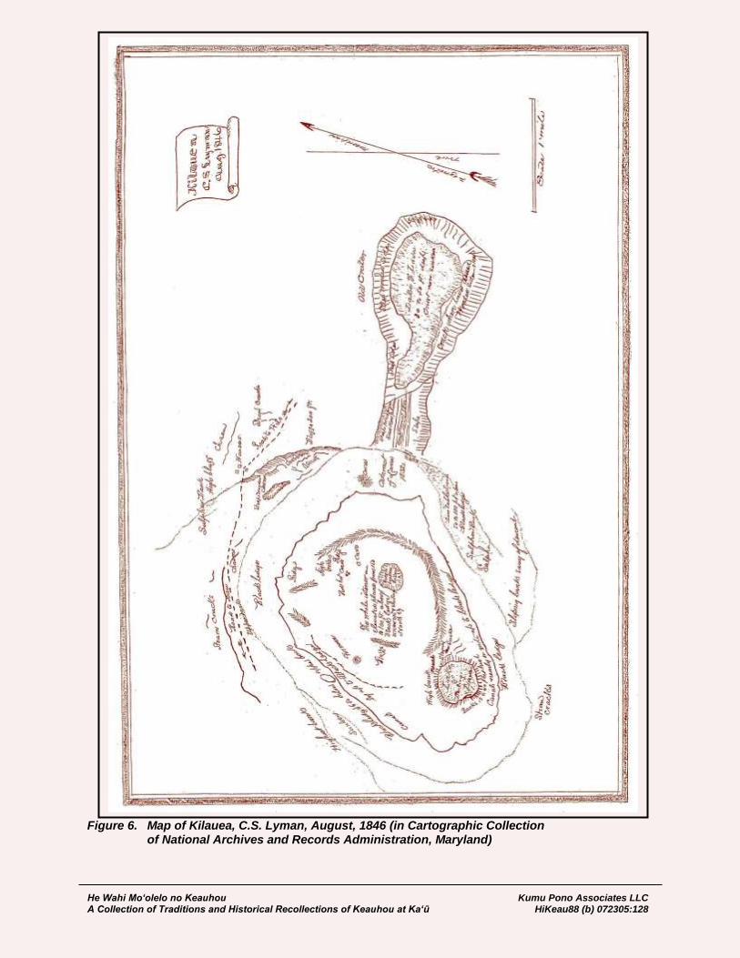
He Wahi Mo‘olelo no Keauhou Kumu Pono Associates LLC A Collection of Traditions and Historical Recollections of Keauhou at Ka‘ū HiKeau88 (b) 072305:128
Figure 6. Map of Kilauea, C.S. Lyman, August, 1846 (in Cartographic Collection of National Archives and Records Administration, Maryland)

He Wahi Mo‘olelo no Keauhou Kumu Pono Associates LLC A Collection of Traditions and Historical Recollections of Keauhou at Ka‘ū HiKeau88 (b) 072305:129
We arrived at the foot of the ascending path on the northern side of the crater about sunset, & after resting a few minutes commenced our ascent. The first 3d or half of the way was comparatively easy & direct, but it is a path that proves very deceptive; when you suppose you are nearly up you suddenly discover that a long crooked rising path is still before you. This part of the volcano is very irregular. The general ascent in going up is towards the left, a perpendicular wall several hundred feet high rising on the right; on the left of the path as you ascend is a deep gorge or ravine densely wooded, with trees of considerable size, with a high ridge between it & the open pit of the crater. After ascending about half way the dusk of evening came on & with it a drizzling rain & mist, which rendered it difficult to follow the footpath through the grass & shrubbery & soon we lost it entirely. After searching for some time in rain & finding ourselves in the midst of crevices & chasms into which it would be fatal to fall we began to despair of success & began to think of spending the night supperless & in the rain among, these chasms & pitfalls. We shouted & screamed at the top of our voices to rouse our friends at the house which was almost directly above us, but owing to the noise of the wind, without success. At length, after groping our way in some places over passages not more than a foot wide with deep chasms on each side Mr. Douglass thought he had hit on the path. On examination it proved to be true, & with thankfulness for our deliverance we continued our ascent, & about 8 o’clock arrived at the house weary wet & hungry. Our friends had become anxious for our safety & were just preparing to hang out a lamp on [page 91] the cliff for our guidance. Mr. Coan has visited the volcano; several times a year for a number of yrs & is familiar with every part of it, yet on this occasion he was utterly unable to find the way. A stranger or one but little acquainted with the place w'd not have succeeded in reaching the top at all in such circumstances. Thurs July 2d [They descend into the crater and make their way to the “Great Lake.”] While standing on the bank Mr. Andrew’s panama hat was blown off & carried, directly on to the lake. The wind swept it along the surface for some distance to where it was sheltered by the perpendicular bank. Altho' the lava was boiling & rolling up within a few feet of it, it lay some 10 or 15 minutes before it took fire. At length it began to smoke & soon burst into a flame. In its charred state it perfectly retained its form for several minutes till a breath of wind scattered it in innumerable flakes over the surface. Passing around the lake to the leeward side we found the fibrous lava or Pele’s hair everywhere collected in the holes & crevices. It appears to be formed by the stringing out & sudden cooling of the lava as it is thrown up in the process of boiling, like the threads of melted sealing wax. These fibres are borne by the wind & scattered all over the leeward side of the crater. On the eastern side I approached the margin of the lake again, threw in a pole which took fire instantly & as it was thrust into the liquid lava by the rolling over of the surface occupied considerable time in consuming. The crust on this side seemed to have little or no motion to the southward but was nearly or quite stationary. The northern bank of the lake is much higher than the rest & a little beyond it a bluff rises a hundred feet or more above the general surface. The space between is much broken up, coated with sulphur enveloped in steam & apparently inaccessible. In the night the distant fires of the lake were brilliant but by no means as much so as usual. Mr. Coan says he never saw the crater so inactive. Friday July 3d 1846. Took lunch in hands and started at 7 in the rain for Hilo… [Lyman, 1924:92]
He Wahi Mo‘olelo no Keauhou Kumu Pono Associates LLC A Collection of Traditions and Historical Recollections of Keauhou at Ka‘ū HiKeau88 (b) 072305:130
Regarding the state of Hawaiian beliefs and offering to Pele, Lyman observed:
In truth the superstitions & habits of heathenism have been so inwrought into the very texture of these people that it will be many generations before they are wholly rooted out. Offerings to Pele are still occasionally made at the Volcano. Bro. Hunt found one there a few months since, consisting of a bundle done up in mats containing tapas & various articles of food… [Lyman, 1924:116]
A Trip to Kīlauea in 1847: Lodging Available and a Visitor’s Book Kept by the Native Proprietor With travel to the volcano at Kīlauea increasing, we learn that by the middle 1840s, a native proprietor had established a series of shelters and houses in which visitors might find protection from the elements, and a selection of foods for meals. The proprietor, unfortunately not named, also acted as a guide to the lua Pele, and had organized services by cost. Jarves, editor of The Polynesian also reported to readers that by 1847, a bound book had been made available to visitors, in which to record their names and comments. While later narratives describe the volcano guest books dating from 1840, this is the earliest reference found, to such a book.
November 18, 1847 A Trip to the Crater of Kilauea (Part II.) [Departing form the half-way house at ‘Ōla‘a] …The ascent became more perceptible as we drew nigh the crater. The soil improved, and sustained quite a growth of wood. Within a few miles, the rife was pretty enough. Indeed it was worth taking for its own sake. No sign of the crater was to be seen until we were immediately upon it, the woods hiding it from the view. At 3 o’clock, we reached the houses, built within a rod of the edge of the outer circle of the crater, and in which we were to take up our lodgings. The main was inferior in size and accommodations to the half-way house—still it was quite comfortable, and visitors have nothing to complain of. A native has charge of it, and its supply of dishes, furniture, oil, lamps, &c. He also keeps a blank book in which travelers enter their names. One page was already filled though he had had it but a few months. He also acts as a guide into the crater, when desired. The tariff of prices established here were found to be 37 11-2 cents for a fowl, 62 1-2 for a hen-turkey, 25 cents for a small calabash of Irish potatoes, and $1 a head for lodging &c. The owners of the horses and mules send boys, without charge, with ropes to take care of their animals, so that the visitor is relieved from all trouble on this score, though his sympathies cannot fail to be collected at the contrast between his fare and theirs, which consists of whatever they can pick up among the bushes that bears any resemblance to grass…
November 20, 1847 A Trip to the Crater of Kilauea (Part III.) …A seven hours ride, for we traveled at a snail’s pace most of the way, had prepared us to enjoy almost anything our cook chose to favor us with. We found chickens and Irish potatoes already preparing and of them, with the addition of our own stores, made a meal that set us at one upon our feet again. Enthusiasm, which had fallen so low before dinner, rose, again above par, and all were for a closer look at the huge pit before us. We do not believe there is another sight like it… …No visitor, acquainted with Hawaiian history, fails to connect Kilauea as its chief seat with their pagan worship…
He Wahi Mo‘olelo no Keauhou Kumu Pono Associates LLC A Collection of Traditions and Historical Recollections of Keauhou at Ka‘ū HiKeau88 (b) 072305:131
November 27, 1847 A Trip to the Crater of Kilauea (Part IV.) …The vicinity of Kilauea affords considerable to interest a visitor who has leisure to explore for a week or more. If he is a sportsman, he will find wild geese and other birds—if a naturalist, every day will present some new feature at the lake, beside explorations of the sulphur banks, lateral craters, steam crack and old lines of eruption… [J.J. Jarves, Editor. The Polynesian]
Cheever’s Account of Kapi‘olani’s Journey to Kīlauea, and Observations at Kīlauea in 1850 Reverend Henry T. Cheever, visited Hawai‘i via a whaling vessel in 1849-1850, and reported on the status of the Hawaiian Mission and life in the islands at the time. In his writings (Cheever, 1853) are found references from events in Hawaiian history—collected from the accounts of earlier writers, and from conversations with island residents—and his personal experiences while traveling through the islands. Cheever made his trip to Kilauea during the first week of January, 1850, and in introducing readers to the volcano, he spoke of the character of Chiefess Kapi‘olani, and her journey to Kīlauea, where she defied the kapu of Pele. Describing the character of Kapi‘olani, Cheever observed:
Kapiolani died in peace on the 5th of May, 1841. Her pastor then said of her that her life was a continual evidence of the elevating and purifying effects of the Gospel. “She was confessedly the most decided Christian, the most civilized in her manners, and the most thoroughly read in her Bible, of all chiefs this nation ever had; and it is saying no more than truth to assert, that her equal, in these respects, is not left in the nation… …She has gone to her rest, and the nation has lost one of its brightest ornaments.” [Cheever, 1853:173]
Cheever provided readers with the following, and somewhat romanticized account, of Kapi‘olani’s visit to Kīlauea:
…She assembled her people; said to them, “My faithful people, the gods do not dwell in that burning mountain in the centre of our isle. That is not God; no, that is a common burning mountain; mere culinary fire, burning under peculiar circumstances. See, I will walk before you to that burning mountain; will empty my wash-bowl into it, cast my slipper over it, defy it to the utmost, and stand the consequences!” She walked, accordingly…moving to the sticking-place, her people following in pale horror and expectancy. She did her experiment, and I am told they have truer notions of the gods in that island ever since… The facts of this truly heroic experiment are these, as detailed substantially in Bingham’s Sandwich Islands, the [page 173] best authority. Early in 1825, five years after the first landing of missionaries on Hawaii, this strong-minded and courageous woman, seeing the spell which held many of the people in superstitious awe of the volcano, resolved, of her own accord, to visit the great crater of Kilauea, the residence from time immemorial of the great Goddess Pele, and to set at naught her tabus, and dare her fires. In order to accomplish this, she must make a journey of about a hundred miles, mostly on foot, from Kealakekua to Hilo. This bold design was, of course, opposed by almost all around her, some fearing she would bring into contempt the regard they sacredly cherished for Pele, and others dreading the danger to her own person from attempting to break the ancient tabus of the Hawaiian Vulcan. Even Naihe, her

He Wahi Mo‘olelo no Keauhou Kumu Pono Associates LLC A Collection of Traditions and Historical Recollections of Keauhou at Ka‘ū HiKeau88 (b) 072305:132
husband, whose powerful person and oratory might be supposed almost to set him above fear, yet not having his mind wholly freed from the shackles of superstition, was unwilling to do what she proposed, and felt an indefinable repugnance to his wife's thus exposing herself. But doing all she could to reason away their apprehensions, she perseveringly pursued her course. KAPIOLANI BREAKS THE TABUS. In approaching the region of the volcano, she was met by a prophetess claiming authority from Pele herself, and solemnly warning her off from those sacred grounds, and predicting her death from the fury of the goddess if she should dare invade her domain with the feelings or hostility and contempt which she professed. “Who are you?” demanded Kapiolani. “One in whom Ke Akua dwells,” she replied. “If God dwells in you, then you are wise, and can teach me,” said Kapiolani, “come hither and sit down.” After some urging she complied. Refreshments were kindly offered her, but, in the haughtiness of her assumed dignity as a supernatural being, she said, “I am a god; I will not eat.” Holding in her hand a piece of bark cloth, she said, “This is a palapala (writing) from the goddess Pele.” “Read it to us,” said Kapiolani; and when the prophetess declined, she resolutely insisted on her proving that she had a book or writing from the god by her reading it. Then cunningly carrying out [page 174] her device, and, with unexpected presence of mind, holding the cloth before her eyes, the prophetess poured forth a torrent of unintelligible words or sounds, which she would have them believe were in the dialect of the ancient Pele. Then Kapiolani, producing her Christian books, said to the impostor, “You pretend to have received and to deliver a message from your god, which none of us can comprehend. I have a palapala as well as you, and will read you a message from the true God which you can understand.” She then read several passages, and called her attention to the character, works, and will of the great Jehovah, and to Jesus Christ as the Saviour of the lost. The haughty prophetess quailed, her head drooped, and her garrulity ceased. She confessed that Ke Akua had left her, and she could not therefore reply. The oracle being silenced, the deluded prophetess herself joined in the repast; the conviction of Kapiolani that she ought to proceed was strengthened, and true to her purpose, she went forward. The missionaries at Hilo, hearing that Kapiolani had set out to visit them, were desirous to meet her at the volcano, and one of them accordingly travelled on foot twenty-five or thirty miles, till he joined her retinue on the brink of that stupendous wonder of the world. Kapiolani was much affected on meeting there a missionary coadjutor, and accompanied by him, with a train of about eighty natives, she descended from the rim of the crater to the black ledge. There, in full view of the terrific panorama before them, the effects of an agency always appalling, she calmly addressed the company thus: “JEHOVAH is my God. He kindled these fires. I fear not Pele. If I perish by the anger of Pele, then you may fear the power of Pele. But if I trust in Jehovah, and he shall save me from the wrath of Pele when I break through her tabus, then you must fear and serve the Lord Jehovah. All the gods of Hawaii are vain. Great is the goodness of Jehovah in sending missionaries to turn us from these vanities to the living God and the way of righteousness.” Then, with the terrific bellowing and whizzing of the [page 175] Volcanic gases, they mingled their voices in a solemn hymn of praise to the true God; and at the
He Wahi Mo‘olelo no Keauhou Kumu Pono Associates LLC A Collection of Traditions and Historical Recollections of Keauhou at Ka‘ū HiKeau88 (b) 072305:133
insistance of the chiefess, Alapai led them in prayer, while all bowed in adoration before Jehovah, as the Creator and Governor of all things. The great God of heaven heard their prayer. Kapiolani and her party went down courageously on that truly heroic mission, for so worthy an end, into that vast fire-eaten pit, called Lua Pele, and came up therefrom unharmed. The spell was broken; the dread Pele-tabu was violated with impunity; and the death blow was given to the tyrant superstition, which had hitherto brooded over the Hawaiian imagination like a nightmare in a long reign of terror…” [page 176]
Cheever recorded the following observations from his personal visit to Kīlauea and vicinity, via the Kapāpala, Ka‘ū route—noting also that the ‘ōhelo had been formerly sacred to Pele:
EXPLORATION AND REVIEW OF THE VOLCANIC CRATER KILAUEA. If a man comes for the first time to the eastern part of Hawaii by the way of the volcano of Kilauea, his brain, and body too, will have gotten such an impress from its tremendous fires, and his imagination will be so engrossed with the novel and stupendous displays of nature which his eyes have been beholding, that it will be some days before he can think or talk of any thing else. It will not be strange if he visit it again in dreams, and stand upon the blackened brink of that stupendous crater, and descend once more, in his sleep, into that great pit of fire… …I have found myself thus exercised ever since arriving at Hilo, at the close of last week, and, though suffering [page 207] sorely with feverishness and general mauvaise, induced by exposure, fatigue, and excitement, I am anxious to record first observations before their vividness and zest shall have at all abated. We left Waiohinu the first Tuesday of the year… Through the favour of Providence, we had fine weather, although it rained early in the morning, and threatened a storm. The horseback ride, and the more favourable climate of the sea-side and Punaluu, soon proved invigorating, and restored, in a measure, the tone of languid nature. The path from that village goes up very gradually to the volcano, distant from Waiohinu about fifty-five miles, of which we went the first day about thirty, stopping that night in a little mountain hamlet, at the house of a Church-member of the name of Jakobo. Arriving there before our men, we went down into a valley that serves, in rains, for a tumbling water-course, and, after refreshing ourselves with a bath, we kneeled upon the rocks at even-tide in prayer to that overruling and wise Providence, who, leading us in a way that we knew not, had strangely brought together, in this volcanic heart of the Pacific, two quondam class-mates in the School of the Prophets. Returning, we found the natives of the village assembled for a meeting. Their pastor read the Scriptures, prayed and sang hymns, and addressed them at some length on their duties and the way of salvation. It was a pleasant meeting, in the open still air of evening; Mauna Loa towering up to the northwest, the evening star pouring down its mellow radiance, the blue abyss of ocean faintly visible in the distance below us, and the illuminated cloud of the volcano just beginning to reflect its beams. Sleep scarcely visited me for the night, but an early departure next morning, and the fresh mountain air, revived the spirits. Our ride was, for a long time, through banana-trees, ohias, kous, and a species of mimosa, until [page 208] we came to an immense field of smooth, flat, unbroken lava, called by the Hawaiians Pahoehoe. It was once evidently a great upland lake of mineral fire, seeming to have been suddenly congealed into a vitreous black rock, while its billows were still rolling, as if it had suddenly heard the voice of God…

He Wahi Mo‘olelo no Keauhou Kumu Pono Associates LLC A Collection of Traditions and Historical Recollections of Keauhou at Ka‘ū HiKeau88 (b) 072305:134
Not only are the large swells and hollows distinctly marked, but in many places it is to be observed that the surface of the great waves is ruffled by a ripple like that seen on the ocean in a calm, at the first springing up of a light breeze. There are interspersed a few tracts of volcanic sand, shining with crystals of olivine, pyroxene, and obsidian. And the furrows between the swells and petri- [page 209] fied waves are filled with the same, or with a light spumous lava, like the froth of the sea drifted by the wind… …Being ahead of our guides, we lost our way and wandered some time… At length, by retracing all our steps, we got out of this dreary domain into the travelled tract, and made for the volcano, whose sulphurous smoke and stench we now began to [page 210] perceive driven along by the trade wind, and to set the vitrous threads of Pele's hair, caught in crevices and cob-webs, and shining in the sun with a metallic lustre. As you proceed, the lava is more decomposed, and the ground cracked and rent into fissures and chasms from which there is issuing steam and vapour of smoke, and you seem to be in a region of lime-kilns or smelting furnaces. A mile or two further on you descend two or three hundred feet, on to a vast terrace-like sunken plain, rent here and there by earthquakes, and strewed with great boulders of lava, and sounding unsafe and hollow under the tramp of your horse, who begins to show his consciousness of a dangerous proximity to the great laboratory of nature, to which this is the vast outer court and hall of entrance. By the time you reach the skirts of this sunken plain you begin to get an idea of the unique Hawaiian volcano; not like the pictures we have of other volcanoes, the truncated top of a mountain with a broad base and furrowed sides made by the overflow and hardening of its lava, and its summit distinguishable at a distance as the raised brim of a mighty caldron, but an immense gaping chasm, or hideous fire-eaten pit, variously estimated from nine to fifteen hundred feet deep, and from nine to fifteen miles in circumference. The scientific Pole, Count Strezelecki, thus roughly sketched the results of his observations for a friend in the Hawaiian Spectator: “What I remember, and long shall recollect, as showing the mighty influence of mighty objects upon me, are the difficulties I had to struggle with before my eye could be torn away from the idle, vacant, but ecstatic gazing with which I regarded the great WHOLE, down to the analytical part of the wondrous and unparalleled scene before me; I say unparalleled, because, having visited most of the European and American volcanoes, I find the greatest of them inferior to Kilauea in intensity, grandeur, and extent or area.” “The abrupt and precipitous cliff which forms the north-northeast wall of the crater, found, after my repeated observations, to be elevated four thousand one hundred and four feet above the level of the sea, overhangs an area [page 211] of three million one hundred and fifty thousand square yards of half-cooled scoria, sunk to the depth of three hundred yards, and containing more than three hundred and twenty-eight thousand square yards of convulsed torrents of earths in igneous fusion, and gaseous fluids constantly effervescing, boiling, spouting, rolling in all directions like waves of a disturbed sea, violently beating the edge of the caldrons like an infuriated surf, and, like surf, spreading all around its spray in the form of capillary glass, which fills the air, and adheres in a flaky and pendulous form to the distorted and broken masses of the lava all around; five caldrons, each of about five thousand seven hundred square yards, almost at the level of the great area, and containing only the twelfth part of the red liquid.” “The sixth caldron is encircled by a wall of accumulated scoria of fifty yards high, forming the south-southwest point; the Halemaumau, to which the bones of the former high chiefs were consigned, the sacrifices to the goddess Pele offered, the

He Wahi Mo‘olelo no Keauhou Kumu Pono Associates LLC A Collection of Traditions and Historical Recollections of Keauhou at Ka‘ū HiKeau88 (b) 072305:135
abyss of abysses, the caldron of caldrons, exhibiting the most frightful area of three hundred thousand square yards of bubbling red-hot lava, changing incessantly its level, sometimes rolling the long, curled waves with broken masses of cooled crust to one side of the horrible laboratory; sometimes, as if they had made a mistake, turning them back with spouting fury, and a subterraneous, terrific noise; of a sound more infernal than earthly. Around are blocks of lava, scoria, slags of every description and combination, here elevated, by the endless number of superimposed layers, in perpendicular walls one thousand feet high; there torn asunder, cracked, or remoulded; every where terror, convulsion—mighty engine of nature—nothingness of man!” The traveller does not at once behold the living volcanic fires and boiling caldron, but the sudden view of the blackened perpendicular sides of such a vast abyss, steaming and smoking at a million pores, and glimmering all over, like a bed of live coals, the play-ground of primeval fire and earthquakes, fills one with amazement and awe at the vast force and intensity of those inward fires, that first uplifted and then fused such a stupendous mass of rocky [page 212] materials, and after spouting over, and letting off, by its great subterranean sluice-ways, floods of mineral blood, has kept supplied with fuel, from age to age, its glowing furnaces… No susceptible mind, though but in a low degree religious, can survey such a scene without his thoughts involuntarily turning to the great Author of Nature with adoration and awe, from the new illustration of the divine attribute of Omnipotence thence derived… It was about four o'clock in the afternoon that we arrived near the brink of this mighty crater of Kilauea, at a place near the northwest end, where our screen was to be erected for the night. It being too late to explore the abyss that day, and our natives not yet having come up with food and baggage, we went to visit a sulphur bank a few hundred yards from the crater, out of which sulphureous vapour was issuing by various crevices, so hot in some places as instantly to scald the hand. It is one hundred and fifty to two hundred yards long, forty wide, and thirty or forty feet high. The mound seems to have been originally lava, now decomposed by the powerful action of hot sulphureous gases, [page 213] and made into a material not inappropriately called by the natives Kukaepele, or Pele's excrements, hardened into a red crust at top, but moist underneath, and all interlaid with shining crystals of sulphur, which you will hear curiously crepitate and rustle, whenever the outside is broken and the external air let in. This mound can be ascended and travelled over its entire length, only that it is very hot and enveloped in mineral vapours, and will shake sometimes rather alarmingly under the feet, like a patch of tenacious clay in spring from which the frost is coming out. There are apertures all along its sides, whose edges are fringed with the finest crystals, of a delicate yellow colour, but so fragile and soft that a touch will crush them. At a few feet from the apertures the crust has somewhat hardened and cooled, and you may dig out with a staff some of the most beautiful specimens of crystallized sulphur that can be found the world over. They are of an orange yellow, in the form of acicular prisms and tetrahedral pyramids, attached on one side as a bed to embossed cakes of joint mud and sulphur, that sparkle like any thing powdered or fretted with gold. The grief of a traveller is, that he can so rarely carry away whole and safe any of these exquisite specimens. In packing or transporting, the crystals will almost inevitably get detached from their nidus, and after all his pains he will find some of

He Wahi Mo‘olelo no Keauhou Kumu Pono Associates LLC A Collection of Traditions and Historical Recollections of Keauhou at Ka‘ū HiKeau88 (b) 072305:136
his best specimens spoiled. Detached crystals can be collected by the peck, if one will have patience to gather them. On one side of the mound is a ravine to which you can see no bottom, it being probably as deep as the volcanic abyss into which you look… The trees and shrubs that grow on its sides as far down as you can look are completely whitened, and in some cases, even crystallized over with sulphur. The genial heat and incessant condensation of steam there constitute a natural hot-house for those species of vegetation that can bear it. The entire hill, and region of inflammable matter under it, [page 214] forms undoubtedly one of the great reservoirs from which the volcano is fed… Undermined as it constantly must be by the subduction of fuel for the volcano, and shaken by earthquakes, it will not be strange if this hill, and the entire sunken plain on which visitors encamp, shall some day slide off into the abyss. The rock there, in some places on the surface, shows a heat of one hundred and twenty degrees Fahrenheit, and travellers have often slept within a foot of a fissure from which steam was escaping hot enough to cook their potatoes. Such seams are numerous and wide, extending undoubtedly down to the igneous bed in which the whole tract has its slippery foundation, like a vast iceberg in the sea. It is from steam escaping at these chasms, and immediately condensed by the cold mountain air, and falling by drops into hollows on the leeward, that the region is providentially supplied with water. The pools so formed on the compact lava are six or eight feet from the seams, surrounded with moss and rushes, and furnishing a copious supply of distilled water for man and beast. When the wind is strong, and especially morning and evenings, this vapour is flying like scud over the brink of the crater as a drizzling rain. By the time of our return to the crater’s brink, some of our party of natives, and other stragglers from both the [page 215] Hilo and Kau side, had arrived singly and with their hogs, at the common encamping ground. The lurid fires of the caldron in the south-western part of the crater began to be visible, looking just as any one who has seen molten ore in a foundry or smelting furnace, may imagine great liquid masses of that would look in the night, tossed to and fro on an ocean, and rising up and down in a mass, without losing its red heat or viscidity. Night and the drizzling vapour having overtaken us before our tired natives could make any thing better, we had to nestle all together under a screen or “Leanto” of cane and brakes, thrown up against the wind, but open in front and looking toward the caldron. It was only a few feet from the precipice, so that by lifting one's self up from the reclining posture you could have in full view the fearful tossing of those fiery waves. Natives and hogs having, it is probable, stopped under the same screen before, we found the ukulele tribe so numerous and rapacious that it was impossible to sleep. They would make their biting onsets in such numbers, and with such desperate fury, that a man could hardly help screaming out with very anguish. If, while our assailants took breath, we dozed a moment, it was only to be awakened by a more fell gripe from these pitiless robbers of your rest, that were no more to be shaken off or got rid of than Hercules's poisoned robe. At length finding, as the proverb goes, what can't be cured must be endured, we fell to making merry with our torment and our tormentors, and to shaking our flea-bitten sides with woebegone bursts of laughter at each other's jokes. And we concluded, not without reason, that the remembrance of Pele's fleas would be quite as indelible as that of her fires.

He Wahi Mo‘olelo no Keauhou Kumu Pono Associates LLC A Collection of Traditions and Historical Recollections of Keauhou at Ka‘ū HiKeau88 (b) 072305:137
After much wearisome tossing and rolling, getting up and lying down, viewing now the salient jets and coruscations, and beautiful fire-works of the volcano, and now the placid moon and stars, I managed, with aching, flea-flayed fingers, to put together grass for a fire. It was so cold [page 216] that ice had formed on a calabash that lay outside our screen. Our natives being wakened from sleep, which the ukulele did not care to harass when they had better blood for game, we soon dispatched breakfast and other duties. After a morning hymn, and prayer by one of Mr. Paris’s deacons that accompanied us as a body-guard, we made ready to descend into the hideous pit… …Let a man only have a good stout pole to put before him and lean upon, and a descent may be accomplished with tolerable ease by the north-eastern cliff of the crater, where the side has fallen in and slidden downward, leaving a number of huge, on-jutting rocks, like giants' stepping- stones, or the courses of the pyramid of Ghizeh. By hanging to these, and the mere aid of a pole, you may descend the first pali (precipice) to where the avalanche brought up and was stayed: a wild region, broken into abrupt hills and deep glens, thickly set with shrubs and old ohias, and producing in great abundance the ohelo (Hawaiian whortleberry, formerly sacred to the goddess of the volcano), and a beautiful lustrous blackberry that grows on a branching vine close to the ground. Thousands of birds find there a safe and warm retreat; and they will continue, I suppose, the innocent warblers, to pair and sing there, till the fires from beneath, having once more eaten through its foundations, the entire tract, with all its miniature mountains and woody glens, shall slide off suddenly into the abyss below to feed the hunger of all-devouring fire. [page 217] No one who passes over it, and looks back upon the tall, jagged, cliffs at the rear and side, can doubt that it was severed and shattered by one such ruin into its present forms. And the bottomless pits and yawning caverns, in some places ejecting hot steam, with which it is traversed, prove that the raging element which once sapped its foundations is still busy beneath. The path that winds over and down through this tract, crossing some of these unsightly seams by a natural bridge of only a foot's breadth, is safe enough by daylight, if one will keep in it. But be careful that you do not diverge far on either side, or let the shades of night overtake you there, lest a single misstep in the grass and ferns, concealing some horrible hole, or an accidental stumble shall plunge you beyond the reach of sunlight into a covered penstock of mineral fire, or into the heart of some deep, sunken cavern. One can hardly wander through that place alone, even in the day time (as I was in coming up from the crater at evening), without having his fancy swarm with forms of evil… …The way through this tract descends not abruptly for about half a mile, to a steep bank of partially decomposed lava, somewhat furrowed by water-courses, by which you go down some hundreds of feet more to what every body calls the Black Ledge. This is an immense rampart or gallery of grisly black scoria and lava, about half a mile wide, running all round the pit, slightly sloping inward, and not unfrequently overflowed in eruptions. By it you learn the dimensions of the great lake to which this is now the shore. It may be compared to the wide beach of an ocean, seldom flooded all over except in very high tides; or to a great field of thick shore ice, from under which the tide has retired, leaving it cracked [page 218] and rent, but not so as to break up the general evenness of its surface.

He Wahi Mo‘olelo no Keauhou Kumu Pono Associates LLC A Collection of Traditions and Historical Recollections of Keauhou at Ka‘ū HiKeau88 (b) 072305:138
The upper crust is generally glossy, cellular, and cinder-like, brittle and crackling under the feet; but directly underneath the superficies, hard and compact, as proved by inspecting the great seams and fissures, from some of which flickering currents of hot air, and from others scalding steam and smoke, are continually issuing. Pound on it, and you will hear deep, hollow reverberations, and sometimes your pole will break through a place like the rotten trap-door of some old ruin, and open upon you a hideous black hole without bottom. Over this great volcanic mole or offset, we proceeded to make our way toward the caldron in the south-east, pounding before us with our pole, like men crossing a river to find whether the ice ahead will bear them. We stopped every now and then to examine and get up on to some great cone or oven, which had been formed after the congelation of the crust, by pent-up gas blowing out from beneath the cooling lava, raising it as in great bubbles, and letting its black, viscous vomit dribble from the top, and flow down sluggishly and congeal before it had found a level, like ice in very cold weather over a waterfall. Thus it would flow over the Black Ledge, hardening sometimes in round streams like a cable, or in serpentine forms like a great anaconda; and again it would spread out from the foot of the cone a little ways in forms like a bronze lion's foot. The surface was frequently broken, or ready to break, with the weight of one's body, from the fiery liquid having subsided after the petrifaction of the crust. Generally, too, the hardened lava seemed to have been flowed over, like ice near the shore when the tide rises and goes down, with a thin scum of lava that became shelly and crepitated under the foot like shelly ice. Then, as we went further into the bed of the crater, gradually going down, we would come to places where, like as in frozen mill ponds, whence the water has been drawn off, the congealed lava had broken in to the depth sometimes of fifty and one hundred feet. Every where, too, there [page 219] were great fissures and cracks, as in fields of river ice, now and then a large air-hole, and here and there great bulges and breaks, and places from which a thin flame would be curling, or over which you would see a glimmer like that which trembles over a body of fresh coals or a recently burned lime-kiln. Touch your stick there, and it would immediately kindle. There were also deep, wide ditches, through which a stream of liquid lava had flowed since the petrifaction of the main body through which it passed. Cascades of fire are said to be often seen in the course of these canals or rivers as they leap some precipice, presenting in the night a scene of unequalled splendour and sublimity. In some places the banks or dikes of these rivers are excavated and fallen in with hideous crash and ruin; and often you may go up, if you dare, the edge on one side and look over into the gulf, and away under the opposite overhanging bank, where the igneous fluid has worn away and scooped it out till the cliff hangs on air, and seems to topple and lean like the tower of Pisa, just ready to fall. It would be no very comfortable reflection, if a man were not too curiously eager and bold, and intent upon the novelties he is drinking in by the senses, to have much reflection or fear at such a time, to think how easily an earthquake might tumble down the bank on which he is standing, undermined in like manner with that which you are looking at right opposite. On our left, as we passed on to the Great Caldron, we explored, as far as was possible between the heat and vapour, the great bank, or, more properly, mountain-side of sulphur and sulphate of lime (plaster of Paris), and obtained some specimens

He Wahi Mo‘olelo no Keauhou Kumu Pono Associates LLC A Collection of Traditions and Historical Recollections of Keauhou at Ka‘ū HiKeau88 (b) 072305:139
of no little beauty. There are cliffs of sulphur through which scalding hot vapour is escaping as high up above you as eight hundred feet; and lower down there are seams from which lambent and flickering flames are darting, and jets of hot air will sometimes whirl by you, involving no little danger by their inhalation. Around these fissures are yellow and green incrustations of sulphur, which afford a new variety of specimens. [page 220] When we had got to the leeward of the caldron, we found large quantities of the finest threads of metallic vitrified lava, like the spears and filaments of sealing-wax, called Pele's hair. The wind has caught them from the jets and bubbling springs of gory lava, and carried them away on its wings till they have lodged in nests and crevices, where they may be collected like shed wool about the time of sheep-shearing. Sometimes this is found twenty miles to the leeward of the volcano. The heat and sulphur gas, irritating the throat and lungs, are so great on that side, that we had to sheer away off from the brim of the caldron, and could not observe close at hand the part where there was the most gushing and bubbling of the ignifluous mineral fluid. But we passed round to the windward, and were thus enabled to get up to the brim so as to look over for a minute into the molten lake, burning incessantly with brimstone and fire… But the lava which forms your precarious foothold, melted, perhaps, a hundred times, can not be handled or trusted, and the heat even there is so great as to burn the skin of one's face, although the heated air, as it rises, is instantly swept off to the leeward by the wind. It is always hazardous, not to say fool-hardy, to stand there for a moment, lest your uncertain foot-hold, crumbling and crispy by the action of fire, shall suddenly give way and throw you instantly into the fiery embrace of death. At times too, the caldron is so furiously boiling, and splashing, and spitting its fires, and casting up its salient, angry jets of melted lava and spume, that all approach to it is forbidden. We slumped several times near it, as a man will in the spring who is walking over a river of which the ice is beginning to thaw, and the upper stratum, made of frozen snow, is dissolved and rotten. A wary native who accompanied us wondered at our daring, and would not be kept once from pulling me back, as with the eager and [page 221] bold curiosity of a discoverer, all absorbed in the view of such exciting wonders, I was getting too near. At the time we viewed it, the brim all round was covered with splashes and spray to the width of ten or twelve feet. The surface of the lake was about a mile in its longest diameter, at a depth of thirty or forty feet from its brim, and agitated more or less all over, in some places throwing up great jets and spouts of fiery red lava, in other places spitting it out like steam from an escape-pipe when the valves are half lifted, and again squirting the molten rock as from a pop-gun. The surface was like a river or lake when the ice is going out and broken up into cakes, over which you will sometimes see the water running, and sometimes it will be quite hidden. In the same manner in this lake of fire, while its surface was generally covered with a crust of half-congealed, dusky lava, and raised into elevations, or sunk into depressions, you would now and then see the live coal-red stream running along. Two cakes of lava, also, would meet like cakes of ice, and their edges crushing, would pile up and fall over precisely like the phenomena of moving fields of ice; there was, too, the same rustling, grinding noise.

He Wahi Mo‘olelo no Keauhou Kumu Pono Associates LLC A Collection of Traditions and Historical Recollections of Keauhou at Ka‘ū HiKeau88 (b) 072305:140
Sometimes, I am told, the roar of the fiery surges is like the heavy beating of surf. Once when Mr. Coan visited it, this caldron was heaped up in the middle, higher above its brim than his head, so that he ran up and thrust in a pyrometer, while streams were running off on different sides. At another time when he saw it, it had sunk four or five hundred feet below its brim, and he had to look down a dreadful gulf to see its fires. Again, when Mr. Bingham was there, it was full, and concentric waves were flowing out and around from its centre. Having carefully observed its movements a while, he threw a stick of wood upon the thin crust of a moving wave where he thought it would bear him, even if it should bend a little, and then stood upon it a few moments. In that position, thrusting his cane down through the cooling tough crust, about half an inch thick, and immediately withdrawing it, forthwith there gushed up, like ooze in a marsh [page 222] or melted tar under a plank, enough of the viscid lava to form a globular mass, which afterward, as it cooled, he broke off and bore away. It is not easy for one that has not himself been in a similar position, to sympathize with and pardon the traveller at such a point, for he is unwilling to forbear and leave it till fairly surfeited and seared with heat and admiration, or driven off by some sudden spout and roar, or splash of the caldron. You gaze, and gaze, and gaze in amazement, without conscious thought, like a man in a trance, reluctant to go away, and you want to spend at least a day and night, viewing close at hand its ever-varying phenomena. Had we only brought with us wrappers, I believe we should have been the first to have slept on the Black Ledge. Now that the edge of curiosity is a little blunted, and the judgment cool, we can see that there would be a degree of hazard and temerity in it which is not felt under the excitement of novelty and in the full tide of discovery. Forced by startling admonitions of instant danger, I had to quit suddenly the precarious footing I had gained on the caldron's edge, like a hungry man hurried from his repast, ere he has snatched a mouthful. But the look I caught there, and the impression of horror, awfulness, and sublimity thence obtained, live and will live in my conscious being for ever and ever… [page 223] It was not, I trust, without some valuable additions to our stock of impressions in this line, that we reluctantly left that spot. Departing thence, we passed over a tract between the level of the brim of the caldron and the Black Ledge, in order to gain again the latter, most strangely rugged and wild, as if convulsion after convulsion had upheaved, and sunk, and rent, and piled the vast mineral and rocky masses; forming here great hills like the ruins of a hundred towers, and there deep indentations, while every block lay upon its fellow, ready to be dislodged, edge-wise, crosswise, endwise, sidewise, angle-wise, and every wise, in the wildest confusion and variety possible, as if Typhoean giants had been hurling them at each other in war… Rocks, too, in earthquake commotions have been started from the perpendicular sides of the crater in this part, and have rolled down eight hundred or a thousand feet with a force, one might think, that would almost shake the world. When we had thus encompassed the crater, and had returned to the point where we first came down upon the Black Ledge, it was getting toward night, and I found myself so excessively heated and feverish, and throbbing with the headache, which most persons there suffer from, as to be unable to go for the castellated and Gothic specimens into some ovens that are found in the sides near by. Leaving, therefore, my companion and the natives to hunt for them, I proceeded slowly back, and toiled

He Wahi Mo‘olelo no Keauhou Kumu Pono Associates LLC A Collection of Traditions and Historical Recollections of Keauhou at Ka‘ū HiKeau88 (b) 072305:141
up, with difficulty, the steep side of this stupendous crater, which may be set down at a moderate calculation as not less than [page 224] twelve miles in circumference, and one thousand feet deep. In the centre of this vast sunken amphitheatre of volcanic fire… The person who can go down into it, and come up safe from it, with a light mind, unthankful and unawed, is as wanting in some of the best attributes of mental manhood as of piety… …Our second night by the volcano, was one of rather more ease and comfort than the first, a screen having been erected for us in a new spot, beyond the domain of imported fleas. I slept a little at intervals, just raising myself at every awakening to look at Pele's fires, which spouted and played like fountains, and leaped suddenly with a flash from place to place, like electricity on wire in the experiments of the lecture-room. Once when I arose at midnight and went out a little beyond the range of our screen, to enjoy in silence the august and grand spectacle, the violence of the wind was such as to take off my unguarded hat, and carry it clear over the brink of the crater, where it lodged for the night, but was recovered with little injury in the morning by one of our courageous natives. One of the early visitors there said that, on coming near the rim, he fell upon his hands and knees awestruck, and crept cautiously to the rocky brink, unwilling at once to walk up to the giddy verge and look down as from a [page 225] mast-head upon the fiery gulf at his feet. In a little time, however, like a landsman after a while at sea, he was able to stand very near and gaze unalarmed upon this wonder of the world. I have myself known seamen that had faced unfearingly all the perils of the deep, and had rushed boldly into battle with its mammoth monsters, to stand appalled on the brink of Kilauea, and depart without daring to try its abyss. Gazing upon it, then, at midnight, so near its brink, as we were, was rather venturing upon the edge of safety, as I found to my cost. But woe to the man that should have a fit of somnambulism on the spot where our tent was pitched that last night! Baron Munchausen's seven-leagued boots could hardly save him from a warm bath in flowing lava cherry-red. Morning broke again upon our open encampment, clear and bracing as upon the Green Mountains of Vermont. With fingers burned and bleeding from the climbing and crystal-digging of yesterday, we made all the despatch possible in collecting and packing specimens, but it was one o'clock before we were ready to leave. Having at length got off the natives with their burdens, two for Hilo and two for Kau, we kneeled for the last time by that wonderful old furnace, where the hand of God works the bellows and keeps up his vast laboratory of elemental fire. Then we mounted our horses and bade a final good-by, the one for Hilo, and the other for his happy Hawaiian home. It was with regret that I left half explored a region so replete with wonder and novelties, where a man might spend a week in the rarest sight seeing without satiety. One wants to encompass the crater above as well as below; to go round about her, to mark well her bulwarks, to tell the towers thereof, and to spy out all the wonderful country round about; to apply the plummet and line, and take the gauge and dimensions of the vast openings into earth's fiery womb here to be met with; and to trace out some of those subterranean galleries and awful caves by which her redundant fires have from time to time flowed off sea-ward; and to explore all the
He Wahi Mo‘olelo no Keauhou Kumu Pono Associates LLC A Collection of Traditions and Historical Recollections of Keauhou at Ka‘ū HiKeau88 (b) 072305:142
region where, sixty years [page 226] ago, Keoua, and his band of warriors were fatally arrested by an eruption.1 When some enterprising Yankee, or Yankeefied Hawaiian, shall have built there a house of entertainment, the thing will be possible, and Kilauea will be resorted to, from far and [page 227] near, as one of the wonders of the world. Invalids and travellers from America may yet cross the Isthmus of Darien or the rocky mountains by rail-road, be ferried to Hawaii nei by iron steamers from San Francisco or Panama, and have their youth renewed by a sulphur bath from one of the steaming orifices of old Pele. Nor is it an impossibility, in this age of gold, that volcanic fire may yet retire from the bed of this crater, and, in the changes of mineral chemistry, leave all its veins and fissures so injected with shining metal from the central Pyrophlegethon, that Hawaii shall yet become the El Dorado of the Pacific, the Colchis of modern Argonauts, and the very Ultima Thule of gold hunters from all nations. It was not till late in the evening that I reached Ola, a district in Puna, where Mr. Coan had deposited a letter for me in the time of his last tour, and had charged his good people there to pay suitable attention to a stranger that was shortly coming through. Warned of our approach by the whoop and whistle of the natives, the hospitable inmates of a house there, with kindest intent, had kindled a large fire in the middle, and called together a goodly deputation from other houses. As the place had no outlet but by one little puka (door) in the side, it was so dense with smoke, and oppressive with heat and twice breathed air, as to induce a violent headache, that was by no means an equivalent for the wet feet and pure air by whose loss it was gained. What with this and the feverishness incurred already by exposure and weariness, and the incessant fire of a flying detachment of ukulele that came in my skirts from the volcano, there was no sleep for the night, and I was in poor plight for travel the
1 The army of Keoua set out on their way in three different companies. The company in advance had not
proceeded far, before the ground began to shake and rock beneath their feet, and it became quite impossible to stand. Soon a dense cloud of darkness was seen to rise out of the crater, and almost at the same instant the electrical effect upon the air was so great, that the thunder began to roar in the heavens and the lightning to flash. It continued to ascend and spread abroad till the whole region was enveloped, and the light of day was entirely excluded. The darkness was the more terrific, being made visible by an awful glare from streams of red and blue light variously combined, that issued from the pit below, and being lit up at intervals by the intense flashes of lightning from above. Soon followed an immense volume of sand and cinders, which were thrown in high heaven, and came down in a destructive shower for many miles around. Some persons of the forward company were burned to death by the sand and cinders, and others were seriously injured. All experienced a suffocating sensation upon the lungs, and hastened on with all possible speed.
The rear body which was nearest the volcano at the time of the eruption, seemed to suffer the least injury, and,
after the earthquake and shower of sand had passed over, hastened forward to escape the dangers which threatened them, and rejoicing in mutual congratulations that they had been preserved in the midst of such imminent peril. But what was their surprise and consternation when, on coming up with their friends of the centre party, they discovered them all to have become corpses. Some were lying down, and others were sitting upright, clasping with dying grasp their wives and children, and joining noses (their form of expressing affection) as in the act of taking a final leave. So much like life they looked, that they first supposed them merely at rest, and it was not until they had come up to them and handled them that they could detect their mistake. The whole party, including women and children, not one of them survived to relate the catastrophe that had befallen their comrades. The only living being they found was a solitary hog, in company with one of the families which had been so suddenly bereft of life. In those perilous circumstances, the surviving party did not even stay to bewail their fate, but leaving their deceased companions as they found them, hurried on and overtook the company in advance at the place of their encampment.—Dibble's, History of the Sandwich Islands, pp. 65, 66. Lahainaluna, Mission Press, 1843.

He Wahi Mo‘olelo no Keauhou Kumu Pono Associates LLC A Collection of Traditions and Historical Recollections of Keauhou at Ka‘ū HiKeau88 (b) 072305:143
next day. Heavy showers, too, prevented an early departure. By nine in the morning of Saturday I was mounted for Hilo. The route lay through the tangled forests and ferns of Puna, fallen trees lying frequently across the way, and the road for a good part of the distance being made of the large stumps of ferns, a la mode corduroy…over which my horse travelled with more shrinking and difficulty than St. Anthony (I believe it was) used to walk [page 228] barefoot, for penance… [Cheever, 1853:229]
Titus Coan’s letter of January 1851— Coastal lands in Vicinity of Puna-Ka‘ū Boundary Described Following a tour in November of 1851, Titus Coan wrote to the mission headquarters, describing conditions in his station. The letter includes a brief description of residency on the coastal lands of the Kealakomo vicinity near the Puna-Ka‘ū boundary, and is one of the few accounts to speak of any native residents in the area. Salt making and fishing were the primary occupations of the near-shore residents.
January 30, 1852 Hilo, Hawaii Titus Coan; to Rev. Anderson, D.D.: …In Nov. [1851] I went through Puna in company with the School Superintendent, with the view of attending School examinations, temperance celebrations, administering the Lord’s supper, preaching, consultation etc. etc. Our first rallying station was at the Kealakomo, a village of some 30 houses, on the southern shores of Puna, & by the coast rout, about 70 miles from Hilo. This village is built on naked lava rocks, & is inhabited chiefly for the purposes of fishing & making salt, which latter operation is performed by solar evaporation, rain being very rare in this region. At this point six schools were assembled, numbering 120 scholars in all. Two days were spent here. The schools were examined, the pupils dressed in their neatest & gayest attire, marched & countermarched, & performed various juvenile evaluations under their teachers, with flying banners, with the pacifist weapons of the spirit, and with the love stirring melody of the psalm, the hymn & the chant. After this joyful & healthful exercise, they all sat down with their parents to a bounteous repast prepared for them & consisting of poi, potatoes, onions, pigs, turkeys, fowls, fish, puddings, bananas &c. After dinner and various exercises, such as singing, addresses, remarks, consultations &c. the assembly adjourned to meet at sunrise the coming day, on which occasion the state of the church was examined, enquiries attended to, candidates examined for church, baptism & the Lords supper administered, &c. We had preaching, of course on each day. A collection was also taken up of about 10 dollars. The people of this region are miserably poor, being far from markets having nothing to sell but a little salt & fish. Still they [page 2] seem happy, & give cheerfully of their deep poverty… [page 3; A.B.C.F.M. Collection, Houghton Library, Harvard]
Titus Coan’s letter of July 1852— Description of Kīlauea and Ascent to Mauna Loa Eruption Site via Keauhou
July 29, 1852 Hilo, Hawaii Titus Coan; to Rev. R. Anderson, D.D.: …During the current month I here made the tour of Puna, visited Kilauea & ascended to the seat of the recent eruption on Maunaloa a circuit of nearly 200 miles. On this tour I was accompanied by two sons of Mr. Alexander, one of Mrs. Chamberlain, three of Mr. Lyman & one of my own, & 9 natives… …We found the old crater of Kilauea

He Wahi Mo‘olelo no Keauhou Kumu Pono Associates LLC A Collection of Traditions and Historical Recollections of Keauhou at Ka‘ū HiKeau88 (b) 072305:144
increasingly in action. For 2 or 3 years past, it has been almost extinct or in a very sluggish state. The old lake of fires, of some 400 acres, was damned over by heavy layers of solid lava, so that no fire could be seen. Now, however, the key stone to this [page 6] ponderous crater, say 1½ mile in circumference & 400 feet high has fallen in, and an orifice of 200 feet diameter is opened at the very summit of the dome. Through this opening you look down the depths of 150 feet & see the old fiery lake boiling, & rolling & turning within its infernal walls. Ere long the entire narrow strata of this dome probably will fall into the boiling furnace below & be melted again, then exposing the lake as in former years to the astonished gaze of man. From this post we ascended the Mt. & came to the spot which was the source of such startling & unthinkable wonders during the latter part of Sab. and the former part of March. Here we found a hallow irregular, truncated cone, one mile in diameter, 500 feet high, 500 deep, about 10000 feet above the level of the sea with an orifice of about 1500 feet diameter. The crater still emits smoke & steam at some points, but it is so nearly cooled that I went round it, over it & into it. How changed the sense! This smouldering pile on whose summit I now stood was but as yesterday, a glowing furious fire & from this awful throat now choked with its own upheaving, & down which I looked much composure was ascending a fiery column 1000 feet in diameter & 700 feet deep… [page 7; A.B.C.F.M. Collection, Houghton Library, Harvard]
Rufus Anderson Visits Kīlauea in 1863 Rufus Anderson served as secretary of the American Board of Commissioners of Foreign Missions (A.B.C.F.M.), and recipient of many of the communications sent by missionaries in Hawai‘i to the offices of the A.B.C.F.M. Following his retirement from the board, he was asked to visit Hawai‘i and write a history and status report on the mission in the islands. As a result, in 1863, Anderson and his daughter traveled to Hawai‘i, visiting each island, and collecting historical accounts, as well as recording his own observations. Anderson’s book was published in 1865, and also printed in Hawaiian in the newspaper, Ku Okoa. On February 2nd, 1865, Hawaiian readers were provided Anderson’s narratives of his visit to Kīlauea. Anderson observed:
Ko Anesona Moolelo No Hawaii nei. HELU 3. KA PIINA I KA LUA O PELE I ka poalua ka la 29 o Maraki, haele aku makou i ka lua pele Kilauea, ma ke alakai ana a Coana, aia hoi iloko o kona apana kahi i ku ai ka lua pele. Ko makou nui he ekolu kane, a he eha wahine, maluna wale no makou o na lio a pau. Elua o makou mau la i ka hele ana a me ka hoi ana mai, a ua ua no ia wa a pau. Na mile mua eha, he ino ke ala, ua paa i ka lauhala a me ke kukui, a mahope aku komo iloko o ka ulu ohia, me ko lakou mau kumu i aneane e huna ia e ka lehua. Alaila, ea mai ka laau hapuu nunui, a me kekahi wahi akea okoa, i uhi ia e ka lauki. No ke ano ono o keia mau lauki, ua ake aku ko makou mau lio e lalau aku ia mau mea ma ke ala. Ma kekahi wahi e aku, ua loaa ia'u kekahi poe kanaka e ai ana i ka mole, oia kekahi o ka lakou ai mau. Ua hoaimu ia iloko o ka lepo e like me ke kalo, a i ka wa e palupalu ai, ua piha loa i ka wai ona. Aohe mea eae, aka, o ka hooko pono ana i ke Kanawai e papa ana i ka hana ana i ka wai ona, oia wale no ka mea e kinai ai i ka hana ana i ka mea ona mai keia laau mai.
Ua hoopomaikai ia makou ma ka loaa ana ia makou kekahi la oluolu ma ka lua pele, a me kekahi hale pili maikai, oiai makou i na po elua malaila. He eha tausani kapuai ke kiekie o ka lua maluna ae o ka ili kai, aka, o ka pii'na aole i ike lea ia. I ka wa i hiki mai ai o Kamekoa Wilike (Wilkes) ma, ua hele aku lakou e ike i kekahi lua, ma ka piko ponoi o ka mauna, a i oi ae no hoi ke kiekie, he umi tausani kapuai. Aole no paha i hui keia mau lua, a ina ua hui, aia ilalo o ka hohonu loa. He ekolu mile ke ana waena o ka lua ma Kilauea, a o ka iho'na ilalo o ka lua aia ma mua iho o ka hale. He hapalua mile ka iho'na. he maloeloe aohe nae pilikia. I kou wa e hiki aku ai, alaila ku iho oe iluna o
He Wahi Mo‘olelo no Keauhou Kumu Pono Associates LLC A Collection of Traditions and Historical Recollections of Keauhou at Ka‘ū HiKeau88 (b) 072305:145
ka papahele eleele nui o ka lua, he elua mile mai laila aku hiki aku i ka loko ahi e a ana, (Oia hoi o Mokuaweoweo.) He awawa a kona ili honua, a he mea hiki ole hoi ke lawe mai i mau huaolelo e hoakaaka aku ai. Ua ike ia aku ka punohu mahu ana ia wahi a pau, a pela no hoi maluna a puni ka hale. Ia wa he kanalima kapuai ka haahaa o ka loko ahi malalo iho o ka papahele eleele, aka ua olelo ia he pii ae, a emi iho. He mau la mahope iho, ua lohe mai makou ua pii ae a hiki i ke kae o ka lua. Ua ikaika ka hana ana malalo, no ka mea, i kekahi wa ua nui ka hoea ana ae me he puu nui ia ; a ma kau wahi, ua pii ka hoolei ana ae a ka pele a kanaono a kanawalu kapuai ke kiekie. No ka wela a me ka mahu hookahi wale no aoao e hookokoke aku ai ma ka aoao makani, a he kaumaha no hoi ke nana aku. Ua ike makou i kekahi o na hana kupanaha a ke Akua. Iloko o ke au hoomana kii o na kanaka Hawaii, ua olelo lakou he ano mana like akua maanei, a oia hoi ko lakou mea i haawi aku ai i ka inoa o Pele, a ina lakou e hiki aku ilaila, he mau pule a he mau mohai ka lakou e haawi aku ai. Ua kakau iho makou iloko o kekahi buke oloko o ia hale kahi a makou i moe ai, i kekahi lalani pokole penei; “NUI A KUPANAHA KAU MAU HANA E KA HAKU KE AKUA MANALOA…” [Nupepa Kuokoa, Pepelualai 2, 1865; Buke 4, Helu 5] Anderson’s History of Hawaii. We started for Kilauea, the great volcano; on Tuesday, March 17th, under the guidance of Mr. Coan, within whose missionary district the volcano is situated. Our company, which was all on horseback, consisted of three ladies and four gentlemen. We were two days on the way, both in going and returning, and it rained nearly all that time. The first four miles was over a bad road, in an open country, with more or less of the pandanus and kukui trees; then through a forest of ohias, with their trunks nearly concealed by the climbing vines. Then came gigantic ferns, and an extensive tract covered with the ti trees, their bright green leaves overtopping the ferns. These abound in saccharine matter, and our horses were eager to pluck them by the way. Elsewhere I found natives eating the root of the ti plant, as a part of their daily food. They bake, it under ground, as they do the taro, when it is softened, and abounds in sweet, nourishing juice. [page 134] Nothing but a faithful execution of the temperance law prevents the abundant manufacture of an intoxicating drink from this plant. We were thankful for a pleasant day at the volcano, as well as for a comfortable grass house during the two nights we were there. The crater is four thousand feet above the level of the sea, yet the ascent was scarcely perceptible. The party of Commodore Wilkes, when here some years since, visited another active crater at the top of this mountain, at an elevation some ten thousand feet higher. Of course the two craters could have no connection; or, if they have one, it must be at a vast depth. The crater at Kilauea has a diameter of three miles; and the only practicable descent appeared to be in front of the house. It is fatiguing, but not dangerous — a walk of half a mile. You then stand on the great black ledge, or floor of the crater, and have a walk of two miles to the burning lake. The surface is broken, irregular, and indescribable. We passed a miniature range of mountains, enough to show how the mighty ranges along the eastern shore of this ocean may have resulted from similar agencies. Jets of scalding steam were seen all over the field, and so they were on the upper surface around the house. The burning lake was at that time about fifty feet

He Wahi Mo‘olelo no Keauhou Kumu Pono Associates LLC A Collection of Traditions and Historical Recollections of Keauhou at Ka‘ū HiKeau88 (b) 072305:146
below the black ledge, but is said to rise and fall. A few days later we heard that the molten mass was near the brim. A mighty power operates beneath; for [page 135] every now and then the lava swelled into an immense dome, while elsewhere it tossed itself up in jets of sixty or eighty feet. The heat and gasses allow of approach only on the windward side. The scene was most impressive. We saw one of God’s wonderful works. The Hawaiians, in their heathen state, recognized a godlike power here, to which they gave the name of Pele, and when they came it was with offerings and prayers. In a book belonging to the house where we lodged, we recorded our impressions “GREAT AND MARVELLOUS ARE THY WORKS, LORD GOD ALMIGHTY!” [Anderson, 1865:136]
Village on the Shore of Keauhou destroyed on April 2nd, 1868 On April 11th, 1868, the Pacific Commercial Advertiser, published a series of articles, describing the “Earthquakes and the Volcano” describing events on Hawai‘i between March 27th to April 2nd, 1868. The articles included excerpts from eyewitness accounts of events around the island of Hawai‘i, and provides us with a glimpse into the former village situated on the shore of Keauhou, Ka‘ū, which was completely destroyed on April 2nd. We also learn of impacts from the earthquakes in uplands Keauhou, and the changes in volcanic activity at the time.
Notes of the Week. Earthquakes and the Volcano. …We have been permitted make the following extracts from a Hilo letter of the third of April: “We have had shocks ever since Saturday last, 28th March. On yesterday, April 2d, at four in the afternoon, we had a very heavy shock, breaking up crockery and glass ware of all descriptions. Miss Brickwood was at Mr. Jones’, and when the shock came, ran out of the house and leaped off the verandah, spraining her ankle and breaking a small bone. Rev. Mr. Lyman’s house looks like a perfect wreck. The plastering is all down and the foundation is badly shaken. The families of Messrs. Coan and Wetmore have left their houses. Dr. Wetmore has lost his stock of drugs. The sea came in yesterday, 2d April, and washed up to and over the Waiakea bridge and up to the King’s fish-ponds, carrying away the wall in several places. The sea came in at Keauhou and Apua, and carried away all the
houses. At Keauhou the natives escaped by running. It is feared that the natives at
Apua were not so fortunate.” The banks around the crater of Kilauea have caved in at several places, and cracks are opening around the Volcano House. The crater is very active, and it is reported that the old craters to the east of Kilauea have opened anew. Reports come in that lava is flowing at Kahuku and on Kona… …From Keauhou we learn that Mr. Stackpole, who has charge of J.C. King’s pulu station at present, had started on horseback for the Volcano House, and had reached the pali overlooking the village when he felt the shock, and looking back saw the sea come in and carry out in one sweep the houses and other material stored in the village, consisting of about one hundred and fifty bales of pulu, the presses used in packing it, canoes, boats, &c. The loss will be quite heavy. Fortunately no lives were lost.

He Wahi Mo‘olelo no Keauhou Kumu Pono Associates LLC A Collection of Traditions and Historical Recollections of Keauhou at Ka‘ū HiKeau88 (b) 072305:147
Mr. Porter, who has charge of the Volcano House, at the crater of Kilauea, had left the house and gone into Hilo, considering it unwise to remain. Kilauea was very active, nearly the whole floor of the crater being in active motion. Native report that the lava in Kilauea was receding very fast, and that the line of the craters east and south from Kilauea, farther down on the slope, were smoking. Another rumor says that a large ravine had opened on the slope above the crater reaching across the road to Kau, rendering it impassible, and still another ravine from the crater to the line of the lesser craters below, cutting off the road to Puna… [Pacific Commercial Advertiser, April 11, 1868]
Mary S. Whitney Visits Kīlauea in 1871 In 1871, Mary S. Whitney, visited Kīlauea and experienced the affects of a significant earthquake within the caldera of Kīlauea. Her letter describing the visit from Hilo to Kīlauea, originally written to her father, was published in the Paradise of the Pacific Magazine, in December, 1915. Ms. Whitney’s letter also includes a description of the Volcano House lodging and services offered at the time. Riding to Keauhou from Hilo, via Hawelu’s half-way house at ‘Ōla‘a, Whitney and party arrived at Kīlauea where she observed:
Hilo, Hawaii, September 17, 1871. My Dear Father: Our long anticipated visit to the volcano of Kilauea is at last accomplished. We have seen the monster and escaped safely from his lair. I will say by way of introduction that Kilauea is not at all like the volcanoes of Vesuvius and those of Central and South America which are represented as lofty, steep cones with smoke and sometimes lava issuing from the top, as from a chimney. This is simply a great pit in the lap of the volcano of Mauna Loa, whose summit crater, 14,000 feet above the sea, is occasionally in eruption. Our party was guided by a native boy, Joseph, who was also luggage carrier and helper in general. We were obliged to start from Hilo before daylight, partly to avoid the heat of the morning sun over the worst of the road, and to give ourselves time to halt and rest awhile in the middle of the day. So behold us, having eaten as hearty a breakfast as the early hour would permit, gathered under the trees about to start for our thirty-mile ride. J. appears with a rubber overcoat, pants in boots, a “ventilating” hat, and jingling Spanish spurs, while Miss M. and I are dressed in bloomers and also “booted and spurred.” I ride my own saddle sidewise, but Miss M. rides a Spanish saddle otherwise, which is the style that most ladies here prefer for long trips. Our boy Joseph carries on his horse our huge saddle-bags, with a change of clothing for each of us in case of rain, some goodies for lunch by the way, a big umbrella, etc. The morning sun had just begun to brighten the eastern sky as we set out at half-past five. Our horses are all fine animals, and we gallop through town and out into the country at full speed. Our road for four miles lay through the open country and then for some miles through the loveliest piece of tropical woods we had seen. Lofty trees were covered to their very tops by lovely vines and fens which hung in festoons from tree to tree, and ran riot in their exuberance. Graceful tree ferns thirty and forty feet high, and lower bushes and ferns of every kind, formed an impenetrable jungle, and excelled all one could imagine of tropical luxuriance. At the end of these woods there are a few cocoanut trees and this is the last of the good road. We stopped here a few minutes to rest and then struck into a miserable piece of road, merely a horse trail through the woods, muddy, hot and monotonous. This lasted a few miles, when we reached the long stretch of old lava which extends

He Wahi Mo‘olelo no Keauhou Kumu Pono Associates LLC A Collection of Traditions and Historical Recollections of Keauhou at Ka‘ū HiKeau88 (b) 072305:148
the rest of the way to the volcano. It is very rough, up and down, up and down, crossed every few rods by little streams, and is covered with a low undergrowth of ferns and bushes which diversify the otherwise barren surface. There are no inhabitants at all over this region except at Olaa, a little oasis of grass in this desert, where there are two settlements of natives about two miles apart, and this is about half way to the volcano. So tired travelers always stop at one of these places to refresh themselves, and there is a little native house at each place kept for this purpose. The first one is called “Hawilu’s [Hawelu’s] Half-way House,” and here we dismounted about 10 o’clock, unsaddled out hot and tired horses, and proceeded to rest and refresh ourselves with a lunch. This house is a little native structure, similar to all those around here, made by erecting a light framework of poles and interlacing on the sides and roof the long, slender leaves of the lauhala or screw pine, a tree common to the country. There is the inevitable porch in front, and inside a single room with a bedstead in one corner and across one end the native bed or hikie of those who adopt a semi-foreign style. The hotel boasts no chairs, but there is a rude little table with benches around it, and upon this we spread our lunch. Our tea is made on a stove in another house, and we enjoy a hearty meal. In two hours we were ready to mount and get away again. Fifteen and a half miles more of this hard lava road, before we could reach our stopping place. So we went single file, clattering over the rocks and splashing through the water, walking our horse most of the time, for they were lazy and we were tired, on and on, till the road seemed interminable. We had planned to reach the Volcano House about 3 o’clock, but there came 4 and half past 4, and no signs of human habitation. And, worse than all, Miss M.’s horse began to show signs of giving out, and our hearts began to fail for fear we had lost our way. Our boy proved to be a very poor guide, and Miss M., who had been over the road before, was sure we ought to have seen the volcano long ago. We had quite made up our minds to encamp in the bushes for the night with no protection and no food, and make the best of it, when suddenly we struck a beautiful piece of road, wide and smooth, quite different from the narrow trail we had been following, which gave new cheer to man and beast, and we galloped on till, leaving a little patch of woods, we were greeted by the welcome sight of the Volcano House, and at the same time at our left the great pit of the crater of Kilauea spread out like a map before us. The Volcano House is thatched like the other I described but is much more pretentious, having seven or eight rooms well furnished and comfortable. The glory of the house, however, is a great, old-fashioned open fireplace in the main room, for the nights are very cold at that altitude. On all sides of the house, but chiefly below and beyond, are “steam cracks” — openings in the ground of all sizes, from that of a horse’s hoof to several rods in length, and large enough to swallow an ox. They are of an unknown depth, and constantly sending out puffs of sulphurous vapor, hot enough to cook meat in a few minutes. Over one of these cracks a small bathhouse is built, providing a steam bath which is one of the luxuries of the place. The whole ground in the vicinity is warm and in some places too hot to be walked upon with comfort. The sulphur bank just above is a side-hill full of these steam cracks and covered with crystals of pure sulphur, brilliantly yellow and beautiful. The heat and the steam and the odor give you peculiar impressions, and you almost feel that it cannot be the same old mother earth whom you are accustomed to tread so securely. There was just time to take a steam bath before supper, so J. volunteered to try the sensation first, and Miss M. and I followed. It was delightfully relaxing and refreshing after our long ride, and we returned to our bright fire and welcome supper with keen appetites. The house is kept by a Chinaman, and we were the only guests at the time. The most

He Wahi Mo‘olelo no Keauhou Kumu Pono Associates LLC A Collection of Traditions and Historical Recollections of Keauhou at Ka‘ū HiKeau88 (b) 072305:149
enjoyable part of our meal was plenty of wild strawberries fresh and sweet which grow in great abundance all about. As I said, the whole crater is plainly visible from the house, and we could distinctly hear the boiling and surging of the great fire in “South Lake,” but nothing but smoke was visible. In the evening there was occasionally a glare of light upon the smoke and that was all. We were all tired and glad to retire early, and after a hearty night’s rest and an early breakfast, about 8 o’clock the next morning we were ready to descend into the crater. The morning was cloudy and cool and the weather favorable for our long tramp. There is a native guide at the house, without whom no one is allowed to make the difficult and sometimes dangerous journey, and with him and Joseph to carry water, lunch, boxes for specimens, umbrellas, etc., we set out. The descent in some places is very steep but is aided by rude steps made of roots and poles, and the precipice which everywhere else is a perpendicular wall nearly a thousand feet deep, is here broken into small precipices with level places between. It was tiresome, but at length we had made the descent and stood upon the comparatively level, black, hard lava of the crater floor. Here we rested a few minutes while the guide told us something about the present formation of the floor of the pit. This is constantly undergoing change and has been ever since there is any record of it. A few years ago the whole floor was two hundred feet lower than it is now, but by various flows from below it has been filled to its present height. There is now only one active place called “Lake” or “vent,” while sometimes there have been as many as eighty in all parts of the crater. Before the great series of earthquakes in 1868 the floor had become nearly level but at that time the part I have marked “Deep depression” on the accompanying sketch, sank rapidly three hundred feet with a great noise, just as the ice upon a frozen river would sink if the water under it were withdrawn, and left a broken, rough precipice all around it. As you see, our path to the South Lake lay down this precipice of broken lava and across the depression. The whole crater is a weird, unearthly place to be in, and to tread for a mile or so over a part of the floor which a few months ago had dropped 300 feet toward the eternal fires did not add to one’s sense of security. The lava as it cooled of course contracted and left deep seams and cracks in every direction over which we had to pass. All through the depressed part and in many other places it was very hot over these cracks, showing that they were not far from the fires below. The lava, too, is piled and thrown up in all imaginable forms and broken and tossed about so that the walk is all the time up and down hill over rough and smooth places. And perhaps the most striking thing of all is the great wall, sheer perpendicular a thousand feet high. It is evident that at some remote time this crater did not exist but was part of the slope of Mauna Loa with its internal fires as now. But some great convulsion caused this part of the crust to sink suddenly as the center of the crater has since done. Many in making the descent into the crater are so overcome with the unearthliness of the place and the thought that only a few feet below the same forces are still at work, that they are unable to proceed and are obliged to return without going further. It is wonderful, however, that with all the danger there has never been a serious accident. The lava is very beautiful; it is impossible to describe it. It glistens like melted glass, and in some places looks as if it were sprinkled with diamonds and rubies and glows with all the colors of the rainbow. And it is through such curious shapes that one is never tired of looking for something new. We brought away many beautiful specimens.

He Wahi Mo‘olelo no Keauhou Kumu Pono Associates LLC A Collection of Traditions and Historical Recollections of Keauhou at Ka‘ū HiKeau88 (b) 072305:150
And now we will resume our long-delayed walk, crunching over half-broken scoria, jumping over the cracks, stumbling over the sharp rocks, stopping to examine some new beauty, climbing up to look into a cone whence lava has recently flowed but now is sending up only hot air, scrambling down some steep precipice, gathering here and there a stay fern that had found a little soil in which to grow, the only living thing except ourselves in all this great hole, sitting down upon the rocks to rest a few minutes, then on again till we come to the first part of the great South Lake. We cautiously approached the brink, lest the loose rocks should treacherously give way under our feet, and gaze down into the vast cavern, the floor covered with immense rocks in great confusion where but a few weeks ago (as our guide told us) the fires had been active. Here we left our luggage and our boy Joseph, and with half-dread proceeded to the active lake. The walk was not long, but the lava was very hot and full of great fissures, where in the night we would have seen the light of the liquid lava, and thru steam issuing was scalding hot. With feelings of awe we approached the burning lake and passing one more chasm, stood upon the brink. The eternal fires were 300 feet below us and we could hear them hissing and roaring, leaping up in mad fury while a great cloud of smoke would rise, falling back again, surging and foaming. We remained there perhaps half an hour and [Whitney, 1915:59] strained our eyes to catch a glimpse of the flame, but nothing but the dense smoke was to be seen. Reluctant to leave with so unsatisfactory a view and yet glad to escape from the dreadful place, we finally retraced our steps to meet our boy Joseph. Thence we proceeded to a sheltered cave in a ledge of rocks overlooking the lake when we rested and refreshed ourselves with a lunch furnished by the Volcano House, and from there we started homeward by the beaten path near the western wall of the crater. We were marching along, the guide ahead. Suddenly our steps were arrested and we looked at each other in dismay. “What? What is this?” From the hundreds of steam cracks all of the floor of the crater came a quick puff of steam. At the same time with a distinct cracking sound the lava seemed to give way and sink beneath our feet. Instantly too, we hear a loud rumbling sound in the great wall around us, and suddenly as far as we could see the whole precipice seemed to burst into a dense cloud of smoke! We all thought the floor of the crater is sinking again, the wall is falling down upon us, and we five little specks of humanity in this awful abyss, whither shall we fly? We were three miles from any upward path and a thousand feet below any human help and there was nothing to do but stand and await issue. My only thought was to run back to my husband and cling to him, so that if we must perish we would go together. Gradually the commotion ceased, the smoke subsided and we knew we had witnessed an earthquake in the crater of the volcano! The apparent smoke was dust caused by the loosening and falling of rocks and stones of all sizes from the bank near us onto the crater floor. This unlooked for incident caused us to hasten our steps to a place of greater safety. But we had not gone far when J. discovered he had left a valuable knife upon the rocks where we had eaten our lunch before the earthquake. In spite of our earnest protestations he went back to try to find it, and lo! the whole rock upon which we had all sat so securely had been shaken by the earthquake, knife and all into the fiery pit below! As he returned safely we resumed our march. We were very tired and the road seemed interminable. Think of climbing that precipice after a hard walk for six or seven miles over hot lava. But it was at length accomplished and at half-past 2 we set our feet with a great sense of relief upon the old familiar earth again. We found some more travelers at the Volcano House and after passing a pleasant social
He Wahi Mo‘olelo no Keauhou Kumu Pono Associates LLC A Collection of Traditions and Historical Recollections of Keauhou at Ka‘ū HiKeau88 (b) 072305:151
evening before the blazing fire we were ready for a good night’s rest. The light from the crater was unusually bright that night, but we did not stay awake to observe it. In the morning we visited the sulphur banks again to obtain some specimens, packed our lava carefully and at 2 o’clock were ready for our homeward ride, intending to spend the night at the Half-way House. The clouds were gathering in the east as we started and soon the rain began to pour, gently but decidedly. We were well protected, as we thought, with rubber overcoats and water proofs, but with all these protections we were soon wet to the skin and no human habitation for fourteen miles! So we “dashed the rowels in our steeds,” and galloped away, clattering on, up and down the rocks, slashing through the water, only stopping a moment now and then to take breath, and way again, J. leading the way. Before dark we reached the welcome shelter of Hawilu’s [Hawelu’s] Half-way House. Here our wet garments were speedily exchanged for dry ones from our saddle bags; and a light repast fraught from Volcano House was enjoyed. Our rest was sweet that night, safely housed from the rain which poured incessantly outside. In the morning there was no abatement, so at 10 o’clock we mounted in the rain and reached Hilo about 2 p.m. somewhat wetter but no sadder and much wiser than when we started forth. Our earthquake experience in the crater is quite the talk of Hilo, so far as we know no such adventure having been recorded before. In the town and vicinity it was considered the severest earthquake since the great one of 1868. Stone walls were thrown down, ornaments and dishes fell from shelves, water was thrown out of tumblers and almost a panic was felt by those who experienced the convulsions of three years ago. Happily, however, at this time no serious accidents occurred. [Whitney, 1915:57-60]
Accounts of Kīlauea and Vicinity in Jarves’ “History of the Hawaiian Islands” (1872) J.J. Jarves arrived in Hawai‘i in 1837, and from 1845 to 1864, was the editor of the government newspaper, The Polynesian. Through his work, including extensive travels across the islands, Jarves compiled a history of the Hawaiian Islands. His writings include an introduction to traditions of Kīlauea, the family of Pele, and her conflict with Kamapua‘a; an account of the explosive eruption of 1790, and its destruction of a part of the war party of Keōua Kū‘ahu‘ula; the journey of Chiefess Kapi‘olani to Kīlauea in 1823, where she defied the kapu of Pele; and eyewitness accounts of the volcanic phenomena, including the impacts of the April 1868 earthquakes on the lands of Keauhou at Ka‘ū:
The Nature of Pele and her Family The most fearful of all their deities was Pele, a goddess. Her habitation, the famous volcano of Kilauea, well accorded with her reputed character. Here, with her attendant spirits, she reveled in the flames; the unearthly noises of the burning mass were the music of their dance, and they bathed in the red surge of the fiery billows, as it dashed against the sides of the crater. This fire-Ioving family is said to have emigrated from Tahiti, soon after the deluge. Their names, as given by Ellis, were characteristic of their habits, and show how readily the native intellect metamorphosed natural phenomena into personal qualities. Pele was the chief goddess. Her principal followers were Ka-ma-hu-alii—the king of steam and vapor. Ka-poha-i-kahi-ola—the explosion in the palace of life. Ke-ua-ke-po—the rain of night. Kane-hekili—thundering god. Ke-o-ahi-kama-kaua—fire-thrusting child of war. These were brothers, and like Vulcan, two of them were deformed. Makole-wawahi-waa—fiery-eyed canoe breaker. Hiaka-wawahi-lani—heaven-dwelling cloud breaker, and several others of longer names, and similar definitions. These latter were sisters. The whole family were regarded with the greatest awe. The volcano was their principal residence, though occasionally they renovated their constitutions amid the snows of the mountains. On such occasions,
He Wahi Mo‘olelo no Keauhou Kumu Pono Associates LLC A Collection of Traditions and Historical Recollections of Keauhou at Ka‘ū HiKeau88 (b) 072305:152
their journeys were accompanied by earthquakes, eruptions, heavy thunder and lightning. All were malignant spirits, delighting in acts of vengeance and destruction. The numerous eruptions with which the island has been devastated, were ascribed to their enmity. Many tributes were assessed to avoid or appease their anger; the greater part of which went to support the numerous and wealthy priesthood and their followers, who regulated the worship of Pele. These were held in the highest reverence, as holding in their power the devouring fires of the all-powerful goddess. To insult them, break their taboos, or neglect to send offerings, was to call down certain destruction. At their call, [page 23] Pele would spout out her lava and destroy the offenders. Vast numbers of hogs, both cooked and alive, were thrown into the crater, when any fear of an eruption was entertained, or to stay the progress of one commenced. Offerings were annually made to keep her in good humor, and no traveler dared venture near her precincts without seeking her good will…
The Conflict between Pele and Kamapuaa …Pele and her family are said to have had a contest, in which they were almost overpowered, with Kamapuaa, half hog and half man; a gigantic animal, the Centaur of Hawaii. He traveled from Oahu to countries beyond the heavens, or where they supposed the sky to join the sea. In his route he visited Kilauea, and desired to pay his addresses to Pele. She rejected him with contempt, impolitely calling him “a hog, and the son of a hog.” In endeavoring to drive him away, a fierce battle took place. Pele fled to her house, and her fires were nearly extinguished by great quantities of water, which Kamapuaa poured into the crater. The thirsty family, however, soon drank it up, and finally obtained the mastery over the demi-hog, forcing him into the sea, amidst a shower of fire and stones. This tale probably originated from an eruption, in which the lava of the volcano came in contact with the ocean. Another account states that he conquered Pele, and they were quietly married; in consequence of which no more islands were formed, or extensive eruptions took place… [Jarves, 1872:24] The Journey of Kapiolani to Kilauea …The immediate region about the crater of Kilauea, Hawaii, being remote from all the mission stations, remained for several years much under the influence of the priesthood of Pele. It was seldom visited by the ruling chiefs, and its inhabitants living within the circuit of the former devastations of the volcano, and in sight of its terrific action, were more deeply imbued with heathen superstitions, than those whose idols had been destroyed, and whose faith had been yearly weakened by an increased foreign intercourse. Here, apart from their fellows, they existed an almost distinct race. Sacrifices were daily offered to Pele, and occasionally her prophets wandered into the more civilized districts, denouncing awful retribution for the general apostasy. But these denunciations had been too frequent and faithless to excite anything but ridicule among the better informed, while the chiefs remonstrated with these self-deluded agents on their folly, or sternly ordered them to renounce their claims to inspiration. Gradually a spirit of inquiry was awakened even here. The first blow given to this dominant belief was in the summer of 1823, when a party of missionaries visited the crater. In defiance of the threats of the priests and the fears of the people, they partook of the sacred fruit [‘ōhelo], and boldly invaded her very fires. The impunity with which this was done, astonished the natives; but they attributed it to the superiority of Jehovah to their goddess, rather than to an entire absence of the supernatural. But early in the year 1825, their credulity was staggered by the boldness of Kapiolani, who, with a daring which, when her previous associations are considered, does her infinite credit, determined to convince its votaries of the falsity of their oracles. She visited the wonderful phenomenon; reproved the idolatry of its worshippers, and neglected every rite and observance which they had been taught to

He Wahi Mo‘olelo no Keauhou Kumu Pono Associates LLC A Collection of Traditions and Historical Recollections of Keauhou at Ka‘ū HiKeau88 (b) 072305:153
consider as necessary for their welfare. In vain the priests launched their anathemas, and denounced upon her the vengeance of the offended deity. She replied she feared them not; the fires of the volcano were the work of the God she worshiped; she would abide the test of daring Pele in the recesses of her domains. Venturing to the brink of the abyss, she descended several hundred feet toward the liquid lava, and after casting the sacred berries into the flames, an act than which none more sacrilegious, according to their ideas, could have been done, she composedly praised Jehovah amid one of the most sublime and terrible of his works. The sincerity of her faith could not have been put to a severer test. The island of Hawaii affords specimens of at once the grandest, most picturesque, and sternest of nature’s works. Raised from the sea, by volcanic action, at a date never to be ascertained by man, it has accumulated layer upon layer of lava rock, piled in every shape that so fearful and powerful an agency can give them, until it has shot up mountains more than two and a half miles high. Mauna Kea on the north, and Mauna Loa on the south, with the lesser mountain, Hualalai, to the west, divide the island between them. Mauna Kea rises to an elevation of 13,950 feet. Mauna Loa 13,760 feet. Both are vast in their proportions, though differing widely in their natural features. Mauna Kea is a succession of craters long extinct, which have risen one above another, heaping up stones, ashes, sand and cinders, long enough quiescent to form soil and clothe its flanks with vegetation. To all appearance it has had a much longer respite from internal fires than its neighbor. But, judging from the late eruptions, all of Hawaii must be a mere crust raised [page 123] upon a vast globe of fire. Mauna Loa forms an immense dome with a base of 120 miles, and a horizon at the top of 27, covered with a gigantic crater through nearly its entire extent. Nothing can exceed the cold sterility of this region, or the fury of the blasts that sweep over it. At long intervals its gigantic crater heaves with internal fires, throwing its boiling lava over its crest, and bursting vents for it lower down its sides, from which it spreads in fiery currents to the plains beneath, consuming before it every living thing. On the eastern flank of this mountain, some 10,000 feet down, at an elevation of 3,970 feet above the sea, is situated that vast pit six miles in circumference, and from 400 to 1,000 feet deep, according to the activity of its fires, called Kilauea, the fabled residence of the goddess Pele… …Kilauea more frequently presents the appearance of a smoking ruin, sunken deep into mother earth, flashing with light and flame, heavy with smoke, and stunning with detonations and angry noises. Occasionally the black crust or mass beneath heaves and is rent asunder; rivers of viscid, boiling lava arise, spouting blood-red jets far into the air; or they spread into a lake which sends its heavy waves against its sides with the noise and fury of the surf on a precipice bound shore. To the eastward, Kilauea, by the lateral pressure of its lava, has thrown out a series of smaller mouths or craters, reaching to the sea-side, from which it ejects its superfluous masses, before accumulating sufficiently to overflow its own banks. These operate as safety valves, and preserve the country in the immediate vicinity, which is fertile and forest-clad, from devastation… [page 124]
Historical Sketch of Hawaiian Volcanoes. The recent eruptions on Hawaii have excited a world-wide interest in Hawaiian volcanoes… [page 213] The crater of Kilauea, being much more accessible than that of Mokuaweoweo, is the chief point of interest with tourists. It is approached either from Kau, (the most southern district of the island,) over a tolerably good road, or from Hilo, distant 29 ½ miles, over a rough and often muddy road, requiring from six to ten hours to accomplish it, according to its condition. The “Volcano House,” kept by an intelligent

He Wahi Mo‘olelo no Keauhou Kumu Pono Associates LLC A Collection of Traditions and Historical Recollections of Keauhou at Ka‘ū HiKeau88 (b) 072305:154
Hawaiian, is provided with the necessaries and food required by travelers. The government steamer makes monthly trips to Hilo, and weekly trips to Kealakeakua Bay, occasionally running to Kau. The cost of the round trip from Honolulu to the crater and back, by either route, is from sixty to one hundred dollars, according to the tastes of the traveler. The crater of Kilauea, called by the natives “Lua Pele,” or Pele’s Pit, is simply a deep pit of oval form, about two by three miles in extent, its walls varying from five hundred to one thousand feet in height. Its bottom or floor is very uneven, and subject to frequent changes caused by eruptions. The level of this floor appears to have varied several hundred feet during the past forty years. It is seldom seen in action throughout its entire extent, the lava flow being generally confined to one or more lakes, which are sometimes connected by streams of lava flowing from one lake to another. The view of this crater given at the commencement of this Appendix, represents it as it appeared early in the present century, when there was more activity than now… [page 214]
…Eruption of 1868. [Affects on the land of Keauhou] The last eruption on Hawaii, (up to this date,) and the ninth on record, occurred in April, 1868…
“The first symptoms of any unusual commotion on Mauna Loa were noticed on the morning of March 27th, about half-past 5 o’clock, when from the whale ships at anchor in Kawaihae harbor, a dense column of smoke was observed to rise in one massive pillar to the height of several miles, directly over Mauna Loa, accompanied with a bright reflection, showing that fires were again active in the great crater of Mokuaweoweo. In a few hours this pillar-cloud dispersed and passed off, and no light was seen on the following night.” “At about 10 A.M., on the 28th, a series of earthquakes began, which continued at intervals with varied severity for over a month. At Kona, as many as fifty or sixty distinct shocks were felt in one day; at Kau, over three hundred in the same time, and near the great crater of Kilauea the earth is represented as having been in a constant quiver for days together, with frequent vigorous shocks that would send crockery, chairs, lamps, &c., spinning around in not a very pleasant way. Mr. J.J. Porter, the proprietor of the Volcano House, says he endured this for several days, as long as he could, till one night, about 11 o'clock, Pele sent one of Rodman's twenty-inch shot, with a well-directed aim, that struck the ground directly under his bed, when he jumped up and ran, where or how he hardly knew, but he found himself after a while in the woods, safe and sound…” …Residents of Kau state that over two thousand distinct shocks occurred there between the 28th of March and the 11th of April, averaging over one hundred and forty a day for two weeks. “The earthquakes continued to increase in severity from March 28th till April 2d, when, about 4 o’clock in the afternoon, one took place that shook down every stone wall, and nearly every stone, frame and thatch house throughout Kau, and [page 228] did more or less damage in every part of Hawaii, while it was felt very sensibly on Maui, Molokai, Oahu and Kauai, the latter island being three hundred miles distant from the crater. Every church in Kau district was destroyed, with perhaps a single exception. The shock was so severe that it threw persons from their feet, and even horses and other animals were served in the same way. A gentleman riding on horseback in Waiohinu, found his horse lying flat under him before he could imagine the cause. The effect of the shock was instantaneous. Before a person could think, he found

He Wahi Mo‘olelo no Keauhou Kumu Pono Associates LLC A Collection of Traditions and Historical Recollections of Keauhou at Ka‘ū HiKeau88 (b) 072305:155
himself prostrate on the ground. The large stone-church of Waiohinu went down in the same way—a sudden jerk, the walls crumbled in and the roof fell flat—all the work of ten seconds… …Simultaneous with the heavy earthquake on the afternoon of April 2d.” The Mud Eruption at Kapapala, occurred which is so singular, and so unlike anything that has heretofore occurred on the islands, that we give a minute description of it. Kapapala is the residence of Mr. Charles E. Richardson in Kau, about fifteen miles from Kilauea crater, and twenty- five from Waiohinu. About midway between Mr. R.'s residence and that of Judge Lyman at Keaiwa, six miles west, are two beautiful valleys, that extend from the road a couple of miles, which every observing traveler must have noticed. They were studded with groves of kukui and other trees, and covered with a rich carpet of the softest manienie grass. Herds of sleek cattle were constantly browsing or enjoying the shade of the cool groves. Native huts were scattered here and there, and horsemen were frequently seen crossing the valley. “This was the scene of the ‘mud-flow.’ Just at the instant the earthquake occurred the sides of the valley were rent, and from the fissure burst out, with a terrific noise, a stream of red mud and water, which was driven by the explosion fully three miles. This stream was ejected simultaneously with the heavy earthquake from both sides of the valley. Immediately under and near the fissures are heaps of stones and boulders, which were evidently thrown out first, and beyond these a vacant space, in which a native thatch-house was left standing and the inmates unharmed, while the mud and stones flew over and beyond them. Eighteen hundred feet from the opening the pile of mud commences, and extends a distance of three miles from the opening, varying in width from half a mile to one mile, and from two feet at the outer edges to twenty and thirty feet deep in the centre. Where it crosses the road it is thirty feet deep and half a mile across.” “This mass of mud, covering an area of at least one thousand acres and weighing millions of tons, was thrown out as if discharged from two huge batteries of ten thousand twenty-inch Rodman guns, planted on each side of the valley. At its [page 229] further extremity is a pile of large boulders and stones, that appear to have been driven before the powerful explosion. As it swept through the valley, with the most indescribable and unearthly noises, it buried and destroyed men, animals and trees alike. Thirty-one lives were lost, and between five hundred and a thousand head of cattle, horses, goats and sheep, some of which were just at the moment being driven across the valley to the farm-house. This mud, or now more properly dirt, as it has become dry, consists of finely pulverized red soil, such as is so often found in the group. In some places it is mixed with stones, trunks of trees, fern-Ieaves, &c. Trunks of trees are found standing, with their limbs shot off by the explosion. The force with which these streams were ejected from the hills, and the speed, is said by eye-witnesses to have been at the rate at least of a mile a minute. The rapidity was so great, even at the very edge of the flow, that numbers of goats, which were fleeing for life, were overtaken by it, and found a short time afterwards by Mr. Richardson, sticking by their hind legs in the mud.” “From where the mud was exploded now issues a stream of clear, cool mountain water, which it is hoped will continue to flow, as it is the only stream in the district. It will be all the more acceptable, as all Mr. Richardson's cisterns have been totally destroyed by the same earthquake which produced the rivulet. Some of the natives present at this eruption state that the mud thrown out was cold, others that it was hot, and that steam and smoke issued from the rent after the eruption. It is quite probable that the earthquake created a subterranean rent, which brought this confined body of water in contact with the lava fires below, and thus produced the explosion without heating the mass above. Mr. Richardson’s loss in cattle, horses, cisterns and houses,

He Wahi Mo‘olelo no Keauhou Kumu Pono Associates LLC A Collection of Traditions and Historical Recollections of Keauhou at Ka‘ū HiKeau88 (b) 072305:156
has been estimated at fifteen thousand dollars, which is probably the largest sustained by any one party. In the valley adjoining there was also a small land-slide, but not on the scale noticed above. The soil thrown out is rich, and will soon be covered with dense vegetation, especially should the fine stream remain permanent.” The Earthquake Wave. “Immediately following the above explosion and the earthquake, there occurred a tidal or earthquake wave, which caused great destruction of life and property along the southeast coast of Hawaii, from Keauhou to Kalae, the most southern point of the island. Judge Lyman, whose residence is six or eight miles from the sea, describes the first view of it as follows: Some one pointed to the shore, and we ran to where we could see it. After the hard shaking had ceased, all along the sea-shore, from directly below us to Punaluu, about three or four miles, the sea was boiling furiously, all red, for about an eighth of a mile from the shore, and the shore was covered by the sea.”
Mr. Abm. Fornander, who passed through the district a day or two before the wave occurred, communicated the following to the “Hawaiian Gazette”:
“At Keauhou, the following results of the earthquake on Thursday have been reported. Mr. Stackpole, who had charge of the place, had been up to the Volcano House during the day, and was returning in the afternoon. While descending the pali
to Keauhou, the first shock occurred, precipitating an immense amount of earth, stones and boulders down the pali after him. Escaping these, he arrived on the
plateau below the pali, and looked in the direction of the village of Apua, but not a house was to be seen! He then rode down to the edge of the plateau, from whence Keauhou ought to have been in sight, but nothing of it could be seen. Descending to Pahoehoe, he met the men working at Keauhou running up mauka, who reported
that nothing was left of Keauhou; that immediately after the earthquake the sea had rushed in and swept off every dwelling and storehouse, and all their contents, and that they had barely escaped with their lives. There were some 167 bales of pulu in store, ready for shipment, all of which was swept away. They represent that the sea went up as far as the two basaltic columns indicating the road down to Keauhou—a depth of wave of at least forty to fifty feet…” [page 230] “Mr. George Jones met a heavy loss at Keauhou by the inundation. Besides the houses and fixtures that were swept away by the sea, he also lost some 167 bales of pulu that were ready for shipment. On Saturday last he chartered the schooner Odd Fellow, and started in her to see if he could not pick up some of the pulu that might have been washed along the shore between there and the south point.” “Hilo and Puna have suffered, so far, comparatively least, though the shocks were severe and frequent, and still continue, and the damage to houses and property is very large. But poor Kau is almost wholly destroyed. The sea washed away the coast villages, and the earthquake razed the inland places. “The number of people now known to have perished between Ninole and Keaiwa, (Punaluu and Hionamoa included,) is 47; at Kawaa, 7; at Honuapo, 27; total, 81, besides a number of the pulu-pickers up in the mountains, back of Hilea; how many I am not yet advised, neither have I heard the number of those who perished at Kaalualu…” [page 231] The Crater of Kilauea. The following vivid description of the great Crater of Kilauea is from the pen of Mr. Jarves, and is taken from his “Scenes and Scenery,” pp. 237 to 251, a work to which we have made frequent reference. As a description of the crater as it appeared thirty
He Wahi Mo‘olelo no Keauhou Kumu Pono Associates LLC A Collection of Traditions and Historical Recollections of Keauhou at Ka‘ū HiKeau88 (b) 072305:157
years ago, it will be found interesting:
“The expectations of those who have formed their ideas of volcanoes from the stereotyped representations of Vesuvius and Etna, with their conical sides and narrowed top, lava red and liquid running like rivers down its sides, stones and rocks soaring like feathers in the air, and volumes of steam and smoke, larger than [page 236] the mountains themselves, ascending yet higher, will not be realized. ‘Lua Pele,' or Kilauea, is unlike anything of the kind, and stands by itself, an anomaly in nature; the mightiest and most wonderful of earth's safety-valves. As we gazed, its immensity grew upon us. More and more we realized its vastness; the stupendous area of the whole became more apparent by analyzing its parts. Vesuvius might easily have lost itself in that pit. All was black, with occasional gleamings of red, like the forkings of lightning in a dense thunder-cloud. It looked like the ruins of some mighty conflagration, from which the smoke and flame still rose, and at any moment liable to break out again, fiercer than before. At the farther extremity, a bright light showed itself, like the flickering flame of half-extinguished embers, and all was silent except the occasional hissing of gases and steam. I thought of Sodom and Gomorrah, and the cities of the plain. They must have appeared like this, before the waters flowed in and buried them forever. After gazing until nightfall, we hastened to the hut, where we were to sleep, a mere shelter of roots and grass thrown upon a few sticks, and covered on the windward side only. It was but three feet from the brink of a perpendicular precipice of four hundred feet, a portion of which had lately slid down part way, and hung threateningly over the remainder. Back of it was a crack in the earth, through which the steam constantly escaped. So occupied were we with the scene before us, that the danger to which we were exposed in sleeping here did not occur to us until we were ready to leave the crater, and the excitement was over. A slight shock of earthquake, and we should have known nothing more. However, having supped, we spread our blankets, with our heads towards the abyss, to be prepared for any display which might occur during the night, which closed in with a cold, drizzling rain. The wind blew in furious squalls, threatening at every gust to drive our frail shelter into the pit below. In the chasm, along its walls, and through the numberless rents and galleries of the superincumbent rock, the blast howled dismally; at times dying away like the moan of some wounded animal; and then again giving a fitful shriek, as it whirled through some narrow pass, and echoed itself from a hundred others. The storm-spirit was abroad, and triumphantly careered over the habitation of the fierce goddess, daring her to the contest. Her response was sullen and ominous. The hitherto quiet crater at intervals threw up columns of hot steam, stones and ashes, accompanied with loud reports, resembling the discharges of heavy artillery in a confined place. Occasionally the fires at the farther extremity would gleam up with considerable brilliancy; excepting this, nothing was to be seen through the darkness but the outlines of the chasm before us, and the whirling mist and smoke, reflecting the glare of the fires.” “What with the rain and cold, it was an uncomfortable night; the scene itself was too novel and exciting to allow either the body or imagination to slumber. Occasionally I fell into a doze, from which a gleam from some new fire, or a violent explosion, aroused me. On such occasions, straining my eyes to pierce the turmoil beneath, I ceased to wonder that native intellect had peopled a place like this with strange and fearful beings. it was a fit habitation for their malignant deities. if the Christian, in this scene, pictures to himself hell and its torments, and how often has it been thus likened, is the savage to be blamed, who sees in it strange shapes, and fiery halls, the lakes, the palaces, and dwelling-places of his devils? Pele, the consuming goddess, insatiable as her element, the fire itself, ‘the rain of night.' ‘the king of vapor,’ ‘the thundering god,' ‘heaven-dwelling cloud-holder,' ‘fiery-eyed canoe-breaker,’ these, and many others, with names alike expressive of the varied actions of the crater, here, according to Hawaiian mythology, hold their court. They have gone from

He Wahi Mo‘olelo no Keauhou Kumu Pono Associates LLC A Collection of Traditions and Historical Recollections of Keauhou at Ka‘ū HiKeau88 (b) 072305:158
the minds of men, but their abode remains unchanged. Their requiem was borne to our ears in the driving storm, the whistling wind, the fire and smoke, and all that was furious and destructive. The morning of the fifth broke as the previous evening had commenced, but the sun soon dispelled much of the mist, and left us a pleasant day for our researches. Thermometer, 58 degrees.” [page 237] “The plain on the north is much split up by fissures, from which steam continually issues, hot enough to cook meat or vegetables. In a few places it condenses and forms excellent drinking water. Four species of very palatable berries grew here abundantly, commonly called ‘huckleberries,' though they have little resemblance in flavor, and none in color, to that fruit. To the northeast of this plain, we find sulphur banks several hundred yards in extent, and about twenty feet high. The gases were not powerful, and by digging into the earth, which was hot, soft, and greasy, we obtained some beautiful specimens of sulphur, in all its different forms, the best of which, however, soon lost their beauty by exposure to the air. The efflorescence’s at the mouth of the crevices were exceedingly delicate and beautiful. These banks appear to be volcanic rock, decomposed by sulphuric acids, for it is to be seen in all its stages, from the hard rock to the soft paste. An hour's steaming here dissipated all the pain and soreness which we felt from our exposure to the weather.” “We estimated the circumference of the whole crater at five miles, the western side of which was the highest; but in no place did the depth to the black ledge exceed five hundred feet. It is more oval than circular, its greatest breadth being from northeast to southwest, and is aptly termed by the natives ‘Lua Pele,' (Pele's Pit,) for it is nothing but an immense hole, which the fire has eaten in the ground. The natives have no other tradition of its origin, than that it has been burning from the time 'of chaos' until now, gradually extending itself laterally and perpendicularly. Formerly, it overflowed its banks, and the reign of each of their kings has witnessed destructive eruptions.” “Count Strzelecki makes the north-northeast cliff four thousand one hundred and one feet above the level of the sea; Douglas, three thousand eight hundred and seventy-four. In descending to the black ledge, at the northeast extremity, the path winds round an old crater, small and steep on all sides; its bottom is covered with masses of large rocks, shaken down by earthquakes, and large trees are also growing in it, indicating a long repose.” “Following this path, we soon arrived on the ledge, which appeared like a field of ice breaking up in the spring. It varied from five hundred to two thousand feet in width, and then abruptly terminated in craggy and overhanging precipices, which had burst in every direction, from the action of the fire beneath. The main body of the crater had settled down from the black ledge, in some places gradually, until its own weight burst it violently from the edge, leaving gaping chasms, the sides of which were intensely heated; at others, it appeared to have sunk instantaneously, tearing away and undermining the ledge, and leaving precipices of two hundred feet in height. The greatest depth was about two hundred and fifty feet. The lakes, cones and forges remained, but were emptied of lava, and quiet, emitting nothing but smoke, excepting a lake at the southwestern extremity, of which a bend in the ledge hid from our view all but the rising flames. Evidently, a short time before, the ledge had been overflowed, as the lava was piled in masses twenty feet high or more, on its outer edge, gradually decreasing in height as it rolled in immense waves from it; and, without doubt, the whole mass had been raised, as we could now stand upon it and pluck ferns from the bank. We walked around the crater on the black ledge, endeavoring to find a place where it would be practicable to descend, but the banks were everywhere too much broken up to admit of it. Independently of that, they were so heated, that the brink could only be approached in a few places, and these only at great risk. It was cracked into great chasms, from a few feet to a rod in width, to
He Wahi Mo‘olelo no Keauhou Kumu Pono Associates LLC A Collection of Traditions and Historical Recollections of Keauhou at Ka‘ū HiKeau88 (b) 072305:159
which no bottom could be seen, and in places large masses had swollen up, and then turn bred in, like the bursting of an air-bubble or the falling in of a vast dome. The hollow, echoing sound beneath our feet, showed the insecurity of where we trod, and liability to give way, and precipitate us at any moment to instantaneous death; and I must confess that it was with fear that I walked along this path of destruction. On the surface of the ledge the rock was black and very vesicular, but as it descended it grew more compact, and [page 238] became of a white or leadish color. From all these pits and chasms a white flickering flame ascended, so hot in one place that we attempted to cross as to singe the hair from our hands and scorch our clothing. Nothing but a precipitate retreat saved us from being enveloped in flames. The hot air would frequently flash up from the fissures without warning, and it required much caution and agility to escape from it. The thermometer, over one fissure, rose to one hundred and sixty-two degrees; on the ledge, five hundred feet from the brink, three feet above the ground, ninety-seven degrees; on the lava at the same place, one hundred and twenty-three degrees; two feet above a fissure, one hundred and forty-eight degrees; eighteen inches below the surface, it rose instantly to one hundred and sixty-six degrees. Continual heavy explosions were occurring on the sides, sounding like muffled artillery, throwing up stones, ashes and hot steam two hundred feet or more into the air, and rending away the banks, tumbled large masses of rock into the crater beneath. Indeed, the whole black ledge appeared like a mere crust, the igneous action beneath having eaten away its support, and which the slightest shock would precipitate into the gulf beneath, and thus restore the crater to its ancient limits.” “Small cones and diminutive piles of lava were scattered over its whole surface, where they had suddenly rose and as quickly cooled. They had assumed many fantastic and even beautiful shapes, and their hues were singularly brilliant and varied. On the southeast and south sides, lava had gushed laterally from the bank, and flowed down from the ledge. Near here are the sulphur hills, from which the finest specimens are obtained. They were prettily coated with fine white, blue and green salts, but owing to the intense heat and suffocating fumes of the gases, we were unable to secure many. A little farther on, we found the lava fissures incrusted with the most beautiful crystals and efflorescence’s, which had condensed into every variety of form and figure, but too delicate to bear exposure to the atmosphere. Having reached the southern extremity, we obtained our first view of the lake, the light of which had attracted our attention the previous night. It was several hundred yards in circumference, and in the most sunken part of the cauldron. The lava was twenty feet below its banks, a liquid body, boiling, bubbling, and thrashing in great fury. Occasionally it would become incrusted over, and then red streaks would shoot rapidly across its surface, leaving a momentary glimmer like meteors. In the centre, the lava was tossed high into the air, with a puffing, spluttering noise like the blast of a heavy bellows, mingled with the roar of the surf. Its color was livid, much resembling clotted blood, of which the whole might be taken for an immense hell-brewed cauldron, and the unearthly noises for the moans of agonized spirits, and the fiendish cries of their tormentors. The effect upon the imagination was powerful, and the reality horrible and hellish, beyond description. To the leeward the gases were strong, requiring much caution to avoid the stifling currents of heated air. On the northwest side, filamentose lava, commonly called ‘Pele's hair,' was thickly strewed for many acres, like a field of mown grass.” “Mr. C. and myself, haying performed the circuit until we were underneath where our hut stood, where the bank, having given way to a considerable height, formed a steep hill, which appeared quite practicable of ascent, we proposed to shorten the distance by climbing up at this spot. No sooner thought of than we made the attempt, and reached the first two hundred feet without any difficulty. Here, the summit being hid
He Wahi Mo‘olelo no Keauhou Kumu Pono Associates LLC A Collection of Traditions and Historical Recollections of Keauhou at Ka‘ū HiKeau88 (b) 072305:160
from us, we held a consultation whether to proceed or not. Upon looking down, we saw our natives gazing in astonishment at us, and urging us to return, saying that it was impossible for us to reach the top, and nothing but a bird could. However, like all obstinate personages, we did not like to retrace our steps, so we pushed ahead. A few rods more climbing brought us to the perpendicular face of the rock, or rather rocks, which were loosely imbedded in earth, and relieved only by some jutting points and a few roots, on which but little dependence could be placed. We were now so high that it was impossible [page 239] to descend, as we could not see where to place our feet beneath us, and the slightest look downwards might make us loosen our hold and be dashed to pieces. Not the least danger was, that one of us might loosen a stone, which starting would draw down an avalanche of others, and ourselves with them. By looking up, zig-zagging along the edge of the rocks, and bearing our weight equally as possible on all parts of our bodies, we drew ourselves slowly up, until we were within ten feet of the top. Here we met with the ‘unkindest cut of all.' The rock was the smoothest, and just at the rising of the brink, hot steam issued from it, making the earth scalding and slippery. Mr. C. being ahead, and blessed with the longest legs, managed, by bearing his whole weight upon a projecting point of rock, not three inches in diameter, to make a spring, and at the same time clawing into the soft earth, he reached the summit with only burnt fingers. He then laid down upon his back, with his arms over his head, clinging to roots, and dangled his legs over the precipice to assist me. Following his steps, I hitched myself up, and making a grab at his toes, was safely toed to the bank. It was not until we were in perfect safety, that we realized the full extent of our danger, and our consummate folly in rushing into it. The slightest misstep, or want of presence of mind, would have hurried us to immediate death; and, while we felt grateful for our escape, we vowed another time ‘to look before we climbed.” “In the excitement of visiting this wonderful phenomenon, its real dangers are overlooked, and many unnecessary risks undergone. No accident has as yet happened, but some escapes have been little short of miraculous. Two gentlemen, a number of years since, were in the heart of the crater, examining the burning cauldron, when a rumbling noise was heard, and an earthquake felt. The rocks began to rattle down the sides of the chasm, and the ground beneath them was so unsteady, that they could not leave the spot where they were. Providentially it was slight, and soon over, and no eruption followed. In January, 1841, Dr. G. P. Judd descended the crater, for the purpose of procuring some of the liquid lava. Not being able to reach it at the great lake, he ventured into a smaller one, at the bottom of which there was a small stream. It appeared very quiet, the banks were steep, and he found some difficulty in reaching it. Having obtained a frying-pan full, he had returned to within a few feet of its brink, the steepest part, when a roar and a hissing noise alarmed him; a stream of lava in a narrow column was forced up into the air, far above his head, and descended in a shower all around. Much alarmed, he shouted for help. All of the natives near by ran away, except one, who threw himself upon his stomach, and grasping the Doctor's hand, assisted him out. But before this was accomplished, the lava rose so rapidly, that the heat of it burned his clothes, and blistered the face and hands of the native. They were no sooner on their feet, than the lava overflowed, and they were obliged to run with all speed to avoid being overtaken by the torrent. A narrower escape from a more horrible death, it is difficult to conceive.” “It is a common remark, that travelers visiting the volcano, even at short intervals, never see it under similar circumstances, and consequently are apt to discredit previous statements. A moment's reflection should convince them, that with such a mighty engine of nature, exercising in their highest degree the combined powers of fire, heated air, and steam, and continually in action, great changes are momentarily liable to occur; and that they do, these very discrepancies bear ample testimony. It

He Wahi Mo‘olelo no Keauhou Kumu Pono Associates LLC A Collection of Traditions and Historical Recollections of Keauhou at Ka‘ū HiKeau88 (b) 072305:161
would be an interesting point gained in geological science, if some observing man could reside in the neighborhood and note the various changes, at the periods of their occurrence.” “I have endeavored to present a faithful picture of it as it appeared at our visit, and it evidently differs much from all preceding descriptions. Douglas makes the depth of the crater, in 1834 one thousand one hundred and fifty-seven feet. At the present time it had filled up one half, and the black ledge, which had been gradually rising, was in some places within three hundred feet of the top, while former accounts state it at eight hundred. A few years since, the basin was much [page 240] in its present state, like the inside of a bowl. A foreigner who visited it a week only before the late eruption, described it as resembling a dome, there being a gradual ascent from the sides to the centre; the lava having overflowed the whole of the black ledge, the limits of which could not be traced. The whole surface was in violent action, thickly indented with fiery lakes, and crowned with puffing cones, and forges, whose bases were lashed by burning waves, and the whole accompanied with dreadful noises. Had not the liquid lava found a vent by pushing its way through subterranean galleries until it met with a weak spot, which its gravity soon forced through, and running out until the fiery mass in the crater subsided to a level with the outlet, it might have risen to the top, and overflowing, destroyed all that portion of the island. The immense lateral pressure which must exist, increasing as the crater fills up, will probably prevent any great and sudden disaster of this kind, by forcing an outlet toward the sea, as it did in this instance. Though so much has drained out, an immense body still remains in the volcano. On the second night of our stay, the fires were much more brilliant, and the reports more frequent.” “It is a remarkable fact, that on all the Islands the general course of volcanic action is southeasterly, or rather, the craters form a chain from the northwest to the southeast. On Hawaii, Mauna Kea appears to have been extinguished first, then Hualalai. Mauna Loa has probably fire still beneath, though it has gradually cooled down by forming a series of lateral craters, extending from the great one on the summit to Kilauea, which is now the great fountain-head. Kilauea is pushing itself easterly, as the late eruption bears witness, and the whole earth in that direction is doubtless pierced with galleries, which carry off the super abundant lava; and when the ground becomes too weak to bear the pressure, it forces its way to the surface, and flows until it creates a common level at Kilauea. The several eruptions can easily be traced towards the sea; and a series of lateral craters also, some of considerable extent, which have no doubt been fed from Kilauea. One, six miles to the east, is a mile in diameter, and emits smoke and sulphurous gases...” [Jarves, 1872:242]
He Wahi Mo‘olelo no Keauhou Kumu Pono Associates LLC A Collection of Traditions and Historical Recollections of Keauhou at Ka‘ū HiKeau88 (b) 072305:162
Kīlauea and Environs Described by Isabella Bird in 1873 Isabella Bird, an English woman—ahead of her time—traveled solo about Hawai‘i, and in the company of native and local guides. She explored many of the remote regions on the island, and her narratives are colorful, being filled with important descriptions of landscape, practices and conditions in the islands. Of particular interest to a study of the lua pele at Keauhou, are Bird’s narratives of Kīlauea. Bird included important descriptions of the natural landscape of Keauhou, approach to the volcano, and the Volcano House. Excerpts from her letters (Bird, 1964), follow below:
Letter V Volcano of Kilauea, Jan. 31. …We think of a volcano as a cone. This is a different thing. The abyss, which really is at a height of nearly 4,000 feet on the flank of Mauna Loa, has the appearance of a great pit on a rolling plain. But such a pit! It is nine miles in circumference, and its lowest area, which not long ago fell about 300 feet, just as ice on a pond falls when the water below it is withdrawn, covers six square miles. The depth of the crater varies from 800 to 1,100 feet in different years, according as the molten sea below is at flood or ebb. Signs of volcanic activity are present more or less throughout its whole depth, and for some distance round its margin, in the form of steam cracks, jets of sulphurous vapour, blowing cones, accumulating deposits of acicular crystals of sulphur, etc., and the pit itself is constantly rent and shaken by earthquakes. Grand eruptions occur at intervals with circumstances of indescribable terror and dignity, but Kilauea does not limit its activity to these outbursts, but has exhibited its marvellous phenomena through all known time in a lake or lakes in the southern part of the crater three miles from this side. This lake, the Hale-mau-mau, or House of Everlasting Fire of the Hawaiian mythology, the abode of the dreaded goddess Pele, is approachable with safety except during an eruption. The spectacle, however, varies almost daily, and at times the level of the lava in the pit within a pit is so low, and the suffocating gases are evolved in such enormous quantities, that travellers are unable to see anything. There had been no news from it for a week, and as nothing was to be seen but a very faint bluish vapour hanging round its margin, the prospect was not encouraging. When I have learned more about the Hawaiian volcanoes, I shall tell you more of their phenomena, but tonight I shall only write to you my first impressions of what we actually saw on this January 31st. My highest expectations have been infinitely exceeded, and I can hardly write soberly after such a spectacle, especially while through the open door I see the fiery clouds of vapour from the pit rolling up into a sky, glowing as if itself on fire. We were accompanied into the crater by a comical native guide, who mimicked us constantly, our Hilo guide, who “makes up” a little English, a native woman from Kona, who speaks imperfect English poetically, and her brother who speaks none. I was conscious that we foreign women with our stout staffs and grotesque dress looked like caricatures, and the natives, who have a keen sense of the ludicrous, did not conceal that they thought us so. The first descent down the terminal wall of the crater is very precipitous, but it and the slope which extends to the second descent are thickly covered with ohias, ohelos (a species of whortleberry), sadlerias, polypodiums, silver [page 57] grass, and a great variety of bulbous plants many of which bore clusters of berries of a brilliant turquoise blue. The “beyond” looked terrible. I could not help clinging to these vestiges of the kindlier mood of nature in which she sought to cover the horrors she had wrought. The next descent is over rough blocks and ridges of broken lava, and appears to form part of a break which extends irregularly round the whole crater, and which probably

He Wahi Mo‘olelo no Keauhou Kumu Pono Associates LLC A Collection of Traditions and Historical Recollections of Keauhou at Ka‘ū HiKeau88 (b) 072305:163
marks a tremendous subsidence of its floor. Here the last apparent vegetation was left behind, and the familiar earth. We were in a new Plutonic region of blackness and awful desolation, the accustomed sights and sounds of nature all gone. Terraces, cliffs, lakes, ridges, rivers, mountain sides, whirlpools, chasms of lava surrounded us, solid, black, and shining, as if vitrified, or an ashen grey, stained yellow with sulphur here and there, or white with alum. The lava was fissured and upheaved everywhere by earthquakes, hot underneath, and emitting a hot breath. After more than an hour of very difficult climbing we reached the lowest level of the crater, pretty nearly a mile across, presenting from above the appearance of a sea at rest, but on crossing it we found it to be an expanse of waves and convolutions of ashy-coloured lava, with huge cracks filled up with black iridescent rolls of lava, only a few weeks old. Parts of it are very rough and ridgy, jammed together like field ice, or compacted by rolls of lava which may have swelled up from beneath, but the largest part of the area presents the appearance of huge coiled hawsers, the ropy formation of the lava rendering the illusion almost perfect. These are riven by deep cracks which emit hot sulphurous vapours. Strange to say, in one of these, deep down in that black and awful region, three slender metamorphosed ferns were growing, three exquisite forms, the fragile heralds of the great forest of vegetation, which probably in coming years will clothe this pit with beauty. Truly they seemed to speak of the love of God. On our right there was a precipitous ledge, and a recent flow of lava had poured over it, cooling as it fell into columnar shapes as symmetrical as those of Staffa. It took us a full hour to cross this deep depression, and as long to master a steep hot ascent of about 400 feet, formed by a recent lava-flow from Hale-mau-mau into the basin. This lava hill is an extraordinary sight--a flood of molten stone, solidifying as it ran down the declivity, forming arrested waves, streams, eddies, gigantic convolutions, forms of snakes, stems of trees, gnarled roots, crooked water-pipes, all involved and contorted on a gigantic scale, a wilderness of force and dread. Over one steeper place the lava had run in a fiery cascade about 100 feet wide. Some had reached the ground, some had been arrested midway, but all had taken the aspect of stems of trees. In some of the crevices I picked up a quantity of very curious filamentose lava, known as “Pele's hair.” It resembles coarse spun glass, and is of a greenish or yellowish-brown colour. In many places the whole surface of the lava is covered with this substance seen through a glazed medium. During eruptions, when fire-fountains play to a great height, and drops of lava are thrown in all direc- [page 58] tions, the wind spins them out in clear green or yellow threads two or three feet long, which catch and adhere to projecting points. As we ascended, the flow became hotter under our feet, as well as more porous and glistening. It was so hot that a shower of rain hissed as it fell upon it. The crust became increasingly insecure, and necessitated our walking in single file with the guide in front, to test the security of the footing. I fell through several times, and always into holes full of sulphurous steam, so malignantly acid that my strong dog-skin gloves were burned through as I raised myself on my hands. We had followed a lava-flow for thirty miles up to the crater’s brink, and now we had toiled over recent lava for three hours, and by all calculation were close to the pit, yet there was no smoke or sign of fire, and I felt sure that the volcano had died out for once for our especial disappointment. Indeed, I had been making up my mind for disappointment since we left the crater-house, in consequence of reading seven different accounts, in which language was exhausted in describing Kilauea.
He Wahi Mo‘olelo no Keauhou Kumu Pono Associates LLC A Collection of Traditions and Historical Recollections of Keauhou at Ka‘ū HiKeau88 (b) 072305:164
Suddenly, just above, and in front of us, gory drops were tossed in air, and springing forwards we stood on the brink of Hale-mau-mau, which was about 35 feet below us. I think we all screamed, I know we all wept, but we were speechless, for a new glory and terror had been added to the earth. It is the most unutterable of wonderful things. The words of common speech are quite useless. It is unimaginable, indescribable, a sight to remember for ever, a sight which at once took possession of every faculty of sense and soul, removing one altogether out of the range of ordinary life. Here was the real “bottomless pit”–the “fire which is not quenched” – “the place of hell” – “the lake which burneth with fire and brimstone” – the “everlasting burnings”--the fiery sea whose waves are never weary. There were groanings, rumblings, and detonations, rushings, hissings, and splashings, and the crashing sound of breakers on the coast, but it was the surging of fiery waves upon a fiery shore. But what can I write! Such words as jets, fountains, waves, spray, convey some idea of order and regularity, but here there was none. The inner lake, while we stood there, formed a sort of crater within itself, the whole lava sea rose about three feet, a blowing cone about eight feet high was formed, it was never the same two minutes together. And what we saw had no existence a month ago, and probably will be changed in every essential feature a month hence. What we did see was one irregularly-shaped lake, possibly 500 feet wide at its narrowest part and nearly half a mile at its broadest, almost divided into two by a low bank of lava, which extended nearly across it where it was narrowest, and which was raised visibly before our eyes. The sides of the nearest part of the lake were absolutely perpendicular, but nowhere more than 40 feet high; but opposite to us on the far side of the larger lake they were bold and craggy, and probably not less than 150 feet high. On one side there was an expanse entirely occupied with blowing cones, and jets of steam or vapour. The lake has been known to sink 400 feet, [page 60] and a month ago it overflowed its banks. The prominent object was fire in motion, but the surface of the double lake was continually skinning over for a second or two with a cooled crust of a lustrous grey-white, like frosted silver, broken by jagged cracks of a bright rose-colour. The movement was nearly always from the sides to the centre, but the movement of the centre itself appeared independent and always took a southerly direction. Before each outburst of agitation there was much hissing and a throbbing internal roaring, as of imprisoned gases. Now it seemed furious, demoniacal, as if no power on earth could bind it, then playful and sportive, then for a second languid, but only because it was accumulating fresh force. On our arrival eleven fire fountains were playing joyously round the lakes, and sometimes the six of the nearer lake ran together in the centre to go wallowing down in one vortex, from which they reappeared bulging upwards, till they formed a huge cone 30 feet high, which plunged downwards in a whirlpool only to reappear in exactly the previous number of fountains in different parts of the lake, high leaping, raging, flinging themselves upwards. Sometimes the whole lake, abandoning its usual centripetal motion, as if impelled southwards, took the form of mighty waves, and surging heavily against the partial barrier with a sound like the Pacific surf, lashed, tore, covered it, and threw itself over it in clots of living fire. It was all confusion, commotion, force, terror, glory, majesty, mystery, and even beauty. And the colour! “Eye hath not seen” it! Molten metal has not that crimson gleam, nor blood that living light! Had I not seen this I should never have known that such a colour was possible. The crust perpetually wrinkled, folded over, and cracked, and great pieces were drawn downwards to be again thrown up on the crests of waves. The eleven fountains of gory fire played the greater part of the time, dancing round the lake with a strength of joyousness which was absolute beauty. Indeed after the first half hour of terror had gone by, the beauty of these jets made a profound impression upon me, and the sight of them must always remain one of the most fascinating recollections of my life. During three hours, the bank of lava which almost divided the lakes rose

He Wahi Mo‘olelo no Keauhou Kumu Pono Associates LLC A Collection of Traditions and Historical Recollections of Keauhou at Ka‘ū HiKeau88 (b) 072305:165
considerably, owing to the cooling of the spray as it dashed over it, and a cavern of considerable size was formed within it, the roof of which was hung with fiery stalactites, more than a foot long. Nearly the whole time the surges of the further lake taking a southerly direction, broke with a tremendous noise on the bold craggy cliffs which are its southern boundary, throwing their gory spray to a height of fully forty feet. At times an overhanging crag fell in, creating a vast splash of fire and increased commotion. Almost close below us there was an intermittent jet of lava, which kept cooling round what was possibly a blowhole forming a cone with an open top, which when we first saw it was about six feet high on its highest side, and about as many in diameter. Up this cone or chimney heavy jets of lava were thrown every second or two, and cooling as they fell over its edge, raised it rapidly before our eyes. Its fiery interior, and the singular sound with [page 61] which the lava was vomited up, were very awful. There was no smoke rising from the lake, only a faint blue vapour which the wind carried in the opposite direction. The heat was excessive. We were obliged to stand the whole time, and the soles of our boots were burned, and my ear and one side of my face were blistered. Although there was no smoke from the lake itself, there was an awful region to the westward, of smoke and sound, and rolling clouds of steam and vapour whose phenomena it was not safe to investigate, where the blowing cones are, whose fires last night appeared stationary. We were able to stand quite near the margin, and look down into the lake, as you look into the sea from the deck of a ship, the only risk being that the fractured ledge might give way. Before we came away, a new impulse seized the lava. The fire was thrown to a great height; the fountains and jets all wallowed together; new ones appeared, and danced joyously round the margin, then converging towards the centre they merged into one glowing mass, which upheaved itself pyramidally and disappeared with a vast plunge. Then innumerable billows of fire dashed themselves into the air, crashing and lashing, and the lake dividing itself recoiled on either side, then hurling its fires together and rising as if by upheaval from below, it surged over the temporary rim which it had formed, passing downwards in a slow majestic flow, leaving the central surface swaying and dashing in fruitless agony as if sent on some errand it failed to accomplish. Farewell, I fear for ever, to the glorious Hale-mau-mau, the grandest type of force that the earth holds! “Break, break, break,” on through the coming years, “No more by thee my steps shall be. No more again for ever!” It seemed a dull trudge over the black and awful crater, and strange, like half-forgotten sights of a world with which I had ceased to have aught to do, were the dwarf tree-ferns, the lilies with their turquoise clusters, the crimson myrtle blossoms, and all the fair things which decked the precipice up which we slowly dragged our stiff and painful limbs. Yet it was but the exchange of a world of sublimity for a world of beauty, the “place of hell,” for the bright upper earth, with its endless summer, and its perennial foliage, blossom, and fruitage. Since writing the above I have been looking over the “Volcano Book,” which contains the observations and impressions of people from all parts of the world. Some of these are painstaking and valuable as showing the extent and rapidity of the changes which take place in the crater, but there is an immense quantity of flippant rubbish, and would-be wit, in which “Madam Pele,” invariably occurs, this goddess, who was undoubtedly one of the grandest of heathen mythical creations, being caricatured in pencil and pen and ink, under every ludicrous aspect that can be conceived. Some of the entries are brief and absurd, “Not much of a fizz,” “a grand splutter,” “Madam Pele
He Wahi Mo‘olelo no Keauhou Kumu Pono Associates LLC A Collection of Traditions and Historical Recollections of Keauhou at Ka‘ū HiKeau88 (b) 072305:166
in the dumps,” and so forth. These generally have English signatures. The American wit is far racier, but depends mainly on the [page 62] profane use of certain passages of scripture, a species of wit which is at once easy and disgusting. People are all particular in giving the precise time of the departure from Hilo and arrival here, “making good time” being a thing much admired on Hawaii, but few can boast of more than three miles an hour. It is wonderful that people can parade their snobbishness within sight of Hale-mau-mau.
The Volcano House Described This inn is a unique and interesting place. Its existence is strikingly precarious, for the whole region is in a state of perpetual throb from earthquakes, and the sights and sounds are gruesome and awful both by day and night. The surrounding country steams and smokes from cracks and pits, and a smell of sulphur fills the air. They cook their kalo in a steam apparatus of nature's own work just behind the house, and every drop of water is from a distillery similarly provided. The inn is a grass and bamboo house, very beautifully constructed without nails. It is a longish building with a steep roof divided inside by partitions which run up to the height of the walls. There is no ceiling. The joists which run across are concealed by wreaths of evergreens, from among which peep out here and there stars on a blue ground. The door opens from the verandah into a centre room with a large open brick fire place, in which a wood fire is constantly burning, for at this altitude the temperature is cool. Some chairs, two lounges, small tables, and some books and pictures on the walls give a look of comfort, and there is the reality of comfort in perfection. Our sleeping-place, a neat room with a matted floor opens from this, and on the other side there is a similar room, and a small eating-room with a grass cookhouse beyond, from which an obliging old Chinaman who persistently calls us “sir,” brings our food. We have had for each meal, tea, preserved milk, coffee, kalo, biscuits, butter, potatoes, goats’ flesh, and ohelos. The charge is five dollars a day, but everything except the potatoes and ohelos has to be brought twenty or thirty miles on mules' backs. It is a very pretty picturesque house both within and without, and stands on a natural lawn of brilliant but unpalatable grass, surrounded by a light fence covered with a small trailing double rose. It is altogether a most magical building in the heart of a formidable volcanic wilderness. Mr. Gilman, our host, is a fine picturesque looking man, half Indian, and speaks remarkably good English, but his wife, a very pretty native woman, speaks none, and he attends to us entirely himself. A party of native travellers rainbound are here, and the native women are sitting on the floor stringing flowers and berries for leis. One very attractive-looking young woman, refined by consumption, is lying on some blankets, and three native men are smoking by the fire. Upa attempts conversation with us in broken English, and the others laugh and talk incessantly. My inkstand, pen, and small handwriting amuse them very much. Miss K., the typical American travelling lady, who is encountered everywhere from the Andes to the Pyramids, tireless, with an indomitable energy, Spartan endurance, and a genius for attaining everything, and myself, a limp, ragged, [page 63] shoeless wretch, complete the group, and our heaps of saddles, blankets, spurs, and gear tell of real travelling, past and future. It is a most picturesque sight by the light of the flickering fire, and the fire which is unquenchable burns without. About 300 yards off there is a sulphur steam vapour-bath, highly recommended by the host as a panacea for the woeful aches, pains, and stiffness produced by the six-mile scramble through the crater, and I groaned and limped down to it: but it is a truly
He Wahi Mo‘olelo no Keauhou Kumu Pono Associates LLC A Collection of Traditions and Historical Recollections of Keauhou at Ka‘ū HiKeau88 (b) 072305:167
spasmodic arrangement, singularly independent of human control, and I have not the slightest doubt that the reason why Mr. Gilman obligingly remained in the vicinity was, lest I should be scalded or blown to atoms by a sudden freak of Kilauea, though I don't see that he was capable of preventing either catastrophe! A slight grass shed has been built over a sulphur steam crack, and within this there is a deep box with a sliding lid and a hole for the throat, and the victim is supposed to sit in this and be steamed. But on this occasion the temperature was so high, that my hand, which I unwisely experimented upon, was immediately peeled. In order not to wound Mr. Gilman's feelings, which are evidently sensitive on the subject of this irresponsible contrivance, I remained the prescribed time within the shed, and then managed to limp a little less, and go with him to what are called the Sulphur Banks, on which sulphurous vapour is perpetually depositing the most exquisite acicular sulphur crystals; these, as they aggregate, take entrancing forms, like the feather work produced by the “frost-fall” in Colorado, but, like it, they perish with a touch, and can only be seen in the wonderful laboratory where they are formed. In addition to the natives before mentioned, there is an old man here who has been a bullock-hunter on Hawaii for forty years, and knows the island thoroughly. In common with all the residents I have seen, he takes an intense interest in volcanic phenomena, and has just been giving us a thrilling account of the great eruption in 1868, when beautiful Hilo was threatened with destruction. Three weeks ago, he says, a profound hush fell on Kilauea, and the summit crater of Mauna Loa became active, and amidst throbbings, rumblings, and earthquakes, broke into such magnificence that the light was visible 100 miles at sea, a burning mountain 13,750 feet high! The fires after two days died out as suddenly, and from here we can see the great dome-like top, snow-capped under the stars, serene in an eternal winter. I.L.B. [page 64] Letter VI HILO, HAWAII, Feb. 3. We left Kilauea at seven in the morning of the 1st Feb. in a pouring rain. The natives decorated us with leis of turquoise and coral berries, and of crimson and yellow ohia blossoms. The saddles were wet, the crater was blotted out by mist, water dripped from the trees, we splashed through pools in the rocks, the horses plunged into mud up to their knees, and the drip, drip, of vertical, earnest, tepid, tropical rain accompanied us nearly to Hilo… [Bird, 1964:65]
Henry M. Whitney 1875 The Hawaiian Guide Book-Travel to Kīlauea In 1875, Henry M. Whitney, editor of the Hawaiian Gazette, published a “Hawaiian Guide Book.” The publication was produced as one of the early promotional guides to encourage visitation to the Hawaiian Islands, and included descriptions of the islands, harbors, agriculture, plantations, scenery, volcanoes, climate, population, commerce, and places to stay while visiting. His publication of 1875 provides readers with interesting commentary on travel via two routes from Hilo through the district of Puna, and on to Kīlauea. Whitney cites the writings of earlier visitors to the volcano, and also describes Kīlauea and accommodations at the Volcano House:
To The Volcano Kilauea. Two routes may be taken to the crater Kilauea, on the slope of Mauna Loa, one by Puna, and the other by Olaa. It will be advisable to combine both, by going one way and returning the other. Time being an object, [page 78] the trip to and from the crater via Olaa can be accomplished in three days, which will give one day and two nights at the volcano house… [page 79] The short route to Kilauea Crater, leads out of Hilo village by Volcano street, adorned

He Wahi Mo‘olelo no Keauhou Kumu Pono Associates LLC A Collection of Traditions and Historical Recollections of Keauhou at Ka‘ū HiKeau88 (b) 072305:168
with white cottages in flower gardens shaded by fruit and ornamental trees. The road soon becomes densely fenced with the ohi bush, then crosses the end of the famous Waiakea fish ponds and only fairly starts in the wilderness after passing Gov. Lyman's cattle ranch in Waiakea. It is no broad macadamized thoroughfare, and will try the patience of most travelers. Ten miles bring the traveler into the magnificent woods with their gorgeous trees, plants, creepers, ferns, and thick undergrowth, conspicuous with many colored flora of the woods. Fifteen miles from Hilo Olaa is reached, the halfway stopping place. The intermediate territory is covered with ti plant and ferns, while the road consists mostly of pahoehoe lava, scantily covered with bunch grass and occasional bushes and trees. “The Half-way House” at Olaa is merely a cluster of grass houses, a passable rest for travelers, who wish to spend the night, and obtain pasturage for horses. Here several orange trees display their rich fruit in sight of the road. Although this point is 1138 feet above the sea level, and ten miles from Keaau, (the nearest point on the sea shore) the roar of the sea may be distinctly heard during a heavy surf. Leaving Olaa, the route is over pahoehoe in all its varieties, thickly covered with wild grass, straggling ferns, creeping vines, and that vegetation which in tropical lands seeks only water to become impenetrable. Fires have swept over parts of the adjoining land and the blackened rocks with their scant supplies of soil, demonstrate how little alluvial earth nature requires to run wild, when it has plenty of light, warmth and moisture. [page 81] Here the ascent hitherto very gradual becomes more rapid, reaches into a second rim of Koa woods, becomes more level and after a short gallop, the traveler finds himself, (eight hours from Hilo,) on the brink of the famous crater, and, four thousand feet above the level of the sea, dismounts from his tired animal and enters the VOLCANO HOUSE, Which is a commodious thatch house, standing on a grassy flat, under the lee of a hill which partially shelters it from the damp and chilly east wind that sweeps over the crater. It is a comfortable one story house, built expressly to accommodate tourists, having ample accommodations for all parties that have made the trip in the last ten years. The enclosure is extensive, the out-buildings are commodious, the table will spread, and if previous notice is given, special effort is made to furnish every tropical luxury in season. The temperature here often approaches the freezing point, and an open fire in an old-fashioned chimney, throwing its shadows over the walls, and comfortable easy chairs, give the stranger a home feeling even on the brink of a crater. The sleeping rooms open out of this common parlor; their windows look directly into the pit, and at any hour of the night, by turning the head, the flames and reflection may be seen, now like an aurora borealis; now like a prairie on fire; now like a burning city, and again like a fan of flame. The Volcano House is under the management of Messrs. Stackpole and Gilman, one of whom is generally on hand to welcome travelers. Guides and every convenience for descent are always in readiness and await an order. [page 82]
HOT SULPHUR STEAM BATHS AND SULPHUR BANKS. Some few rods to the right of the Volcano House, a steam-crack has been harnessed into use by Yankee invention. A bath house is built and a steam-box fashioned, where any desired heat from simple moisture to boiling may be controlled at will. This sulphur bath is most refreshing, resting the system and preparing it for a night of sweetest repose. Northwest of the Volcano House, less than a quarter of a mile, are Sulphur Banks, several hundred yards in extent and twenty or thirty feet high. The sulphurous steam is not very highly charged with noxious gas and the traveler may with safety collect the crystals that abound in this formation. The finest are by the side of miniature cones or blow-holes and must be carefully detached as they break easily, especially
He Wahi Mo‘olelo no Keauhou Kumu Pono Associates LLC A Collection of Traditions and Historical Recollections of Keauhou at Ka‘ū HiKeau88 (b) 072305:169
when moist and warm. The slopes are damp and slippery from the constant steam which escapes in clouds from a crevice of the cleft where are wonderfully fine specimens of pendent flowers in pure and stained sulphur. The rock in various directions, near and remote, is penetrated with steam fissures, whence clouds continually puff forth; which condensed, make delicious drinking water. THE DESCENT INTO KILAUEA. Probably no two visitors ever see Kilauea alike, their emotions may be similar, but absolute likeness is impossible, when the restless fiery lava is producing constant change; but of all the descriptions yet published of this wonderful exhibition of nature, we have seen none which equals in truth and vividness that of Miss I.L. Bird, a Scotch lady who visited these islands in [page 83] 1874, and has since issued a book descriptive of her travels…* [page 84]
THE DISTRICT OF KA-U, Which commences at the crater of Kilauea, extends to about ten miles beyond or north of the south point of this island, and includes hundreds of square miles devastated by eruptions. Leaving the volcano, the road winds around the Lua Pele (crater pit) in sight of its black walls, and over the strawberry and ohelo beds, on and on. Distance, in this region, cannot be accurately [page 91] measured by the eye, as many a long gallop will prove. Ashes, sand and lava prevail hour after hour, to be succeeded by clinkers and pahoehoe, with a few scattering trees. The tragic camp where the army of Keoua met its terrible destruction, is in this vicinity. Bingham says, “It may be briefly stated, on the authority of natives who were cotemporary with Keoua and Kamehameha, and who represent themselves as having been witnesses, that while they encamped two days and three nights at the crater of Kilauea, there were repeated eruptions or the sending up of flame and smoke, cinders and stones. On the third day they set forward towards Kau. The earth trembled and shook under their feet, a dense dark cloud arose from the immense crater, lightning and thunder burst forth over their heads, and darkness covered them, and a shower of cinders and sand, thrown high from the crater, descended on the region round about, and great numbers of Keoua’s men were killed and were found there many days afterward, apparently unchanged, and were at first mistaken for a living company.” Near the verge of the broad lava field, ten or more miles from Kilauea, are caves, some of narrow limits; one, an ancient burial place, has two mauka (mountain-ward) and two makai (sea-ward) corridors, extending several miles. They are unexplored, and will probably remain so forever, unless some traveler, more daring than any who have preceded him, is found to accomplish the task.
REED’S RANCH, at Kapapala, is a tract of land bounded by the ocean and the sky, or as high on Mauna Loa as grass can [page 92] grow, and has an extent of pasturage like a pampas in Brazil. At the shore the cattle are tame and form a rich herd; but in the upper forest region they are wild, and are hunted only for their hides. The proprietor counts cattle, sheep, goats and acres by the tens of thousands. Here the stranger is sure of a cordial reception, and at this point preparation may be made for the ascent of the 14,000 feet elevation to the summit crater of Mokuaweoweo… [Whitney, 1875:93]
Travel to Kīlauea Described in “The Hawaiian Kingdom Statistical and Commercial Directory and Tourists Guide” (Bowser, 1880) A growing interest in developing a tourist industry was evolving in Hawai‘i through the 1800s, and several publications were printed, in part to spread the word, and encourage visitors to make the
* “Hawaiian Archipelago.” London, 1876. (See narratives penned by Isabella Bird in this study.)
He Wahi Mo‘olelo no Keauhou Kumu Pono Associates LLC A Collection of Traditions and Historical Recollections of Keauhou at Ka‘ū HiKeau88 (b) 072305:170
journey. With the publishing of George Bowser’s guide in 1880, one of the most significant collections of statistics and historical descriptions of Hawai‘i was made available to readers around the world. The following excerpts from Bowser’s guide include accounts of—travel to Kīlauea from Ka‘ū and Hilo; notes on Kīlauea and it’s volcanic activities; and a description of the Volcano House and associated facilities and services.
[traveling from Punalu‘u to Kilauea] …I started on my way to return to Hilo, by way of Kilauea, the first stage on my journey being to Punaluu. This place is between eight and nine miles north of Honuapo and is a regular calling place for the steamer. The place is pretty, and the views to be had from it are splendid. The Hawaiian Agricultural Company whose plantations and farms lie to the northeast of the place have built a large storehouse there. There is also a general store there, and the omnipresent Chinaman, with his coffee saloons. There is good bathing to be had here too, and the roads in the vicinity are all good. The sugar mill of the Agricultural Company is the largest but one that has ever been erected. An account of it has already been given in my description of sugar plantations (see p. 424.) From Punaluu, as far as the dairy farms of the Hawaiian Agricultural Company at Kapapala, I found a good road, and no adventures; but after passing that place I got lost in a lava desert and had to sleep on the bold gray stones under the canopy of Heaven. Travelers have need to beware that they take the right track (which is not the right hand one) when they get to a place some two or two and a half miles from the Company’s farm. The left-hand track leads direct to the Volcano House, which is only about thirteen miles from the farm. I took the right-hand track, which leads over some twenty miles of lava beds to the Ohia forest. The trail over the lava is often very indistinct, but I found that a little search soon brought me onto it again. This was all very well in the daylight, but as soon as the short tropical twilight had faded the case became hopeless. About seven in the even- [page 557] ing we lost the track, and there was nothing for it but to take off our saddles and tie our horses to a stunted tree, where they had to remain till morning without a lead or any water. My interpreter and I then set about to find some place of shelter for ourselves, and, after walking about for nearly an hour, we at last came upon quite a large heap, of lava, by which we managed to camp for the night in a little shelter, using our saddle-bags as pillows. Being tired, in spite of my cold lava bed and the fact that we had nothing either to eat or to drink, I managed to sleep very soundly, except that I awoke two or three times feeling very cold and miserable. But for the disagreeable circumstances under which it was taken, our trudge in search of shelter would not have been devoid of interest. The night was very fine, and though there was no moon, the stars shone brightly, and the glare from the volcano in the distance lighted up everything for miles around. The light came chiefly from the smoke over Kilauea, which was illuminated by the burning lakes below; but occasionally flames and sparks of fire could be seen. The desolation around me, these solemn fires, the distant and dimly-seen mass of Maunaloa, with its snow-capped summit, and the silent solitude of the place, all combined to make a deep impression on my mind. As soon as it was daylight we were stirring, and found the trail immediately. This soon brought us into a romantic and picturesque country, through which we made the rest of the journey to Panau. It took us till noon to reach that place being obliged to leave one of my horses behind and walk all the way… [page 558]
Having completed his circuit through Puna, Bowser returned to Kilauea from Hilo, and provided readers of his guide with the following account:
…I had now to complete my examination of the beauties and wonders of Hawaii by making a visit to the volcano of Kilauea. My plan of operations being confined to the inhabited parts of the islands, I did not, except in the case of Haleakala, attempt any

He Wahi Mo‘olelo no Keauhou Kumu Pono Associates LLC A Collection of Traditions and Historical Recollections of Keauhou at Ka‘ū HiKeau88 (b) 072305:171
mountain climbing. Maunaloa, Maunakea and Mauna Hualalai have all been scaled and descriptions of their ascents have been given by those who were ambitious enough to make them. My book is for the ordinary tourist who will, like myself, confine his excursions to lower ground. I started from Hilo on a fine day; and, although I did not altogether escape without a few showers, there was no rain to inconvenience me in such a climate as this. For quite a mile and a half the road is through the suburbs of Hilo, after which I came to another ranch of Messrs. Shipman & Eldarts. For the next two the country is wooded; and then the road plunges into dense forest with rich undergrowth for more than four miles. This is followed by swampy ground, the chosen abode of the ti tree, hard to travel over in wet weather. Emerging from this, I came on my old acquaintance, the lava; here, all of the description, called by the natives pahoehoe, and by white men satin rock. Two or three miles of this brought me to the Half-Way House, which is kept by a native named Hawelu. Here meals are to be had and fodder for one’s horses, but having unwisely started late from Hilo I had to hurry on. My experience leads me to tender this advice to tourists: Start early from Hilo and stop for a couple of hours at the Half-Way House to recruit your horse, and yourself, too, for the journey is by no means an easy one. The balance of the distance to the volcano house—about seventeen miles—is still over pahoehoe, [page 560] interspersed with an occasional stretch of good road. At the end of the tedious journey I found a hearty welcome and plenty of good cheer awaiting me. Mr. Lentz, who keeps the Volcano House [Figure 7], does all he can for the comfort of his visitors. The rooms and beds scrupulously clean, the sitting-rooms good, the fare of excellent quality and of quite unexpected variety, and the charges quite moderate. The Volcano House is situated close to the great crater of Kilauea, and at an altitude of 4,440 feet from the sea level. At that height I need hardly say that the evenings are quite cool. On arrival, I, of course, took the regulation natural sulphur bath, which proved to deserve well its reputation as a restorative after the fatiguing journey. Near the baths are the celebrated sulphur banks. Mr. Lentz pointed out the way to me; and I should certainly advise all tourists to visit these curious formations. They are not more than three hundred yards from the house, and are very interesting, continually changing and re-forming. I devoted the next day to the crater, but am not going to add another to the many accounts that have been written about it. The way down to the platform of the crater is by a zigzag pathway about three quarters of a mile long. The walls of the crater are a continuous series of precipices. The highest of these is nearly nine hundred feet; this is at the west side of the crater, and is, as far as I could judge, absolutely perpendicular. The lowest part of the rim is about three hundred feet high, and is in the neighborhood of the old sulphur banks. From north to south, the crater is about three miles in diameter, and it is nearly nine miles in circumference. There are two active craters within this enormous chasm, neither of them very large in comparison with the area of the floor they are pierced through. When I was there, on April 12, 1880, these were in full activity. The spectacle was sublime, but beyond my powers of description. No proper account of the place can be given within the narrow limits of space which I can accord to it. Each man who would really know what it is like must
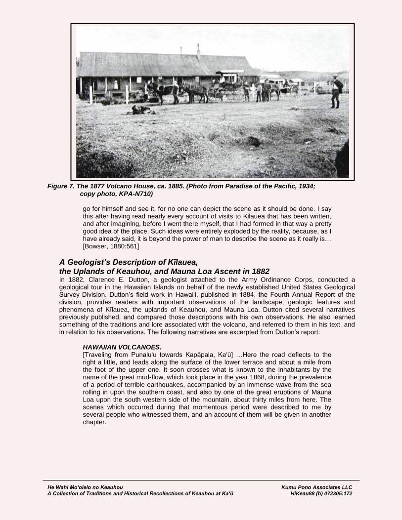
He Wahi Mo‘olelo no Keauhou Kumu Pono Associates LLC A Collection of Traditions and Historical Recollections of Keauhou at Ka‘ū HiKeau88 (b) 072305:172
Figure 7. The 1877 Volcano House, ca. 1885. (Photo from Paradise of the Pacific, 1934; copy photo, KPA-N710)
go for himself and see it, for no one can depict the scene as it should be done. I say this after having read nearly every account of visits to Kilauea that has been written, and after imagining, before I went there myself, that I had formed in that way a pretty good idea of the place. Such ideas were entirely exploded by the reality, because, as I have already said, it is beyond the power of man to describe the scene as it really is… [Bowser, 1880:561]
A Geologist’s Description of Kīlauea, the Uplands of Keauhou, and Mauna Loa Ascent in 1882 In 1882, Clarence E. Dutton, a geologist attached to the Army Ordinance Corps, conducted a geological tour in the Hawaiian Islands on behalf of the newly established United States Geological Survey Division. Dutton’s field work in Hawai‘i, published in 1884, the Fourth Annual Report of the division, provides readers with important observations of the landscape, geologic features and phenomena of Kīlauea, the uplands of Keauhou, and Mauna Loa. Dutton cited several narratives previously published, and compared those descriptions with his own observations. He also learned something of the traditions and lore associated with the volcano, and referred to them in his text, and in relation to his observations. The following narratives are excerpted from Dutton’s report:
HAWAIIAN VOLCANOES. [Traveling from Punalu‘u towards Kapāpala, Ka‘ū] …Here the road deflects to the right a little, and leads along the surface of the lower terrace and about a mile from the foot of the upper one. It soon crosses what is known to the inhabitants by the name of the great mud-flow, which took place in the year 1868, during the prevalence of a period of terrible earthquakes, accompanied by an immense wave from the sea rolling in upon the southern coast, and also by one of the great eruptions of Mauna Loa upon the south western side of the mountain, about thirty miles from here. The scenes which occurred during that momentous period were described to me by several people who witnessed them, and an account of them will be given in another chapter.

He Wahi Mo‘olelo no Keauhou Kumu Pono Associates LLC A Collection of Traditions and Historical Recollections of Keauhou at Ka‘ū HiKeau88 (b) 072305:173
The so-called mud-flow of Kapapala took place during the culminating part of this earthquake period, and was very probably started by one of the severest shocks. The principal alluvial terrace at this point is composed of unconsolidated clay, and it was saturated with water supplied by springs. The face of the terrace is very steep as well as very lofty, and it is easy to understand how the mass saturated with water might have been put in motion by a severe earthquake shock. Certain it is that a great land-slip occurred, and an enormous mass of clay containing some gravel and a few small boulders detached itself from the great bank and flowed about two miles and a half, with great swiftness and in a stream about a third of a mile in width. So sudden and swift was the movement that the people of a native village directly in front of it who saw it coming were overwhelmed by it, and about thirty of them were buried. Not an individual who was in its way had time to escape, and those who were spared were such as happened at the time to be in positions which the flow did not touch. So far as I can learn, no evidence of heat or volcanic action attended this catastrophe, although some accounts (which I do not credit) represent that it was accompanied by exploding steam. It appears, however, to have been a genuine land-slip detached by an earthquake, the materials composing it having been rendered sufficiently fluent by saturation with water. For several months the mud stream was so soft that it was impassable. At present it is overgrown by rank grass which affords excellent pasturage. Its thickness appears to be between forty and sixty feet. A little beyond is situated what is known as the Kapapala ranch; It is one of those localities which seem to possess local importance and interest for which no sufficient reason can be assigned. Probably, however, its notability may be associated with the fact that it is the last watering-place on the road to Kilauea, and is also a halting-place for [page 100] travelers who wish to ascend Mauna Loa. The traditional hospitality of the natives to whom it originally belonged, and of the white proprietors who have succeeded them, is, no doubt, a still more intelligible reason. It also has an importance somewhat analogous to that of some of our western hamlets where several lines of railroad intersect, for at this point several divergent roads lead to as many different parts of the island. Here, too, we begin to pass into a tract of lavas which appear to be associated in part at least, if not chiefly, with Kilauea as distinguished from Mauna Loa. It is customary to speak of Kilauea as a mere appendage of Mauna Loa and situated upon its flanks. As my familiarity with the relations of the two increased, it produced a growing impression of distinctness in the two volcanoes. As we approach Kilauea from the Kau side this impression of distinctness will, I think, become stronger and stronger. From Kapapala the road winds on, slowly and steadily ascending over ancient fields of pahoehoe thinly covered with soil. The lavas here have buried the lower terrace, and now and then an ancient flow from Mauna Loa is seen descending from the upper terrace, merging with the lavas below. Half a mile from the ranch the trail passes a deep cavity in the ground, and the rocks ring hollow beneath the feet. It is a common occurrence, and one which we might have noted before, because we have passed many such already on our route. It is an old lava pipe. A lava stream which has been flowing for several days gradually forms an outer covering by the superficial cooling of the lava, making a regular tunnel. Probably no great eruption takes place without the formation of several such tunnels, perhaps many of them. They are often of great extent and even as much as three or four miles in length. Here and there the roof of the tunnel falls in. Sometimes a single slab drops in, forming a skylight for the cavern below. More frequently the tunnel preserves its arch. There are literally thousands of these tunnels throughout the mass of Mauna Loa. Their transverse dimensions are highly variable, sometimes expanding into a great chamber 60 or 80 feet in height and of corresponding width, again contracting to an aperture of a few
He Wahi Mo‘olelo no Keauhou Kumu Pono Associates LLC A Collection of Traditions and Historical Recollections of Keauhou at Ka‘ū HiKeau88 (b) 072305:174
square yards. So numerous are these caverns that it seems as if they must form some appreciable part of the entire volume of the mountain. The lavas we are traversing in the vicinity of Kapapala no doubt originated from Mauna Loa. But a little to the right and seaward is a barren wilderness of black lava which certainly originated in chief part at least from the purlieus of Kilauea; for at a distance of about four miles from Kapapala the trail descends upon this plain, reaching a spot from which the general surface again ascends in all directions except, to the southwest. Mauna Loa is upon our left and the long declivity of Kilauea is upon our right, and we ride along a line where the two conical surfaces intersect. Undoubtedly the lavas from the two sources, are blended together and alternate with each other. Upon our right [page 101] also, at a distance of about three miles, may be seen four or five cinder cones standing upon a line which, if prolonged, would pass into the great basin of Kilauea. These cones are conspicuous rather for their rarity than for anything else. The geologist who has rambled much among the scenes of recent volcanism will greatly miss these almost invariable accompaniments of activity, and wonder at their paucity. The line of cones seen upon our right is situated upon a fissure, the prolongation of which carries it directly into the pit of Kilauea. There are several fissures traversing this great lava-plain, all radiating from Kilauea, and from some of them volumes of steam are still issuing. This is a noteworthy fact, pointing to the individuality of Kilauea as a distinct volcanic center. We shall find that similar fissures radiate from the summit of Mauna Loa. And now for a time the trail winds pleasantly along upon a grassy bottom of soil with the lava beds upon our right and an alluvial bank upon our left. This alluvial bank, no doubt, is a degraded exposure of one of the alluvial terraces hitherto noted, which just here has escaped burial by recent lavas. At length the trail leaves the alluvial bottom and runs into the broad fields of naked pahoehoe. Around us and reaching southward and eastward into the dim distance is a barren desolate waste of rolling and smoothly rounded hummocks of solid rock. Once, no doubt, they were black as coal, but now they are faintly brownish or ruddy from weathering. The path winds tortuously among them, now making a detour to escape some shattered pile or ragged crack, now tumbling over a wrinkled, contorted knoll of solidified lava. The first impression produced by the sight of one of these vast fields of naked lava is very memorable. It has something akin to the first prospect of the sea or the great plains, or an arctic ice-field. It conveys a sense of grandeur, solemnity, desolation, but above all, monotony. Very impressive, too, is the sense of magnitude and power which it produces. Rarely are such wide spreading lava wastes to be found elsewhere in the world. Probably those of Iceland equal them, and those of the Snake River country incomparably surpass them, but I know of no others of equal magnitude. The journey over them is monotonous and wearisome, for the rolling surface for the most part shows no more diversity than the prairies of Iowa or a newly planted corn-field. And yet there is one diversion. After a few miles of pahoehoe we find ourselves in front of an ugly, ominous barrier, which scowls and bristles across the path as if to forbid a nearer approach to the Inferno beyond. It is the edge of a great field of aa, stretching for many a weary mile across the broad expanse of rolling pahoehoe. A. good trail has been macadamized across it with a course as straight as an arrow. It has the ordinary aspect with which we have already become familiar in the great fields of aa between Honuapo and Punaluu. It seems, however, to be somewhat older than those, or rather it has been more discolored by [page 102] weathering, which, however, is not a safe guide to inferences concerning age, since the amount of weathering depends altogether upon climate.
He Wahi Mo‘olelo no Keauhou Kumu Pono Associates LLC A Collection of Traditions and Historical Recollections of Keauhou at Ka‘ū HiKeau88 (b) 072305:175
APPROACHES TO KILAUEA. This field of aa came from a prehistoric though doubtless recent eruption, from a vent situated upon the northeastern flank of Mauna Loa, at an altitude of about 8,000 feet, and about seventeen or eighteen miles from the summit. It rivaled in magnitude the great historic eruptions, and it eventually reached the sea on the Kau coast about five miles east of Punaluu. The entire length of the stream was about twenty-three miles. The upper portion of it is composed largely of pahoehoe. But where it strikes this phlegrean field on which we are traveling the very feeble slope checked its velocity, enabling it to spread out and to flow sluggishly. In accordance with the mechanism already described, it here takes the form of aa. But further on to the southward, where the slope again becomes much greater, the stream narrows, and for the most part takes the form of pahoehoe. Here at its narrowest part the field of aa is a little over a mile in width, and its thickness is probably between 60 and 80 feet. There is no tradition indicating the time of its eruption. Descending the eastern wall of this field of aa we are once more upon a vast expanse of pahoehoe. The journey now becomes toilsome. The hummocks of lava are large and high and the animals lurch and strain as they scramble over them. But as the surface in detail is otherwise smooth the hardship is limited to severe work, the foothold being perfectly secure. For about four miles the trail keeps near the barrier of aa, winding among the hummocks of pahoehoe. At length it deflects away from the aa and points as straight as possible for Kilauea. The ascent is very gradual and it is only by consulting the barometer that we become conscious how rapidly we are gaining in altitude. After about twelve miles of floundering among these hummocks we find ourselves at the foot of a rather steep hill which is broken away on the right by an abrupt cliff. As we ascend it, the trail, rising out of a little rain gully, leads us to a narrow platform. In front of us the surface of the earth instantly drops from the face of a vertical wall about 500 feet high, and Kilauea is before us. [page 103] KILAUEA. The Kau trail first strikes the edge of the Kilauea amphitheater upon its western side, and, following the western rim, circles around the northern end until it reaches the Volcano House. A few hundred yards beyond this point, where the volcano first breaks into view, we reach, by a sharp acclivity, the loftiest point of the encircling crest line of the amphitheater. It is a memorable spot. Behind us rises the dome of Mauna Loa, and nowhere else upon the island is the superlative grandeur of this king of volcanoes displayed to such advantage. When the curtain of clouds is drawn aside, we behold also far to the northward the almost equally majestic mass of Mauna Kea. In front of us and right beneath out feet, over the crest of a nearly vertical wall, more than 700 feet below, is outspread the broad floor of the far-famed Kilauea. It is a pit about three and a half miles in length and two and a half miles in width, nearly elliptical in plan, and surrounded with cliffs for the most part inaccessible to human foot, and varying in altitude from a little more than 300 feet to a little more than 700 feet. The altitude of the point on which we stand is about 4,200 feet above the sea. The object upon which the attention is instantly fixed is a large chaotic pile of rocks, situated in the center of the amphitheater, rising to a height which by an eye estimate appears to be about 350 to 400 feet. From innumerable places in its mass volumes of steam are poured forth and borne away to the leeward by the trade wind. The color of the pile is intensely black, spotted and streaked here and there with red–not the red of fire, but of iron persalts, alternating with the magnetic black. Its general form is conical, holding a large crater-form depression within. But it is so shattered and broken that it has a craggy, ominous aspect, which may well be called hideous. Around it spreads out the slightly undulated floor of the amphitheater, as black as midnight. To the left of the steaming pile is an opening in the floor of the crater, within which we behold the ruddy gleams of boiling lava. From numerous points in the surrounding floor clouds of steam issue forth and melt away in the steady flow of the
He Wahi Mo‘olelo no Keauhou Kumu Pono Associates LLC A Collection of Traditions and Historical Recollections of Keauhou at Ka‘ū HiKeau88 (b) 072305:176
wind. The vapors issue most copiously from an area situated to the right of the central pile and in the southern portion of the amphitheater. Desolation and horror reign supreme. The engirdling walls everywhere hedge it in. But upon their summits and upon the receding platform beyond are all the wealth and luxuriance of tropical vegetation heightening the contrast with the desolation below. KILAUEA. THE CALDERA. Yet we can pause here but a few moments. The journey has been [page 104] long and wearisome and we must seek rest and shelter, in order to survey the scene with deliberation. A ride of two miles further brings us to the Volcano House, which is a very comfortable hostelry, affording much needed shelter, for we are almost sure to reach it in the midst of a driving rain. The entire distance from the Kau coast to the verge of the amphitheater lies through a country which is almost arid. And yet as soon as we reach the summit point of the surrounding wall, we pass, in the space of half a mile, from a very dry region to a very moist one. These rapid transitions from wet to dry and vice versa are common on the island of Hawaii. And nowhere is this transition more abrupt than at Kilauea. The transverse axis of the pit may be issued as a sharply dividing line between two strongly contrasted climates. North of it the rainfall is excessive. South of it the rainfall is very deficient. I have hitherto carefully avoided applying the term “crater” to Kilauea. It has so little in common with the orifices from which lavas and other volcanic products emanate that the word is little more than a misnomer here. All the accessories of Kilauea differ immensely from those associated with normal craters, and it seems necessary to apply to it some designation expressing its distinct characters. Counterparts of Kilauea are not common. I can think of but one in the Mediterranean volcanoes which appears to be at all homologous to it, and that is the Val del Bove; though my acquaintance with European volcanoes is insufficient to enable me to say whether or not this is the only one in Europe. On these islands the exact counterpart of Kilauea is the great pit on the summit of Mauna Loa named Mokuaweoweo. The vastly larger depression on the summit of Haleakala, though differing much in form, is in my opinion strictly homologous. Numerous small crater-form depressions are found in many parts of Hawaii, which also seem to me to be homologous with Kilauea, some of which are only a few hundred feet in diameter, and none of them exhibit any signs of recent activity. Considered with reference to their origin the evidence is conclusive that they were formed by the dropping of a block of the mountain crust which once covered a reservoir of lava, this reservoir being tapped and drained by eruptions occurring at much lower levels. A great deal of misconception and confusion of ideas have arisen from the practice of characterizing these depressions by the term craters. For example, few people speak of Haleakala without calling it the greatest crater in the world. My understanding is that it is not a crater at all, and that we have therefore nothing to compare it with except such formations as I have just mentioned. It seems necessary therefore to adopt some term which will apply to the very limited class of amphitheaters of which Kilauea may be considered as the type. Perhaps the term caldera may be as unobjectionable as any, though I am far from regarding it as quite satisfactory, and am fully prepared to find it severely criticized. It is the best one I can offer, and hereafter I shall employ it in speaking of these formations wherever they occur in these islands. [page 105]
The morning after reaching the Volcano House, I descended to the floor of Kilauea. The wall of the caldera at its northern end has settled into a series of steps by the sinking of successive portions which have faulted off from the main platform of the country. This dropping of successive spalls of great size, many hundreds of yards in length and from 20 to 200 yards in width, is conspicuous around many portions of the parapet. Each of these great spalls forms a shelf or ledge, backed by a steep and sometimes vertical cliff. Wherever the escarpment is sloped a good foot trail has

He Wahi Mo‘olelo no Keauhou Kumu Pono Associates LLC A Collection of Traditions and Historical Recollections of Keauhou at Ka‘ū HiKeau88 (b) 072305:177
been dug, allowing of a steep but safe and easy descent. By such a trail the floor of Kilauea is reached without difficulty. As soon as we reach the bottom we find ourselves upon brand new pahoehoe of the most typical kind. We travel over rolling, smooth-surfaced bosses of rock without difficulty for a distance of about a mile and three-quarters, when we reach a rapidly ascending slope, which rises a little more than a hundred feet. Gaining the summit, we find ourselves upon the brink of a pool of burning lava. This pool is about 480 feet long and a little over 300 feet in width. Its shape is reniform. It is surrounded by vertical walls 15 to 20 feet in height. When we first reach it the probabilities are that the surface of the lake is coated over with a black, solidified crust, showing a rim of fire all around its edge. At numerous points at the edge of the crust jets of fire are seen spouting upwards, throwing up a spray of glowing lava drops and emitting a dull, simmering sound. The heat for the time being is not intense. Now and then a fountain breaks out in the middle of the lake and boils feebly for a few minutes. It then becomes quiet, but only to renew the operation at some other point. Gradually the spurting and fretting at the edges augment. A belch of lava is thrown up here and there to the height of 5 or 6 feet, and falls back upon the crust. Presently, and near the edge, a cake of the crust cracks off, and one edge of it bending downwards descends beneath the lava, and the whole cake disappears, disclosing a naked surface of liquid fire. Again it coats over and turns black. This operation is repeated edgewise at some other part of the lake. Suddenly a network of cracks shoots through the entire crust. Piece after piece of it turns its edge downward and sinks with a grand commotion, leaving the whole pool a single expanse of liquid lava. The lake surges feebly for awhile, but soon comes to rest. The heat is now insupportable, and for a time it is necessary to withdraw from the immediate brink. Gradually the surface darkens with the formation of a new crust, which grows blacker and blacker until the last ray of incandescence disappears. This alternation of the freezing of the surface of the lake and the break-up and sinking of the crust goes on in a continuous round, with an approach to a regular period of about two hours. The interval between the break-ups varies, so far as observed, from forty minutes to two hours and a quarter. Probably the average interval is somewhat less than two hours. The explanation of the phenomenon is not difficult.
PHENOMENA OF THE LAVA LAKES [Figure 8]. It is now believed that [page 106] lavas at temperatures a little below the point of solidification have a specific gravity slightly less than that of liquid lava; but when they have cooled considerably below the point of congelation their specific gravity is greater in the solid than in the liquid state. Hence, when the crust first forms it is light enough to float, and is very thin, but it gradually thickens, and the upper part grows denser. At length a stage is reached at which the mean density of the crust is greater than that of the lavas beneath, and the position of the crust then becomes unstable. This instability is first shown at the edges of the lake, where the mechanical support of the crust is interrupted by the escaping gasses and by the feeble boiling of the liquid mass within.

He Wahi Mo‘olelo no Keauhou Kumu Pono Associates LLC A Collection of Traditions and Historical Recollections of Keauhou at Ka‘ū HiKeau88 (b) 072305:178
Figure 8. C.E. Dutton’s Plate VIII, The New Lava Lake, Kilauea As the density of the crust increases the strain set up by the yielding at the edges at length becomes sufficient to propagate itself through the whole mass and break it up into fragments, which at once sink.*
* Since the above attempt to explain the periodic break-ups was put in writing I have felt distrustful of it. As these
pages are undergoing revision I therefore take advantage of the opportunity to amend it. It seems to me that the conclusion that lavas expand in solidifying is open to question, and that the experiments from which it is derived may have been vitiated by an omission to take account of the following facts. It is certain that the melted silicates readily occlude notable quantities of water, and when they solidify they exclude the water just as water itself excludes air in freezing. The excluded gas or vapor, however, is mechanically entangled in the solidifying mass in the form of bubbles or vesicles. As these vesicles are often minute, they may have been neglected and no account taken of them. But as their number is vast they may have seriously diminished the apparent density, in the case of lava or cast iron, though it is not to be supposed that this would affect the main fact (expansion in solidifying) in the case of water.
Now, the silicates, when passing from the melted to the solid condition, pass through a very considerable range
of temperature within which they are viscous. If the lava be kept for a long time, say an hour or two, well within this range of temperature the steam vesicles would have an opportunity to disentangle themselves from the mass and escape just as they do in a glass furnace. The amendment, therefore, which I would offer is as follows: The first inch or two of crust which forms is cooled quickly and becomes stiff and black in a few minutes. Its absolute density is presumably greater than that of the liquid below; but, being full of vesicles and spongy, it is light enough to float. Subsequent additions to its thickness are made to its under surface. Each successive film so added has a longer and longer time in which to disengage its gaseous contents. Therefore they successively become more and more compact, and their successive specific gravities approach more and more nearly the absolute density of the substance. Hence, as the thickness of the crust increases, its specific gravity increases. When the mean specific gravity becomes greater than that of the liquid (as it surely does) the position is unstable, and rupture once started is quickly propagated through the entire crust, which goes to pieces and sinks.

He Wahi Mo‘olelo no Keauhou Kumu Pono Associates LLC A Collection of Traditions and Historical Recollections of Keauhou at Ka‘ū HiKeau88 (b) 072305:179
When the lava is freshly exposed in the lake it has exactly the appearance of melted cast iron, its color shading from red through orange into yellow. It is easy to see that the temperature of the freshly exposed surface is by no means so great as many have been led to suppose. Basic lavas are very fusible, and those before us have the appearance of being decidedly viscous and sluggish in their movements. It is very probable that the basalts which come up out of the earth in [page 107] great eruptions reach the surface at a far higher temperature than those seen in this lake, being, in fact, most probably at a white instead of a red or yellow heat. The phenomenon of Pele's hair is often spoken of in the school books, and receives its name from this locality. It has generally been explained as the result of the action of the wind upon minute threads of lava drawn out by the sporting up of boiling lava. Nothing of the sort was seen here, and yet Pele’s hair was seen forming in great abundance. Whenever the surface of the liquid lava was exposed during the break-up the air above the lake was filled with these cobwebs, but there was no spurting or apparent boiling on the exposed surface. The explanation of the phenomenon which I would offer is as follows: Liquid lava coming up from the depths always contains more or less water, which it gives off slowly and by degrees, in much the same way as champagne gives off carbonic acid when the bottle is uncorked. Water-vapor is held in the liquid lava by some affinity similar to chemical affinity, and though it escapes ultimately, yet it is surrendered by the lava with reluctance so long as the lava remains liquid. But when the lava solidifies the water is expelled much more energetically, and the water-vapor separates in the form of minute vesicles. Since the congelation of all siliceous compounds is a passage from a liquid condition through an intermediate stage of viscosity to final solidity, the walls of these vesicles are capable of being drawn out as in the case of glass. The commotion set up by the descending crust produces eddies and numberless currents in the surface of the lava. These vesicles are drawn out on the surface of the current with exceeding tenuity, producing myriads of minute filaments, and the air, agitated by the intense heat at the surface of the pool, readily lifts them and wafts them away. It forms almost wholly at the time of the break-up. The air is then full of it. Yet I saw no spouting or sputtering, but only the eddying of the lava like water in the wake of a ship. The country to the leeward of Kilauea shows an abundance of Pele's hair, and it may be gathered by the barrel-full. A bunch of it is much like finely shredded asbestos.
The lava pool before us is called the New Lake. It was formed in May, 1881. It opened suddenly in the floor of the caldera, and was at first of much smaller dimensions than at present. It has been gradually enlarged by the cleaving off and engulfment of successive slices of its encircling wall. In truth the lava lakes do not, as a rule, maintain any constant position. They have been seen to open in various parts of the floor, and after some months or years of activity, similar to that already described, they freeze up permanently, and are entirely obliterated. Five or six lakes were known in 1853. Four years ago (1878) a large open lake existed near the north end of the pit, but its location is no longer discernible. In truth, the floor of the caldera is liable to open and become a lava pool at almost any point. The changes [page 108] have been very great within historic times, and some recital will be made presently of its condition in the first part of the present century. HALEMAUMAU. There is a second and larger lake presenting a somewhat more dramatic appearance. It is situated less than half a mile from the New Lake, within the large chaotic pile of rocks or cone which first attracted our attention when we reached the brink of the caldera. It has occupied its present situation many years, so long in fact that the imperfect records kept of its changes hardly permit us to form an idea of the exact period of its origin. Its name is Halemaumau. This name was applied to the

He Wahi Mo‘olelo no Keauhou Kumu Pono Associates LLC A Collection of Traditions and Historical Recollections of Keauhou at Ka‘ū HiKeau88 (b) 072305:180
great central lake of Kilauea, as it was first seen by Ellis in 1823, and Halemaumau may be fairly considered as representing what now remains of that great feature. As we pass from the New Lake to Halemaumau, we have abundant evidence that we are treading upon the thin crust of a slumbering volcano. Numerous cracks on either band emit steam and sulphurous vapors. The rocks are corroded and chemically changed by the action of acid gases, and are warm to the touch upon the surface. A stick plunged into one of these cracks is quickly charred. Signs of instability, such as shattering and heaving movements, are seen all around, and the thoughts of a catastrophe are ever before the mind. At length we reach the encircling cone which surrounds the older lake. At the north end the barrier is broken down into a mass of rubble and sharp angular fragments, over which progress is somewhat difficult. Ascending a steep slope of lava fragments, we soon reach the summit of it, and the lake is before us. We cannot, however, approach it as we could the New Lake. A vertical cliff, at the foot of which is a series of yawning cracks and fissures, sending out intensely hot steam and the most acrid vapors, forms an insuperable barrier. Still we may command from an elevation of about a hundred feet a very good view of the greater part of the pool. Its aspect is somewhat different from that of the New Lake. There is more activity, and its surface is covered with boiling fountains of liquid lava, but none of them spout to any great altitude. In the presence of this ebullition a thick crust like that of the New Lake cannot form. The surface is too unquiet. Still, the greater part of the lake is covered with a thin black crust which floats in detached sheets which sink from time to time. The periodical changes and alternations between congelation and the sinking of the crust are not so well marked. From time to time periods of comparative quiet supervene, followed by periods of general activity throughout the pool. The area of Halemaumau also is larger than that of the New Lake, being nearly 1,000 feet in length, with a width of nearly 600 feet. The cone which surrounds this lake is a very striking construction, or rather destruction. It is not composed of fragmental material like an ordinary crater, but of masses of lava which have been apparently pushed up. The elevatory movement has been accompanied with much shattering and contortion, and the rocks have been thrown into such [page 109] attitudes that it seems as if a breath would knock the whole thing down. Still it is a definite structure, having some features in common with the summit cone of Vesuvius. It consists, in fact, of cones within cones. That it has really been hoisted is testified by those who have occupied the Volcano House since 1875, and the greater part of the upheaval has taken place within the last three years. The amount of steam and gaseous exhalations is very much greater in Halemaumau than in the New Lake. The ebullition in the former is constant, while in the latter it is very feeble and almost insignificant. Fountains of liquid lava rising to the height of 5 to 10 feet, as nearly as could be judged by an eye estimate, are seen at all times in Halemaumau. But they are generally confined to a few localities at any given time. They change about frequently from place to place, breaking out suddenly in one spot and gradually dying away in another. The amount of condensed steam floating away in the form of white vapor is not so very great, when we consider the very large surface from which it emanates. Most of this visible steam, however, does not come apparently from the surface of the lava itself but from the fissures and numberless vent holes in the wall of the surrounding crater. It is probable, however, that the intense heat of radiation from the pool itself prevents the condensation of the steam until it has diffused itself throughout a considerable body of the atmosphere. Over the entire surface of the burning lake is spread a pall of translucent vapor, through which the remoter wall of the crater is still visible, though somewhat clouded. What proportion of these vaporous exhalations consists of sulphur gases it is impossible to estimate, though I have no doubt that it is considerable. Some of it is probably in the form of sublimed sulphur, which collects in small quantities upon the leeward side of the crater. Some of it may perhaps be anhydrous sulphuric acid. But as no precipitate
He Wahi Mo‘olelo no Keauhou Kumu Pono Associates LLC A Collection of Traditions and Historical Recollections of Keauhou at Ka‘ū HiKeau88 (b) 072305:181
or deposit of this acid has been detected, I have no better ground for this conjecture than the fact that some of the white fumes did not appear to have the odor either of sublimed sulphur or of sulphurous acid, being far more acrid. The presence of hydrochloric acid would have been readily detected by its peculiar odor, which is quite unmistakable. Still there are some indications that hydrochloric acid is among the exhalations of this volcano. In many places the lava is bleached by the abstraction of its iron protoxide. In many small spots are seen brilliant red, orange, and saffron colors. The bleaching would be most readily accomplished by hydrochloric acid, and similar red and orange spots are known to be produced by the conversion of iron chloride so formed into peroxide. In general, there is not disclosed to the eye an amount of condensed vapors which seems to be adequate to account for the amount of ebullition taking place over the surface of the lake, and it is quite probable that much of the vaporous products are carried off by the wind in the form of invisible vapor. To these gaseous emanations we may look for an explanation of the persistent liquidity of the lava within the lake. [page 110]
LAVA LAKES AND BLOWING CONES. They rise, no doubt, from very great depths in the form of bubbles at a temperature very much higher than that of the lava at the surface of the lake and replace all the heat which is lost at the surface by radiation. In their ascent it is probable that they produce also convection currents consisting of ascending eddies of hotter lava and descending eddies of cooler lava. It seems necessary, however, to pursue our inquiries a little further in this direction. At great depths below the surface we may presume the vapors to have a much higher temperature than at the surface. But they are also under enormous pressure, and as they ascend in the lava column the diminishing pressure ought to be accompanied by an elastic expansion of the vapors, and this in turn would lower the temperature by reason of heat becoming latent. Thus it may happen that unless these vapors are most intensely heated below and have temperatures very greatly above that of the surface the loss of temperature by this expansion would render them incapable of imparting more heat to the superficial portions of the lava column. No estimate of this possible loss of temperature, however, is practicable. But the convection currents would not be liable to this criticism. The earlier visitors to Kilauea whose accounts of it are now accessible speak of a phenomenon which did not exist at the time of my visit. I refer here to what have been termed “blowing cones” within the Lake. Ellis, in his account of Kilauea in 1823, describes them as “conical inverted funnels” rising to heights varying from 20 to 40, or even 50 feet above the surface of the lake, with openings at the top from which jets of vapor and sometimes spouts of lava were thrown out. As many as fifty were seen at one time within the great lava lake then existing, and most of them were simultaneously active. The same phenomenon was described in 1825 by parties from the H. B. M. Frigate Blonde. They were also seen by Wilkes in 1841, and have frequently been seen within the last ten or fifteen years by many other visitors. They appear to have been composed of solidified but very hot lava. None of them were permanent, but after a short period of activity they were either melted down or shifted their positions. Ultimately, no doubt, they were re-melted. That they shifted their positions is fully attested by many observers. Most probably they were masses of solidified lava floating like bergs in the lake. During my visit two masses of solid lava formed within the New Lake. These had no orifices at their summits and showed no action at all suggestive of blowing cones. They appeared to be simply masses of solidified lava formed out of the pool itself. In the course of several days these islands, as we called them, certainly shifted their positions by a very considerable amount, one of them moving across two-thirds of the shorter diameter of the lake. We
He Wahi Mo‘olelo no Keauhou Kumu Pono Associates LLC A Collection of Traditions and Historical Recollections of Keauhou at Ka‘ū HiKeau88 (b) 072305:182
may perhaps account for their buoyancy by the supposition that lava at a temperature a little below that of congelation is specifically lighter than lava a little above that temperature. There is difficulty, however, in [page 111] understanding how a considerable mass of lava could so congeal within the pool at all. The principal mass of lava surrounding it is still in a liquid condition. I have been unable to find any satisfactory explanation of this problem. Leaving Halemaumau and passing around the rocky cone which incloses it, we may enter the southern half of Kilauea. Half a mile to the southwest of the cone the aspect of the floor of the caldera becomes very repellent. Great quantities of steam and bluish vapor rise from innumerable rifts and cracks, and blending into a dense cloud, float away to the leeward. Here existed a few years ago a large lava lake, which is now entirely frozen over, though the clouds of steam still indicate plainly the thinness of the covering. This pool of lava was known by the name of the Old South Lake. Although it has ceased to exist as a distinct lake, it still emits at intervals of a few months or even a few weeks considerable quantities of lava, which overflow portions of the adjoining floor. It requires some courage to venture upon an area so dangerous, though in reality the risk of accident is not very great, if ordinary caution is exercised. Very little knowledge, however, is to be gained by such a journey, for it is impossible to visit the places we would most like to inspect on account of the great quantities of pungent gases emanating from the numberless fissures. The surface consists wholly of pahoehoe, which has an unusually spongy and vesicular character, and which crumbles beneath the feet. Innumerable blisters occur, which break beneath the tread and let the foot down into holes, from which it must be instantly withdrawn to prevent the shoe from being burned to a crisp. The black color of the lava has been discharged in many places by the reaction of acid vapors, here changed to a snowy white, there to an orange, red, or saffron color. The Old South Lake sealed up about three years ago, but the eruptions from it have been frequent since that time, though most of them have been quite small. It is interesting to recur to the accounts of Kilauea given by those who visited it in the early part of the century. Prior to the discovery of the islands by Captain Cook (1776 [1778]), we have no accounts excepting the most fanciful myths. There is, however, a tradition which was learned by the earliest missionaries concerning an eruption of Kilauea, which is supposed to have taken place in the year 1789 [1790], and to which a certain amount of credence is given by the most intelligent among the earlier writers. This account relates that Keoua, King of Hilo [Kau], being at war with the King of Kau [Hilo], marched his army in three divisions past Kilauea; that while the columns were in movement a violent eruption took place, during which great volumes of smoke were shot high in the air, carrying with them great quantities of rocks and hot stones, and that one division of the army was destroyed to the last man by the inhalation of the sulphurous vapors. As this event took place during the reign of Kamehameha I, and must have been fully within the recollection of [page 112] many people living at the time of the advent of the missionaries, and as it is very circumstantial in its account, there may be justification for the belief that an eruption of an unusual and violent character took place at that time.
He Wahi Mo‘olelo no Keauhou Kumu Pono Associates LLC A Collection of Traditions and Historical Recollections of Keauhou at Ka‘ū HiKeau88 (b) 072305:183
EARLY ACCOUNTS OF KILAUEA. It is certain, however, that no subsequent eruption has been attended with the like degree of violence, or with action resembling in character that which the tradition describes. All primitive peoples are addicted to the grossest exaggeration, and are quite incapable of describing any natural phenomenon with accuracy. The most that we are at liberty to infer from this account is that an eruption of great violence may have taken place in that year attended with occurrences which have not since repeated themselves. In the year 1823 the Rev. William Ellis, an English missionary, made an extended tour of the island of Hawaii, and reached Kilauea from Kau by way of Kapapala, the same route which has been described in the preceding chapter. The description which he gives leads to the belief that Kilauea presented at that time an aspect differing greatly from the present one… [quoting Ellis, Dutton writes]
“As eight of the natives with us belonged to the adjoining district, we asked
them to tell us what they knew of the history of this volcano and what their
opinions were respecting it. From their account and that of others with
whom we had conversed we learned that it had been burning from time
immemorial, or, to use their own words, from chaos until now, and had
overflowed some part of the country during the reign of every king that had
governed in Hawaii; that in earlier ages it used to boil up, overflow its
banks, and inundate the adjacent country; but that for many kings' reigns
past it had kept below the level of the surrounding plain, continually
extending its surface and increasing its depth, and occasionally throwing up
with violent explosion huge rocks or red-hot stones. These eruptions, they
said, were always accompanied by dreadful earthquakes, loud claps of
thunder, with vivid and quick succeeding lightning. No great explosion, they
added, had taken place since the days of Keoua; but many places near the
sea had since been overflowed, on which occasions they supposed Pele
went by the road under ground from her house in the crater to the shore.”
I quote this last paragraph, not because I attach much weight to primitive traditions, but because the statements it contains seem so intrinsically probable. There is no evidence that the lavas have, within [page 114] any recent period, overflowed the outer rim of the caldera. KILAUEA IN 1841. On the contrary, the fields of pahoehoe, which now form the crests of the surrounding walls, are quite ancient and are considerably decomposed by many centuries of weathering. Yet there is reason to believe that at some ancient epoch such outflows actually occurred, because the streams of lava in some instances, perhaps in many instances, radiate away from the rim of the caldera. That the great pit has progressively enlarged its dimensions through a considerable period of time is also most probable, for there is strong evidence that this enlargement is still going on from time to time by the sinking of large spalls or slices which break off from the walls of the surrounding precipice. The black ledge referred to in Ellis’s description was at that time, no doubt, one of the most striking features of Kilauea. It is described a few years later in some detail by Mr. Stuart, who accompanied Lord Byron, commanding H. B. M. Frigate Blonde. In Lord Byron’s narrative Kilauea is figured in drawings made by Lieutenant MaIden, R. N., and his sketch shows the great interior pit and the black ledge as very conspicuous features.
The Wilkes Exploring Expedition visited these islands in 1840-‘41, and Lieutenant

He Wahi Mo‘olelo no Keauhou Kumu Pono Associates LLC A Collection of Traditions and Historical Recollections of Keauhou at Ka‘ū HiKeau88 (b) 072305:184
Wilkes has given a very excellent account of the condition of Kilauea at that time… [page 115] [Dutton cites narratives from earlier accounts, and previously referenced in this study.] …Similar accounts of the condition of Kilauea between the years 1823 and 1841 have been given by other parties who visited it during that period. The most striking feature at that time must have been the great inner cavity of the caldera and the surrounding black ledge. This interior depression has now wholly disappeared. It has been filled up completely. And not only that, but the portions which it once occupied are built up so far that they now form the highest part of the floor of the main caldera. Over what was once the most active part of this great lake has been built up the choatic pile of crateriform rocks which now encircle the pool of Halemaumau. Both the north and the south lakes have disappeared, having been frozen over completely, and in their stead the New Lake, situated half a mile northeast of Halemaumau has made its appearance. It appears that in 1841 the level of the liquid lava at the bottom of the great interior pit was a little more than a thousand feet below the highest point of the outer wall of the caldera. At the present time the level of the liquid lava in the New Lake is about 580 feet below the highest point of the rim, and its level in Halemaumau I judge to be about the same, but it was impossible to obtain access to it in order to verify this inference. At the present time, then, the liquid lava columns stand about 435 feet higher than they did forty years ago. No record has ever been kept of the progressive action by which these changes have been brought about. Nothing remains to show the successive steps in the accretion of lavas which gradually filled up the interior pit. The only guides we have are the fragmentary accounts of numberless [page 117] visitors describing the condition of Kilauea from time to time. These are all so incoherent and so grossly wanting in precision that it is impossible to frame a connected account of the process. There are, however, a few general features of the process which appear, and these may be briefly summarized. All accounts go to show that the height of the liquid column oscillates in an irregular manner, and while most of these oscillations are small, usually not exceeding 10 to 15 feet, yet in exceptional cases they are very much greater. Whenever the liquid column rises there is a tendency to overflow the margin of the pool which surrounds it, and this frequently happens. The quantities of lava thus out flowing and spreading out over a considerable area vary extremely, being sufficient sometimes to cover no more than a few acres to the thickness of a very few feet, while on rare occasions a square mile or two may be overflowed with a considerable body. The duration of these overflows is also extremely variable. Sometimes it is a single belch or surge lasting but a few minutes. It is quite common for the lava to run in this way for a whole day, and in larger overflows it may run for two or three weeks without interruption. Sooner or later the liquid column sinks and the overflow ceases. The eruptions are not by any means confined to the lakes, but break out at unexpected places. One of the most favored spots for this action is the former locus of the Old South Lake, which for several years has been completely frozen over. The cooling lava invariably takes the form of pahoehoe. In reading the earlier accounts of Kilauea and in comparing them with the condition prevailing at the time of my visit, I was at first impressed with the idea that there had been on the whole a decrease in the amount of volcanic energy within the last forty years or more. But a more careful and critical study of these accounts has tended to efface that impression. It is evident that the writers were profoundly impressed with the sublime spectacle, and their deepest emotions were stirred. It is natural under

He Wahi Mo‘olelo no Keauhou Kumu Pono Associates LLC A Collection of Traditions and Historical Recollections of Keauhou at Ka‘ū HiKeau88 (b) 072305:185
such circumstances that their writings should portray the intensity of their feelings. It is not to be suspected for a moment that they intended to exaggerate, but under the spur of intense enthusiasm they aimed rather to express what they felt than to give a rigorous and exact description in cool, formal language. The reader of these accounts also is apt to be somewhat at fault, for he is liable to be intent upon the dramatic aspect of the scene and to share the enthusiasm of the writers and to forget or be indifferent to the strictest exactitude. Scrutinizing these earlier accounts more closely it will be seen that there is little reason to suppose that the amount of surface of liquid lava exposed to the atmosphere was any greater then than now. The amount of energy displayed would depend entirely upon the quantity of vaporous products given off. And it is by no means certain that there has been any diminution in this respect. In truth, this form of energy is never constant. It increases and diminishes from week to week and month to month, and it is a common saying that Kilauea is never twice [page 118] alike. VARIABLE ACTIVITY OF KILAUEA [Figure 9]. At the time of my visit it was probably more quiet than usual. And yet, immediately after I left it, there broke out from a point near the New Lake one of the largest eruptions which has ever been known to take place within the caldera. The lava flowed steadily for nearly a month, and completely overflowed more than half of the floor of the caldera, profoundly changing the aspect of its details. The boiling and surging, the spouting upward of the lava in fountains was feeble and unfrequent during my visit; but it had occurred a short time before with great power, and there is no reason to doubt that it may occur still more forcibly hereafter. The phenomenon of the blowing cones, however, has not been witnessed for some years. [page 119]
PURLIEUS OF KILAUEA. Having examined the salient points of interest in the great caldera it will be instructive to take a broader and more general view of the volcanic pile of which Kilauea is the focus. It has been habitual on the part of almost all writers to speak of Kilauea as situated upon the flanks of Mauna Loa and forming merely an appendage to that mountain. Many considerations have led me to regard it as a distinct volcano, having no more connection with Mauna Loa than any other volcanic center of the Hawaiian group. The horizontal distance from Kilauea to the summit of Mauna Loa is about 19 miles. The distances from the summit of Mauna Loa to the summits of Mauna Kea and of Hualalai are respectively 22 and 20 miles. So far as the length of the interval is concerned it is quite sufficient for as great a degree of independence as that prevailing between any two adjacent volcanoes. The difference in altitude between the lava lakes of Kilauea and the central pool of Mokuaweoweo is about 9,300 feet. The idea of a liquid connection or continuity through subterranean passages between these lava lakes seems to be so thoroughly opposed to all hydrostatic laws as to be incredible upon the very face of it. It seems impossible that the two vents can derive their lavas from a common reservoir. If we take our stand upon the western brink and highest point of the wall inclosing Kilauea, we shall observe that the profile of the country descends towards Mauna Loa. A slight but still decided depression exists towards the latter mountain. Across this depression a horizontal line will strike the nearest portion of Mauna Loa at a distance of about 4 ½ miles, and the intervening depression along this line amounts to about 340 feet. This indicates to us the fact that Kilauea is situated upon a totally
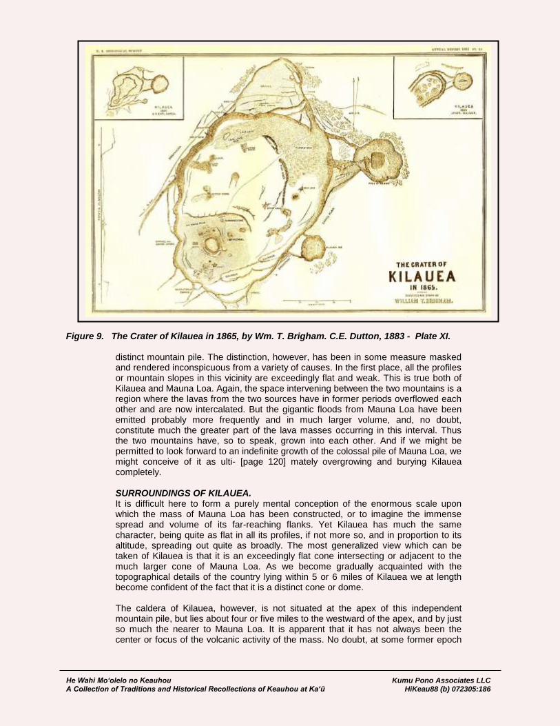
He Wahi Mo‘olelo no Keauhou Kumu Pono Associates LLC A Collection of Traditions and Historical Recollections of Keauhou at Ka‘ū HiKeau88 (b) 072305:186
Figure 9. The Crater of Kilauea in 1865, by Wm. T. Brigham. C.E. Dutton, 1883 - Plate XI. distinct mountain pile. The distinction, however, has been in some measure masked and rendered inconspicuous from a variety of causes. In the first place, all the profiles or mountain slopes in this vicinity are exceedingly flat and weak. This is true both of Kilauea and Mauna Loa. Again, the space intervening between the two mountains is a region where the lavas from the two sources have in former periods overflowed each other and are now intercalated. But the gigantic floods from Mauna Loa have been emitted probably more frequently and in much larger volume, and, no doubt, constitute much the greater part of the lava masses occurring in this interval. Thus the two mountains have, so to speak, grown into each other. And if we might be permitted to look forward to an indefinite growth of the colossal pile of Mauna Loa, we might conceive of it as ulti- [page 120] mately overgrowing and burying Kilauea completely. SURROUNDINGS OF KILAUEA. It is difficult here to form a purely mental conception of the enormous scale upon which the mass of Mauna Loa has been constructed, or to imagine the immense spread and volume of its far-reaching flanks. Yet Kilauea has much the same character, being quite as flat in all its profiles, if not more so, and in proportion to its altitude, spreading out quite as broadly. The most generalized view which can be taken of Kilauea is that it is an exceedingly flat cone intersecting or adjacent to the much larger cone of Mauna Loa. As we become gradually acquainted with the topographical details of the country lying within 5 or 6 miles of Kilauea we at length become confident of the fact that it is a distinct cone or dome. The caldera of Kilauea, however, is not situated at the apex of this independent mountain pile, but lies about four or five miles to the westward of the apex, and by just so much the nearer to Mauna Loa. It is apparent that it has not always been the center or focus of the volcanic activity of the mass. No doubt, at some former epoch

He Wahi Mo‘olelo no Keauhou Kumu Pono Associates LLC A Collection of Traditions and Historical Recollections of Keauhou at Ka‘ū HiKeau88 (b) 072305:187
this focus was situated at the apex, and it has been transferred to its present situation at an epoch which is presumably recent. Evidence of this may be found in riding around the pit and examining the lava beds which form the surface of the adjoining country. These radiate, for the most part, from the apex of the main cone, as if they flowed originally from that direction. Still other evidences may be found, of which the most striking are the occurrence of those singular abnormal, abortive cinder cones which stand over the cracks or fissures radiating from the summit of the pile. These radiating fissures are very characteristic both of Kilauea and Mauna Loa, and diverge from volcanic centers. In much more recent times a great fissure has been formed, starting from the southern end of Kilauea and reaching a distance of about 16 miles to the south-south west. It is still open, and emits steam at many points, and was in that condition when seen by Ellis in 1823. But the older fissures, with here and there a cone formed above them, radiate from an apex four or five miles to the eastward. The summit platform in the immediate vicinity of the caldera discloses numerous points of interest; and I propose to describe them as they present themselves to the observer who makes the circuit of Kilauea, taking the Volcano House as a starting point. The first feature which will catch the attention of the geologist is the manner in which the platform in the vicinity of the pit is riven by faults. Large fragments of the wall cleaving off from the main platform have sunken to various depths; and this feature manifests itself around the entire circumference. The most complicated instance of this fracturing and sinking of detached blocks is presented along the trail descending from the Volcano House to the floor of the caldera. The courses of the faults are, with some notable exceptions, parallel to the rim of the surrounding walls. The magnitudes of the sunken blocks are always con- [page 121] siderable, and in some cases their upper surfaces have areas which form a considerable fraction of a square mile. Those in the immediate vicinity of the upper wall are, in some cases, nearly a mile in length, and vary in width from 20 or 30 yards to more than 300 yards. The accompanying section will exhibit in the most concise form the apparent relations of these faulted fragments in front of the Volcano House. (Fig.3.)
Figure 10. C.E. Dutton’s Figure 3. “Faults in the northern wall of the caldera at Kilauea”
Immediately west of the hotel a road descends about 100 feet upon a sunken platform of very large proportions. It is well figured on the map drawn by the Wilkes Exploring Expedition. Towards the south this platform ends upon the brink of Kilauea, and upon all other sides it is inclosed by ledges evidently originating in a circuitous fault, with displacements varying from 30 to 150 feet. Numerous fissures traverse this platform, having courses parallel to the brink of the caldera. They open in gaps from two to six feet in width and are of unknown depths. From nearly all of them hot steam issues, and it is evident that the heat is intense at depths of only a very few feet below the surface. From most of them nothing emanates but the vapor of water. But in that portion of the platform nearest to the Volcano House large quantities of sulphur vapor exhale which condense in the forms of arborescent and acicular crystals of sulphur

He Wahi Mo‘olelo no Keauhou Kumu Pono Associates LLC A Collection of Traditions and Historical Recollections of Keauhou at Ka‘ū HiKeau88 (b) 072305:188
which are very beautiful. At other places fumes of sulphurous acid are given off in abundance. It is not a little remarkable that these three classes of volcanic products should, as a general rule, be quite distinct. The larger portion of the emanations consists of steam which shows no trace of acid. Over the steam cracks ferns and bushes grow with such rank luxuriance that the crack is often concealed, and the traveler must be on his guard while walking through the shrubbery lest he be precipitated into one of them. The evidence is abundant that the volcanic fires underlying this sunken platform have a very slight depth.
Figure 11. C.E. Dutton’s Figure 4. “Faults in the western wall of the caldera at Kilauea”
Proceeding around the northern end of the pit, the ground steadily ascends upon the northwestern and western sides. Here, too, are ob- [page 122] servable many open cracks, which still maintain a general parallelism with the brink of the main precipice. At about the middle of the western side of Kilauea we reach the highest point of its surrounding wall, which has an elevation of about 730 feet above the floor in its vicinity. Here, too, the faulted and sunken blocks are shown very clearly and are of large proportions, being about a mile in length and from 100 to 350 yards in width. This is also the most commanding spot from which Kilauea may be viewed and the best idea obtained of its general features. Farther southward the wall declines in altitude, but still maintains its abruptness, being very nearly vertical. Passing around the southern end new features engage our attention. Notable among these are the fragmental products scattered over the ground. It should be remembered that the northern and eastern portions are upon the windward side, while the southern and western portions are upon the leeward. Whatever volcanic products may be cast up into the atmosphere and wafted away by the winds are to be seen upon the leeward, and never upon the windward border. Moreover, the leeward side is arid, while the opposite is very rainy and continuously clothed with vegetation. Hence these fragmental products are well preserved and well exposed. Among them are considerable quantities of coarse sand or fine lapilli occupying the swales between the bosses of pahoehoe or drifting about in little sand dunes. This material is seen in considerable abundance in coming from Kau. It has been swept by the infrequent rains into the low, broad washes and carried to the distance of eight or ten miles. It is supposed by many of the white residents that this black sand was thrown out in the traditional eruption of 1789, alluded to in the last chapter. Nor does the supposition seem at all improbable.
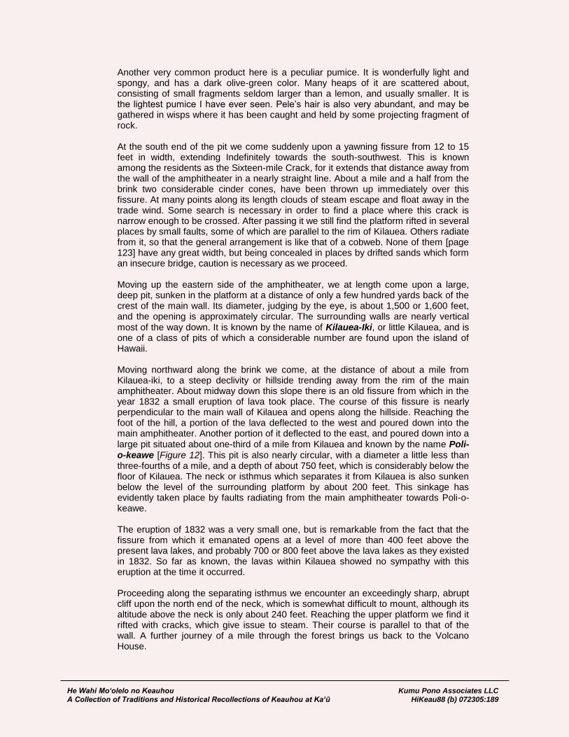
He Wahi Mo‘olelo no Keauhou Kumu Pono Associates LLC A Collection of Traditions and Historical Recollections of Keauhou at Ka‘ū HiKeau88 (b) 072305:189
Another very common product here is a peculiar pumice. It is wonderfully light and spongy, and has a dark olive-green color. Many heaps of it are scattered about, consisting of small fragments seldom larger than a lemon, and usually smaller. It is the lightest pumice I have ever seen. Pele’s hair is also very abundant, and may be gathered in wisps where it has been caught and held by some projecting fragment of rock. At the south end of the pit we come suddenly upon a yawning fissure from 12 to 15 feet in width, extending Indefinitely towards the south-southwest. This is known among the residents as the Sixteen-mile Crack, for it extends that distance away from the wall of the amphitheater in a nearly straight line. About a mile and a half from the brink two considerable cinder cones, have been thrown up immediately over this fissure. At many points along its length clouds of steam escape and float away in the trade wind. Some search is necessary in order to find a place where this crack is narrow enough to be crossed. After passing it we still find the platform rifted in several places by small faults, some of which are parallel to the rim of Kilauea. Others radiate from it, so that the general arrangement is like that of a cobweb. None of them [page 123] have any great width, but being concealed in places by drifted sands which form an insecure bridge, caution is necessary as we proceed. Moving up the eastern side of the amphitheater, we at length come upon a large, deep pit, sunken in the platform at a distance of only a few hundred yards back of the crest of the main wall. Its diameter, judging by the eye, is about 1,500 or 1,600 feet, and the opening is approximately circular. The surrounding walls are nearly vertical most of the way down. It is known by the name of Kilauea-Iki, or little Kilauea, and is one of a class of pits of which a considerable number are found upon the island of Hawaii. Moving northward along the brink we come, at the distance of about a mile from Kilauea-iki, to a steep declivity or hillside trending away from the rim of the main amphitheater. About midway down this slope there is an old fissure from which in the year 1832 a small eruption of lava took place. The course of this fissure is nearly perpendicular to the main wall of Kilauea and opens along the hillside. Reaching the foot of the hill, a portion of the lava deflected to the west and poured down into the main amphitheater. Another portion of it deflected to the east, and poured down into a large pit situated about one-third of a mile from Kilauea and known by the name Poli-o-keawe [Figure 12]. This pit is also nearly circular, with a diameter a little less than three-fourths of a mile, and a depth of about 750 feet, which is considerably below the floor of Kilauea. The neck or isthmus which separates it from Kilauea is also sunken below the level of the surrounding platform by about 200 feet. This sinkage has evidently taken place by faults radiating from the main amphitheater towards Poli-o-keawe. The eruption of 1832 was a very small one, but is remarkable from the fact that the fissure from which it emanated opens at a level of more than 400 feet above the present lava lakes, and probably 700 or 800 feet above the lava lakes as they existed in 1832. So far as known, the lavas within Kilauea showed no sympathy with this eruption at the time it occurred. Proceeding along the separating isthmus we encounter an exceedingly sharp, abrupt cliff upon the north end of the neck, which is somewhat difficult to mount, although its altitude above the neck is only about 240 feet. Reaching the upper platform we find it rifted with cracks, which give issue to steam. Their course is parallel to that of the wall. A further journey of a mile through the forest brings us back to the Volcano House.
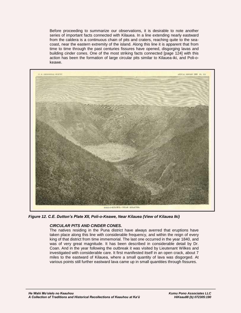
He Wahi Mo‘olelo no Keauhou Kumu Pono Associates LLC A Collection of Traditions and Historical Recollections of Keauhou at Ka‘ū HiKeau88 (b) 072305:190
Before proceeding to summarize our observations, it is desirable to note another series of important facts connected with Kilauea. In a line extending nearly eastward from the caldera is a continuous chain of pits and craters, reaching quite to the sea-coast, near the eastern extremity of the island. Along this line it is apparent that from time to time through the past centuries fissures have opened, disgorging lavas and building cinder cones. One of the most striking facts connected [page 124] with this action has been the formation of large circular pits similar to Kilauea-iki, and Poli-o-keawe.
Figure 12. C.E. Dutton’s Plate XII, Poli-o-Keawe, Near Kilauea (View of Kilauea Iki) CIRCULAR PITS AND CINDER CONES. The natives residing in the Puna district have always averred that eruptions have taken place along this line with considerable frequency, and within the reign of every king of that district from time immemorial. The last one occurred in the year 1840, and was of very great magnitude. It has been described in considerable detail by Dr. Coan. And in the year following the outbreak it was visited by Lieutenant Wilkes and investigated with considerable care. It first manifested itself in an open crack, about 7 miles to the eastward of Kilauea, where a small quantity of lava was disgorged. At various points still further eastward lava came up in small quantities through fissures.

He Wahi Mo‘olelo no Keauhou Kumu Pono Associates LLC A Collection of Traditions and Historical Recollections of Keauhou at Ka‘ū HiKeau88 (b) 072305:191
The main eruption broke out about 12 miles from the sea-coast and about 25 miles east of Kilauea, and an enormous mass of lava was outpoured. It spread out in a stream nearly 3 miles in width, and reached the ocean at Nanawale. This eruption has often been spoken of as emanating from Kilauea and flowing underground to the principal point of outbreak. This view is scarcely credible. It is much more rational to suppose that the several points of outbreak had a common connection with a single line of fissure, and that the principal outbreak took place merely at the lowest point. The number of circular pits in the vicinity of Kilauea and along this line of volcanic energy is considerable. Fifteen of them are now known, and it is by no means certain that the number is not considerably greater. They are situated in a region which is densely forest-clad, and which the traveler crosses only by means of trails hewn through the woods. On the road from Kilauea to Puna I passed within a dozen yards of a large one without seeing it until I was called back by one of my packers, who pulled aside the dense curtain of shrubbery, disclosing a pit nearly 2,000 feet wide and 600 feet in depth. These pits are either circular or elliptical in form, with remarkably regular outlines, and the sides are partly precipitous, and for the remainder, very steeply sloped. They are usually spoken of as craters, but as the term crater in this connection seems to commit us to the idea that they have some affinity with true craters, I avoid using it. Along the line of volcanic activity, extending from Kilauea to Nanawale, are numerous cinder cones. There are several lines of these, which are very nearly parallel and separated by short intervals. Most of them are quite small, but there are two or three of considerable magnitude. The larger ones are perfectly normal in structure, and are composed of lapilli of ordinary type. I have already remarked upon the absence of normal cinder cones upon the mass of Mauna Loa, and so far as Kilauea is concerned, the number of such normal cones is small, considering the mass of mountain. It is difficult at the present time to distinguish the character of the many eruptions which have no doubt taken place along this line of activity. Vegetation is so luxuriant, the rainfall is so great, and the dis- [page 125] integration of the rocks by atmospheric weathering is so rapid, that eruptions a few centuries old are completely obscured as to their details. But at many points we become conscious of the fact that many large eruptions which seem to emanate from this line of volcanic activity have followed each other in rather rapid succession. If we go from Kilauea to the sea-coast on the southeastern side of the island, then follow this sea-coast for 20 or 25 miles to the easternmost cape of Hawaii, we shall cross many large streams of lava flowing directly seawards from the principal line of fissure five miles inland. Many of these streams appear to be moderately recent; that is to say, not more than a few centuries old. No soil as yet covers them; still there are numberless plants which grow upon the rocks themselves as readily as the ivy grows upon the walls of an old cathedral; and lava beds without a trace of soil are completely overgrown with luxuriant vegetation. We are now prepared to conjecture something concerning the origin and mode of formation of this great depression of Kilauea, though our conclusions must of necessity be very limited. There can be very little doubt that its formation has been gradual. It is quite possible that violent action has in past times occurred, though there is no reason to suppose that it has ever been of such extreme character as would be necessary to produce so large a cavity at a single convulsion. The long continuance of just such a process as we now either perceive clearly or directly infer would be ample to explain its development. The many pits in the neighborhood, and of which Poli-o-keawe is a good type, may suggest to us the condition of Kilauea in its earlier stages. We may conceive a column of lava penetrating the rocks upward until it nearly or quite reaches the surface. At times it may erupt and pour out lava

He Wahi Mo‘olelo no Keauhou Kumu Pono Associates LLC A Collection of Traditions and Historical Recollections of Keauhou at Ka‘ū HiKeau88 (b) 072305:192
streams of variable magnitude. Once established, this column remains for a long time in a liquid condition, being kept hot by the rising of intensely heated gases from below or by convection currents which these rising gases set up. The height of the column oscillates from month to month or from year to year, but within small limits—say a very few hundred feet of altitude. Gradually the rocks in its vicinity are melted, but at a slow rate. This rate would depend upon the difference between the supply of heat from below and the loss of heat by escape into the atmosphere. The melting of the rocks in contact with the lava column not only enlarges the pipe itself but robs the superficial beds adjacent to the orifice of their support, and they sink down in successive spalls and are gradually remelted below. From time to time the reservoir thus formed is emptied temporarily by some eruption from a distant fissure or crater with which it is for a time brought into connection. But this distant eruption ceases, the fissures and subterranean conduits close up, the reservoir is refilled, and the lava column comes back to its former condition, and the process is renewed. That the caldera has been enlarged by the sinkage of large fragments is sufficiently borne out by the appearance of such fragments, more or less sunken, all around [page 126] its rim.
DEVELOPMENT OF THE CALDERA. At nearly every sharp shock of earthquake the slipping of these fragments is witnessed, and I noted in the great wall which is on the left as we descend by the trail from the Volcano House into the caldera the fresh face of the escarpment between two parallel lines which appeared to mark the former height of the sunken spall in front of it. Such marks would doubtless appear more frequently were not the growth of vegetation so rapid and the rains so incessant that they are soon obliterated. On the northwestern verge of the pit a large spall was shaken down by an earthquake in 1878, and the manager of the Volcano House assured me that such occurrences had happened under his observations many times. This is understood to be the case by those who have frequent occasion to pass by Kilauea. The height of the lava column in Kilauea has varied considerably from year to year. It is probably higher now than at any time within the historic period. When Ellis visited it in 1823 it must have been nearly four hundred feet lower. By its rising it has filled up completely the great inner cavity within the historic black ledge, and has built up the whole floor of the caldera with new lavas to a height which is variable, but which may average nearly a hundred feet above the former level of the ledge. The rise of the lava column, however, has not been uniform, but the height has oscillated up and down with a gain of altitude on the whole of about 400 feet in sixty years. Beneath the floor of the caldera we may conjecture the existence of a lake of far greater proportions than those which now expose a fiery surface to the sky. The visible lakes might be compared to the air holes in the surface of a frozen pond. That such a lake of large proportions really exists with a thin covering of congealed lava, and open in only two spots, may derive support from the fact that whenever eruptions take place within the caldera (and no year passes without several of them), they do not come from the overflow of the open lava pools, but break out anywhere in the floor, and always at unexpected places. Wisps of steam are seen rising at many points, and even from cracks in the summit above. A few feet and often a few inches below the surface within these cracks the temperature is scalding hot, and sometimes hot enough to char a stick thrust into them. It is very doubtful, however, if this great lava lake underlies the whole caldera and the cliffs of the entire surrounding rim. This is matter of the purest conjecture without facts sufficient for guidance. We can perhaps justify the belief that the open surface of liquid lava is but a fraction—perhaps a small fraction—of its area, but we have no means of estimating either its extent or configuration.
He Wahi Mo‘olelo no Keauhou Kumu Pono Associates LLC A Collection of Traditions and Historical Recollections of Keauhou at Ka‘ū HiKeau88 (b) 072305:193
It may be asked, why should not the solid crust above this lake break up and sink like the crust in the open lakes? This may be readily answered. The rocks forming the floor of the caldera and of the surrounding platform above it are pahoehoe, which is very porous and spongy. A glance at a fragment of it shows thousands of closed vesi- [page 127] cles. Its specific gravity, then, is small and much below the absolute density of the constituent material. In a word, it is so light that it can readily float. The scum formed on the burning lake, though it may have such vesicles at first, yet by remaining a long time in contact with hot lava in a viscous condition the vesicles disappear just as they do from glass in the glass furnace by protracted heating, and the specific gravity of the scum becomes about equal to its absolute density, until at last it is heavy enough to sink. That it is very viscous at the moment of break-up is seen distinctly in the easy way the cakes bend down their edges like a piece of leather when they sink. It may be interesting to compare Kilauea with other depressions around volcanic vents, which seem to show similar action. Perhaps the most striking instance outside of these islands is the summit of Teneriffe and the great “cirque” around the Pico de Teyde. This has been splendidly figured by Fritsch, Hartung, and Reiss, and shows a nearly elliptical depression in the summit portion of the island, whose diameters are about twelve and eight miles respectively, while the engirdling walls are from one thousand to fifteen hundred feet high.* In the center of it rises the lofty cone Pico de Teyde, which is frequently steaming, and has within the last hundred years given forth lava. The peak rises more than four thousand feet above the floor of the cirque, and nearly covers it with its ample base. The descriptions and illustrations of it suggest an origin for the depression similar to that propounded here for Kilauea. The central cone may be in chief part of subsequent accumulation. Another instance apparently similar is the Volcan de Taal on the island of Luzon, about forty miles south of Manila. [page 128]
MAUNA LOA. Our next objective point is Mauna Loa. From almost every point on the rim of Kilauea the great dome of this mountain is in full view. In truth, it is difficult to imagine a much more advantageous way of viewing so vast a mass than from the rising knoll of Kilauea. No forest obstructs the view, and all that portion of the dome which lies higher than the 4,000 foot level is fully presented. We cannot realize its magnitude. It rises nearly 10,000 feet above us, and occupies about 130 degrees of the horizon. Its slopes are very gentle and uniform, and the absence of details is its most peculiar characteristic. There are no ravines, no spurs nor sharp crests, no knobs, cinder cones, nor monticules. In one or two places, however, may be seen a few minute prominences, which we recognize at once as the abortive attempts to form cinder cones, which characterize many of the eruptions of this volcano. The roundness and smoothness of the pile is, in a topographical sense, its most conspicuous feature. The mottling of light and shadow upon its surface gives us some premonition of its real character. Here a long dark streak, reaching many miles down its slope, indicates some lava-flow of recent date, which has not, as yet, lost its blackness by weathering. Far up toward the summit these black streaks increase in number and merge together. The upper limit of vegetation is generally well marked, but forms a
* This is larger than Haleakala, though the depth is considerably less; but the indications are that much of the
depth has been refilled by materials ejected from the central and surrounding orifices.
He Wahi Mo‘olelo no Keauhou Kumu Pono Associates LLC A Collection of Traditions and Historical Recollections of Keauhou at Ka‘ū HiKeau88 (b) 072305:194
very uneven line, here ascending, there descending. The greater part of the altitude of the mountain seems to be above this limit.
[Ascent of Mauna Loa Through the Uplands of Keauhou –
Observations of the Koa Forest] From the Volcano House there are several methods of approaching the mountain. Perhaps the most common one is by the trail leading back to Kapapala, over which we came as we approached Kilauea from Kau. Having traversed this route once, I determined to select one leading more directly to the object. Leaving the Volcano House, and passing along the northern rim, we moved away from Kilauea towards the northwest, crossing the depression or saddle which separates the two mountains. The trail soon enters a region covered with patches of koa forest and a long rich grass strikingly similar to the grasses found high up in the mountains and plateaus of the Rocky Mountain region. The koa forests are eminently characteristic of the island, and form one of the most attractive features of its vegetation. The trees are large, having trunks often two and a half to three feet in diameter, and growing very closely together. The wood of this tree is very dark and hard, having a color somewhat similar to the black walnut, and even more ornamental. It is also quite as hard, if not harder. It was from these [page 129] trees that the natives formerly made their canoes. The koa does not flourish on this island below 4,000 feet, though straggling groves and individual trees are occasionally found at considerably lower levels. From 4,000 to 6,000 feet, and sometimes higher up, it is the dominant forest tree. The koa forests, though still rather extensive, were formerly much more so. But they have within the present century been greatly ravaged by wild cattle. The alternation of forest and grassy park is very pleasing, and if water were abundant the region would be a paradise. The trail soon enters upon the naked lava. Wide fields of pahoehoe stretch illimitably to the south and southwest, alternating here and there with bands of clinkers. About four miles from Kilauea we reach the foot of the ascending slope of Mauna Loa, and for a time we leave the naked lava and enter upon a rising slope of soil, clothed with grass nearly waist high. The ascent now becomes somewhat rapid, though never steep. After gaining about a thousand feet of altitude, we reach an abandoned ranch named Ohaikea. Here stands a decaying and abandoned cottage built out of planks sawed by hand from koa trees. Several cisterns or large hogsheads contain rain-water gathered from the roof. The mountain slopes in the vicinity are deeply clothed with soil, and appear to have enjoyed for a long period immunity from the devastations of flowing lava. During the summer season the climate here is rather dry, but during the winter the rainfall is copious. The altitude is about 4,800 feet. Leaving Ohaikea, we turn sharply to the southwestward, moving along the flank of the mountain, and, on the whole, gradually descending. A few miles in front of us is a long lava stream which flowed in the latter part of 1880, forming what is termed the Kau branch of the great eruption of that year. It ends just where the slope of Mauna Loa meets the slope of Kilauea. As it consists mostly of aa, and has a width of about half a mile at its narrowest, it is better to go around it rather than to attempt to cross it. After a ride of about four miles from Ohaikea, we reach the termination of this flow, and find it ending in a bristling mass of angular fragments, fringed with a steep slope about 40 or 50 feet in height, and repulsive to the last degree. The whole mass seems to have thoroughly cooled, and no traces of heat were detected. Skirting around the end of this flow, we again move a little way up the slope of Mauna Loa and thence along its base. Upon our right is a steep slope, suggestive of the face of a terrace, rising about 300 feet very abruptly. Whether this is another and higher member of the series of terraces which we saw in the vicinity of Hilea, Pahala, and KapapaIa it is difficult to say, but there are many appearances which suggest that

He Wahi Mo‘olelo no Keauhou Kumu Pono Associates LLC A Collection of Traditions and Historical Recollections of Keauhou at Ka‘ū HiKeau88 (b) 072305:195
interpretation. It is tolerably well marked for the distance of about 16 miles upon the eastern flank of the mountain, and at either end is overflowed and buried by numerous eruptions. Traversing the base of this terrace seven or eight miles, we at length ascend to the [page 130] summit of it. ASCENT OF MAUNA LOA. Winding among the koa groves, and through the open meadows of mountain grass,
we at length reach an inhabited ranch called Ainapo. Here a large cistern has been constructed of cement and filled with rain-water from the roofs of the houses. Ainapo is a charming spot in the summer time. It is situated at an altitude of about 4,200 feet, among open grassy parks and groves of koa. The air is cool, and the trade-wind ever blows gently. The view seawards is a commanding one, though often obstructed by the drifting banks of trade-wind clouds. Far down the mountain slopes, which here descend with a gentle declivity, may be seen the broad, black, desolate fields of pahoehoe which have flowed from Kilauea over a very gently descending plain to the southwestward. Still further beyond is the faint glimmering expanse of the sea merging into the sky without a visible horizon. To the eastward is seen the cloud which always overhangs the furnace of Kilauea, and when the night comes the glare of its fires suffuses the clouds with a rosy red “flaring like a dreary dawn.” The rim of its amphitheatre is distinctly visible, and just behind it the chaos of jagged rocks which encircles the fiery pool of Halemaumau. Ainapo is the last halting place in the ascent to Mauna Loa where the traveler will find the three great requisites of camp life, fuel, water, and grass, in proximity to one another. Using this as a base station, my first objective point was the sources of the last great eruption of Mauna Loa, 1880—‘81. They are situated high up on the northeastern flank of the mountain. To find them a guide is necessary. A determined traveler might reach them without one, but only with immense labor and loss of time, if not with loss of animals. I had been so fortunate as to secure the services of a native goat hunter, who knows the entire southern portion of Mauna Loa more thoroughly than any other man. Leaving Ainapo early in the morning, we moved obliquely to the northeastward, slowly and steadily gaining in altitude. For about 7 miles we followed cattle trails leading through koa groves and grassy parks; then crossing a stream of aa we turned sharply up the mountain slopes, and in an hour or two had reached the upper limit of vegetation at an altitude of about 6,700 feet. Hard by was the Kau branch of the flow of 1880. Here we camped for the night, the afternoon being spent in foot excursions among the various lava streams, most of which are of very recent origin, though of unknown dates. These lavas vary but little in composition, all of them being highly olivinitic and heavily charged with iron. They are very vesicular, and really compact specimens are difficult to find. Most of the lava has taken the form of pahoehoe, though many broad fields of aa alternate with it. At the first streak of dawn we began the final march to the summit, or rather to a point a few miles northeast of it. The whole distance lies through barren fields of naked lava. Innumerable streams descending from the summit are all around us, showing by the varying degrees to which they have been affected by weathering just so many different [page 131] epochs of eruption. These streams vary in width from a few hundred yards to a mile or more, and many of them have taken the form of aa. Between them are broad lanes of pahoehoe, along which we lay our line of travel. Frequently the streams of aa are seen to coalesce further up the mountain, and whenever this is noticed it becomes necessary to look for an easy place to cross the aa on the right or left, in order to find another lane of pahoehoe which will carry us further up. The crossing of one of these clinker fields is harassing to the animals. So keen and sharp is the loose rubble of clinkers that the fetlocks of the mules are lacerated as they flounder through it. The poor brutes dread the ordeal not a little, and
He Wahi Mo‘olelo no Keauhou Kumu Pono Associates LLC A Collection of Traditions and Historical Recollections of Keauhou at Ka‘ū HiKeau88 (b) 072305:196
it usually requires something more than mere moral suasion to induce them to enter upon it. The lavas present many curious forms along the way, arising from the varying circumstances under which they have cooled and solidified. Wherever it has poured over sharp ledges or down steep slopes it takes the form of a matted and tangled mass of large ropes. On the gentler declivities it is, for the most part, typical pahoehoe, spreading out in large belches 20 to 40 feet square with wrinkled surfaces. In a few places we found some appearances which were difficult to explain. Long straight gutters or trenches looking like ditches in the soil which have been dug by hand, are seen with banks a foot or a foot and a half high, and with the bottoms two or three feet wide. Within these troughs the lava reproduces in stone the appearance of water running swiftly through a wooden flume. As we approach the summit the fields of clinkers become more abundant and of larger proportions. The upper 2,000 feet of the mountain seems to be surfaced chiefly with this form of lava. The guide showed admirable acuteness in dodging the greater part of these formidable fields and selecting lanes of pahoehoe. But at the very best, we must have crossed in the ascent rather more than two miles of aa, and the condition of the animals was most pitiable. At an altitude of 11,800 feet we were obliged to dismount and tether the mules to the rocks. For in front of us and on every hand was a chaos of clinkers and rubble, with yawning cracks and fissures, which must be crossed on foot. Lashing our instruments and photographic camera on our backs, we journeyed about a mile, crossing several large fissures until at last we reached one which gave unmistakable signs of being the object sought. It stretched as far as the eye could follow it both up and down the mountain. It was very narrow for the most part, but at several places it expanded into large holes where no bottom could be seen and from which there still issued copious volumes of steam. From these great holes the last drainings of the lava flow are seen streaming away down the mountain slope. It has the appearance of basaltic obsidian. It is highly vesicular, and the vesicles, contrary to the usual habit in basalt, are very elongated and much drawn out, like those so often seen in rhyolite or pumice. It has a dark olive-green [page 132] color, and as we step upon it, it grinds, shatters, and crackles beneath our feet… [page 133] ABUNDANCE OF WILD ANIMALS. …Game is perhaps as abundant here as in any locality in the world, but the kind of game and the kind of hunting are certainly exceptional. The mountain literally [page 136] swarms with pigs, cattle, and goats, all of which are thoroughly wild. Wild horses and asses are also met with, and occasionally even wild mules. The commonest beast is the hog, and the facility with which it was caught and slaughtered by my native guide was most amusing. A large well-trained dog suddenly darts into the shrubbery, and in a moment the squealing begins. The guide, dismounting from his horse, at once comes to the rescue, and as the pig and the dog are tussling in opposite directions he seizes the former by the hind legs, trips his fore legs, turns him upon his back, and with a large sheath-knife severs the jugular vein in less time than it takes to tell it. The dog and the kanaka are then after another pig and with the same result. Many of these animals are vicious creatures, with sharp tusks four or five inches in length, and an assault upon them is apt to be dangerous, especially to the dogs. Most of them are black, with singularly long snouts and large heads. These pigs were abundant in the islands at the time of their discovery. They are said to
He Wahi Mo‘olelo no Keauhou Kumu Pono Associates LLC A Collection of Traditions and Historical Recollections of Keauhou at Ka‘ū HiKeau88 (b) 072305:197
have a very close resemblance to the wild hogs which are so abundant in the East Indian archipelago, from which part of the world they were no doubt derived. Wild goats are also very abundant. These were brought to the islands near the close of the last century by Vancouver, and they have multiplied rapidly. The native method of hunting them is decidedly unique. The goat hunter follows a flock on foot. As he approaches they gallop away over the rocks, leaving the pursuer far behind. But they soon halt, tired and blown by their exertions, while the kanaka keeps on. It becomes a question of endurance between the steady jog-trot of the pursuer and the alternate halts and spasmodic efforts of the pursued. The kanaka wins every time. In the course of a couple of hours the animals are too weary and too much discouraged to flee further. Reaching the first laggard, the hunter breaks its hind legs across his knee, and the remainder of the flock are treated in like manner. Returning upon his track, he skins the animals at his leisure. The goats have little or no value except for their skins, many thousands of which are exported from the islands annually. The flesh of the ewe goat proved to be much better meat than I had ever supposed, being quite as good as veal or mutton, with a flavor intermediate between the two. The wild cattle are also very abundant. They were introduced by Vancouver in the year 1792, and a strict tabu was laid upon them for many years. They multiplied with great rapidity, and in the year 1825 large herds of them were running wild over the mountains of Hawaii. They are very destructive to the forest vegetation, and efforts have been made from time to time to check their increase, but no check has been found possible beyond the steady decimation by cattle hunters and the limit of the amount of suitable food. They have for many years been hunted and slaughtered in large numbers for their hides. Within the past few years the development of the sugar plantations, with the increased number of laborers employed, has created a demand [page 137] for the dried or jerked beef, which is brought down from the mountains by the hunters, though not in great quantities. From all accounts it would appear that the koa forests have been very much ravaged by these animals, which not only devour the young seedlings, but strip the bark from the older trees. The animals are very timorous in the presence of man, for they have been hunted for several generations and slaughtered without remorse. The sense and fear of danger thus acquired have made them very cunning. Their favorite places of retreat are the dense jungles, where a horse and rider cannot penetrate. In seasons of drought they are obliged to leave their fastnesses to seek for water, and they make their journeys always in the night-time, returning to their retreats before daylight. They have the faculty of noting during the dry weather the fall of a distant shower in the day-time, and when the night comes they make a long journey to the locality with an unerring instinct, and seek the pools of water in the hollows of the rocks. The native hunter is still more cunning than the brute, and spends the night upon the trail which he anticipates they will follow in pursuit of water, and shoots them down as they pass. We reached the upper limit of vegetation early in the day and spent the afternoon in hunting pigs and wild cattle. So far as the pigs were concerned we could never go amiss. The country swarmed with them, and at every hundred yards or so a snorting porker would scud out of the path. We were also fortunate enough to secure a fine large cow, which furnished us with a supply of beef for several days. It seemed at first like utter ruthlessness to destroy so noble an animal merely to get two or three beefsteaks, but circumstances alter cases… [page 138] UPPER LIMIT OF THE TRADE-WIND. …I was much impressed with the fact that the trade-wind is not felt on any of the high mountains of these islands at altitudes above 7,000 to 8,000 feet. The upper part of this mountain is in a region of complete calm excepting the uppermost 2,000 feet, where a gentle wind usually blows in a direction opposite to that of the trade-wind.

He Wahi Mo‘olelo no Keauhou Kumu Pono Associates LLC A Collection of Traditions and Historical Recollections of Keauhou at Ka‘ū HiKeau88 (b) 072305:198
Storms and gales of great power sometimes prevail upon the summit, but there are no observations which may enable us to estimate their frequency. The accounts given of them by those who have experienced them indicate that they are quite independent of the trade-winds. Most of them seem to come from the southwest and northwest. It is certainly remarkable that a wind so powerful as the trade, and covering so wide a zone, should be confined within such narrow vertical limits… [Dutton, 1884:145]
Professor J.D. Dana and Party at Kīlauea in 1887 In 1887, Professor James Dana, who first visited Hawai‘i and the Keauhou-Kīlauea region in 1840-1841, as a part of the Wilkes, American Exploring Expedition, returned to the islands, and again visited lands around the Hawaiian volcanoes. During this visit, Dana was accompanied by several representatives of the Hawaiian Government, including, J.S. Emerson, Kingdom Surveyor, who had done extensive work in the Mauna Loa-Kīlauea region. In two issues of the Hawaiian magazine, Paradise of the Pacific, for the year 1888, descriptions of Dana’s trip, and observations from it, were published. Through the articles, we learn about the landscape and traditions associated with the volcanoes, including, one of the earliest English accounts of the name, “Hale-ama‘uma‘u,” and the naming of “Dana Lake.”
With Dana at Kilauea We sailed from Honolulu on August 8, 1887, per steamer Kinau, with Mr. J.S. Emerson, who was detailed by the Surveyor General for the duty of guide and escort to Professor Dana to Kilauea… …Early on Friday morning, our noble ship Kinau bore
us around some 60 miles of the Puna coast to Keauhou, lying under the lofty bluffs and terraces where the great Kilauea plateau ends abruptly southward at the sea. The Puna shores of low aa country thickly wooded, differed from any other in this group. The coast was thick with cocoa palms and pandanus groves, with many white villages and churches. From our landing boat we scrambled upon the ledge, finding rest at the large station house, while our animals were saddled, and the luggage packed upon the mules. An ascent of 2,600 feet in six miles was made over a very fair road, reminding us of the “mountain” road between Lahaina and Wailuku. An interesting geological feature was the prevalence of conspicuous fissures of great length parallel to the coast. Evidently in intimate relation with these were the terraced bluffs or benches, due to break-downs and subsidence’s of the coast for very many miles, succeeding each other apparently from an ancient period, as they were much buried by massive lava flows descending over them and spreading far into the sea… We lunched delightfully at Mr. Pogue’s ranch [at Kuehu, later Ainahou Ranch of O. Shipman]. Here brakes with good horses were provided, and we made fair time over the remaining eight miles, rising about 1,450 feet high. To our surprise, the road was an excellent one, well graded and gravelled. It was all the way through low ohia forest and ferns with ohelo berries tempting us to frequent stoppages. Evening brought us suddenly to the steaming clefts and vast caldron of Kilauea. The long veranda of the Volcano House looked most cheerful. Mine host, Maby, made us cordially welcome to his noble fireplace and blazing logs, so needed among those chill mists. Rooms were assigned, toilets made, and an ample supper put away. We did not fail meantime to step to the brink, and see the old pit after the laps of thirty years. “How shallow it has become! How it has filled up!” was our first exclamation.
He Wahi Mo‘olelo no Keauhou Kumu Pono Associates LLC A Collection of Traditions and Historical Recollections of Keauhou at Ka‘ū HiKeau88 (b) 072305:199
During those years 150 feet of lava had overlaid the old floor of the crater by means of successive outflows from the pit of Halemaumau. All the rugged broken chasms and pile of the old flow had become obliterated. Only far to the south was the same portentous smoking furnace. Still twenty-one years earlier, in 1839, we had seen Kilauea much as Prof. Dana had seen it in 1840, when instead of as now 130 acres of depressed pit near one end, there were over 1,200 acres of area deeply sunken below the level of the so-called Black Ledge, which was itself 650 feet below the Volcano House. It is an astounding but well-established fact, that this vast lowest floor was at some time between 1840 and 1850 bodily elevated as by hydraulic uplift until it was somewhat higher than the black ledge. Overflows had no part in filling up the great pit. It was done solely by the upward pressure of the lava column on which it rested. In a similar manner, since the great collapse of Halemaumau eighteen months ago, its bottom has steadily risen by the upward push of the hidden lava below, lifting up in a dome-like pile the enormous mass of debris which fell into the bottom at the collapse. Around this dome and between it and the great vertical cliffs of the pit lies a canal-like depression, flooded with fresh black lava, and containing three or more small lakes of open fire. Moreover, the top of the central dome of debris has long since fallen in, making an interior crater floored with black lava. The whole steams and smokes heavily… A preliminary visit to the fires was made on Saturday by the men of the party. Five hundred feet descent by the nice horse road, through the ohia and sandal-wood and
tree-ferns, with the plentiful ama‘u, from which the inner crater takes its name, Hale-
ama‘uma‘u—house of fern thatch. This is a fanciful comparison of the small rough cones which so commonly surmount the lava ducts, to huts of Pele, black like dry fern thatch. Do you say it is a pity to break up the “House of everlasting fire” rendering of the name? Sorry, but cannot help it. Thence two miles of rapid walking over the hummocks and cracks of black ropy lava, with its sharp glassy crusts, all these full of remarkable forms. The spreading overflows of thirty years had filled up the entire crater for a depth of 150 feet. We reach the inner crater at a point over the “Little Beggar,” and near “Severin’s Furnace.” The latter is now a broken cone over an empty duct of great dimensions, say ten by fifteen feet section, through which Hale-ama‘uma‘u at its period of highest action, twenty months ago, was wont to pour steady floods of lava to fill up the floor to the northward. “Little Beggar” was another cone of violent activity directly over the point where the same duct took its exit from the road strait connecting Hale-ama‘uma‘u with the “New Lake…” Hale-ama‘uma‘u was immediately at our right. We now moved eastward skirting its straight northern edge, where the comparatively level floor of the main crater drops in a vertical precipice of 150 feet into the great inner crater. Half a mile and we turn a sharp angle, where another immense duct stretches away under the floor to the northwest to fill up that part of the crater. Now due south one-fourth mile, still along the vertical precipice, and we are immediately above a beautiful fire-pond of about 180 by 150 feet, which we at once christen “Dana Lake.” This lies in the bottom of the great canal which surround the central crater-cone of upheaved debris… [Paradise of the Pacific, January 1888:5-7]
He Wahi Mo‘olelo no Keauhou Kumu Pono Associates LLC A Collection of Traditions and Historical Recollections of Keauhou at Ka‘ū HiKeau88 (b) 072305:200
The Tourist’s Guide Through the Hawaiian Islands (Whitney, 1890) In 1890, Henry Whitney published an updated “tourists guide.” In the 1890 publication, he told readers about activity at Kīlauea, the accommodations of the Volcano House, and improvements in the routes of access to the volcano.
[departing from Captain Lee’s Hotel at Punaluu]: Early in the morning the start for the Volcano is made. The first five mile are done by rail to Pahala… …Approach to the Volcano. At Pahala a coach will be found ready to convey the tourist to the Volcano. This travels over a road recently made by the energy of Captain Lee. At first the drive is over a pleasant grassy country with the tree clad slopes of Mauna Loa lying to the left, while to the right glimpses of the sea and the lower land are occasionally caught. The Half-way House is reached in about three hours. Here a lunch is always ready for the travelers, and [page 33] a short rest is given to the animals. The air becomes cooler as the travellers advance, and a pleasant ride of seven hours through a country abounding in pretty scenery brings the party to the Volcano House. The smoke which forever overhangs this wonder of nature will have been pointed out by the guide, miles before the crater is reached. About a mile from the Volcano House, a view into the crater is obtained. By daylight the sight is by no means so striking as at night, but enough can be seen to excite wonder in the beholder. The Volcano House, under charge of Mr. and Mrs. Maby will be found comfortable. Of course at such a distance from all stores and means of supply, the traveller must not expect to find the Parker House or Delmonico's overhanging the crater of KlLAUEA. The Volcano House is a one-story building and has accommodation for twenty guests, though on a pinch some thirty-five or so may be accommodated. There is a comfortable dining room and a parlor furnished with easy chairs, a couch or two, tables and fine fire place, a very necessary adjunct in such a cold climate. The Volcano registers, which are kept in this room afford a fund of amusement. They contain autographs and marks from many eminent pens and the nonsense of a generation or so of those who are by no means eminent. There is also a small library. The table is plain, but good, and a very fair variety is offered to the visitor. Down into the Crater. The descent into the crater should be made about 4 P.M., which will enable the tourist to reach the scene of main activity a little before dark. The path-way into the crater is of a fairly gentle grade, and is a mile in length, accomplishing in that distance a drop of nearly 500 feet. This is usually performed on foot, though horses or mules can be supplied to those who wish to reserve their force for the inevitable walk across the crater floor. This has to be done on foot and is somewhat rough, though there is a good path over the crinkled surface. Guides accompany the party and carry lanterns and canteens of water. Each sight-seer is provided with a stick and a lantern. Strong but easy shoes should be worn, above all things let new shoes be carefully avoided… [page 34] Another Description of the Crater. Alter Miss Bird saw the crater, both Halemaumau and South Lake disappeared and a new one, named Dana Lake, after the celebrated professor, was formed. A visitor, writing under date of October, 1888, finds much of the above changed; he says:

He Wahi Mo‘olelo no Keauhou Kumu Pono Associates LLC A Collection of Traditions and Historical Recollections of Keauhou at Ka‘ū HiKeau88 (b) 072305:201
“We saw the hole where Halemaumau had been, a black lava-coated
abyss, or rather basin. The ruins of the famous “Little Beggar” were also
looked at. When I was here in 1885, we had quite a climb to reach him,
now he is thirty or forty feet below where I was standing and instead of
spluttering, puffing and blowing he was as silent as a tombstone. He had
lived his little life and had gone to his account. The history of the crater may
chronicle his name, but people will hardly be able to realize what a fierce,
fussy little blow-hole he was.”
“Advancing further we began to see the great activity going on. The lava
became hot under foot and masses of smoke would sweep past across the
cone in front of us. To the left, like a glowing eye, now flashing out, now
obscured by smoke, was a far distant blow-hole. To the right, within a
hundred yards or so [page 40] was another, a great yawning throat, glowing
fiercely with intense heat. ‘Puffing like a porpoise,’ said my companion, but
to my mind it sounded like the throbbing of all the machinery in the world.
Whatever it was like it was a heart-thrilling sound that came rushing forth
every ten seconds or so, while brilliant green flames darted from the very
midst of the red glow. A very angry blow-hole this, snorting and fuming and
anxious to do a mischief if it could.”
“But the great sight was yet to come. The lava floor became still hotter
under foot and ugly looking cracks appeared here and there, bridged by
very inadequate looking scraps of stone. Black, shining stuff this was that
crackled under your feet as you trod. It had only poured down the crater
side in a molten mass a fort-night ago. Up, up we stumbled, when suddenly
the burning lake burst upon our sight. I saw Halemaumau in 1885, and was
told I had been particularly fortunate in seeing it so active, but I never saw
any thing like this new Dana Lake. As change after change came on, one
could only draw one’s breath and open one’s eyes wider with wonder. The
pit was large. How large? Some people can measure these things, I cannot
any more than I can measure the fury of the storm or the diapason note of
an organ. The one may be going 1000 miles an hour and the other thirty-
two vibrations a second, but that is no matter to me. The farther recesses
of the pit walls were veiled with clouds of smoke and vapor, which ever and
anon seemed to suggest untold vistas of glowing depths, dim, mysterious
homes of unspeakable fires. Who can say how large it was? The
mysterious is always appalling, and those mist-obscured, dull, glowing
furnaces of the opposite cliffs, flashing for a moment into brilliance and
then snatched away by the dull gray pall that kept endlessly sweeping by,
were very gruesome.”
“The portion of the lake under our feet was brilliantly lighted from the
mouths of three gigantic furnaces. White, blinding, molten light was
bubbling and tossing about in their interior. The surface of the lake was a
bluish-black when we arrived, and across its surface rays of light would
flash. To the right of us rose cliffs of ashes, to the left a steep slope
seemed to fade into endless night. At our feet was the rim of the lake,
sloping downwards and outwards, the lower part being lower than the
surface of the burning lava.” [page 41]
He Wahi Mo‘olelo no Keauhou Kumu Pono Associates LLC A Collection of Traditions and Historical Recollections of Keauhou at Ka‘ū HiKeau88 (b) 072305:202
Madame Pele as a Jovial Actor. “One of the furnaces was just under this rim, we could see the blaze of light projected over the surface, we could see the flying streams of glowing, red-hot stones, but we could not see into its throat. Opposite, however, were two into whose interior we could gaze—vast caves of white-hot light, and gas, and semi-molten rock. Each furnace took a turn at scenic display, tossing up waves of fire, vomiting forth a molten, yellow, gleaming mass upon the black froth and shooting into the air columns of liquid rock, which fell in sparkling spray and scattered scintillating gems for yards around. The most striking, perhaps, was the furnace at our feet, the fountain of light would spring high above the rim, say twenty feet or so, and then the fiery hail fell upon the dark sides of the abyss, gemming it with flashing jewels of every color of the rainbow. Then there would be a swish of sound and a stream of white-hot lava would appear at the dark edge, and run over the rugged and uncouth side like a ribbon of gold. Last scene of all was the break up of the whole lake. A thin red streak appeared, it widened, the color, faint at first became more rosy, other streaks crossed the blue-black surface. The black became a net work of streaks. The black was swept away in an instant, the rosy lines flashed out of sight and the surface became one sheet of white-hot lava. The furnaces all roared in concert, masses of light and liquid fire kept pouring forth in torrents from their throats. The centre of this vast cauldron heaved and bubbled, there was one fire fountain in the centre, there were three, there were a dozen, twenty, nay, countless tossing columns of fire, each leaping in a wild sabbatic joy. Talk of Pele being an evil genius, she is a merry sprite.”
“I looked up at the sky. There was the moon overhead looking so cold and
calm; so evenly sailing on her appointed course through space. She was
the emblem of heavenly peace, as this seething caldron at my feet was the
fit emblem of the stormy passions of the world. I looked again at the lake.
The whole wild scene was over. The fountains of flame had sunk to rest,
the surface of the lake was once more shimmering black, and the furnaces
were alone keeping their angry watch, ready at a moment’s notice to join
once more in that unholy sabbath. They did again and are now.”
And so the accounts go. No two are alike. No two persons [page 42] see this grand phenomenon with its ever-changing phenomena in the same way. The walk back from the volcanic fires is always wearisome, and the two-mile tramp down seems ten miles back. The mind and the eye have been unduly excited and the reaction sets in. It is with great satisfaction that the crater cliffs are surmounted and the hospitable door entered. There it is, supper and bed and everyone sleeps well and into the next morning. But breakfast is a late meal. The return trip from the Volcano by the steamer is exactly similar to the trip to the volcano, and the same ports are stopped at. Route II. To the Volcano. [traveling upland from Hilo, through ‘Ōla‘a] …As we approach THE HALF-WAY HOUSE the timber belts contract; and even on these pahoehoe areas, tall trees are seen, and their roots twist and twine and penetrate every crevice and rent in the rock to find their needed nourishment. The decomposition observable on the old lava flows, or pahoehoe, is in places extensive and makes very rich soil, and the vegetation is exceedingly luxuriant. Guava bushes here assume the size of trees, and the massive fern growth is unequaled in any country. The half-way house is now in sight, and on the surrounding areas are some native houses.”
He Wahi Mo‘olelo no Keauhou Kumu Pono Associates LLC A Collection of Traditions and Historical Recollections of Keauhou at Ka‘ū HiKeau88 (b) 072305:203
“We are now thirteen miles from Hilo, and seventeen and one-fourth miles from the Volcano House; it is, therefore, prudent that we rest here, as it is nearly noon. This house of accommodation has several bedrooms and the usual conveniences of a stopping place; but as our host makes very poor attempts at speaking English, the best we can do is to proceed on our journey after partaking of some “one-finger poi,” which is presented to us. Opposite the half-way house is a native school of some pretentious, but it seemed to be keeping holiday as we passed. Around here are large quantities of edible berries called ohelo, a pleasant tasting fruit and very easily gathered from the low bushes where it hangs in tempting red and yellow clusters. These berries resemble cranberries in appearance, but in taste and consistence they are not unlike grapes, although less acid and juicy. This plant is evidently a variety of the blueberry of north-eastern America, and the blueberry of Scotland; but more favorable conditions of climate and soil have produced, in the ohelo, a very much larger size of both bush and berry. The taste and shape of the fruit are, however, similar, and the matter of size and color is doubtless owing to difference in climate and soil. After passing the half-way house scattered trees abound on the roadside, and a green finch, peculiar to the islands, warbles melodious notes as we pass. Indeed the woods all around here are vocal with the song of birds at all hours of the day, and their notes are sweet and continuous. Flocks of mountain plover rise from their feeding grounds, and crows are occasionally seen; but no wild quadruped makes its appearance. As we proceed, the mountain forests of ohia [page 52] lehua approach nearer to the track, catches of water become more common, and a built path of stones is traversed for about a mile. We are now about five miles above the half-way house, and forests of ohia bound the track on both sides. The country is on the whole level but broken, covered with pahoehoe, and over-grown with ohia, ohelo and fern. When the woods are passed, an open country comes into view, and the great mountains of Mauna Loa and Mauna Kea are seen nestling among the clouds. The ascent now becomes gradually more steep, but much cooler. From here to the four-mile board the track is somewhat rough and steep, and there is a great deal of ohia timber; but no obstacle to easy traveling exists anywhere. Three miles farther brings us to a fine wagon road, and another mile and a quarter along this highway lands us at THE VOLCANO HOUSE, which is the property of Wilder’s Steamship Co. It is now 6 P.M., and, after a hearty and first-class meal, and an evening round the old-fashioned fireplace, we retire for the night to a comfortable bed-room.” “The hotel accommodations are confined to what is known as the Volcano House, where everything in reason can be obtained. This substantially-built and comfortable house is of one story, and has a wide veranda over 100 feet long. The main building is 110 feet long by thirty-five feet wide, and there are six bed-rooms which accommodate three persons each, exclusive of two bed-rooms for the family use of the manager. As many as thirty-five guests can be accommodated if it should happen that such a number come at one time, but this has never yet been the case. There are extra beds, and plenty of extra bedding, ottomans, sofas, etc. It is now in contemplation also to add several bed-rooms to the building, and make alterations and improved additions to other portions of the house. The parlor and dining-room adjoin each other in the middle part of the main building, and both these are large and convenient. The former has several sofas and a superior melodeon of large size. There is also a comfortable and roomy fireplace, with rocking and easy chairs around. A well selected library and medicine-chest are also there—the latter being well supplied with all the medicines and surgical instruments needed. The manager, Mr. Maby, is an obliging, [page 53] and entertaining host, and Mrs. Maby attends to the lady guests in a manner that has given much satisfaction and appreciation.”

He Wahi Mo‘olelo no Keauhou Kumu Pono Associates LLC A Collection of Traditions and Historical Recollections of Keauhou at Ka‘ū HiKeau88 (b) 072305:204
“Outside, and in front of the building, is a flower garden, and to the left of the house a vegetable patch, where the usual vegetables are grown to perfection. There are also stables and paddocks for the accommodation of horses, which are grain-fed morning and evening. As there are no springs of water nor streamlets in this volcanic region, rain-water has to be depended upon, and large tanks are kept for its storage; but there is never any scarcity of this necessity of life at the Volcano House. During our stay the whole arrangements and surroundings gave our party the fullest satisfaction, and there was much greater comfort experienced than we could have reasonably expected; indeed, there are few hotels or boarding-houses in Honolulu that are so well supplied with conveniences as the Volcano House at Kilauea.” “Next morning we are early astir, and find that there are steam-holes all around us on the brink of the great crater where the Volcano House is built. We visit the sulphur baths near by, where is a large bank of pure brimstone, and more forming by the condensation of the sulphurous vapor arising from the several blow-holes. Clusters of ohelo berries hang from the bushes all around, and this plant grows also among the brimstone beds. The sulphur baths may be described as air-tight boxes with an opening at the top from which the head of the bather projects. To these boxes a pipe is laid from a sulphur steam-hole, and the box fills gradually with the vapor which surrounds the bather’s body. The temperature of the steam thus introduced is regulated to meet requirements, and the bath-boxes are enclosed in a frame building, where are other bathing utensils. These baths have proved very efficacious in curing certain classes of diseases; and, when they become more widely known, will doubtless attract large numbers of suffering humanity. At the mouths of some of the steam-holes a reddish brown ooze or pigment is formed; but whether this substance has any commercial value has not yet been determined. About a mile to the westward of the sulphur-beds is a large koa grove, where some of the trees are from two to three feet in diameter. This species of timber is suited for ornamental cabinet work and is of a rich brown color, close veined, [page 54] and commands a high price. The koa is peculiar to these islands, and is a handsome tree with a clean trunk and beautiful foliage. When the wagon road from Hilo is finished, much of this wild timber will find its way to market; and many resources of this mountain district will then have a value little dreamed of at present. We are now 4040 feet above sea level, and the air is cool and bracing during the day, though somewhat chilly at night; but there is a good fire in the hotel parlor and we are happy. After breakfast, and before descending into the grand crater, a guide takes us to KILAUEA-IKI, a dormant crater, one mile from the Volcano House and reached by a path through the timber, which is here of stunted growth. The fires of this crater are at present extinct; but there is a close connection and a supposed subterranean passage between this huge pit and the lakes of fire at Kilauea, from which it is divided by a quarter mile of deep and rugged ravine. Kilauea-iki is one mile in circumference, 1000 feet deep, 1860 feet across the bottom or floor, and the sides are so precipitous that any attempt to descend them is attended with danger; although successful descents have been made. From the brink of the crater upon which we stand, the whole interior of the immense pit can be seen with its blackened floor strewn over with volcanic debris, and the sides from top to bottom covered with vegetation similar to what surrounds our point of observation. When the adjoining volcano is in extra activity, and its lava flows rise to sufficient height, Kilauea-iki receives a part of the fiery flood; but its own fires are now invisible, and a thick crust of cold lava covers them. We now retrace our steps towards the Volcano House through the omnipresent ohia, with its scarlet blossoms, and a rich under-growth of ohelo bushes, from which one person could pick a bushel of berries in half an hour. The ohia lehua, which is the most common of all the timber in this district, although a native of Hawaii, is not peculiar to these islands.”

He Wahi Mo‘olelo no Keauhou Kumu Pono Associates LLC A Collection of Traditions and Historical Recollections of Keauhou at Ka‘ū HiKeau88 (b) 072305:205
Curios. Pele’s Hair—a substance thrown off by the molten lava and found close to the lakes of fire. It clings to the adjoining rocks in fibre-Iike threads of a flaxen color, and has the appearance of human hair; but mixed with it are sharp particles of black lava. [page 55] Considering that this substance is a mineral production, it is wonderfully flexible and tough—bending easily, but not ductile in its present state or capable of being lengthened. It is peculiar to this volcano, and is certainly a singular production. Shining Lava—composed of black and also brown lava matrix, chilled and honey-combed, and having imbedded in it shining crystals of yellow, green and blue colors. These gems are sulphurets of different metals, chiefly iron, and they are so thickly set in the matrix that the appearance of these specimens is very rich and often gorgeous in the blending and sparkling quality of color. Pieces of this variety can be picked up on the path across the crater in many places, from an ounce to a pound in weight. They are very pretty and interesting as mineral gems and relics of the visit. Lava Specimens. These are of a very varied nature, so far as form is concerned, and assume their shape in the turnings and twistings of lava flows during eruptions. When there is a new flow in motion over the crater the molten lava can be moulded to any form, and these artificial specimens are also prized and preserved. In places on the floor of the crater, there are other curiosities which find their way into museums and cabinets. There are patches covered with a white substance resembling snow, and at other places red and brown patches are seen. Strange forms of upheaval also arise in the crater, and vanish in the course of time by a crumbling process inseparable from these lava conditions. At the period of the writer’s visit there appeared, near the path, a shape of lava very like an ostrich—the body was placed upon two long legs, and there was the tail, head and long neck complete and life-like; but upon nearer approach the illusion was not so striking. Regarding other productions of this volcano, that have, or may have a commercial value, should be mentioned sulphur and pigments. The former is of good quality and abundant, in a large deposit of volcanic debris near the sulphur baths of the Volcano House. There are also other deposits of this mineral near Halemaumau and elsewhere around. The pigments, found at the mouths of the steam-holes are a red-colored ooze that is kept moist by the steam. The color varies from red to brown, with often a tinge of yellow. Oxide of iron doubtless gives the hue to these pigments… [page 56]
Travel to Kīlauea and Environs in 1913 In 1913, H.W. Kinney, a resident of Hilo, published a visitor’s guide titled, “The Island of Hawaii” (Kinney, 1913), on behalf of the Hilo Board of Trade. The book includes a then current description of features, travel, access, and activities in Keauhou, Kīlauea, and travel along the East Rift Zone of the volcano. Among the interesting details provided by Kinney were a description of travel to the uplands of Keauhou, via the koa lumber milling trails, the rail system, and of the access to Keauhou landing, past ‘Āinahou Ranch. The latter trail being used at that time mostly by Japanese fishermen. Kinney also reported on trails through the crater, and on lodging expenses at the Volcano House and the Crater House Hotels. The following narratives are excerpted from Kinney’s publication:

He Wahi Mo‘olelo no Keauhou Kumu Pono Associates LLC A Collection of Traditions and Historical Recollections of Keauhou at Ka‘ū HiKeau88 (b) 072305:206
The Crater of Kilauea Kilauea, the greatest show place of the group, is the largest active volcano in the world, and is withal easy of access, it being possible to go in an auto within a couple of hundred yards of the very rim of the pit, wherein seethe the fiery liquid lava cauldrons of Halemaumau (the house of everlasting fire). The crater contains an area of 4.14 square miles. The pit itself is about 200 yards wide, the lava rising and falling constantly at various heights. For several years past the crater has constantly been very active, its main lava fountain, “Old Faithful” being always at work. The Volcano House records teem with descriptions of the wonderful phenomenon, and it has been called “nature’s titanic workshop.” Inferno and a thousand other names, but no description has as yet been found adequate. It should be seen. From Hilo to the Volcano House, at the edge of the crater, is 31 miles. The Volcano road, leaving Hilo, passes through cane for a few miles, then it strikes through a piece of forest, passing into Puna district 7 miles from Hilo. At 9 miles it passes through the great Keaau camp of the Olaa plantation, and runs through cane fields and past small individual holdings to Mountain View, another camp village, and then on to Glenwood, whence it passes through nine miles of forest which is very beautiful, to the Volcano House. The trip is interesting as it gives an idea of both the high state of cultivation of the sugar plantations and of the virgin forest country. The road passes the Crater Hotel. The Olaa region is famous for its splendid growth of flowers. The Volcano House: Rates: $5 a day, $24.50 a week. Cottages extra. The Crater Hotel: Rates : $3.50 a day, $20 a week, for separate room. Cheaper rates by month. Various Points Of Interest Right by the Volcano House are the sulphur banks, banks of red earth, brilliantly colored by constantly issuing sulphur steam and sulphur forming scintillating crystals. The hotel has taken advantage of one of these cracks for a sulphur steam bath. Close to the hotel is the observatory, recently erected, for the observation of volcanic phenomena. It contains an interesting collection of seismographs and other instruments, in charge of eminent scientists and is open to public inspection. [page 8] On the Hilo side of the Volcano House an automobile road, passing through forest, runs (7 miles) to the pit. The Crater Hotel is connected with this road by a short-cut. Vehicles are left in a corral within a few hundred feet of the edge of the pit. At the pit, on this side, is a rest house, and a trail leads around the entire pit, connecting with the observation station on the north side, where there is also a rest house. The pit should be seen at both daylight and at night, and it is a good plan to arrive there before dusk and wait until after night has fallen. Behind the observatory is a cave, easy of access, where visitors often leave cards. From this point a horse trail leads (3 miles) to the Volcano House through the main crater bed, passing the Devil’s Kitchen, the Picture Frame, Pele’s Bathroom, and other interesting volcanic freak formations. The auto road to the pit passes Kilauea-iki, on the right going down, a great dead crater 800 feet deep. A foot path runs over the ridge which separates this crater from Kilauea, joining the auto road further down. Further on the auto road passes the site of an old prisoners’ camp, and still further on it passes the dead crater Keanakakoi, on the left. The Crater Hotel short-cut strikes the auto road near Kilauea-iki.
He Wahi Mo‘olelo no Keauhou Kumu Pono Associates LLC A Collection of Traditions and Historical Recollections of Keauhou at Ka‘ū HiKeau88 (b) 072305:207
The great chain of dead craters on the Puna side of Kilauea gives the occasion for a splendid excursion. The Cockett trail, beginning five miles down the crater auto road, where there is a sign post, leads past six of these. The first is within half a mile of the start of the trail. The second, Puhimau, is so called because of the steam which issues forth constantly. The third is densely wooded, and easy of descent, and the fourth, the Devil’s Throat, is a very deep, narrow hole with a diameter of only about fifty feet. The fifth is very large, with a deep funnel-shaped pit at the east corner, and a cone and steam cracks at the west corner. The sixth is a double affair, half of it being densely wooded. The trail leading to these craters is excellent and very pretty. With a guide it is possible to cross hence to the junction, where one road (west) goes to Keauhou, and another, the Kalapana trail, leads past the second, and even more interesting chain of craters. The road to Keauhou is passable for autos as far as the Ainahou ranch, whence a poor trail leads to Keauhou, formerly a steamer landing, but now used only by a Japanese as a fishing place. The ranch is a sheep station, inhabited by a lone white man. Before reaching the ranch, the road passes a trail, marked by a tree with five marks blazed therein, which leads to the “Makamanu” cave, a long lava tunnel, with several entrances where the top is broken. One of these tunnels is double. The Keauhou road begins near the Crater Hotel and leads past the small Kaluaiki crater on the right and the two small Twin Craters on the left, all of them densely wooded and very pretty. The Kalapana trail forks, on the left, from the main road, and is good for riding. The first side trail, east, goes to the Puuhuluhulu peak, whence a magnificent view is had of the entire country. It is 3443 feet high. The crater, by the same name, is a very pretty one. The next trail, on the west side, leads to a round [page 9] crater with steam cracks. The third trail, on the east, goes to the Alealea crater, large and deep with a double floor, and the last trail, also on the east, leads to the largest and most famous of the chain, Makaopuhi, a magnificent, double-floored crater, beautifully wooded, with smoking sulphur banks. About 4 miles further east is another crater, which is seldom visited, there being no trail made to it. From the Makaopuhi side trail junction, which is about 8 miles from the Volcano House, the trail continues, into Puna, through splendid forest. No habitation is passed, except that of Pea, a Hawaiian rancher, until Kahaualea is reached (see Puna). The last part of this trail, before it strikes down into the coast flats, is not particularly good, but can be traversed on horseback. (For this entire region see map.) Northwest of the Volcano House is another interesting region. The first east side road from the main road leading to Kau, goes into the famous fern forest, with its magnificent growth of gigantic tree ferns. The second east trail leads to the gate of the Shipman ranch. Just beyond this a trail, turning sharply to the left, leads to the tree moulds, formed where the lava surrounded trees, and, burning them out, left holes as casts of the trees. The main trail leads to the ranch house, and through the paddocks into the splendid forest of gigantic koa trees, beyond the old lumber mill, whence leads a railroad track, used for hauling the logs to a point close to the Volcano House, whence they are taken by wagon to Glenwood. It affords a good walk through koa and fern forest, emerging near the hotel. Both koa and fern forests are traversed by good trails, made by the loggers. From the ranch house a trail leads west to a small peach and fig orchard. Another trail leads from the ranch house to Puu Oo ranch on the mountain slope. A trail follows the N.W. side of the crater to the Uwekahuna bluff, whence a good view is had of the crater, pit and surrounding country. The Volcano is famed in both legends and history. The legend has it that Pele, the goddess of volcanoes, immigrated, with six sisters, a brother and others, from Kahiki, and settled on Hawaii, after having lived on Oahu, Maui and Molokai. After having lived in various Puna craters (see Puna), Pele settled at Halemaumau, although she

He Wahi Mo‘olelo no Keauhou Kumu Pono Associates LLC A Collection of Traditions and Historical Recollections of Keauhou at Ka‘ū HiKeau88 (b) 072305:208
also caused the Mauna Loa and the Hualalai eruptions. In this region she was feared more than any other deity, and no one dared approach without making an offering of ohelo berries. At times of eruptions great sacrifices were made to appease her anger. The demi-god Kaneapua once approached the crater as a suitor to Pele. In spite of the advice of her sisters, she made fun of Kaneapua, and after an exchange of repartee, a battle began, Pele using fire and Kaneapua water, Pele narrowly escaping having the crater fires drowned out. A truce was finally made, whereby the Wailuku river was fixed as a boundary. Pele agreed never to cause eruptions north of the river, and, as a matter of fact, no lava flows have ever occurred north thereof; while Kaneapua agreed never to cause freshets south of this boundary. [page 11] In 1790 Keoua the Kau chief who was Kamehameha’s main antagonist, passed with his army, in three divisions, along the trail, which was then east of the present Kau road. A terrific earthquake took place, as well as an eruption of sand and cinders, which fell in a shower for miles around, destroying the middle party. This led the people to believe that Pele sided with Kamehameha. In 1824 Queen Kapiolani decided to break the belief in Pele, and in spite of warnings from the priestess of Pele, she journeyed from Kealakekua to the crater, where she advanced, quoting scriptures, to within 500 feet of the black ledge, and there she threw stones into the crater and ate berries consecrated to Pele, at the same time defying the goddess to destroy her. [page 13] The Hilo Railroad Company is the pioneer in the field of Standard gauge railroads in the Islands, and has today approximately 90 miles of line in operation. From Hilo the line runs southward towards the mountain of Mauna Loa, the terminus being Glenwood, situated at an elevation of about 2,300 feet above sea level. The ride to Glenwood is of surpassing beauty. The train passes through miles of virgin forest, then through the vast cane fields of the Olaa Sugar Company’s plantation, again entering a noble forest before reaching the end of the road. Glenwood is 25.3 miles from Hilo and the first-class fare is but $1.15. Proportionately low rates are charged for the intermediate stations. At Glenwood station connection is made with the Volcano House Auto-Bus Service, which operates between that point and the Volcano House Hotel en route. Special round trip rates from Hilo to the Volcano House are now in force, and tourists are taken care of, as far as transportation is concerned, for $5, including a trip from the Volcano House to the Crater… [page 87] The Volcano Stables & Transportation Co. …VOLCANO—Auto trip, includes drive to main points about Hilo, crater, tree moulds, fern forest, and return, $5 a person. When a longer trip is desired, giving more time in which to inspect the various interesting places, including Kilauea-iki, Goat Crater, Seven Craters, etc., rates are: Second day, $7 a person; third day, $9 a person… [W.H. Kinney, 1913:88]
He Wahi Mo‘olelo no Keauhou Kumu Pono Associates LLC A Collection of Traditions and Historical Recollections of Keauhou at Ka‘ū HiKeau88 (b) 072305:209
MĀHELE ‘ĀINA–LAND TENURE DEFINED IN THE LAND DIVISION
In pre-western contact Hawai‘i, all land, ocean and natural resources were held in trust by the high chiefs (ali‘i ‘ai ahupua‘a or ali‘i ‘ai moku). The use of land, fisheries, forests and other resources were given to the hoa‘āina (native tenants) at the prerogative of the ali‘i and their representatives or land agents (konohiki), who were generally lesser chiefs as well. By 1845, the Hawaiian system of land tenure was being radically altered, and the foundation for implementing the Māhele ‘Āina (a fee-simple right of ownership), was set in place. As the Māhele (Division) evolved, it defined the land interests of Kauikeaouli (King Kamehameha III), some 252 Ali‘i, Konohiki, and the Government. As a result of the Māhele, all land in the Kingdom of Hawai‘i came to be placed in one of three categories: (1) Crown Lands (for the occupant of the throne); (2) Government Lands; and (3) Konohiki Lands (cf. Indices of Awards 1929). The “Enabling” or “Kuleana Act” of the Māhele (December 21, 1849) further defined the frame work by which hoa‘āina could apply for, and be granted fee-simple interest in “Kuleana” lands (cf. Kamakau in Ke Au Okoa July 8 & 15, 1869; 1961:403-403). The Kuleana Act also reconfirmed the rights of hoa‘āina to access, subsistence and collection of resources necessary to their life upon the land in their given ahupua‘a. The Kuleana Act, which remains the foundation of law pertaining to native tenant rights, sets forth the following:
August 6, 1850 An Act confirming certain resolutions of the King and Privy Council passed on the 21st day of December 1849, granting to the common people allodial titles for their own lands and house lots, and certain other privileges. Be it enacted by the Nobles and Representatives of the People of the Hawaiian Islands in Legislative Council assembled; That the following sections which were passed by the King in Privy Council on the 21st day of December A.D. 1849 when the Legislature was not in session, be, and are hereby confirmed, and that certain other provisions be inserted, as follows:
Section 1. Resolved. That fee simple titles, free of commutation, be and are hereby granted to all native tenants, who occupy and improve any portion of any Government land, for the land they so occupy and improve, and whose claims to said lands shall be recognized as genuine by the Land Commission; Provided, however, that the Resolution shall not extend to Konohikis or other persons having the care of Government lands or to the house lots and other lands, in which the Government have an interest, in the Districts of Honolulu, Lahaina and Hilo.
Section 2. By and with the consent of the King and Chiefs in Privy Council assembled, it is hereby resolved, that fee simple titles free of commutation, be and are hereby granted to all native tenants who occupy and improve any lands other than those mentioned in the preceding Resolution, held by the King or any chief or Konohiki for the land they so occupy and improve. Provided however, this Resolution shall not extend to house lots or other lands situated in the Districts of Honolulu, Lahaina and Hilo.
Section 3. Resolved that the Board of Commissioners to quiet Land titles be, and is hereby empowered to award fee simple titles in accordance with the foregoing Resolutions; to define and separate the portions belonging to different individuals; and to provide for an equitable exchange of such different portions where it can be done, so that each man’s land may be by itself.

He Wahi Mo‘olelo no Keauhou Kumu Pono Associates LLC A Collection of Traditions and Historical Recollections of Keauhou at Ka‘ū HiKeau88 (b) 072305:210
Section 4. Resolved that a certain portion of the Government lands in each Island shall be set apart, and placed in the hands of special agents to be disposed of in lots of from one to fifty acres in fee simple to such natives as may not be otherwise furnished with sufficient lands at a minimum price of fifty cents per acre.
Section 5. In granting to the People, their House lots in fee simple, such as are separate and distinct from their cultivated lands, the amount of land in each of said House lots shall not exceed one quarter of an acre.
Section 6. In granting to the people their cultivated grounds, or Kalo lands, they shall only be entitled to what they have really cultivated, and which lie in the form of cultivated lands; and not such as the people may have cultivated in different spots, with the seeming intention of enlarging their lots; nor shall they be entitled to the waste lands.
Section 7. When the Landlords have taken allodial titles to their lands the people on each of their lands shall not be deprived of the right to take firewood, aho cord, thatch, or ti leaf from the land on which they live, for their own private use, should they need them, but they shall not have a right to take such articles to sell for profit. They shall also inform the Landlord or his agent, and proceed with his consent. The people shall also have a right to drinking water, and running water, and the right of way. The springs of water, and running water, and roads shall be free to all should they need them, on all lands granted in fee simple. Provided, that this shall not be applicable to wells and water courses which individuals have made for their own use. Done and passed at the Council House, Honolulu this 6th day of August 1850. [copied from original hand written “Enabling Act”16 – HSA, DLNR 2-4]
The most important source of documentation that describes native Hawaiian residency and land use practices—identifying specific residents, types of land use, crops cultivated, and features on the landscape—is found in the records of the Māhele ‘Āina. The Māhele gave the hoa‘āina an opportunity to acquire fee-simple property interest (kuleana) on land which they lived and actively cultivated, but the process required them to provide personal testimonies regarding their residency and land use practices. As a result, records of the Māhele ‘Āina present readers with first-hand accounts from native tenants generally spanning the period from ca. 1800 to 1850. The lands awarded to the hoa‘āina became known as “Kuleana Lands” and all the claims and awards (the Land Commission Awards or L.C.A.) were numbered with “Helu”. The L.C.A. numbers remain in use today to identify the original owners of lands in Hawai‘i. Unfortunately, our review of all records submitted to the Commissioner to Quiet Land Titles, revealed no applications from native tenants for kuleana in the ‘ili of Keauhou, or the larger ahupua‘a of Kapāpala17. And only one claim was made for the neighboring land of ‘Āpua by Kumauna (Helu 11091), which was not awarded. The absence of claims is unexplained in any records reviewed, though we know from traditional and historical accounts, both pre- and post-dating the Māhele, that individuals were living at Keauhou (and in the larger area of Kapāpala), and working the lands from sea level to the forest and mountain zones (see acounts in this study).
16 See also “Kanawai Hoopai Karaima no ko Hawaii Pae Aina” (Penal Code) 1850. 17 In the year 2000, Kumu Pono Associates LLC digitized the entire collection of records for the Māhele ‘Āina (that
is, all volumes of the Register, Testimony, Mahele Award Books and Royal Patent Books). As a part of the present study, a review of all records was made, and no claims could be specifically identified as being in Keauhou.
He Wahi Mo‘olelo no Keauhou Kumu Pono Associates LLC A Collection of Traditions and Historical Recollections of Keauhou at Ka‘ū HiKeau88 (b) 072305:211
Disposition of Keauhou and Neighboring Lands Recorded in the Buke Mahele of 1848 On January 27, 1848, King Kamehameha III and Victoria Kamāmalu agreed to their Māhele, by which Victoria Kamāmalu received the ‘ili of Keauhou in Kapāpala Ahupua‘a (Buke Mahele, 1848:5-6; and Helu 7713). The following Māhele of neighboring lands was agreed to by the King and other participants in the Māhele ‘Āina:
Kapapala Claimed by Kamake‘e Pi‘ikoi, relinquished to the King on January 28,
1848 (Buke Mahele, 1848:11-12).
Retained as Crown Land on March 8, 1848.
Apua Claimed by Ane Keohokalole, relinquished to the King on January 28,
1848 (Buke Mahele, 1848:9-10).
Retained as Crown Land on March 8, 1848.
Kalana Olaa Claimed by Kaunuohua, relinquished to the King on February 4, 1848
(Buke Mahele, 1848:91-92).
Retained as Crown Land on March 8, 1848.
Waiakea Claimed by Kaunuohua, relinquished to the King on February 4, 1848
(Buke Mahele, 1848:91-92).
Retained as Crown Land on March 8, 1848.
Humuula Claimed by Victoria Kamāmalu, relinquished to the King on January 27,
1848 (Buke Mahele, 1848:5-6).
Retained as Crown Land on March 8, 1848.
Keauhou Claimed by and granted to Victoria Kamāmalu on January 27, 1848
(Buke Mahele, 1848:5-6).
Palapala Sila Nui (Royal Patent) 4475, ‘Āpana 11 was issued to Victoria
Kamāmalu for Keauhou, in name only, with no survey documentation
included. Figures 13-a and 13-b are of Royal Patent Volume 18 page 405
and the ending portion of page 406, listing Keauhou as ‘Āpana 11 to
Kamāmalu, and noting “Koe no nae ke Kuleana o na Kanaka iloko o na
Ahupuaa a me na Ili aina i hoike ia maluna.” (The rights of the people are
retained within the Ahupuaa and Ili lands listed above.)
In 1857, following closure of the Māhele, an inspection of select Crown Lands on the island of Hawai‘i was conducted. Through a letter from Isaac Y. Davis to Keoni Ana, we learn a little bit about the ahupua‘a of ‘Āpua and Kapāpala, which bound Keauhou. Through the account, we learn that salt was a primary product of ‘Āpua, and that there was good agricultural land and koa logs for canoes on portions of Kapāpala”
Waimea, Hawaii 26, March, 1857 Isaac Y. Davis; to Keoni Ana (Regarding status of the King’s Lands at Apua, Kapapala and other locations): …I have made a circuit of the Island of Hawaii, and I have returned. I have seen all the places that I visited, and saw the lands of the King in Puna, Kau & Kona, some are good, and some are not good… Apua, Ahupuaa in Puna, I do not know the extent of this land, not at the sea shore, but, on making observation, there is a lot of stone on that land, Kapaakea’s man told
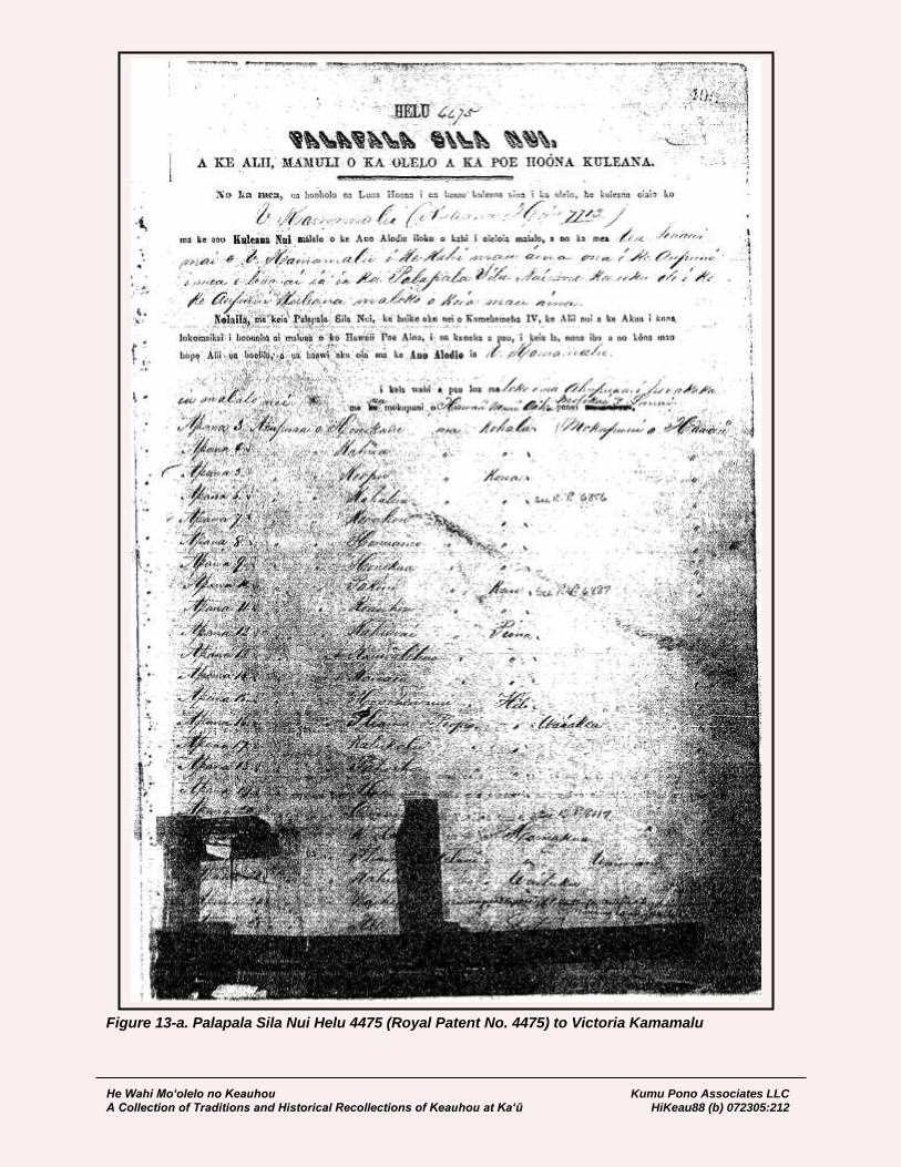
He Wahi Mo‘olelo no Keauhou Kumu Pono Associates LLC A Collection of Traditions and Historical Recollections of Keauhou at Ka‘ū HiKeau88 (b) 072305:212
Figure 13-a. Palapala Sila Nui Helu 4475 (Royal Patent No. 4475) to Victoria Kamamalu

He Wahi Mo‘olelo no Keauhou Kumu Pono Associates LLC A Collection of Traditions and Historical Recollections of Keauhou at Ka‘ū HiKeau88 (b) 072305:213
Figure 13-b. Palapala Sila Nui Helu 4475 (Royal Patent No. 4475) to Victoria Kamamalu
me that salt is the only product on this land, but it is very little, and I called the natives to lease it, but there was no one wanted it, and no one made a reply. Kapapala, Ahupuaa in Kau, is a large land, but one side is stone, but, the side joining the mountain is good, plenty of earth, the land is rich and green as I observed. The canoe koa forest in Kau belongs to Kapapala, there is also a pond, but I did not visit it, and this land is similar to Waimea. I called the people to come, and I told them my desire to lease said land hoping that I would be able to get between $300.00 and $500.00, and if five hundred, all the better, but the natives said only $50.00 to $60.00, and then up to a hundred, and not more, so I did not consent… [HSA – Interior Department, Lands]

He Wahi Mo‘olelo no Keauhou Kumu Pono Associates LLC A Collection of Traditions and Historical Recollections of Keauhou at Ka‘ū HiKeau88 (b) 072305:214
BOUNDARY COMMISSION PROCEEDINGS: KEAUHOU AND NEIGHBORING LANDS (1873-1876)
In 1862, a Commission of Boundaries (the Boundary Commission) was established in the Kingdom of Hawai‘i to legally set the boundaries of all the ahupua‘a and land divisions such as ‘ili, that had been awarded as a part of the Māhele. Subsequently, in 1874, the Commissioners of Boundaries were authorized to certify the boundaries for lands brought before them (W.D. Alexander in Thrum 1891:117-118). In most cases, boundaries were described and confirmed through the testimonies of native informants, who were old residents of the areas being discussed. By association with events described at the time of their birth, the oldest informants were born around 1790, and the youngest, born around 1830. The native witnesses usually spoke in Hawaiian, and their testimony was translated into English and transcribed as the proceedings occurred. The witnesses had learned of the boundaries from elder residents, and they described the landscape by the nature of the terrain, the presence of resources, land use, and features which were of significance to the residents of the land. Readers will note that there are significant inconsistencies in spelling of various words, including place names, people names, and features on the landscape. This is problematic, but with the help of maps and other documents produced as a part of the surveys to establish boundaries, many of the locations described can be identified. We have also observed that in some testimonies, when the original translator-transcriber used two of the same vowels, it indicated that he heard a lengthened pronunciation of a particular vowel. This emphasis of pronunciation is now indicated by a macron mark—for example, the word “neenee” (for nēnē), the native goose formerly hunted on the mountain lands. While in the modern context of the language, two of the same vowels are generally both pronounced, and broken by an ‘okina or glottal mark. The narratives cited below, are verbatim transcripts from the testimonies given by native residents or land owners, and those given by surveyors who recorded the boundaries based on the testimony of native guides. The testimonies include descriptions of the lands of Keauhou, Kapāpala, ‘Āpua, ‘Ōla‘a, Waiākea, and Humu‘ula. The testimonies document thorough knowledge of the landscape, and demonstrate continuity in the types of traditional and customary practices described at various elevational zones. The witnesses generally described the boundaries as they rose form the ocean or lowlands, running through the forest lands, to a point where they reached the slopes of Mauna Loa or Kīlauea. Place names played an important role in documenting boundaries of the lands being described. Underlining, square bracketing, bold and italic print are used here, by the compilers, to highlight place names and particular points of historical interest recorded in the testimonies. The proceedings for the cited lands are given by land area and date of recordation. In the days leading up to the recordation of testimonies regarding the boundaries of Waiākea and Humu‘ula, Hilo; and Keauhou, Ka‘ū, we find that a difference of opinion had arisen among the witnesses. The commission proceedings standardized the boundaries of these lands, sometimes without following the former traditional boundaries:
Hilo May 1st 1873 R.A. Lyman; to J.O. Dominis, Agt. of Crown Lands (Regarding hearings for Crown Lands before Boundary Commission): I have set the 2d of next June for the hearing of testimony for the settlement of the boundaries of Punahoa, Makahanaloa & Pepekeo in Hilo, Keaau & Keahialaka in Puna, Honuapo & Pakiniiki in Kau. I will have the hearing at Hilo. The Crown Com. are interested in the lands of Piihonua & Humuula joining Makahanaloa & Pepekeo,

He Wahi Mo‘olelo no Keauhou Kumu Pono Associates LLC A Collection of Traditions and Historical Recollections of Keauhou at Ka‘ū HiKeau88 (b) 072305:215
Ponahawai joining Punahoa 1st; Waiakea & Olaa joining Keaau in Puna. Please to authorize some one to appear at the hearing and look after your interests… [HSA – ID Lands]
Hilo, June 9, 1873 R.A. Lyman, to J.O. Dominis, Agent of Crown Lands (Regarding Boundaries of Humu‘ula and Neighboring, and Disposition of Pi‘ihonua): …Enclosed, please find a list of lands as near as I can make it out at present. I have written to Mr. Wiltse and Hoapili asking them to send you correct lists of lands in their districts and to forward me copies as soon as possible. Please to send me surveys of as many of the lands as you can. If the surveys made by my brothers have been lost, I think that any brother could make out new copies of most of them. The survey of Humuula made by Wiltse cuts way into Waiakea as surveyed by Webster and cuts off several miles of Kapapala and Keauhou. Kahue, Wiltse’s Kamaaina swears that they did not go to a single point on the boundary of Humuula along in the woods and did not put any flags there but that he pointed out some above the woods where he guessed the points were and they sighted to them. The Piihonua people are very much put out about the survey of Humuula as they supposed they had leased Piihonua by the ancient boundaries and the survey of Humuula cuts off a strip several miles wide clear across the head of the land and leaves no wild cattle to speak of for Piihonua. They say they cannot afford to pay $100 a year for the woods of Piihonua now. [HSA, Crown Lands File]
Resources and Practices Described in Boundary Commission Testimonies The types of practices, access and usage include: travel on native trails, land use in a wide range of elevational zones; knowledge of heiau and other ritual sites; collection of resources—such as sandalwood and koa; the collection of, or “hunting” of birds—such as mamo, ‘ō‘ō, nēnē, and ‘ua‘u; canoe making; knowledge of residences, shelters, caves and waterholes; and the subsequent practices associated with hunting introduced ungulates—all under the control of Konohiki 18. The testimonies also record that changes had occurred on the landscape during the life-time of the witnesses. It is of importance to note that the boundaries were known by the native tenants, and the rights to take or hunt resources in traditional times were fiercely protected—individuals without chiefly, genealogical claims, or residency ties to given lands were not allowed to trespass and take resources from the ahupua‘a.
Place Names Cited Along the Boundaries of Keauhou A number of the named localities were identified on the Register Maps for the given lands. Among these maps are Register Map No. 27 (Keauhou); Register Map No. 510 (Kapāpala); Register Map No. 12 (‘Āpua); Register Map No. 42 (‘Ōla‘a); Register Map No. 524 (Waiākea); and Register Map No. 1641 (Humu‘ula). Three primary native witnesses—one born in Keauhou (ca. 1804), one in Kapāpala (ca. 1811), and one born in Hilo (ca. 1795), but had lived in Ka‘ū since 1804—provided testimony, documenting at least 63 place names (other than primary ahupua‘a) on the Ka‘u, Puna and Hilo boundaries of Keauhou. The named locations included both natural and cultural features. Table 2 is a list of those place names with a brief description of their location and function.
18 In regards to hunting, it will be noted that descriptions of traditional hunting practices are limited to native
species of birds, including the ‘ua‘u, nēnē, mamo and ‘ō‘ō; while descriptions of historical hunting practices are limited to goats and wild cattle, which were hunted under contract of Konohiki, the Crown, or the Government.
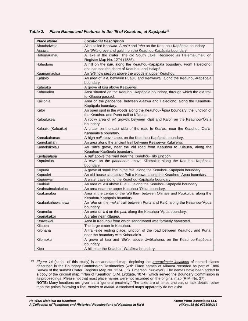
He Wahi Mo‘olelo no Keauhou Kumu Pono Associates LLC A Collection of Traditions and Historical Recollections of Keauhou at Ka‘ū HiKeau88 (b) 072305:216
Table 2. Place Names and Features in the ‘Ili of Keauhou, at Kapāpala19
Place Name Locational Description
Ahuahoiwale Also called Kaaiwaa. A pu‘u and ‘ahu on the Keauhou-Kapāpala boundary.
Aiaawa An ‘ōhi‘a grove and gulch, on the Keauhou-Kapāpala boundary.
Halemaumau A lake in the crater. The old South Lake. Recorded as Halema‘uma‘u on
Register Map No. 1274 (1886).
Haleolono A hill on the pali, along the Keauhou-Kapāpala boundary. From Haleolono,
one can see the shore of Keauhou and Halapē.
Kaamamauloa An ‘a‘ā flow section above the woods in upper Keauhou.
Kahiolo An area of ‘a‘ā, between Puaulu and Keawewai, along the Keauhou-Kapāpala
boundary.
Kahoaka A grove of koa above Keawewai.
Kahaualoa Area situated on the Keauhou-Kapāpala boundary, through which the old trail
to Kīlauea passed.
Kailiohia Area on the pāhoehoe, between Aiaawa and Haleolono; along the Keauhou-
Kapāpala boundary.
Kaloi An open spot in the woods along the Keauhou-‘Āpua boundary; the junction of
the Keauhou and Puna trail to Kīlauea.
Kaloulukea A rocky area of pili growth, between Kīpū and Kaloi, on the Keauhou-‘Ōla‘a
boundary.
Kaluaiki (Kaluaike) A crater on the east side of the road to Kea‘au, near the Keauhou-‘Ōla‘a-
Kahauale‘a boundary.
Kamakahanau A high pali above Lapo, on the Keauhou-Kapāpala boundary.
Kamokuiliahi An area along the ancient trail between Keawewai Kalai‘eha.
Kamokukolau An ‘ōhi‘a grove, near the old road from Keauhou to Kīlauea, along the
Keauhou-Kapāpala boundary.
Kaolapalapa A pali above the road near the Keauhou-Hilo junction.
Kapukalua A cave on the pāhoehoe, above Kilomoku; along the Keauhou-Kapāpala
boundary.
Kapuna A grove of small koa in the ‘a‘ā, along the Keauhou-Kapāpala boundary.
Kapuulei An old house site above Poli-o-Keawe, along the Keauhou-‘Āpua boundary.
Kapuuwai A water cave along the Keauhou-Kapāpala boundary.
Kauhiulii An area of ‘a‘ā above Puaulu, along the Keauhou-Kapāpala boundary.
Keahoaimakakoloa An area near the upper Keauhou-‘Ōla‘a boundary.
Keakanaloa Area in the center of the ‘a‘ā flow, between Ohinale and Puukulua; along the
Keauhou-Kapāpala boundary.
Kealaakahewahewa An ‘ahu on the makai trail between Puna and Ka‘ū, along the Keauhou-‘Āpua
boundary.
Keamoku An area of ‘a‘ā on the pali, along the Keauhou-‘Āpua boundary.
Keanakakoi A crater near Kīlauea.
Keawewai Area in Keauhou from which sandalwood was formerly harvested.
Kilauea The large crater in Keauhou.
Kilohana A trail-side resting place, junction of the road between Keauhou and Puna,
near the boundary with Kahauale‘a.
Kilomoku A grove of koa and ‘ōhi‘a, above Uwēkahuna, on the Keauhou-Kapāpala
boundary.
Kipu A hill near the Keauhou-Waiākea boundary.
19 Figure 14 (at the of this study) is an annotated map, depicting the approximate locations of named places
described in the Boundary Commission Testimonies (with Place names of Kilauea recorded as part of 1886 Survey of the summit Crater. Register Map No. 1274, J.S. Emerson, Surveyor). The names have been added to a copy of the original map, “Plan of Keauhou” (J.M. Lydgate, 1874), which served the Boundary Commission in its proceedings. Please not that most place names were not recorded on the original map (R.M. No. 27).
NOTE: Many locations are given as a “general proximity.” The texts are at times unclear, or lack details, other than the points following a line, mauka or makai. Associated maps apparently do not exist.
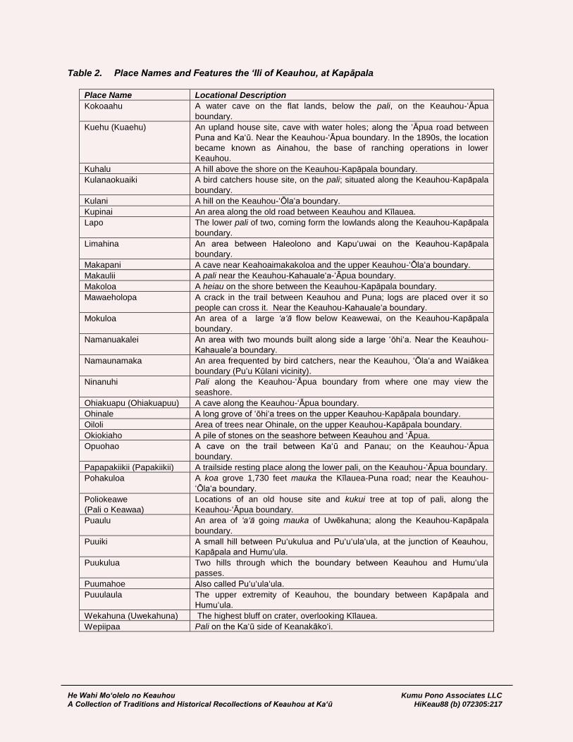
He Wahi Mo‘olelo no Keauhou Kumu Pono Associates LLC A Collection of Traditions and Historical Recollections of Keauhou at Ka‘ū HiKeau88 (b) 072305:217
Table 2. Place Names and Features the ‘Ili of Keauhou, at Kapāpala
Place Name Locational Description
Kokoaahu A water cave on the flat lands, below the pali, on the Keauhou-‘Āpua
boundary.
Kuehu (Kuaehu) An upland house site, cave with water holes; along the ‘Āpua road between
Puna and Ka‘ū. Near the Keauhou-‘Āpua boundary. In the 1890s, the location
became known as Ainahou, the base of ranching operations in lower
Keauhou.
Kuhalu A hill above the shore on the Keauhou-Kapāpala boundary.
Kulanaokuaiki A bird catchers house site, on the pali; situated along the Keauhou-Kapāpala
boundary.
Kulani A hill on the Keauhou-‘Ōla‘a boundary.
Kupinai An area along the old road between Keauhou and Kīlauea.
Lapo The lower pali of two, coming form the lowlands along the Keauhou-Kapāpala
boundary.
Limahina An area between Haleolono and Kapu‘uwai on the Keauhou-Kapāpala
boundary.
Makapani A cave near Keahoaimakakoloa and the upper Keauhou-‘Ōla‘a boundary.
Makaulii A pali near the Keauhou-Kahauale‘a-‘Āpua boundary.
Makoloa A heiau on the shore between the Keauhou-Kapāpala boundary.
Mawaeholopa A crack in the trail between Keauhou and Puna; logs are placed over it so
people can cross it. Near the Keauhou-Kahauale‘a boundary.
Mokuloa An area of a large ‘a‘ā flow below Keawewai, on the Keauhou-Kapāpala
boundary.
Namanuakalei An area with two mounds built along side a large ‘ōhi‘a. Near the Keauhou-
Kahauale‘a boundary.
Namaunamaka An area frequented by bird catchers, near the Keauhou, ‘Ōla‘a and Waiākea
boundary (Pu‘u Kūlani vicinity).
Ninanuhi Pali along the Keauhou-‘Āpua boundary from where one may view the
seashore.
Ohiakuapu (Ohiakuapuu) A cave along the Keauhou-‘Āpua boundary.
Ohinale A long grove of ‘ōhi‘a trees on the upper Keauhou-Kapāpala boundary.
Oiloli Area of trees near Ohinale, on the upper Keauhou-Kapāpala boundary.
Okiokiaho A pile of stones on the seashore between Keauhou and ‘Āpua.
Opuohao A cave on the trail between Ka‘ū and Panau; on the Keauhou-‘Āpua
boundary.
Papapakiikii (Papakiikii) A trailside resting place along the lower pali, on the Keauhou-‘Āpua boundary.
Pohakuloa A koa grove 1,730 feet mauka the Kīlauea-Puna road; near the Keauhou-
‘Ōla‘a boundary.
Poliokeawe
(Pali o Keawaa)
Locations of an old house site and kukui tree at top of pali, along the
Keauhou-‘Āpua boundary.
Puaulu An area of ‘a‘ā going mauka of Uwēkahuna; along the Keauhou-Kapāpala
boundary.
Puuiki A small hill between Pu‘ukulua and Pu‘u‘ula‘ula, at the junction of Keauhou,
Kapāpala and Humu‘ula.
Puukulua Two hills through which the boundary between Keauhou and Humu‘ula
passes.
Puumahoe Also called Pu‘u‘ula‘ula.
Puuulaula The upper extremity of Keauhou, the boundary between Kapāpala and
Humu‘ula.
Wekahuna (Uwekahuna) The highest bluff on crater, overlooking Kīlauea.
Wepiipaa Pali on the Ka‘ū side of Keanakāko‘i.

He Wahi Mo‘olelo no Keauhou Kumu Pono Associates LLC A Collection of Traditions and Historical Recollections of Keauhou at Ka‘ū HiKeau88 (b) 072305:218
Ili of Keauhou, Ahupuaa of Kapapala District of Kau, Island of Hawaii Boundary Commission, Hawaii, Volume A, No. 1:245-246
Honorable R.A. Lyman Boundary Commissioner for Island of Hawaii The undersigned would herewith make appli- cation for the settlement of the Boundaries of the following named Ahupuaas or lands belonging to the Estate of the Kekuanaoa & V. Kamamalu, viz.;
Honohononui District of Hilo, Haw.
adjoining lands unknown
Piopio District of Hilo, Haw.
adjoining lands unknown
Kaaumana District of Hilo, Haw.
adjoining lands Ponahawai & Kukuau
Kalalau District of Hilo, Hawaii
bounded by Puueo, Alae & Wainaku
Alae District of Hilo, Hawaii
bounded by Kauhiaula, Mokuhonua, Kalalau & Kaiwiki
Pahoehoe District of Hilo, Hawaii, bounded
by Paukaa Papaikou & Pueopaku
Kalaikahonu District of Hilo, Hawaii
adjoining lands unknown
Kahuwai District of Puna, Hawaii
adjoining lands unknown
Kauaaea District of Puna, Hawaii
adjoining lands unknown
Kanalehua District of Puna, Hawaii
adjoining lands unknown
Keauhou Ili of Kapapala, District of Kau Hawaii
adjoining lands Kapapala, Apua
Pakininui District of Kau, Hawaii
adjoining lands unknown
Halehia District of Kau, Hawaii
adjoining lands unknown
Honokua District of Kona, Hawaii
bounded by Government lands of Pahoehoe
and Waiea
Keopu District of Kona, Hawaii
bounded by Government lands Keopu
and Honuaula
Holualua [Holualoa] 2 District of Kona, Hawaii
adjoining lands unknown
Haukalua 2 District of Kona, Hawaii
adjoining lands unknown
Haukalua District of Kona, Hawaii
adjoining lands unknown [page 245]

He Wahi Mo‘olelo no Keauhou Kumu Pono Associates LLC A Collection of Traditions and Historical Recollections of Keauhou at Ka‘ū HiKeau88 (b) 072305:219
Keauhou District of Kona, Hawaii
adjoining lands Kahaluu &
Keauhou 2, Est. – Kam V.
Haluu [Kahaluu], District of Kona, Hawaii
adjoining lands Kapalaea & Keauhou
Olelomoana, District of Kona, Hawaii
adjoining lands Kolo & Opiihali, Govt.
Alae 2, District of Kona, Hawaii
adjoining lands unknown
Honuaino, District of Kona, Hawaii
adjoining lands unknown
Moeauoa, District of Kona, Hawaii
adjoining lands unknown
Awakee, District of Kona, Hawaii
adjoining lands unknown
Keokea, District of Kona, Hawaii
Honokane, District of Kohala, Hawaii
adjoining lands unknown
Kahuaike, District of Kohala, Hawaii
adjoining lands unknown
Waiapuka, District of Kohala, Hawaii
adjoining lands unknown
Kahua, District of Kohala, Hawaii
adjoining lands unknown
Halelua, District of Kohala, Hawaii
adjoining lands unknown
Kuilei, District of Hamakua, Hawaii
adjoining lands unknown
Kekelani, Ili of Waimanu, Dist. Hamakua
adjoining lands unknown Your Honor therefore will please appoint a day for the hearing of said application, and grant a certificate in accordance there- with, (sig) J.O. Dominis, admts. J.F.H. Harris, Atty at Law Hilo August 16th A.D. 1873 [page 246]
The Ili of Keauhou, Ahupuaa of Kapapala District of Kau, Island of Hawaii Boundary Commission, Hawaii, Volume A No. 1:444-446
The Ahupuaa of Keauhou, District of Kau, Island of Hawaii, 3d J.C. On this, the 24th day of October A.D. 1873 the Commission of Boundaries for the island of Hawaii, 3rd J.C. met at the Volcano House, Kilauea, Kau on the application of J.O. Dominis, act- ing for or Administrator of the Estate of
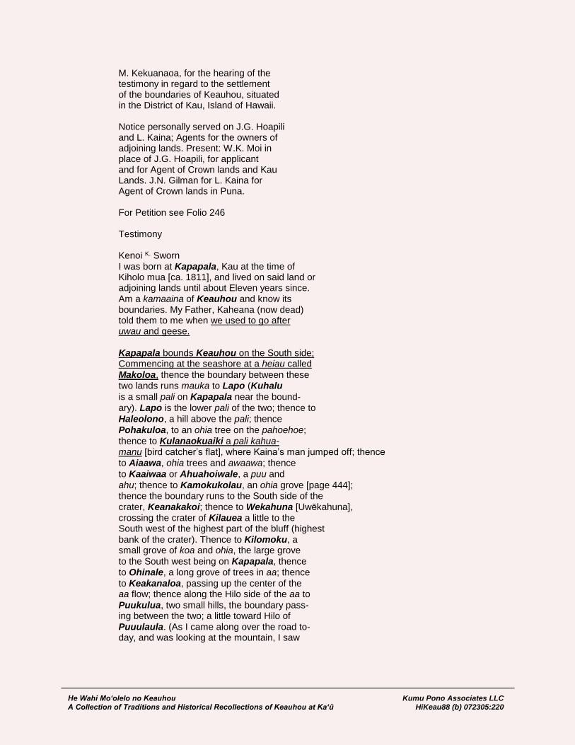
He Wahi Mo‘olelo no Keauhou Kumu Pono Associates LLC A Collection of Traditions and Historical Recollections of Keauhou at Ka‘ū HiKeau88 (b) 072305:220
M. Kekuanaoa, for the hearing of the testimony in regard to the settlement of the boundaries of Keauhou, situated in the District of Kau, Island of Hawaii. Notice personally served on J.G. Hoapili and L. Kaina; Agents for the owners of adjoining lands. Present: W.K. Moi in place of J.G. Hoapili, for applicant and for Agent of Crown lands and Kau Lands. J.N. Gilman for L. Kaina for Agent of Crown lands in Puna. For Petition see Folio 246 Testimony Kenoi K. Sworn I was born at Kapapala, Kau at the time of Kiholo mua [ca. 1811], and lived on said land or adjoining lands until about Eleven years since. Am a kamaaina of Keauhou and know its boundaries. My Father, Kaheana (now dead) told them to me when we used to go after uwau and geese. Kapapala bounds Keauhou on the South side; Commencing at the seashore at a heiau called
Makoloa, thence the boundary between these two lands runs mauka to Lapo (Kuhalu
is a small pali on Kapapala near the bound-
ary). Lapo is the lower pali of the two; thence to
Haleolono, a hill above the pali; thence
Pohakuloa, to an ohia tree on the pahoehoe;
thence to Kulanaokuaiki a pali kahua- manu [bird catcher’s flat], where Kaina’s man jumped off; thence
to Aiaawa, ohia trees and awaawa; thence
to Kaaiwaa or Ahuahoiwale, a puu and
ahu; thence to Kamokukolau, an ohia grove [page 444]; thence the boundary runs to the South side of the crater, Keanakakoi; thence to Wekahuna [Uwēkahuna], crossing the crater of Kilauea a little to the South west of the highest part of the bluff (highest bank of the crater). Thence to Kilomoku, a small grove of koa and ohia, the large grove
to the South west being on Kapapala, thence to Ohinale, a long grove of trees in aa; thence
to Keakanaloa, passing up the center of the aa flow; thence along the Hilo side of the aa to
Puukulua, two small hills, the boundary pass- ing between the two; a little toward Hilo of Puuulaula. (As I came along over the road to- day, and was looking at the mountain, I saw

He Wahi Mo‘olelo no Keauhou Kumu Pono Associates LLC A Collection of Traditions and Historical Recollections of Keauhou at Ka‘ū HiKeau88 (b) 072305:221
I had made a mistake in saying Puuulaula was the boundary.) From Puukulua (I do not know what land cuts if off, Waimea perhaps) the boundary runs towards Hilo to Kaa- mamauloa, an aa flow on the Hilo side of the mountain. Cannot say where it is exactly as it is a long time since I have been there. There the boundary turns makai towards
Kilauea, to the South west side of Kipu, the
hill mauka of Kulani; thence makai along
Olaa to Kaloulukea, a pili a; thence to Kaloi,
an open spot in the woods; thence to Kaola- palapa, a pali at the road; thence along
the road to Pohakuloa junction of the roads to Hilo and Keauhou; thence along the road along Keaau to Kaluaike [Kaluaiki], a crater on the East side of the road & on Kahaualea. Thence along Kahaualea, along the road to Namanuakalei, a large ohia on the Kau side of the road, thence makai along
the road to Kilohana; junction of Keau- hou and Puna roads; thence along the land of Apua, along the road to Ohiakuapu, a cave; thence through the bush to Kuehu, a cave on the road from Kau to Panau, thence to Opuohao, a cave; thence to Pali o Keawaa [Poli o Keawe] to a kukui tree on the side of the pali; thence
to Keamoku, a small flow of aa, on the
pahoehoe, the aa on Apua Boundary, is on the South
west side of it; thence to Ninanuhi, a pali from which you can see the seashore; thence down the pali to Kealaakahewahewa, a ahu at the makai road to Puna and Kau;
thence to Okiokiaho a pile of stones at the sea shore; two piles of stones and a mawae [page 445]. The land of Keauhou is bounded on the makai side by the sea, and has ancient fishing rights extending out to sea. C.X.d Kamakahanau is the high pali above
Lapo, on the South west side of Kapapala. I remember a cave called Kapukalua, it is above Kilomoku on the pahoehoe.
Oiloli is a grove of trees in the aa, Ohinale is the true boundary; and is on the Hilo side of Oiloli (Witness is rested ten min- utes, to give him an opportunity to think it over). The true boundary between Kapa- pala and Keauhou is at Puuike [Puuiki], a

He Wahi Mo‘olelo no Keauhou Kumu Pono Associates LLC A Collection of Traditions and Historical Recollections of Keauhou at Ka‘ū HiKeau88 (b) 072305:222
small hill between Puuulaula and Puukulua, on the Eastern slope of Mau- na Loa. Kaolapalapa is the pali above the Volcano road on the makai side, as you
go towards the junction of the Keauhou and Hilo road. Kaloi is on Keauhou. There used to be a road from Keauhou to Kilauea, passing Kamokukolau, and coming along Kupinai, at the foot of Ma- kaulii pali. I have never heard that that road is the boundary between Keau- hou and Kahaualea. Case continued to Hilo, Oct. 27th 1873. One o’clock in the afternoon. R.A. Lyman Commissioner of Boundaries 3d J.C. Hilo, Oct. 27th 1873 Parties not having come from Puna, the case is continued until further notice R.A. Lyman Commissioner of Boundaries 3d J.C. Case continued on Folio 302, Book B. [page 446]
Ili of Keauhou Ili, Ahupuaa of Kapapala District of Kau, Island of Hawaii Boundary Commission, Hawaii, Volume B:302-304
The Ahupuaa of Keauhou, District of Kau Island of Hawaii, 3d J.C. Case continued from October 27, 1873. See Folio 446, Book A On this, the 8th day October A.D. 1874 the Commission of Boundaries for the Island of Hawaii, 3d J.C. met at the Court House in Hilo for the examin- ation of witnesses as to the boundaries of Keauhou, situated in the District of Kau, Island of Hawaii. Due notice personally served on own- ers or agents of adjoining lands as far as known. Present: L. Kaina on part of applicant and Crown Agent in Puna, E.G. Hitchcock for Crown lands in Hilo.

He Wahi Mo‘olelo no Keauhou Kumu Pono Associates LLC A Collection of Traditions and Historical Recollections of Keauhou at Ka‘ū HiKeau88 (b) 072305:223
Testimony Keliilohi K. Sworn. I was born at Keauhou, Ili of Kapapala at the time of Okuu [ca. 1804], and lived there till eight years since. I now live in Hilo. Am a kamaaina of
Keauhou and know the boundaries. My kupuna and parents (Kaialii was my Father) told me the boundaries. Keauhou bounded at shore on the Hilo side by the land of Apua. A large pile of stones called Okiokiaho is on the bound- ary at the seashore. Thence mauka to Papapa
-kiikii, an oioina on the makai pali; thence to
Kokoaahu, a cave with water holes; thence to Keamoku, an old kauhale; to Poli-o-
Keawe, a kauhale and kukui tree on top of
the pali; thence to Kapuulei, an old kauhale;
thence to Opuohao, a cave; thence to Kuehu, a kauhale, and cave with water holes on Apua
at the road from Kau to Puna; thence to Ohia- kuapu, a cave where the boundary strikes the road from Keauhou to Kilauea. Thence to Kaloi, the junction of the Keauhou and Puna roads, the mauka corner of Apua. Thence
Keauhou, I have always been told is bounded by Kahaualea; thence the boundary runs up the road to a large ohia tree and two mounds on each side of the road; this place is called [page 302] Namanuakalei; thence to Kilohana, a resting place palipali and ohia tree; thence to Mawae
holopa, a crack in the road where sticks are laid across to form a bridge; thence to Kaluaiki, a crater on the Hamakua side of the road. I have heard that this crater is on Kahaualea; thence to Pohakuloa which is the junction of the Hilo, Puna and Kau roads. Thence along the land of Olaa towards Kulani hill to a place called Kaloi. Two open spots in the woods about as large as the Court House yard; the one toward Hamakua being the smallest, covered with hapu and ferns; thence to Ka-
loulukea, a palm tree; thence to Kulani hill; thence to Namaunamaka, a place where we used to catch birds; thence along the land of Waiakea to Kiipu, a hill; thence to Kaamamauloa aa about as far as from here to Kalepolepo, above the woods. This is as far as I know the boundaries. I have heard that Waiakea bounds it on the Hamakua side. There is a large Mawae there that runs mauka and makai. Thence the boundary runs up
the mountain to Puumahoe, called Puuula-

He Wahi Mo‘olelo no Keauhou Kumu Pono Associates LLC A Collection of Traditions and Historical Recollections of Keauhou at Ka‘ū HiKeau88 (b) 072305:224
ula and Puuiki at the junction of Keauhou and Kapapala. Kapapala bounds this land on the Kau side. The boundary at shore is at the Eastern base of a hill called Kuhalu; thence to Lapo, thence to Kalakuono; thence to the Kau side of Haleolono; thence to Limahina; thence to Kapuuwai, a water cave; thence to Kulanakuaiki, where Kaina’s man was killed by jumping off of the pali.
Thence to Aiaawa; thence to Kahaualoa at the old road to Kilauea; thence to Wepiipaa, a pali on the Kau side of Keanakaakoi. Kamokukolau is on Keauhou; thence to Kilauea passing around the South end of the crater, Wekahuna; Thence mauka towards the
mountain to Puaulu aa, to Kauhiulii; the aa
belonging to Kapapala, and aa to this land. Thence to Kahiolo, aa, thence to Mokuloa, a large
aa flow; thence to Kapuna, a grove of small koa
in the aa; thence to Kahoaka, a grove of koa
above Keawewai; thence to Puulaula between this and Puuike [Puuiki]. C.X.d. I went with Lydgate when he surveyed Keauhou. [page 303] He surveyed from Pohakuloa to Okiokiaho and to the points I have testified to today. I have not been surveying with him between Keauhou and Kapapala. We did not go above Pohakuloa. Keauhou is bounded makai by the sea and has Ancient fishing rights extend- ing out to sea. L. Kaina on the part of the Agent for Crown lands in Puna states that he accepts the boundary between Keauhou and Apua as surveyed to boundary between this land and Kahaualea, and Olaa to the top of Kulani hill, and from thence the boundary between Waiakea and Keauhou to Kipu; thence as surveyed by W. Webster to Kamaa- mauloa, and also the survey between Kapapala and Keauhou. E.G. Hitchcock on the part of the Agent from Crown Lands for Hilo accepts the boundary between Waiakea and Keauhou as given in evidence by Keliilohi, and Webster’s survey, and from Kamaa- mauloa to Puulaula and Puuike according to the evidence of Keliilohi. Testimony Closed.
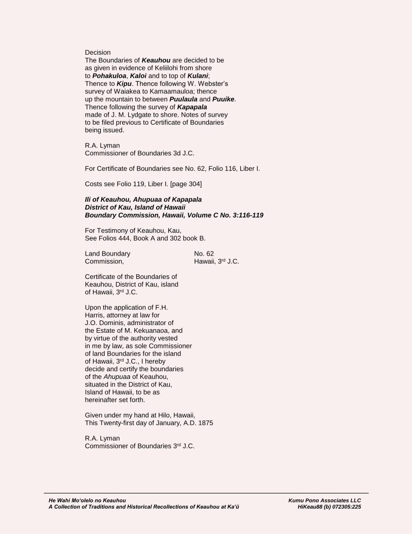
He Wahi Mo‘olelo no Keauhou Kumu Pono Associates LLC A Collection of Traditions and Historical Recollections of Keauhou at Ka‘ū HiKeau88 (b) 072305:225
Decision The Boundaries of Keauhou are decided to be as given in evidence of Keliilohi from shore to Pohakuloa, Kaloi and to top of Kulani; Thence to Kipu. Thence following W. Webster’s survey of Waiakea to Kamaamauloa; thence up the mountain to between Puulaula and Puuike. Thence following the survey of Kapapala made of J. M. Lydgate to shore. Notes of survey to be filed previous to Certificate of Boundaries being issued. R.A. Lyman Commissioner of Boundaries 3d J.C. For Certificate of Boundaries see No. 62, Folio 116, Liber I. Costs see Folio 119, Liber I. [page 304]
Ili of Keauhou, Ahupuaa of Kapapala District of Kau, Island of Hawaii Boundary Commission, Hawaii, Volume C No. 3:116-119
For Testimony of Keauhou, Kau, See Folios 444, Book A and 302 book B. Land Boundary No. 62 Commission, Hawaii, 3rd J.C. Certificate of the Boundaries of Keauhou, District of Kau, island of Hawaii, 3rd J.C. Upon the application of F.H. Harris, attorney at law for J.O. Dominis, administrator of the Estate of M. Kekuanaoa, and by virtue of the authority vested in me by law, as sole Commissioner of land Boundaries for the island of Hawaii, 3rd J.C., I hereby decide and certify the boundaries of the Ahupuaa of Keauhou, situated in the District of Kau, Island of Hawaii, to be as hereinafter set forth. Given under my hand at Hilo, Hawaii, This Twenty-first day of January, A.D. 1875 R.A. Lyman Commissioner of Boundaries 3rd J.C.

He Wahi Mo‘olelo no Keauhou Kumu Pono Associates LLC A Collection of Traditions and Historical Recollections of Keauhou at Ka‘ū HiKeau88 (b) 072305:226
Boundaries of Keauhou Commencing at a pile of stones on the sea shore at place called [page 118] Oki-oki-ahu [Okiokiaho], at the East corner of this land, and running thence along the land of Apua, Magnetic bearings; North 11º 15’ West 19392 feet; to an ohia tree marked by two notches and standing on the brow of the Poliokeawe pali, at the lower end of a point of ohia just East of
the Keauhou road; North 20º 40’ West 13250 feet;
to an ohia marked ┼ at Ohiakua-
puu, a large water cave; North 11º 03’ East 8200 feet;
to ohia tree marked ┼┼ at Kaloi, the junction of the Puna and Keauhou roads. Thence along the land of Kahaualea; North 35º 15’ West 16100 feet; to Kaluaike crater on the volcano and Puna road; North 6º 40’ West 3600 feet; to Pohakuloa Koa grove on the Hilo
and Volcano road; thence along Olaa; North 38º 20’ West 37400 feet; to top of large hill known as Kulani. Thence along land of Waiakea; North 59º 45’ west 17400 feet; To above and opposite a small hill in the edge of the woods called Kipuu [Kipu]; North 33º 00’ West 17,800 feet; Along Waiakea in accordance with Webster’s survey; South 45º 00’ West 31100 feet; [page 117] along Humuula to a double hill on the mountain called Puuulaula, which presents somewhat this appearance from the volcano,

He Wahi Mo‘olelo no Keauhou Kumu Pono Associates LLC A Collection of Traditions and Historical Recollections of Keauhou at Ka‘ū HiKeau88 (b) 072305:227
Thence down along the land of Kapapala; South 57º 00’ East 17,200 feet; to an island in the Aa flow. Thence down this lava flow, which is the well defined boundary between this land and Kapapala; South 53º 35’ East 46,000 feet; To a pile of stones by the side of the Volcano and Kau road 1556 feet South West of a pile of stones on the top of the Wekahuna [Uwekahuna] bluff; South 55º 00’ East 5140 feet; to Halemaumau lake in the crater, This is the old South Lake South 75º 30’ East 6670 feet; to a pile of stones a little South of Keanakaakoi crater; South 8º 50’ East 7300 feet; To pile of stones on ahua at
Kamokukolau; South 24º 30’ East 11150 feet; To a pile of stones on Kulanaokuaiki pali and on the edge of the Puna [page 118] and Kau road; South 16º 40’ East 30220 feet; To pile of stones on the sea shore at place called Makoloa, and old Heiau. This place is 6111 feet East of the top of Kapukapu hill. Thence along the sea shore to point of Commencement. Containing an Area of 50,740 Acres R.A. Lyman Commissioner of Boundaries 3d, J.C. Surveyed by J.M. Lydgate… [page 119]
Ahupuaa of Kapapala, District of Kau, Island of Hawaii Boundary Commission, Hawaii, Volume A, No. 1:238-240
Honolulu July 7, 1873 R.A. Lyman, Esq. Hilo Dear Sir Mr. F.H. Harris is authorized by the commissioners of Crown lands to make applic- ation to you as Commissioner of Boundaries to have the boundaries of all Crown lands on

He Wahi Mo‘olelo no Keauhou Kumu Pono Associates LLC A Collection of Traditions and Historical Recollections of Keauhou at Ka‘ū HiKeau88 (b) 072305:228
the Island of Hawaii defined. He has a list of the lands with him. I have also authorized Mr. F.H. Harris to make application to you for the settlement of boundaries of all lands belonging to Est. of His late Majesty and Her Excellency, R. Keelikolani. I expect to be in Kona by the trip of the “Kilauea” which leaves here on the 28th inst. Can’t you make it convenient to come round as the steamer goes to Hilo on that trip. I wish also to apply for the settle- ment of the boundaries of Honohina. I remain Yours respectfully Jno. O. Dominis Honorable R.A. Lyman Boundary Commissioner for Island of Hawaii, Hawaiian Is. The undersigned would herewith make appli- cation for the settlement of the Boundaries of the following named Ahupuaa or Lands belonging to the Crown, viz. Waiakea in the District of Hilo bounded by Keaau, Olaa, Kapapala, Humuula, Piihonua. Piihonua in the District of Hilo, bounded by Punahoa, Waiakea, Humuula and Pueo, Paukaa & Alae and other lands, names not known. Ponahawai in the District of Hilo bounded by Punahoa, Kukuau & other small lands. Hakalauike in the District of Hilo, adjoining lands unknown [page 238] Humuula in the District of Hilo bounded by Kapapala, various lands in Kona and Kohala and Hamakua, and Hakalau, Makahanaloa, Papaikou, Paukaa, Piihonua and Waiaka in the District of Hilo. Lalakea in the District of Hamakua, adjoining lands unknown. Kalopa in the District of Hamakua, adjoining lands unknown. Honokaia in the District of Hamakua, adjoining lands unknown. Kaohia in the District of Hamakua, adjoining lands unknown.

He Wahi Mo‘olelo no Keauhou Kumu Pono Associates LLC A Collection of Traditions and Historical Recollections of Keauhou at Ka‘ū HiKeau88 (b) 072305:229
Waimanu in the District of Hamakua, adjoining lands unknown. Pohakumauluulu, Ili of Waipio in the District of Hamakua, adjoining lands unknown. Muliwai, Ili of Waipio in the District of Hamakua. Pololu in the District of Kohala adjoining lands unknown. Aamakao in the District of Kohala adjoining lands unknown. Iole in the District of Kohala adjoining lands unknown. Kaauhuhu in the District of Kohala adjoining lands unknown. Waimea in the District of Kohala adjoining lands unknown. Puukapu in the District of Kohala adjoining lands unknown. Kawaihae in the District of Kohala adjoining lands unknown. Puuwaawaa In the District of Kona bounded by Puuanahulu, Govt., Kaupulehu, Est. Kam V. Haleohiu in the District of Kona bounded by Govt. lands & Kaupulehu, Est. Kam V. Honomalino in the District of Kona bounded by Omokaa & Okoi [Okoe], Govt. & by Kahuku, G.W.C. Jones & Co. Puaa in the District of Kona adjoining lands unknown. Onouli in the District of Kona adjoining lands unknown [page 239] Manoloa, District of Hilo. Hiaananaloli II in the District of Kona bounded by Hiaananaloli, Govt. & Hiaanaloli, R. Keliikolani. Waiohinu in the District of Kau, bounded by Keau, Govt., Kahilipalinui and Kahuku, G.W.C. Jones & Co. Kapapala in the District of Kau bounded by Kahuku, G.W.C. Jones, Keauhou, Est. Kam V, Waiakea, Hilo & other lands unknown. Olaa in the District of Puna, bounded by Keaau, Wm. C. Lunalilo, H. M., Waiakea & Kapapala Apua in the District of Puna. Bounded by various lands in Puna. Waiakolea, ili of Kalapana, Dist. of Puna adjoining lands unknown. Kaimu in the District of Puna adjoining lands unknown. Gehena [Kehena] in the District of Puna adjoining lands unknown.
He Wahi Mo‘olelo no Keauhou Kumu Pono Associates LLC A Collection of Traditions and Historical Recollections of Keauhou at Ka‘ū HiKeau88 (b) 072305:230
Your Honor will therefore please appoint a day for the hearing the evidence in the foregoing named lands and having decided upon the same to grant a certificate to that effect to the undersigned. (Signed) Jno. O. Dominis Crown Land Agent, F.H. Harris Atty. at law, Hilo Hawaii August 16th A.D. 1873
Ahupuaa of Kapapala, District of Kau, Island of Hawaii Boundary Commission, Hawaii, Volume A, No. 1:436-443 The Ahupuaa of Kapapala, District of Kau Island of Hawaii, 3d J.C. On this the 20th day of October A.D. 1873 the Commission of Boundaries for the Island of Hawaii, 3d J.C. met at the house of J. Kauhane, Keaiwa, Kau, on the application of J.O. Dominis, Agent of Crown lands for the hearing of testimony for the settle- ment of the boundaries of Kapapala, situated in the District of Kau, Island of Hawaii. Notice personally served on owners or agents of adjoining lands, as far as known. Present: J.G. Hoapili for applicant and the Estate of Kamehameha V; J. Kauhane for Hawaiian Government. For Petition see Folio 240 Note Notes of survey, lease of Government Land filed for boundary by agreement between the Crown Commissioner and Minister of Interior for boundary between Kapapala and Government lands. Testimony Kenoi K. Sworn. I was born at Kapapala, Kau, at the time of Kiholo mua [ca. 1811]; moved to Oahu ten years ago before that time I had always lived at Kapapala. Am a kamaaina of said land and know the boundaries. They were point- ed out to me in olden times, when it was kapu to catch birds on any land but the one you

He Wahi Mo‘olelo no Keauhou Kumu Pono Associates LLC A Collection of Traditions and Historical Recollections of Keauhou at Ka‘ū HiKeau88 (b) 072305:231
lived on, and if you did so the birds were taken away from you. Keaweehu, my makuahonowai hanai [adopted father-in-law] and Kama (his nephew) pointed out the boundaries to me; both of these men are now dead; they pointed out the boundary line between Kaalaala and Kapapala from shore to mountain. Kaheana, my father, who was a kamaaina of Kapapala showed me the boundary line between this land and Keauhou in Kau from seashore to mountain. He is dead and buried at Kapapala. Kaalaala bounds Kapapala on the South _____ from shore; then Pohakuloa, then [page 436] to Ahulili 1st and Ahulili 2nd; thence to Waimuku 1st and Waimuku 2d. Kailiula 1st; thence to Kailiula 2nd; thence to Kaamakamaka; thence to Puukoa and to Makakupa 1st, Makakupa 2d, Makakupa 3d; and from thence to Makakupa 4th; then Kaalaala. The boundary at shore between Kaalaala and Kapapala is at a hill or puulepo called
Napuuona Elemakule; thence mauka to Kukalaula, a cave in the pahoehoe, where people used to live; the boundary follows along an old trail all the way from the seashore. Thence the boundary runs to Keanaona- luahine; aa and a cave in the pahoehoe;
thence to Puuahi, two hills and two ahus running between the hills; thence to Kapai, an awaawa and cave; old trail from shore runs along boundary; thence to Puulehuo- paniu, on pahoehoe; thence to a hill of rocks
called Punahaha, along the road to where Kukuilauliilii [small leafed kukui tree] used to stand; thence along
Makakupa to Moomamani, a heiau and
ahi pu. Thence along Puukoa to Kapaliokee,
ili aina and awaawa; thence along Pohakuloa
to Puuokamalii at the Government road on the edge of the pahoehoe towards Hilo; thence
to Naunu, the mauka corner of Pohakuloa,
the lae ohia on Pali; thence along Ahuliilii
to Kaholoina, kauhale mamake & kahawai. Thence along Kaalaala to Waiheka kahawai; the boundary runs up the kahawai form
Kaholoina to Waiheka; thence up the kaha-
wai to Puuhaokalei, piha kauhale kalaiwaa [filled with canoe maker’s houses]
in koa; thence up the kahawai to Omahinui, a large ohia grove. (this is the strip of ohia trees running mauka and makai through the woods, that you see from the Government road); Thence up the kahawai through the lae ohia

He Wahi Mo‘olelo no Keauhou Kumu Pono Associates LLC A Collection of Traditions and Historical Recollections of Keauhou at Ka‘ū HiKeau88 (b) 072305:232
to Kapapaaulaula, the red pahoehoe
above the woods; thence to Kilohana, a small hill; thence the boundary runs mauka to
A Poohina, where Kaalaala is cut off by Kahuku; thence along A Poohina along the land of Kahuku to Pohakuhanalei; thence along the District of Kona to Moku- [a]weoweo. I have heard that Keauhou of Kona goes to Pohakuhanalei, a hill on Mauna Loa. Thence to Puuulaula, a large hill on the brow of the mountain at the mauka corner of
Keauhou of Kau. I do not know what land bounds Kapapala from Mokuweoweo to Puuulaula. Thence the boundary runs ma- [page 437]
kai from Puuulaula along the land of Keauhou
of Kau to Kilomoku; the boundary follows along the edge of the aa, which is on Kapa-
pala to this point. Kilomoku which is a lae ohia;
thence to Wekahuna [Uwekahuna], the high bluff on the mauka side of Kilauea where the old horse bones are; close to the road, and a little towards Kau from the highest part of the bluff; thence to Kamokukolau, the boundary passing thorough the crater and South lake; Kamokukolau is a lae ohia makai of the crater where I used to live; the boundary passes a short distance to the South of the small crater called Kaanakaakoi; said crater being on Keauhou. From Kamokukolau the boundary runs makai to Aiaawa, a lae ohia awaawa; thence cross the Kau road to Puna and run to Kailiohia, on the Pahoehoe; thence
to a hill and pali called Haleolono,
where you can see the shore at Keauhou and Halapee. This is where Kapahu killed my wife and child; there are two hills at this place and the boundary passes between the hills; thence down the pali
and to another pali called Lapo; thence
to the heiau called Makoloa at Kuuhala on the seashore. Ancient fishing rights extending out to sea. C.X.d by J. Kauhane The tall woods end at Papapaulaula, all trees end below Kilohana. An Ahupohaku
used to stand below Kilohana. I have been as far as this place but not to A Poo- hina. The kamaaina told me that the

He Wahi Mo‘olelo no Keauhou Kumu Pono Associates LLC A Collection of Traditions and Historical Recollections of Keauhou at Ka‘ū HiKeau88 (b) 072305:233
boundary runs to aa, but did not tell me of any mark that denoted the boundary. It is some distance from Papapaulaula to Kilohana. C.X.d By Commissioner I stated before that these lands were cut off at the mauka edge of the woods by Kahuku
cutting off Kaalaala, as Awakamanu induced me to join these lands at the A poohina; The truth is that Kahuku and Kapapa- la join above Kilohana at A poohina; and do not join at Papaulaula or at the edge of the woods at A poohina. Papaulaula is at the South end of the pali [page 438]
of Waaloa. What I have testified to today is as the boundaries were pointed out to me in olden times. I never heard in olden times that Kaalaala cut off Kapapala at the upper edge of the woods. I heard that the day I gave evidence in Hilo (see Folio 155). The geese and uwau on the mountain all belonged to Kahuku, and from the aa to Hamakua they all belonged to Kaalaala. The Oo and mamo all belonged to Kapapala. There was formerly a road running from Aaa’s to Kalanihale (where halau used to stand); thence running
past Keawewai, Kamokuiliahi and to Kalaieha, but I never heard of any ili or ahupuaa or kihapai on said road. The land belonged to Kapapala; but the geese and uwau all belonged to Kaalaala. I heard that when Nuunu and Kakohi kaikaina of Liiloa [Liloa] (then King of Hawaii), he mau kahuna [some priests] were taken on a canoe and
carried to Na Elemakule, and set up there. They were ordered to take these Kahunas to a hill called Kapukapu They went from Punaluu in a canoe and fell asleep on the way; the canoe men thinking Na Elemakule was the hill woke the Kahuna up, and so that became the boundary of the land; taking a strip of land from Kapapala and giving it to Kaalaala. They lived where Ana lives at Moeala. Kanui was their Kahu; and as he was sick, the Kau people carried them over the foot of the mountain into Hamakua; the uwau and geese were

He Wahi Mo‘olelo no Keauhou Kumu Pono Associates LLC A Collection of Traditions and Historical Recollections of Keauhou at Ka‘ū HiKeau88 (b) 072305:234
their meat and so the birds became the property of Kaalaala. When the people used to go after sandal wood the Alii of Kapapala, Naihe and Aikanaka
took it for Kaahumanu. The Kaalaala people went after sandalwood for their chief, but the people of other lands in Kau used to go after sandal wood on Kapapala and take to their chiefs. This was the last gathering of sandal wood for Kamehameha III to pay the debt. I do not know about the boundaries of Kaalaala and other lands, only those adjoining Kapapala. I do not know about the boundaries of Kapapala on the slope towards Mauna Kea. I have never heard that Kapapala extends down that slope but that Mokuweoweo and Puuulaula [page 439] are at the end of Kapapala. J. Kaonohi K. Sworn I was born at Hilo at the time of making the Peleleu [ca. 1795], and have lived at Kau ever since
the Okuu [ca. 1804]; know the land of Kapapala and its boundaries. Commencing at the sea shore at a place called Puuna Elemakule, a hill between Kapapala and Kaalaala; thence mauka to Makahuna, a cave;
thence to Kilohana, an oioina on the road
to Puna. Thence to a cave called Kuka- laula, on said road; thence to Nahuaaka- hoalii, a heiau; thence to Puainako;
thence to Keanaonaluahine, a cave near the Government road; thence to Kapai, an awaawa and caves; two are mauka and one makai and the road between is the boundary; thence to a Mawae pele, an oioina on the road; thence to
Puulehuopaniu. The boundary used to run from this point to Moenaoniau, an oioina and from thence to Keanaoloa, on makai side of it, but in the time of Kamehameha I the boundary was changed from Puulehuo paniu, to Puunahaha, a puu or oioina,
and from thence it runs to Keanoano, on pahoehohe; thence to Keanapaki, a
cave, and thence along Makakupa 1st, & small lands (Kukuilauliilii is on Kaalaala) to Kapalioku, ilina pali_____ [cliff burial place];
thence the boundary of Kapapala runs along the edge of the pahoehoe along Makakupa 1st,
Makakupa 2d, Makakupa 3 and Makakupa 4th, Pukoa, Kamakamaka. Kailiula 1st and Kailiula 2d, Waimuku 1st and Waimuku 2d

He Wahi Mo‘olelo no Keauhou Kumu Pono Associates LLC A Collection of Traditions and Historical Recollections of Keauhou at Ka‘ū HiKeau88 (b) 072305:235
and Ahulili 1st and Ahulili 2d to Pohakuloa; thence along Pohakuloa to the East corner where Pele (F.S. Lyman) surveyed; thence mauka to the Hilo side of Puuokamalii;
thence to kahawai Opilopilo, on the Hilo
side of Puuhana, the mauka corner of
Pohakuloa; thence along Ahulili to the mauka corner of this land (this is as Kaili, kaikaina of Nalimanui pointed it out.)
Thence along Kaalaala, the boundary running towards Hilo to a kahawai
called Opilopilo; thence along this kaha- wai (I have never been above this place. [page 440] and what I know is from Keaweehu and Kama). They told me the boundary ran up the kahawai
passing Puuhaokalai, and thence still following the kahawai to lae ohia; the tall
trees being on Kapapala and the short ones on Kaalaala, through the woods, but I do not know the name of the point at the mauka edge of the woods. Have been told that Kaalaala cuts Kapapala off at the mauka edge of the woods, that are fit for timber and that from thence Kaalaala runs along the pahoehoe, above the woods to Kona, Hamakua, and Hilo. I went with Keaweehu to Keawewai, after sandal wood, and he said it was on Keauhou. We then went to Keahoaimakakoloa; then to Makapani, a cave. He said part of it was Olaa and part Kau, Kapapala or Keauhou; then to Nahaleowai, Kauhale;
thence to Punaluu, a heiau, the sand at
Punaluu came from this place; thence to Kaamaumauloa, aa makai of a hill;
said hill being a Puuulaula, but the aa was covered up by the flow of 1852. Keaweehu said that the sandal wood belong- ed to Kapapala. I do not know the boundaries between Kaalaala and Kapapala on the mountain, but have always heard that Kaalaala cuts Kapapala off at the upper edge of the woods. There was a road running along where the Government road to Kilauea now is and up to Keawewai and the places I saw when I went after sandal wood; and the uwau and geese on the mountain

He Wahi Mo‘olelo no Keauhou Kumu Pono Associates LLC A Collection of Traditions and Historical Recollections of Keauhou at Ka‘ū HiKeau88 (b) 072305:236
all belonged to Kaalaala, and the other birds belonged to Kapapala. C.X.d Kuihelani was konohiki of Kahuku, and
Kapapala, Kaalaala and Makaka all had different konohiki, as they used to be large lands. All the sandal wood grow- ing on the pahoehoe above the woods
belonged to Kapapala, but the uwau and
geese to Kaalaala, and we used to go after the sandal wood on the pahoehoe above the tall trees, but the geese and Uwau
belonged to Kaalaala, and Kapapala [page 441] people could not take them. Kaholoina is a kahawai on Kaalaala;
Waiheka is a kahawai on Kapapala at some little distance from the boundary further than from here to Ana’s land. I have not been on the mountain above Kaalaala, but on Makaka. Puuhaokalai is on Kaalaala. I do not know the old name of the small gulch on the boundary, now called Opilo- pilo, it runs to Lae ohia Omalu nui. No more witnesses at hand. Case continued until further notice is given to all interested parties. R.A. Lyman Commissioner of Boundaries 3d J.C. Notes from Journal October 21, 1873 Left Kapapala in company with J.G. Hoapili, Rev. J. Kauhane, G.W.C. Jones, C. Hall, Nahala, Kenoi and others, went to Ainapo; thence through woods onto base of Mauna Loa; thence towards Kahuku to a puu pahoehoe, that Kenoi pointed out as place
called Kilohana. It is a rock mound about 100 yards above a clump of scrub ohia, and there is another rocky knoll a short distance above the first knoll. From this point we could see the upper end of ohia grove in woods, that slopes
off easterly towards Waiohinu [small diagram] and a few koa trees mauka of it. This point bears by pocket compass between nearly S.S. East. Kenoi says this is the boundary between Kaalaala, and Kapapala, and runs thence to Kilohana and thence to A Poohina, striking the boundary of Kahuku, above vegetation. We went up the base of mountain until we came to a small stream of Aa, but we could not cross with our horses, so we were obliged to follow it down to the edge of woods; we then proceeded towards Kahuku, and camped at Kauhuhuula gulch at an elevation of about 6300 feet.
He Wahi Mo‘olelo no Keauhou Kumu Pono Associates LLC A Collection of Traditions and Historical Recollections of Keauhou at Ka‘ū HiKeau88 (b) 072305:237
October 22nd, 1874. Left camp and proceeded towards round hill on the western slope of Mauna Loa, and at an eleva- tion of about 7300 feet came to an old aa flow running
to the top of the mountain, and said to be the Aa Poohina. From this point we could see the flow on the side of mountain, but none of the kamaaina were able
to point out where Kapapala and Kahuku unite. We then followed the Aa to edge of woods and proceeded [page 442]
on to Kahuku. R.A. Lyman Commissioner of Boundaries 3d J.C. Decision Hilo Feb. 23d 1876. Present: E.G. Hitchcock at Atty. for J.O. Dominis, Agt. Crown lands; C.E. Richardson for owners of Kahuku; and copy of decision of boundary between this land and Kaalaala and by mail to Rev. J. Kauhane, Agt. for Hawaiian Govt. lands in the Dist. of Kau. Decision After looking over the evidence given as to the boundaries of Kapa- pala and Kahuku, it appears to me that Kapapala and Kaala- ala are one and the same land on the mountain. That Kaalaala cuts Kapapala off at the upper edge of the woods, or that Kapapala cuts Kaalaala off. It appears in evidence that Kaalaala had an ancient bird right extending onto the pahoehoe makai of
Kilauea, to the top of Mauna Loa, to Kulani hill, and towards Kalaieha and Humuula, given by the sister living on Kapapala, to the brother living on Kaalaala, and that the road ran through a halau on Kapapala; and that the bird
catchers paid toll to the konohiki of Kaalaala. We find in evidence
that the Kona kamaaina were always told that Kapapala reached
to the top of the mountain; the Kahuku kamaaina say the same, and kamaaina elsewhere, so that it appears to me that
parties have taken advantage of the bird right of Kaalaala to try and make Kaalaala extend to the top of the mountain. But they are unable to tell or point boundaries between Kaalaala and Kahuku, and can only give the points on the boundary between Kapapala and Kaalaala from shore to the upper edge of woods. It appears in evidence, both of kamaaina and Mr. Reed & C.N. Spencer
that Kahuku and Kapapala bound each other on the mountain. I decide the boundaries of Kapapala to be as given in Lydgate’s notes of survey on the Kaalaala side from the shore to Kilohana, and from there to run in a straight line to crater Mokuaweoweo, and to be bounded by Kaalaala and Govt. lands from shore to upper

He Wahi Mo‘olelo no Keauhou Kumu Pono Associates LLC A Collection of Traditions and Historical Recollections of Keauhou at Ka‘ū HiKeau88 (b) 072305:238
edge of woods, and form there to top of mountain by land of Kahuku; and along top of mountain as given in notes of survey to corner of Ili aina Keauhou in Kau, and from the mauka corner of Keauhou
to shore as given in Certificate of Boundaries of Keauhou No. 62, Folio 116, Liber I, and will issue Certificate of Boundaries as of today. R.A. Lyman Comm. of Boundaries 3rd J.C… For Certificate of Boundaries see No. 84, Folio 178, Liber I. For Costs see Folio 182, Liber I. [page 443]
Ahupuaa of Kapapala, District of Kau, Island of Hawaii Boundary Commission, Hawaii, Volume 1, No. 3:178-182 For Testimony of Kapapala See Folio 496, Book A. For Decision, see Folio 443 Book A Land Boundary No. 84 Commission Hawaii, 3d Judicial Circuit Certificate of the boundary of Kapapala, District of Kau, Island of Hawaii, Third Judicial Circuit. Upon the application of Jno. O. Dominis, Crown Land Agent by F.H. Harris, Atty. at Law, and by virtue of the authority vested in me by law, as sole Commissioner of Land Boundaries for the Island of Hawaii, 3d J.C. I hereby decide and certify the boundaries of the Ahupuaa of Kapapala, situated in the District of Kau, Island of Hawaii, to be as hereinafter set forth. Given under my hand at Hilo, Hawaii, this Twenty-third day of January, A.D. 1876 R.A. Lyman Commissioner of Land Boundaries Third Judicial Circuit. Boundaries of Kapapala Commencing at a small sand hill on the sea shore called Na Puu o Naelemakule at the junction of this land, and the Govt. land of Kaalaala, and running thence up along said land True Magnetic Feet Chains South 89º 10’ West; South 81º 10’ West; 32040 feet; 485.45 to a pile of stones on top of a rocky bluff called Puunahaha. This pile of stones is on a clear place near [page 178] the North Eastern end of the high part of the pali; Thence Magnetic bearing South 24º 54’ West 3320 feet to pile of stones; South 67º 00’ West 1240 feet to a pile of stones;

He Wahi Mo‘olelo no Keauhou Kumu Pono Associates LLC A Collection of Traditions and Historical Recollections of Keauhou at Ka‘ū HiKeau88 (b) 072305:239
North 85º 30’ West 4540 feet to a pile of stones; North 74º 10’ West 2343 feet to a pile of stones on ahua; North 36º 00’ West 1145 feet to a pile of stones at the South East corner of land owned by Ana; Thence along Government lands North 65º 00’ East 654 feet; North 16º 15’ West 1782 feet;
North 29º 00’ East 5478 feet to A.D. cut in pahoehoe;
North 43º 45’ East 1090 feet to I. cut in pahoehoe;
North 33º 15’ East 1142 feet to X. cut in pahoehoe; North 58º 45; West 1452 feet; North 55º 15’ West 2345 feet
North 60º 15’ West 2507 feet to K cut in pahoehoe;
North 55º 30’ West 4818 feet to rock marked H;
North 47º 30’ West 1218 feet to rock marked M; North 57º 30; West 1462 feet to edge of ohia woods;
North 59º 30’ West 2954 feet to ohia tree marked V; North 39º 00; West 1575 feet to water hole in ravine; thence along land of Kaalaala;
North 43º 50’ West 1720 feet to an ohia tree marked K; North 53º 55; West 14,330 feet to lower point of Lae ohia
called Omalunui; North 43º 35’ West 4640 feet along Lae ohia;
North 24º 40’ West 3366 feet to a large Koa tree marked ◊ & W; Thence along land of Kahuku; North 24º 40’ West 2244 feet to pile of stones on ahua called Kilohana; This is a small ahua just above a small grove of ohia trees 1/4 of a mile or so from the woods; Thence North 40º 00’ West 45,870 feet to the Lake in the South end of the crater of Mokuaweoweo; North 56º 05’ East 63,630 feet along the land of [________] [page 179]; to a small hill named Puuulaula at the North East corner of this land, and at its junction with the Ili aina Keauhou of Kau; This hill is plainly
visible from the crater of Kilauea, being the middle one of three on the brow of Mauna Loa; Thence along the land of Keauhou South 57º 00’ East 17,200 feet to an island in an old lava flow; Thence South 53º 35’ East 46,000 feet to a pile of stones by the side of the road from Kau to Hilo, 1556 feet South West of Wekahuna bluff station; South 55º 00’ East 5140 feet to the South lake in the crater of Kilauea called Halemaumau; Thence South 75º 30’ East 6670 feet to a pile of stones near the edge of Keanakaakoi crater. The pile of stones stands about 150 feet southeast of the crater; South 8º 50’ East 7300 feet to a pile of stones on ahua
at place called Kamokukolau; South 24º 30’ East 11,150 feet to a pile of stones on the Kulanaokuaiki pali; South 8º 10’ [?] East 30,220 feet to a pile of stones at sea shore at point called Makoloa (an old Heiau). The pile of stones stands on top of the small pali that runs along the sea shore;

He Wahi Mo‘olelo no Keauhou Kumu Pono Associates LLC A Collection of Traditions and Historical Recollections of Keauhou at Ka‘ū HiKeau88 (b) 072305:240
North 62º 00; West 6111 feet to Kapukapu, a high hill on the shore. A pile of stones marks the point on the summit; Thence along sea shore South 61º 37’ West 28,345 feet to point of com- mencement, and containing an area of 172,780 Acres more or less. The land was surveyed largely from triangulation. A base line of 14,600 feet was carefully measured with a hundred foot wire on the flat south of Reed’s lower Ranch. [page 180] The angles were carefully taken by repetitions, by a 7 in Queen Transit reading to minutes. The principal stations were as follows: Puunahaha, a line of bluffs about 3 miles below Reed’s lower Ranch — A large pile of stones marks the station. Ridge — a station well up on the ridge East of the mud flow — marked by a pile of stones; Ainapo — a small ahua, a few hundred feet directly below Reed’s upper Ranch — marked by a pile of stones; Kamakaiea — a scoria hill on the pahoehoe below the Govt. road — There is a cluster of 3 or 4 hills here, the southern most one being the station. A pile of stones marks the spot. Wekehuna — on the bluff forming the outer North Western edge of the crater of Kilauea, also on the Kau road — a pile of stones markes the place. Kilohana: — a ahua above the woods at mauka of lae ohia in woods, that is the bound-
ary of this land and Kaalaala. Mokuaweoweo —: The lake in the crater. The light and smoke when clearly defined, on a still day were triangulated to: Puuulaula —: the hill at the north Eastern corner of this land. Table of Distances and Bearings: True
He Wahi Mo‘olelo no Keauhou Kumu Pono Associates LLC A Collection of Traditions and Historical Recollections of Keauhou at Ka‘ū HiKeau88 (b) 072305:241
Punahaha to Ridge N. 65º 04’ W. 25054 feet Ainapo N. 2º 23’ E. 42210 feet Kamakaiea N. 38º 40’ E. 30,173 feet Kilohana N. 40º 55’ W. 51,750 feet [page 181] True Ridge to Ainapo N. 37º 46’ E. 39,980 feet Kamakaia to Punahaha S. 38º 40’ W. 30,173 feet Ainapo N. 42º 34’ East 25,265 feet Kilohana N. 72º 96’ W. 54,953 feet Wekahuna N. 33º 19’ E. 51,042 feet Wekahuna to Kamakaiea S. 33º 19’ W. 54042 feet Ainapo S. 61º 57’ W. 51,126 feet Puualaula N. 48º 32’ W. 63,840 feet. As surveyed by J.M. Lydgate. R.A. Lyman Commissioner of Land Boundaries Third Judicial Circuit… [page 182]
The Ahupuaa of Humuula District of Hilo, Island of Hawaii Boundary Commission, Hawaii, Volume A No. 1:238-240 Honolulu, July 7, 1873 R.A. Lyman, Esq. Hilo Dear Sir Mr. F.H. Harris is authorized by the Commissioners of Crown lands to make appli- cation to you as Commissioner of Boundaries to have the boundaries of all Crown lands on the Island of Hawaii defined. He has a list of the lands with him. I have also authorized Mr. F.H. Harris to make application to you for the settlement of boundaries of all lands belonging to Est. of His late Majesty and Her Excellency, R. Keelikolani. I expect to be in Kona by the trip of the “Kilauea” which leaves here on the 28th inst. Can’t you make it convenient to come round as the steamer goes to Hilo on that trip. I wish also to apply for the settle- ment of the boundaries of Honohina.

He Wahi Mo‘olelo no Keauhou Kumu Pono Associates LLC A Collection of Traditions and Historical Recollections of Keauhou at Ka‘ū HiKeau88 (b) 072305:242
I remain, Yours Respy. Jno. O. Dominis Honorable R.A. Lyman Boundary Commissioner for Island of Hawaii, Haw. Is. The undersigned would herewith make appli- cation for the settlement of the boundaries of the following named Ahupuaas or Lands belonging to the Crown, viz.: Waiakea in the District of Hilo bounded by Keaau, Olaa, Kapapala, Humuula, Piihonua. Piihonua in the District of Hilo, bounded by Punahoa, Waiakea, Humuula and Puueo, Paukaa & Alae and other lands names not known… [page 238] Humuula in the District of Hilo bounded by Kapapala, various lands in Kona and Kohala and Hamakua, and Hakalau, Makahanaloa, Papaikou, Paukaa, Piihonua and Waiakea in the District of Hilo… [page 239] …Olaa in the District of Puna, bounded by Keaau, Wm. C. Lunalilo, H. M. Waiakea & Kapapala… Your Honor will therefore please appoint a day for hearing the evidence in the foregoing named lands and having decided upon the same to grant a certificate to that effect to the undersigned. Hilo Hawaii, August 16th A.D. 1873 (Signed) Jno. O. Dominis Crown Land Agent. by F.H. Harris atty. at law. [page 240] Ahupuaa of Humuula Boundary Commission, Hawaii Volume B:28-59 The Ahupuaa of Humuula, District of Hilo, Island of Hawaii, 3d J.C. On this, the 3d day of November A.D. 1873 by adjourn- ment from the 30th October, the Commission of Boundaries for the Island of Hawaii, 3d J.C. met at the Court House in Hilo, on the appli- cation of J.O. Dominis, Agent of Crown Lands for the settlement of the boundaries of Humuula, situated in the District of Hilo, Island of Haw-

He Wahi Mo‘olelo no Keauhou Kumu Pono Associates LLC A Collection of Traditions and Historical Recollections of Keauhou at Ka‘ū HiKeau88 (b) 072305:243
aii. Notice personally served on owners or Agents of adjoining lands, as far as known. Also served by publication in the Hawaiian Gazette of _________ and Kuokoa of ___________. Present, E.G. Hitchcock for applicant, for Mrs. L.K. Dominis, Her Ex. R. Keelikolani, the Estate of Kamehameha V, C.R. Bishop and self, D. Kamai for Hawaiian Government Lands in Hilo, and D. Alapai. For Petition see Folio 238, Book A. Testimony. J.A. Simmons K., Sworn: I have lived on Hawaii for forty two years and in Hilo, District about half of that time. I shot wild cattle on Humuula for eight years. This was soon after I came into the Country, but I have been there since. I used to live with Ned Gurney at Lahohino [Lahohinu], a place above the woods on Humuula… Makaulaula K. and Opukeike K., old bird catchers of Piihonua, also pointed out the boundaries to me, when I lived at Pahukea, saw mills on Piihonua… [page 28] …A great deal of the forest has been killed out by the cattle barking the trees and destroying the underbrush. Therefore the woods do not extend so far mauka as they did twenty years ago. Know the place called Puuoo, a big hill on the plains of Humuula is now called by that name, but the original Puuoo is a hill covered with ohia, and was told it was on the land
of Waiakea. It is makai of the hill on
Humuula, and I am certain it is not on that land… Nainoa K. Sworn. I am a kamaaina of Hamakua, at the time of Aipala [famine of ca. 1811], know a part of the boundaries of Humuula, as they were pointed out to me by people who are now dead. Li. Kauwila (his father) and Pali, who were kamaainas of Humuula showed me the boundaries, and told me not to go to certain places… [page 30]

He Wahi Mo‘olelo no Keauhou Kumu Pono Associates LLC A Collection of Traditions and Historical Recollections of Keauhou at Ka‘ū HiKeau88 (b) 072305:244
…I went with the kamaaina.
They told me that Humuula was bounded by Kapapala of Kau, Keauhou of Kona, and Kaohe of Hamakua. I have never heard that Kaalaala of Kau or Waiakea of Hilo joined Humuula. The old trail from Humuula towards Piihonua used to run along the mauka edge of the woods, near the boundary, not in the woods. The Humuula and Piihonua people used to go after water at Kelewa [Kaelewa]… [page 31] …When I went after birds on Humuula Li told me not to catch the birds in koa and mamani, as they belong to the makai lands, and would be taken away by the people of those lands if I caught them… [page 32]
Kahue K. Sworn: I was born at Humuula, am seventy three years of age, and a kamaaina of the land and know its boundaries. Kalaimaka, Mohaiku, Eekamoku (all dead) were kama-
aina of Humuula and pointed out the boundaries to me… [page 33] …Kahiliku, a lae laau [a section of forest that extends out from the surrounding forest on to an open area], outside of the woods. Thence to Mawae, a crack in the woods that runs from makai. I have heard
that Waiakea joins Humuula here, but I do not know which side of the lava flow of 1854 or 1855, the lands join. Thence the boundary of Humuula runs to Kawauwauwai a kau- hale; the boundary running to this point in scat-
tering bush. The forest ends at Elekalua…[page 34] …Kapapala is said to cut Humuula off to Pohakuhanalei. Boundary runs near Puuonioni on Humuula; the boundary is a little beyond. Wekahuna [Uwēkahuna] is a hill on Humuula. Waiakea ends at Pohakuloa, and from there Humuula is bounded by Kapapala to Pohaku- hanalei (I do not know whether Kapapala extends to Pohakuhanalei). From Pohakuhanalei to Koaohe it is bounded by Kaalaala of Kau… [page 35] Witness rested until 10 o’clock tomorrow morning Nov. 4th 1873. R.A. Lyman Com. Boundaries 3d J.C.

He Wahi Mo‘olelo no Keauhou Kumu Pono Associates LLC A Collection of Traditions and Historical Recollections of Keauhou at Ka‘ū HiKeau88 (b) 072305:245
Hilo Nov. 4th 1873. Court opened according to adjournment… [Witness Kahue, continued]: I went with Wiltse one time when he surveyed the land of Humuula [Register Map 668]… [page 36] I do not know the places called Punaluu (on Mauna Loa), Kaamaumauloa, Puuulaula and Puu- kulua, Puuonioni and Wekahuna. I have not seen, but have heard that they are on the boundaries. Humuula does not reach to Kulani. Puuiki is by the boundary of Humuula and Waiakea… [page 37] Waiki K. Sworn: I live at Humuula, was born there after the battle of Kekuakalani [1819], and know the bound- aries of the land. My parents told them to me. Eekamoku was my father and Koapunini my grandfather, they were bird catchers and canoe makers. Kalaimaka, father of my wife pointed out the boundaries and told them to me… [page 38] …Kahiliku kauhale manu [a bird catcher’s house at Kahiliku];
thence to Kaelewa, where there is now water. Thence to Kawauwai by the edge of the forest. Thence to Kaieie; Waiakea and Piihonua join Humu- ula between these two places. Thence along the edge of the forest to Kalapaohelo. I have been there with my parents, an old lava ground. Thence to Pohakuloa, a large rock where Kaehu Paki laid down on the side of the mountain towards Kau of Kalapaohelo. There I [page 40] staid with my kupuna and they said the boundary runs from here up the mountain to Pohakuhanalei, a rock on the slope of the mountain towards Kaleieha. Waiakea bounded it to Pohakuloa, but they did not tell me what lands bounded Humuula from there to Pohakuhanalei... [page 41] Kaaua K. Sworn. I was born at Waiakea Hilo, at the time of Akakai Mokuokai [Hakaka i Mokuohai, the Battle of Mokuohai in 1782]. I have always lived there, and know where Waiakea joins Humuula. I was told by Olaa kamaaina, Opuloa and others (whose names I have forgotten) at the time Webster surveyed Wai- akea. I have always heard that Waiakea joins Humuula from Puuhuluhulu to Mawai [Mawae]. Webster set flags on Puuhuluhulu when he surveyed Waiakea... [page 55]

He Wahi Mo‘olelo no Keauhou Kumu Pono Associates LLC A Collection of Traditions and Historical Recollections of Keauhou at Ka‘ū HiKeau88 (b) 072305:246
The Ahupuaa of Olaa District of Puna, Island of Hawaii Boundary Commission, Hawaii Volume B:305-306 The Ahupuaa of Olaa, District of Puna Island of Hawaii On this, the 8th day of October A.D. 1874, the Commission of Boundaries for the Island of Hawaii, 3d J.C. met at the Court house in Hilo, on the application of F.H. Harris, Attorney at Law for J.O. Dominis, Agent of Crown Lands for the settlement of the bound- aries of Olaa, situated in the District of Puna, Island of Hawaii. Due notice of hearing person- ally served on all owners or agents of adjoining lands, as far as known. Present: L. Kaina for all parties concerned. For Petition see Folios 238 and 240, Book A. Testimony Nailima K. Sworn. I was born at Olaa at the time of the death of Kekua- kalani [1819] and lived there until about a year ago when I moved to Hilo. I am a kamaaina of Olaa and know the boundaries of the land. Kapuna, an old kamaaina of Olaa told them to
me. Commencing at Pohakuloa the junction of the Hilo and Puna roads to Kilauea at the mauka corner of Olaa and Keaau on the
boundary of Keauhou; thence the boundary of Olaa runs makai along the old road through the edge of the koa grove; thence makai still along
the road through the woods to Keekee to Palau- hulu, junction of the Panau and Hilo road. Thence along the road to Kanekoa following the road through houses; thence along the road to makai of where the old road to Puna used to run. This point is outside of Naia’s houses, where you look makai. Thence makai to the junction
of Keaau road at the grove of ohia trees called
Pahee. Thence following along the Hilo road to makai of Makaulele to another junction of
Keaau road; thence mauka to Puhala trees on an ahua on the Puna side of an old kauhale
called Kilohana, near some orange trees. Thence mauka to Puaaehu, a kauhale on the Hilo side.
Thence mauka to Kanamanu, an old kauhale on the boundary covered with ohia trees. Thence to [page 305]
Kaaipuaa; thence to Waiaele, a swamp in the woods; thence to Mawae junction of Olaa and Waiakea; thence along Waiakea to the upper end of land. C.X.d.

He Wahi Mo‘olelo no Keauhou Kumu Pono Associates LLC A Collection of Traditions and Historical Recollections of Keauhou at Ka‘ū HiKeau88 (b) 072305:247
Note. L. Kaina declines to question the witness on the boundaries between Olaa and Waiakea as the Agent of Crown Lands accepts the boundaries as surveyed by W. Webster. He also accepts the boundary of Olaa and Keauhou as given in the Decision of Keauhou. No more witnesses on hand. Case continued until the Notes of survey are made out so that the Commissioner of Boundaries can decide the point in the woods where Keaau, Olaa and Waiakea join as J.O. Dominis, Crown Agent and C.R. Bishop, on the part of owner of Keaau, leave it with the Commissioner to decide so as to save the expense of looking for the point given in evidence, as said point is in the middle of a dense forest and it is over forty years since the kamaaina has been there. R.A. Lyman Commissioner of Boundaries, 3d J.C. Notes of survey filed and Certificate of Boundaries issued January 21st A.D. 1875 See No. 60 Folio 109 Liber I… [page 306]
Ahupuaa of Olaa Boundary Commission, Hawaii Volume C, No. 3:109-111 For Testimony of Olaa See Folio 305, Book B. Land Boundary No. 60 Commission Hawaii 3rd Judicial Circuit Certificate of the boundaries of Olaa, District of Puna, island of Hawaii, 3rd J.C. Upon the application of “J.O. Dominis, Agent for Crown lands, and by virtue of the authority vested in me by law as sole Commissioner of Land Boundaries for the island of Hawaii, 3rd J.C., I hereby decide and certify the boundaries of the Ahupuaa
of Olaa, situated in the District of Puna, Island of Hawaii, to be as hereinafter set forth. Given under my hand at Hilo, Hawaii, This Twenty-first day of January A.D. 1875. R.A. Lyman ,Commissioner of Boundaries, 3d J.C.
He Wahi Mo‘olelo no Keauhou Kumu Pono Associates LLC A Collection of Traditions and Historical Recollections of Keauhou at Ka‘ū HiKeau88 (b) 072305:248
Boundaries of Olaa. Commencing at the top of a wooded Hill known as Kulani at the West corner of this land and running thence along the land of Keauhou, magnetic bearings South 38º 20’ East [page 109] 37,400 feet to a point on the Hilo and Volcano road at Pohakuloa Koa grove about 1730 feet from the junction of the Hilo and Puna roads. Thence along the land of Keaau North 46º 38’ East 10,230 feet; North 56º 15’ East
9400 feet to O cut in the pahoehoe on a little rise in the road, about a mile and a quarter above the Omao woods; North 69º 18’ East 6400 feet
to O cut in the pahoehoe on the
road in the belt of woods at Omao;
North 40º 42’ East 13,070 feet to K cut
in the road at Kuhalau; North
29º 12’ East 12,140 feet to A cut in the
road at place called Kahooku where Neneleau trees are growing and from
where the houses at Kanekoa can first be seen in coming down from the Volcano; North 24º 00’ East 23,810 feet to a pile of stones on a small ahua by the side of the road (East side) a little below Waiuli; North 42º 10’ East 12,350 feet to a pile of stones at the upper edge of little point of ohia through which the road runs; North 13º 05’ East 5600 feet to a large pile of stones at the lower side of the road at Makaulele;
North 16º 10’ East 985 feet to O cut in the road at the extreme East corner of this Land. Thence still running along the Land of Keaau; South 85º 00’ West 4250; South 72º 20’ West 25,800 feet [page 110] to a place where the Land of Keaau is cut off and this land joins the Land of Waiakea; South 54º 45’ West 60,400 feet along the land of Wai- akea to the hill at the point of Commencement. Containing 54,260 Acres. R.A. Lyman Commissioner of Boundaries, 3d J.C. Surveyed by J.M. Lydgate… [page 111]
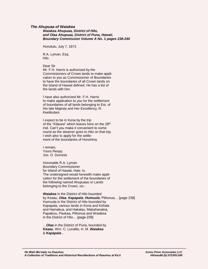
He Wahi Mo‘olelo no Keauhou Kumu Pono Associates LLC A Collection of Traditions and Historical Recollections of Keauhou at Ka‘ū HiKeau88 (b) 072305:249
The Ahupuaa of Waiakea Waiakea Ahupuaa, District of Hilo, and Olaa Ahupuaa, District of Puna, Hawaii. Boundary Commission Volume A No. 1 pages 238-240 Honolulu, July 7, 1873 R.A. Lyman, Esq. Hilo Dear Sir Mr. F.H. Harris is authorized by the Commissioners of Crown lands to make appli- cation to you as Commissioner of Boundaries to have the boundaries of all Crown lands on the Island of Hawaii defined. He has a list of the lands with him. I have also authorized Mr. F.H. Harris to make application to you for the settlement of boundaries of all lands belonging to Est. of His late Majesty and Her Excellency, R. Keelikolani. I expect to be in Kona by the trip of the “Kilauea” which leaves here on the 28th inst. Can’t you make it convenient to come round as the steamer goes to Hilo on that trip. I wish also to apply for the settle- ment of the boundaries of Honohina. I remain, Yours Respy. Jno. O. Dominis Honorable R.A. Lyman Boundary Commissioner for Island of Hawaii, Haw. Is. The undersigned would herewith make appli- cation for the settlement of the boundaries of the following named Ahupuaas or Lands belonging to the Crown, viz.: Waiakea in the District of Hilo bounded by Keaau, Olaa, Kapapala, Humuula, Piihonua… [page 238] Humuula in the District of Hilo bounded by Kapapala, various lands in Kona and Kohala and Hamakua, and Hakalau, Makahanaloa, Papaikou, Paukaa, Piihonua and Waiakea in the District of Hilo… [page 239] …Olaa in the District of Puna, bounded by Keaau, Wm. C. Lunalilo, H. M. Waiakea & Kapapala…

He Wahi Mo‘olelo no Keauhou Kumu Pono Associates LLC A Collection of Traditions and Historical Recollections of Keauhou at Ka‘ū HiKeau88 (b) 072305:250
Your Honor will therefore please appoint a day for hearing the evidence in the foregoing named lands and having decided upon the same to grant a certificate to that effect to the undersigned. Hilo Hawaii, August 16th A.D. 1873 (Signed) Jno. O. Dominis Crown Land Agent. by F.H. Harris atty. at law. [page 240]
The metes and bounds of Waiākea were decided by testimonies and surveys of adjoining lands—‘Ōla‘a and Kea‘au, Puna; Keauhou and Kapāpala, Ka‘ū; and Humu‘ula on the mountain lands of Hilo; thus, no further commission proceedings were conducted under the heading of Waiākea.
Ahupuaa of Apua District of Puna, Island of Hawaii Boundary Commission, Hawaii, Volume A, No. 1:238-240
Honolulu July 7, 1873 R.A. Lyman, Esq. Hilo Dear Sir Mr. F.H. Harris is authorized by the commissioners of Crown lands to make applic- ation to you as Commissioner of Boundaries to have the boundaries of all Crown lands on the Island of Hawaii defined. He has a list of the lands with him. I have also authorized Mr. F.H. Harris to make application to you for the settlement of boundaries of all lands belonging to Est. of His late Majesty and Her Excellency, R. Keelikolani. I expect to be in Kona by the trip of the “Kilauea” which leaves here on the 28th inst. Can’t you make it convenient to come round as the steamer goes to Hilo on that trip. I wish also to apply for the settle- ment of the boundaries of Honohina. I remain Yours respectfully Jno. O. Dominis

He Wahi Mo‘olelo no Keauhou Kumu Pono Associates LLC A Collection of Traditions and Historical Recollections of Keauhou at Ka‘ū HiKeau88 (b) 072305:251
Honorable R.A. Lyman Boundary Commissioner for Island of Hawaii, Hawaiian Is. The undersigned would herewith make appli- cation for the settlement of the Boundaries of the following named Ahupuaa or Lands belonging to the Crown, viz.
Waiakea in the District of Hilo bounded by
Keaau, Olaa, Kapapala, Humuula, Piihonua.
Piihonua in the District of Hilo, bounded by Punahoa,
Waiakea, Humuula and Puueo, Paukaa & Alae and other lands
names not known.
Ponahawai in the District of Hilo bounded by
Punahoa, Kukuau & other small lands.
Hakalauike in the District of Hilo, adjoining
lands unknown [Volume A No. 1 page 238].
Humuula in the District of Hilo bounded by
Kapapala, various lands in Kona and Kohala and Hamakua, and
Hakalau, Makahanaloa, Papaikou, Paukaa, Piihonua and Waiaka
in the District of Hilo.
Lalakea in the District of Hamakua, adjoining lands unknown.
Kalopa in the District of Hamakua, adjoining lands unknown.
Honokaia in the District of Hamakua, adjoining lands unknown.
Kaohia in the District of Hamakua, adjoining lands unknown.
Waimanu in the District of Hamakua, adjoining lands unknown.
Pohakumauluulu, Ili of Waipio in the District of
Hamakua, adjoining lands unknown.
Muliwai, Ili of Waipio in the District of Hamakua.
Pololu in the District of Kohala adjoining lands unknown.
Aamakao in the District of Kohala adjoining lands unknown.
Iole in the District of Kohala adjoining lands unknown.
Kaauhuhu in the District of Kohala adjoining lands unknown.
Waimea in the District of Kohala adjoining lands unknown.
Puukapu in the District of Kohala adjoining lands unknown.
Kawaihae in the District of Kohala adjoining lands unknown.
Puuwaawaa In the District of Kona bounded by
Puuanahulu, Government, Kaupulehu Estate Kamehameha V.
Haleohiu in the District of Kona bounded by Government
lands & Kaupulehu, Estate Kamehameha V.
Honomalino in the District of Kona bounded by
Omokaa & Okoe, Government & by Kahuku, G.W. C. Jones & Co.
Puaa in the District of Kona adjoining lands unknown.
Onouli in the District of Kona adjoining lands unknown [Volume A No. 1 page
239].
Manoloa, District of Hilo.
Hiaananaloli [Hianaloli] II in the District of Kona
bounded by Hiananaloli, Government & Hiaananaloli, R. Keliikolani.
Waiohinu in the District of Kau, bounded by
Keaau, Government, Kahilipalinui and Kahuku, G.W.C. Jones &
Co.
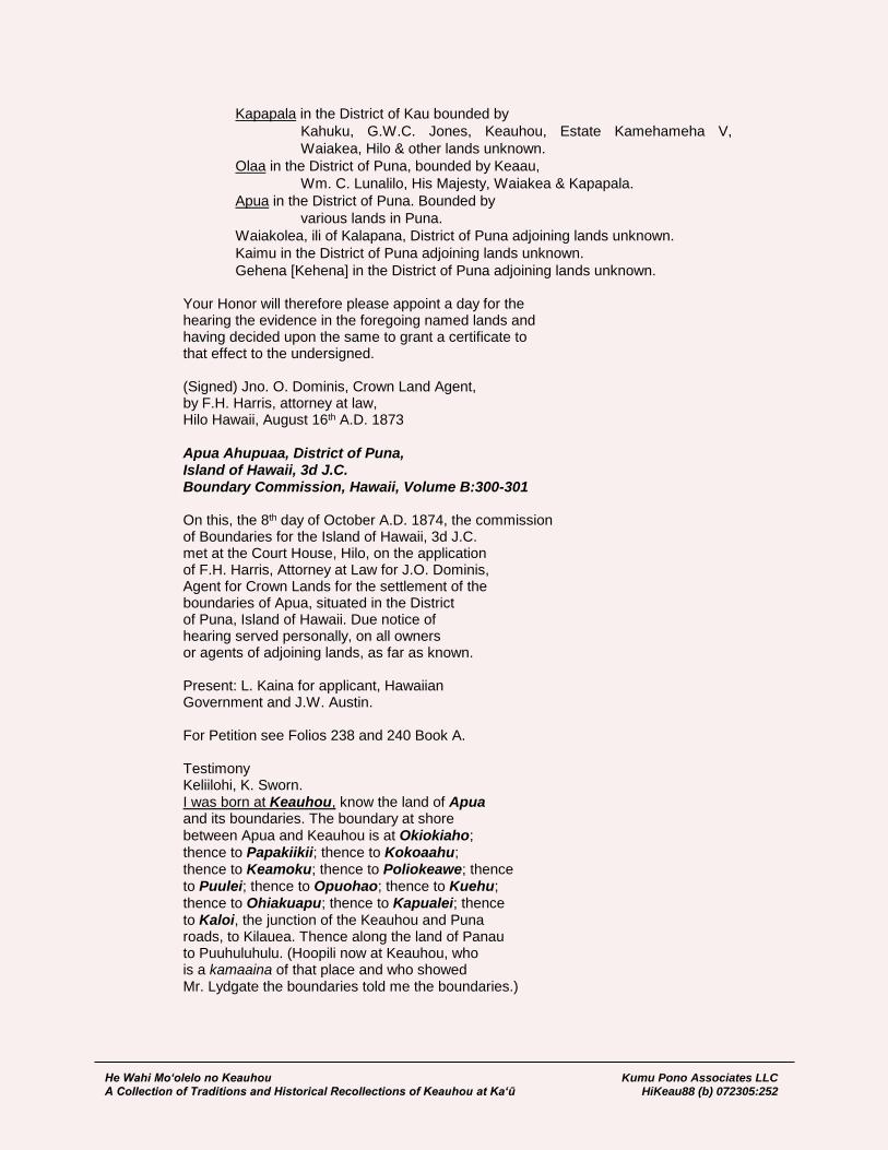
He Wahi Mo‘olelo no Keauhou Kumu Pono Associates LLC A Collection of Traditions and Historical Recollections of Keauhou at Ka‘ū HiKeau88 (b) 072305:252
Kapapala in the District of Kau bounded by
Kahuku, G.W.C. Jones, Keauhou, Estate Kamehameha V,
Waiakea, Hilo & other lands unknown.
Olaa in the District of Puna, bounded by Keaau,
Wm. C. Lunalilo, His Majesty, Waiakea & Kapapala.
Apua in the District of Puna. Bounded by
various lands in Puna.
Waiakolea, ili of Kalapana, District of Puna adjoining lands unknown.
Kaimu in the District of Puna adjoining lands unknown.
Gehena [Kehena] in the District of Puna adjoining lands unknown. Your Honor will therefore please appoint a day for the hearing the evidence in the foregoing named lands and having decided upon the same to grant a certificate to that effect to the undersigned. (Signed) Jno. O. Dominis, Crown Land Agent, by F.H. Harris, attorney at law, Hilo Hawaii, August 16th A.D. 1873 Apua Ahupuaa, District of Puna, Island of Hawaii, 3d J.C. Boundary Commission, Hawaii, Volume B:300-301 On this, the 8th day of October A.D. 1874, the commission of Boundaries for the Island of Hawaii, 3d J.C. met at the Court House, Hilo, on the application of F.H. Harris, Attorney at Law for J.O. Dominis, Agent for Crown Lands for the settlement of the boundaries of Apua, situated in the District of Puna, Island of Hawaii. Due notice of hearing served personally, on all owners or agents of adjoining lands, as far as known. Present: L. Kaina for applicant, Hawaiian Government and J.W. Austin. For Petition see Folios 238 and 240 Book A. Testimony Keliilohi, K. Sworn. I was born at Keauhou, know the land of Apua and its boundaries. The boundary at shore between Apua and Keauhou is at Okiokiaho; thence to Papakiikii; thence to Kokoaahu; thence to Keamoku; thence to Poliokeawe; thence to Puulei; thence to Opuohao; thence to Kuehu; thence to Ohiakuapu; thence to Kapualei; thence to Kaloi, the junction of the Keauhou and Puna roads, to Kilauea. Thence along the land of Panau to Puuhuluhulu. (Hoopili now at Keauhou, who is a kamaaina of that place and who showed Mr. Lydgate the boundaries told me the boundaries.)
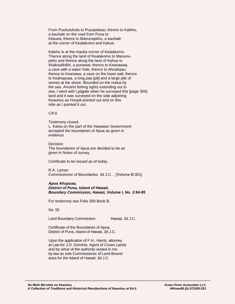
He Wahi Mo‘olelo no Keauhou Kumu Pono Associates LLC A Collection of Traditions and Historical Recollections of Keauhou at Ka‘ū HiKeau88 (b) 072305:253
From Puuhuluhulu to Puuopeleau; thence to Kalehu, a kauhale on the road from Puna to Kilauea; thence to Manunupehu, a kauhale at the corner of Kealakomo and Kahue. Kalehu is at the mauka corner of Kealakomo. Thence along the land of Kealakomo to Manunu- pehu and thence along the land of Kahue to Waikoolihilihi, a punawai; thence to Keanawaa, a cave with a water hole; thence to Ahuahaau; thence to Keanawa, a cave on the lower pali; thence to Keahupuaa, a long paa [pā] and a large pile of stones at the shore. Bounded on the makai by the sea. Ancient fishing rights extending out to sea. I went with Lydgate when he surveyed this [page 300] land and it was surveyed on the side adjoining Keauhou as Hoopili pointed out and on this side as I pointed it out. CX’d. Testimony closed. L. Kaina on the part of the Hawaiian Government accepted the boundaries of Apua as given in evidence. Decision The boundaries of Apua are decided to be as given in Notes of survey. Certificate to be issued as of today. R.A. Lyman Commissioner of Boundaries, 3d J.C… [Volume B:301] Apua Ahupuaa, District of Puna, Island of Hawaii, Boundary Commission, Hawaii, Volume I, No. 3:94-95 For testimony see Folio 300 Book B. No. 55 Land Boundary Commission Hawaii, 3d J.C. Certificate of the Boundaries of Apua, District of Puna, Island of Hawaii, 3d J.C. Upon the application of F.H., Harris, attorney at Law for J.O. Dominis, Agent of Crown Lands and by virtue of the authority vested in me by law as sole Commissioner of Land Bound- aries for the Island of Hawaii, 3d J.C.

He Wahi Mo‘olelo no Keauhou Kumu Pono Associates LLC A Collection of Traditions and Historical Recollections of Keauhou at Ka‘ū HiKeau88 (b) 072305:254
I hereby decide and certify the boundaries of the Ahupuaa of Apua, situated in the District of Puna, Island of Hawaii, to be as hereinafter set forth. Given under my hand at Hilo, Hawaii, this Eighth day of October A.D. 1874 R.A. Lyman Commissioner of Boundaries, 3d J.C. Boundaries of Apua Commencing at a pile of stones on the sea shore at a place called Kaahupuaa, at the South East corner of this land and adjoining the land of Kahue; Thence running along said land: North 8° 00’ West (Mag) 19050 feet to pile of stones on top of upper pali at a [page 94] place known as Ahuahaau; thence North 7° 10’ West 1240 feet to a pile of stones North 9° 00’ West 1300 feet to a pile of stones at Keanaoawaa, a cave in the pahoehoe where water is found; Thence North 34° 45’ East 5470 feet; North 10° 15’ East 4500 feet to the Volcano and Puna road at a point
called Kalehu, where there is an A cut in the rock. This place is at the upper corner of Kealakomo. Thence along Panau North 64° 00’ West 13252 feet to the top of Puuhuluhulu. Thence along the land of Kahaualea North 79° 25’ West 4430 feet
to an ohia tree marked ++ at Kaloi, the junction of the Puna and Keauhou road. Thence down this road South 11° 03’ West 1200 feet to water cave and an ohia
marked X at Ohiakuapuu. Thence leaving the road South 20° 40’ East 13250 feet to an ohia tree marked by two deep notches,
standing on the brow of the Poli-o-keawe pali at the lower end of a point of ohia East of the Keauhou road. South 11° 15’ East 19392 feet to a pile of stones at sea shore at Okiokiahu [Okiokiaho]. Thence along shore North 74° 35’ East 8430 feet to point of com- mencement. Containing an Area of 9420 Acres. As surveyed by J.M. Lydgate. R.A. Lyman Commissioner of Boundaries, 3d J.C… [Volume I, No. 3:65]
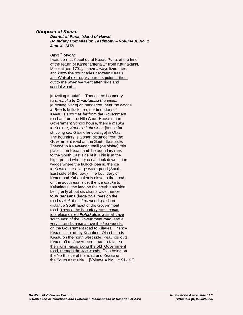
He Wahi Mo‘olelo no Keauhou Kumu Pono Associates LLC A Collection of Traditions and Historical Recollections of Keauhou at Ka‘ū HiKeau88 (b) 072305:255
Ahupuaa of Keaau District of Puna, Island of Hawaii Boundary Commission Testimony – Volume A. No. 1 June 4, 1873
Uma K. Sworn I was born at Keauhou at Keaau Puna, at the time of the return of Kamehameha 1st from Kaunakakai, Molokai [ca. 1791], I have always lived there and know the boundaries between Keaau and Waikahekahe. My parents pointed them out to me when we went after birds and sandal wood… [traveling mauka] …Thence the boundary runs mauka to Omaolaulau (he oioina [a resting place] on pahoehoe) near the woods at Reeds bullock pen, the boundary of Keaau is about as far from the Government road as from the Hilo Court House to the Government School house, thence mauka to Keekee, Kauhale kahi olona [house for stripping olonā bark for cordage] in Olaa. The boundary is a short distance from the Government road on the South East side. Thence to Kauwaanahunalii (he oioina) this place is on Keaau and the boundary runs to the South East side of it. This is at the high ground where you can look down in the woods where the bullock pen is, thence to Kawaiaeae a large water pond (South East side of the road). The boundary of Keaau and Kahaualea is close to the pond, on the south east side, thence mauka to Kalaninauli, the land on the south east side being only about six chains wide thence to Puuenaena (large ohia trees on the road makai of the koa woods) a short distance South East of the Government road. Thence the boundary runs mauka
to a place called Pohakuloa, a small cave south east of the Government road, and a very short distance above the koa woods, on the Government road to Kilauea. Thence Keaau is cut off by Keauhou. Olaa bounds Keaau on the north west side. Keauhou cuts Keaau off to Government road to Kilauea, then runs makai along the old Government road, through the koa woods. Olaa being on the North side of the road and Keaau on the South east side… [Volume A No. 1:191-193]

He Wahi Mo‘olelo no Keauhou Kumu Pono Associates LLC A Collection of Traditions and Historical Recollections of Keauhou at Ka‘ū HiKeau88 (b) 072305:256
Puaa K. Sworn Keaau ends a little above the cave at Pohakuloa, and is cut off by Keauhou. Uma told me this. Nailima of Olaa told me Keaau ended at Halaaniani, he told me this when I was Konohiki of Keaau. Some of the Olaa people told me Keaau ended at Palauhulu. KaooK. told me that Kahaualea cut both Waikahekahe’s off. I think at a point outside of Kanekoa, he did not tell me where. Have heard that Waikahekahe Iki runs clear to Kilauea. Kaoo is a kamaaina of Waikahekahe, have always been told that the road from Hilo is between Keaau and Olaa, until you get to Makaulele, below Kahopuaku’s houses to a place called Kilohana where oranges are growing… [Volume A No. 1:193]
Kanoi K. Sworn I was born at Kapapala in Kau, at the time of the building of Kiholo [ca. 1811] lived there until a few years since know the land of Keaau and the boundaries on the mountain adjoining Kahaualea. The upper end of Keaau is bounded on the South East-side by Kahaualea, and on the mauka side by
Keauhou and on the Northwest side by Olaa; Kaheana, Kaihe Kaheana2nd, and Makanui my Kupuna showed me some of the boundaries of these lands. Kaheana was from Panau, Puna, and Kaihe was from Kau. These two men, with others from Kapapala showed me boundaries between Keauhou and Kahaualea where we went after the oo on Keauhou. Went after
sandalwood on Kahaualea. Keauhou cuts
Keaau off at Pohakuloa, the huina alanui [road intersection], where the marks or sign board is at the junctions of the Hilo and Puna roads this side of the Kilauea House, the name of this place is Halemaumau. The boundary of Keaau runs makai along the Puna road to Kaluaiki, a small crater, at a place where the road runs between two craters. On to the mauka side
of crater Kaluaiki, said crater is on Kahaualea and Keauhou is on the South side of the road. Keaau and Kahaualea lay side and side, from Kaluaiki to Nawailoloa, a place on the road from Palauhulu to Panau. Kaluaiki is about as far Pohakuloa as from Hilo Court House to Kaina’s house at Alenaio. Nawailoloa and Kilohana, two ponds of water, on the road

He Wahi Mo‘olelo no Keauhou Kumu Pono Associates LLC A Collection of Traditions and Historical Recollections of Keauhou at Ka‘ū HiKeau88 (b) 072305:257
to Panau from Palauhulu, from Nawailoloa the boundary between these two lands runs mauka to a grove of Ohia trees called Namauu-
okalahili, thence mauka to Puukea a hill in the woods where we used to go after sandal wood, thence mauka to Namamokalei where we used to catch uwao [‘ua‘u – petrels].
This place is opposite to Kauanahunahu, mauka
of Keekee about a mile. Thence to Kaluaiki. I have often been to these points from Waiuli to Pohakuloa. I have always heard that the old Government road to Kilauea is the boundary between Keaau and Olaa. I do not know the makai boundaries. CXd. [Volume A No. 1:195-196]
Nailima K. Sworn (same witness as for Olaa) I was born at Olaa, and know the boundaries between Olaa and Keaau. My kupuna, now dead, showed them to me. Keaau ends at Halemaomao at the junction of the Hilo and Puna road. Olaa on the Hilo side of the road and Keaau on the Puna side. Thence makai to Pohakuloa, thence makai to Puuenaena (big ohia trees) thence to
Kalaninauli, so called by Nahienaena… [Volume A No. 1:196]
He Wahi Mo‘olelo no Keauhou Kumu Pono Associates LLC A Collection of Traditions and Historical Recollections of Keauhou at Ka‘ū HiKeau88 (b) 072305:258
GOVERNMENT SURVEYS AND ROADS – KEAUHOU AND KĪLAUEA VICINITY (1874-1898)
Records of the Government Surveyors Among the important records documenting the landscape of Keauhou, and the nature of Kīlauea and environs, are the early letters and maps of surveyors who were working on behalf of the Kingdom Survey Department and the ali‘i land owners of Keauhou. Formal surveys were begun in 1874, as a part of the Boundary Commission proceedings, with later work to improve the surveys, and answer questions as curiosity about the volcano increased. From the field letters and entries in the Volcano House Ledgers, we learn of the nature of the landscape of Keauhou, the kinds of historical land uses undertaken, the occurrence of place names, and of the ever changing appearance of Kīlauea.
August 25, 1874 John M. Lydgate on the Survey of Keauhou: During the last 3 or 4 months I have been here considerable, while engaged in the survey of Olaa, Kapapala, etc. February 13th came very near losing my life by falling over the bluff at Wekahuna where it is 50 feet high. In the first 20 feet I struck 3 or 4 times and in the remaining clear fall somersault, and struck on my thigh on a three-cornered stone, badly fracturing the ilium. For 2 hours I lay there hollering, with the hope of attracting some passing native, which I finally did. I was carried to the house and remained here a week, unable to move. [Volcano House Ledger, in the colletion of Hawaii Volcanoes National Park]
December 29, 1874 John M. Lydgate, Surveyor (Survey Notes of Keauhou): The upper and lower parts of this land are excellent goat runs. From the wooded portion a considerable quantity of pulu is picked. The landing is said to be the best on all the southern coast of the island. [In the collection of Kamehameha Schools]
January 18, 1878 Curtis J. Lyons, Asst. Govt. Surveyor: Approximate measurements with 2-inch aneroid barometer give the following: Half way house 1150 ft. elev. Volcano House 4000 ft. elev. Foot of road down into crater 500 feet below the Volcano House Present level of the lake Halemaumau 350 ft. below V. House Height of the West Cliff 650 feet Halemaumau is now about 400 feet long by 110 in width. Lake “Kilauea” is to the west of it and not approachable. There is an extensive flow of lava from the north side of the latter, about three quarters of a mile in length. N.N.E. in direction. True bearing of E. side of Halemaumau from Volcano House S45W. Present height of cone 175 ft. estimated. A week of perfectly clear weather. No snow on M. Kea or M. Loa. But one light fall of snow as yet for the season. [Volcano House Ledger, in the colletion of Hawaii Volcanoes National Park]

He Wahi Mo‘olelo no Keauhou Kumu Pono Associates LLC A Collection of Traditions and Historical Recollections of Keauhou at Ka‘ū HiKeau88 (b) 072305:259
September-October, 1886 Frank S. Dodge, Government Surveyor: Sept. 24, 1886. Made the circuit of Kilauea in 5 ½ hours setting flags and selecting stations for the survey of the crater. Weather clear nearly all day. 26th. A perfect day, clear and bright. Occupied several stations on north end of crater with 4” transit, and began the triangulation. Halemaumau is rising rapidly, and there is an increase of smoke and steam and the lights show brighter at night. Sept. 27th. The usual Volcano rain and fog this morning. Visited Halemaumau and the site of the New Lake this noon but found no new flows visible, though there was plenty of noise, steam, and smoke issuing from many places all around Halemaumau. New Lake is dead. Sept. 28th. Fine, clear weather. Surveying in the morning. In the evening visited the crater again with Mrs. D. and remained near Halemaumau until 7 p.m. Liquid lava was seen in many places on the floor of the pit on the north and west sides of the hills, surrounding Halemaumau proper. The south and southeast sides are probably in the same condition, judging from the frequent flashes of light visible through the smoke and steam in those directions. Sept. 29th. A fine steady rain nearly all the forenoon, after which we had clear cool weather with strong trade winds. Spent the p.m. triangulating across the crater. Sept. 30th. Continued survey around towards the south from Uekahuna Bluff. The last flow of pahoehoe of 1885 is only about 40 feet below the lowest point in the rim of Kilauea, S.W. of the long gravel point seen from the house. Oct. 2d. Occupied station in the crater and around the south and east to Poli o Keawe. Found traces of the old Kau and Hilo trail all along the gravel banks near Keanakakoi, and leading into the woods below Kilauea. Oct. 3d. Finished the survey of the crater of Kilauea and Kilauea Iki this a.m., having been highly favored by the weather for the past week. Oct. 5th. Our little party leaves for Keauhou and Hilo after a very pleasant stay, during which everything has been done to make it agreeable and profitable. [Volcano House Ledger, in the colletion of Hawaii Volcanoes National Park]
Mar. 25, 1886 8 P.M. Volcano House, J.S. Emerson; to Prof. W.D. Alexander: Thermometer 62º Barometer 26.42 Mr. Wilson’s Barometer 26.06 Prof. Eaton’s Barometer 25.93 Mr. Thrum’s …My trip on the Kinau was one of unusual interest. The sea was calm and the view from Kawaihae to Laupahoehoe, all the way by daylight, was a rich treat. I have never had the like before. Mr. Thrum will give you a full account of the volcano. He is posted. Great changes are taking place from day to day and even from hour to hour. For a scientist it is a rare opportunity to study this wonder, such as is seldom obtained. I wish Prof. Hitchcock were here. There is an unusual amount of steam visible in and
He Wahi Mo‘olelo no Keauhou Kumu Pono Associates LLC A Collection of Traditions and Historical Recollections of Keauhou at Ka‘ū HiKeau88 (b) 072305:260
about the crater. This P.M. a dark cloud hung over the crater and from time to time a tongue of cloud would reach down and unite with a column of steam shaped like a water spout arising from the crater. I saw this repeated about six times. [page 1] The lakes are still empty. Mr. Thrum & I tried to approach near enough to Halemaumau to measure a depression angle to the bottom, but did not succeed. Great masses of rocks were falling in from the sides, and where we stood the shattered rock beneath us seemed just ready to fall in. We lingered for a minute or two on the awful brink of destruction and ruin, and then were compelled by fear to withdraw to a place of greater safety. On the 18th Mr. Baker went down into this hole several hundred feet while the rocks were falling near him. It was a dare devil performance like going down Niagara rapids in a boat. None but Mr. Baker would attempt it. Floating island has stranded at the bottom of New Lake. Within the past twenty four hours it has settled a hundred or more (200?) feet. As the sides fall in the empty lakes are rapidly increasing in size. It is late and I must close. Mr. Thrum will tell you what I am unable to write… [HSA, DAGS 6; Hawaiian Government Survey]
March 29, 1886 Volcano House 8 P.M. Thermometer 57º J.S. Emerson; to Prof. W.D. Alexander: …Mr. Thrum has no doubt given you a full account of the volcano up to Friday morning. Since that time there is little to report. Gradually the rocky masses on the sides of the great abyss have come to rest, so that I took the opportunity this noon, in company with Mr. J.N.S. Williams & two natives of descending into the South lake for about one third of its depth until we had a fine view of the bottom which I judge to be about 350 feet below the general level of the rim. By a route which I have examined I think I could easily reach the bottom without great risk. A very small column of smoke is ascending from a fissure at the bottom but there is no sign of fire or of molten lava. I measured the depression angle to the point where the smoke issues from the fissure at the bottom. From one end of the base line I got it accurately while from the other it is approximate. The lateness of the hour prevented my completing my work and determining the length of my base lines in time to give you the result by this mail. New lake is about one half as deep. I estimate it at about 175 feet. The rocky masses have at length come to the angle of repose on the sides of both of these empty lakes. Unless an earthquake shakes them up I don’t think there will be much more falling in of the sides for the present. Though there is considerable heat in places about the rim of the lakes I see no evidence of molten lava any where. In general everything is quiet. For a time yesterday there was scarcely any steam or smoke to be seen. Today it is about the same as when Mr. Thrum left. No news of any eruption on M. Loa or elsewhere. The natives say that Pele is travelling, making a tour of these islands which she finds to be in a bad way and that soon she will return. In a few days I will be able to give some careful measurements of elevations and [page 2] distances. On Friday, in company with Mr. Severrin, I examined a series of steam jets issuing from the fissures extending South Westerly for a couple of miles or so from the caldera of Kilauea. In every case I found that the steam issued from old moss grown fissured and never from the newly formed fissures. These steam jets may be seen arising for some five or six miles towards Kapapala. Steam was often seen there before the 6th of this month, but probably not as far nor as abundant as since that date. Today the trade wind blows for the first time since the lava disappeared, taking the place of the South wind which has lasted for several weeks.

He Wahi Mo‘olelo no Keauhou Kumu Pono Associates LLC A Collection of Traditions and Historical Recollections of Keauhou at Ka‘ū HiKeau88 (b) 072305:261
Excuse haste… [HSA, DAGS 6; Hawaiian Government Survey] As a result of the work done by Emerson (and his assistant, F.S. Dodge), a map depicting Kīlauea, and citing the use of the ‘okina (glottal mark) in the name of Halema‘uma‘u (Figure 15), was registered in the Survey Department. Emerson’s letter below, also references Halema‘uma‘u:
April 7, 1886 Volcano House 7:30 P.M. Thermometer 57º Foggy & Rainy J.S. Emerson; to Prof. W.D. Alexander: …By careful triangulation I have determined the following heights referred to the veranda of the Volcano House as datum viz. above below Veranda Volcano House 0 0 Uwekahuna highest pt. N.W. edge crater 118 feet Top of Houlder’s marble tomb stone20 + 343 feet Road enters upon pahoehoe at bottom of Caldera 485 feet Highest point of rock standing on N.E. side of lakes. Commanding a general view 321 feet East edge of New Lake 345 feet Bottom of New Lake about 495 feet South West edge of Halema‘uma‘u 334 feet Bottom of Halema‘uma‘u 893 feet Surface of molten lava Dec. 1, 1885 about 365 feet Surface of molten lava Jan. 1, 1886 about 333 feet Surface of molten lava Mar. 1, 1886 about 310 feet The last three heights depend upon Mr. Maby’s estimates of the height of the lava above a particular point near the East edge of New Lake, and are only approximate. Total length of great chasm including New Lake & Halema‘uma‘u (Mag bearing S 44º W) 3360 feet Width of do [Halema‘uma‘u]. about 2000 feet The thermometer during the past two weeks has ranged from 53º to 70º. Rainfall for week ending sundown evening Apr. 4 according to Mr. Mab. 1 7/10 inches. Since last Sunday about 2 inches. The weather is exceedingly unfavorable for surveying. Continued mist with light rain or fog has hindered my work greatly. I want if possible to make a plan of the defunct lakes. To do this obliges me to remain another week.
On Monday Apr. 5 I descended to the bottom of New Lake and went all through it. It is cooling off. No smoke or steam visible in it. Halema‘uma‘u on the contrary seems ready to revive at any time. A column of smoke issues most of the time from a vent at the bottom. From another point about 200 feet above it on the north side there now issues a dense volume of steam. The greatest heat as before still comes from a furnace [page 2] outside of and just west of Halema‘uma‘u. Here possibly is to be the next lake of fire. The amount of steam issuing from the various fissures in and about Kilauea continues as great as ever since the 6th of March. No fire to be seen yet, nor any tidings of the absent Pele… [HSA, DAGS 6; Hawaiian Government Survey]
20 Houlder’s tomb stone was situated along Waldron’s Ledge, on the trail into the crater, near the old Lookout Hill
(see Reg. Map No. 1274).
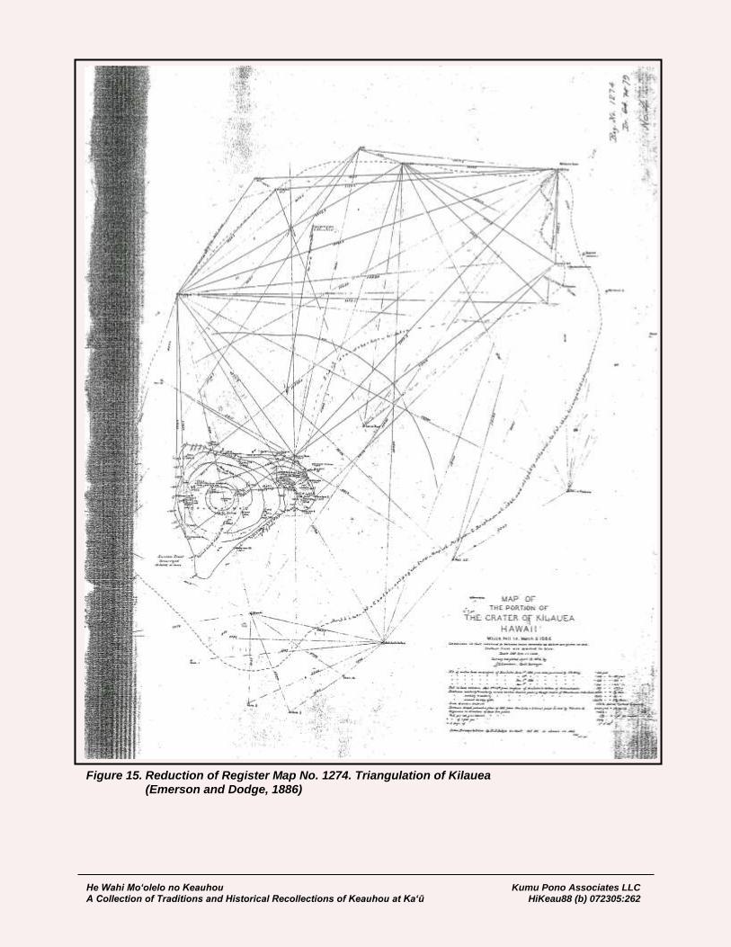
He Wahi Mo‘olelo no Keauhou Kumu Pono Associates LLC A Collection of Traditions and Historical Recollections of Keauhou at Ka‘ū HiKeau88 (b) 072305:262
Figure 15. Reduction of Register Map No. 1274. Triangulation of Kilauea (Emerson and Dodge, 1886)
He Wahi Mo‘olelo no Keauhou Kumu Pono Associates LLC A Collection of Traditions and Historical Recollections of Keauhou at Ka‘ū HiKeau88 (b) 072305:263
August 10, 1894 Bureau of Survey Honolulu Frank S. Dodge, Assistant, H.G. Survey; to Jas. A. King, Minister of Interior: …At the Pahala Volcano Road, it is unnecessary for me to add to my remarks of last March, except that it is in a worse condition now, than it was then. Repairs should be made as soon as possible, to put this very important road in good condition [page 5] for the through travel to and from the volcano and Hilo. At the Volcano, with the assistance of Mr. Wall, I made a complete survey of Halemaumau, showing the great change which took place early in July, when the level of the lava sank about three hundred (300) feet in one day. The results of this survey are to be filed in this office, with similar surveys made by myself in 1886-’88 and ’92 [Figure 16]. I also devoted one day to work on the Volcano Road, to carry the grade down the bluff towards Kau. The Volcano Road is now so near its completion, that it would be well to give some attention to the lower or Hilo portion to put it in better condition for heavy traffic. The ruts and holes should be filled, the whole surface top dressed and rolled, and the dangerous borrow-pits along the roadside, filled in, as a precaution against accidents… [HSA, DAGS 6; Hawaiian Government Survey]
Kulani Trig. Station November 24, 1896 J.S. Emerson; to W.D. Alexander: …After 8 1/2 days of severe labor, my party of 4 strong and experienced wood cutters, yesterday completed the road through the Koa forest and Pulu jungle to this point. We started a blazing fire at 4:30 this morning. At 8:30 our party, with 5 good pack mules, left the Kipuka and at 10:50 we had reached the base of this noble hill. About 40 minutes of this time was spent in cutting away some obstructions in the path, leaving 1 hour and forty minutes for travelling time. While the mules are resting in an akala thicket at the base of the hill, my men are climbing the ascent with loads that surprise me. I found it hard work to lug a gun and overcoat, and my handwriting shows the affects of the exertion on my nerves and muscles. The weather continues almost perfect. We have been most fortunate in having two weeks of such unusually clear weather. I have never known it better since I began my work last July. At the moment (12:25), Mauna Kea is clouding in, while M. Loa has only two small specks of clouds just forming. Last Sunday was the finest day of the season. A heavy frost covered the ground when we awoke in the morning. My men who had never seen anything of the kind before, the guide was not among them, tasted to see if it was salt, and asked me what it was. All that day the sun shone from a cloudless sky. We went to Keawewai to bathe, and the view of the mountain and coast was wonderfully fine. I can’t expect such weather to last. Kulani signal is in distress. A few tattered rags here and there all over the tripod, a bare pole with a rag or two on it, the whole surrounded by a jungle of brush 6 feet high, with a few bare trunks of lehua trees near by, easily mistaken for the signal, that is all. No wonder I have had trouble to see anything to sight on. Kamaki flagged the signal as he had been taught. The system or lack of system was all wrong. Of course heliotropes have to be used to supply the defects of such signals… [HSA, DAGS 6; Hawaiian Government Survey]

He Wahi Mo‘olelo no Keauhou Kumu Pono Associates LLC A Collection of Traditions and Historical Recollections of Keauhou at Ka‘ū HiKeau88 (b) 072305:264
Figure 16. Sketch of Halemaumau, July 30th, 1894, by Frank S. Dodge (Volcano House Ledger, in Collection of Hawaii Volcanoes National Park)
He Wahi Mo‘olelo no Keauhou Kumu Pono Associates LLC A Collection of Traditions and Historical Recollections of Keauhou at Ka‘ū HiKeau88 (b) 072305:265
May 16, 1897 In Camp Ohale Kau, Hawaii J.S. Emerson; to Prof. W.D. Alexander: …The day now closing has been one of surpassing beauty and loveliness. A more perfect climate, outside of Kona, Hawaii, would be hard to find. An everlasting drizzle drove us from Puu Huluhulu last Tuesday. We took the trail north westerly, towards the volcano, for a mile and a half or so, until we struck the cart road leading down to Keauhou. This we followed for several miles, nearly to Shipman’s ranch at Kuaehu [Kuehu], lately named Ainahou. We then struck the Puna-Kau trail, which we followed for some miles through a lovely ohia lehua forest, past the vertical cliff, now
called Palilele o Kalihipaa where, over a score of years ago, Kalihipaa leaped to his death. The spot now famous, is marked by a substantial stone ahu which commemorates a sad tragedy. Kalihipaa was a contract laborer under Kaina, collecting pulu for J.C. King. There was no better man to work than he, when he chose to put forth his strength. But slavery he could not endure, and he finally ran away from a cruel task master. Kaina’s son found him, and, armed with an odious law, he drove the captive back to his toil. “When Kaina gets you once more within his clutches he will thrash you within an inch [page 1] of your life.” So spoke the son of a Hawaiian task master to his poor slave. And Kaina would no doubt be as good as his word! As the two passed along the trail, but a few rods from the pali, the contract laborer in his desperation made one bold rush for liberty and was free. His mangled remains were picked up later. The jury brought in a verdict of suicide. Kaina’s son was acquitted. The barbarous law however, remains, a blot on the statute book and an obstacle to annexation. Policy no doubt will wipe out what has so long withstood the demands of justice and right, and this cursed law will be changed. We camped for the night on the edge of the forest, on the pahoehoe below the pali. We had reached the border of the great Kau desert. Such a profusion of ohia lehua blossoms I never before saw. Every little dwarf ohia tree on the pahoehoe is loaded with rich clusters of this bright flower. I never saw the like of it. Wednesday we were fortunate in having enough clear weather to pick out our station, situated over an air bubble on the highest point of a sea of pahoehoe rock, the only suitable point in this great wilderness for the purpose. The accompanying summary of observations sufficiently well locates the point and tells its own story of what has been accomplished with the instrument. The cloudy weather which characterized the country on our arrival here has been slowly giving place to clearer skies. Over Puu Enuhe and Kaiholena however, the [page 2] clouds still hold undisputed sway. Save for the smoke which still arises from the “bottomless pit,” the mornings are glorious. It has been a constant struggle with the powers of darkness and smoke to accomplish anything. Puu Huluhulu is the only signal visible from here that is always free from smoke. It stands like a thing of beauty, perched on its sharp hill top. It has waited long and patiently for its crowning, and now it is the peer of any of them. A solid ahu of stone, 13 feet high and 13 feet in diameter at the base, had to be constructed with great care on such a dizzy edge of destruction. I am thankful that no accident happened while there and that we are safely away. I can sleep more sweetly for being at a distance from such an uncanny spot. As to all the other signals they are hid by the smoke most of the time during the early hours of the day. The motions of the smoke columns are strangely interesting. At early dawn the cold air from the mountains causes it to stretch its huge bulk like a serpent, prone over its belly, shutting out every signal in its path save Puu Ulaula, which at an angle of 4º 7’ 18” soars above the great dragon

He Wahi Mo‘olelo no Keauhou Kumu Pono Associates LLC A Collection of Traditions and Historical Recollections of Keauhou at Ka‘ū HiKeau88 (b) 072305:266
ready to devour it. Just as I get ready to observe, a great cloud of obscurity, milky white in the morning sun, shuts out the sight. I wait and wait and snatch the favoring [page 3] moment to rescue my prize. Poor thing! It is only the ghost of a signal. All the other signals are plump and fat. Puu Ulaula is so thin and starved that it requires an extra good light to see it at all. The signal for an unfrequented point is the stone or hapuu ahu. Such signals last for years through rain and storm, while these poor lean tripods torture the eyes and hide their meager, pinched forms after a storm has torn their clothes off. Water is a scarce article now a days. Mr. O. Shipman has had to abandon his dairy at Kuaehu [Kuehu] for lack of water. All the rain falls on the high ridge (from Puu Huluhulu to Heiheiahulu), while the air when it reached Kuaehu and the Kau desert is drained of it’s moisture. How to keep my mules and my men from thirst is an important item, essential to the success of my work. Darkness is approaching, and I must close with aloha nui… [HSA, DAGS 6; Hawaiian Government Survey]
November 20, 1898 In Camp, by Pahu‘amimi Water Hole, Kapapala, Kau, Hawaii J.S. Emerson; to W.D. Alexander: …The above suggestive name is sufficiently descriptive of this place. It is the common resort for the cattle, horses, dogs and birds of this mountain region, who come here to drink and roll in it’s muddy waters. On arriving here yesterday my first duty in a sanitary point of view was to cremate a poor dog lying unburied beside the pool. The “Paniolo” natives from Mr. Monsarratt’s dairy at Ainapo frequent this place in search of stock, and sometimes drink of the water, but it is filthy stuff. At the same time it is most acceptable to my poor mules. A fairly good pasture and an abundant supply of fire wood make this the best available spot for my camp while in search for a hill that will command a view of Kaiholena, Puu Ulaula, Kulani, etc. Thus far the weather has been propitious, no rain, and fog only in the latter part of the day. Ainapo, five or six miles distant will furnish us with clear fresh water. We have a good supply of provisions and a shot gun that supplies us with game. From this camp as our headquarters we propose to explore the inhospitable, dreary region above us until we find what we are after. My party of three natives with Keanaha as their natural and recognized leader, is the best I ever had the direction of. With such men and continued fair weather, ultimate success seems reasonably assured. I don’t propose to retreat from this place of vantage until the object is accomplished or a storm makes it unsafe to remain. The great difficulty of course will be fog or cloud which renders traveling in the latter part of the day somewhat dangerous. I am glad there is a moon which may save us a bitter nights experience on the aa. I hope to be able to report progress in my next. Thanks for the boxes and mule shoeing outfit which arrived all right. The boxes are too large for packing on a mule but will do good service in other ways. They are all right for transportation by ox cart and are excellent for storage purposes. 2 P.M. The clouds settled about us at 12 noon. Now they are dropping a light rain, the first we have had since leaving Naalehu. My men and animals are enjoying a Sunday rest… [HSA, DAGS 6; Hawaiian Government Survey]

He Wahi Mo‘olelo no Keauhou Kumu Pono Associates LLC A Collection of Traditions and Historical Recollections of Keauhou at Ka‘ū HiKeau88 (b) 072305:267
Figure 17. Ancient ‘Alā Stone Paved Trail to Kīlauea from Ka‘ū (H.T. Stearns, 1924, in Collection of USGS, Denver) (Copy Photo, KPA-N299)
From Native Trails to Government Roads: Kingdom Efforts to Improve Access to and Through Keauhou and Kīlauea 1847-1915 The attraction of the volcano, as a visitor’s attraction was observed in government communications by the 1840s. In 1847, King Kamehameha III, ordered the development of the Government Road System. In most instances traditional trails served as the basis for the improved road system, with straightening and widening of the routes implemented as necessary. In addition to the narratives cited through historical journals and letters, as those cited in this study, we also find a number of communications between offices of the government and individuals appointed as “Road Supervisors” and contractors, who oversaw the development of the Alanui Aupuni (Government Road) system. The earliest trails between Ka‘ū, Puna, and Hilo, passed through the lava fields of Kīlauea. One trail, paved with dense ‘alā stones rises out of Ka‘ū, across the sun-baked plains of Kūkalā‘ula, and approached ‘Uwēkahuna, as described in ancient mele, traditions, and early historical accounts (Figure 17). The near shore trail across Keauhou, and running between Puna and Ka‘ū, is commemorated by the ahupua‘a name, Kealakomo (literally, The-entry-path). Native lore and early descriptions, tell us that in ancient times, travel on these trails could be treacherous, not so much because of the nature of the landscape, but because of the ‘ōlohe and pōwā (expert fighters and thieves) who frequently attacked travelers along the way. One famous account from the lands near Keauhou, reported that if an individual or two was traveling, the spies set along the trail would call out to the ‘ōlohe, “Kai make!” (low tide), meaning that those on the trail were few in number, and could be easily beaten. While the call of “Kai nui!” (high tide or rough seas), meant that there were too many travelers, and they should be allowed to pass. Thus, the ‘ōlohe communicated among themselves, and monitored the ancient trails (pers comm. M.K. Pukui, 1975). Perhaps the earliest letter documenting the Kingdom’s interest in improved routes of travel around the island of Hawai‘i, is a letter from Kapeau, Governor of the island of Hawai‘i, to Keoni Ana, Minister of the Interior, written in 1847. Through Kapeau’s letter we find references to the trails through Keauhou, and thoughts on growing interest in travel to the volcano:
August 13, 1847 Governor of Hawaii, George L. Kapeau; to Premier and Minister of Interior, Keoni Ana: Aloha oe e ka mea Hanohano – …I have a few questions which I wish to ask you. Will the police officers be required to pay, when they do not attend the Tuesday (Poalua) labor days? How about parents who have several children? What about school teachers and school agents? Are they not required to work like all other people when there is Government work on the roads and highways? I believe that school agents, school teachers and parents

He Wahi Mo‘olelo no Keauhou Kumu Pono Associates LLC A Collection of Traditions and Historical Recollections of Keauhou at Ka‘ū HiKeau88 (b) 072305:268
who have several children, should only go and work on the weeks of the public, and not on the konohiki days… …The roads from Kailua and down the pali of Kealakekua, and from Kailua to Honokohau, Kaloko, Ooma, the place where our King was cared for, and from thence to Kaelehuluhulu [at Kaulana], are now being surveyed. When I find a suitable day, I will go to Napoopoo immediately, to confer with the old timers of that place, in order to decide upon the proper place to build the highway from Napoopoo to Honaunau, and Kauhako, and thence continue on to meet the road from Kau. The road is close to the shore of Kapalilua. Also, the road that is to go makai of Kukalaula, below Keauhou, and then continue to the shore of Puna and Hilo, will probably begin at Keaiwa. The width of the highways round Hawaii, is only one fathom, but, where it is suitable to widen where there is plenty of dirt, two fathoms and over would be all right. For the town of Hilo, I have appointed some road overseers, being B. Pitman, Frank W. Wood, maybe Koana, Halai, Luhilea, Kaiana. Three natives and three foreigners. They get no pay for this work which has been placed upon them, they give their services free to this work because of their desire to improve the land. If the roads are put into proper condition, there are a lot of places for the strangers to visit when they come here. The Kilauea volcano, and the mountains of Maunaloa, Maunakea, Hualalai. There is only one trouble to prevent the building of a highway all around, the steep gulches at Waipio and Pololu, but this place can be left to the very last. The palis at Hilopaliku are also very bad, but another and better place has been found, it is a little mauka of that, that is what the old timers living at Kulaimanu say. A foreign carpenter has proposed to me that he build the bridge over Wailuku completely, all the material to be his and also the labor, and to pay him two thousand dollars. I did not pay much attention to this, because, I do not believe that it can be built for that amount of money, it will take three thousand dollars to finish it, and maybe it will go into four thousand… [HSA, Subject File–Roads Hawaii; translated modified by Maly]
March 12, 1870 L. Kaina, Puna Road Supervisor; to Chas. L. Gulick, Clerk of the Minister of the Interior (Reports on Road work to Kilauea): …I have received your letter at Hilo and see the Minister of the Interior has agreed to my constructing three miles of the road – and that I am to take the money from the hand of R.A. Lyman. I am taking the money and going to Kilauea to get our men, and will take the workers, I will work diligently with all of my people on the three miles, and will await further response, then do additional work. Please tell His Excellency, the Minister of the Interior that the lua pele (volcano) is very full, it rose perhaps on the 19th of February, passed and overflowed the top. It is very fine to look at the eruption at this time… [HSA, Subject File–Roads Hawaii; translated by Maly]
In 1875, J.M. Lydgate proposed to conduct survey work for the Government, including the survey of the District of Puna and the Puna Government Road. His application to undertake the work was approved, and Register Map 583 was prepared as a result of the survey work. Lydgate wrote:

He Wahi Mo‘olelo no Keauhou Kumu Pono Associates LLC A Collection of Traditions and Historical Recollections of Keauhou at Ka‘ū HiKeau88 (b) 072305:269
January 21, 1875 Hawaiian Government Survey Files John. M. Lydgate to W.D. Alexander: …I have a conditional proposition to make you as superintendent of the Gov’t. Survey. I rather expect to leave the Islands for the States in a short time – probably inside of a month, and the condition and proposition is that if I should have time to do the amount of work necessary, I should like to furnish the Gov’t. Survey for the Sum of $100.00; 1st the coast line of that part of the Island lying between the town of Hilo and the land of Keaiwa in Kau. Some 65 or 70 miles I should say. Of course I can’t afford to give it with the accuracy that I know is required in the final Gov’t. Survey work. It will be the nice miniature that are wanting, not the outline however. 2nd I will give the two Gov’t. Roads; the one from Hilo direct to the Volcano and the other round by the shore. These will be given from actual survey. Also the roads from the Volcano to Kapapala and Keauhou indicated pretty correctly. 3rd The main topographical features – hills, craters, &c.; and the general nature of the country—whether wooded or not, recent lava flows &c; of the regions above named, extending from Hilo to Keaiwa… I think you will see at once that these results represent a large amount of work, as indeed they do, and were it not that I have already data from which a considerable part of it can be derived I could not think of doing it for that sum… I will also indicate as far as I am able what I consider the best plan of triangulation for that part of the Island, and will mile the Puna Road if the Minister of the Interior will pay the expense of putting up marks – not over $4 or $5 I should say… JML. (I recommend the above application to the favorable consideration of the Dept., W.D. Alexander ) [HSA, DAGS 6; Hawaiian Government Survey]
December 7, 1882 Michael Hahale (at Pepeekeo); to J.E. Bush, Minister of the Interior (Applying for position as Road Supervisor, District of Puna; and to work on Road to Volcano and Kau): …If I should receive the authorization of my Lord, your humble servant asks that I be appointed Road Supervisor for the District of Puna, Island of Hawaii. The roads of this district are not good for the most part it is the road in the distant uplands that is in disrepair. It has been fully 20 years or more that no work has been done on this road, that is the road from the boundary of Hilo to Volcano. The previous Road Supervisor did not put any money into this road, he only spent money on the lower section of the road over the last 20 years or more. The $4,000 in funds is not enough but we will make do with it for the work. Here is how the funds can be divided, the coastal Road $5,500; the upland Road $1,500. I have mistaken, there is not $7,000 for the District of Puna as I thought, but only $4,000. If I get your permission to become the Road Supervisor of Puna the roads will be made good.
He Wahi Mo‘olelo no Keauhou Kumu Pono Associates LLC A Collection of Traditions and Historical Recollections of Keauhou at Ka‘ū HiKeau88 (b) 072305:270
My great desire is to make the upland road good; that is the road that ascends all the way to the wondrous Volcano and Kau so that visitors from other lands can come. Puna is the land of my birth and I have resided there as a native, therefore I am a newcomer to Hilo… [HSA, Subject File–Roads Hawaii; translated by Maly]
September 22, 1888 Punaluu Peter Lee; to L.A. Thurston Reports that the Carriage Road from Pahala to the Volcano is near completion; requests to be considered for the contract in making the Carriage Road from Volcano to Hilo): …I understand there is going to be built a carriage road from Hilo to the Volcano, and if you have not already appointed a man to put that road through, I hereby take the liberty to apply for it. I am just now making a carriage road to the Volcano on the Kau side, which road will be completed in a few weeks. Several competent people have overlooked this road and are highly recommending it. As I have been employed for several years in road building in Peru and California, I am thoroughly familiar with this kind of work, and am confident that I can make this road as good and cheap, and in as short a time as anybody in the country. I am well experienced as to the nature of the country, what material it consists of, the different lava flows and know how to make use of it to best advantage, besides I have a perfect knowledge of working men; and should of course pay my personal attention to the work from beginning to end. If your Excellency should reflect on this application and desire references as to my ability I shall be glad to furnish you with such on receiving your esteemed reply… [HSA, Subject File Roads, Hawaii]
August 26, 1893 No Ke Alanui o ka Lua o Pele. (About the Road to the Volcano.) Work is progressing on the road to Kilauea, at an expense of $1000.000 per month to the government. At the time there are finished, 23 miles from Hilo, and only 7 miles remain to be completed, and when a carriage may pass. Indeed, one more mile is almost completed, and only six more remain. The work may be done quickly because there is fine cinder for about half the distance. When the road is completed, carriages may easily travel to the Hotel at the Volcano, then there will be an increase in the numbers of people who go to visit there. It is a good place to visit, and where one may restore a body weakened by illness. The sections of Crown Land, adjoining the road have been leased. There are twelve miles of road that pass these lands, and the people are now working hard to cultivate the land. There are also many good houses that are being built, though those who travel along the road do not even see half of the areas worked, and they are hidden by the forest. This is because the forest has been protected from planting and from taking wood from along the road side… The land of Olaa, which has been left from ancient times as wilderness (nahelehele), is now being planted in gardens since the making of this good road. [Ku Okoa, August 26, 1893:3; Maly, translator]

He Wahi Mo‘olelo no Keauhou Kumu Pono Associates LLC A Collection of Traditions and Historical Recollections of Keauhou at Ka‘ū HiKeau88 (b) 072305:271
December 12, 1893 Ka Lua Pele o Kilauea. (The Volcano, Kilauea.) (Describing road work recently completed at Kīlauea): …The road has been greatly improved because of the work overseen by Supervisor, Mr. Lee. One may now quickly travel, going from the crater to the hotel in only 45 minutes… [H.M. Whitney; Nupepa Ku Okoa, December 12, 1893:3; Maly, translator]
The Volcano House and Keauhou Landing In the 1870s, Samuel G. Wilder was contracted to oversee the governments’ steamship enterprise. Under his management, inter-island shipping saw a profit for the first time in the Kingdom’s history. In 1883, Wilder organized his own company, “Wilder’s Steamship Company, Limited,” and began operating vessels between the islands, carrying passengers, freight, and livestock. That same year, Wilder also purchased the S.S. Kinau. In June, 1885, Wilder and company secured a sub-lease from G.W.C. Jones and partners for the Keauhou holdings, including the Volcano House, and the old Keauhou Landing. In between June 1885 and June 1886, Wilder and Company renovated and improved the Volcano House and facilities, and restored the Keauhou Landing. Thrum’s Hawaiian Annual and Almanac for the year 1886 announced to readers that the Keauhou Landing had been reopened, as an access to Kilauea (Figure 18):
Another important step taken this year, of special interest to the travelling public, is the opening of the new route to the volcano Kilauea, by way of Keauhou, by Wilder’s Steamship Company, on the 23rd of last June. This route via Hilo, promises unequal facilities for convenient and expeditious sight seeing of our famed volcano; the road from Keauhou to the volcano being fourteen miles. The volcano house has put under the management of Mr. J.H. Maby, and faithful guides are in attendance to conduct tourists down into and across the crater, as may be desired. The new route opened up with quite an excursion party who were enthusiastic at the completeness of everything at the different points on the route, and the prospect bids fair for the roughness of such a trip being reduced to a minimum under the present management. The rough by way of Kau, by the Inter-Island Steam Navigation Company also offers excellent facilities, and by either line tourists can make the round trip from Honolulu for $50.—this sum covering all expenses for horses, guide, volcano house and steamer fare. [Thrum, 1886:65]
Wilder’s Steamship Company continued operations at Keauhou, but by late 1896, the Inter-island Steam Navigation Company (I.I.S.N. Co.) had assumed responsibility for the landing at Keauhou, and in 1905, it absorbed Wilder’s Steamship Company. In 1897, the I.I.S.N. Co. proposed to undertake improvements on the Keauhou-Kīlauea Road. The Pacific Commercial Advertiser reported:
Keauhou Route Inter-Island Company Considering New Volcano Road. Should the I.I.S.N. Co. decide to fix up the road from Keauhou to the crater of Kilauea on the Island of Hawaii, it will mean a matter of great importance to tourists who have only the most limited time to spend seeing the sights of the Hawaiian Islands. It will mean the saving of time, money and wear and tear on the constitution. Although it has not been fully decided whether it will pay to put the road into fit condition for the conveyance in carriages or stages of the passengers from Keauhou to the volcano, still it is more than likely that it will be found on examination that the expense will not be so great that the project cannot be carried into effect. It is the intention of Mr. John Ena, vice president of the Inter-Island Company, shortly to make a trip to Keauhou for the purpose stated above.
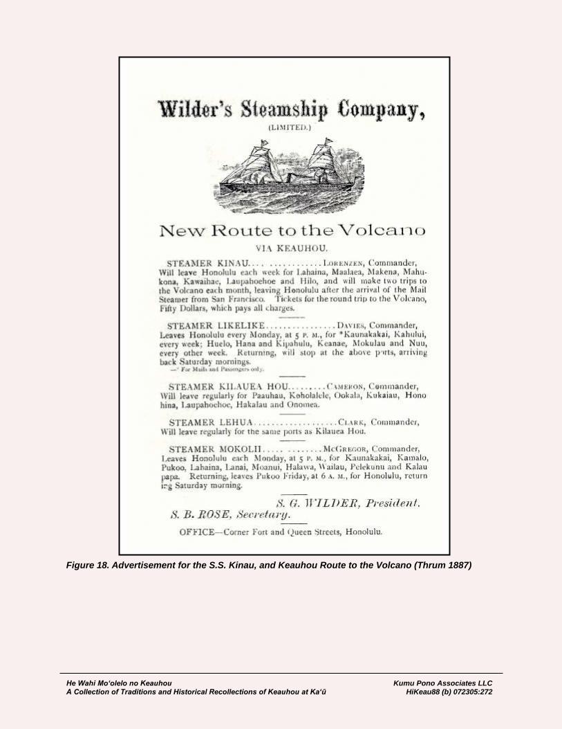
He Wahi Mo‘olelo no Keauhou Kumu Pono Associates LLC A Collection of Traditions and Historical Recollections of Keauhou at Ka‘ū HiKeau88 (b) 072305:272
Figure 18. Advertisement for the S.S. Kinau, and Keauhou Route to the Volcano (Thrum 1887)
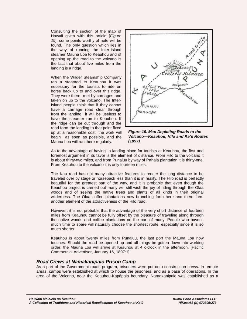
He Wahi Mo‘olelo no Keauhou Kumu Pono Associates LLC A Collection of Traditions and Historical Recollections of Keauhou at Ka‘ū HiKeau88 (b) 072305:273
Figure 19. Map Depicting Roads to the Volcano—Keauhou, Hilo and Ka‘ū Routes (1897)
Consulting the section of the map of Hawaii given with this article [Figure 19], some points worthy of note will be found. The only question which lies in the way of running the Inter-Island steamer Mauna Loa to Keauhou and of opening up the road to the volcano is the fact that about five miles from the landing is a ridge. When the Wilder Steamship Company ran a steamed to Keauhou it was necessary for the tourists to ride on horse back up to and over this ridge. They were there met by carriages and taken on up to the volcano. The Inter-Island people think that if they cannot have a carriage road clear through from the landing it will be useless to have the steamer run to Keauhou. If the ridge can be cut through and the road form the landing to that point fixed up at a reasonable cost, the work will begin as soon as possible, and the Mauna Loa will run there regularly. As to the advantage of having a landing place for tourists at Keauhou, the first and foremost argument in its favor is the element of distance. From Hilo to the volcano it is about thirty-two miles, and from Punaluu by way of Pahala plantation it is thirty-one. From Keauhou to the volcano it is only fourteen miles. The Kau road has not many attractive features to render the long distance to be traveled over by stage or horseback less than it is in reality. The Hilo road is perfectly beautiful for the greatest part of the way, and it is probable that even though the Keauhou project is carried out many will still wish the joy of riding through the Olaa woods and of seeing the native trees and plants of all kinds in their original wilderness. The Olaa coffee plantations now branching forth here and there form another element of the attractiveness of the Hilo road. However, it is not probable that the advantage of the very short distance of fourteen miles from Keauhou cannot be fully offset by the pleasure of traveling along through the native woods and coffee plantations on the part of many. People who haven’t much time to spare will naturally choose the shortest route, especially since it is so much shorter. Keauhou is about twenty miles from Punaluu, the last port the Mauna Loa now touches. Should the road be opened up and all things be gotten down into working order, the Mauna Loa will arrive at Keauhou at 4 o’clock in the afternoon. [Pacific Commercial Advertiser, January 16, 1897:1]
Road Crews at Namakanipaio Prison Camp As a part of the Government roads program, prisoners were put onto construction crews. In remote areas, camps were established at which to house the prisoners, and as a base of operations. In the area of the Volcano, near the Keauhou-Kapāpala boundary, Namakanipaio was established as a

He Wahi Mo‘olelo no Keauhou Kumu Pono Associates LLC A Collection of Traditions and Historical Recollections of Keauhou at Ka‘ū HiKeau88 (b) 072305:274
prison camp. We see in historic narratives, dating from 1861, that the name “Namakanipaio” (The battling winds) is a traditional one. As noted earlier in this study, Joseph N. Kaapa referenced the winds of Namakanipaio in a mele kanikau:
…Loaa aku i ka makani o Namakanipaio, …Where is found the wind of Namakanipaio, E hooholu mai ana i ka lau o ka nahele… Which causes the leaves of the forest to sway… [in Nupepa Kuokoa, November 28, 1861]
From the early 1900s, prisoners at Namakanipaio worked on rebuilding the “Peter Lee Road” into Ka‘ū, and on roads and trails around the Kīlauea, and towards Puna. The prison site was closed shortly after 191521. Two articles published in the Hawaiian language newspaper, Ka Hoku o Hawaii, provide us with a glimpse into prisoner activities at Namakanipaio. The following translations summarize the accounts:
In the September 21st, 1912 issue of Ka Hoku o Hawaii, Joseph Kawaha, prison guard and church committee member from Namakanipaio, Kau, wrote to the paper, informing readers that the prisoners who resided in the Halepaahao o Kaluapele (Volcano Prison), had contributed donations to the building of the church at Kalaupapa. The prisoners, who were likened to the ‘ōhelopapa of the volcano, were: Kaliko, Wm. R. Kulanakila, R.A. Lyman, J.H. Kiaha, E.K. Kanepuu, Wm. Kane, Wm. Bray, John Marks, Joe Potelho, M. Donoshuki, Pisara, Antone Reyes, Joe King; and the guard, J.L.K. Kawaha (Ka Hoku o Hawaii, September 21, 1912; Maly, translator). On September 16th, 1915, Ka Hoku o Hawaii reported to its readers that there was trouble between the Warden and the County Board of Supervisors regarding the continued operation of the Volcano Prison. Talks did not go well, and the head of the board, refused to authorize continued operation of the prison. The problem arose a s a result of a difference between the warden and the road supervisor. The disagreement lead to the warden’s refusal to release the prisoners to the road work crew. As result, the board withheld the $833.00 monthly payment of expenses for the prisoners, and those prisoners from Honolulu were returned to O‘ahu. The warden was then released from his position, and the County then allowed for the continued work by the remaining prisoners, on the Volcano Crater road (alanui o ka Luaopele) (Ka Hoku o Hawaii, September 16, 1915; Maly, translator).
21 Selected Roads and Prisons collections in the Hawaii State Archives were reviewed for additional information on
the camp, but no records were located. It is likely, that additional records may be found at a later date.

He Wahi Mo‘olelo no Keauhou Kumu Pono Associates LLC A Collection of Traditions and Historical Recollections of Keauhou at Ka‘ū HiKeau88 (b) 072305:275
A CHRONOLOGICAL OVERVIEW OF RESIDENCY AND LAND USE IN KEAUHOU AND VICINITY (ca. 1848-1937)
The following documentation describes land tenure, residency, land use, and the individuals associated with Keauhou and neighboring lands in the years following the Māhele ‘Āina. The records were compiled from books in collection of the State of Hawai‘i-Bureau of Conveyances (BoC); a review of documents in the Kamehameha Schools Collection; and records of the Hawaii State Archives (HSA). All documents recorded in Hawaiian, were translated by Maly. The texts provide readers with a synopsis of the original records, focusing on names of the participants in the transactions (to trace residency); the land area of conveyance; the types of features and or improvements situated on the land (such as buildings, rights of way, resources collected, and animals pastured); and the terms of agreement.
Origin of Fee-Simple Title in Keauhou As noted in the records of the Māhele ‘Āina, Victoria Kamāmalu, a granddaughter of Kamehameha I, claimed and received the ‘ili of Keauhou during the Māhele (Helu 7713, Royal Patent 4475). Victoria Kamāmalu died on May 29th, 1866, at the age of 28 years. Her lands were inherited by her father, Mataio Kekūanao‘a. Mataio Kekūanao‘a died two years later, on November 24th, 1868. His lands—including those he’d inherited from his own children and relatives—were inherited by his daughter, Luta “Ruth” Ke‘elikōlani (half sister of V. Kamāmalu). Luta Ke‘elikōlani died on May 24, 1883. Her lands—including those she inherited from her own father, siblings, husband, and relatives—were inherited by her cousin, Bernice Pauahi Bishop. Bernice Pauahi Bishop (Pauahi), daughter of Laura Konia and Abner Pākī, inherited the lands of her parents—Abner Pākī, who died on June 13, 1855, leaving Pauahi his six (6) Māhele lands and numerous parcels; and Laura Konia, who died on July 2, 1857, leaving Pauahi her ten (10) Māhele lands. Pauahi also inherited the six (6) Māhele lands of her aunt, ‘Akāhi, who died on October 8, 1877; and the lands of her cousin, Luta “Ruth” Ke‘elikōlani on May 24, 1883—these lands included the ‘ili of Keauhou, which embrace Kīlauea. Bernice Pauahi Bishop died on October 15, 1884, her combined lands were dedicated to the establishment of the trust forming the Bishop Estate-Kamehameha Schools.
Lease-hold and Fee-simple Conveyances of Lands in Keauhou, Ka‘ū (1860-1937) The historical record provides us with numerous accounts describing travel through Keauhou—the focal point being Kīlauea—and of the collection of resources from the land, as well as the presence of shelters and lodgings in Keauhou in the years prior to and following the Māhele. The narratives also document the presence of wayside shelters and houses at Keauhou, overlooking Kīlauea. It appears that the earliest facility, dedicated to visitor accommodations, was opened in 1844 (see The Polynesian, July 13, 1844, in this study). It is not until 1863, that we find the first formal record of a conveyance, in the form of a lease, for the ‘ili of Keauhou, and it is not until 1868, that we found specific references in conveyances, to buildings and facilities on the land. The records below, cover the leases of Keauhou, allowing the collection of pulu (fibers of the hāpu‘u), an endeavor that was developed into a “Pulu Plantation,” with three primary bases of operation: 1) situated near the rim of Kīlauea, and being near the 1860s Volcano House; 2) the “factory” between Makaopūhi and Napau, on the east rift zone, and outside of Keauhou; and 3) the Keauhou landing, from where items were shipped and received. In addition to the pulu business at Keauhou, other economic ventures, including the harvesting of native woods such as koa; the hunting of cattle and goats, and eventual development of ranches;
He Wahi Mo‘olelo no Keauhou Kumu Pono Associates LLC A Collection of Traditions and Historical Recollections of Keauhou at Ka‘ū HiKeau88 (b) 072305:276
development of the Volcano House facilities; improvements of trails and road ways; and the establishment of the Kilauea Military Camp, and Hawaii National Park in 1916. The records cited below, describe the development of the pulu and ranching interests; the Volcano House Hotel and Keauhou Landing operations; development of the koa milling plan in the early 1900s; and the eventual conveyances of lands to establishment of the Hawaii National Park. Unless otherwise noted, all records cited were found in the collection of the State Bureau of Conveyances. We find accounts documenting that a number of activities were occurring on Keauhou following the granting of fee-simple land title in the Kingdom. A letter published on February 11, 1857, in the native newspaper, Ka Hae Hawaii, was submitted by J.D. Kanekoa of Kahuwai, Puna. In the letter, Kanekoa reported to readers that a man who had apparently been hunting goats had been lost at ka lua o Pele. Kanekoa noted that the man’s personal items had been left in the house at the crater, and that Ka‘ū was a land of goats—implying that they were numerous:
I have a little bit of news for you, and you may share it with those people who dwell in various places. There was a man lost at kalua o Pele (the Volcano). It is not known where he went, or where he was coming from; it is thought to be from Kau. His bullock was found at a rugged place, and his nose rope having come off, but he could not go anywhere because of trouble with his hooves. His goods were left at the house, being four bundles of goat hides. Therefore, the people who saw these things, the bullock, and the goat hide bundles, think that he was from Kau; because Kau is a land of goats. The people got the bullock and the goat hide bundles on the 17th of January, but there was no man; the people went there again on the 19th, and still there was no man. It is so sad for this man, and his friends, wife and children, who do no know if he is alive or dead. [J.D. Kanekoa, in Ka Hae Hawaii, February 11, 1857:197. Maly, translator]
Records from Selected Conveyances of Lands in Keauhou and Vicinity In 1860, the larger land of Kapāpala, within which Keauhou lies, was leased by the King, to the interests of William H. Reed (step-father of W.H. Shipman), and Charles Richardson, for the development of ranching interests. While we have no specific reference to the occurrence, it is likely that activities associated with the lease of Kapāpala carried over to Keauhou, as some of the partners in the lease, later secured leases on Keauhou. The lease for Kapāpala recorded:
Kamehameha IV; to Reed & Richardson Lease of Kapapala March 1, 1860 This Indenture made this first day of March AD 1860 between His Majesty, Kamehameha IV, King of the Hawaiian Islands of the one part & and W.H. Reed & C. Richardson of Hilo, Hawaii of the other part. Witnesseth that for & in consideration of the Rent & Covenants on the Lessee’s part, herein after reserved & contains, he the said Kamehameha IV hath demised & leased & by these presents doth demise & lease unto the said W.H Reed & C. Richardson, their heirs, executors & assigns, all that tract of land known as the Ahupuaa of Kapapala, situate in the District of Kau, Island of Hawaii (excepting so much thereof as may have been awarded as Kuleanas by the Land Commissioners) with all the rights, members, easements and appurtenances thereunto belonging for & during the term of Thirty Years to commence from the first day of March AD one thousand eight hundred and sixty, yielding & paying therefore unto the said Kamehameha IV, his heirs & assigns, the yearly rent of Three Hundred Dollars ($300) to be paid at the end of each year of the said term…
He Wahi Mo‘olelo no Keauhou Kumu Pono Associates LLC A Collection of Traditions and Historical Recollections of Keauhou at Ka‘ū HiKeau88 (b) 072305:277
…That the said W.H. Reed & C. Richardson shall not commit or knowingly permit or suffer any waste to be done of the said demised premises, or cut down, or permit to be cut down any fruit trees on said land, whereby the ________ [illegible] thereof might be injured… [BoC Liber 13:56-57]
In September 1863, the ‘ili of Keauhou was leased, withholding the fisheries and koa trees. The lessee, F.B. Swain was involved in ranching, and again, though not specifically stated, it is likely that Swain has some interest in the running of a shelter near Kīlauea for travelers. The lease to Swain did not spell out all uses, but noted:
Kamamalu & Kekuanaoa; to F.B. Swain September 25, 1863 Lease This lease agreement for land is made on this 25th day of September, 1863, between V. Kamamalu and M. Kekuanaoa, of Honolulu, Island of Oahu of the first part; and Francis B. Swain of Kau, Island of Hawaii, of the second part. The party of the first part hereby leases all of the Ili named Keauhou, in the Ahupuaa of Kapapala, Kau, Island of Hawaii to the party of the second part, his heirs and assigns. There are withheld from this lease, the Kuleana of the people therein, the fishery, and the Koa trees, for the party of the first part. All the Ili land is granted to the party of the second part for the term of three years, for eighty dollars per year. If after the term of three years all payments have been made without default, the party of the second part may continue his tenancy… [BoC Liber 17:223-224; Maly, translator]
In1864, G.W. Jones—who was a primary party in ranching operations at several areas across the district of Ka‘ū, and in partnership with W.H. Reed and C. Richardson—published a public notice in the native language newspaper, Ku Okoa. Addressed from his residence in Keauhou (in the Ka‘auea vicinity, near the site of the old Volcano House), Jones informed readers that stray animals caught on the lands of Kapāpala would be captured and impounded, at the owner’s expense. The notice read:
Nupepa Ku Okoa April 16, 1864 OLELO HOOLAHA. E ike auanei na kanaka a pau o kela ano keia ano, ua kapu no kela Apana Aina e waiho la ma Kapapala, Kau, Hawaii, e pili ana me Keauhou, aole hele wale na holoholona, Bipi, Lio Kekake, a holoholona e ae paha maluna o ua aina la i oleloia'e la maluna. - Ina e loaa kekahi o keia mau holoholona e hele ana ma kuu aina me ko'u ae ole aku, uku no $1.00 no ke poo hookahi, ina aole e uku mai, e lawe ia no ma ka Pa Aupuni, e like me ke Kanawai.
GEO. W. JONES (KEOKI). Keauhou, Kau. Hawaii Aperila 1,1864.
NOTICE. Know all men these things, there is a restriction on the Land Area situated at Kapapala, Kau, Hawaii, and adjoining Keauhou. Animals are not allowed to roam there, that is the Cattle, Horses, Donkeys, and other such animals on the above mentioned land. If any of these animals are found upon my land, without my agreement, a fee of $1.00 will be charged per head. If payment isn’t made, it will be taken to the Government Pound, pursuant to the Law. Geo, W. Jones (Keoki) Keauhou, Kau. Hawaii April 1, 1864. [Maly, translator]
We find that collection of pulu from the native tree ferns, hāpu‘u, was a business of some significance in Keauhou and neighboring lands in Puna. Jones, in partnership with Kaina (who also acted as a land agent for Government and Crown Lands, and as a road supervisor and magistrate), and several

He Wahi Mo‘olelo no Keauhou Kumu Pono Associates LLC A Collection of Traditions and Historical Recollections of Keauhou at Ka‘ū HiKeau88 (b) 072305:278
local and United States businessmen. The first formal lease of pulu collection rights on Keauhou was issued in 1865, to James C. King, who later entered into partnership with Jones and Kaina, as the endeavor developed into a “Pulu Plantation.”
C.C. Harris, Trustee for V. Kaahumanu Kamamalu; to James C. King Lease – Right to Collect Pulu April 17th, 1865 This Indenture made this seventeenth day of April eight hundred and sixty five by and between Charles C. Harris, Trustee for H.R.H. V.K. Kaahumanu of the City of Honolulu, Island of Oahu, party of the first part, and James C. King of the City of San Francisco, State of California, United States of America, party of the second part. Witnesseth that the said party of the first part hath let and by these presents doth grant, demise and let unto the said party of the second part, that Ili Aina known as Keauhou situated in the Ahupuaa of Kapapala, District of Kau, Island of Hawaii for the term of Five Years commencing from the twenty fifth day of September AD 1866 at the yearly rent of one hundred and twenty five dollars to be paid semi-annually… And it is hereby expressly understood and agreed that the said party of the second part shall be at liberty to gather whatever Pulu there may be growing upon the said Land, but shall not be at liberty to cut and take away any Wood from off the said Land. And it is further understood and agreed that the said party of the second part shall not have any right to the fishing privilege connected with the said Land… The understanding of the above is that Mr. King has the exclusive use of the Pulu, but the Proprietors may at any time cut wood or cause it to be cut, or fish the waters, or cause them to be fished… [BoC Liber 19:238-240]
In 1868, G.W. Jones took over the lease of Keauhou as recorded in the following conveyance:
Administrators of V.K. Kamamalu; to G.W.C. Jones February 4, 1868 Lease of Keauhou This indenture made this twenty-fourth day of February AD one thousand eight hundred and sixty-eight, by and between John O Dominis, Administrator of the Estate of Her Late Royal Highness Victoria K. Kaahumanu party of the first part, and George W.C. Jones of “Keahou” [Keauhou] Island of Hawaii, party of the second part. Witnesseth that the said party of the first part hath let and by these presents doth grant, demise and let unto the party of the second part, that Ili Aina known as “Keauhou” situated in the Ahupuaa of Kapapala, District of Kau, Island of Hawaii, for the term of five years commencing from the twenty fifth day of September in the year one thousand eight hundred and seventy one at the yearly Rent of One Hundred and Seventy Five Dollars payable semi-annually in advance… And it is hereby expressly understood and agreed that the said party of the second part shall be at liberty to gather whatsoever Pulu, there may be growing upon the said land, but shall not be at liberty to cut and take away Wood from off the said lands. And it is further understood and agreed that the party of the second part shall not have any right to the fishing privileges connected with the said land. And it is further understood and agreed that the party of the second part has the exclusive use of the Pulu, but the proprietor or proprietors, owners may not at any time cut the wood or cause it to be cut; or may fish the waters, or cause them to be fished. It being expressly understood that this privilege extends only to the party of the first part, his successor or successors and the heirs, executors, administrators and assigns of the said Her Late Royal Highness Victoria K. Kaahumanu… [BoC Liber 25:119-120]
He Wahi Mo‘olelo no Keauhou Kumu Pono Associates LLC A Collection of Traditions and Historical Recollections of Keauhou at Ka‘ū HiKeau88 (b) 072305:279
In the following conveyances, mortgages were taken out on Keauhou, and lands held by the Estate of Victoria Kamāmalu:
Administrator of V.K. Kamamalu; to James Robinson & Co. Mortgage Deed February 25, 1868 Know all me by these presents that I, M. Kekuanaoa, the heir of Victoria Kamamalu, late of Honolulu, Island of Oahu, and John O. Dominis, Administrator of the Estate of Victoria Kamamalu, by virtue of the order of the Supreme Court of the Hawaiian Islands dated the 18th and 24th days of February AD 1868, in consideration of the sum of Thirteen Thousand Five Hundred Dollars to me paid by James Robinson and Robert C. Lawrence of Honolulu aforesaid… have granted, bargained, sold and conveyed unto the said James Robinson and Robert C. Lawrence, their heirs and assigns, the following Ahupuaas, Ilis and Tracts of Land as granted to the said Victoria Kamamalu by Royal Patent and Awards of the Land Commission: Keauhou, Kona Hawaii; Honokua, Kona, Hawaii; Kahaluu, Kona, Hawaii; Keauhou, Kau, Hawaii; Kipu, Kauai; Hanamaulu, Kauai; Mahaulepu, Kauai; Waiawa, Oahu; Waiau, Oahu; Halawa, Molokai; and all those premises situated in Aienui on Nuuanu Street, Honolulu, Island of Oahu, at present occupied by Chingkoon… To have and to hold the said with all the rights, privileges, appurtenances and improvements to the same belonging… This Conveyance is intended as a mortgage to secure the payment of a certain promissory note paid on this date… [BoC Liber 25:132-133]
Administrators of V.K. Kamamalu; to C. de Varigny Mortgage Deed March 5, 1868 Know all me by these presents that I, M. Kekuanaoa, sole heir of Victoria Kamamalu, late of Honolulu, Island of Oahu, and I, John O. Dominis, Administrator of the Estate of Victoria Kamamalu, by virtue of the order of the Supreme Court of the Hawaiian Islands dated the 18th and 24th days of February AD 1868, in consideration of the sum of Twelve Thousand Dollars to us paid by Charles de Varigny of Honolulu aforesaid…have granted, bargained and sold, and by these present do hereby grant bargain, sell and convey unto the said Charles de Varigny, his heirs and assigns, the following Ahupuaas, Ili and Tracts of Land as granted to the said Victoria Kamamalu by Royal Patent and Awards of the Lands Commission: Keauhou, Kona Hawaii; Honokua, Kona, Hawaii; Kahaluu, Kona, Hawaii; Keauhou, Kau, Hawaii; Kipu, Kauai; Hanamaulu, Kauai; Mahaulepu, Kauai; Waiawa, Oahu; Waiau, Oahu; Halawa, Molokai; and all those premises situated in Aienui on Nuuanu Street, Honolulu, Island of Oahu; at present occupied by Chingkoon and directly makai of the Public Hall premises; these premises having upon them a stone building and outbuilding. It being understood that there is a first mortgage on the said property, executed by us to James Robinson and Robert Lawrence… Also, the Ahupuaa of Waihee, situated on the Island of Maui, and leased to C.H. Lewers for the term of fifty years… Also, the Land of Kalaepohaku, Kapalama, Island of Oahu. To have and to hold the same with all the rights, privileges, appurtenances and improvements to the same… This conveyance is intended as a mortgage to secure payment of a certain promissory note of same date…payable in five years… [BoC Liber 25:151-153]
He Wahi Mo‘olelo no Keauhou Kumu Pono Associates LLC A Collection of Traditions and Historical Recollections of Keauhou at Ka‘ū HiKeau88 (b) 072305:280
Through the following conveyances, the leasehold interests of G.W.C. Jones and company were formalized, and the development of pulu harvesting, ranching, and the Volcano House Hotel interests were established as viable businesses.
Reed & Richardson; to G.W.C. Jones Lease March 7, 1868 This indenture made this 7th day of March 1868 between “Reed & Richardson” of Kapapala, Kau, of the first part, and G.W.C. Jones of Keauhou, Kau of the second part, Witnesseth: That the said party of the first part for and in consideration of the terms, covenants and agreements herein after mentioned, reserved and contained on the part and behalf of the party of the second part, his heirs executors administrators & assigns to be paid, kept and performed, hath granted demised… All that tract of land situate in Kapapala, Kau, Hawaii, described as follows:
“Commencing at the Sea on the boundary line between Kapapala and
Keauhou and running mauka along said boundary line, till the line meets
the Puna road; thence along said road to a place called “Nukupili;” thence
in a straight line to a place called “Nahuakahualii” a “Chimney Rock;” from
thence in a straight line makai to the boundary of Kapapala on the Kau side
is reached; thence along said boundary to the sea and thence along the
sea to point of commencement.”
To have and to hold the said above mentioned and described premises with the appurtenances unto the said party of the second part…from the first day of March 1868, for and during and until the full end and term of Ten Years… And it is further more mutually agreed by & between both of the said parties, that the whole fishing privilege is hereby granted to the said party of the second part… and that the said party of the second part, his heirs, executors and assigns, cannot make an assignment of this lease or release the before mentioned premises unto any Native Hawaiians without the written consent of the party of the first part, nor unto any Foreigner without first having notified the said party of the first part thereof. That the “Cattle Privilege” of whatever nature is reserved for the party of the first part… [BoC Liber 25:204-206]
James C. King & Co.; to Milton S. Latham Assignment December 13, 1868 Know all me by these presents that we, J.C. King and Company, Merchants of the City and County of San Francisco, State of California, and J.C. King, by his attorney in fact, Henry Leiding of the same place, parties of the first part, for and in consideration of the sum of one dollar, lawful money of the United States to us and each of us in hand paid by Milton S. Latham of the same place, party of the second part… have sold, granted, conveyed, assigned, transferred and set over… unto the said Milton S. Latham a certain Indenture of Lease of the Pulu Plantation situated on the Island of Hawaii, Sandwich Islands, known and called “Keauhou” heretofore made to said J.C. King at the Sandwich Islands…This assignment is intended to cover all the interest of the parties in the first part in the said land known as “Keauhou” in the said Island of Hawaii, under the said lease, and being one undivided quarter part there of… [BoC Liber 27:100-101]
He Wahi Mo‘olelo no Keauhou Kumu Pono Associates LLC A Collection of Traditions and Historical Recollections of Keauhou at Ka‘ū HiKeau88 (b) 072305:281
M.S. Latham; to W.C. Jones Deed August 4, 1869 …I, Milton S. Latham of the City of San Francisco, State of California, one of the United States of America, for and in consideration of the sum of Five Hundred Dollars to me in hand paid by George W.C. Jones of Keauhou, District of Kau, Island of Hawaii… have granted, bargained and sold and by these presents do grant, bargain, sell and convey unto the said George W.C. Jones… All of my right, title and interest in and to a certain Indenture of Lease of the Land of Keauhou, aforesaid made by Charles C. Harris Trustee of her Royal Highness V. Kamamalu to James C. King dated the 17th day of April A.D. 1865 and recorded in… Liber 19 on pages 238 and 239. And also in and to all other Leases, all buildings, cattle, horses, and all other partnership property of every description… belonging to the firm of James C. King and Company, situated in the Island of Hawaii… [BoC Liber 29:388-389]
L. Kaina; to G.W.C. Jones22 Deed July 1, 1873 This Indenture made the first day of July in the year One thousand eight hundred and seventy three between L. Kaina of Kau, Island of Hawaii of the first part and G.W.C. Jones of the same place and Island of the second part, Witnesseth; that the said party of the first part for and in consideration of the sum of Five thousand five hundred Dollars ($5500) to him in hand paid by the party of the second part… hath granted, bargained, sold, released, conveyed and confirmed… unto the party of the second part and to his heirs and assigns forever, all the undivided one half interest of the party of the first part of, in and to the business of George Jones & Co., of Keauhou in the District of Kau… together with all houses, buildings of whatever description, all Leases of land together with all the goats, donkeys, mules, dogs, and animals of all kinds running on said lands, and belonging to the business of the aforesaid George Jones & Co., as well as all debts due by natives to the said firm, as also all contracts between natives and that firm. Also, all the undivided one quarter interest of the party of the first part of, in, and to that certain tract of land known as Kahuku, lying and being in the District of Kau, Island of Hawaii, being the same land as granted to Charles C. Harris by Royal Patent No. 2791, and by him conveyed to Theophilus Brown by deed dated on the third day of April A.D. 1866, and recorded in Registry Office in Honolulu in Liber 21 on page 111, and by him conveyed to Msrs. Reed and Richardson, G.W.C. Jones and L. Kaina on the fourth day of September A.D. 1871, by deed recorded in Registry Office in Honolulu, in Liber 34 on pages 47 and 48. Together with all and singular the tenements, hereditaments, improvements and privileges to the said land belonging; as well as to all the stock of Cattle, mules, goats and animals of all kinds to the said land belonging. To have and to hold the above granted premises to the said party of the second party, his heirs and assigns, to their use forever… [BoC Liber 38:109-111]
22 L. Kaina, G.W.C. Jones, J. King, and C. Richardson had all been partners in development of the pulu business
at Keauhou. Jones bought out the last of his partners by this conveyance, and according to his daughter, Mrs. Jennie Jones Lowry, the elder Jones continued in the business for another twelve years. The Jones house was pili-thatched, framed with sandalwood posts, built in 1866; and was situated near where the present-day Volcano House is located (in Doerr, 1932 – Hawaii National Park Nature Notes, Volume II).
He Wahi Mo‘olelo no Keauhou Kumu Pono Associates LLC A Collection of Traditions and Historical Recollections of Keauhou at Ka‘ū HiKeau88 (b) 072305:282
R.H. R. Keelikolani; to Jones and Richardson23 Lease May 8, 1876 This Indenture of Lease made and entered into this 8th day of May A.D. 1876 between Her Highness Ruth Keelikolani… party of the first part, and G.W.C. Jones and C.E. Richardson of Kahuku, Kau… composing the firm of Jones and Richardson, the parties of the second part, Witnesseth: that the said party of the first part does hereby demise and lease unto the said parties of the second part… All that certain piece or parcel of land situate, lying and being in the Ahupuaa of Kapapala, District of Kau, Island of Hawaii, and known as the Ili aina of Keauhou, the lessees yielding and paying rent thereof the sum of One hundred and fifty dollars a year and after the same rate for any part of a year. To lease and to hold the above described premises for and during the full end and term of Twenty (20) years from the 25th day of September A.D. 1876, with the privilege of further lease, for the further term of Five (5) years after expiration of the term hereby demised at the yearly rental of one hundred and eighty (180) dollars… And that they will not cut any firewood for sale… And it is understood by and between the parties hereto, that the said lessees shall have the right to cut and use any wood growing upon said land, that may be necessary as is to be used on the demised premises, and for that only; and also that the lessees shall have the right of fishing in the waters and seas connected with said premises for their own use, and for no other… [BoC Liber 46:79-80]
G.W.C. Jones; to J.F. Jordan Lease March 5, 1883 This indenture…between G.W.C. Jones of Kahuku, Kau…of the first part, and J.F. Jordan of Keauhou, Kau… of the second party, Witnesseth: That the said party of the first part for and in consideration of the rents, covenants and agreements herein set forth, to be paid and kept and preformed by the said party of the second part… hath given, granted and leased… unto the said party of the second part… All that tract or parcel of land situate in Keauhou, District of Kau…the same being the upper portion of the Ili of Keauhou aforesaid, Ahupuaa of Kapapala, being more particularly bounded and described as follows:
Beginning at the ahu on the middle road between Puna and Kau on the line
of Kapapala and Keauhou and running in a line to a point formed by the
intersection of the road from Puna to the Volcano, and the road to the port
of Keauhou, that point aforesaid being known as “Kaloi;” thence along the
eastern boundary of Keauhou, along the Puna and Hilo line to the extreme
upper boundary of Keauhou; thence along the ridge of the mountain to the
line of Kapapala aforesaid; thence makai along said line of Kapapala to the
point of commencement. Together with the premises, buildings &c., known
as and belonging to the “Volcano House” situate within the afore described
tract, and all the furniture, fixtures, appurtenances thereunto belonging, as
more fully described in the schedule annexed to and made a part of this
instrument… To have and to hold… from the 25th day of April 1883 to and
until the full term of eighteen years next ensuing and fully to be completed.
Yielding and paying therefore unto the said party of the first part… the
yearly rent of and sum of seven hundred and fifty dollars ($750.00)…
23 This lease led to the development of the 1877 Volcano House and facilities described in the transfer of lease
between S.G. Wilder and G.W.C. Jones dated June 20, 1885.
He Wahi Mo‘olelo no Keauhou Kumu Pono Associates LLC A Collection of Traditions and Historical Recollections of Keauhou at Ka‘ū HiKeau88 (b) 072305:283
That from the 4th day of January A.D. 1884 he will continue the insurance of ($2000.00) two thousand dollars on the buildings and premises of the Volcano House in the name of the party of the first part. Provided however that if in the event of destruction of the said premises by fire, the said party of the second part shall again renew and rebuild said premises and buildings… And that he will not cut or allow to be cut any timber or firewood for sale; that he will not kill or allow to be killed any tame or wild goats or sheep that may enter upon said premises; and that he will allow the party of the first part or his representatives to at any time enter upon said premises for the purpose of chasing and killing such wild goats or sheep that may be upon said premises for his own use and benefit… [BoC Liber 81:14-16]
In 1885, we find the first specific conveyance of the “Volcano House” and associated facilities, in a lease documents dated June 20th. As a result of these conveyances, the Wilder’s Steamship Company secured the lease and also refurbished the Keauhou Landing, and began its business of transporting people to Keauhou via its steamers, and to the Volcano House via the Keauhou Road. The lease which ran till 1901, also granted the right of “killing” cattle, sheep and goats running on the land of Keauhou:
S.G. Wilder; to G.W.C. Jones Chattel Mortgage June 20, 1885 This Indenture made…between Samuel G. Wilder…of the first part; and George W.C. Jones of Kahuku…of the second part; Witnesseth that the party of the first part for and in consideration of the sum of ($3000) Three thousand dollars to him paid in hand by the party of the second part…hath bargained and sold…to the party of the second part the following stock, chattels and property:
(A) All the Goats, Donkeys and Cattle now running upon certain lands in the
Island of Hawaii, which said lands are more particularly in four several
Indentures of Lease this day assigned by the party of the second part
hereto, to the party of the first part hereto, and which said Indentures of
Lease may be referred to respectively as follows: (1) that Lease numbered
179 by the Interior Department of date of June 18th, 1874 from W.L. Green,
then Minister of Interior, to George W.C. Jones; (2) That Lease recorded on
pages 79, 80 and 81 of Liber 46… (3) that Lease recorded on pages 74,
75, 76, 77 and 78 of said Liber 46; (4) that Lease recorded on pages 297
and 298 of Liber 86…
(B) The Storehouse Buildings and tenements situate and being at and in the
vicinity of Keauhou Landing, formerly owned and occupied by the party of
the second part, but by him sold and transferred to the party of the first part,
with an assignment of Lease of the lands whereon the same are situated;
To have and to hold all of the said goats, donkeys, cattle, buildings and
tenements for and unto the said party of the second part… Provided
nevertheless… that if the party of the first part….shall well and truly pay…
to the party of the second part… two promissory notes of ($1500) Fifteen
hundred dollars… This Indenture shall become null and void… [BoC Liber
94:319-320]
He Wahi Mo‘olelo no Keauhou Kumu Pono Associates LLC A Collection of Traditions and Historical Recollections of Keauhou at Ka‘ū HiKeau88 (b) 072305:284
Sam’l. G. Wilder; to G.W.C. Jones Lease June 20, 1885 This Indenture…by and between Samuel G. Wilder… of the first part, and George W.C. Jones of Kahuku in the District of Kau… of the second part. Witnesseth: that for and in consideration the yearly rental of One Dollar by the party of the second part to the party of the first part… together with other good and valuable considerations to him… the party of the first part hath leased and letten and by these presents doth lease, demise and let unto the party of the second part,… All that certain parcel or tract of land and premises situate, lying and being at Keauhou in the District of Kau… including the lands extending mauka of the bluff situate about one-quarter mile above the Volcano House and more particularly described as follows:
Commencing at a place where the Hilo and Volcano Road crosses the
boundary of Olaa and Keauhou; thence in a W.S.W direction to the junction
of the Hilo and Keauhou Roads known as the One Mile Post; thence
W.N.W. 30 chains more or less to where it intersects the high bluff; thence
along said bluff 55 chains, more or less to a point 22 chains N. of the
Volcano House; thence along the aforesaid bluff to a place 4 chains S. of
Jordan’s House; thence W.S.W. to a Koa grove W. of the Crater on the
edge of the aforesaid bluff; thence W. to the boundary of Kapapala and
Keauhou; thence along said boundary mauka to the ridge of mountain as
seen from the Kau Road to the line of Waiakea; thence Makai to the point
of commencement.
To have and to hold the same with appurtenances to the party of the second part… together with the right of Killing or otherwise disposing of any cattle, sheep and goats running upon such herein demised lands for, during and until the full end and terms of Sixteen years and a fraction of a year… till the Twenty-fifth day of September 1901. And in consideration of the premises the party of the second part for himself, his heirs…and assigns, hereby covenants and agrees that he will commit no waste nor suffer or allow such to be committed, nor cut timber or firewood for sale, or suffer others to do upon the herein demised premises… It is understood and agreed that the party of the first part… may have right of entry upon and passage across the herein demised premises but not for the purposes of interfering with any business rights or interests by these presents conveyed… such as the killing and disposing of goats, donkeys or cattle… [BoC Liber 93:322-325]
G.W.C. Jones, to S.G. Wilder Lease June 20, 1885 This Indenture made and entered into this twentieth day of June A.D. 1885, by and between Geo. W.C. Jones of Kahuku, Kau, Hawaii, of the first part, and Samuel G. Wilder of Honolulu, Oahu, of the second part; Witnesseth that for in consideration of the rents, covenants, and agreements hereinafter reserved and contained by the said party of the second part, to be well, truly and faithfully paid, kept and performed, he the said party of the first part hath leased…unto the said party of the second part, The Buildings at the volcano of Kilauea known as the “Volcano House” together with all the buildings, tenements, outhouses, appurtenances and belongings in any way belonging or appertaining thereto, and also the furniture, furnishings, fixtures, beds, bedding, crockery, glassware, dishes, table utensils and implements whatsoever, now in or upon the said premises or in connexion therewith, and which said furniture,

He Wahi Mo‘olelo no Keauhou Kumu Pono Associates LLC A Collection of Traditions and Historical Recollections of Keauhou at Ka‘ū HiKeau88 (b) 072305:285
fixings, &c &c, and more fully described in a schedule hereto attached, and hereby made part and parcel of these presents. To have and to hold the same unto said Samuel G. Wilder… from the 20th herewith day of June, current for and during the full time and term of sixteen years, and a fraction of year, viz.: till the twenty-fifth day of September A.D. 1901. Yielding and paying therefore unto the said party of the second part… the yearly rental or sum of $750.00… according to the terms and intent of a certain Indenture of Lease made to and between Her Highness Ruth Keelikolani of the first part and G.W.C. Jones and C.E. Richardson of the other part dated May 8th, 1876, recorded on pages 70, 80 and 81 of Liber 46… and assigned to the party of the first part hereto, to the said party of the second part hereto… [describing the value of livestock] For stock and animals running upon the lands… the rate of seventy five cents per head for goats; Ten dollars for donkeys; Thirty dollars for full grown cattle (above two years old); and Ten dollars for calves and young cattle between one and two years old… [BoC 95:195-199]
In 1885, George Jones also sub-let the ranching lands of Keauhou. The lessees were John F. Jordan and Ollie Shipman in 1885. The areas, excluding the Volcano House and crater vicinity, included the lands extending inland of Kīlauea to the forest and Mauna Loa slopes, and the lowlands towards the Keauhou-‘Āpua boundary. The lower parcel was crossed by the Keauhou Landing trail, and was headquartered near the area called Kuehu, in native land testimonies. In the 1890s, Ollie Shipman renamed the lowland area of Kuehu (or Kuaehu), “Ainahou.”
G.W.C. Jones; to J.F. Jordan & O.T. Shipman Lease June 25, 1885 This Indenture…by and between George W.C. Jones of Kahuku…hereinafter named the Lessor of the first part, and J.F. Jordan and O.T. Shipman of Keauhou… hereinafter named the Lessees of the second part. Witnesseth that the said Lessor doth hereby demise, lease and sub-let unto the said Lessees, all that certain tract or parcel of land situate in the District of Kau, and being a portion of the Ili of Keauhou, Ahupuaa of Kapapala, and bounded and described as follows: Commencing at a place where the Hilo and Volcano Road crosses the boundary of Olaa and Keahou; thence in a W.S.W direction to the junction of the Hilo and Keauhou Roads known as the One Mile Post; thence W.N.W. 30 chs. More or less to where it intersects the high bluff; thence along said bluff 55 chs. More or less to a point 22 chs. N.W. of the Volcano House; thence along the aforesaid bluff to a place 4 chs. S. of Jordan’s House; thence W.S.W. to a Koa grove W. of the Crater on the edge of the aforesaid bluff; thence W. to the boundary of Kapapala and Keauhou; thence along said boundary mauka to the ridge of mountain as seen from the Kau Road to the line of Waiakea; thence Makai to the point of commencement. To have and to hold the same with all the easements, rights, privileges and appurtenances thereto belonging unto the said Lessees… for the term of Sixteen years beginning with the 25th day of June A.D. 1885. Yielding and paying therefore rent at the rate of Two hundred and fifty ($250) Dollars per annum… …They will not cut any trees, timber or firewood upon said premises for sale; that they will neither erect or cause to be erected any hotel, inn, lodging or boarding house or any house of entertainment for tourists or travellers whatsoever upon the same, nor any business that will in anyway interfere with the business of the present Volcano House… That they will not give any unnecessary annoyance to the guests of said house so far as debarring them from crossing or riding upon said premises for purposes of sight seeing or pleasure; and at the end of said term, will peaceably deliver up the said premises to the said Lessor… together with all future erections and improvements upon same… And that the said Lessees… shall have full rights to

He Wahi Mo‘olelo no Keauhou Kumu Pono Associates LLC A Collection of Traditions and Historical Recollections of Keauhou at Ka‘ū HiKeau88 (b) 072305:286
kill or otherwise dispose of all cattle, sheep or goats running wild upon said premises for the term aforesaid… [BoC Liber 93:334-335]
O.T. Shipman; to J.F. Jordan Mortgage Deed Kaluaopele March 22, 1886 This Indenture…between O.T. Shipman, party of the first part, and J.F. Jordan, party of the second part, and both of Kau, Hawaii… Witnesseth that whereas the party of the first part has given said party of the second part a certain promissory note dated March 22nd 1886, for the sum of $1000 Dollars in payment of property purchased of the said Jordan, and the said Shipman being desirous to secure the said Jordan the payment of the same… the said Shipman… had granted, bargained and sold…unto the said Jordan the following chattels, to wit: 20 Hawaiian mares; 24 colts of different ages; 1 Sorrel Stallion; 5 mules; 16 cows; and 14 jackasses… [BoC Liber 98:265]
J.F. Jordan; to Pogue & Co. Bill of Sale March 3, 1887 This indenture made and entered into…between J.F. Jordan, party of the first part, and W.F. Pogue and S.G. Wilder, partners in the business of ranching under the name of Pogue & Co., parties of the second part… Witnesseth that the said Jordan, for and in consideration of the sum of Six Hundred and Fifty Dollars ($650) to him paid by the said parties of the second part… has granted, bargained and sold…and set over unto the said parties of the second part, the following property viz. First a certain promissory note executed by O.T. Shipman in favor of the said Jordan for the sum of One Thousand Dollars ($1000), dated at Kaluaopele, Kau, March 22, 1886, also the chattel mortgage securing the said note, dated at Kaluaopele, March 22, 1886 and recorded in the Register Office Oahu… Liber 98 page 265… [BoC Liber 107:19-20]
In 1891, Geo. Jones assigned the remaining years of his master lease back to the Trustees of the Bernice Pauahi Bishop Estate.
G.W.C. Jones; to Est. of Bernice P. Bishop Assignment of Lease August 15, 1891 This Indenture… by and between George W.C. Jones of Honolulu… of the first part, and Charles R. Bishop, Samuel M. Damon, Charles M. Hyde, Charles M. Cooke, and Joseph O. Carter… Trustees under the Will of Bernice Pauahi Bishop, of the second part, Witnesseth: That said party of the first part, for and in consideration of the sum of Four Thousand and Five Hundred Dollars ($4500.00) to him paid by said parties of the second part… hath bargained, sold, assigned, transferred, set over and conveyed unto said parties of the second part… That certain Indenture of Lease of premises at Keauhou, District of Kau… made by and between Samuel G. Wilder of the first part, and George W.C. Jones of the second part, dated June 20th, 1885, of record in… Lib. 93, Fols. 322-324, being for a term of sixteen years, and also all the rights, title and interest of said party of the first part in and to the premises described in said Indenture… And in consideration aforesaid the party of the first part doth also bargain, sell, assign, transfer, set over and convey unto said parties of the second part… all the rents, benefits and reversions accruing to him under the following Leases:
He Wahi Mo‘olelo no Keauhou Kumu Pono Associates LLC A Collection of Traditions and Historical Recollections of Keauhou at Ka‘ū HiKeau88 (b) 072305:287
1. Lease of the Volcano House from him, said George W.C. Jones to Said
Samuel G. Wilder dated June 20th, 1885, of record in Lib. 95 Fols. 195,
being for a term of sixteen years.
2. Lease of pasture and forest land from said George W.C. Jones to J.F.
Jordan and O.T. Shipman dated June 25th, 1885, of record in Lib. 93 Fols.
334, being for a term of sixteen years.
And also all of the rights, title and interest of him, said George W.C. Jones in and to all and singular the premises described in said Leases… [BoC Liber 134:151-152]
Following the release of the Keauhou lease by G.W.C. Jones in 1890, Lorrin A. Thurston, purchased the company’s interest in the Volcano House Hotel, and he secured a lease from the trustees of Bishop Estate. Thurston recalled his second visit to Kīlauea in 1890, which also included an ascent of Mauna Loa, that:
…In June 1890, I again visited Kilauea, and became so interested in it that I applied to Samuel G. Wilder, then head of Wilder’s Steamship Co., who held leases of the Volcano House and site; I purchased some leases of him, and secured a new lease from the owner, the present Bishop Estate. I also purchased a hotel at Punaluu from Peter Lee, and made him the manager of both hotels. A new company was formed; I got enough capital to remodel the Volcano House and to make additions so that it was much more commodious and attractive. Formerly it had had only six bedrooms for visitors, a living room, a small dining room, a kitchen, and a room for the manager. The lumber and other materials for construction and repairs were shipped from Honolulu to Punaluu, whence they were hauled to Pahala by the plantation railroad, and thence to the volcano by the Hustace draying concern of Honolulu. [Thurston, 1936:59]
The sale and renovation of the Volcano House and Punaluu Hotel, and arrangements between the hotel and Wilder’s Steamship Company, and the Inter-Island Company, was announced in the March 1893 edition of the Paradise of the Pacific, with details of how transportation might be arranged:
The Kilauea Volcano House Co. has Purchased the Volcano House and Punaluu Hotel. Arrangements have been completed with the Wilder’s Steamship Co. and the Inter-Island Com., so that a single round trip ticket can be obtained at the office of either Steamship Company for fifty dollars ($50) which covers all room, meals, board and lodging at Hilo or Kau, transportation to and from the Volcano by either carriage or horse back, and board, lodging, steam sulphur baths and guide into the crater, at the Volcano. This ticket includes an absence from Honolulu. of eight days and gives five days on shore, which can be spent at any point the ticket-holder chooses, either at the Volcano, Hilo or Punaluu. If the trip up to the volcano is made the day the steamer arrives, and return on the day she leaves, it allows four nights and three days at the volcano, or two days and two nights longer than heretofore allowed on this ticket. Double route round trip tickets may also be obtained for seventy dollars ($70). This ticket includes all expenses covered by the other ticket and the holder may go by either the Hilo or Kau route and return by the other. By taking this ticket an entire wee may be spent at the Volcano, in a cool bracing climate, with invigorating sulphur baths at hand, and the Greatest Volcano on Earth in constant action in the front yard of the Hotel. Until a rearrangement of the time tables can be made, this ticket will be issued only to go up by the “Hall” and back by the

He Wahi Mo‘olelo no Keauhou Kumu Pono Associates LLC A Collection of Traditions and Historical Recollections of Keauhou at Ka‘ū HiKeau88 (b) 072305:288
“Kinau.” [Paradise of the Pacific, March 1896:45]
O.T. Shipman; to J.C. Searle Chattel Mortgage May 15, 1894 This indenture…between O.T. Shipman of Kau, Hawaii… of the first part, and J.C. Searle of said Kau, of the second part, Witnesseth, that the said party of the first part for and in consideration of the sum of ten hundred ($1000.00) dollars in U.S. gold coin, to him in hand paid by said party of the second part… hath granted, bargained, and sold… unto the said party of the second part… the following chattels, now being and running at large upon the ranch of the said party of the first part on the land of Keauhou in the District of Kau, Hawaii, to wit: Three hundred (300) head of grown cattle, branded as follows 79. to have and to hold the above mentioned property to the said party of the second part… Provided nevertheless that if the said party of the first part… shall well and truly pay to the said party of the second part…. the sum of $1000.00 within eighteen (18) months… with interest at the rate of ten (10) percent… then these presents shall be void… [BoC Liber 147:261-262]
On July 24th, 1906, Trustees of the Bishop Estate entered into an unrecorded agreement with the Hawaiian Mahogany Lumber Company, Limited (HMLC), giving them the right to harvest koa from the land of Keauhou, Ka‘ū. The operation was organized in partnership with several individuals and businesses, and secured a loan for development of the venture, on June 24th, 1908. The HMLC cut koa from Keauhou (Figure 20), and then transported the logs via wagon to the Volcano Railroad Terminus, and on to Hilo via rail. In 1909, Lorrin Thurston, one of the investors, and a vocal proponent of the “national park” idea24, foreclosed on the Hawaiian Mahogany Company, as recorded in the following record:
March 26, 1909 Hawaiian Mahogany Company, Limited; to Hawaiian Development Company, Limited Foreclosure & Affidavit: I, Lorrin A. Thurston, of Honolulu, Territory of Hawaii, President of the Hawaiian Development Company, Limited, the Mortgagee named in that certain mortgage made by the Hawaiian Mahogany Lumber Company, Limited, dated June 24th, 1908, recorded in the Registry of Conveyances… in Book 309 on pages 78 to 88, both inclusive, and also in Book 306 on pages 181 to 191, both inclusive, being duly sworn, upon oath depose and say that default has been made in the payment of the principal and interest mentioned in the condition of the said mortgage… Notices are as follows: Mortgagee’s Notice of Intention to Foreclose and of Foreclosure Sale. In accordance with the provision of a certain mortgage made by the Hawaiian Mahogany Lumber Company, Limited, and Hawaiian corporation to the Hawaiian Development Company, Limited, and Hawaiian corporation, dated June 24, 1908… notice is hereby given that the Mortgagee intends to foreclose the same for condition broken, to wit: non-payment of both principal and interest…
24 See communications from Bishop Estate and L.A. Thurston, in the section of this study on “Hawaii National
Park.”
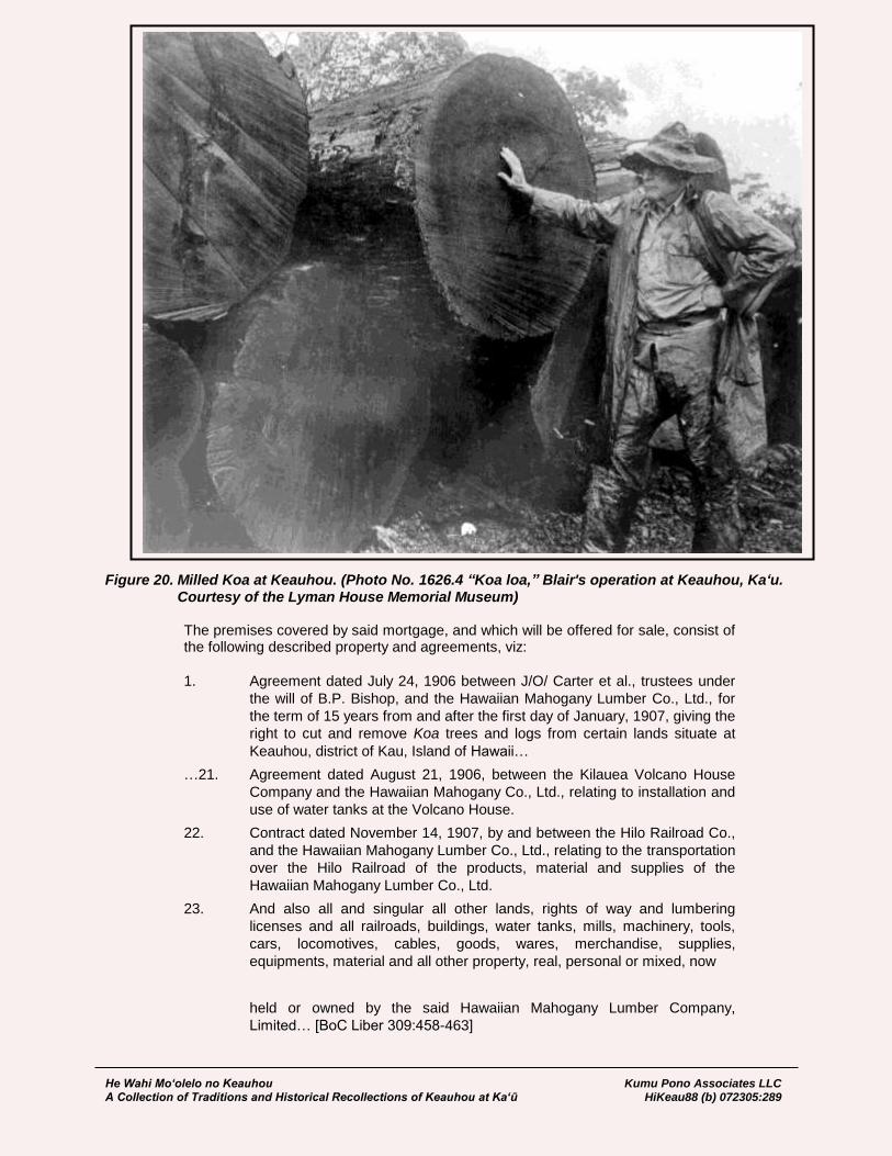
He Wahi Mo‘olelo no Keauhou Kumu Pono Associates LLC A Collection of Traditions and Historical Recollections of Keauhou at Ka‘ū HiKeau88 (b) 072305:289
Figure 20. Milled Koa at Keauhou. (Photo No. 1626.4 “Koa loa,” Blair's operation at Keauhou, Ka‘u. Courtesy of the Lyman House Memorial Museum)
The premises covered by said mortgage, and which will be offered for sale, consist of the following described property and agreements, viz:
1. Agreement dated July 24, 1906 between J/O/ Carter et al., trustees under
the will of B.P. Bishop, and the Hawaiian Mahogany Lumber Co., Ltd., for
the term of 15 years from and after the first day of January, 1907, giving the
right to cut and remove Koa trees and logs from certain lands situate at
Keauhou, district of Kau, Island of Hawaii…
…21. Agreement dated August 21, 1906, between the Kilauea Volcano House
Company and the Hawaiian Mahogany Co., Ltd., relating to installation and
use of water tanks at the Volcano House.
22. Contract dated November 14, 1907, by and between the Hilo Railroad Co.,
and the Hawaiian Mahogany Lumber Co., Ltd., relating to the transportation
over the Hilo Railroad of the products, material and supplies of the
Hawaiian Mahogany Lumber Co., Ltd.
23. And also all and singular all other lands, rights of way and lumbering
licenses and all railroads, buildings, water tanks, mills, machinery, tools,
cars, locomotives, cables, goods, wares, merchandise, supplies,
equipments, material and all other property, real, personal or mixed, now
held or owned by the said Hawaiian Mahogany Lumber Company,
Limited… [BoC Liber 309:458-463]
He Wahi Mo‘olelo no Keauhou Kumu Pono Associates LLC A Collection of Traditions and Historical Recollections of Keauhou at Ka‘ū HiKeau88 (b) 072305:290
On June 4th, 1920, Trustees of the Bishop Estate agreed to an indenture with the Territory of Hawaii, exchanging approximately 12,035 acres of Keauhou for Government land at Mohokea, Ka‘ū. The agreement excluded unrecorded leases between the Estate and the Volcano House Company; O.T. Shipman (for Keauhou Ranch); the Kilauea Military Camp and Territorial Guard; the County of Hawai‘i; and eleven individuals, holding leasehold residential lots (BoC Liber 577:1). The agreement of 1920 provided the Territory of Hawaii, with the lands necessary to form the Kīlauea section of Hawaii National Park. The Territory subsequently transferred the Keauhou-Kīlauea parcel to the United States Government in 1922. For contents of the conveyance see the section of this study titled “Hawaii National Park.”
A.M. Brown, by Trustees, to W.H. Shipman, Limited Bill of Sale December 7, 1937 This Indenture, made this 7th day of December, 1937, by and between Charles S. Davis and Bishop Trust Company, Limited… Trustees under the Will and of the Estate of Arthur M. Brown, Deceased, and Arthur M. Brown, Jr., of Hawaii National Park, Island of Hawaii… hereinafter called the “Sellers” and “Assignors,” and W.H. Shipman, Limited… hereinafter called the “Purchaser” and “Assignee,” Witnesseth that: Whereas W.H. Shipman Limited, has agreed to buy and the sellers above named have agreed to sell all that certain property on the Island of County of Hawaii… known as Keauhou Ranch, including all leases, livestock and improvements belong to and used in the maintenance and operation of said Ranch; and Whereas Charles S. Davis and Bishop Trust Company, Limited, Trustees under the Will and of the Estate of Arthur M. Brown, Deceased, are, under the terms of said Last Will of Arthur M. Brown, Deceased, empowered to sell all real estate, personal property, leaseholds and other property, leaseholds and other property belonging to said trust estate; and Whereas said Trustees are the owners of a two-thirds (2/3) interest in said Keauhou Ranch and Arthur M. Brown, Jr., is the owner of a one-third (1/3) interest in said Keauhou Ranch, Now therefore, Charles S. Davis and Bishop Trust Company, Limited, Trustees… and Arthur M. Brown, Jr., in consideration of the sum of Ten Dollars ($10.00), and other good and valuable consideration to the paid by W.H. Shipman, Limited… do herby grant, bargain and sell unto the Purchaser… as follows:
(1) All livestock including cattle (being cattle branded or unbranded running on
the premises known as Keauhou Ranch and owned by the sellers), horses,
hogs, poultry, and turkeys, together with the brand of Keauhou Ranch and
the right to use the same to be placed on livestock, also the ear mark of
said Keauhou Ranch;
(2) All improvements including fences, house, buildings, corrals, water tanks,
etc. situate on, belonging to and used in the maintenance and operation of
the aforesaid Keauhou Ranch (subject as to all erections and
improvements to the terms of the lease hereinafter mentioned) and also all
tools, machinery and other equipment…
To have and to hold the same unto the Purchaser… absolutely. And for the consideration aforesaid, Charles S. Davis and Bishop Trust Company,
He Wahi Mo‘olelo no Keauhou Kumu Pono Associates LLC A Collection of Traditions and Historical Recollections of Keauhou at Ka‘ū HiKeau88 (b) 072305:291
Limited, Trustees under the Will and of the Estate of Arthur M. Brown, Deceased, and Arthur M. Brown, Jr., Do hereby grant, bargain, sell, transfer and assign unto W.H. Shipman, Limited… All of that certain unrecorded Indenture of Lease, being Bishop Estate Lease no. 5750, dated August 6, 1937, made by and between E. Faxon Bishop et al., Trustees under the will and of the Estate of Bernice P. Bishop… Covering Tract “1” area 27,000 acres more or less and Tract “B” area 8250 acres more or less, situate in Keauhou, District of Kau, Island of Hawaii…, as shown on Bishop Estate Map 236 and 979 on file in the office of the Lessors. To have and to hold the same, together with the buildings, tenements, rights, easements, privileges and appurtenances to the same belonging or appertaining… unto the assignee… for the unexpired residue of the term of the said leas, subject, nevertheless, to the rents, covenants, conditions and stipulations in said indenture of lease and also subject to that certain lease made by the Assignors to Volcano Golf Club dated March 2, 1932, covering the land known as “Volcano Golf Links: as extended to March 31, 1942… It is mutually understood and agreed by and between the Sellers and the Purchaser as follows…:
(4) That this sale is made and the Purchaser acquired said Keauhou Ranch
subject to the negotiation now pending between the Sellers and the United
States of America for the grant by the Sellers for the benefit of the United
State Army of an easement for a pipe line and water tanks on portions of
the property constituting the Keauhou Ranch, and that the Purchaser will
grant said easement in accordance with said negotiations.
(5) That the Seller will abide by and carry out all the terms of that certain
woodcutting privilege as set forth in that letter from the Trustees of the
Bishop Estate to the Sellers dated July 2, 1937, and the reply of the sellers
thereto dated July 27, 1937; all moneys accumulated by the Sellers in
connection with the sale of wood and transferred and set over unto the
Purchaser will be subject to and be used and expended by the purchaser in
accordance with the provisions of said woodcutting privilege;
(6) That the number of cattle included in the sale of the Keauhou Ranch, being
the cattle running on the premises known as Keauhou Ranch, will not be
less than Seven Hundred (700) head… [BoC Liber 1415:177-181]
The 1924 United States Geological Survey Quadrangle Map depicts the location of several historic features described in the preceeding conveyances, or associated with the developments of the National Park and Kilauea Military Camp. It will be observed that the location of the “Old Koa Mill,” Keauhou Ranch, roads and trails of the Keauhou-Kīlauea vicinity are given on the map (Figure 21)
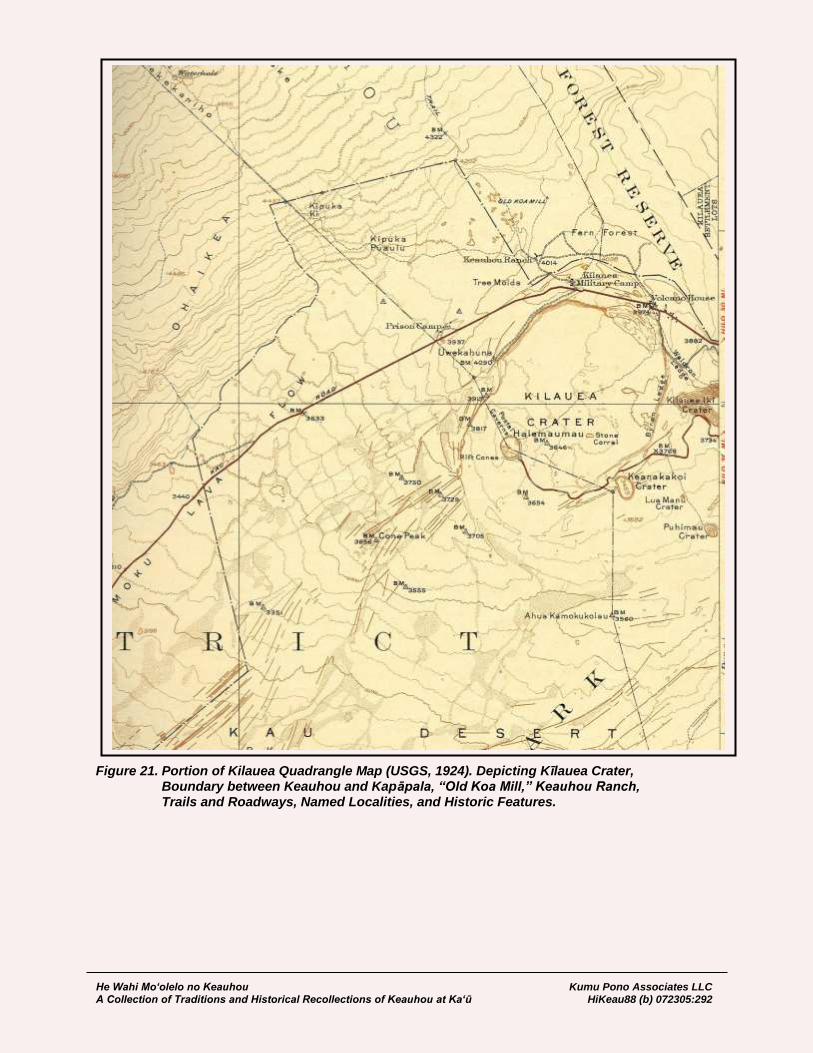
He Wahi Mo‘olelo no Keauhou Kumu Pono Associates LLC A Collection of Traditions and Historical Recollections of Keauhou at Ka‘ū HiKeau88 (b) 072305:292
Figure 21. Portion of Kilauea Quadrangle Map (USGS, 1924). Depicting Kīlauea Crater, Boundary between Keauhou and Kapāpala, “Old Koa Mill,” Keauhou Ranch, Trails and Roadways, Named Localities, and Historic Features.

He Wahi Mo‘olelo no Keauhou Kumu Pono Associates LLC A Collection of Traditions and Historical Recollections of Keauhou at Ka‘ū HiKeau88 (b) 072305:293
The Volcano House and Historical Ledgers Early historical accounts record the presence of native huts and shelters overlooking Kīlauea being in place and built from the time that the first foreigners visited Kīlauea in 1823. We also know that traditional structures ranging from shelters, to long-houses, and heiau occurred at various locations around the lands of Keauhou and the lua Pele, from time immemorial. Among the interesting historical records, documenting the names of visitors, dates of travel, and occurrences of events at the volcano, are the Volcano House Ledgers. Historical accounts describe these volumes as having been started in 1840, though the earliest book now available dates from 1865. The formal appearance of lodging at Keauhou, on the bluff overlooking Kīlauea, was reported to readers of the government newspaper, “The Polynesian,” on July 13, 1844, where readers were informed:
Visitors to the crater of Kilauea will be gratified to learn that an enterprising Hawaiian has erected on the brink of the crater, a comfortable thatched house. He also provides food; and in other ways, has added much to the comforts and convenience of travellers. He deserves to be well patronized. [The Polynesian, July 13, 1844:30]
The Government newspaper, The Polynesian reported to its readers in 1866, that a new hotel was built at Kīlauea, by the following notices:
January 13, 1866:2 Pacific Commercial Advertiser AHEAD OF HONOLULU — The volcano of Kilauea is to be honored with a hotel soon, erected expressly for the comfort of travelers. Mr. Julius C. Richardson has for several weeks been making preparations for erecting a suitable building on the site of the old “crater house,” which every traveler who has visited Kilauea during the last twenty years will remember. He has purchased the materials, lumber and furniture necessary for such an establishment, and shipped them by the schooner Alberni, which takes them to Keauhou, a small port near the crater, where J.C. King’s pulu establishment is located. From Keauhou there is said to be a good road to the volcano, distant twelve miles. In future, therefore, there will be three routes to the crater, one via Hilo, another via Kealakekua, and the third via Keauhou. Mr. Richardson proposes to establish and keep open a good hotel, not on a very large scale, of course, but sufficient for the accommodations of travelers. During 1865, there were over four hundred visitors at the volcano; and with the improved lodgings and comforts, and an enterprising foreigner to look after them, it is not unlikely that there will be fully one thousand during the present year. Travelers heretofore have generally stopped only one night; but with comfortable lodgings and a well-furnished table, every one will expect to spend several nights, or even a week, as the beauty of the volcano is chiefly in the night views. It has always been rather annoying to gentlemen who wished to spend more time there to be compelled to leave before their visit was half up, on account of the discomforts encountered, especially by their lady companions. Mr. R. appears determined to overcome all obstacles, and will no doubt make the place attractive and comfortable to visitors from every part of the globe. Success to the enterprise.
March 30, 1866:2 Pacific Commercial Advertiser VOLCANO HOTEL. — By an advertisement in today’s paper, it will be seen that the new hotel at Kilauea, to which we lately referred, has been completed, and is now
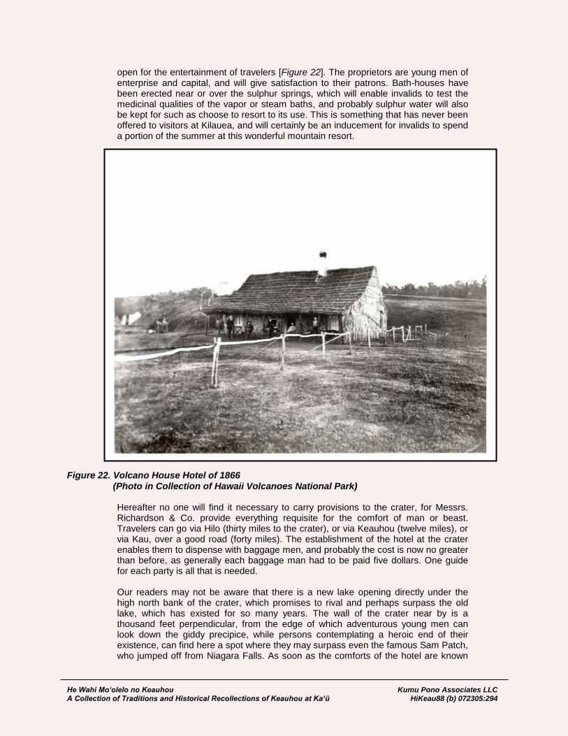
He Wahi Mo‘olelo no Keauhou Kumu Pono Associates LLC A Collection of Traditions and Historical Recollections of Keauhou at Ka‘ū HiKeau88 (b) 072305:294
open for the entertainment of travelers [Figure 22]. The proprietors are young men of enterprise and capital, and will give satisfaction to their patrons. Bath-houses have been erected near or over the sulphur springs, which will enable invalids to test the medicinal qualities of the vapor or steam baths, and probably sulphur water will also be kept for such as choose to resort to its use. This is something that has never been offered to visitors at Kilauea, and will certainly be an inducement for invalids to spend a portion of the summer at this wonderful mountain resort.
Figure 22. Volcano House Hotel of 1866 (Photo in Collection of Hawaii Volcanoes National Park)
Hereafter no one will find it necessary to carry provisions to the crater, for Messrs. Richardson & Co. provide everything requisite for the comfort of man or beast. Travelers can go via Hilo (thirty miles to the crater), or via Keauhou (twelve miles), or via Kau, over a good road (forty miles). The establishment of the hotel at the crater enables them to dispense with baggage men, and probably the cost is now no greater than before, as generally each baggage man had to be paid five dollars. One guide for each party is all that is needed. Our readers may not be aware that there is a new lake opening directly under the high north bank of the crater, which promises to rival and perhaps surpass the old lake, which has existed for so many years. The wall of the crater near by is a thousand feet perpendicular, from the edge of which adventurous young men can look down the giddy precipice, while persons contemplating a heroic end of their existence, can find here a spot where they may surpass even the famous Sam Patch, who jumped off from Niagara Falls. As soon as the comforts of the hotel are known
He Wahi Mo‘olelo no Keauhou Kumu Pono Associates LLC A Collection of Traditions and Historical Recollections of Keauhou at Ka‘ū HiKeau88 (b) 072305:295
we predict there will be a crowd of visitors to see the new sights, and of patients to quaff the health-giving vapors that rise from the fiery domains of Madame Pele.
The great earthquakes of 1868—described in earlier sections of this study—caused the pali of Keauhou to collapse, and destroyed the Keauhou Landing (Ke Alaula, 1868; and Jarves 1872, in this study), though the Volcano House suffered no damage (Whitney 1875, in this study). In 1875, H. M. Whitney, editor of the Hawaiian Gazette, provided readers with a detailed account of the volumes of what became the Volcano House Ledgers. His narrative is of particular importance as it discusses the books, then in use from 1865 to 1875, and also describes, with excerpts, the three volumes dating from 1840 to 1864, which are apparently, no longer available. Whitney wrote:
Editorial Correspondence – No. 4 Volcanic Specimens from Kilauea. VOLCANO HOTEL, December, 1874. No traveler who visits this place should be content with simply recording his name and observations in the record book, but should take time to look through the volumes, which contain the autographs of several thousand visitors, some of whom had since their visits attained considerable fame. Of these volumes there are two at the hotel, and in all there must be four or five, with dates as far back as 1840, when the American exploring expedition, commanded by Captain Wilkes, was here, and made extensive explorations. The full record book now to be found at the Hotel, and which is probably volume 4, commences with the date of February 2, 1865, and closed with December 31, 1872, covering a series of eight years. Under the first date, travelers and passers by are requested by the donor of the volume “to record their names in it, and to note all or any volcanic phenomena that may come under their notice during their visit. By so doing,” it is added, “this record may become of great value in years hence to the scientific world.” These remarks are in the handwriting of Mr. Orramel Gulick, but the name of the modest donor of the book is not inserted. We spent an hour or two examining its pages, and made a few notes: In 1863, a large overflow of lava is recorded which covered one half of the floor of the basin, or 1,000 acres. At this time was formed a large lake under the northern bank, distant one and one half miles from “Halemaumau.” How long this continued active is not stated. In August, 1865, we find a record by Chas. Walcot Brooks and Wm. T. Brigham, who state that “Vesuvius is nothing compared to Kilauea, and the lava is of an entirely different nature.” Some of the observations made in the book, are quaint, others humorous, while many are attempts at the grand and sublime. Among the quaint, we find that of a Western New Yorker, who hopes that any visitor who passes by his residence (which he states very minutely) will inquire after him and report how “old Pele” is getting on. He apologizes for his haste, as his horse is lame and has no grass, and he is half starved. One ambitious traveler, after writing a five-page notice of his peculiar views and observations, signs himself, “Chas. W. Marlette, of Morgan Co. Ill., a loyal American citizen, and a friend of liberty and union, now and forever, one and inseparable.”
He Wahi Mo‘olelo no Keauhou Kumu Pono Associates LLC A Collection of Traditions and Historical Recollections of Keauhou at Ka‘ū HiKeau88 (b) 072305:296
Some annotator adds, “the band then struck up Hail Columbia and Shoo Fly, interspersed with rebel airs.” Wide-awake advertisers come all the way from foreign cities to herald their wares, and occasionally a page is found devoted to them. But we looked in vain for the cabalistic “S.T. X 1860” of the plantation bitters—they are not yet in the record book nor on the high walls of the most famous volcano in the world. On one page we found a caution to travelers visiting the crater to insure so that their friends may have some remembrancer of their prudence, should the fiery lake overflow and swallow them within its surging bosom. The Manhattan Life Insurance Company of New Youk was recommended as the best. This notice was signed by Mr. Landers, general agent for California, whose death was recently announced, and who visited these islands in 1867 and 8. Even politics finds a place in the record book, and on one of its pages is sketched a full-length portrait of Mr. Greely, bearing an American flag inscribed “Anything to beat Grant,” while he is made to utter, “What I know about Volcanoes!” Under date of April 2, 1868, when the last great earthquake and eruption took place, it is recorded that the fire in Halemaumau became extinct, and continued so till May 27. Singularly enough, the shock was not felt by the inmates of the hotel, nor was the tall chimney broken or injured in the least, nor any damage done to the premises. The overseer accounts for this, by it being located on an island or rather it is separated from the surrounding land by deep fissures, giving it an isolated position. Occasionally, very clever sketches are found, the handiwork of artists who have visited the crater. Among these, one of the best is under date of March 1869, where the scientific corps of the U.S. Ossipee are pictured to the life, furnishing one of the most comical scenes in the book. Another artist, under date of March 12, 1871, sketches “Ye gay and festive Party,” consisting of three ladies and three gentlemen, which is most capitally done. At the end of this volume, several pages are devoted to Mark Twain, who appears to have seen Kilauea in its glory, and his famous dream of what he saw there is copied in full in manuscript, taking up several pages. The last entry in it closes December 31, 1872, and the new Volume V., now open for signatures commences with January, 1873. From present appearances it will be as curious and valuable as any of the previous. Regarding the other three volumes of record books I can find no trace of volume one, dating from about 1840 to 1847, and it probably has been lost. Volume two was rebound in 1860 for Mr. Benj. Pitman, and is probably now in his possession. Volume three is said to be in the possession of a gentleman on Hawaii. It would be well if these could be collected and preserved in the national library in this city for future reference. In this way they would be safely kept, and be useful and accessible to all. While volume two was in my possession, a few years since for binding, I preserved some data which will be of interest here. Its records commence with Oct. 13, 1847, and end in 1857, covering ten years. The first entry in it is made by Hon. A. Ten Eyck, U.S. Commissioner, who visited the crater with J.J. Jarves and his wife, H.B. Johnson of New Bedford, Rev. J.D. Paris, Stephen H. Williams, Capt. Ottis Webb of ship Ohio, Capt. Geo. A. Covell of ship Vernon, and others. Under date of Dec. 2, 1847, Mr. B. Pitman states that he made the circuit of the crater on foot in four hours and ten minutes, not far from ten miles. In the same month and year we noted the names of Capt. Gelett and wife, Miss Margaret A. Mills, and Capt.
He Wahi Mo‘olelo no Keauhou Kumu Pono Associates LLC A Collection of Traditions and Historical Recollections of Keauhou at Ka‘ū HiKeau88 (b) 072305:297
J.W. Grew of ship Uncas. In June 1848, Com. Glynn and officers of the U.S. ship Preble, record their arrival, and in connection with it, Christopher Baker, pilot of Hilo, notes this as his fifty-fifth trip. In August of the same year we find the name of Capt. Shubrick of the U.S.S. Independence. Among the officers was Lieut. Henry A. Wise, since well-known author of “Los Gringos,” and other works. Turning to another page, under date of August, 1848, we find recorded the names of Bishop Maigret, and several catholic missionaries. Also that of our townsman David N. Flitner, who recorded, “very little fire in the crater, and it is cold enough to freeze poi.” He advises travelers “to bring blankets.” Next morning, the 28th, he states that the crater “burned very brightly last night, but continued so only an hour.” On the opposite page is an illustration of a forlorn traveler, in the usual costume, mounted on a refractory mule, and plodding through the mud and rain. Oct. 4, 1848, Richard Armstrong records crater very inactive. Mr. S.S. Hill of London notes March 9, 1849, “several cones like Vesuvius in miniature.” May 29, 1849, Capt. Jones of the U.S. ship Ohio, records “Mauna Loa in an active state, the fire on the summit blazing up and presenting an interesting appearance, both from this place and the anchorage in Hilo. On July 5, 1849, we find recorded the arrival of King Kamehameha III, accompanied by Prince Alexander Liholiho, C.G. Hopkins and numerous Chiefs, enroute from Kona to Hilo. During the same month the captain and officers of H.B.M. ship Amphitrite visited the crater, and recorded their obligations to the King and his party for many courtesies shown them. “Mokuaweoweo still in action.” The next few pages have the names of Rev. L. Smith, Miss Emma Smith, J Fuller, S.G. Dwight, A.K. Clark. “Volcano very quiet.” In 1850, we see the names of W.B. Rice of Boston, Mrs. L.C.C. Brickwood, Sarah Andrews, Henry Rhodes, and officers of the U.S. ships Falmouth and Vandalia. In May, 1851, Julius L. Benchley and Chas. Smeathman of England report the volcano very inactive. Near the above we find one of the last records of the lamented Boyd of the yacht Wanderer. It reads, “Aug. 1, 1851, B. Boyd, Merton Hall, Weytonshire, Scotland, Wandered, schooner, Royal Yacht Squadron. To the goddess Pele:—I have visited every quarter of the globe, but have seen nothing which conveys the idea of such utter desolation as thy infernal regions. A Wanderer.” It will be remembered that he was killed soon after leaving here by the native of some island west of this group. On the opposite page is a clever sketch of the native guide who accompanied the party, and under it a few lines stating his name and that he had visited England in 1816, in a British whaler, and had lived one year in London with the family of Mr. Bligh, the owner of the whaler.
He Wahi Mo‘olelo no Keauhou Kumu Pono Associates LLC A Collection of Traditions and Historical Recollections of Keauhou at Ka‘ū HiKeau88 (b) 072305:298
Following soon after, July 1, 1851, we find the names Wesley Miller of Troy, New York, W.H. Mack, Maine, Dr. J. Mott Smith, who says he is satisfied with at last seeing a genuine volcano, and leaves with a desire to examine it more at Leisure. Judge J. Lippett was very much annoyed with difficulties and gives the following advice: “If people will take my advice and experience, they will never go beyond the half way house, for the following reasons: 1st, exposed to a drenching rain or scorching sun; 2d, a long rood and rough traveling; 3d, encountering an innumerable army of fleas, remarkably blood-thirsty; 4th, three times thrown from my horse; and lastly, nothing of special interest to see.” July 3, 1851—J. Gaskin, Capt. Oldham and officers of H.B.M. ship Swift, and Dr. B.L. Ball were among the visitors. March 1852, we find the names of Capt. D. P. Penahallow, Capt. W. Babcock, Chas, Brewer 2d, and wife, W.A. Aldrich, J.T. Ludlow, Miss Holt, Miss E.J. Dowsett and others. About the same date are found the names of the officers of the U.S. ship St. Mary, one of whom, G.E. Gates, perpetrates a few lines of poetry: “Oh I have roamed in many a land, And many a humbug met, But ne’er one that could compare With this same crater yet.” Probably one of the same party leaves the following; “Je-ru-salem! w-a-l-l! thunder and coonskins! May I be struck forked end uppermost into a bar-hole, if this ere old cratur aint some shakes! It beets Uncle Ebineezur’s brush-heep burnings all hollar. Snakes and alligaturs! Crocadiles and Mississippi snags! Hyenas and Rocky mountain grizzlies! W-h-e-w! Joe-whittiker! In the words of the immortal Crockett, when he was lecturing to his constituents, on the banks of the Blue Lick, Go it old cratur, go it, while yure yung!” In October 1852 and 1853, several visitors note that the volcano had become very active. S.A.W. Hatchett, in March 1853, says, “I have seen the Mammoth Cave and Great Niagara, the natural bridge of Virginia, the splendors of San Loui Potosi, Vesuvius, Etna, and other volcanoes, but Pele is the most sublimest of them all!” In 1853, we find the names of Sarah K. Clark, C.S. Kittridge, Miss I. Chamberlain, Julius E. Remy de Livry, Julius L. Brenchly, — the latter recording their views at some length. In 1854, are the names of Dr. F. Homan, C. S. Bartow, Capt. Pierce, of ship Kutusoff, and Captains Green and Nickerson. Then follows a series of very fine sketches, which add greatly to the value and interest of the book. In 1853, Hon. D.L. Gregg, Chas. A. Dana, P.W. Graves, H. Pendergast, W.B. Rice, L. Hanks, J. Fallon, T.H. Marshall, Dr. Stangenwald, H. Turton, J.H. Wood, John Ritson, Dr. C.F. Winslow, H. Williams, Capt. Killmer and others record their narratives. This volume ends with 1857, and among the last entries in it, Dr. J. Mott Smith records his second visit, when the crater was very active. As we said before these old volumes ought to be collected and deposited in the Hawaiian Government Library for preservation. H.M. Whitney [The Hawaiian Gazette
He Wahi Mo‘olelo no Keauhou Kumu Pono Associates LLC A Collection of Traditions and Historical Recollections of Keauhou at Ka‘ū HiKeau88 (b) 072305:299
January 13, 1875:2] As the new Volcano House facility was being developed, a bound ledger was donated by Orramel G. Gulick, for the purpose of recording names and comments. In 1904, W.D. Westervelt penned an article documenting various facets of the Volcano House and its ledgers, commenting on the wide array of notes and comments found within them. Westervelt wrote:
The Volcano House Records …The story of the Volcano House itself is worth telling and should be put on record by some one who knows the facts and the dates. There was the old grass house, sometimes dry and sometimes damp and mouldy, but the best shelter visitors and collectors could find when seeking a cover under which to arrange their collections of lava specimens. There was the old frame building in which “guests” were provided for, instead of being left to take care of themselves, as had formerly been the case. Then came the new building with its conveniences and luxuries. Under the present management far better accommodations are provided than could reasonably be expected when contrasted with the best which could be secured not very [Westervelt, 1904:11] long ago. The story of the Volcano trail is also worth telling. Kapiolani, the noted Hawaiian queen who made a special journey to the pit of Pele (Lua Pele), which lies in the large crater of Kilauea, had to travel on foot over rough lava beds, until tired and footsore, she stood on the crater’s edge and hurled defiance to the fire goddess. Later visitors rode on horseback or followed the example of the queen and walked. Now, the volcano is easily reached by railroad trains, and stages, over a government road which is a boulevard compared with the trail of fifteen years ago. The management of the Volcano House has changed several times during its history. Sometimes private parties have tried to provide for visitors and then again Wilder’s Steamship Co. and other corporations have taken the house in charge. But through all the changes in both buildings and management the series of manuscript books have been preserved and important records placed therein. These are called “The Volcano House Records.” Almost forty years ago a party of young people, residents of these Islands, made a visit to Kilauea. One of the party felt that the changes in volcanic phenomena should not be left to memory or even to the letters of visitors, for these letters are easily lost and are also difficult of access. Therefore he carried with him a large blank book and left it in the Volcano House. It was dedicated to the public by the young man who donated it with this inscription:
Feb. 2, 1865.
“Travellers and passers by are requested by the donor of this book to
record their names in it and to note all or any phenomena that may come
under their notice, By so doing this record may become of great value
some years hence, to the scientific world. — O.G. Gulick.”
Some six or seven volumes now form the library started by Mr. Gulick in 1865. Hundreds of visitors have inscribed their names and experiences, and hundreds more have amused themselves with the quaint, curious, valuable and sometimes conceited and foolish records placed therein. Once in a while a writer has used the pages for the purpose of advertising his name, residence and business, although to the credit of the large number of business men who must have visited the crater during the past forty years, it must be said that very few have allowed the least suggestion of an advertisement. Poetry, such as it is, abounds. It would be difficult to find any verses which are worth quoting, but there are little touches of beauty here and there, by the

He Wahi Mo‘olelo no Keauhou Kumu Pono Associates LLC A Collection of Traditions and Historical Recollections of Keauhou at Ka‘ū HiKeau88 (b) 072305:300
side of much that is comic and some that is so poor and maudlin that one visitor was led to remark:
“A poet who writes inspired by gin;
should be taken to the crater and thrown in.”
Sometimes acts of vandalism have been perpetrated and a few names have been stolen from the books. Some one desired the autograph of a noted person or perhaps a list of names and simply cut it out. Thus, Mark Twain’s autograph was taken. And yet such vandalism is exceedingly rare… There are notes now and then touching upon the fabled goddess Pele and her worship, but no record of any of the Pele legends. The interest of visitors would be greatly enhanced if the island people could take time to collect and note some of these traditions. The coming of Pele and her sisters from a foreign land centuries ago; the residence in the region of the volcano; the probable wiping out of the family by some great volcanic outburst, when ashes, small stones and pumice were scattered for miles around throughout the country tributary to the volcano; the legends of the various adventures of Pele, after she was supposed to take up her residence in spirit-form in the lake of fire, and her conflicts with various admirers would make a very interesting legendary reading for those who rest on the veranda of the Volcano House and look over the escaping volumes of smoke beneath them. Sometimes there is a hint of Pele worship as on September 1, 1865, when a visitor notes that a party of thirty-seven natives is visiting the volcano. He says: “They have been down to the lake of fire and have threw in shoes, knives, handkerchiefs, coins, etc.” These offerings were prized articles and were made out of this poverty of personal effects. Sometimes the Hawaiian visitors are simply recorded as “parties,” but between the lines is very interesting unwritten history which is learned only from the conversations of the dining table and the evening circle. Then the stories are told of chickens and fruits and the articles especially devoted to Pele, taken in recent times to the crater and thrown into the hot depths—sacrifices to the goddess. Sometimes the more gruesome stories of the Pule-anaana, or “praying to death,” are whispered, for then the story is told of human flesh taken from the body of some dead member of a family and cast into the pit of Pele, in order that the worshipper might be endued with a new spirit-power ad become a witch doctor. But scarcely a hint of all this is touched in the story of the books of the Volcano House. Frequently the visitor records his disappointment in view of what his dim imagination had previously pictured. It is difficult nevertheless to over paint the feeling of sublime mystery which always attends the outlook upon even the most quiescent state of crater-activity… The mysterious earth-forces are always at play around the Volcano House and in the crater—the smoking sulphur [Westervelt, 1904:12] beds, the hot air and the overpowering fumes of brimstone escaping from the cracks in the floor of the great crater, the immense fields of tossed and twisted lava which give way at times and let the careless traveller fall into some hidden cavern, the immense fern fields and koa forests, the smaller extinct craters which abound between Kilauea and the ocean. These and many other objects of lesser interest can give a thoughtful tourist pleasure as long as he’s able to remain. One person records his disappointment, but another on the same page will express his gratification.

He Wahi Mo‘olelo no Keauhou Kumu Pono Associates LLC A Collection of Traditions and Historical Recollections of Keauhou at Ka‘ū HiKeau88 (b) 072305:301
There can never be wheat without chaff, and there is very much valuable material sandwiched between records made by many visitors. Careful observers have made notes of great value which are not difficult to separate from the mass of names and nonsense around them. Mr. Gulick’s purpose has been abundantly carried out, and his public-spirited foresight has been fully justified. Scientists from various nations have jotted down their observations and impressions. Residents of the Island have noted the volcanic phenomena and changes of the crater occurring during the past forty years. Maps and outline diagrams of the crater have been made from time to time. This has all been done with more or less haste and yet, when the various statements are compared, the history of the crater during the past forty years can be said to be quite complete. It is a little curious to note the fact that the men who have felt the importance of the record are almost without exception men of missionary or religious training. The Hitchcocks, Rev. E. P. Baker and Dr. Wetmore, of Hilo; Dr. Hillebrand, L. A. Thurston, W. R. Castle and others, of Honolulu, have all taken especial pains to make their visits to the crater worth something to future visitors. They have made measurements of the crater, drawn diagrams and stated facts. Some of the United States surveys as well as those of the island government have been recorded in such a manner as to give quite a clear idea of the different lakes of fire. Some writers by contrasting their past with their present experiences have left very useful dates and descriptions. In this way personal testimony is given to the fact that different observers have noted an apparent decline in the activity of the boiling pit during the century past. Kilauea was exceedingly active at the time of Kamehameha’s conquest of the islands. While he was carrying on a war with the high chiefs of Hilo his most important enemy, Keoua, prepared an army to meet him. After several [Westervelt, 1904:13] indecisive battles Keoua retreated to the district of Kau, passing by the great volcano. His army was divided into three divisions. One division had passed, but while the second body journeyed by there was a terrific earthquake and an immense outburst of black sand, pumice stone, ashes and cinders. The cloud of debris mixed with masses of smoke and poisonous gases rose to a great height and fell upon the surrounding country for miles around. The middle division of the army was overwhelmed and utterly destroyed. Some of the party were found lying down, some sitting, and some clasping wives and children in the final throes of death. This was a time of exceeding great activity, which has not been equaled during the hundred years which followed. The island people who have called attention to this decline in activity state again and again that the fires in the crater seem to grow less and less, until at last the almost entire absence of floods of burning lava present a strong contrast to the eruptions of a century ago. It must be borne in mind, however, that in the absence of regular records, the memory of man would take note only of eruptions and not of periods of quiescence. The Volcano House Records bring out a fact of considerable interest when these periods of disappearance of fire are placed by the notes which relate any especial volcanic activity. For forty years and more the records show that the disappearance of smoke and fire from the crater has been closely connected with some eruption in the surrounding country. These eruptions usually precede the withdrawal of fire, as if the lava had been drawn off through the vent offered by the eruption, leaving the crater empty, but after a time the smoke has returned—and the pit of Pele has again shown activity. Hillebrand gives the first record of this kind when he writes in April, 1868: “For the first time since 1840, when Kilauea erupted its liquid contents through subterranean conduits in the flow which reached the sea at Nanawali [Nanawale], Puna, the crater is again quiescent. I have made full circuit of the crater and find not a
He Wahi Mo‘olelo no Keauhou Kumu Pono Associates LLC A Collection of Traditions and Historical Recollections of Keauhou at Ka‘ū HiKeau88 (b) 072305:302
trace of liquid lava. There are vast pits with toppling walls of frightful desolation. Steam is rising from most of the crater, almost from every crack. The floor is hot. Of mineral gases only faint traces are perceptible here and there.” “The lava has passed underground forty miles to appear in a destructive flow in the district of Kau.” But the crater soon began to manifest signs of life, and the Volcano House Records tell of renewed activity in the form of five eruptions over the floor of the large crater. Then came the records of earthquakes and apparently submarine flows of burning lava, with the disappearance again of the fire and smoke. Hence from time to time the only view from the Hotel was of black lava with occasional puffs of smoke, and around the crater on the north and east beautiful vistas of tropic foliage while desolation reigned over the brown territory southwest, across which at other times the vast clouds of smoke and sulphur fumes have poured month after month and year after [Westervelt, 1904:14] year. Thus the record is made of eruptions and qui-escence with the almost unanimous testimony that activity has been far less during the past forty years than it was a hundred years ago. It is interesting to note the dates of disappearance and return of activity to the house of continual burning, as gleaned from the Volcano House Records. In 1840 the lava sank from the crater and passed underground eastward, breaking out on the sea shore about twelve miles distant. At that time for a few days there was no fire in the pit of Pele. In 1868 the lava again journeyed underground toward the southwest. The fire in the crater disappeared. Again in 1877 activity ceased for a while, caused by another supposed underground discharge of lava. So also in 1880, and again in 1886, when boiling spots in the ocean gave some evidence of the lava having escaped into the sea. Then came a time of intense activity in 1890 and 1891 and the consequent disappearance of fire, to reappear shortly in one lake instead of three and in varying degrees of life in that one spot. It is safe to say that for the past thirteen years the crater has been comparatively quiescent according to the records. But the mysterious life and subterranean activity are still manifest in large measure and the great crater is always worth a visit. [Westervelt, 1904:15]
Excerpts from the Volcano House Ledgers (1865 to 1916) Surviving volumes of the Volcano House ledgers are housed in the collection of Hawai‘i Volcanoes National Park, and include a number of interesting accounts. Some of the entries were penned by members of the royal families of Hawai‘i—including Prince Leleiohoku and Queen Lili‘uokalani and others; while others were penned by native residents visiting from Hawai‘i and neighboring islands, and foreign visitors and residents. As noted by both Whitney and Westervelt above, some of the entries include rich and interesting narratives. The selections cited below are from the ledgers, spanning the period from 1865 to 1916. The selected entries describe the natural features of the volcano—with changes observed by repeat visitors; conditions of travel to the lua pele, including the access from the Wilder’s Steamship Landing at Keauhou beginning in 1886; the growing services and facilities of the Volcano House; Hawaiian expressions of attachment, and respect for Pele and the cultural landscape; and the early seeds of thought, leading to the establishment of the National Park. The selected Hawaiian entries were translated by Maly25.
25 Kepā Maly worked at Hawai‘i Volcanoes National Park from 1979 to 1983, and during that time, prepared
translations of selected entries in the ledgers. As a part of the present study, further research was conducted in the HAVO Library, and through the courtesy of Tracy Laqua (NPS staff), additional records were viewed and made available.
He Wahi Mo‘olelo no Keauhou Kumu Pono Associates LLC A Collection of Traditions and Historical Recollections of Keauhou at Ka‘ū HiKeau88 (b) 072305:303
February 2, 1865 O.H. Gulick (Donation of a ledger for the recordation of visitors observations): Travelers and passersby are requested by the donor of this book to record their names in it and to note all, or any, volcanic phenomena that may come under their notice during their stay or at the time of their visit. By so doing, this record may become of great value, some years hence, to the scientific world. The testimony of all those who visited the volcano of Kilauea years ago seems to indicate that there was much greater activity apparent forty years ago, than there is at present. About the beginning of the present century tradition says that a party of warriors from Hilo on their way to Kau under Keoua, a brother of Kamehameha I, were killed while descending the slope from Kilauea to Kau, by the falling of a cloud of hot cinders thrown out by the volcano, Keoua himself, taking a different road, with part of his men, escaped unharmed. This account is considered reliable and may be found in the histories of these islands; and indicates a greater activity than at present witnessed. In September 1863 a crack opened in the northern bank of the crater, varying from three to six or eight feet in width, and being some miles in length, it was first observed by J.H. Coney Esq. while on his way to Kau, Sept. 6. It crossed the road from the Volcano House to Kau up on the high land on the north side of the crater. For some years past previous to 1863, the most of the fires visible were to be seen at, or in the vicinity of, the lake, in the S.W. part of the crater, but in May or June 1863, there was an extensive eruption in the northern part of the crater, which flowed over perhaps one third of the whole basin of the crater, the fresh lava covering perhaps over a thousand acres. Since that time, the second or smaller lake at the northern side of the crater has been formed—and seems to have become a permanent institution. The two lakes are perhaps a mile and a half apart. There is more or less smoke issuing from many of the cracks in a line between the two lakes. The island that has been in the large lake for some time past has disappeared.
November 27, 1865 Emalia Kauhane: Ua hiki mai au i keia la a ua ike au i ka hana a ia kupu eu e hoolailai ana ia i ua uka anu ala i uhi paa ia i ka noe a ua honi hoomau aku au i na ea oluolu maikai nolaila he nui ka iini a me ka hakui lua ole o ka puuwai e hana nei la i na mea he nui kino i ka ike ana i kana mau hana kupaianaha nolaila ke huli hoi nei au ke nee ae nei ka ohu e uhi paa i ka luna o Maunaloa a ke hoolai no na keiki o Kaluaopele. Ua pau me ke aloha, Emalia Kauhane. Eia kekahi mea au i mahalo ai o ka hao mai ona.
I arrived today and saw the mischievous doings of that supernatural being,
who calms the cool, fragrant uplands, covered by the mist. I continually
breathed in the pleasant and fine air, and there arose in me great desire
and unequalled palpitations of the heart, to do what I had not done before,
He Wahi Mo‘olelo no Keauhou Kumu Pono Associates LLC A Collection of Traditions and Historical Recollections of Keauhou at Ka‘ū HiKeau88 (b) 072305:304
that is, to view her marvelous works. Therefore, I turned back as the fog
crept along and covered the heights of Maunaloa, calming the youth of
Kaluaopele. So this is done with aloha, Emalia Kauhane.
Here is another thing, I admire her surprising nature.
July 19, 1866 M.A. Chamberlain, Honolulu: Having visited Kilauea in the days when the old shed with its open door and hole in the centre, for a fire place, were all the accommodation for poor weary chilled travellers; how great is our appreciation and admiration of the present delightful dwelling which well deserves the name of hotel. Well may Madame Pele now light up her fires and advertise for visitors since she can receive them with hospitality.
August 6, 1866 Gerrit P. Judd, Comments on new accommodations at the volcano: I first visited this crater in July 1830, when its depth was three or four times greater than now. In 1849 I marked a spot upon the bank, estimated 60 feet above the bottom, which is now out of sight. To those who have visited this place in former times, nothing need be said in commendation of Messrs. J.S. Richardson & Co. who have converted the sojourn here from a scene of suffering from cold and wet and hunger, into one of comparative comfort. To others I say come and try it.
October 23, 1866 Gerritt P. Judd: Since the 6th of August the long ridge of rocks and earth which had fallen from the western wall and appeared to be floating into the middle of the crater bottom has bloated past the middle to the eastward. The centre is rising slowly without change of surface, while the sides of the whole crater have been overflowed and kept full by fresh lava. The action tonight of the South Lake is grand. There are several new lakes.
April 18, 1868 William Hillebrand: Kilauea is dry, for the first time since 1840, when Kilauea emptied its liquid contents through subterranean conduits in the flow which reached the sea at Nanawali [Nanawale] in Puna. This time it seems to have sent them underground a distance of 40 miles to rise in the destructive eruptions at Kahuku in Kau. We have today made a full circuit of the crater and not found a trace of liquid lava, not a vestige of the incandescent lakes remaining, in place of them vast pits, with beetling toppling walls, of frightful desolation. At least two-thirds of the area of the crater towards W. and N.W. have caved in and sunk about 300 feet below the level of the remaining portion of the old floor. Near the N.W. corner, the principal seat of the fearful catastrophe of 12 days ago, there exists a deep chasm of about 1/3 mile in length, the surrounding ground thrown in the utmost confusion and disorder. Heavy vapors of steam rise from most parts of the crater, almost from every crack and chasm, and the floor is in many places so hot that the hand does not bear its touch, but of mineral gases, so abundant formerly, there are only faint traces perceptible now, here and there. During our stay below, twice heavy detonations occurred of falling rocky masses, indicating the continued caving in of portions of the floor, both coming from near the western wall. Portions of the eastern wall have been thrown down by the earthquake of April 4 and heavy boulders obstruct the path leading down. A great number of crevices (one not far from the Puna road, 14 feet in width) have formed in the immediate
He Wahi Mo‘olelo no Keauhou Kumu Pono Associates LLC A Collection of Traditions and Historical Recollections of Keauhou at Ka‘ū HiKeau88 (b) 072305:305
neighborhood of the crater. The bottom of Kilauea Iki, formerly covered with thick vegetation, is now floored with black lava which rose in it between 6 and 10 p.m. on April 4.
April 19, 1868 William Hillebrand: Pele has roared again last night. Fire was seen in the south lake at 12 midnight. Reports from Kau have come in that the eruption at Kahuku ceased two days ago. April 27, 1868 Frank Spencer: Arrived at this hospitable house at half past one P.M. in company with Mr. G. Holmes. We left Waimea on the 18th. Visited the new flow at Kahuku. [Lists party.] We found the flow came from an immense split or ravine with quite a number of cones. The lava was hot and steaming on 23rd. Capt. Haley and Nicholas George indeed showed us great kindness. After two days rest there, we made the ranch of Mr. C. Richardson, who received us very kindly, and accompanied us to the new flow at Nuka Pili [Nukupili]. We found red hot lava but the flow had ceased. The pahoehoe was quite hot. The flow also appears to come from a split or ravine. The extent appears about a mile I guess or more. The mud flow near Mr. Richardson’s where some 31 persons perished is well worth a visit. Mr. Holmes and myself went to the top. I must say it is the hardest walk one can take. I visited this place on the 13th of November 1864. Although the volcano now appears almost lifeless, the many comforts one can enjoy in this new House of Rest after a journey from Waimea, one should feel satisfied. No doubt Mrs. Pele will assume all her grandeur shortly—like a sperm whale she has only gone down to rest and I hope to hear before long that she is again spouting in all her glory. The crater is full of steam and smoke. I cannot recognize any part as belonging to that which I visited in 1864. No doubt the two new flows have in a great measure weakened her resources. P.S. The mud flow was caused by the Great Earthquake on April 2nd was so sudden and quick that it could not be seen by those who were within a short distance. 28th. Quite unwell with influenza, hope to make a start for Hilo tomorrow. Pele was illuminated all last night. Quite a grand sight.
June 16, 1870 L. Severance, Punaluu Oahu; John D. Brewer, Honolulu; L.L. Austin, Onomea En route for the summit of Mauna Loa. We came up today from Keauhou in company with Mr. G.W.C. Jones, having made the journey through the Puna district to Keauhou, a journey which we advise all to take. It is eighteen years since my first visit to Kilauea, and since that time there has been a great change in the floor of the crater. The crater now looks as I imagine it looked to Wilke’s party in 1841 after it had been drained off by the eruption of 1840—as it has recently been emptied by that of 1868. During the interval between those dates it had filled up, and instead of the depression in the center which now is there, there was a hill in some places one hundred feet high. But the greatest change is in the accommodations now but those who have experienced the discomforts of camping
He Wahi Mo‘olelo no Keauhou Kumu Pono Associates LLC A Collection of Traditions and Historical Recollections of Keauhou at Ka‘ū HiKeau88 (b) 072305:306
out at Kilauea in old times can appreciate the energy which had been displayed by the proprietors of the new volcano house. June 22. The above party have just returned from a successful visit to the summit of Mauna Loa. We left Richardson’s Kapapala Monday 20th at 9 o’clock and stopped at Capt. Elisses and watered our mules and filled our water containers, and arrived at the camping ground at the upper edge of the woods at 4 P.M. Here we pitched our tent and made things comfortable for the night, at an altitude of about 8000 feet. The temperature at 7 P.M. was 54, at midnight 42. Early the next morning we were off for the summit. About a mile above the woods all vegetation ceases, and for the rest of the way the trail is over pathless tracts of lava (pahoehoe). At 11:20 A.M. we reached the summit and the great Crater of Mokuaweoweo having ridden all the way up (the first time it was ever done). We found no action in the crater excepting a few steam cracks on the west side. The crater is not as large as Kilauea but deeper. We found some snow and ice in the crevices of the rocks near the crater. Our party did not experience any of the symptoms usual to those visiting such great heights. We found the temperature at the summit in the shade to be 57, in the sun 82. After eating a lunch we started on our return down the mountain and arrived at the camp at 5 o’clock P.M., amply repaid for our exertions and we would advise all who wish to see a wonderful sight to visit the summit of Mauna Loa.
Iulai 28, 1870 S.M. Pohano Ua hiki mai makou ma keia awakea o ka poaha, 2 minute i hala ka hora 12. Mai Hilo mai, ka pii ana i kakahiaka o ka poalua, a moe ma Olaa ma ka hale o Kawelu's “Halfway House.” No ka nui loa o ka ua o ka poakolu a'e, ua moe hou no ilaila. Kakahiaka ae o ka poaha, ua wehe molale ia mai ka ao malie o ka la. O ko makou pii ana no ia a hiki ia nei. E ike maka i na hana a ka wahine o ka lua. O ka ike wale aku no nae ka i ala punohu uwahi mai ilalo ka, ka nui o makou i ike, a owau wale no ka i koele wawae a makou e iho e lulu lima pu me na kamaaina nei o ka lua. He wehi awapuhi, kau wahi mea i hoolei aku i na Lii Wahine nei o ka lua. A o ka huli hoi mai no ia e pukui ae ana no makou nui i ke anu o Hauailiki i kae pali, a o ka hoolale koke neia o ka aina ahiahi. Na S.M. Pohano
July 28, 1870
We arrived this Thursday afternoon at 2 minutes past 12.
Ascending from Hilo, on Tuesday morning, we slept at Olaa, at Kawelu's
“Halfway House.” Because there was so much rain on Wednesday, we
slept there again. On Thursday morning the light of the sun shone clearly
and gently. So we came to ascend and reach here. To see with our eyes,
the doings of the woman of the crater. Most of the party only saw the steam
rising from below. I was the only one of the group who went trudging down
to “shake hands” with the hosts of the volcano.
A ginger wreath was my gift to adorn the Royal Women of the volcano. I
then turned to join with the others in the cold of Hauailiki at the cliff’s edge.
Hurrying now, as this is the time of the evening meal.
By S.M. Pohano.
He Wahi Mo‘olelo no Keauhou Kumu Pono Associates LLC A Collection of Traditions and Historical Recollections of Keauhou at Ka‘ū HiKeau88 (b) 072305:307
October 14, 1874 Prince Leleiohoku (arriving from Kau): Arrived at the Volcano House at 5 o’clock on Wednesday evening after a long and tedious ride of about twenty-odd miles from Keaiwa, Kau, en route for Kohala via Puna, Hilo, etc. Regretting for not being able to make a longer stay in order to visit Madame Pele and her wonders, we beg to express our most heartfelt thanks for the kind hospitality received at our hands, during our short visit. Prince Leleiohoku=hoku Likelike S. Kipi J.A. Cummins L.M. Napali hauliuli o Koolaupoko, Oahu S.K. Kaai Jno. G. Hoapili, Lai a Ehu H.A. Kahanu Hannah Lanithis Miss Georgiana Hamauku Elizabeth K. Lipoa David Manaku James H. Boyd Jno Hamauku 40 natives
December 8, 1874 Henry M. Whitney, Editor Hawaiian Gazette, (With the party of Her Royal Highness the Princess Lydia Dominis): The following party arrived last evening, about 10 o’clock, 12 hours from Hilo, after a cold, wet and extremely disagreeable ride. The night was clear, the dew heavy, ther. 54 degrees, and today is one of the loveliest that could be wished for the observation of the Transit of Venus, which takes place at 4 p.m. Western sky very clear at 4 p.m. Found the crater in about the same state of activity as on former visits; but the area of the lakes has increased and changed very much since my last previous visit in 1864. Then there was but one lake, now there are two—both much larger than Halemaumau formerly was. The plan on the next page will indicate the size as now estimated, and the extent of the walls surrounding them, which vary from 50 to 125 feet in height. Halemaumau is located in the southern part and not easily accessible. The new and larger lake at the right is called “Kilauea” and our party stood within six feet of the edge of the bank on the windward side, from which position a fine view was obtained of the whole of this boiling cauldron, and at 100 feet above the liquid mass. The depression or valley in the center of the crater was formed in April 1868, and takes forty minutes of good walking to cross it, indicating a distance of about two miles. The time occupied from the Volcano House to the lake was one hour and 20 minutes—time in returning—two hours.

He Wahi Mo‘olelo no Keauhou Kumu Pono Associates LLC A Collection of Traditions and Historical Recollections of Keauhou at Ka‘ū HiKeau88 (b) 072305:308
Aukake 4, 1885 Kaululeimalama: Mokuahi Kinau. Haalele ia Honolulu ika la 30th of July no Maui ame Hawaii. Ku makou i Keauhou ika la 3 August. Iwakalua Kumamakolu ko makou nui. Ka pii ana ika lua pele nui. Ko makou lealea ika iho ana ilalo oka lua, nui ka a oka pele nui. Na Huapala ili Keokeo Ameleka apu ka pele liilii. Keia ka huakai nui i hiki maka lua pele mai Keauhou mai. Apopo makou alaila haalele ika Hale lua pele ika hola 6 oke Kakahiaka no Keauhou. Alaila huli hoi ke keiki oke Kaona. Kaululeimalama Kulakahua, Honolulu.
August 4, 1885
Kaululeimalama:
Steamship Kinau. Departed from Honolulu on the 30th day of July for Maui
and Hawaii. We landed at Keauhou on the 3rd day of August. There were
twenty-three of us. We ascended to the great volcano. We were pleased
upon going down into the crater, that there was much lava below. The fair,
White skinned Americans gathered little bits of the lava. This is the largest
group to arrive at the volcano from Keauhou.
Tomorrow were depart from the Volcano House at 6 in the morning for
Keauhou. Then these youth of the Town will return.
Kaululeimalama
Kulakahua, Honolulu.
August 23, 1885 D.H. Hitchcock (Recommends Improvements to the Keauhou Landing, Route of Access and Volcano House Facilities and Services): Arrived here Friday noon via Puna. Found the late storm had done great damage along the coast, uprooting cocoanut trees and other large trees and in many places washing away all traces of the road, in others filling it so full of huge boulders that it was impossible to follow it and a long circuit around would have to be made. Rocks weighing from 100 to 5000 pounds were bodily lifted from the bottom of the bluff and deposited inland. In many places the bluff was torn up as if by an earthquake. The storm must have been something terrible. For the benefit of travellers going to Hilo via Puna, I’d make your first nights stop at Kahoomana’s house at Kahaualea, where you will find many of the comforts of civilized life. Since I was here April 1883, I do not find many changes. Halemaumau now overtops the west bank and lava is continually running there from all over the lake. The crater is gradually filling up and now bids fair to become a huge cone instead of a vast pit. The new lake on the east bank of Halemaumau is quite active and the source from whence the lava flowing over the crater bed, comes. Mr. Maby, Marcus Blackman, and self descended the bluff near Kilauea iki and crossing the flat went over to Poli o Keawe, a small crater, not far from the S.E. bank of Kilauea. We found it about 300 feet deep with two rifts running down into the bottom from the eastern side. A recent flow of lava has covered the whole floor with a rock bed so smooth that it would almost do for a skating rink.
He Wahi Mo‘olelo no Keauhou Kumu Pono Associates LLC A Collection of Traditions and Historical Recollections of Keauhou at Ka‘ū HiKeau88 (b) 072305:309
Other deep and large craters are to be found scattered all over the plain to the southeast of Kilauea which time failed us to go and see. Now as to the “new departure” in the Volcano House, by Wilder Steamship Co. The whole premises need repairs badly. A little whitewash and paint would vastly add to its appearance. Better accommodations for horses and animals need to be made. Oats do not want to be fed out in bottomless boxes, but good stable room is wanted. Good covered iron tanks are needed instead of the large open tank now half filled. The roof of the building ought to be of corrugated iron, so that the water can be clear and clean instead of running off the mossy roof, carrying with it dirt and moss into the tank. And generally the whole place ought to be kept scrupulously clean and neat. Mr. Maby is trying to remedy some of these things, but a great deal remains to be done, to make this a popular resort. There is no reason why the table should not be better supplied. Fresh milk, and butter made on the place ought to be supplied in abundance. A good supply of beef, mutton, and fowls ought to be constantly on hand. Beef will keep well up here, protected from the flies, for a week. There is no reason why a first class table should not be furnished for the prices charged. No one feels like growling at a charge if he thinks he is served as well as he might be. I am not saying this to find fault with our kind host, but only to stir up the owners of this place to do more for the traveling public than they are now doing. Have enjoyed my stay of two days up here very much.
August 30, 1885 W.L. Peterson: I came from Keauhou which was a long ride. I stopped at the Volcano House until half past 5 o’clock and went to see the volcano. It broke up once and it looked very pretty. I then went to the new lake and after that I started back. I slept at the Volcano House, and now I am going to start for Puna. June 17, 1886 S. Wilder (Reports that the New Road from Keauhou Landing to the Volcano House is completed): Arrived at Keauhou per “Kinau” Wednesday June 16 6 a.m. Left the landing at 6:50. Stopped twenty minutes at the half way station. Mrs. Lux of San Francisco took a carriage at the top of the hill and arrived at Volcano House at 10:45 the first lady to ride on this road. A party of nine and the last all came in at 10:55. When the road is finished, the time can be easily, three and a half hours from steamer to Volcano House.
June 17, 1886 J.B. McChesney, Oakland, Cal., (Observes that the Accommodations at the Volcano House are Excellent): Tourists wishing to visit the famous volcano of Kilauea can now make the trip from Honolulu with all the ease and comfort possible under the circumstances. Procure a ticket of the Wilder Steamship Co. and you will be landed at Keauhou only fourteen miles from the volcano. This part of the journey is made in the saddle or in a carriage as parties may desire. Nearly all the way a well graded road runs through a tropical forest, the beauties and rarities of which are a source of constant surprise and enjoyment. In fact, the three or four hours occupied in the ride is only too brief for the pleasure offered, and we arrive at the Volcano House, not jaded and worn as is too often the case in seeking the rare and wonderful in nature, but actually refreshed by the ride. With the present arrangements for transporting passengers from the landing to the volcano no one need hesitate about undertaking the journey.

He Wahi Mo‘olelo no Keauhou Kumu Pono Associates LLC A Collection of Traditions and Historical Recollections of Keauhou at Ka‘ū HiKeau88 (b) 072305:310
Our party of nine not only enjoyed every moment of the time we were on the way but were surprised at the excellent accommodations awaiting us at the Volcano House. Everything was done to make the visit enjoyable and we leave feeling that if anyone grumbles at our reception and entertainment, he should be sent to the regions of Pluto by way of “The Little Beggar.” As for the object of our journey, the volcano, I say nothing. The sentimental may gush and the scientific may speculate, but there are things in this world of ours which are so far beyond any expression of emotion or even the comprehension of human knowledge that we simply wish to bow before them in reverence, with uncovered heads, and acknowledge the Infinite who created them. The volcano of Kilauea is one of them and we have no desire to belittle it by description or explanation.
June 27, 1886 F.L. Clarke: Arrived at the Volcano House Wednesday June 16th with Hon. S.G. Wilder and party. Thursday 17th visited the scene of the late break down, and found considerable smoke and steam issuing from the lava rock in the west pit. It may be remarked that the two large pits now in the floor of the crater occupy the former sites of Halemaumau on the west and the New Lake on the east. The pits are irregularly circular in outline, the west pit measuring probably one half mile in diameter, the east pit about one half as large. The center of the west pit is occupied by the shattered rim of the former walls of Halemaumau. From the perpendicular walls of the sides of the west pit which are about 300 feet in height, the broken rocks slope gradually up to the ragged edges of Halemaumau on all sides. On the west side this ragged edge is connected with the side walls by a ridge of broken rock from which was issuing a dense cloud of sulphur fumes the deposit from which coloring the rocks a bright yellow. The bottom of the space enclosed by the broken rim of Halemaumau could not be seen, being below the line of sight from where we stand on the north bank of the west pit. On the east side of Halemaumau’s rim, dense clouds of mingled smoke and steam were rising, and at a point in the side wall on that (the east) side a vent hole was emitting intensely hot bluish vapors. The space between the west pit already described and the east pit is marked by a partly sunken peninsula on which the original surface of the lava bed covering the whole floor of the crater is but little disturbed. This peninsula has perhaps been formed by a gradual sinking of the mass. Where the sunken portion joins the unchanged portion of the crater floor on the south side, it rises to near the level of the floor and has broken off sharply, leaving a “neck” of the original floor between the two pits. This neck is sharply defined, its east and west sides which are curved in correspondence with the circular form of the pits, and its end from which the sunken peninsula spoken of has broken off being perpendicular. The eastern (and smaller) of the two pits is also roughly circular in shape, its walls all around being perpendicular, excepting on the northwest side…
May 16th to 21st, 1887 Excursion from Honolulu to Kilauea, as described by the illustrations on preceding page [Figure 23]: Design No. 1 shows process of landing from the Wilder Co. steamers, as practiced at the port of Keauhou. Design No. 2 describes the road and ride between the shore and the half-way house, the section of ground represented showing one of the moderate grades. Design No. 3 hands down to an admiring posterity the individual of the party who made the above memorable excursion at the above dates, as they appeared on their
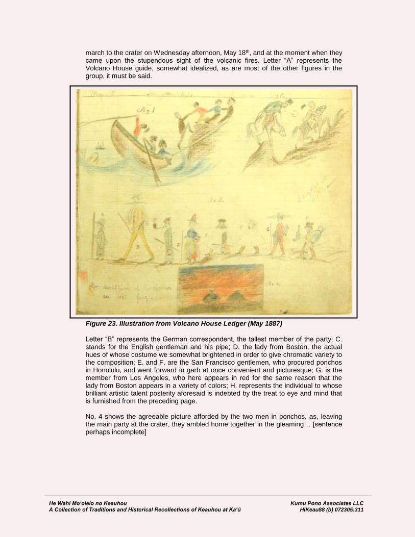
He Wahi Mo‘olelo no Keauhou Kumu Pono Associates LLC A Collection of Traditions and Historical Recollections of Keauhou at Ka‘ū HiKeau88 (b) 072305:311
march to the crater on Wednesday afternoon, May 18th, and at the moment when they came upon the stupendous sight of the volcanic fires. Letter “A” represents the Volcano House guide, somewhat idealized, as are most of the other figures in the group, it must be said.
Figure 23. Illustration from Volcano House Ledger (May 1887) Letter “B” represents the German correspondent, the tallest member of the party; C. stands for the English gentleman and his pipe; D. the lady from Boston, the actual hues of whose costume we somewhat brightened in order to give chromatic variety to the composition; E. and F. are the San Francisco gentlemen, who procured ponchos in Honolulu, and went forward in garb at once convenient and picturesque; G. is the member from Los Angeles, who here appears in red for the same reason that the lady from Boston appears in a variety of colors; H. represents the individual to whose brilliant artistic talent posterity aforesaid is indebted by the treat to eye and mind that is furnished from the preceding page. No. 4 shows the agreeable picture afforded by the two men in ponchos, as, leaving the main party at the crater, they ambled home together in the gleaming… [sentence perhaps incomplete]

He Wahi Mo‘olelo no Keauhou Kumu Pono Associates LLC A Collection of Traditions and Historical Recollections of Keauhou at Ka‘ū HiKeau88 (b) 072305:312
August 12, 1887 E.S. Wilder, Honolulu: Arrived at the Volcano House July 28 after a journey of some 6 hours from Keauhou landing. Visited the crater twice; first time was on the evening of Aug. 2, when we found the crater quite active; the second time on Sunday morning Aug. 7 when it was still more active. On August 8 went after pohas and after an 8 mile ride in brake and six on horseback we arrived at the poha beds where we gathered four bags full and then started for home arriving about 9 p.m. Our journey home was as dark as O-Hell-O and just enough rain to keep us wet; with a horse that kicked three shoes off in less than two miles. After a delightful stay of two weeks, under the hospitable care of our amiable host & hostess, we are prepared to recommend all visitors who may have the pleasure of a sojourn here.
August 12-19, 1887 James D. Dana, Observes that there were errors in the record of the Wilkes Expedition, on which he participated in 1840-1841: Second visit, the first as geologist of the Wilkes exploring expedition in November 1840. This visit to the islands was made to supplement the investigations of 1840, and remove a doubt as to the accuracy of the survey of the crater by Captain Wilkes, the map from which he published in his Narrative of the Exploring Expedition. I am sorry to find evidence of great inaccuracy instead of accuracy. A comparison of Mr. Drayton’s sketch (made for Captain Wilkes and contained in the same volume) with the present western outline of the crater showing that the western wall, instead of having the course given it by Captain Wilkes, differed but little in position and in headland from the present, as represented on the second map of the Hawaiian Government Survey, and now visible in the crater. Much indebted to the able assistant in the Topographical Survey of the Hawaiian Islands, Mr. J.S. Emerson, for assistance in my studies of the region, and to many other friends in the party for the pleasure and success of the visits—including among them the artist of the old and useful hammer. Left New Haven Connecticut July 8 1887 with my wife and daughter.
July 29, 1890 L.A. Thurston: Memo of an ascent of Mauna Loa by W.B. Clark, of Boston, Julian Monsarrat, W. Gates and L.A. Thurston, under the guidance of Kanae of Ainapo. The time which was occupied in proceeding from one point to another is given for the information of those who may desire to ascent the mountain hereafter as a basis of estimate. Left Kapapala ranch at 5:45 A.M., July 26; arrived at Ainapo 8:30; left at 9 A.M.; arrived at Ana Peahi (upper water-hole) 11 A.M.; arrived Kipuka Kakina [Thurston’s Kipuka] camp, at the upper edge of vegetation, 1:30 P.M. Temperature at this camp, where the night was spent, was as follows, in the shade: 1:30 P.M., 58 F 6:46 P.M., 48 F 5:00 P.M., 54 6:56 P.M., 47 6:15 P.M., 52 7:25 P.M., 46, Ditto up to 10 P.M.
He Wahi Mo‘olelo no Keauhou Kumu Pono Associates LLC A Collection of Traditions and Historical Recollections of Keauhou at Ka‘ū HiKeau88 (b) 072305:313
6:40 P.M., 49 4:30 A.M., 43 July 27 left camp at 6:30 A.M. and arrived at the crater at 11:30. Temperature at noon in the shade, 49; in the sun, 54; at 5 A.M. on the 28th, 24 out of doors and 28 in the tent. The entire party, except Mr. Clark, were affected with mountain sickness. Descent into the crater was made by Mr. Clark and myself at the highest point of the bluff on this side, near the old Wilkes camp, where there is a breakdown and a debris pile. There was very good walking on the bottom of the crater, the pahoehoe being unusually smooth. There was evidence of recent eruption from a blow-hole about the centre of the crater which was still uncomfortably warm. The eruption was mostly of a dark pumice stone and a very thin black pahoehoe. There was steam and some smoke from a spot several hundred yards out into the crater from the western bank. At the southwestern corner of the crater a dense column of steam was rising which did not become dissipated for several hundred feet above the rim of the crater. The spot from which the steam issued was covered with very bright yellow sulphur extending nearly all the way up the crater, and about two hundred feet wide. Immediately at the base of this sulphur bank there was a breakdown in the floor of the crater some one hundred feet deep and several feet across.
Ka Huakai Makaikai a ka Moiwahine Liliuokalani i ka luapele o Kilauea May 14, 1891: Ua hiki mai ka Huakai Alii a ka Moiwahine Her Majesty the Queen Liliuokalani ma ka Hale Hookipa a ka Luapele, ma ka Poaha May 14, 1891, Hora 11 ½ a.m. mai Kau mai, me ka maikai a me ka oluolu. A ke Mahalo ae nei makou i ka Akua Mana Loa no Kona kokua ana mai i Kana Kauwa Wahine iloko a kono lima me ka maalahi, a me ke aloha—Ka Huakai Alii. [The above entry was crossed out, and the following note, entered.] Ka Huakai Alii O ka Huakai Makaikai a ka Moiwahine a ka Hawaii Pae Aina H.M. The Queen Liliuokalani. Ua hiki mai i ka Hale Hookipa ma ka Luapele a Kilauea Hora 11 ½ a.m. May 14, 1891, iloko a na la mua o kona noho alii ana me ke Kalaunu a Hawaii.
The Sightseeing Tour of Queen Liliuokalani
to the crater of Kilauea May 14, 1891:
The Royal Tour of the Queen, Her Majesty the Queen Liliuokalani, arrived
at the Guest House at the Crater, on Thursday May 14, 1891, at 11:30 a.m.
from Kau, well and comfortable. We give thanks to Almighty God for His
support of His Female Servant in His hands, with ease, and with aloha. The
Royal Procession.
[above entry replaced with the following:]
The Royal Procession, the Sightseeing Tour of the Queen of the Hawaiian
Islands, H.M. The Queen Liliuokalani, arrived at the Guest House at the
Crater of Kilauea at 11:30 a.m. May 14, 1891, in the early days of her reign
with the Crown of Hawaii. [Maly, translator]
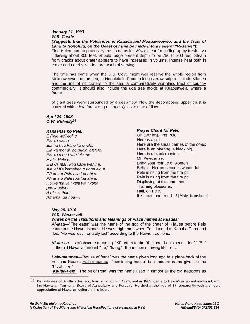
He Wahi Mo‘olelo no Keauhou Kumu Pono Associates LLC A Collection of Traditions and Historical Recollections of Keauhou at Ka‘ū HiKeau88 (b) 072305:314
January 21, 1903 W.R. Castle (Suggests that the Volcanoes of Kilauea and Mokuaweoweo, and the Tract of Land to Honolulu, on the Coast of Puna be made into a Federal “Reserve”): Find Halemaumau practically the same as in 1894 except for a filing up by fresh lava inflowing about 300 feet. Should judge present depth to be 750 to 800 feet. Steam from cracks about crater appears to have increased in volume. Intense heat both in crater and nearby is a feature worth observing. The time has come when the U.S. Govt. might well reserve the whole region from Mokuaweoweo to the sea, at Honolulu in Puna, a long narrow strip to include Kilauea and the line of pit craters to the sea; a comparatively worthless tract of country commercially. It should also include the koa tree molds at Kuapuawela, where a forest of giant trees were surrounded by a deep flow. Now the decomposed upper crust is covered with a koa forest of great age. Q. as to time of flow.
April 24, 1908
G.W. Kirkaldy26 Kanaenae no Pele. E Pele weliweli e. Eia ka alana. Eia na hua liilii o ka ohelo. Eia ka mohai, he pua'a 'ele'ele. Eia ka moa kane 'ele'ele. E ala, Pele e. E lawe mai i kou kapa wahine. Aia la! Ke kamahao o kona alo e. Pi'i ana o Pele i ka lua ahi e! Pi'i ana o Pele i ka lua ahi e! Ho'ike mai la i keia wa i kona pua lapalapa. A ulu, e Pele! Amama, ua noa—!
Prayer Chant for Pele. Oh awe inspiring Pele. Here is a gift. Here are the small berries of the ohelo Here is an offering, a black pig. Here is a black rooster. Oh Pele, arise. Bring your retinue of women. Behold! Her presence is wonderful. Pele is rising from the fire pit! Pele is rising from the fire pit! Displaying at this time, her flaming blossoms. Hail, oh Pele. It is open and freed—! [Maly, translator]
May 29, 1916 W.D. Westervelt Writes on the Traditions and Meanings of Place names at Kilauea: Ai-laau—“Fire eater” was the name of the god of the crater of Kilauea before Pele came to the Hawn. Islands. He was frightened when Pele landed at Kapoho Puna and fled. “He was lost—entirely lost” according to the Hawn. traditions. Ki-lau-ea—is of obscure meaning. “Ki” refers to the “ti” plant. “Lau” means “leaf.” “Ea” in the old Hawaiian meant “life,” “living,” “the motion showing life,” etc. Hale-maumau—“house of ferns” was the name given long ago to a place back of the Volcano House. Hale-maumau—“continuing house” is a modern name given to the “Pit of Fire.” “Ka-lua-Pele” “The pit of Pele” was the name used in almost all the old traditions as
26 Kirkaldy was of Scottish descent, born in London in 1873, and in 1903, came to Hawai‘i as an entomologist, with
the Hawaiian Territorial Board of Agriculture and Forestry. He died at the age of 37, apparently with a sincere appreciation of Hawaiian culture in his heart.

He Wahi Mo‘olelo no Keauhou Kumu Pono Associates LLC A Collection of Traditions and Historical Recollections of Keauhou at Ka‘ū HiKeau88 (b) 072305:315
the name of the place of active fire. Pele however was used as a name for all pits of fire and eruptions in action i.e. flowing lava. Many of the names of places surrounding the crater Kilauea were names of chiefs coming either with Lohiau or Kahawali. Both of these were Kauai chiefs whose friends followed their disastrous adventures with the fire goddess. This is a hastily written note and has much legendary interest back of it.
May 29, 1916 W.R. Castle: Writes on the Traditions and Meanings of Place names at Kilauea; observes that the crater is named “Halema‘uma‘u:” Quite true that many Hawaiian names—of places particularly—are of obscure and doubtful origin. Rev. T. Coan said that “Halemaumau” meant “House of everlasting fire”—doubtless quite in accord with some systems of theology; but also, it is not “Halemaumau” but “Halema‘uma‘u” or the fern (ma‘uma‘u) house. It is Pele’s fern house—the name may have arisen from the curious twisted form assumed frequently by cooling pahoehoe, of which there are endless samples on the floor of Kilauea. Hence “ma‘uma‘u.” So too “Mokuaweoweo.” “Moku” means a place cast off (moku)—so island for the country is full of “mokus” or places separate—cut off from surrounding parcels, generally rather of a small lot, frequently of a few acres only, sometimes of several miles in extent. “Aweoweo” is the name of a mountain grass. Some of the twisted and curling lavas up there may have resembled that grass so “Mokuaweoweo,” may have been so named because it is a place of “aweoweo,” so called by the ancient Hawaiians. It is also true that “Mokuaweoweo” may refer to the “place of curling flames.” It is possible to make this meaning of the word. I must not claim any originality for these ideas. I got them wholly from discussions with old Hawaiians many years ago & conversations with such men as the three Hitchcock brothers, Prof. W.D. Alexander, Rev. L. Lyons, C.J. Lyons &c &c. [Volcanoe House Ledger]
The Kilauea Military Camp Lorrin A. Thurston, a member of the group that overthrew Queen Lili‘uokalani, in 1893, who for a while, was also owner of the Volcano House and Punalu‘u hotels; and an ardent supporter of the movement to establish the Hawaii National Park, also promoted the development of the Kilauea Military Camp. An association was formed in 1916, and communications regarding the camp were sent to private and military representatives. The effort was supported by many business people on the island of Hawai‘i, who also saw it as a means of economic growth. Thurston and party secured a lease from trustees of the Bishop Estate in October, 1916 (Lease No. 1810), and plans made for development of the camp. Replying to a letter from L.A. Thurston, regarding the proposed Kilauea Military Camp, Brigadier General, R.K. Evans, confirmed that if such a facility were to be developed and run, it would be of benefit armed services personnel. Evans observed:
June 27, 1916 R.K. Evans, Brigadier General, Commanding Depart; to L.A. Thurston: …I hereby acknowledge the receipt of your communications of the 24th instant, in which you state that it is the desire of certain citizens of the Territory to donate a site near the Volcano of Kilauea, Island of Hawaii, and certain buildings to be erected thereon, for use as an encampment for maneuvers by the National Guard of Hawaii,

He Wahi Mo‘olelo no Keauhou Kumu Pono Associates LLC A Collection of Traditions and Historical Recollections of Keauhou at Ka‘ū HiKeau88 (b) 072305:316
and as a recreation and health station for the use of the regular army in Hawaii. In reply, I beg to state that I have inspected the plans submitted by you, which I understand were designed by officers of the National Guard and of the regular army, and have visited the locality proposed for the station in question, and otherwise investigated and considered the subject. I am of the opinion that the location and accommodations proposed are admirably adapted for use by the National Guard for their maneuvers. As to the establishment of a “Hawaiian Baguio” as a recreation and health resort of use of members of the regular army stationed in this department, I think the suggestion an excellent one, and one which will be greatly appreciated by the army and all connected therewith. The invigorating climate of the location suggested, together with the extremely varied and interesting scenery and natural phenomena of the locality, will add greatly to the attractiveness of the proposition. I believe that such a station will be of very material assistance to the army in Hawaii, and I will be glad to do what I can toward facilitating its use for the purpose suggested, so far as conditions will permit. I shall encourage its use by officers and enlisted men of this command, as far as practicable… [Honolulu Advertiser; February 4, 1917:13]
In preparation for development of the Kilauea Military Camp, the Hilo Tribune of July 5, 1916 announced:
Bishop Estate Donates Land. Fifty Acres Near Volcano Picked Out for Great Camp for Soldiers of Territory. The National Guard and Regular Army permanent camp at the Volcano is practically an assured fact. It is stated that the Bishop Estate which owns the land is ready to deed fifty acres over to the board of trustees in Hilo for the holding of this tract. Last Sunday Col. John D. Easton of the Second Regiment, N.G.H. and Lieut. Charles Bonesteel, U.S.A., made a trip to the Volcano of Kilauea and picked out that fifty acres. The land they chose is about one mile west of the Volcano House and just north of the Volcano Road to Kau. Lorrin A. Thurston, who with Mrs. Thurston and Miss M. Thurston, returned to Hilo last Sunday, brought the good news, which means much to Hilo from a commercial and social point of view. It is probable that the board of trustees in trust to which the land will be deeded will consist of the head of the National Guard in the Island of Hawaii, the representative of the United States Army and some business man of Hilo. This would mean at this time the Col. Easton, Lieut. Bonesteel and one other would be the trustees of the camp ground. [Hilo Tribune, July 5, 1916:1]
By November 1922, construction on the first phase of the Kilauea Military Camp had been completed, and was described in the Hilo Tribune, on November 22, 1916:
Military Camp Now Complete Members of the board of trustees of the new Military Camp at the Volcano of Kilauea made a thorough inspection of the camp grounds and new buildings there last Friday and have expressed their greatest satisfaction at the results of the work accomplished for the establishment of this splendid innovation. All the trustees were

He Wahi Mo‘olelo no Keauhou Kumu Pono Associates LLC A Collection of Traditions and Historical Recollections of Keauhou at Ka‘ū HiKeau88 (b) 072305:317
present except L.A. Thurston, who was represented by R.W. Filler. The others were Lieut. Charles Bonesteel, U.S.A. Col. J.D. Easton, N.G.H. Liet. Col. J.T. Moir, and Capt. A.C. Wheeler, N.G.H. The trustees speak in the highest terms of the work of the contractor for the buildings, the Hilo Mercantile Company, the buildings being practically complete, except for a few finishing touches. Capt. Robert Peck and the member of Company G, Second Infantry, U.S.A., took possession last week and all were delighted with the accommodations. Capt. Peck and other army officers were all enthusiastic of the climate at the Volcano and state that the benefit to themselves and the men of this change had been of immense value. Some of the men have gained as much as fifteen pounds in the week they have been there. Trustee Filler states that he will be very glad to receive any donations of old lanai furniture or comfortable chairs, which he can have fixed up for the use of the men and officers at the camp. Also any pictures or periodicals which can be donated will be much appreciated and will help to make it more homelike for the visitors. He expects that there will be a continuous stream of army men to the Volcano, now that the quarters have been completed and accepted. [Hilo Tribune, November 22, 1916:1]
In February, 1917, on behalf of the Trustees of Kilauea Military Camp. Lorrin Thurston submitted to the Honolulu Advertiser, an update on development of the Kilauea Military Camp. His paper included background on the origin of the camp; a description of the facilities developed and those expected to be develop; an overview of land tenure of the parcel, being in Keauhou, Ka‘ū; and a description of access to and from the camp, as well as the kinds of “recreational” accesses which might be enjoyed. At the time, use of the trail from the camp to Mauna Loa, and beyond to Mauna Kea, across the Keauhou-Humu‘ula lands, was given as an option to those interested. Excerpts from Thurston’s description follow, below:
Status of the “Kilauea Military Camp” Objects Set Forth by the Trustees How to get There and What to see in Region Today the Most Wonderful on the Face of the Globe. A Military Camp has been established near the volcano of Kilauea, for the use of the National Guard of Hawaii, and the Army and Navy of the United States. The Trustees of this camp make the following statement for the purposes of concretely setting forth the origin and objects of the Camp; where it is; what it consists of; how to get there; what there is to see and not to see it; and where information can be obtained concerning use of the Camp. 1. Origin of the Camp—The National Guard. The origin of the Camp has its roots in the desire to help support the National Guard and to add to the health, pleasure and comfort of the Regular Army and Navy… 3. Offer to Furnish Free Camp. In response to the request of the military authorities for such a camp site, a number of the residents of the island presented the merits of the locality in question and offered to procure and equip it for the purpose indicated without expense to the government… 4. Location of the Camp.

He Wahi Mo‘olelo no Keauhou Kumu Pono Associates LLC A Collection of Traditions and Historical Recollections of Keauhou at Ka‘ū HiKeau88 (b) 072305:318
The Camp is located at an elevation of 4000 feet in the District of Kau, Island of Hawaii; directly on the macadamized belt road around the island; one mile west of the Volcano House; ten miles from Glenwood, the terminus of the railroad from Hilo; thirty-two miles from Hilo; thirty-three miles from Honuapo, the steamer landing in Kau; about a quarter of a mile from the outer rim of the crater, and three miles from the active crater of Kilauea. It is at the junction with the belt road, of the trail up Mauna Loa and to Mauna Kea, and the Puuoo and Parker Ranches located thereon. 5. Ownership, Area and Character of the Camp Site. The Camp site is on the land of Keauhou; belonging to the Bishop Estate; is leased to trustees for the purpose above set forth, for a term of 20 years, and contains an area of approximately 50 acres. In character the land is nearly level, slightly undulating; consists of a sandy loam with perfect drainage, and has a sparse growth of native trees and shrubs. The site is within the area set apart by Congress as a National Park. It is the center of an area remarkable alike for spectacular volcanic phenomena and a luxuriant tropical forest and jungle. Good automobile roads and foot and horse trails radiate from the Camp to all parts of the island. 6. The Trustees. The Trustees of the Camp, who hold the title to and control it, are five in number, viz: Ex offico the Commander of the Army Department of Hawaii, now General Frederick S. Strong; Ex officio the Commanding General of the National Guard of Hawaii, now General Samuel Johnson; Lieut. Col. John T. Moir, National Guard, Island of Hawaii; G.H. Vicars of Hilo and L.A. Thurston of Honolulu and Hilo. 7. Number and Character of Buildings and Appurtenances; Facilities and Conditions at and about the Camp, Etc. The was laid out and buildings designed by officers of the Regular Army and National Guard. All buildings are of one story, built of Douglas Fir and with “ship lap” floors and galvanized iron roofs. (1) Officers’ Building. There is an officers’ building 30x70 feet in size, with 8-foot verandah along one side, containing a sitting room with large stone fire place; dining room; kitchen and cook room; dining tables and benches for 36 men; also in an adjacent building, a wash-house and latrine. (2) There are two main buildings, the main dimensions of them being 50’x154’, with four kitchens and cook rooms included; and an 8-foot verandah along one side. Each building is divided by rails into four divisions, each with tables and benches for seating the men; giving accommodation for seating 400 men in each building; 800 in all. (3) Fire Places. Each division will be provided with an iron fire place for heating purposes. (4) There are washrooms and latrines adjacent to each of the main buildings.

He Wahi Mo‘olelo no Keauhou Kumu Pono Associates LLC A Collection of Traditions and Historical Recollections of Keauhou at Ka‘ū HiKeau88 (b) 072305:319
(5) Lighting and stoves. There are no lamps or stoves, but a kitchen is being arranged for use of regular field ranges. A permanent stove pipe, to connect with the pipe of the field range is installed. (6) The Water Supply is obtained from the roofs and stored in redwood tanks. Water is piped to washrooms and kitchens. There is an ample supply, provided care is used. (7) Sleeping Accommodations. At present it is intended that both officers and men will sleep in tents except when the number does not exceed four companies, when part of the buildings can be used as sleeping quarters… [Honolulu Advertiser; February 4, 1917:12-13]
The early years of the Kilauea Military Camp (Figure 24) were described in an article about the army in Hawai‘i, James E. Nelson (1923). Nelson noted:
Figure 24. Kilauea Military Camp (1923). 11th Photo Sec. B1562. Kilauea Military Camp and Crater. 500 ft. 11-9-23. (in the Collection of National Archives and Records Administration)
Brief History of the United States Army in Hawaii …Camp at Kilauea Volcano About 200 miles from Honolulu, on the Island of Hawaii, and near the pit of Kilauea volcano, has been built a camp for the soldiers of the Hawaiian Department—the most ideal vacation grounds in the whole world. Each member of the military establishment is entitled to spend ten days at the camp. At every hour, both day and night, can be seen the khaki-clad soldiers of Uncle Sam lounging on the rim of Halemaumau pit and watching the ebb and flow of the crimson lava beneath their feet. It would be futile to attempt to write a fitting description of that seething mass of

He Wahi Mo‘olelo no Keauhou Kumu Pono Associates LLC A Collection of Traditions and Historical Recollections of Keauhou at Ka‘ū HiKeau88 (b) 072305:320
liquid fire which is so awesome as to make the most vivid picture of “hell” insignificant in comparison. It is a cauldron of seemingly supernatural elements; the heaving of the terrible yet beautiful flood of molten rock, with its flickering tongues of flame, renders the spectator speechless in amazement. To me there is nothing in the world as grand as Kilauea volcano. Major General Charles P. Summerall inaugurated weekly trips to the camp shortly after he assumed command of the Hawaiian Department [August 1921]. The camp has now been recognized by the War Department as a fine contributing factor to the morale of the army in Hawaii. On August 5, 1921, Major General Charles P. Summerall relieved Major General Charles G. Morton and took command of the Hawaiian Department. During the past two years the efficiency of the Hawaiian command has been raised to a standard which has received the highest encomiums from distinguished military, naval and civilian personages. The standards set include the highest training of troops, development, improvement of their living conditions which make for happiness and contentment, and maintaining a cordial sprit of co-operation and understanding with the civil community of which the Army on Oahu is an integral part. [Nelson, in Paradise of the Pacific; 1923:110]
Use of the Kilauea Military Camp has continued through the present day, though for a while, the military presence was even greater, as coastal lands in the Na Pu‘u o na Elemakule region of Kapāpala were conveyed to the military for target practice in July 1940 (this is a conveyance which has yet to be removed from the books).
He Wahi Mo‘olelo no Keauhou Kumu Pono Associates LLC A Collection of Traditions and Historical Recollections of Keauhou at Ka‘ū HiKeau88 (b) 072305:321
LANDS OF KEAUHOU AND VICINITY INCORPORATED INTO FOREST RESERVES AND HAWAII NATIONAL PARK
We find that shortly after western contact—with the introduction of alien herbivores, and placing of financial value upon resources of the forests and mountain lands—the health and integrity of the island resources began to decline. After western contact, the forests were primarily evaluated in the terms of the western economic system. While in the centuries prior to the arrival of westerners in 1778, and subsequently into the reign of Kamehameha I, the system of land tenure and management mirrored the natural landscape of the islands. Later management systems focused on what, and how much could be gotten from the land. Immediately, upon western contact, foreigners looked at the land—first, as a source of provisions for ships; and second, as a means for earning money, through the trade of natural resources such as ‘iliahi (sandalwood). In 1778, European boars, goats, rams, and ewes were introduced by Captain Cook. While offered as a “gift,” one of the motivating factors was that leaving the animals behind would produce a breeding stock to supply other foreign ships (cf. Beaglehole 1967:276, 578-579). Later, in 1793, cattle were brought to Hawai‘i by Captain Vancouver. Given as gifts to Kamehameha I, the cattle were first let off at Kawaihae (then at Kealakekua), and were placed under a ten-year kapu to protect them and allow them to reproduce (Kamakau 1961:164). Between 1793 and ca. 1811, new stock was added, and the numbers of cattle had increased dramatically. The introduced cattle, goats and sheep rapidly became a problem to the native population and forests. While the introduced animals were making their way into the higher elevations, other economic pursuits also led to the clearing of large tracts of land. In the early 1800s (ca. 1810-1829), tens-of-thousands of pounds of ‘iliahi (sandalwood) were cut from the forests of Keauhou, Ka‘ū, and Waiākea, Hilo (cf. Kamakau 1961, and Ellis 1963). By the 1830s, the forest had been stripped of sandalwood and many other plants of the forest were impacted by the clearings made for collection and transportation of the ‘iliahi. It is perhaps appropriate to note here, that the European boar, introduced by Cook and later visitors, was significantly larger, and thus stronger, than the Polynesian introduced pua‘a, or pig (Beaglehole 1967:579). Our review of more than 60,000 native Hawaiian land documents dating from 1846 to 1910 revealed many references to pua‘a (pigs), but nearly every reference was in the context of them being near-home, and as being cared for, raised, and not hunted. In the same review of the native Hawaiian land documents, and a large collection of writings from native authors (e.g., D. Malo, 1951; J.P. Ii, 1959, S.M. Kamakau 1961, 1964 & 1976), every reference to traditional collection or “hunting” (a word seldom used in the historical records), was in the context of native birds—those used either for food or from which feathers were collected for royal ornaments and symbolic dress. After ca. 1815, we find that when native Hawaiians went hunting in the uplands—as described in testimonies and historical texts of the time—they were hunting bullocks, goats and other introduced grazers, and this was generally done on the demand of their landlords, and later for the growing ranches being established in the islands. The first full-scale efforts of western-style hunting in the Keauhou, Ka‘ū, and Humu‘ula-Waiākea region does not appear in reference until around 1840 (cf. Kamakau, 1961; and letters and journals in this study). Those early outings were focused on collection of hides and tallow; and controlling wild herds of animals that were a threat to travelers, agricultural fields, residences, and forest resources. By the 1860s, the makai and distant upland areas of Keauhou—those lands outside of the forest zone—were noted as good goat runs; and the forest land was primarily worked in collection of pulu from the hāpu‘u (cf. Conveyances and Lydgate, Dec. 29, 1874, in this study).
He Wahi Mo‘olelo no Keauhou Kumu Pono Associates LLC A Collection of Traditions and Historical Recollections of Keauhou at Ka‘ū HiKeau88 (b) 072305:322
So significant was the threat of the introduced animals to the Hawaiian landscape, that on September 19, 1876, King David Kalākaua signed into law, an Act for the Protection and Preservation of Woods and Forests. By this Act, the Minister of the Interior was authorized to set apart and protect from “damage by trespass of animals or otherwise, such woods and forest lands, the property of government…best suited for the protection of water resources…” (Hawaii Laws Chapter XXX:39). The Minister of the Interior was authorized to appoint a superintendent of woods and forests:
…who shall, under the direction of said Minister, enforce such rules and regulations as may be established to protect and preserve such reserved woods and forest lands from trespass. Said superintendent shall have charge of the construction of fences and barriers required to protect the said woods and forest lands, and shall be responsible for their being kept in good condition… (ibid.).
The above Act was further defined by an Act of the Legislature of the Hawaiian Kingdom, approved by Queen Lili‘uokalani on January 4, 1893, which established the Bureau of Agriculture and Forestry. Among the Bureau’s goals was the “preservation of forests.” On June 14, 1900 (as organized under the newly formed Territorial Government), the members and functions of the Bureau were absorbed by the Board of Commissioners of Agriculture and Forestry (Hawaii State Archives – Com 2, Box 11). The Board then set about the task of establishing forest reserves on all the islands. By this time, the significance of the Kīlauea and Mauna Loa volcanoes was being realized, as something more than a private or territorial matter, and as early as 1903, it was suggested that the two volcanoes and lands extending along the east rift zone of Kīlauea to Honolulu, on the coast of Puna, be considered as a “reserve” by the United States Government (W.R. Castle, January 21, 1903). From 1903, it took a little more than thirteen years for the agreements to be worked out on land matters between the U.S. Congress, Territory of Hawaii, and Trustees of the Bishop Estate. On August 1, 1916, the Kīlauea and Mauna Loa tracts were officially made a part of the Hawaii National Park (HNP)—with the crater of Haleakalā, on the island of Maui, making up a third component of HNP. While broad efforts were undertaken on behalf of HNP, local efforts of the Territory and private land owners were also underway, and in between 1904 to the 1920s, inspection of Keauhou and neighboring government lands of the ‘Ōla‘a and Waiākea forest and mountain regions—adjoining Keauhou—were undertaken. In 1904, at a time when the “National Park” idea was new and uncertain, the Territorial Board of Commissioners of Agriculture and Forestry, were also interested in the forest lands of the Keauhou region. Minutes of the December 14, 1904, meeting, reveal the presence of an important grove of ‘iliahi (sandalwood) in the area above the crater, in the area ranched by O.T. Shipman, under Bishop Estate lease, and also reported on the proposal to harvest koa for lumber from the land of Keauhou:
Committee on Forestry …Mr. Thurston requested Mr. Hosmer to read his report on his recent trip in company with Mr. Dodge, Superintendent of the Bishop Estate, to the land of Keauhou, Kau, Hawaii. Mr. Hosmer then read the report, which is attached herewith, pointing out on the map of Hawaii some of the points mentioned. Mr. Thurston asked Mr. Hosmer if he came across a grove of sandalwood, to which Mr. Hosmer replied in the negative. Mr. Carter asked if it was real sandalwood. Mr. Thurston stated that there are about 30 sandal wood trees, situated within half a mile of Mr. O. T. Shipman’s house. He further stated that the sandal wood is right among the Koa trees. They are scattered over an area of about ten acres. These with

He Wahi Mo‘olelo no Keauhou Kumu Pono Associates LLC A Collection of Traditions and Historical Recollections of Keauhou at Ka‘ū HiKeau88 (b) 072305:323
the exception of three or four had made a most vigorous growth, the biggest one being about eighteen inches in diameter. Mr. Giffard asked if it were the true sandal wood, saying the reason why he asked was that the true sandal wood generally feeds on the roots of other trees. Mr. Thurston said that there was a small open country back of Mr. O. T. Shipman’s place, and some of the trees are right out in the open, being full of seed and flowers, of most vigorous growth. The report of Mr. Hosmer regarding the trip to the land of Keauhou, Kau, Hawaii, was ordered placed on file. Mr. Holloway wanted to know how the people who proposed logging the Koa would ship it to Hilo. Mr. Hosmer replied that the proposition which Mr. Richley made was in a general way as follows: He wants to buy the standing Koa, paying a given stumpage to the Bishop Estate, although nothing had been agreed upon as yet. He would then probably put in a railroad, with very light rails, to haul the logs from the woods to the main road where he would put them on wagons and haul to 22 miles, thence by rail, to Hilo. The logs would be sent to San Francisco to be cut into veneer. The good material to be made into veneer and lumber and shipped to the Coast, while some of the poorer might be made in dimension stuff and used locally for construction. Mr. Richley did not quote any figures and only spoke in a general way… [HSA, Com 2-8]
As noted in the preceding communication, Territorial Forester, R. Hosmer, conducted an inspection of the portion of Keauhou—from the present-day Volcano Golf Course, and above, with lands extending from ‘Ōla‘a to Kapāpala. Hosmer’s report provides us with conditions and uses on the land of Keauhou at the time. Hosmer also recommended that if the rich stand of mature koa was to be harvested by the Bishop Estate, that the best methods of foresters should be utilized in doing so:
Dec. 14th, 1904. Ralph S. Hosmer, Superintendent of Forestry; to Board of Commissioners of Agriculture and Forestry: …I beg to submit herewith a report upon my recent trip of inspection to the land of Keauhou, Kau, Hawaii, made in company with Mr. F.S. Dodge, at the request of the Bishop Estate. Leaving Honolulu by the Kinau of Dec. 6th, we proceeded at once to the Volcano House and spent three days in the woods looking over the conditions on the ground and inspecting the forest. We returned to Honolulu by the Mauna Loa, arriving early Tuesday morning Dec. 13th. The tract visited was the lower half of that part of Keauhou lying on the Southwestern slope of Mauna Loa, mauka of the government road and between the lands of Olaa and Kapapala. A strip of about a mile in width on the Olaa side of this tract has been set apart by the Bishop Estate as a private forest reserve [incorporated in 1923, into the Kilauea Forest Reserve]. This area, 4,500 acres, is fenced in and cattle are excluded from it. The remainder of the tract is leased to Mr. O.T. Shipman as a cattle ranch. The portion of the tract containing the Koa forest, about which the Bishop Estate desires advice, is a strip just west of the above described reserve. It extends from the government road near Mr. Shipman’s house to a paddock fence across the tract at an elevation of about 5000 feet; some five miles in length, by a mile or more in breadth;

He Wahi Mo‘olelo no Keauhou Kumu Pono Associates LLC A Collection of Traditions and Historical Recollections of Keauhou at Ka‘ū HiKeau88 (b) 072305:324
an area of between 4000 and 5000 acres. On this section, particularly on its upper half, is a fairly heavy stand of large Koa (Acacia Koa) trees. The forest is practically pure Koa, there being few other trees in mixture. Beneath the Koa is a dense jungle of tree ferns (Cibotium menziesii). The Koa trees are of good size and quality, many of the larger ones being from 80 to 100 feet in height and from 2 to 6 feet in diameter, breast high. These trees are mature and in my judgment thought soon to be cut and utilized. The local conditions are such that with proper facilities for handling the logs, the large trees could be felled and got out of the forest at reasonable cost. The demand for Koa is believed to be great enough to insure a market for the product, and a fair profit, if the work is handled in a business-like way by the right people. The proposition may therefore be regarded as a feasible one from a business standpoint. Considered from the point of view of the Forester the removal of valuable trees, when mature, is distinctly good policy, provided always that the work is done in such a way that another crop is insured. This indeed is the key note of forestry. On the land in question I believe that the value of the Koa forest is greater of its commercial importance than for any other reason; that, provided the work were done in accordance with forestry methods, the mature trees could be lumbered without detriment to the permanent productive value of the forest; and, provided an assured market can be secured, that the logging of the tract at this time is good business policy for the Bishop Estate. In my report to the Bishop Estate I shall therefore recommend that the tract be logged, provided suitable arrangements can be made as to stumpage prices, and provided, also, that certain regulations, to be contained in my report, be made a part of the contract… [HSA, Com 2-8]
The Waiākea and ‘Ōla‘a Forest Reserves Bounding Keauhou The mountain lands of Mauna Loa and Mauna Kea were considered an important part of any plans the territory had for forestry and conservation work on Hawai‘i. In 1913, the Governor and Board of Commissioners of Agriculture and Forestry met and discussed various lands considered of importance to the forest reserves on the island of Hawai‘i. In their discussion of the upper ‘Ōla‘a forests, the board also discussed the rich koa forests of Keauhou which in ca. 1903 had been placed in a private reserve by the trustees of the B.P. Bishop Estate. Territorial Forester, R. Hosmer feared for the harvesting of forests in the regions, and reported to the Board on June 18, 1913:
Upper Olaa Forest Reserve. …I have the honor to submit as follows, the recommendation that the remainder of the mauka portion of the government land of Olaa, to the north and west of the various subdivisions of homestead lots in the district of Puna, island and county of Hawaii, be set apart as a forest reserve… The reasons for the reservation of the Olaa forest remainder are largely the same that prompted me a short time since to recommend the reservation of the adjoining forest land of Waiakea, mauka (see report, dated June 6, 1913). Indeed, these two tracts, forming a continuous forest, are really to be considered together. They are only reported on separately because, for purposes of description, it was found desirable to treat them as two units rather than one.

He Wahi Mo‘olelo no Keauhou Kumu Pono Associates LLC A Collection of Traditions and Historical Recollections of Keauhou at Ka‘ū HiKeau88 (b) 072305:325
No running water comes from the Upper Olaa forest. Its reservation as a forest reserve is justified, rather, because of the fact that the question may some time arise of exploiting its timber. It is none to soon to make provision against that time. One essential reason for setting the land apart now is that it may be brought under the care and control of the Territory’s forest department. [page 304] Like Waiakea, the upper portion of Olaa bears a heavy stand of forest. Ohia-lehua is the predominating tree, but with it in mixture are many other species. On its western edge the Upper Olaa forest joins the Bishop Estate land of Keauhou, on which is a heavy stand of the tallest and largest koa in the Territory. A section of Keauhou some seven miles long by one mile in width has for 10 or 12 years been held by that estate as a private forest reserve. The heavy koa forest does not extend much, if any, on to Olaa, but near the Keauhou boundary, on the government land, is a fine stand of large tree-ferns (Cibotium) of perhaps as large size as any to be found in the Territory. These give at least a botanical interest to this region. Some five years ago ohia-lehua railroad ties were, for a time, cut on the McKenzie lots, one of the homestead subdivisions of upper Olaa. Other than this, except as certain areas of forest have been cleared on other adjoining homestead lands and sold as firewood, there has been no commercial development of the upper Olaa forest… For the reasons given above I do now recommend that the Board approve the setting apart of this tract as the Upper Olaa forest reserve, and that the governor be called upon to hold the hearing and thereafter to issue the proclamation incident thereto… [Hawaiian Forester and Agriculturalist, 1913:305]
Later in 1913, lands in Hilo and Puna were set aside as public Forest Reserves, and by modifications made to the reserves in 1923, portions of the boundaries adjoin the ‘ili of Keauhou, Ka‘ū:
Proclamation of Forest Reserves in the Districts of Hilo and Puna, Island and County of Hawaii, Territory of Hawaii. UNDER and by virtue of the authority vested in me by the provisions of Chapter 28 of the Revised Laws of Hawaii, as amended by Act 65 of the Session Laws of 1905, and by Act 4 of the Session Laws of 1907, and of every other power me hereunto enabling, I, Ernest A. Mott-Smith, Acting Governor of Hawaii, with the approval of a majority of the Board of Commissioners of Agriculture and Forestry, having held the hearing of which notice has been duly given as in said Acts provided, do hereby, subject to the existing leases, SET APART as forest reserves, to be called respectively the Upper Waiakea Forest Reserve and the Upper Olaa Forest Reserve, those certain pieces of government land in the Districts of Hilo and Puna, Island and County of Hawaii, Territory of Hawaii, which may be described roughly as being the block of native forest on the lower slopes of Mauna Loa lying above the agricultural land back of Hilo and to the north and west on the various Olaa homestead subdivisions, and containing, respectively, areas of 51,800 acres and 9280 acres, more or less, more particularly described by and on a map made by the Government Survey Department of the Territory of Hawaii, which said map is now on file in the said Survey Department marked Government Survey Reg. Map No. 1808, and “Upper Waiakea” and “Upper Olaa Forest Reserves,” and descriptions accompanying the same, numbered respectively C.S.F. Nos. 2430 and 2476, which said descriptions, now on file in the said Survey Department… [Hawaiian Forester and Agriculturalist, 1913:332]

He Wahi Mo‘olelo no Keauhou Kumu Pono Associates LLC A Collection of Traditions and Historical Recollections of Keauhou at Ka‘ū HiKeau88 (b) 072305:326
In 1923, the boundaries of the Upper Waiakea Forest Reserve were modified, by survey of 1922, and recorded in C.S.F. 3876:
C.S.F. 3876 Upper Waiakea Forest Reserve, South Hilo, Hawaii. (revised) June 13, 1922 Including the upper portion of the land of Waiakea [see Figure 25]. Beginning at “Kulani”, a Government Survey Triangulation Station, at the South corner of the land of Waiakea and the Northwest corner of the land of Olaa, and on the East boundary of the land of Keauhou, and running by true azimuths:–
1. 133º 18’ 05” 19346.9 feet along the land of Keauhou to a spike in large
upright stone near Kipu Hill;
2. 159º 33’ 17” 49478.2 feet along the lands of Keauhou and Humuula to
“Kahiliku Boundary” Point;
3. 288º 24’ 33” 15744.0 feet along the land of Piihonua to “Mawae” Trig.
Station;
4. 271º 41’ 28484.0 feet along same;
5. 4º 33’ 30” 535.0 feet along the land of Kaumana;
6. 52º 30’ 2750.0 feet along the land of Kukuau 2nd;
7. 340º 25’ 1150.0 feet along the land of Kukuau 1st;
8. 284º 51’ 27258.0 feet along same;
9. 308º 23’ 24802.0 feet along Waiakea Forest Reserve;
10. 63º 20’ 62845.7 feet along Olaa and Upper Olaa Forest Reserves to the
point
of beginning.
Area 63,150 Acres.
Excepting and Reserving there from the following Tracts or parcels of land, to-wit:– Part 1, Portion of Waiakea. Beginning at a point called “Kahiliku Boundary”, on the boundary of Humuula, Waiakea and Piihonua, the direct azimuth and distance of said point of beginning from Government Survey Trig. Station “Puu Oo” being 355º 40’ 55” 16092.7 feet, and running by true azimuths:-
1. 288º 24’ 33” 7500.0 feet along Piihonua;
2. 83º 00’ 6005.0 feet;
3. 159º 33’ 17” 3309.0 feet along Humuula-Waiakea boundary to the point of
beginning.
Area 222-00/100 Acres.

He Wahi Mo‘olelo no Keauhou Kumu Pono Associates LLC A Collection of Traditions and Historical Recollections of Keauhou at Ka‘ū HiKeau88 (b) 072305:327
Figure 25. Plan of the Upper Waiakea Forest Reserve; C.S.F. 3876 Hawaii Territorial Survey, 1922)
He Wahi Mo‘olelo no Keauhou Kumu Pono Associates LLC A Collection of Traditions and Historical Recollections of Keauhou at Ka‘ū HiKeau88 (b) 072305:328
Part 2. Portion of Aina Hou Kipuka in Waiakea. Beginning at a point on the Humuula-Waiakea boundary, the coordinates of said point of beginning referred to Government Survey Trig. Station “Puu Oo” being 21021.4 feet South and 3081.3 feet East, and running by true azimuths:–
1. 268º 00’ 3500.0 feet;
2. 59º 00’ 3370.0 feet;
3. 159º 17’ 33” 1725.0 feet to the point of beginning.
Area 66-00/100 Acres.
LEAVING A NET AREA OF 62,862 ACRES. Compiled from Gov’t. Survey Records & Survey of E.W. Hockley, by A.S. Chaney, Assistant Government Surveyor. [State Survey Division] [See also Plat 788; R.M. 2682, Dated Jan. 3, 1923; and C.S.F. 2430, 3942, 9193, 16633, 21210-21213.]
In 1918, the larger “Olaa Forest Reserve” was recommended to the Board of Commissioners of Agriculture and Forestry. Forester, C.S. Judd described the importance of the ‘Ōla‘a forest, and encroaching uses of homesteading and cattle ranching to the board members in a letter dated November 26, 1918:
…I have the honor to recommend the setting apart as a forest reserve of a portion of the government land of Olaa, Puna, Hawaii, consisting of 20,030 acres, more or less, as shown on the attached blueprint map. The whole area is covered with a heavy forest of native trees such as the ohia, olapa, koa, loulu palm and tree ferns with their accompaniment of a heavy undergrowth of ferns and vines and is situated between the Upper Waiakea Forest Reserve on the north, the Upper Olaa Forest Reserve on the west, and Section A of the Olaa Forest Park Reserve and homestead lots on the south. It includes a vast wilderness of heavy forest, situated between the elevations of 1700 and 3800 feet, which is impenetrable except for the roads and trails which have been cut through it. Over fifteen years ago the tract was surveyed into homestead lots with the idea that they would be settled upon by coffee planters. Coffee cultivation was a failure here owing to the [page 492] shallowness of the soil and other unfavorable factors, and although homesteads have repeatedly been taken up in this region and a lot of money spent in improving them, no one has been successful in raising any crops. With this demonstration in view, and with the idea of making some use of the land, four leases have been made during the past two years by the Land Office of a part of the land at the lower or makai end, consisting of a total of 8,886 acres, at nominal rentals, with the idea that cattle could be raised on the land. All of these leases are held by Japanese, who are about the only people who will live in this wet region. In connection with one of these leases, the largest, consisting of 8589 acres, portions of the land have been subleased to four other Japanese. These men are making an unsuccessful attempt at raising a few head of scrubby cattle in the forest. At the time the first lease was assigned to a second party in April, 1918. 175 head of cattle were supposed to have been turned over with the lease, but on account of the heavy growth of forest the assignees have been able to find only 100 head.
He Wahi Mo‘olelo no Keauhou Kumu Pono Associates LLC A Collection of Traditions and Historical Recollections of Keauhou at Ka‘ū HiKeau88 (b) 072305:329
Recently an application was made for a lease of the balance of this forest land for grazing purposes, but at my request the application has been held up. If further extended grazing is permitted on the land it will, in time, become similar to adjacent lands makai—a useless waste of dead trees, fallen logs and Hilo grass. Such a large stretch of forest cannot help but exert a favorable influence on the surrounding climate, and this is of importance to the Olaa Sugar Plantation just below, which suffered from the effects of drought two summers ago. As stated above, the soil throughout the region for the most part is shallow and is best suited to forest growth. Continued grazing in the region on any scale will in time reduce the forest to a useless waste. Sufficient land has been left out of the area recommended to be set aside to provide for the need of additional homesteads at the makai or lower end where soil conditions are more favorable, and a sufficient area at the high elevation near the upper end, not far from the Volcano House, has been reserved for additional summer lots. For the reasons above set forth, I recommend that the Board approve the project of creating the Olaa Forest Reserve, as described above, and that the Governor be requested to take the necessary steps toward this end… [Hawaiian Forester and Agriculturalist, 1918:493]
Pu‘u Kūlani and Vicinity Described in 1919 The upper boundary between Keauhou, Ka‘ū, ‘Ōla‘a, Puna, and Waiākea, Hilo, is the volcanic cone of Pu‘u Kūlani. In 1919, Botanist, Joseph Rock described the make up of the forest in the Pu‘u Kūlani area as it existed in 1919. Interestingly, at that time, he called for fencing as a means of protecting the unique biological system from depredation of wild cattle and pigs:
One Government Forest Reserve Lands at Kulani, Hawaii, Described. By Joseph F. Rock, Consulting Botanist. The whole forest reserve area at Kulani, Hawaii, is covered with a decidedly uniform and, geologically speaking, rather young forest. The border below 29 Miles contains more of a mixture of trees than the area further up toward Kulani proper. Near 29 Miles we find that trees are more numerous, especially ohia lehuas with occasional mana [maua] trees, Xylosma Hillebrandii, of which the writer encountered large individuals. Dispersed throughout that region is a very beautiful native fan palm with large orbicular fruits described by the writer as a new species under the name of Pritchardia Beccariana. Olapa, Cheirodendron, Gaudichaudii; an occasional aiea, Nothocestrum; kopiko, Straussia; olomea, Perrottetia; pilo, Coprosma; and manono, Gouldia, form the rest of the arborescent growth. The forest is, however, mainly a tree-fern forest interspersed with an occasional tree of the species mentioned. An acre of this forest land may contain perhaps five or six mature trees, of which four may belong to the genus Metrosideros (ohia lehua). The remainder is all tree ferns composed of the two common types—Cibotium Chamissoi and Cibotium Menziesii. Undergrowth is mainly composed of Cyrtandrae, Broussaisia, [page 39] Cyanea tritomantha, Cyanea pilosa, Rubus, Phyllostegia, etc. Ferns are of course very numerous. The whole forest is in splendid condition, but the undergrowth is much disturbed by the ravages of wild pigs. The uniformity of the forest makes exploring rather uninteresting for a botanist.

He Wahi Mo‘olelo no Keauhou Kumu Pono Associates LLC A Collection of Traditions and Historical Recollections of Keauhou at Ka‘ū HiKeau88 (b) 072305:330
Kulani proper is a densely wooded volcanic cone, the forest being exceedingly uniform and of the rain forest type. Palms are entirely absent. A gap was cut at the summit to permit a view of the surrounding region. The land toward Keauhou lies considerably lower than that over which Kulani was approached, or, in other words, the slopes of Kulani towards Keauhou are rather steep, giving the cone quite a formidable appearance both in height and size. The summit appears as two cones, but in fact the central valley or ridge, densely wooded, is nothing but an ancient volcanic fissure dividing the cone in two. The ground is covered with fallen trunks of both trees and tree-ferns which are covered with numerous epiphytes such as ferns Stenogyne, Clermontia parviflora, Astelia veratroides, Selagruella, Lycopodium, etc. The soil is mostly black loam, and the ground quite hummocky, which, besides fallen trunks and the absence of a trail, made progress quite slow. If properly fenced and protected from cattle and wild hogs, this forest reserve is certainly one of the finest on Hawaii, and deserves protection from cattle and hogs. [Hawaiian Forester and Agriculturalist, 1919:40]
The Hawaii National Park, taking in portions of Keauhou and neighboring lands in Puna and Ka‘ū, was established on August 1st, 1916. In the same year, the Kilauea Military Camp was also established on the land of Keauhou, and the ranching interests of Shipman and Brown at Keauhou, above; and at Kuehu or Ainahou, on the lower Puna-side of the newly formed National Park continued.
Efforts to Eradicate Goats and Sheep from the Mountain Lands In 1920, a letter from surveyor, Frank Dodge, to Forester, C.S. Judd, Dodge spoke of the territorial program of eradicating goats and sheep from the mountain lands, observing that the herd populations were high. Dodge describes use of trails between the Hilo and Keauhou, across the Mauna Loa flows, and provided a general sense of conditions on the land of Keauhou:
January 23, 1920 Keauhou Frank Dodge, Surveyor; to Charles Judd, Superintendent of Forestry: I have taken a leave of absence and am at present staying with Buster Brown at the Ranch. A.M. Brown went back to town and Buster asked me to come down & stay with him for ten days or so, driving cattle etc., so I left my camp the a.m. of the 21st. You had best make out my check for this month only up to that date. So far I have to my credit 256 head of game which includes 6 pigs and 25 sheep. Total ctgs. used were 386. I was camped in Kipuka Ahiu which is just north of the pahoehoe of 1881. Most, in fact practically all my shooting was done between the aa of 1852 & the Puu Oo ranch lands, just north of Ainahou. Ainahou is flooded with sheep which one can almost hunt with salt. Hunter foreman at Puu Oo, say they get through the fence from Humuula and are considered wild. What to do with them is the question. I imagine they equal a goat in damage done. I shot some but wasn’t hard-hearted enough to continue. Too much of a slaughter and also not being sure of my ground & rights etc. I though it best to quit. There are no cattle in Ainahou, only sheep & goats, but the sheep when they just mill around in circles & it seems like murder to kill the poor things. Had a letter from Burkland but given no date when their work starts. They are waiting on the Territory appropriation. However, it can’t be very far off.
He Wahi Mo‘olelo no Keauhou Kumu Pono Associates LLC A Collection of Traditions and Historical Recollections of Keauhou at Ka‘ū HiKeau88 (b) 072305:331
I’ve practically had my vacation & hunting trip and have about broke even on the job so far. If I continued for any length of time I would want to get two animals (saddle & pack) and would prefer to work at so much per tail. As it is now, I don’t make enough to warrant the hard work & the sporting angle of it does wear off. How does 50¢ per head with you supplying the ctgs. strike you? There are days when one cannot hunt on account of fog & rain and trips to the Volcano House or to Hilo via Puu Oo trail would consume at least two days for the former and from two to three days for the latter, and after shooting one can very plainly notice the scarcity of goats in the localities that have been worked over. I can make a big haul in some places today, but perhaps tomorrow I couldn’t do much more than pay for my two meals. Are goats raising havoc with your reserve in Puna, Kau & Kona? While I pack for the survey, do you want to supply me with ctgs. and I’ll shoot what I can without interfering with the packing? Sorry to desert you at this time and before I really had to, but to chase cows & ride good horses was too much of a temptation… …I hope the goats that have been killed are worth the money your Dept. has spent on them. Please don’t consider me as through with the job, but only temporarily suspended because if the survey work holds off I want to go back and as I’ve already said, if I go back to stay I aught to get more out of it and be fixed so that I could move around more easily & if goats got scarce along the mauka Hilo boundary I could move into Puna, Kau or Kona, if the damage done there warranted such actions. You know as well as I do that the total eradication of the goats via the rifle route is an absolute impossibility. Man can thin them out but you’ll always find more to fill the ranks. The only way to make an impression on them & to make the cost worthwhile is to shoot them off where they are thick and not bother with the last few remaining and then move on to a new locality & then later, come back and start over again. If this island was Kahoolawe it would be a different proposition but even then we might have to turn over every rock looking for the last female. You can’t do that here with 30,000 goats and Chas. Brown’s order for only 500 rams. The importation of some germ (perhaps the H.S.P.A. could help out) would be the only sure way of making a complete clean up. If I keep this up (writing) I’ll have to have these sheets bound in book form & call it a novel, so I’ll quit. Buster says just now to tell you that it’s the wild turkeys we’re living on that’s to blame for my desertion. I’ll admit that they are better than goat… [HSA, COM 2-34]
When the HNP was originally approved, the Kīlauea and Mauna Loa sections were separated parts, joined together by a public trail across portions of the private land of Keauhou, and the government, Crown Land of Kapāpala. In 1927, an addition to the park, made up of additional Bishop Estate, and government lands, connected the Kīlauea and Mauna Loa Sections of the park (C.S.F. 4625, State Survey Division).
The Kilauea Forest Reserve (1928) On December 22, 1928, the Kilauea Forest Reserve, comprising the section of Keauhou, adjoining the ‘Ōla‘a and Waiākea Forest Reserve lands—originally a part of the private forest reserve established by Trustees of the B.P. Bishop Estate—was established. Lands of the reserve were described in notes of survey, C.S.F. 4842 (Figure 26).
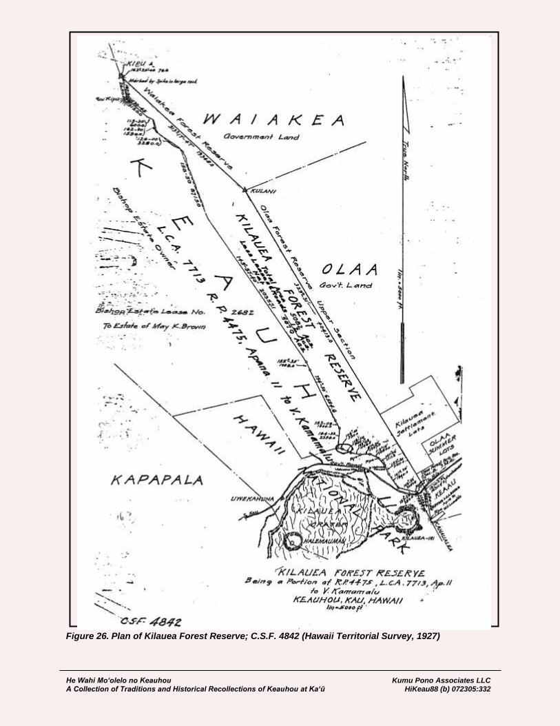
He Wahi Mo‘olelo no Keauhou Kumu Pono Associates LLC A Collection of Traditions and Historical Recollections of Keauhou at Ka‘ū HiKeau88 (b) 072305:332
Figure 26. Plan of Kilauea Forest Reserve; C.S.F. 4842 (Hawaii Territorial Survey, 1927)

He Wahi Mo‘olelo no Keauhou Kumu Pono Associates LLC A Collection of Traditions and Historical Recollections of Keauhou at Ka‘ū HiKeau88 (b) 072305:333
C.S.F. 4842 - Kilauea Forest Reserve Keauhou, Kau, Hawaii. Proclaimed Forest Reserve, December 22, 1928. Copy furnished Terr. Forestry, November 2, 1927. Territory of Hawaii Office of the Government Survey Honolulu, T.H. October 25, 1927 Kilauea Forest Reserve, Keauhou, Kau, Hawaii. Being a portion of R.P. 4475, L.C.A. 7713 Apana 11 to V. Kamamalu; B.P. Bishop Estate, Owner. Beginning at the Southwest corner of the land of Olaa, being also the common corner of the lands of Olaa, Keaau and Keauhou, the coordinates of said point of beginning referred to Government Survey Trig. Station “Uwekahuna” being 1270.2 feet North and 16311.4 feet East, and running by true azimuths:- 354º 54’ 3683.4 feet along the land of Keaau (L.C.A. 8559-B Apana 16 to W.C. Lunalilo) to a pipe marking the boundary of the Hawaii National Park; 153º 20’ 3283.2 feet along the Hawaii National Park to a pipe; 153º 20’ 250.0 feet along same to a pipe; 103º 39’ 2057.4 feet along same; 147º 20’ 1940.0 feet along same; 153º 50’ 1100.0 feet along same; 141º 46’ 1111.3 feet along same to a pipe; 113º 10’ 1050.0 feet along same; 87º 20’ 1027.5 feet along same to a pipe; 103º 48’ 1146.5 feet along same; 118º 00’ 960.0 feet along same; 106º 00’ 530.0 feet along same; 184º 33’ 2358.0 feet along fence along remainder of Keauhou (along land described in B.P. Bishop Estate Lease No. 2682 to the Estate of May K. Brown); 153º 09’ 1000.0 feet along fence along same; 154º 50’ 6554.6 feet along same; 155º 35’ 1008.0 feet along same; 145º 57’ 40” 20357.1 feet along same; Thence along irregular fence and along remainder of Keauhou, the direct azimuths and distances being:- 158º 50’ 8715.0 feet; 126º 00’ 3280.0 feet; 162º 00’ 1590.0 feet; 113º 30’ 600.0 feet; 130º 45’ 3120.0 feet to Puu Kipu; 167º 30’ 2650.0 feet along same to a spike in rock, said spike being 342º 25’ 76.6 feet from KIPU Trig. Station; 313º 17’ 47” 19348.0 feet along the land of Waiakea to Government Survey Trig. Station KULANI; 329º 31’ 00” feet along the land of Olaa to the point of beginning. Area 5,082 Acres, more or less.
He Wahi Mo‘olelo no Keauhou Kumu Pono Associates LLC A Collection of Traditions and Historical Recollections of Keauhou at Ka‘ū HiKeau88 (b) 072305:334
Excepting and reserving there from the B.P. Bishop Estate Leases, as follows: No. 1203, Area 4.32 Acres; No. 1500, Area 2.00 Acres; and No. 1801, Area 1.00 Acre; together with all existing rights-of-way, roads, and trails, Area 4.68 Acres, containing a total Area of 12.00 Acres, LEAVING A NET AREA OF 5,070 ACRES, MORE OR LESS. Compiled from Description & Plan of the B.P. Bishop Est. and Gov’t Survey Records, by H.B. Coff, Assistant Government Surveyor.
While the land of Keauhou had been leased out to ranching interests since 1863, some control over the cattle, goats and sheep had been maintained. The leases also specifically stipulated that care would be taken of the forest resources (cf. Bureau of Conveyances Liber 13:56-57). Until the early 1900s, the collection of lumber from forest resources was limited to that needed for activities on the land, and it was not until 1906, that the Bishop Estate entered into agreements for cutting koa from the forests. The initial logging efforts got off to a slow start, and development of the National Park led to the protection of portions of the forest stand. Logging was allowed in the privately held section of Keauhou, and koa harvested through 1993.
He Wahi Mo‘olelo no Keauhou Kumu Pono Associates LLC A Collection of Traditions and Historical Recollections of Keauhou at Ka‘ū HiKeau88 (b) 072305:335
HAWAII NATIONAL PARK
In the holdings of the Hawaii State Archives, are found communications with the Territorial Governors, in regards to various matters. Among the topics are those leading to the establishment of the Hawaii National Park—initially the Kilauea section in Keauhou, and adjoining lands in Puna; and the Mauna Loa section, including lands of Kapāpala and Kahuku, Ka‘ū; Humu‘ula, Hilo; Ka‘ohe, Kamakau; and Keauhou 2nd, Kona. While the Territorial Government had been actively pursuing it’s own forestry program, several individuals, notably, Lorrin A. Thurston, Prince Kūhiō, and Thomas Jaggar, actively pursued federal status of the “Kilauea National Park,” a name that was not used, as the final park, authorized in 1916, also included Haleakalā Crater, on Maui—thus, the name “Hawaii National Park.” In 1906, J. Wheelock, editor of the weekly Hilo Tribune, made an impassioned editorial noting the value of Kīlauea, and its worthiness as a national park:
Within the Territory of the United States, and upon our own island, is the greatest volcano of its kind, recognized everywhere as one of the wonders of the world, Kilauea. It is eminently proper and in line with the national policy that this volcano and its environs should be in the keeping, and under the care of the federal government for the benefit of the people and in order that its surroundings may be both protected and improved. The people of the United States demand the preservation by the government of all such localities containing nature’s wonders. The President of the United States in his last message to Congress, earnestly called attention to the importance of the subject, mentioned the Grand Canyon of the Colorado and Niagara Falls, among others. He said: “There are certain mighty, natural features of our land which should be preserved in perpetuity for our children and our children’s children.” It is certain that the Hawaii National Park idea would meet the approval of the administration. [J. Wheelock Marsh, Editor, Hilo Tribune; March 20, 1906:2]
By 1910, a steady line of communications between the federal government, governors, the Bishop Estate, and land agents began to be kept on this matter. The letters and notes of survey that follow, were viewed in the collection of the Hawaii State Archives [HSA], and provide readers with background on the assessment of the lands, descriptions of the natural resources and geologic features thereon, and also document the nature of deliberations that transpired on various levels to facilitate establishment of the park. Trustees of the Bernice Pauahi Bishop Estate, or their predecessors, had held leasehold agreements with tenants of Keauhou since at least 1863. By the early 1900s, two primary activities were generating revenue for the estate—one, was the Volcano House Hotel, and associated facilities; the second was the ranching venture, which worked lands both above and below the Kīlauea crater. The latter, became the Keauhou Ranch, which was under operation by the late 1860s (and associated with the earlier Pulu harvesting business), and the Ainahou Ranch parcel, established by the early1880s. Recognizing the significance of the dense forests of Keauhou, the trustees set aside approximately 4,500 acres, as a private reserve in ca. 1903. Figure 27 is a portion of Register Map 2192, surveyed by E.D. Baldwin in 1903, depicting the O.T. Shipman’s, Keauhou Ranch House; Kīlauea, and roads and trails of the time, notably those crossing Keauhou, to Mauna Loa. At the same time the movement for establishment of a national park at Keauhou was under way, the trustees were also exploring other options for generation of revenue on the land. By 1910, agreements on a koa harvesting enterprise had been entered into; and applications for homestead lots behind the crater (in the area of the present-day golf course and house lots), were being received. As a result, the Trustees had authorized the survey and laying out of the volcano lots.

He Wahi Mo‘olelo no Keauhou Kumu Pono Associates LLC A Collection of Traditions and Historical Recollections of Keauhou at Ka‘ū HiKeau88 (b) 072305:336
Figure 27. Reduction of Register Map No. 2192 – Upper Boundary of Keauhou (E.D. Baldwin, June 1903)
He Wahi Mo‘olelo no Keauhou Kumu Pono Associates LLC A Collection of Traditions and Historical Recollections of Keauhou at Ka‘ū HiKeau88 (b) 072305:337
These uses being considered, the Trustees were cautious about the proposal, and hesitant to give up too much of Keauhou in the park scheme. In between 1910 to 1916, the federal and territorial governments proceeded with their motions for establishment of the park. Legislation was put before Congress by Hawai‘i’s delegate, Prince Jonah Kūhiō Kalanaiana‘ole, and on August 1, 1916, Congress authorized the establishment of Hawaii National Park. The park though, was basically a park on paper only, as negotiations between the Trustees of the Bernice Pauahi Bishop Estate, and Territorial Government, had not concluded with an agreement of financial compensation, and land swaps until 1920. It was not until September 27, 1922, that the first part of the Keauhou lands were transferred by the Territory to the National Park Service, with subsequent additions from Keauhou and neighboring lands made on April 4th and April 13th, 1927. The communications and boundary descriptions that follow, highlight some of the key efforts and considerations in formation of Hawaii National Park27:
October 17, 1910 Wm. F. Frear, Governor; to F.S. Dodge, Agent, Trustees of the B.P. Bishop Estate (Requesting documentation on the nature of existing lease on Keauhou): …Referring to our conversation of this afternoon at a conference in regard to the establishment of a National Park to include the volcano of Kilauea and adjoining lands, will you kindly furnish me with a statement of the leases from the Bishop Estate of the portions of the Keauhou land that might be included in such a park, stating their terms, rental, etc's, and also any other information that may assist the government in making a proposition to the Bishop Estate for the acquisition of such lands… [HSA Gov 3-11]
October 19, 1910 F.S. Dodge, Superintendent, Estate of B.P. Bishop; to Governor, W.F. Frear (Providing background on Leases and business interests at Keauhou): In compliance with your request of October 17th, for information concerning Bishop Estate leases on the land of Keauhou, Kau, Hawaii, I enclose a statement regarding all leases now in force, and further information bearing on the same subject… [Attachment] Notes on Keauhou Leases Kau, Hawaii
No. 921a Kilauea Volcano House Co., Ltd. dated July 2nd, 1902.
Terms: 15 years from October 1, 1906, at $500 net per annum.
Extended 6 years from October 1, 1921, at $900 net per annum.
Area: 37.81 acres, including the Hotel site, paddocks, gardens, etc. in rear
of same, and land along pali overlooking Kilauea Crater.
All buildings and other improvements revert to the Lessors at the expiration
of the term of lease and their value is considered as a part of the assets of
the Bishop Estate.
27 The name “Hawaii National Park” remained in use, covering both the Hawai‘i and Maui Island components of the
park until September 22nd, 1961, when on Hawai‘i, it became Hawaii Volcanoes National Park.
He Wahi Mo‘olelo no Keauhou Kumu Pono Associates LLC A Collection of Traditions and Historical Recollections of Keauhou at Ka‘ū HiKeau88 (b) 072305:338
No. 923 O.T. Shipman, dated May 31st, 1902.
Terms: 15 years from October 1, 1901 at $500 net per annum.
Extended 5 years to October 1, 1921 at same rental.
Area: 29,000 acres mauka of Crater.
14,200 acres makai of the crater.
Forest land and pasture land mostly.
Under the terms of this lease the Lessee has built and maintained a fence
along the boundary of his leasehold and the Forest Reserve adjoining Olaa,
and is under obligations to build along the boundary of said reserve and the
Government land of Olaa, whenever directed to do so by the Lessors. The
Forest Reserve contains about 4,500 acres.
No. 1203 Peter Lee, Dated April 10, 1906.
Terms: 21 years from October 1, 1906, at $43.20 net per annum.
Area: 4.32 acres, - a homestead lot on the Volcano Road, about two miles
from the Volcano House.
No. 1403 G.F. Becker, dated May 10, 1910.
Terms: 10 years from May 1, 1910, at $25 per annum net.
Area: about ½ acre, for stable and garage – on the Volcano Road,
adjoining the Volcano House premises.
In addition to the foregoing leases, the Trustees of the Bishop Estate have granted a license, now held by Jas. B. Castle, for cutting the Koa forest on about 20,000 acres of Keauhou mauka of Kilauea Crater, for a term of fifteen years from July 1st, 1907. The time of commencement of operations has been extended from time to time upon terms agreed upon by both parties. Under present terms the licensee is under obligations to cut not less than 30000 feet B.M. of marketable Koa lumber, during each and every period of six months, paying therefore at a rate of $7.50 per 1000 feet B.M. and also paying a percentage of receipts from the sale of cord wood and bark. The estimated minimum receipts under these terms amount to $4500 per annum. Only a small portion of the forest land above mentioned is within the boundaries of the proposed Park Reservation. The Bishop Estate has already decided upon opening a tract of land for residence and homestead lots along the volcano road, the new Halemaumau Road and the 29 mile Cut-off road, and the Assistant Land Agent, Mr. Sorenson, is already on the ground, making preparations for the surveys of these lots, and applications are on file for such lots. Kilauea Crater and adjacent land, about 4500 acres in all, is held as a reserve, not covered by any lease. [HSA Gov 3-11]

He Wahi Mo‘olelo no Keauhou Kumu Pono Associates LLC A Collection of Traditions and Historical Recollections of Keauhou at Ka‘ū HiKeau88 (b) 072305:339
Honolulu December 30, 1910 W. Giffard; to Governor W.F. Frear (Regarding land area of Keauhou to be considered for National Park, and observations of flora and fauna, unique to the area): …It would appear that this is an opportune time to further take up with you the question of boundaries of the proposed Kilauea National Park, more especially those which include the area of forest to the Northwest of the Volcano House. So far, it has been apparent to all interested that the region of arid or semi-arid lands which includes the volcano itself as well as the extinct craters to its South, should and would be included in any National Park set aside by the Federal Government, and for that reason I will endeavor, as far as possible, to confine my remarks to the altogether different, but adjacent, area northwest of the crater of Kilauea which still remains, to a more or less extent, covered with a well-grown, indigenous forest in marked contrast to that of the more Southern section which at best supports a sparse and scrubby vegetation or else none at all. I surmise that the Federal Government in creating National Parks has always in mind the purposes to which these can be placed. These Parks are undoubtedly intended to be of National as well as of local interest and scientists as well as the general public have equal liberties to enjoy the restricted areas subject to such regulations as circumstances may require. It goes without saying that not only will the general public enjoy the natural surroundings of the proposed park under certain restrictions, but, in due course, the National Government will undoubtedly appropriate sufficient sums for forest fencing purposes wherever necessary within the park area and will also establish and maintain their stations of scientific interest. Among these latter may be included stations with facilities for Geological and Meteorological research work. Botanists, Ornithologists, Entomologists and others scientifically inclined will also find within the National Park a richness of material in each of their special lines of work, always provided that the boundaries in the forest area to be set aside are adjusted to conform with natures requirements as well as those of the scientist. The area of forest referred to by me as located to the Northwest of the Volcano House appears to be of particular importance to both the public at large and scientists in general. The Botanist will find this section rich in native flora and the Naturalist, as well as lovers of bird life, will also find that there are still in this locality a number of species of our native birds which have not as yet become extinct. It is more particularly with a view to preserving this peculiar section of forest and the fauna and flora therein that I am now discussing the all important question of the North Western boundaries of the proposed National Park. Personally I have on more than one occasion been through a large portion of the section referred to and therefore might speak from personal experience. There are others, however, who have a much better knowledge of this region and it may therefore be preferable to quote as an instance what one of these observers has to say on the subject. I desire to refer to Dr. R. C. L. Perkins, who is well known to certain of the Washington scientific authorities as well as to the people at large in this Territory as having had very many years of ornithological and entomological experience on the islands of this group. His systematic work has also to a great extent included observations on our native flora. In an address made in 1906 before the Hawaiian Entomological Society during his term as President of that body, Dr. Perkins particularly referred to the scientifically productive localities at or near the neighborhood of Kilauea. To better describe these localities from a botanical as well as an entomological standpoint, he gave the members of the society a brief account of the neighborhood of the Volcano and divided it into three districts, viz.:-
He Wahi Mo‘olelo no Keauhou Kumu Pono Associates LLC A Collection of Traditions and Historical Recollections of Keauhou at Ka‘ū HiKeau88 (b) 072305:340
(1) The crater itself is surrounded by a nearly level plain, which on the west
side supports a stunted and more or less sparse vegetation. This consists
of small examples of the Myrtaceous ‘Ohia’ tree (Metrosiderus) some of
which are almost sure to be found in full bloom at all seasons of the year;
beneath and between these the Epacridaceous Cyathodes, a New Zealand
or Australian element of the flora, and the very variable Vaccinium
reticulatum are conspicuous, together with species of Coprosma and
Raillardia and, in moister and shadier spots especially various species of
Cyperaceae and the lilaceous Astelia, Dianella and Smilax.
The comparatively open, and in some parts very exposed, country is the
home of many interesting insects not found in the adjoining and better
wooded parts. Towards Kilauea-iki and southwards the growth is more
dense, the ground is damper and the moisture-loving species of plants
more numerous, but this denser forest lacks many of the species
conspicuous on the open plain.
(2) By walking a mile or more along the Kau road, then facing towards the
summit of the mountain and crossing the open country such as I have just
described, one enters a totally different locality. The forest here is well-
grown and consists of large Koa and Ohia trees, in some places the former
(Acacia koa), in others the latter predominating; in some spots tree-ferns, in
others bracken, abound, while various trees of smaller growth are
numerous, species of Pelea, Myrsine, Myoporum, Sophora, occasionally
Pipturus and Euphorbia being amongst these. In some spots Alyxia
Olivaeformis forms dense hanging masses in these trees.
(3) Immediately behind the Volcano House Hotel one quickly enters another
well marked district. There is a forest that is essentially formed of Ohia, the
woods are always damp, the undergrowth largely consists of great tree-
ferns, but a variety of smaller trees are scattered amongst these, Pipturus,
Myrsine, Cheirodendron, Broussasia and occasional arborescent
Lobeliaceae. The more open parts of this forest have now become invaded
by an imported raspberry, which bears an abundance of very pretty but
insipid berries of an altogether inferior quality. On the Hilo side, where the
forest is generally of a similar character this importation is a still greater
pest.
The section under consideration by me in this letter is (in part) covered by the description #2 as above. Since the period of Dr. Perkins’ address above mentioned I have had conversations with him on the subject of preserving sections of the areas referred to but more particularly that to the North-west of Kilauea. The gist of these conversations during the past few months has been, however, more particularly as to the bird life contained in this important forest area and its vicinity. A few days ago I was much pleased to receive the following brief communication from Dr. Perkins on this phase of the subject. Following is his letter in full, viz.:-
Waikiki Dec. 23, 1910 R.C.L. Perkins; to Giffard:
…With reference to our recent conversation on the Kilauea National Park, I
have elsewhere pointed out the great interest of the botany and entomology
of that region, showing how in a small area of a few square miles there are
three quite different kinds of flora and fauna.
He Wahi Mo‘olelo no Keauhou Kumu Pono Associates LLC A Collection of Traditions and Historical Recollections of Keauhou at Ka‘ū HiKeau88 (b) 072305:341
When, a few years ago, it was proposed to induce, the American
Association for the advancement of Science to hold a meeting in the
islands, I wrote to the effect that as, no doubt, all would wish to visit the
active volcano, a fine opportunity would be afforded the ornithologists to
see a considerable number of the remarkable birds that are peculiar to
these islands. Only a few of the birds will be found in the Southern two-
thirds of the proposed reservation, the most interesting being restricted to
the area North West of the Volcano House or the Kau road. A few years
ago there were species of no less than ten (10) genera of these peculiar
birds to be found in the latter area, and this is a large percentage of the
whole number found in the islands. The names of these birds are Iiwi
(Vestiaria) Apapane (Himatione) Amakihi (Chlorodrepania) Akekeke
(Oreomyza) Akepa (Loxops) Akialoa (Hemignathus) Nukupuu
(Heterorhynohus) Ou (Paittacirostra) Elepaio (Chasiempis) Amaui
(Phaeornis).
At higher elevations one or two others were formerly found, but these are
now very likely extinct there, as elsewhere. If any increase should be made
in the area of the proposed park it should, from the point of view of a
naturalist, be by addition to the North-west portion of the enclosed area, as
this would add to the limited region wherein the greater number of birds is
to be found. The relatively great area of the reservation south of the
Volcano house, as well as part of that behind it, is not suited to many of
these birds, as they do not find there the food on which they largely depend
and this particularly applies to those, which are the most extraordinary of
the ornithological productions of Hawaii. One reason for making the
national park as comprehensive of the fauna as possible is, that, so far as
we know, there is not a single other public place on the whole islands
where either a resident or visiting naturalist can lodge in comfort and with
facilities for scientific work in a locality where so many interesting creatures
are to be found. In other good localities he is either dependent on friends or
acquaintances for lodging, or, if he wishes to be independent, must put up
with the discomfort of living and working in a tent… R.C.L. Perkins
It will therefore be seen by all lovers of nature as well as by those scientifically inclined, that it is of importance that the proposed Park boundaries include a sufficient area of this forest section which will tend beyond any doubt whatsoever, to perpetuate many of our native birds as well as the flora on which these depend for food. I am informed that the intention is to take in only a comparatively small portion of the forest in question. This area, like all the rest in the neighborhood, is overrun with cattle and as a result its native vegetation will ultimately be destroyed. It appears to me and to others that the Northern or upper boundary of the National Park, as proposed, should be extended for some part to the highest limit of the forest, and thence continued in a Westerly direction above this forest line towards the summit crater of Mauna Loa. Between those points only an arid and apparently worthless country is visible for miles. The crater of Mokuaweoweo, including this arid section and the forest portion referred to, might therefore well be included within the proposed Park areas thereby setting aside land for one National Park rather than having two with a connecting trail or right-of-way as has been already proposed.
He Wahi Mo‘olelo no Keauhou Kumu Pono Associates LLC A Collection of Traditions and Historical Recollections of Keauhou at Ka‘ū HiKeau88 (b) 072305:342
It might also appear to those who are unselfishly interested in creating a National Park in the vicinity of Kilauea and the Volcano that satisfactory arrangements should, if at all possible, be made with those who own and control the areas referred to, so that these be included within its boundaries. Fencing the forest section where necessary, against the trespass of cattle will not only preserve but in a very great measure perpetuate the flora and fauna peculiar to that region. To effectively protect and preserve the existing native birds of this region it should be remembered that a large and uninterrupted area of the natural forest is absolutely necessary. Any radical disturbance of the natural conditions, within or without any proposed Park, brought about by either man or beast may within a few years mean the total extinction of many of the species. Natures balance has already been too much disturbed in this particularly interesting region, yet not so much so but that evils which have existed may not be easily corrected provided action is taken in the very near future and in such manner as will eliminate cattle from the forest areas in question. Apparently the only satisfactory method which can at present be suggested is the acquisition of these forests and their arid and semi-arid vicinities and the setting aside of all of these within the area required for National Park purposes. It is to be presumed that efforts will be made to secure an appropriation from the Federal Government sufficiently large to fence in where necessary, the forest areas and thereby exclude all cattle. Regulations and restrictions which usually govern all National Parks will prevent the depredations of man whether he be scientist or tourist or even both of these latter without restrictions can do their share of destruction in our native forests even though it may not be in so great a measure as through the continued trespass of cattle… [HSA – Gov 3-2 Hawaii National Park]
Hilo, Hawaii December 31, 1910 N.G. Willfong, Tax Assessor Division; to Governor W.F. Frear (Assessment of value on the Ahupua‘a of Keauhou): …In reply to yours of yesterday I would state that the land of Keauhou owned by the B.P. Bishop Estate in Kau district was assessed this year as follows: 4500 acres above crater of Kilauea 4500. ave. $1. pr. a. 4800 around the crater of Kilauea 2000. ave. about 40c. 43300 acres from crater to the Sea 4000. ave. about 10c. The portion of this land which is to be included in the Park I suppose would be worth between 25 cents and 50 cents an acre. The land of Panau-nui in the Puna district owned by the J.W. Austin Estate is assessed at 35 cents an acre and Laeapuki & Kealakomo at the same rate. It seems to me that 50 cents an acre for that portion taken in below the crater is enough. For the portions above the crater and around same perhaps the assessed value might be considered rather low. Just what value to put on that portion of the land of Keauhou is hard to say. Trusting that the above is about what you desire, I remain… P.S. Should you require any more information please let me know and I will do my best to furnish it. [HSA – Gov 3-2 Hawaii National Park]
He Wahi Mo‘olelo no Keauhou Kumu Pono Associates LLC A Collection of Traditions and Historical Recollections of Keauhou at Ka‘ū HiKeau88 (b) 072305:343
January 5, 1911 Governor W.F. Frear; to Trustees of the B.P. Bishop Estate: …As you are probably aware, it is proposed to create by act of Congress a national park to include the craters of Kilauea and Mokuaweoweo and some of the surrounding country. The inclosed blue print [Figure 28] shows portions of the proposed park which belong to the Bishop Estate, namely, a part of the land of Keauhou at Kilauea containing approximately 14,765 acres and a part of the land of Keauhou 2 at the summit of Mauna Loa. There is also inclosed a copy of the proposed bill28. If the bill passes it will probably be necessary to acquire the portions of land in question belonging to the Bishop Estate by agreement or condemnation proceedings. It will be a convenience if you can state at what price you can sell these lands for this purpose. Any suggestions that you may care to make in regard to this matter will be welcome. It is not unlikely that the bill will be sent to Washington by the steamer sailing tomorrow or next day but the naming of a price for the Bishop Estate lands at an early date and any other suggestions will nevertheless be desirable… [HSA – Gov 3-2 Hawaii National Park]
January 5, 1911 Revised Description KILAUEA VOLCANO NATIONAL PARK. Including portions of the lands of Kapapala and Keauhou, in the district of Kau, And Kahaualea, Panaunui and Apua, in the district of Puna, Island of Hawaii, Territory of Hawaii. Beginning at the Hawaiian Government Survey Trigonometrical Station “Ohaikea” (marked by a galvanized spike driven in pahoehoe on the upper Ohaikea Bluff and also by a cairn of stones), the coordinates of said station, referred to Government Survey Trigonometrical Station “Uwekahuna” on the edge of the crater of Kilauea, being 1463.6 feet North and 19470.7 feet West, and running by true azimuths:-
1. 215º 06’ 10638 feet, more or less, to a point on the Southwesterly boundary
of Keauhou;
2. 256º 15’ 21800 feet, more or less, across the land of Keauhou to the
Southwest boundary of Olaa;
3. 329º 31’ 16200 feet, more or less, along the land of Olaa;
4. 360º 00’ 7000 feet, more or less, along the land of Keaau;
5. 334º 00’ 7000 feet along the land of Kahaualea;
6. 281º 00’ 30455 feet, more or less, across the land of Kahaualea, passing
through the North corner of the land of Panaunui to the North corner of the
land of Laeapuki;
7. 31º 30’ 13200 feet, more or less, along the land of Laeapuki and across the
land of Panaunui;
28 This bill failed, as did two others, because questions regarding acquisition of the land of Keauhou could not be
resolved.
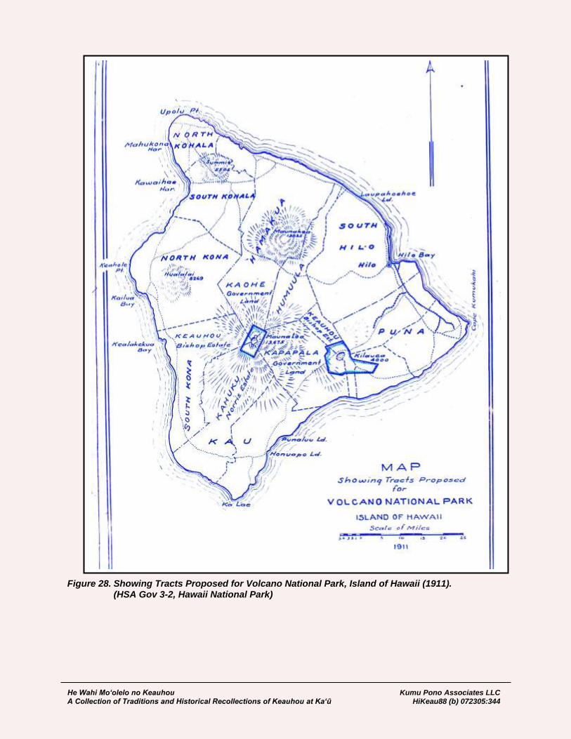
He Wahi Mo‘olelo no Keauhou Kumu Pono Associates LLC A Collection of Traditions and Historical Recollections of Keauhou at Ka‘ū HiKeau88 (b) 072305:344
Figure 28. Showing Tracts Proposed for Volcano National Park, Island of Hawaii (1911). (HSA Gov 3-2, Hawaii National Park)
He Wahi Mo‘olelo no Keauhou Kumu Pono Associates LLC A Collection of Traditions and Historical Recollections of Keauhou at Ka‘ū HiKeau88 (b) 072305:345
8. 89º 40’ 32225 feet, more or less, across the lands of Panaunui, Apua and
Keauhou to “Pali-lele-o-Kalihipaa” a boundary point on the Keauhou-
Kapapala boundary;
9. 62º 50’ 6200 feet across the land of Kapapala;
10. 101º 00’ 17700 feet across the land of Kapapala to a small cone about
1500 feet Southwest of “Puu Koae” Trigonometrical Station.
11. 166º 20’ 27350 feet across the land of Kapapala to the point of beginning.
Area 38395 Acres. Compiled from survey of Thos. E. Cook and from Government Survey Records, by R.D. King, Assistant Government Surveyor. [HSA – Gov 3-2 Hawaii National Park]
Honolulu, T.H. January 21, 1911. Office of the Trustees under the Will of Bernice P. Bishop; to W.F. Frear, Governor, Territory of Hawaii (Trustees express concern over the Park Bill, and proposed extent of lands to be taken from Keauhou): …We have for acknowledgement your letter of the 5th inst. accompanied by plans and copy of the bill proposed to be introduced in Congress, having for its object the creation of a National Park to include the Craters of Kilauea and Mokuaweoweo and some of the surrounding country. As your letter was received at so short a period prior to the dispatch of the bill to Washington, it was impossible for the Trustees of this Estate to take definite action in time to write you before the mailing of the bill. The Trustees, while inclined to favor the general idea of the reservation by the Government of those natural curiosities, the Craters of Kilauea and Kilauea-iki, and such land immediately around them as may be essential, do not favor the reservation of so large a tract as is specified in the proposed bill, and the passage of this will be opposed by them on the ground that the areas proposed to be taken are excessive and that the time granted them in which to consider the important interests at stake was insufficient… [HSA – Gov 3-2 Hawaii National Park]
Hilo, Hawaii April 14, 1911. L.A. Thurston; to W.F. Frear (Reports on the findings of rare trees at Kīpuka Kī, Kīpuka Puaulu, and other localities of Keauhou and Kapāpala; urges that fencing be employed to protect such areas until the land matter is resolved): …IN RE VOLCANO PARK. Your letter was duly received. I received a wireless from Holstein yesterday suggesting that I return to Honolulu in connection with the matter, but business here will not permit of it. Mr. Giffard and Mr. Rock, the Territorial Botanist, have just spent a week at the Volcano and thoroughly investigated the area northwest of the crater which is the point of difference. Mr. Rock states that he has in the few days’ examination, located five trees which are new, never having been described before and which probably grow nowhere else than the locality indicated. There are also a number of other trees which grow only in this locality, such fact being stated by Hildebrand, and in a number of instances, Mr. Rock could find only one tree of each kind.
He Wahi Mo‘olelo no Keauhou Kumu Pono Associates LLC A Collection of Traditions and Historical Recollections of Keauhou at Ka‘ū HiKeau88 (b) 072305:346
Both Mr. Rock and Mr. Giffard say that the evident destruction caused by cattle, among these rarer trees, is such that but a brief period of cattle running there will work irreparable damage. They report that the most important areas are two kipukas, one on Kapapala known as Kipuka-Ki containing approximately 90 acres and one on the Bishop Estate land of Keauhou, known as Puaulu, containing approximately 300 acres. If arrangements could be made to fence out these temporarily, the remainder of the area under discussion would not suffer so much while awaiting final decision as to whether it should be included or not. My suggestion is that in the interest of all concerned, a resolution be passed by the Legislature recommending the proposed park without any boundaries being named. Meanwhile, between now and next December, the Kapapala Ranch and Bishop Estate people will have opportunity to see exactly what the conditions are and the necessity for protection of the forest area under discussion. My positive belief is that if we can get them to go on to the ground and see just exactly what the situation is, they will fully agree with others who have already made such examination, that the reservation suggested should include, at least in a large degree, the lands described in Kuhio’s bill. I saw W.O. Smith today upon the matter and this suggestion rather seemed to appeal to him. I hope it can be carried out… [HSA – Gov 3-2 Hawaii National Park]
Hilo, Hawaii July 14, 1911. L.A. Thurston; to W.F. Frear, Governor, Territory of Hawaii (regarding Bishop Estate Concerns over taking of valuable Koa Forest lands in Keauhou, and plans for ensuring success of the park proposal): …IN RE BOUNDARIES OF VOLCANO PARK. While in Honolulu two weeks ago I had conversations with Alfred Carter and W.O. Smith, Bishop Estate trustees, in regard to getting together as to boundaries of the proposed Volcano Park. Carter said that the prime difficulty in getting together, so far as he was concerned, was valuation; that the proposed boundary included a large portion of the koa forest which they are proposing to lumber, the value of which they placed very much higher than, he felt certain, the Government would consent to; that they proposed to stand out for their valuation even to the extent of opposing the whole proposition if necessary. I told him that I thought he was entirely wrong as to the proposed park including any considerable portion of the lumberable koa, as my understanding with Tom Cook was, that the boundary now recommended came only to the top of the bluff in the immediate rear of the koa lumber mill; that if it went any further into the forest than that point, I was perfectly willing, so far as I was concerned, to have such boundary moved down to the crest of the hill indicated. He said that if the boundary was along the crest indicated or could be placed there he thought that might make a difference, altho he was still inclined to believe we could not agree upon the valuation. Mr. Carter did not seem much impressed with my suggestion that a representative of the Interior Department be asked to come and give advice as to what the boundary should be in the location indicated; he appeared to me to think that it was likely to hamper them in their freedom of decision and did not seem to want to commit himself to anything.

He Wahi Mo‘olelo no Keauhou Kumu Pono Associates LLC A Collection of Traditions and Historical Recollections of Keauhou at Ka‘ū HiKeau88 (b) 072305:347
Mr. Smith, on the contrary, expressed his unqualified approval of the proposition; but stated that, as a matter of policy, he thought the suggestion had better come from you, as Governor, to the trustees of the Bishop Estate. His reason for this suggested procedure was, that it would probably give more weight, coming from you as Governor, and would moreover show a disposition to consult with the trustees, whom, he appeared to think, had heretofore rather been ignored in the matter. I accordingly suggest that you address a communication to the trustees of the Bishop Estate suggesting the desirability of all parties interested in getting together on this proposition and the soundness of suggesting to the Secretary of the Interior to send someone to investigate the proposition and make recommendation of boundaries. I suggest that you do not ask that they commit themselves to the boundaries so recommended; but merely ask for their approval of the proposition. If they do not, with reasonable promptness, acquiesce in your suggestion, I then suggest that you go ahead on your own initiative and ask the Secretary of the Interior to dispute someone whose opinion will carry weight, to come and make the examination and report. If the question of the traveling expenses of the investigator should be involved, I suggest that you authorize McClellan, who had better be kept in contact with the proposition, to assure the Secretary that such expenses will be paid by the Territory, the contingent fund being used for that purpose. Meanwhile, as backing for the foregoing proposition, I will have a communication from the Hawaii Trail & Mountain Club addressed to you asking for action along the above lines… [HSA – Gov 3-2 Hawaii National Park]
January 23, 1912 Hilo, Hawaii T.A. Jaggar, Jr.; to Governor Frear (Regarding improvements on observatory facilities, mapping, and plotting potential flows of Mauna Loa to Hilo): …The people of Hilo and vicinity have subscribed the money to erect at once our first observatory on Waldron’s Ledge. The little house at Halemaumau will be moved to a less public place near the pit and I am anxious to get whatever authority you can give me to protect it. It has been broken into three times, so that we cannot leave instruments there for even a few hours without molestation. Perhaps a sign indicating government protection might help, I shall fence it and make it stronger. Hilo is interested in the possible paths of lava flow from Mauna Loa in the future. To tell what the paths will be, given the vent, an accurate topographic map is essential. Such a map of both craters is also of first importance for scientific work. Would it not be possible for you to detach a topographer to put through this work at an early date, as an eruption of Mauna Loa from the north side is likely to come at any time? Dr. G.O. Smith, Director of the Geological Survey, told me in Washington that he was ready to agree to such a special detail if you were. For quick access to Mokuaweoweo, a trail surveyed from Kilauea is of much importance. To hew out roughly such a trail the Observatory is prepared to do all it can, and if a Territorial surveyor could assist, we would quickly get results which will be of great importance when the road question comes up in connection with the National Park. Would it be possible to put a surveyor on this job at the same time the topographers make their camp on Mauna Loa…? [HSA Gove 3-11]
He Wahi Mo‘olelo no Keauhou Kumu Pono Associates LLC A Collection of Traditions and Historical Recollections of Keauhou at Ka‘ū HiKeau88 (b) 072305:348
February 1, 1912 Hilo, Hawaii L.A. Thurston; to Hon. W.F. Frear, Governor (Regarding discrepancies in the boundaries of proposed park, and communications with Trustees of Bishop Estate): …A short time since I had quite a talk with Albert Judd on the above subject. I have also talked with several of the other Bishop Estate Trustees. My impression, from these talks with them, is that they are ready to agree to compromise in regard to the mauka boundary of the proposed park upon a line which it will be sound for those interested in securing the setting aside of the park to accept. If you will remember, the Bishop Trustees wanted a line which would come along the big crack and low bluff between Ollie Shipman’s house and the crater, following along the same only a little in the rear of the Volcano House. The line which we wanted, on the other hand, was a mile or two further mauka. The point which I was most desirous of securing was the kipuka known as “Puaulu” situated northwest from the Uwekahuna bluff. I think there has been something of a misunderstanding as to where this line would be located on the ground. My understanding was that the line which Tom Cook had run out, was about 1000 feet mauka of the edge of the bluff, directly back of the old Koa mill. Tom Cook went onto the ground with myself and Ollie Sorenson and pointed out to us exactly where it was. I have been satisfied, however, after going over the maps with Frank Dodge and Sorenson, that the line which Cook put into the description which is embodied in the bill now before Congress and on the map, is, in fact, considerably further mauka of the location pointed out by him. Also that it extends further in, back of the Volcano House, than we had supposed and than stated by him. It has not been our intention to take away from the Bishop Estate any of their commercial Koa land. This I have repeatedly stated to them; but, I am satisfied, that the description which appears in the bill, does, in fact, include a considerable amount of their commercial Koa land. I have suggested to the trustees that, if they would consent to a line which includes “Puaulu,” and came along the top of the bluff back of the old Koa mill, at approximately the location pointed out by Cook to Sorenson and myself, and thence over to the Olaa boundary, on a line which would not include their commercial Koa, that, so far as I was concerned, I would recommend such line as an amended line, to be submitted to Kuhio, for embodiment in the bill, subject to your approval. Without saying so in so many words, the intimation has been made to me that the trustees would not be unfavorable to this suggestion but they would like the suggestion to come from you officially in the matter. Judd told me that if such intimation came from you they would immediately detail a man to come up here and, in conjunction with Tom Cook and myself, if you wished us to act, go over the proposition on the ground and see there just what was proposed, and that if the line was where they understood it to be from my oral description, he thought that the trustees would probably withdraw their opposition to the bill at Washington. I very strongly urge that this suggestion be followed, as, in this year of turmoil at Washington, a very little opposition will probably hang the question up.

He Wahi Mo‘olelo no Keauhou Kumu Pono Associates LLC A Collection of Traditions and Historical Recollections of Keauhou at Ka‘ū HiKeau88 (b) 072305:349
The boundaries above suggested by me, while not all that I would like, embody a fair representation of each of the different types of vegetation which ought to be included in the park and exclude mainly that which we never intended to take, to-wit, the commercial Koa. If the above meets your views I suggest that you communicate with the trustees as early as possible so that the matter can be acted upon promptly at this end of the line. In order to save you time I enclose herewith a suggested draft of communication from yourself to the Bishop trustees along the lines above suggested. If this meets your approval I will hold myself in readiness to go to the Volcano at any time on a few days notice, to do what is necessary to be done at that point. A communication ought to be sent also to Tom Cook, from the Superintendent of Public Works, to do whatever is necessary from the surveying standpoint… [HSA Gov 3-11]
February 2, 1912. Governor; to Prof. T.A. Jaggar, Jr.: …Replying to your letter of the 23rd ultim., I have taken up your suggestions with the Superintendent of Public Works and he will endeavor to arrange for the topographers to take up the matter of making topographic surveys of the two craters and the slope of Mauna Loa on the side where the next lava flow is likely to take place. He thinks also that the topographers can survey the trail from Kilauea to Mokuaweoweo. In regard to the house, you could put up a sign warning trespassers that they will be prosecuted according to law which might answer your purposes. Perhaps the sheriff of your island would allow you to use his name on the sign… [HSA Gov 3-11]
February 3, 1912. Governor W.F. Frear; to The Trustees of the B.P. Bishop Estate (Regarding misunderstanding as to the proposed boundaries of the park): …It has been drawn to my attention that there is probably a misunderstanding as to the location on the ground, of the mauka boundary of the proposed public park reservation at Kilauea. It has been my desire, and that of others interested in securing the setting aside of the park, to include therein representation of the various distinct types of vegetation in the vicinity of the Volcano, but not to include the Koa forest, on the land of Keauhou, belonging to yourselves, now being lumbered under your control, which may be styled as the “commercial Koa.” The boundary set forth in the bill now before Congress was fixed upon the hypothesis that it accomplishes this object. I am informed that, as a matter of fact, it probably includes a portion of the “commercial Koa” above mentioned. For the purpose of eliminating, so far as possible, any misunderstanding upon this subject, and to ascertain exactly what boundary along the mauka side of the park will be agreeable to all concerned, I suggest that you appoint someone to represent you to go on the ground with someone representing the Government, the two to agree, if possible, upon a line which shall thereupon be marked, such representatives to thereupon report to you and myself their conclusions and recommendations; and with the understanding that such conclusions and recommendations are subject to approval. If this suggestion meets your approval I will nominate Mr. Lorrin A. Thurston to represent the Government in this matter and will detail Mr. Thomas Cook, the

He Wahi Mo‘olelo no Keauhou Kumu Pono Associates LLC A Collection of Traditions and Historical Recollections of Keauhou at Ka‘ū HiKeau88 (b) 072305:350
surveyor who made the survey of the proposed park, to meet your representative for the purposes above stated… [HSA Gov 3-11]
February 8, 1912 Volcano House, Hawaii T.A. Jaggar, Director Technology Station, Jr.; to W.F. Frear (Regarding preparations for construction of the new observatory near Waldron’s Ledge): …I am very grateful to you for your prompt attention to the mapping question. I had a conference with Mr. Birdseye yesterday and we decided it would be most expedient to map the Kilauea reservation area first, then in the summer the Mokuaweoweo area, and thereafter as fast as possible the north slopes of Mauna Loa. This is in the order of our immediate needs for the work of the Observatory, and it would do no good to attack the north slopes of Mauna Loa first, as that area is very large and in the event of any eruption this coming year could not possibly be mapped in time to be of any use. I have moved the Perret house and fortified it, and now we are getting ready of an observatory on the cliff-edge in front of the Volcano House. Hilo has subscribed the money and Hackfeld has the contract… [HSA Gov 3-11]
On January 11, 1916, the Hilo Tribune announced to the public that land for the “Kilauea National Park” had been requested, and that Prince Jonah K. Kalanianaole had brought the matter before Congress once again for action:
5000 Acres Asked For Kilauea Park Bill Introduced by Delegate Places Restriction on all Leases. Kilauea National Park is again before Congress. On December 6, Delegate J.K. Kalanianaole introduced a Bill in the House of Representatives known as No. 68, providing for the establishment of such a park in the Territory of Hawaii. Approximately 56,315 acres of land are provided for in the Bill, besides a strip of land of sufficient width to for a road to the park. The park shall be under the control of the Secretary of the Interior, according to the provisions of the Bill and he shall make and publish such rules and regulations as he may deem necessary or proper for the care and management of it. These regulations shall provide for the preservation from injury of all timber, birds, mineral deposits, and natural curiosities or wonders within the park and their retention in natural condition as nearly as possible. Provision is made by which the Secretary may grant leases at such annual rental as he may see fit, but such leases are not to exceed terms of 20 years each, and not more than 200 acres may be leased by the same person or firm. Furthermore the lease must not include any of the objects of curiosity or interest in the park, or exclude the public from visiting them. Permission may be granted by the Secretary for the erection of science buildings in the park, or for railroad rights of way into and across it. Possession of the land may be secured for the federal government by purchase, condemnation, or otherwise, but the cost of gaining possession shall not exceed $50,000. Following its introduction in the House, the Bill was referred to the Committee on Agriculture, and ordered to be printed. [Hilo Tribune, January 11, 1916:5]

He Wahi Mo‘olelo no Keauhou Kumu Pono Associates LLC A Collection of Traditions and Historical Recollections of Keauhou at Ka‘ū HiKeau88 (b) 072305:351
Hawaii National Park Established on August 1, 1916 On August 1, 1916, after more than twelve years, on the part of a number of individuals, and following three failed bills before Congress, the Act to establish Hawaii National Park, including the craters of Kīlauea and Moku‘āweoweo, on the island of Hawai‘i, and Haleakalā, on the island of Maui passed. The Act (for the Hawai‘i Island section of the park) reads:
Hawaii National Park. Established on Islands of Hawaii and Maui. August 1, 1916 (H.R. 9525) (Public, No. 171)
CHAP. 264. An Act To establish a National Park in the Territory of Hawaii. Be it enacted by the Senate and House of Representatives of the United States of America in Congress assembled. That the tracts of land on the island of Hawaii and on the island of Maui, in the Territory of Hawaii, hereinafter described, shall be perpetually dedicated and set apart as a public park of pleasure ground for the benefit and enjoyment of the people of the United States, to be known as Hawaii National Park. Said tracts of land are described as follows: First. All that tract of land comprising portions of the lands of Kapapala and Keauhou, in the district of Kau, and Kahaualea, Panaunui, and Apua, in the district of Puna, on the island of Hawaii, containing approximately thirty-five thousand eight hundred and sixty-five acres, bounded as follows: Beginning at a point on the west edge of the Keamoku Aa Flow (lava flow of eighteen hundred and twenty-three), from which point the true azimuth and distance to Government survey trigonometrical station Ohaikea is one hundred and sixty-six degrees twenty minutes, six thousand three hundred and fifty feet, and running by true azimuths: (First) Along the west edge of the Keamoku lava flow in a northeasterly and northwesterly direction, the direct azimuth and distance being one hundred and ninety-eight degrees ten minutes, fourteen thousand seven hundred feet; (second) two hundred and fifty-six degrees, eleven thousand four hundred feet, more or less, across the land of Kapapala and Keahou [Keauhou] to a marked point on the Humuula trail; (third) three hundred and twenty-eight degrees fifteen minutes, eight thousand seven hundred and twenty-five feet, across the land of Keauhou to the top of the fault north of the Kau road; (fourth) along the fault in a northeasterly direction, the direction azimuth and distance being two hundred and fifty-one degrees and thirty minutes, four thousand three hundred and thirty feet; (fifth) two hundred and forty-five degrees, six thousand feet, to a point near the southwest boundary of the land of Olaa; (sixth) three hundred and thirty-seven degrees ten minutes, eight thousand six hundred and fifty feet, more or less, to the junction of the Hilo and Keauhou roads; (seventh) three hundred and thirty-three degrees and twenty minutes, three thousand three hundred feet, more or less, to the southwest corner of the land of Keaau; (eighth) three hundred and thirty-two degrees and ten minutes, seven thousand feet, along the land of Kahaualea; (ninth) two hundred and eighty-one degrees, thirty thousand three hundred and seventy-five feet, more or less, across the land of Kahaualea, passing through the north corner of the land of Panaunui, to the north corner of the land of Laeapuki; (tenth) thirty-one degrees thirty minutes, thirteen thousand two hundred feet, more or less, along the land of Laeapuki and across the land of Panaunui; (eleventh) eighty-nine degrees and ten minutes, thirty-two thousand nine hundred feet, more or less, across the land of Panaunui, Apua, and Keauhou to “Palilele-o-Kalihipaa,” the boundary point of the Keauhou-Kapapala boundary; (twelfth) fifty-one degrees and thirty minutes, five thousand and five hundred feet, across the land of Kapapala; (thirteenth) one hundred and two degrees and fifty

He Wahi Mo‘olelo no Keauhou Kumu Pono Associates LLC A Collection of Traditions and Historical Recollections of Keauhou at Ka‘ū HiKeau88 (b) 072305:352
minutes, nineteen thousand one hundred and fifty feet., across the land of Kapapala to a small cone about one thousand five hundred feet southwest of Puu Koae trigonometrical station; (fourteenth) one hundred and sixty-six degrees twenty minutes, twenty-one thousand feet, across the land of Kapapala to the point of beginning. Second. All that tract of land comprising portions of the lands of Kapapala and Kahuku, in the district of Kau, island of Hawaii; Keauhou second, in the district of North Kona; and Kaohe, in the district of Hamakua, containing seventeen thousand nine hundred and twenty acres, bounded as follows: Beginning at Pohaku Hanalei of Humuula, a small cone on the brow of Mauna Loa, and at the common boundary points of the lands of Humuula, Kapapala, and Kaohe, from which the true azimuth and distance to Government survey trigonometrical station Omaokoili is one hundred and ninety-five degrees twelve minutes eighteen seconds, seventy-eight thousand two hundred and eighty-six feet, and running by true azimuths: First, two hundred and ninety-eight degrees, five thousand two hundred and forty feet; second, twenty-eight degrees, thirty-six thousand nine hundred and sixty feet; third, one hundred and eighteen degrees, twenty-one thousand one hundred and twenty feet; fourth, two hundred and eight degrees, thirty-six thousand nine hundred and sixty feet; fifth, two hundred and ninety-eight degrees, fifteen thousand eight hundred and eighty feet, to the point of beginning. Third. A strip of land of sufficient width for a road to connect the two tracts of land on the island of Hawaii above described, the width and location of which strip shall be determined by the Secretary of the Interior… Sec. 2. That nothing herein contained shall affect any valid existing claim, locations, or entry under the land laws of the United States, whether for homestead, mineral, right of way, or any other purpose whatsoever… Sec. 4. That the aid park shall be under the executive control of the Secretary of the Interior whose duty is shall be, as soon as practicable, to make and publish such rules and regulations as he may deem necessary or proper for the care and management of same. Such regulations shall provide for the preservation from injury of all timber, birds, mineral deposits, and natural curiosities or wonders within said park, and their retention in their natural condition as nearly as possible… …And provided further, That no appropriation shall be made for the improvement or maintenance of said park until proper conveyances shall be made to the United States of such perpetual easements and rights of way over private lands within the exterior boundaries of said park as the Secretary of the Interior shall find necessary to make said park reasonably accessible in all its parts, and said Secretary shall when such easements and rights of way have been conveyed to the United State report the same to Congress… [HSA Gov 5-7, Hawaii National Park]
Conveyance of Lands to Formation of Hawaii National Park (1919-1927) Following the 1916 Act, establishing Hawaii National Park, negotiations between Trustees of the Bernice Pauahi Bishop Estate, and Territory of Hawaii, continued in regards to securing the Keauhou, Ka‘ū and Keauhou 2nd, North Kona Lands for the park. As a result, of negotiations, and the stipulation of the Act, that the private lands must be conveyed to the United States prior to releasing of substantial funding for park improvements, only limited work was undertaken in the park for the first five years of its existence. This said, the Volcano House, Lorrin Thurston, business interests, the Hawaii National Guard and Army, and individuals committed to promoting science and visitation to Kīlauea secured funding and labor (through private, military, prison, and County programs), for work on roads and trails around and through Kīlauea.

He Wahi Mo‘olelo no Keauhou Kumu Pono Associates LLC A Collection of Traditions and Historical Recollections of Keauhou at Ka‘ū HiKeau88 (b) 072305:353
Negotiations with the Bishop Estate continued through 1919, when both the Federal and Territorial governments agreed to reach final agreement with the Estate in whatever means was necessary. A series of conveyances and Executive orders followed between 1920 to 1927, for Keauhou, and parcels that made up the initial lands of the park (BoC 577:1, and associated documents in this study; see pages 289 & 355-359). While the initial lands within the park included approximately 12,025 acres for the Kīlauea section of the park, subsequent additions of Government lands in Puna (28,745 acres); the Ka‘ū Desert section (43,400 acres); and the Mauna Loa Strip, taking in lands from Keauhou, through Kapāpala, Humu‘ula and Ka‘ohe (46,050 acres), brought the parks acreage up to some 130,220 acres by 1927. The following communications provide readers with an overview of the efforts and plans that resulted in the final conveyance of the Kīlauea section of Keauhou to the Territory, and subsequently to the Federal Government. It will be noted, that as a part of the agreed conveyance, the Estate would receive exchange lands from the government inventory, for the land given up in Keauhou. The communications also document the Executive Orders which conveyed the Ka‘ū Desert lands of Kapāpala, adjoining Keauhou; and a portion of the Government lands of Puna to the park.
January 3, 1919. Washington, D.C. F.R. Lane, Secretary, Committee on Agriculture; to Prince Jonah Kuhio Kalanianaole, House of Representatives U.S. Washington, D.C.: …When I was in Hawaii last summer, I had some conferences with the Trustees of the Bishop Estate, who control most of the privately owned land in the Kilauea section of the Hawaii National Park, for the purpose of effecting some arrangement with these gentlemen whereby all of the major portion of this private property might be acquired by the Federal Government for park purposes. You will recall that the organic act establishing the Hawaii National Park, the act of August 1, 1916 (39 Stat., 432), contains the following provisos in Section 4.
“Provided, That no appropriation for the maintenance, supervision, and
improvement of said park in excess of $10,000 annually shall be made
unless the same shall have first been expressly authorized by law: And
provided further, That no appropriation shall be made for the improvement
or maintenance of said park until proper conveyances shall be made to the
United States of such perpetual easements and rights of way over private
lands within the exterior boundaries of said park as the Secretary of the
Interior shall find necessary to make said park reasonably accessible in all
its parts, and said Secretary shall when such easements and rights of way
have been conveyed to the United States report the same to Congress.”
Until the requirements of the last proviso are met, it is clear that we can make no progress in the development of the park as a tourist resort, or even give it adequate protection from depredations upon its natural features. These obstacles I wish to remove as soon as possible. My conferences with the representatives of the Bishop Estate resulted in an offer by these trustees to convey the larger part of their holdings, including the portion of the Kilauea Crater owned by the Estate, to the Territory of Hawaii, for later dedication by executive order as park land, in exchange for land belonging to the Territory outside of the park areas. An exchange of this character would be mutually advantageous to the Territory and to the owners of the private lands in the park. Resort to the laws
He Wahi Mo‘olelo no Keauhou Kumu Pono Associates LLC A Collection of Traditions and Historical Recollections of Keauhou at Ka‘ū HiKeau88 (b) 072305:354
governing the Territory fails to reveal authority for consummating a transaction of this character, and it is necessary to secure additional legislation authorizing the Governor of the Territory to proceed with the pending exchange. I am transmitting herewith a form of bill which will relieve the existing situation, and I would be grateful if you would introduce the measure and have it referred to this Department by the Committee on the Territories in order that a report may be submitted on the bill at an early date. I am writing a similar letter to Senator Pittman… [HSA Gov 5-7]
January 7, 1919. UNION CALENDAR NO. 390. H. R. 13699. (REPORT NO. 116.) IN THE HOUSE OF REPRESENTATIVES. Mr. Kalanianaole introduced the following bill; which was referred to the Committee on the Territories and ordered to be printed. February 21, 1919. Reported with amendments, committed to the Committee of the Whole House on the state of the Union, and ordered to be printed… A BILL To authorize the governor of the Territory of Hawaii to acquire privately owned lands and rights of way within the boundaries of the Hawaii National Park. Be it enacted by the Senate and House of Representatives of the United States of America in Congress assembled, That the governor of the Territory of Hawaii is hereby authorized, subject to the approval of the Secretary of the Interior, to acquire, by exchange or otherwise, except by purchase, all privately owned lands lying within the boundaries of the Hawaii National Park as defined by “An Act to establish a national park in the Territory of Hawaii,” approved August first, nineteen hundred and sixteen, and [page 2 of the Bill] all necessary perpetual easements and rights of way, or roadways, in fee simple, over or to said land or any part thereof. Sec. 2. That the provisions of section seventy-three of an Act entitled “An Act to provide a government for the Territory of Hawaii,” approved April thirtieth, nineteen hundred, as amended by an Act approved May twenty-seventh, nineteen hundred and ten, relating to exchanges of public lands, shall not apply in the acquisition, by exchange, of the privately owned lands herein referred to… [HSA Gov 5-7]
May 5, 1919. Honolulu, T.H. Stephen T. Mather, Director, National Park Service; to Hon. C.J. McCarthy, Governor of Hawaii: IN RE BISHOP ESTATE LAND IN KILAUEA SECTION OF HAWAIIAN NATIONAL PARK. On behalf of the Interior Department, as represented by the National Park Service, and in confirmation of my several conversations with you, I submit the following as my understanding of the present status of the above named subject, and make certain suggestions in connection with the same.

He Wahi Mo‘olelo no Keauhou Kumu Pono Associates LLC A Collection of Traditions and Historical Recollections of Keauhou at Ka‘ū HiKeau88 (b) 072305:355
1. It is the opinion of Secretary Lane that the public interests will be best
served by the acquisition of the fee of at least a part of the land above
indicated.
2. Secretary Lane has arrived at a tentative understanding with you that,
subject to the approval of Congress, you will endeavor to acquire from the
Trustees of the B.P. Bishop Estate said lands, by conveying to them in
exchange certain Territorial lands of equal value, the lands so acquired
from said Estate to be thereupon transferred to the U.S. Government for
National Park purposes.
3. The said Trustees have signified their willingness to convey the greater part
of the said land for National Park purposes, but excluding from such
conveyance the Volcano House site and certain other land adjacent
thereto; for a certain fixed sum; or to convey their entire holdings within the
park boundaries for a considerably larger sum.
I express no opinion as to the values placed on said lands by the Bishop
Estate.
4. While the National Park Service prefers, as a rule, to own the fee of land
within park boundaries, there are exceptions, and after examination of the
premises and consideration of the subject, I am of opinion that, under
existing conditions, the public interests will be served by now acquiring the
smaller area suggested by said trustees, leaving the question of whether
title should be acquired to the remainder of said Bishop Estate land, to be
taken up by the parties at some future time, if they so desire.
5. As the exchange proposed involves local knowledge of values and will
probably involve detailed examinations of the lands and consideration
extending over a considerable time, I suggest that it would be well if you
could come to an understanding with the Bishop Estate, concerning the
lands to be exchanged. The proposed basis of exchange could then be
submitted to the Secretary of the Interior for his approval and when the
necessary congressional authority is secured, prompt completion of the
exchange can be made, thus forwarding the date at which active
development of the park can take place. [HSA Gov 5-7]
May 5, 1919. Honolulu, T.H. S. Mather, Director National Park Service; to Trustees under the Will of Bernice P. Bishop: IN RE BISHOP ESTATE LAND IN KILAUEA SECTION OF THE NATIONAL PARK. At a recent conference with you by myself, you expressed your willingness to convey, for park purposes, the land owned by you above indicated; but stated that you preferred to retain the Volcano House site and certain land adjoining the same, expressing your willingness to convey the same for a much smaller consideration than asked for the whole. Since such conversation I have visited the lands in question, and, under present conditions, am of opinion that the public interests will best be served by acquiring from you the smaller area as suggested by you. You doubtless understand that I have no authority to commit the Government to any policy or agreement to eventually seek to acquire title from you to the land now reserved by you. Such matter must be an
He Wahi Mo‘olelo no Keauhou Kumu Pono Associates LLC A Collection of Traditions and Historical Recollections of Keauhou at Ka‘ū HiKeau88 (b) 072305:356
entirely independent subject, open to such action as may, in the future, appear best. Under these circumstances I will recommend to the Secretary of the Interior that the conveyance of the smaller area suggested by you, be approved by him as complying, in so far as this part of the park is concerned, with the requirements of the act of Congress creating the Hawaiian National Park. It was tentatively agreed between the Secretary of the Interior, the Governor of Hawaii and yourselves that the Territory should, on behalf of the park, acquire from you the lands in question, by conveying to you in exchange certain Government lands of equal value. A bill was introduced in Congress authorizing such transaction; it passed the Senate but owing to press of business failed in the House of enactment, although there was no opposition thereto. Such bill will be re-introduced at the next session and we have every reason to expect that it will receive favorable action. In the interest of forwarding the early conclusions of the proposed exchange, I have suggested to Governor McCarthy and now suggest to you that it would be well if you and the Governor could tentatively agree upon the exact values of the lands to be exchanged, and the terms of the exchange for submission to the Secretary of the Interior for his approval, so that as soon as congressional authority is obtained the matter can be concluded, thereby forwarding the date at which active development of the park can take place… [HSA Gov 5-7]
May 1919 (Agreement for Conveyance of Right of Way across Keauhou to connect the Kilauea and Mauna Loa sections of the Hawaii National Park): THIS AGREEMENT made this _____ [left blank] day of May, 1919, by and between William O. Smith, E. Faxon Bishop, Albert F. Judd, William Williamson and Richard H. Trent, all of Honolulu, Territory of Hawaii, Trustees under the Will and of the Estate of Bernice Pauahi Bishop, deceased, hereinafter called the “Trustees,” Parties of the First Part; and the United States Government, hereinafter referred to as the “Government,” Party of the Second Part, Witneseth: Whereas by Act of Congress a national park has been created in the Territory of Hawaii, consisting of several sections, of which one, consisting of the crater of Mokuaweoweo and vicinity, is situate at the summit of Mauna Loa and one consists of the Crater of Kilauea and vicinity, both on the island of Hawaii; And Whereas said act provides for the acquiring of a right of way connecting said two sections, to be located in the discretion of the Secretary of Interior; And Whereas the Trustees are the owners of certain hereinafter more particularly described land, lying between said sections, upon which said right of way will probably be partially located, and have agreed with the Government to permit its representatives to enter upon said land for the purpose of inspecting, locating and surveying said right of way, and thereafter, when located and surveyed, to convey the same by proper conveyance of easement of right of way, said adjacent land,
He Wahi Mo‘olelo no Keauhou Kumu Pono Associates LLC A Collection of Traditions and Historical Recollections of Keauhou at Ka‘ū HiKeau88 (b) 072305:357
buildings and other structures, for administrative purposes in connection with said park, and for rest houses or camps for the use of the public frequenting the same. Reserving however, unto the Grantors, the right to erect and maintain across said right of way, a gate or gates, which the Grantors or their representatives of assigns may deem necessary to control live stock running on said land. With full right of ingress or egress upon and over said land for said purposes or any of them. Provided however that within three months after the survey of said location for said right of way is completed, a copy thereof shall be furnished to the Grantors, and a copy shall be hereto attached and made a part hereof. TO HAVE AND TO HOLD the rights, powers and authority herein enumerated, and an easement of right of way in and over the said right of way when located as aforesaid, unto the United States Government and its successors and assigns forever. THIS AGREEMENT is subject to that certain lease from the Trustees to O.T. Shipman, dated _____ [left blank] and expiring _____ [left blank]. IN WITNESS WHEREOF the said parties of the First Part have hereunto set their hands and seals this _____ [left blank] day of May 1919. [HSA Gov 5-7]
February 27, 1920 Public No. 150 66th Congress (H.R. 3654.) An Act to authorize the governor of the Territory of Hawaii to acquire privately owned lands and rights of way within the boundaries of the Hawaii National Park. Be it enacted by the Senate and House of Representatives of the United States of America in Congress assembled, That the governor of the Territory of Hawaii is hereby authorized to acquire, at the expense of the Territory of Hawaii, by exchange or otherwise, all privately owned lands lying within the boundaries of the Hawaii National Park as defined by “An Act to establish a national park in the Territory of Hawaii,” approved August 1, 1916, and all necessary perpetual easements and rights of way, or roadways, in fee simple, over or to said land or any part thereof. Sec. 2. That the provisions of section 73 of an Act entitled “An Act to provide a government of the Territory of Hawaii,” Approved April 30, 1900, as amended by an Act approved May 27, 1910, relating to exchanges of public lands, shall not apply in the acquisition, by exchange, of the privately owned lands herein referred to. Approved February 27, 1920… [HSA Gov 9-9, Hawaii National Park]
June 4, 1920 Trustees of the Bishop Estate; to the Territory of Hawaii Indenture – Agreement to Exchange portions of Keauhou for Public Park Purposes, in return for Certain Government Lands: THIS INDENTURE, made and entered into this 4th day of June, A.D. 1920, by and between W.O. SMITH, E. FAXSON BISHOP, A.F. JUDD, WILLIAM WILLIAMSON and RICHARD H. TRENT, Trustees under the will and of the Estate of Bernice Pauahi Bishop, Deceased, parties of the first part, and THE TERRITORY OF HAWAII, party of the second part. WITNESSETH:
He Wahi Mo‘olelo no Keauhou Kumu Pono Associates LLC A Collection of Traditions and Historical Recollections of Keauhou at Ka‘ū HiKeau88 (b) 072305:358
WHEREAS, the party of the second part is desirous of acquiring by way of exchange, directly for public use, namely, for public park purposes, that certain piece of parcel of land belonging to the parties of the first part, which said pieces or parcel of land is hereinafter more particularly described, and WHEREAS, the party of the second part is willing and has agreed to grant and convey by Land Patent in exchange therefore that certain piece or parcel of land belonging to it, situate in the District of Kau, Island of Hawaii, Territory of Hawaii, being portions of Mohokea 1 and 2, and more particularly described as follows:
“Beginning at + on large stone known as N. Honokoa at the South corner of
Grant 2895 to Haalulu and the West corner of Grant 2934 to Honokoa and
on the boundary between Moaula and Mohokea, the true azimuth to Trig.
Station ‘Moaula 22’ being 201º 58’ 30” and to Trig. Station ‘Moaula 21’
being 97º 37’, as shown on Government Survey Registered Map No. 1837,
and running by true azimuths:-
1. 314º 57’ 30” 2787.0 feet along Grant 2934 to Honokoa along wall to + on
stone in wall at Keanakapuaa;
2. 334º 00’ 1950.0 feet along same to + on stone in wall at Kanakaloloa about
20 feet makai of small gulch;
3. 334º 50’ 3085.0 feet along Grant 2934 to Honokoa along wall;
4. 313º 05’ 375.0 feet along Grant 2934 to Honokoa along wall;
5. 23º 50’ 208.0 feet along Grant 2934 to Honokoa along wall to + in bed rock
of Punaluu Gulch, about 1400 feet mauka of Government Road;
Thence following center of Punaluu Gulch which is the boundary between
Mohokea and Punaluu, the direct azimuths and distance being;-
6. 134º 20’ 697.0 feet along center of Punaluu Gulch to M in bed rock at
junction of Mohokea 1 and 2;
7. 134º 00’ 7280.0 feet along center Punaluu Gulch to + in bed rock at
Waipakii, the azimuth to Trig. Station “Moaula 21” being 118º 5’ 30”; to Trig.
Station “Alili” being 188º 3’;
8. 123º 30’ 6942.0 feet along center of Punaluu Gulch to W in bed rock;
9. 132º 20’ 1908.0 feet along center of Punaluu Gulch to HN in bed rock at
head of Mohokea 1, the azimuth and distance to Trig. Station “Pooauwai”,
marked by + on stone being 285º 44’ 30” 99 feet, and from Trig. Station
“Pooauwai” to Trig. Station “Puu Enuhe” the azimuth is 350º 40’ 30”;
10. 126º 23’ 1920.0 feet more or less, along center of Punaluu Gulch;
11. 198º 54’ 2410.0 feet, more or less, along makai line of the Kau Forest
Reserve;
12. 327º 05’ 450.0 feet, more or less along center of Kahawailepo Gulch being
a branch of Moaula Gulch to M in bed rock at junction of gulches;
Thence the boundary leaves Moaula Gulch and follows along the land of
Moaula on the following azimuths and distances:
13. 290º 10’ 2333.0 feet;
14. 316º 15’ 1142.0 feet;
15. 306º 12’ 1548.0 feet;
16. 311º 00’ 6475.0 feet to the point of beginning, containing an area of 912.5

He Wahi Mo‘olelo no Keauhou Kumu Pono Associates LLC A Collection of Traditions and Historical Recollections of Keauhou at Ka‘ū HiKeau88 (b) 072305:359
ACRES, divided as follows:
Forest and Hill Land 115.0 acres Cane Land 575.0 acres Pasture Land 222.5 acres TOTAL 912.5 ACRES A portion of this land, however, being subject to Government Lease No. 997 to the Hawaiian Agricultural Company, expiring December 4, 1933, and Government License No. 857 to the said company, expiring November 30, 1935. IT BEING UNDERSTOOD AND AGREED, however between the parties of the first and second parts that the rentals under the Government License above mentioned shall be reserved unto the party of the second part for the unexpired term of said License. WHEREAS, the said parties of the first part are also willing and have agreed to grant and convey that certain piece or parcel of land belonging to them as Trustees aforesaid, hereinafter more particularly described, to the party of the second part in exchange for the said piece or parcel of land herein above described, belonging to the party of the second part, and WHEREAS, by an Act of the Congress of the United States of America entitled, “An Act to Authorize the Governor of the Territory of Hawaii to acquire privately owned lands and rights of way within the boundaries of the Hawaii National Park,” which act was approved February 27, 1920, it was provided as follows: “BE IT ENACTED BY THE SENATE AND HOUSE OF REPRESENTATIVES OF THE UNITED STATES OF AMERICA IN CONGRESS ASSEMBLED, That the governor of the Territory of Hawaii is hereby authorized to acquire, at the expense of the Territory of Hawaii, by exchange or otherwise, all privately owned lands lying within the boundaries of the Hawaii National Park as defined by ‘An Act to establish a national park in the Territory of Hawaii,’ approved August 1, 1916, and all necessary perpetual easements and rights of way, or roadways, in fee simple, over or to said land or any part thereof.” “SEC. 2. That the provisions of section 73 of an Act entitled ‘An Act to provide a government for the Territory of Hawaii,’ approved April 30, 1900, as amended by an Act approved May 27, 1910, relating to exchanges of public lands, shall not apply in the acquisition, by exchange, of the privately owned lands herein referred to.” “Approved, February 27, 1920.” NOW THEREFORE, the parties of the first part, acting as such Trustees as aforesaid, in consideration of the conveyance in exchange by Land Patent to be made by the party of the second part of the said piece of land hereinabove described as granted and conveyed by these presents, do hereby grant and convey unto the party of the second part, its successors and assigns, that certain piece or parcel of land belonging to it, situate in the District of Kau, Island of Hawaii, Territory of Hawaii, being a portion of the land of Keauhou, namely, Apana 11, Land Commission Award 7713, Royal Patent 4475 to Victoria Kamamalu, and more particularly described as follows, to wit:

He Wahi Mo‘olelo no Keauhou Kumu Pono Associates LLC A Collection of Traditions and Historical Recollections of Keauhou at Ka‘ū HiKeau88 (b) 072305:360
“Beginning at a point on the rim of Kilauea Crater northwest of and overlooking the pit of Halemaumau and on the boundary of the Government land of Kapapala, the coordinates of said point referred to the Territorial Government Survey Triangulation Station “Uwekahuna,” being South 1018.49 feet and West 1230.61 feet and running by true azimuths and distances as follows:-
1. 132º 39’ 15,403.0 feet along the Government land of Kapapala;
2. 256º 00’ 10,484.5 feet across the land of Keauhou to a marked point on
the Humuula trail;
3. 328º 15’ 8,725.0 feet across the land of Keauhou to the top of the fault
north of the Kau Road;
4. Along the fault in a northeasterly direction, the direct azimuth and distance
being 251º 30’ 4,330.0 feet;
5. Along the fault in a southeasterly direction to the northwest corner of the
Bishop Estate lease No. 921a to the Kilauea Volcano House Company, the
direct azimuth and distance being 306º 08’ 3614.0 feet;
6. 8º 24’ 380.8 feet along Bishop Estate lease No. 921a to an iron pipe;
7. 285º 53’ 153.6 feet along north side of the Kau Road along said lease No.
921a;
8. 322º 19’ 331.4 feet crossing the Kau Road to the Territorial Government
Survey Triangulation Station “Volcano House Flag;”
9. Along the south side of the Kau Road to its junction with the Keauhou
Road, the direct azimuth and distance being 295º 12’ 6167.1 feet;
10. 333º 20’ 3,300.0 feet more or less across the land of Keauhou to the
southwest corner of the land of Keaau;
11. 332º 10’ 16,100.0 feet along the land of Kahaualea;
12. 20º 03’ 8,200.0 feet along the land of Apua;
13. 348º 81’ 1,516.4 feet along the land of Apua to the southerly boundary of
Kilauea Volcano National Park;
14. 89º 10’ 11,715.0 feet along the southerly boundary of the Kilauea Volcano
National Park to the “Pali-lele-o-Kalihipaa;”
15. 165º 23’ 30” 11,143.6 feet along the Government land of Kapapala to the
point “Ahua Kamokukolau;”
16. 180º 23’ 7,356.0 feet along the Government land of Kapapala to a marked
point southwest of the Crater of Keanakakoi;
17. 112º 21’ 6,683.0 feet along the land of Kapapala to the pit of Halemaumau;
18. 152º 45’ 4,850.0 feet along the land of Kapapala to the point of beginning;
and containing an area of 12,035 acres, more or less.
TO HAVE AND TO HOLD the said piece or parcel of land hereby granted and conveyed, with the appurtenances thereto belonging, unto the said party of the second part, its successors and assigns forever, in exchange for the said piece or parcel of land first above described as granted and conveyed by the party of the second part by Land Patent, to the parties of the first part. THE SAID PARTIES OF THE FIRST PART, acting as such Trustees as aforesaid, do hereby covenant to and with the said party of the second part that they have full right and authority to sell, exchange and convey the said promise above described; that
He Wahi Mo‘olelo no Keauhou Kumu Pono Associates LLC A Collection of Traditions and Historical Recollections of Keauhou at Ka‘ū HiKeau88 (b) 072305:361
said premises are free and clear of and from all incumbrances made by them except as follows:
1. Lease (921 a) to Kilauea Volcano House Company, dated July 2, 1902, and
expiring October 1, 1927.
2. Lease (923) to O.T. Shipman, dated May 31, 1902, and expiring October 1,
1921.
3. Lease (1810) to Kilauea Military Camp, dated October 2, 1916, and expiring
September 1st, 1936.
4. Lease (1843) to T. Guard, dated April 28, 1917, and expiring, May 1, 1937.
5. Lease (1844) to G.J. Richardson, dated April 28, 1917, and expiring May 1,
1937.
6. Lease (1845) to Alvah A. Scott, dated April 28, 1917, and expiring May 1,
1937.
7. Lease (1846) to J.W. Russell, dated April 28, 1917, and expiring May 1,
1937.
8. Lease (1847) to H.A. Truslow, dated April 28, 1917, and expiring May 1,
1937.
9. Lease (1848) to E.M.R. Smith, dated April 28, 1917, and expiring May 1,
1937.
10. Lease (1854) to James Henderson, dated April 28, 1917, and expiring May
1, 1937.
11. Lease (1859) to Hattie S. Lewis, dated July 10, 1917 and expiring May 1,
1937.
12. Lease (2004) to Louise Ahrens dated January 21, 1918 and expiring
January 1, 1938.
13. Lease (2401) to the County of Hawaii, dated November 29, 1919, and
expiring December 1, 1939.
IT BEING UNDERSTOOD AND AGREED, between the parties of the first and second parts that the rentals under the leases hereinabove firstly and secondly described shall be reserved unto the parties of the first part for the unexpired term of said leases. IN WITNESS WHEREOF, The said parties of the first part, acting as such Trustees as aforesaid, have set their hands and seals the day and year first above written. (Signed) A.F. Judd; Richard W. Trent; William O. Smith; Wm. Williamson; E.F. Bishop.
Trustees under the Will and of the Estate of Bernice Pauahi Bishop, Deceased. [BoC Liber 577:1 & Kamehameha Schools Collection]
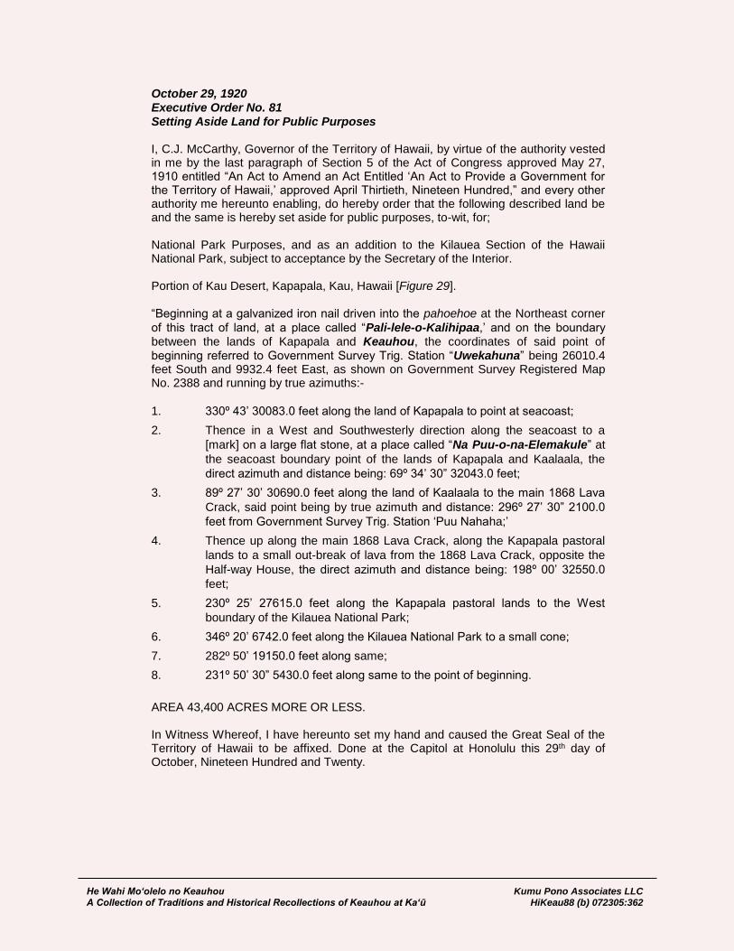
He Wahi Mo‘olelo no Keauhou Kumu Pono Associates LLC A Collection of Traditions and Historical Recollections of Keauhou at Ka‘ū HiKeau88 (b) 072305:362
October 29, 1920 Executive Order No. 81 Setting Aside Land for Public Purposes I, C.J. McCarthy, Governor of the Territory of Hawaii, by virtue of the authority vested in me by the last paragraph of Section 5 of the Act of Congress approved May 27, 1910 entitled “An Act to Amend an Act Entitled ‘An Act to Provide a Government for the Territory of Hawaii,’ approved April Thirtieth, Nineteen Hundred,” and every other authority me hereunto enabling, do hereby order that the following described land be and the same is hereby set aside for public purposes, to-wit, for; National Park Purposes, and as an addition to the Kilauea Section of the Hawaii National Park, subject to acceptance by the Secretary of the Interior. Portion of Kau Desert, Kapapala, Kau, Hawaii [Figure 29]. “Beginning at a galvanized iron nail driven into the pahoehoe at the Northeast corner
of this tract of land, at a place called “Pali-lele-o-Kalihipaa,’ and on the boundary between the lands of Kapapala and Keauhou, the coordinates of said point of beginning referred to Government Survey Trig. Station “Uwekahuna” being 26010.4 feet South and 9932.4 feet East, as shown on Government Survey Registered Map No. 2388 and running by true azimuths:-
1. 330º 43’ 30083.0 feet along the land of Kapapala to point at seacoast;
2. Thence in a West and Southwesterly direction along the seacoast to a
[mark] on a large flat stone, at a place called “Na Puu-o-na-Elemakule” at
the seacoast boundary point of the lands of Kapapala and Kaalaala, the
direct azimuth and distance being: 69º 34’ 30” 32043.0 feet;
3. 89º 27’ 30’ 30690.0 feet along the land of Kaalaala to the main 1868 Lava
Crack, said point being by true azimuth and distance: 296º 27’ 30” 2100.0
feet from Government Survey Trig. Station ‘Puu Nahaha;’
4. Thence up along the main 1868 Lava Crack, along the Kapapala pastoral
lands to a small out-break of lava from the 1868 Lava Crack, opposite the
Half-way House, the direct azimuth and distance being: 198º 00’ 32550.0
feet;
5. 230º 25’ 27615.0 feet along the Kapapala pastoral lands to the West
boundary of the Kilauea National Park;
6. 346º 20’ 6742.0 feet along the Kilauea National Park to a small cone;
7. 282º 50’ 19150.0 feet along same;
8. 231º 50’ 30” 5430.0 feet along same to the point of beginning.
AREA 43,400 ACRES MORE OR LESS. In Witness Whereof, I have hereunto set my hand and caused the Great Seal of the Territory of Hawaii to be affixed. Done at the Capitol at Honolulu this 29th day of October, Nineteen Hundred and Twenty.
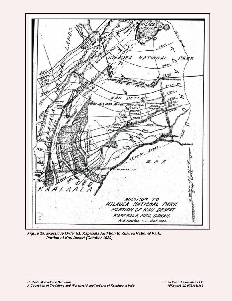
He Wahi Mo‘olelo no Keauhou Kumu Pono Associates LLC A Collection of Traditions and Historical Recollections of Keauhou at Ka‘ū HiKeau88 (b) 072305:363
Figure 29. Executive Order 81. Kapapala Addition to Kilauea National Park, Portion of Kau Desert (October 1920)
He Wahi Mo‘olelo no Keauhou Kumu Pono Associates LLC A Collection of Traditions and Historical Recollections of Keauhou at Ka‘ū HiKeau88 (b) 072305:364
November 6, 1920 Executive Order No. 83 Setting Aside Land for Public Purposes I, C.J. McCarthy, Governor of the Territory of Hawaii, by virtue of the authority vested in me by the last paragraph of Section 5 of the Act of Congress approved May 27, 1910 entitled “An Act to Amend an Act Entitled ‘An Act to Provide a Government for the Territory of Hawaii,’ approved April Thirtieth, Nineteen Hundred,” and every other authority me hereunto enabling, do hereby order that the following described land be and the same is hereby set aside for public purposes, to-wit, for National Park Purposes, and as a portion of the Hawaii National Park, Kilauea Section, subject to acceptance by the Secretary of the Interior [Figure 30]. “Beginning at a point on the rim of Kilauea Crater northwest of and overlooking the pit of Halemaumau and on the boundary of the Government land of Kapapala, the coordinates of said point referred to the Territorial Government Survey Triangulation Station, “Uwekahuna,” being South 1018.49 feet and West 1230.61 feet and running by true azimuths and distances as follows:-
1. 132º 59’ 15,403.0 feet along the Government land of Kapapala;
2. 256º 00’ 10,484.5 feet across the land of Keauhou to a marked point on the
Humuula trail;
3. 328º 15’ 8,725.0 feet across the land of Keauhou to the top of the fault
north of the Kau Road;
4. Along the fault in a northeasterly direction, the direct azimuth and distance
being 251º 30’ 4,330.0 feet;
5. Along the fault in a southeasterly direction to the northwest corner of Bishop
Estate lease No. 921a to the Kilauea Volcano House Company, the direct
azimuth and distance being 306º 08’ 3614.0 feet;
6. 8º 24’ 380.8 feet along Bishop Estate lease No. 921a to an iron pipe;
7. 285º 53’ 153.6 feet along north side of the Kau Road along said lease No.
921a;
8. 322º 19’ 331.4 feet crossing the Kau Road to the Territorial Government
Survey Triangulation Station “Volcano House Flag;”
9. Along the south side of the Kau road to its junction with the Keauhou Road,
the direct azimuth and distance being 295º 12’ 6167.1 feet;
10. 333º 20’ 3,306.0 feet more or less across the land of Keauhou to the
southwest corner of the land of Keaau;
11. 332º 10’ 16,100.0 feet along the land of Kahaualea;
12. 20º 03’ 8,200.0 feet along the land of Apua;
13. 348º 51’ 1,516.4 feet along the land of Apua to the southerly boundary of
the Kilauea Volcano National Park;
14. 89º 10’ 11,715.0 feet along the southerly boundary of the Kilauea Volcano
National Park to the “Pali-lele-o-Kalihipaa;”
15. 165º 23’ 30” 11,163.6 feet along the Government land of Kapapala to the
point “Ahua Kamokukulau;”
16. 180º 23’ 7,356.0 feet along the Government land of Kapapala to a marked
point southwest of the Crater of Keanakakoi;
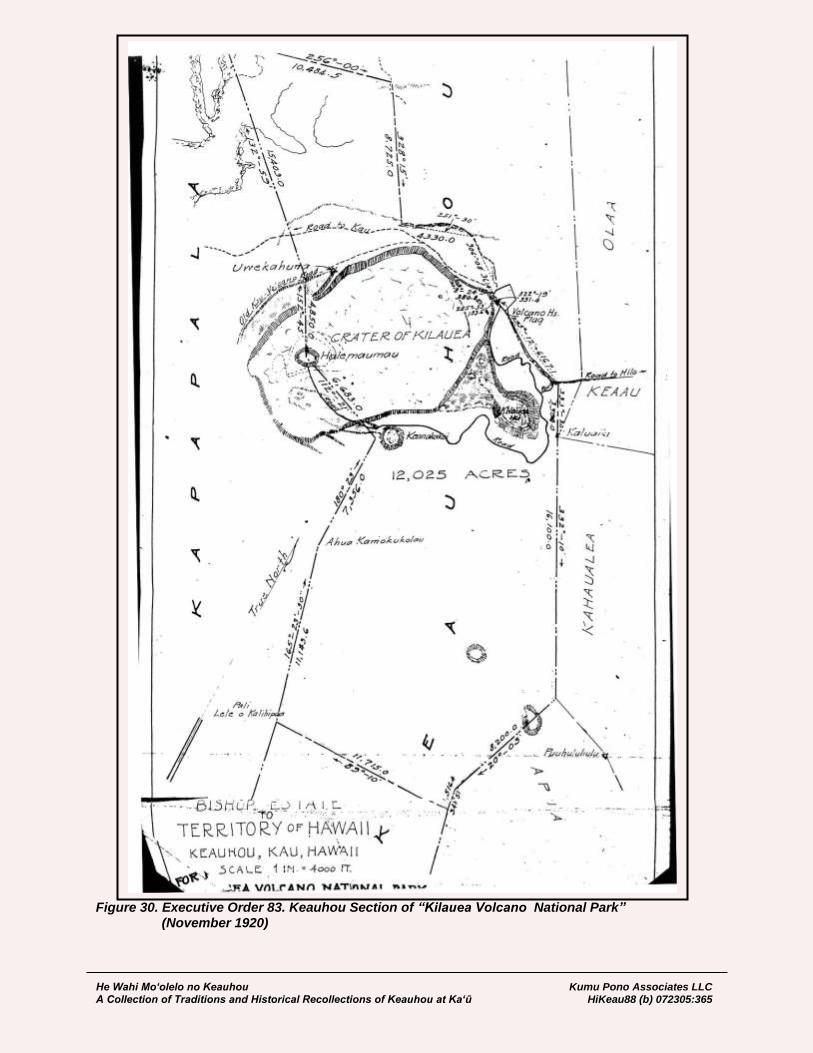
He Wahi Mo‘olelo no Keauhou Kumu Pono Associates LLC A Collection of Traditions and Historical Recollections of Keauhou at Ka‘ū HiKeau88 (b) 072305:365
Figure 30. Executive Order 83. Keauhou Section of “Kilauea Volcano National Park” (November 1920)
He Wahi Mo‘olelo no Keauhou Kumu Pono Associates LLC A Collection of Traditions and Historical Recollections of Keauhou at Ka‘ū HiKeau88 (b) 072305:366
17. 112º 21’ 6,683.0 feet along the land of Kapapala to the pit of Halemaumau;
18. 152º 45’ 4,850.0 feet along the land of Kapapala to the point of beginning;
and containing an area of 12,025 acres, more or less.
In Witness Whereof, I have hereunto set my hand and caused the Great Seal of the Territory of Hawaii to be affixed. Done at the Capitol at Honolulu this 6th day of November, Nineteen Hundred and Twenty. [State Survey Division]
February 8, 1921 Executive Order No. 86 Setting Aside Land for Public Purposes I, C.J. McCarthy, Governor of the Territory of Hawaii, by virtue of the authority vested in me by the last paragraph of Section 5 of the Act of Congress approved May 27, 1910 entitled “An Act to Amend an Act Entitled ‘An Act to Provide a Government for the Territory of Hawaii,’ approved April Thirtieth, Nineteen Hundred,” and every other authority me hereunto enabling, do hereby order that the following described land be and the same is hereby set aside for public purposes, to-wit, for; National Park Purposes, and as a portion of the Hawaii National Park, Kilauea Section, subject to acceptance by the Secretary of the Interior [Figure 31]. All that tract of land comprising portions of the lands of Kapapala and Keauhou, in the District of Kau, and portion of the land of Apua, in the District of Puna, on the Island of Hawaii, containing an Area of 28,745 Acres, bounded as follows:- “Beginning at a point on the West edge of the Keamoku Aa Flow (Lava flow of 1823), the coordinates of said point of beginning referred to Government Survey Trig. Station ‘Uwekahuna’ being 4706.6 ft. South and 17970.3 feet West, and the true azimuth and distance from said point of beginning to Government Survey Trig. Station ‘Ohaikea’ being 166º 20’ 6350.0 feet and running by true azimuths:-
1. Along the West edge of the Keamoku Aa Flow in a Northeasterly and
Northwesterly direction, the direct azimuth and distance being: 198º 10’
14700.0 feet;
2. 256º 00’ 11400.0 feet across the land of Kapapala and Keauhou to a
marked point on the Humuula trail;
3. 328º 15’ 8725.0 feet across the land of Keauhou to the top of the fault
North of the Kau Road;
4. Thence along the fault in a Northeasterly direction along the remainder of
Keauhou to a pipe, the direct azimuth and distance being: 251º 30’ 4330.0
feet;
5. 286º 00’ 530.0 feet along the remainder of Keauhou;
6. 298º 00’ 960.0 feet along same;
7. 283º 48’ 1146.5 feet along same to a pipe;
8. 267º 20’ 1027.5 feet along same;
9. 293º 10’ 1050.0 feet along same to a pipe;
11. 333º 50’ 1100.0;

He Wahi Mo‘olelo no Keauhou Kumu Pono Associates LLC A Collection of Traditions and Historical Recollections of Keauhou at Ka‘ū HiKeau88 (b) 072305:367
Figure 31. Executive Order 86. Government Lands in Kilauea Section of Hawaii National Park. (1921)
He Wahi Mo‘olelo no Keauhou Kumu Pono Associates LLC A Collection of Traditions and Historical Recollections of Keauhou at Ka‘ū HiKeau88 (b) 072305:368
12. 327º 20’ 1940.0 feet along same;
13. 283º 39’ 2057.4 feet along same to a pipe;
14. 333º 20’ 250.0 feet along same to a pipe on the North side of Government
Main Road at Junction with the Keauhou Road, said pipe being by true
azimuth and distance 295º 12’ 6167.1 feet from Government Survey Trig.
Station ‘Volcano House Flag;’
15. 333º 20’ 3300.0 feet along the remainder of Keauhou to the Southwest
corner of Keaau;
16. 332º 10’ 16100.0 feet along the land of Kahaualea;
17. 289º 27’ 4110.0 feet along same to Government Survey Trig. Station
‘Puuhuluhulu’ at the junction of the lands of Apua, Kahaualea and Panau
Nui;
18. 304º 00’ 13252.0 feet along the land of Panau Nui to the junction of the
lands of Apua, Kealakomo and Panau Nui;
19. 18º 20’ 168.0 feet along the land of Kealakomo;
20. 89º 10’ 29044.0 feet across the lands of Apua and Keauhou to ‘Pali-lele-o-
Kalihipaa’, at an angle in the Keauhou-Kapapala boundary marked by pile
of stones;
21. 51º 50’ 30” 5430.0 feet across the land of Kapapala;
22. 102º 50’ 1915.0 feet across same to a small cone about 1500 feet
Southwest of ‘Puu Koae;’
23. 166º 20’ 21000.0 feet across the land of Kapapala to the point of beginning.
AREA 28,745 ACRES.
In Witness Whereof, I have hereunto set my hand and caused the Great Seal of the Territory of Hawaii to be affixed. Done at the Capitol at Honolulu this 8th day of February, Nineteen Hundred and Twenty-One. Territory of Hawaii; to U.S. of America Territory of Hawaii Office of the Government Survey Honolulu, T.H. December 3, 1926 Addition to HAWAII NATIONAL PARK Island of Hawaii. Portions of the Government Lands of KAPAPALA AND HUMUULA District of Kau and N. Hilo, Island of Hawaii. Being a strip of land connecting Kilauea and Mauna Loa Sections. Beginning at Pohaku o Hanalei of Humuula, a small cone on the brow of Mauna Loa, and at the common boundary point of the lands of Humuula, Kapapala, and Kaohe, from which the true azimuth and distance to Government Survey Trig. Station “Omaokoili: is 195º 12’ 18” 78286.0 feet, the coordinates of said point of beginning referred to Government Survey Trig. Station “Uwekahuna” being 30600 feet North and 92742 feet West, and running by true azimuths:
1. 238º 00’ 29241.2 feet along government land;
2. 284º 00’ 19423.7 feet along same to a place called “Puu Kulua” at the
common boundary point of the lands of Humuula, Kapapala, and Keauhou;
He Wahi Mo‘olelo no Keauhou Kumu Pono Associates LLC A Collection of Traditions and Historical Recollections of Keauhou at Ka‘ū HiKeau88 (b) 072305:369
3. 308º 17’ 19592.0 feet along the land of Keauhou to an island in “Aa”;
4. 312º 59’ 29006.5 feet along the land of Keauhou;
5. 76º 00’ 915.5 feet along the Kilauea Section, Hawaii National Park;
6. Thence along same along the West edge of the Keamoku Aa Flow, the
direct azimuth and distance being: 329º 34’ 30” 7817.9 feet;
7. 108º 20’ 37492.3 feet across the land of Kapapala;
8. 79º 50’ 56657.6 feet across the land of Kapapala to the boundary of
Kahuku;
9. 208º 00’ 26987.5 feet along Mauna Loa Section, Hawaii National Park;
10. 118º 00’ 5240.0 feet along same to the point of beginning.
AREA 46050-00/100 ACRES [State Survey Division]
The Territory of Hawaii; to The United States of America Deed March 30, 1927 Know all men by these presents: That the Territory of Hawaii, for and in consideration of the sum of One ($1.00) Dollar, to it in hand paid by The United States of America… does hereby give, grant, bargain, sell and convey unto the United States of America, all that certain parcel of land belonging to it, situate at Kau and North Hilo, County and Territory of Hawaii, being portions of the Government lands of Kapapala and Humuula, consisting of a strip of land connecting the Kilauea and Mauna Loa Sections of the Hawaii National Park and more particularly described as follows: Beginning at Pohaku o Hanalei of Humuula, a small cone on the brow of Mauna Loa, and at the common boundary point of the lands of Humuula, Kapapala, and Kaohe, from which the true azimuth and distance to Government Survey trig. Station “Omaokoili” is 195º 12’ 18” 78286.0 feet, the coordinates of said point of beginning referred to Government Survey Trig. Station “Uwekahuna” being 30600 feet North and 92742 feet West, and running by true azimuths:
1. 238º 00’ 29241.2 feet along government land;
2. 284º 0019423.7 feet along same to place called “Puu Kulua” at the
common boundary point of the lands of Humuula, Kapapala, and Keauhou;
3. 308º 17’ 19592.0 feet along the land of Keauhou to an island in “Aa”;
4. 312º 59’ 29006.5 feet along land of Keauhou;
5. 76º 00’ 915.5 feet along the Kilauea Section, Hawaii National Park;
6. Thence along same along the West edge of Keamoku Aa Flow, the direct
azimuth and distance being: 329º 34’ 30” 7817.9 feet;
7. 108º 20’ 37492.3 feet across the land of Kapapala;
8. 79º 50’ 5667.6 feet across the land of Kapapala to the boundary of Kahuku;
9. 208º 00 26987.5 feet along Mauna Loa Section, Hawaii National Park;
10. 118º 00 5240.0 feet along same to the point of beginning.
Containing an Area of 46050-00/100 Acres. Reserving, however, to the Territory of Hawaii, its successors and assigns, a perpetual right to at any time graze livestock on any portion or the whole of the lands herein conveyed.

He Wahi Mo‘olelo no Keauhou Kumu Pono Associates LLC A Collection of Traditions and Historical Recollections of Keauhou at Ka‘ū HiKeau88 (b) 072305:370
To have and to hold the same with all the rights, privileges and appurtenances thereunto belonging or in anywise appertaining unto the United States of America, its successors and assigns forever… In witness whereof, The Territory of Hawaii has hereunto caused its name to be signed by the Governor of the Territory of Hawaii and by the Commissioner of Public Lands… and has caused the great Seal of the Territory of Hawaii to be affixed this 30th day of March, 1927 W.R. Farrington, Governor… [BoC Liber 896:496-498]
Events and Recollections of Keauhou
and the Lua Pele Since Establishment of Hawaii National Park As it had been in the past, prior to the establishment of Hawaii National Park, significant, and interesting events and activities at Kīlauea continued to be reported in the local newspapers. Dr. Thomas Jaggar, who came to Hawai‘i in 1909, while on his way to observe the volcanoes in Japan, was entertained in Honolulu, and agreed to stay in Hawai‘i, where he made his life-work the study of Hawaiian volcanoes. An organization under the name of the “Hawaiian Volcano Research Association” was formed, Dr. Jaggar, it’s head, and a lease obtained from Bishop Estate to build and operate an observatory (Thurston, 1936). By 1910, articles penned by Dr. Jaggar, regarding the volcanic phenomena became a regular feature in island newspapers. Jaggar also penned vivid and passionate letters in support of the National Park scheme, and establishment of a United State Geological Survey (USGS) station in the park (see the Hilo Tribune-Hawaii Herald, and The Advertiser). The staff of Hawaii National Park, also took a keen interest in the history of the volcano, and working with kama‘āina informants and employees, also undertook publishing a series of articles in the “Hawaii National Park Nature Notes” series. Below, follow four such articles on events and places of interest in the early history of Hawaii National Park:
The Eruption of Halema‘uma‘u in May 1924 In the early years of the National Park, one of the most significant eruptions ever recorded, occurred from Halema‘uma‘u. The eruption was an explosive end to a summit eruption that had begun more than 100 years before, and had been the subject and source of most of the historical descriptions of volcanic activity at Kīlauea. Numerous accounts have been published about the event, the following from Lorrin A. Thurston, an eyewitness to the event described, and key player in the national park scheme in Hawai‘i (Thurston, 1936). Photographs cited in the texts below, were found in the collection of the USGS-Denver Library.
…I witnessed several gas explosions in 1924, when the pit was blown out to a depth of some 1,300 feet, and a large area of the main crater, surrounding the pit, was engulfed. At one explosion, I was with a party on the main floor of Kilauea, about a half mile from Halemaumau, when a rock, afterward estimated to weigh more than seven tons, was [page 69] hurled several hundred feet above our heads. It landed beyond us—and is still pointed out to tourists—as did smaller rocks. One fell upon a sight-seer, pinning him to the ground. He was rescued by members of our party, and was taken to a hospital in Hilo by an army truck, but he died the next morning. That is the only fatal accident at the volcano since it was first visited by white men in 1823… [Excerpted from Thurston’s article in The Advertiser of May 24, 1924] …I returned yesterday [to Honolulu] from a visit of six days to the Island of Hawaii. During that time, I spent two whole days and parts of two other days at Kilauea; I also visited the districts of Puna, Kau, and North and South Kona. I spent most of the time in seeing what there was to be seen, making as accurate a record thereof as possible, and forwarding a daily wireless to The Advertiser. I now summarize the result of the observations of the last week. In the first place, I have not exaggerated one single item, nor have I seen or heard any exaggeration, wither in or out of the
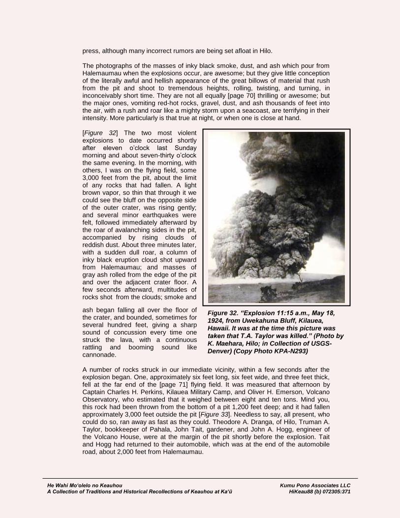
He Wahi Mo‘olelo no Keauhou Kumu Pono Associates LLC A Collection of Traditions and Historical Recollections of Keauhou at Ka‘ū HiKeau88 (b) 072305:371
Figure 32. “Explosion 11:15 a.m., May 18, 1924, from Uwekahuna Bluff, Kilauea, Hawaii. It was at the time this picture was taken that T.A. Taylor was killed.” (Photo by K. Maehara, Hilo; in Collection of USGS- Denver) (Copy Photo KPA-N293)
press, although many incorrect rumors are being set afloat in Hilo. The photographs of the masses of inky black smoke, dust, and ash which pour from Halemaumau when the explosions occur, are awesome; but they give little conception of the literally awful and hellish appearance of the great billows of material that rush from the pit and shoot to tremendous heights, rolling, twisting, and turning, in inconceivably short time. They are not all equally [page 70] thrilling or awesome; but the major ones, vomiting red-hot rocks, gravel, dust, and ash thousands of feet into the air, with a rush and roar like a mighty storm upon a seacoast, are terrifying in their intensity. More particularly is that true at night, or when one is close at hand. [Figure 32] The two most violent explosions to date occurred shortly after eleven o’clock last Sunday morning and about seven-thirty o’clock the same evening. In the morning, with others, I was on the flying field, some 3,000 feet from the pit, about the limit of any rocks that had fallen. A light brown vapor, so thin that through it we could see the bluff on the opposite side of the outer crater, was rising gently; and several minor earthquakes were felt, followed immediately afterward by the roar of avalanching sides in the pit, accompanied by rising clouds of reddish dust. About three minutes later, with a sudden dull roar, a column of inky black eruption cloud shot upward from Halemaumau; and masses of gray ash rolled from the edge of the pit and over the adjacent crater floor. A few seconds afterward, multitudes of rocks shot from the clouds; smoke and
ash began falling all over the floor of the crater, and bounded, sometimes for several hundred feet, giving a sharp sound of concussion every time one struck the lava, with a continuous rattling and booming sound like cannonade. A number of rocks struck in our immediate vicinity, within a few seconds after the explosion began. One, approximately six feet long, six feet wide, and three feet thick, fell at the far end of the [page 71] flying field. It was measured that afternoon by Captain Charles H. Perkins, Kilauea Military Camp, and Oliver H. Emerson, Volcano Observatory, who estimated that it weighed between eight and ten tons. Mind you, this rock had been thrown from the bottom of a pit 1,200 feet deep; and it had fallen approximately 3,000 feet outside the pit [Figure 33]. Needless to say, all present, who could do so, ran away as fast as they could. Theodore A. Dranga, of Hilo, Truman A. Taylor, bookkeeper of Pahala, John Tait, gardener, and John A. Hogg, engineer of the Volcano House, were at the margin of the pit shortly before the explosion. Tait and Hogg had returned to their automobile, which was at the end of the automobile road, about 2,000 feet from Halemaumau.
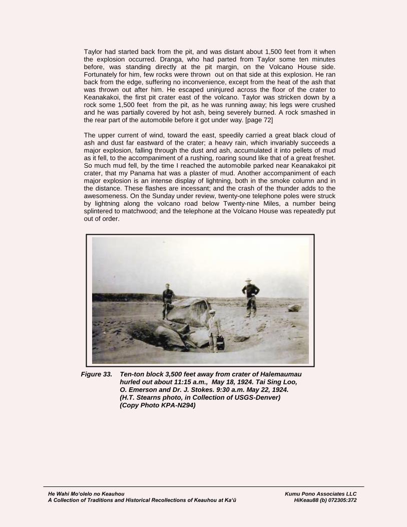
He Wahi Mo‘olelo no Keauhou Kumu Pono Associates LLC A Collection of Traditions and Historical Recollections of Keauhou at Ka‘ū HiKeau88 (b) 072305:372
Taylor had started back from the pit, and was distant about 1,500 feet from it when the explosion occurred. Dranga, who had parted from Taylor some ten minutes before, was standing directly at the pit margin, on the Volcano House side. Fortunately for him, few rocks were thrown out on that side at this explosion. He ran back from the edge, suffering no inconvenience, except from the heat of the ash that was thrown out after him. He escaped uninjured across the floor of the crater to Keanakakoi, the first pit crater east of the volcano. Taylor was stricken down by a rock some 1,500 feet from the pit, as he was running away; his legs were crushed and he was partially covered by hot ash, being severely burned. A rock smashed in the rear part of the automobile before it got under way. [page 72] The upper current of wind, toward the east, speedily carried a great black cloud of ash and dust far eastward of the crater; a heavy rain, which invariably succeeds a major explosion, falling through the dust and ash, accumulated it into pellets of mud as it fell, to the accompaniment of a rushing, roaring sound like that of a great freshet. So much mud fell, by the time I reached the automobile parked near Keanakakoi pit crater, that my Panama hat was a plaster of mud. Another accompaniment of each major explosion is an intense display of lightning, both in the smoke column and in the distance. These flashes are incessant; and the crash of the thunder adds to the awesomeness. On the Sunday under review, twenty-one telephone poles were struck by lightning along the volcano road below Twenty-nine Miles, a number being splintered to matchwood; and the telephone at the Volcano House was repeatedly put out of order.
Figure 33. Ten-ton block 3,500 feet away from crater of Halemaumau hurled out about 11:15 a.m., May 18, 1924. Tai Sing Loo, O. Emerson and Dr. J. Stokes. 9:30 a.m. May 22, 1924. (H.T. Stearns photo, in Collection of USGS-Denver) (Copy Photo KPA-N294)
He Wahi Mo‘olelo no Keauhou Kumu Pono Associates LLC A Collection of Traditions and Historical Recollections of Keauhou at Ka‘ū HiKeau88 (b) 072305:373
Upon gathering at the point where the automobiles were parked, and counting noses, we discovered that two members of the party were missing: Dranga, Senior, and Taylor. Dranga, however, was observed approaching the crater with his umbrella up, to keep the falling mud off. After we learned that he had not seen Taylor, a search party of four, consisting of R. H. Finch, the Volcano Observatory man, William O. Clark, Pahala geologist, T. A. Dranga, and Ted Dranga, returned in Dranga’s car to search for Taylor. When the car stopped, as far as it could go, about 2,000 feet from the pit, where it was blocked by newly- [page 73] fallen rock in the road, Taylor was heard calling. He was found under a coating of ash, which had burned him seriously, with both legs crushed. A tourniquet was immediately applied to stop the bleeding; and he was carried to the automobile on a raincoat as a stretcher, while a second fusillade of rocks showered about the party, fortunately striking no one. Taylor was conveyed immediately [page 74] to the Volcano House, where he received aid from the Military Camp physician, Captain Patrick J. McKenzie, and two trained nurses, Miss Mollie Thomas and Miss Antoinette Peck. On the advice of Dr. McKenzie, Taylor was transferred to the Hilo Hospital on an army truck. In spite of all that four doctors could do there, he succumbed to loss of blood and shock at eleven o’clock that night. The most terrific explosion came at seven-thirty o’clock that Sunday evening. It gave us an idea of what might happen at any time on a much larger scale. Without warning, a gigantic black cloud arose to a height estimated by Mr. Boles at twelve miles. As it rose, it scintillated throughout its length and breadth with a multitude of lightning flashes. Showers of hot rocks, some of immense size, flew in all directions, with such rapidity and in such quantity that in moments the entire floor of the crater, for a distance of several thousand feet from the pit, was so afire with hot rocks that it gave the appearance of a live lava flow. Many hot boulders struck the face of the Uwekahuna Bluff, on the Mauna Loa side of the crater, more than a mile from the pit, shattering and crashing to the crater floor below in a glowing shower, while great quantities were thrown upon the lower bank of the crater to the south of Uwekahuna, the glow being visible from the Volcano House for some minutes after they fell. Once, there was a serious question whether the hot rocks from the pit would be thrown as far as the Volcano House. As Mr. Finch said, they came forward in jumps of five hundred feet at a time. [page 75] All of the Volcano House guests, except four, had departed. Channing J. Lovejoy, manager, was game. He said, so long as a guest remained, that he would keep the hotel open, but that, if the remaining guests left, he would close the hotel immediately for the night. In a few minutes, the remaining guests had departed, with a number of Hilo people who had been watching the crater. For the first time, the Volcano House closed its doors, although two watchmen and several cooks and waiters remained on the premises. Manager Lovejoy joined the others in the retreat to Hilo. He returned on the next morning; and the hotel has been open since, subject to the notice that it may close at any time in the judgment of the manager, based on the advice of Thomas Boles, park superintendent, and Roy H. Finch, observatory attendant. Mrs. Finch and A. L. Burdick, a county engineer, remained on watch Saturday and Sunday nights; and Mrs. Finch has spelled her husband and Mr. Emerson in a continuous day-and-night watch since the beginning of the explosions on Saturday, May 10. So much for some details of the most spectacular activities of Kilauea within the memory of living men. . . . In 1790, 134 years ago, explosive eruptions were last known in Hawaii. Then the whole great crater of Kilauea was blown out. Pumice, rocks, and enormous amounts of sand and ash were thrown from the crater to a distance of two miles back of the present Volcano House and ten miles across the Kau Desert; and one section of a

He Wahi Mo‘olelo no Keauhou Kumu Pono Associates LLC A Collection of Traditions and Historical Recollections of Keauhou at Ka‘ū HiKeau88 (b) 072305:374
passing Hawaiian army was killed. Quantities of pumice [page 76] and sand and many large rocks from Kilauea are still found at the Twenty-nine Mile village on the volcano road, and in the entire country within several miles of the volcano. All that has yet happened is the most minor activity compared with what is known to have happened in the past. Earthquakes have been heretofore almost unknown at the Volcano House. In forty odd years, during which I have been going there frequently, I have felt only two, and those inconsiderable. Perceptible earthquakes—some of them quite severe, although none have yet done any injury—are being felt every day by dozens and scores; and they appear to be increasing in intensity. This can mean but one of two things: first, that the surplus energy of the volcano is being worked off through these minor explosions; or, second, that the explosive energy is accumulating and racking the framework of the earth, as evidenced by the multiplying earthquakes, which may ultimately cause a recurrence of the phenomena of 1790, with perhaps still greater energy. . . There is no activity at present in Hilo, other than a few scattered and incon-siderable earthquakes. For the past three weeks, there have been no earthquakes or activity in Kapoho, Puna, where the earthquakes and subsidences were so strong a short time ago. Hilea, in Kau, known as the “home of earthquakes,” which normally has more than any other spot on Hawaii, is recording an almost continuous tremble on the seismograph, but is having no perceptible earthquakes. Conditions elsewhere in Kau and Kona are normal. On the other hand, [page 77] the Volcano House, which has no earthquakes normally, is experiencing a daily and nightly “flock of earthquakes,” as Dr. Thomas A. Jaggar calls them, of increasing intensity, accompanied by explosive eruptions. While small in comparison with those of 1790, these explosions are violent. Dr. Jaggar, who is making a life study of the volcano, is not at hand, but he has repeatedly placed himself on record as believing that another explosive period might be expected… [Thurston, 1936:78]
Prayers to Bring About an Eruption (1931) One additional account is cited in this section of the study, as it demonstrates that even in the years after the National Park was established, that tradition and practice continued at Kīlauea. In 1931, The Honolulu Advertiser reported that an elderly Hawaiian woman and her son, were on their way to Kīlauea from O‘ahu, where she was going to pray to Pele, for renewed eruptive activity. An important fact revealed in this notice, is that cultural practitioners—those with ties to Kīlauea—may not necessarily live in lands adjoining Keauhou, but may, and will also come from other Hawaiian islands. The Pele traditions span all of Hawai‘i, and have remained most visible because of the volcanic manifestations of Pele and her family.
Honolulu Advertiser Aged Woman Will Try Arts on Madame Pele Ancient rites in honor of Madame Pele, goddess of Kilauea, will be performed on the edge of Halemaumau this week by an aged Hawaiian sorceress, so she claims, to revive activity in the volcano. The expedition to Kilauea left Monday under the leadership of George Maluna, 907 Waikamilo road, son of the aged woman who says she is personally acquainted with the goddess and is almost 100 years old. E.P. Leavitt, superintendent of Hawaii National Park, has been invited to be present as an eye witness to the rites. Later, when the Volcano has erupted, the aged woman says she will ask Pele to stop the eruption. [Honolulu, Advertiser; February 12, 1931 p7/c3]
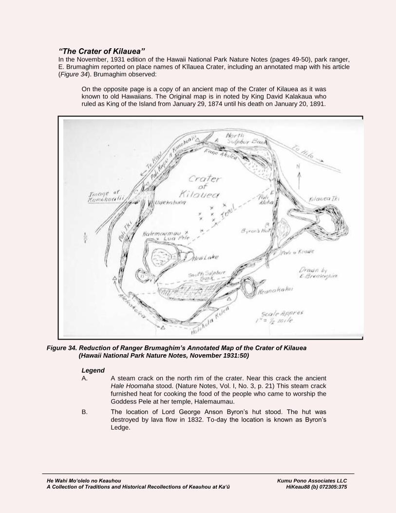
He Wahi Mo‘olelo no Keauhou Kumu Pono Associates LLC A Collection of Traditions and Historical Recollections of Keauhou at Ka‘ū HiKeau88 (b) 072305:375
“The Crater of Kilauea” In the November, 1931 edition of the Hawaii National Park Nature Notes (pages 49-50), park ranger, E. Brumaghim reported on place names of Kīlauea Crater, including an annotated map with his article (Figure 34). Brumaghim observed:
On the opposite page is a copy of an ancient map of the Crater of Kilauea as it was known to old Hawaiians. The Original map is in noted by King David Kalakaua who ruled as King of the Island from January 29, 1874 until his death on January 20, 1891.
Figure 34. Reduction of Ranger Brumaghim’s Annotated Map of the Crater of Kilauea (Hawaii National Park Nature Notes, November 1931:50)
Legend
A. A steam crack on the north rim of the crater. Near this crack the ancient
Hale Hoomaha stood. (Nature Notes, Vol. I, No. 3, p. 21) This steam crack
furnished heat for cooking the food of the people who came to worship the
Goddess Pele at her temple, Halemaumau.
B. The location of Lord George Anson Byron’s hut stood. The hut was
destroyed by lava flow in 1832. To-day the location is known as Byron’s
Ledge.
He Wahi Mo‘olelo no Keauhou Kumu Pono Associates LLC A Collection of Traditions and Historical Recollections of Keauhou at Ka‘ū HiKeau88 (b) 072305:376
C. Image of Kamohoalii, brother of the Goddess Pele. Legend tells us that his
body is buried on this cliff and that when erosion uncovers his bones Pele
comes with lava and volcanic ashes and covers them again. The image of
Kamohoalii can be seen to-day on this pali.
D. A crater in which Amaumau ferns grew. This crater does not exist now.
E. Marks the spot where Pele met and fell in love with Lohiau.
F. Where Princess Kapiolani had her camp.
x. Spatter cones on the floor of the crater. Only Little Beggar remains to-day.
“Ka Manu Hawaii” (The Birds of Hawaii) On January 11, 1939, Ka Hoku o Hawaii published a short article in Hawaiian, describing recent observations of native birds in Hawaii National Park, around Kīlauea. The article names localities from “Paka Manu” (Bird Park), to the woods around the golf course and behind Kīlauea iki, as being noted for bird watching. The paper reported:
We have received word from the Hui Manuiki, that there are many, many ‘apapane at this time, at Kilauea. They are the most prevalent of the birds gathered there. And just as do people in other fields, there are those who wish to see the different birds, as those which are only in Hawai‘i. At Kīlauea, these people go into the forest to look at the Hawaiian Birds. To do this, they take the narrow path from the Paka Manu (Bird Park), to the fields of the golf course, and to the Army Camp at Kīlauea, and continue on to Kīlauea iki. The ‘apapane are foremost of the birds that are seen. Through the research of the National Park Rangers at Kīlauea, they have learned that when there is an increase of insects in the tree branches, the number of birds are also greatest, because this is what the birds eat. There has been a decrease in the numbers of the kōlea and piheekelo. Their numbers have diminished, and it is thought that this is perhaps because of the cold. Other Hawaiian birds seen at Kīlauea at this time are the ‘amakihi and the ‘elepaio. Thus, by this notice, we know that the ‘apapane is the most prevalent of the Hawaiian birds. [Ka Hoku o Hawaii, January 11, 1939; Maly, translator]
Haku Mele–Chants and Songs for Kīlauea Made and Offered in Modern Times In 1965, Hawaiian historians and composers, Alice Namakelua and Mary Kawena Pukui, created an album of mele (songs) for the children of Hawai‘i. The last composition was in the traditional form of a mele (chant), that honored Kīlauea and Pele. The mele, “Kīlauea,” incorporates traditional knowledge into poetry that suggests to those who hear it, that if the sacredness is returned to Kīlauea—the manner in which we approach and treat the land—we shall all be granted life:
A ka luna o Kīlauea, At the heights of Kīlauea, I ke ahi a ka wahine. Are seen the fires of the woman. Ha‘a ana o ka wahine Pele Pele, the woman, dances, Uhi uha mai ana la. Surging back and forth. Nome ana o Pele i Puna Pele eats away at Puna, Aia ka palena ‘aekai ea She is there on the shore. He inoa no a‘e Pele ea, This is a name chant for Pele, Ka wahine noho ai i Kīlauea. The woman who dwells at Kīlauea.

He Wahi Mo‘olelo no Keauhou Kumu Pono Associates LLC A Collection of Traditions and Historical Recollections of Keauhou at Ka‘ū HiKeau88 (b) 072305:377
Ho‘i no e ke kapu i Kīlauea, Return the sacredness to Kīlauea, E ola mākou a mau loa! That we may all have life! [pers com. Alice Namakelua, 1975]
In 1979, while working at Hawai‘i Volcanoes National Park, co-author, Kepā Maly, remained in contact with several kūpuna and elder kama‘āina, discussing the history, mele, and traditions of Kīlauea and vicinity. Based on the teachings of Mary Kawena Pukui, Alice Namakelua, Ho‘ohila Kawelo, Edith Kanaka‘ole and Dorothy Barrere, Maly composed a song, referencing traditions and ancient mele taught to him, as an expression of aloha for Kīlauea and those who dwell therein. The mele was subsequently performed on several occasions at Kīlauea and in the Merry Monarch Hula Festival in 1981, by a group of musicians and dancers from the lands that make up Hawai‘i Volcanoes National Park:
He Aloha no a o Kīlauea He aloha no a o Kilauea, One loves Kīlauea, Lei ana i ka ‘uwahi, Which wears the steam as its lei, ‘Uahi a ka wahine i ka lua, It is the steam of the woman in the crater, Noho no Halema‘uma‘u. Dwelling at Halema‘uma‘u. Hōpoe lei a ka wahine, Hōpoe (the lehua) is the adornment of the woman (Hi‘iaka), Lehua ‘ula i ka papa. The red blossomed lehua on the plain. Ha‘a no na pua a i ka makani, The blossoms dance in the wind, Pu‘ulena o ka ‘āina. Pu‘ulena of this land. A‘ohe wahi ho‘ohalahala, There is nothing to criticize, A ka maka ke ‘ike aku, That the eyes can see, Mau no ka nani, ka maika‘i, ke onaona, For the beauty, perfection, and the fragrances are forever, Noho no i Kīlauea. That reside at Kīlauea. E nihi ka hele i ka lihilihi, One much travel cautiously to the rim, O ka pali a ka Wahinekapu, Of the cliff of Wahinekapu, Kanaenae ma mua o ka ‘ohi ‘ana Prayers must be offered before picking, O ka pua lehua kea. The white blossomed lehua. Puana ka inoa a i lohe ‘ia, So spoken is the name that is heard, No ka nani a o Kīlauea, For the beauty of Kilauea, Ke ha‘a mai la e ka wahine, The woman dances, I ke kula pāhoehoe, On the plains of pāhoehoe, I ke kula ‘a‘ā. And on the plain of ‘a‘ā. [Kepā Maly, 1979]

He Wahi Mo‘olelo no Keauhou Kumu Pono Associates LLC A Collection of Traditions and Historical Recollections of Keauhou at Ka‘ū HiKeau88 (b) 072305:378
KAMA‘ĀINA RECOLLECTIONS
We find today, that the voices of kūpuna (elders) are among the most precious resources handed down to us from the past. Accompanying this study, are excerpts from oral histories which provide readers with a unique opportunity to learn about the history and cultural-historical landscape of Keauhou and vicinity. While the historical and archival records, as those presented in the first part of the study, help us understand how we came to be where we are today, the voices of the elders give life to the stories, and demonstrate how history and practices are handed down. The interviews offer readers glimpses into the personal knowledge and experiences of individuals with generational and cultural attachments to Keauhou and Pele.
Historic Interviews with Kūpuna
Notes collected by Theodore Kelsey (1920s-1950s) Historian, Theodore Kelsey was born in Hilo in the 1890s. Early in his life he found a great interest in Hawaiian history and language, speaking with elders and researching previously recorded accounts. By 1920, he was publishing articles in news papers and periodicals. Throughout his life, he was a meticulous note keeper, and when Maly met him in 1976, he still remained active in his life’s work. Much of his collection of notes, both hand written and typeset, may be found in the Hawai‘i State Archives, Bishop Museum Collection, and currated in the collection of the late June Gutmanis. In 1997, Ms. Gutmanis provided copies of selected records from the Kelsey collection to Maly, excerpts from Kelsey’s life work with kūpuna, knowledgable about sites in Keauhou and practices associated with Pele, follow below: In the 1920s, Reverend H.B. Nalimu told Kelsey:
Pauahilani was a man who carried the bone sof chiefs to Kilauea and threw them into the mouth of the crater in old times. This “waha o Kilauea” was a big open hole with fire in it where smoke rose, between ka pali kapu o Kamohoali‘i and Hale-ma‘uma‘u. Awa, pig etc. were also sacrificed.
Regarding pronunciation of place names and traditions associated with named localities, Kelsey documented accounts he received from the elder, Naluahine Kaopua in 1957:
‘Uwē-kāhuna is plural, meaning the crying or lamenting of kāhunas, who presumably would be the kahu Pele, or attendants, or priests of Pele. The prominent inset cliff formations below ‘Uwē-kāhuna’s top and the large pit of Ki-lauea is Wahine-kape, or Taboo Woman. In the crater somewhere below Ka Pali Kapu o Ka-moho-ali‘i (The Tabu Pali of Pele’s brother, a shark deiity) is a formation. Naluahine says the formation in the big crater is Lupe or Ka Lupe (the Kite). He says it is somewhere below the tabu Pali, which Pele’s smoke would not touch, as it would always blow in another direction. Similarly, she would not bombard it with pohāhā, or big fiery rocks hurled in the air. Wai-a-ka-pāo‘o. Water of the pao‘o fish, was a spring part-way down the trail from the concrete monument where the trail goes down into the crater. Naluahine spoke of it. The pao‘o is a small fish in sea-pools (kāheka) and shallow sea (kai pāpa‘u). There are the pao‘o kauila (the color of Kauila wood, I think) and the pao‘o lekei, or leaping pao‘o. I do not know the legend of the spring.
He Wahi Mo‘olelo no Keauhou Kumu Pono Associates LLC A Collection of Traditions and Historical Recollections of Keauhou at Ka‘ū HiKeau88 (b) 072305:379
‘A-kani-kolea is a high point. Kama-pua‘a came and taunted Pele. Perhaps he stood on ‘A-kani-kolea. Hale-ma‘uma‘u. House made of ama‘u fern leaves (like a teepee), fastened together and stood upright, then covered over, as a temporary ountain shelter while travelling. Hale-ma‘uma‘u was the name of one of severl cheifs who came over from Kaua‘i to fight Pele. They were turned to stone. Pohaku-loa was one of them. There is a list of them given in Westervelt’s Legends of Volcanoes, I believe. Ka Pali o Ka-‘au-ea. This was in the crater in fromt of the old Volcno House. Naluahine said the heiau, Ke-ala-lau-‘ō (The pathway of sugarcane leaves) was up there in the bushes and trees, near the course of the ancient road. Kāma‘a Lā‘ī, place where ti leaf sandals were put on to cross the lava. Keone-o-Kaha-loa. A sandy area. It was tabu to pick any shrubs or flowers unless first praying to Pele. On the way up from Hilo, don’t pick things because it might rain. [Notes from interviews with Naluahine Kaopua. Theodore Kelsey Collection.]
Louis Kauanoekauikalikokahalaopuna Panui An Account of the Battle Between Pele and Kamapua‘a, And Dividing the Island Between Themselves (January 5, 1951 – with Flora Kaai-Hayes and Homer Hayes) Louis Kauanoekauikalikokahalaopuna (Tūtū Kaua) Panui, a descendant of Kekuhaupi‘o, was born at Ke‘ei, South Kona, in 1863, where he lived until his death in 1960. Tūtū Kaua was a noted Hawaiian historian, who contributed many articles and letters to the Hawaiian language newspapers, and was an informant to various researchers from the Bishop Museum. In late 1950, and early 1951, Flora Ka‘ai Hayes and her son, Homer Hayes, visited Tūtū Kaua at Ke‘ei, where they recorded several accounts pertaining to Pele (events around the eruption of 1950), and of various facets of history. The following transcript is excerpted from the larger set of interviews, and is a recounting of the battle between Pele and Kamapua‘a, as learned by Tūtū Kaua from his own kūpuna. The account is introduced and closed with a discussion on two stone forms—one at Ke‘omo, Ke‘ei, and the other at Keōkea (both lands, which like Keauhou, Ka‘ū, became a part of the Estate of Chiefess Pauahi Bishop)—which are attributed to Pele. Tūtū Kauas’ mo‘opuna, and hānai, William Kalikolehua Pānui, resides at the family land in Ke‘ei. As his own kupuna did, the younger Kupuna Panui still shares the mo‘olelo of Pele and the stone forms described below, as well as other traditions recorded by Tūtū Kaua. The recording from which the following transcript was made, was received through the generosity of Homer Hayes, and is transcribed below, as near as possible in verbatim form (in some areas, the recording is difficult to understand). The translation was prepared by Kepā Maly, and reflects as accurately as possible the original meaning as spoken by Tūtū Kaua.
[28:00] ‘Ae, hele mai o Pele mai Kahiki. Yes, Pele came from Kahiki. Noho ‘oia ma ka mokupuni, i Honolulu. She stayed on the island, at Honolulu. Pi‘i ‘oia i Nu‘uanu, ‘ali i ka lua, pāpa‘u, She ascended Nu‘uanu, dug a crater, loa‘a ka wai. Hele mai ‘oia hiki i Maui. But it was shallow, there was water. She Hiki i Maui, pi‘i ‘oia iluna o Haleakalā. then went to Maui. Arriving at Maui, she ‘ali ‘oia i ka lua ilaila, pāpa‘u, loa‘a ka ascended Haleakalā. She dug a crater

He Wahi Mo‘olelo no Keauhou Kumu Pono Associates LLC A Collection of Traditions and Historical Recollections of Keauhou at Ka‘ū HiKeau88 (b) 072305:380
wai. Hele mai ‘oia i ke kuahiwi o there, but it was shallow and had water. Mauna Loa, a hiki i Kīlauea. She then went to the mountain of Mauna Loa, and then to Kīlauea. Noho mai ‘oia ma laila a hiki i She has dwelled there to the present kēia lā, ma Halema‘uma‘u. Kona day, at Halema‘uma‘u. That is her hale ‘ia i noho ai, a hiki i kēia lā. House, where she lives, to the present ‘Ali oia i ka lua, hohonu. A‘ole loa‘a day. She dug a deep crater. No water was i ka wai. Ma laila ‘oia kāhi e noho found. That is where she lives to the ai a hiki i kēia lā. present day. Hele mai la o Pele mai Kahiki mai. Luku Pele came from Kahiki. She destroyed ‘ia i nā kupua a pau o Hawai‘i nei. all of the supernatural beings of Hawai‘i. A‘ole kupua ola. Pēlā e make ai o No kupua was left alive. That is how He‘eka‘ole. Kupua o He‘eka‘ole. Luku He‘eka‘ole died. He‘eka‘ole was a kupua. ‘ia pau nā kupua a pau o Hawai‘i All of the kupua of Hawai‘i were killed. nei. A‘ole kupua e koe ai. Koe No kupua were left. There only remained ho‘okāhi no o Pele. Mahope mai Pele. After the time that all of these beings o ka manawa o ka luku ‘ia o kēia were destroyed, she returned to Kīlauea, po‘e a pau, ho‘i ‘oia i Kīlauea, to live there, that is at the crater of Hale- noho ai ilaila, ‘oia ho‘i ka lua o ma‘uma‘u. She lives there. That is the Halema‘uma‘u. Noho ‘oia ilaila, ‘oia place where she lives to this very day. ke kahua e noho ai a hiki i kēia lā. Mai laila mai, hele ho‘omaka mai It was also from there [Kahiki], that o Kamapua‘a e hele ai mai Kahiki Kamapua‘a traveled, he came from mai. Hele o Kamapua‘a a hiki i Kahiki. Kamapua‘a arrived at Honolulu. Honolulu. Mai Honolulu mai, hiki i From Honolulu, he arrived at Kohala. Kohala. Hiki i Kohala, hele ‘oia mauka. Arriving in Kohala, he went to the uplands. Kamapua‘a, ‘imi ‘ana ‘oia iā Pele. Kamapua‘a was searching for Pele. Mamake ‘oia iā Pele i wahine nāna. He desired her to become his wife. Hele ‘oia a hiki i Halema‘uma‘u, Kīlauea. He went and arrived at Halema‘uma‘u, Noho ‘oia ilaila, a ‘ike i nā kaikaina o Kīlauea. He stood there and saw the Pele. He nui nā kaikaina o Pele. Ae, sisters of Pele. There are many sisters of o na inoa o nā kaikaina o Pele: O Pele. Yes, the names of the sisters of Pele Pele ‘oia no ke kaikua‘ana. O Pele, are: Pele is the eldest. It is Pele, Hi‘iaka, o Hi‘iaka, Hi‘ilani, Kapo, Kumainiho [?], Hi‘ilani, Kapo, Kumainiho [?], Kamiki, Kamiki, Wahine‘ōma‘o, ‘Āpuakea, nā Wahine‘ōma‘o, ‘Āpuakea, they are the kaikaina ia mea, o Pele. E noho ‘ana sisters of her, Pele. They were residing i loko o ka lua, ai lākou i ka lua, ke ‘ā in the crater, there in the crater, where the nei i ke ahi. Kiei o Kamapua‘a mauka, fires were burning. They looked at Kama- a‘ole hilahila ‘oia. Kiei o Kamapuaa pua‘a, there above, he was not ashamed. maluna, ‘ike o Hi‘iaka. O Hi‘iaka keia Looking above, Hi‘iaka saw Kamapua‘a. i ka poli o Pele. A ‘ike kēia kanaka u‘i This was Hi‘iakaikapoliopele. She saw this e kū ‘ana maluna, a‘ole loa‘a a ‘oi aku, handsome man standing above, there was nani hoi kēia kanaka e kū nei. no one more attractive than this man who O Kamapuaa kēia. stood there. This was Kamapua‘a. Tsaa! ‘Ōlelo aku o Pele, “a‘ole kēnā he Tsaa! Pele called out, “that is not a man, kanaka, he pua‘a! Tsaa—a, he pua‘a!” it is a pig! Tsaa—a, he is a pig!” ‘Ōlelo aku nei “a‘ole kēlā he kanaka, She said, “that is not a man, but a pig. he puaa. A e ho‘olohe mai oukou i ka‘u All of you listen to my call (to him).” Pele kahea ana.” Alaila kahea o Pele: then called out: Kamapua‘a ‘ōkole papalehī. Kamapua‘a has diarrhea of the buttocks. He huelo pili i ka ‘ōkole. A tail adjoining the buttocks.
He Wahi Mo‘olelo no Keauhou Kumu Pono Associates LLC A Collection of Traditions and Historical Recollections of Keauhou at Ka‘ū HiKeau88 (b) 072305:381
He ‘ule pili i ka ōpū. A penis connected to his stomach. He ihu pa‘a i ka ‘aha, A nose through which a cord is run, He pepe o keia. And this is a flat one. Ho‘omaka o Kamapua‘a i ka hūhū. Kamapua‘a became angry. As his anger Hūhū o Kamapua‘a, a pēlā ka pai rose, he began to urge up the piglet ai o ka puapuaa e hele nei mauka, clouds, drawing them all to the uplands, he ua li‘ili‘i kēlā, puapua‘a. Kapa that is the little rains, the puapua‘a clouds. ‘ia kēlā puapua‘a, Kamapua‘a. The puapua‘a are called (bodies of) Kama- Kamapua‘a ‘ia, ka puapua‘a. pua‘a. Kamapua‘a is the piglet clouds. Ho‘omaka o Kamapua‘a e hī, Kamapua‘a then began to excrete, hī i ka lua o Pele. Hī i ka lua excrete in the crater of Pele. He excreted a—kokoke piha. Kokoke piha o ke until—it was almost filled. Nearly over- ahi o Pele. Kahea o Pele iā Kapo. flowing the fires of Pele. Pele called to Kēia Kapo, o Kapokohelele kēia. Kapo. Now this Kapo was Kapo of the Lele a‘e nei o Kapo, a ‘ike o flying vagina. Kapo flew, Kamapua‘a Kamapua‘a iā Kapo, ‘alu‘alu. saw Kapo, and followed after her. He ‘Alu‘alu a hiki kēia i Puna, followed her to Puna, and mated with a moe me Kapo. Kapo. He mana‘o Kapo…he mana‘o no ho‘i Kapo thought…Kamapua‘a thought it o Kamapua‘a, akā i ka moe ‘ana ia was so, but when he mated with Kapo ne‘i me Kapo, ‘umi‘umi i ka pāhoehoe, he was thwarted by the pāhoehoe, ‘oia i moe ai a puka kēia pāhoehoe, he had mated with, and perforated the aia i Puna a hiki i kēia lā. Puka, a‘ole pāhoehoe, it (the hole) is there in Puna ka wahine. I huli a‘e a nānā ‘ike to this day. A hole, not a woman. He i ke ahi e ‘ā ‘ana, aole kena mai. then turned and saw the fires burning, Aia mamua o ka ‘ā ‘ana o ke ahi e without abatement. There in front of the hele mai ai, o Pele kēia. Ho‘omaka burning fire, coming, was Pele. She e iho, no ka iho ‘ana e hana make began to descend, to kill Kamapua‘a. iā mea, o Kamapua‘a. A‘ole nae make But, Kamapua‘a was not killed, they two o Kamapua‘a, hui a‘e lāua ma ke joined together in the nature of love, ‘ano, he aloha, māhele ka ‘āina o lāua. they then divided the land between themselves. Hele ma kēlā ‘ao‘ao o Hāmākua a That side to Hāmākua, and up to hiki ma Kohala ko Kamapua‘a. Kēia Kohala, was for Kamapua‘a. This side ‘ao‘ao mai Hilo mai, Puna a hiki ma from Hilo, to Puna and to Kona, was for Kona nei, no Pele. Pēlā o Pele e Pele. That is why Pele only descends on iho ‘ana ‘oia ma kēlā ‘ao‘ao, pēlā that side, and why Kamapua‘a goes to that ho‘i o Kamapua‘a e hele ‘oia ma side in storms. There are many storms kēia ‘ao‘ao e ‘ino ai. Nui ke ‘ino e at Hāmākua, and many cliffs. The cliffs hele ma Hāmākua, nui ka pali. reach all the way to Kohala. There are Ka pali a hiki ma Kohala. Nui ke many storms up to Waipi‘o and the other ‘ino, hiki Waipi‘o mā, he pali wale valleys, it is all cliffs. This place is no. No Kamapua‘a kēia wahi. for Kamapua‘a. Ua hana ‘ino Kamapua‘a i kona Kamapua‘a has abused his lands. But ‘āina. O Pele, aole. Hele o Pele a Pele, no. Pele goes all the way to the hiki i ka palena pau o Kona ‘akau, boundary of North Kona, here, at Puakō, mane‘i nei o Puakō, pau. Pau o she ends. Pele is done there. That is the Pele. ‘Oia ka pau ‘ana o nā Kona. end of Kona. Kēia ka mo‘olelo o Pele me So this is the story of Pele and Kamapua‘a. Pau! ‘Oia ka luku ‘ia Kamapua‘a. It’s done! That is how all

He Wahi Mo‘olelo no Keauhou Kumu Pono Associates LLC A Collection of Traditions and Historical Recollections of Keauhou at Ka‘ū HiKeau88 (b) 072305:382
‘ana nā kupua a pau o Hawai‘i the kupua of Hawai‘i were destroyed. nei. A‘ole kupua i koe. Aia he No kupua remain. There is a dog situated ‘īlio ke waiho i Keōkea, ai loko o at Keōkea, in the sea. That dog is left ke kai. Ke waiho mai kēlā ‘īlio, kapa there, and his name is Anahulu, to this ‘ia kona inoa o Anahulu, a hiki very day. The meaning of the word i kēia lā. Ka mana‘o o ka hua‘ōlelo anahulu is ten days. One anahulu is anahulu, ‘oia ho‘i he ‘umi lā, ten days, by the counting of the Hawaiians. ho‘okāhi anahulu ‘ia, ma ka Ten days are one anahulu. This is the end helu a ka Hawai‘i. ‘Umi lā, of my explanation. All of the kupua ho‘okahi anahulu. Kēia ka pau of Hawai‘i were destroyed, there o ka‘u mōakaaka ‘ana. Luku remains only Pele to this day… ‘ia nā kupua a pau o Hawai‘i nei, [Maly, translator] koe ho‘okāhi no o Pele, a hiki i kēia lā… [34:24]
Traditions of Named Localities on the Shore of Keauhou (1959) As a part of research undertaken in 1959, in conjunction with reports on the Kalapana Extension of Hawaii National Park, two traditions of places in Keauhou, near the shore, were included. The traditions were from the collection of Mary Kawena Pukui, who was descended from families with generational ties to Keauhou, and the larger lands of Ka‘ū and Puna. In 1979, Dorothy Barrere, co-author of the 1959 study, gave a copy of her the study, which she had prepared with contributions from Mary Kawena Pukui, to Maly (Barrere, 1959, Vol. 1, Part VII). From those papers, we find traditions pertaining to the naming of ‘Oki‘okiaho, situated on the near-shore boundary of Keauhou and ‘Āpua; and the naming of ‘Ōpihinehe, on the shore of Keauhou. The accounts follow below:
The naming of ‘Oki‘okiaho. This story belongs to Ka-‘u and Puna. Once Maui flew a kite [lupe] in Hilo. He wanted his kite to fly higher, so he called on La‘amaomao (the wind goddess). The wind blew it towards Ka-‘u, and the kite began to go low. A woman at this place came out and saw the kite cord and cut herself a piece of it. She did not know that on the other end was the kite. Her cutting of the cord gave this place its name, ‘Oki‘oki-aho (Cord-cut-in-pieces). The kite fell mauka of Kalae (Ka-‘u). A mo‘o woman found it and hid it back of Pu‘u-‘enuhe, above Punalu‘u. When the owner [Maui] came running after the kite he did not find it. When the kite fell, it left an imprint on the ground. The spot was called Lupe-nui-a-ka-‘aiwaiwa (The-great-kite-of-the-wonderous-one), and a Ka-‘u chief was named that. [Pukui in Barrere, 1959:59-6029]
The Kapu of ‘Opihinehe in Keauhou, Ka-‘u The place was called ‘Opihi-nehe (rustling ‘opihi) because that was the kapu of the place. There were plenty of ‘opihi there but when they went to gather them, the people were careful not to make any noise with the shells. It they did, then they should go home right away. They warned everybody not to do that. They would gather and clean the ‘opihi without any noise. If someone did make noise with the shells, then at night they would hear voices talking:
29 In 1976, while with Tūtū Kawena Pukui (kupuna of co-author, Onaona Maly), she shared the above account with
Kepā, adding that the family which today bears the name Lupenui, is the direct descendant of the chief named for this event. Today, there are successors of the Lupenui “hula” line, that still visit Kīlauea for ritual observances and to collect plant materials for lei and ho‘okupu (offerings).

He Wahi Mo‘olelo no Keauhou Kumu Pono Associates LLC A Collection of Traditions and Historical Recollections of Keauhou at Ka‘ū HiKeau88 (b) 072305:383
“Is it mauka or is it makai?” If the person referred to, that is, the one who had made the noise, was related to one of the invisible speakers, the answer would be “mauka;” if unrelated, it would be “makai.” Then he would be as though in a trance and would feel himself be lifted up and tossed. If “makai” he landed in the sea or on stones and [would] be badly hurt. If “mauka” he would be hurt, yes, but not seriously. [Pukui in Barrere, 1959:6030]
Ho‘ohila Kawelo A Family Experience at Kīlauea in ca. 1870 (from notes taken by Kepā Maly in June 1975) Kupuna Ho‘ohila Kawelo was born in 1893, at Ka‘alaea, O‘ahu. She was descended from a line of kāula Pele. From her kūpunahine, Ka‘ā‘īkaula, and mākua kupuna (grand uncle), Keahi‘āloa, she learned mele, ‘oli, and traditions of her family as associated with Pele and hula. While living with Kupuna Kawelo, Maly was instructed in some of the mele and traditions that had been handed down to her. Below, follows an account, shared by Kupuna Kawelo, of a journey made to Kīlauea by Ka‘ā‘īkaula and Keahi‘āloa mā around 1870, to make an offering to Pele:
Because of my family’s ties to Pele mā, my grandmother had a kapu placed upon her, that her hair could not be cut. In fact, my grand uncle had cared for her hair, combing it out, gathering any hair that collected on the brush, and ensuring that her hair was never cut or thrown away. Over the years, my grandmother’s hair had grown so long that it would touch the ground and trail behind her, if it wasn’t cared for. So Tūtū Keahi‘āloa would comb out her hair, braid it and wrap it around her shoulders, encircling her neck, thus the name Ka-‘ā‘ī-kaula (The neck surrounded by rope). When my father was about ten years old, Tūtū Keahi‘āloa determined that it was time to end the kapu on my grandmother. He sailed with my grandmother and father, a young boy at the time, to the island of Hawai‘i. The purpose of the trip was to travel to Kilauea, to the crater of Halema‘uma‘u, and to call upon Pele, with the offering of hair from my grandmother. When they arrived at Halema‘uma‘u, Tūtū Keahi‘āloa began to chant, and laid out a moena upon which my grandmother sat, with my father next to her. This is one of the mele from Tūtū Keahi‘āloa:
O Pele o ke kumu o Kahiki. Pele the goddess is from Kahiki. Nāna i ho‘olale ka pōhaku, She spreads forth her lava rocks, Ke kani, ke ku‘i ke Kahiki, Resounding and reverberating in Kahiki, Ka moku newa ‘ula. An island red with heat. Ilaila ka pili kua, ka pili ‘alo, There dwell the gods and goddesses. Ka pili nā Hoali‘i. The chiefly gods. Ka wewe ka lani nehe i ka honua, The sky spills its contents upon the earth, Kohia e Kāne ka moku ahi ‘ōwaka i ka lani. Kāne holds up the fire brand that lights the sky. Na Pele ia ahi ke ‘ā nei i Kīlauea. Pele’s fires burn there at Kīlauea. Wakawaka ka niho o ke akua. Sharply pointed are the teeth of the goddess. Aia o haku o Haumea. Haumea is the goddess . Hele ae a komo i ka hale o Pele. It was Pele who entered the house. Ua hua‘i Kahiki, lapa uila Pele, Kahiki glares up with flashes of Pele’s fires,
30 The collection of ‘ōpihi, other fish, and salt from the coast and near-shore waters of Keauhou and neighboring
lands, was one of the primary reasons that natives of Puna traveled to Keauhou throughout out historic times (pers comm., John Hauani‘o and Kaipo Roberts) (cf. Langlas 2003a & 2003b).

He Wahi Mo‘olelo no Keauhou Kumu Pono Associates LLC A Collection of Traditions and Historical Recollections of Keauhou at Ka‘ū HiKeau88 (b) 072305:384
E hua‘i, e hua‘i nō ho‘i, The lava pours forth, pours forth, Elieli kau mai—! Awe possesses me—! [translation with M. Kawena Pukui, 1975]
My father told me that while Tūtū Keahi‘āloa was chanting, they began to see a finger of fire rise from the floor of the crater. Papa got scared and tried to run away, but tūtū held him down firmly and gestured to him to be still. Another of Tūtū Keahi‘āloas’ mele is this one:
Hulihia ke au, ne‘e lalo i ke ‘ā. The current changes, flames move below. Hulihia i ka mole o ka honua. Changing the very core of the earth. Huli i Kealohilani. Overturning Kealohilani. Ui ‘ia aku kupua o luna nei. Ask the deity that is there above. O wai kupua o luna nei? Who are these deity above? O ‘Īlio-uli-o-ka-lani It is ‘Īliouliokalani, O ‘Īlio-mea ‘Īliomea. O Kū-ke-ao-iki, o Kū-ke-ao-nui It is Kū of the small cloud, and Kū of the large cloud. O Kū-ke-ao-loa, o Kū-ke-ao-poko It is Kū of the short cloud, and Kū of the long cloud. O Kū-ke-ao-amihamiha-‘ula-o-ka-lani Kū of the red tinged cloud of heaven. Kanakaloloa o ka mauna, The long man of the mountains, Hina ka ke ololani. And Hina the acclaimed chiefess. Kū mai o Laka ka ‘ōmaka wai Laka stands forth at the water source. Wā ka ua, kahe ka wai e nā Hoali‘i The rains roar, the waters of Hoali‘i (the chiefly companions) flow. O Kū-wāwā, o Kū-pīna‘i, Here is Kū who shouts aloud, Kū who echoes, O Ha‘iha‘i-lau-ākea, And Ha‘iha‘ilauākea. O nā wahine i ka puoko o ke ahi. The sacred women who are in the pillars of the fire. O ‘imi‘imi o nalowale o loa‘a la e, Seek that which is lost, that it might be understood, Loa‘a la ho‘i i ka hala uku na ka ‘ōiwi That the offspring may receive their due. Na ke aloha no e kono aku la, It is love which beckons us. E hele no e. Come. ‘Ano‘ai ke aloha. Greetings are given with love. [translation with M. Kawena Pukui, 1975] When Tūtū Keahi‘āloa finished his chanting, the finger of fire stood directly in front of him. Tūtū Ka‘ā‘īkaula leaned forward, with her head toward the crater and the dancing flame. Tūtū Keahi‘āloa called out in prayer, and then held the length of hair near Tūtū Ka‘ā‘īkaulas’ head saying “Nāu no kēia, na mākou kēia” (this part is for you, and this part is for us), indicating that the long portion of tūtūs’ hair was for Pele, and the section from his hand back was for the family. The flame appeared to cut through the hair, though not burning either Tūtū Keahi‘āloa or Ka‘ā‘īkaula. When the flame retreated into Halema‘uma‘u, they left Kīlauea and returned home to Ka‘alaea. From that day on, Tūtū Ka‘ā‘īkaulas’ hair never again grew long, but remained cropped above her shoulders. Her hair was ‘ehu (reddish in color), and every year, Tūtū Ka‘ā‘īkaula reported on having been visited by Pele, feeling her presence in a heat that surrounded her at each occurrence. Reportedly, her hair never again grew long. Every morning, throughout her life, Tūtū Ka‘ā‘īkaula, and subsequently, Kupuna Kawelo, offered a prayer chant to Pele at the rising of the sun. The mele remained

He Wahi Mo‘olelo no Keauhou Kumu Pono Associates LLC A Collection of Traditions and Historical Recollections of Keauhou at Ka‘ū HiKeau88 (b) 072305:385
kapu until Kupuna Kawelo’s passing away in 1977. The mele states: Pele came from Kahiki. When she came, there are came the pouring rains and light mist rains, That completely cover the cliffs of Kahiki. But at last, the sun arrives. Have compassion upon me o heavenly one, Who descends here, below. I am at peace o Kāne and the host of gods. They have cut the jealousy and anger of those around me. I am freed! Profound is the kapu. Profound is the freedom. I am free to stand. I am free to travel. The freedom is multi-faceted! [Maly, translator]
Consultation with the HAVO Cultural Advisory Group (2005) At a meeting with the HAVO Kupuna Advisory Group on January 24, 2005, I reviewed present study with committee members and park staff—detailing the types and sources of cultural historical information collected. Committee members were very interested in the work, and expressed interest in seeing the study when completed. Having learned of the research conducted by Langlas and Waipā (by draft of 1997), while at the Advisory Committee meeting, I inquired of Laura Carter-Schuster (NPS-HAVO Archaeologist) if the study had been completed, and whether or not it might be available. The idea, in-part being, not to repeat oral history interviews—also recognizing the some individuals previously interviewed had passed away. A copy of the final study, dated 2003 was received from Ms. Keola Awong (HAVO-Curator, and Advisory Committee Coordinator) on July 22, 2005. During the January 24th meeting, I also inquired if there were any recommendations on possible interviewees. Noted historian and cultural practitioner, Pualani Kanaka‘ole-Kanahele indicated that she would be willing to participate in some form of an interview, schedule permitting. The interview has not yet occurred, as we are awaiting a time in which several participants may be gathered together in upper Keauhou, with representatives of Kamehameha Schools, to document facets of history, practices and protocols. When completed such an interview will be made an attachment to the present study.
Overview of Interviews Conducted for Hawai‘i Volcanoes National Park (1996-2000) In October 1996, Charles Langlas, Cultural Anthropologist (University of Hawai‘i at Hilo), and Jennifer Waipā, Cultural Resources Manager, Hawai‘i Volcanoes National Park, began a project to document “Native Hawaiian Use of Hawai‘i Volcanoes National Park” (Langlas, 2003a:vi). The study focused on all lands found within the boundaries of the park, and extends from Poupou in Puna (on the east), to Ka‘ala‘ala in Ka‘ū (on the west). Thus the ahupua‘a of Keauhou is one of twelve traditional land units that make of the Ka‘ū-Puna region of the park, and of consideration in the Langlas study. While Keauhou is but one of several lands reviewed by Langlas, it plays an important role in the study—this is a result of the significance of Kīlauea and traditions associated with Pele. As noted in this study, Kīlauea is a focal point for many native Hawaiian cultural beliefs and practitioners. Regarding his efforts to conduct the oral historical component of his ethnographic study,

He Wahi Mo‘olelo no Keauhou Kumu Pono Associates LLC A Collection of Traditions and Historical Recollections of Keauhou at Ka‘ū HiKeau88 (b) 072305:386
Langlas reported:
…the search for Hawaiian kūpuna (elders) with traditional knowledge about the Park was disappointing. For the Kalapana side, most of those born before 1930 had died before the study began. Those who were left had few clear memories of the period before 1950… For the Ka‘ū side, a number of kūpuna with clear memories were located, but they had little experience or knowledge of the Park. [Langlas, 2003a:2]
Langlas further reported that he focused on four primary topics of inquiry in his interviews:
(a) traditional use of Park resources,
(b) trails used to access Park resources,
(c) place-names for sites in the Park and traditional stories connected to
places,
(d) the physical and biological nature of Park areas. [Langlas, 2003a:64]
In the process of conducting the interviews, Langlas found that:
It was mostly male fishermen who had used the Park during the period 1900 to 1963 and that their knowledge was primarily of the Park’s coast. [Langlas, 2003a:64]
In all, Langlas cited twenty-nine interviews with individuals associated with both the Puna and Ka‘ū districts, and who shared generational ties to lands within (or neighboring) the National Park, or who had worked in the park (Langlas, 2003b:67-72). The interests of the interviewees ranged from ritual observances and collection of resources for traditional practices—generally in lands around the Kīlauea Caldera (Kīlauea nui), and in forested sections of the Mauna Loa Strip Road, and the Chain of Craters-Hilina Pali Roads; fishing along the coastal region of the park—areas extending from Poupou to Keauhou, and continuing to Ka‘ala‘ala; and hunting—as a part of the park’s resource management program to control feral pigs and goats; to interviews of former park employees—including native Hawaiians with familial ties to the region, and others who had transferred to the park from other locations, but who shared responsibilities for resource management, and in some cases documenting traditional knowledge of place (cf. Langlas, 2003 a & b). In his summary of documentation on “Sacred Sites and Plant Gathering”, Langlas discussed United States Laws, governing management of HAVO. In reference to The American Indian Religious Freed Act (1978; Amended in 199631), Langlas also documented discussions with native practitioners—generally in association with ritual hula and mele (chants and dances), and the collection of plant materials, either in association with ritual observances around the volcano, or as a part of practices occurring elsewhere (Langlas, 2003a:98-107). Later in the same study, in sections titled “Current Use and Protection of Religious Sites”, “Current Use and Protection of Religious Sites” and “Current Use of Plants Under the Plant Collection Permit Program” (Langlas, 2003a:120-137), Langlas further elaborates on documentation provided by interviewees, and observations of park employees as they relate to resources in Kīlauea (Keauhou) and vicinity. It is in these sections of the study, that Langlas summarizes some of the most specific information pertaining to traditional and customary practices—and the on-going relationship of native practitioners with Pele and the land—in the ahupua‘a of
31 § 1996. Protection and preservation of traditional religions of Native Americans.
On and after August 11, 1978, it shall be the policy of the United States to protect and preserve for American Indians their inherent right of freedom to believe, express, and exercise the traditional religions of the American Indian, Eskimo, Aleut, and Native Hawaiians, including but not limited to access to sites, use and possession of sacred objects, and the freedom to worship through ceremonials and traditional rites (Heritage Preservation Services – United States Code (Title 42, Chapter 21, Sub-Chapter 1).
(Web Site, http://www.cr.nps.gov/hps/laws/religious.htm–July 23, 2005).

He Wahi Mo‘olelo no Keauhou Kumu Pono Associates LLC A Collection of Traditions and Historical Recollections of Keauhou at Ka‘ū HiKeau88 (b) 072305:387
Keauhou (and larger lands of the park)32. Notably, Hawaiian historian, cultural practitioner, and kumu hula (hula master), Pualani Kanaka‘ole-Kanahele, reported to Langlas that “All of Kīlauea—the whole caldera, the whole mountain formed by Kīlauea is sacred” (Kanahele in Langlas, 2003a:121). Among the most noted ritual sites frequented by the Kanaka‘ole family and other native practitioners are the south side of Halema‘uma‘u Crater, Uwēkahuna, and Wahinekapu, all within Keauhou, or near the Keauhou boundary (Kanahele in Langlas, 2003a:121-122). It is worth noting here, that Kanahele went on further to observe that the:
…whole area is very sacred, and we don’t really use just one site, we use many sites. It depends on how we feel… (Kanahele in Langlas, 2003a:121)
Based on personal experiences and practices of the authors, we know this sentiment to be true for many cultural practitioners who visit — ka ‘āina a ke akua i noho ai!
32 Copies of the Langlas studies (2003a & 2003b) have been provided to Ms. Ulalia Woodside of the
Kamehameha Schools-Land Assets Division.

He Wahi Mo‘olelo no Keauhou Kumu Pono Associates LLC A Collection of Traditions and Historical Recollections of Keauhou at Ka‘ū HiKeau88 (b) 072305:388
REFERENCES CITED
ACHP (Advisory Council on Historic Preservation) 1985 Guidelines for Consideration of Traditional Cultural Values in Historic Preservation
Review. Washington, D.C.: Advisory Council on Historic Preservation. (Draft report, August)
Alexander, W.D.
1891 A Brief History of Land Titles in the Hawaiian Kingdom. Hawaiian Almanac and Annual for 1891. Honolulu. T.G. Thrum.
Barrere, D.
1959 Volume I. Natural and Cultural History Report on the Kalapana Extension of the Hawaii National Park. Part VII (pp.15-65).
1994 The King’s Mahele: The Awardees and Their Lands. (private printing)
Board of Commissioners 1929 Indices of Awards Made by the Board of Commissioners to Quiet Land Titles in the
Hawaiian Islands. Honolulu: Star Bulletin Publishing.
Boundary Commission Proceedings 1873-1892 Testimonies and Decisions for the Island of Hawai‘i. Digitized Volumes in Collection
of Kumu Pono Associates LLC.
Bowser, G. (compiler) 1880 The Hawaiian Kingdom Statistical and Commercial Directory and Tourists Guide.
Honolulu: Bowser and Co.
Buke Mahele 1848 Buke Kakau Paa no ka Mahele Aina i Hooholoia Iwaena o Kamehameha 3 a me Na
Lii a me Na Konohiki ana. Hale Alii, Honolulu (January 1848; copy, 1864).
Cheever, H.T. 1853 The Island World. William Collins, Publisher. London.
Desha, S.L. (F. Frazier, translator) 2000 Kamehameha and his Warrior Kekūhaupi‘o. Kamehameha Schools Press.
Ellis, Wm. 1963 Journal of William Ellis, Narrative of a Tour of Hawaii, or Owhyee... Honolulu:
Advertiser Publishing Co.
Emerson, N.B. 1965 Unwritten Literature of Hawaii. The Sacred Songs of the Hula. Charles E. Tuttle
Company. Rutland, Vermont & Tokyo, Japan.
Fornander, A. 1916- Fornander Collection of Hawaiian Antiquities and Folklore. (9 vols.). Honolulu: 1919 Bishop Museum Press.
He Wahi Mo‘olelo no Keauhou Kumu Pono Associates LLC A Collection of Traditions and Historical Recollections of Keauhou at Ka‘ū HiKeau88 (b) 072305:389
Jackson, F. 1972 An Administrative History of Hawaii Volcanoes National Park and Haleakala National
Park. Honolulu, Hawaii. Jarves, J.J.
1872 A Tourists’ Guide Through the Hawaiian Islands. The Hawaiian Gazette Company, Honolulu, Hawaii.
Kamakau, S.M.
1961 Ruling Chiefs of Hawaii. Honolulu: Kamehameha Schools Press. 1964 Ka Po‘e Kahiko: The People of Old. B.P. Bishop Museum Special Bulletin 51. Bishop
Museum Press, Honolulu. 1976 The Works of the People of Old, Na hana a ka Po‘e Kahiko. B.P. Bishop Museum
Special Publication 61. Bishop Museum Press, Honolulu.
Kelsey, T. ms. Historical Notes on Place Names of Kīlauea and Vicinity. From Collection of June
Gutmanis.
Kent, J. 1995 Cultural Attachment: Assessment of Impacts to Living Culture. Prepared for
Woodward-Clyde Consultants; APCo 756 kv Transmission Line EIS. James Kent Associates. Aspen Colorado. (Appendix M; September 1995).
Kingdom of Hawai‘i
1850 Kanawai Hoopai Karaima no ko Hawaii Pae Aina [Penal Code].
Langlas, C. 2003a Native Hawaiian Use of Hawai‘i Volcanoes National Park A Historical and
Ethnographic Overview. Prepared for Hawai‘i Volcanoes National Park. 2003b Ethnographic Studies at Hawaii Volcanoes National Park. Prepared for Hawai‘i
Volcanoes National Park.
Langlas, C. and J. Waipa ms. Hawaii Volcanoes National Park Ethnographic Study, Draft Interim Report for Phase I
(1996-1997). Prepared for Hawai‘i Volcanoes National Park. (draft, 1997)
Macrae, James 1922 With Lord Byron at the Sandwich Islands in 1825. Diary Extracts from James Macrae,
a Scottish Botanist. Honolulu (Wm. F. Wilson, Editor). (Sailed with Lord Byron in 1825, and his accounts as a collector of plants and objects of natural history.)
Malo, D.
1951 Hawaiian Antiquities. Honolulu, B.P. Bishop Museum.
OEQC (Office of Environmental Quality Control, State of Hawai‘i) 1997 Guidelines for Assessing Cultural Impacts. Adopted by the Environmental Council;
November 17, 1997.

He Wahi Mo‘olelo no Keauhou Kumu Pono Associates LLC A Collection of Traditions and Historical Recollections of Keauhou at Ka‘ū HiKeau88 (b) 072305:390
Parker, P.L., and T.F. King 1990 Guidelines for Evaluating and Documenting Traditional Cultural Properties. National
Register Bulletin 38. U.S. Department of the Interior, National Park Service, Washington D.C.
State of Hawai‘i
Ms. Files cited in text from the collections of the: Hawai‘i State Archives Department of Land and Natural Resources — Bureau of Conveyances Department of Land and Natural Resources — Land Management Division Department of Land and Natural Resources — State Survey Division
Thurston, L.A. (A. Farrell, Editor) 1936 Writings of Lorrin A. Thurston. Honolulu Advertiser Publishing Co., Ltd.
Whitney, A.W..
1890 The Tourist’s Guide Through the Hawaiian Islands, Honolulu.


