

Reservoir Potential of TertiaryReservoir Potential of Tertiary d M i S d td M i S d t
Reservoir Potential of TertiaryReservoir Potential of Tertiary d M i S d td M i S d tand Mesozoic Sandstones,and Mesozoic Sandstones,
Cook Inlet AlaskaCook Inlet Alaskaand Mesozoic Sandstones,and Mesozoic Sandstones,
Cook Inlet AlaskaCook Inlet AlaskaCook Inlet, AlaskaCook Inlet, AlaskaCook Inlet, AlaskaCook Inlet, Alaska
Kenneth P. Helmold1, David L. LePain2, Marwan A. Wartes2, Richard G. Stanley3, Robert J. Gillis2, C. Shaun Peterson1 and Trystan M. Herriott2Kenneth P. Helmold1, David L. LePain2, Marwan A. Wartes2, Richard G. Stanley3, Robert J. Gillis2, C. Shaun Peterson1 and Trystan M. Herriott2
1Alaska Division of Oil & Gas, Anchorage, AK2Alaska Division of Geological & Geophysical Surveys, Fairbanks, AK
3U. S. Geological Survey, Menlo Park, CA
1Alaska Division of Oil & Gas, Anchorage, AK 2Alaska Division of Geological & Geophysical Surveys, Fairbanks, AK
3U. S. Geological Survey, Menlo Park, CA
AAPG Pacific SectionAAPG Pacific SectionAnchorage, AKAnchorage, AK
May 10, 2011May 10, 2011
AAPG Pacific SectionAAPG Pacific Section Anchorage, AKAnchorage, AK
May 10, 2011May 10, 2011

Collaborative effort between DGGS, DOG, UAF, Purdue University and USGS
Collaborative effort between DGGS, DOG, UAF, Purdue University and USGS, y, y
DGGS: Dave Lepain, Marwan Wartes, Bob Gillis, Paige Peapples DOG: Diane Shellenbaum, Laura Silliphant, Ken Helmold, Shaun Peterson UAF: Paul McCarthy, Jake Mongrain Purdue: Ken Ridgway, Emily Finzel USGS: Rick Stanley
Sources of funding: Apache Corporation, Benchmark Oil & Gas, State of AlaskaSources of funding: Apache Corporation, Benchmark Oil & Gas, State of Alaska

P id d ti l dP id d ti l d
p,p,
AcknowledgementsAcknowledgements Mike Wilson Wilson & AssociatesMike Wilson Wilson & AssociatesMike Wilson, Wilson & AssociatesMike Wilson, Wilson & Associates
Provided pointProvided point--count analysescount analyses (composition & grain size) of(composition & grain size) of outcrop and subsurface samplesoutcrop and subsurface samplesoutcrop and subsurface samplesoutcrop and subsurface samples
Dave Doherty, Renaissance AlaskaDave Doherty, Renaissance Alaska Provided routine core analyses andProvided routine core analyses and modal data collected from publicmodal data collected from public domaindomain
Jim Hickey,Jim Hickey, DeGolyerDeGolyer && MacNaughtonMacNaughton Provided interpretation of MICPProvided interpretation of MICP analysesanalyses
Don Krouskop, AK Division Oil & GasDon Krouskop, AK Division Oil & Gas Provided routine core analysesProvided routine core analyses from DOG databasefrom DOG database

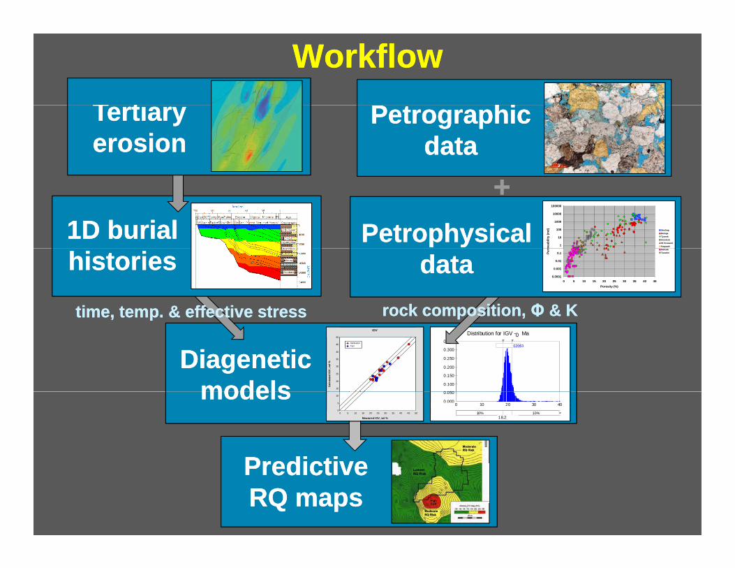
W kflW kfl
F k i lF k i lProvenance assessmentProvenance assessment
OutlineOutline
WorkflowWorkflow Geologic settingGeologic settingg gg g
Sample preparationSample preparation Framework mineralogyFramework mineralogy
Provenance assessmentProvenance assessment Overall Reservoir qualityOverall Reservoir quality
Petrology & RQ by formationPetrology & RQ by formation
T tiT ti P hiP hi
Mean=20.02063 Mean=20.
0 10 20 30 40
80%
WorkflowWorkflow TertiaryTertiary erosionerosion
PetrographicPetrographic datadata
1D burial1D burial PetrophysicalPetrophysical ++
1
10
100
1000
10000
100000
mea
bilit
y (m
d) Sterling Beluga Tyonek Hemlock W Foreland Kaguyak
historieshistories datadata time, temp. & effective stresstime, temp. & effective stress rock composition,rock composition, ΦΦ & K& K
0.0001
0.001
0.01
0.1
0 5 10 15 20 25 30 35 40 45 Porosity (%)
Perm Naknek
Tuxedni
Distribution for IGV -0 Ma
0 050
0.100
0.150
0.200
0.250
0.300
0.350 02063
DiageneticDiagenetic modelsmodels
pp
15
20
25
30
35
40
45
50
Calc
ulat
ed IG
V, v
ol %
IGVIGV
Calibration Test
0.000
0.050
0 10 20 30 40
10% 10% > 18.212 1.78
modelsmodels
PredictivePredictive
0
5
10
0 5 10 15 20 25 30 35 40 45 50
Measured IGV, vol %
PredictivePredictive RQ mapsRQ maps

filled with Mesozoic and filled with Mesozoic and filled with Mesozoic and filled with Mesozoic and
Beaufort SeaBeaufort SeaChukchi SeaChukchi Sea
Regional GeologyRegional Geology
NPRANPRAANWRANWR
FairbanksFairbanks
Prudhoe BayPrudhoe Bay
Cook InletCook Inlet
AnchorageAnchorage
FairbanksFairbanks
BasinBasin •• CollisionalCollisional forearc basinforearc basin
filled with Mesozoic andfilled with Mesozoic and•• CollisionalCollisional forearc basinforearc basin
filled with Mesozoic andfilled with Mesozoic and Cenozoic marine andCenozoic marine and nonmarine stratanonmarine strata
•• ArcArc trench system sincetrench system since
Cenozoic marine andCenozoic marine and nonmarine stratanonmarine strata
•• ArcArc trench system sincetrench system since
NW SE
•• ArcArc--trench system sincetrench system sincelatest Triassiclatest Triassic
•• Accretionary prismAccretionary prism to SEto SE
•• ArcArc--trench system sincetrench system since latest Triassiclatest Triassic
•• Accretionary prismAccretionary prism to SEto SE
•• Magmatic arc toMagmatic arc to NWNW
•• FaultFault--bounded basinbounded basin
•• Magmatic arc toMagmatic arc to NWNW
•• FaultFault--bounded basinbounded basin Swensen, R., 1997

to ft of Mesozoic to ft of Mesozoic to ft of Mesozoic to ft of Mesozoic
••••
••••
StratigraphyStratigraphy •• Up to 30,000 ft of MesozoicUp to 30,000 ft of Mesozoic•• Up to 30,000 ft of MesozoicUp to 30,000 ft of MesozoicUp 30,000Up 30,000
sedimentary rockssedimentary rocks
•• Up to 25,000 ft of Tertiary ageUp to 25,000 ft of Tertiary age nonmarine sedimentary rocksnonmarine sedimentary rocks
Up 30,000Up 30,000 sedimentary rockssedimentary rocks
•• Up to 25,000 ft of Tertiary ageUp to 25,000 ft of Tertiary age nonmarine sedimentary rocksnonmarine sedimentary rocks
•• Basin fill hasBasin fill has b difi d bb difi d b
•• Basin fill hasBasin fill has b difi d bb difi d b
nonmarine sedimentary rocksnonmarine sedimentary rocksnonmarine sedimentary rocksnonmarine sedimentary rocks
been modified bybeen modified by folding andfolding and faulting to formfaulting to form structural trapsstructural traps
been modified bybeen modified by folding andfolding and faulting to formfaulting to form structural trapsstructural trapspp
LithologiesLithologiesinterfinger withininterfinger withinformationsformations
pp
LithologiesLithologiesinterfinger withininterfinger withinformationsformations
Interfingering isInterfingering isthe basis forthe basis for stratigraphicstratigraphic
Interfingering isInterfingering isthe basis forthe basis for stratigraphicstratigraphic trapstrapstrapstraps
From Curry and others (1993) and Swenson (2003)

SampleSample DistributionDistributionCC DistributionDistribution
See insetSee inset
CappsCapps GlacierGlacier
Clam GulchClam GulchChisik Is.Chisik Is.Fossil Pt.Fossil Pt.
Tertiary outcropsTertiary outcrops144 samples from 37 sections144 samples from 37 sections
Mesozoic outcropsMesozoic outcrops
Tertiary outcropsTertiary outcrops 144 samples from 37 sections144 samples from 37 sections
Mesozoic outcropsMesozoic outcrops
Falls Ck.Falls Ck. Gull Is.Gull Is.
Red GlacierRed Glacier64 samples from 14 sections64 samples from 14 sectionsTertiary wellTertiary well
61 samples from 1 well61 samples from 1 wellTertiary & Mesozoic wellsTertiary & Mesozoic wells
64 samples from 14 sections64 samples from 14 sections Tertiary wellTertiary well
61 samples from 1 well61 samples from 1 well Tertiary & Mesozoic wellsTertiary & Mesozoic wells Fritz Ck.Fritz Ck.
Bidarki Ck.Bidarki Ck. Oil BayOil Bay
Pomeroy Is.Pomeroy Is. Tertiary & Mesozoic wellsTertiary & Mesozoic wells((ФФ –– K data only)K data only)
5779 samples from 98 wells5779 samples from 98 wells
Tertiary & Mesozoic wellsTertiary & Mesozoic wells ((ФФ –– K data only)K data only)
5779 samples from 98 wells5779 samples from 98 wells
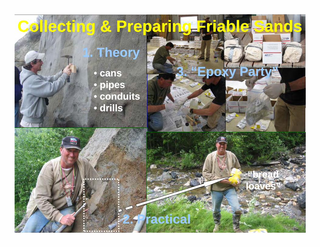
CollectingCollecting & Preparing Friable& Preparing Friable SandsSands 1. Theory1. Theory
•• canscans 3. “Epoxy Party”3. “Epoxy Party” •• pipespipes •• conduitsconduits •• drillsdrills
p y yp y y
•• drillsdrills
“bread“bread loaves”loaves”
2. Practical2. Practical

tt
Sandstone ProvenanceSandstone Provenance
Magmatic arc (Alaska Range)Magmatic arc (Alaska Range) Alaska RangeAlaska RangeAlaska RangeAlaska Range Chugach MountainsChugach MountainsChugach MountainsChugach Mountains
Magmatic arc (Alaska Range)Magmatic arc (Alaska Range) Volcanic cover (JurassicVolcanic cover (Jurassic –– Tertiary)Tertiary)
Basalt, andesite, tuff,Basalt, andesite, tuff, brecciabreccia Plutonic roots (JurassicPlutonic roots (Jurassic –– Cretaceous)Cretaceous) GranodioriteGranodiorite, quartz, quartz monzonitemonzonite, diorite,, diorite, syenitesyenite
A i i (Ch h T )A i i (Ch h T )Accretionary prism (Chugach Terrane)Accretionary prism (Chugach Terrane) Valdez Group (Upper Cretaceous)Valdez Group (Upper Cretaceous)
Sandstone siltstone shaleSandstone siltstone shaleSandstone, siltstone, shaleSandstone, siltstone, shale Schist,Schist, phyllitephyllite ((greenschistgreenschist facies)facies)
McHugh Complex (JurassicMcHugh Complex (Jurassic –– Cretaceous)Cretaceous)g p (g p ( )) Argillite,Argillite, graywackegraywacke, limestone, chert, limestone, chert
Tuff, gabbro, basalt (Tuff, gabbro, basalt (prehniteprehnite--pumpellyitepumpellyite facies)facies)
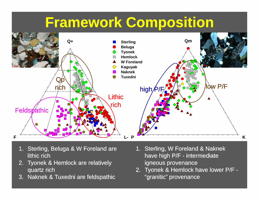
Framework CompositionFramework Composition QmQ+ Sterling
Beluga Tyonek Hemlock W Foreland
low P/Flow P/Fhi h P/Fhi h P/F QpQp richrich
W Foreland Kaguyak Naknek Tuxedni
low P/Flow P/Fhigh P/Fhigh P/Frichrich
FeldspathicFeldspathic
LithicLithic richrich
KPLF
pp
KPLF
1.1. Sterling, BelugaSterling, Beluga & W Foreland& W Foreland areare lithic richlithic rich
22 Tyonek &Tyonek & Hemlock areHemlock are relativelyrelatively
1.1. Sterling, WSterling, W ForelandForeland & Naknek& Naknek have high P/Fhave high P/F -- intermediateintermediate igneous provenanceigneous provenance2.2. Tyonek &Tyonek & Hemlock areHemlock are relativelyrelatively
quartz richquartz rich 3.3. Naknek & Tuxedni are feldspathicNaknek & Tuxedni are feldspathic
igneous provenanceigneous provenance 2.2. Tyonek &Tyonek & Hemlock haveHemlock have lower P/Flower P/F --
“granitic“granitic” provenance” provenance

cc
Lithic CompositionLithic Composition Ls+Qp+
SRFSRFQpQp QpQp richrich
Sterling Beluga Tyonek SRFSRF
richrichrichrich Tyonek Hemlock W Foreland Kaguyak Naknek Tuxedni
VRFVRF richrich
VRFVRF richrich
LmLvLsmLvm
TransitionalTransitional SRF richSRF richTransitionalTransitional
1.1. Most Beluga are rich in argillaceous SRFMost Beluga are rich in argillaceous SRF
2.2. Tyonek &Tyonek & HemlockHemlock are rich inare rich in QpQp and chert (common provenance ?)and chert (common provenance ?)
3.3. Sterling, WSterling, W Foreland &Foreland & TuxedniTuxedni are rich in VRF’sare rich in VRF’s
4.4. Some Sterling & Beluga are transitional (changing provenance ?)Some Sterling & Beluga are transitional (changing provenance ?)

v
ProvenanceProvenance CappsCapps GlacierGlacier
ImplicationsImplications Qp+ Clam GulchClam Gulch
Sterling Beluga Tyonek
Falls Ck
Clam GchUp Sterling
Low Sterling Rozak RVMid Sterling
1 Beluga Fm shows ertical
Theodore RTheodore R Beluga RBeluga R Falls Ck.Falls Ck.
Fritz Ck.Fritz Ck.BidarkiBidarki Ck.Ck.
Tyonek Hemlock W Foreland Kaguyak Naknek Tuxedni
Fritz Ck
Bidarki Ck
Mid Beluga
Up Beluga
1. Beluga Fm. shows vertical provenance transition from SRF-rich Middle Beluga (Fritz CK) to mixed SRF-VRF Upper Beluga (Bidarki Ck)
Tuxedni
older Upper Beluga (Bidarki Ck)
2. Sterling Fm. shows vertical provenance transition from mixed SRF-VRF lower
BidarkiBidarki CKCKFallsFalls CkCkCappsCapps GlrGlr
Straight CkStraight Ck
LsmLvm
Sterling (Falls Ck) to VRF-rich upper Sterling (Clam Gulch)
FritzFritz CKCK Clam GulchClam Gulch
younger

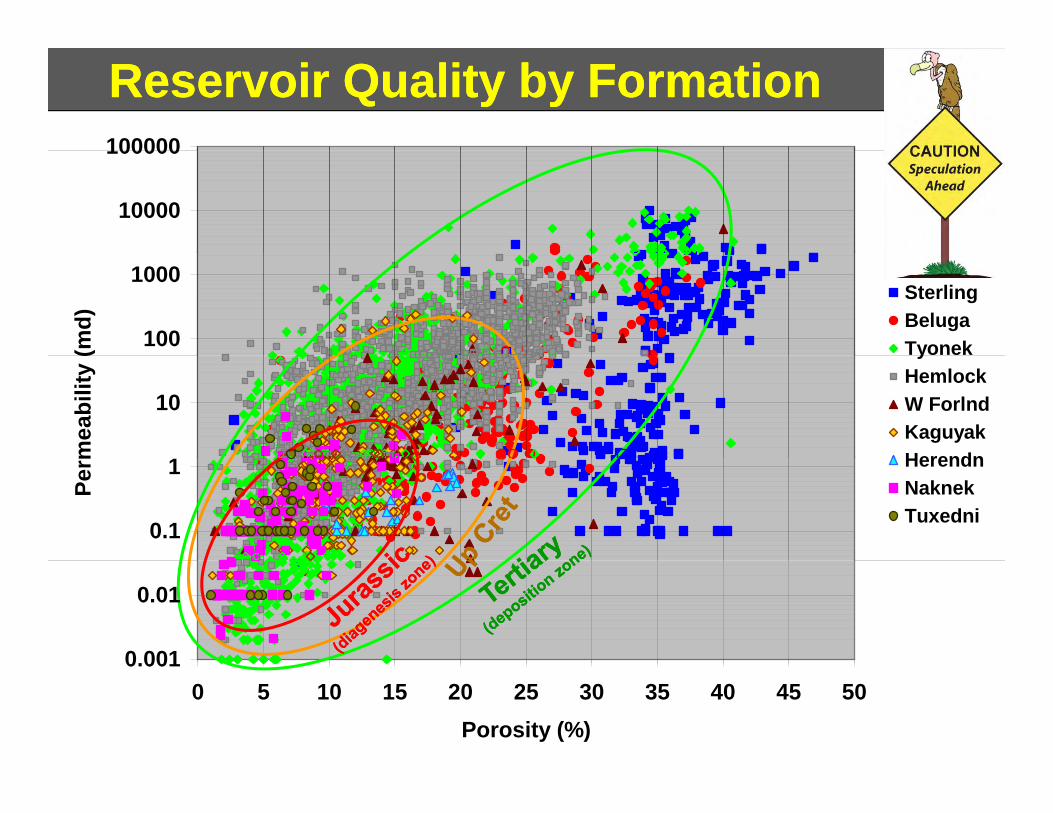
Outcrop Reservoir QualityOutcrop Reservoir Quality
10000
100000
r2 = 0.84
100
1000
md) Sterling
Beluga JurassicJurassic
1
10
mea
bilit
y (m Beluga
Tyonek Hemlock W Foreland Kaguyak
((diagenesisdiagenesis zone)zone)
0.01
0.1Perm Naknek
Tuxedni
TertiaryTertiary(deposition zone)(deposition zone)
0.0001
0.001
0 5 10 15 20 25 30 35 40 45 Porosity (%)

Routine CoreRoutine Core AnalysisAnalysis 100000Well Outcropp 5779 Subsurface samples5779 Subsurface samples
100005052 Tertiary100000 1000430 Upper Cretaceous 297 Neocomian
- Jurassic
Perrm
eabi
lity
(md)
10000
1000
100
10
11
Perm
eabbi
lity
(md)
0.1
10
100
10
0.001
0.01
0 5 10
Tertiary Unitsy 15 20 25 30
Porosity (%) 35 40 45 50
1 10000
100000
SWC are artificially enhanced 1000
0.1
0.01
Perm
eabi
oity
(md)
100
10
1
0.1
y
0.001 Core dataCore data SWC dataSWC data0 5 10 15 20 25 30 35 40 45 0.01 50
0 0010.0015921 Samples5921 Samples Porosity (%) 0 5 10 15 20 25 30 35 40 45 50
Mesozoic Units Porosity (%)
1.1. Core and outcropCore and outcrop data occupy similardata occupy similar ΦΦ-K fields-K fields
2.2. LowLow--permpermeeabilityability SSterlingterling ssandsands plotplot ofofff regionalregional 2.2. LowLow permpermeeabilityability SterlingSterling sandssands plotplot ofofff regionalregional trend (facies ortrend (facies or texture ?)texture ?)
3.3. WWellell data include conventional and sidewalldata include conventional and sidewall corecore datadata
1.1. Mesozoic core +Mesozoic core + SWCSWC data overliedata overlie TTertiary dataertiary data
2.2. FairFair –– moderatemoderate overlapoverlap betweenbetween TTertiaryertiary corecore andand corecore andand2.2. FairFair moderatemoderate overlapoverlap betweenbetween TTertiaryertiary SWC dataSWC data
3.3. Poor overlapPoor overlap between Mesozoic core and SWCbetween Mesozoic core and SWC datadata
Reservoir Quality by FormationReservoir Quality by FormationPe
rmmea
bilit
y ((m
d)
100000100000
10000
100
1000
1
10
0.1
1
Sterling Beluga Tyoneky Hemlock W Forlnd Kaguyak HerendnHerendn Naknek Tuxedni
0.01
0 0010.001 0 5 10 15 20 25 30 35 40 45 50
Porosity (%)
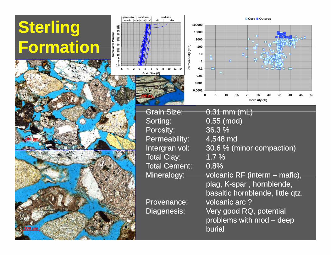
SterlingSterling FormationFormation 100
1000
10000
100000
d)
Core Outcrop
tive
Perc
ent
50 70 80 90 95 98 99
claysiltpebble gr c m f vf sand-size mud-sizegravel-size
vc
FormationFormation 0.01
0.1
1
10
100
Perm
eabi
lity
(md
Grain Size (Ø) -6 -4 -2 0 2 4 6 8 10 12 14
Cum
ula
0.51 2 5
10 20 30
Grain Size:Grain Size: 0 31 mm (0 31 mm (mLmL))
0.0001
0.001
0 5 10 15 20 25 30 35 40 45 50 Porosity (%)
Grain Size:Grain Size: 0.31 mm (0.31 mm (mLmL)) Sorting:Sorting: 0.55 (mod)0.55 (mod) Porosity:Porosity: 36.3 %36.3 % Permeability:Permeability: 4,5484,548 mdmd IntergranIntergran volvol:: 30.630.6 % (minor compaction)% (minor compaction) Total Clay:Total Clay: 1.71.7 %% Total Cement:Total Cement: 0.8%0.8% Mineralogy:Mineralogy: volcanic RF (volcanic RF (interminterm –– maficmafic))Mineralogy:Mineralogy: volcanic RF (volcanic RF (interminterm maficmafic),),
plagplag, K, K--spar , hornblende,spar , hornblende, basaltic hornblende,basaltic hornblende, littlelittle qtzqtz..
Provenance:Provenance: volcanic arc ?volcanic arc ? Diagenesis:Diagenesis: Very good RQ, potentialVery good RQ, potential
problems with modproblems with mod –– deepdeep burialburial

Di iDi i i l f d ili l f d il
BelugaBeluga FormationFormation 100
1000
10000
100000
)
Core Outcrop
tive
Perc
ent
50 70 80 90 95 98 99
claysiltpebble gr c m f vf sand-size mud-sizegravel-size
vc
FormationFormation 0.01
0.1
1
10
100
Perm
eabi
lity
(md)
Grain Size (Ø) -6 -4 -2 0 2 4 6 8 10 12 14
Cum
ulat
0.51 2 5
10 20 30
Grain Size:Grain Size: 0 26 mm (0 26 mm (mLmL))
0.0001
0.001
0 5 10 15 20 25 30 35 40 45 50 Porosity (%)
Grain Size:Grain Size: 0.26 mm (0.26 mm (mLmL)) Sorting:Sorting: 1.27 (poor)1.27 (poor) Porosity:Porosity: 30.0 % (not all effective)30.0 % (not all effective) Permeability:Permeability: 331.8331.8 mdmd IntergranIntergran volvol:: 22.022.0 % (mod. Compaction)% (mod. Compaction) Total Clay:Total Clay: 7.77.7 %% Total Cement:Total Cement: 1.7 %1.7 % Mineralogy:Mineralogy: Argillaceous SRF & MRFArgillaceous SRF & MRFMineralogy:Mineralogy: Argillaceous SRF & MRF,Argillaceous SRF & MRF,
minor quartz, Kminor quartz, K--spar, chert,spar, chert, plagioclaseplagioclase
Provenance:Provenance: accretionary prismaccretionary prism DiagenesisDiagenesis:: potential for mega ductilepotential for mega ductile
grain deformation, littlegrain deformation, little cement, faircement, fair RQRQ

hihi
gravel-size sand-size mud-size Core Outcroppebble gr vc c f vf silt claym
100000 98 95
99
1000090 80 70 1000 50
100
TTyonekyonekFormationFormation 100
Cum
ulaat
ive
Perc
ent
FormationFormation 30 20
Perm
eabi
lity
(mdd)
10 5 2 1
0.5
10
1
0.1-6 -4 -2 0 2 4 6 8 10 12 14 Grain Size (Ø)
0.01
0.001
0.0001 0 5 10 15 20 25 30
Porosity (%) 35 40 45 50
GrainGrain SSize:ize:GrainGrain Size:Size: 0 30 399 mmmm ((mUmU))00..3939 mmmm ((mUmU)) Sorting:Sorting: 0.820.82 (mod)(mod) Porosity:Porosity: 25.325.3 %% Permeability:Permeability: 1,7551,755 mdmd IntergranIntergran volvol:: 23.2 %23.2 % (mod. compaction)(mod. compaction) TTotal Clay:otal Clay: 6.0 %6.0 % TTotal Cement:otal Cement: 3.0 %3.0 % Mineralogy:Mineralogy:Mineralogy:Mineralogy: quartzquartz KK--sparspar plagioclaseplagioclasequartzquartz,, KK sparspar,, plagioclaseplagioclase,,
PRFPRF,, chert,chert, argillaceousargillaceous SRFSRF & MRF& MRF,, biotitebiotite
Provenance:Provenance: dissected arcdissected arc plutonsplutons,, metamorpmetamorphihic covec coverr
DiagenesisDiagenesis:: good RQ,good RQ, chlorite/smectite rims,chlorite/smectite rims, kaolinite porekaolinite pore--fills, little cementfills, little cement
--
pebble gr c m f vf sand-sizegravel-size
vc silt clay mud-size Core MGS A43-11
98 99 100000
90 95 10000
70 80 1000
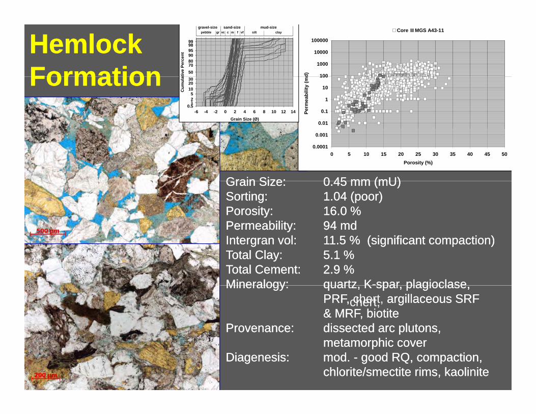
HemlockHemlockFormationFormation 50
100100
Cum
ulaat
ive
Perc
ent
FormationFormation 30 20
Perm
eabi
lity
(mdd)
10 5 2 1
0.5
10
1
0.1-6 -4 -2 0 2 4 6 8 10 12 14 Grain Size (Ø)
0.01
0.001
0.0001 0 5 10 15 20 25 30
Porosity (%) 35 40 45 50
GrainGrain SSize:ize:GrainGrain 0 40 4Size:Size: 5500..4545 mmmm ((mUmU))mmmm ((mUmU)) Sorting:Sorting: 1.04 (poor)1.04 (poor) Porosity:Porosity: 16.0 %16.0 %Permeability:Permeability: 94 md94 mdIntergranIntergran volvol:: 111.5 %1.5 % (significant compaction)(significant compaction) TTotal Clay:otal Clay: 5.1 %5.1 % TTotal Cement:otal Cement: 2.9 %2.9 % Mineralogy:Mineralogy:Mineralogy:Mineralogy: quartzquartz KK--sparspar plagioclaseplagioclasequartzquartz,, KK sparspar,, plagioclaseplagioclase,,
PRFPRF,, chert,chert, argillaceousargillaceous SRFSRF & MRF& MRF,, biotitebiotite
Provenance:Provenance: dissected arcdissected arc plutonsplutons,, metamorphic covemetamorphic coverr
DiagenesisDiagenesis:: mod.mod. -- good RQ, compaction,good RQ, compaction, chlorite/smectite rims,chlorite/smectite rims, kaolinitekaolinite

enanceenance arcarc
P bilitP bilit 259259 dd
Total Cement:Total Cement: 7.7 % 7.7 %
W ForelandW Foreland FormationFormation 100
1000
10000
100000
d)
Core Outcrop
ativ
e Pe
rcen
t
50 70 80 90 95 98 99
claysiltpebble gr c m f vf sand-size mud-sizegravel-size
vc
FormationFormation 0.01
0.1
1
10
100
Perm
eabi
lity
(md
Grain Size (Ø) -6 -4 -2 0 2 4 6 8 10 12 14
Cum
ula
0.51 2 5
10 20 30
0.0001
0.001
0 5 10 15 20 25 30 35 40 45 50 Porosity (%)
Grain Size:Grain Size: 0.450.45 mm (mm (mUmU)) Sorting:Sorting: 1.411.41 (poor)(poor) Porosity:Porosity: 21.9 % (not all effective)21.9 % (not all effective) Permeability:Permeability: 259259 m dmd IntergranIntergran volvol:: 28.0 % (early clays & zeolites)28.0 % (early clays & zeolites) Total Clay:Total Clay: 17.3 %17.3 % Total Cement:Total Cement: 7.7 % (zeolites)7.7 % (zeolites)(zeolites)(zeolites) Mineralogy:Mineralogy: VRF (VRF (interminterm -- maficmafic),), plagplag,,
hornblende, basaltichornblende, basaltic HbHb,, biotitebiotite, pumice, shards,, pumice, shards, minorminor qtzqtz
ProPro olcanicolcanicProvenance:Provenance: volcanic arcvolcanic arc DiagenesisDiagenesis:: clinoptilolite, chlorite/smectiteclinoptilolite, chlorite/smectite
rims and pore fillsrims and pore fills

KaguyakKaguyak FormationFormation 100
1000
10000
100000
d)
Core Outcrop
ativ
e Pe
rcen
t
50 70 80 90 95 98 99
claysiltpebble gr c m f vf sand-size mud-sizegravel-size
vc
FormationFormation 0.01
0.1
1
10
100
Perm
eabi
oity
(m
Grain Size (Ø) -6 -4 -2 0 2 4 6 8 10 12 14
Cum
ula
0.51 2 5
10 20 30
0.0001
0.001
0 5 10 15 20 25 30 35 40 45 50 Porosity (%)
Grain Size:Grain Size: 0.49 mm (0.49 mm (mUmU)) Sorting:Sorting: 1.25 (poor)1.25 (poor) Porosity:Porosity: 11.4 %11.4 % Permeability:Permeability: 8 28 2 mdmdPermeability:Permeability: 8.28.2 mdmd IntergranIntergran volvol:: 27.027.0 % (mod. compaction)% (mod. compaction) Total Clay:Total Clay: 12.012.0 %% Total Cement:Total Cement: 3.6 %3.6 % Mineralogy:Mineralogy: quartz, plagioclase,quartz, plagioclase, KK--sparspar
hornblende, VRF,hornblende, VRF, PRFPRF Provenance:Provenance: dissected arcdissected arc plutonsplutons
and overlyingand overlying volcanicsvolcanicsand overlyingand overlying volcanicsvolcanics DiagenesisDiagenesis:: kaolinite, chlorite/smectite,kaolinite, chlorite/smectite,
ductileductile VRF’s,VRF’s, fairfair -- modmod RQRQ

t 959899
claysiltpebble gr c m f vfsand-size mud-sizegravel-size
vc
yy
Cum
ulat
ive
Perc
en
0 5125
10203050708090
Grain Size (Ø)-6 -4 2 0 2 4 6 8 10 12 14
0.5
NaknekNaknek FormationFormation 100
1000
10000
100000
d)
Core Outcrop
ativ
e Pe
rcen
t
50 70 80 90 95 98 99
claysiltpebble gr c m f vf sand-size mud-sizegravel-size
vc
FormationFormation 0.01
0.1
1
10
100
Perm
eabi
lity
(md
Grain Size (Ø) -6 -4 -2 0 2 4 6 8 10 12 14
Cum
ula
0.51 2 5
10 20 30
0.0001
0.001
0 5 10 15 20 25 30 35 40 45 50 Porosity (%)
Grain Size:Grain Size: 0.220.22 mm (mm (fUfU)) Sorting:Sorting: 1.231.23 (poor)(poor) Porosity:Porosity: 4.14.1 %% Permeability:Permeability: 0.210.21 mdmd IntergranIntergran volvol:: 24.2 % (extensive zeolites)24.2 % (extensive zeolites) Total Clay:Total Clay: 6.5 %6.5 % Total Cement:Total Cement: 18 2 % (zeolites)18 2 % (zeolites) t Total Cement:Total Cement: 18.2 % (zeolites)18.2 % (zeolites) Mineralogy:Mineralogy: plagioclase, hornblendeplagioclase, hornblende, bas., bas. HbHb,,
ilmeniteilmenite/magnetite, little quartz/magnetite, little quartz Provenance:Provenance: dissected arcdissected arc plutonsplutons
- DiagenesisDiagenesis:: laumontite, heulandite,laumontite, heulandite, authigenic chlorite/smectiteauthigenic chlorite/smectite or chlorite, pooror chlorite, poor RQRQ

e eabe eab 5 95 9 dde eabe eab 5 95 9 dd
G i SiG i Si 0 200 20 ((fUfU))G i SiG i Si 0 200 20 ((fUfU))
gg gg pp gg yygg gg pp gg yy
TuxedniTuxedni GroupGroup 100
1000
10000
100000
d)
Core Outcrop
ativ
e Pe
rcen
t
50 70 80 90 95 98 99
claysiltpebble gr c m f vf sand-size mud-sizegravel-size
vc
GroupGroup Red Glacier Fm.Red Glacier Fm.
0.01
0.1
1
10
100
Perm
eabi
lity
(md
Grain Size (Ø) -6 -4 -2 0 2 4 6 8 10 12 14
Cum
ula
0.51 2 5
10 20 30
0.0001
0.001
0 5 10 15 20 25 30 35 40 45 50 Porosity (%)
Grain Size:Grain Size: 0.200.20 mm (mm (fUfU))Sorting:Sorting: 0.81 (mod)0.81 (mod)Porosity:Porosity: 7.5 % (little effective7.5 % (little effective ԄԄ))Permeability:Permeability: 5.95.9 mdmd
Grain Size:Grain Size: 0.200.20 mm (mm (fUfU)) Sorting:Sorting: 0.81 (mod)0.81 (mod) Porosity:Porosity: 7.5 % (little effective7.5 % (little effective ԄԄ)) Permeability:Permeability: 5.95.9 m dmdtytyIntergranIntergran volvol:: 35.6 % (extensive clay cement)35.6 % (extensive clay cement)Total Clay:Total Clay: 21.9 %21.9 %Total Cement:Total Cement: 16.7 % (zeolites)16.7 % (zeolites)Mineralogy:Mineralogy: volcanic RF (felsicvolcanic RF (felsic interminterm))
tyty IntergranIntergran volvol:: 35.6 % (extensive clay cement)35.6 % (extensive clay cement) Total Clay:Total Clay: 21.9 %21.9 % Total Cement:Total Cement: 16.7 % (zeolites)16.7 % (zeolites) Mineralogy:Mineralogy: volcanic RF (felsicvolcanic RF (felsic interminterm))
Gaikema Fm.Gaikema Fm.
Mineralogy:Mineralogy: volcanic RF (felsicvolcanic RF (felsic -- interminterm),), altered VRF,altered VRF, plagioclase, min.plagioclase, min. qtzqtz
Provenance:Provenance: volcanic arcvolcanic arcDiagenesisDiagenesis:: AuthigenicAuthigenic porepore--fillingfilling clay,clay,
Mineralogy:Mineralogy: volcanic RF (felsicvolcanic RF (felsic -- interminterm),), altered VRF,altered VRF, plagioclase, min.plagioclase, min. qtzqtz
Provenance:Provenance: volcanic arcvolcanic arc DiagenesisDiagenesis:: AuthigenicAuthigenic porepore--fillingfilling cla y,clay,
chlorite/smectite, chloritechlorite/smectite, chlorite,, laumontite, heulandite, poor RQlaumontite, heulandite, poor RQchlorite/smectite, chloritechlorite/smectite, chlorite,, laumontite, heulandite, poor RQlaumontite, heulandite, poor RQ

The Rich Get Richer...The Rich Get Richer... R.G. Loucks,
Tertiary & Up.Tertiary & Up. CretCret. Sandstones. Sandstones –– Rich guys (deposition zone)Rich guys (deposition zone)
TX BEG
•• Young age ( < 65 million years old)Young age ( < 65 million years old)
•• Shallow burial (< 10,000 feet)Shallow burial (< 10,000 feet)
•• Chemically stable mineralogy (Quartz +Chemically stable mineralogy (Quartz +KK--feldspar)feldspar)
Mesozoic SandstonesMesozoic SandstonesMesozoic SandstonesMesozoic Sandstones –– Poor guys (diagenesis zone)Poor guys (diagenesis zone)
•• Old age ( > 65 million years old)Old age ( > 65 million years old)
•• Deep burial (> 10,000 feet)Deep burial (> 10,000 feet)
•• Chemically unstable mineralogyChemically unstable mineralogy(Plagioclase + VRF’s)(Plagioclase + VRF’s)(Plagioclase + VRF s)(Plagioclase + VRF s)
•• Enhanced potential for unconventionalEnhanced potential for unconventional reservoirsreservoirs

t tt t
&&
i t i h T i d ti t i h T i d t
ConclusionsConclusions •• Tertiary & Mesozoic sandstones have distinctTertiary & Mesozoic sandstones have distinct
differences in mineralogy due to variations indifferences in mineralogy due to variations in provenance (accretionary prism vs arc)provenance (accretionary prism vs arc)provenance (accretionary prism vs. arc)provenance (accretionary prism vs. arc)
•• Vertical and possible lateral variations inVertical and possible lateral variations in provenance exist in the Tertiary sandstonesprovenance exist in the Tertiary sandstones
•• Mineralogy exerts a strong control onMineralogy exerts a strong control on diagenesis and reservoir qualitydiagenesis and reservoir quality
•• Tertiary & Upper Cretaceous have substantialTertiary & Upper Cretaceous have substantialTertiary & Upper Cretaceous have substantialTertiary & Upper Cretaceous have substantial potential for conventional reservoirspotential for conventional reservoirs
•• Jurassic has potential for unconventionalJurassic has potential for unconventional•• Jurassic has potential for unconventionalJurassic has potential for unconventional reservoirsreservoirs

and the subsurface and the subsurface
d l d t t t t f d di tid l d t t t t f d di ti
tt
The Way ForwardThe Way Forward •• Continue collecting petrographic data fromContinue collecting petrographic data from
outcrops and the subsurfaceoutcrops and the subsurfaceoutcropsoutcrops
•• Construct 1D burial histories for subsurfaceConstruct 1D burial histories for subsurface samples using Tertiary erosion estimatessamples using Tertiary erosion estimatessamples using Tertiary erosion estimatessamples using Tertiary erosion estimates
•• Combine timeCombine time--temperaturetemperature--pressure andpressure and modal data to construct forward diageneticmodal data to construct forward diagenetic modelsmodels
•• Combine static diagenetic models toCombine static diagenetic models to produce regional maps of reservoir qualityproduce regional maps of reservoir quality ( it bilit IGV )( it bilit IGV )(porosity, permeability, IGV, cement)(porosity, permeability, IGV, cement)

The EndThe EndThe EndThe End


