

PROVINCE OF TREVISO“MARCA STORICA” - HISTORICAL MARCA

2
Undoubtedly, any visitor who happened to pass through the Marca Trevigiana even in ancient times could not help but recognise the beauty of these lands. The many peoples that chose to settle here bore witness to this, leaving their indelible mark on how the Province of Treviso appears today and on our culture and the historical, artistic and architectural heritage of the Marca. The many traces of evidence take us back in time, from ancient history to more recent times and the era of our grandfathers. We can go back through the centuries, straight back to ancient Roman times, suffice to think of the ancient Roman roads, to discover treasures such as the via Claudia Augusta, or the traces of Roman centuriation. Medieval history enthusiasts will cherish the opportunity to visit the walled cities and the many castles, parish churches, and chapels dotted throughout the Marca Gioiosa et Amorosa as the Province is known. Visible signs of human activity are present everywhere, from the frescoed buildings to the paintings hanging in the churches and abbeys. The surroundings constantly refer back to history, to the ups and downs of autonomous municipal authorities and the conflicts between the Seigniories. In addition to these, the Province now offers archaeological and prehistoric exploration, in the Livelet Archaeology Teaching Park on the shores of the lakes at Revine Lago. It is a dense territory, that will thrill you. This is why we wish to accompany you on a journey amidst the signs of history and the many events that re-enact ancient rituals and events.
A JOURNEY THROUGH THE SIGNS OF HISTORY
Leonardo MuraroPresident Province of Treviso

3
CHARTING A ROUTE TO UNDERSTAND THE AREA
The philosophy underlying this editorial initiative is the Province of Treviso’s intention to suggest organised visit trails to help discover one or rediscover places connected to some of the Marca Trevigiana’s most characteristic aspects. These include the essential role played by our heritage of archaeological sites and castles, which by and large, are little known or even completely unknown to the general public. However, this does not mean that the trails and monuments suggested should become static circuits that cannot be extended or altered: rather the itineraries proposed in this volume should be considered as a “lively” guideline, which can be constantly updated with fortunate personal “discoveries” anchored to a certain reference basis.
Prof. Guido Rosada
Via Claudia Augusta is one of the main ancient Roman roads of northern Italy. However, it also demonstrates a clear “trans-alpine” significance, in that it was built to connect the Padania plain with the Roman colonies on the other side of the Alps.Interest in this road would appear to have flourished in recent years, as it was not merely intended as a passage to reach the Danube but also as a main European route for territorial and administrative coordination that over time involved the most significant activities of the areas involved, conditioning their pre- existent aspects and developments from a civil, historical, artistic, economic and touristic standpoint.
Prof. Vittorio Galliazzo

4
FOREWORD“Marca Storica” - Historical Marca
In his Invisible Cities, Italo Calvino wrote
“sometimes different cities are built on
top of one another on the same site and
under the same name, they are born
and die without being known, unable to
communicate with one another”, which not
only highlights the ancient history of our
country, but also our indifference towards a
distant history that has nevertheless played
a fundamental role in the development of
contemporary society.
Fortunately, this attitude is changing as we
gradually overcome that oublie towards our
roots due partly to a renewed sensitivity
to our historical heritage, which is also
manifested thorough cultural tourism,
which transforms a journey, a “visit”, into a
unique educational experience. This kind
of unique educational experience can be
gained in the Marca Trevigiana simply by
travelling the millennia-old roads, in a kind
of a time machine that travels through the
varied landscape, allowing us to relive
our most distant history, as it constantly
entwines with more modern evidence,
offering fertile countryside, bubbling
waters and the gentle horizons that provide
a backdrop to cities, castles, medieval
hamlets, churches and monasteries bearing
witness to man’s unstinting work.Forum area (Oderzo)

5
The itineraries that Province of Treviso intends to present in this brief guide primarily interest the Marca territory characterised by a significant concentration of noteworthy destinations that cover a vast chronological course, from ancient times to the Middle Ages and through to the era of the Seigniories.In the interest of easy reading and consultation, the guide has been broken down into four sections:(A) The Feud of the Ezzelino Dynasty, whose policy greatly affected the area to the right of the River Piave; (B) The great feuds of the Collalto, da Camino, da Carrara and Brandolini dynasties, which favoured development to the left of the Piave;(C) The walled cities whose suggestive architecture dates from the Middle Ages and Renaissance periods;(D) The enigma of Via Claudia Augusta,
a very important road built under the Emperor Claudius in the 1st century AD that crosses the Marca from south to north.
The main sites visited following these itineraries are marked in the maps that accompany the texts, with progressive numbers and in the field with appropriate direction and description signs.
Castle of St. Salvatore (Susegana)
Friuli gate (Portobuffolè)
Castle (Conegliano)

6
Grande Guerra
PROVINCE OF TREVISO
PROVINCE OF BELLUNO
PROVINCE OF PADUA
PROVINCE OF VENICE
PROVINCE OF PORDENONE
PROVINCE OF VICENZA
• Castelfranco Veneto
• Asolo • Oderzo
• Vittorio Veneto
• Conegliano
• Valdobbiadene
• Montebelluna
WHERE IS THE PROVINCE OF TREVISO?
Located in the Veneto region, in the North-East of Italy, just a few kilometres from Venice, the Province of Treviso can be easily reached by:Motorways: A27 Venice-Belluno (exit at Vittorio Veneto North and South, Conegliano, Treviso North and South, Mogliano Veneto), A4 Turin-Trieste (exit Cessalto)Airports: A. Canova (TV), M.Polo (VE)Railway lines: Venice-Udine, Venice-Belluno, Vicenza-Treviso
Milan
Bologna
Treviso
Venice

7
Piave
Piave
Piave
Piave
Sile
Sile
Zero
Musone
Monticano
Livenza
Fontanelle
Altivole
Arcade
Borso del Grappa
Breda di Piave Saletto
Caerano di San Marco
Cappella Maggiore
Carbonera
Casale Sul Sile
Casier
Castelcucco
Castello di Godego
Cavaso del Tomba
Cessalto
Chiarano
Cimadolmo
Cison di Valmarino
Codogne'
Colle Umberto Cordignano
CornudaCrocettadel Montello
Farra di Soligo
Follina
Gaiarine
Giavera del Montello
Godega di Sant'urbano
Istrana
Loria
Mansue'
Mareno di Piave
Maser
Maserada Sul Piave
Meduna di Livenza
Miane
Mogliano Veneto
Monfumo
Morgano
Moriago della Battaglia
MOTTA DI LIVENZA
Nervesa della Battaglia
Ormelle
Orsago
Paese
Pederobba
Pieve di Soligo
Ponte di Piave
Ponzano Veneto
PORTOBUFFOLE'
Possagno
Povegliano
Preganziol
Quinto di Treviso
Refrontolo
Resana
Revine Lago
Riese Pio X
Roncade
Salgareda
San Biagio di Callalta
San FiorSan Pietro di Feletto
San Polo di Piave
San Vendemiano
San Zenone degli Ezzelini
Santa Lucia di Piave
Sarmede
Segusino
Sernaglia della Battaglia
Silea
Spresiano
Susegana
Tarzo
Trevignano
Vazzola
Vedelago
Vedelago
Vidor
Villorba
Volpago del Montello
Zenson di Piave
Zero Branco
Fregona
Fonte
Monastier
Crespano del Grappa
Paderno del Grappa
Parco ArcheologicoDidattico del Livelet
VALDOBBIADENE
ASOLO
CASTELFRANCO VENETO
VITTORIO VENETO
CONEGLIANO
MONTEBELLUNABassano del Grappa
Marostica
TREVISO
ODERZOPagnano
Casonetto
One'
Fonte Alto
SopracastelloLiedolo
S. Eulalia
Semonzo
Cassanego
FiettaCaniezza
Vettorazzi
Castelli
Curogna
Levada
S. UrbanoS. Vettore
La Valle
Madonna della Salute
Lauro
Busta
Edifizio
Borgo Campagnola
VillarazzoBella Venezia
Villaraspa
Caonada
GranigoCima Grappa
Stramare
Milies
S. VitoFuner
Barbozza
Saccol
Guia
Colbertaldo
Carlot Bosco
Piazza Rovere
Posmon Boschet
Solighetto
Castello
Premaor La BellaPedeguardaCombai Campea
ValmarenoMura
TovenaSoller
Arfanta
Lago Nogarolo
Longhere
Olarigo
Savassa Bassa
Botteon
Nove
Fadalto
Sonego
Breda MezzavillaLuca
Silvella
Montaner
Rugolo
Villa di Villa
PinidelloPine'
Ponte della Muda
BibanoSalvarotonda
Bibano di Sotto
Levada
Baver
Pianzano
Falze' di Piave
Collalto
Corbanese
Cozzuolo
Carpesica
Ogliano
ScomigoMenare'
Ceneda BassaCeneda Alta
Serravalle
Bagnolo
Crevada
Collalbrigo Borghetto Cosniga
Capo di Sotto
Bocca di StradaRamera
Soffratta
S. Maria di Piave Rai
Tempio
Stabiuzzo
Visna'
CimavillaBorgo Chiesa
Roverbasso
VallontoCornare Rigole
Lutrano Brische
Lorenzaga
VillanovaMalintrada
Campobernardo
Fagare'
Pralongo
San Pietro Novello
Rovare'
Vallio
Borgo Verde
Olmi
San Martino
Spercenigo
Busco
San NicoloCandole
Francenigo
Cavrie'Le Marche
Cendon
Canton
Bonisiolo
Lughignano S. Elena
Borgo Verde
ZermanBoschettaCampocroce
Sambughe'
MazzoccoGhetto
Conscio
Santa Bona
Fontane
Castello
Barrucchella
Bel Giardino
VacilSan Giacomo
Mercatelli
Parrocchia Colfosco
Bidasio
Palu'
S. Maria
Franceniga
Guizza
Carita'
Nerbon
Borgo Bellussi
Manzana
Prapian
San MartinoPecolCosta di La'
Intrivigne
Guizzetta
Pra de Roda
RiveVitipan
Villanova
Le Grazie
Bagaggiolo
Villaggio I.A.C.P.
Navole'
Fae'
BavariaSovilla
Santi Angeli
San Giovanni
Cusignana
Santa Mama
Santa Croce
Santa MariaM O N T E L L O
S. Michele
S.Maria
Molinetto delle Crode
Rocchetta
Guizza
Osigo
Fratte
Ponte Maset
Formeniga
Praderadego
Farro'
Castelcies LevadaCovolo
Coste
Lauro
Busta
Virago
S. Stefano
Guia
Colbertaldo
Gai
Baver
Corbanese
San Giorgio
Salettuol
Borgo Chiesa
Basalghelle
LutranoMure
VelapiccolaS. Anastasio
Busco
Campomolino
Bonisiolo
Ca' Tron
Boschetta
Conscio
Biban
Bel Giardino
Vigonovo
Pezzan
Guizzetta
Le Grazie
Bagaggiolo
Villaggio I.A.C.P.
Navole'
Bavaria
Passo San Boldo
Feltre
Pero
San MarcoSanta Cristina
Albaredo
Anzano
Badoere
Barbisano
BarconBessica
Biadene
Biancade
Bigolino
Bocca Callalta
Borgo Marconi
Ca' RainatiCamalo'
Campagnola
Campigo
Campo Pietra
Candelu'
Carpenedo
Casacorba
Casella D'asolo
Caselle
Castagnole
Castelminio
Castione
Catena
Cavalier
Cavasagra
Ciano
Col San Martino
Colfrancui
Costa
Crespignaga
Dosson
Falze'
Fanzolo
Fossalta Maggiore
Fossalunga
Fratta
Frescada
Gorgo Dei MoliniGorgo della Chiesa
Lancenigo
Lanzago
Levada
Lovadina
Marocco
Merlengo
Mignagola
Mosnigo
Musano
Musestre
Altino
Negrisia
Onigo
Ospedaletto
Padernello
Paderno
Pare'
Pezzan
Piavon
Poggiana
Ponte della Priula
Porcellengo
Postioma
Ramon
Roncadelle
Rua
Sala
Salvarosa
Salvatronda
San Bartolomeo
San Cipriano
San FlorianoSan Floriano-olmi
San Gaetano
San Giacomo di Veglia
San Giovanni di MottaSan Michele di Piave
San Trovaso
San Vito di Altivole
Sant'alberto
Sant'andrea Oltre Muson
Sant'Apollinare
Santa Maria di Campagna
Santandra'
Scandolara
Selva del Montello
Signoressa
Soligo
Spineda
Tezze
Treville
Valla'
Varago
Vascon
Venegazzu'Villa d'Asolo
Villanova
Visnadello
Borgo di Fontane
Pederiva
Guarda Bassa
(D) The enigma of Via Claudia Augusta
(B) The great feuds
(A) The feud of the Ezzelino dynasty
(C) The walled cities
I percorsi sono localmente segnalati con frecce direzionali colorate come da cartografia
PROVINCE OF BELLUNO
PROVINCE OF PADUA
PROVINCE OF VENICE
PROVINz PORDENONE
PROVINCE OF VICENZA

8
In that part of the depraved land of Italy
that lies between the Rialto and the
springs of the Brenta and the Piave, rises
a hill of no great height ...: this was how
Cunizza da Romano, sister of Ezzelino III,
lord of the Marca, described her birthplace
to Dante in Paradiso. The definition of
depraved given to these lands can be
explained by the fact that at the time, the
poet had taken refuge in Verona at the
court of Cangrande della Scala, the sworn
enemy of the Ezzelino family, and it is
therefore evident that it is Dante who talks
with these very severe tones.
In these terms and for a long time,
(A) THE FEUD OF THE EZZELINO DYNASTY
Ezzelino’s tower (San Zenone degli Ezzelini)

9
Piave
Piave
Sile
Sile
Zero
Musone
Monticano
Livenza
Pero
San MarcoSanta Cristina
Albaredo
Anzano
Badoere
Barbisano
BarconBessica
Biadene
Biancade
Bigolino
Bocca Callalta
Borgo Marconi
Ca' RainatiCamalo'
Campagnola
Campigo
Campo Pietra
Candelu'
Carpenedo
Casacorba
Casella d'Asolo
Caselle
Castagnole
Castelminio
Castione
Catena
Cavalier
Cavasagra
Ciano
Col San Martino
Colfrancui
Costa
Crespignaga
Dosson
Falze'
Fanzolo
Fossalta Maggiore
Fossalunga
Fratta
Frescada
Gorgo Dei MoliniGorgo della Chiesa
Lancenigo
Lanzago
Levada
Lovadina
Marocco
Merlengo
Mignagola
Mosnigo
Musano
Musestre
Negrisia
Onigo
Ospedaletto
Padernello
Paderno
Pare'
Pezzan
Piavon
Poggiana
Ponte della Priula
Porcellengo
Postioma
Ramon
Roncadelle
Rua
Sala
Salvarosa
Salvatronda
San Bartolomeo
San Cipriano
San Floriano
San Floriano-olmi
San Gaetano
San Giacomo di Veglia
San Giovanni di MottaSan Michele di Piave
San Trovaso
San Vito di Altivole
Sant'alberto
Sant'andrea Oltre Muson
Sant'Apollinare
Santa Maria di Campagna
Santandra'
Scandolara
Selva del Montello
Signoressa
Soligo
Spineda
Tezze
Treville
Valla'
Varago
Vascon
Venegazzu'
Villa d'Asolo
Villanova
Visnadello
Borgo di Fontane
Pederiva
Guarda Bassa
Fontanelle
Altivole
Arcade
Borso del Grappa
Breda di Piave
Candelù
Saletto
Caerano di San Marco
Cappella Maggiore
Carbonera
Casale Sul Sile
Casier
Castelcucco
Castello di Godego
Cavaso del Tomba
Cessalto
Chiarano
Cimadolmo
Cison di Valmarino
Codogne'
Colle Umberto Cordignano
Cornuda Crocetta del Montello
Farra di Soligo
Follina
Gaiarine
Giavera del Montello
Godega di Sant'urbano
Istrana
Loria
Mansue'
Mareno di Piave
Maser
Maserada Sul Piave
Meduna di Livenza
Miane
Mogliano Veneto
Monfumo
Morgano
Moriago della Battaglia
Motta di Livenza
Nervesa della Battaglia
Ormelle
Orsago
Paese
Pederobba
Pieve di Soligo
Ponte di Piave
Ponzano Veneto
Portobuffole'
Possagno
Povegliano
Preganziol
Quinto di Treviso
Refrontolo
Resana
Revine Lago
Riese Pio X
Roncade
Salgareda
San Biagio di Callalta
San Fior San Pietro di Feletto
San Polo di Piave
San Vendemiano
San Zenone degli Ezzelini
Santa Lucia di Piave
Sarmede
Segusino
Sernaglia della Battaglia
Silea
Spresiano
Susegana
Tarzo
Trevignano
Vazzola
Vedelago
Vedelago
Vidor
Villorba
Volpago del Montello
Zenson di Piave
Zero Branco
Fregona
Fonte
Monastier
Crespano del Grappa
Paderno del Grappa
VALDOBBIADENE
ASOLO
CASTELFRANCO VENETO
VITTORIO VENETO
CONEGLIANO
MONTEBELLUNA
TREVISO
ODERZO
Pagnano
Casonetto
One'
Fonte Alto
SopracastelloLiedolo
S. Eulalia
Semonzo
Bassano del Grappa
Marostica
Cassanego
Fietta
Caniezza
Vettorazzi
Castelli
Curogna
Levada
S. UrbanoS. Vettore
La Valle
Madonna della Salute
Lauro
Busta
Edifizio
Borgo Campagnola
Villarazzo
Bella Venezia
Villaraspa
Caonada
GranigoCima Grappa
Stramare
Milies
S. VitoFuner
Barbozza
Saccol
S. StefanoGuia
Colbertaldo
Carlot Bosco
Piazza RovereGiussin
PosmonCastelletto
Boschet
Solighetto
Castello
PremaorLa Bella
PedeguardaCombaiVergoman
Campea
ValmarenoMura
TovenaSoller
Sotto Croda
Arfanta
CaiadaLago
ColmaggioreNogarolo
Borgo Villa
Longhere
Olarigo
Savassa Bassa
Botteon
Nove
Fadalto
Sonego
BredaMezzavilla
Luca
Silvella
Montaner
Rugolo
Villa di Villa
PinidelloPine'
Ponte della Muda
Bibano
Salvarotonda
Bibano di Sotto
Levada
Baver
Pianzano
Falze' di Piave
Collalto
Corbanese
Cozzuolo
Carpesica
Ogliano
ScomigoMenare'
Ceneda Bassa
Ceneda Alta
Serravalle
Bagnolo
Crevada
Collalbrigo Borghetto Cosniga
Capo di Sotto
Bocca di StradaRamera
Soffratta
S. Maria di PiaveRai
Tempio
Stabiuzzo
Visna'
Cimavilla Borgo Chiesa
Roverbasso
Vallonto
Cornare Rigole
Lutrano Brische
Lorenzaga
VillanovaMalintrada
Campobernardo
Fagare'
Pralongo
San Pietro Novello
Rovare'
Vallio
Borgo Verde
Olmi
San Martino
Spercenigo
Busco
San NicoloCandole
Francenigo
Cavrie'Le Marche
Cendon
Canton
Bonisiolo
Lughignano S. Elena
Borgo Verde Ca' Tron
ZermanBoschetta
Campocroce
Sambughe'
MazzoccoGhetto
Conscio
Santa Bona
Fontane
Castello
Barrucchella
Bel Giardino
VacilSan Giacomo
Mercatelli
Parrocchia Colfosco
Bidasio
Palu'
S. Maria
S. CiprianoFranceniga
Guizza
Negrisia
Carita'
Nerbon
Borgo Bellussi
Manzana
PrapianSan MartinoPecol
Costa di La'
Intrivigne
Guizzetta
Pra de Roda
RiveVitipan
Villanova
Le Grazie
Bagaggiolo
Villaggio I.A.C.P.
Navole'
Fae'
Bavaria
Sovilla
Santi Angeli
San Giovanni
Santa Mama
Santa Croce
Santa Maria
S. Michele
S.Maria
Molinetto delle Crode
Rocchetta
Guizza
Osigo
Fratte
Ponte Maset
Formeniga
Pra De Radego
Farro'
Castelcies LevadaCovolo
Coste
Villaraspa
Caonada
Virago
S. StefanoGuia
Solighetto
Premaor
CombaiVergoman
Campea
Gai
Baver
Corbanese
Ramera
San Giorgio
Borgo Chiesa
Basalghelle
LutranoMure
VelapiccolaS. Anastasio
Busco
Campomolino
Bonisiolo
Borgo Verde Ca' Tron
ZermanBoschetta
Conscio
Biban
Vigonovo
Pezzan
Guizzetta
Le Grazie
Bagaggiolo
Villaggio I.A.C.P.
Navole'
Cusignana
Passo San Boldo
M O N T E L L O
PROVINCE OF PORDENONE
PROVINCE OF VICENZA
PROVINCE OF PADUA PROVINCE OF
VENICE
PROVINCE OF BELLUNO
SAN ZENONE DEGLI EZZELINI1 Castellano hill
FONTE2 Castle
MASER3 Former site of the Castle
CORNUDA4 Fortress
PEDEROBBA5 Mura della Bastia (Onigo)
CAVASO DEL TOMBA6 Castelcies7 Church of St. Martin
POSSAGNO8 Castelar Rover
12
76
8
5
4
3

10
historians painted a negative picture of the da Romano family, and above all of Ezzelino III. The latter, however, has recently been seen under a more favourable light on account of his political outlook, which was pioneering for the time, as it was connected to a vision of power that far from being introverted, was open to the European scenario.It is nevertheless true that between the 12th and 13th centuries, the Marca Trevigiana was the scene of many bloody battles, some of which between members of the same family. It therefore comes as no surprise that the memory of such difficult times lives on in the castles, including those in the Vicenza area, for example at Bassano del Grappa and Marostica, in the fortified castles and towers that characterise the hillside landscapes and in local place names, such as Castelli, Castellaro, Castelàr,
Castelcucco and Castelciés.
There are therefore countless places of
interest in this area, where breathtaking
landscapes have provided a backdrop to
millennia of history, for example by setting
out from the modern town of S. Zenone
degli Ezzelini home to Castellaro hill 1 ,
characterised by man-made steep slopes.
The site enjoys a marvellous natural setting
that is, as yet, unspoilt by invasive modern
human activity. The castle that was erected
on the hill in the mid-12th century was
extended by Ezzelino III in the second
half of the 13th, with the construction
of a quodammodo Babilonis tower and
the transfer of the surrounding hamlet
View from the tower (San Zenone degli Ezzelini)

11
historians to suggest that the planning
work may have been done by the southern
Italian engineers of Emperor Frederick II.
Unfortunately, Ezzelino’s plans failed and
in 1260-61 the Pope’s crusade against the
da Romano family, involving the Venetians
and Paduans, marked the demise of the
dynasty and Treviso’s authorities ordered
the destruction of the castle and even
made it illegal to live in S. Zenone.
On leaving Castellaro hill, we recommend
visiting the nearby interesting examples
of traditional rural architecture and the
Patriciate villas such as villa Rovèro and
villa Rubelli.
However, the da Romano saga also
to the lowlands to make space for the
fortifications.
The size, unusual building technique and
buildings erected downhill suggest a truly
extraordinary construction for its time,
one of very few similar buildings from the
same era in Veneto, including the lookout
tower of Monselice castle, urging some
Landscape (San Zenone degli Ezzelini)

12
involves a countless series of castles that are reported to have been conquered by Ezzelino III propter metum et per forciam, by fear and by force, and which constitute an ideal connecting theme for subsequent visits. The first, little more than a short walk away, is Fonte Castle 2 , which is reputed, like Pagnano Castle, to have been donated to Gerardo Maltraverso by the Emperor Henry IV in 1024. It subsequently became the property of the da Camino and the Camposampiero families, and was later occupied by Ezzelino, who made it, together with the castle of S. Zenone, one of his strongholds, and suffered a similar fate when it was destroyed by Treviso’s municipal authorities. On the site, which has now been radically transformed by military and agricultural works, the southern part of the walls and the remains of the medieval chapel dedicated to St. Nicholas are still visible.
On arriving in Maser, at the foot of the hill, one comes to the splendid villa, one of Andrea Palladio’s many masterpieces, built as the archetype of an ideal villa with the forward set central body, colonnade and two porticoed side wings. Behind the building, on what was once the site of a thirteenth century castle 3 , stands the last remaining evidence of the former construction, a well, a characteristic and essential element of all fortresses.By following the gentle profiles of the hills to the east, one comes to Cornuda, which stands not far from the River Piave, where the site of the fortress 4 is devoid of all traces of the ancient fortification: the only surviving suggestion of ancient times is a centuries’-old oak tree that legend tells was planted at the foot of the castle during the crusades. However, the view is splendid and the panorama stretches from the Dolomites to the Adriatic Sea, from the
River Brenta to Quartier del Piave. Tracing one’s steps back from Cornuda, on a level with Maser, take the road that passes the Mostaccin junction to enter what appears to be a mountain environment that is particularly pleasant in the early autumn. This takes one on a pretty trail across the
Mura della Bastia (Onigo)

13
preserves a strong monumental impact and a great legibility of the structures that testify to the evolution of history, from the era of Ezzelino III, who took possession of it to the claim to ownership by Giovanni da Onigo, through to its 16th century transformation into a “bastia” or fortress.By proceeding west, one follows a charming road amidst green hills dotted with remote rural houses, in a timeless dimension that expands at sunset when the golden light lengthens the shadows and exalts the colour contrasts.By crossing these magical landscapes, one comes to Castelciés 6 , whose importance has been confirmed by the archaeological digs that have brought to light traces of inhabitation dating from protohistorical and Roman times, as well as the remains of the foundations of a medieval castle (XI-XIII century), whose memory lives on it its modern toponym.
This place takes much of its special romantic and suggestive allure from the surrounding setting, which, like a precious treasure chest, encloses a little church dedicated to St. Martin 7 , frescoed by Marco da Mel. From here, before reaching Possagno, famous as the birthplace of Antonio Canova and as the home of the Temple and Sculpture Gallery (Gipsoteca), where one can still breathe the aura of the great artist, it is worth stopping at the very interesting villages of Rovèr 8 and Cuniàl, splendid examples of walled hamlets that could be defended against external hazards such as thieves, brigands and wolves.Slightly north, one comes to the venerated chapel of St. Justine, a building of medieval origin that is thought to have originally stood at a once very important crossroads that is now steeped in nothing but solitude.
hills of Asolo to other suggestive sites.Setting out once again from the east, from the balconnade over the Piave that is the site of Mura della Bastia 5 , at Onigo, one comes to the remains of what was once an extraordinary example of a seigniory castle. Although in ruins, it
The church of St. Martino (Castelcies)

14
Go suppliant with fervour, o little book...
from here cross the territory and the fertile
plains of Veneto, following the line of tall
foothill castles ... As you pass through
Ceneda and the friends of Valdobbiadene,
where I was born, the land of my parents,
where my family originates from, home
to my brother, sister, nieces and nephews
and all my loved ones, I ask you to convey
my greetings ... . This tormented and
melancholy greeting was uttered, over
fifteen hundred years ago by a Latin writer
addressing his homeland in the times of
the terrible Gothic war and the arrival of
the Longobard conquerors. Venanzio
Fortunato recalls his friends and family
in Valdobbiadene, the ancient Duplavilis
some believe to have been crossed by the
via Claudia Augusta and now best known
for the marvellous vines that yield the
highly acclaimed Prosecco wine.
In this territory, on the left bank of
the River Piave, art and culture are
omnipresent, in the country and cities,
cellars and villas.
Thus the vast estates of the princes of
Collalto (a few kilometres beyond the
centre of Pieve di Soligo), partly kept as
parkland, partly cultivated as a vineyard,
preserve treasures of substantial historical
(B) THE GREAT FEUDS
Castle (Collalto)

15Fontanelle
Altivole
Arcade
Borso del Grappa
Breda di Piave
Candelù
Saletto
Caerano di San Marco
Cappella Maggiore
Carbonera
Casale Sul Sile
Casier
Castelcucco
Castello di Godego
Cavaso del Tomba
Cessalto
Chiarano
Cimadolmo
Cison di Valmarino
Codogne'
Colle Umberto Cordignano
Cornuda Crocetta del Montello
Farra di Soligo
Follina
Gaiarine
Giavera del Montello
Godega di Sant'urbano
Istrana
Loria
Mansue'
Mareno di Piave
Maser
Maserada Sul Piave
Meduna di Livenza
Miane
Mogliano Veneto
Monfumo
Morgano
Moriago della Battaglia
Motta di Livenza
Nervesa della Battaglia
Ormelle
Orsago
Paese
Pederobba
Pieve di Soligo
Ponte di Piave
Ponzano Veneto
Portobuffole'
Possagno
Povegliano
Preganziol
Quinto di Treviso
Refrontolo
Resana
Revine Lago
Riese Pio X
Roncade
Salgareda
San Biagio di Callalta
San Fior San Pietro di Feletto
San Polo di Piave
San Vendemiano
San Zenone Degli Ezzelini
Santa Lucia di Piave
Sarmede
Segusino
Sernaglia della Battaglia
Silea
Spresiano
Susegana
Tarzo
Trevignano
Vazzola
Vedelago
Vedelago
Vidor
Villorba
Volpago del Montello
Zenson di Piave
Zero Branco
Fregona
Fonte
Monastier
Crespano del Grappa
Paderno del Grappa
VALDOBBIADENE
ASOLO
CASTELFRANCO VENETO
VITTORIO VENETO
CONEGLIANO
MONTEBELLUNA
TREVISO
ODERZO
Pagnano
Casonetto
One'
Fonte Alto
SopracastelloLiedolo
S. Eulalia
Semonzo
Cassanego
Fietta
Caniezza
Vettorazzi
Castelli
Curogna
Levada
S. UrbanoS. Vettore
La Valle
Madonna della Salute
Lauro
Busta
Edifizio
Borgo Campagnola
Villarazzo
Bella Venezia
Villaraspa
Caonada
GranigoCima Grappa
Stramare
Milies
S. VitoFuner
Barbozza
Saccol
S. StefanoGuia
Colbertaldo
Carlot Bosco
Piazza RovereGiussin
Posmon Boschet
Solighetto
Castello
PremaorLa Bella
PedeguardaCombaiVergoman
Campea
Valmareno
Mura
TovenaSoller
Sotto Croda
Arfanta
CaiadaLago
ColmaggioreNogarolo
Borgo Villa
Longhere
Olarigo
Savassa Bassa
Botteon
Nove
Fadalto
Sonego
BredaMezzavilla
Luca
Silvella
Montaner
Rugolo
Villa di Villa
PinidelloPine'
Ponte della Muda
Bibano
Salvarotonda
Bibano di Sotto
Levada
Baver
Pianzano
Falze' di Piave
Collalto
Corbanese
Cozzuolo
Carpesica
Ogliano
Scomigo
Menare'
Ceneda BassaCeneda Alta
Serravalle
Bagnolo
Crevada
Collalbrigo Borghetto Cosniga
Capo di Sotto
Bocca di Strada
Soffratta
S. Maria di PiaveRai
Tempio
Prato Stabiuzzo
Visna'
Cimavilla Borgo Chiesa
Roverbasso
Vallonto
Cornare Rigole
Lutrano Brische
Lorenzaga
VillanovaMalintrada
Campobernardo
Fagare'
Pralongo
San Pietro Novello
Rovare'
Vallio
Borgo Verde
Olmi
San Martino
Spercenigo
Busco
San NicoloCandole
Francenigo
Cavrie'Le Marche
Cendon
Canton
Bonisiolo
Lughignano S. Elena
Borgo Verde Ca' Tron
ZermanBoschetta
Campocroce
Sambughe'
MazzoccoGhetto
Conscio
Santa Bona
Fontane
Castello
Barrucchella
Bel Giardino
VacilSan Giacomo
MercatelliParrocchia Colfosco
Bidasio
Palu'
S. Maria
S. CiprianoFranceniga
Guizza
Negrisia
Carita'
Nerbon
Borgo Bellussi
Manzana
PrapianSan MartinoPecol
Costa di La'
Intrivigne
Guizzetta
Pra De Roda
RiveVitipan
Villanova
Le Grazie
Bagaggiolo
Villaggio I.A.C.P.
Navole'
Fae'
Bavaria
Sovilla
Santi Angeli
San Giovanni
Cusignana
Santa Mama
Santa Croce
Santa Maria
S. Michele
S.Maria
Molinetto delle Crode
Rocchetta
Guizza
Osigo
Fratte
Ponte Maset
Formeniga
Praderadego
Farro'
Castelcies LevadaCovolo
Coste
Lauro
Busta
Villaraspa
Caonada
Virago
S. StefanoGuia
Colbertaldo
Premaor
Combai
Gai
Baver
Corbanese
Ramera
San Giorgio
Prato
Borgo Chiesa
Basalghelle
LutranoMure
VelapiccolaS. Anastasio
Busco
Campomolino
Bonisiolo
Borgo Verde Ca' Tron
ZermanBoschetta
Conscio
Biban
Bel Giardino
Vigonovo
Pezzan
Guizzetta
Le Grazie
Bagaggiolo
Villaggio I.A.C.P.
Navole'
Cusignana
Passo San Boldo
Pero
San MarcoSanta Cristina
Albaredo
Anzano
Badoere
Barbisano
BarconBessica
Biadene
Biancade
Bigolino
Bocca Callalta
Borgo Marconi
Ca' RainatiCamalo'
Campagnola
Campigo
Campo Pietra
Candelu'
Carpenedo
Casacorba
Casella D'asolo
Caselle
Castagnole
Castelminio
Castione
Catena
Cavalier
Cavasagra
Ciano
Col San Martino
Colfrancui
Costa
Crespignaga
Dosson
Falze'
Fanzolo
Fossalta Maggiore
Fossalunga
Fratta
Frescada
Gorgo Dei MoliniGorgo della Chiesa
Lancenigo
Lanzago
Levada
Lovadina
Marocco
Merlengo
Mignagola
Mosnigo
Musano
Musestre
Negrisia
Onigo
Ospedaletto
Padernello
Paderno
Pare'
Pezzan
Piavon
Poggiana
Ponte della Priula
Porcellengo
Postioma
Ramon
Roncadelle
Rua
Sala
Saletto di Breda di Piave
Salvarosa
Salvatronda
San Bartolomeo
San Cipriano
San Floriano
San Floriano-olmi
San Gaetano
San Giacomo di Veglia
San Giovanni di MottaSan Michele di Piave
San Trovaso
San Vito di Altivole
Sant'alberto
Sant'andrea Oltre Muson
Sant'apollinare
Santa Maria di Campagna
Santandra'
Scandolara
Selva del Montello
Signoressa
Soligo
Spineda
Tezze
Treville
Valla'
Varago
Vascon
Venegazzu'
Villa D'asolo
Villanova
Visnadello
Borgo di Fontane
Pederiva
Guarda Bassa
M O N T E L L O
PROVINCE OF PORDENONE
PROVINCE OF VICENZA
PROVINCE OF PADUA
PROVINCE OF VENICE
PROVINCE OF BELLUNO
SUSEGANA1 Castle of St. Salvatore2 Colle della Tombola 3 Church of St. Daniel4 Collalto Castle
CISON DI VALMARINO5 Brandolini-Colomban Castle
VITTORIO VENETO6 Serravalle7 Castle of St. Florian
FARRA DI SOLIGO8 Torri di Credazzo
1
42
3
5
6
7
8

16
and architectural value.The Castle of St. Salvatore 1 , despite the very severe damage suffered during the first world war, undoubtedly remains one of the most magnificent and original stately homes in Italy. The vast living quarters in the original medieval defensive structures, merge with surprising Baroque, neoclassical and romantic additions that make it one of the nation’s most attractive fortified complexes.Colfosco castle on colle della Tombola 2 a curious, large conical motte under which the remains are thought to lie, erected in the mid-19th century for the construction of a bird snare, lies inside the Collalto princes’ hunting grounds and is not therefore open to visitors. The ruins of the church of St. Daniel 3 , on the other hand, which were restored and made visible ten years or so ago, which are now once more stifled by
vegetation and at present belong to
Susegana Municipal Authority, can only
be reached by crossing private property.
In addition to the suggestive ruins of the
church and the memory of the castle’s
existence, what makes a visit to the site
attractive is undoubtedly the gentle rolling
surrounding landscape, of significant
wildlife interest, despite the fact that in this
area, the traditional farming system has
been largely replaced by wild vegetation,
and the strategic position overlooking
the Crevada valley to the north-west and
within sight of Conegliano, which justified
the importance of the fortification in
Medieval times.
This stunning landscape has also left
its mark in the world of painting, where
Castle of St Salvatore of Conti di Collalto

17
we find it as the background to the
beautiful Madonna with Child (1505)
by Giambattista Cima da Conegliano
depicting a castle: Collalto castle 4 .
Despite having suffered extensive
damage, this vast, structured fortified
complex, is still visible in its definitive
14th century form, although the original
construction dated from the end of the
its kind, and the various bodies of the building, the defensive structures, towers are other architectural features, despite being in ruins, are easily recognisable and immediately identifiable. Even the houses in the hamlet, still enclosed in what remains of the outer wall, constitute a fine example of traditional architecture in themselves. The vast area within the castle structure is partly the private property of the Collalto princes, partly public and in part coincides with the modern hamlet. In any case, the castle is almost completely open to visitors. Only the residential portion or keep, is the princes’ property and can only be visited during the antique market held in the castle every second Sunday of the month from April to September.Follina is steeped in knowledge, mysticism and industriousness and is home to one of the best kept examples of medieval
10th century.
The castle and hamlet lie within one of the
most suggestive and rich environmental
and landscape settings in the Marca
Trevigiana and, indeed, the whole of
Veneto.
The monumental remains of the castle
strike the visitor: it is, indeed, one of the
largest and best preserved structures of
Castle (Collalto)

18
monastic architecture: this religious centre
played an important role in the agricultural
history of the Northern Marca Trevigiana,
by ordering reclamation work and the
cultivation of unfarmed land that started in
the Middle Ages.
Moving northeast, one comes to mighty
Brandolini-Colomban Castle 5 ,
previously a sumptuous residence and
now prestigious hotel and conference
and event venue that lends a stunning panorama over the hamlet of Cison and the Valmareno.Unsteady traces of the medieval castle remain despite the transformation starting from 1436, into the stately home of the Brandolini d’Adda counts, firstly with the construction of a Renaissance palace in the early 16th century, and subsequently with the addition of the great wing around the courtyard, which also used to be the Romanic chapel of St. Martin, which testifies to the antiquity of the site and was rebuilt in 18th century style.Proceeding eastwards, one comes to Serravalle 6 , which Marin Sanudo described thus in the late 15th century: this castle is called Seravalle because it closes the valley. It has two castles: one atop a hill, t’other on top of the first, with two wings of walls it is a joyful sight and the waters of the Meschio pass ‘tween
them. In actual fact, the orographic
situation of Serravalle is the key to
understanding its importance: the city
and its fortifications bars the deep, narrow
gorge that was one a compulsory passage
along the trading route that stretched
from Venice and the Adriatic towards the
Cadore and Germany across the Lapisina
Valley. Serravalle therefore deserves an in
depth visit, on account of the complexity
Meschietti (Vittorio Veneto) Flaminio square (Vittorio Veneto)

19
rocky crag of Col Visentin and the artificial lake at Restello and by the footpath trail and nature reserve that allows one to enjoy the very best of these features.Torri di Credazzo 8 , property of the da Camino family in the 12th century and sacked by the Hungarians under Pippo Spano in the early 15th, lies in one of the region’s most attractive landscape
of the itineraries, that must include the city centre and, above all, the exceptional fortified system and the two fortresses of St. Augusta with its Black Tower and that of Montesel, home to the remains of the church of St. Anthony.A farfetched local tradition would have it that the tower of St. Florian 7 is of Roman origin, in actual fact we know for sure that it was built in Medieval times, although the exact date of construction is unknown. In all probability, the tower was erected to guard the road leading to the Fadalto Pass along the Val Lapisina towards Belluno and Germany to the right of the Meschio, i.e. the opposite side of the valley to the current Alemagna state road. Despite being an element of secondary fortification with respect to the great complex of urban fortification at Serravalle, the interest of tourists is heightened by the extraordinary landscape, between the
contexts, heralded for two centuries for its harmony and gentleness; nesting in the rolling hills of Prosecco, covered as far as the eye can see with the orderly and perfectly kept vines of great value.
Torri di Credazzo (Farra di Soligo)

20
Even now, on visiting the historical centre of
Treviso , one can well understand how, since
the most ancient times, its inhabitants were
closely bound to the surrounding landscape
and fully exploited the potential offered by the
nature of the place. The earliest settlement was
established in the 14th to 13th century BC, on a
fluvial island in the River Sile, before expanding
over the centuries to the surrounding areas in
part made inhabitable by reclamation work.
Until recently, the River was an important
trading and communication route that
connected directly with the Adriatic Sea.
This gives it the peasant and very sweet
impression of a city whose history flows with
the River that crosses it. In Roman times,
the layout of Tarvisium, which was made a
municipium and assigned to the Claudia tribe,
followed the two main roads that crossed to
form a quadruvium, as testified to by a wall
mounted stone plaque on the south side of the
Baptistery, to the left of the Cathedral. On the
north façade, this construction, which was built
in the 11th and 12th century also maintains
a Roman funeral stele, in line with that
somewhat frequent taste of using historical
(C) THE WALLED CITIES
St Tomaso gate (Treviso)

21
Piave
Piave
Piave
Sile
Sile
Zero
Musone
Monticano
Livenza
Pero
San MarcoSanta Cristina
Albaredo
Anzano
Badoere
Barbisano
BarconBessica
Biadene
Biancade
Bigolino
Bocca Callalta
Borgo Marconi
Ca' Rainati Camalo'
Campigo
Campo Pietra
Candelu'
Carpenedo
Casacorba
Casella D'asolo
Caselle
Castagnole
Castelminio
Castione
Catena
Cavalier
Cavasagra
Ciano
Col San Martino
Colfrancui
Costa
Crespignaga
Dosson
Falze'
Fanzolo
Fossalta Maggiore
Fossalunga
Fratta
Frescada
Gorgo Dei Molini
Gorgo della Chiesa
Lancenigo
Lanzago
Levada
Lovadina
Marocco
Merlengo
Mignagola
Mosnigo
Musano
Musestre
Onigo
Ospedaletto
Padernello
Paderno
Pare'
Pezzan
Piavon
Poggiana
Ponte della Priula
Porcellengo
Postioma
Ramon
Roncadelle
Rua
Sala
Salvarosa
Salvatronda
San Bartolomeo
San Cipriano
San FlorianoSan Floriano-olmi
San Gaetano
San Giacomo di Veglia
San Giovanni di MottaSan Michele di Piave
San Trovaso
San Vito di Altivole
Sant'alberto
Sant'andrea Oltre Muson
Sant'apollinare
Santa Maria di Campagna
Santandra'
Scandolara
Selva del Montello
Signoressa
Soligo
Spineda
Tezze
Treville
Valla'
Varago
Vascon
Venegazzu'
Villa D'asolo
Villanova
Visnadello
Borgo di Fontane
Pederiva
Guarda Bassa
Fontanelle
Altivole
Arcade
Borso del Grappa
Breda di Piave
CandelùSaletto
Caerano di San Marco
Cappella Maggiore
Carbonera
Casale Sul Sile
Casier
Castelcucco
Castello di Godego
Cavaso del Tomba
Cessalto
Chiarano
Cimadolmo
Cison di Valmarino
Codogne'
Colle Umberto Cordignano
CornudaCrocettadel Montello
Farra di Soligo
Follina
Gaiarine
Giavera del Montello
Godega di Sant'urbano
Istrana
Loria
Mansue'
Mareno di Piave
Maser
Maserada Sul Piave
Meduna di Livenza
Miane
Mogliano Veneto
Monfumo
Morgano
Moriago della Battaglia
MOTTA DI LIVENZA
Nervesa della Battaglia
Ormelle
Orsago
Paese
Pederobba
Pieve di Soligo
Ponte di Piave
Ponzano Veneto
PORTOBUFFOLE'
Possagno
Povegliano
Preganziol
Quinto di Treviso
Refrontolo
Resana
Revine Lago
Riese Pio X
Roncade
Salgareda
San Biagio di Callalta
San FiorSan Pietro di Feletto
San Polo di Piave
San Vendemiano
San Zenone Degli Ezzelini
Santa Lucia di Piave
Sarmede
Segusino
Sernaglia della Battaglia
Silea
Spresiano
Susegana
Tarzo
Trevignano
Vazzola
Vedelago
Vedelago
Vidor
Villorba
Volpago del Montello
Zenson di Piave
Zero Branco
Fregona
Fonte
Monastier
Crespano del Grappa
Paderno del Grappa
VALDOBBIADENE
ASOLO
VITTORIO VENETO
CONEGLIANO
MONTEBELLUNA
TREVISO
ODERZO
CASTELFRANCO VENETO
Pagnano
Casonetto
One'
Fonte Alto
SopracastelloLiedolo
S. Eulalia
Semonzo
Cassanego
Fietta
CaniezzaVettorazzi
La ValleCastelli
Curogna
Levada
S. UrbanoS. Vettore
La Valle
Madonna della Salute
Lauro
Busta
Edifizio
Borgo Campagnola
VillarazzoBella Venezia
Villaraspa
Caonada
GranigoCima Grappa
Stramare
Milies
S. VitoFuner
Barbozza
Saccol
S. Stefano
Guia
Colbertaldo
Carlot Bosco
Piazza RovereGiussin
Posmon Boschet
Solighetto
Castello
PremaorLa Bella
PedeguardaCombaiVergoman
Campea
ValmarenoMura
TovenaSollerSotto Croda
Arfanta
CaiadaLago
ColmaggioreNogarolo
Borgo Villa
Longhere
Olarigo
Savassa Bassa
Botteon
Nove
Fadalto
Sonego
Breda MezzavillaLuca
Silvella
Montaner
Rugolo
Villa di Villa
PinidelloPine'
Ponte della Muda
BibanoSalvarotonda
Bibano di Sotto
Levada
Baver
Pianzano
Falze' di Piave
Collalto
Corbanese
Cozzuolo
Carpesica
Ogliano
ScomigoMenare'
Ceneda BassaCeneda Alta
Serravalle
Bagnolo
Crevada
Collalbrigo Borghetto Cosniga
Capo di Sotto
Bocca di StradaRamera
Soffratta
S. Maria di Piave Rai
Tempio
Prato Stabiuzzo
Visna'
Cimavilla Borgo Chiesa
Roverbasso
VallontoCornare Rigole
Lutrano Brische
Lorenzaga
VillanovaMalintrada
Campobernardo
Fagare'
Pralongo
San Pietro Novello
Rovare'
Vallio
Borgo Verde
Olmi
San Martino
Spercenigo
Busco
San NicoloCandole
Francenigo
Cavrie'
Le Marche
Cendon
Canton
Bonisiolo
LughignanoS. Elena
Borgo Verde Ca' Tron
ZermanBoschettaCampocroce
Sambughe'
MazzoccoGhetto
Conscio
Santa Bona
Fontane
Castello
Barrucchella
Bel Giardino
VacilSan Giacomo
Mercatelli
Parrocchia Colfosco
Bidasio
Palu'
S. Maria
S. CiprianoFranceniga
Guizza
Negrisia
Carita'
Nerbon
Borgo Bellussi
Manzana
PrapianSan MartinoPecol
Costa di La'
Intrivigne
Guizzetta
Pra De Roda
RiveVitipan
Villanova
Le Grazie
Bagaggiolo
Villaggio I.A.C.P.
Navole'
Fae'
BavariaSovilla
Santi Angeli
San Giovanni
Cusignana
Santa Mama
Santa Croce
Santa Maria
S. Michele
S.Maria
Molinetto delle Crode
Rocchetta
Guizza
Osigo
Fratte
Ponte Maset
Formeniga
Pra De Radego
Farro'
Castelcies LevadaCovolo
Coste
Virago
Guia
Colbertaldo
CombaiVergoman
Gai
Baver
Corbanese
Ramera
San Giorgio
Prato
Basalghelle
Lutrano Mure
Velapiccola
S. Anastasio
Busco
Campomolino
Bonisiolo
Borgo Verde Ca' Tron
ZermanBoschetta
Conscio
Biban
Bel Giardino
Vigonovo
Pezzan
Guizzetta
Le Grazie
Bagaggiolo
Villaggio I.A.C.P.
Navole'
Bavaria
Passo San Boldo
M O N T E L L O
PROVINCE OF PORDENONE
PROVINCE OFVICENZA
PROVINCE OFPADUA
PROVINCE OFVENICE
PROVINCE OF BELLUNO

22
materials, with a sensitivity and meaning
completely different to the original one.
West of the Cathedral stands the Episcopio,
the bishop’s residence that for many centuries
developed the Treviso district by building
abbeys such as that at Mogliano Veneto
founded by Rosone in 997.
The bishop’s residence is again of Medieval
origin, despite having been greatly re-worked
and expanded. To the right of it lies a covered
passageway leading to Via Canoniche, the site
of an early Christian baptistery in turn erected
on the site of an earlier building to demonstrate
the exceptional historical evolution of this city.
Of this older building, which housed the
public baths, a circular room decorated with
multicoloured mosaic from the 4th century
AD showing subjects connected to the life
of the sea and the land has been unearthed
and testifies to the ancient civilisations’ strong
attachment to nature. Close to the Cathedral it
is worth visiting the Dominicans’ Capitol Room,
in the Episcopal Seminary, where one can
admire the magnificent frescoes by Tomaso da
Modena (14th century) and the first depicting
spectacles. From Piazza Duomo, take the
Calmaggiore, the historical callis maior whose
remains were visible until recently, before
allowing oneself an intentionally leisurely visit
of the many shops in the city centre.
Roman glasses - Public Museums (Treviso) Alleyway of the Duomo (Treviso) The baptistery of the Duomo (Treviso)
23
As the centuries passed and political situation changed as Treviso was subject to the dominion of the da Romano, da Camino and della Scala families, followed by the Venetians, so the urban perimeter gradually expanded, firstly towards the east and then west and south, as is demonstrated by the beautiful buildings, churches and convents that were enclosed in the 14th century by a first city wall and which was followed in the 16th century by a larger one built by the Venetian Republic, which appointed Fra’ Giocondo as planner. This was the start of a period of introversion for the city, a sort of fortress city that only opened up to the exterior in recent times, thanks to the renewed economic development that is now well represented, by Marca Gioiosa, as the provincial capital. One of the many routes for reaching the Marca is to follow the state road 307 from Padua. Some believe that this road in part follows the line of the via Aurelia built in the first half of the 1st century BC
to connect the centre of Patavium to that of Acelum – Asolo, the fertile plain at the foot of the hill where flocks abound, in a territory that preserves the traces of the ancient practice of centuriation. Centuriation, the characteristic agricultural organisation of the Roman world, is still exceptionally visible in the area of Riese Pio X and S. Vito di Altivole, representing an authentic landscape monument on account of the geometry of the roads, pathways, rows of
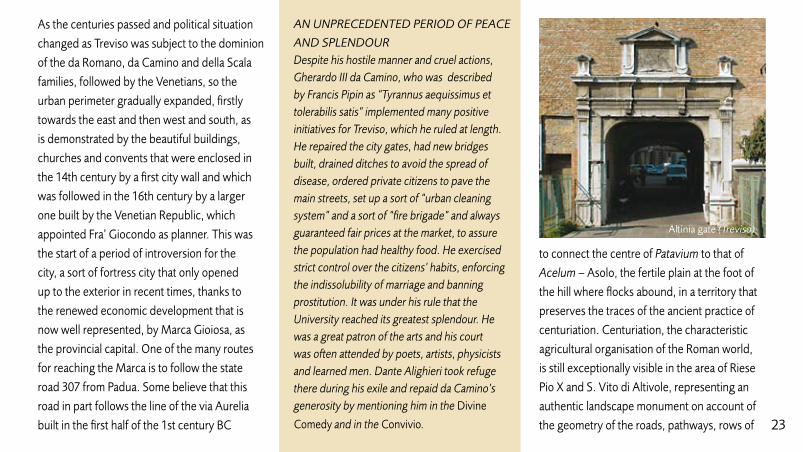
Altinia gate (Treviso)
AN UNPRECEDENTED PERIOD OF PEACE
AND SPLENDOURDespite his hostile manner and cruel actions, Gherardo III da Camino, who was described by Francis Pipin as “Tyrannus aequissimus et tolerabilis satis” implemented many positive initiatives for Treviso, which he ruled at length. He repaired the city gates, had new bridges built, drained ditches to avoid the spread of disease, ordered private citizens to pave the main streets, set up a sort of “urban cleaning system” and a sort of “fire brigade” and always guaranteed fair prices at the market, to assure the population had healthy food. He exercised strict control over the citizens’ habits, enforcing the indissolubility of marriage and banning prostitution. It was under his rule that the University reached its greatest splendour. He was a great patron of the arts and his court was often attended by poets, artists, physicists and learned men. Dante Alighieri took refuge there during his exile and repaid da Camino’s generosity by mentioning him in the Divine
Comedy and in the Convivio.

24
trees and the canals that cross one another to
form a perfect chessboard in which the visitor
could almost lose himself.
Anyone desiring to catch a glimpse of this
distant past can visit the town of Cendrole,
north west of Riese, where the walls of the bell
tower of the St. Mary’s Sanctuary bear a plaque
with a 1st century funeral inscription, which
may have been part of an urn or box, which
recalls the Roman magistrate Lucius Vilonius,
an official of the nearby municipium of Asolo.
However, before visiting Asolo, one should
not miss a stop at Castelfranco Veneto,
whose urban organisation is defined by two
different spirits: that connected to historical
times of hardship when citizens were forced
to defend themselves from external threats
inside mighty fortifications, and that connected
to the development of trading and therefore
open towards the countryside and other
nearby towns. This led to the creation
of a vast marketplace to the north of the
walls, coinciding with modern-day Piazza
Giorgione, which still provides a venue for
a market every Friday. The city appears
geometrically, with beautiful towered walls
surrounded by a defensive embankment
and moat. It is the oldest Frankish city,
hence the name and one of the best
preserved 12 – 13th century fortified
systems in our region.
Together with Cittadella, Castelfranco
constitutes one of Veneto’s most successful
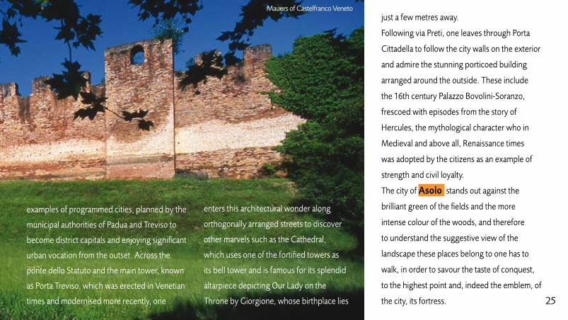
25
examples of programmed cities, planned by the
municipal authorities of Padua and Treviso to
become district capitals and enjoying significant
urban vocation from the outset. Across the
ponte dello Statuto and the main tower, known
as Porta Treviso, which was erected in Venetian
times and modernised more recently, one
just a few metres away.
Following via Preti, one leaves through Porta
Cittadella to follow the city walls on the exterior
and admire the stunning porticoed building
arranged around the outside. These include
the 16th century Palazzo Bovolini-Soranzo,
frescoed with episodes from the story of
Hercules, the mythological character who in
Medieval and above all, Renaissance times
was adopted by the citizens as an example of
strength and civil loyalty.
The city of Asolo stands out against the
brilliant green of the fields and the more
intense colour of the woods, and therefore
to understand the suggestive view of the
landscape these places belong to one has to
walk, in order to savour the taste of conquest,
to the highest point and, indeed the emblem, of
the city, its fortress.
enters this architectural wonder along
orthogonally arranged streets to discover
other marvels such as the Cathedral,
which uses one of the fortified towers as
its bell tower and is famous for its splendid
altarpiece depicting Our Lady on the
Throne by Giorgione, whose birthplace lies
Mauers of Castelfranco Veneto

26
Perched at the top of Monte Ricco, it is
steeped in centuries of history, from the first
settlements in Veneto times, to the presence
of a small church dating from the 6th – 8th
centuries AD, with a mosaic floor and small
neighbouring cemetery, to an urban nucleus
with productive sectors dating from the 10th
– 11th century. It is on this pre-existing life that
the fortress was founded in the second half of
the 12th century. It is a very unusual castle in
that rather than being a stately home, it was
built to accommodate a military garrison. In
actual fact, the mighty polygonal structure
almost constituted a turret, the highest of them
all, when several centuries later, between the
late 13th and the early 14th centuries, it was
reached by the Venetian walls that surrounded
the hamlet. From here the panorama is
incredibly suggestive, as to the north the
eyes take in the series of hills and beyond the
Grappa plateau that define the Valcavasia, to
east and west the succession of the hills as
far as the Piave on one side and towards the
Brenta on the other, to the south the uniform
extension of the plain, but also to witness
the continuous change, from one season to
the next, from one time of day to another, in
the colours and shadows of the landscape,
reminiscent of Giorgione’s palette. From the
bastions one can also see the characteristic
urban setting of Asolo, concentrated around
the “Isolo” and piazza Maggiore, also known as
piazza della Fontana and Piazza Brugnoli (where
the baths of Roman Acelum used to stand),
before extending along a number of centripetal
Fortress (Asolo)

27
and centrifugal branches, the Foresti, which
follow the crests of the hills, alternating with
the shady caesuras of the valleys.
In ancient times, the most important must
have been that leading south, which is now
crossed by the Forestuzzo, across the Portello
di Castelfranco: it was here that the Roman
Theatre stood, in direct perspective of the
plain. On the former site of the theatre, a 17th
century villa was the last home of the famous
English traveller, Freya Stark.
However, the suggestions also mount as one
follows the other ridges. By following via
Browning, which is entirely porticoed with
little shops packed in next to one another, and
having passed the Cathedral, after a visit to
the rooms of the Public Museum, one comes
to the great terracing of the Castle where, by
stopping on the bastions, one can still hear the
echoes of the court of queen Cornaro and the
conversation of Pietro Bembo.
By descending another crest, towards the
Foresto del Casonetto, a house recalls another
female figure, the actress Eleonora Duse, who
lived her last years in Asolo, finding in the local
landscape a real yet transfigured backdrop for
the final act of her life.
She now rests with others who loved this
land, such as Manara Valgimigli (illustrious
Greek historian) and Freya Stark, in the
beautiful cemetery close to the church and the
neighbouring convent of St. Anna, both late
15th century Thinking of these women, from
Caterina Cornaro, to Eleonora Duse, to Freya
Stark, all of whom loved Asolo, one can almost
Asolo Public Museum (Asolo)

28
feel this little town, which admirably maintains
its medieval structure, pervaded by a warm
female spirit nestling in the womb of history.
The name Vittorio Veneto takes us back
to a particularly significant period for our
country, when Veneto was annexed to Italy
and in particular when, in 1866 Serravalle and
Ceneda merged to form a single town, taking
its name from Vittorio Emanuele II. In actual
fact, even after the creation of new residential
areas, intended to form a trait d’union between
them, the two settlements, which were
located along the Alemagna state road uphill
and down hill, respectively, still maintained
separate physiognomies. According to written
evidence, Ceneda was built in the first half of
the 6th century and as an important fortified
town, it became the scene of the bloody battles
between the Franks, Longobards, Byzantines
and Goths for dominion over northeastern Italy.
Ceneda was made a Longobard dukedom that
stretched from the Piave to the Tagliamento,
and later became home to the Bishop-Count
who moved a new political and religious
establishment there from Oderzo. Ceneda’s
military, political and religious role can be well
illustrated by a visit to the main square, which
Caterina Cornaro

29
is overlooked by the loggia and the cathedral
and, even more so, by climbing the hill above
traditionally attributed with having been the
site of five different fortifications: San Rocco,
“Palasi”, “Rocca” or St.Paul, St. Martin’s Castle
and “Rocchetta di Salsa” (now St. Gottard’s
Church). The best preserved of these is
undoubtedly the Castle of St Martin, which was
the residence of the Bishop-Count from the
8th century and was consequently profoundly
restored over the years until the end of the 18th
century. Today, it appears as an official patriciate
residence that nevertheless maintains some
of the fortification’s main features, such as the
mighty pentagonal tower built on a rocky spur,
later softened and enhanced with Renaissance
and modern additions to make it suitable for use
as the Bishop’s residence and convent to a small
community of nuns to date.
Descending from the castle, proceed to the
centre of Serravalle, a town of Roman origins
that developed a strategically and economically
important role in medieval times, having become
a feud of the da Camino family, on account of
the traffic that transited the narrow valley and
consequently, trading, blacksmithery and the
processing of the wool produced in the Alps.Flaminio Square (Serravalle Vittorio V.to)
Castle of St Martino (Vittorio Veneto)

30
The wealth generated by these activities
is visible in certain parts of the town
reminiscent of subalpine settlements and
in the construction of the handsome main
square flanked by the loggia erected by the
Podestà Gabriele Venier, the long porticade
of ogee arches of the Flagellants’ hospital or
headquarters and the long sequence of elegant
residences in via Martiri della Libertà, formerly
known as Calgrande. A graceful example of
Venetian architecture, the loggia is now home
to the Ceneda Museum, which gives a clear
account of local history, and especially the
period of the Longobard occupation, with
exhibits and works of art of significant value, a
real discovery for all first-time visitors.
For all those who wish to become familiar with
Conegliano , which is famous for much
more than its excellent Prosecco and
outstanding cuisine, we recommend starting
their visit from the earliest settlement,
Castelvecchio, from which the town and later
the city developed on the hillside.
The castle is thought to date from the 10th or
early 11th century and was built by the Bishop
of Belluno, who was later replaced by the Da
Camino family, which was politically closer to
Lombard Fibula - Cenedese Museum (Vittorio V.to)
Castle (Conegliano)
31
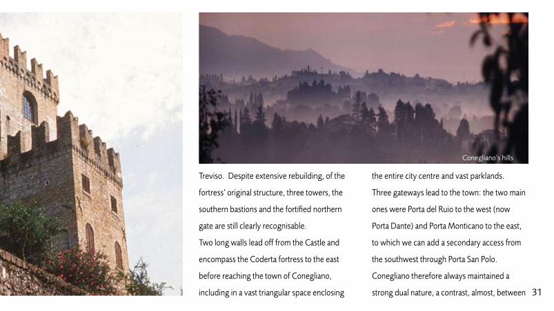
Treviso. Despite extensive rebuilding, of the
fortress’ original structure, three towers, the
southern bastions and the fortified northern
gate are still clearly recognisable.
Two long walls lead off from the Castle and
encompass the Coderta fortress to the east
before reaching the town of Conegliano,
including in a vast triangular space enclosing
the entire city centre and vast parklands.
Three gateways lead to the town: the two main
ones were Porta del Ruio to the west (now
Porta Dante) and Porta Monticano to the east,
to which we can add a secondary access from
the southwest through Porta San Polo.
Conegliano therefore always maintained a
strong dual nature, a contrast, almost, between
Conegliano’s hills

32
the castle on the hill, home to noble families
first, and of Trevisan and Venetian domain
later, and the burgus or town at the foot of
the hill, home to artisan and professional
activities according to that planning and social
dichotomy that we would now define up- and
downtown. From here, having admired the
gate of Ser Belle a little further to the north,
walk down the Calle della Madonna della Neve,
along the archivolts of the Carrara stone walls
and the former convent of St. Francis to Piazza
Cima, the centre of the town.
To the right, follow the porticoes of the
Renaissance building along via XX Settembre,
including Casa Longega, stopping at the
Cathedral (alternatively turn right down
via Cima before reaching the square to the
painter’s birthplace with a museum that houses
documents and other exhibits.
Almost opposite Casa Cima a gate is open all
day long and allows one to go down to the
suggestive Flagellants’ campiello, between the
Cathedral and the Flagellants’ school and from
here across a vault underneath the bell tower
to Via XX Settembre). Leaves the town through
the curious Porta Dante, which was officially
opened in 1865 to mark the anniversary of the
poet’s death, replacing the Medieval Porta
Conegliano’s hills
33
del Ruio. Having passed through the gate and
alongside to the Horses Fountain, continue
along Corso Vittorio Emauele and Corso
Mazzini, the main road that corresponds to
the course of the moat that surrounded the
town until the 16th century and was known as
Refosso. To the left, the buildings line the town
walls and in places the defensive structures,
two towers and Porta San Polo are visible.
A long row of gardens is perched atop the
embankment. Proceed outside the town
to Porta Monticano, undoubtedly the best
preserved and most suggestive of the city’s
fortifications. However, if we continue to
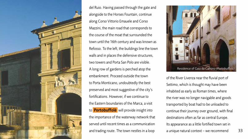
the Eastern boundaries of the Marca, a visit
to Portobuffolè will provide insight into
the importance of the waterway network that
served until recent times as a communication
and trading route. The town nestles in a loop
of the River Livenza near the fluvial port of
Settimo, which is thought may have been
inhabited as early as Roman times, where
the river was no longer navigable and goods
transported by boat had to be unloaded to
continue their journey over ground, with final
destinations often as far as central Europe.
Its appearance as a little fortified town set in
a unique natural context – we recommend Portobuffolè
Residence of Gaia da Camino (Portobuffolè)

34
the suggestive view over the towered town
from Pra’ dei Gai, a vast boggy area along the
Livenza – makes Portobuffolé one of the real
treasures of the Marca Trevigiana.
By crossing Porta Friuli and the bridge over
the Livenza, one comes to the Medieval city
gate, which was completely transformed by the
Venetians in 1513, and the southwestern side
of the walls, which is now enclosed by modern
buildings.
To the left of the gate, overlooking the
river, it is possible to make out the façade
of the Fontego or public stores that once
housed salt, as evidence of the trade that
represented the port’s main source of income
for many centuries. This area was, at one time
populated, by quays and other port facilities.
On entering the town, one immediately comes
to Piazza Maggiore, edged by many of the
town’s monumental buildings: here one finds
the main façade of the Fontego (a 16th century
rebuilding of the Medieval deposit), Monte di
Pietà, or pawnbroker’s (until the 15th century),
the medieval public tower and, a short way
off, the gothic building that once served as a
customs house. From here, take Via Businello,
which leads to the residence of Gaia da
Camino, a Medieval patriciate residence that
Oderzo

35
was restyled in Renaissance times, and piazza
Beccaro. Leave the fortified town by crossing
Ponte Trevisana, the only surviving sign of the
walls and Porta Trevisana, which was destroyed
in 1918. Follow Calgranda dei Sali, whose name
once again refers to the main source of income
of this Medieval port, crossing Borgo dei Servi,
which leads back to Porta Friuli in just a few
minutes’ walk.
From Portobuffolé, follow the Livenza south,
to the centre of Motta di Livenza, which
even in Medieval times used the river as a
trading route with Venice. Of the castle built
to defend the town all that remains are a few
traces and place names such as Via del Girone
(the circuit of the fortress walls) and La Castella,
referring to one of the 15th century buildings
erected next to the walls under Venetian rule.
One suggestion for reaching Oderzo is to
La Castella (Motta di Livenza)
Domus of via Mazzini, mosaic flooring (Oderzo)
follow, albeit ideally, the footsteps of the
ancient travellers, taking the old state road
53, which follows the route of Via Postumia,
the Roman road that led from Genoa to
Aquileia, crossing the whole of northern
Italy, including this town. Since its origins,
Oderzo has always represented a traffic and
trading place for connection and exchange
between the Eugania area, the alps and

36
Eastern Veneto, as the city’s name would
suggest, deriving from the Venetii word
Opitergium, from the root terg, meaning
market, square. Again this city, owed its
development to its unusual geographic
position, which favoured its development
from protohistorical times, being located
in the middle of a broad band of land
between the Livenza and Piave rivers and
connected to the sea by short stretches
of easily navigable waterways. The most
ancient traces of settlement here date from
the early Iron Age. By the Late Iron Age
the town must have achieved significant
importance and it later received a new
impulse during the Romanisation of the
Cisalpine area, which coincided with the
construction of the Via Postumia in 148 BC
and the city’s earliest urban layout. Later,
during the civil war between Caesar and
Pompeius, in 49 BC, the city allied with
Caesar and was rewarded as a consequence
with a twenty-year exoneration from military
service, an extension of its farming rights
and a rise in status to Roman municipium.
The monumentalisation of the town, which
is thought to have taken place in Augustus’
time (late 1st century BC) and the remains of
which are still visible in various parts of the
city, provides us with a good idea of what
the Roman city must have looked like. It had
a forum with a basilica, workshops, public
baths and magnificent mosaic-decorated
private residences, such as that which can
be admired in Via dei Mosaici, a fluvial jetty
and a water collection system. With the
decline of the Roman Empire, on account of
its strategic position, Oderzo was repeatedly
sacked, but nevertheless succeeded in
maintaining its characteristic as a trading
centre and in the 11th century, it is once
more recalled as a market place and is even
contended by the patriarchs of Aquileia,
Bishops of Ceneda and Belluno.
In the 13th century, the city returned under
the municipality of Treviso. A city wall
was built, surrounded by a canal and the
settlement’s physiognomy assumed the
typical appearance of the Medieval and
Renaissance towns in Veneto, characterised
by the Cathedral surrounded by houses
and buildings with frescoed façades. These
millennia of history can be explored by
visiting the Eno Bellis Public Archaeological
Museum, whose exhibition areas house
unique historical finds from the most ancient
of times through to the Middle Ages.

37Public Museum (Oderzo)

38
(D) THE ENIGMA OF VIA CLAUDIA AUGUSTA
On a par with the Via Postumia, the Via
Claudia Augusta was essential to the Marca
Trevigiana and still represents a project of
trasnational importance. Planned around
15 BC by Druso Maggiore, in the midst of a
military campaign and built by the Emperor
Claudius (son of Druso) in 46-47 AD to connect
the Padania Plain and, above all, Altino to
the shores of the Danube, it was 350 Roman
miles (approximately 518 km) long, or so the
honorary milestone found in Cesiomaggiore
northeast of Feltre claims.
The road’s route is for certain aspects a
mystery, as the itinerary is not reported either
in the Tabula Peutingeriana or any other ancient
map or itinerary, although place names provide
us with a series of clues. In any case, in the light
of documented historical and archaeological
studies, we currently have no clear idea of
the original route, although it would appear
that a number of secondary routes were built
adjoining the main road.
The oldest suggestion, which was published
in 1789, was formulated by Count Aurelio
Guarnirei Ottoni: it envisaged a stretch from
Altino to Oderzo and then Serravalle (Vittorio Cippus or Milepost of Cesiomaggiore

39
Piave
Piave Piave
Sile
Sile
ZeroMusone
Monticano
Livenza
Fontanelle
Altivole
Arcade
Borso del Grappa
Breda di Piave
CandelùSaletto
Caerano di San Marco
Cappella Maggiore
Carbonera
Casale Sul Sile
CasierCastelcucco
Castello di Godego
Cavaso del Tomba
CessaltoChiarano
Cimadolmo
Cison di Valmarino
Codogne'
Colle Umberto
Cordignano
Cornuda Crocettadel Montello
Farra di Soligo
Follina
Gaiarine
Giavera del Montello
Godega di Sant'urbano
Istrana
Loria
Mansue'
Mareno di Piave
Maser
Maserada Sul Piave
Meduna di Livenza
MianeFeltre
Mogliano Veneto
Monfumo
Morgano
Moriago della Battaglia
Motta di Livenza
Nervesa della Battaglia
Ormelle
Orsago
Paese
Pederobba
Pieve di Soligo
Ponte di Piave
Ponzano Veneto
Portobuffole'
Possagno
Povegliano
Preganziol
Quinto di Treviso
Refrontolo
Resana
Revine Lago
Riese Pio X
Roncade
Salgareda
San Biagio di Callalta
San Fior
San Pietro di Feletto
San Polo di Piave
San Vendemiano
San Zenone Degli Ezzelini
Santa Lucia di Piave
Sarmede
Segusino
Sernaglia della Battaglia
Silea
Spresiano
Susegana
Tarzo
Trevignano
Vazzola
Vedelago
Vedelago
Vidor
Villorba
Volpago del Montello
Zenson di Piave
Zero Branco
Fregona
Fonte
Monastier
Crespano del Grappa
Paderno del Grappa
VALDOBBIADENE
ASOLO
CASTELFRANCO VENETO
VITTORIO VENETO
CONEGLIANO
MONTEBELLUNA TREVISO
ODERZO
Pagnano
Casonetto
One'
Fonte Alto
Sopracastello
Liedolo
S. Eulalia
Semonzo
Cassanego
Fietta
Caniezza
Vettorazzi Castelli
Curogna
Levada
S. Urbano
S. Vettore
La Valle
Madonna della Salute
Lauro
Busta
Edifizio
Borgo CampagnolaVillarazzo
Bella Venezia
Villaraspa
Caonada
Granigo
Cima Grappa
Stramare
Milies
S. VitoFuner
Fener
Barbozza
Saccol
S. Stefano
Guia
Colbertaldo
Carlot
Bosco
Piazza RovereGiussin
Posmon Castelletto
Boschet
SolighettoCastello
PremaorLa Bella
Pedeguarda
Combai
VergomanCampea
Valmareno
Mura
TovenaSoller
Sotto Croda
Arfanta
Caiada
Lago Colmaggiore
Nogarolo
Borgo Villa
Longhere Olarigo
Savassa Bassa
Botteon
Nove
Fadalto
Sonego
Breda
Mezzavilla
Luca
Silvella
MontanerRugolo
Villa di Villa
PinidelloPine'Ponte della Muda
BibanoSalvarotonda Bibano di Sotto
Levada
BaverPianzano
Falze' di Piave
Collalto
Corbanese
CozzuoloCarpesica
Ogliano
Scomigo Menare'
Ceneda BassaCeneda Alta
Serravalle
Bagnolo
Crevada
Collalbrigo
Borghetto
Cosniga
Capo di Sotto
Bocca di Strada
Ramera Soffratta
S. Maria di Piave
Rai Tempio
Prato
Stabiuzzo
Visna'
Cimavilla
Borgo ChiesaRoverbasso
Vallonto Cornare
Rigole
Lutrano
Brische
Lorenzaga
Villanova
Malintrada
Campobernardo
Fagare'
PralongoSan Pietro Novello
Rovare'
Vallio
Borgo Verde
Olmi
San Martino
Spercenigo
Busco
San Nicolo
Candole
Francenigo
Cavrie'Le Marche
Cendon
Canton
Bonisiolo
Lughignano
S. Elena
Zerman
BoschettaCampocroce
Sambughe'
Mazzocco
Ghetto
Santa Bona
Fontane Castello
Barrucchella
Bel Giardino
VacilSan Giacomo
Mercatelli Colfosco
Bidasio
Palu'
S. Maria
Franceniga
Guizza
Carita'
Nerbon
Borgo Bellussi
ManzanaPrapian
San Martino
Pecol
Costa di La'
Intrivigne
Guizzetta
Pra De Roda
Rive
Vitipan
Villanova
Bagaggiolo
ALTINOQUARTOD’ALTINO
Villaggio I.A.C.P.
Navole'
Fae'
Bavaria
SovillaSanti Angeli
San Giovanni Santa Mama
Santa Croce
Santa Maria
S. MicheleS.Maria
Molinetto delle Crode
Rocchetta
Guizza
Osigo
Fratte
Ponte Maset
Formeniga
Praderadego
Farro'
Castelcies
Levada
Covolo
Coste
Lauro
Busta
Villaraspa
Caonada
Virago
S. Stefano
Guia
Colbertaldo
Solighetto
Combai
VergomanCampea
Gai
Baver
Ramera
San Giorgio
Prato
Basalghelle
Lutrano
Mure
VelapiccolaS. Anastasio
Busco
Campomolino
BonisioloBorgo Verde
Ca' Tron
Zerman
Boschetta
Conscio
Biban
Bel Giardino
Vigonovo
Pezzan
Guizzetta
Le Grazie
Bavaria
Cusignana
Passo San Boldo
M O N T E L LO
PROVINZ PORDENONE
PROVINZ VICENZA
PROVINZ PADUA
PROVIZ VENEDING
PROVINZ BELLUNONORTH
WEST
EAST
SOUTH
Pero
San Marco
Santa Cristina
Albaredo
Anzano
Badoere
Barbisano
Barcon
Bessica
Biadene Biancade
Bigolino
Bocca Callalta
Borgo Marconi
Ca' Rainati
Camalo'
Campagnola
Campigo
Campo Pietra
Candelu'
Carpenedo
Casacorba
Casella d'Asolo
Caselle
Castagnole
Castelminio
Castione
Catena
Cavalier
Cavasagra
Ciano
Col San Martino
Colfrancui
Costa
Crespignaga
Dosson
Falze'
Fanzolo
Fossalta Maggiore
Fossalunga
Fratta
Frescada
Gorgo Dei Molini
Gorgo della Chiesa
Lancenigo
Lanzago
Levada
Lovadina
Marocco
Merlengo
Mignagola
Mosnigo
Musano
Musestre
Negrisia
Onigo
Ospedaletto
Padernello
Paderno
Pare'
Pezzan
Piavon
Poggiana
Ponte della Priula
Porcellengo
Postioma
Ramon
Roncadelle
Rua
Sala
SalvarosaSalvatronda
San Bartolomeo
San Cipriano
San Floriano
San Floriano
San Gaetano
San Giacomo di Veglia
San Giovanni di Motta
San Michele di Piave
San Trovaso
San Vito di Altivole
Sant'alberto
Sant'andrea Oltre Muson
Sant'Apollinare
Santa Maria di Campagna
Santandra'
Scandolara
Selva del Montello
Signoressa
Soligo
Spineda
Tezze
Treville
Valla'
Varago
Vascon
Venegazzu'
Villa d'Asolo
Villanova
Visnadello
Borgo di FontanePederiva
Guarda Bassa
1
12
2
3 4
5
6
7 8
9
10
11
13
14
15
16
18
17
Hypothetical course of the Via Claudia Augusta
A
B
C
D
A
B
C
D
T. Mommsen - G. Rosada
A. De Bon - V. Galliazzo
A. Alpago Novello
P. Fraccaro
The first stretch of the probable course of the Via Claudia Augusta can be followed from Altino to Callalta and from the River Piave to Valdobbiadene and Segusino. Other routes are partially visible in the sites indicated in the key.
CB
D
ALTINO1 Altino (archaeological area)2 via Claudia Augusta3 Quarto d’Altino
RONCADE4 Lagozzo (via Cl. Augusta)5 Lagozzo (via Cl. Augusta)6 Villa-castle Giustinian
SILEA7 Nerbon (route of the via Cl. Augusta)
SAN BIAGIO DI CALLALTA8 Route of the via Claudia Augusta
CARBONERA9 Villa Tiepolo Passi
10 Villa Valier-Loredan (Vascon)11 Crossroads between the Via Cl. Augu-
sta and Via PostumiaNERVESA DELLA BATTAGLIA
12 Ca’ TonetSUSEGANA
13 Roman bridges (Colfosco)VALDOBBIADENE
14 Probable route of the via Cl. AugustaFOLLINA
15 Cistercian Abbey16 Praderadego Pass
CISON DI VALMARINO17 Borgo Cison Valmarino and Brandolini Castle18 S. Boldo pass

40
Veneto) and on to Belluno before proceeding
to Cesiomaggiore and Feltre. Later, in 1863,
the German scholar Theodor Mommsen was
more inclined to believe that the road went
from Altino to Treviso and then straight on to
Feltre. The same hypothesis was taken up again
in 1916 by Konrad Miller who also provided an
illustration, in which the Via Claudia Augusta
formed an important crossroads with the Via
Postumia at Postioma on the Feltrina road
before proceeding towards Montebelluna,
Cavaso and Feltre, following a route that was
adopted in 1926 by Walther Cartellieri (with
the exception of its initial portion, which went
through Altino, Lagozzo, Nerbon and from here
“undoubtedly” on to Treviso).
Most recently, in 1999, the route passing
through Treviso suggested on several
occasions, was considered and updated in a
rationalistic key by Professor Guido Rosada,
of the University of Padua. According to
this version, the Via Claudia Augusta ran a
short distance from the banks of the River
Sile. It continued through the pleasant fluvial
landscape, through what is now Casale sul Sile
and Lughignano (where the later 15th century
Villa Barbaro-Gabbianelli overlooks the river).
Having reached Casier, a town along the Sile
where it is thought that cheese was once
produced or sold, the road must have headed,
through the town of Sant’Antonino, towards
Treviso entering the city through an ancient
gate that still goes by the name of Altinia,
recalling the connection with the Riviera city.
On leaving Porta Santi Quaranta, the road
followed the straight line of the current Feltrina
road, which in ancient times also constituted
one of the main hinges of centuriation in the Roman pavement (Altino)

41
municipality of Treviso, meeting the town
of Postioma, a name that relates to the most
important and oldest main road in northern
Italy, which as we know, in 148 BC, served to
connect Genoa and Aquileia. In actual fact,
at this point, state road 348 crosses the Via
Postumia, as is still indicated on maps and that
in this Veneto stretch of its course, is perfectly
preserved and used by intense motor traffic.
By continuing north, one comes to
Montebelluna, which occupies a strategic
place, not far from the southwestern slopes of
Montello and the point where the Piave meets
the plain.
At the same time, it lies at the easternmost
point of state road 248 that skirts the southern
slopes of the foothills between the Piave
and the Brenta and that since ancient times,
was a route used also during invasions from Archeological finds - Museum (Montebelluna)

42
believes that the Via Claudia Augusta, which
started from Altino 1 , an archaeological
site of significant interest and home to the
important National Museum, ran through the
city in a non-continuous manner in the first 300
metres after branching of the Via Annia.
Along the road 2 that leads from S. Michele
del Quarto (now Quarto d’Altino 3 ) to the
Tre Palade near the River Sile, the traces of the
Via Claudia Augusta disappear, however, north
of Quarto d’Altino and downstream from the
confluence of the Sile and the Musestre, one
can still just about make out the remains of a
Roman bridge over the River Sile.
One can then proceed along the route known
as Lagozzo 4 or Agozzo (a vast, mighty
embankment that was once seven metres
high and stony) on the left bank of the river,
passing through Musestre and from here, in a
the exterior, as suggested by the name
Schiavonesca that it preserves today.
The position of Montebelluna therefore
combines various meanings and plenty of
history that is well narrated in the rooms of
the Public Museum, where Veneti and Roman
materials testify to the logistic value of the site,
due to its vicinity to a great communication
route, making it a locally important settlement
along the road.
Having passed Pederiva, further on, between
Cornuda and Onigo, the layers of foothills
are home to the remains of important castle
systems overlooking the River Piave.
Head east to Pederobba and start to go up
the Piave valley on the right bank of the river,
passing Fenèr, where one can still see the
milestone and the inscription indicating it as the
11th mile, indicating the distance from Feltre
Milepost of Fener
and at the same time, the crossroads with the
Via Claudia Augusta and the road that ancient
itineraries indicate as joining Oderzo to Trent.
The most accredited hypothesis, backed up by
the undisputed archaeological remains found in
1938, at least in the Altino Vidor stretch, is that
formulated by Alessio De Bon. The scholar

43
north/northwesterly direction, one can still see
on the ground and on the map, odd signs of
the ancient road that with a clear straight line
5 , must have reached the area immediately
east of Nerbon 7 . It is a land characterised
by lowlands, in part involved in the repeated
reclamation work that justify the raised
structure of the road, built on an embankment
on a higher plane than the surrounding
Via Claudia Augusta (Roncade)
countryside. The reclamation work, of course,
gradually transformed the original appearance
of these places where the boggy stretches must
have been frequent and difficult to cross and
nevertheless, the nearby presence of the Sile
and many other small waterways, such as the
Musestre, still clearly characterise the overall
physiognomy of these lands that are, in a
certain sense, amphibious. The inhabited areas
along the Roman road have yielded abundant
archaeological finds from both protohistorical
and Roman times. Further north lies Roncade,
now a wine producing town, once the town
surrounding the Villa-Castle Giustinian 6 ,
a late 15th century prototype of Veneto-style
villa that simultaneously recalls surprising late
feudal architecture. Following the line of the
Lagozzo 8 , one passes Callalta, crossing
it after the town of Borgo Furo, a name that
Villa Valier Loredan (Vascon)
may suggest a nearby town. Continue close
to Carbonera and a number of 16th century
villas 9 - 10 which adorn the landscape just
east of Treviso and head towards the junction
with the Postumia 11 , more or less along
the Vascon-Lovadina line. This route, which
once crossed open countryside in step with the
Piave, must have constituted a valid connection
with the territories further north. At a height

44
best looking and most intact is undoubtedly
that near Villa Jacur, at Colfosco di Susegana.
From Falzè di Piave, opinions differ as to the
route followed by the road. According to De
Bon, the Roman road proceeded along the
southern part of Quartier del Piave passing
Sernaglia, Fontigo, Moriago, Bosco or
Nosledo and Vidor, before crossing the Piave,
following the right bank and then through
The crossing of the Piave also represented a
significant difficulty for the Roman engineers
who decided to cross the waterway choosing
the safest crossing point, namely halfway
between the Ponte della Piùla and the town
of Nervesa, where the Piave bent to the
south east and then towards a little island
that divided its waters into two branches,
which could be crossed with moderate
difficulty. Having crossed the river by means
of a ford and probably also a parallel auxiliary
wooden bridge, for a short stretch, the Via
Claudia Augusta followed the left bank before
moving away and back again, following the
morphology of the land.
The Roman road was able to cross the smaller
tributaries of the Piave, which were hazardous
in the event of heavy rain, by means of a series
of small Roman bridges 13, of which the
of Ca’ Tonet 12 (on the Nervesa-Spresiano
border) the road, which was still marked by
two lateral drainage channels as late as the
1980s, turned north west to cross the Piave,
which must have taken place up stream, not far
from modern-day Ponte della Priula, heading
towards the Strada Vecchia dei Mercatelli,
a toponym that evokes a market place on
the left bank of the river at the fluvial pass.
Ponte della Priùla (Susegana) Roman bridges (Colfosco)

45
and the town of Fontigo, the Roman road
continued through Moriago della Battaglia,
and then, heading west, merged with the
provincial road to Bosco as far as Vidor, which
was undoubtedly inhabited in Roman times,
as demonstrated by the little necropolis dating
from the 4th century AD in Piazza Maggiore.
The Roman road must have then followed
a sunny and safe course along the left bank
of the Piave, taking in the hamlet of Bigolino
(form Bigollium, river passage), the old centre
of Valdobbiadene 14 (the ancient Duplavilis
of Venanzio Fortunato, the last Latin and first
Medieval writer, who lived in the 6th century
AD), San Vito, Segusino, Vas, Scalon, Cavrera,
Marziai, Cesana and having crossed the
Piave at Busche, switched to the right bank,
in the territory governed by ancient Pieve di
Cesiomaggiore to Feltre.
Quero towards Feltre and then Cesiomaggiore
(and on to Belluno, Cadore, Val Pusteria
and the Brenner Pass). Luciano Bosio (1970
and 1991) agrees with this route only with
regard to the stretch from Altino to Vidor.
The scholar is convinced that after Falzè di
Piave, the Via Claudia Augusta continued
towards the Moriago della Battaglia, Mosnigo
and Valdobbiadene, before continuing,
again along the left bank of the Piave, to
Busche, crossing the river and reaching
Cesiomaggiore. Professor Vittorio Galliazzo of
the University of Venice, was appointed by the
Province of Treviso to conduct more detailed
investigations on the above research on the
probable route followed by the Via Claudia
Augusta, following and examining potential
traces and other documents according to the
most recent scientific criteria. In his work, the
hypotheses put forward by De Bon (for the
Altino-Vidor stretch alone) and Bosio (at least
as far as Busche, with the exception of a few
variants) were partially confirmed. Therefore,
after passing the little church of St. Anna
in Colfosco, the Via Claudia Augusta went
northwest and, after crossing the bridge over
the River Soligo, headed for the centre of Falzè
di Piave. Having crossed the River Rosper
Cloister of St. Maria abbey (Follina)

46
Finally, three further hypotheses have
been put forward that envisage the direct
crossing of the mountains north of the Marca
Trevigiana. Feltre-born Alberto Alpago-
Novello believes the Roman Road headed
from Mercatelli to Falzè then turned north to
Soligo and on to Follina, where in addition
to the exceptional Cistercian abbey 15
founded in the 12th century, the toponym
also refers to the presence at one time, of a
fullonica, a wool washing and dying house,
providing additional evidence to support
the existence of pastoral activities along
the road. From here, the road reached the
Praderadego Pass 16, on the border with
the province of Belluno, with a route that
could not be travelled in carriages, due to
the narrowness of the passage and the steep
slopes, through a picturesque and hazardous
stretch between occasional woods and sheer
drops. According to another hypothesis,
supported by the Scholar Plinio Fraccaro, the
road from Soligo, after following the course
of the river of the same name, led, through
the centre of Cison di Valmarino 17, to
the altitude of 701 metres at the S. Boldo
Pass 18 , climbing to the very top of the
ridge, which has now been overcome by a
series of tunnels built during the First World
War. A secondary yet interesting road, from
west of Praderadego, according to Filippo
Pilla (1968), is thought to have led to Col San
Brandolini castle (Cison di Valmarino)
Tunnels (Passo di S. Boldo)

47
FeltreOpitergium
Altinum
Po
Inn
Isar
Donau
Lech
100 kmPatavium
Verona
Cesiomaggiore
Hostilia
Mediolanum
Comum
Rablà
Teriolis
Curia
Foetibus
Bratananium Pons Aeni
Iuvavum
Aboduacum
Augusta Vindelicum
Submuntorium
Cambodunum
Tridentum
AguntumTeurnia
Aquileia
Pons Drusi
Martino and Guia, to finish the other side of
Stabie (stabulum) and Busche.
These latter hypotheses, capable of arousing
the imagination and emotions even on a
popular level, would appear to be particularly
well-loved more for the great suggestion of
the places it passes than for their concrete
importance, although the San Boldo Pass was
undoubtedly used from prehistoric times, to
Roman times through to Medieval Times and
beyond. Quite apart from the discussion and
debate of various kinds, supported by varying
degrees of scientific evidence, research on
the Via Claudia Augusta, a road that unites
three nations (Italy, Austria and Germany),
has demonstrated the high territorial, civil,
cultural and natural historical value of the
towns it is thought to have passed through, in
an ideal connection between different lands
and populations, positioned in the heart and
at the roots of modern Europe. Probable route of the Via Claudia Augusta with the milestones of Cesiomaggiore and Rablà

48
THE EMPEROR CLAUDIUSHe realised a number of large-scale works but was less concerned with the number than the need for them. The most important were: the aqueduct started by Gaius, the drainage channel of Lake Fucino and the port of Ostia, despite the fact that Augustus had always refused the latter … and that the former was planned by the divo Julius and later abandoned … He often distributed donations to people and organised frequent, sumptuous games, including some new kinds in addition to the conventional type.(Svetonio, Le vite dei Cesari,Divo Claudio: XX-XXI)
EVEN THE ROMANS FOLLOWED GUIDESEven in Roman times, guides were used and provided meticulous details on the route to be followed.Some of them consisted simply in lengthy lists of places to stop, the main towns and number of miles between them.Others included illustrations and representative symbols and were much The Emperor Claudius

49
No tolls were charged on public Roman roads. A traveller covered about 45 km a day.
like our road atlases. The Tabula Peutingeriana, which is now kept in the National Library in Vienna and is the most important map document dating from ancient times, was discovered in the late 15th century (it belonged to antiques dealer Konrad Peutinger, who it is named after).The parchment was originally divided into 12 segments that when joined together, made a roll almost 7 metres long and 34 cm high. It documented 100,000 km of road the length and breadth of the Empire, from Brittany to India, Africa to the Rhine, it indicates over 3,000 different places, includes drawings on the morphology of the land and their populations, as well as including a number of allegorical illustrations.
UNITS OF MEASUREMENTThe Romans measured distance in miles. One mile corresponded to 1000 paces. One pace measured five feet. Each foot is equal to 0.2957m. A Roman mile corresponds to 1478.5m.
Milepost of Rablà
The Tabula Peutingeriana - detail

50
GLOSSARIO ABBAZIA (ABBEY) - building complex for the accommodation and activities of a community of monks. Abbeys were particularly important in the Middle Ages, when they influenced religious, cultural, political and economic life.
BASILICA (BASILICA) - a public building that in Roman times, served legal purposes: the building usually had a rectangular plan and was divided into naves by colonnades and had two apses on the short sides. With the advent of Christianity, this architectural formula was adopted for the building of early churches.
BORGO (HAMLET, TOWN) - from approximately the 4th century, the word burgus, of Germanic origin, appears in manuscripts and epigraphs to indicate a fortified place or watch tower; later the word borgo was adopted in Italian to mean a hamlet or town.
CALLE (ALLEY) - from the Latin word callis, generally refers to a narrow street used to transferring livestock, in Veneto dialect it is used to indicate a city or country alley; the generic term is often followed by a specific adjective, such as Callalta, Calmaggiore, Calgrande.
CASTELLIERE (HILL FORT) - typical prehistoric settlement usually on a hill with one or more ring of defensive walls.
During the High Imperial age (1st – 2nd century AD ) the following currency system was used:1 Aureus= 25 denari (silver)1 Denarius= 4 sesterti (orichalcos)1 Sestertius = 2 dupondi (orichalcos)1 Dupondius= 2 asses (bronze)1 As= 4 quadrants (bronze)
One sestertius was the price for a night’s accommodation or a measure of wine or the straw for beasts of burden. The daily wage for a common labourer was 2 – 4 sestertiA kilo of bread cost almost one as, a kilo of pork cost 9 asses and a mule cost 512 sesterti.
Aureus Denarius
Sestertius
Dupondius
As

51
FORO (FORUM) - in Roman times, a rectangular open space often surrounded by porticoes overlooked by public buildings, used as a place in which citizens could meet and do business.
MARCA - of Germanic origin, a term used to indicate all those places on the borders of the Carolingian Empire and therefore entrusted to a regent to defend them from enemies; the term was used after the decline of the Empire to indicate the northern Marca (Verona, Trento and Treviso) and the western Marca. MILIARE (MILESTONE) - stone element, usually with a cylindrical shape, engraved with the distance in miles in relation to the route of a road. MOSAICO (MOSAIC) - technique used to clad floors and walls, based on the use of cubical pieces (of stone, marble, glass or terracotta) arranged and set in mortar to create a homogeneous surface often decorated with geometric and figurative designs. MOTTA (MOTTE) - a natural or man-made mound on which a settlement could be established; frequently used in place names.
NECROPOLI (NECROPOLIS) - literally “city of the dead”, a term used in ancient times to indicate a burial ground, always located outside the town or city.
PIEVE (PARISH) - term of Medieval origin used to indicate small ecclesiastic districts and that was used in later eras, especially in central and northern Italy, in place names.
CASTELLO (CASTLE) - group of buildings of varying complexity, originally defended by a simple moat or fence but was later given walls and bastions making it a mighty fortified place and residence of the local lord.
CASTRUM - Latin word for a temporary or permanent military camp.
CENTURIAZIONE (CENTURIATION) - typical Roman system adopted to organise farmland by sowing perpendicular rows of trees at set distances from one another to create equally sized fields. DOMUS - a Roman building use as a private residence and characterised by a hall surrounded by various spaces and rooms, including the cubiculum (bedroom), tablinum (living room) and triclinium (dining room).
DONGIONE (LOOKOUT TOWER) - from the French donjon, a large tower inside a castle in a dominant and isolated position used as a look out and place of ultimate defence.
FEUDO (FEUD) - in Medieval times, indicated the concession by a sovereign to a vassal of one or more rights over a given territory.
FIBULA - a kind of broach, which varied in shape in the different eras and cultures, used inmen’s and ladies’ clothing to hold the edges of garments together or as a simpleornament.
ROCCA (FORTRESS) - fortified building usually erected in a raised position destined in Medieval Times to accommodate troops.
STELE - stone or marble plate bearing engravings and decorations, used as a funeral or commemorative monument.
TOPONOMASTICA (TOPONOMY) - scientific analysis of place names, toponyms, considered in relation to their origin and meaning and therefore useful in the historical reconstruction of a given settlement or area.
VIA PUBLICA - Latin term indicating a long road used for civilian and military journeys that was built and maintained at the State’s expense.

52
The very ancient history of the Marca
Trevigiana, whose roots date back to
prehistoric times, can now be discovered
and relived thanks to an innovative and
almost unique initiative. Revine Lago, on
the western shore of the glacial lake of
Lago, in a truly suggestive environmental
setting in the Prealpi trevigiane, is home
to the Livelet Teaching Archaeology Park,
which focuses on the period between
the Neolithic and bronze ages.
The initiative originated from the
discovery at Colmaggiore di Tarzo, of
archaeological findings and remains that
are though to have been the foundations
of lake huts on stilts, testifying to the
existence of marsh dwellings covering
the whole are that currently separates the
two lakes at Revine.
Visitors to the park soak up the
prehistoric atmosphere and can
Livelet Teaching Archaeological Park
The artificially rebuilt homes of the Livelet
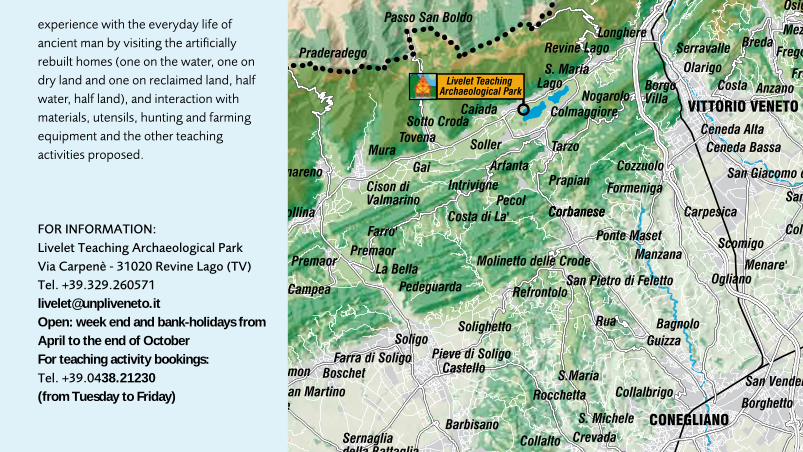
53
Fontanelle
Altivole
Arcade
Borso del Grappa
Breda di Piave
Candelù
Saletto
Caerano di San Marco
Cappella Maggiore
Carbonera
Casale Sul Sile
Casier
Castelcucco
Castello di Godego
Cavaso del Tomba
Cessalto
Chiarano
Cimadolmo
Cison di Valmarino
Codogne'
Colle Umberto Cordignano
Cornuda Crocetta del Montello
Farra di Soligo
Follina
Gaiarine
Giavera del Montello
Godega di Sant'urbano
Istrana
Loria
Mansue'
Mareno di Piave
Maser
Maserada Sul Piave
Meduna di Livenza
Miane
Mogliano Veneto
Monfumo
Morgano
Moriago della Battaglia
Motta di Livenza
Nervesa della Battaglia
Ormelle
Orsago
Paese
Pederobba
Pieve di Soligo
Ponte di Piave
Ponzano Veneto
Portobuffole'
Possagno
Povegliano
Preganziol
Quinto di Treviso
Refrontolo
Resana
Revine Lago
Riese Pio X
Roncade
Salgareda
San Biagio di Callalta
San Fior San Pietro di Feletto
San Polo di Piave
San Vendemiano
San Zenone Degli Ezzelini
Santa Lucia di Piave
Sarmede
Segusino
Sernaglia della Battaglia
Silea
Spresiano
Susegana
Tarzo
Trevignano
Vazzola
Vedelago
Vedelago
Vidor
Villorba
Volpago del Montello
Zenson di Piave
Zero Branco
Fregona
Fonte
Monastier
Crespano del Grappa
Paderno del Grappa
VALDOBBIADENE
ASOLO
CASTELFRANCO VENETO
VITTORIO VENETO
CONEGLIANO
MONTEBELLUNA
TREVISO
ODERZO
Pagnano
Casonetto
One'
Fonte Alto
SopracastelloLiedolo
S. Eulalia
Semonzo
Cassanego
Fietta
Caniezza
Vettorazzi
Castelli
Curogna
Levada
S. UrbanoS. Vettore
La Valle
Madonna della Salute
Lauro
Busta
Edifizio
Borgo Campagnola
Villarazzo
Bella Venezia
Villaraspa
Caonada
GranigoCima Grappa
Stramare
Milies
S. VitoFuner
Barbozza
Saccol
S. StefanoGuia
Colbertaldo
Carlot Bosco
Piazza RovereGiussin
Posmon Boschet
Solighetto
Castello
PremaorLa Bella
PedeguardaCombaiVergoman
Campea
Valmareno
MuraTovena Soller
Sotto Croda
Arfanta
Caiada
Lago
ColmaggioreNogarolo
Borgo Villa
Longhere
Olarigo
Savassa Bassa
Botteon
Nove
Fadalto
Sonego
BredaMezzavilla
Luca
Silvella
Montaner
Rugolo
Villa di Villa
PinidelloPine'
Ponte della Muda
Bibano
Salvarotonda
Bibano di Sotto
Levada
Baver
Pianzano
Falze' di Piave
Collalto
Corbanese
Cozzuolo
Carpesica
Ogliano
Scomigo
Menare'
Ceneda BassaCeneda Alta
Serravalle
Bagnolo
Crevada
CollalbrigoBorghetto Cosniga
Capo di Sotto
Bocca di Strada
Soffratta
S. Maria di PiaveRai
Tempio
Prato Stabiuzzo
Visna'
Cimavilla Borgo Chiesa
Roverbasso
Vallonto
Cornare Rigole
Lutrano Brische
Lorenzaga
VillanovaMalintrada
Campobernardo
Fagare'
Pralongo
San Pietro Novello
Rovare'
Vallio
Borgo Verde
Olmi
San Martino
Spercenigo
Busco
San NicoloCandole
Francenigo
Cavrie'Le Marche
Cendon
Canton
Bonisiolo
Lughignano S. Elena
Borgo Verde Ca' Tron
ZermanBoschetta
Campocroce
Sambughe'
MazzoccoGhetto
Conscio
Santa Bona
Fontane
Castello
Barrucchella
Bel Giardino
VacilSan Giacomo
MercatelliParrocchia Colfosco
Bidasio
Palu'
S. Maria
S. CiprianoFranceniga
Guizza
Negrisia
Carita'
Nerbon
Borgo Bellussi
Manzana
PrapianSan MartinoPecol
Costa di La'
Intrivigne
Guizzetta
Pra De Roda
RiveVitipan
Villanova
Le Grazie
Bagaggiolo
Villaggio I.A.C.P.
Navole'
Fae'
Bavaria
Sovilla
Santi Angeli
San Giovanni
Cusignana
Santa Mama
Santa Croce
Santa Maria
S. Michele
S.Maria
Molinetto delle Crode
Rocchetta
Guizza
Osigo
Fratte
Ponte Maset
Formeniga
Praderadego
Farro'
Castelcies LevadaCovolo
Coste
Lauro
Busta
Villaraspa
Virago
S. StefanoGuia
Colbertaldo
Premaor
Combai
Gai
Baver
Corbanese
Ramera
San Giorgio
Prato
Borgo Chiesa
Basalghelle
LutranoMure
VelapiccolaS. Anastasio
Busco
Campomolino
Bonisiolo
Borgo Verde Ca' Tron
ZermanBoschetta
Conscio
Biban
Bel Giardino
Vigonovo
Pezzan
Guizzetta
Le Grazie
Bagaggiolo
Villaggio I.A.C.P.
Navole'
Passo San Boldo
Pero
San MarcoSanta Cristina
Albaredo
Anzano
Badoere
Barbisano
BarconBessica
Biadene
Biancade
Bigolino
Bocca Callalta
Borgo Marconi
Ca' RainatiCamalo'
Campagnola
Campigo
Campo Pietra
Candelu'
Carpenedo
Casacorba
Casella D'asolo
Caselle
Castagnole
Castelminio
Castione
Catena
Cavalier
Cavasagra
Ciano
Col San Martino
Colfrancui
Costa
Crespignaga
Dosson
Falze'
Fanzolo
Fossalta Maggiore
Fossalunga
Fratta
Frescada
Gorgo Dei MoliniGorgo della Chiesa
Lancenigo
Lanzago
Levada
Lovadina
Marocco
Merlengo
Mignagola
Mosnigo
Musano
Musestre
Negrisia
Onigo
Ospedaletto
Padernello
Paderno
Pare'
Pezzan
Piavon
Poggiana
Ponte della Priula
Porcellengo
Postioma
Ramon
Roncadelle
Rua
Sala
Saletto di Breda di Piave
Salvarosa
Salvatronda
San Bartolomeo
San Cipriano
San Floriano
San Floriano-olmi
San Gaetano
San Giacomo di Veglia
San Giovanni di MottaSan Michele di Piave
San Trovaso
San Vito di Altivole
Sant'alberto
Sant'andrea Oltre Muson
Sant'apollinare
Santa Maria di Campagna
Santandra'
Scandolara
Selva del Montello
Signoressa
Soligo
Spineda
Tezze
Treville
Valla'
Varago
Vascon
Venegazzu'
Villa D'asolo
Villanova
Visnadello
Borgo di Fontane
Pederiva
Guarda Bassa
M O N T E L L O
PROVINCIA DI PORDENONE
PROVINCIA DI VICENZA
PROVINCIA DI PADOVA
PROVINCIA DI VENEZIA
PROVINCIA DI BELLUNO
Livelet Teaching Archaeological Park
experience with the everyday life of ancient man by visiting the artificially rebuilt homes (one on the water, one on dry land and one on reclaimed land, half water, half land), and interaction with materials, utensils, hunting and farming equipment and the other teaching activities proposed.
FOR INFORMATION:Livelet Teaching Archaeological ParkVia Carpenè - 31020 Revine Lago (TV)Tel. [email protected]: week end and bank-holidays fromApril to the end of OctoberFor teaching activity bookings: Tel. +39.0438.21230(from Tuesday to Friday)

5454
“HISTORICAL MARCA” MUSEUMS
Asolo Public MuseumVia Regina Cornaro, 74 - 31011 ASOLO (TV) Tel. +39.0423.952313 - Fax +39.0423.55745www.asolo.it /museo - [email protected]: Saturday, Sunday and on bank-holidays (except 25/12 and 01/01)10.00/12.00 - 15.00/19.00
Giorgione’s House MuseumPiazza S. Liberale - 31033 CASTELFRANCO VENETO (TV)Tel. +39.0423.725022 www.museocasagiorgione.it - [email protected]: from Tuesday to Saturday 10.00/12.30 - 15.00/18.30Sunday: 10.00/19.00Closed: Monday, 25/12, 01/01 and Easter
Conegliano Public Museum Piazzale S. Leonardo - 31015 CONEGLIANO (TV) Tel. +39.0438.22871 - Fax +39.0438.413556www.comune.conegliano.tv.itservizio.cultura@comune.conegliano.tv.it Open April - September : 10.00/12.30 - 16.00/19.30from October - March 10.00/12.30 - 14.30/18.00 closed on non-bank holiday Mondays and in November except on Saturday and Sunday
Birth place of Cima da ConeglianoVia G. B. Cima, 24 - 31015 CONEGLIANO (TV)Tel. +39.0438.21660 Fondazione G. B. Cima da Conegliano www.conegliano2000.itOpen: Saturday and Sunday 15.00 – 18.00For the other days: tel. +39.0438.22492
Montebelluna natural History and Arachaeology Museum Via Piave, 51 - 31044 MONTEBELLUNA (TV)Tel. +39.0423.300465 - Fax +39.0423.602284www.museomontebelluna.itinfo@museomontebelluna.itOpen: Monday - Sunday 9.00/12.00 - 14.30/18.00
“Eno Bellis” Archaeological Museum, Oderzo Via Garibaldi, 63 - 31046 ODERZO (TV)Tel. +39.0422.713333 - Fax +39.0422.713333www.oderzocultura.it [email protected] Open: Wednesday - Saturday9.00/12.00 - 15.30/18.30 Sunday and bank-holidays 15.30 -18.30
“Luigi Bailo” Public Museum, TrevisoBorgo Cavour, 24 - 31100 TrevisoTel. +39.0422.658442 - Fax +39.0422.591337www.comune.treviso.it [email protected] closed for restoration work
Santa Caterina Public Museums - Treviso Piazzetta Botter, 1 - 31100 TREVISOTel. +39.0422.544864/+39.0422.658442 Fax +39.0422.582634www.comune.treviso.it [email protected] Open: Tuesday - Sunday9.00/12.30 - 14.30/18.00
Diocesan Museum of Sacred Art Via Canoniche, 9 - 31100 TREVISOTel. +39.0422.416700 www.diocesitv.it - [email protected]: by appointment, Tuesday, Thursday, Friday 9.00-12.00 15-18.
“Vittorio Emanuele II” Gallery, Vittorio VenetoViale della Vittoria, 321 - 31029 VITTORIO VENETO (TV)Tel. +39.0438.552905 - Fax +39.0438.946702www.galleriavittorio.it [email protected] Open: Fridayand SaturdaySolar-hour: 9.30/12.30 - 14.00/17.00Summer-time: 9.30/12.30 - 16.00/19.00
Cenedese Museum, Vittorio VenetoPiazza M. Flaminio, 1 - 31029 VITTORIO VENETO (TV)Tel. +39.0438.57103 - Fax +39.0438.946385 www.museocenedese.it [email protected] Open: Tuesday - Sunday Solar-hour: 9.30/12.30 - 14.00/17.00Summer-time: 9.30/12.30 - 16.00/19.00
National and Archaeological Museum of AltinoVia S.Eliodoro, 37 - 30020 QUARTO D’ALTINO (VE)Tel. and fax +39.0422.829008 [email protected]: every day Winter and summer: 9.00/19.00Except: 01/01; 01/05; 25/12

55
For information:www.provincia.treviso.it www.turismo.provincia.treviso.it
Department of TourismFloriano Zambon
Department of Cultural HeritageMarzio Favero
Administration DepartmentUberto Di Remigio
Technical & Tourism SupervisionElena Bisiol
Technical & Scientific contributionGuido Rosada (University of Padua), Vittorio Galliazzo (University of Venice)
Texts Maria Teresa Lachin
Texts on Via Claudia AugustaVittorio Galliazzo
Text editingConsuelo Ceolin
Editing of texts on Livelet ParkFrancesca Susanna and office staff
MapsIntegrated Territorial Information Service Treviso Provincial Authority
DistributionTourism organisation unit
IndicationsTourism progammation unit
PhotographsMaurizio Sartoretto, FAST Province of Treviso, Ruggero Piccoli, Minister for Cultural Heritage and Activities – Super Intendency for the Archaeological Heritage of Veneto, Eno Bellis”- Oderzo Archaeology Museum, Asolo Public Museum, Treviso Public Museums - Franco Scaramella, Ceneda Museum - Vittorio V.to, Montebelluna Natural History and Archaeology Museum, University of Padua – DARC, Comune di Motta di Livenza - Dino Sutto, Archives of Comune di San Zenone degli Ezzelini, Nave Piergiorgio
Page settingEurekip.com
TranslationsEmma Claire Drew for Easy Language- Jesolo (VE)
PrintingGrafiche Gifiex - Roncade (TV) Our thanks to all the Municipalities involved.
INFORMATION AND TOURISM OFFICES PROVINCE OF TREVISO
I.A.T. TREVISOTel. +39.0422.547632 - Fax +39.0422.419092e-mail: [email protected]
I.A.T. TREVISO AIRPORTVia Noalese, 63Tel. e fax +39.0422.263282 e-mail: [email protected]
I.A.T. ASOLOPiazza Garibaldi, 73Tel. +39.0423.529046 - Fax +39.0423.524137e-mail: [email protected]
I.A.T. CASTELFRANCO VENETOVia F. M. Preti, 66Tel. +39.0423.491416 - Fax +39.0423.771085e-mail: [email protected]
I.A.T. CONEGLIANOVia XX Settembre, 61Tel. +39.0438.21230 - Fax +39.0438.428777e-mail: [email protected]
I.A.T. MONTEBELLUNAPiazza A. Moro, 1Tel. +39.348.6093050 e-mail: [email protected]
I.A.T. ODERZOCalle Opitergium, 5Tel. +39.0422.815251 - Fax +39.0422.814081e-mail: [email protected]
I.A.T. VALDOBBIADENEVia Piva, 53Cell. +39.329.8603071 - Fax +39.0423.976975e-mail: [email protected]
I.A.T. VITTORIO VENETOViale della Vittoria, 110Tel. +39.0438.57243 - Fax +39.0438.53629e-mail: [email protected]
Referat für Fremdenverkehr
Assessorato al Turismo
For tourist reservations
CONSORZIO DI PROMOZIONE TURISTICA
Tel. +39 0422 541052 Fax +39 0422 591195
e-mail: [email protected] site: www.marcatreviso.it

08/0
9
STL
N3
Loca
l Mar
ca T
revi
gian
a To
uris
m S
yste
m


