

Hydrological Modelling of Slope Stability
Grigorios AnagnostopoulosPaolo Burlando
Institute of Environmental Engineering, ETH Zurich
European Geosciences Union, Vienna, April 7 2011

Background Computational framework Test Case Summary
Shallow landslide hazard
Landslides triggered by rainfall occur in most mountainouslandscapes.
Most of them occur suddenly and travel long distances at highspeeds.
They can pose great threats to life and property.
Landslides in Urseren Valey, Kanton Uri,Switzerland
Typical dimensions
Width ∼ tens of meters
Lenght ∼ hundreds of meters.
Depth ∼ 1-2 meters.
2 / 17
Hydrological Modelling of Slope Stability
Background Computational framework Test Case Summary
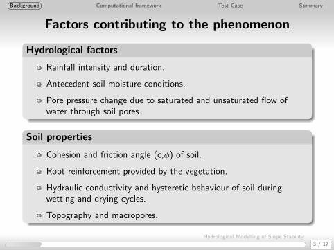
Factors contributing to the phenomenon
Hydrological factors
Rainfall intensity and duration.
Antecedent soil moisture conditions.
Pore pressure change due to saturated and unsaturated flow ofwater through soil pores.
Soil properties
Cohesion and friction angle (c,φ) of soil.
Root reinforcement provided by the vegetation.
Hydraulic conductivity and hysteretic behaviour of soil duringwetting and drying cycles.
Topography and macropores.
3 / 17
Hydrological Modelling of Slope Stability
Background Computational framework Test Case Summary
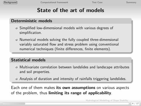
State of the art of models
Deterministic models
Simplified low-dimensional models with various degrees ofsimplification.
Numerical models solving the fully coupled three-dimensionalvariably saturated flow and stress problem using conventionalnumerical techniques (finite differences, finite elements).
Statistical models
Multivariate correlation between landslides and landscape attributesand soil properties.
Analysis of duration and intensity of rainfalls triggering landslides.
Each one of them makes its own assumptions on various aspectsof the problem, thus limiting its range of applicability.
4 / 17
Hydrological Modelling of Slope Stability
Background Computational framework Test Case Summary
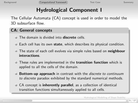
Hydrological Component I
The Cellular Automata (CA) concept is used in order to model the3D subsurface flow.
CA: General concepts
The domain is divided into discrete cells.
Each cell has its own state, which describes its physical condition.
The state of each cell evolves via simple rules based on neighbourinteractions.
These rules are implemented in the transition function which isapplied to all the cells of the domain.
Bottom-up approach in contrast with the discrete to continuumto discrete paradox exhibited by the standard numerical methods.
CA concept is inherently parallel, as a collection of identicaltransition functions simultaneously applied to all cells.
5 / 17
Hydrological Modelling of Slope Stability

Background Computational framework Test Case Summary
Hydrological Component II
(0,0,-1)
(0,0,1)
(0,-1,0) (0,1,0)
(1,0,0)
(-1,0,0)
(0,0,0)
Q0
Q1
Q2Q3
Q4
Q5
In the case of 3-D variably saturated flowthe mass balance equation plays the role ofthe transition function:∑α∈I
Kαc
(hα − hc
lαc
)Aαc+Sc = Vcσ(ψc)
∆h
∆t
σ(ψc) =
{Cc(ψc), for ψc < 0Ss , for ψc > 0
Each cell of the lattice communicates with its neighbours onlythrough its faces.
Spatial heterogeneity is tackled because every cell has its ownconstitutive hydraulic properties.
The boundary conditions can be of two types: constant head(Diriclet) or constant flux (Neumann).
6 / 17
Hydrological Modelling of Slope Stability
Background Computational framework Test Case Summary
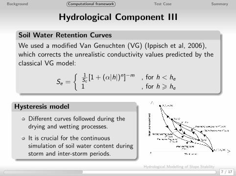
Hydrological Component III
Soil Water Retention Curves
We used a modified Van Genuchten (VG) (Ippisch et al, 2006),which corrects the unrealistic conductivity values predicted by theclassical VG model:
Se =
{ 1Sc
[1 + (α|h|)n]−m , for h < he1 , for h > he
Hysteresis model
Different curves followed during thedrying and wetting processes.
It is crucial for the continuoussimulation of soil water content duringstorm and inter-storm periods.
7 / 17
Hydrological Modelling of Slope Stability

Background Computational framework Test Case Summary
Geotechnical Component
Despite their limitations, infinite slope analysis and the factor ofsafety concept are used due to their simplicity.
Infinite Slope analysis limitations
Long, continuous slopes where the sliding surface is parallel to thesurface.
The thickness of the unstable material is small compared to theheight of the slope.
The end effects on the sliding block are neglected.
A factor of safety equation for both unsaturated and saturatedconditions is used, which uses the concept of effective stress (LuNing and Godt Jonathan, WRR, 2010).
FOS =tanφ
tanβ+
2c
γz sin2β+ Se
uα − uwγz
(tanβ + cotβ)tanφ
8 / 17
Hydrological Modelling of Slope Stability

Background Computational framework Test Case Summary
Napf catchment: Overview
Location: Kanton Bern, Switzerland.
Area: 2, 5 km2 (48 % forested).
Altitude: 900 m − 1360 m.
Triggering event: A 3-hour precipitation event at 15-16 July 2002caused many soil slips.
9 / 17
Hydrological Modelling of Slope Stability

Background Computational framework Test Case Summary
Input data
Surface topography: A 3x3 m Digital Elevation Model is used.
Slope: It is calculated from the DEM using the ArcGIS routine.
Soil Depth: An exponential model, which relates the soil depth tothe slope is used: d = 3.0 · e(− 1
40 ·slope).
Soil Parameters:
The soil map of switzerland (Bodeneignungskarte) was used for theidentification of the soil classes.Representative values from the literature are used for the soilproperties of each soil class.
Land use: The land use map of Switzerland was used, which has a100x100 m resolution.
Precipitation: We used the historical record of the Napf station,which is located 5 km at the north of the catchment.
Initial conditions: We ran the model for a 6-month period prior tothe event in order to create more realistic soil moisture conditions.
10 / 17
Hydrological Modelling of Slope Stability

Background Computational framework Test Case Summary
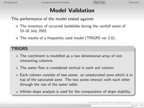
Model Validation
The performance of the model tested against:
The inventory of occurred landslides during the rainfall event of15-16 July 2002.
The results of a frequently used model (TRIGRS ver 2.0).
TRIGRS
The catchment is modelled as a two dimensional array of noninteracting columns.
The water flow is considered vertical in each soil column.
Each column consists of two zones: an unsaturated zone which is intop of the saturated zone. The two zones interact with each otherthrough the rise of the water table.
Infinite slope analysis is used for the computation of slope stability.
12 / 17
Hydrological Modelling of Slope Stability

Background Computational framework Test Case Summary
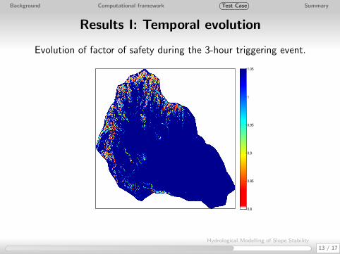
Results I: Temporal evolution
Evolution of factor of safety during the 3-hour triggering event.
0.8
0.85
0.9
0.95
1
1.05
0.8
0.85
0.9
0.95
1
1.05
0.8
0.85
0.9
0.95
1
1.05
0.8
0.85
0.9
0.95
1
1.05
13 / 17
Hydrological Modelling of Slope Stability

Background Computational framework Test Case Summary
Results I: Temporal evolution
Evolution of factor of safety during the 3-hour triggering event.
0.8
0.85
0.9
0.95
1
1.05
0.8
0.85
0.9
0.95
1
1.05
0.8
0.85
0.9
0.95
1
1.05
0.8
0.85
0.9
0.95
1
1.05
13 / 17
Hydrological Modelling of Slope Stability

Background Computational framework Test Case Summary
Results I: Temporal evolution
Evolution of factor of safety during the 3-hour triggering event.
0.8
0.85
0.9
0.95
1
1.05
0.8
0.85
0.9
0.95
1
1.05
0.8
0.85
0.9
0.95
1
1.05
0.8
0.85
0.9
0.95
1
1.05
13 / 17
Hydrological Modelling of Slope Stability
Background Computational framework Test Case Summary
Results I: Temporal evolution
Evolution of factor of safety during the 3-hour triggering event.
0.8
0.85
0.9
0.95
1
1.05
0.8
0.85
0.9
0.95
1
1.05
0.8
0.85
0.9
0.95
1
1.05
0.8
0.85
0.9
0.95
1
1.05
13 / 17
Hydrological Modelling of Slope Stability

Background Computational framework Test Case Summary
Results II: Destabilised areas
14 / 17
Hydrological Modelling of Slope Stability
Background Computational framework Test Case Summary
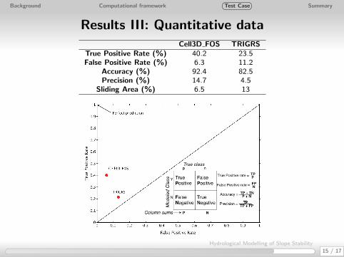
Results III: Quantitative dataCell3D FOS TRIGRS
True Positive Rate (%) 40.2 23.5False Positive Rate (%) 6.3 11.2
Accuracy (%) 92.4 82.5Precision (%) 14.7 4.5
Sliding Area (%) 6.5 13
15 / 17
Hydrological Modelling of Slope Stability

Background Computational framework Test Case Summary
Summary, conclusions and future work
1 A reduced complexity model based on Cellular Automata is used forthe simulation of rainfall-induced landslides.
2 Emphasis is given on the detailed simulation of the water flow andthe resulting pore water pressures.
3 A simple model for slope stability based on infinite slope analysis iscoupled to the hydrological component.
4 The proposed model had a relatively good performance despite thelack of detailed hydrological and soil data.
5 An elasto-plastic model will be incorporated in order to describebetter the soil behaviour due to stress and suction changes.
6 A parallel version in OpenMP and CUDA will be implemented inorder to simulate bigger catchments.
16 / 17
Hydrological Modelling of Slope Stability

Thanks for your attention!


