

IGARSS’11, Vancouver
Water Body Detection from TanDEM-X Data: concept & first evaluation of an accurate water indication mask
A. Wendleder1), M. Breunig1), K. Martin2), B. Wessel1), A. Roth1) 1) German Aerospace Center DLR | 2) Company for Remote Sensing and Environmental Research SLU IGARSS 2011 / Vancouver / 2011-07-28
Slide 2
Outline
Introduction
Definition of the TanDEM-X water indication mask
Challenges for TanDEM-X water body detection
Concept & methodology of water body detection
Test site demonstration
Evaluation of classification results
Outlook
Slide 3
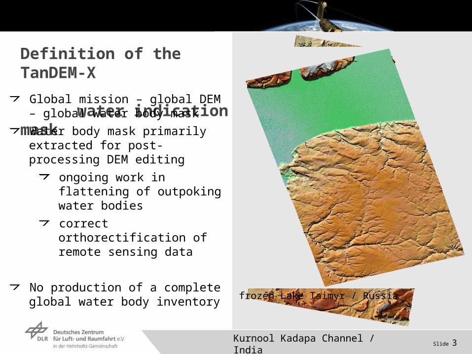
Definition of the TanDEM-X water indication maskGlobal mission – global DEM – global
water body mask
Water body mask primarily extracted for post-processing DEM editing
ongoing work in flattening of outpoking water bodies
correct orthorectification of remote sensing data
No production of a complete global water body inventory
Kurnool Kadapa Channel / India
frozen Lake Taimyr / Russia
Slide 4
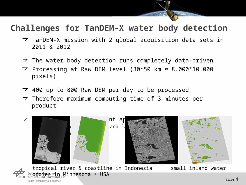
Challenges for TanDEM-X water body detection TanDEM-X mission with 2 global acquisition data sets in 2011 & 2012
The water body detection runs completely data-driven
Processing at Raw DEM level (30*50 km ≈ 8.000*10.000 pixels)
400 up to 800 Raw DEM per day to be processed
Therefore maximum computing time of 3 minutes per product
Applicable for different appearances of water bodies worldwide (coastline, inland lake, river, tropical, arctic, arid or humide climates etc.)
tropical river & coastline in Indonesia small inland water bodies in Minnesota / USA

Slide 5
Concept & Methodology (I)
Input images are amplitude & coherence image
Exclusion of desert & polar regions
SRTM WAM
MODIS/Terra Land Cover Types
Exclusion of steep terrain
SRTM DEM
Potential Water bodies
available
Dataset:AmplitudeCoherence
SRTM Water Mask
yes
RawDEM
MODIS/TerraLand Cover Types
SRTM DEM
Calculation of slope
Slide 6
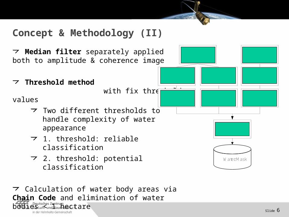
Median filter separately applied both to amplitude & coherence image
Threshold method with fix threshold values
Two different thresholds to handle complexity of water appearance
1. threshold: reliable classification
2. threshold: potential classification
Calculation of water body areas via Chain Code and elimination of water bodies < 1 hectare
Fusion of three intermediate water body layers
Concept & Methodology (II)
1. Threshold Analysis
on Amplitude
Water Mask
Fusion
Threshold Analysis
on Coherence
Medianfilter on Amplitude
Chain Code
Medianfilter on Coherence
Chain Code
2. Threshold Analysis
on Amplitude
Chain Code
Slide 7
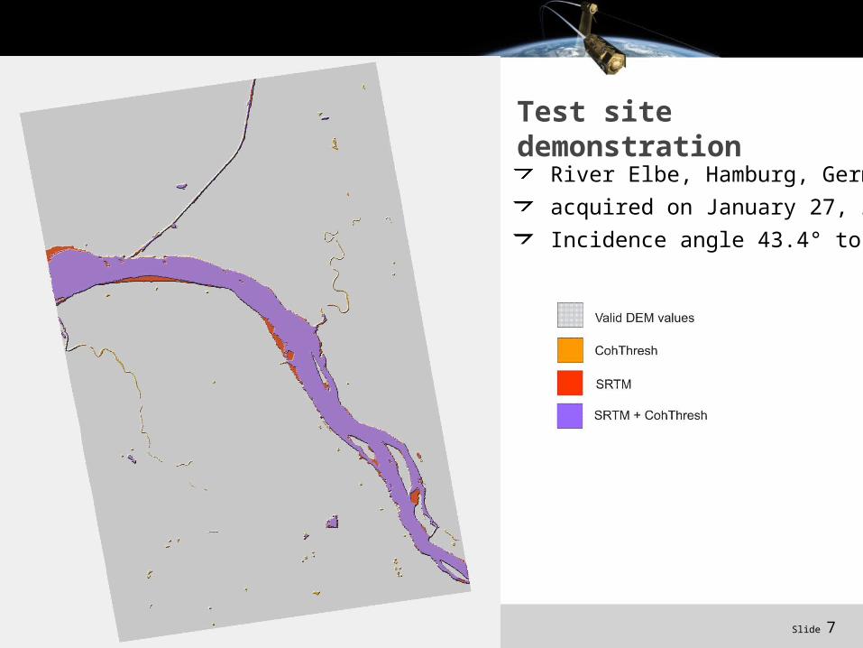
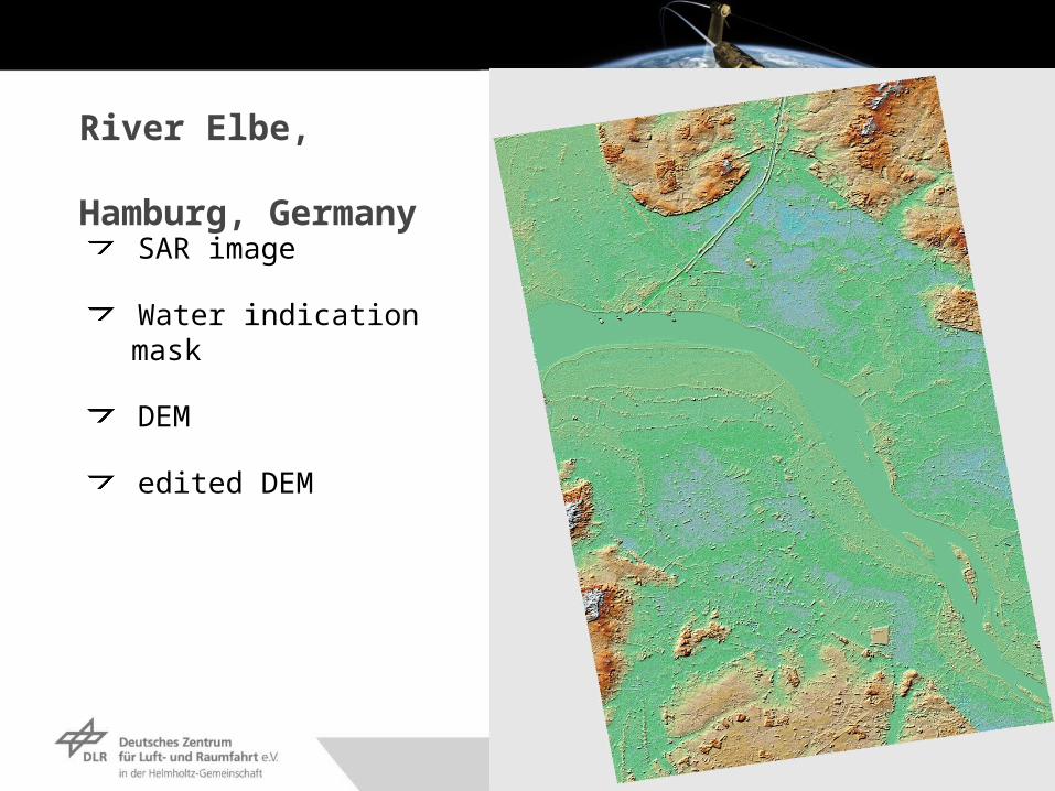
Test site demonstration
River Elbe, Hamburg, Germany
acquired on January 27, 2011
Incidence angle 43.4° to 45.7°
Slide 8
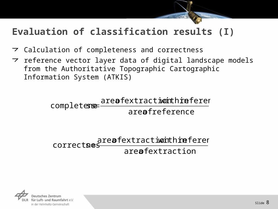
Evaluation of classification results (I)
reference of area
reference within extraction of areasscompletene
extraction of area
reference within extraction of areascorrectnes
Calculation of completeness and correctness
reference vector layer data of digital landscape models from the Authoritative Topographic Cartographic Information System (ATKIS)
Slide 9
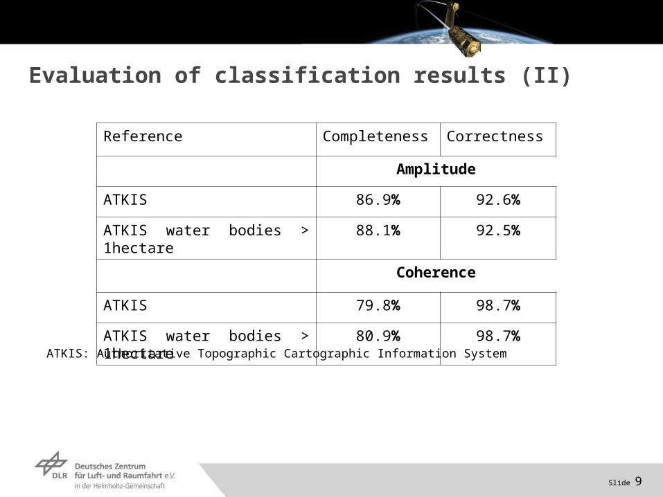
Evaluation of classification results (II)
Reference Completeness Correctness
Amplitude
ATKIS 86.9% 92.6%
ATKIS water bodies > 1hectare
88.1% 92.5%
Coherence
ATKIS 79.8% 98.7%
ATKIS water bodies > 1hectare
80.9% 98.7%
ATKIS: Authoritative Topographic Cartographic Information System
Slide 10
Evaluation of classification results (III)
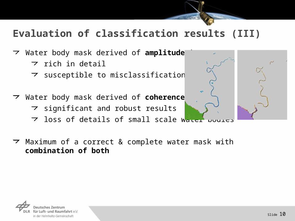
Water body mask derived of amplitude image
rich in detail
susceptible to misclassifications
Water body mask derived of coherence image
significant and robust results
loss of details of small scale water bodies
Maximum of a correct & complete water mask with combination of both
Slide 11
Outlook
Accuracy assessment of the water body detection for different climate zones
robustness & global transferability of our approach
Mosaicking of different water bodies (neighboring acquisitions resp. first & second year acquisition) to an intermediate & final TanDEM-X water body mask product
TanDEM-X DEM editing using TanDEM-X water body mask
flattening of outpoking water bodies
Slide 12
River Elbe, Hamburg, Germany
SAR image
Water indication mask
DEM
edited DEM
Slide 14
Thank you for your attention!
Anna Wendleder | Markus Breunig
German Remote Sensing Data CenterTeam SAR Topography
Phone: +49 8153 28 3439Email: [email protected] | [email protected]


