

Implementation and Evaluation of a Mesoscale Short-Range
Ensemble Forecasting System Over the Pacific Northwest
Eric P. Grimit and Clifford F. Mass
Department of Atmospheric Sciences, University of Washington
Seattle, Washington

Mesoscale Ensemble Background
Mesoscale, short-range ensemble forecasting (SREF) has been focused primarily over the eastern half of the U.S. where convection plays an important role in atmospheric behavior.(Mullen and Baumhefner 1989, 1994; Stensrud and Fritsch 1994a,b; Du et al. 1997; Hamill and Colucci 1997, 1998; Stensrud et al. 2000; Hou et al. 2001)
Error growth due to model deficiencies may be as important as error growth due to imperfect initial conditions (ICs).
Vary model physics parameterizations or use multiple models.
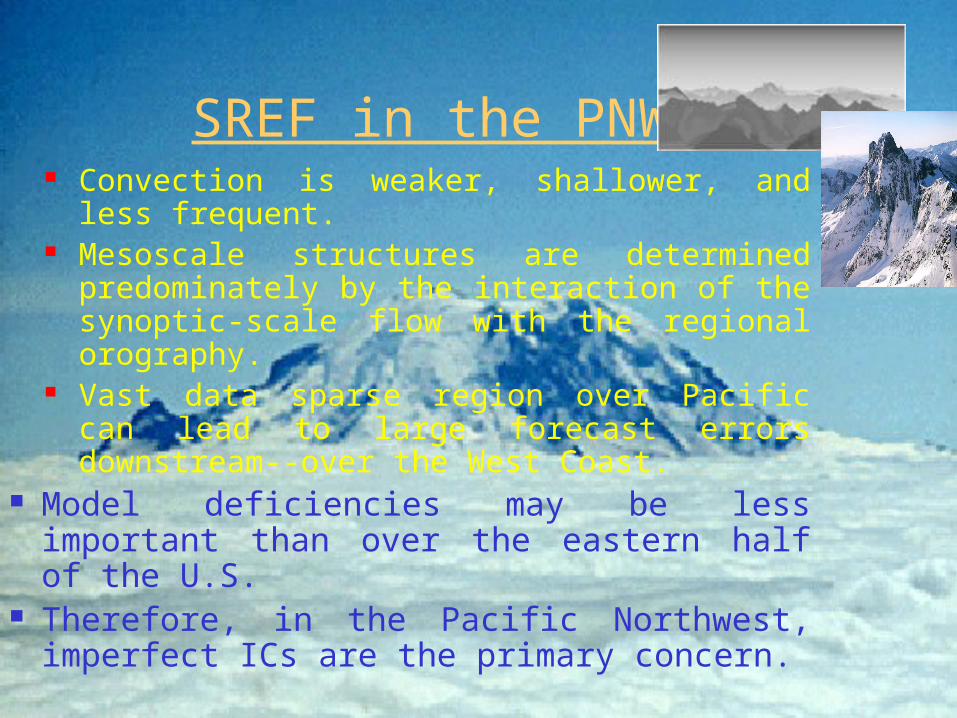
SREF in the PNW Convection is weaker, shallower, and less
frequent. Mesoscale structures are determined
predominately by the interaction of the synoptic-scale flow with the regional orography.
Vast data sparse region over Pacific can lead to large forecast errors downstream--over the West Coast.
Model deficiencies may be less important than over the eastern half of the U.S.
Therefore, in the Pacific Northwest, imperfect ICs are the primary concern.

Our Approach
Single modeling system (MM5) 2-day (48-hr) forecasts at
36-km & 12-km grid spacingin real-time.
IC Selection: Multi-analysis (MA)[From different operational centers (NCEP, CMC, FNMOC)]
David Richardson (QJRMS 2001): An ensemble using this MA strategy can realize up to 80% of the improvements gained by running a multi-model, multi-analysis (MMMA) ensemble.
Lateral Boundary Conditions (LBCs): Drawn from the corresponding, synoptic-scale forecasts
36-KM DOM
12-KM DOM

x = 6.4 ºC s = 2.2 ºC
Initial Conditions and Lateral Boundary Conditions:
Mesoscale Model:
PHASE I: JAN - JUN 2000
Ensemble Forecasts:
Forecast Probability:
Multi-Analysis Approach
Temperature at KSEA (°C)
NGMNGM
Cumulus: Kain-FritschPBL: MRFMicrophysics: Simple Ice
T = 0
T = 48 hrs.
AVNAVN CMC-GEMCMC-GEM ETAETA NOGAPSNOGAPS
MM5
Initial Condition UncertaintyInitial Condition Uncertainty
4 6 6 106
P( t > 6.4 ºC) = 50% ???
NGMNGMETAETA
6
15 March 2000

Limitations ICs are not equally likely or equally skillful. Only a finite number of analyses available. MA approach relies on products that may
evolve with time. Examples:
15 March 2000 changes to NGM (RDAS -> EDAS) Fall 2000 changes to ETA (32-km -> 22-km, etc.)
Complete independence between the IC “perturbations” is not guaranteed (and not likely).

Initial Research Questions
1) Is a MA ensemble approach using ICs and LBCs from different operational forecast systems viable?
2) Does the ensemble mean possess greater skill than its component forecasts in terms of standard measures of forecast skill?
3) How does ensemble mean forecast skill compare with higher-resolution deterministic forecasts?
4) Can the mesoscale ensemble predict forecast skill? Specifically, is there a significant correlation between ensemble spread and ensemble mean skill and/or the skill of the component forecasts?

Verification Method
Model forecasts are interpolated to the observation sites over 12-km domain only.
Focus is on near-surface weather variables. Mesoscale verification variable of choice:
10-m Wind Direction More extensive coverage & greater # of reporting
sites. Greatly influenced by regional orography and diurnal
circulations. MM5’s systematic biases in the other near-surface
variables can dominate errors originating from ICs. Fcst error: Mean Abs. Error (MAE) Fcst spread: Dom. Av. Std. Dev. ()


Missing rates WAY too large!
2
M+1>>

Conclusions
Ensemble mean forecasts verify better than the component forecasts over a large number of cases.
On a case-by-case basis, ensemble mean forecasts verify as the best forecast with about the same frequency as any member forecast.
The 12-km ensemble mean forecasts perform as well as the 4-km deterministic MM5 forecasts.
Ensemble averaging tends to help more at higher-resolution.
Ensemble mean forecasts retain many important mesoscale structures evident in the component forecasts.

Conclusions (cont.)
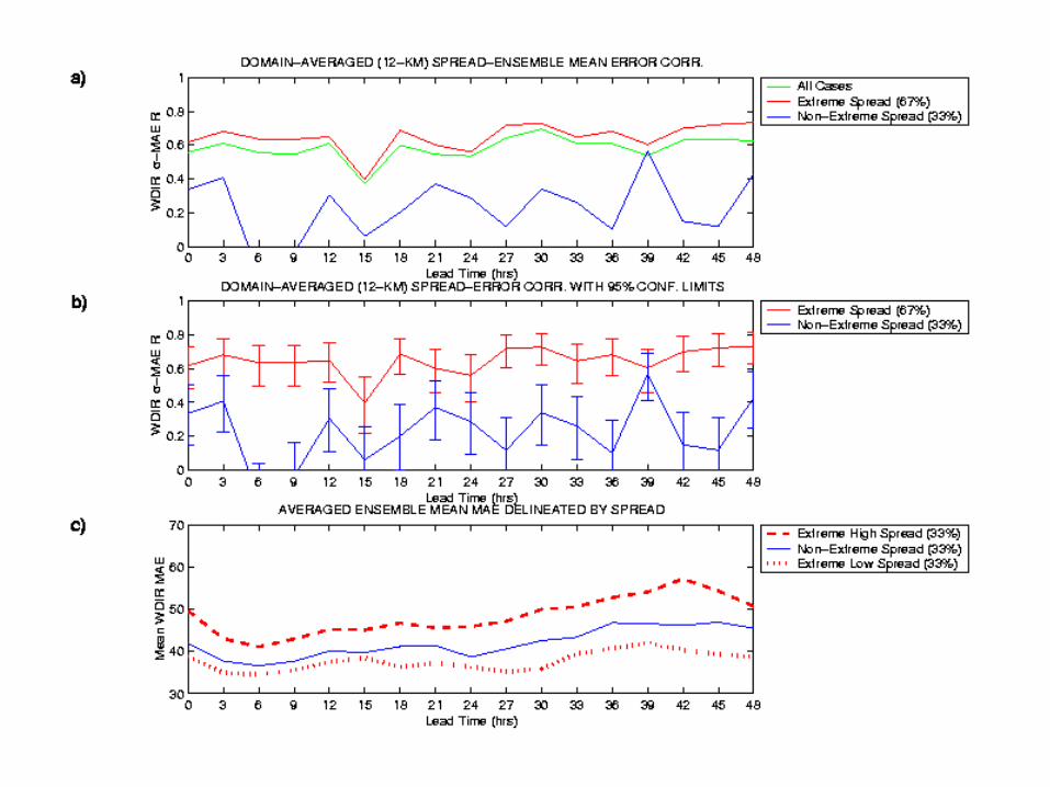
The UW MM5 ensemble confirms that it can be possible to predict mesoscale forecast skill, at least for near-surface wind direction.
Spread and error are not well correlated for cases with intermediate spread.
Low (high) spread events are essentially more (less) predictable, since high spread/error correlations also extend to the component forecasts.
Even though it may not be possible to adequately define the atmospheric PDF, valuable information about forecast reliability can be gleaned from the ensemble spread.
ICs and LBCs:
Mesoscale Model:
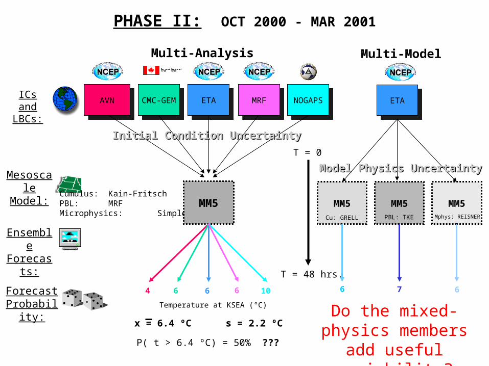
PHASE II: OCT 2000 - MAR 2001
Ensemble Forecasts:
Forecast Probability:
Multi-Analysis
x = 6.4 ºC s = 2.2 ºC
Temperature at KSEA (°C)
MRFMRF
Cumulus: Kain-FritschPBL: MRFMicrophysics: Simple Ice
T = 0
T = 48 hrs.
AVNAVN CMC-GEMCMC-GEM ETAETA NOGAPSNOGAPS
MM5
Initial Condition UncertaintyInitial Condition Uncertainty
4 6 6 106
P( t > 6.4 ºC) = 50% ???
Multi-Model
MM5 MM5 MM5
ETAETA
Model Physics UncertaintyModel Physics Uncertainty
6 7 6
Cu: GRELL Mphys: REISNERPBL: TKE
Do the mixed-physics members add useful
variability?

IC ENSM TOT ENSM
Missing rates still WAY too large!
Verification Rank Histograms
Missing Rate Difference (TOT ENSM – IC ENSM)
Asymptotes to 2
MIC+1
2
MTOT+1-
Mixed-physics members provide
most improvement for RH & TEMP.
= 11.1%
2
M+1>>
WDIR

Reliability Diagrams
ROC Curves & ROC Area
Brier Skill Scores (BSS) & Limits of
Skill

Future Work
Expand ensemble system with more operational analyses.
Investigate synoptic patterns associated with extreme high & low spread.
Investigate the spread/error relationship for other near-surface parameters, if possible.
Use a temporal ensemble (lagged forecast) approach to investigate temporal spread/error correlations.

Acknowledgements Brad Colman Sc.D. (NOAA-NWS
Seattle) F. Anthony Eckel (USAF & UW) Dr. Jun Du (NCEP)
Website
Publication
http://www.atmos.washington.edu/~epgrimit/ensemble.cgi
Grimit, E. P., and C. F. Mass, 2001: Initial results of a mesoscale short-range ensemble forecasting system over the Pacific Northwest. Wea. Forecasting, accepted.
[available in pdf format on website]


