

Improved Atmospheric Correction Techniques for MASTER and HyspIRI
Thermal Infrared (TIR) Data
Glynn Hulley, Topher Hughes, Simon Hook
Jet Propulsion Laboratory, California Institute of Technology, Pasadena, CA
(c) 2012 California Institute of Technology. Government sponsorship acknowledged.
2012 HyspIRI Science Workshop, NASA Decadal Survey Mission ,16 - 18 October 2012, Washington, DC
National Aeronautics and Space Administration

Outline
� Relevance to HyspIRI � MASTER online ordering tool � Atmospheric correction � Water Vapor Scaling (WVS) method � Examples
2
� MASTER TIR online ordering tool: � Support for HyspIRI prep. airborne activities research (FY13-15) � Prototype for distribution of HyTES-TIR data
� MASTER improved atmospheric correction
� TES + Water Vapor Scaling (WVS) method � Closer simulation of HyspIRI-TIR L2 algorithms (e.g. ATBDs at http://hyspiri.jpl.nasa.gov/documents)
Relevance to HyspIRI
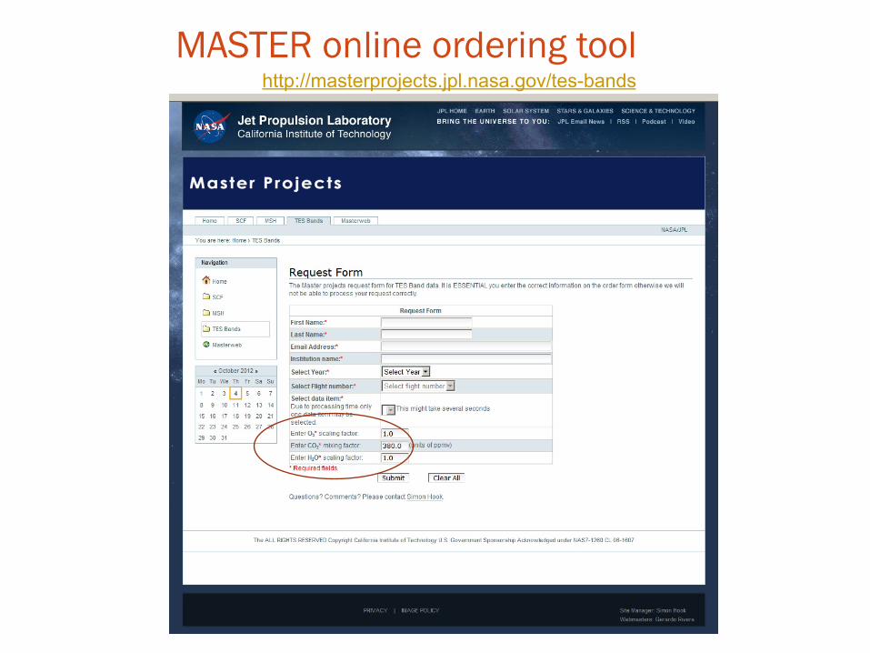
MASTER online ordering tool http://masterprojects.jpl.nasa.gov/tes-bands

MASTER L1-B Radiance at Sensor
1. NCEP (GDAS) atmospheric profiles 6 hourly, 1° resolution 2. ASTER Digital Elevation Model
Atmospheric Correction MODTRAN 5.2
Temperature/Emissivity Separation (TES)
Algorithm
τ -‐ Transmissivity L↑ -‐ Path radiance L↓ -‐ Sky irradiance
LST and spectral emissivity
• MASTER Land Surface Temperature/Emissivity Retrieval Scheme • Prototype algorithm for HyspIRI
Surface Radiance
START
Water Vapor Scaling (WVS)
1. WVS coefficients 2. NCEP TCW estimate 3. MASTER NDVI 4. Water mask
NEW

Band-dependent TES Calibration curves
Bands 43, 44, 47, 48 Bands 43, 44, 49
TES algorithm can be run for a combination of MASTER TIR bands: • Minimum of 3 bands required • At least one band between 11-12 µm (48 or 49) • At least one band between 8 - 9.5 µm (43 or 44)

∫+⋅−+⋅⋅=↓
⋅ iiiiiSiiii dPTBLeTBeL τθτθτθ ))(()1()()()()(
Surface Emission
Surface Reflection
Skin Temperature & Surface Emissivity
Thermal Infrared Radiative Transfer
Surface Radiance
Atmospheric Emission
At-sensor Radiance
↓iL
)(θ↑iL
Atmospheric Parameters (Greatest source of Uncertainty)

),..,1,0(2,,,,
1,,,
nkWrWqp
TT
kikikiki
n
kkkioiig
=++=
+= ∑=
α
αα Total column water estimate
⎟⎟⎠
⎞⎜⎜⎝
⎛
⎥⎥⎥
⎦
⎤
⎢⎢⎢
⎣
⎡
⎟⎟
⎠
⎞
⎜⎜
⎝
⎛
−−
−−⋅
=
−
↑
↑
)()(ln
))(1/()())(1/()()(
)()(ln
1
2
11
11,
1
2
21
2
1
γτγτ
γτγ
γτγ
γτ
γτ
γ
γγ
γ
γ
i
i
iii
iiigi
i
i
a
iaia
ia
ia
i
LLLTB
Tonooka, H., (2005), Accurate Atmospheric Correction of ASTER Thermal Infrared Imagery Using the WVS Method, IEEE Trans. Geos. Remote Sens., 43 (12)
EMC/WVD equation
Observed brightness temperature Surface brightness temperature
Scaling factor
Water Vapor Scaling (WVS) method

)(1)(1)()(
)()()(
11
)/(2
)/(1
211212
γτγτ
γγ
γτγτγτ γγγγγγγγ
i
iii
iii
LL
iaiaiaiaiaiaiaia
−
−⋅=
⋅=
↑↑
−−−−
2)()()( γγγ ↑↑↓ ⋅+⋅+= iiiiii LcLbaL
is used to modify and improve atmospheric correction terms:
Transmittance:
Path Radiance:
Sky Radiance:
γ
Water Vapor Scaling (WVS)

WVS Scaling Factor, γ

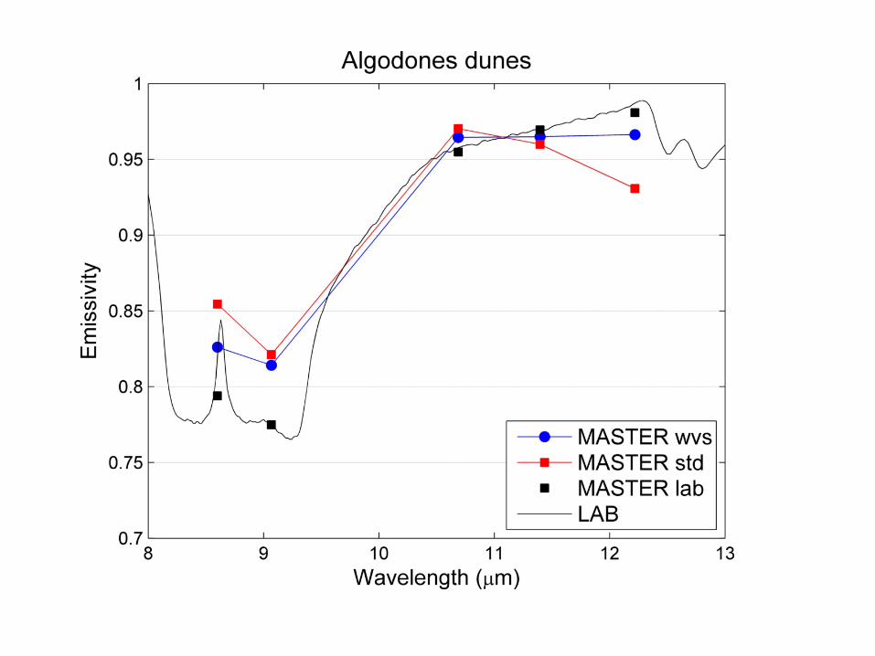
ASTER & MODIS Emissivity spectra for the Salton Sea showing effects of water vapor scaling (wvs)
MODIS STD
MODIS WVS
ASTER STD
ASTER WVS

MASTERL1B_0395000_03_20030805_1745_1753_V02
MASTER WVS test

MASTER band 49 emissivity (12.2 µm) --TES Standard
MASTER band 49 emissivity (12.2 µm) --TES WVS
Normal Range
Normal Range
Cloud

MASTER broadband emissivity (8-12 µm) -- TES Standard
MASTER broadband emissivity (8-12 µm) -- TES WVS

Broadband emissivity difference (WVS – Standard)
Change in Net Longwave Radiation (Wm-2)**
**Zhou et al. (2003)

MASTER Land Surface Temperature -- TES Standard
MASTER Land Surface Temperature -- TES WVS

Summary � Online ordering tool developed for
MASTER TIR data � Improved atmospheric correction method
(WVS) implemented for MASTER TIR data
� Both will benefit future HyTES/HyspIRI TIR data

National Aeronautics and Space Administration Jet Propulsion Laboratory California Institute of Technology Pasadena, California www.nasa.gov JPL 400-1278 7/06

MASTER online ordering tool
� Automated MASTER online ordering and distribution tool implemented for L2 temperature/emissivity products
� ASTER-TES algorithm and atmospheric correction
(MODTRAN5.2) implemented with Python code � Prototype tool for distribution of future HyTES temperature/
emissivity products � Future enhancements include improvement of atmospheric
correction using Water Vapor Scaling (WVS) method

)()()()1()(, θτ
θθ
i
iiiiSiiisurf
LLLeTBeL↑
↓ −=⋅−+⋅=
Ø Atmospheric Parameters: , ,
Estimated using radiative transfer code such as MODTRAN with
Atmospheric profiles and elevation data
NCEP data (6-hourly, 1º spatial resolution, 26 levels)
)(θτ i )(θ↑iL )(θ↓
iL
Surface Radiance: Observed Radiance
Atmospheric Correction


