
INTEGRATED GEOSPATIAL SOFTWARE PLATFORM FOR URBAN GROUNDWATER
June 14, 2012Bologna, Italy
POSCCE – ID660Sedimentary media modeling platform for groundwater management in urban areas
D Gaitanaru, C R Gogu , A Priceputu, L Anghel, M A Boukhemacha, I Bica, A Ionita

0
1000000
2000000
3000000
4000000
5000000
6000000
7000000
8000000
9000000
10000000
1950 1970 1990 2010 2030 2050
Pop
ula
tion
71%
29%51%
49% 30%
70%
1950 2010 2050URBAN RURAL
Urban population growth (for2050 is foreseen that the urbanpopulation will be around 70% oftotal population - UN,DESA, 2011)implies a grater consumption ofresources (natural or processed)like: electricity, gas and oil products,food and water. As consequence, theurban water management becomean important aspect of urbansustainable development planning .
INTRODUCTION
POSCCE – ID660Sedimentary media modeling platform for groundwater management in urban areas

Managing Water for the City of the Futurehttp://www.switchurbanwater.eu
POSCCE – ID660Sedimentary media modeling platform for groundwater management in urban areas

INTRODUCTION
Geo-dataStudy Mark-UpInternet
HYGES (Gogu et al., 2001)
ArcHydro(Maidment, 2002
Hydrogeological M. (Strassberg, 2006)
WaterStrategyMan(ProGEA 2004)
GABARDINE (Wojdaet al, 2006)
Water Framework Directive(2000) INSPIRE – (2007)
GML (Cox et al., 2002; Lake, 2005)
XMML (Cox, 2001)
GeoSciML (Senand Duffy, 2005)
GWMLWaterML
1
2
3
1 Databases
2 Mark Up Languages
3 Directive
POSCCE – ID660Sedimentary media modeling platform for groundwater management in urban areas

PLATFORM ARCHITECTURE
EXPERT (specialists in geology, hydrogeology, water management, geotechnics).
DECISIONAL(local stakeholders, local authority, etc. ).
PUBLIC
The software platform architecture isbased on three major components.
POSCCE – ID660Sedimentary media modeling platform for groundwater management in urban areas

SERVER APPLICATIONDatabase
International standards for Geo-Spatial data transfer.International standards for Geo-Spatial data transfer.
Object – Orientated approach.Object – Orientated approach.
Open Geospatial Consortium (OGC)Open Geospatial Consortium (OGC)
POSCCE – ID660Sedimentary media modeling platform for groundwater management in urban areas

WMS WFS WCS
SERVER APPLICATION
rolu
ri/ro
luri/
rolu
ri
rolu
ri/ro
luri/
rolu
ri
UTI
LIZA
TOR
I
GLA
SSFI
SH (
JAV
A E
E SE
RV
ER)
GEO
SER
VER
The geospatial server application allows the communication between theclient side application (geoportal), the geospatial database and the desktopplatform component.
POSCCE – ID660Sedimentary media modeling platform for groundwater management in urban areas
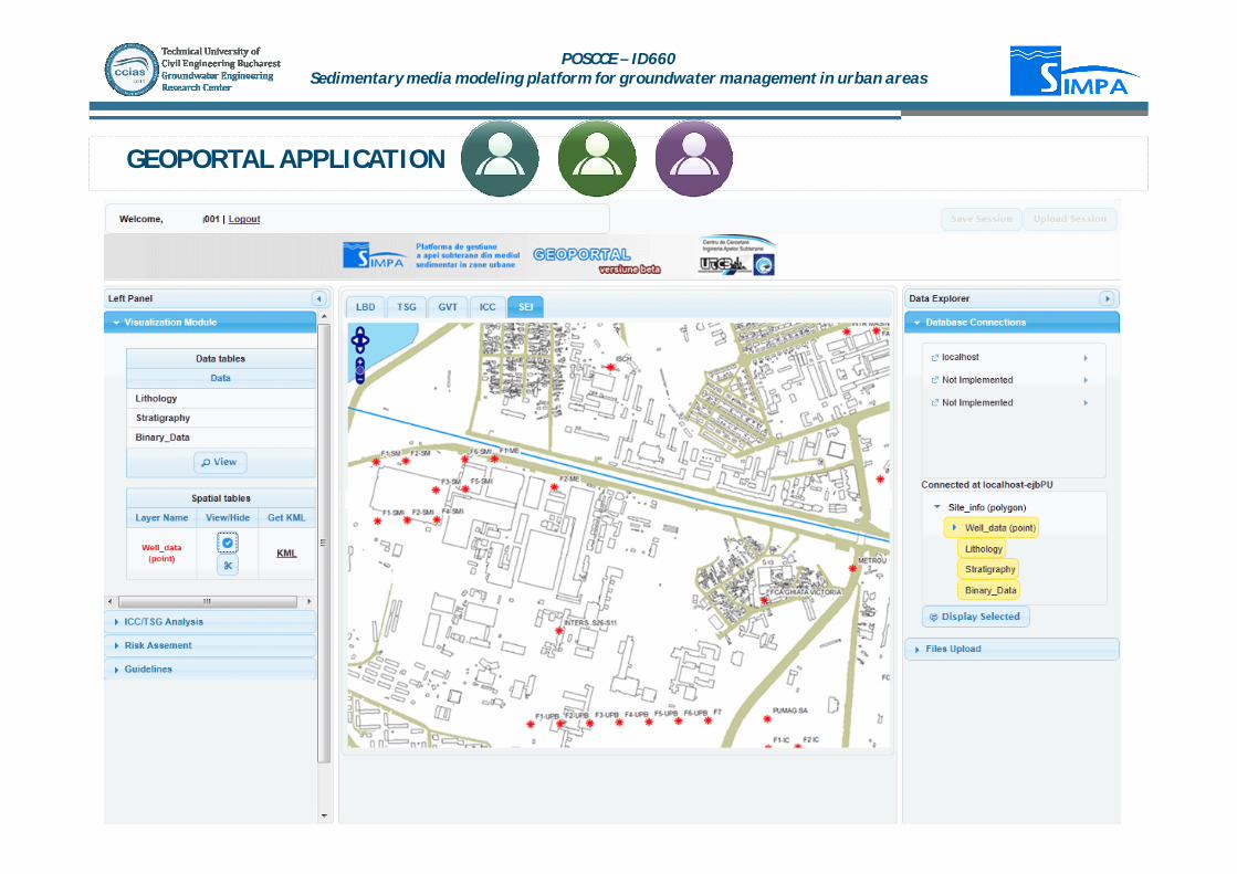
GEOPORTAL APPLICATION
POSCCE – ID660Sedimentary media modeling platform for groundwater management in urban areas
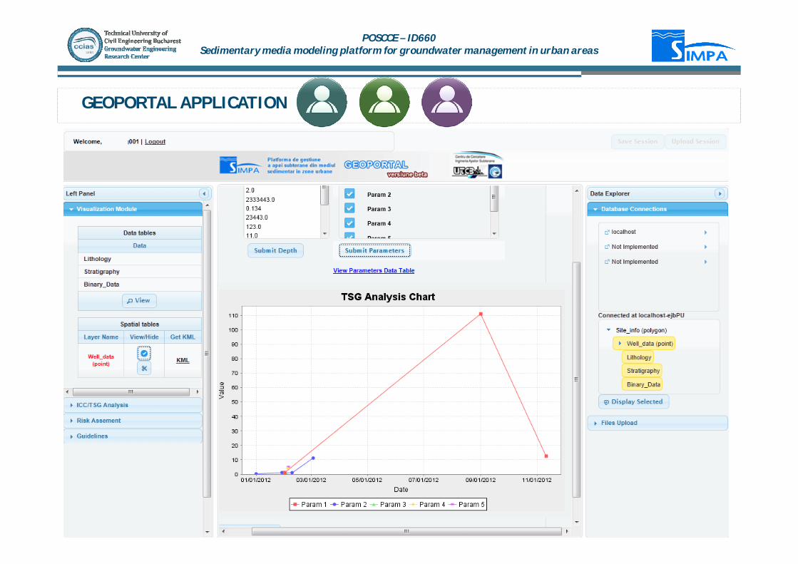
GEOPORTAL APPLICATION
POSCCE – ID660Sedimentary media modeling platform for groundwater management in urban areas

DESKTOP PLATFORM
Data Management
Modeling and analysis.
The desktop platform is designed to be used by specialists and researchers.
The platform is developed under a GIS framework (ArcGIS).
POSCCE – ID660Sedimentary media modeling platform for groundwater management in urban areas

DESKTOP PLATFORMGeological analysis
The geological toolbox allows the specialist to manage litology, geophysical, and petrologicaldata. Analysis such as: borehole diagram, geological cross-sections, defining hydrogeologicalunits, can be easily made and exported in 2D and in 3D environment.
POSCCE – ID660Sedimentary media modeling platform for groundwater management in urban areas

PLATFORMA DESKTOPHydro Chemical analysis
The hydrochemical toolbox performs a series of hydrochemical analysis for groundwater quality data:hydrochemical parameter statistics (univariable, bivariable,analysis), geostatistics (using GSLiblibrary), general chemical diagrams, charts and maps (Stiff Map, Wilcox diagram, Ionic Balance, PiperDiagram) and a series of parameter orientated maps.
POSCCE – ID660Sedimentary media modeling platform for groundwater management in urban areas

DESKTOP PLATFORMHydrogeology
The third toolbox is an interface between the platform and other third parties software (such as GMS -Groundwater Modelling System). Data from the geospatial database are exported to the modellingsoftware and the outputs of model can be imported back to the platform. Beside the communicationcapabilities, the toolbox can generate an optimal cell-size modelling grid on the basis of thehydrogeological data spatial distribution.
POSCCE – ID660Sedimentary media modeling platform for groundwater management in urban areas

CONCLUSIONS
STANDARD TRANSFER LANGUAGES.
MULTI CRITERIA QUERIES.
HYDROGEOLOGICAL DATABASE
NEW MARK-UP LANGUAGE.
POSCCE – ID660Sedimentary media modeling platform for groundwater management in urban areas
Thank you !
POSCCE – ID660Sedimentary media modeling platform for groundwater management in urban areas


