
Jordan Creek Greenway Feasibility Study
4–1
JORDAN CREEK GREENWAY FEASIBILITY
The current conditions and issues discussed in the previous two chapters provide the basis to developa concept for the Jordan Creek Greenway. The concept presented in the Jordan Creek GreenwayFeasibility Study is two-fold:
• To promote land preservation along the entire creek from the Appalachian Trail atop BlueMountain to Jordan Meadows Park in the City of Allentown
• To develop a trail linkage from Jordan Meadows Park to the Appalachian Trail that willconsist of:
— An off-road trail between Jordan Meadows Park and the Trexler Nature Preserve; Theproposed off-road trail will connect to the trail system being developed in accord withthe nature preserve master plan.
— A system of signed, low-volume roads for shared use by autos and bicycles between theTrexler Nature Preserve and the Appalachian Trail.
The remainder of the concept plan presents the recommended alignment of the trail, describing eachof the six sections of the corridor (Map 4.1 and 4.1A) in terms of key features within the section andpotential priority for development. The plan information includes cost estimates for the downs bysegment. The maps in the concept plan also divide the downstream, off-road portion of the proposedtrail— from the Trexler Nature Preserve to Jordan Meadows Park—into 61 segments for costestimation. The entire off-road trail is approximately 68,800 feet, or 13.0 miles, in length (Table 4.1)
The estimated cost for constructing the trail is approximately $4.5 million plus any necessary landacquisition. Cost estimates are also provided by segment and section.
Table 4.1Proposed Off-Road Trail Length
Name Segments Length (feet)
Jordan Meadows Park 1–2 1,000
N. 4 St. to Jordan Meadows Park 3–7 4,700th
Jordan Park (City of Allentown) 8–13 6,500
Jordan Creek Parkway (Lehigh
County)
14–26 11,000
Private Land – 1 27–34 12,600
Iron Bridge Road 35–38A 4,000
Covered Bridge Park 39–48 8,200
Private Land – 2 49–51 9,800
West End 52–61 11,000
Total — 68,800
Source: URDC
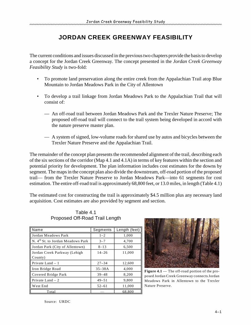
Figure 4.1 — The off-road portion of the pro-
posed Jordan Creek Greenway connects Jordan
Meadows Park in Allentown to the Trexler
Nature Preserve.
Jordan Creek Greenway Feasibility Study
4–2
The off-road trail concept is presented by section. Each section description includes notes on thesegments and a table of estimated costs.
SECTION 1: JORDAN MEADOWS PARK TO JORDAN CREEK PARKWAY
Section 1 of the proposed Jordan Creek Greenway connects Jordan Meadows Park to Jordan CreekParkway (Map 4.2) and includes segments 1 through 26. Each segment is briefly below.
Segment 1 — uses the existing parking lot at Jordan Meadows Park for a trailhead, then continueson an existing trail in the park
Segment 2 — new, gravel trail along the football field in an area of the park that is not currentlydeveloped
The total cost of the Jordan Meadows Park improvements is estimated to be $15,100 (Table 4.2) andinvolves construction of 400 feet of new trail. The land is already owned by the City of Allentown.
Table 4.2Cost Estimate, Jordan Meadows Park
Segment Length
(ft.)
Description Amount Unit
Cost
Unit Total
Cost
Owner
1 600 Existing trail — — — $0 Allentown
2400 Gravel trail, open field along football field 400 $31.50 lf $12,600
Allentown— Kiosk 1 $2,500.00 ea $2,500
Totals 1,000 — — — — $15,100 —
Source: URDC
Segment 3 — new, gravel trail along east side of the creek;area is wooded, narrow, and in a floodplainbetween American Parkway and JordanCreek
Segment 4 — crossing of Sumner Avenue near AmericanParkway; cost estimate represents anallowance for safety improvements, such asa painted pedestrian crosswalk or flashinglights
Segment 5 — new, gravel trail along the side of the ceme-tery behind St. John the Baptist SlovakChurch
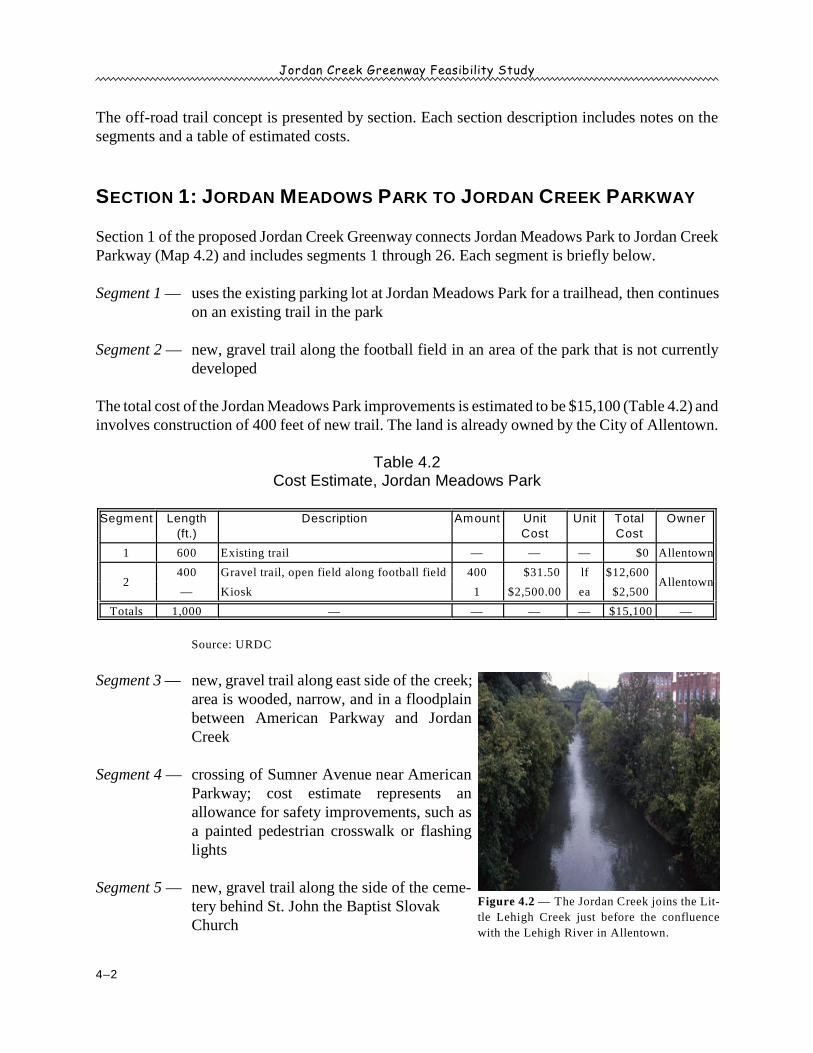
Figure 4.2 — The Jordan Creek joins the Lit-
tle Lehigh Creek just before the confluence
with the Lehigh River in Allentown.
Jordan Creek Greenway Feasibility Study
4–3
Segment 6 — new, gravel trail over private land; must contend with steep slopes
Segment 7 — new, gravel trail in floodplain on private land; owner is reportedly willing to considerthe greenway/trail concept; under 4 Street bridgeth
The total cost of improvements in the portion from North 4 Street to Jordan Meadows Parkth
(segments 3–7) is estimated to be $195,300 (Table 4.3) and involves construction of 4,700 feet ofnew trail. The land is privately owned.
Note: The Jordan Creek Greenway/Trail connection between Jordan Meadows Park in the Cityof Allentown and other existing or proposed trails—including but not limited to the AuburnCross Trails Park, the Delaware and Lehigh Corridor Trail, the Little Lehigh CreekParkway Trail, the Lower Macungie Township trail system, and the Ironton Rail Trail—isnot part of the Jordan Creek Greenway Feasibility Study but will be investigated through thecity’s comprehensive trail network study currently underway.
Table 4.3Cost Estimate, North 4 Street to Jordan Meadows Parkth
Segment Length
(ft.)
Description Amount Unit
Cost
Unit Total
Cost
Owner
31,400 Gravel trail, flood plain, wooded 1,400 $31.50 lf $44,100
Private— Clear & grub 1,400 $20.00 — $28,000
4 100 Road crossing, Sumner Ave 1 $7,600.00 ea $7,600 Allentown
5 400 Gravel trail, cemetery 400 $31.50 lf $12,600 Church
6
500 Gravel trail, steep slope 500 $31.50 lf $15,750
— Steep slope 20 $20.00 lf $400 Private
— Clear & grub 20 $20.00 lf $400
7
2,300 Gravel trail, old RR bed & flood plain 2,300 $31.50 lf $72,450
— Mow & clear Vegetation 2,300 $5.00 lf $11,500 Private
— Kiosk 1 $2,500.00 ea $2,500
Totals 4,700 — — — — $195,300 —
Source: URDC
Segment 8 — new, gravel trail on north side of Jordan Creek to causeway across creek
Segment 9 — existing causeway across creek
Segment 10 — existing trail within Jordan Park
Segment 11 — use east side of N. 7 St. to the light at Jordan Parkway; cross 7 St. at Jordan Park-th th
way; use west side of N. 7 St. back to Jordan Creek; The cost estimate includes anth
allowance for safety improvements to the 7 St. crossing at Jordan Parkway.th
Jordan Creek Greenway Feasibility Study
4–4
Segment12 — new, gravel trail north, passing under U. S. 22; area is partially wooded and part lawn
Segment 13 — new, gravel trail behind Whitehall Estates and through the eastern portion of JordanCreek Parkway
The total cost of improvements in the portion of the greenway through the part of Jordan Park thatis owned by the City of Allentown (segments 8 through 13) is approximately $260,700 (Table 4.4).The portion includes approximately 6,500 feet (1¼ miles) of new trail.
Table 4.4Cost Estimate, Jordan Park (City of Allentown)
Segment Length
(ft.)
Description Amount Unit
Cost
Unit Total
Cost
Owner
8 1,000 Gravel trail, open park 1,000 $31.50 lf $31,500 Allentown
9 100 Existing causeway — — — $0 Allentown
10200 Existing trail — — — $0
Allentown— Kiosk 1 $2,500.00 ea $2,500
111,000 Sidewalk, 7th St — — — $0
Allentown— Road crossing, 7th St 1 $7,600.00 ea $7,600
12
1,800 Gravel trail, wooded 1,800 $31.50 lf $56,700 Whitehall
Township— Clear & grub 1,800 $20.00 lf $36,000
— Kiosk 1 $2,500.00 ea $2,500
131,200 Gravel trail 1,200 $31.50 lf $37,800 Whitehall
Township— Clear & grub 1,500 $20.00 lf $30,000
Totals 5,300 — — — — $204,600 —
Source: URDC
Segment 14 — Install a pedestrian bridge across Jordan Creek near existing, paved parking area.
Segment 15 — crossing at Mickley Road; As with other road crossings, the cost estimate includesan allowance safety improvements.
Segment 16 — uses the existing sidewalk on the west side of Mickley Road
Segment 17 — uses an old, existing road owned by Lehigh County; A trailhead should be placed offof Mickley Road.
Segments 18–21 — use existing trails and bridges in Jordan Park, which are all in good condition
Segment 22 — uses an existing sewer easement
Jordan Creek Greenway Feasibility Study
4–5
Segment 23 — uses an existing bridge; The bridge is narrow (four feet) and may have to bewidened/replaced to provide at least eight feet of width.
Segment 24 — new, gravel path through the wooded area along the developed portions of the park
Segment 25 — continuation of new, gravel path to trailhead at existing parking lot
Segment 26 — crossing of Mauch Chunk Road; cost estimate includes allowance for safetyimprovements
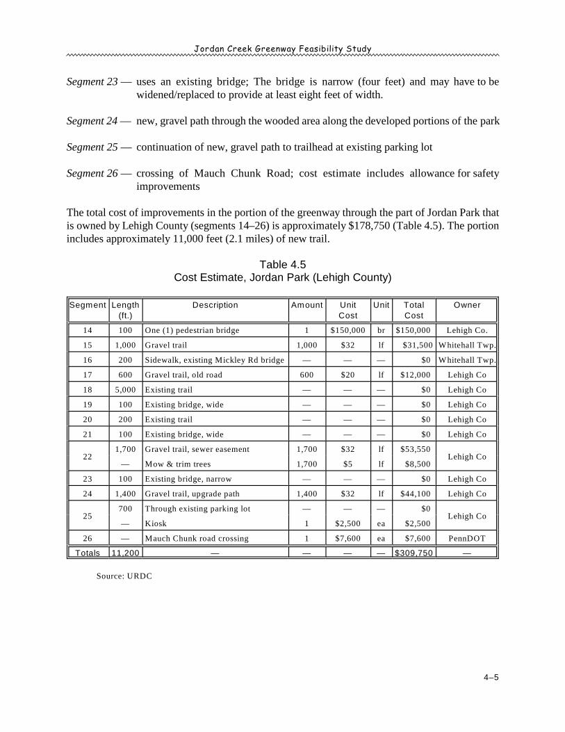
The total cost of improvements in the portion of the greenway through the part of Jordan Park thatis owned by Lehigh County (segments 14–26) is approximately $178,750 (Table 4.5). The portionincludes approximately 11,000 feet (2.1 miles) of new trail.
Table 4.5Cost Estimate, Jordan Park (Lehigh County)
Segment Length
(ft.)
Description Amount Unit
Cost
Unit Total
Cost
Owner
14 100 One (1) pedestrian bridge 1 $150,000 br $150,000 Lehigh Co.
15 1,000 Gravel trail 1,000 $32 lf $31,500 Whitehall Twp.
16 200 Sidewalk, existing Mickley Rd bridge — — — $0 Whitehall Twp.
17 600 Gravel trail, old road 600 $20 lf $12,000 Lehigh Co
18 5,000 Existing trail — — — $0 Lehigh Co
19 100 Existing bridge, wide — — — $0 Lehigh Co
20 200 Existing trail — — — $0 Lehigh Co
21 100 Existing bridge, wide — — — $0 Lehigh Co
221,700 Gravel trail, sewer easement 1,700 $32 lf $53,550
Lehigh Co— Mow & trim trees 1,700 $5 lf $8,500
23 100 Existing bridge, narrow — — — $0 Lehigh Co
24 1,400 Gravel trail, upgrade path 1,400 $32 lf $44,100 Lehigh Co
25700 Through existing parking lot — — — $0
Lehigh Co— Kiosk 1 $2,500 ea $2,500
26 — Mauch Chunk road crossing 1 $7,600 ea $7,600 PennDOT
Totals 11,200 — — — — $309,750 —
Source: URDC
Jordan Creek Greenway Feasibility Study
4–6
SECTION 2: JORDAN CREEK PARKWAY TO COVERED BRIDGE PARK
Section 2 of the proposed Jordan Creek Greenway connects Jordan Creek Parkway in WhitehallTownship to Covered Bridge Park in South Whitehall Township. Section 2 includes segments:
• Across private land (27 through 34, Map 4.3).• Along Iron Bridge Road (35 through 38, Map 4.3).• In Covered Bridge Park (39 through 48, Maps 4.3 and 4.4).
Two portions of the greenway cross exclusively over private land. The first portion includessegments 27 through 34, and the second portion includes segments 49 through 51.
Segment 27 — new, gravel trail across private land to North Cedar Crest Boulevard
Segment 28 — new pedestrian bridge between sections of private land
Segment 29 — new, gravel trail across private open field
Segment 30 — new, gravel trail across bottom edge of steep slope; privately owned
Segments 31–33 — new, gravel trail across private land
Segment 34 — shoulder of Minnich Road to North Cedar Crest Boulevard
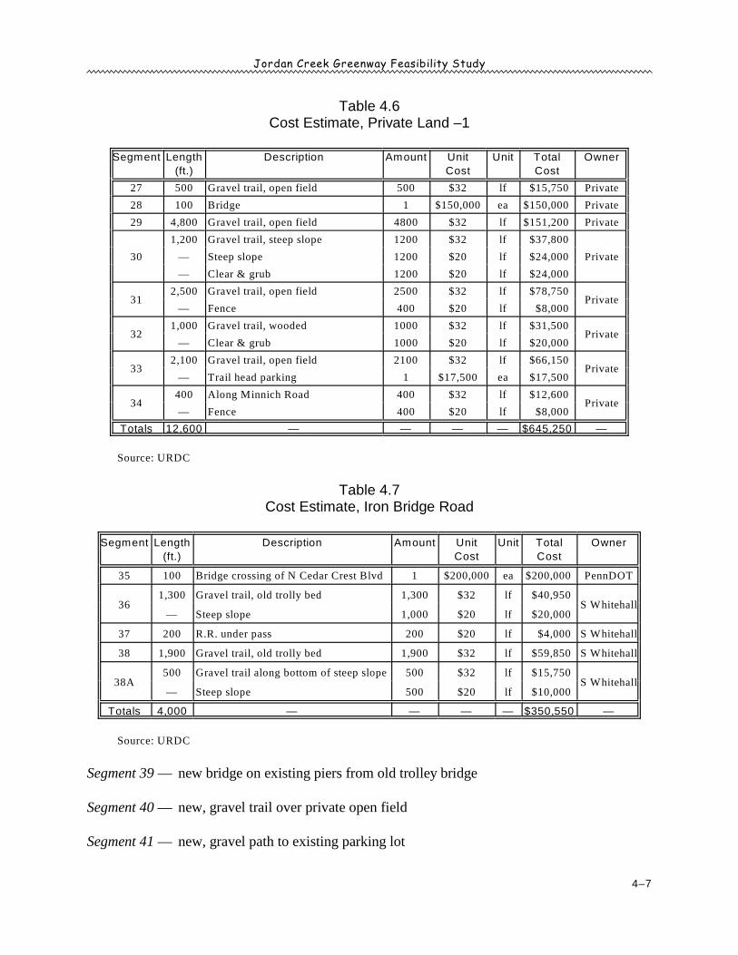
The total cost of improvements in the first portion of the greenway through major private landholdings (segments 27–34, Map 4.3) is approximately $645,250 (Table 4.6). The portion includesapproximately 12,600 feet (2.4 miles) of new trail.
Segment 35 — bridge across North Cedar Crest Boulevard near an old trolley bed
Segment 36 — new, gravel trail using old trolley bed parallel to Iron Bridge Road; portion of theland is steep
Segment 37 — use railroad underpass
Segments 38 and 38A — new, gravel trail on old trolley bed parallel to Iron Bridge Road; portionof the land is steep
The total cost of improvements in the Iron Bridge Road portion of the greenway (segments 35–38A,Map 4.3) is approximately $350,550 (Table 4.7). The portion includes approximately 4,000 feet(0.75 miles) of new trail.
Jordan Creek Greenway Feasibility Study
4–7
Table 4.6Cost Estimate, Private Land –1
Segment Length
(ft.)
Description Amount Unit
Cost
Unit Total
Cost
Owner
27 500 Gravel trail, open field 500 $32 lf $15,750 Private
28 100 Bridge 1 $150,000 ea $150,000 Private
29 4,800 Gravel trail, open field 4800 $32 lf $151,200 Private
30
1,200 Gravel trail, steep slope 1200 $32 lf $37,800
— Steep slope 1200 $20 lf $24,000 Private
— Clear & grub 1200 $20 lf $24,000
312,500 Gravel trail, open field 2500 $32 lf $78,750
Private— Fence 400 $20 lf $8,000
321,000 Gravel trail, wooded 1000 $32 lf $31,500
Private— Clear & grub 1000 $20 lf $20,000
332,100 Gravel trail, open field 2100 $32 lf $66,150
Private— Trail head parking 1 $17,500 ea $17,500
34400 Along Minnich Road 400 $32 lf $12,600
Private— Fence 400 $20 lf $8,000
Totals 12,600 — — — — $645,250 —
Source: URDC
Table 4.7Cost Estimate, Iron Bridge Road
Segment Length
(ft.)
Description Amount Unit
Cost
Unit Total
Cost
Owner
35 100 Bridge crossing of N Cedar Crest Blvd 1 $200,000 ea $200,000 PennDOT
361,300 Gravel trail, old trolly bed 1,300 $32 lf $40,950
S Whitehall— Steep slope 1,000 $20 lf $20,000
37 200 R.R. under pass 200 $20 lf $4,000 S Whitehall
38 1,900 Gravel trail, old trolly bed 1,900 $32 lf $59,850 S Whitehall
38A500 Gravel trail along bottom of steep slope 500 $32 lf $15,750
S Whitehall— Steep slope 500 $20 lf $10,000
Totals 4,000 — — — — $350,550 —
Source: URDC
Segment 39 — new bridge on existing piers from old trolley bridge
Segment 40 — new, gravel trail over private open field
Segment 41 — new, gravel path to existing parking lot
Jordan Creek Greenway Feasibility Study
4–8
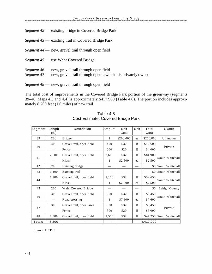
Segment 42 — existing bridge in Covered Bridge Park
Segment 43 — existing trail in Covered Bridge Park
Segment 44 — new, gravel trail through open field
Segment 45 — use Wehr Covered Bridge
Segment 46 — new, gravel trail through open fieldSegment 47 — new, gravel trail through open lawn that is privately owned
Segment 48 — new, gravel trail through open field
The total cost of improvements in the Covered Bridge Park portion of the greenway (segments39–48, Maps 4.3 and 4.4) is approximately $417,900 (Table 4.8). The portion includes approxi-mately 8,200 feet (1.6 miles) of new trail.
Table 4.8Cost Estimate, Covered Bridge Park
Segment Length
(ft.)
Description Amount Unit
Cost
Unit Total
Cost
Owner
39 200 Bridge 1 $200,000 ea $200,000 Unknown
40400 Gravel trail, open field 400 $32 lf $12,600
Private— Fence 200 $20 lf $4,000
412,600 Gravel trail, open field 2,600 $32 lf $81,900
South Whitehall — Kiosk 1 $2,500 ea $2,500
42 200 Existing bridge — — — $0 South Whitehall
43 1,400 Existing trail — — — $0 South Whitehall
441,100 Gravel trail, open field 1,100 $32 lf $34,650
South Whitehall — Kiosk 1 $2,500 ea $2,500
45 200 Wehr Covered Bridge — — — $0 Lehigh County
46300 Gravel trail, open field 300 $32 lf $9,450
South Whitehall — Road crossing 1 $7,600 ea $7,600
47300 Gravel trail, open lawn 300 $32 lf $9,450
Private— Fence 300 $20 lf $6,000
48 1,500 Gravel trail, open field 1,500 $32 lf $47,250 South Whitehall
Totals 8,200 — — — — $417,900 —
Source: URDC
Jordan Creek Greenway Feasibility Study
4–9
SECTION 3: COVERED BRIDGE PARK TO TREXLER NATURE PRESERVE
Section 3 of the proposed Jordan Creek Greenway connects Covered Bridge Park in South WhitehallTownship to the Trexler Nature Preserve in Lowhill and North Whitehall Townships. The sectionincludes the remainder of the remainder of the off-road trail (segments 49–61, Maps 4.4 and 4.5).Much of the land is in private ownership, although large tracts are owned by a single landownerreportedly favorable to the greenway concept. Some segments near the nature preserve are ownedby Lehigh County.
Segment 49 — new, gravel trail across private land, then under the Pennsylvania Turnpike
Segment 50 — new, gravel trail across private land
Segment 51 — new, gravel trail across private land, including improvements for crossing PA 309
The total cost of improvements in the second portion of the proposed greenway over private land(segments 49–51, Map 4.4) is approximately $339,800 (Table 4.9). The portion includes approxi-mately 9,800 feet (1.9 miles) of new trail. All of the land is under single ownership, and the owneris reportedly willing to discuss the possibility of greenway development.
Table 4.9Cost Estimate, Private Land — 2
Segment Length
(ft.)
Description Amount Unit
Cost
Unit Total
Cost
Owner
49 1,200 Gravel Trail, Open field 1200 $31.50 lf $37,800 Private
501,100 Gravel Trail, Open field 1100 $31.50 lf $34,650
PrivateFence 300 $20.00 lf $6,000
51
7,500 Gravel Trail, open field 7500 $31.50 lf $236,250
Road crossing, Rt 309 1 $7,600.00 ea $7,600 Private
Trail head parking 1 $17,500.00 ea $17,500
Totals 9,800 — — — — $339,800 —
Source: URDC
Segment 52 — pedestrian bridge across the Jordan Creek to bypass an agribusiness located on theeast bank of the creek
Segment 53 — new, gravel path through private land
Segment 54 — new, gravel trail through open area of Grist Mill Estates; includes safety improve-ments to cross Kernsville Road
Jordan Creek Greenway Feasibility Study
4–10
Segment 55 — new, gravel trail throughopen area owned byLehigh County adjacent toGrist Mil l Estates;includes 1,400 feet offencing
Segment 56 — new trail through privatewoods; includes fence toc l ea r ly d i s t i ngu i shb e t w e en t ra i l a n dneighboring property
Segment 57 — bridge across Jordan Creek(avoids steep slope onnorth bank of creek)
Segment 58 — new trail across private land; may need to address some steep slopes
Segment 59 — trail across private land with steep slope requiring additional grading
Segment 60 — new trail through open field owned by Lehigh County; possible future site of Low-hill Township park
Segment 61 — into Trexler Nature Preserve; connect to planned trail system in preserve; appearsto be wetlands; may require raised walkway for passage; should include trailhead;includes safety improvements for crossing Jordan Road
The total cost of improvements in the west end of the proposed greenway (segments 52–61, Maps4.4 and 4.5) is approximately $779,050 (Table 4.10). The portion includes approximately 11,000 feet(2.1 miles) of new trail. Portions of the land are owned privately, and portions are owned by LehighCounty.
OFF-ROAD TRAIL SUMMARY
The estimated cost for constructing the 12.8 miles of off-road trail proposed as part of the JordanCreek Greenway is approximately $4.6 million (Table 4.11), or approximately $253,700 per mile.The West End portion of the trail is the most expensive in total. The Iron Bridge Road portion carriesthe highest unit cost.
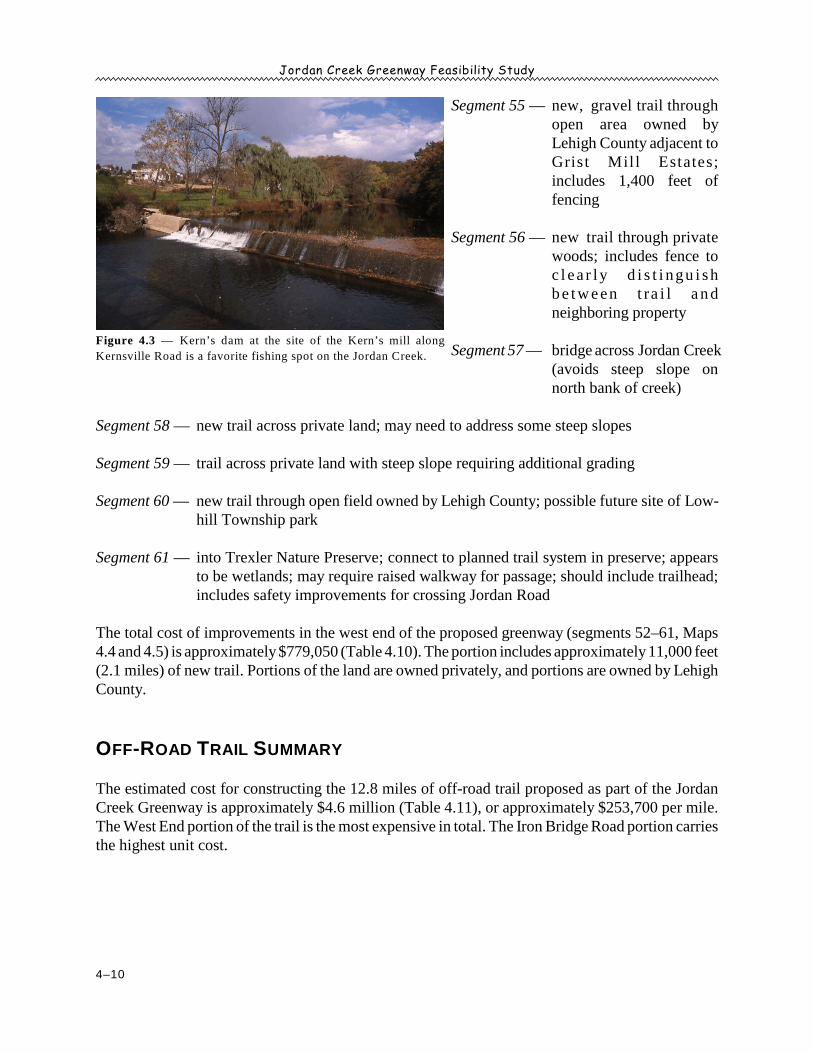
Figure 4.3 — Kern’s dam at the site of the Kern’s mill along
Kernsville Road is a favorite fishing spot on the Jordan Creek.
Jordan Creek Greenway Feasibility Study
4–11
Table 4.10Cost Estimate, West End
Segment Length
(ft.)
Description Amount Unit
Cost
Unit Total
Cost
Owner
52 100 Bridge 1 $150,000.00 ea $150,000 Private
53
1,000 Gravel trail, wooded 1000 $31.50 lf $31,500
— Clear & grub 1000 $20.00 lf $20,000 Private
— Fence 200 $20.00 lf $4,000
541,100 Gravel trail, open area 1000 $31.50 lf $31,500 Private
— Road crossing, Kernsville Rd 1 $7,600.00 ea $7,600 PennDOT
552,800 Gravel trail, open area 2800 $31.50 lf $88,200 North
Whitehall Twp— Fence 1400 $20.00 lf $28,000
56
200 Gravel trail, wooded 200 $31.50 lf $6,300
— Clear & grub 200 $20.00 lf $4,000 Private
— Fence 200 $20.00 lf $4,000
57 100 Bridge 1 $150,000.00 ea $150,000 —
58
1,000 Gravel trail, steep slope 1000 $31.50 lf $31,500
— Extra grading 400 $10.00 lf $4,000 Private
— Clear & grub 1000 $20.00 lf $20,000
59
500 Gravel trail, steep slope 500 $31.50 lf $15,750
— Extra grading 400 $10.00 lf $4,000 Lehigh Co
— Road crossing, Jordan Road 1 $7,600.00 ea $7,600
60 4,000 Gravel trail, open field 4000 $31.50 lf $126,000 Lehigh Co
61
200 Wet area, raised walk 100 $200.00 lf $20,000
— Road crossing, Jordan Road 1 $7,600.00 ea $7,600 Lehigh Co
— Trailhead parking 1 $17,500.00 ea $17,500
Totals 11,000 — — — — $779,050 —
Source: URDC
Table 4.11Off-Road Trail Cost Estimate Summary
Trail Portion Table
No.
Length Estimated Construction Cost
Name Sections* Segments* Feet Miles Total Per Mile
Jordan Meadows Park 1 1–2 4.2 1,000 0.2 $15,100 $79,700
N. 4 St. to Jordan Meadows Park 1 3–7 4.3 4,700 0.9 $195,300 $219,400th
Jordan Park (City of Allentown) 1 8–13 4.4 5,300 1.0 $204,600 $203,800
Jordan Park (Lehigh County) 1 14–26 4.5 11,200 2.1 $309,750 $146,025
Private Land – 1 2 27–34 4.6 12,600 2.4 $645,250 $270,400
Iron Bridge Road 2 35–38A 4.7 4,000 0.8 $350,550 $462,700
Covered Bridge Park 2 39–48 4.8 8,200 1.6 $417,900 $269,100
Private Land – 2 3 49–51 4.9 9,800 1.9 $339,800 $183,100
West End 3 52–61 4.10 11,000 2.1 $779,050 $373,900
Construction — 67,800 12.8 $3,257,300 $253,700
20% contingency $651,460 —
Construction subtotal $3,908,760 —
18% design and engineering $703,577 —
$4,612,337 $359,200
* Sections are larger areas delineated for mapping and general analysis. Segments are smaller areas delineated
for cost estimation.
Source: URDC
Jordan Creek Greenway Feasibility Study
4–12
SHARED ROAD TRAIL:
TREXLER NATURE PRESERVE TO THE APPALA-
CHIAN TRAIL
The concept for the Jordan Creek Greenway trail connectionscontinues north of the Trexler Nature Preserve to the AppalachianTrail (Maps 4.6 and 4.7). The entire connection uses low-volumeroads to be signed and shared with both bicyclists and hikers. Thenorthern connections consist of three major segments comprising atotal of 35.8 miles:
• Trexler Nature Preserve to Leaser Lake via Schocary Road (15.9 miles)• Trexler Nature Preserve to Leaser Lake via Pleasant Corners (17.9 miles)• Appalachian Trail Pedestrian Spur (2.0 miles)
The greenway uses low volume roads north of the nature preserve for two primary reasons:
1. Lynn and Heidelberg Townships have a preponderance of preserved farmland (Map 2.10) onwhich trails are not legally permitted. Therefore, an overland trail alignment was virtuallyimpossible.
2. Many roads in the area are low volume, rural roads, which offers a simple, low-cost alternativeto off-road trail development. The only cost involved in designating the route would be signs,which should include the Jordan Creek Greenway logo. (Pennsylvania Bike Route L passesthrough the area and was considered for inclusion when possible.) The townships should beurged to add bike lanes to road shoulders whenever roads in the area are improved.
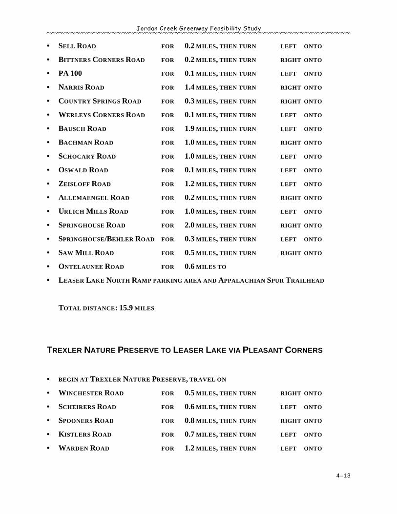
Section 6 of the Jordan Creek Greenway provides a connection to Leaser Lake, from which hikerscan access the Appalachian Trail. The greenway provides two routes to Leaser Lake— 15.9 milesvia Schocary Road or 17.9 miles via Pleasant Corners. Combined, the on-road portion of thegreenway creates a 33.8-mile loop using the following specific directions:
Trexler Nature Preserve to Leaser Lake via Schocary Road
• BEGIN AT TREXLER NATURE PRESERVE, TRAVEL ON
• WINCHESTER ROAD FOR 0.5 MILES, THEN TURN RIGHT ONTO
• SCHEIRERS ROAD FOR 0.6 MILES, THEN TURN LEFT ONTO
• SPOONERS ROAD FOR 0.8 MILES, THEN TURN RIGHT ONTO
• KISTLERS ROAD FOR 0.7 MILES, THEN TURN LEFT ONTO
• WARDEN ROAD FOR 1.2 MILES, THEN TURN LEFT ONTO
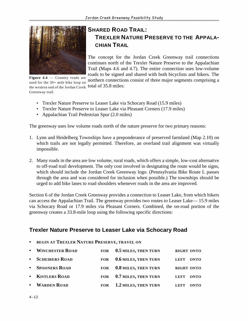
Figure 4.4 — Country roads are
used for the 30+ mile bike loop on
the western end of the Jordan Creek
Greenway trail.
Jordan Creek Greenway Feasibility Study
4–13
• SELL ROAD FOR 0.2 MILES, THEN TURN LEFT ONTO
• BITTNERS CORNERS ROAD FOR 0.2 MILES, THEN TURN RIGHT ONTO
• PA 100 FOR 0.1 MILES, THEN TURN LEFT ONTO
• NARRIS ROAD FOR 1.4 MILES, THEN TURN RIGHT ONTO
• COUNTRY SPRINGS ROAD FOR 0.3 MILES, THEN TURN RIGHT ONTO
• WERLEYS CORNERS ROAD FOR 0.1 MILES, THEN TURN LEFT ONTO
• BAUSCH ROAD FOR 1.9 MILES, THEN TURN LEFT ONTO
• BACHMAN ROAD FOR 1.0 MILES, THEN TURN RIGHT ONTO
• SCHOCARY ROAD FOR 1.0 MILES, THEN TURN LEFT ONTO
• OSWALD ROAD FOR 0.1 MILES, THEN TURN LEFT ONTO
• ZEISLOFF ROAD FOR 1.2 MILES, THEN TURN LEFT ONTO
• ALLEMAENGEL ROAD FOR 0.2 MILES, THEN TURN RIGHT ONTO
• URLICH MILLS ROAD FOR 1.0 MILES, THEN TURN LEFT ONTO
• SPRINGHOUSE ROAD FOR 2.0 MILES, THEN TURN RIGHT ONTO
• SPRINGHOUSE/BEHLER ROAD FOR 0.3 MILES, THEN TURN LEFT ONTO
• SAW MILL ROAD FOR 0.5 MILES, THEN TURN RIGHT ONTO
• ONTELAUNEE ROAD FOR 0.6 MILES TO
• LEASER LAKE NORTH RAMP PARKING AREA AND APPALACHIAN SPUR TRAILHEAD
TOTAL DISTANCE: 15.9 MILES
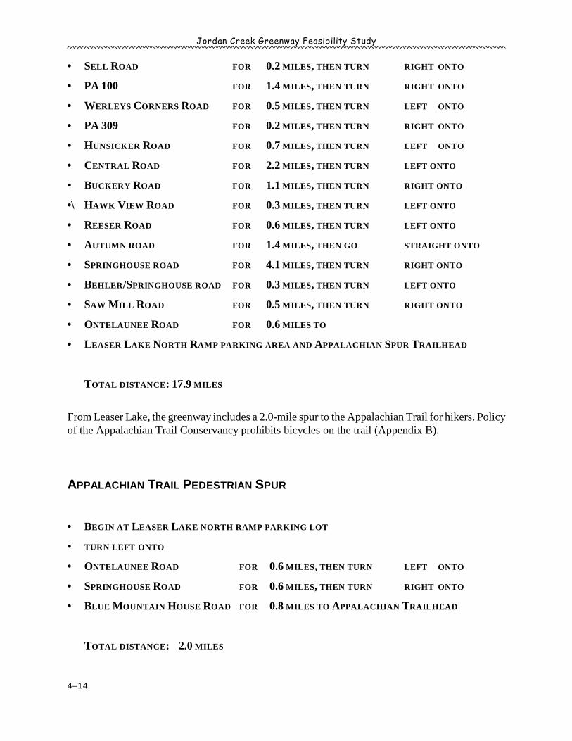
TREXLER NATURE PRESERVE TO LEASER LAKE VIA PLEASANT CORNERS
• BEGIN AT TREXLER NATURE PRESERVE, TRAVEL ON
• WINCHESTER ROAD FOR 0.5 MILES, THEN TURN RIGHT ONTO
• SCHEIRERS ROAD FOR 0.6 MILES, THEN TURN LEFT ONTO
• SPOONERS ROAD FOR 0.8 MILES, THEN TURN RIGHT ONTO
• KISTLERS ROAD FOR 0.7 MILES, THEN TURN LEFT ONTO
• WARDEN ROAD FOR 1.2 MILES, THEN TURN LEFT ONTO
Jordan Creek Greenway Feasibility Study
4–14
• SELL ROAD FOR 0.2 MILES, THEN TURN RIGHT ONTO
• PA 100 FOR 1.4 MILES, THEN TURN RIGHT ONTO
• WERLEYS CORNERS ROAD FOR 0.5 MILES, THEN TURN LEFT ONTO
• PA 309 FOR 0.2 MILES, THEN TURN RIGHT ONTO
• HUNSICKER ROAD FOR 0.7 MILES, THEN TURN LEFT ONTO
• CENTRAL ROAD FOR 2.2 MILES, THEN TURN LEFT ONTO
• BUCKERY ROAD FOR 1.1 MILES, THEN TURN RIGHT ONTO
•\ HAWK VIEW ROAD FOR 0.3 MILES, THEN TURN LEFT ONTO
• REESER ROAD FOR 0.6 MILES, THEN TURN LEFT ONTO
• AUTUMN ROAD FOR 1.4 MILES, THEN GO STRAIGHT ONTO
• SPRINGHOUSE ROAD FOR 4.1 MILES, THEN TURN RIGHT ONTO
• BEHLER/SPRINGHOUSE ROAD FOR 0.3 MILES, THEN TURN LEFT ONTO
• SAW MILL ROAD FOR 0.5 MILES, THEN TURN RIGHT ONTO
• ONTELAUNEE ROAD FOR 0.6 MILES TO
• LEASER LAKE NORTH RAMP PARKING AREA AND APPALACHIAN SPUR TRAILHEAD
TOTAL DISTANCE: 17.9 MILES
From Leaser Lake, the greenway includes a 2.0-mile spur to the Appalachian Trail for hikers. Policyof the Appalachian Trail Conservancy prohibits bicycles on the trail (Appendix B).
APPALACHIAN TRAIL PEDESTRIAN SPUR
• BEGIN AT LEASER LAKE NORTH RAMP PARKING LOT
• TURN LEFT ONTO
• ONTELAUNEE ROAD FOR 0.6 MILES, THEN TURN LEFT ONTO
• SPRINGHOUSE ROAD FOR 0.6 MILES, THEN TURN RIGHT ONTO
• BLUE MOUNTAIN HOUSE ROAD FOR 0.8 MILES TO APPALACHIAN TRAILHEAD
TOTAL DISTANCE: 2.0 MILES
Jordan Creek Greenway Feasibility Study
4–15
CONCLUSION
The proposed Jordan Creek Greenway is feasible as an off-road trail south of the Trexler NaturePreserve and as a shared roadway system from the nature preserve north to the Appalachian Trail,given sufficient funding and the cooperation of a few key landowners in the off-road portion.
The proposed greenway serves both conservation and recreation functions. In addition, the greenwayoffers potential connections to several current and potential greenway efforts, such as the proposedNorthern Lehigh Rail Trail in Lynn Township.
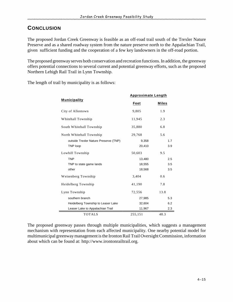
The length of trail by municipality is as follows:
Municipality
Approximate Length
Feet Miles
City of Allentown 9,805 1.9
Whitehall Township 11,945 2.3
South Whitehall Township 35,880 6.8
North Whitehall Township 29,768 5.6
outside Trexler Nature Preserve (TNP) 9,358 1.7
TNP loop 20,410 3.9
Lowhill Township 50,603 9.5
TNP 13,480 2.5
TNP to state game lands 18,555 3.5
other 18,568 3.5
Weisenberg Township 3,404 0.6
Heidelberg Township 41,190 7.8
Lynn Township 72,556 13.8
southern branch 27,985 5.3
Heidelberg Township to Leaser Lake 32,604 6.2
Leaser Lake to Appalachian Trail 11,967 2.3
TOTALS 255,151 48.3
The proposed greenway passes through multiple municipalities, which suggests a managementmechanism with representation from each affected municipality. One nearby potential model formultimunicipal greenway management is the Ironton Rail Trail Oversight Commission, informationabout which can be found at: http://www.irontonrailtrail.org.

Jordan Creek Greenway Feasibility Study
4–16
This page intentionally blank.
Jordan Creek Greenway Feasibility Study
5–1
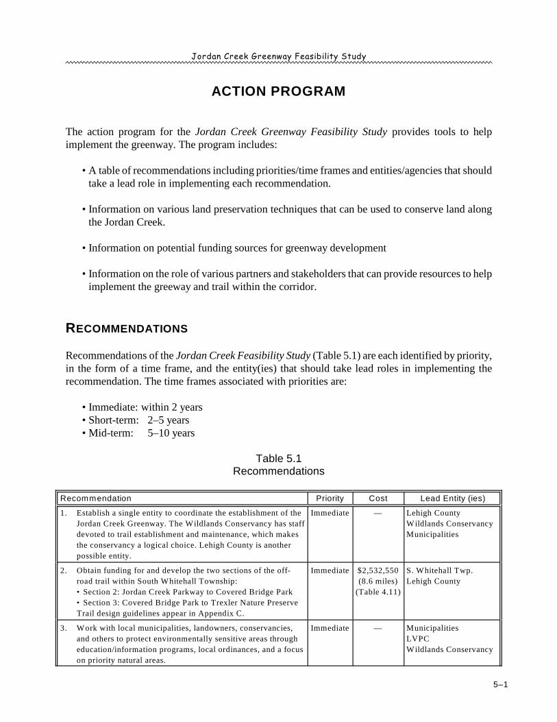
ACTION PROGRAM
The action program for the Jordan Creek Greenway Feasibility Study provides tools to helpimplement the greenway. The program includes:
• A table of recommendations including priorities/time frames and entities/agencies that shouldtake a lead role in implementing each recommendation.
• Information on various land preservation techniques that can be used to conserve land alongthe Jordan Creek.
• Information on potential funding sources for greenway development
• Information on the role of various partners and stakeholders that can provide resources to helpimplement the greeway and trail within the corridor.
RECOMMENDATIONS
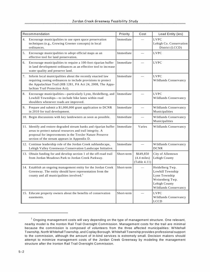
Recommendations of the Jordan Creek Feasibility Study (Table 5.1) are each identified by priority,in the form of a time frame, and the entity(ies) that should take lead roles in implementing therecommendation. The time frames associated with priorities are:
• Immediate: within 2 years• Short-term: 2–5 years• Mid-term: 5–10 years
Table 5.1Recommendations
Recommendation Priority Cost Lead Entity (ies)
1. Establish a single entity to coordinate the establishment of the
Jordan Creek Greenway. The Wildlands Conservancy has staff
devoted to trail establishment and maintenance, which makes
the conservancy a logical choice. Lehigh County is another
possible entity.
Immediate — Lehigh County
Wildlands Conservancy
Municipalities
2. Obtain funding for and develop the two sections of the off-
road trail within South Whitehall Township:
• Section 2: Jordan Creek Parkway to Covered Bridge Park
• Section 3: Covered Bridge Park to Trexler Nature Preserve
Trail design guidelines appear in Appendix C.
Immediate $2,532,550
(8.6 miles)
(Table 4.11)
S. Whitehall Twp.
Lehigh County
3. Work with local municipalities, landowners, conservancies,
and others to protect environmentally sensitive areas through
education/information programs, local ordinances, and a focus
on priority natural areas.
Immediate — Municipalities
LVPC
Wildlands Conservancy
Jordan Creek Greenway Feasibility Study
Recommendation Priority Cost Lead Entity (ies)
Ongoing management costs will vary depending on the type of management structure. One relevant,1
nearby model is the Ironton Rail Trail Oversight Commission. Management costs for the trail are minimal
because the commission is composed of volunteers from the three affected municipalities: W hitehall
Township, North W hitehall Township, and Coplay Borough. W hitehall Township provides professional support
to the commission, although the amount of in-kind services is extremely small. Decision makers should
attempt to minimize management costs of the Jordan Creek Greenway by modeling the management
structure after the Ironton Rail Trail Oversight Commission.
5–2
4. Encourage municipalities to use open space preservation
techniques (e.g., Growing Greener concepts) in local
ordinances.
Immediate — LVPC
Lehigh Co. Conservation
District (LCCD)
5. Encourage municipalities to adopt official maps as an
effective tool for land preservation.
Immediate — LVPC
6. Encourage municipalities to require a 100-foot riparian buffer
in land development ordinances as an effective tool to increase
water quality and preserve land.
Immediate — LVPC
7. Inform local municipalities about the recently enacted law
requiring zoning ordinances to include provisions to protect
the Appalachian Trail (HB 1281, PA Act 24, 2008, The Appa-
lachian Trail Protection Act).
Immediate — LVPC
Wildlands Conservancy
8. Encourage municipalities—particularly Lynn, Heidelberg, and
Lowhill Townships—to include bike lanes within road
shoulders whenever roads are improved.
Immediate — LVPC
Wildlands Conservancy
9. Prepare and submit a $1,000,000 grant application to DCNR
in 2010 for trail development.
Immediate — Wildlands Conservancy
Municipalities
10. Begin discussions with key landowners as soon as possible. Immediate — Wildlands Conservancy
Municipalities
11. Identify and restore degraded stream banks and riparian buffer
areas to protect natural resources and trail integrity. A
proposal for improvements in the Trexler Nature Preserve
section of the stream appears in Appendix D.
Immediate Varies Wildlands Conservancy
12. Continue leadership role of the Jordan Creek sublandscape,
Lehigh Valley Greenways Conservation Landscape Initiative.
Immediate — Wildlands Conservancy
DCNR
13. Obtain funding for and develop section 1 of the off-road trail
from Jordan Meadows Park to Jordan Creek Parkway.
Short-term $649,850
(4.4 miles)
(Table 4.11)
City of Allentown
Lehigh County
14. Establish an ongoing management entity for the Jordan Creek
Greenway. The entity should have representation from the
county and all municipalities involved. 1
Short-term — Heidelberg Twp.
Lowhill Township
Lynn Township
Weisenberg Twp.
Lehigh County
Wildlands Conservancy
15. Educate property owners about the benefits of conservation
easements.
Short-term — LVPC
Wildlands Conservancy
LCCD
Jordan Creek Greenway Feasibility Study
Recommendation Priority Cost Lead Entity (ies)
5–3
16. Obtain funding for and develop improvements for the Jordan
Creek Greenway trail within and north of the Trexler Nature
Preserve.
Mid-term pending
design
Heidelberg Twp.
Lowhill Township
Lynn Township
Weisenberg Twp.
Lehigh County
PennDOT
17. Develop a “Friends of the Jordan Creek” organization to
advocate for land preservation along the stream.
Mid-term — Wildlands Conservancy
Municipalities
Source: URDC, Wildlands Conservancy
LAND PRESERVATION TECHNIQUES
One of the most important purposes of greenways is to preserve land. The techniques used topreserve the land must be available to and feasible for the landowner. Since landowners have manydifferent financial needs and circumstances, techniques that are appropriate for some owners willnot be useful to others. The following section describes many of the tools that can be effective inpreserving land along the Jordan Creek Greenway and throughout the watershed.
• Fee Simple Acquisition — The most effective means of preserving land is through fee simplepurchase. Fee simple purchase gives the owner complete control of the land, including all publicaccess and conservation practice decisions. In most situations, fee simple acquisition is also themost expensive method of land control. Therefore, many entities interested in land preservation,particularly public agencies or land conservancies with limited budgets, will explore other, lessexpensive options for land control.
• Conservation Easements — Conservation easements place restrictions or an outright prohibitionon development at a lower cost than fee simple acquisition. Under a conservation easement, landcould (and usually does) remain in current ownership, but the property owner voluntarily agreesto donate or sell the right to develop the land. The property owner agrees to place a restrictionin the deed of the property, which becomes binding on all future owners of the land. Theeasement is held by the municipality, county, or a private, nonprofit conservancy, such as theWildlands Conservancy. Conservation easements often provide the property owner with federalincome tax and estate tax benefits.
• Other Easements — Conservation easements may be used to preserve many types of resources.For example, easements may be placed on historic lands or buildings, open space, forests, orfarmland. Conservation easements are frequently used for environmental preservation withoutproviding for public use of the land. However, a conservation easement can also be combinedwith a pedestrian easement or right of public access easement to allow public access for walking,hiking, horseback riding, bicycling, and other activities with established rules and restrictions.
Jordan Creek Greenway Feasibility Study
Additional information about agricultural conservation easements is available from the Lehigh County2
Agricultural Conservation Easement Program, information about which can be found at:
http://lehighconservation.org/index.php?page=easement-program
5–4
With such an easement, the landowner is not held liable for any injuries, crimes, or deathassociated with public use of the land.
Another easement type is the joint-use easement, which accommodates multiple uses under oneeasement. Joint-use easements are particularly appropriate for public utility corridors. Electrictransmission lines, sanitary sewer lines, petroleum or gas pipelines, and other such corridors maybe ideal for trail connections, as they often contain a cleared pathway. Joint-use easements areadvantageous in that landowners will know the exact purposes of the singular easement, ratherthan dealing with multiple easements.
Agricultural conservation easements may be appropriate in areas with prime farmland adjacentto greenways. The action preserves additional contiguous land and helps to maintain the sceniccharacter of both the greenway and the area as a whole. Local, county, or state governments maypurchase easements from owners of prime farmland if the owner agrees to keep the land inagricultural use. The land must meet certain acreage, soil, and production criteria to qualify forthe program. 2
By law, trails cannot be placed on eased farmland. Therefore, agricultural easements are not asuitable tool for preserving land for the Jordan Creek Greeway itself. However, preserving farmsadjacent to the greenway is a valid method of creating a wider, preserved viewshed, panorama,or other scenic area.
The Pennsylvania Land Trust Association (PALTA) is the statewide organization of nonprofit,land conservation groups. PALTA has developed model easements that are available on the asso-ciation website (http://www.conserveland.org) and include:
— Pennsylvania Conservation Easement— Riparian Forest Buffer Protection Agreement— Trail Easement Agreement
— Fishing Access Agreement— Water Quality Improvement Easement
• Purchase and Leaseback or Resale — An entity interested in preservation, such as a localgovernment or conservancy, can purchase land in fee simple, place restrictions on the deedprohibiting certain uses (e.g., residential development), and sell or lease the land to interestedparties. The original buyer gains the potential for future use at the current price and may recoversome or all of the purchase price through leasing. The land is maintained in open space and maybe developed as a park if and when future demand warrants. Resale of some or all of the landwith deed restrictions may maintain open space, relieve the municipality of maintenanceobligations, and return the land to the tax rolls.

Jordan Creek Greenway Feasibility Study
5–5
• Donations — Frequently, land can be acquired through donations from private owners, organiza-tions, and corporations. Local governments should encourage land donations by pointing outbenefits of such actions, such as federal income and estate tax benefits and the public relationsvalue. Prior to accepting a donation, a municipality should consider two points:
— Location of the parcel and the anticipated development and maintenance costs. If the locationis poor and/or projected costs will be excessive, the municipality should strongly consideraccepting a fee rather than the land.
— If the land is suitable, the municipality should encourage the donor to provide an endowmentfund along with the land to assist with development and/or maintenance costs.
In addition to land, corporations and other private parties also frequently provide cash donationsfor worthy causes, including land preservation.
• Land Exchange — A land exchange, or land swap, is useful when a development interest anda conservation interest both own a piece of land more appropriate to the mission of the other. Forexample, a residential developer may own a wetland area next to a park while a townshipgovernment owns a vacant tract near an existing developed area. With the land exchange, theenvironmentally-sensitive land is preserved by the township, and the developer builds houses inan appropriate location. Any mismatches in land value can be negotiated.
• Municipal Ordinances — One of the least expensive ways to protect environmentally-sensitiveland is through municipal zoning ordinances and subdivision and land development ordinances(SALDOs). Local ordinances contain provisions that prohibit or limit activities on or near envi-ronmentally sensitive areas. The following provisions are most important with regard to green-ways.
— Riparian buffers are the areas within a specified distance (or “setback”) of a waterway withinwhich development or other activities is prohibited or restricted. Most township ordinancesestablish riparian buffers between 50 and 100 feet, while many borough and city ordinancesdo not contain any riparian buffer provisions. The most appropriate buffer size depends onthe size of the stream, and the existing natural and human features along the stream. A two-tiered buffer can set different standards for two different setbacks (e.g. no developmentwithin 100 feet, and no mowing within 50 feet).
— Floodplain regulations prohibit development and certain other activities within the 100-yearfloodplain, frequently in a separate floodplain ordinance. The 100-year floodplain corridoris composed of a floodway and flood fringe area. State floodplain regulations form a bareminimum of floodplain protection. All floodplains should be kept in open space. Activitiessuch as tree-cutting, clearing of vegetation, storage of hazardous materials, and landfilloperations would have a negative effect during flood events and should be prohibited. Inplaces where existing structures are located within the floodplain, regulation options include
Jordan Creek Greenway Feasibility Study
5–6
establishing a lowest floor level for buildings, requiring floodproofing, and prohibitingfurther development or improvements.
— Wetlands, high water table soils, and hydric soils are areas containing permanently orfrequently saturated soil conditions or standing water. The three features often coincide. Mostzoning ordinances take a site-by-site approach to wetlands regulation, requiring a zoningofficer or engineer to determine if wetland indicators are present on a parcel being developed.If the site contains wetland indicators, the applicant must have a qualified wetland specialistdelineate wetlands, on which development must be prohibited. Alternatively, a municipalitymay have a complete wetlands map database prepared for the jurisdiction by a wetlandsspecialist.
— Steep slopes are usually divided into two categories: 15–25% and 25% and greater.Development densities and buildings sites are typically restricted in slopes between 15 and25 %, and restricted or prohibited on slopes 25% and greater. Keeping steep slopes in openspace is a benefit to ridge-based greenways as well as stream-based greenways, where theriparian zone is surrounded by slopes.
— Woodlands — Most SALDOs contain tree-cutting ordinances, permitting unlimited tree-cutting in areas necessary to accommodate home sites and road right-of-ways, and providinga maximum tree extraction number or rate for other areas. A more protective option is todeclare a maximum percentage of tree removal per lot. To protect woodlands along streamcorridors and ridges, cutting restrictions can be placed on floodplain forests and uplandforests, respectively.
— Agricultural zoning — “Effective agricultural zoning” limits the amount of development onkey prime farmland tracts so that most of the land remains in large lots that can still be viablefor farming. Agricultural zoning must consider soils, physical features, current land usepatterns, and other matters. Limiting water and sewer extensions, transfer of developmentrights, and other techniques may also help to conserve farmland.
• Public Dedication — The Pennsylvania Municipalities Planning Code (Act 247, as amended)enables municipalities to require that residential developers dedicate land, or fees in lieu of land,for public recreation. Municipalities must have an adopted recreation plan and an adopted ordi-nance relating to public dedication before land or fees can be accepted. The amount of landrequired must be related to the demand for recreation land typically created by new development.The required land dedication should be in addition to the preservation of natural features on theland, such as floodplains, wetlands, steep slopes, woodlands, or other sensitive areas. Furtherinformation is available at: http://conserveland.org/lpr/one?lpr_id=23142
• Open Space Development — Open space development, similar in some respects to “clusterdevelopment”, is very useful in areas where greenways pass through land that is zoned fordevelopment. When a tract is developed in the open space scheme, increased developmentdensities are allowed in exchange for mandatory open space. As an example, under standard
Jordan Creek Greenway Feasibility Study
Authority for an official map is provided in Article IV of the Pennsylvania Municipalities Planning Code3
(Act 247 as reenacted and amended).
5–7
suburban development schemes, a 100-acre lot adjacent to a stream might be subdivided into 100one-acre lots. Under open space development:
— The natural features of the site are identified and preserved first (10 acres, for example).— Open space is then set aside near the stream (40 acres, for example).— The remaining area is subdivided into the 100 lots originally allowed under conventional
zoning, but the lots are only 0.5 acres each.
Open space development can be facilitated with provisions in the zoning ordinance and SALDO.Open space development provisions are often amendments to existing lot size requirements ineach zoning district (e.g. “Low Density Residential District: 1.0 acre minimum lot size, or 0.60acre with 40% open space.”).
• Transfer of Development Rights — Transfer of development rights (TDR) is often a voluntaryoption in a zoning ordinance that provides incentives for private developers to pay to preserveenvironmentally-sensitive land. Under a typical TDR system, a developer pays a private land-owner to permanently preserve the land in return for being able to add the potential developmentfrom the preserved parcel to a parcel in another area of the municipality more suitable for intensedevelopment. Therefore, the developer receives approval to build on the development parcel ata higher density than would be allowed without the additional development rights from thepreserved parcel. The developer and the owner of the sensitive land privately negotiate a price.The municipality approves the higher density development, and, simultaneously, a conservationeasement is placed on the sensitive land.
• Official Map — An official map is a map showing public lands and facilities from officiallyadopted municipal plans, such as a comprehensive plan. The official map can be used to reserve3
right-of-way for a period of one year, which can be very useful to a municipality for trail devel-opment, easement acquisition, or other negotiations with developers. When a greenway plan isadopted, the proposed greenways should be put on an official map, which should be adopted bythe municipality. If a development is proposed on a parcel where a greenway is proposed, themunicipality has one year to acquire control of all or a portion of the parcel or negotiate otherarrangements in accordance with local policies prior to development of the parcel.
FUNDING SOURCES
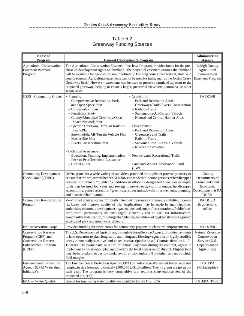
The federal government, state government, county government, private organizations, and founda-tions provide various opportunities for the funding of greenway efforts (Table 5.2). Funding sources
Jordan Creek Greenway Feasibility Study
5–8
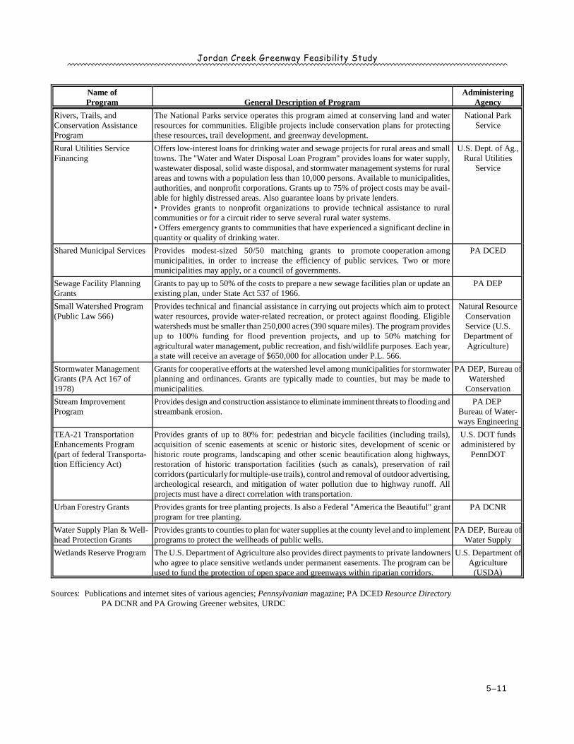
Table 5.2Greenway Funding Sources
Name ofProgram General Description of Program
AdministeringAgency
Agricultural ConservationEasement PurchaseProgram
The Agricultural Conservation Easement Purchase Program provides funds for the pur-chase of development rights on farmland. The perpetual easement ensures the farmlandwill be available for agricultural use indefinitely. Funding comes from federal, state, andcounty sources. Agricultural easements cannot be used for trails, such as the Jordan CreekGreenway itself. However, easements can be used to preserve farmland adjacent to theproposed greenway, helping to create a larger, preserved viewshed, panorama, or otherscenic asset.
Lehigh CountyAgriculturalConservation
Easement Program
C2P2 - Community Grants • Planning– Comprehensive Recreation, Park,
and Open Space Plan– Conservation Plan– Feasibility Study– County/Municipal Greenway/Open
Space Network Plan– Specific Greenway, Trail, or Rails-to-
Trails Plan– Snowmobile/All-Terrain Vehicle Plan– Master Site Plan– Rivers Conservation Plan
• Technical Assistance– Education, Training, Implementation– Peer-to-Peer Technical Assistance– Circuit Rider
• Acquisition– Park and Recreation Areas– Greenways/Trails/Rivers Conservation– Rails-to-Trails– Snowmobile/All-Terrain Vehicle– Natural and Critical Habitat Areas
• Development– Park and Recreation Areas– Greenways and Trails– Rails-to-Trails– Snowmobile/All-Terrain Vehicle– Rivers Conservation
• Pennsylvania Recreational Trails
• Land and Water Conservation Fund(LWCF)
PA DCNR
Community DevelopmentBlock Grant (CDBG)
Offers grants for a wide variety of activities, provided the applicant proves by survey orcensus that the project will benefit 51% low and moderate income persons or handicappedpersons or eliminate "blighted" conditions in officially designated areas. For example,funds can be used for water and sewage improvements, storm drainage, handicappedaccessibility, parks / recreation / greenways, street and sidewalk improvements, planning,and historic rehabilitation.
CountyDepartments ofCommunity and
EconomicDevelopment & PA
DCED
Community RevitalizationProgram
Very broad grant program. Officially intended to promote community stability, increasetax bases and improve quality of life. Applications may be made by municipalities,authorities, economic development organizations, and nonprofit corporations. Public/non-profit/profit partnerships are encouraged. Generally can be used for infrastructure,community revitalization, building rehabilitation, demolition of blighted structures, publicsafety, and park and greenways projects.
PA DCED& governor's
office
PA Conservation Corps Provides funding for work crews for community projects, such as trail improvements. PA DCNR
Conservation ReserveProgram (CRP) andConservation ReserveEnhancement Program(CREP)
The U.S. Department of Agriculture, through its Farm Service Agency, provides paymentsto farm operators to plant long-term, stabilizing and filtering vegetation on highly erodibleor environmentally sensitive landscapes (such as riparian areas). Contract duration is 10–15 years. The participant, in return for annual payments during the contract, agrees toimplement a conservation plan approved by the local conservation district. Eligible landmust be in cropland or pasture land, have an erosion index of 8 or higher, and may includefield margins.
Natural ResourceConservationService (U.S.Department ofAgriculture)
Environmental ProtectionAgency (EPA) WatershedInitiative’s
The Environmental Protection Agency (EPA) provides large Watershed Initiative grantsranging in size from approximately $300,000 to $1.3 million. Twenty grants are given outeach year. The program is very competitive and requires state endorsement of theproposed project(s).
U.S. EPA(Philadelphia)
EPA — Water Quality Grants for improving water quality are available for the U.S. EPA. U.S. EPA (Phila.)
Jordan Creek Greenway Feasibility Study
Name ofProgram General Description of Program
AdministeringAgency
5–9
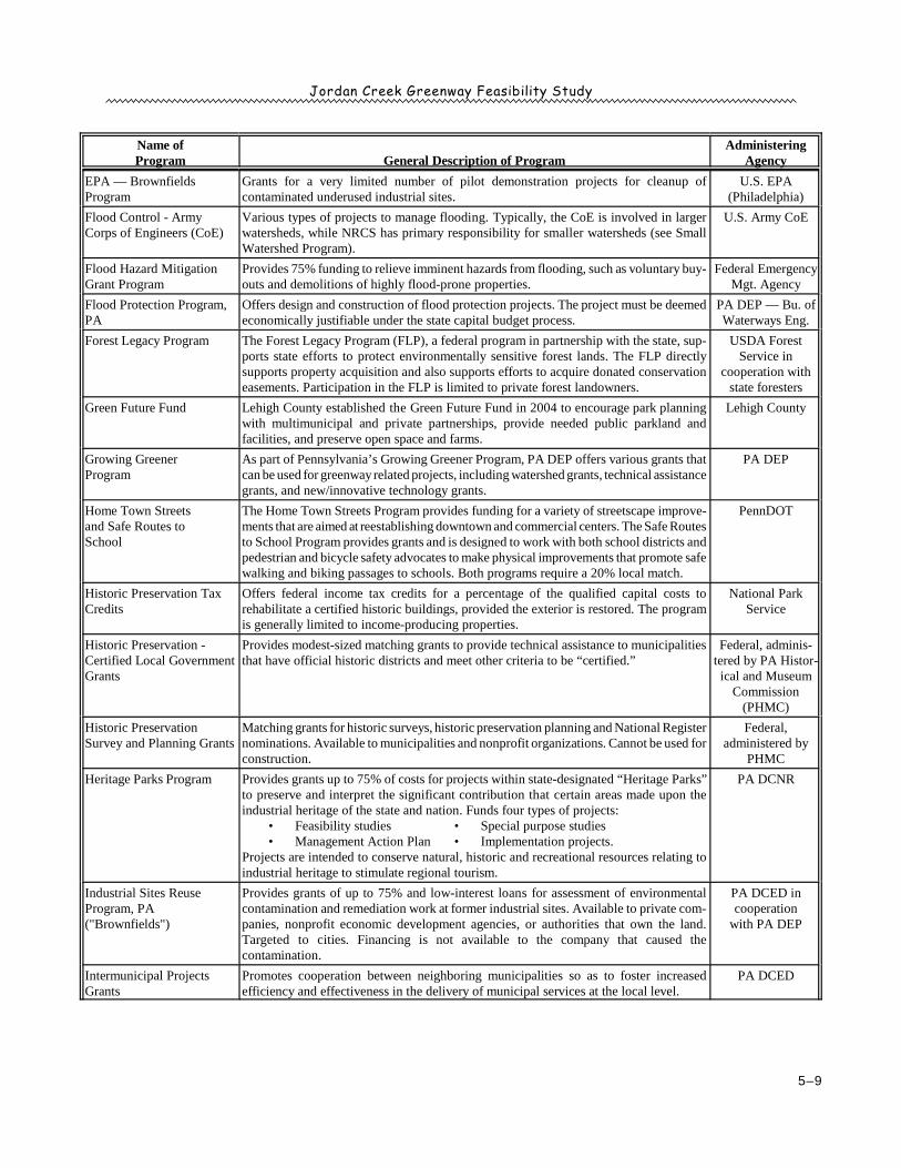
EPA — BrownfieldsProgram
Grants for a very limited number of pilot demonstration projects for cleanup ofcontaminated underused industrial sites.
U.S. EPA(Philadelphia)
Flood Control - ArmyCorps of Engineers (CoE)
Various types of projects to manage flooding. Typically, the CoE is involved in largerwatersheds, while NRCS has primary responsibility for smaller watersheds (see SmallWatershed Program).
U.S. Army CoE
Flood Hazard MitigationGrant Program
Provides 75% funding to relieve imminent hazards from flooding, such as voluntary buy-outs and demolitions of highly flood-prone properties.
Federal EmergencyMgt. Agency
Flood Protection Program,PA
Offers design and construction of flood protection projects. The project must be deemedeconomically justifiable under the state capital budget process.
PA DEP — Bu. ofWaterways Eng.
Forest Legacy Program The Forest Legacy Program (FLP), a federal program in partnership with the state, sup-ports state efforts to protect environmentally sensitive forest lands. The FLP directlysupports property acquisition and also supports efforts to acquire donated conservationeasements. Participation in the FLP is limited to private forest landowners.
USDA ForestService in
cooperation withstate foresters
Green Future Fund Lehigh County established the Green Future Fund in 2004 to encourage park planningwith multimunicipal and private partnerships, provide needed public parkland andfacilities, and preserve open space and farms.
Lehigh County
Growing GreenerProgram
As part of Pennsylvania’s Growing Greener Program, PA DEP offers various grants thatcan be used for greenway related projects, including watershed grants, technical assistancegrants, and new/innovative technology grants.
PA DEP
Home Town Streetsand Safe Routes toSchool
The Home Town Streets Program provides funding for a variety of streetscape improve-ments that are aimed at reestablishing downtown and commercial centers. The Safe Routesto School Program provides grants and is designed to work with both school districts andpedestrian and bicycle safety advocates to make physical improvements that promote safewalking and biking passages to schools. Both programs require a 20% local match.
PennDOT
Historic Preservation TaxCredits
Offers federal income tax credits for a percentage of the qualified capital costs torehabilitate a certified historic buildings, provided the exterior is restored. The programis generally limited to income-producing properties.
National ParkService
Historic Preservation -Certified Local GovernmentGrants
Provides modest-sized matching grants to provide technical assistance to municipalitiesthat have official historic districts and meet other criteria to be “certified.”
Federal, adminis-tered by PA Histor-ical and Museum
Commission(PHMC)
Historic PreservationSurvey and Planning Grants
Matching grants for historic surveys, historic preservation planning and National Registernominations. Available to municipalities and nonprofit organizations. Cannot be used forconstruction.
Federal,administered by
PHMC
Heritage Parks Program Provides grants up to 75% of costs for projects within state-designated “Heritage Parks”to preserve and interpret the significant contribution that certain areas made upon theindustrial heritage of the state and nation. Funds four types of projects:
• Feasibility studies • Special purpose studies• Management Action Plan • Implementation projects.
Projects are intended to conserve natural, historic and recreational resources relating toindustrial heritage to stimulate regional tourism.
PA DCNR
Industrial Sites ReuseProgram, PA("Brownfields")
Provides grants of up to 75% and low-interest loans for assessment of environmentalcontamination and remediation work at former industrial sites. Available to private com-panies, nonprofit economic development agencies, or authorities that own the land.Targeted to cities. Financing is not available to the company that caused thecontamination.
PA DCED incooperation
with PA DEP
Intermunicipal ProjectsGrants
Promotes cooperation between neighboring municipalities so as to foster increasedefficiency and effectiveness in the delivery of municipal services at the local level.
PA DCED
Jordan Creek Greenway Feasibility Study
Name ofProgram General Description of Program
AdministeringAgency
5–10
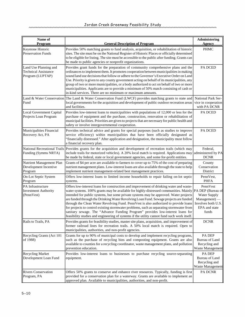
Keystone HistoricPreservation Funds
Provides 50% matching grants to fund analysis, acquisition, or rehabilitation of historicsites. The site must be on the National Register of Historic Places or officially determinedto be eligible for listing. The site must be accessible to the public after funding. Grants canbe made to public agencies or nonprofit organizations.
PHMC
Land Use Planning andTechnical AssistanceProgram (LUPTAP)
Provides grant funds for the preparation of community comprehensive plans and theordinances to implement them. It promotes cooperation between municipalities in makingsound land use decisions that follow or adhere to the Governor’s Executive Order on LandUse. Priority is given to any county government acting on behalf of its municipalities, anygroup of two or more municipalities, or a body authorized to act on behalf of two or moremunicipalities. Applicants are to provide a minimum of 50% match consisting of cash orin-kind services. There are no minimum or maximum amounts.
PA DCED
Land & Water ConservationFund
The Land & Water Conservation Fund (LWCF) provides matching grants to state andlocal governments for the acquisition and development of public outdoor recreation areasand facilities.
National Park Ser-vice in cooperation
with PA DCNR
Local Government CapitalProjects Loan Program
Provides low-interest loans to municipalities with populations of 12,000 or less for thepurchase of equipment and the purchase, construction, renovation or rehabilitation ofmunicipal facilities. Priorities are given to projects that are necessary for public health andsafety or involve intergovernmental cooperation.
PA DCED
Municipalities FinancialRecovery Act, PA
Provides technical advice and grants for special purposes (such as studies to improveservice efficiency) within municipalities that have been officially designated as“financially distressed.” After application and designation, the municipality must followa financial recovery plan.
PA DCED
National Recreational TrailsFunding (Symms NRTA)
Provides grants for the acquisition and development of recreation trails (which mayinclude trails for motorized vehicles). A 20% local match is required. Applications maybe made by federal, state or local government agencies, and some for-profit entities.
Federal,administered by PA
DCNR
Nutrient Management PlanDevelopment IncentiveProgram
Grants of $4 per acre are available to farmers to cover up to 75% of the cost of preparingnutrient management plans. Low-interest loans are also available through the state to helpimplement nutrient management-related best management practices.
CountyConservation
District
On-Lot Septic SystemProgram
Offers low-interest loans to limited income households to repair failing on-lot septicsystems.
PennVest,PHFA
PA InfrastructureInvestment Authority(PennVest)
Offers low-interest loans for construction and improvement of drinking water and waste-water systems. 100% grants may be available for highly-distressed communities. Mainlyintended for public systems, but some private systems may be approved. Water projectsare funded through the Drinking Water Revolving Loan Fund. Sewage projects are fundedthrough the Clean Water Revolving Fund. PennVest is also authorized to provide loansfor projects to control existing stormwater problems, such as separating stormwater fromsanitary sewage. The “Advance Funding Program” provides low-interest loans forfeasibility studies and engineering of systems if the utility cannot fund such work itself.
PennVestPA DEP (Bureau of
Water SupplyManagement) —
Involves both U.S.EPA and state
funds
Rails to Trails, PA Provides grants for feasibility studies, master site plans, acquisition, and improvement offormer railroad lines for recreation trails. A 50% local match is required. Open tomunicipalities, authorities, and non-profit agencies.
DCNR
Recycling Grants (Act 101of 1988)
Grants for up to 90% of municipal costs to develop and implement recycling programs,such as the purchase of recycling bins and composting equipment. Grants are alsoavailable to counties for a recycling coordinator, waste management plans, and pollutionprevention education.
PA DEPBureau of LandRecycling and
Waste Management
Recycling MarketDevelopment Loan Fund
Provides low-interest loans to businesses to purchase recycling source-separatingequipment.
PA DEPBureau of LandRecycling and
Waste Management
Rivers ConservationProgram, PA
Offers 50% grants to conserve and enhance river resources. Typically, funding is firstprovided for a conservation plan for a waterway. Grants are available to implement anapproved plan. Available to municipalities, authorities, and non-profit.
PA DCNR
Jordan Creek Greenway Feasibility Study
Name ofProgram General Description of Program
AdministeringAgency
5–11
Rivers, Trails, andConservation AssistanceProgram
The National Parks service operates this program aimed at conserving land and waterresources for communities. Eligible projects include conservation plans for protectingthese resources, trail development, and greenway development.
National ParkService
Rural Utilities ServiceFinancing
Offers low-interest loans for drinking water and sewage projects for rural areas and smalltowns. The "Water and Water Disposal Loan Program" provides loans for water supply,wastewater disposal, solid waste disposal, and stormwater management systems for ruralareas and towns with a population less than 10,000 persons. Available to municipalities,authorities, and nonprofit corporations. Grants up to 75% of project costs may be avail-able for highly distressed areas. Also guarantee loans by private lenders.• Provides grants to nonprofit organizations to provide technical assistance to ruralcommunities or for a circuit rider to serve several rural water systems. • Offers emergency grants to communities that have experienced a significant decline inquantity or quality of drinking water.
U.S. Dept. of Ag.,Rural Utilities
Service
Shared Municipal Services Provides modest-sized 50/50 matching grants to promote cooperation amongmunicipalities, in order to increase the efficiency of public services. Two or moremunicipalities may apply, or a council of governments.
PA DCED
Sewage Facility PlanningGrants
Grants to pay up to 50% of the costs to prepare a new sewage facilities plan or update anexisting plan, under State Act 537 of 1966.
PA DEP
Small Watershed Program(Public Law 566)
Provides technical and financial assistance in carrying out projects which aim to protectwater resources, provide water-related recreation, or protect against flooding. Eligiblewatersheds must be smaller than 250,000 acres (390 square miles). The program providesup to 100% funding for flood prevention projects, and up to 50% matching foragricultural water management, public recreation, and fish/wildlife purposes. Each year,a state will receive an average of $650,000 for allocation under P.L. 566.
Natural ResourceConservationService (U.S.Department ofAgriculture)
Stormwater ManagementGrants (PA Act 167 of1978)
Grants for cooperative efforts at the watershed level among municipalities for stormwaterplanning and ordinances. Grants are typically made to counties, but may be made tomunicipalities.
PA DEP, Bureau ofWatershed
Conservation
Stream ImprovementProgram
Provides design and construction assistance to eliminate imminent threats to flooding andstreambank erosion.
PA DEP Bureau of Water-ways Engineering
TEA-21 TransportationEnhancements Program (part of federal Transporta-tion Efficiency Act)
Provides grants of up to 80% for: pedestrian and bicycle facilities (including trails),acquisition of scenic easements at scenic or historic sites, development of scenic orhistoric route programs, landscaping and other scenic beautification along highways,restoration of historic transportation facilities (such as canals), preservation of railcorridors (particularly for multiple-use trails), control and removal of outdoor advertising,archeological research, and mitigation of water pollution due to highway runoff. Allprojects must have a direct correlation with transportation.
U.S. DOT fundsadministered by
PennDOT
Urban Forestry Grants Provides grants for tree planting projects. Is also a Federal "America the Beautiful" grantprogram for tree planting.
PA DCNR
Water Supply Plan & Well-head Protection Grants
Provides grants to counties to plan for water supplies at the county level and to implementprograms to protect the wellheads of public wells.
PA DEP, Bureau ofWater Supply
Wetlands Reserve Program The U.S. Department of Agriculture also provides direct payments to private landownerswho agree to place sensitive wetlands under permanent easements. The program can beused to fund the protection of open space and greenways within riparian corridors.
U.S. Department ofAgriculture
(USDA)
Sources: Publications and internet sites of various agencies; Pennsylvanian magazine; PA DCED Resource DirectoryPA DCNR and PA Growing Greener websites, URDC
Jordan Creek Greenway Feasibility Study
5–12
are always changing. New programs are added. Older programs are revised or deleted. Therefore,any potential applicant on behalf of a Jordan Creek Greenway project should contact the administer-ing agency to determine the exact requirements in effect at the time of application.
POTENTIAL PARTNERS
Developing the Jordan Creen Greenway will require cooperation from many diverse interests,including groups in both the private and public sectors. Potential partners in the Jordan Creekprojects include:
1. Municipalities2. Lehigh County3. Lehigh County Conservation District4. Lehigh Valley Planning Commission
5. Conservation and recreation groups6. Landowners7. State agencies8. Other key organizations and individuals
Municipalities
The ten municipalities—elected officials, parks and recreation departments, and other local agen-cies—will be the focus of support for the Jordan Creek Greenway. Successful greenways depend ona strong base of support, which should begin building at the local level.
The Jordan Creek Greenway concept includes a recreational greenway between the Trexler NaturePreserve and Jordan Meadows Park. City of Allentown and the Townships of South Whitehall,Whitehall, and North Whitehall will be the focus of land acquisition for the publicly accessible trail.
Conservation greenways are greenways with limited or no public access that are intended almostexclusively to protect land from development and preserve environmental features. The connectionsin the upstream portion of the Jordan Creek Greenway (north of the Trexler Nature Preserve) are allon-road. Nevertheless, municipalities can enhance the greenway and conserve land through the useof special provisions in zoning ordinances, subdivision and land development ordinances (SALDOs),comprehensive plans, open space plans, and official maps designed to establish and maintainconservation greenways by regulation rather than acquisition. For example, a borough or townshipcan require in the zoning ordinance and SALDO that all 100-year floodplains, 50-foot streambuffers, wetlands, steep slopes, and riparian woodlands remain as open space. The documents canalso include provisions on historic preservation.
Municipalities can also help with education and outreach efforts to promote land conservation. Localnewsletters, posters, and pamphlets can help landowners and residents understand land preservationissues and environmental preservation practices.
Jordan Creek Greenway Feasibility Study
Lehigh Valley Greenways Plan, LVPC, May 2007, p.67, 77-784
5–13
Some municipalities create Environmental Advisory Councils (EACs) to advise the governing bodyregarding conservation, regulation, and development. An EAC is typically a volunteer group withenvironmental professionals and other residents that lend knowledge and experience to better guidethe actions of the municipal government. A municipality can receive up to $5,000 in grant moneyfrom the Pennsylvania Environmental Council to establish an EAC.
Lehigh County
Lehigh County government has a strong presence in several areas related to land preservation,including land use, recreation and environmental planning and management, and economicdevelopment. The county will be an important partner in creating the Jordan Creek Greenwaythrough the work of the following agencies and entities:
• Lehigh County Executive• Lehigh County Commissioners
The executive branch of Lehigh County government can strongly endorse and, perhaps,provide funding in support of the Jordan Creek Greenway. The county also owns some landalong the proposed trail alignment,
• Lehigh Valley Planning Commission
The Lehigh Valley Planning Commission (LVPC) provides planning services for bothLehigh and Northampton Counties. LVPC is a strong supporter of greenways and recentlyprepared the Lehigh Valley Greenways Plan, which identifies the Jordan Creek as both amulti-use and a conservation greenway.4
• Lehigh County Agricultural Conservation Easement Program
The conservation easement program plays an important role in the environmental conser-vation and land preservation aspect of greenways. The easement program is cohoused withthe Lehigh County Conservation District but functions as a separate program that administersagricultural conservation easements in the county.
Conservation and Recreation Groups
Conservancies and recreation organizations often provide the hands-on activism and volunteerismneeded to realize the greenway vision. Conservancies are focused on the issue of land preservationand can solicit support and organize resources targeted to the specific cause. Recreation groups
Jordan Creek Greenway Feasibility Study
5–14
provide an invaluable pool of volunteer effort and typically have goals compatible with those of landconservation efforts. Both types of groups will be instrumental in establishing greenways byadvocating conservation on private land, raising funds, writing grant applications, increasing publicawareness of conservation through events and publications, providing volunteer resources for trailand other conservation projects, and coordinating local and governmental entities. Some of thegroups that may be involved at some point during implementation include the following:
• Wildlands Conservancy• Audubon Society• Trout Unlimited, Lehigh County Chapter• Sierra Club, Pennsylvania Chapter
• Appalachian Mountain Club• Highlands Coalition• Pennsylvania Environmental Council (PEC)• Ironton Rail Trail Oversight Commission
Landowners
Effective greenway planning and implementation must involve all affected landowners. Landownerinvolvement is particularly important for the proposed Jordan Creek Greenway because severalmajor landowners control significant amounts of land in key locations that are critical for the successof the greenway. To date, the key landowners have shown a receptiveness to the greenway concept.
Any proposed action, such as riparian restoration, conservation easements, hiking trails, water trails,or bike routes, can have an impact on a landowner’s well-being and interests. Landowners shouldbe encouraged to support any greenway effort, especially at the conceptual stage, through publicsurveys, public meetings, and inclusion in steering committees.
State Agencies
Many agencies of the Commonwealth of Pennsylvania can be involved in realizing the vision for theJordan Creek Greenway. The following agencies have funding programs available and/or landholdings in the county which can become part of the proposed greenway:
• Department of Conservation and Natural Resources (DCNR) — DCNR is the lead agencyresponsible for implementing the Pennsylvania Greenways Action Plan. Initiated by a governor’sexecutive order in 1998, DCNR’s greenway effort aims to significantly enhance conservation,recreation, and quality of life in Pennsylvania by conserving and enhancing a statewide networkof linear open space and trails. The proposed Jordan Creek Greenway has the potential to connectto a larger network of statewide greenways, including the Appalachian Trail.
• Pennsylvania Game Commission (PGC) — The PGC oversees all hunting regulations statewideand manages all state game lands. State Game Land #205 covers a large area in section 5 of theproposed Jordan Creek Greenway.
Jordan Creek Greenway Feasibility Study
5–15
• Pennsylvania Fish and Boat Commission (PFBC) — The PFBC regulates recreational fishingand boating on all Pennsylvania streams and lakes and provides access points with parking. ThePFBC will be an important contact for helping establish access points to the accessible ripariangreenways along the Jordan Creek. The PFBC is also responsible for trout stocking in portionsof the Jordan Creek.
• Pennsylvania Department of Environmental Protection (DEP) — DEP will have a passive butnecessary role in the implementation of the Jordan Creek Greenway. DEP establishes andenforces environmental regulations that involve storm water and wastewater management,mineral extraction, smokestack venting, vehicle emissions, and development near wetlands andfloodplains. Many DEP regulations are either modeled or referenced in municipal zoning andland development ordinances. Also, in the event of major environmental challenges or disagree-ments, DEP officials may become involved locally.
• Pennsylvania Department of Transportation (PennDOT) — The owner and maintenance entityof all state-owned roads will be a major stakeholder when pursuing crossings for the off-roadtrail and the auto/bike/hike portion of the trail north of the Trexler Nature Preserve. PennDOTapproval is necessary when considering trail crossings or bike lanes in state road right-of-ways.The agency also oversees the distribution of certain grant monies for trail and path construction,including TEA-21 (Table 5.2).
• Pennsylvania Department of Community and Economic Development (DCED) — The DCEDcan provide guidance and funding for community revitalization and redevelopment projects inthe county as well as historic rehabilitation and interpretation efforts. Grants from DCED canalso be used for establishing auto touring routes or any other tourism-related project.
• Pennsylvania Historical and Museum Commission (PHMC) — Created in 1945 as the officialhistory agency of the commonwealth, PHMC is responsible for the collection, conservation, andinterpretation of Pennsylvania’s heritage, accomplished through the Bureau for Historic Preser-vation, the Pennsylvania State Archives, the State Museum of Pennsylvania, and the Pennsylva-nia Trail of History. The agency also maintains a comprehensive database of historic resourcesstatewide, and will be an important contact when seeking additional recognition and protectionof any historic resources in the county.
Other Key Organizations and Individuals
Many other organizations and individuals will play key roles in supporting the proposed JordcanCreek Greenway. The following examples illustrate the breadth of interests that greenways canattract.
Jordan Creek Greenway Feasibility Study
5–16
• Local businesses and corporations — Local businesses are often a good source of cash dona-tions and volunteer efforts. Many local businesses are also important members of the community,and the approval of local businesses is often just as important to successful greenway efforts asthe support of individual landowners.
• Chambers of Commerce and tourism bureaus — The Lehigh Valley Convention and VisitorsBureau, local merchant groups, and other business associations are strong partners that can helpto publicize greenway elements, such as the proposed off-road trail, the complete trail, and keyhubs, such as the Trexler Nature Preserve. Like a DCED, a chamber of commerce publicizeslocal amenities to foster economic growth in an area. Tourism bureaus promote the sameamenities to draw visitors to the area. Occasionally, the organizations will provide funding forefforts that support economic growth.
• Volunteer organizations — During and after the development of the Jordan CreekGreenway/Trail, volunteer efforts will be necessary to help maintain the trails and assist withinterpretive materials and events. Many groups can be enlisted for supporting projects, includingthe conservation and recreation groups listed above as well as youth organizations, such as theBoy Scouts, Girl Scouts, church groups, and extracurricular school groups.
• Land developers — Throughout the development review process, municipal officials, conserva-tion groups, and the general public should meet with developers to assure that new develop-ments:
— Respect sensitive natural features.— Leave ample buffers along streams.— Adequately control storm water and erosion.— Allow for connectivity of open space.— Facilitate the building of any proposed recreation trails. — LVPC and other agencies should continue to educate developers on innovative, environment-
ally-conscious practices, such as open space development and traditional neighborhooddevelopments.
Jordan Creek Greenway Feasibility Study
Appendices
A Study Committee/Public Meetings
B Appalachian Trail Conservancy (ATC)Policy on Side/Connecting Trails
C Trail Design Guidelines
D Stream Restoration Proposal

Jordan Creek Greenway Feasibility Study
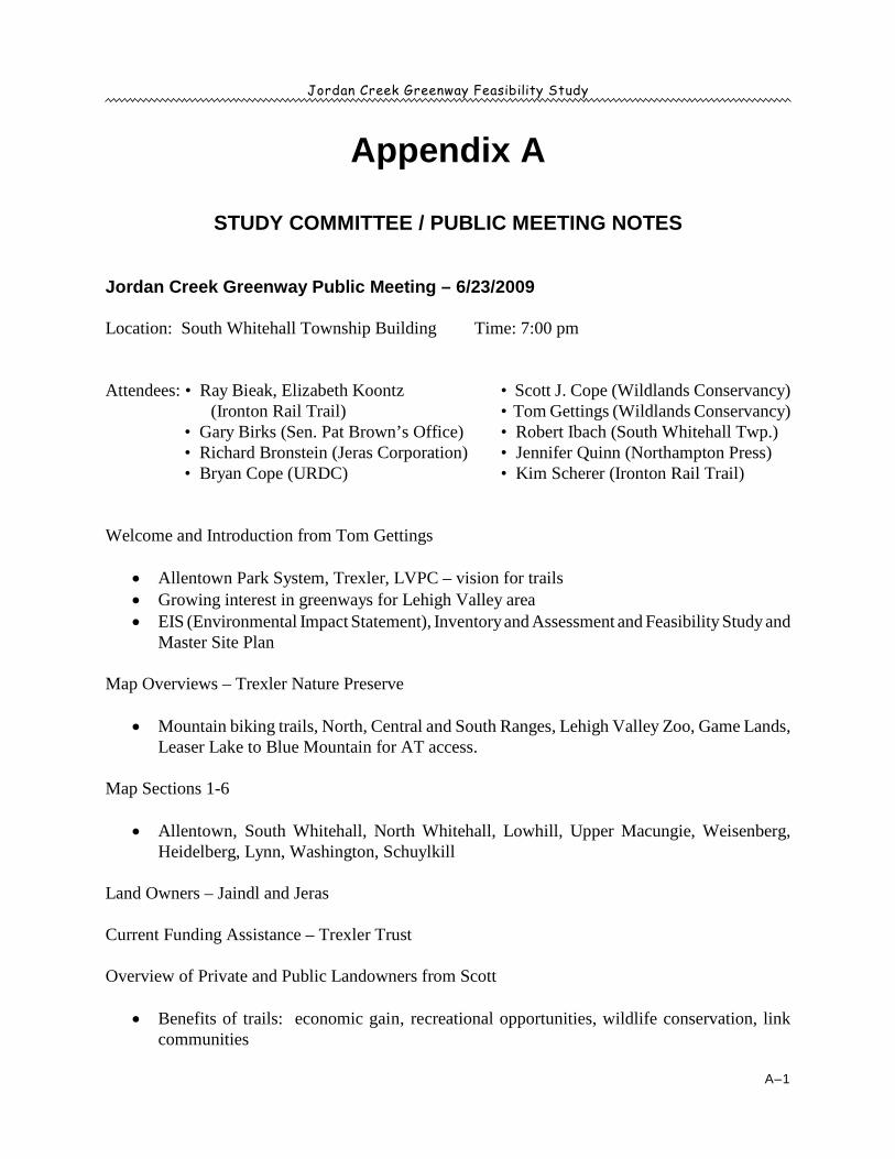
Jordan Creek Greenway Feasibility Study
A–1
Appendix A
STUDY COMMITTEE / PUBLIC MEETING NOTES
Jordan Creek Greenway Public Meeting – 6/23/2009
Location: South Whitehall Township Building Time: 7:00 pm
Attendees: • Ray Bieak, Elizabeth Koontz (Ironton Rail Trail)
• Gary Birks (Sen. Pat Brown’s Office)• Richard Bronstein (Jeras Corporation)• Bryan Cope (URDC)
• Scott J. Cope (Wildlands Conservancy)• Tom Gettings (Wildlands Conservancy)• Robert Ibach (South Whitehall Twp.)• Jennifer Quinn (Northampton Press)• Kim Scherer (Ironton Rail Trail)
Welcome and Introduction from Tom Gettings
· Allentown Park System, Trexler, LVPC – vision for trails· Growing interest in greenways for Lehigh Valley area· EIS (Environmental Impact Statement), Inventory and Assessment and Feasibility Study and
Master Site Plan
Map Overviews – Trexler Nature Preserve
· Mountain biking trails, North, Central and South Ranges, Lehigh Valley Zoo, Game Lands,Leaser Lake to Blue Mountain for AT access.
Map Sections 1-6
· Allentown, South Whitehall, North Whitehall, Lowhill, Upper Macungie, Weisenberg,Heidelberg, Lynn, Washington, Schuylkill
Land Owners – Jaindl and Jeras
Current Funding Assistance – Trexler Trust
Overview of Private and Public Landowners from Scott
· Benefits of trails: economic gain, recreational opportunities, wildlife conservation, linkcommunities
Jordan Creek Greenway Feasibility Study
A–2
Questions and Comments/Open Discussion
· Location of Jordan Creek; adjacent to proposed trail, except for loops in North Whitehall,Lowhill, etc.
· Comments on other trails; Schuylkill, Perkiomen, etc.· Trespassing issues; ATV’s parties, etc. (Ironton Rail Trail – no real issues anymore, after
more people use a trail, it becomes safer “word of mouth.”)· Thanks to Senator Browne – becoming more aware of benefits and increased use of trails
“pocket parks” and in-between locations – Railroads, Canal Towpaths, etc. · Jordan Creek Greenway – Are there other trail systems within the area along other small
tributaries, i.e. Hokey Creek, Fells Creek, Little Lehigh, etc.· Lower Macungie Township Regional Trails System – grant application submitted· Easton to Blue Mountain Trail
Next Steps: (after Public Meeting)
· Change proposed route(s) where necessary· Revise current feasibility study and master site plan· Final draft published
Final Comments, Thank You and Departures
· Public meeting this Fall on site· LVPC compiling trail map of Lehigh Valley locations· “Lehigh Valley Top 10 missing gaps” for trail connection
Jordan Creek Greenway Feasibility Study
A–3
Jordan Creek Greenway Steering Committee Meeting — 3/3/2009
Location: South Whitehall Township Building Time: 3pm – 4:30pm
Attendees:• Scott J. Cope (Wildlands Conservancy)• Lee Creyer (PA Fish & Boat Waterways)• Tim Dugan (DCNR)• Erin Frederick (Lehigh Co. Conservation District)• Tom Gettings (Wildlands Conservancy)• Bernie Harris (Allentown Hiking Club)• Ed Hozza, Jr. (Whitehall Twp.)
• Bob Ibach (South Whitehall Twp.)• Stacey Johnson (Lehigh Valley Zoo)• Gene Scharle (Allentown Hiking Club)• Ron Stahley (North Whitehall Twp.)• Dan Stonehouse (Heidelberg Twp.)• Greg Weitzel (City of Allentown)
· Displayed 4 Jordan Creek Greenway (JCG) Maps on left side wall- 1. JCG Corridor, 2. JCG Generalized Land-Use, 3. JCG Overview Trail Detail
and 4. Land Ownership along Trail Corridor
· Created a sign-in sheet to record the steering committee member attendance· Passed around 2 copies of the JCG Feasibility Study for members to peruse before
meeting begins· Meet and Greet approximately 20 minutes from 3-3:20pm, while members continue to
show-up
· Welcome and brief introduction from Tom:· Credited DCNR & LVPC for most recent version of JCG Feasibility Study, Final Draft:
March 2009· JCG Feasibility Study from DCNR & LVPC almost like a Master Site Plan, pleased with
final draft· Overview of JCG Maps on display, 6 sections from Allentown to Lynn & Heidelberg
Townships: 30+ miles- Jordan Meadows to Trexler (connect to D&L trail?)- Trail becomes difficult at Lynn & Heidelberg Townships, up to Leaser Lake- Ended trail by Bake Oven Knob (bike access ends, need bike racks/permanent
structure)- Leaser Lake to Appalachian Trail, pedestrian access only
· Each Section is broken –up into a cost-per-section w/ details of implementation for each;Section 1: Allentown, Section 2-3: North Whitehall – Trexler, Section 4: Trexler, Section5: PA Game Lands, Section 6: Lynn – Heidelberg Townships
· Opened up the floor for comments/concerns/questions:- Proposed timeline: 5-10 years- Approximate cost estimate: $5 million
Jordan Creek Greenway Feasibility Study
A–4
- South Whitehall Twp Comprehensive Plan is pending: private landowners want towait for this study (Jaindl & Jeras)
- Rex Bridge by Kids Peace determined a loophole w/ private property acrossJordan in floodplain for a foot bridge
- Cedar Crest crossing issues- Funding: Approached Trexler Trust, Trustees view JCG as a continuation of Gen.
Trexler’s original vision for “parks and preserve system”- Home Depot: Coplay Twp facilities are planning construction project w/
Whitehall Sewage Authority – contact Dave- Rte. 22 & Mickley Road: Restoration at stream crossing, good opportunity for
trail implementation- Slatington Borough Rail Trail: Feasibility Study for Emerald, Washington,
Heidelberg, Lynn & Wanamaker- Old Reading Rail Bed: a connection to Slatington’s Slate Heritage Trail
· Thanks for coming and brief overview of Implementation Phase from Scott:· Needs a resolution from each municipality w/ needs: formal adoption w/ plans & support
letters w/in 30-45 days· N. Whitehall, S. Whitehall & Heidelberg Townships want copies of maps and Feasibility
Study final draft when available- Entire group feels that the steering committee should include townships,
landowners and stakeholders- Are site plans available for individual sections (1-6) w/ entire length, specific trail
lengths, etc. (each 10-20 miles)- Trails will be implemented as funds are available, not necessarily in order from
section 1 to section 6
· A Penn Dot Traffic Study is underway at Mauch Chunk intersection by Jordan Creekcrossing
· Must Consider the flood plain along the Jordan: ice flows and floods· PA Fish and Boat Commission have removed dams in the past to prevent damage from
ice flows/floods- Kernsville Dam increases ice/flooding and Wehr’s Dam is problematic, yet too
iconic to locals· JCG is highlighted in DCNR’s priority projects – Green Future’s Fund can be matched by
DCNR grant· Entire group agreed on regular Quarterly meetings and nobody opposed public meeting(s)
· Next Twp Meetings:- North Whitehall: March 16- South Whitehall: Last Monday in March- Whitehall Twp: Last Wednesday in March- Heidelberg, Lynn & Lowhill: First Tuesday each month

Jordan Creek Greenway Feasibility Study
A–5
· Dan Stonehouse @ Heidelberg Twp wants a copy of the JCG Feasibility Study – will pickup from WC on 3/4/2009 at 4:30pm
· Bob Iback is checking the schedule for the South Whitehall Twp Building meeting roomfor next JCG Steering Committee meeting and public meeting(s): Monday, April 6 at7pm-8pm > canceled, want to meet with Jaindl and Jeras first, need to reschedule…
· Ask Bob Iback for Penn Dot contact for Traffic Study being conducted at Mauch ChunkRoad intersection by Jordan Creek
- Left a message for Bob to contact Scott with Penn Dot information…
Jordan Creek Greenway Feasibility Study
A–6
Jordan Creek Greenway Public Meeting — 6/6/07
Spoke withGordon Hamm ([email protected]), 6/6/07Current Volunteer and past member of the Ironton Rail-Trail Oversight Commission
Ironton Rail-Trail
Ironton Rail-Trail Commission:
· Formal structure with by-laws· Reps from all 3 municipalities - % of reps depends on length of trail in each municipality· Alternates for each rep so that if rep doesn’t make it, they can still have a quorum· Meets the 3 Tuesday of each monthrd
· Open to the public· www.irontonrailtrail.org
Miscellaneous:
· “People love it.”· Used as a marketing tool when people sell their homes
Issues:
Vandalism:
· Runs in rashes, usually when school lets out and then resumes· Signs stolen and posts destroyed· Addressed right away· Has gotten less each year
Trash:
· Addressed right away· Has gotten less each year
Liability Insurance:
· Townships hold liability insurance policy
Wildlife and Wildlife Habitat Disturbance:
· Hasn’t been an issue
Jordan Creek Greenway Feasibility Study
A–7
Noise:
· Hasn’t been an issue
Maintenance:
· Friends of the Ironton Rail-Trail· Commitment from each municipality· Usually volunteers clean up (i.e., cut up a fallen tree or collect trash) and the municipality
comes through with a truck and picks up the piles· Volunteer Maintenance Days· Boy and Girl Scouts groups
Improvements:
· Boy and Girl Scouts groups· Eagle Scouts – currently have about 30 projects going· Grants – need grant writer – money out there – they’ve never been denied a grant
Survey Results To-Date:
· Total of 323 surveys mails (original number of 365 reduced by returns) to adjacent andnearby landowners
· 14 surveys received to-date – 4.33% return· 5 females & 9 males filled in the survey· 57% are in the 45-54 age group; 29% in the 55-64 age group; 7% each in the 65-74 and
75 & over age groups· Question 1: 85% visit municipal, county or state parks· Question 3: 79% participate in recreational activities on a regular basis· Question 9: 57% were not concerned about the trail
Concerns expressed included parking, maintenance, security, floods, ice disturbance, disturbedwildlife, liability issues and loss of privacy
Jordan Creek Greenway Feasibility Study
A–8
Jordan Creek Greenway Steering Committee Meeting — March 29, 2007
Attendees: • Heather Carrington• Jan Creedon• Tim Dugan• Tom Gettings• Bob Ibach
• Stacey Johnson• Chris Kocher• Debra Lermitte• Barry Mantz• Greg Weitzel
Main Issues Discussed:
· Steering Committee’s role in the project· Review of project scope of work· Maps and slide show of possible trail location· Phases, specifics, and challenges· Next steps
Steering Committee’s Role in the Project:
· Active and advisory· Tie-in with existing and proposed projects in their municipality.· Public interaction
Phases, Specifics, and Challenges:
· Phases – will be phased over time in three stageso Phase I – Trexler Nature Preserve to Covered Bridge Parko Phase II – Covered Bridge to Jordan Creek Parkwayo Phase III – Jordan Creek Parkway to Jordan Parko Phase IV – Jordan Park to Incinerator Parko Phase V – Trexler Nature Preserve to the Appalachian Trail and Leaser Lake
· Northern Lehigh County Multi-municipal Park, Recreation, and Open Space Plan (Lynn,Heidelberg, Lowhill, Weisenberg, and Washington Townships, ad Slatington Borough)will take into consideration this feasibility study.
· North Whitehall and South Whitehall upgrading Park, Recreation, and Open Space Plansin order to combine them. There is the potential of a connection with the Ironton Rail-Trail.
· South Whitehall Township – replacing the bridge is on PennDot’s “fast-track” and thiswill affect the trail crossing Minnich Road. Bob Ibach will keep the Conservancyupdated.
· Jeras Corporation pipeline near Cedar Crest. Questions were raised as to where thepipeline goes and if there is an associated right-of-way that could be used as a trail.
Jordan Creek Greenway Feasibility Study
A–9
· City of Allentown has PA. Department of Conservation and Natural Resources grant of$80,000 to conduct a city-wide trail feasibility study. They will look at the Jordan CreekGreenway/Trail connection.
· Feasibility study will look at connectivity to nearby trails and impact on
Next steps:
· E-mail contact list to Steering Committee (Wildlands Conservancy)· Develop a key stakeholders interview list (Wildlands Conservancy and Steering
Committee)· Conduct meetings with major landowners (Johnson, Jeras, Jaindl) in order to move Phase
I and II forward (Wildlands Conservancy)· List of landowner contact information for Heidelberg Township (Heidelberg Township)· Develop a survey to mail to adjacent and nearby landowners (Wildlands Conservancy and
Steering Committee)· 1 Public Hearing – May or Junest
· Determine next meeting date

Jordan Creek Greenway Feasibility Study
A–10
This page intentionally blank.
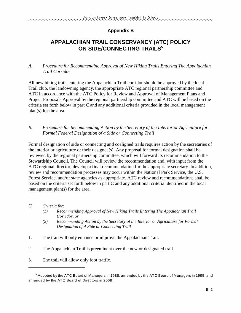
Jordan Creek Greenway Feasibility Study
Adopted by the ATC Board of Managers in 1988, amended by the ATC Board of Managers in 1995, and5
amended by the ATC Board of Directors in 2008
B–1
Appendix B
APPALACHIAN TRAIL CONSERVANCY (ATC) POLICYON SIDE/CONNECTING TRAILS5
A. Procedure for Recommending Approval of New Hiking Trails Entering The AppalachianTrail Corridor
All new hiking trails entering the Appalachian Trail corridor should be approved by the localTrail club, the landowning agency, the appropriate ATC regional partnership committee andATC in accordance with the ATC Policy for Review and Approval of Management Plans andProject Proposals Approval by the regional partnership committee and ATC will be based on thecriteria set forth below in part C and any additional criteria provided in the local managementplan(s) for the area.
B. Procedure for Recommending Action by the Secretary of the Interior or Agriculture forFormal Federal Designation of a Side or Connecting Trail
Formal designation of side or connecting and coaligned trails requires action by the secretaries ofthe interior or agriculture or their designee(s). Any proposal for formal designation shall bereviewed by the regional partnership committee, which will forward its recommendation to theStewardship Council. The Council will review the recommendation and, with input from theATC regional director, develop a final recommendation for the appropriate secretary. In addition,review and recommendation processes may occur within the National Park Service, the U.S.Forest Service, and/or state agencies as appropriate. ATC review and recommendations shall bebased on the criteria set forth below in part C and any additional criteria identified in the localmanagement plan(s) for the area.
C. Criteria for:(1) Recommending Approval of New Hiking Trails Entering The Appalachian Trail
Corridor, or (2) Recommending Action by the Secretary of the Interior or Agriculture for Formal
Designation of A Side or Connecting Trail
1. The trail will only enhance or improve the Appalachian Trail.
2. The Appalachian Trail is preeminent over the new or designated trail.
3. The trail will allow only foot traffic.

Jordan Creek Greenway Feasibility Study
B–2
4. The trail will provide significant access to the Appalachian Trail or between the Trail andsignificant scenic, natural, or cultural resources and/or Trail facilities.
5. The Appalachian Trail will take precedence on trail signing and marking.
6. Dual marking will be avoided on any new coaligned trail; however, other trails may beidentified on A.T. signs. ATC also will work to establish this standard for existingcoaligned trails.
7. A.T. managers will cooperate in developing standards for construction, design, andmaintenance of trails that intersect the Appalachian Trail. ATC will encourage adoptionof standards that protect resource values and prevent environmental damage in a mannerconsistent with resource protection on the Appalachian Trail.
Jordan Creek Greenway Feasibility Study
Flink, Charles A. and Robert M. Searns. Greenways, A Guide to Planning, Design and Development. Island Press,6
Washington, D.C. 1993. P 198.
C–1
Appendix C
TRAIL DESIGN GUIDELINES
The proposed Jordan Creek Greenway/Trail may vary from primitive earthen tracks to gravel,graded pathways. The northern portion of the trail will also include shared roadways on low-volume roads. Trail users will include both hikers and bicyclists, and, perhaps, equestrians insome portions of the trail. When designing a trail, layout, surface, road crossings, signs,landscaping, and other infrastructure are all important considerations.
The following information should serve as a guide for municipalities that will be spearheadingthe implementation of the Jordan Creek Greenway/Trail. The municipalities should work closelywith Lehigh County and surrounding municipalities to develop a cohesive, multimunicipal trail.
TRAIL LAYOUT
Trail layout should be sensitive to the environment the greenway intends to preserve. The trailshould be compatible with the natural landscape and follow elevation contours where possible. Ifthe trail cannot accommodate the intended user groups without having a negative impact onsurroundings, the location and design of the trail should be reevaluated. The trail should also berouted to increase environmental awareness, and be built and maintained in a sustainable, cost-effective, and timely fashion. Improper trail implementation can lead to long-term maintenanceproblems, which are often difficult to fix.6
Trails should also be compliant with design criteria established by the Americans withDisabilities Act (ADA). At this time, trails must meet the following technical provisions in orderto be considered accessible:
• Surface - the trail surface shall be firm, stable and slip resistant• Clear Tread Width - 36" minimum• Tread Obstacles - 2" high maximum (up to 3" high where running and cross slopes are
5% or less)• Cross Slope - 5% maximum• Passing Space - provided at least every 1,000' where the trail width is less than 60" (5'-0")• Signs - shall be provided indicating the length of accessible trail segment• Running Slope (trail grade) shall meet one or more of the following:• 5% or less for any distance• Up to 8.33% for 200' maximum with resting intervals no more than 200' apart
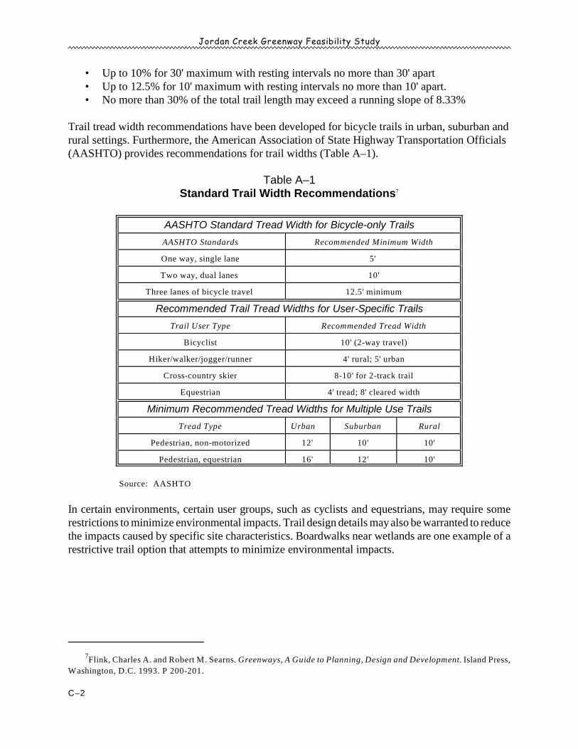
Jordan Creek Greenway Feasibility Study
Flink, Charles A. and Robert M. Searns. Greenways, A Guide to Planning, Design and Development. Island Press,7
Washington, D.C. 1993. P 200-201.
C–2
• Up to 10% for 30' maximum with resting intervals no more than 30' apart• Up to 12.5% for 10' maximum with resting intervals no more than 10' apart.• No more than 30% of the total trail length may exceed a running slope of 8.33%
Trail tread width recommendations have been developed for bicycle trails in urban, suburban andrural settings. Furthermore, the American Association of State Highway Transportation Officials(AASHTO) provides recommendations for trail widths (Table A–1).
Table A–1Standard Trail Width Recommendations7
AASHTO Standard Tread Width for Bicycle-only Trails
AASHTO Standards Recommended Minimum Width
One way, single lane 5'
Two way, dual lanes 10'
Three lanes of bicycle travel 12.5' minimum
Recommended Trail Tread Widths for User-Specific Trails
Trail User Type Recommended Tread Width
Bicyclist 10' (2-way travel)
Hiker/walker/jogger/runner 4' rural; 5' urban
Cross-country skier 8-10' for 2-track trail
Equestrian 4' tread; 8' cleared width
Minimum Recommended Tread Widths for Multiple Use Trails
Tread Type Urban Suburban Rural
Pedestrian, non-motorized 12' 10' 10'
Pedestrian, equestrian 16' 12' 10'
Source: AASHTO
In certain environments, certain user groups, such as cyclists and equestrians, may require somerestrictions to minimize environmental impacts. Trail design details may also be warranted to reducethe impacts caused by specific site characteristics. Boardwalks near wetlands are one example of arestrictive trail option that attempts to minimize environmental impacts.
Jordan Creek Greenway Feasibility Study
Flink, Charles A., Kristine Olka and Robert M. Searns. Trails for the Twenty-First Century. Island Press,8
Washington, D.C. 2001. P 62-65.
C–3
TRAIL CONSTRUCTION
A highly-developed trail is made of three components: the sub-grade, the sub-base and the trailsurface. The sub-grade is the trail's foundation, which is made up of the native soils that bears theload generated by trail users. The sub-base distributes the weight of the trail surface and users to thesub-grade. The trail surface is the point of contact between the trail and the users. The surface canbe either soft or hard, depending on its ability to absorb or repel water.
Sub-grade
The sub-grade provides the foundation for the trail to be developed. Any imperfections in the sub-grade will eventually become apparent in the final trail surface. The characteristics of the sub-gradethat provide a good foundation are susceptibility to freezing, weight bearing, and shrink/swellcharacteristics. Adequate drainage is a requirement to maintain a sound sub-grade and can beaccomplished with surface or sub-surface drainage systems, or a combination of the two. 8
Sub-base
The sub-base distributes the load of the trail surface and trail users to the sub-grade and providesdrainage. The design load of the trail, or the maximum weight able to be carried by the trail, alongwith the type of material used for the sub-base and the use of geotextiles, will determine the depthof the sub-base necessary.
Trail Surface
The surface of the trail can be constructed of either soft or hard materials. Soft materials are definedas those that are able to absorb moisture, such as earth and wood chips. Hard materials repelmoisture and include crushed stone, bituminous concrete, soil cement, resin-based stabilized materialand concrete. The type of trail surface can encourage or discourage different types of use. Trailssurfaced with soft materials are preferred by equestrians because horses are less susceptible to injuryon soft materials. Hard materials with a smooth finished surface such as bituminous concrete arepreferred by inline skaters as more conducive to the sport. The surface of the trail (Table A–2)should be chosen conservatively when first installed and can be upgraded as use and demandincrease.
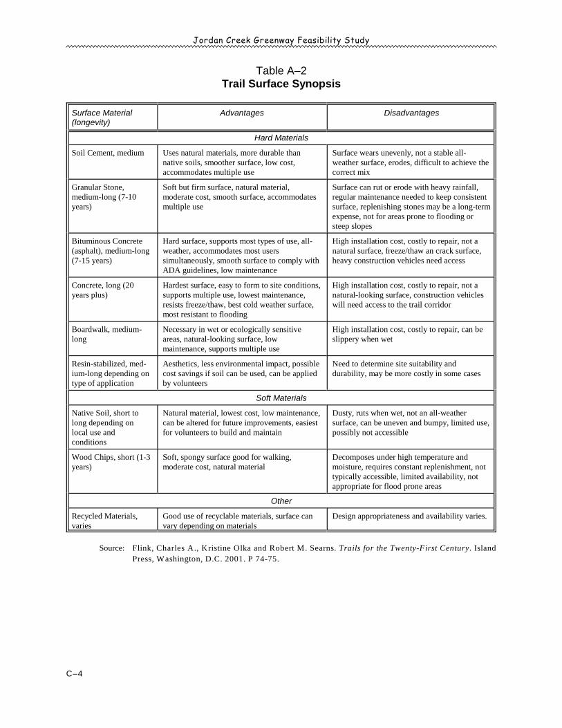
Jordan Creek Greenway Feasibility Study
C–4
Table A–2Trail Surface Synopsis
Surface Material(longevity)
Advantages Disadvantages
Hard Materials
Soil Cement, medium Uses natural materials, more durable thannative soils, smoother surface, low cost,accommodates multiple use
Surface wears unevenly, not a stable all-weather surface, erodes, difficult to achieve thecorrect mix
Granular Stone,medium-long (7-10years)
Soft but firm surface, natural material,moderate cost, smooth surface, accommodatesmultiple use
Surface can rut or erode with heavy rainfall,regular maintenance needed to keep consistentsurface, replenishing stones may be a long-termexpense, not for areas prone to flooding orsteep slopes
Bituminous Concrete(asphalt), medium-long(7-15 years)
Hard surface, supports most types of use, all-weather, accommodates most userssimultaneously, smooth surface to comply withADA guidelines, low maintenance
High installation cost, costly to repair, not anatural surface, freeze/thaw an crack surface,heavy construction vehicles need access
Concrete, long (20years plus)
Hardest surface, easy to form to site conditions,supports multiple use, lowest maintenance,resists freeze/thaw, best cold weather surface,most resistant to flooding
High installation cost, costly to repair, not anatural-looking surface, construction vehicleswill need access to the trail corridor
Boardwalk, medium-long
Necessary in wet or ecologically sensitiveareas, natural-looking surface, lowmaintenance, supports multiple use
High installation cost, costly to repair, can beslippery when wet
Resin-stabilized, med-ium-long depending ontype of application
Aesthetics, less environmental impact, possiblecost savings if soil can be used, can be appliedby volunteers
Need to determine site suitability anddurability, may be more costly in some cases
Soft Materials
Native Soil, short tolong depending onlocal use andconditions
Natural material, lowest cost, low maintenance,can be altered for future improvements, easiestfor volunteers to build and maintain
Dusty, ruts when wet, not an all-weathersurface, can be uneven and bumpy, limited use,possibly not accessible
Wood Chips, short (1-3years)
Soft, spongy surface good for walking,moderate cost, natural material
Decomposes under high temperature andmoisture, requires constant replenishment, nottypically accessible, limited availability, notappropriate for flood prone areas
Other
Recycled Materials,varies
Good use of recyclable materials, surface canvary depending on materials
Design appropriateness and availability varies.
Source: Flink, Charles A., Kristine Olka and Robert M. Searns. Trails for the Twenty-First Century. Island
Press, Washington, D.C. 2001. P 74-75.
Jordan Creek Greenway Feasibility Study
Flink, Charles A., Kristine Olka and Robert M. Searns. Trails for the Twenty-First Century. Island Press,9
Washington, D.C. 2001. P 85-88.
C–5
Simple Hiking Trails
More rugged trails need not follow all of the above-mentioned design guidelines. Trails intended forwalking (and in some cases, equestrian, mountain bike, and bicycle use) could be kept in a primitivestate, with natural surfaces three to four feet wide. The trail surface may be completely unimproved,consisting of native soil, grasses, forest litter, and occasional bedrock. Muddy sections may betreated with wood mulch or small, compacted logs.
Unlike the highly-developed recreation trails, simple hiking trails can be built largely with volunteerlabor. Regular maintenance will ensure that the hiking trails are not blocked by fallen trees, over-grown with vegetation, erosion, or flooding.
CROSSINGS9
Trails may cross roads or rail lines at-grade, above-grade or below-grade. At-grade crossings are themost common although certain situations may present the opportunity to provide a bridge or tunnel.Crossings are site specific and require careful evaluation and planning.
At-Grade
The most ideal at-grade road crossing will experience very light traffic or provide a traffic signal thatcan be activated by trail users to allow for safe passage. A professional should be employed toevaluate the intersection and establish a safe method of crossing. Ideally, the crossing should takeplace as close to an intersection as possible, preferably in the location of the crosswalk. "TrailCrossing" signs should be installed along the road and, if necessary:
• A painted crosswalk should be installed. • Curb cuts should be as wide as the trail itself. • Access to the trail can be controlled if the need arises. The most common method is the
installation of bollards, which can be removable or hinged to allow access for authorizedvehicles, such as emergency and maintenance vehicles, while preventing unauthorizedvehicle access to the trail. Another effective vehicle barrier are gates extending completelyacross the trail. Barriers preventing unauthorized vehicle access must be easily visible underall conditions to avoid becoming a hazard and otherwise conflicting with trail use. Barriersshould be placed on straightaways instead of curves in order to maintain satisfactory sightdistance. Barriers should meet current ADA guidelines and allow for ease of trail use byusers with disabilities.
Jordan Creek Greenway Feasibility Study
Flink, Charles A., Kristine Olka and Robert M. Searns. Trails for the Twenty-First Century. Island Press,10
Washington, D.C. 2001. P 88-93.
C–6
Alternative methods to alert users of an intersection include warning signs, a change in surfacepavement, or a centerline along paved trails. Stop signs should be placed 4–5 feet from the road toallow time for users, especially cyclists, to stop. Site stopping distances should be evaluated by aprofessional, and adequate warning should be given to allow cyclists to stop. AASHTO guidelines,which incorporate curves, slopes, and other factors, have been developed to help determine thenecessary warning distances needed for cyclists to stop.
Above- or Below-Grade Crossings
Crossing above- or below-grade minimizes conflicts between trail users and vehicles but can alsobe very costly. When dealing with roadways that have a large volume of high-speed traffic, the onlyfeasible alternative may be an above- or below-grade crossing. Above-grade crossings, such aspedestrian overpasses, are perceived to be less threatening and safer by users than below-grade cross-ings, or tunnels. Above-grade crossings can be extremely expensive and may require long accessramps in order to meet ADA requirements.
Railroad Crossings
Any proposed railroad crossings must be safe. If an at-grade railroad crossing is necessary, the trailshould cross perpendicular to the tracks to prevent the front tire of a bicycle or in-line skate frombecoming lodged in the track. If a right angle crossing is not possible, another safety alternativeshould be used, such as:
• A compressible flangeway filler could be installed to reduce the chance of an accident for acyclist.
• The trail could be widened, giving cyclists the opportunity to approach the crossing at a rightangle to the tracks.
Signs requiring cyclists to dismount when crossing the tracks, which would be used in conjunctionwith track crossing warning signs, should also be installed. The railroad company must be consultedprior to installing any crossing.
SIGNS FOR GREENWAY TRAILS10
Signs portray vital information and play an important role in the success of greenway trails. Signscan serve to regulate, warn, inform, and educate trail users. The U.S. Department of Transportation'sFederal Highway Administration (FHWA) has outlined the size, shape and color criteria for signs

Jordan Creek Greenway Feasibility Study
One good example of a plan for consistent signage is the signage manual developed for the Schuylkill11
River Heritage Area in Montgomery and Berks Counties, Pennsylvania.
C–7
in the Manual on Uniform Traffic Control Devices (MUTCD). Where feasible, and to reduceexposure to liability and promote safe trail use, the standard color and shapes should be followed.Signs need to be designed and placed appropriately within the greenway but done so in a manner thatdoes not lead to cluttering of the landscape. The materials chosen for a sign system should beconsistent and take into account budget, aesthetics, durability, and maintenance costs. Some optionsfor materials include plastics, fiberglass, wood, aluminum, steel, brass, bronze, stone, fabric andrecycled products. Selected materials should give the sign prominence but still blend well with thesurrounding environment.
Identification and Directional Signs
Creating a uniform signage system will help define the identity of the trail system. Lehigh County,through the Lehigh Valley Planning Commission, should help municipalities develop uniform identi-fication signage for the Jordan Creek Greenway Trail within the municipality. Directional signsshould be used in conjunction with route identification signs, providing distances and directionalarrows to nearby destinations.11
Regulatory Signs
Regulatory signs describe the laws and regulations that apply within the greenway, such as stopsigns, speed limit signs, and permitted use signs. Regulatory signs are usually posted where theregulation applies.
Warning Signs
Warning signs inform the users of existing or potentially hazardous conditions along the trail andare mounted prior to the condition to allow time to make the necessary preparations, such asreducing speed. Signs should be used near intersections, bridges and tunnels. Warning signs can alsobe used to bring attention to changes in the trail’s grade or surface.
Educational Signs
Educational signs point out areas of interest that make the trail unique, including natural or culturalfeatures. Interpretive displays for greenways can provide educational information about the signifi-cant environmental or historic qualities of the area. Educational signs, often more detailed and ornatethan other signs, should be made of weather-proof materials. Sign placement along the trail isimportant because a poorly located sign may not properly inform the trail user and could become
Jordan Creek Greenway Feasibility Study
The importance of communication in public/private greenway projects is almost universal. See, for example, Flink,12
Charles A. and Robert M. Searns. Greenways, A Guide to Planning, Design and Development. Island Press, Washington,
D.C. 1993. P 268.
C–8
hazardous. Signs located on posts should be at least three feet off the edge of the trail and be raisedfour to five feet off the ground. Information or education signs that do not contain traffic-orientedmaterial should be placed a minimum of four feet off the edge of the trail, allowing people to viewthe sign while keeping a clear travel area on the trail.
SUPPORT FACILITIES
Support facilities are the additional amenities in the greenway network to provide users with apleasant experience. The location and amount of support facilities provided will depend on the trail’spopularity, the resources of the managing agency, and the infrastructure that is already in place.Restrooms and large trailhead parking areas should not be initial investments, but may becomewarranted as trail popularity increases.
Access Points, Trailheads, and Parking Facilities
Access to the greenway trail system can occur from a variety of locations, the most common beingroad crossings. Access points may contain identification signs, trail maps, and other signs. Roadcrossings, especially in urban and suburban environments, can provide an easily accessible meansfor local residents to reach greenway trails. Trailheads can be located near public parks, shoppingcenters or other prominent sites near the greenway trail system. Access points, trailheads, andparking areas are often the first and last impression of the greenway, so design, appearance, andfunction are all important. Facilities should be convenient for people to use the trail system.
Much of the proposed Jordan Creek Greenway/Trail will involve private property. Whenever aprivate landowner is involved in the process of establishing access points, or any part of a greenway,establishing a positive working relationship by making contact early and often in the process iscrucial to the success of the greenway. Conversely, the lack of strong communication will make12
a public/private greenway partnership much more difficult.
Prior to undertaking the construction of additional parking areas, an evaluation of existing facilitiesshould be completed. Existing parking areas should be used wherever possible, which reduces theneed to develop new parking areas and promotes a “preserve and conserve” concept of establishinggreenways. New parking facilities, when required, should be located at the edge of the greenway,away from environmentally sensitive areas. Providing a small number of parking spaces will mini-mize initial development impacts and costs and allow for future expansion, if demand increases.Parking areas should be no larger than 10–20 spaces. Parking areas should be constructed usingnatural materials, such as stone, or from surfaces such as porous asphalt or concrete and grid pavers.Handicap-accessible spaces will be required to have firm, stable, and slip-resistant surfacing. Parking
Jordan Creek Greenway Feasibility Study
C–9
areas should have an obvious connection to the trail. Convenient pedestrian access to the trails isimportant and can be in the form of an accessible route from the handicap spaces and drop-off area.Obvious access minimizes the desire to create shortcuts to the trail, which can result in negativeenvironmental impacts or trespassing on private property. In parking areas where equestrian use isallowed, larger spaces must be provided for horse trailers.
Bicycle Parking
No network of bicycle trails would be complete without safe, secure places to lock bikes. In fact,most people will not consider using the bicycle as a mode of transportation unless some form ofbicycle parking is provided at destination points. As bicycle trails become more common throughoutthe Lehigh Valley, municipalities, either individually or in multimunicipal regions, perhapscoordinated with the help of the Lehigh Valley Planning Commission, should seek funding andnegotiate with landowners to provide bicycle racks at common destinations, such as the following:
• Parks and recreation centers• Municipal buildings• Public and private schools
• Libraries• Post offices• Major shopping destinations
For maximum security and effectiveness, a fixed bicycle rack design should be used, either boltedor embedded in concrete. Where possible, sheltered areas (awnings, breezeways, etc.) can help keepbicycles dry during inclement weather. Many municipalities have incorporated bicycle racks intostreetscape designs, and in some cases, employed unique bicycle rack shapes as public art.
Benches, Rest Areas, and Receptacles
Benches and rest areas along the greenway trail system provide a place for users to rest, gather,picnic, or view nature. Benches come in numerous designs and, along with rest areas, should belocated at regular intervals along the trail, as well as at trailheads. Benches, like signs, should belocated three feet from the trail’s edge.
The issue of receptacles on trails is a matter of policy. Trails that are strongly oriented toward envi-ronmental preservation and nature observation should have a strict “carry in-carry out” policy:whatever the user carries in to the trail, the user should also carry out. Therefore, no receptaclesshould be provided along the trails.
Jordan Creek Greenway Feasibility Study
Flink, Charles A., Kristine Olka and Robert M. Searns. Trails for the Twenty-First Century. Island Press,13
Washington, D.C. 2001. P 105-109.
Flink, Charles A. and Robert M. Searns. Greenways, A Guide to Planning, Design and Development. Island Press,14
Washington, D.C. 1993. P 267-268.
C–10
Landscaping13
Landscaping helps to beautify the trail, provide visual screening of adjacent land uses, and enhancethe ecological value of the greenway corridor. Using native vegetation can help strengthen theenvironment and restore areas that have been degraded, such as riparian buffers. The type oflandscaping implemented along the greenway trail depends on the desired goals and the conditionsof the area. An inventory of the environmental features of the area will help to determine ifremediation measures are necessary. Site conditions will help to determine the types of plants mostsuitable, such as wetland or drought-tolerant species. Furthermore, using native plants in designscompatible with site characteristics can help to minimize maintenance costs.
Large trees and shrubs can be used to create shade, define spaces, provide a visual screen for adja-cent properties, block wind, and frame views. Smaller shrubs and plants help to reduce maintenanceby crowding out weeds and provide additional visual interest for the trail users. Ground cover, in theform of native grasses, vines, and other perennial plants provides food and cover for wildlife. Amaintenance schedule should be established in urban, suburban, and rural settings for mowing andtrimming to keep the trail corridor free of encroaching plant material. Safety is an important elementalong any trail and visibility is an important factor regarding safety. A safe sight distance should bemaintained along urban and suburban trails.
Fencing
In some instances, a vegetative buffer may not suffice to provide the desired separation or barrierbetween the greenway trail and adjacent land use. If no satisfactory alternative solution can bereached, a fence may be needed. Fences come in different styles, which perform different functions,and can be constructed from various materials, including wood, metal, and stone. Fences should beconstructed to enhance the greenway corridor—not to create barriers to wildlife or be visuallyunattractive.
Sometimes a landowner perceives a need to have a fence installed because of fear related to trail usenear the property. Most of the time, the fear dissipates after the trail has been in place for a fewmonths. If an agreement can be reached at the beginning of a project to forego fence construction fora specified period of time, the landowner may relent. After the allotted time, if the landowner is notpersuaded otherwise, the fence may be constructed. 14
Jordan Creek Greenway Feasibility Study
Flink, Charles A., Kristine Olka and Robert M. Searns. Trails for the Twenty-First Century. Island Press,15
Washington, D.C. 2001. P 96-97.
Design guidelines for all three types of bicycle accommodations can be developed from the Manual on16
Uniform Traffic Control Devices (MUTCD), published by the Federal Highway Administration in 2003.
C–11
Restrooms
Restrooms require careful consideration prior to installation. Expensive to install and maintain,restrooms are also often the target of vandalism. Access to public, central water and sewer is animportant component of the decision to install restroom facilities. If either or neither utility is avail-able, alternatives may include wells, septic systems, portable toilets, or composting toilets, depend-ing on local codes. Restroom facilities can be an opportunity to exercise “green architecture” prac-tices when designing, locating, and constructing the building. As with parking, agreements with adja-cent establishments to use existing facilities may be negotiable and may reduce or eliminate the needto create new facilities. Signs should be installed indicating the location of the restroom facilities.15
BICYCLE ROUTES
The northern portion of the Jordan Creek Greenway/Trail requires travel on or along roads, wherebicyclists will use the roadway and pedestrians will use shoulders or, where available, sidewalks,with a few exceptions. Bicyclists are accommodated in one of three types of facilities, depending onthe volume and width of each road segment:16
• Bicycle lanes—dedicated lanes on the same cartway as other vehicles.• Shared roadways—signage indicating joint use of the same cartway without dedicated lanes.• Sidepaths—separate pathway parallel to the cartway, similar to a sidewalk.
Relative to roads, the only treatment for bicycles recommended for the Jordan Creek Greenway/Trailis a shared roadway. The feasibility study does not propose any separate bicycle lanes on anyroadways in the county. Likewise, no separate sidepaths are included in the plan recommendations.
SHARED ROADWAYS
The northern portion of the proposed Jordan Creek Greenway/Trail will be located on low-volumerural roads. Examples include:
• Narris Road• Springhouse Road• Bausch Road• Bake Oven Knob Road
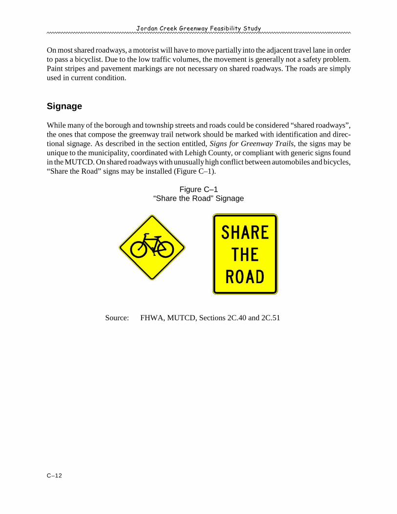
Jordan Creek Greenway Feasibility Study
C–12
On most shared roadways, a motorist will have to move partially into the adjacent travel lane in orderto pass a bicyclist. Due to the low traffic volumes, the movement is generally not a safety problem.Paint stripes and pavement markings are not necessary on shared roadways. The roads are simplyused in current condition.
Signage
While many of the borough and township streets and roads could be considered “shared roadways”,the ones that compose the greenway trail network should be marked with identification and direc-tional signage. As described in the section entitled, Signs for Greenway Trails, the signs may beunique to the municipality, coordinated with Lehigh County, or compliant with generic signs foundin the MUTCD. On shared roadways with unusually high conflict between automobiles and bicycles,“Share the Road” signs may be installed (Figure C–1).
Figure C–1“Share the Road” Signage
Source: FHWA, MUTCD, Sections 2C.40 and 2C.51
Jordan Creek Greenway Feasibility Study
D–1
Appendix D
STREAM RESTORATION PROPOSAL
Jordan Creek Stream Restoration Project at Lehigh County’s Trexler Nature Preserve
Wildlands Conservancy proposes completing stream bank restoration and aquatic habitat enhance-ment projects along the Jordan Creek within the Trexler Nature Preserve (see map, p. D–2). Thefollowing project information was prepared by the staff of Wildlands Conservancy.
Statement of Need:Currently, the Jordan Creek at this location is eroding the stream banks, creating a vertical bankheight of 4-6 feet. The floodplain, perched 4-6 feet above the stream level is disconnected from thestream flow. When a rain event occurs, the channelized stream is unable to reduce its velocity byflowing over the stream banks and spreading out into the floodplain. Instead, the stream erodes thebanks and carries sediment downstream.
The vegetation diversity is degraded along the stream corridor. The invasive Autumn olive isgrowing upland from the potential restoration site, and the riparian buffer vegetation is lacking nativetrees and shrubs.
Expected Environmental Benefits:- Restoring the stream banks will provide stabilization and flood control for downstream sites,
and improve the stream water quality.- Aquatic habitat structures and plantings would add diversity to the site, enhance wildlife
habitat, and stabilize stream banks. The installed structures would benefit fisherman byproviding food and habitat for aquatic organisms.
- Implementing this project will provide additional stewardship and improvement to aprotected recreation and nature site.
Proposed Scope of Work:This project would involve:
1) Grading the stream banks to a gradual slope to re-connect the stream to its floodplain, 2) Seeding and matting the stream banks to stabilize loose soil, and in some areas, 3) Installing aquatic habitat structures along the stream banks to stabilize the stream banks and
enhance wildlife habitat (as designed by Pa. Fish & Boat Commission)4) Planting native trees and shrubs throughout the floodplain to stabilize the stream banks,
provide wildlife habitat, and enhance native species diversity.
Timeline:Phase I—2009 Wildlands Conservancy has already secured approximately $15,000 (which must be spent in2009) and we would like to use this money to restore the streambanks in the area directlydownstream of the Mill Creek Road bridge (see map, Phase I area). The Pa. Fish & Boat

Jordan Creek Greenway Feasibility Study
D–2
Jordan Creek Greenway Feasibility Study
D–3
Commission has agreed to do the design and permitting required for this area. This phase of theproject will require in-kind services from Lehigh County in the form of heavy equipment and anoperator, as well as some general project labor.
Estimated direct cost of Phase I = $25,000 (est.) covered by Wildlands Conservancy & Pa. F &B, not including in-kind services from Lehigh County
Phase II—2010 Either Wildlands Conservancy or Lehigh County should apply for DCNR funding to completestreambank restoration and habitat improvements from the area directly upstream of the coveredbridge to the area around the ford. The Pa. Fish & Boat Commission can complete any designand permitting to be done along this stretch. The potential DCNR funds would need to bematched by the in-kind services provided by the County and by design services and materialsprovided by Pa. F & B.
If the County is successful in securing assistance from the Emergency watershed protectionprogram administered by the Northampton County NRCS, those funds should be used to matchthe DCNR funds.
Additional considerations: Because this area is so intensely used by the public, considerablethought should be put into how we can provide environmental education opportunities and alsohow we can provide access to the stream for people with physical disabilities.
Estimated direct cost of Phase II = additional investigation required, to be covered in part by aDCNR grant and in part through in kind services provided by the County, Pa. F & B, and NRCS(direct or indirect).
Commitment from Lehigh County:1) Provide machinery and operator (track hoe & skid loader) during the project.2) Secure an access agreement from the property owner adjacent to the Mill Creek bridge (if the
County does not already has such an agreement).3) Provide labor and augers to dig holes for plant material.4) If Wildlands Conservancy is the grant applicant the County will need to provide a letter of
support and commitment to providing the above.** If Lehigh County receives compensation from NRCS for Riparian buffer easements it wouldbe greatly preferable if the County directed those funds to the proposed stream restorationefforts.
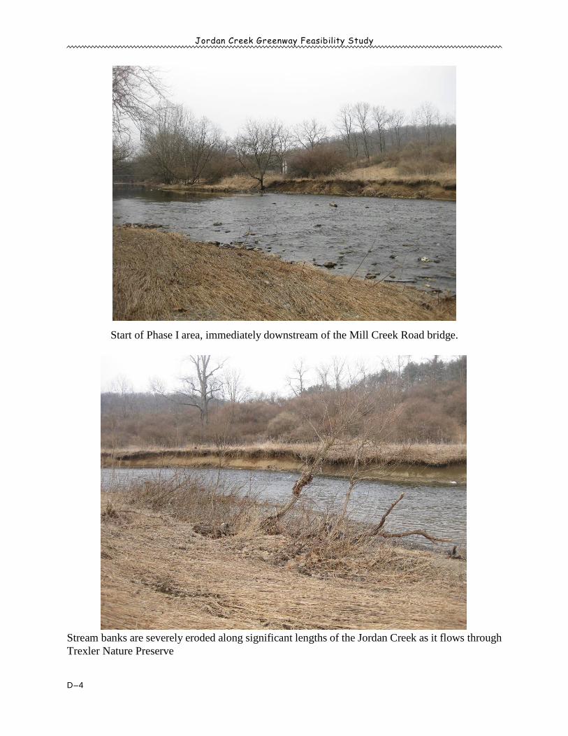
Jordan Creek Greenway Feasibility Study
D–4
Start of Phase I area, immediately downstream of the Mill Creek Road bridge.
Stream banks are severely eroded along significant lengths of the Jordan Creek as it flows throughTrexler Nature Preserve
Jordan Creek Greenway Feasibility Study
D–5
Project Benefits:Needs, issues, problems, or opportunities to be addressed: Wildlands Conservancy proposescompleting stream bank restoration and aquatic habitat enhancement projects along the Jordan Creekwithin the Trexler Nature Preserve in Lehigh County (formerly known as The Trexler-Lehigh CountyGame Preserve). Although in a nature preserve, this section of the Jordan is characterized by severelyeroded, bare soil stream banks and an almost complete lack of in-stream structural habitat. Inaddition there is little to no riparian vegetation along the stretch. Because of the degraded riparianzone, each storm event further entrenches the stream and erodes the banks. As a result the floodplainis disconnected from the stream flow and erosion and downstream sedimentation are increasing inseverity. This degraded stretch of the Jordan is approximately one mile long. In the early fall of 2009Wildlands Conservancy will be working with the Pa. Fish & Boat Commission and Lehigh Countyto repair an upstream segment of this stretch. Funding for this work is provided in part by a LehighValley Greenways Implementation Block Grant. We are requesting funding to complete therestoration of the remaining 3000 foot reach in 2010.
Correspondence with local, county, and statewide planning: Addressing the severe erosion andflooding along the Jordan Creek as it flows through the Trexler Nature Preserve is listed as arecommendation in several planning documents, including both the Jordan Creek RiversConservation Management Plan (completed in 2000 and funded by the Department of Conservation& Natural Resources’ Bureau of Recreation & Conservation) and the Jordan Creek WatershedAssessment Plan (completed in 2000 and funded by the Department of Environmental Protection’sBureau of Watershed Conservation’s Section 319 Non-point source program). Restoring andprotecting Streambanks and riparian corridors is recommended in the 2009 Lehigh Valley GreenwaysConservation Landscape Initiative work plan (Jordan Creek sub-landscape), the 2007 Lehigh ValleyGreenways Plan, and the North Whitehall Township Comprehensive Parks, Recreation, and OpenSpace Plan. In 2005 Wildlands Conservancy completed the Trexler-Lehigh County Game PreserveEcological Inventory and Assessment. In the assessment this stretch of the Jordan Creek was rankedas sub-optimal and recommended for riparian restoration. Addressing the health of the Jordan Creekis also listed in Lehigh County’s Trexler-Lehigh county Game Preserve Master Site Plan, preparedin 2006.
Public involvement: Studies and actions show that residents of the Lehigh Valley value their parksand open space. Lehigh Valley voters have strongly supported state and county referendums to fundthe creation of parks and protect important natural areas. In 1999 The Lehigh Valley PlanningCommission conducted extensive surveys and showed that nearly 70% of the Lehigh Valleypopulation felt that more parks, recreation facilities and open space should be acquired and/ordeveloped in their county. According to that survey the most needed park and recreation facilitieswere felt to be large regional parks, trails for hiking and biking, and nature reserves, ones exactly likethe Trexler Nature Preserve. Residents of the Lehigh Valley also agreed that in order to preserve thenatural environment, priority should be given first to protecting streams and rivers.
In 2005 more than 400 visitors to the Preserve completed surveys about how they do andwould like to utilize the property. Results of these surveys show that people enjoy a wide array ofpassive recreational activities such as hiking, fishing, and wading in the Jordan creek. More than85% of survey participants indicated they visit the Preserve specifically to experience nature.
Jordan Creek Greenway Feasibility Study
D–6
Short and long term community, recreation, and/or conservation benefits:
Conservation Benefits: The Jordan Creek is classified as a Trout-stocked fishery (downgraded froma High-quality, Cold water fishery in 1987). The water quality and biological communities of theJordan Creek are adversely impacted by non-point source pollution, and as a result the Creek is listedon the integrated list (formerly the 303(d) list). This project will restore this section of the JordanCreek to a more natural state. The stream banks will be graded to a gradual slope to re-connect thestream to its floodplain. Stream banks will be seeded and matted to stabilize loose soil. Aquatichabitat structures designed by the Fish & Boat Commission and will be installed along the streambanks and native trees and shrubs will be planted throughout the floodplain. Restoring the streambanks at this site will greatly reduce erosion and resultant downstream sedimentation and will reducethe severity and frequency of flood events. Aquatic habitat structures and riparian plantings willenhance wildlife habitat, establish native plant communities, improve water quality, and furtherstabilize stream banks. This project will take place on a highly visible and intensely utilized stretchof stream. We plan to take this opportunity to educate the public about best management practicesfor waterways and riparian corridors. We will install a kiosk near the parking area used to access thissegment of the creek that will contain photographs and information about the purposes of therestoration project and will also place these materials at other kiosks located throughout the naturepreserve.
Community Recreation Benefits: Trexler Nature Preserve is located in the heart of the Jordan Creekwatershed, and the main stem of the Jordan flows through the center of the property. The 1108 acrePreserve is an unparalleled natural asset to the Lehigh Valley, which is experiencing pervasivedevelopment pressure. The Preserve remains the largest area of “green space” in a regionexperiencing a rapid conversion of farmland and woodland to suburban and industrial uses. TheNature Preserve is open daily and admission is free of charge. Visitors can enjoy a wide variety ofoutdoor recreation activities, including hiking, biking, fishing, and cross-country skiing. WildlandsConservancy offers many public environmental education programs at the Preserve and the Preserveis a field trip destination for many of the surrounding school districts. Implementing this project willdemonstrate good environmental stewardship in one of the few places in Lehigh County whereresidents can truly experience nature. The Trexler Nature Preserve offers 18 miles of trails that canbe enjoyed by hikers, bicyclists, and equestrians, as well as those who just want to enjoy theaesthetics of the property. This section of the Jordan Creek is a very popular place for fishermen. Theproposed habitat improvements would benefit fisherman by providing food and habitat for aquaticorganisms. The Nature Preserve is also a popular destination for bird watchers. Creating a healthyriparian habitat will increase the numbers and diversity of birds that can be observed in the area. TheAllentown Health Bureau recently identified green space, including parks and recreation areas, asa key component to quality of life in the area and specifically suggests protection of waterways,riparian buffers and wetlands.
Project Site Conditions:Location: The Trexler Nature Preserve is located in north central Lehigh County and consists of1,108 acres in Lowhill and North Whitehall townships. It is about a 20 - 30 minute drive from mostlocations in the Lehigh Valley and an hour's drive from Valley Forge, Reading, and parts of New

Jordan Creek Greenway Feasibility Study
D–7
Jersey. The Preserve contains the Lehigh County Zoo. The zoo alone sees in excess of 100,000visitors a year. Why was site chosen: The Trexler Nature Preserve is the largest piece of preserved natural land inLehigh County and there are several ecological restoration efforts underway at the Preserve. Theportion of the Jordan Creek that flows through the Preserve is degraded in part due to historicchannel alterations. Restoration of this segment of the Jordan Creek is a key component of theoverall restoration of the Preserve. In addition, the segment of stream in need of restoration is highlyvisible and there is ample opportunity to use the project to demonstrate best management practicesand stream restoration techniques to the general public.Environmental Conditions: Currently, the Jordan Creek at this location is eroding the stream banks,creating a vertical bank height of 4-6 feet. In the affected area there is little or no riparian vegetation.The floodplain is disconnected from the stream flow. When a storm event occurs, the channelizedstream is unable to reduce its velocity by flowing over the stream banks and spreading out into thefloodplain. Instead, the fast moving water erodes the banks and carries sediment downstream (seephotos). Historical & Architectural Features: This project will stabilize the stream banks and restore thefloodplain surrounding a historically and architecturally significant covered bridge that was built in1882. This bridge is listed on the Pennsylvania Historical and Museum Commission’s NationalRegister of Historic Places. Public Access & Permitted Uses:The public can enjoy walking, hiking, mountain biking, nature and bird watching, picnicking, fishingand hunting at the Trexler Nature Preserve. The Preserve is open daily from dawn until dusk andadmission is free of charge.
Project Schedule/Timeline: In the winter of 2009 we plan to have the project design finalized andthe general permit approved. In the spring of 2010 we will request estimates from contractors andschedule a construction date with the selected contractor and partners. In the summer of 2010construction activities will commence. We will order plants and organize volunteers. Planting willtake place in the fall of 2010 or the spring of 2011 (weather depending).
Partnerships: This restoration project will be accomplished through a partnership betweenWildlands Conservancy, Lehigh County, and the Pennsylvania Fish & Boat Commission. WildlandsConservancy will administer the grant, hire contractors, develop planting plans and oversee theproject. The Pa. Fish & Boat Commission will design the habitat structures, acquire necessarypermits for their construction, and provide on-site construction oversight. Lehigh County willprovide a cash match for the project and will donate professional services.

Jordan Creek Greenway Feasibility Study
D–8
This page intentionally blank.


