

Colonial Hall Site
Original Riggs Home Site
New location of the original Riggs Home
Ledgewood Canal Walk
Riggs Canal PaRk & loCk 1 EastIn the early 1800s Silas Riggs moved to the area and lived in a house that stood across the street from the park. He prospered in the tanning business and in the 1820s was awarded one of the first contracts to build a section of the Morris Canal. On the property that is now Riggs Canal Park, he built for himself a new Federal style home that survived into the 1960s. When threatened with demolition, the
original home was moved and is now cared for by the Roxbury Township Historical Society. Follow the walking path through the woods to the site of Lock 2 East, along the canal tow-path and back around to the parking lot.
Riggs mansion house.
Lock 1 East looking west with the lock tender’s house in the trees on the right.
Riggs Canal Park is a work-in-progress that needs restoration work at the lock site and volunteers to help keep the walking path clear.
Canal SoCiety of new JerSeyP.O. Box 737, Morristown, New Jersey 07963-0737Page 1 of 3

New location of the original Riggs Home
M a i n S t r e e t
Emm
ans Road
Canal Street
Parking
Parking
Gate
CanalBasin
Drakes Brook
Site of
Inclined Plane
3 East
Inclined Plane – 2 EastTowpath
CANAL PARK
Site ofPlane 3 Power
House
57
46
PrivateProperty
Site ofPlane Tender’s
House
Marked trail to the Ledge Overlook
2
61
8
START3
Gate
Mountain Road 4
PrivateProperty
TowpathNot Walkable
Bypass Channel
Filled in Canal Basin
Upper Canal Level
46
46
Main Street
Ledgewood
Mt Arlington
Road
Riggs Avenue
Raritan Avenue
Inclined Plane 3 East
Emm
ans
Road
Canal Street
Private Property
Main Street
Riggs Canal Park
Canal Park
King Canal Store
RiggsHouse
King House
Interpretive Panels
Parking
Park Entrance
Traffic Light & Crosswalk
Street Parking
Canal Basin
Roxbury Historical Society
Form
er R
oute
of t
he M
orri
s Ca
nal
10
Parking
Route of the Morris Canal
Greenway information: canalsocietynj.org
Greenway Trail
Route of the Morris Canal
Greenway information: canalsocietynj.org
Greenway TrailOther Trails
Ledgewood, formerly known as Drakesville, was a crossroads village that became a port on the Morris Canal. King Canal Store was the center of village activity for both boatmen and farmers. Park along Main Street then follow the Greenway trail along Canal Street past the remains of the canal basin. Plane 3 West was located in the back yards of the homes alongthe north side of Canal Street.
Ledgewood Canal Walk
king Canal stoRE & inClinEd PlanE 3 East
Drakesville Historic District
Canal SoCiety of new JerSeyP.O. Box 737, Morristown, New Jersey 07963-0737
Page 2 of 3
M a i n S t r e e t
Emm
ans Road
Canal Street
Parking
Parking
Gate
CanalBasin
Drakes Brook
Site of
Inclined Plane
3 East
Inclined Plane – 2 EastTowpath
CANAL PARK
Site ofPlane 3 Power
House
57
46
PrivateProperty
Site ofPlane Tender’s
House
Marked trail to the Ledge Overlook
2
61
8
START3
Gate
Mountain Road 4
PrivateProperty
TowpathNot Walkable
Bypass Channel
Filled in Canal Basin
Upper Canal Level
46
46
Main Street
Ledgewood
Mt Arlington
Road
Riggs Avenue
Raritan Avenue
Inclined Plane 3 East
Emm
ans
Road
Canal Street
Private Property
Main Street
Riggs Canal Park
Canal Park
King Canal Store
RiggsHouse
King House
Interpretive Panels
Parking
Park Entrance
Traffic Light & Crosswalk
Street Parking
Canal Basin
Roxbury Historical Society
Form
er R
oute
of t
he M
orri
s Ca
nal
10
Parking
Route of the Morris Canal
Greenway information: canalsocietynj.org
Greenway Trail
Route of the Morris Canal
Greenway information: canalsocietynj.org
Greenway TrailOther Trails
© 2020, Joe Macasek-MacGraphics
Ledgewood Canal Walk
Canal PaRk & inClinEd PlanE 2 East
Canal SoCiety of new JerSeyP.O. Box 737, Morristown, New Jersey 07963-0737
Historic view looking upPlane 2 East.
Historic view looking down Plane 2 East.
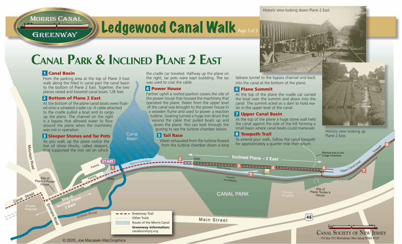
1 Canal Basin From the parking area at the top of Plane 3 East walk along the filled in canal past the canal basin to the bottom of Plane 2 East. Together, the two planes raised and lowered canal boats 128 feet.
2 Bottom of Plane 2 EastAt the bottom of the plane canal boats were float-ed onto a wheeled cradle car. A cable attached to the cradle pulled a boat and its cargo up the plane. The channel on the right is a bypass that allowed water to flow around the plane when the machinery was not in operation.
3 Sleeper Stones and Tar PotsAs you walk up the plane notice the line of stone blocks, called sleepers, that supported the iron rail on which
the cradle car traveled. Halfway up the plane on the right, tar pots were kept bubbling. The tar was used to coat the cable.
4 Power HouseFarther uphill a roofed pavilion covers the site of the power house that housed the machinery that operated the plane. Water from the upper level of the canal was brought to the power house in a wooden flume and used to power a reaction turbine. Gearing turned a huge iron drum that wound the cable that pulled boats up and down the plane. You can look through the grating to see the turbine chamber below.
5 Tail Race Water exhausted from the turbine flowed from the turbine chamber down a long
tailrace tunnel to the bypass channel and back into the canal at the bottom of the plane.
6 Plane Summit At the top of the plane the cradle car carried the boat over the summit and down into the canal. The summit acted as a dam to hold wa-ter in the upper level of the canal.
7 Upper Canal Basin At the top of the plane a huge stone wall held the canal against the side of the hill forming a small basin where canal boats could maneuver.
8 Towpath Trail To extend your walk, follow the canal towpath for approximately a quarter mile then return.
Page 3 of 3


