1
Billing Code: 3510-22-P
DEPARTMENT OF COMMERCE
National Oceanic and Atmospheric Administration
50 CFR 226
[Docket No. 130513467-3467-01]
RIN 0648-BD27
Endangered and Threatened Species: Proposed Rule to Designate Critical Habitat for the
Northwest Atlantic Ocean Loggerhead Sea Turtle Distinct Population Segment (DPS)
and Proposed Determination Regarding Critical Habitat for the North Pacific Ocean
Loggerhead DPS
AGENCY: National Marine Fisheries Service (NMFS), National Oceanic and
Atmospheric Administration (NOAA), Commerce
ACTION: Proposed rule; request for comments.
SUMMARY: We, the National Marine Fisheries Service (NMFS), propose critical
habitat for the Northwest Atlantic Ocean loggerhead sea turtle Distinct Population
Segment (DPS) (Caretta caretta) within the Atlantic Ocean and the Gulf of Mexico.
Specific areas proposed for designation include 36 occupied marine areas within the
range of the Northwest Atlantic Ocean DPS. These areas contain one or a combination of
nearshore reproductive habitat, winter area, breeding areas, and migratory corridors. We
are also asking for comment on whether to include as critical habitat in the final rule
some areas that contain foraging habitat and two large areas that contain Sargassum
habitat. The U.S. Fish and Wildlife Service addressed terrestrial areas (nesting beaches)
in a separate document (78 FR 18000; March 25, 2013). No marine areas meeting the

2
definition of critical habitat were identified within the jurisdiction of the United States for
the North Pacific Ocean DPS, and therefore we are not proposing to designate critical
habitat for that DPS.
We are soliciting comments from the public on all aspects of the proposal,
including information on the economic, national security, and other relevant impacts.
We will consider additional information received prior to making a final designation.
DATES: Comments and information regarding this proposed rule must be received by
[insert date 60 days after date of publication in the FEDERAL REGISTER].
ADDRESSES: You may submit comments on this document, identified by NOAA-
NMFS-2013-0079, by any of the following methods:
Electronic Submission: Submit all electronic public comments via the Federal e-
Rulemaking Portal. Go to www.regulations.gov/#!docketDetail;D=NOAA-NMFS-
2013-0079, click the �“Comment Now!�” icon, complete the required fields, and enter
or attach our comments.
Mail: Submit written comments to Susan Pultz, NMFS, Office of Protected
Resources, 1315 East West Highway, Silver Spring, MD 20910.
Fax: 301-713-0376; Attn: Susan Pultz.
Instructions: Comments sent by any other method, to any other address or
individual, or received after the end of the comment period, may not be considered by
NMFS. All comments received will be part of the public record and will generally be
posted for public viewing on www.regulations.gov without change. All personal
identifying information (e.g., name, address, etc.), confidential business information, or
otherwise sensitive information submitted voluntarily by the sender will be publicly

3
accessible. NMFS will accept anonymous comments (enter "N/A" in the required fields
if you wish to remain anonymous). Attachments to electronic comments will be accepted
in Microsoft Word, Excel, or Adobe PDF file formats only.
The proposed rule, list of references and supporting documents, including the
biological report, the draft Economic Analysis and the Initial Regulatory Flexibility Act
(IRFA) analysis which is appended to the draft Economic Analysis, are also available
electronically at http://www.nmfs.noaa.gov/pr/species/turtles/loggerhead.htm.
FOR FURTHER INFORMATION CONTACT: Susan Pultz, NMFS, Office of Protected
Resources 301-427-8472 or [email protected]; or Angela Somma, NMFS, Office of
Protected Resources 301-427-8474 or [email protected].
SUPPLEMENTARY INFORMATION:
Executive Summary
Section 4 of the Endangered Species Act of 1973, as amended (ESA) requires the
designation of critical habitat for threatened and endangered species to the maximum
extent prudent and determinable, and provides for the revision of critical habitat based on
the best scientific data available, as appropriate (16 U.S.C. 533(a)(3)(A); 16 U.S.C.
1533(b)(2)). Critical habitat may only be designated in areas under U.S. jurisdiction (50
CFR 424.12(h)). Critical habitat is defined as �“(i) the specific areas within the
geographical area occupied by the species, at the time it is listed [under Section 4], on
which are found those physical or biological features (I) essential to the conservation of
the species and (II) which may require special management considerations or protection;
and (ii) specific areas outside the geographical area occupied by the species at the time it

4
is listed, upon a determination by the Secretary that such areas are essential for the
conservation of the species�” (16 U.S.C. section 1532(5)(A)).
This rule proposes designation of critical habitat for the threatened Northwest
Atlantic Ocean Distinct Population Segment (DPS) of the loggerhead sea turtle (Caretta
caretta), and also constitutes NMFS�’ proposed determination that there are no areas
meeting the definition of �“critical habitat�” for the endangered North Pacific Ocean DPS
of the loggerhead sea turtle. The designation of critical habitat was prompted by a 2011
final rule revising the listing of loggerhead sea turtles under the ESA from a single
worldwide listing of the species as threatened to nine DPSs, listed as either threatened or
endangered (76 FR 58868, September 22, 2011). The two DPSs that are the subject of
this notice �– the Northwest Atlantic Ocean and North Pacific Ocean �– are the only DPSs
of loggerheads that occur within U.S. jurisdiction.
We propose designation of 36 marine areas within the Northwest Atlantic Ocean
DPS as critical habitat. These areas that contain one or a combination of nearshore
reproductive habitat (off nesting beaches to 1.6 km (1 mile)), wintering habitat, breeding
habitat, and constricted migratory corridors. We further seek comment on whether to
include foraging habitat and two large areas that contain Sargassum habitat. The US Fish
and Wildlife Service (USFWS) proposed terrestrial critical habitat (nesting beaches) in a
separate rulemaking on March 25, 2013 (78 FR 18000). We refer to those terrestrial
areas in this report where necessary to explain how we identified corresponding marine
habitat. No marine areas are proposed for designation as critical habitat within the North
Pacific Ocean DPS. We did not identify any unoccupied areas essential to the
conservation of either DPS.

5
Background
The loggerhead sea turtle was listed worldwide as a threatened species on July 28,
1978 (43 FR 32800) pursuant to the Endangered Species Act of 1973, as amended (ESA).
No critical habitat was designated for the loggerhead at that time. Pursuant to a joint
memorandum of understanding, signed on July 18, 1977, the U.S. Fish and Wildlife
Service (USFWS) has jurisdiction over sea turtles on the land and the National Oceanic
and Atmospheric Administration�’s (NOAA�’s) NMFS has jurisdiction over sea turtles in
the marine environment. On September 22, 2011, NMFS and USFWS jointly published a
final rule revising the loggerhead�’s listing from a single worldwide threatened species to
nine DPSs (76 FR 58868). In the final rule, five DPSs were listed as endangered (North
Pacific Ocean, South Pacific Ocean, North Indian Ocean, Northeast Atlantic Ocean, and
Mediterranean Sea), and four DPSs were listed as threatened (Northwest Atlantic Ocean,
South Atlantic Ocean, Southeast Indo-Pacific Ocean, and Southwest Indian Ocean). Two
DPSs occur within U.S. jurisdiction: the Northwest Atlantic Ocean DPS (range defined as
north of the equator, south of 60° N. lat., and west of 40° W. long.), and the North Pacific
Ocean DPS (range defined as north of the equator and south of 60° N. lat.). At the time
the final listing rule was developed, we lacked comprehensive data and information
necessary to identify and describe physical or biological features (PBFs) of the terrestrial
and marine habitats. As a result, we found designation of critical habitat to be �“not
determinable�” (see 16 U.S.C. section 1533(b)(6)(C)(ii)). In the final rule we stated that
we would consider designating critical habitat for the two DPSs within U.S. jurisdiction
in future rulemakings. Information from the public related to the identification of critical
habitat, essential PBFs for this species, and other relevant impacts of a critical habitat

6
designation was solicited. We received two responses, one from the Department of the
Navy, Commander Navy Region Southeast, dated January 26, 2012, and one from
Oceana, dated March 6, 2012. These comments were considered in the formulation of
the proposed rule.
NMFS and USFWS convened a critical habitat review team (CHRT) to assist in
the assessment and evaluation of critical habitat areas for the Northwest Atlantic Ocean
and North Pacific Ocean DPSs, which met three times in 2012. The CHRT consisted of
six NMFS and two USFWS biologists with experience and expertise ranging from
loggerhead biology to sea turtle management and ESA section 7 consultations. Five
biologists from the states of Florida, Georgia, South Carolina, and North Carolina served
as consultants to the team.
USFWS and NMFS decided to publish separate proposed rules in accordance
with our respective jurisdictions. Terrestrial areas, which are under the jurisdiction of
USFWS, are not included in this proposed rule. This proposed rule details the areas
under NMFS jurisdiction -- those in the marine environment. Terrestrial areas (nesting
beaches) are referred to only when needed to explain how corresponding marine habitat
was determined. In many areas, marine habitat that we are proposing is adjacent to
nesting beaches proposed for designation as critical habitat by USFWS. Nowhere do
they overlap. NMFS and FWS currently plan to issue a combined final rule.
Because the agencies had not yet made the required determinations regarding
designation of critical habitat for these DPSs, the Center for Biological Diversity,
Oceana, and the Turtle Island Restoration Network sent NMFS and USFWS a notice of
intent to file a lawsuit on October 11, 2012. A complaint for declaratory and injunctive

7
relief was filed in the United States District Court for the Northern District of California
on January 8, 2013. On March 25, 2013, the USFWS proposed rule designating specific
nesting beaches as critical habitat for the Northwest Atlantic Ocean DPS was published
in the Federal Register (78 FR 18000, March 25, 2013).
Loggerhead Natural History
The loggerhead belongs to the family Cheloniidae along with all other sea turtle
species except the leatherback (Dermochelys coriacea). The genus Caretta is monotypic.
The carapace of adult and juvenile loggerheads is reddish-brown. Mean straight carapace
length (SCL) of nesting females in the southeastern United States, the only location
where loggerheads nest in the United States, averages 90 centimeters (cm) (35 inches
(in)) (NMFS 2001). Hatchlings vary from light to dark brown to dark gray dorsally and
lack the reddish-brown coloration of adults and juveniles. Flippers are dark gray to
brown above with distinct white margins. The ventral coloration of the plastron and
other areas of the integument are generally yellowish to tan. At emergence, hatchlings
average 45 millimeters (mm) (1.8 in) SCL and weigh approximately 20 grams (g) (0.7
ounces (oz)) (Dodd 1988).
Loggerheads are long-lived, slow-growing animals that use multiple habitats
across entire ocean basins throughout their life history. This complex life history
encompasses terrestrial, inshore/estuarine, nearshore, and open ocean habitats. The three
basic ecosystems in which loggerheads live are categorized in this proposed designation
as the following:
(1) Terrestrial zone (supralittoral) �– the nesting beach where oviposition (egg laying),
embryonic development, and hatching occurs.
8
(2) Neritic zone �– the nearshore marine environment (from the surface to the sea
floor) where water depths do not exceed 200 meters (m) (656 feet (ft)). The neritic zone
generally includes the continental shelf, but in areas where the continental shelf is very
narrow or nonexistent, the neritic zone conventionally extends from the shore to areas
where water depths reach 200 m (656 ft). Neritic habitat also occurs inshore, in bays and
estuaries.
(3) Oceanic zone �– the open ocean environment (from the surface to the sea floor)
where water depths are greater than 200 m (656 ft).
The following global nesting information is provided for context, but note the
remainder of this proposed rule will focus on marine areas in the Northwest Atlantic
Ocean and North Pacific Ocean DPSs, because these are the only DPSs that occur in U.S.
waters.
Loggerhead sea turtles occur throughout the temperate and tropical regions of the
Atlantic, Pacific, and Indian Oceans (Dodd 1988). However, the majority of loggerhead
nesting is at the western rims of the Atlantic and Indian Oceans. Only two loggerhead
nesting aggregations have greater than 10,000 females nesting per year: Peninsular
Florida, in the United States, and Masirah Island, in Oman (Baldwin et al. 2003; Ehrhart
et al. 2003; Kamezaki et al. 2003; Limpus and Limpus 2003b; Margaritoulis et al. 2003).
Smaller nesting aggregations occur in the Northern Gulf of Mexico, Dry Tortugas, and
Georgia through North Carolina (United States), Quintana Roo and Yucatan (Mexico),
Brazil, Cape Verde Islands (Cape Verde), Queensland and Western Australia (Australia),
Japan, Cay Sal Bank (Bahamas), Tongaland (South Africa), Mozambique, Arabian Sea

9
Coast and Halaniyat Islands (Oman), Cyprus, Peloponnesus, Zakynthos, Crete (Greece),
and Turkey (NMFS and USFWS 2008).
Loggerheads in the Northwest Atlantic Ocean DPS nest on beaches in the
southeastern United States, whereas loggerheads in the North Pacific Ocean DPS nest
outside of U.S. jurisdiction, in Japan. The Northwest Atlantic Ocean DPS�’s nesting
season extends from about late April through early September with nesting occurring
primarily at night. Loggerheads typically lay approximately 3 to 6 nests per season
(Murphy and Hopkins 1984; Frazer and Richardson 1985; Hawkes et al. 2005; Scott
2006; Tucker 2010; Ehrhart, unpublished data) at intervals of approximately 12 to 15
days (Caldwell 1962; Dodd 1988). Mean clutch size varies from about 100 to 126 eggs
(Dodd 1988). Remigration intervals (number of years between successive nesting
migrations) typically average from 2.5 to 3.7 years (Richardson et al. 1978; Bjorndal et
al. 1983; Ehrhart, unpublished data). Sexual maturity in the Northwest Atlantic Ocean
ranges from as early as approximately 25 years to as late as 45 years (Snover 2002;
Conant et al. 2009; Scott et al. 2012). Comparable data for adult males do not exist.
Egg incubation duration for the Northwest Atlantic Ocean DPS varies depending
on time of year and latitude but typically ranges from about 42 to 75 days (Dodd and
Mackinnon 2006; Dodd and Mackinnon 2007; Dodd and Mackinnon 2008; Dodd and
Mackinnon 2009; Dodd and Mackinnon 2010). Sand temperatures prevailing during the
middle third of the incubation period also determine the sex of hatchlings (Mrosovsky
and Yntema 1980). Incubation temperatures near the upper end of the tolerable range
produce only female hatchlings while incubation temperatures near the lower end of the
tolerable range produce only male hatchlings. The pivotal temperature (i.e., the

10
incubation temperature that produces equal numbers of males and females) in
loggerheads is approximately 29° C (84.2° F) (Limpus et al. 1983; Mrosovsky 1988;
Marcovaldi et al. 1997). Loggerhead hatchlings pip and escape from their eggs over a 1-
to 3-day interval and move upward and out of the nest over a 2- to 4-day interval
(Christens 1990). Hatchlings emerge from their nests en masse almost exclusively at
night, presumably using decreasing sand temperature as a cue (Hendrickson 1958;
Mrosovsky 1968; Witherington et al. 1990; Moran et al. 1999).
Hatchlings use a progression of seafinding orientation cues to guide their
movement from the nest to the marine environment where they spend their early years
(Lohmann and Lohmann 2003). Hatchlings first use light cues to find the ocean. On
naturally lighted beaches without artificial lighting, ambient light from the open sky
creates a relatively bright horizon compared to the dark silhouette of the dune and
vegetation landward of the nest. This contrast guides the hatchlings to the ocean (Daniel
and Smith 1947; Limpus 1971; Salmon et al. 1992; Witherington and Martin 1996;
Witherington 1997). Hatchlings also use wave orientation in nearshore waters and
magnetic field orientation as they proceed further toward open water (Lohmann and
Lohmann 2003).
Immediately after hatchlings emerge from the nest, they begin a period of
frenzied activity. During this active period, hatchlings move from their nest to the surf,
swim, and are swept through the surf zone, and continue swimming away from land for
approximately 20 to 30 hours (Carr and Ogren 1960; Carr 1962; Carr 1982; Wyneken and
Salmon 1992; Witherington 1995). This frenzied swimming is thought to be a
mechanism for limiting time spent in the nearshore coastal waters, thus reducing

11
exposure to predators such as fish and birds that tend to be concentrated in nearshore
coastal waters. Hatchlings do not feed during the swim frenzy and rely on their retained
yolk for nourishment (Witherington 2002).
Post-hatchling transition stage describes neonate sea turtles that have matured to
the point beyond the period of frenzied swimming (Wyneken and Salmon 1992). The
post-hatchling transition stage occurs in the neritic environment and ends when the small
turtles enter the oceanic zone (Bolten 2003). Post-hatchling loggerheads are largely
inactive, exhibit infrequent low-energy swimming, and have begun to feed. In the
Northwest Atlantic, post-hatchling, small oceanic juvenile, and some neritic juvenile
loggerheads inhabit areas where surface waters converge to form local downwelling
(Witherington 2002; Witherington et al. 2012). These areas are characterized by
accumulations of floating material, especially pelagic Sargassum (a genus of brown
macroalgae), and are common between the Gulf Stream and the southeastern U.S. coast,
and between the Loop Current and the western Florida coast in the Gulf of Mexico.
Surface convergence zones consolidate a variety of floating material, including woody
material, seagrass, and synthetic debris (as observed by Witherington et al. 2012), but
pelagic Sargassum is prolific. Sargassum and other flotsam can be arranged within long
linear or meandering rows collectively termed �“windrows�” as a result of Langmuir
circulations, internal waves, and convergence zones along fronts, but when currents and
winds are negligible, Sargassum is also found in broad irregular mats or scattered clumps
(Comyns et al. 2002; SAFMC 2002).

12
This neritic post-hatchling stage is weeks or months long and may be a transition
to the oceanic stage that loggerheads enter as they grow and are carried by ocean currents
(Witherington 2002; Bolten 2003).
The oceanic juvenile stage begins when loggerheads first enter the oceanic zone
(Bolten 2003). Juvenile loggerheads originating from nesting beaches in both the
Northwest Atlantic and North Pacific Oceans appear to use oceanic developmental
habitats and move with the predominant ocean gyres for several years before returning to
their neritic foraging habitats (Pitman 1990; Bowen et al. 1995; Zug et al. 1995; Musick
and Limpus 1997; Bolten 2003). The presence of Sargassum is also important for the
oceanic juvenile life stage, as it offers a concentrated, protected foraging area, with
facilitated dispersal by associated oceanic currents. Turtles in this stage use active and
passive movements relative to oceanic currents and winds, with 75% of their time spent
in the top 5 m (16 ft) of the water column (Howell et al. 2010; Witherington et al. 2012).
In the western Atlantic, Caribbean Sea and Gulf of Mexico, post-hatchling and
oceanic juvenile sea turtle habitat occurs at the margins of the Mexican Current, Yucatan
Current, Gulf Loop Current, Florida Current, and Gulf Stream; at the margins and centers
of eddies produced by these currents; at tidal rips and other convergence zones at the
plume seaward of the Mississippi River delta; at consolidated patches (lines, mats) of
pelagic Sargassum; and at other convergence zones indicated by salinity fronts,
temperature fronts, water-color changes, or floating debris (including pelagic Sargassum).
Loggerheads are also found in the Sargasso Sea, the open-ocean ecosystem of pelagic
drift algae found in the Atlantic Ocean and defined by ocean currents (but generally
outside the U.S. EEZ). These habitat features are dynamic and transitory. Juvenile sea

13
turtles do not just use the currents as passive transport, but will actively swim to maintain
a position in currents that provide favorable transport away from coastal areas and cold
waters that would present lower odds of survival (Putman et al. 2012). The importance
of such current systems, and access to those currents by hatchling sea turtles, are thought
to influence the evolution of sea turtle nesting location choices and may explain the
limited loggerhead nesting in large sections of the Gulf of Mexico that would have
otherwise suitable beaches (Putman et al. 2010).
The actual duration of the oceanic juvenile stage varies. In the North Pacific
Ocean, juveniles may spend an estimated 27 years in their oceanic phase (Conant et al.
2009) with juvenile loggerheads not returning to coastal neritic habitats until around 60
cm (24 in) SCL (Ishihara et al. 2011, referring to coastal waters of Japan; Y. Matsuzawa
and Sea Turtle Association of Japan, unpublished data). In the Atlantic Ocean, the
duration of the oceanic juvenile stage is estimated to be between 7 and 24 years, with
juveniles recruiting to neritic habitats over a size range of 45.5�–64 cm (18�–25 in) curved
carapace length (Bolten et al. 1993; Bjorndal et al. 2000; Snover 2002; Bjorndal et al.
2003; Loggerhead Turtle Expert Working Group (TEWG 2009)). Studies conducted in
the Northwest Atlantic Ocean and Mediterranean Sea indicate that some juveniles move
between neritic and oceanic zones (Keinath 1993; Laurent et al. 1998; Witzell 2002;
Bolten 2003; Morreale and Standora 2005; Mansfield 2006; McClellan and Read 2007;
Eckert et al. 2008; Mansfield et al. 2009; Arendt et al. 2012c).
The neritic juvenile stage begins when loggerheads exit the oceanic zone and
enter the neritic zone (Bolten 2003). After migrating to the neritic zone, juvenile
loggerheads continue maturing until they reach adulthood, engaging in foraging and

14
migratory behavior. In the western North Atlantic, neritic juvenile loggerheads inhabit
continental shelf waters from Cape Cod Bay, Massachusetts, south through Florida, the
Bahamas, Cuba, and the Gulf of Mexico (Musick and Limpus 1997; Spotila et al. 1997a;
Hopkins-Murphy et al. 2003). Notable inshore habitat includes estuarine waters such as
Long Island Sound, Delaware Bay, Chesapeake Bay, Pamlico and Core Sounds, the large
open sounds of South Carolina and Georgia, Mosquito and Indian River Lagoons,
Biscayne Bay, Florida Bay, and numerous embayments fringing the Gulf of Mexico
(Musick and Limpus 1997; Spotila et al. 1997a; Hopkins-Murphy et al. 2003). Juvenile
loggerheads reside in particular developmental foraging areas for many years (Lutcavage
and Musick 1985; Mansfield 2006; Ehrhart et al. 2007; Braun-McNeill et al. 2008a;
Arendt et al. 2012f). Sea turtle migrations and distribution in neritic habitat are largely
correlated to environmental conditions including sea surface temperature (SST) (Coles
and Musick 2000; Braun-McNeill et al. 2008b) and changes in habitat quality over time
(e.g., declines in prey availability (Mansfield et al. 2009). Some juveniles move between
neritic and oceanic zones (Keinath 1993; Laurent et al. 1998; Witzell 2002; Bolten 2003;
Morreale and Standora 2005; Mansfield 2006; McClellan and Read 2007; Eckert et al.
2008; Mansfield et al. 2009; Arendt et al. 2012c).
The neritic zone also provides important foraging habitat, internesting habitat,
breeding habitat, and migratory habitat for adult loggerheads. Habitat preferences of
non-nesting adult loggerheads in the neritic zone differ from the juvenile stage in that
relatively enclosed, shallow water estuarine habitats with limited ocean access are less
frequently used. Areas such as Pamlico Sound, North Carolina, and the Indian River
Lagoon, Florida, regularly used by juvenile loggerheads, are only rarely frequented by

15
adults (Ehrhart and Redfoot 1995; Epperly et al. 2007). In comparison, estuarine areas
with more open ocean access, such as the Delaware Bay and the Chesapeake Bay in the
U.S. mid-Atlantic, as well as the neritic shelf waters of the Mid-Atlantic Bight and the
South Atlantic Bight are regularly used by both juvenile and adult loggerheads, primarily
during warmer seasons (Lutcavage and Musick 1985; Spotila et al. 1998; Stezer 2002;
Mansfield 2006; Hawkes et al. 2007; Mansfield et al. 2009; Hawkes et al. 2011; Arendt
et al. 2012b; Arendt et al. 2012c; Arendt et al. 2012d; Ceriani et al. 2012; Pajuelo et al.
2012; Griffin et al., unpublished data). Shallow water habitats with large expanses of
open ocean access, such as Florida Bay, provide year-round resident foraging areas for
significant numbers of male and female adult loggerheads, including nesting females
(Schroeder et al. 1998; Witherington et al. 2006).
Loggerheads are distributed along the east coast of the United States and Gulf of
Mexico, generally along the continental shelf approximately out to the 200 m (656 ft)
bathymetric contour line (TEWG 2009). Seasonal composites indicate few to no turtles
occurring coastally north of 36° N. lat., or just north of Cape Hatteras, North Carolina,
during winter. From spring through fall, turtles occurred in nearshore coastal waters with
high use areas occurring from South Carolina north into Virginia�’s Chesapeake Bay and
coastal waters of the Mid-Atlantic Bight. During the colder fall and winter months,
turtles had a high frequency of days spent south of Cape Hatteras through Florida.
In the Gulf of Mexico, nearshore coastal surveys have been infrequently
conducted, with most surveys further offshore (TEWG 2009). When surveys covered
nearshore areas, sightings usually were reported. This was especially true during fall

16
surveys off the west coast of Florida, indicating a high density of loggerheads sighted
during those surveys.
Adults may also periodically move between neritic and oceanic zones (Harrison
and Bjorndal 2006; Hawkes et al. 2006; Girard et al. 2009; Reich et al. 2010; Eder et al.
2012). Hatase et al. (2002) used stable isotope analyses and satellite telemetry to
demonstrate that some adult female loggerheads nesting in Japan inhabit oceanic habitats
rather than neritic habitats. Kobayashi et al. (2011) found that non-reproductive
loggerheads (size 64.0�–92.0 cm (25.2�–36.2 in) SCL) originally satellite tagged in Taiwan
spent portions of their time in neritic habitats, exhibiting a quasi-resident behavior
between Taiwan, China, Japan, and South Korea, and 12.5 percent of their time in the
high seas. Reich et al. (2010) analyzed stable isotopes and epibionts from Florida nesting
loggerheads and found that some turtles may inhabit oceanic habitats. However, Pajuelo
et al. (2012) evaluated the stable isotope values from Reich et al. (2010) and from
northern nesting areas in conjunction with satellite telemetry data. This study identified
three neritic foraging areas based on isotopic ratios, with differences associated with
latitudinal gradients (Pajuelo et al. 2012).
In neritic zones, loggerheads are primarily carnivorous, although they do consume
some plant matter as well (see Bjorndal 1997; and Dodd 1988, for reviews).
Loggerheads feed on a wide variety of food items with ontogenetic, regional, and even
individual differences in diet. In general, loggerheads in neritic habitats within the
Northwest Atlantic Ocean prey on benthic invertebrates, primarily mollusks and benthic
crabs (NMFS and USFWS 2008). Loggerheads occurring in the Eastern Pacific Ocean

17
while in neritic habitats of Baja California Sur, Mexico, feed extensively on pelagic red
crabs (Pleuroncodes planipes) (Wingfield et al. 2011).
Critical Habitat
Section 4 of the Endangered Species Act of 1973, as amended (ESA) requires the
designation of critical habitat for threatened and endangered species �“to the maximum
extent prudent and determinable,�” and provides for the revision of critical habitat based
on the best scientific data available, as appropriate. (16 U.S.C. 1533(a)(3)(A); 16 U.S.C.
1533(b)(2)). Critical habitat may only be designated in areas under U.S. jurisdiction (50
CFR 424.12(h)).
Section 4(b)(2) of the ESA requires us to designate critical habitat for threatened
and endangered species �‘�‘on the basis of the best scientific data available and after taking
into consideration the economic impact, the impact on national security, and any other
relevant impact, of specifying any particular area as critical habitat.�’�’ Section 4(b)(2) also
grants the Secretary of Commerce (Secretary) discretion to exclude any area from critical
habitat if s/he determines �‘�‘the benefits of such exclusion outweigh the benefits of
specifying such area as part of the critical habitat.�’�’ However, the Secretary may not
exclude areas that �‘�‘will result in the extinction of the species.�’�’
The ESA defines critical habitat in section 3(5)(A) as: �‘�‘(i) the specific areas
within the geographical area occupied by the species, at the time it is listed . . . on which
are found those physical or biological features (I) essential to the conservation of the
species and (II) which may require special management considerations or protection; and
(ii) specific areas outside the geographical area occupied by the species at the time it is

18
listed. . . upon a determination by the Secretary that such areas are essential for the
conservation of the species.�’�’
Joint NMFS�–USFWS regulations emphasize that in identifying critical habitat,
the agencies shall consider those PBFs that are essential to the conservation of a given
species and that may require special management considerations or protection (50 CFR
424.12(b)). The regulations provide examples of the kinds of essential features to
consider, which may include but are not limited to:
(1) Space for individual and population growth, and for normal behavior;
(2) Food, water, air, light, minerals, or other nutritional or physiological
requirements;
(3) Cover or shelter;
(4) Sites for breeding, reproduction, rearing of offspring, germination, or seed
dispersal; and generally
(5) Habitats that are protected from disturbance or are representative of the historic
geographical and ecological distributions of a species.
The regulations also require agencies to �“focus on the principal biological or
physical constituent elements�” (hereafter referred to as �“Primary Constituent Elements�”
or PCEs) within the specific areas considered for designation, which �“may include, but
are not limited to, the following: �… nesting grounds, spawning sites, feeding sites,
seasonal wetland or dryland, water quality or quantity, �… geological formation,
vegetation type, tide, and specific soil types�” (50 CFR 424.12(b)). There is inherent
overlap between what may constitute a PBF and what can be enumerated as a PCE. In
this proposed rule, when we set out a list of PCEs with a PBF, our intent is that the PBF
19
exists whenever a sufficient subset of PCEs is present to allow the habitat to serve the
conservation function for a single life stage. It is not necessary for all the PCEs to occur
simultaneously.
Section 4(b)(2) of the ESA and our implementing regulations (50 CFR 424.12(a)),
require designation of critical habitat to be based on the best scientific data available.
Accordingly, we reviewed the most recent and comprehensive assessment for
loggerheads by habitat category (e.g., neritic, oceanic), which for most cases was the
TEWG (2009). This review resulted in the identification of relatively high use areas
(generally those with 60 or more turtle days in the TEWG satellite tracking analysis
figures), which served as a proxy for identifying important habitat areas, especially as
there is little quantitative data on loggerhead use of offshore waters. This information
was supplemented by known and available studies that were not included in the TEWG
analysis or occurred subsequent to it. For the nearshore reproductive habitat, we relied
on data and information on nesting distribution and patterns to identify nearshore
reproductive areas associated with high density nesting beaches, as described in the
USFWS proposed rule to designate critical habitat for the Northwest Atlantic Ocean DPS
(78 FR 18000, March 25, 2013). For the Sargassum habitat, we reviewed data on the
distribution of Sargassum and its relationship to loggerhead habitat needs to identify
Sargassum habitat.
Once critical habitat is designated, section 7 of the ESA requires Federal agencies
to ensure they do not fund, authorize, or carry out any actions that are likely to result in
the �“destruction or adverse modification�” of that habitat (16 U.S.C. section 1536(a)(2)).
This standard is separate from the section 7 requirement that Federal agencies must

20
ensure that their actions are not likely to �“jeopardize the continued existence of�” listed
species.
Geographical Area Occupied by the Species
As noted above, the statutory definition of �“critical habitat�” requires that we
initially identify the geographical area occupied by the species at the time of its listing.
NMFS has interpreted �‘�‘geographical area occupied�’�’ in the definition of critical habitat
to mean generally the range of the species at the time of listing (which, for the loggerhead
DPSs, was September 22, 2011 (76 FR 58868). Loggerhead sea turtles occur throughout
the temperate and tropical regions of the Atlantic, Pacific, and Indian Oceans (Dodd
1988). Because critical habitat can only be designated in U.S. territory, the findings set
out in this proposed rule are limited to the Northwest Atlantic Ocean and North Pacific
Ocean DPSs within the U.S. Economic Exclusive Zone (EEZ). For both of these DPSs,
there is no known unoccupied marine habitat because all areas known to have been
historically occupied are still occupied. As such, we identified the geographical area
occupied as south of 60° N. lat., north of the equator, and west of 40° W. long. for the
Northwest Atlantic Ocean DPS, and south of 60° N. lat. and north of the equator for the
North Pacific Ocean DPS (76 FR 58868, September 22, 2011). While this is the range
occupied by the species, we reviewed data for only U.S. EEZ waters within that range.
Within the U.S. EEZ, loggerhead sea turtle nesting occurs only within the Northwest
Atlantic Ocean DPS, and USFWS defined the terrestrial portion of the geographical area
occupied in this DPS as those areas where nesting has been documented for the most part
annually for a 10-year period (2002 to 2011) (78 FR 18000, March 25, 2013).
Northwest Atlantic Ocean DPS

21
As stated earlier, we analyzed three ecosystem types when identifying critical
habitat: terrestrial, neritic, and oceanic. Because NMFS has jurisdiction only in the
marine environment, this rule examines areas within the broad categories of neritic and
oceanic habitat, although as we worked through our analysis we also identified
Sargassum habitat as a separate category, as Sargassum occurs in both neritic and oceanic
habitat.
Neritic habitat consists of the nearshore marine environment from the surface to
the sea floor where water depths do not exceed 200 m (656 ft), including inshore bays
and estuaries. For purposes of describing potential critical habitat in the Atlantic Ocean,
the CHRT considered loggerhead behavior and broke discussions of neritic habitat into
several habitat types: (1) Nearshore Reproductive Habitat, including hatchling swim
frenzy and internesting female habitat; (2) Foraging Habitat; (3) Wintering Habitat; (4)
Breeding Habitat; (5) Constricted Migratory Habitat; and (6) Sargassum Habitat.
However, because of the overlap of many of these habitats, all but the Sargassum Habitat
(which also extends into oceanic habitat) were labeled Neritic Habitat in any units
proposed for designation as critical habitat.
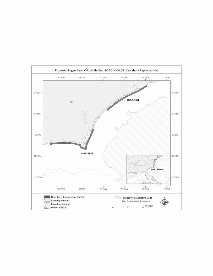
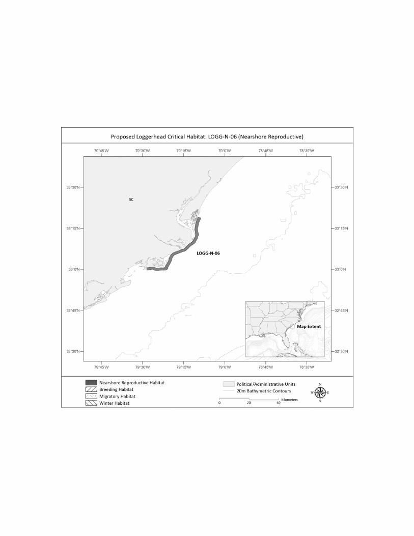
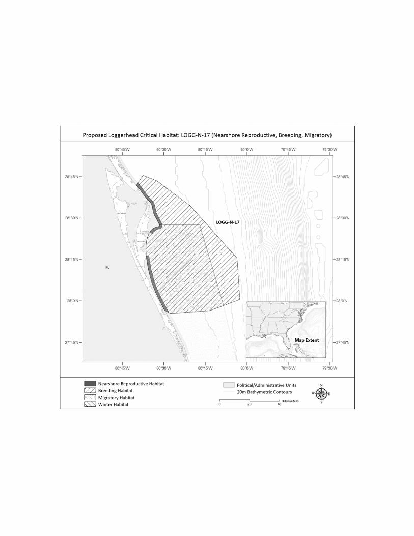
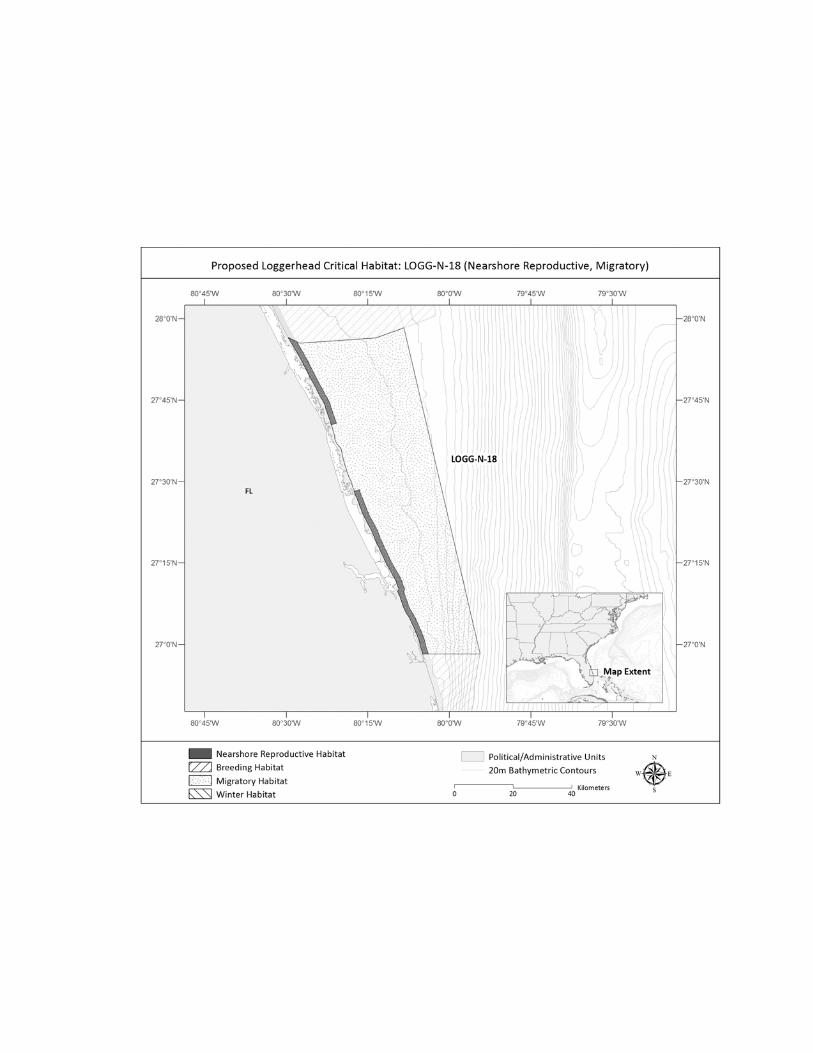
Nearshore Reproductive Habitat: Nearshore reproductive habitat includes habitat
for the hatchling swim frenzy and for females during the internesting period from the
shoreline (Mean High Water (MHW)) seaward 1.6 km (1 mile). This nearshore zone is a
vulnerable, pivotal transitional habitat area for hatchling transit to open waters, and for
nesting females to transit back and forth between open waters and nesting beaches during
their multiple nesting attempts throughout the nesting season. The location of nearshore
reproductive habitat is determined largely by the location of the nesting beaches. The
22
four recovery units identified in the Recovery Plan for the Northwest Atlantic Population
of the Loggerhead Sea Turtle (NMFS and USFWS 2008) represent nesting assemblages
and, thus, the geographical areas utilized for nesting by each unit contain this nearshore
reproductive habitat. The recovery units are (1) the Northern Recovery Unit, which is
defined as loggerheads originating from nesting beaches from the Florida-Georgia border
through southern Virginia (the northern extent of the nesting range); (2) the Peninsular
Florida Recovery Unit, defined as loggerheads originating from nesting beaches from the
Florida-Georgia border through Pinellas County on the west coast of Florida, excluding
the islands west of Key West, Florida; (3) the Dry Tortugas Recovery Unit, defined as
loggerheads originating from nesting beaches throughout the islands located west of Key
West, Florida, because these islands are geographically separated from other recovery
units; and (4) the Northern Gulf of Mexico Recovery Unit, defined as loggerheads
originating from nesting beaches from Franklin County on the northwest Gulf coast of
Florida through Texas (the western extent of U.S. nesting range). The fifth recovery unit,
the Greater Caribbean Recovery Unit, includes all nesting assemblages within the Greater
Caribbean, which are outside the U.S. EEZ with a few exceptions in Puerto Rico and the
U.S. Virgin Islands. Marine waters offshore Puerto Rico and the U.S. Virgin Islands are
not proposed as critical habitat and will not be discussed further, due to extremely limited
records of inhabitance (Pollock et al. 2009).
The habitat characteristics of this nearshore zone are important in female nest site
selection and successful repeat nesting. In addition to nesting beach suitability and
proximity to nearshore oceanic currents needed for hatchling transport, habitat suitable
for transit between the beach and open waters by the adult female turtle is necessary.

23
Nesting females typically favor beach approaches with few obstructions or physical
impediments such as reefs or shallow water rocks which may make the entrance to
nearshore waters more difficult or even injure the female as she attempts to reach the surf
zone (Salmon 2006). During the internesting period, loggerhead sea turtles have been
shown to use varying strategies. It is rare for turtles to travel well offshore during
internesting, with the vast majority remaining no more than a few miles from shore.
However, the nearshore areas used range from individuals remaining directly off the
beach on which they had just nested, to individuals traveling substantial distances along
shore before settling into a resting area to await the next nesting attempt, with habitats
types ranging from the back side of barrier islands, to sand, to structure (Hopkins and
Murphy 1981; Stoneburner 1982; Mansfield et al. 2001; Griffin 2002; Scott 2006; Tucker
2009; Hart et al. 2010).
Foraging Habitat: Foraging loggerheads are commonly found throughout the
continental shelf from Florida to Cape Cod, Massachusetts, and in the Gulf of Mexico
from Florida to Texas, although their presence in more northern waters (north of Cape
Hatteras) is dependent upon suitable water temperature (Shoop and Kenney 1992;
Keinath 1993; Epperly et al. 1995a; Morreale and Standora 2005; Braun-McNeill et al.
2008b; NMFSa 2012). In other words, foraging grounds for juvenile and adult
loggerheads are essentially the entire continental shelf, including estuaries, bays, and
sounds (Hopkins-Murphy et al. 2003; Morreale and Standora 2005).
In-water surveys were reviewed to identify habitat features of important foraging
grounds, although this endeavor was largely unsuccessful. Arendt et al. (2012d)
conducted trawl surveys from South Carolina to northern Florida and found loggerhead

24
capture locations to be clustered throughout the survey area. While there were spatial
hotspots and cold spots in this area, the origin of spatial clusters could not be explained
by biotic and other environmental parameters (Arendt et al. 2012d). Mansfield et al.
(2009) also examined environmental parameters (e.g., SST, chlorophyll a, sea surface
height, net primary productivity) associated with satellite-tracked juvenile loggerheads in
the neritic and oceanic environment. Parameter ranges varied by season and by habitat,
with the highest chlorophyll values associated with neritic loggerheads during the
summer (Mansfield et al. 2009).
In addition to the satellite telemetry and aerial survey data indicating high use
areas, diet studies examining stomach contents, and trawl studies mentioned above, stable
isotope analyses of nitrogen and carbon have been examined to provide information on
forage species and the environment in which loggerheads foraged (Vander Zanden et al.
2010; Ceriani et al. 2012; Pajuelo et al. 2012a; Pajuelo et al. 2012b). While large scale
geographic regions (e.g., Mid-Atlantic Bight, South Atlantic Bight) used by adult
loggerheads to forage can be identified by stable isotope studies, feeding areas at a finer
scale will require the use of additional biomarkers (Pajuelo et al. 2012b).
Winter Habitat: The importance of winter habitat became clear as we evaluated
foraging habitat given the unique nature and patterns of this seasonal habitat. While
loggerheads from northern foraging areas may inhabit other areas during the winter (e.g.,
Georgia and Florida; Hawkes et al. 2007; Mansfield et al. 2009), the best available data
indicates that the area south of Cape Hatteras is an important winter concentration area,
especially for turtles from the Northern Recovery Unit and other Recovery Units that
may forage in northern waters.

25
Cold water temperatures can be lethal for ectothermic marine turtles, with
temperatures lower than 10° C leading to cold stunning, the metabolic suppression of
activity which may result in stranding and death (George 1997; Milton and Lutz 2003).
Water temperatures north of Cape Hatteras decrease in the fall, which coincides with a
southerly migration of loggerheads in search of more favorable habitat (Lutcavage and
Musick 1985; Shoop and Kenney 1992; Byles 1988; Keinath 1993; Morreale and
Standora 2005; Mansfield et al. 2009). Loggerheads inhabiting northern foraging areas
during the summer move to winter areas, presumably to avoid declining water
temperatures (which fall as low as 5° C), whereas loggerheads found in southern foraging
areas (off Georgia and Florida) year round do not need to migrate across latitudes in the
fall and winter because water temperatures generally remain above 18° C in winter
(Hawkes et al. 2011).
Loggerheads migrate southward past Cape Hatteras when water temperatures
cool, but the end destination appears to vary (Morreale and Standora (2005). Some
turtles continue moving to a position far enough south to ensure suitable temperatures
throughout the winter (e.g., off Florida), while others move to the closest position with
reasonable temperatures (e.g., southern North Carolina). Indeed, the region south of
Cape Hatteras, North Carolina, has been identified as a high use concentration area for
loggerheads in the winter months (Epperly et al. 1995a; Keinath 1993; Morreale 1999;
Mansfield et al. 2009; TEWG 2009; Hawkes et al. 2011; Ceriani et al. 2012; Griffin et
al., unpublished data).
Some evidence indicates loggerheads concentrate in certain areas during the
winter, while some data suggest wider dispersal in winter than in the summer and

26
movement into oceanic waters (Mansfield et al. 2009; Arendt et al. 2012c). Cape
Canaveral, Florida, is one of these winter areas with a concentration of loggerheads, some
of which may be brumating (Carr et al. 1980; Henwood 1987; Ogren and McVea 1995;
Morreale and Standora 2005). The combination of water temperatures, shallow water,
and relative production contribute to the suitability of Cape Canaveral during the winter
(Morreale and Standora 2005).
The difference between wintering areas off Florida and the Gulf of Mexico and
waters off southern North Carolina (at what is thought to be the northern extent of
suitable winter habitat) is that southern North Carolina provides consistent warm water
habitat and is the closest thermally habitable winter environment for turtles that forage
further north (Keinath 1993; Mansfield et al. 2009). Inhabiting the area between Cape
Hatteras and Cape Fear during the winter at the edge of the Gulf Stream minimizes
migratory distance back to northerly summer foraging areas, and therefore the time and
energy needed to reach them, while avoiding cold winter temperatures in inshore waters
at the same latitude, and reducing the energetic costs necessary to maintain a position
within the strong currents of the Gulf Stream (Epperly et al. 1995a; Hawkes et al. 2007;
Mansfield et al. 2009). The Gulf Stream flows along the shelf edge from the south,
coming relatively close to shore off Cape Hatteras, then turning offshore to the northeast.
Favorable temperature and depth regimes occur throughout the winter along the western
edge of the Gulf Stream from Cape Hatteras south (Epperly et al. 1995a). Further,
offshore waters in southern North Carolina would be expected to be more thermally
stable than inshore waters (Hawkes et al. 2011). The western edge of the Gulf Stream
provides warm waters and, together with the confluence of other water masses, creates a

27
dynamic and highly productive environment (SAFMC 2002; Mansfield et al. 2009).
High upwelling coastal regions have been noted as having particular importance as
potential foraging areas (McCarthy et al. 2010).
Breeding Habitat: While breeding likely occurs anywhere that reproductively
active males and females encounter each other during the breeding season, efficient
propagation of such a widely dispersed species would require that breeding-age adults
either remain in regular proximity to each other or migrate to specific locations at specific
times to gather for breeding. Arendt et al. (2012b) concluded that loggerheads in the
Northwest Atlantic Ocean DPS use both strategies. Some reproductively mature males
and females co-occur on foraging grounds year round, while others migrate to and
concentrate in established areas during the breeding season (Hawkes et al. 2011; Arendt
et al. 2012b; Foley et al. in review). While mating does occur across a larger area and
further out from shore, it appears to be more common closer to the nesting grounds
(Owens 2012, pers. comm.). Mating primarily begins a few weeks prior to the nesting
season and may last more than six weeks (Miller et al. 2003). The nesting season for
loggerhead turtles in the Northwest Atlantic Ocean is typically from late April to early
September (NMFS and USFWS 2008). We recognize the data limitations and inherent
difficulty in identifying every breeding area that marine species inhabit, so we analyzed
the known high density breeding aggregations to derive their associated specific habitat
features to frame the evaluation for critical habitat designation.
While mating is also prevalent offshore of the nesting beaches, two primary
breeding sites were identified as containing large concentrations of reproductively active
male and female loggerheads in the spring, prior to the nesting season. The first is off

28
southern Florida, from the shore out to the 200 m (656 ft) contour in between the
Marquesas Keys and the Martin County/Palm Beach County line. Foley et al. (in review)
concludes that this area is serving as a concentrated breeding site based upon their
research on turtle movements in the migratory corridor, along with other studies on adult
male and female movements and capture data, and anecdotal reports of mating pairs.
This is further supported by unpublished data of reproductively active male and female
loggerheads in this area prior to the nesting season (Foley 2012, pers. comm.).
The second area identified as a concentrated breeding site is located in the
nearshore waters just south of Cape Canaveral, Florida. The location is central to the
high value Florida east coast nesting beaches (as defined in the USFWS proposed rule to
designate terrestrial critical habitat for the Northwest Atlantic Ocean DPS (78 FR 18000)
and at the northern extent of southern Florida).
We were unable to identify specific habitat features within the breeding areas to
distinguish them from other areas not used for breeding. In the face of a lack of clear
habitat features, we believe it is reasonable to conclude that the importance of the
breeding areas is based primarily on their locations. The first area is located within the
southern Florida migratory corridor leading to the prime nesting habitat, and the second
area is central to the prime nesting habitat along the east coast of Florida and at the
northern end of the migratory corridor.
Constricted Migratory Habitat: Migratory habitat, particularly habitat that is
constricted, was examined closely as we sought to describe critical habitat. Loggerheads
are wide- ranging, with individuals often traveling long distances among nesting,
breeding, and foraging sites. The continental shelf appears to be a natural delineation for

29
migratory corridors of juveniles and adults. Although some individuals take less direct
migratory routes, and some even cross the shelf out to open waters to access foraging
grounds in the Caribbean (Arendt et al. 2012b; Ceriani et al. 2012), telemetry data from
most studies show that all but a few individuals migrating to or from nesting and foraging
grounds use waters between land and the shelf break and/or nearshore current (Gulf
Stream or Florida Current).
We identified two migratory corridors that are constricted in width, as indicated
by both the width of the continental shelf and available satellite tracks, and thus more
vulnerable to perturbations than other migratory areas along the continental shelf. These
migratory corridors occur off the coast of North Carolina and Florida.
The first constricted migratory corridor is off the coast of North Carolina. As
noted above, sea turtles are highly migratory and ectothermic, thus linked to the thermal
constraints of their environment (Spotila et al. 1997b). For those loggerheads that
migrate northward in the spring (to foraging areas in the Mid-Atlantic Bight), and
southward in the fall (to waters with more suitable water temperatures, e.g., south of
Cape Hatteras), passage through the waters off North Carolina is necessary. The
continental shelf offshore North Carolina narrows considerably between 34.75° and 36°
N. lat, resulting in a narrow strip of available neritic habitat (Arendt et al. 2012b), which
is approximately 30 km (18.6 miles) in width off Cape Hatteras (SAFMC 2002). This
narrow corridor of continental shelf waters extends to the north and south, until the
continental shelf widens and the turtles have a larger available area to inhabit. The shelf
break depth ranges from approximately 150 m (492 ft) in the Mid-Atlantic Bight to 50 m
(164 ft) off Cape Hatteras to 70 m (230 ft) in Onslow Bay (Werner et al. 1999). While

30
some loggerheads may move offshore with the Gulf Stream at the junction of Cape
Hatteras (McClellan and Read 2007; Mansfield et al. 2009), the majority of telemetry
data shows neritic juveniles and adults transiting the waters of the narrow continental
shelf along the North Carolina Outer Banks (Morreale and Standora 2005; Mansfield et
al. 2009; Hawkes et al. 2011; Arendt et al. 2012b; Griffin et al., unpublished data).
The second constricted migratory corridor is off the southeastern coast of Florida.
Of several migratory corridors along the continental shelf that have been identified for
Florida turtles, one along the southeastern coast of Florida from the Keys to the central
east coast of the state is the only one that is constricted by a narrowing of the shelf. This
southern Florida corridor stretches from the western edge of the Marquesas Keys to Cape
Canaveral, with the shelf, and thus the migratory route used by the turtles, widening
substantially beyond each of the end points. This narrow shelf is under 2 km (1.2 mi)
wide at its narrowest off West Palm Beach with a gradual widening north of West Palm
Beach up to Cape Canaveral where it is around 50 km (31.1 mi) wide. The narrowing
results in a highly defined, constricted and densely-used migratory corridor that appears
to be important for a large proportion of the Peninsular Florida Recovery Unit post-
nesting females tracked from the Archie Carr National Wildlife Refuge (NWR). These
turtles followed the narrow route along the coast of southern Florida and some ended
their migration on the southwest Florida shelf, whereas others traveled north along the
shelf or out to the Caribbean (Ceriani et al. 2012; Foley et al. in review). The importance
of this route was also noted from anecdotal information cited in Meylan et al. (1983)
where aerial surveys for bluefin tuna resulted in the sightings of hundreds of loggerhead
turtles along the Florida Keys reef tract in mid-to-late May 1976 and 1977 during the

31
breeding season and early nesting season. The same surveys found only a few turtles at
any given time in April and early May in the same areas. The use of this migratory
corridor has also been documented for some adults and juveniles making their fall
migration from the Mid-Atlantic Bight area to the Gulf of Mexico (Mansfield 2006;
Mansfield et al. 2009). While most of the research conducted has involved post-nesting
females, there is information that male loggerheads also use the same corridor for
reproduction-related migrations (Arendt et al. 2012b). It is also notable that a portion of
the Southern Florida migratory corridor also serves as a concentrated breeding site.
Sargassum Habitat: Sargassum habitat is found in both the neritic and oceanic
environment. Witherington et al. (2012) found that the distribution of post-hatchling and
early juvenile loggerheads was determined by the presence of Sargassum. Indeed, in
surveys in which they measured the relative abundance of sea turtles in transects of
surface-pelagic habitat across areas with and without Sargassum, Witherington et al.
(2012) found that 89% of 1,884 post-hatchling and juvenile turtles were initially observed
within 1 meter of floating Sargassum. Sargassum rafts are likely not the only habitat of
this life stage, as young turtles move through other areas where Sargassum does not occur
(Carr and Meylan 1980); however, loggerheads may be actively selecting these habitats
for shelter and foraging opportunities. Behavioral studies have shown that neonate
loggerheads are attracted to floating seaweed and hide motionless for long periods of
time in the weed (Mellgren et al. 1994; Mellgren and Mann 1996). Further, laboratory
and field experiments with post-hatchling loggerhead and green turtles found that the
turtles oriented towards Sargassum (Smith and Salmon 2009). Post-hatchlings remain at
or near the surface for the majority of the time while in the Sargassum environment
32
(Mansfield et al. 2012; Mansfield and Putman in press). Witherington et al. (2012) found
the majority of loggerheads to be within 1 m (3.3 ft) of Sargassum, and of those turtles,
most were inactive at the surface, suggesting that they were drifting with Sargassum
rather than transiting through it. Of the turtles that were active at the surface, most were
found with their front flippers or mouths actively touching or manipulating Sargassum, a
behavior consistent with active foraging (Witherington et al. 2012). Neritic size
loggerheads are also found in association with Sargassum on the continental shelf
(Witherington 2012, pers. comm.).
Pelagic Sargassum supports a diverse assemblage of marine organisms, including
over 100 species of fish, fungi, micro- and macro-epiphytes, at least 145 species of
invertebrates, four species of sea turtles, and numerous marine birds (SAFMC 2002).
The planktonic community beneath the Sargassum along the Gulf Stream front is more
productive than the core of the Gulf Stream or the waters of the outer continental shelf,
and potential loggerhead food is in greater abundance than the surrounding water
(Richardson and McGillivary 1991). Witherington (2002) captured post-hatchling
loggerheads in association with floating material near a Gulf Stream front off east-central
Florida. Analysis of loggerhead gut content showed that 70 percent of ingested
organisms were associated with the Sargassum community (see Witherington 2002).
Witherington et al. (2012) propose that the diet of turtles found within the Sargassum
community is that of a generalist, opportunistic omnivore.
Sargassum is widespread and the geographical and temporal distributions are
variable and not well understood. Most pelagic Sargassum in the Atlantic Ocean
circulates between 20° N. and 40° N. lat. and 30° W. long. and the western edge of the

33
Florida Current/Gulf Stream (SAFMC 2002; Dooley 1972). These downwelling
Sargassum areas also occur close to the shore and in the Gulf of Mexico (Bortone et al.
1977; Gower and King 2011), and may occur in the Atlantic Ocean as far north as the
Grand Banks (Dooley 1972; SAFMC 2002). Distribution and movement of pelagic
Sargassum in the Gulf of Mexico and western Atlantic Ocean exhibits a temporal pattern
from year to year (Gower and King (2011). Sargassum is concentrated in the northwest
Gulf of Mexico from March to June, then spreads eastward into the central and eastern
Gulf of Mexico. After September, few concentrations are present in the Gulf of Mexico.
Sargassum detection counts are generally low in the Atlantic Ocean for the months of
March, April, and May, then disperse into both the Gulf of Mexico and a widespread area
of the Atlantic Ocean east of Cape Hatteras, spreading further east (approximately to 45°
W. long.) by September and ending up northeast of the Bahamas in February of the
following year (Gower and King 2011).
In the western North Atlantic Ocean, the highest Sargassum production has been
found in the Gulf Stream, lowest on the shelf, and intermediate in the Sargasso Sea, with
Sargassum contributing about 0.5 percent of the total primary production in the
respective area, but nearly 60 percent of the total in the upper 1 m (3 ft) of the water
column (Howard and Menzies 1969; Carpenter and Cox 1974; Hanson 1977). Sargassum
production varies by season, with the greatest biomass occurring off the southeastern
U.S. coast after July (Gower and King 2011). This roughly coincides with peak hatchling
production in the southeastern United States (Mansfield and Putman in press).
The specific density of Sargassum that may result in high concentration of
loggerhead turtles is unknown. It has been suggested that turtle density increases with

34
Sargassum density and Sargassum consolidation, especially when Sargassum
consolidation is linear (Witherington et al. 2012). Sargassum consolidation is greatest at
strong convergences, which occur at fronts, especially at the margins of major surface
currents. Witherington et al. (2012), however, captured most turtles in Sargassum outside
these dense convergence zones (i.e., in scattered patches, weak convergences, windrows),
so a direct correlation between strong convergences and essential loggerhead habitat
cannot be made. That said, the highest density of post-hatchling loggerheads was found
near the Gulf Stream (a major convergence) off Florida; little effort and few captures
occurred at major convergences in the Gulf of Mexico (Witherington et al. 2012).
The physical forces that aggregate Sargassum also aggregate pollutants and
debris, making this habitat especially vulnerable. Witherington et al. (2012) found a high
frequency of plastics in the Sargassum community, which may impact the quality and
prey species found in this habitat (as well result in direct impacts to loggerheads from
ingestion). This plastic and debris may originate from a variety of sources, and disposal
at sea or on land.
Oceanic Habitat: Although adults transition between neritic and oceanic habitat,
the oceanic habitat is predominantly used by young loggerhead sea turtles that leave
neritic areas as neonates or young juveniles, and remain in oceanic habitat moving with
the predominant ocean gyres for several years. The ocean currents and gyres, such as the
Gulf Stream and Florida Loop Current in the Atlantic Ocean, serve as important dispersal
mechanisms for hatchlings and neonate sea turtles as well as vital developmental habitat
for those early age classes. The presence of Sargassum is important for the oceanic
35
juvenile life stage, as it offers a concentrated, protected foraging area, with facilitated
dispersal by associated oceanic currents.
The oceanic juvenile stage in the North Atlantic Ocean has been primarily studied
in the waters around the Azores and Madeira (Bolten 2003). In Azorean waters, satellite
telemetry data and flipper tag returns suggest a long period of residency (Bolten 2003),
whereas off Madeira, turtles appear to be transient (Dellinger and Freitas 2000).
Preliminary genetic analyses indicate that juvenile loggerheads found in Moroccan waters
are of western Atlantic Ocean origin (M. Tiwari, NMFS, and A. Bolten, unpublished
data).
Other concentrations of oceanic juvenile turtles exist in the Atlantic Ocean, such
as in the region of the Grand Banks off Newfoundland (Witzell 2002). Much of the
information on the prevalence of juvenile loggerheads in U.S. oceanic waters comes from
captures in the pelagic longline fishery (Witzel 1999; Yeung 2001; NMFS 2004; Watson
et al. 2005; LaCasella et al., in review). High loggerhead bycatch has been observed in
the U.S. Northeast distant pelagic fishing statistical reporting area, which is in the
western North Atlantic Ocean, including the Grand Banks (Witzel 1999; Yeung 2001).
However, fishery-dependent data may not necessarily indicate important loggerhead
habitat, as it is only representative of the distribution of fishing effort. Previous genetic
information indicated the Grand Banks were foraging grounds for a mixture of
loggerheads from all the North Atlantic Ocean rookeries (Bowen et al. 2005; LaCasella et
al. 2005), but recent analysis shows that juvenile loggerheads in the central North
Atlantic Ocean (e.g., the Grand Banks) are almost exclusively of Northwest Atlantic
Ocean DPS nesting stock origin (instead of Northeast Atlantic Ocean or Mediterranean

36
Sea DPSs), with the majority coming from the large eastern Florida rookeries (LaCasella
et al., in review).
There are limited fishery-independent studies on the oceanographic features
associated with loggerhead high use areas in the Atlantic oceanic environment. However,
McCarthy et al. (2010) analyzed movement of satellite-tracked juvenile loggerheads
(n=10) in relation to the environment they occupied within the North Atlantic Ocean. All
loggerheads exhibited behavior interpreted as foraging in waters with high chlorophyll a
and shallower parts of the ocean compared to deeper, low chlorophyll areas (McCarthy et
al. 2010). Further, straighter tracks (not interpreted as foraging) occurred in warmer SST
and areas with weaker current velocity. Juvenile loggerheads may spend more time
foraging in shallow oceanic waters (represented by seamounts) with high chlorophyll
(McCarthy et al. 2010). Juveniles have also been found in areas of high primary
productivity and along the edges of mesoscale eddies (identified by sea surface height
anomalies) (Mansfield et al. 2009).
North Pacific Ocean DPS
The following discussion is not divided by ecosystem (i.e., terrestrial, neritic, and
oceanic zones) and habitat type, as with the Northwest Atlantic Ocean DPS, due to the
limited occurrence of loggerheads within the North Pacific Ocean DPS in habitats under
U.S. jurisdiction. Within the U.S. EEZ, loggerheads are found only in waters northwest
of the Hawaiian Islands, and off the U.S. west coast, primarily the Southern California
Bight, south of Point Conception. No loggerhead nesting occurs within U.S. jurisdiction.
Loggerhead nesting has been documented only in Japan (Kamezaki et al. 2003), although
low level nesting may occur outside of Japan in areas around the South China Sea (Chan

37
et al. 2007). Loggerhead hatchlings undertake extensive developmental migrations using
the Kuroshio and North Pacific Current (Polovina et al. 2001; Polovina et al. 2006;
Kobayashi et al., 2008), and some turtles reach the vicinity of Baja California in the
eastern Pacific Ocean (Uchida and Teruya 1988; Bowen et al. 1995; Peckham et al.
2007). After spending years foraging in the central and eastern Pacific Ocean,
loggerheads return to their natal beaches for reproduction (Resendiz et al. 1998; Nichols
et al. 2000) and remain in the western Pacific Ocean for the remainder of their life cycle
(Iwamoto et al. 1985; Kamezaki et al. 1997; Sakamoto et al. 1997; Hatase et al. 2002;
Ishihara et al. 2011).
In the central North Pacific Ocean, foraging juvenile loggerheads congregate in
the boundary between the warm, vertically-stratified, low chlorophyll water of the
subtropical gyre and the vertically-mixed, cool, high chlorophyll transition zone water.
This boundary area is referred to as the Transition Zone Chlorophyll Front and is favored
foraging and developmental habitat for juvenile loggerhead turtles (Polovina et al. 2001;
Kobayashi et al. 2008). Satellite telemetry of loggerheads also identified the Kuroshio
Extension Current (KEC), specifically the Kuroshio Extension Bifurcation Region
(KEBR), as a forage hotspot (Polovina et al. 2006; Kobayashi et al. 2008). The KEBR is
an area of high primary productivity that concentrates zooplankton and other organisms
that in turn attract higher trophic level predators, including sea turtles (Polovina et al.
2004). Loggerhead sea turtle habitat in the North Pacific Ocean occurs between 28° N.
and 40° N. lat. (Polovina et al. 2004) and SST of 14.45° C to 19.95° C (58.01° F to
67.91° F) (Kobayashi et al. 2008), but is highly correlated at the 17/18° C (63/64° F)
isotherm (Howell et al. 2008).

38
Within the U.S. EEZ around Hawaii, North Pacific Ocean DPS developmental,
foraging and transiting habitat described above occurs both seasonally and inter-annually
within the southernmost fringe of the Transition Zone Chlorophyll Front. Although the
Transition Zone Chlorophyll Front located north and northwest of Hawaii is an oceanic
foraging area for juveniles (Polovina et al. 2006), the area extending into the U.S. EEZ is
very limited compared to the foraging area overall. Further, the area of the U.S. EEZ
around Hawaii does not provide suitable SST, and therefore suitable loggerhead habitat,
from July to November.
Loggerheads, which have been documented off the U.S. west coast and
southeastern Alaska, are primarily found south of Point Conception, the northern
boundary of the Southern California Bight. In Alaska, only two loggerheads have been
documented since 1960 (Hodge and Wing 2000). In Oregon and Washington, records
have been kept since 1958, with nine strandings recorded over approximately 54 years
(NMFS Northwest Region stranding records database, unpublished data). In California,
48 loggerheads have either stranded or been taken in the drift gillnet fishery since 1990.
Of 32 documented strandings in California from 1990 to 2012, only four
loggerheads have stranded north of Point Conception. The majority of strandings
occurred in months associated with warmer SSTs (July-September), although
loggerheads also stranded in the colder months (December-February) (NMFS Southwest
Region sea turtle stranding database, unpublished data). An examination of the records
from 1990 to 2010 showed that just over half of the loggerheads (14 of 26) stranded in
the Southern California Bight area during non-El Niño events (Allen et al. 2013).

39
The only fishery that has been documented as interacting with loggerheads off the
U.S. west coast and Alaska is the California/Oregon (now just California) drift gillnet
fishery targeting swordfish and thresher sharks. This fishery has been observed by the
NMFS Southwest Region since 1990, with roughly 20 percent observer coverage. Since
1990, 16 loggerheads have been observed taken by this fishery. All of the fishery
interactions have taken place south of Point Conception. The loggerheads caught in these
drift gillnets were most likely early and late oceanic stage juveniles (Ishihara et al. 2011).
Off the U.S. west coast, the southward flowing California Current moves along
the California coast, after which it swings westward as the California Current Extension
and becomes or joins the North Pacific Equatorial Current. Normally this current brings
low salinity, low nutrient waters relative to upwelled waters along the coast (Chavez et al.
2002). Northerly-moving countercurrents include (1) the Davidson Countercurrent,
flowing northward and coastally between Point Conception and the Pacific Northwest;
(2) the Southern California Countercurrrent, moving coastally from southern Baja
California and expanding into a gyre inside the islands off southern California; and (3)
the California undercurrent transporting deeper waters (~200 m (~ 656 ft)) northward
toward California from the Baja peninsula, and bringing warmer, higher saline and
nutrient/oxygen-poor waters into the Southern California Bight (in Boyd 1967; Bograd
and Lynn 2001). The seasonal behavior of these current features may influence prey of
loggerheads and other marine species. Overall the Southern California Bight is little
influenced by coastal upwelling, and is therefore nutrient-limited over much of the year.
During some El Niños, anomalies in the wind field in the western equatorial
Pacific Ocean generate Kelvin waves that move eastward, depressing the thermocline,

40
deepening the nutricline, and developing warm surface temperatures. Reduced coastal
upwelling also leads to less nutrient-rich waters and less biological production (Chavez et
al. 2002). The normal current pattern, as described above, is also altered, with a reduced
southward surface transport of the California Current and increased northward flow of the
deeper California Undercurrent, bringing more tropical planktonic species such as warm-
water krill and, most importantly for loggerheads, pelagic red crabs, found to be an
important prey species of these turtles off central Baja California (Schwing et al. 2005;
Peckham et al. 2011).
A comparison of the habitat features within the Southern California Bight under
El Niño and non-El Niño conditions with those in central Baja California, reveals
significant differences. This helps explain why loggerheads are found primarily off Baja
and rarely off southern California. South of Point Eugenia on the Pacific coast of Baja
California, pelagic red crabs have been found in great numbers, attracting top predators
such as tunas, whales and sea turtles, particularly loggerheads (Blackburn 1969; Pitman
1990; Wingfield et al. 2011). This area is highly productive due to its unique
geomorphological and physical oceanographic features, which promote upwelling
through persistent positive wind-stress and wind stress curl (Ekman pumping). Water is
recirculated in the upwelling shadow, providing warmer SSTs. Fronts exist in the
nearshore area which converge cold and warm water, enhance prey abundance and,
maintain high densities of red crabs. Thus, foraging opportunities and thermal conditions
are optimal for loggerhead sea turtles (Wingfield et al. 2011), and these turtles have been
documented in the thousands in this area off Baja California (Pitman 1990; Seminoff et

41
al. 2006). Pitman (1990) found loggerhead distribution off Baja to be strongly associated
with the red crab, which often occurred in such numbers as to �“turn the ocean red.�”
Allen et al. (2013) reported a significant difference in stable carbon ( 13C) and
nitrogen ( 15N) isotope ratios between eight loggerheads bycaught by the California drift
gillnet fishery in the Southern California Bight and loggerheads in Baja, Mexico. The
team also found that isotope ratios of Southern California Bight turtles were highly
similar to those of loggerheads sampled in the central Pacific Ocean. However, of
hundreds of loggerheads foraging in oceanic and neritic habitats of the North Pacific
Ocean that have been studied via satellite telemetry (Polovina et al. 2003; Polovina et al.
2004; Polovina et al. 2006; Kobayashi et al. 2008; Howell et al. 2010; Nichols et al.
2000; Peckham et al. 2011), few turtles exhibited movements toward the U.S. west coast
or toward the Baja California Peninsula. Further review of the loggerhead tagging
database of turtles tagged in the central north Pacific Ocean showed only 2 out of 54,655
track records showed up in the U.S. west coast EEZ (Kobayashi, 2012, pers. comm).
This occurred in October 1998 and was found to be a transition period between the 1997�–
1998 El Niño and a La Niña (Benson et al. 2002). In addition, Peckham et al. (2011)
reported that of 40 loggerheads outfitted with satellite transmitters off the Baja California
Peninsula, none of the turtles traveled north to southern California.
Little is known about the importance of prey to loggerheads found in southern
California waters. Few necropsies have been conducted on loggerheads stranded or
bycaught off the U.S. west coast. Based on the stable isotope analysis by Allen et al.
(2013), loggerheads found off the U.S. west coast may employ a strategy similar to that
of loggerheads found in the central North Pacific Ocean, i.e. that they forage
42
opportunistically on a wide variety of prey. However, identifying oceanographic and
biological features that aggregate prey in the Southern California Bight is not as clear as
in the central north Pacific Ocean (concentrations of phytoplankton which attract
neustonic and oceanic organisms, etc.; Parker et al. 2005). Confounding this is the
documented presence (and assumed co-occurrence) of both loggerheads and pelagic red
crabs in the Southern California Bight during non-normal (El Niño) years. Because
loggerheads are rarely found off the U.S. west coast and they are generally opportunistic
feeders, no prey could be identified as a biological feature of habitat for this species.
Although nearly all (15 of 16) loggerheads observed taken by the California drift
gillnet fishery occurred during El Niño events, Allen et al. (2013) point out that
loggerheads have stranded off southern California during non-El Niño events. An
examination of the records showed that the SSTs in the vicinity of bycaught turtles were
similar to the SSTs that loggerheads associated with off the central North Pacific Ocean
(14° C to 19.95° C (58° F to 68° F) (Kobayashi et al. 2008). Given this wide range and
non-predictability of SST as a habitat feature within the Southern California Bight, we
could not identify SST as a habitat feature for loggerheads. In addition, given the
variability in oceanographic (e.g. currents, lack of prolific or profound year-round
upwelling or fronts/gyres) and biological (e.g. chlorophyll a) features that are associated
within the Southern California Bight during both non-El Niño and El Niño years, and
which differ so profoundly from other areas where loggerheads are regularly found in
large numbers (i.e. the central north Pacific Ocean and off central Baja California,
Mexico), we could identify no such habitat features associated with loggerheads found
off the Southern California Bight.

43
Description of Physical or Biological Features and Primary Constituent Elements and
Identification of Specific Sites
Based on the best available scientific information, we identified PBFs of habitat
essential for the conservation of the loggerhead sea turtle, as well as the PCEs that
support the PBFs. A particular area of critical habitat serves its conservation function
whenever one or more of the PBFs is present. Further, because the various life stages
will depend upon different PCEs, it is not necessary for every PCE listed with a PBF to
be present in order to find that the PBF is present in a specific area. So long as a
sufficient subset of PCEs is present to allow the habitat to serve the conservation function
for a single life stage, we would conclude that the PBF is found within the area.
We also described the means used to identify specific sites that contain the PBFs
and PCEs considered essential to the conservation of the species. In this rulemaking, we
include a summary of the means used to identify terrestrial habitat, even though terrestrial
critical habitat was proposed for designation by USFWS (78 FR 18000; March 25, 2013),
because the critical habitat for nearshore reproductive habitat is very closely associated
with the terrestrial habitat. The means used to identify specific habitat containing the
PBFs and PCEs in each category (e.g., nearshore reproductive, foraging, migratory, etc.)
was different from category to category because each category and life history stage
warrant different considerations. As appropriate and consistent with the best available
science, we expressly sought to include areas that provided the highest level of
conservation benefit to the species, with particular consideration of areas needed to
support recovery units discussed in the species�’ recovery plan (which is by definition
reflective of the best available scientific information regarding the conservation needs of

44
the species). Because information that allowed us to use quantitative criteria (such as
was done for terrestrial habitat) was lacking, we necessarily identified most marine
habitat in a more qualitative manner.
Northwest Atlantic Ocean DPS
PBFs and PCEs were identified for each of the following habitats: (1) Terrestrial
Habitat (nesting; done by USFWS); (2) Neritic Habitat (nearshore reproductive, foraging,
winter, breeding, migratory); and (3) Sargassum Habitat. No PBFs or PCEs were
identified for Oceanic Habitat in the Northwest Atlantic Ocean DPS because we could
find no specific habitat features that were essential to the conservation of the species
within this area other than Sargassum.
Terrestrial Habitat: USFWS describes the PBFs of terrestrial habitat as (1) sites
for breeding, reproduction or rearing (or development) of offspring, and (2) habitats
protected from disturbance or representative of the historical, geographic and ecological
distributions of the species. See 78 FR 18000 (March 25, 2013) for more specifics on
these PBFs and the PCEs.
As explained further in their proposed rule for terrestrial habitat, USFWS used the
following process to select appropriate terrestrial critical habitat units for Northwest
Atlantic Ocean DPS. For each recovery unit, they looked at nesting densities by state (or
units within the State in the case of Florida) to ensure a good spatial distribution of
critical habitat and to address the conservation needs of each recovery unit delineated in
the Recovery Plan for the Northwest Atlantic Population of the Loggerhead Sea Turtle
(NMFS and USFWS 2008). They identified beach segments as islands or mainland
beaches separated by creeks, inlets, or sounds, except for long, contiguous beaches, in

45
which case they used political boundaries, e.g., Myrtle Beach. USFWS then divided
beach nesting densities (mean density of nest counts from 2006�–2011) into quartiles (four
equal groups) by state or, for peninsular Florida, by 5 units within the State, and selected
beaches that were within the upper quartile -- high density nesting beaches -- for
designation as critical habitat. USFWS also identified adjacent beaches for each of the
high density nesting beaches, i.e., USFWS selected one beach to the north and one to the
south of each of the high density nesting beaches identified for inclusion as critical
habitat. Because loggerheads are known to exhibit high site fidelity to individual nesting
beaches, and because they nest on dynamic beaches that may be significantly degraded or
lost through natural processes and upland development, USFWS concluded that
protecting beaches adjacent to high nesting density beaches should provide sufficient
habitat to accommodate nesting females whose primary nesting beach has been lost.
These areas also will facilitate recovery by providing additional nesting habitat for
population expansion. For the Dry Tortugas Recovery Unit, USFWS proposed
designating as terrestrial critical habitat all islands west of Key West, Florida where
loggerhead nesting has been documented, due to the extremely small size of this recovery
unit.
Using the rationale described above, USFWS identified 88 units as terrestrial
critical habitat for the loggerhead sea turtle. The methodology used for identifying
critical habitat is described in detail in the USFWS proposed rule (78 FR 18000, March
25, 2013).
Neritic Habitat: Neritic habitat in the United States occurs only within the range
of the Northwest Atlantic Ocean DPS. We described neritic habitat as waters that are less

46
than 200 m (656 ft) in depth. We described the PBFs and PCEs of neritic habitat as
occurring in five categories, which were determined in consideration of the types of
loggerhead behavior essential for conservation: nearshore reproductive, foraging, winter,
breeding, and constricted migratory.
Nearshore Reproductive Habitat: We describe the PBF of nearshore reproductive
habitat as a portion of the nearshore waters adjacent to nesting beaches that are used by
hatchlings to egress to the open-water environment as well as by nesting females to
transit between beach and open water during the nesting season.
PCEs that support this habitat are the following:
(1) Nearshore waters directly off the highest density nesting beaches as
identified in 78 FR 18000 (March 25, 2013) to 1.6 km offshore;
(2) Waters sufficiently free of obstructions or artificial lighting to allow transit
through the surf zone and outward toward open water; and
(3) Waters with minimal manmade structures that could promote predators
(i.e., nearshore predator concentration caused by submerged and emergent offshore
structures), disrupt wave patterns necessary for orientation, and/or create excessive
longshore currents.
As indicated above, the identification of nearshore reproductive habitat was based
primarily on the location of beaches identified as high density nesting beaches by
USFWS (78 FR 18000, March 25, 2013), as well as beaches adjacent to the high density
nesting beaches that can serve as expansion areas, in accordance with the process
described in Terrestrial Habitat above. Because the nesting beach habitat considered for
designation by USFWS has the densest nesting within given geographic locations, the

47
greatest number of hatchlings is presumed to be produced on these beaches and either the
greatest number of nesting females and/or the most productive females presumably nests
on these beaches. Currently, nearshore reproductive habitat includes waters off the four
high density or expansion nesting beaches that were not proposed for designation as
terrestrial critical habitat by USFWS because they occur on military lands that are exempt
from designation due to the existence of an adequate Integrated Natural Resources
Management Plan (INRMP). They are identified here as essential nearshore reproductive
habitat because either their INRMPs do not address waters off the beach or it is not clear
to the extent that they address waters off the beach. We are in discussions with the U.S.
Marine Corps regarding the INRMP for Onslow Beach on Marine Corps Base (MCB)
Camp Lejeune and nearshore areas under their control. We may revisit this
determination prior to finalizing this proposed rule.
In determining the boundary for this nearshore reproductive habitat, there was no
clear distance from shore indicated in available information and from discussions with
experts on hatchling movements. We considered using 1.6 km (1 mile), 4.8 km (3 miles),
and distances farther from shore. A study from Georgia (Scott 2006) showed that
satellite tagged turtles were observed within state jurisdictional waters (3 miles (4.8 km))
82 percent of the time. However, longshore dispersal during internesting is also
relatively high and turtles may disperse miles away from the nesting beach. Scott (2006)
reported that 14 of the 22 turtles (64 percent) had mean distances along shore from the
nesting site of 10 km (6.2 miles) and 7 (32 percent) had mean distances of 20
km(12.4 miles). Numerous other studies have documented similar longshore movement
distances during the internesting period (Hopkins and Murphy 1981; Stoneburner 1982;

48
Mansfield et al. 2001; Mansfield 2006; Griffin 2002; Tucker 2009; Hart et al. 2010).
Hatchlings, which remain in a swim frenzy for 20-30 hours (Carr and Ogren 1960; Carr
1962; Carr 1982; Wyneken and Salmon 1992; Witherington 1995), presumably move
well beyond 4.8 km (3 miles).
We determined that a distance of 1.6 km (1 mile) from the MHW line of each
identified high-density nesting beach would most accurately identify the areas essential to
the conservation of loggerhead sea turtles because nearshore waters pose the greatest
opportunity for disruption of the habitat functions necessary for offshore egress for
hatchlings and transit to and from the nesting beach by nesting females. Threats to the
essential function of the hatchling swim frenzy habitat include physical impediments to
offshore egress, predator concentration, disruption of wave angles used for orientation to
open water, and the formation of strong longshore currents resulting from artificial
structures (such as breakwaters or groins), the vast majority of which would occur well
within the 1.6 km (1 mile) line. Studies such as Witherington and Salmon (1992) have
shown that predation of hatchling sea turtles was substantially higher in the vicinity of
reef structure, even patchy, low-relief reefs, than over open sand. Hatchling dispersal
during the swim frenzy is both energetically expensive and time-limited. Disorientation
and prolonging of the time in which hatchlings attempt to reach deeper, open waters can
be expected to have a significant, though unquantifiable, impact on the hatchlings. One
such effect can be excess resource expenditures resulting in physiological effects
reducing fitness or survival as a result of excessively high lactate levels that are known to
occur during frenzy activity (Dial 1987). As they go farther from shore, hatchling
dispersal is expected to increase substantially due to individual differences in the angles

49
they swim away from shore and the effects of longshore currents, and the likelihood for
significant habitat disruption preventing the hatchlings from reaching their post-hatchling
transition habitat is much lower. Likewise, internesting female dispersal is expected to
increase in habitats beyond nearshore waters as discussed previously. A distance of 1.6
km (1 mile) from MHW would include the areas most in need of protection from
potential habitat disruptions such as the construction and placement of structures that
could alter the nearshore habitat conditions and thus affect hatchling egress to open
waters from those beaches and nesting female transit to and from the nesting beaches.
The amount and distribution of nearshore reproductive habitat being proposed for
designation is closely linked to the USFWS terrestrial critical habitat designation (78 FR
18000, March 25, 2013). Designation of nearshore reproductive habitat off the high
density and adjacent nesting beaches will conserve Northwest Atlantic Ocean DPS by
doing the following: (1) Protecting nearshore habitat adjacent to a broad distribution of
nesting sites; (2) allow for movement between beach areas depending on habitat
availability (response to changing nature of coastal beach habitat) and support genetic
interchange; (3) allow for an increase in the size of each recovery unit to a level at which
the threats of genetic, demographic, and normal environmental uncertainties are
diminished; and (4) maintain their ability to withstand local or unit level environmental
fluctuations or catastrophes.
Using the rationale described above, we identified 36 units of nearshore
reproductive habitat.
50
Foraging Habitat: Identification of foraging areas for consideration as critical
habitat was a challenge, given the wide-spread nature of foraging loggerheads in the
Northwest Atlantic Ocean and the lack of clear habitat features of foraging areas, as
discussed below.
We describe the PBF of foraging habitat as specific sites on the continental shelf
or in estuarine waters frequently used by large numbers of juveniles or adults as foraging
areas.
The PCEs that support this habitat are the following:
(1) Sufficient prey availability and quality, such as benthic invertebrates,
including crabs (spider, rock, lady, hermit, blue, horseshoe), mollusks, echinoderms and
sea pens; and
(2) Water temperatures to support loggerhead inhabitance, generally above
10° C.
We identified high use areas throughout the Atlantic Ocean and Gulf of Mexico,
as these areas likely have habitat features that are critical to population recovery. In order
to identify high use foraging areas, available data on sea turtle distribution were
considered. Specifically, we evaluated information from aerial and shipboard surveys,
stable isotope analyses, satellite telemetry studies, and in-water studies to identify areas
of known high use foraging habitat.
First, aerial survey and, in some cases, shipboard survey information obtained
from available reports were evaluated for loggerhead concentration patterns (Shoop and
Kenney 1992; Epperly et al. 1995; Keinath 1993; Keinath et al. 1996; Mansfield 2006;
TEWG 2009; NMFS 2011; NMFSa 2012; Virginia Aquarium 2011a, 2011b, 2012a,

51
2012b). The aerial survey information showed that loggerheads were dispersed from
inshore waters and across the continental shelf from Massachusetts through the Gulf of
Mexico. Seasonal differences in distribution were apparent.
Second, we reviewed available stable isotope papers, which can be used to
identify distinct foraging regions based upon the carbon and nitrogen values of the prey
(Wallace et al. 2009; Vander Zanden et al. 2010; Ceriani et al. 2012; Pajuelo et al. 2012a;
Pajuelo et al. 2012b). The analyses (some of which were combined with satellite
telemetry) revealed distinct foraging areas, but on a broad scale. That is, the Mid- and
South Atlantic Bights were recognized as prime foraging areas for adult loggerheads, but
within these large foraging grounds, finer scale feeding areas could not be identified with
the available methodology. The stable isotope papers corroborated the aerial survey
information of widespread inhabitance (foraging) in the Atlantic Ocean.
In order to evaluate more specific foraging areas and the habitat features of these
high use areas, we then considered satellite telemetry data from published and available
sources (McClellan and Read 2007; Hawkes et al. 2007; TEWG 2009; Mansfield et al.
2009; Hawkes et al. 2011; Arendt et al. 2012a; Arendt et al. 2012b; Arendt et al. 2012c;
Foley et al. in review; Griffin et al., unpublished data; McClellan, unpublished data;
NEFSC and Coonamessett Farm Foundation, unpublished data; Virginia Aquarium
2011a, 2011b, 2012a, 2012b). This analysis resulted in a number of high use areas that
were further evaluated in consideration of the identified habitat features that would
dictate such a high use area. High use areas were considered to be areas with identified
home ranges (Hawkes et al. 2011), kernel density utilization distributions (Mansfield
2006; McClellan, unpublished data) or a concentration of satellite telemetry points

52
(generally, those with 60 or more turtle days in the TEWG satellite tracking analysis
figures) in a particular area (Mansfield et al. 2009; TEWG 2009; Hawkes et al. 2011;
Griffin et al., unpublished data).
There are limited in-water habitat assessments for loggerheads. However, in-
water loggerhead capture studies were reviewed in order to gauge the prevalence of the
identified habitat features. Such in-water information included regional trawl surveys off
South Carolina to northern Florida (Arendt et al. 2012d; Arendt et al. 2012f) and long-
term capture studies in North Carolina and Florida (Epperly et al. 2007; Ehrhart et al.
2007). NMFS fishery bycatch analyses for bottom trawl, dredge, and gillnet gear were
also evaluated in the event those assessments would provide oceanographic correlate
information associated with turtle interactions, which would then be helpful in habitat
assessments (Murray 2009; Warden 2011; Murray 2011). For example, for commercial
trawls, bycatch rates were highest in waters <50 m (164 ft) deep and SST >15°C (59° F)
and south of 37° N. lat. (Warden 2011). Observable interaction rates between sea turtles
and commercial scallop dredges in the Mid-Atlantic were higher with warm SST
(generally >17° C (62.6° F)), depth of around 40-60 m (131-197 ft), and without chain
mat use (Murray 2011). For gillnets, rates were highest in SST >15° C (59° F) with large
mesh gillnets and south of 36° N. lat (Murray 2009). It should be noted that these
bycatch reports are largely a reflection of where fishing effort is occurring (overlapping
with high turtle distribution) and may not be a true reflection of important loggerhead
habitat, e.g., there was limited observed bottom trawl effort south of Cape Hatteras. To
that end, Murray and Orphanides (in press) recently evaluated fishery independent and
dependent data to identify environmental conditions associated with turtle presence and

53
the subsequent risk of a bycatch encounter if fishing effort is present. We also reviewed
this information, finding that fishery-independent encounter rates were a function of
latitude, SST, depth, and salinity. When the model was fit to fishery dependent data
(gillnet, bottom trawl, and scallop dredge), it found a decreasing trend in encounter rates
as latitude increases, an increasing trend as SST increases, a bimodal relationship
between encounter rates and salinity, and higher encounter rates in depths between 25
and 50 m (Murray and Orphanides, in press).
The above information supports the widespread nature of loggerhead foraging
behavior and associated habitat, spread all along the Atlantic coast wrapping around to
the southwest Florida coast and into the Gulf of Mexico. It was difficult to identify
habitat features necessary for foraging beyond water temperature and sufficient prey
availability and quality, and these both occur year-round in the Gulf of Mexico and the
Atlantic coast up to North Carolina, and as far north as Massachusetts in the summer.
While loggerheads forage in warm waters throughout the continental shelf, and there are
some known foraging habitats, we found no information on specific prey density or
quality essential for the conservation of loggerheads, which would serve as PCEs that
would help prioritize foraging area type. Foraging areas are likely populated by
loggerheads due to abundant or suitable benthic biota, but it is possible that there are
other environmental cues that may factor into loggerhead foraging habitat selection. We
considered evaluating foraging habitat by substrate type (e.g., hard bottom), but there are
no quantitative studies that would help identify the required concentrations and types of
foraging substrate, and all are likely to be widespread but patchy throughout the
continental shelf. As such, the habitat features of the considered high use foraging areas

54
could not be differentiated and prioritized compared to neighboring areas or identified
foraging areas in different regions.
Given the wide-spread nature of foraging loggerheads in the Northwest Atlantic
Ocean, and the lack of clear habitat features of foraging areas, we were unsuccessful in
identifying specific high value sites as foraging critical habitat for loggerheads. However,
in reviewing the literature, we identified numerous sites of known foraging habitat. In
addition to the entire Mid-Atlantic and South Atlantic Bights, and the shelf in the eastern
Gulf of Mexico, these areas include, but are not limited to, the following:
Delaware Bay, New Jersey/Delaware (Spotila et al. 1998; Stezer 2002; Mansfield
2006; Griffin et al., unpublished data);
Chesapeake Bay, Virginia (Lutcavage and Musick 1985; Keinath et al. 1987;
Byles 1988; Mansfield 2006; Seney and Musick 2007; Mansfield et al. 2009; Griffin et
al., unpublished data);
Off the Outer Banks of North Carolina (Shoop and Kenney 1992; McClellan and
Read 2007; Mansfield et al. 2009; Hawkes et al. 2011; Griffin et al., unpublished data);
Pamlico and Core Sounds, North Carolina (Avens et al. 2003; Sasso et al. 2007;
McClellan 2009; Wallace et al. 2009);
Shipping channels in the southeast United States, e.g., Canaveral Harbor entrance
channel, Florida; Fernandina Harbor St. Marys River entrance channel (Kings Bay),
Florida; Brunswick Harbor ocean bar channel, Georgia; Savannah Harbor ocean bar
channel, Georgia; Charleston Harbor entrance channel, South Carolina (Van Dolah and
Maier 1993; Dickerson et al. 1995; Arendt et al. 2012e);

55
Inshore waters of the northern Indian River Lagoon System, Florida (north of
South Bay, the Banana River, and Mosquito Lagoon; Medonca and Ehrhart 1982;
Witherington and Ehrhart 1989; Ehrhart et al. 2007);
Nearshore waters around Cape Canaveral, Florida (Henwood 1987; Arendt et al.
2012a);
Florida Bay, and waters around the Florida Keys (Schroeder and Foley,
unpublished data);
Continental shelf waters of southwest Florida (Girard et al. 2009; Foley 2012,
pers. comm.; Hart et al. 2012);
St. Joseph Bay, Florida Panhandle (Lamont 2012, pers. comm.); and
Waters around Dry Tortugas (Hart et al. in prep).
Because we are not proposing any foraging areas for designation, we specifically
request input from the public as to the importance of these areas to foraging, any other
areas we may have overlooked, and habitat features for foraging areas.
Winter Habitat: While reviewing foraging habitat for high use areas, seasonal
differences (e.g., summer vs. winter) were observed. Because warm water winter habitat
is essential for northern foraging ectothermic sea turtles and the availability of preferred
habitat (water temperature) is confined to specific (southern) areas, we decided to
highlight this habitat category as an area of particular importance for loggerheads.

56
We describe the PBF of winter habitat as warm water habitat south of Cape
Hatteras, North Carolina near the western edge of the Gulf Stream used by a high
concentration of juveniles and adults during the winter months.
PCEs that support this habitat are the following:
(1) Water temperatures above 10° C from November through April;
(2) Continental shelf waters in proximity to the western boundary of the Gulf
Stream; and
(3) Water depths between 20 and 100 m.
In the consideration of winter habitat, the same data sets as those for foraging
habitat were evaluated. The same steps were also followed as above, but greater
emphasis was placed on the satellite telemetry data to identify seasonal differences in
distribution. While there were other high use areas identified, this analysis revealed a
consistent high use area during the colder months off the coast of North Carolina that
may be a particularly important area for northern foraging loggerheads.
While loggerheads inhabit and sometimes concentrate in other southern areas
during the winter (e.g., Florida), the information reviewed indicated that the features off
North Carolina serve to concentrate juvenile and adult loggerheads, especially those
foraging in northern latitudes. The greatest loggerhead concentration in the winter off
North Carolina occurs south of Cape Hatteras (in particular the area between Cape
Lookout and Cape Fear) from November through April (Mansfield et al. 2009; Hawkes et
al. 2011; Griffin et al., unpublished data) in water depths between 20 to 100 m (Hawkes
et al. 2011; McClellan, unpublished data; NEFSC and Coonamessett Farm Foundation,
unpublished data; Read 2013, pers. comm.). We identified this winter habitat area as

57
extending from Cape Hatteras, at the 20-m depth contour straight across 35.27° N. lat. to
the 100 m (328 ft) depth contour, south to Cape Fear at the 20 m (66 ft) depth contour
(approximately 33.47° N. lat., 77.58° W. long.) extending in a diagonal line to the 100 m
(328 ft) depth contour (approximately 33.2° N. lat., 77.32° W. long.). This southern
diagonal line (in lieu of a straight latitudinal line) was chosen to encompass the
loggerhead concentration area (observed in satellite telemetry data) and identified habitat
features, while excluding the less appropriate habitat (e.g., nearshore waters at 33.2° N.
lat.).
The designation of critical habitat in southern North Carolina during the winter
will likely conserve loggerhead sea turtles by (1) maintaining the habitat in an area where
sea turtles are concentrated during a discrete time period and for a distinct group of
loggerheads (e.g., northern foragers); and (2) allowing for variation in seasonal
concentrations based on water temperatures and Gulf Stream patterns.
Breeding Habitat: Concentrated breeding aggregations were identified via a
review of the literature and expert opinion. We determined that such areas are essential
to the conservation of the species because, as a result of the high concentration of
breeding individuals, the areas likely represent important established locations for
breeding activities and the propagation of the species. Although there is no clear, distinct
boundary for these concentrated breeding sites, we chose to constrain the boundaries of
the proposed designation to what we consider the �“core�” areas where data indicate adult
males congregate to gain access to receptive females.
We describe the PBFs of concentrated breeding habitat as sites with high
concentrations of both male and female adult individuals during the breeding season.

58
PCEs that support this habitat are the following:
(1) High concentrations of reproductive male and female loggerheads;
(2) Proximity to primary Florida migratory corridor; and
(3) Proximity to Florida nesting grounds.
We identified two primary breeding sites that have been noted in the scientific
literature as containing large concentrations of reproductively active male and female
loggerheads in the spring, prior to the nesting season. The first is contained within the
Southern Florida migration corridor from the shore out to the 200 m (656 ft) contour
along the stretch of the corridor between the Marquesas Keys and the Martin
County/Palm Beach County line. The second area identified as a concentrated breeding
site is located in the nearshore waters just south of Cape Canaveral, Florida. We
attempted to identify specific habitat features or boundaries to help delineate the areas to
be potentially proposed as critical habitat, but as described previously, review of the
literature and communication with the researchers that determined the areas to be
concentrated breeding sites did not reveal such features. Given a lack of clear �“habitat�”
features, per se, it appears a reasonable conclusion that the importance of the breeding
areas is based on concentrations of breeding adults which facilitates breeding, and their
locations, i.e., proximity to prime nesting habitat and the migratory corridor leading to
prime nesting habitat. The first area is located within the southern Florida migratory
corridor leading to the prime nesting habitat, and the second area is central to the prime
nesting habitat along the east coast of Florida and at the northern end of the migratory
corridor.

59
The designation of critical habitat in the two Florida breeding areas will help
conserve loggerhead sea turtles by maintaining the habitat in a documented high use area
for behavior essential to the propagation of the species.
Migratory Habitat: Migratory habitat, particularly well-defined, high-use
corridors (e.g., continental shelf and land), is essential to the conservation of loggerheads.
Further, corridors that are constricted in width are more vulnerable to perturbations than
other migratory areas, and may be considered in particular need of protection. Such
constricted, high use corridors are used for traveling from nesting, breeding, and foraging
sites by both juvenile and adult loggerheads. The corridors provide the function of a
relatively safe, efficient route for a large proportion of the population to move between
areas that are vital to the species for foraging and reproduction. Thus, we focus our
proposed designation of migratory habitat on this type of corridor.
We describe the PBF of constricted migratory habitat as high use migratory
corridors that are constricted (limited in width) by land on one side and the edge of the
continental shelf and Gulf Stream on the other side.
PCEs that support this habitat are the following:
(1) Constricted continental shelf area relative to nearby continental shelf
waters that concentrate migratory pathways; and
(2) Passage conditions to allow for migration to and from nesting, breeding,
and/or foraging areas.
Satellite telemetry information, in-water studies, and available mid-Atlantic
fishery bycatch assessments showed the majority of neritic stage loggerhead migratory
tracks to be on the continental shelf, with two defined shelf constriction areas off North

60
Carolina and Florida (McClellan and Read 2007; Hawkes et al. 2007; Mansfield et al.
2009; Murray 2009; TEWG 2009; Hawkes et al. 2011; Warden 2011; Arendt et al.
2012b; Arendt et al. 2012c; Ceriani et al. 2012; Griffin et al., unpublished data; NEFSC
and Coonamessett Farm Foundation, unpublished data; Virginia Aquarium 2011a, 2011b,
2012a, 2012b, Murray and Orphanides, in press, Foley et al. in review). The constricted
shelf waters off North Carolina and southern Florida were identified as high use (Murray
2009; Warden 2011; Foley et al. in review Murray and Orphanides in press). This
information included both neritic stage juveniles and adults from multiple Recovery
Units, and also provided details on seasonality of loggerhead movements and behavior on
either end of the migratory area (e.g., foraging, breeding, and nesting areas).
Next, features that constricted the width of these corridors were examined. While
the shelf width off southern Florida (typically 3-4 km off Palm Beach and Miami-Dade
Counties) (Banks et al. 2008) is narrower than the shelf width off North Carolina
(approximately 30 km around Cape Hatteras) (Townsend et al. 2004), both areas are
constricted relative to the shelf width of adjacent areas. The constricted shelf waters off
southern Florida and Cape Hatteras are also associated with near-land contact by the Gulf
Stream (Putman et al. 2010). This results in the available neritic habitat being more
narrowly confined in these areas. The location of the Gulf Stream was also assessed as
currents may be a factor in guiding sea turtle migrations and distribution.
The loggerhead migratory corridor off North Carolina serves as a concentrated
migratory pathway for loggerheads transiting to neritic foraging areas in the north, and
back to winter, foraging, and/or nesting areas in the south. The majority of loggerheads
will pass through this migratory corridor in the spring (April to June) and fall (September

61
to November), but loggerheads are also present in this area from April through November
and, given variations in water temperatures and individual turtle migration patterns, these
time periods are variable.
The migratory corridor from the Marquesas Keys to the Cape Canaveral area is
the only identified corridor south of the North Carolina corridor. This corridor stretches
along the Florida coast from the westernmost edge of the Marquesas Keys (82.17° W.
long.) to the tip of Cape Canaveral (28.46° N. lat.). The northern border stretches from
shore to the 30-m contour line. The seaward border then stretches from the northeastern-
most corner to the intersection of the 200-m contour line and 27° N. lat. parallel. The
seaward border then follows the 200-m contour line to the westernmost edge at the
Marquesas Keys. Adult male and female turtles use this corridor to move from foraging
sites to the nesting beach or breeding sites from March to May, and then use this corridor
to move from the nesting beach or breeding sites to foraging sites from August to
October, while juveniles and adults use it to move south during fall migrations to warmer
waters (Mansfield 2006; Mansfield et al. 2009; Arendt et al. 2012b; Foley et al. in
review).
The designation of critical habitat in the North Carolina and southern Florida
migratory corridors will help conserve loggerhead sea turtles by (1) preserving passage
conditions to and from important nesting, breeding, and foraging areas; and (2) protecting
the habitat in a narrowly confined area of the continental shelf with documented high use
by loggerheads.
Sargassum Habitat: Sargassum habitat occurs in both the neritic and oceanic
environment. The conservation of loggerhead sea turtles, in particular the post-hatchling

62
and small oceanic juvenile stages, is dependent upon suitable foraging and shelter habitat,
both of which are provided by Sargassum in the Atlantic Ocean and Gulf of Mexico
(Witherington et al. 2012). Sargassum habitat refers to the overarching habitat type that
contains multiple life stages (e.g., post-hatchling, juvenile) and behavior categories (e.g.,
foraging and shelter) of loggerheads, as well as ecosystem zones (e.g., neritic and
oceanic).
We describe the PBF of loggerhead Sargassum habitat as developmental and
foraging habitat for young loggerheads where surface waters form accumulations of
floating material, especially Sargassum.
PCEs that support this habitat are the following:
(1) Convergence zones, surface-water downwelling areas, and other locations
where there are concentrated components of the Sargassum community in water
temperatures suitable for the optimal growth of Sargassum and inhabitance of
loggerheads;
(2) Sargassum in concentrations that support adequate prey abundance and
cover;
(3) Available prey and other material associated with Sargassum habitat
including, but not limited to, plants and cyanobacteria and animals endemic to the
Sargassum community such as hydroids and copepods; and
(4) Sufficient water depth and proximity to available currents to ensure
offshore transport, and foraging and cover requirements by Sargassum for post-hatchling
loggerheads, i.e., >10 m depth to ensure not in surf zone.

63
Witherington et al. (2012) found that the presence of floating Sargassum itself,
irrespective of other detectable surface features, defined habitat used by juvenile sea
turtles. However, it is difficult to identify specific areas where these weedlines are likely
to form consistently because Sargassum habitat is widespread and dynamic, and
dependent upon varying oceanic currents. In the Atlantic Ocean, most pelagic Sargassum
circulates between 20° N. and 40° N. lat., and 30° W. long. and the western edge of the
Florida Current/Gulf Stream (SAFMC 2002). Given the available information on
Sargassum and loggerhead distribution, we consider Sargassum habitat essential for the
conservation of loggerhead turtles to occur south of 40° N. lat. throughout the Atlantic
Ocean and Gulf of Mexico U.S. EEZ because this is where the processes supporting
dynamic Sargassum habitat, and the essential features of that habitat, occur.
Sargassum generally circulates more in offshore waters; however, it can occur
close to shore, generally deeper than the 10-m depth contour (Witherington, 2012, pers.
comm.). While Sargassum may extend all the way to land, the value of Sargassum
habitat to loggerhead turtles in the tidal range is debatable. The Sargassum found farther
offshore contains concentrated features of this habitat important to loggerhead turtles
(e.g., forage, cover, dispersal aid). As such, we considered the 10-m depth contour as the
shoreward boundary of Sargassum habitat to represent the features essential to the
conservation of loggerhead turtles.
Given the broad range of Sargassum in the Northwest Atlantic Ocean, we were
unsuccessful in identifying specific sites as Sargassum critical habitat for loggerheads.
Instead, we found virtually the entire range of Sargassum habitat within the U.S. EEZ
essential to loggerhead posthatchlings and juveniles, although we cannot identify where it

64
will occur at any point in time because Sargassum habitat is dynamic and the habitat
features are not present at all times throughout the area.
We note that some conservation measures are currently in place to protect
Sargassum habitat. Essential Fish Habitat has been designated in the Gulf of Mexico and
the Atlantic under the Magnuson-Stevens Fishery Conservation and Management Act.
There is also a Fishery Management Plan for Pelagic Sargassum Habitat that regulates
the harvest of Sargassum. However, we also note that these measures do not provide the
same protections as critical habitat.
Given the importance of Sargassum habitat to loggerhead turtles, we are
specifically seeking comment on the proposed inclusion in the final rule of Sargassum
critical habitat as U.S. waters south of 40° N. lat. in the Atlantic Ocean and Gulf of
Mexico from the 10-m depth contour to the outer boundary of the EEZ. For purposes of
description, we decided to separate the large geographical area of Sargassum habitat into
two large contiguous areas, the Gulf of Mexico and the U.S. Atlantic Ocean, although the
boundaries and extent of Sargassum habitat could be described differently if we were
provided with information that enabled us to do so. If this area is included in the final
rule, we would include in the final rule the following specific unit descriptions for
Sargassum habitat (or some portion thereof, if we were able to identify a more limited
area where Sargassum habitat is likely to occur):
LOGG-S-1 �– Atlantic Ocean Sargassum: U.S. waters south of 40° N. lat. in the
Atlantic Ocean to the beginning of the Gulf of Mexico (the Gulf of Mexico/ Atlantic
Ocean divides begins at the intersection of the outer boundary of the U.S. EEZ and

65
83°W. long., and proceeds northward along that meridian to 24.58° N. lat. (near the Dry
Tortugas Islands)) from the 10-m depth contour to the outer boundary of the EEZ.
LOGG-S-2 �– Gulf of Mexico Sargassum: U.S. waters in the Gulf of Mexico to
the beginning of the Atlantic Ocean (the Gulf of Mexico/ Atlantic Ocean divide begins at
the intersection of the outer boundary of the U.S. EEZ and 83°W. long., and proceeds
northward along that meridian to 24.58° N. lat. (near the Dry Tortugas Islands)) from the
10-m depth contour to the outer boundary of the EEZ.
We would also include in the final rule the following as the relevant �“physical or
biological features essential for conservation�”:
Sargassum Habitat. Sargassum habitat occurs in both the neritic and oceanic
environment. We describe the PBFs of loggerhead Sargassum habitat as developmental
and foraging habitat for young loggerheads where surface waters form accumulations of
floating material, especially Sargassum. PCEs that support this habitat are the following:
(1) Convergence zones, surface-water downwelling areas, and other locations
where there are concentrated components of the Sargassum community in
water temperatures suitable for the optimal growth of Sargassum and
inhabitance of loggerheads;
(2) Sargassum in concentrations that support adequate prey abundance and cover;
and
(3) Available prey and other material associated with Sargassum habitat such as,
but not limited to, plants and cyanobacteria and animals endemic to the
Sargassum community such as hydroids and copepods.
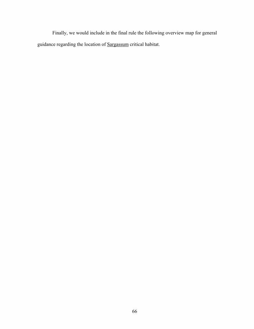
66
Finally, we would include in the final rule the following overview map for general
guidance regarding the location of Sargassum critical habitat.


68
We specifically seek comment on the proposed inclusion of Sargassum habitat as
critical habitat in the final rule, as well as the proposed regulatory text for the specific
unit descriptions, the physical or biological features essential for conservation, and the
overview map.
Because we recognize that this covers a great deal of area, we�’re also seeking
comment from the public on areas that more frequently encompass convergence zones,
surface-water downwelling areas and/or other locations where concentrated components
of the Sargassum community are likely to be found in the Atlantic Ocean and Gulf of
Mexico in order to delimit more accurately and precisely potential Sargassum critical
habitat. This may include information on times of year loggerheads are most likely to co-
occur with Sargassum habitat.
Although consideration of effects to this habitat will be most concerned with
impacts to the Sargassum itself, such as large scale directed take or large scale pollutants
(such as would occur in an oil spill, or large scale disposal or accidental release of trash,
wastes and toxic substances), we recognize that the inclusion of Sargassum habitat would
increase the regulatory burden on Federal agencies and that the dynamic nature of the
habitat presents inherent uncertainties and rather novel issues not presented in previous
designations by NMFS. Thus, we�’re also seeking information on potential impacts of
designation of Sargassum habitat, including the conservation benefits and economic and
other costs, that may have been overlooked in this proposed rule.
The designation of Sargassum critical habitat would help conserve loggerhead sea
turtles by (1) providing for essential forage, cover, and transport habitat for a particularly

69
vulnerable life stage (e.g., post-hatchlings); and (2) ensuring habitat longevity for a
habitat type that is important to multiple life stages and not able to be easily replicated.
Oceanic Habitat. We describe oceanic habitat as waters that are 200 m (656 ft) or
greater in depth. Aside from Sargassum habitat noted above, we did not identify any
additional PBFs of oceanic habitat essential to conservation of the species within the
Northwest Atlantic Ocean DPS. While loggerheads occur in oceanic waters within the
U.S. EEZ and use the Gulf Stream and Florida Loop Current as important dispersal
features to access the developmental habitat of the ocean gyres, we could find no specific
habitat features that were essential to the conservation of the species within this area
other than Sargassum.
North Pacific Ocean DPS
Within the range of the North Pacific Ocean DPS, neither neritic nor Sargassum
habitat are used by loggerheads within U.S. jurisdiction; therefore, no PBFs were
identified for these habitat types. PBFs (and PCEs) were identified for Oceanic Habitat
only. Although the Central North Pacific and the Eastern Pacific/U.S. West Coast share
the PBFs, they have different accompanying PCEs.
Central North Pacific Ocean: We describe the essential PBFs of loggerhead sea
turtle oceanic habitat in the central North Pacific Ocean as waters that support suitable
conditions in sufficient quantity and frequency to provide meaningful foraging,
development, and/or transiting opportunities to the population in the North Pacific
Ocean.
PCEs in the central North Pacific Ocean that support this habitat include the
following:

70
(1) Currents and circulation patterns of the North Pacific Ocean (KEBR, and
the southern edge of the KEC characterized by the Transition Zone Chlorophyll Front)
where physical and biological oceanography combine to promote high productivity
(chlorophyll a = 0.11�–0.31 mg/m3) and sufficient prey quality (energy density 11.2
kJ/g) of species; and
(2) Appropriate SSTs (14.45° to 19.95° C (58.01° to 67.91° F)), primarily
concentrated at the 17° to 18° C (63° to 64° F) isotherm.
Loggerhead foraging and developmental habitat in the North Pacific Ocean occurs
between 28° N. and 40° N. lat. (Polovina et al. 2004) in water with SST of 14.45° C to
19.95° C (58.01° F to 67.91° F) (Kobayashi et al. 2008), but is highly correlated at the
17/18° C (63/64° F) isotherm (Howell et al. 2008). Kobayashi (2012c; NMFS Pacific
Islands Fisheries Science Center (PIFSC), unpublished data) estimated the proportion of
the habitat available to loggerheads that occurs in the U.S. EEZ around Hawaii while
taking into account seasonal and interannual variability, and found a maximum of 4.2
percent of potential loggerhead habitat within the U.S. EEZ. Kobayashi further
examined the seasonal variability of the broader range of SST (14.45° C to 19.95° C).
His analysis showed that this range of SST does not exist within the U.S. EEZ from July
through November, therefore further limiting suitable loggerhead habitat within the U.S.
EEZ around Hawaii to a portion of the year.
Limited data exist to characterize westward migratory routes or habitat of adults
traveling back to Japan where they will breed and nest. Of 48 loggerhead turtles fitted
with satellite transmitters deployed by the Grupo Tortuguero Proyecto Caguama project
at foraging areas in Baja California Sur, Mexico, three (two adults, 1 subadult) transited

71
through the U.S. EEZ around Hawaii (Peckham et al. 2011; Peckham 2012, pers. comm).
NOAA PIFSC Marine Turtle Research Program stranding data indicate that since 1982
only two loggerheads have been recorded as stranded in the Hawaiian Islands, which may
suggest low use of U.S. EEZ waters.
Despite historical population decline and nesting trend variability (Kamezaki et
al. 2003; Conant et al. 2009; Van Houtan and Halley 2011), loggerheads appear to have
remained widely distributed and continue to occupy most, if not all, of their historical
range in the central North Pacific Ocean. Accordingly, those oceanic areas within
loggerhead range that are infrequently used generally do not provide the significant
function that they might for a species with a constricted range. The potential loggerhead
habitat occurring in the U.S. EEZ around Hawaii represents between 0.68 percent and 4.2
percent of the total habitat in the central portion of the Pacific Ocean. This habitat
represents a small percentage of suitable habitat, and the variables that make it suitable
only occur within the U.S. EEZ around Hawaii a portion of the year in spite of
loggerheads using areas north of it throughout the year.
Given the information presented above, we conclude that the habitat within the
U.S. EEZ of the central North Pacific Ocean does not provide meaningful foraging,
development, and/or transiting opportunities to the North Pacific Ocean DPS, and
therefore does not contain PBFs described in the previous section.
Eastern Pacific/ U.S. West Coast: We describe the essential PBFs of loggerhead
sea turtle oceanic habitat in the eastern North Pacific Ocean as waters that support
suitable conditions in sufficient quantity and frequency to provide meaningful foraging,

72
development, and/or transiting opportunities to the population in the North Pacific
Ocean.
PCEs in the eastern North Pacific Ocean that support this habitat include the
following:
(1) Sites that support meaningful aggregations of foraging juveniles; and
(2) Sufficient prey densities of neustonic and oceanic organisms.
Given that so few loggerheads have been found off the coasts of Alaska (two
since 1960), Oregon and Washington (nine since 1958), and California north of Point
Conception (four of 32 off the coast of California since 1990), the only area considered
for designation of critical habitat off the U.S. west coast is the area in southern California
from Point Conception south to the U.S.-Mexico border (also referred to as the Southern
California Bight).
Based on interactions with the California drift gillnet fishery and stranding
records, recorded observations in the Southern California Bight are generally rare events,
with 16 loggerheads taken in 4,165 observed sets from 1990�–2010 (Allen et al. 2013) and
28 loggerheads observed stranded from 1990 to 2012 (average ~1.3 loggerheads/year).
In contrast, waters off the Pacific coast of Baja California, and particularly within the
shelf waters of Ulloa Bay, are highly productive. Loggerheads have been documented in
the thousands in this area (Pitman 1990; Seminoff et al. 2006), and their occurrence is
strongly associated with the red crab, which has often occurred in such numbers as to
�“turn the ocean red�” (Pitman 1990).
Due to the rarity of the presence of loggerheads and their prey both historically
and currently in waters off the U.S. west coast, U.S. waters in the eastern Pacific Ocean

73
do not provide meaningful foraging, development, and/or transiting opportunities to the
loggerhead population in the North Pacific Ocean DPS, and therefore do not contain the
PBFs described in the previous section.
Special Management Considerations
An occupied area may be designated as critical habitat if it contains one or more
of the PBFs essential to conservation, and if such features �“may require special
management considerations or protection�” (16 U.S.C. section 1532(5)(a)(i)(II)). Joint
NMFS and USFWS regulations (50 CFR 424.02(j)) define �“special management
considerations or protection�” to mean �“any methods or procedures useful in protecting
PBFs of the environment for the conservation of listed species.�” NMFS determined that
the PBFs identified earlier may require special management considerations due to a
number of factors that may affect them. These factors include activities, structures, or
other byproducts of human activities. The list below is not necessarily inclusive of all
factors.
Major categories of factors, by habitat type, follow. All of these may have an
effect on one or more PBF or PCE within the range of the Northwest Atlantic Ocean DPS
and may require special management considerations as described below.
Northwest Atlantic Ocean DPS
Terrestrial: The USFWS has addressed special management considerations for
terrestrial units in their proposed rule.
Neritic: Neritic habitat consists of nearshore reproductive, winter, breeding, and
constricted migratory habitat.

74
Nearshore Reproductive Habitat: The primary impact to the PBFs and PCEs of
the nearshore reproductive habitat (habitat from MHW to 1.6 km (1 mile) offshore of
high density nesting beaches and adjacent beaches) for loggerhead sea turtles would be
from activities that result in a loss of habitat conditions that allow for a) hatchling egress
from the water�’s edge to open water; and b) nesting female transit back and forth between
the open water and the nesting beach during nesting season. The loss of such habitat
conditions could come from, but is not limited to, the following sources:
Offshore structures including, but not limited to, breakwaters, groins, jetties, and
artificial reefs, that block or otherwise impede efficient passage of hatchlings or females
and/or which concentrate hatchling predators and thus result in greater predation on
hatchlings;
(1) Lights on land or in the water, which can disorient hatchlings and nesting
females and/or attract predators , particularly lighting that�’s permanent or present for long
durations and has a short wave length (below 540nm);
(2) Oil spills and response, that affect habitat conditions for efficient passage
of hatchlings or females;
(3) Alternative offshore energy development (turbines) that affects habitat
conditions for efficient passage of hatchlings or females;
(4) Fishing gear that blocks or impedes efficient passage of hatchlings or
females; and
(5) Dredging and disposal activities that affect habitat conditions for efficient
passage of hatchlings or females by creating barriers or dramatically altering the slope of
the beach approach.

75
Winter Habitat: The PBF, water temperature PCE, and Gulf Stream boundary
PCE of the winter habitat for loggerhead sea turtles may be affected through the
following:
(1) Large-scale water temperature changes resulting from global climate
change; and
(2) Shifts in the patterns of the Gulf Stream resulting from climate change.
While unlikely to be affected to a significant extent by human activities, the water
depth PCE (20-100 m) could potentially be affected by extensive dredging or sediment
disposal activities.
Breeding Habitat: The PBF of a concentrated breeding habitat and the associated
PCE of high concentrations of reproductive male and female loggerheads (which
facilitates breeding for individuals migrating to that area) could be affected by the
following activities:
(1) Fishing activities that disrupt use of habitat and thus affect concentrations
of reproductive loggerheads;
(2) Dredging and disposal of sediments that affect concentrations of
reproductive loggerheads;
(3) Oil spills and response that affect concentrations of reproductive
loggerheads;
(4) Alternative offshore energy development (turbines) that affect
concentrations of reproductive loggerheads; and
(5) Climate change, which can affect currents and water temperatures and
affect concentrations of reproductive loggerheads.

76
Constricted Migratory Habitat: The primary impact to the functionality of the
identified corridors as migratory routes for loggerhead sea turtles would be a loss of
passage conditions that allow for the free and efficient migration along the corridor. The
loss of these passage conditions could come from large-scale and or multiple construction
projects that result in the placement of substantial structures along the path of the
migration, or other similar habitat alterations, requiring large-scale deviations in the
migration movements. This impact is expected to be much more likely, and have a
greater impact, in the most constricted areas of the migratory routes. Other activities are
less likely to result in an impact to the PCEs but are still considered below.
(1) Oil and gas activities, such as construction and removal of platforms,
lighting and noise that alter habitat conditions needed for efficient passage;
(2) Power generation activities such as turbines, wind farms, conversion of wave
or tidal energy into power that result in altered habitat conditions needed for
efficient passage;
(3) Dredging and disposal of sediments that results in altered habitat conditions
needed for efficient passage;
(4) Channel blasting, including use of explosives to remove existing bridge or
piling structures or to deepen navigation channels, that results in altered
habitat conditions needed for efficient passage;
(5) Marina and dock/pier development that results in altered habitat conditions
needed for efficient passage;
(6) Offshore breakwaters that result in altered habitat conditions needed for
efficient passage;

77
(7) Aquaculture structures such as net pens and fixed structures and artificial
lighting that result in altered habitat conditions needed for efficient passage;
(8) Fishing activities, particularly those using fixed gear (pots, pound nets), that,
when arranged closely together over a wide geographic area, result in altered
habitat conditions needed for efficient passage; and
(9) Noise pollution from construction, shipping and/or military activities that
results in altered habitat conditions needed for efficient passage.
Sargassum Habitat: The PBF of developmental and foraging habitat in
accumulations of floating materials, especially Sargassum, and its associated PCEs of
convergence zones and other areas of concentration, adequate concentrations of
Sargassum to support abundant prey and cover, and the existence of the community of
flora and fauna typically associated with Sargassum habitat can all be impacted by the
following activities which may require special management:
(1) Commercial harvest of Sargassum, which would directly decrease the
amount of habitat;
(2) Oil and gas exploration, development, and transportation that affects the
Sargassum habitat itself and the loggerhead prey items found within this habitat -- this
could occur both in the process of normal operations and during blowouts and oil spills,
which release toxic hydrocarbons and also require other toxic chemicals for cleanup;
(3) Vessel operations that result in the routine disposal of trash and wastes
and/or the accidental release or spillage of cargo, trash or toxic substances, and/or result
in the transfer and introduction of exotic and harmful organisms through ballast water

78
discharge, which may then impact the loggerhead prey species found in Sargassum
habitat;
(4) Ocean dumping of anthropogenic debris and toxins that affects the
Sargassum habitat itself and the loggerhead prey items found within this habitat; and
(5) Global climate change, which can alter the conditions (such as currents
and other oceanographic features and temperature) that allow Sargassum habitat and
communities to thrive in abundance and locations suitable for loggerhead developmental
habitat.
North Pacific Ocean DPS
NMFS did not identify any specific areas within the U.S. EEZ in the North Pacific
Ocean that contain PBFs essential to the conservation of the North Pacific Ocean DPS;
therefore, we did not analyze special management considerations.
Proposed Determinations and Critical Habitat Designation
Northwest Atlantic Ocean DPS
After reviewing the best available scientific information, we conclude that certain
specific areas meet the definition of critical habitat for the Northwest Atlantic Ocean
DPS, that a critical habitat designation is prudent, and that critical habitat is determinable.
Per our joint regulations with USFWS, a designation is prudent because neither of the
situations enumerated in 50 CFR 424.12(a)(1) exists here. Specifically, we find that a
designation is not expected to increase the degree of threats to the species and will be
beneficial to the species. Further, although NMFS and USFWS jointly determined at the
time of the final listing rule in September 2011 (76 FR 58868) that habitat was not then
determinable (per 16 U.S.C. 1533(b)(6)(C)(ii)), we find now, after review of the best

79
available scientific information, that critical habitat for the Northwest Atlantic Ocean
DPS is determinable because neither of the situations described in 50 CFR 424.12(a)(2)
exists here.
When identifying proposed critical habitat, we do not include Naval Air Station
Key West in accordance with section 4(a)(3) of the ESA because its INRMP provides
benefits to the loggerhead sea turtle. We also do not include existing (already
constructed) federally authorized or permitted man-made structures such as aids-to-
navigation, boat ramps, platforms, docks, and pilings within the boundaries of critical
habitat. Man-made structures in the context of this regulation refers to actually
constructed materials or structures placed in, over, or near the water that are not used by
loggerhead sea turtles as habitat. Because these structures are not useable as habitat, they
are not essential to the conservation of the species and therefore do not constitute critical
habitat. We do not refer to human altered elements of the habitat such as navigation
channels or disposal areas. Such altered habitat would not be excluded. If the critical
habitat is finalized as proposed, a Federal action involving excluded structures would not
trigger section 7 consultation to examine effects to critical habitat and the duty to avoid
destruction or adverse modification of designated critical habitat, unless the specific
action would affect the physical or biological features in the adjacent critical habitat. We
seek public comment on the exclusion of these structures and whether our exclusion
should be expanded or narrowed in any way, including information on whether
loggerhead sea turtles use such structures as habitat. The critical habitat areas described
below constitute our best assessment at this time of areas that meet the definition of

80
critical habitat in the marine environment for the Northwest Atlantic Ocean DPS of the
loggerhead sea turtle.
The critical habitat areas described below constitute our best assessment at this
time of areas that meet the definition of critical habitat in the marine environment for the
Northwest Atlantic Ocean DPS of the loggerhead sea turtle.
Neritic Habitat: Neritic habitat includes nearshore reproductive habitat, foraging
habitat, winter habitat, breeding habitat, and constricted migratory habitat. Nearshore
reproductive habitat units are those directed at conserving hatchling swim frenzy and
internesting turtle habitat directly off high density nesting beaches and beaches adjacent
to them, as defined by USFWS in their proposed rule to designate critical habitat for the
loggerhead sea turtle (78 FR 18000; March 25, 2013). Generally, the units include
nearshore areas extending directly seaward from the coast 1.6 km from each end of the
unit (in cases of long, straight beaches, such as many of those found along Florida�’s east
coast). In the cases of beaches along islands or that wrap around into an inlet, we took
the furthest point from the far end of the unit and extended out seaward. Where beaches
are adjacent and within 1.6 km of each other, nearshore areas are connected, either along
the shoreline or by delineating on GIS a straight line from the end of one beach to the
beginning of another (either from island to island or across an inlet or the mouth of an
estuary). Although generally following these rules, the exact delineation of each unit was
determined individually because each was unique.
Specific unit descriptions are as follows. Some units combine two or more habitat
types identified.

81
LOGG-N-1 �– North Carolina Constricted Migratory Corridor and Northern
Portion of the North Carolina Winter Concentration Area: This unit contains constricted
migratory and winter habitat. The unit includes the North Carolina constricted migratory
corridor and the overlapping northern half of the North Carolina winter concentration
area. We defined the constricted migratory corridor off North Carolina as the waters
between 36° N. lat. and Cape Lookout (approximately 34.58° N) and from the shoreline
(MHW) of the Outer Banks, North Carolina, barrier islands to the 200-m depth contour
(continental shelf).
The constricted migratory corridor overlaps with the northern portion of winter
concentration area off North Carolina. The western and eastern boundaries of winter
habitat are the 20-m and 100-m contours, respectively. The northern boundary of winter
habitat starts at Cape Hatteras (35° 16' N) in a straight latitudinal line between the 20-
and 100-m depth contours and ends at Cape Lookout (approximately 34.58° N).
LOGG-N-2 �– Southern Portion of the North Carolina Winter Concentration Area:
This unit contains winter habitat only. The boundaries include waters between the 20-
and 100-m depth contours between Cape Lookout and Cape Fear. The western and
eastern boundaries of winter habitat are the 20-m and 100-m depth contours, respectively.
The northern boundary is Cape Lookout (approximately 34.58° N). The southern
boundary is a 37.5-km line that extends from the 20-m depth contour at approximately
33.47° N, 77.58° W (off Cape Fear) to the 100-m depth contour at approximately 33.2°
N, 77.32° W.
LOGG-N-3 �– Bogue Banks and Bear Island, Carteret and Onslow Counties, NC:
This unit contains nearshore reproductive habitat only. The unit consists of nearshore

82
area from Beaufort Inlet to Bear Inlet (crossing Bogue Inlet) from the MHW line seaward
1.6 km. This unit contains an area adjacent to high density nearshore reproductive habitat
(Beaufort Inlet to Bogue Inlet) as well as an area of high density nearshore reproductive
habitat (Bogue Inlet to Bear Inlet).
LOGG-N-4 �– Onslow Beach (Marine Corps Base Camp Lejeune), Topsail Island
and Lea-Huttaf Islands, Onslow and Pender Counties, NC: This unit contains nearshore
reproductive habitat only. The unit consists of nearshore area from Browns Inlet to Rich
Inlet (crossing New River Inlet and New Topsail Inlet) from the MHW line seaward 1.6
km. This unit contains areas of high density nearshore reproductive habitat (Topsail
Island) as well as areas adjacent to high density nearshore reproductive habitat (Onslow
Beach and Lea-Hutaff Island).
LOGG-N-5 �– Pleasure Island, Bald Head Island, Oak Island, and Holden Beach,
New Hanover and Brunswick Counties, NC: This unit contains nearshore reproductive
habitat only. The unit consists of nearshore areas from Carolina Beach Inlet around Cape
Fear to Shallotte Inlet (crossing the mouths of the Cape Fear River and Lockwoods Folly
Inlet) from the MHW line seaward 1.6 km. This unit contains areas adjacent to high
density nearshore reproductive habitat (Pleasure Island and Holden Beach) and high
density nearshore reproductive habitat (Bald Head Island and Oak Island) of loggerhead
sea turtles in North Carolina.
LOGG-N-6 �– North, Sand, South and Cedar Islands, Georgetown County, SC;
Murphy, Cape and Lighthouse Islands and Racoon Key, Charleston County, SC: This
unit contains nearshore reproductive habitat only. The unit consists of nearshore area
from North Inlet to Five Fathom Creek Inlet (crossing Winyah Bay, North Santee Inlet,

83
South Santee Inlet, Cape Romain Inlet, and Key Inlet) from the MHW line seaward 1.6
km. This unit contains areas adjacent to high density nearshore reproductive habitat
(North, Cedar and Murphy Islands and Raccoon Key) and high density nearshore
reproductive habitat (Sand, South, Cape and Lighthouse Islands) of loggerhead sea turtles
in South Carolina.
LOGG-N-7 �– Folly, Kiawah, Seabrook, Botany Bay Islands, Botany Bay
Plantation, Interlude Beach and Edingsville Beach, Charleston County, SC; Edisto Beach
State Park, Edisto Beach, and Pine and Otter Islands, Colleton County, SC: This unit
contains nearshore reproductive habitat only. The unit consists of nearshore area from
Lighthouse Inlet to Saint Helena Sound (crossing Folly River, Stono, Captain Sam�’s,
North Edisto, Frampton, Jeremy, South Edisto and Fish Creek Inlets) from the MHW line
seaward 1.6 km. This unit contains areas adjacent to high density nearshore reproductive
habitat (Folly and Seabrook Islands, Interlude Beach, Edisto Beach, and Pine Island) and
high density nearshore reproductive habitat (Kiawah and Botany Bay Islands, Botany
Bay Plantation, Edingsville Beach, Edisto Beach State Park, and Otter Island) of
loggerhead sea turtles in South Carolina.
LOGG-N-8 �– Harbor Island, Beaufort County, SC: This unit contains nearshore
reproductive habitat only. The unit consists of nearshore area from Harbor Inlet to
Johnson Inlet from the MHW line seaward 1.6 km. This unit is adjacent to high density
nearshore reproductive habitat by loggerhead sea turtles in South Carolina.
LOGG-N-9�– Little Capers, St. Phillips and Bay Point Islands, Beaufort County,
SC: This unit contains nearshore reproductive habitat only. The unit consists of
nearshore area from Pritchards Inlet to Port Royal Sound (crossing Trenchards Inlet and

84
Morse Island Creek Inlet East) from the MHW line seaward 1.6 km. This unit consists of
areas adjacent to high density nearshore reproductive habitat (Little Capers and Bay Point
Islands) and high density nearshore reproductive habitat (St. Phillips Island) of
loggerhead sea turtles in South Carolina.
LOGG-N-10 �– Little Tybee Island, Chatham County, GA: This unit contains
nearshore reproductive habitat only. The boundaries of this unit are from Tybee Creek
Inlet to Wassaw Sound from the MHW line seaward 1.6 km. This unit is adjacent to high
density nearshore reproductive habitat of loggerhead sea turtles in Georgia.
LOGG-N-11 �– Wassaw Island, Chatham County, GA: This unit contains
nearshore reproductive habitat only. The boundaries of the unit are from Wassaw Sound
to Ossabaw Sound from the MHW line seaward 1.6 km. This unit contains high density
nearshore reproductive habitat of loggerhead sea turtles in Georgia.
LOGG-N-12 �– Ossabaw Island, Chatham County, GA; St. Catherines Island,
Liberty County, GA; Blackbeard and Sapelo Islands, McIntosh County, GA: This unit
contains nearshore reproductive habitat only. The boundaries of this unit are nearshore
areas from Ossabow Sound to Deboy Sound (crossing St. Catherines Sound, McQueen
Inlet, Sapelo Sound, and Cabretta Inlet) from the MHW line seaward 1.6 km. This unit
contains both high density nearshore reproductive habitat (Ossabaw and Blackbeard
Islands), and areas adjacent to high density nearshore reproductive habitat (St. Catherines
and Sapelo Islands) of loggerhead sea turtles in Georgia.
LOGG-N-13 �– Little Cumberland Island, Camden County, GA; Cumberland
Island, Camden County, GA: This unit contains nearshore reproductive habitat only.
The boundaries of this unit are nearshore areas from St. Andrew Sound to the St. Marys

85
River (Crossing Christmas Creek) from the MHW line seaward 1.6 km. This unit
contains both high density nearshore reproductive habitat (Cumberland Island) and areas
adjacent to high density nearshore reproductive habitat (Little Cumberland Island) of
loggerhead sea turtles in Georgia.
LOGG-N-14 �– Southern boundary of Kathryn Abbey Hanna Park, Duval County
to Matanzas Inlet, St. Johns County, FL: This unit contains nearshore reproductive
habitat only. The boundaries of the unit are nearshore areas from the southern boundary
of Kathryn Abbey Hanna Park to Matanzas Inlet (crossing St. Augustine Inlet) from the
MHW line seaward 1.6 km. This unit contains both high density nearshore reproductive
habitat (Guana Tolomato Matanzas NERR to St. Augustine Inlet) and areas adjacent to
high density nearshore reproductive habitat (South Duval County to Old Ponte Vedra,
and St. Augustine Inlet to Matanzas Inlet) of loggerhead sea turtles in the Northern
Florida Region of the Peninsular Florida Recovery Unit.
LOGG-N-15 �– Northern Boundary of River to Sea Preserve at Marineland,
Flagler County, FL to Granada Blvd, Volusia County, FL: This unit contains nearshore
reproductive habitat only. The boundaries of the unit are nearshore areas from the
northern boundary of River to Sea Preserve at Marineland to Granada Boulevard in
Ormond Beach from the MHW line seaward 1.6 km. This unit contains high density
nearshore reproductive habitat in the Northern Florida Region of the Peninsular Florida
Recovery Unit.
LOGG-N-16 �– Canaveral National Seashore to 28.70 ° N, 80.66 ° W near
Titusville, Volusia and Brevard Counties, FL: This unit contains nearshore reproductive
habitat only. Boundaries of the unit are nearshore areas from the north boundary of

86
Canaveral National Seashore to 28.70 ° N, 80.66 ° W near Titusville (at the start of the
Titusville -- Floridana Beach concentrated breeding area) from the MHW line seaward
1.6 km. This unit contains both areas adjacent to high density nearshore reproductive
habitat (northern boundary of Canaveral National Seashore to the Volusia-Brevard
County line) and high density nearshore reproductive habitat (Volusia-Brevard County
line to Titusville) of loggerhead sea turtles in the Central Eastern Florida Region of the
Peninsular Florida Recovery Unit.
LOGG-N-17 �– Titusville to Floridana Beach Concentrated Breeding Area,
Northern Portion of the Florida Constricted Migratory Corridor, Nearshore Reproductive
Habitat from 28.70 ° N, 80.66 ° W near Titusville to Cape Canaveral Air Force Station,
Brevard County, FL, and Nearshore Reproductive Habitat Patrick Airforce Base and
Central Brevard Beaches, FL: This unit includes overlapping areas of nearshore
reproductive habitat, constricted migratory habitat, and breeding habitat. The
concentrated breeding habitat area is from the MHW line on shore at 28.70 ° N, 80.66 °
W near Titusville, out to depths less than 60 m (consistent with what is reported in
Arendt et al. 2012a), and extending south to Floridana Beach. This overlaps with waters
in the northern portion of the Florida constricted migratory corridor, which begins at the
tip of Cape Canaveral Air Force Station and ends at Floridana beach, extending from the
MHW line on shore to the 30-m depth contour line.
Additionally, the above two habitat areas overlap with two nearshore reproductive
habitat areas. The first begins near Titusville at 28.70 ° N, 80.66 ° W to the south
boundary of the Cape Canaveral Air Force Station/Canaveral Barge Canal Inlet from the
MHW line seaward 1.6 km. The second begins at Patrick Air Force Base, Brevard

87
County, through the central Brevard Beaches to Floridana Beach from the MHW line
seaward 1.6 km. These nearshore reproductive areas contain high density nearshore
reproductive habitat of loggerhead sea turtles in the Central Eastern Florida Region of the
Peninsular Florida Recovery Unit.
LOGG-N-18 �– Florida Constricted Migratory Corridor from Floridana Beach to
Martin County/Palm Beach County Line, FL; and Nearshore Reproductive Habitat from
Floridana Beach to the south end of Indian River Shores; Brevard and Indian River
Counties; and Nearshore Reproductive Habitat from the Fort Pierce inlet to Martin
County/Palm Beach County Line, Sebastian and Martin Counties, FL: This unit contains
nearshore reproductive habitat and constricted migratory habitat. The unit contains a
portion of the Florida constricted migratory corridor, which is located in the nearshore
waters from the MHW line on shore to the 30-m depth contour off Floridana Beach to the
Martin County/Palm Beach County line. This overlaps with two nearshore reproductive
habitat areas. The first nearshore reproductive area includes nearshore areas from
Floridana Beach to the south end of Indian River Shores (crossing Sebastian Inlet) from
the MHW line seaward 1.6 km. The second nearshore reproductive habitat area includes
nearshore areas from Fort Pierce inlet to Martin County/Palm Beach County line
(crossing St. Lucie Inlet) from the MHW line seaward 1.6 km. These nearshore
reproductive areas contain high density nearshore reproductive habitat (Floridana to
Sebastian Inlet and Fort Pierce Inlet to the Martin County/Palm Beach County line) and
areas adjacent to high density nearshore reproductive habitat (Sebastian Inlet to Indian
River Shores) by loggerhead sea turtles in the Central Eastern Florida Region of the
Peninsular Florida Recovery Unit.

88
LOGG-N-19 - Southern Florida Constricted Migratory Corridor; Southern
Florida Concentrated Breeding Area; and Nearshore Reproductive Areas of Martin
County/Palm Beach County line to Hillsboro Inlet, Palm Beach and Broward Counties,
FL); and Long Key, Bahia Honda Key, Woman Key, Boca Grande Key, and Marquesas
Keys, Monroe County, FL: This unit contains nearshore reproductive habitat, constricted
migratory habitat, and breeding habitat. The unit contains the southern Florida
constricted migratory corridor habitat, overlapping southern Florida breeding habitat, and
overlapping nearshore reproductive habitat. The southern portion of the Florida
concentrated breeding area and the southern Florida constricted migratory corridor are
both located in the nearshore waters starting at the Martin County/Palm Beach County
line to the westernmost edge of the Marquesas Keys (82.17° W. long.), with the
exception of the waters under the jurisdiction of NAS Key West. The seaward border
then follows the 200-m depth contour line to the westernmost edge at the Marquesas
Keys.
The nearshore reproductive habitat includes (1) nearshore waters starting at the
Martin County/Palm Beach County line to Hillsboro Inlet (crossing Jupiter, Lake Worth,
Boynton and Boca Raton Inlets) from the MHW line seaward 1.6 km; (2) Long Key,
which is bordered on the east by the Atlantic Ocean, on the west by Florida Bay, and on
the north and south by natural channels between Keys (Fiesta Key to the north and Conch
Key to the south), and has boundaries following the borders of the island from the MHW
line and seaward to 1.6 km; (3) Bahia Honda Key, from the MHW line seaward 1.6 km;
(4) Woman Key, from the MHW line seaward 1.6 km; (5) Boca Grande Key, from the
MHW line seaward 1.6 km; (6) the Marquesas Keys unit boundary, including nearshore

89
areas from the MHW line and seaward to 1.6 km from four islands where loggerhead sea
turtle nesting has been documented within the Marquesas Keys: Marquesas Key,
Unnamed Key 1, Unnamed Key 2, and Unnamed Key 3.
These nearshore reproductive unit from the Martin County/Palm Beach County
line to Hillsboro Inlet contains both high density nearshore reproductive habitat (Jupiter
Inlet to Boynton Inlet (crossing Lake Worth Inlet), and Boca Raton Inlet to Hillsboro
Inlet) and areas adjacent to high density nearshore reproductive habitat (Boynston Inlet to
Boca Raton Inlet). The nearshore reproductive habitat units in the Florida Keys (Long
Key and Bahia Honda Key) were included to ensure conservation of nearshore
reproductive habitat off of the unique nesting habitat in the Florida Keys. Woman and
Boca Grande Keys and the Marquesas Keys are part of the Dry Tortugas Recovery Unit
and were included because of the extremely small size of the Dry Tortugas Recovery
Unit.
LOGG-N-20 �– Dry Tortugas, Monroe County, FL: This unit contains nearshore
reproductive habitat only. The unit boundary includes nearshore areas from the MHW
line and seaward to 1.6 km from six islands where loggerhead sea turtle nesting has been
documented within the Dry Tortugas. From west to east, these six islands are:
Loggerhead Key, Garden Key, Bush Key, Long Key, Hospital Key, and East Key. This
unit was included because of the extremely small size of the Dry Tortugas Recovery
Unit.
LOGG-N-21 �– Cape Sable, Monroe County, FL: This unit contains nearshore
reproductive habitat only. The boundaries of the unit are nearshore areas from the MHW
line and seaward to 1.6 km from the north boundary of Cape Sable to the south boundary

90
of Cape Sable. This unit contains high density nearshore reproductive habitat of
loggerhead sea turtles in the Southwestern Florida Region of the Peninsular Florida
Recovery Unit.
LOGG-N-22 �– Graveyard Creek to Shark Point, Monroe County, FL: This unit
contains nearshore reproductive habitat only. The boundaries of this unit are nearshore
areas from Shark Point (25.387949, -81.149308) to Graveyard Creek Inlet from the
MHW line seaward 1.6 km. This unit contains high density nearshore reproductive
habitat of loggerhead sea turtles in the Southwestern Florida Region of the Peninsular
Florida Recovery Unit.
LOGG-N-23 �– Highland Beach, Monroe County, FL: This unit contains
nearshore reproductive habitat only. The boundaries of this unit are from First Bay to
Rogers River Inlet from the MHW line seaward 1.6 km. This unit contains areas adjacent
to high density nearshore reproductive habitat of loggerhead sea turtles in the
Southwestern Florida Region of the Peninsular Florida Recovery Unit.
LOGG-N-24 �– Ten Thousand Islands North, Collier County, FL: This unit
contains nearshore reproductive habitat only. The unit includes nearshore areas from the
MHW line seaward 1.6 km of nine keys where loggerhead sea turtle nesting has been
documented within the northern part of the Ten Thousand Islands in Collier County in
both the Ten Thousand Islands NWR and the Rookery Bay NERR. This unit contains
areas adjacent to high density nearshore reproductive habitat of loggerhead sea turtles in
the Southwestern Florida Region of the Peninsular Florida Recovery Unit.
LOGG-N-25 �– Cape Romano, Collier County, FL: This unit contains nearshore
reproductive habitat only. The boundaries of the unit are nearshore areas from Caxambas

91
Pass to Gullivan Bay from the MHW line seaward 1.6 km. This unit contains areas
adjacent to high density nearshore reproductive habitat of loggerhead sea turtles in the
Southwestern Florida Region of the Peninsular Florida Recovery Unit.
LOGG-N-26 �– Keewaydin Island and Sea Oat Island, Collier County, FL: This
unit contains nearshore reproductive habitat only. The boundaries of the unit are
nearshore areas from Gordon Pass to Big Marco Pass from the MHW line seaward 1.6
km. This unit contains areas of high density nearshore reproductive habitat of loggerhead
sea turtles in the Southwestern Florida Region of the Peninsular Florida Recovery Unit.
LOGG-N-27 �– Little Hickory Island to Doctors Pass, Lee and Collier Counties,
FL: This unit contains nearshore reproductive habitat only. The boundaries of the unit
are nearshore areas from Little Hickory Island to Doctors Pass (crossing Wiggins Pass
and Clam Pass) from the MHW line seaward 1.6 km. This unit contains areas adjacent to
high density nearshore reproductive habitat of loggerhead sea turtles in the Southwestern
Florida Region of the Peninsular Florida Recovery Unit.
LOGG-N-28 �– Captiva Island and Sanibel Island West, Lee County, FL: This
unit contains nearshore reproductive habitat only. The boundaries of the unit are
nearshore areas from the north end of Captiva/Captiva Island Golf Club (starting at
Redfish Pass and crossing Blind Pass) and along Sanibel Island West to Tarpon Bay
Road from the MHW line seaward 1.6 km. This unit contains both high density
nearshore reproductive habitat (Sanibel Island West) and areas adjacent to high density
nearshore reproductive habitat (Captiva Island) of loggerhead sea turtles in the Central
Western Florida Region of the Peninsular Florida Recovery Unit.

92
LOGG-N-29 �– Siesta and Casey Keys, Sarasota Count, FL; Venice Beaches and
Manasota Key, Sarasota and Charlotte Counties, FL; Knight, Don Pedro, and Little
Gasparilla Islands, Charlotte County, FL; Gasparilla Island, Charlotte and Lee Counties,
FL; Cayo Costa, Lee County, FL: This unit contains nearshore reproductive habitat only.
The boundaries of this unit are nearshore areas from Big Sarasota Pass to Cativa Pass
(crossing Venice Inlet, Stump Pass, Gasparilla Pass, and Boca Grande Pass) from the
MHW line seaward 1.6 km. This unit contains both high density nearshore reproductive
habitat (Siesta and Casey Keys; Venice Beaches and Manasota Key; and Knight, Don
Pedro, and Little Gasparilla Islands) and areas adjacent to high density nearshore
reproductive habitat (Cayo Costa) of loggerhead sea turtles in the Central Western
Florida Region of the Peninsular Florida Recovery Unit.
LOGG-N-30 �– Longboat Key, Manatee and Sarasota Counties, FL: This unit
contains nearshore reproductive habitat only. The boundaries of this unit are the north
point of Longboat Key at Longboat Pass to New Pass from the MHW line seaward 1.6
km. This unit is adjacent to high density nearshore reproductive habitat of loggerhead
sea turtles in the Central Western Florida Region of the Peninsular Florida Recovery
Unit.
LOGG-N-31 �– St. Joseph Peninsula, Cape San Blas, St. Vincent, Little St.
George, St. George, and Dog Islands, Gulf and Franklin Counties, FL: This unit contains
nearshore reproductive habitat only. The boundaries of this unit are from St. Joseph Bay
to St. George Sound (including Eglin Air Force Base and crossing Indian, West, and East
Passes) from the MHW line seaward 1.6 km. This unit contains both areas adjacent to
high density nearshore reproductive habitat (Cape San Blas, St. George Island and Dog

93
Island) and high density nearshore reproductive habitat (St. Joseph Peninsula, St. Vincent
Island, Little St. George Island) of loggerhead sea turtles in the Florida portion of the
Northern Gulf of Mexico Recovery Unit.
LOGG-N-32 �– Mexico Beach and St. Joe Beach, Bay and Gulf Counties, FL:
This unit contains nearshore reproductive habitat only. The boundaries of the unit are
from the eastern boundary of Tyndall Air Force Base to Gulf County Canal in St. Joseph
Bay from the MHW line seaward 1.6 km. This unit is adjacent to high density nearshore
reproductive habitat of loggerhead sea turtles in the Florida portion of the Northern Gulf
of Mexico Recovery Unit.
LOGG-N-33 �– Gulf State Park to Pensacola Pass, Baldwin County, AL and
Escambia County, FL: This unit contains nearshore reproductive habitat only. The
boundaries of the unit are nearshore areas from the west boundary of Gulf State Park to
the Pensacola Pass (crossing Perdido Pass and the AL-FL border) from the MHW line
seaward 1.6 km. This unit contains both high density nearshore reproductive habitat
(Gulf State Park to Perdido Pass) and areas adjacent to high density nearshore
reproductive habitat (Perdido Pass to Pensacola Pass) of loggerhead sea turtles in the
Alabama and Florida portions of the Northern Gulf of Mexico Recovery Unit.
LOGG-N-34 �– Mobile Bay �— Little Lagoon Pass, Baldwin County, AL: This
unit contains nearshore reproductive habitat only. The boundaries of the unit are
nearshore areas from Mobile Bay Inlet to Little Lagoon Pass from the MHW line seaward
1.6 km. This unit contains high density nearshore reproductive habitat of loggerhead sea
turtles in the Alabama portion of the Northern Gulf of Mexico Recovery Unit.

94
LOGG-N-35 �– Petit Bois Island, Jackson County, MS: This unit contains
nearshore reproductive habitat only. The boundaries of the unit are nearshore areas from
Horn Island Pass to Petit Bois Pass from the MHW line seaward 1.6 km. This unit was
selected because it is one of two islands with the greatest number of nests in the
Mississippi portion of the Northern Gulf of Mexico Recovery Unit.
LOGG-N-36 �– Horn Island, Jackson County, MS: This unit contains nearshore
reproductive habitat only. The boundaries of the unit are nearshore areas from Dog Keys
Pass to the eastern most point of the ocean facing island shore from the MHW line
seaward 1.6 km. This unit was selected because it is one of two islands with the greatest
number of nests in the Mississippi portion of the Northern Gulf of Mexico Recovery
Unit.
Oceanic Habitat. If Sargassum habitat is included in the final rule, it would likely
include oceanic habitat as described above.
North Pacific Ocean DPS
After reviewing the best available scientific information, we conclude that no
specific areas exist within U.S. jurisdiction that meet the definition of critical habitat for
the North Pacific Ocean DPS. We did not identify any critical habitat within the U.S.
EEZ in the Pacific Ocean for the North Pacific Ocean DPS because occupied habitat
within the U.S. EEZ did not support suitable conditions in sufficient quantity and
frequency to provide meaningful foraging, development, and/or transiting opportunities
to the population in the North Pacific Ocean.
Unoccupied Areas

95
Section 3(5)(A)(ii) of the ESA authorizes designation of �“specific areas outside
the geographical areas occupied by the species at the time it is listed�” if those areas are
determined to be essential to the conservation of the species. Joint NMFS and USFWS
regulations (50 CFR 424.12(e)) emphasize that the agency shall designate as critical
habitat areas outside the geographical area presently occupied by a species only when a
designation limited to its present range would be inadequate to ensure the conservation of
the species. At the present time we have not identified additional specific areas outside
the geographic area occupied by loggerheads at the time of their listing that may be
essential for the conservation of the species.
Application of section 4(a)(3) of the ESA
The ESA precludes the Secretary from designating military lands as critical
habitat if those lands are subject to an INRMP under the Sikes Act Improvement Act of
1997 (Sikes Act; 16 U.S.C. 670a) and the Secretary certifies in writing that the plan
benefits the listed species (Section 4(a)(3), Pub. L. 108�–136).
NMFS has determined that the INRMP for NAS Key West confers benefits to the
loggerhead sea turtle and enhances its habitat, and therefore is not proposing the waters
subject to that INRMP for critical habitat designation. Management actions described in
the NAS Key West INRMP that benefit loggerhead sea turtles include water quality
measures, invasive species control, re-establishment of historic tidal connections for
mangrove/saltmarsh and shallow open water (including areas containing seagrasses),
completion of a marine benthic survey, installation of turtle-friendly lights, and
community outreach and information.

96
We are proposing as critical habitat the waters off Onslow Beach on MCB Camp
Lejeune, North Carolina; however, we are holding discussions with the U.S. Marine
Corps regarding this INRMP, and may revisit this determination prior to finalizing this
proposed rule.
ESA Section 4(b)(2) Analysis
Section 4(b)(2) of the ESA states that the Secretary shall designate and make
revisions to critical habitat on the basis of the best available scientific data after taking
into consideration the economic impact, national security impact, and any other relevant
impact of specifying any particular area as critical habitat (16 U.S.C. section 1533(b)(2)).
In addition to this mandatory consideration of impacts set out in the first sentence of
section 4(b)(2), the second sentence gives the Secretary discretion to go further and
proceed to an optional weighing of the benefits of including a particular area against the
benefits of excluding such an area. The Secretary may exclude an area from critical
habitat if s/he determines that the benefits of such exclusion (avoiding the economic,
national security, or other costs) outweigh the benefits of specifying such area as part of
the critical habitat (the conservation benefits to the species), unless s/he determines,
based on the best scientific data available, that the failure to designate such area as
critical habitat will result in the extinction of the species (16 U.S.C. 1533(b)(2)). In
making that determination, the statute, as well as the legislative history, are clear that the
Secretary has broad discretion regarding whether to proceed to the optional weighing of
benefits, which factor(s) to use, how much weight to give to any factor, and whether or
not to exclude any area.
Benefits of Inclusion

97
The benefits of designating specific areas include the protection afforded under
section 7(a)(2) of the ESA, requiring all Federal agencies to ensure that their actions are
not likely to destroy or adversely modify critical habitat. This is in addition to the
requirement that all Federal agencies ensure that their actions are not likely to jeopardize
the continued existence of the species. The designation of critical habitat also provides
conservation benefits such as improved education and outreach by informing the public
about areas and features important to species conservation, as well as additional
protections under state and local authorities.
We find that, because the PBFs and PCEs of the proposed habitat inherently focus
on the areas that best support the needs of the species (i.e., those that support meaningful
aggregations of the species) and the areas were selected expressly to ensure maximum
consistency with the goals in the species�’ recovery plan, each of the proposed areas is of
high conservation value.
Economic Benefits of Exclusion
According to the draft Economic Analysis, the total estimated present value of the
quantified impacts is $830,000 over the next 10 years. On an annualized basis, this is
equivalent to impacts of $95,000 (IEc 2013). The quantified impacts of designation are
the same as the economic benefits of exclusion. Costs for each unit can be found in
Exhibit 1 of the draft Economic Analysis (IEc 2013). Impacts are anticipated to be
greatest in LOGG-N-19 (25 percent or $24,200 annually), a large unit that extends from
Martin County/Palm Beach County line to the Marquesas Keys in Monroe County, and
which includes several nearshore reproductive areas as well as the southern-most
constricted migratory corridor and concentrated breeding habitat in Florida. These costs

98
are due primarily to the frequency of consultations anticipated for in-water construction,
dredging, and sediment disposal activities, but also to the size of the unit relative to most
of the other units. Impacts in the Atlantic Sargassum habitat unit, LOGG-S-01 (23
percent or $22,000) and the Gulf of Mexico Sargassum unit, LOGG-S-02 (13 percent, or
$12,000) reflect the very large size of these units, rather than the potential for activities to
adversely affect this habitat type in particular. The majority of anticipated impacts are
administrative costs associated with consultation on nearshore and in-water construction,
dredging, and sediment disposal activities (63 percent) and fisheries and related activities
(33 percent). The draft Economic Analysis describes in more detail the types of activities
that may be affected by the designation and the estimated relative level of economic
impacts (IEc 2013).
The highest estimated annual economic cost associated with the designation of
loggerhead critical habitat is $25,000 for a large unit, LOGG-N-19, and the estimated
cost associated with the designation of most units as critical habitat is below $1,000.
Because these numbers are so low, all units are considered to have a �“low�” economic
impact. Typically, to be considered �“high,�” an economic value would need to be above
several million dollars (sometimes tens of millions), and �“medium�” may fall between
several hundred thousand and millions of dollars.
Exclusions of Particular Areas Based on Economic Impacts
Because all units identified for loggerheads have a high conservation value and a
low economic impact, no areas were considered for exclusion based on economic
impacts. Because no areas are recommended for exclusion, we do not need to make the

99
further consideration of whether exclusions would result in the extinction of the
Northwest Atlantic Ocean DPS of the loggerhead sea turtle.
Exclusions Based on Impacts to National Security
The Secretary must consider possible impacts to national security when
determining critical habitat (16 U.S.C. 1533(b)(2)). We shared the draft Biological
Report with the Departments of the Navy (including Marine Corps), Army, Air Force and
the Department of Homeland Security. The Navy and Air Force provided comments and
shared concerns about portions of the breeding area in LOGG-N-17 (the Trident
Submarine Basin, other basins and the portion of the navigation channel, inlet, and
Canaveral Barge Canal). This unit, which represented a minimal convex polygon
delineating breeding habitat that was adopted from Arendt (2012a), was re-examined
with Arendt and others to ensure its borders were appropriate for a critical habitat unit, as
there were questions as to whether the channel, basins, Banana River and a portion of the
Indian River Lagoon truly represented critical breeding habitat. The western extent of
LOGG-N-17 was adjusted, based on input from the Navy and Air Force, to follow the
shoreline instead of going into the Port and the Indian River Lagoon and Banana River.
Although we did not adjust this boundary for national security reasons, per se, we agreed
that these basins, rivers and canal, were not critical to loggerhead breeding.
Discussions with the Navy indicated that there is overlap between the areas
proposed for critical habitat and Navy activities. However, we do not believe that these
activities, as currently conducted, are the types of activities that may affect or adversely
modify critical habitat proposed for the loggerhead sea turtle or its PBF/PCEs. As a

100
result, we conclude that Navy activities are not likely to be affected by this proposed
designation, and the designation would not affect national security.
Department of Homeland Security (DHS) marine vessels routinely conduct patrol
activities in areas proposed for critical habitat. These patrol activities support DHS�’s
national security mission. The patrols involve vessels that are typically smaller than
Navy vessels. We do not believe that these activities, as currently conducted, are the
types of activities that may affect or adversely modify critical habitat proposed for the
loggerhead sea turtle or its PBF/PCEs. Therefore, we conclude that DHS activities are
not likely to be affected by this proposed designation, and the designation would not
affect national security.
No additional national security concerns have been raised at this time; therefore,
we have not excluded any areas due to national security concern. We can revisit this
determination.
Exclusions for Indian Lands
No Indian lands occur in the areas being recommended for designation, and no
Indian activities are anticipated to be affected by designation. Therefore no exclusions
are recommended for Indian Lands.
Critical Habitat Designation
We proposed to designate 36 occupied marine areas of critical habitat for the
Northwest Atlantic Ocean DPS. These areas contain one or a combination of nearshore
reproductive habitat, winter area, breeding areas, and constricted migratory corridors, and
two areas that contain Sargassum habitat. The proposed critical habitat areas contain the
PBFs essential to the conservation of the species that may require special management

101
considerations or protection. We do not propose to exclude any areas based on economic
impacts and do not propose to exclude any areas based on national security concerns at
this time but can revisit this determination.
Effects of Critical Habitat Designation
Section 7(a)(2) of the ESA requires Federal agencies to insure that any action
authorized, funded, or carried out by the agency (agency action) does not jeopardize the
continued existence of any threatened or endangered species or destroy or adversely
modify designated critical habitat (16 U.S.C. 1536(a)(2)). Federal agencies are also
required to confer with us and USFWS regarding any actions likely to jeopardize a
species proposed for listing under the ESA, or likely to destroy or adversely modify
proposed critical habitat, pursuant to section 7(a)(4) (16 U.S.C. 1536(a)(4)). A
conference involves informal discussions in which we may recommend conservation
measures to minimize or avoid adverse effects. The discussions and conservation
recommendations are to be documented in a conference report provided to the Federal
agency undertaking the action at issue. If requested by the Federal agency, a formal
conference report may be issued, including a biological opinion prepared according to 50
CFR 402.14. A formal conference report may be adopted as the biological opinion when
the species is listed or critical habitat designated, if no significant new information or
changes to the action alter the content of the opinion. When a species is listed or critical
habitat is designated, Federal agencies must consult with NMFS on any agency actions
they authorize, fund, or carry out that may affect the species or its critical habitat (16
U.S.C. 1536(a)(2)). During the consultation, we evaluate the agency action to determine
whether the action may adversely affect listed species or critical habitat and issue our
102
findings in a biological opinion or, if appropriate, in a letter concurring with a finding of
the action agency that their action is not likely to adversely affect the species. If we
conclude in the biological opinion that the agency action would likely result in the
destruction or adverse modification of critical habitat, we would also recommend any
reasonable and prudent alternatives to the action. 16 U.S.C. 1536(b)(4)(2). Reasonable
and prudent alternatives (defined in 50 CFR 402.02) are alternative actions identified
during formal consultation that can be implemented in a manner consistent with the
intended purpose of the action, that are consistent with the scope of the Federal agency�’s
legal authority and jurisdiction, that are economically and technologically feasible, and
that would avoid the destruction or adverse modification of critical habitat. Regulations
(50 CFR 402.16) require Federal agencies that have retained discretionary involvement or
control over an action, or where such discretionary involvement or control is authorized
by law, to reinitiate consultation on previously reviewed actions in instances where (1)
critical habitat is subsequently designated, or (2) new information or changes to the
action may result in effects to critical habitat not previously considered in the biological
opinion. Consequently, some Federal agencies may request reinitiation of a consultation
or conference with us on actions for which formal consultation has been completed, if
those actions may affect designated critical habitat or adversely modify or destroy
proposed critical habitat.
Activities subject to the ESA section 7 consultation process include Federal
activities and non-Federal activities requiring a permit from a Federal agency (e.g., a
Clean Water Act, Section 404 dredge or fill permit from the U.S. Army Corps of
Engineers (USACE)) or some other Federal action, including funding (e.g., Federal

103
Highway Administration funding for transportation projects). ESA section 7 consultation
would not be required for Federal actions that do not affect listed species or critical
habitat and for non-Federal activities or activities on non-federal and private lands that
are not federally funded, authorized, or carried out.
Activities that May be Affected
ESA section 4(b)(8) requires in any proposed or final rule to designate critical
habitat an evaluation and brief description, to the maximum extent practicable, of those
activities that may adversely modify such habitat or that may be affected by the
designation. A wide variety of activities may affect the proposed critical habitat and may
be subject to the ESA section 7 consultation process when carried out, funded, or
authorized by a Federal agency. These include (1) nearshore and in-water construction,
dredging, and sediment disposal, such as construction and maintenance of offshore
structures such as breakwaters, groins, jetties, and artificial reefs; construction and
maintenance of transportation projects (e.g., bridges) and utility projects; dredging and
sediment disposal; channel blasting; (2) fisheries management, such as Federal
commercial fisheries and related activities; (3) oil and gas exploration and development,
such as decommissioning of old oil and gas platforms, construction of nearshore oil and
gas platforms, oil and gas activity transport in the nearshore environment; (4) renewable
energy projects, such as ocean thermal energy, wave energy, and offshore wind energy;
(5) some military activities, such as in-water training and research; and (6) aquaculture,
such as marine species propagation.
For ongoing activities, we recognize that designation of critical habitat may
trigger reinitiation of past consultations. In most cases, we do not anticipate the outcome

104
of reinitated consultation to require significant additional conservation measures, because
effects to habitat would likely have been assessed in the original consultation. We
commit to working closely with other Federal agencies to implement these reinitiated
consultations in an efficient and streamlined manner that, as much as possible and
consistent with our statutory and regulatory obligations, minimizes the staff and resource
burden and recognizes existing habitat conservation measures from previously completed
ESA consultations. Further, we will continue to work with other agencies to refine and
revise cost estimates associated with such consultations.
Information Quality Act and Peer Review
The data and analyses supporting this proposed action have undergone a pre-
dissemination review and have been determined to be in compliance with applicable
information quality guidelines implementing the Information Quality Act (IQA) (Section
515 of Public Law 106�–554). In December 2004, the Office of Management and Budget
(OMB) issued a Final Information Quality Bulletin for Peer Review pursuant to the IQA.
The Bulletin established minimum peer review standards, a transparent process for public
disclosure of peer review planning, and opportunities for public participation with regard
to certain types of information disseminated by the Federal Government. The peer
review requirements of the OMB Bulletin apply to influential or highly influential
scientific information disseminated on or after June 16, 2005. To satisfy our
requirements under the OMB Bulletin, we obtained independent peer review of the draft
Biological Report (NMFS 2013) that supports the proposal to designate critical habitat
for the loggerhead sea turtle and incorporated the peer review comments prior to
dissemination of this proposed rulemaking.
105
Public Comments Solicited
We solicit comments or suggestions from the public, other concerned governments and
agencies, the scientific community, industry, non-governmental organizations, or any
other interested party concerning the proposed designation, the biological report, the draft
Economic Analysis and its appended IRFA analysis. We are particularly interested in
comments and information in the following areas: (1) information on foraging areas that
could be considered for critical habitat designation, including the PBFs and PCEs of these
areas (see the foraging habitat discussion in the �“Description of Physical or Biological
Features and Primary Constituent Elements and Identification of Specific Sites�” section
for further detail); (2) comments on whether to include Sargassum habitat as critical
habitat and, if so, whether we should include the entire areas, features, and elements
described and mapped in the �“Description of Physical or Biological Features and Primary
Constituent Elements and Identification of Specific Sites�” section, information on
specific areas that frequently encompass convergence zones, surface-water downwelling
areas and/or other locations where concentrated components of the Sargassum
community are likely to be found in the Atlantic Ocean and Gulf of Mexico in order to
delimit more accurately and precisely potential Sargassum critical habitat, and
information on times of year or areas that loggerheads are most likely to co-occur with
Sargassum habitat, (3) information on potential impacts, including conservation benefits
and economic and other costs, of designating Sargassum critical habitat that may have
been overlooked; (4) comments on critical habitat units proposed for designation or those
overlooked, including PBFs and PCEs of these areas, particularly for breeding areas; (5)
comments on the methodology underlying our approach to focus on areas supporting the

106
most meaningful usage by the species and to ensure geographic representation of areas to
ensure consistency with the recovery plan; (6) comments regarding any areas we may
have overlooked that would meet the definition of critical habitat for the North Pacific
Ocean DPS; (7) information on other impacts to PBFs or PCEs that may require special
management considerations or protection; (8) information regarding potential benefits or
impacts of designating any particular area proposed as critical habitat, including
information on the types of Federal actions that may trigger an ESA section 7
consultation and may either affect the area�’s PBFs or require modifications of those
activities; (9) information regarding the benefits of excluding a particular area from
critical habitat, including on the basis of economic impacts or national security concerns;
(10) information regarding the benefits of excluding existing manmade structures from
critical habitat, whether the waters below such structures should likewise be excluded
from designation (including potential impacts and costs of requiring consultation to such
areas by including them in the designation), and whether the exclusion of existing
manmade structures should be expanded or narrowed in a way; (11) current or planned
activities in the areas proposed as critical habitat and costs of potential modifications to
those activities due to critical habitat designation; and (12) any foreseeable economic,
national security, or other relevant impact resulting from the proposed designation. You
may submit your comments and materials concerning this proposal by any one of several
methods (see ADDRESSES). Copies of the proposed rule and supporting
documentation can be found on the NMFS Web site at
http://www.nmfs.noaa.gov/pr/species/turtles/loggerhead.htm. We will consider all

107
comments pertaining to this designation received during the comment period in preparing
the final rule. Accordingly, the final decision may differ from this proposal.
Public Hearings
Joint NMFS and USFWS regulations (50 CFR 424.16(c)(3)) state that the
Secretary shall promptly hold at least one public hearing if any person requests one
within 45 days of publication of a proposed rule to list a species or to designate critical
habitat. Public hearings provide the opportunity for interested individuals and parties to
give comments, exchange information and opinions, and engage in a constructive
dialogue concerning this proposed rule. We encourage the public�’s participation and
involvement in ESA matters. Requests for public hearings must be made in writing (see
ADDRESSES) by [insert date 45 days after date of publication in the Federal Register].
If a public hearing is requested, a notice detailing the specific hearing location and time
will be published in the Federal Register at least 15 days before the hearing is to be held.
Information on the specific hearing locations and times will also be posted on our Web
site at: http://www.nmfs.noaa.gov/pr/species/turtles/loggerhead.htm.
Classification
Regulatory Planning and Review
The Office of Management and Budget (OMB) has determined that this proposed
rule is significant under Executive Order 12866. A draft Economic Analysis and 4(b)(2)
analysis as set forth herein have been prepared to support the exclusion process under
section 4(b)(2) of the ESA.
National Environmental Policy Act

108
We have determined that an environmental analysis as provided for under the
National Environmental Policy Act of 1969 for critical habitat designations made
pursuant to the ESA is not required. See Douglas County v. Babbitt, 48 F.3d 1495 (9th
Cir. 1995), cert. Denied, 116 S.Ct 698 (1996).
Regulatory Flexibility Act
Under the Regulatory Flexibility Act (RFA) (5 U.S.C. 601 et seq., as amended by
the Small Business Regulatory Enforcement Fairness Act (SBREFA) of 1996), whenever
an agency publishes a notice of rulemaking for any proposed or final rule (other than one
regarding the listing of a species under the Endangered Species Act), it must prepare and
make available for public comment a regulatory flexibility analysis describing the effects
of the rule on small entities (i.e., small businesses, small organizations, and small
government jurisdictions). We have prepared an initial regulatory flexibility analysis
(IRFA), which is an appendix to the draft Economic Analysis. This document is
available upon request (see ADDRESSES) and via our Web site
http://www.nmfs.noaa.gov/pr/species/turtles/loggerhead.htm, or via the Federal
eRulemaking web site at http://www.regulations.gov. The results of the IRFA are
summarized below.
The action is being considered by the agency because it is required by the
Endangered Species Act (16 U.S.C. 1531 et seq.). In 2011, NMFS and USFWS
published a joint rulemaking revising the species�’ listing from a single, worldwide
threatened species to nine DPSs. The two DPSs occurring in U.S. jurisdiction are the
Northwest Atlantic Ocean DPS and the North Pacific Ocean DPS. Critical habitat can
only be designated in areas under U.S. jurisdiction. The 2011 revised listing rule

109
precipitated the proposed critical habitat designation for the Northwest Atlantic Ocean
DPS and the proposed determination not to designate critical habitat for the North Pacific
Ocean DPS.
The objective of the rule is to utilize the best scientific and commercial
information available to designate critical habitat for the loggerhead sea turtle to best
meet the conservation needs of the species in order to meet recovery goals. Section
4(b)(2) of the Act requires NMFS to designate critical habitat for threatened and
endangered species �“on the basis of the best scientific data available and after taking into
consideration the economic impact, impact on national security, and any other relevant
impact, of specifying any particular area as critical habitat.�”
Three types of small entities are defined in the IRFA: (1) Small business, (2)
small governmental jurisdiction; and (3) small organization. The regulatory mechanism
through which critical habitat protections are enforced is section 7 of the Act, which
directly regulates only those activities carried out, funded, or permitted by a Federal
agency. By definition, Federal agencies are not considered small entities, although the
activities they may fund or permit may be proposed or carried out by small entities. This
analysis considers the extent to which this designation could potentially affect small
entities, regardless of whether these entities would be directly regulated by NMFS
through the proposed rule or by a delegation of impact from the directly regulated entity.
The IRFA focuses on small entities that may bear the incremental impacts of this
rulemaking quantified in chapters 3 through 6 of the draft Economic Analysis on four
categories of economic activity potentially requiring modification to avoid destruction or
adverse modification of loggerhead sea turtle critical habitat. Small entities also may

110
participate in ESA section 7 consultation as an applicant or may be affected by a
consultation if they intend to undertake an activity that requires a permit, license or
funding from the Federal Government. It is therefore possible that the small entities may
spend additional time considering critical habitat during section 7 consultation for the
loggerhead sea turtle. Potentially affected activities include: nearshore and in-water
construction, dredging and disposal, fisheries, oil and gas exploration and development,
and alternative energy projects.
Estimated impacts to small entities are summarized by industry in Exhibit A-1 of
the IRFA. Exhibit A-2 of the IRFA describes potentially affected small businesses by
NAICS code, highlighting the relevant small business thresholds. Although businesses
affected indirectly are considered, this analysis considers only those entities for which
impacts would not be measurably diluted; i.e., it focuses on those entities that may bear
some additional costs associated with participation in section 7 consultation.
Based on the number of past consultations and information about potential future
actions likely to take place within proposed critical habitat areas, this analysis forecasts
the number of additional consultations that may take place as a result of critical habitat
(see Chapters 3 through 6 of the draft Economic Analysis). Based on this forecast,
annual incremental consultation costs that may be borne by third parties are forecast at
$27,200 (discounted at seven percent), some portion of which may be borne by small
entities.
Ideally this analysis would directly identify the number of small entities which
may engage in activities that overlap with the proposed designation; however, while
NMFS tracks the Federal agency that is involved in the consultation process, it does not
111
track the identity of past permit recipients or the particulars that would allow NMFS to
determine whether the recipients were small entities. Nor does NMFS track how often
Federal agencies have hired small entities to complete various actions associated with
these consultations. In the absence of this information, this analysis utilizes Dun and
Bradstreet databases to determine the number of small businesses operating within the
NAICS codes identified in Exhibit A-3 in each county with marine coastline in the
proposed designation. Exhibit A-4 presents the potentially affected small counties.
The proposed rule does not directly mandate �“reporting�” or �“record keeping�”
within the meaning of the Paperwork Reduction Act (PRA), and does not impose record
keeping or reporting requirements on small entities. A critical habitat designation would
require that Federal agencies initiate a section 7 consultation to insure their actions do not
destroy or adversely modify critical habitat. During formal section 7 consultation under
the ESA, NMFS, the action agency (Federal agency), and a third party participant
applying for Federal funding or permitting, may communicate in efforts to minimize
potential adverse impacts to the habitat and/or the essential features. Communication
may include written letters, phone calls, and/or meetings. Project variables such as the
type of consultation, the location, impacted essential features, and activity of concern,
may in turn dictate the complexity of these interactions. Third party costs may include
administrative work, such as cost of time and materials to prepare for letters, calls, or
meetings. The cost of analyses related to the activity and associated reports may be
included in these administrative costs. In addition, following the section 7 consultation
process, entities may be required to monitor progress during the said activity to ensure
that impacts to the habitat and features have been minimized.

112
An IRFA must identify any duplicative, overlapping, and conflicting Federal
rules. The protection of listed species and habitat under critical habitat may overlap other
sections of the Act. The protections afforded to threatened and endangered species and
their habitat are described in section 7, 9, and 10 of the ESA. A final determination to
designate critical habitat requires Federal Agencies to consult, pursuant to section 7 of the
ESA, with NMFS on any activities the Federal agency funds, authorizes, or carries out,
including permitting, approving, or funding non-Federal activities (e.g., a Clean Water
Act, Section 404 dredge or fill permit from USACE). The requirement to consult is to
ensure that any Federal action authorized, funded, or carried out will not likely jeopardize
the continued existence of any endangered or threatened species or result in the
destruction or adverse modification of critical habitat. The incremental impacts forecast
in this report and contemplated in this IRFA are expected to result from the critical
habitat designation and not other Federal regulations.
In accordance with the requirements of the RFA (as amended by SBREFA, 1996)
this analysis considers various alternatives to the proposed critical habitat designation for
the loggerhead sea turtle. The alternative of not designating critical habitat for the
loggerhead sea turtle was considered and rejected because such an approach does not
meet the legal requirements of the ESA. Section 4(b)(2) of the Act allows the NMFS to
exclude areas proposed for designation based on economic impact and other relevant
impacts. Therefore, an alternative to the proposed designation is the designation of a
subset of these areas or portions of the various habitat types.
Coastal Zone Management Act

113
Section 307(c)(1) of the Federal Coastal Zone Management Act of 1972 requires
that all Federal activities that affect the land or water use or natural resource of the
coastal zone be consistent with approved state coastal zone management programs to the
maximum extent practicable. We have determined that this proposed designation of
critical habitat is consistent to the maximum extent practicable with the enforceable
policies of approved Coastal Zone Management Programs of New Jersey, Delaware,
Maryland, Virginia, North Carolina, South Carolina, Georgia, Florida, Alabama,
Mississippi, Louisiana, and Texas. The determination has been submitted to the
responsible agencies in the aforementioned states for review.
Federalism
Executive Order 13132 requires agencies to take into account any Federalism
impacts of regulations under development. It includes specific consultation directives for
situations in which a regulation will preempt state law, or impose substantial direct
compliance costs on state and local governments (unless required by statute). We have
determined that the proposed rule to designate critical habitat for the loggerhead sea turtle
under the ESA would, if finalized, not have federalism implications. The designation of
critical habitat directly affects only the responsibilities of Federal agencies. As a result,
the proposed rule does not have substantial direct effects on the States, on the relationship
between the national government and the States, or on the distribution of power and
responsibilities among the various levels of government, as specified in the Order. State
or local governments may be indirectly affected by the proposed revision if they require
Federal funds or formal approval or authorization from a Federal agency as a prerequisite
to conducting an action. In these cases, the State or local government agency may

114
participate in the section 7 consultation as a third party. One of the key conclusions of
the incremental analysis is that we do not expect critical habitat designation to generate
additional requests for project modification in any of the proposed critical habitat units.
Incremental economic impacts of the designation will likely be limited to minor
additional administrative costs to NMFS, Federal agencies, and third parties when
considering critical habitat as part of the forecast section 7 consultations. Therefore, the
proposed designation of critical habitat is also not expected to have substantial indirect
impacts on State or local governments.
Consistent with the requirements of Executive Order 13132, recognizing the
intent of the Administration and Congress to provide continuing and meaningful dialogue
on issues of mutual state and Federal interest, and in keeping with Department of
Commerce policies, the Assistant Secretary for Legislative and Intergovernmental Affairs
will provide notice of the proposed action and request comments from the appropriate
officials in states where loggerhead sea turtles occur.
Paperwork Reduction Act
This proposed rule does not contain a collection-of-information requirement
for purposes of the Paperwork Reduction Act.
Unfunded Mandates Reform Act
In accordance with the Unfunded Mandates Reform Act, we make the following
findings: The designation of critical habitat does not impose an �‘�‘enforceable duty�’�’ on
state, local, tribal governments, or the private sector and therefore does not qualify as a
Federal mandate. In general, a Federal mandate is a provision in legislation, statute, or
regulation that would impose an �‘�‘enforceable duty�’�’ upon non-federal governments, or

115
the private sector and includes both �‘�‘Federal intergovernmental mandates�’�’ and �‘�‘Federal
private sector mandates.�’�’
Under the ESA, the only direct regulatory effect of this proposed rule, if finalized,
is that Federal agencies must ensure that their actions do not destroy or adversely modify
critical habitat under section 7. While non-federal entities who receive Federal funding,
assistance, permits, or otherwise require approval or authorization from a Federal agency
for an action may be indirectly affected by the designation of critical habitat, the legally
binding duty to avoid the destruction or adverse modification of critical habitat rests
squarely on the Federal agency. Furthermore, to the extent that nonfederal entities are
indirectly affected because they receive Federal assistance or participate in a voluntary
Federal aid program, the Unfunded Mandates Reform Act would not apply.
We do not believe that this proposed rule would significantly or uniquely affect
small governments because it is not likely to produce a Federal mandate of $100 million
or greater in any year; that is, it is not a �‘�‘significant regulatory action�’�’ under the
Unfunded Mandates Reform Act. In addition, the designation of critical habitat imposes
no obligations on local, state or tribal governments. Therefore, a Small Government
Agency Plan is not required.
Takings
Under Executive Order 12630, Federal agencies must consider the effects of their
actions on constitutionally protected private property rights and avoid unnecessary
takings of property. A taking of property includes actions that result in physical invasion
or occupancy of private property, and regulations imposed on private property that
substantially affect its value or use.

116
In accordance with Executive Order 12630, the proposed critical habitat
designation does not pose significant takings implications. A takings implication
assessment is not required. This proposed designation affects only Federal agency
actions (i.e. those actions authorized, funded, or carried out by Federal agencies).
Therefore, the critical habitat designation does not affect landowner actions that do not
require Federal funding or permits.
This designation would not increase or decrease the current restrictions on private
property concerning take of loggerhead sea turtles, nor do we expect the final critical
habitat designation to impose substantial additional burdens on land use or substantially
affect property values. Additionally, the final critical habitat designation does not
preclude the development of Conservation Plans and issuance of incidental take permits
for non-Federal actions. Owners of property included or used within the proposed critical
habitat designation would continue to have the opportunity to use their property in ways
consistent with the survival of listed loggerhead sea turtles.
Government to Government Relationships with Tribes
The longstanding and distinctive relationship between the Federal and tribal
governments is defined by treaties, statutes, executive orders, judicial decisions, and
agreements, which differentiate tribal governments from the other entities that deal with,
or are affected by, the Federal Government. This relationship has given rise to a special
Federal trust responsibility involving the legal responsibilities and obligations of the
United States toward Indian Tribes and the application of fiduciary standards of due care
with respect to Indian lands, tribal trust resources, and the exercise of tribal rights.
117
Executive Order 13175, Consultation and Coordination with Indian Tribal
Governments, outlines the responsibilities of the Federal Government in matters affecting
tribal interests. If NMFS issues a regulation with tribal implications (defined as having a
substantial direct effect on one or more Indian tribes, on the relationship between the
Federal Government and Indian tribes, or on the distribution of power and responsibilities
between the Federal Government and Indian tribes) we must consult with those
governments or the Federal Government must provide funds necessary to pay direct
compliance costs incurred by tribal governments. The proposed critical habitat
designation does not have tribal implications. The proposed critical habitat designation
does not include any tribal lands and does not affect tribal trust resources or the exercise
of tribal rights.
Energy Effects
Executive Order 13211 requires agencies to prepare a Statement of Energy
Effects when undertaking a �‘�‘significant energy action.�’�’ According to Executive Order
13211, �‘�‘significant energy action�’�’ means any action by an agency that is expected to
lead to the promulgation of a final rule or regulation that is a significant regulatory action
under Executive Order 12866 and is likely to have a significant adverse effect on the
supply, distribution, or use of energy. We have considered the potential impacts of this
action on the supply, distribution, or use of energy (see draft Economic Analysis). Oil
and gas exploration and alternative energy projects may affect the essential features of
critical habitat for the loggerhead sea turtle. Due to the extensive requirements of oil and
gas development and renewable energy projects to consider environmental impacts,
including impacts on marine life, even absent critical habitat designation for the
118
loggerhead sea turtle, we anticipate it is unlikely that critical habitat designation will
change conservation efforts recommended during section 7 consultation for these
projects. Consequently, it is unlikely the identified activities and projects will be affected
by the designation beyond the quantified administrative impacts. Therefore, the proposed
designation is not expected to impact the level of energy production. It is unlikely that
any impacts to the industry that remain unquantified will result in a change in production
above the one billion kilowatt-hour threshold identified in the Executive Order.
Therefore, it appears unlikely that the energy industry will experience �“a significant
adverse effect�” as a result of the critical habitat designation for the loggerhead sea turtle.
References Cited
A complete list of all references cited in this rule making can be found on our web
site at http://www.nmfs.noaa.gov/pr/species/turtles/loggerhead.htm, and is available upon
request from the NMFS (see ADDRESSES).
List of Subjects in 50 CFR Part 226
Endangered and threatened species.
Dated:
______________________
Samuel D. Rauch III,
Deputy Assistant Administrator for Regulatory Programs,
performing the functions and duties of the
Assistant Administrator for Fisheries
National Marine Fisheries Service.

119
For the reasons set out in the preamble, we propose to amend part 226, title 50 of
the Code of Federal Regulations as set forth below:
PART 226-DESIGNATED CRITICAL HABITAT
1. The authority citation of part 226 continues to read as follows:
Authority: 16 U.S.C. 1533.
2. Add § 226.223, to read as follows:
§ 226.223 Critical habitat for the Northwest Atlantic Ocean Distinct Population Segment
of the loggerhead sea turtle (Caretta caretta).
Critical habitat is designated for the Northwest Atlantic Ocean Distinct Population
Segment of the loggerhead sea turtle (Caretta caretta) as described in this section. The
textual descriptions of critical habitat in this section are the definitive source for
determining the critical habitat boundaries. For nearshore reproductive areas, the units
extend directly from the mean high water (MHW) line at each end of the unit seaward 1.6
km. Where beaches are within 1.6 km of each other, nearshore areas are connected,
either along the shoreline (MHW line) or by delineating on GIS a straight line from the
end of one beach to the beginning of another (either from island to island or across an
inlet or the mouth of an estuary). Although generally following these rules, the exact
delineation of each unit was determined individually because each was unique. The
overview maps are provided for general guidance only and not as a definitive source for
determining critical habitat boundaries.
(a) Critical habitat boundaries. Critical habitat is designated to include the
following areas:
120
(1) LOGG-N-1 �– North Carolina Constricted Migratory Corridor and
Northern Portion of the North Carolina Winter Concentration Area. This unit contains
constricted migratory and winter habitat. The unit includes the North Carolina
constricted migratory corridor and the overlapping northern half of the North Carolina
winter concentration area. We defined the constricted migratory corridor off North
Carolina as the waters between 36° N. lat. and Cape Lookout (approximately 34.58° N)
from the edge of the Outer Banks, North Carolina, barrier islands to the 200-meter (m)
(656 feet) depth contour (continental shelf). The constricted migratory corridor overlaps
with the northern portion of winter concentration area off North Carolina. The east and
western boundaries of winter habitat are the 20-m and 100-m (65.6 and 328 feet)
contours, respectively. The northern boundary of winter habitat starts at Cape Hatteras
(35° 16' N) in a straight latitudinal line between 20- and 100- m (65.6-328 feet) depth
contours and ends at Cape Lookout (approximately 34.58° N).
(2) LOGG-N-2 �– Southern Portion of the North Carolina Winter
Concentration Area. This unit contains winter habitat only. The boundaries include
waters between the 20- and 100-m (65.6 and 328 feet) depth contours between Cape
Lookout to Cape Fear. The eastern and western boundaries of winter habitat are the 20-m
and 100-m (65.6 and 328 feet) contours, respectively. The northern boundary is Cape
Lookout (approximately 34.58° N). The southern boundary is a 37.5-km (23.25-mile)
line that extends from the 20-m (65.6 feet) depth contour at approximately 33.47° N,
77.58° W (off Cape Fear) to the 100-m (328 feet) depth contour at approximately 33.2°
N, 77.32° W.
121
(3) LOGG-N-3 �– Bogue Banks and Bear Island, Carteret and Onslow
Counties, North Carolina. This unit contains nearshore reproductive habitat only. The
unit consists of nearshore area from Beaufort Inlet to Bear Inlet (crossing Bogue Inlet)
from the MHW line seaward 1.6 km.
(4) LOGG-N-4 �– Onslow Beach (Marine Corps Base Camp Lejeune), Topsail
Island and Lea-Huttaf Island, Onslow and Pender Counties, North Carolina. This unit
contains nearshore reproductive habitat only. The unit consists of nearshore area from
Browns Inlet to Rich Inlet (crossing New River Inlet and New Topsail Inlet) from the
MHW line seaward 1.6 km (1.0 mile).
(5) LOGG-N-5 �– Pleasure Island, Bald Head Island, Oak Island, and Holden
Beach, New Hanover and Brunswick Counties, North Carolina. This unit contains
nearshore reproductive habitat only. The unit consists of nearshore area from Carolina
Beach Inlet around Cape Fear to Shallotte Inlet (crossing the mouths of the Cape Fear
River and Lockwoods Folly Inlet), from the MHW line seaward 1.6 km.
(6) LOGG-N-6 �– North, Sand, South and Cedar Islands, Georgetown County,
South Carolina; Murphy, Cape, Lighthouse Islands and Racoon Key, Charleston County,
South Carolina. This unit contains nearshore reproductive habitat only. The unit consists
of nearshore area from North Inlet to Five Fathom Creek Inlet (crossing Winyah Bay,
North Santee Inlet, South Santee Inlet, Cape Romain Inlet, and Key Inlet) from the MHW
line seaward 1.6 km.
(7) LOGG-N-7 �– Folly, Kiawah, Seabrook, Botany Bay Islands, Botany Bay
Plantation, Interlude Beach, and Edingsville Beach, Charleston County, South Carolina;
Edisto Beach State Park, Edisto Beach, and Pine and Otter Islands, Colleton County,
122
South Carolina. This unit contains nearshore reproductive habitat only. The unit consists
of nearshore area from Lighthouse Inlet to Saint Helena Sound (crossing Folly River,
Stono, Captain Sam�’s, North Edisto, Frampton, Jeremy, South Edisto and Fish Creek
Inlets) from the MHW line seaward 1.6 km.
(8) LOGG-N-8 �– Harbor Island, Beaufort County, South Carolina. This unit
contains nearshore reproductive habitat only. The unit consists of nearshore area from
Harbor Inlet to Johnson Inlet from the MHW line seaward 1.6 km.
(9) LOGG-N-9�– Little Capers, St. Phillips, and Bay Point Islands, Beaufort
County, South Carolina. This unit contains nearshore reproductive habitat only. The unit
consists of nearshore area from Pritchards Inlet to Port Royal Sound(crossing Trenchards
Inlet and Morse Island Creek Inlet East) from the MHW line seaward 1.6 km.
(10) LOGG-N-10 �– Little Tybee Island, Chatham County, Georgia: This unit
contains nearshore reproductive habitat only. The boundaries of this unit are from Tybee
Creek Inlet to Wassaw Sound from the MHW line seaward 1.6 km.
(11) LOGG-N-11 �– Wassaw Island, Chatham County, Georgia: This unit
contains nearshore reproductive habitat only. The boundaries of the unit are from
Wassaw Sound to Ossabaw Sound from the MHW line seaward 1.6 km.
(12) LOGG-N-12 – Ossabaw Island, Chatham County, Georgia; St. Catherines
Island, Liberty County, Georgia; Blackbeard and Sapelo Islands, McIntosh County,
Georgia: This unit contains nearshore reproductive habitat only. The boundaries of this
unit are nearshore areas from the Ogeechee River to Deboy Sound (crossing St.
Catherines Sound, McQueen Inlet, Sapelo Sound, and Cabretta Inlet) extending from the
MHW line and seaward 1.6 km.

123
(13) LOGG-N-13 �– Little Cumberland Island and Cumberland Island, Camden
County, Georgia: This unit contains nearshore reproductive habitat only. The boundaries
of this unit are nearshore areas from St. Andrew Sound to the St. Marys River (Crossing
Christmas Creek) from the MHW line seaward 1.6 km (1.0mile).
(14) LOGG-N-14 �– Southern Boundary of Kathryn Abbey Hanna Park to
Mantanzas Inlet, Duval and St. Johns Counties, Florida: This unit contains nearshore
reproductive habitat only. The boundaries of the unit are nearshore areas from the south
boundary of Kathryn Abbey Hanna Park to Matanzas Inlet (crossing St. Augustine Inlet)
from the MHW line seaward 1.6 km.
(15) LOGG-N-15 �– Northern Boundary of River to Sea Preserve at Marineland
to Granada Blvd, Flagler and Volusia Counties, Florida: This unit contains nearshore
reproductive habitat only. The boundaries of the unit are nearshore areas from the north
boundary of River to Sea Preserve at Marineland to Granada Boulevard in Ormond
Beach from the MHW line seaward 1.6 km.
(16) LOGG-N-16 �– Canaveral National Seashore to 28.70 ° N, 80.66 ° W near
Titusville, Volusia and Brevard Counties, Florida: This unit contains nearshore
reproductive habitat only. Boundaries of the unit are nearshore areas from the north
boundary of Canaveral National Seashore to 28.70 ° N, 80.66 ° W near Titusville (at the
start of the Titusville--Floridana Beach concentrated breeding area) from the MHW line
seaward 1.6 km.
(17) LOGG-N-17 �– Titusville to Floridana Beach Concentrated Breeding Area,
Northern Portion of the Florida Constricted Migratory Corridor, Nearshore Reproductive
Habitat from 28.70 ° N, 80.66 ° W near Titusville to Cape Canaveral Air Force Station;

124
and Nearshore Reproductive Habitat from Patrick Airforce Base and Central Brevard
Beaches, Brevard County, Florida: This unit includes overlapping areas of nearshore
reproductive habitat, constricted migratory habitat, and breeding habitat. The
concentrated breeding habitat area is from the MHW line on shore at 28.70 ° N, 80.66 °
W near Titusville to depths less than 60 m and extending south to Floridana Beach. This
overlaps with waters in the northern portion of the Florida constricted migratory corridor,
which begins at the tip of Cape Canaveral Air Force Station (28.46° N. lat.) and ends at
Floridana beach, including waters from the MHW line on shore to the 30-m contour line.
Additionally, the above two habitat areas overlap with two nearshore reproductive habitat
areas. The first begins near Titusville at 28.70 ° N, 80.66 ° W to the south boundary of
the Cape Canaveral Air Force Station/Canaveral Barge Canal Inlet from the MHW line
seaward 1.6 km. The second begins at Patrick Air Force Base, Brevard County, through
the central Brevard Beaches to Floridana Beach from the MHW line seaward 1.6 km.
(18) LOGG-N-18 �– Florida Constricted Migratory Corridor from Floridana
Beach to Martin County/Palm Beach County Line; Nearshore Reproductive Habitat from
Floridana Beach to the south end of Indian River Shores; Nearshore Reproductive
Habitat from Fort Pierce inlet to Martin County/Palm Beach County Line, Brevard,
Indian River and Martin Counties, Florida �– This unit contains nearshore reproductive
habitat and constricted migratory habitat. The unit contains a portion of the Florida
constricted migratory corridor, which is located in the nearshore waters from the MHW
line to the 30-m contour off Floridana Beach to the Martin County/Palm Beach County
line. This overlaps with two nearshore reproductive habitat areas. The first nearshore
reproductive area includes nearshore areas from Floridana Beach to the south end of

125
Indian River Shores (crossing Sebastian Inlet) from the MHW line seaward1.6 km. The
second nearshore reproductive habitat area includes nearshore areas from Fort Pierce
inlet to Martin County/Palm Beach County line (crossing St. Lucie Inlet) from the MHW
line seaward 1.6 km.
(19) LOGG-N-19 - Southern Florida Constricted Migratory Corridor; Southern
Florida Concentrated Breeding Area; and Six Nearshore Reproductive Areas: Martin
County/Palm Beach County line to Hillsboro Inlet, Palm Beach and Broward Counties,
Florida; Long Key, Bahia Honda Key, Woman Key, Boca Grande Key, and Marquesas
Keys, Monroe County, Florida �– This unit contains nearshore reproductive habitat,
constricted migratory habitat, and breeding habitat. The unit contains the southern
Florida constricted migratory corridor habitat, overlapping southern Florida breeding
habitat, and overlapping nearshore reproductive habitat. The southern portion of the
Florida concentrated breeding area and the southern Florida constricted migratory
corridor are both located in the nearshore waters starting at the Martin County/Palm
Beach County line to the westernmost edge of the Marquesas Keys (82.17° W. long.),
with the exception of the waters under the jurisdiction of NAS Key West. The seaward
border then follows the 200-m contour line to the westernmost edge at the Marquesas
Keys. The overlapping nearshore reproductive habitat includes nearshore waters starting
at the Martin County/Palm Beach County line to Hillsboro Inlet (crossing Jupiter, Lake
Worth, Boyton, and Boca Raton Inlets) from the MHW line seaward 1.6 km; Long Key,
which is bordered on the east by the Atlantic Ocean, on the west by Florida Bay, and on
the north and south by natural channels between Keys (Fiesta Key to the north and Conch
Key to the south), and has boundaries following the borders of the island from the MHW

126
line seaward to 1.6 km; Bahia Honda Key, from the MHW line seaward 1.6 km; 4)
Woman Key, from the MHW line and seaward to 1.6 km; 5) Boca Grande Key, from the
MHW line seaward to 1.6 km; 6) the Marquesas Keys unit boundary, including nearshore
areas from the MHW line seaward to 1.6 km from four islands where loggerhead sea
turtle nesting has been documented within the Marquesas Keys: Marquesas Key,
Unnamed Key 1, Unnamed Key 2, and Unnamed Key 3.
(20) LOGG-N-20 �– Dry Tortugas, Monroe County, Florida: This unit contains
nearshore reproductive habitat only. The unit boundary includes nearshore areas from
the MHW line and seaward to 1.6 km (1.0 mile) from six islands where loggerhead sea
turtle nesting has been documented within the Dry Tortugas. From west to east, these six
islands are: Loggerhead Key, Garden Key, Bush Key, Long Key, Hospital Key, and East
Key.
(21) LOGG-N-21 �– Cape Sable, Monroe County, Florida: This unit contains
nearshore reproductive habitat only. The boundaries of the unit are nearshore areas from
the MHW line and seaward to 1.6 km from the north boundary of Cape Sable at 25.25 °
N, 81.17 ° W to the south boundary of Cape Sable at 25.12 ° N, 81.07 ° W.
(22) LOGG-N-22 �– Graveyard Creek to Shark Point, Monroe County, Florida:
This unit contains nearshore reproductive habitat only. The boundaries of this unit are
nearshore areas from Shark Point (25.39 ° N, 81.15 ° W) to Graveyard Creek Inlet from
the MHW line seaward 1.6 km.
(23) LOGG-N-23 �– Highland Beach, Monroe County, Florida: This unit
contains nearshore reproductive habitat only. The boundaries of this unit are from First
Bay to Rogers River Inlet from the MHW line seaward 1.6 km.

127
(24) LOGG-N-24 �– Ten Thousand Islands North, Collier County, Florida: This
unit contains nearshore reproductive habitat only. The unit boundary includes nearshore
areas from the MHW line seaward 1.6 km (1.0 mile) of nine keys where loggerhead sea
turtle nesting has been documented within the northern part of the Ten Thousand Islands
in Collier County in both the Ten Thousand Islands NWR and the Rookery Bay NERR.
(25) LOGG-N-25 �– Cape Romano, Collier County, Florida: This unit contains
nearshore reproductive habitat only. The boundaries of the unit are nearshore areas from
Caxambas Pass to Gullivan Bay from the MHW line seaward 1.6 km.
(26) LOGG-N-26 �– Keewaydin Island and Sea Oat Island, Collier County,
Florida: This unit contains nearshore reproductive habitat only. The boundaries of the
unit are nearshore areas from Gordon Pass to Big Marco Pass from the MHW line
seaward 1.6 km.
(27) LOGG-N-27 �– Little Hickory Island to Doctors Pass, Lee and Collier
Counties, Florida: This unit contains nearshore reproductive habitat only. The
boundaries of the unit are nearshore areas from Little Hickory Island to Doctors Pass
(crossing Wiggins Pass and Clam Pass) from the MHW line seaward 1.6 km.
(28) LOGG-N-28 �– Captiva Island and Sanibel Island West, Lee County,
Florida: This unit contains nearshore reproductive habitat only. The boundaries of the
unit are nearshore areas from the north end of Captiva/Captiva Island Golf Club (starting
at Redfish Pass and crossing Blind Pass) and along Sanibel Island West to Tarpon Bay
Road, from the MHW line seaward 1.6 km.
(29) LOGG-N-29 �– Siesta and Casey Keys, Sarasota County; Venice Beaches
and Manasota Key, Sarasota and Charlotte Counties; Knight, Don Pedro, and Little

128
Gasparilla Islands, Charlotte County; Gasparilla Island, Charlotte and Lee Counties;
Cayo Costa, Lee County, Florida: This unit contains nearshore reproductive habitat only.
The boundaries of this unit are nearshore areas from Big Sarasota Pass to Catliva Pass
(crossing Venice Inlet, Stump Pass, Gasparilla Pass, and Boca Grande Pass), from the
MHW line seaward 1.6 km.
(30) LOGG-N-30 �– Longboat Key, Manatee and Sarasota Counties, Florida:
This unit contains nearshore reproductive habitat only. The boundaries of this unit are
the north point of Longboat Key at Longboat Pass to New Pass, from the MHW line
seaward 1.6 km.
(31) LOGG-N-31 – St. Joseph Peninsula, Cape San Blas, St. Vincent, St.
George and Dog Islands, Gulf and Franklin Counties, Florida: This unit contains
nearshore reproductive habitat only. The boundaries of this unit are from St. Joseph Bay
to St. George Sound (crossing Indian, West, and East Passes) from the MHW line
seaward 1.6 km. .
(32) LOGG-N-32 �– Mexico Beach and St. Joe Beach, Bay and Gulf Counties,
Florida: This unit contains nearshore reproductive habitat only. The boundaries of the
unit are from the eastern boundary of Tyndall Air Force Base to Gulf County Canal in St.
Joseph Bay from the MHW line seaward 1.6 km.
(33) LOGG-N-33 �– Gulf State Park to FL/AL state line, Baldwin County,
Alabama; FL/AL state line to Pensacola Pass, Escambia County, Florida: This unit
contains nearshore reproductive habitat only. The boundaries of the unit are nearshore
areas from the west boundary of Gulf State Park to the Pensacola Pass (crossing Perido
Pass and the Alabama-Florida border) from the MHW line and seaward to 1.6 km.

129
(34) LOGG-N-34 �– Mobile Bay �— Little Lagoon Pass, Baldwin County,
Alabama: This unit contains nearshore reproductive habitat only. The boundaries of the
unit are nearshore areas from Mobile Bay Inlet to Little Lagoon Pass from the MHW line
and seaward to 1.6 km.
(35) LOGG-N-35 �– Petit Bois Island, Jackson County, Mississippi: This unit
contains nearshore reproductive habitat only. The boundaries of the unit are nearshore
areas from Horn Island Pass to Petit Bois Pass from the MHW line and seaward to 1.6
km.
(36) LOGG-N-36 �– Horn Island, Jackson County, Mississippi: This unit
contains nearshore reproductive habitat only. The boundaries of the unit are nearshore
areas from Dog Keys Pass to the eastern most point of the ocean facing island shore from
the MHW line and seaward to 1.6 km (1.0 mile)
(b) Physical or biological features essential for conservation. The physical or
biological features (PBFs) and primary constituent elements (PCEs) essential for
conservation of the Northwest Atlantic Ocean DPS of the loggerhead sea turtle are
identified by habitat type below.
(1) Nearshore Reproductive Habitat. We describe the PBF of nearshore
reproductive habitat as a portion of the nearshore waters adjacent to nesting beaches that
are used by hatchlings to egress to the open-water environment as well as by nesting
females to transit between beach and open water during the nesting season. PCEs that
support this habitat are the following:
(i) Nearshore waters directly off the highest density nesting beaches, as identified
in 78 FR 18000, March 25, 2013, to 1.6 km (1 mile) offshore;

130
(ii) Waters sufficiently free of obstructions or artificial lighting to allow transit
through the surf zone and outward toward open water; and
(iii) Waters with minimal manmade structures that could promote predators (i.e.,
nearshore predator concentration caused by submerged and emergent offshore structures),
disrupt wave patterns necessary for orientation, and/or create excessive longshore
currents.
(2) Winter Habitat. We describe the PBF of the winter habitat as warm water
habitat south of Cape Hatteras near the western edge of the Gulf Stream used by a high
concentration of juveniles and adults during the winter months. PCEs that support this
habitat are the following:
(i) Water temperatures above 10° C from November through April;
(ii) Continental shelf waters in proximity to the western boundary of the Gulf
Stream; and
(iii) Water depths between 20 and 100 m.
(3) Breeding Habitat. We describe the PBF of concentrated breeding habitat
as those sites with high concentrations of both male and female adult individuals during
the breeding season. PCEs that support this habitat are the following:
(i) High concentrations of reproductive male and female loggerheads;
(ii) Proximity to primary Florida migratory corridor; and
(iii) Proximity to Florida nesting grounds.
(4) Migratory Habitat. We describe the PBF of constricted migratory habitat
as high use migratory corridors that are constricted (limited in width) by land on one side
131
and the edge of the continental shelf and Gulf Stream on the other side. PCEs that
support this habitat are the following:
(i) Constricted continental shelf area relative to nearby continental shelf
waters that concentrate migratory pathways; and
(ii) Passage conditions to allow for migration to and from nesting, breeding,
and/or foraging areas.
(c) Areas not included in critical habitat. Critical habitat does not include the
following particular areas where they overlap with the areas described in paragraph (a) of
this section:
(1) Pursuant to ESA section 4(a)(3)(B), all areas subject to the 2008 Naval Air
Station Key West Integrated Natural Resources Management Plan.
(2) Pursuant to ESA section 3(5)(A)(i), all federally authorized or permitted man-
made structures such as aids-to-navigation, boat ramps, platforms, docks, and pilings
existing within the legal boundaries on [INSERT DATE 30 DAYS AFTER
PUBLICATION DATE FOR THE FINAL RULE].