

MAPPING SEA TURTLE MIGRATION BACKGROUND (page 1 of 3)
Introduction:
Sea turtles have survived for millions of years and have changed very little during this time.
Now their future is uncertain. All seven species of sea turtles are listed as either endangered
or threatened species. Worldwide conservation efforts have focused predominately upon
protecting sea turtles on their nesting beaches. Much of what we know about sea turtles has
resulted from these efforts, however, sea turtles spend very little of their life on land.
Females return to land only to nest, while males never come to shore. In order to fully
protect sea turtles, we need to understand their life cycles and protect these animals across
their entire range. Current scientific efforts seek to learn more about sea turtles by tagging
them and gaining insights into their ranges, behavior, and ecology.
Migration
Beginning as hatchlings (baby sea turtles just hatched from eggs), sea turtles migrate
throughout their lives. Hatchlings swim from the beach to the open ocean. In the Atlantic
and Caribbean, loggerhead hatchlings make their way into the Gulf Stream. Amidst the
floating Sargassum weeds (a type of marine algae), the hatchlings find safety, ample food, and
few predators. They spend several years drifting passively. Scientists believe that loggerhead
turtles follow the currents and travel completely around the Atlantic ocean basin at least
once. Older juveniles return to live and feed near shore. Adult females migrate to a new
feeding area after reaching sexual maturity. They stay in this new habitat, except during
breeding season. When it is time to mate and nest, females leave their feeding grounds, and
travel hundreds to thousands of kilometers, returning to their natal (birth) beaches to nest.
Little is known about the behavior of adult male sea turtles.
Navigation
In the open ocean, there are no visible landmarks and sea turtles encounter strong ocean
currents. Turtles have modest vision and can raise their heads out of the water only a few
centimeters. Even with these limitations, sea turtles swim long distances and return to their
natal (birth) beaches to reproduce. Researchers are currently trying
to understand how they are able to navigate, and although several
hypotheses exist, they are still being tested.
• 45 •

MAPPING SEA TURTLE MIGRATION BACKGROUND (page 2 of 3)
Studying Migration
The migratory nature of sea turtles creates many challenges for those trying to protect
them. In order to fully protect them, we need to know where sea turtle habitats are located,
how turtles behave in their different habitats, and the routes they use to migrate between
them. Yet, most of a sea turtle’s life is spent at sea, where direct observation is difficult.
New technologies, such as satellite telemetry, allow scientists to monitor sea turtles
throughout their range.
Thousands of sea turtles from around the world have been tagged to help collect
information about growth rates, reproductive cycles, and migration routes. After decades of
study, much has been learned; however, many questions remain unanswered.
Tagging Methods
Flipper Tags: One of the simplest tagging methods involves placing a small, harmless metal
tag on one of the turtle’s flippers when it comes ashore to nest. Each tag includes a coded
number and a message asking people to return the tag if it is found. When people return
the tag, they get a small reward and are asked a few questions about the turtle. Sometimes
scientists find sea turtles that are missing their flipper tags, and suspect that the metal tags
may resemble a fishing lure that attracts fishes that pick at it.
Imbedded Tags: Scientists have also begun painlessly inserting a small needle-like tag under
the skin of the sea turtle's flippers. The imbedded tags do not stick out and are not visible
externally, so are unlikely to be accidentally removed. Researchers use a hand-held scanner
to check the flippers for imbedded tags and to read the identification code.
Satellite Telemetry: Researchers have recently begun using satellites to track sea turtles in
the open ocean. A hand-held radio-sized transmitter is attached to the back of an adult or
juvenile sea turtle. The transmitter is glued directly to the turtle’s carapace (shell) behind its
head. It has a small flexible antenna, which can break the surface and transmit when the
turtle comes up to breathe. A passing satellite receives the information
and sends it back to researchers on Earth. After 8-10 months, the trans-
mitter stops working and safely falls off the turtle. Sometimes, a trans-
mitter may quit transmitting early. Satellite tags are also much more
expensive than the flipper or imbedded tags.
• 46 •

MAPPING SEA TURTLE MIGRATION BACKGROUND (page 3 of 3)
Data from Space
Scientists receive the transmitted data as a series of numbers, beginning with the tag, or
ID number for the turtle. They also receive information on the date, time, and location of
the turtle’s transmission, as well as the fix quality, which measures the reliability of the
data. Some satellite transmitters also collect information on the length, depth (average
and maximum), and number of dives the turtle performs in a given period of time.
Data from a sample tag is provided below.
Using the information provided by the satellite tags and either computer-based or manual
graphing programs, researchers are able to track the movement of individual sea turtles.
The information they collect provides insight into the life cycle and ecology of sea turtles.
Depending upon how much detail their maps have, scientists can learn about the types of
habitats and prey items that sea turtles prefer. Scientists hope to use this information to
better understand and protect sea turtles.
Information and additional satellite tracking data are available on the Internet from the
Caribbean Conservation Corporation (CCC) and WhaleNet web sites. Data from current and
past years are available for various regions of the country along with satellite tracking data
for other marine species.
• 47 •

MAPPING SEA TURTLE MIGRATION QUESTIONS (page 1 of 3)
1) Scientists estimate that only one out of 1,000 hatchlings survives to reproduce.
Describe five hazards a baby sea turtle must overcome in order to reach adulthood.
Hazards may be encountered either on shore or in the water. After listing your obstacles,
classify the hazard as natural or human-influenced.
Hazards:
2) How do sea turtles migrate long distances without depending upon their eyesight?
Suggest other environmental clues to which they might be responding.
3) Why do scientists want to know the location of sea turtle habitats and their migration
routes?
4) What are the advantages/disadvantages of each type of tracking device?
5) Most of the turtles outfitted with satellite telemetry have been female. Suggest a
reason why.
a)
b)
c)
d)
e)
Method
Flipper tag
Imbedded tag
Satellite telemetry
Advantage Disadvantage
• 48 •
MAPPING SEA TURTLE MIGRATION QUESTIONS (page 2 of 3)
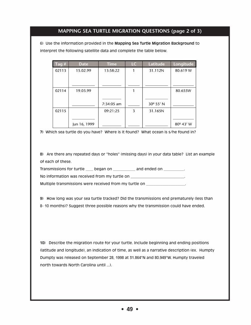
6) Use the information provided in the Mapping Sea Turtle Migration Background to
interpret the following satellite data and complete the table below.
7) Which sea turtle do you have? Where is it found? What ocean is s/he found in?
8) Are there any repeated days or "holes" (missing days) in your data table? List an example
of each of these.
Transmissions for turtle ____ began on ____________ and ended on ___________.
No information was received from my turtle on _____________________________.
Multiple transmissions were received from my turtle on _____________________.
9) How long was your sea turtle tracked? Did the transmissions end prematurely (less than
8- 10 months)? Suggest three possible reasons why the transmission could have ended.
10) Describe the migration route for your turtle. Include beginning and ending positions
(latitude and longitude), an indication of time, as well as a narrative description (ex. Humpty
Dumpty was released on September 28, 1998 at 31.864°N and 80.949°W. Humpty traveled
north towards North Carolina until ...).
• 49 •

MAPPING SEA TURTLE MIGRATION QUESTIONS (page 3 of 3)
11) Does the migration pattern make sense in terms of the behavior of the sea turtle?
12) Look at the Map of the National Marine Sanctuaries provided by your teacher. Does your
turtle travel near or through any of the marine sanctuaries? If so, which one(s)?
13) Why are international treaties necessary to protect pelagic (open ocean) species such as
sea turtles?
14) What role do national marine sanctuaries play in protecting all marine organisms?
15) In three to four sentences, summarize what you have learned about satellite tracking
programs and their importance to conservation efforts.
• 50 •

T U R T L E M I G R AT I O N S A M P L E D ATA S H E E T A N D M A P
Humpty Dumpty, a juvenile loggerhead
sea turtle, was captured in Gray's Reef
National Marine Sanctuary as part of a
sea turtle tagging project. When NOAA
personnel hoisted Humpty aboard their
vessel in order to attach the transmitter,
they noticed that Humpty had a cracked
shell. Humpty Dumpty was rehabilitated
at Marineland, Florida. Two months later,
Humpty was released at Gray’s Reef. The
sex of the turtle was not determined.
• 51 •

T U R T L E # 1 M I G R AT I O N D ATA
Lupita is a sub-adult, female loggerhead sea turtle. She weighs 158 lbs. and
was released near Santa Rosalita, Baja California (Mexico) during the
summer of 1998. This turtle is truly in the ocean wilderness and probably
only rarely encounters a fishing boat. She is being monitored by the Sea
Turtles of the Pacific tagging project.
Satellite Positions for Lupita 7/3/98 – 9/19/98
• 52 •

T U R T L E # 1 M I G R AT I O N M A P
Provided by the Sea Turtle Survival League
Map for Lupita
• 53 •

.
T U R T L E # 2 M I G R AT I O N D ATA
Scarlet was first encountered nesting on June 5th, 1998 at the Archie Carr
National Wildlife Refuge in Brevard County, Florida. She was observed
nesting again on August 11th, and a satellite tag was attached when she
finished nesting.
Satellite Positions for Scarlet 8/11/98 – 3/14/98
• 54 •

T U R T L E # 2 M I G R AT I O N M A P
Provided by the Sea Turtle Survival League
Map for Scarlet
• 55 •

.
T U R T L E # 3 M I G R AT I O N D ATA
Satellite Positions for Sarah8/6/98 to 3/17/99
Sarah was first tagged on July 26th, 1998 when she was discovered nesting
on Manasota Key, FL. She was again encountered nesting on August 5th on
Manasota Key, but at the northern end of the island. A satellite tag was
applied when she finished nesting. Sarah measured 91.4 cm in carapace
(shell) length.
• 56 •

.
T U R T L E # 3 M I G R AT I O N M A P
Provided by the Sea Turtle Survival League
Map for Sarah
• 57 •
.
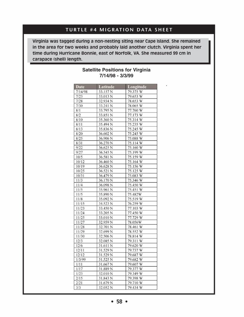
T U R T L E # 4 M I G R AT I O N D ATA S H E E T
Virginia was tagged during a non-nesting siting near Cape Island. She remained
in the area for two weeks and probably laid another clutch. Virginia spent her
time during Hurricane Bonnie, east of Norfolk, VA. She measured 99 cm in
carapace (shell) length.
Satellite Positions for Virginia7/14/98 - 3/3/99
• 58 •

.
T U R T L E # 4 M I G R AT I O N M A P
Provided by the Sea Turtle Survival League
Map for Virginia
34˚34˚
36˚ 36˚
• 59 •
km

.T U R T L E # 5 M I G R AT I O N D ATA
Joe is an adult male loggerhead sea turtle. He was captured
and released May 31, 1998 off Egmont Key in Tampa Bay, FL.
Joe's carapace length was 99.3 cm, and he weighed 84.4 kg
(230 lbs.). Joe is one of the largest loggerhead sea turtles
captured to date.
Satellite Positions for Joe5/31/98 - 6/12/98
• 60 •

.
T U R T L E # 5 M I G R AT I O N M A P
Provided by the Sea Turtle Survival League
Map for Joe
26˚
27˚
26˚
27˚
28˚ 28˚
-84˚
-84˚
-83˚
-83˚
-82˚
-82˚
• 61 •
.
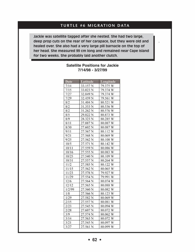
T U R T L E # 6 M I G R AT I O N D ATA
Jackie was satellite tagged after she nested. She had two large,
deep prop cuts on the rear of her carapace, but they were old and
healed over. She also had a very large pill barnacle on the top of
her head. She measured 99 cm long and remained near Cape Island
for two weeks. She probably laid another clutch.
Satellite Positions for Jackie7/14/98 - 3/27/99
• 62 •
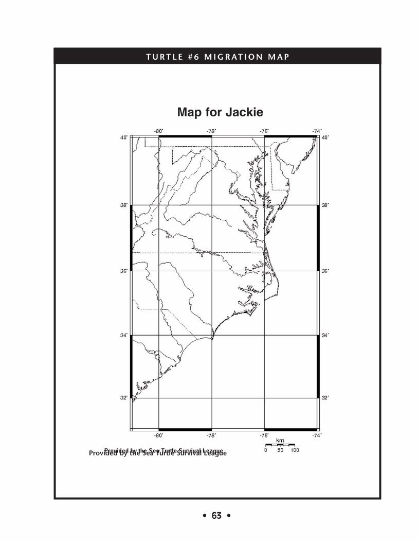
T U R T L E # 6 M I G R AT I O N M A P
Provided by the Sea Turtle Survival League
Map for Jackie
• 63 •


