
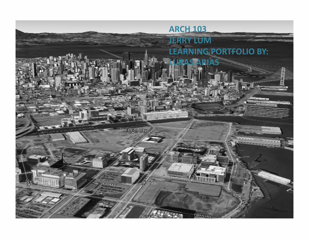
ARCH 103 JERRY LUM LEARNING PORTFOLIO BY: LUKAS ARIAS

Ice breaker: This ice breaker was I a.empt to explore how the ground quietly communicates to the pedestrian by changes on texture, size, color.

Week 2 and 3 City Image by Kevin Lynch
During week 2 we were introduce to Kevin Lynch’s five principals: nodes, landmarks , paths districts and edges. These five elements are the foundaJon in which the urban environment is perceived and navigate by the individual.
During the massing process , I created a district that honor Lynch’s four principles and creates a vibrant district
• Nodes: they are primarily points of conjuncJon in which we usually found high concentraJon of people and for this same reason nodes are important actors that bring vitality to an area. • since humans are naturally a.ract to water In this first I a.empt to create an interesJng node by placing a fountain or landmark.
This district model is base of Japan town in SF. While making this model I became more aware of the choices an urban planner is confronted with, and how so many quesJons arise right aOer a choice is make. Keeping the vitality as a main value helped me give direcJon to my design choices.

Landmarks: they are usually tall structures that are visible from the distance and from all direcJons
• two very tall buildings were placed at almost opposite extremes of the district from each other to enhance navigaJon. These two buildings have also very disJncJve shapes that make them easily recognizable. Landmarks can become world known icons that can promote a city or district like the GG bridge or Empire State building
• An smaller landmark was place on plaza to increase the a.racJveness of the node as well as become more of a local landmark
• Landmarks and nodes are place not too far from each other to make the journey through the district more interesJng avoiding large monotonous blocks

Path: Routs along which the observer moves, e.g. streets, walkways, transit lines, canals, railroads, etc. I believe paths and more precisely walkways are the most influenJal of the five principles. its qualiJes set
the tone of the over all experience by being the constant element the individual would interact with. An urban area can have vibrant nodes, strong edges, memorable land marks but if the sidewalks are dirty a clu.er and mobility is difficult our a.enJon will be focus only on navigaJng paying li.le a.enJon to anything else
I was inspire by Japan Town ample side walks and pedestrian only areas; these kind of qualiJes are definitely important to invite people to walk which would energize the district an would promotes commerce
• In this parJcular area I decided to create a tree barrier between the pedestrian and the cars to create a more sense of safety and tranquility.
• The threes would also give the drivers a sense of speed make them more cauJous, in the other hand trees could block visibility between drivers an pedestrians. I believe the key is to have enough distance between trees and chose a variety of tree that has longer trunks

• Edge: linear elements not used or considered as paths by the observer. They are the boundaries between two phases, linear breaks in conJnuity: shores, railroad cuts, edges of development, walls. Edges may be barriers or seams, lines along which two regions are related and joined together
Edges were a parJcular element I was not aware of. By analyzing Geary st I realize the drasJc impact of a wide street. The velocity of the traffic and the difficulty of crossing Geary make this street a clear boundary that creates two different areas. I duplicate the effect of Geary st on my model to get clearer sense of it
• A “green” boundary right in the middle of the district was place that not just divide two areas but also serves as an transiJon and leisure area where people can relax and enjoy a piece of nature
• Green areas are vital for a healthy urban environment. We designers have the responsibility to reestablish the balance with our natural environment

District: large secJons of the city. Successful districts create an idea of “inside of” they are recognizable as having some common, idenJfying character that enhances a sense of belonging and ownership to the residents making the residents more responsible about the well being of their environment
Parts of Japan Town has a very disJncJve character base mostly because of its Japanese inspire architecture and eateries. Even thou I tried to copy some of the main aspects by using similar massing is hard to achieve or give character to the model without going in to more detail
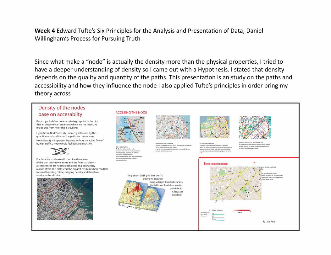
Week 4 Edward TuOe’s Six Principles for the Analysis and PresentaJon of Data; Daniel Willingham’s Process for Pursuing Truth
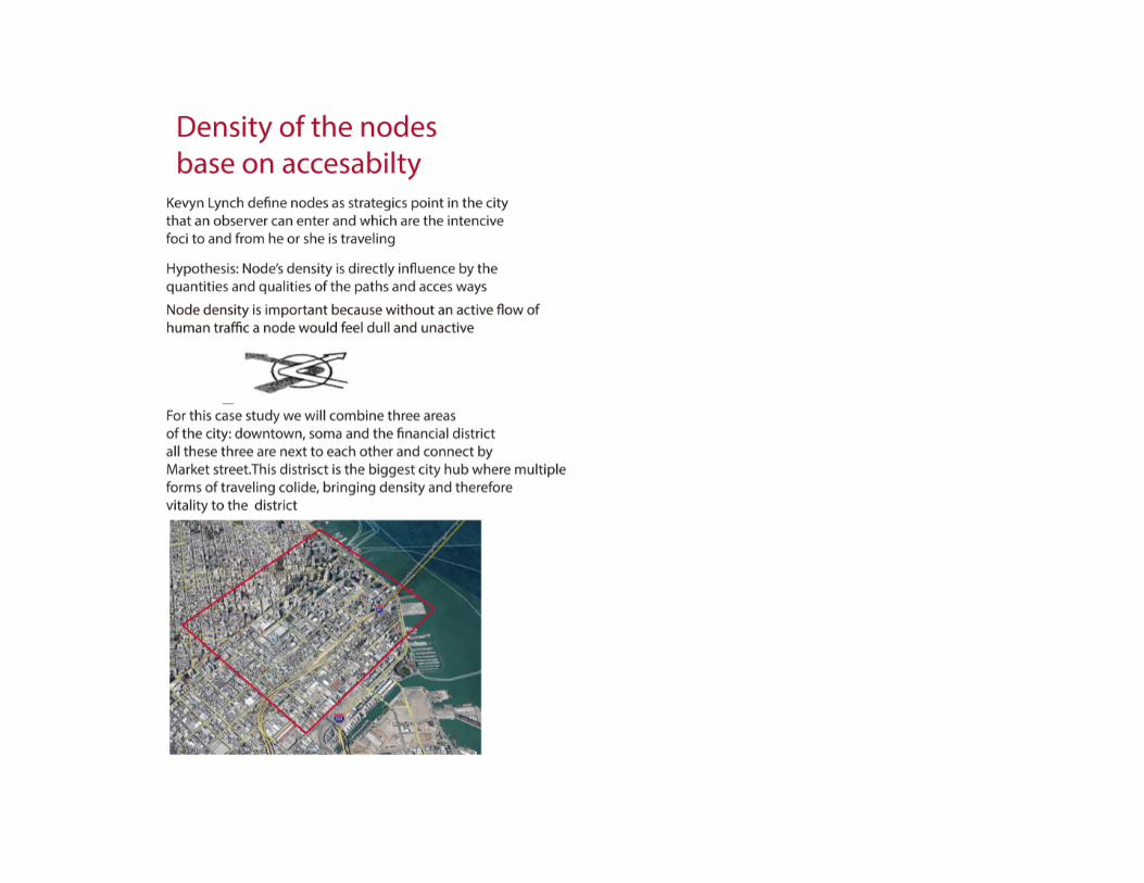
Density of the nodes base on accesabilty
that an observer can enter and which are the intencivefoci to and from he or she is traveling
quantities and qualities of the paths and acces ways
For this case study we will combine three areas
all these three are next to each other and connect by Market street.This distrisct is the biggest city hub where multipleforms of traveling colide, bringing density and thereforevitality to the district
Bay area Bart systemThe Bart is probably one ofthe best formof transportation in the bay. moving an average of366.000 pasangers a day during the week daysand 330.000 during the weekends.As we can see in the map above shows four major Bartlines cross the Downtown along with three underground stations
Downtown San Francisco Bike routes Dispite the topography of the city, SF is concider by Bicycling.Com
As we can see in the map above SF’s Downtown is crisscross by bike lanes and using Market street as an axis
San francisco major Highways
As is shown in the map above the Downtown is the ending point of the interstate 80 which cross the country from east to west.Approximetly 280.000 vehicles move accross the east bay bridgeevery day. Downtown It is also located along highway 101 and the I-280
Downtown san francisco bus, trains and ferry mapthis map shows how three modes of transportation that intersect Bus, ferry, Muni and the Cal-tran they all have major stations in the district, bringing passangers from all
The graphic of the SF “great down town” is showing the population by day and night. This district is the area that holds more density than any other part of the city. making it the biggest node
Bart
BicycleBUS
Sidealks and streets
From macro to microat minor scale.
In here we can see nodes within a node.These three nodes are part of the “great downtown”and they also have their own access and path ways
node
By: Lukas Arias
- +Density
+
-
Means that peopleuse in and outof downtown
ACCESING THE NODE
Since what make a “node” is actually the density more than the physical properJes, I tried to have a deeper understanding of density so I came out with a Hypothesis. I stated that density depends on the quality and quanJty of the paths. This presentaJon is an study on the paths and accessibility and how they influence the node I also applied TuOe’s principles in order bring my theory across


Conclusion: the node’s density and therefore it vitality; is directly influence by the access channels. High density is usually found on nodes that are intercept by major freeways, easily access by public transport, and when pedestrian and bike routes are spacious, well define and safe automobiles
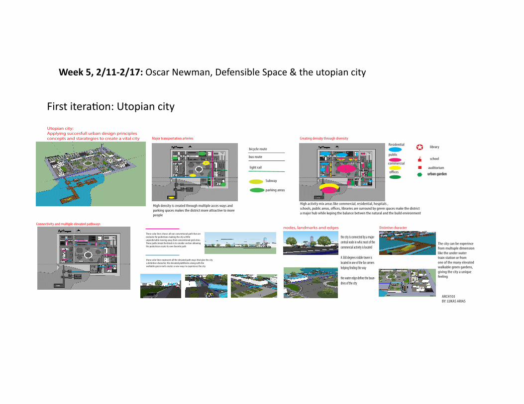
Week 5, 2/11-‐2/17: Oscar Newman, Defensible Space & the utopian city
Utopian city:Applying succesfull urban design principlesconcepts and starategies to create a vital city Major transportation arteries
bicycle route
bus route
light rail
Subway
parking areas
Creating density through diversity
Residential
public
commercial
o!ces
library
school
auditoriumurban garden
High density is created through multiple acces ways andparking spaces makes the district more attractive to morepeople
High activity mix areas like commercial, residential, hospitals ,schools, public areas, o!ces, libraries are surround by green spaces make the districta major hub while keping the balance betwen the natural and the build environment
Connectivity and multiple elevated pathways
These color lines shows all non conventional path that are exclusive for pedretians making the city a littleunpredictable moving away from conventional grid cities.These paths break the block in to smaller section allowingthe pedestrian create its own favorite path
these color lines represent all the elevated path ways that give the citya distintive character, the elevated plathforms along with the walkable green roofs creates a new ways to experience the city
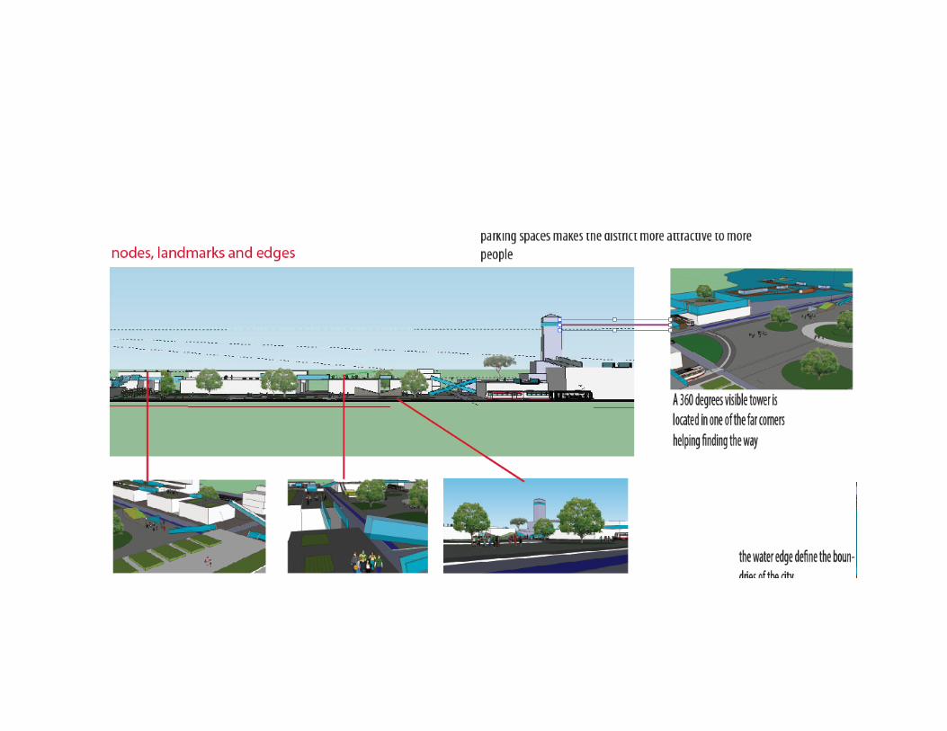
nodes, landmarks and edges
the city is connected by a major central node in whic most of the commercial activity is located
A 360 degrees visible tower is located in one of the far cornershelping "nding the way
the water edge de"ne the boun-dries of the city
Distintive character
The city can be experincefrom multuple dimensionlike the under watertrain station or fromone of the many elevatedwalkable green gardens,giving the city a uniquefeeling
ARCH103BY: LUKAS ARIAS
First iteraJon: Utopian city

• In the second iteraJon I add a Jtle which helps with the overall vision • I placed all the plan view data next to each other to keep conJnuity in the way the
informaJon is presented • Larger elevaJon images along with visual references with locaJon that help to improve
the locaJon in the model


City Strata was inspired by another student who also was exploring the idea of elevated pathways where people could move free form vehicle traffic. I decided that I wanted to push that idea as far as I can without thinking much on the achievability or possible “mistakes” of the to project later reflect on it. However I tried to achieve a the set of values dictated for the utopian city project and adding the idea or goal to achieve a super connecJve city
•
Conclusions Pros and cons of city strata pros • City strata was designed to fully uJlize the roofs of the buildings and treat them as public space this would create a very
disJncJve district where pedestrians can experience the city from above. • That is walkabilty from roof to roof through a series of glass bridges would accentuate the feeling of being above ground
which is something unusual for a city • Since the city has so many different layer pathways and the blocs are small, the individual would be able to create their own
routes making the city less predictable and therefore more fun to walk • AddiJonal green area and green roofs would increase posiJvely the vegetaJon raJo air quality and temperature Cons • crime might be able a problem due to the lack of ownership of the roof pathways, only few people on tall buildings would be
able to watch the elevated pathways, It would be hard for a vicJm to escape a potenJal dangerous situaJon due to the high of the buildings and the the few possible escape routes
• Commercial acJvity would be limited to ground level only so the pedestrian flow would decrease at ground level which will affect negaJvely the commercial desirability
• Too many pathways with not enough density would make feel the district more empty than an average one • Maintenance of the public roof sibng on private buildings might be difficult to organize

• Parking areas are close to building entrances promotes safety • Entry ways serve only six families facing the inner outer streets that gives the residents a sense of control • Residents have close view of the streets which promotes safety • Building entrances are juxtapose with the city streets • Small green areas with benches outside the walkup entrances increase the sense of community
CreaVng defensible space

Mid term conclusion: • During Arch102 I began to understand the definite role the site has and how influences the
design process. Arch103 is been working on deepening that understanding and heightening the sensibility of the complex urban environment. However I find very difficult what set of values should I choose and promote since there are so many variables that could influences the design choices but I believe choosing these values will get easier once the program get introduce
• I really enjoy the introducJon to urbanism and I would had enjoyed if we could have explore other theories. like other students had menJon perhaps we spent too much Jme on Lynch principles but I guess sJll can go on my own and research other approaches
• Like I menJon above the urban environment has start to unfold and I found this very interesJng and entertaining. What was invisible has become very relevant, walking through SF has become an opportunity to quesJoning why the things are the way they are what were the possible problems the designers had to solve and what they could have missed. I am really curios how far this re-‐discovering of the city might take us , however I can see myself starJng to applying the same analysis to the infinite realms and complex systems of nature which ulJmate holds the keys of building a true healthy and sustainable build environment
• Thank you Jerry
• I know you like bullet points


