

transitioning unique NASA data and research technologies to operations
MODIS-GOES Hybrid
Sixth Meeting of the Science Advisory Committee28 February - 1 March, 2012
transitioning unique NASA data and research technologies to operations
National Space Science and Technology Center, Huntsville, AL

transitioning unique NASA data and research technologies to operations
Background• GOES animations are second nature to forecasters
• MODIS data are higher resolution, but infrequent
• Forecasters would say:– “The data aren’t here when I need them”– “I would use the data if I could loop the images”
Let’s combine the best of both worlds

transitioning unique NASA data and research technologies to operations
MODIS-GOES Hybrid Visible

transitioning unique NASA data and research technologies to operations
Relevance to SPoRT• GOES-R Proving Ground
– Preparation for Advanced Baseline Imager (ABI)• 500 m resolution visible channel• 2 km resolution infrared channels
• Forecasters can begin to become accustomed to higher resolution imagery– GOES-R ABI will be a whole new paradigm
• Awareness of present weather conditions will improve nowcasting and short-term forecasts.

transitioning unique NASA data and research technologies to operations
Accomplishments since SAC 2009
• Training completed in April 2010• User Survey completed in May 2011• Currently 13 WFOs receiving products
– 6 receiving highest-res version• BMX, HUN, JSC, LIX, MFL, MOB
– 8 receiving ABI-res version• ABQ, CRP, HGX, HUN, JAN, MLB, MRX, OHX
• Blog posts report successes at WFOs
transitioning unique NASA data and research technologies to operations
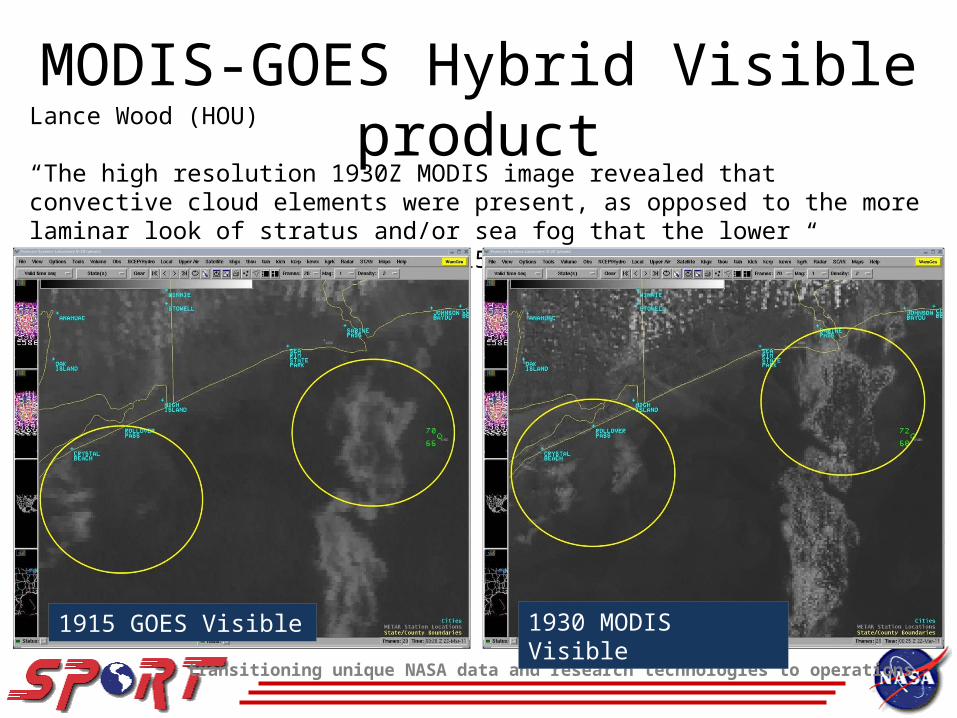
MODIS-GOES Hybrid Visible productLance Wood (HOU)
“The high resolution 1930Z MODIS image revealed that convective cloud elements were present, as opposed to the more laminar look of stratus and/or sea fog that the lower resolution GOES products at 1915Z and 1945Z depicted.”
1915 GOES Visible 1930 MODIS Visible

transitioning unique NASA data and research technologies to operations
MODIS-GOES Hybrid Fog product0645 GOES Spec. Diff.
0701 MODIS Spec. Diff.
Kris White (HUN)
“The early detection of this fog can be pivotal is assessing its eventual intensity and coverage. The MODIS-GOES hybrid 11um-3.9 product early yesterday morning showed the usefulness of the MODIS imagery…”

transitioning unique NASA data and research technologies to operations
MODIS-GOES Hybrid Shortwave productBrian Guyer (ABQ)
-“…at 1945Z (1245 pm MST) … no hot spot is evident.
-“…MODIS image …from 2002Z – a hot spot likely associated with the fire is depicted in the 2km resolution (image).”
-“The hot spot is not readily identifiable in the GOES imagery until 2032Z, and even at that time the signal is subtle.”

transitioning unique NASA data and research technologies to operations
Hybrid Resolutions (km)
• Visible 1 0.5 0.25
• IR (SW) 4 2 1• IR (LW) 4 2 1• Water Vapor 4 2 1• Fog 4 2 1
NASAG-RPG(ABI)GOES

transitioning unique NASA data and research technologies to operations
MODIS-GOES Hybrid IR loop
transitioning unique NASA data and research technologies to operations
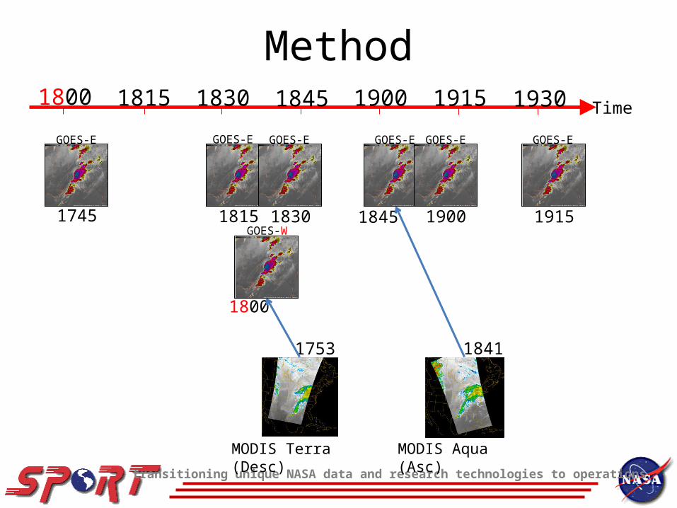
Method
1800
1753 1841
MODIS Terra (Desc) MODIS Aqua (Asc)
1745
GOES-E
1915
GOES-E
1815
GOES-E
1830
GOES-E
1845
GOES-E
1900
GOES-E
GOES-W
1800
1830
1815
1900
1845
1915
1930
Time

transitioning unique NASA data and research technologies to operations
Future Work• Incorporate VIIRS data (new name)• Add product domains for
Alaska RegionPacific Region
• Make atmospheric corrections forParallaxLimb Effects
• Investigate AWIPS II capabilities• Incorporate RGB Products
MODIS Airmass -> GOES Water VaporMODIS Nighttime Microphysics -> GOES FogMODIS True Color -> GOES VisibleMODIS Dust -> GOES Visible

transitioning unique NASA data and research technologies to operations
Questions ?

transitioning unique NASA data and research technologies to operations
MODIS/GOES Hybrid Visible


