

1
Mohawk Bicycle and Pedestrian Path: A Roadway Feasibility Study
A report developed by: Josh Cantor
Ryan Dunfee Jared Oubre
and Ben Swimm
ENVI 302
Professors Sarah Gardner and Elizabeth Goodman Submitted 12/14/07

2
Table of Contents
Page
I. Planning Problem 3
II. Vision 3
III. Project Importance 4
IV. Community Profile 6
V. Site History 9
VI. Project History 10
VII. Law and Policy & Technical Issues 15
VIII. Where We Come In: Client Goals 18
IX. Methods 19
X. Results 27
XI. Recommendations 33
XII. Biases in Research Methods 42
XIII. Conclusion 45
XIV. Acknowledgements 46

3
I. Planning Problem:
Our project was undertaken within the context of the larger plan of connecting Williamstown
and North Adams with a recreational bicycle and pedestrian path. This bike path will be designed
to be accessible to people of all abilities and largely serve as a safe and scenic transit route
between the two towns. Within this larger goal, our project will specifically focus on evaluating
the road routes between the two towns to determine the levels of feasibility and desirability for
constructing a bike path adjacent to different sections.
II. Vision
The vision for the North Adams to Williamstown path—officially the “Mohawk Bicycle and
Pedestrian Path”—mainly includes the purpose of recreation. For this reason, all attempts
possible are being made to stay away from roadways, as they create dangerous situations for
pedestrian or bicycle traffic, and do not provide as many scenic and recreational opportunities as
other off-road alternatives. On-road options must be considered, however, because there exists a
perception that bike trail construction could be easier and cheaper in these areas of existing
infrastructure. In the end, though, to best serve the goals of this project, the Mohawk Bike Path
must be a predominantly off-road facility. Before such a route can be proposed, however, there
must be an in depth investigation of the possible bike routes along the side of the road. Part of
the purpose of this investigation is to show which sections of roads are not feasible for a bike
path. This will ultimately allow the Berkshire Regional Planning Commission (Henceforth,

4
BRPC) to prove that the trail must necessarily travel away from unsafe and ugly roadways. In
other areas, a roadside path may be absolutely necessary. In these cases, we evaluated current
safety, feasibility and conflicts, and made recommendations about what would have to be done to
make these sections acceptable.
It is particularly important to keep in mind the project vision as a recreational opportunity
available to all. Our planning evaluations and eventual recommendations are therefore made to
suit a “family of four,” as a sort of safety and feasibility standard. For this reason, our vision for
a roadside bike path is that of one separated from the road with ample space or a physical barrier.
The current condition of Massachusetts roads allows for biking on all roads, thus making travel
between North Adams and Williamstown by bike theoretically possible. This trip would
obviously not be safe, however, especially not for children. An improvement to a bike lane on
Route 2 or Massachusetts Ave. would appropriately serve the purpose of a commuting route, but
again would not be safe enough to meet the recreation standards of a family of four.
III. Project Importance
The need for a bike trail connecting North Adams and Williamstown is great for many
reasons. First, though the towns are a mere five miles apart, many people commute between
them by car. Commuting occurs regularly for workers of both towns, but also for the students of
Williams College, who drive to North Adams frequently for commercial and social reasons. A
bike trail would reduce car use, thereby improving the beauty of the Berkshire area and also
reducing environmental impact through reduction of green house gas emissions. These issues are
now increasingly important, as climate change has become a clear and visible problem, and
Williamstown has recently joined the Cities for Climate Protection Campaign and set emission
reduction goals.

5
A second reason justifying the construction of a bike trail connecting North Adams and
Williamstown is the opportunity for recreation. The recently constructed Ashuwillticook Trail
connecting Adams and Pittsfield has been tremendously popular in the community for its
recreation value, and this interest in bike routes further validates the need for an additional trail
connecting North Adams and Williamstown. Public support for the project was recorded
officially through public forums held in June, 2007 by the Mohawk Bicycle/Pedestrian Trail
Advisory. Ninety eight percent of respondents were in support of a bike trail connecting North
Adams and Williamstown; though the group was probably self selected towards people with an
already high interest in bike routes (92% had used the Ashuwillticook Trail).1 Still, between the
evidence of the public forum and the high use of the already existing Ashuwillticook Trail it is
clear that a bike route from North Adams to Williamstown would be popular and used frequently.
Finally, the construction of this bike trail will help complete a plan proposed by the
Massachusetts Highway Department, which officially recognized the importance of bike paths in
1998 by drafting a Statewide Bicycle Plan. This plan is illustrated by the following mission
statement:
The vision statement of the Statewide Bicycle Transportation Plan is recognition of bicycling as a viable means of transportation and reasonable accommodation of the needs of bicyclists in policies, programs, and projects. Greater recognition and accommodation of the needs of bicyclists will lead to a more balanced transportation system with greater modal choice and improvements in bicycle safety. Such actions will enhance the environment and quality of life in the Commonwealth, and improve personal mobility. 2
The plan, shown in the map below, involves over 500 miles of statewide trail, eventually
connecting the North, South, East, and West borders of the state continuously with bike trail.
1 Lauren Gaherty, Bershire Planning Commission, Senior Planner, North Adams Survey Results, June 2007. 2 http://www.mhd.state.ma.us/default.asp?pgid=content/bikepaths01&sid=about#para1, accessed 10-15-07
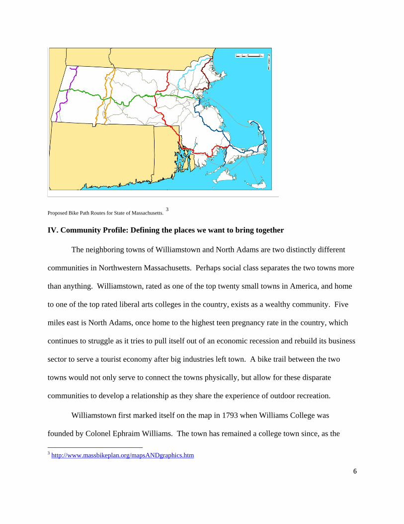
Proposed Bike Path Routes for State of Massachusetts. 3
IV. Community Profile: Defining the places we want to bring together
The neighboring towns of Williamstown and North Adams are two distinctly different
communities in Northwestern Massachusetts. Perhaps social class separates the two towns more
than anything. Williamstown, rated as one of the top twenty small towns in America, and home
to one of the top rated liberal arts colleges in the country, exists as a wealthy community. Five
miles east is North Adams, once home to the highest teen pregnancy rate in the country, which
continues to struggle as it tries to pull itself out of an economic recession and rebuild its business
sector to serve a tourist economy after big industries left town. A bike trail between the two
towns would not only serve to connect the towns physically, but allow for these disparate
communities to develop a relationship as they share the experience of outdoor recreation.
Williamstown first marked itself on the map in 1793 when Williams College was
founded by Colonel Ephraim Williams. The town has remained a college town since, as the
3 http://www.massbikeplan.org/mapsANDgraphics.htm
6

7
college supplies over half Williamstown residents with jobs. The town is also home to a variety
of art museums, including the Clark Art Institute and Williams College Museum of Art
(WCMA), and a Summer Theater Festival that brings well known Broadway and Hollywood
performers to town. The July 1984 Connoisseur stated that Williamstown has the most art per
capita of any American Community.4
North Adams has a strikingly different history. The city first established itself as an
industrial town when sawmills, textile factories, and shoe making companies arrived in the 1720s.
In 1929 Sprague Electric moved to town, employing 4,000 residents and becoming one of the
most successful producers of electronic products in the world. By the 1970s, greater competition
and ever changing technology lead to fewer profits and in 1985 Sprague shut down, leaving
many North Adams residents jobless. The town soon went into a severe economic recession
causing it to become dormant5.
In 1987 Sprague Electric’s abandoned twelve acre, twenty-seven building complex was
reopened as a Museum of Modern Art under the inspiration of WCMA’s director Thomas Krens.
After millions of dollars in private donations and financial backing from the state, reconstruction
and renovation of the depressed factory area began in 1995. Three years later in May of 1999,
the largest center for contemporary arts in the United States opened.6 Over the past decade,
beginning with the introduction of Mass MoCA, North Adams has taken positive steps towards
urban revitalization and developing an economy that focuses on tourists to the area.
Today North Adams is still the medium sized, blue collar town that it has always been,
however the mayor and town residents are more excited about the possibility of tourist
4 http://www.mass.gov/dhcd/iprofile/341.pdf 5 http://en.wikipedia.org/wiki/North_Adams,_Massachusetts 6 http://www.massmoca.org/facts.php

8
attractions like a recreational bike path.7 With 16,797 residents concentrated within a density of
822 persons/ square mile North Adams is twice the population count and five times the
population density of Williamstown (8,424 residents and 175 persons/square mile). In trying to
describe the current housing situation the latest data from the 2000 census shows, 65.7 % of
existing households are family households (have at least one child and a parent living in them)
and almost identical in Williamstown at 61.5%. Almost 13% of housing units in the town are
subsidized; ranking North Adams among the most financially needy towns in the state of
Massachusetts, while in Williamstown only 4.8% of its housing is subsidized.8
The 2000 census states the average income in Williamstown ($51,000) is almost twice
that of North Adams ($27,000).9 Williamstown is one of the wealthiest towns in Berkshire
County, primarily due to the financial stability of Williams College and the healthy incomes it
offers its almost 2,000 faculty and staff, most of whom live in Williamstown. The town also
offers abundant sources of recreational activity including biking, hiking, and cross country skiing,
as well as many renowned art museums and a one of the top rated golf courses in the country.
Aside from Mass MoCA, North Adams’ attractions are more defined by its natural and
historical landmarks including the Hoosac Tunnel, regarded as one of Massachusetts greatest
engineering feats when built in the 1860s; Western Gate Heritage Park, one of only a few
historic urban parks in Massachusetts; Mt. Greylock State Reservation, which claims the state’s
highest peak, and Natural Bridge State Park, home to the only naturally formed marble bridge in
North America.10
7 http://www.berkshireplanning.org/7/8/ , accessed 11-26-07 8 http://www.mass.gov/dhcd/components/SCP/shiinv.htm accessed 11-7-07 9 http://www.census.gov/, accessed 11-7-07 10 http://williams.edu/ces/mattcole/resources/onlinepaperpdfs/papers/biketrail.pdf, accessed 11-7-07

9
In trying to understand who would benefit from the construction of a bike path it is useful
to note the past and current profiles of these communities and how the bike path might change
the social and cultural structure of these communities. Both towns have substantial residential
populations, North Adams containing larger and more densely populated residential
neighborhoods, while Williamstown though mostly oriented around the large and active college
campus has many residents who live up in the hills on several acres of open land. Hopefully the
path provide a common ground where Williamstown residents living near the college and
privileged Williams College Students will leave their comfortable setting and interact with the
mixed class neighborhoods of North Adams. Such a common ground could help to unite and
foster positive interaction between the two disparate and different towns.
The bike path would also almost certainly become a tourist attraction during the summer
and fall seasons, as well as hopefully help Williamstown realize its master plan in becoming a
City for Climate Protection, and North Adams to help meet its Open Space and Recreational Plan.
Though cost and acquiring open corridors to place to the path are definite issues, we are hoping
that these two towns will find a recreational bike path a great addition to their already dynamic
and diverse communities.
V. Site History: The Mohican-Mohawk Historical Trail
In the 100 mile corridor stretching from Deerfield, Massachusetts through Pownal,
Vermont and eventually ending at the confluence of the Hoosic River and Hudson River in New
York, there are remnants of the old Mohican-Mohawk trail. Archaeological evidence shows that
Native Americans lived in the Hoosic Basin as early as 4000 B.C. The Mohican-Mohawk trail,
which Route 2 follows, was used as a provisioning route during the Revolutionary and French &
Indian Wars. Fort Massachusetts was strategically placed near the trail, as Colonel Ephraim

10
Williams used the trail frequently as commander of the fort from 1744 to 1763. In 1755
Benedict Arnold traveled the trail to capture Fort Ticonderoga, while distinguished authors such
as Ralph Waldo Emerson, Nathaniel Hawthorn, and Henry David Thoreau all at one time also
traveled the trail.11
One may ask why these historical facts are important to the construction of a bike path?
The rich history of the Berkshires serves to promote the tourist economy that continues to
develop in North Adams and Williamstown. Like the preservation of Boston’s Liberty Trail
sites as a kind of memorial to our fore fathers who fought for American Independence, so is the
Mohican-Mohawk trail a significant route narrating the advanced trading and communication
tactics of the North Eastern Native American tribes. In this sense re-creating the trail is helping
memorialize the history of the Native Americans in the Berkshires.
VI. Project History and Work Already Done
The planning of a bike trail between North Adams and Williamstown is set in the context
of a rich project planning history. The Hoosic River Watershed Association (HooRWA) has
discussed possibilities of a scenic trail along the Hoosic River for past 35 years and a 1969 the
Williams College Political Economy 340 class reported that the Conservation Commission in
Williamstown and North Adams had proposed a bike trail as early as 1968. In a Williams’
College Winter Study Project students retraced the Mohican-Mohawk trail from Deerfield to the
eastern boundary of North Adams. But planning efforts have been redoubled in recent years,
perhaps in response to the urging of the Massachusetts Highway Department. Over the past
decade Mass Highway has encouraged communities to plan their own bike paths as part of a
state wide proposal that began in 1998 when they published the Massachusetts Statewide Bicycle
11 http://williams.edu/ces/mattcole/resources/onlinepaperpdfs/papers/biketrail.pdf, 11-6-07

11
Plan. It encourages the creation of new off-road bike paths, bike lanes, bike lockers, and other
bicycle related projects, however most the funding has gone to wealthy urban areas in eastern
part of state.
The most recent and in depth bike path report between North Adams and Williamstown
was conducted by the Williams College Environmental Planning class in spring of 2002. This
group assessed the feasibility of three different bike route options connecting Cole Ave to Galvin
St: 1). Following a buried sewer line adjacent to the Hoosic River, 2). Following the active
railway, and 3). Creating an on-road path along a section of Route 2.
Other recent studies include HooRWA’s and the Williamstown Rural Lands Foundation’s
1999 evaluation of feasibility of greenway along Hoosic River for hiking. The project was
deemed “a feasible and attainable goal.”12 In 2001 HooRWA filed for $9600 grant for pre-
engineering feasibility to follow up on their greenways report. After the success of the
Ashuwillticook’s construction, the North Adams-Williamstown bike trail plan became a more
serious goal, and in 2000 North Adams established the Bikeways Committee and eventually the
project was turned over to Berkshire Regional Planning Commission under the direction of
Lauren Gaherty, where it continues to develop today.13
Work Already Done
Lauren Gaherty and the BRPC have worked in conjunction with another Berkshire
organization, the Mohawk Bicycle/Pedestrian Advisory Committee to begin the process of
planning a North Adams-Williamstown connecting bike path. Our project will also draw on
12 http://www.hoorwa.org/aboutriver.htm, 11-6-07 13 http://berkshireplanning.org/7/7/, 11-6-07

12
work done by other groups and organizations, summarized below. This “work already done”
places the tasks yet to be done in a context that must be understood before proceeding further.
Environmental Planning 302 Project, Spring 2002
As mentioned above, previous site investigation was completed by a Williams College
Environmental Planning class in the Spring of 2002. Their detailed report included the
evaluation of three possible routes:
1) Sewer Easement Path (Follows the Hoosic Water Quality District Sewer line near the
Hoosic River, starting and the Photech site following a proposed scenic, yet expensive
route near the river eventually ending near Ashton Ave.);
2) The Rail-With-Trail Alternative (This route along the rail bed would allow for an
already level and cleared pathway)
3) Route 2 Bike Lane (This was environmentally friendly yet dangerous proposal to
create a bike lane along route 2)
Through an “alternatives analysis” the group created and quantitative way to rate the three bike
routes (including variable such a conflict points, environmental impact, accessibility, cost, etc..
The Sewer Easement Path received the highest rating followed by the Rail-with-Trail alternative
as the second most desirable, and the Route 2 Bike Lane the least acceptable.14 This study is
applicable to our project because it investigated a Route 2 bike route option. However, the study
investigated only the possibility of bike lanes, while we are recommending a fully separated
multiuse path for safety reasons.
The Ashuwillticook Trail
14 http://www.williams.edu/CES/mattcole/resources/onlinepaperpdfs/papers/biketrail.pdf, accessed 10-15-07
13
The planning history of our project theoretically goes back to the completion of another
bike trail project: the Ashuwillticook Rail Trail (henceforth, ART). The ART is an eleven mile
trail running north-south along Route 8 between Adams and Pittsfield, maintained by the
Massachusetts Department of Conservation and Recreation. 15 The trail is built along an
abandoned railway corridor, allowing a scenic and flat bike route which has been popular among
Berkshire County residents. Now that the trail is completed, there has been a push to extend it
further into North Adams, and perhaps even South to Lenox. An extension of the trail would
make the long-range goal of a Connecticut to Vermont trail possible, as the trail proposed in this
project could then serve as a link Pittsfield to North Adams to Williamstown and eventually into
Pownal, VT.
Though the Ashuwillticook has served to inspire for the creation of a North Adams to
Williamstown bike path, its construction model can unfortunately not be followed in this project.
While a railroad does connect the two towns, it is active, and therefore a trail cannot be placed
along the entirety of this corridor. Therefore, though the Ashuwillticook serves a sort of
inspirational background for our project, other non-rail-trail options are being investigated by the
BPRC for the construction of the Mohawk Bike and Pedestrian Path.
Public Interest Surveys
As mentioned above, the Mohawk Bicycle and Pedestrian Advisory Committee
conducted a public forum to gauge the interest for the trail. There were fifty responses to the
survey, generally in favor of the trail. Because many of the participants said they used the
Ashuwillticook Trail, the survey group was probably heavily weighted towards those already
15 http://www.berkshirebikepath.com/wst_page5.html

14
interested in using bike trails. Two thirds of the respondents said they would use the trail more
than once a week1.
When asked what they would use the trail for, most respondents replied with recreational
uses such as exercise, outdoor enjoyment, and social time with family and friends. Few
envisioned the trail as a commuting route. Participants were also asked to rank the first three
most important characteristics of a potential trail, out of a list of eleven. The three most chosen
responses were safety, accessibility, and scenery1.
Project Funding
With public interest established for the existence of a North Adams to Williamstown bike
route, the BRPC went about gathering the funds to begin feasibility and route assessment studies.
Because Route 2 is a part of the Mohawk-Mohican Trail National Scenic Byway, the area is
eligible for National Scenic Byway Grant funding. The Berkshire Regional Planning
Commission has already received a grant from this program to investigate the feasibility of
different routes for a potential bicycle and pedestrian path connecting Williamstown and North
Adams. Between state and federal funds, the BRPC has received $110,000. Our investigation
and report help the BRPC to be able to apply for additional funding for the actual construction of
the trail.
Site Investigation
With the planning funds mentioned, the BRPC has already identified possible routes for
the Mohawk Bike and Pedestrian Path. Lauren Gaherty, the Senior Planner with BRPC, said in
an interview that she had already “bushwhacked” sections of land adjacent to the Hoosic River,

15
and walked other possible roads and routes16. After collecting field data and performing
extensive feasibility studies, the BRPC and the Mohawk Bike and Pedestrian Advisory
Committee produced preferred and secondary path routes. Potential bike path areas that the
BRPC is looking to survey include: town owned floodplains, parks and playing fields, and land
adjacent to the active rail bed. This background information is particularly important to our
project because it allowed the BRPC to come to us with a map of road routes (areas where the
path came near, crossed, or ran parallel to roads) that it needed us to investigate.
North Adams Trail Feasibility Committee
This North Adams citizen group has produced an informal report drawn from quantitative
analysis of possible bike trail routes. We have not yet been able to acquire the report or
recommendation justifications, but the recommended route generally follows the Hoosic River
closely.
Massachusetts Highway Department Data
Part of our project will include gathering data on existing road shoulders and sidewalks.
The Massachusetts Highway Department has already collected much of this data, which will be
useful in our analyses, but which we must verify in field visits.
VII. Law and Policy & Technical Issues
Due to issues of safety regarding moving vehicles and other obstructions by the road as
well as issues of feasibility and ease of access arising from having a bike path coincide with a
pre-existing motor road, we are charged with the task of evaluating motorways connecting North
Adams to Williamstown with the expressed goal of gathering information to illuminate the
16 Lauren Gaherty, Interview, October 2007
16
current status of those roads considering the afore mentioned issues. Collecting information
based on volume of traffic (both trucks and cars), number of intersections, speed limits, traffic
signals, bridges, shoulders/sidewalks, shade/shelter, developed versus undeveloped surroundings,
street lighting and proximity to residential areas, other recreational/cultural venues, places of
employment, schools, bus stops and commercial centers with be part of an on-road evaluation
form for each section of road considered.
One of our main concerns is that because these roads were not initially constructed with a
bike path in mind, they will not adequately conform to the ideal conditions for shared use as a
“community path.” The requirements for ideal bike way conditions are as follows:
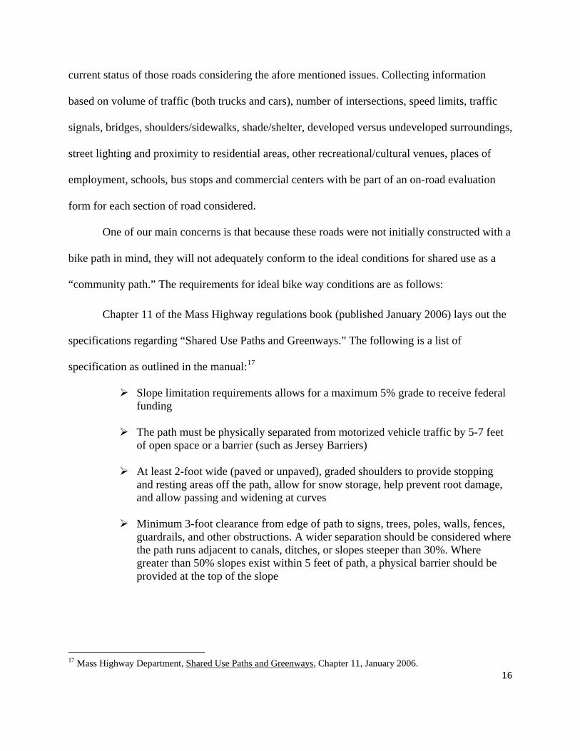
Chapter 11 of the Mass Highway regulations book (published January 2006) lays out the
specifications regarding “Shared Use Paths and Greenways.” The following is a list of
specification as outlined in the manual:17
Slope limitation requirements allows for a maximum 5% grade to receive federal funding
The path must be physically separated from motorized vehicle traffic by 5-7 feet
of open space or a barrier (such as Jersey Barriers)
At least 2-foot wide (paved or unpaved), graded shoulders to provide stopping and resting areas off the path, allow for snow storage, help prevent root damage, and allow passing and widening at curves
Minimum 3-foot clearance from edge of path to signs, trees, poles, walls, fences,
guardrails, and other obstructions. A wider separation should be considered where the path runs adjacent to canals, ditches, or slopes steeper than 30%. Where greater than 50% slopes exist within 5 feet of path, a physical barrier should be provided at the top of the slope
17 Mass Highway Department, Shared Use Paths and Greenways, Chapter 11, January 2006.

-Diagram showing path separation from roadway -Jersey Barriers might beused to (5-7 ft recommended) separate roadways from mixed used
path
Signing and marking (i.e. centerline)
Minimum width of a two directional path is 10 feet. A reduction to 8 feet may be
granted where severe circumstances are deemed to exist such as extreme environmental, historical and/or structural constraints.
Minimum of 8 feet overhead clearance to obstruction, with a minimum of 12 feet
if equestrian traffic is expected.
Speed of bike traffic dictated by radius of curves and sight distance
We also looked at what other bike friendly cities, such as Portland, Oregon and
Northampton, Massachusetts have set as their standards for mixed use paths. Below is a revised
version of what laws and policies we thought would be most useful to consult in the
Williamstown/North Adams mixed-use path.
Portland, Oregon, Master Plan for Bicycling (with engineering guidelines):
17

18
(Appendix A, Part I, Section C) Concrete paths are better than asphalt because lower maintenance, not affected by
roots, ice, etc. They are like asphalt, but do cost more to make.
Five foot minimum separation from roadway.
Under AASHTO recommendations, you can have up to a 10% grade for 500 ft.
Instead of physical separation from the road, the use of a Jersey barrier to separate bike path from road, with retaining fence 4.5 feet tall.
“Bicycle lanes” can be constructed by adding an 8 inch stripe on paved shoulder
of road
Bicycle lanes adjacent to curbs or parking must be 5 feet wide (can be 4 feet for less than 1 mile as long as it connects existing bikeways on both ends.)18 Ex: The section in North Adams nearing the graveyard would have to be 44 feet wide to accommodate a bike lane under these circumstances.
In Northampton, Massachusetts the road was thinned to better accommodate bikes.
One stipulation to this possibility is that bike lanes on state roads must connect to the other bike
paths. Though such an option may be recommended for the Williamstown/North Adams bike
path it is unlikely that thinning the road would necessarily would even be possible.19
Yet a third resource to confirm certain laws and policies was bike enthusiast, Tom
Galvagni of the Massachusetts Highway Department. In brief discussion via phone Galvagni
assured us that a 5-7 ft separation from the road would be most desired for a “mixed-use path.”20
Galvagni also stated that if a two lane separated path along a road way was not possible,
individual one lane separated paths could exist on opposite sides for short distances.
VIII. Where We Come In: Client Goals
18 http://www.portlandonline.com/shared/cfm/image.cfm?id=40414, 12-4-07 19 http://www.massbike.org/mbpv/involve/updates.html#calm, 12-4-07 20 Personal Contact with Tom Galvagni, Massachusetts Highway Dept., 12-6-07

19
With these factors of importance, vision, history, and work already done in mind, our
client Lauren Gaherty came to us with the next phase of the project: comparing preferred bike
path routes with the feasibility of a road-side path. With the realization that at least a few parts of
the path may need to be on the road at points, the goal set by our client can be broadly defined as
evaluating the existing roadways between the Williamstown and North Adams, primarily Route
2 and Massachusetts Avenue, for their potential ability to accommodate an additional bike and
pedestrian path (mixed use path).
This goal has many technical aspects to it that involve much field work, which was our
primary task. Our team’s “work tasks” as stated by our client were as follows: 1). Conduct a
“bicyclist’s point of view” analysis of traveling Rt. 2 and Mass. Avenue, and a few other streets
in the downtown areas, whereby a bicyclist will ride the length of each roadway and assess the
roadway conditions experienced, 2). Field verify existing data on Rt. 2, Mass. Avenue and a few
other streets to identify and correct inaccuracies. Data that will be verified include shoulder
widths, sidewalk widths, crosswalk locations, traffic and pedestrian signals, driveways and
roadway curb cuts. Data will also include on-road parking, 3). Note areas where the roadways
become steep and would be difficult for persons with disabilities (>5%), 4). Document existing
land use and topography along the roadways to determine if road widening to accommodate a
dedicated bike lane is possible and/or appropriate, 5). Identify areas where creating common
driveways may be possible to reduce the number of vehicle/bike/pedestrian conflict sites, 6).
Map data collected in GIS format, 7). Quantify route assessment using field check sheets
provided by BRPC, 8). Develop assessment report to present findings. With these goals in mind,
our project focused on two main forms of analysis: GIS mapping and quantitative analysis.
IX: Methods

20
A: Methods—data collection:
Both the GIS mapping and the quantitative analysis of this project required data
collection through walking and bicycling the roads in question. This task was usually performed
in groups of two. One person would mark waypoints with the GPS unit and record the waypoint
number, section of road, and conflict point type. This information was needed to later sort the
recorded waypoints into separate GPS layers. The second person in the two man carried on-road
evaluation forms to collect the data needed to make quantitative analyses of the road sections. A
scheme for the data collected for these analyses was developed and is as follows:
Table 1: Collection scheme for data required in quantitative analysis
FEASIBILITY SCORE Road Section Date Safety Tally High traffic volumes yes or no Truck traffic allowed? yes or no > # driveways # > # high volume driveways (retail, gas stations, etc) #, take GPS data > # road intersections #, take GPS data > # traffic lights #, take GPS data turn lanes #, take GPS data On-street parking yes or no, see GPS data' Speed limit >40 mph yes or no, take GPS data Subtotals Constraints: Building Considerations Grade >5% yes or no, take GPS Bridges need widening yes or no, take GPS Possible encroach on residential properties yes or no, take GPS No existing paved shoulder within section yes or no, take GPS stormdrain in way of path #, take GPS Currently not paved yes or no, take GPS Dangerous curves #, take GPS data demo or rock blasting required yes or no, take GPS Subtotals

21
DESIRABILITY SCORE
Road Section
Date Opportunities: Physical Amenities Tally Shade/sheltered area from wind one to three scale Interesting views/vistas one to three scale Goes through protected open space/APR yes or no Undeveloped/natural surroundings yes or no Existing raised or separate sidewalk yes or no, use existing GPS data Street lighting yes or no Subtotals Opportunities: Community Amenities Connects to recreation/cultural places one to three Connects to areas of employment or school/college one to three Interesting features on or directly near road one to three Number of bus stops #, take GPS data
After field data was collected, the GPS data was compiled into nine different GIS layers
showing 1) road grades greater than 5%, 2) high volume/conflict driveways, 3) intersections, 4)
traffic lights, 5) areas with a speed limit greater than 40mph, 6). storm drains in the way of a
potential path, 7) dangerous curves/hills with limited visibility, 8). Cross walks, and 9). Turn
lanes. In this way, the major “conflict” points can be visualized any number of ways using the
GIS maps. Complementing the GIS maps for each section will be a thorough record of all other
parameters being accounted for in our data collection. Quantitative analysis raw data was
manipulated as described in the evaluation section below to produce comparable results
regarding different road sections.
B: Methods—evaluation:
Using the data collected, we performed two quantitative evaluations per section: a
feasibility assessment and a desirability assessment. These scores were added to produce a
combined score for each section. Our quantitative analyses drew on a pre-constructed “On-Road
Evaluation Form” given to us by our client, but incorporated some approved changes in the

22
factors evaluated. These additional categories will allow us to more appropriately evaluate
potential factors specific to roadways, rather than off-road bicycle facilities.
The feasibility assessment contained two sub categories, safety and building constraints,
and the following factors were taken into account: 1). Safety: traffic volumes, truck traffic, #
driveways, # high volume driveways, # road intersections, # traffic lights, # turn lanes, on-street
parking, high speed zones, 2). Building considerations: steep slopes, bridges needing widening,
possible encroachment on residential properties, existing shoulder and sidewalk space, storm
drains, dangerous curves, encroaching physical topography, and current paved status. After
collecting safety and building constraint data for each road section, we converted the raw data
from each category into a point value (1 = little or no impact, 2 = moderate impact, 3 = major
impact) based on the perceived impact of that factor on the feasibility of a mixed use path. We
then multiplied these point values by predetermined weights specific to each parameter, and
added the solutions to give the entire road section a feasibility rating. Each feasibility score was
then considered negative, and the more negative the score, the less feasible the given section of
road is for a mixed use path.
The desirability assessment score is also divided into two sub-categories, physical
amenities and community amenities. The goal of this assessment is to determine how desirable a
road section is with respect to the opportunities it affords in terms of shade/shelter, interesting
views, and connections to schools, commercial centers, recreational centers, places of
employment, public transportation, etc. Factors of analysis included: 1). Physical amenities:
shade and shelter, views and vistas, surrounding open and natural space, existing raised or
separated sidewalk, existing street lighting, and 2). Community amenities: connection to
recreation and cultural places, connection to employment and school/college areas, other

23
interesting features, and number of bus stops. Again, using a 1-3 point scale and predetermined
weights, we represented a given section of road with a desirability value. The higher this value,
the more desirable this area of road would be for the inclusion of a multi-use path. For a better
illustration of these pointing and weighting systems, see Appendix 1 for the actual On-Road
evaluation forms.
C: Physical Site Description:
The project site will focus on all major roadways along the five mile stretch of the Hoosic
River Corridor connecting North Adams with Williamstown that could potentially accommodate
a recreational bike bath. The western-most site to be surveyed will be the Rt. 7/ Rt. 2 roundabout,
while the eastern-most point will include the Rt. 8 bridge in North Adams. The northern-most
roadway will be Mass Ave., while the southern-most roadway will be Rt. 2 and Barber St.
Below are the main site descriptions of the sections of different roads we are surveying. All
roads will be surveyed on both sides.
Main Roads:
Rt. 2: Rt. 7 > Cole Ave: This area passes through almost entirely Williams College property
which includes large areas of green space on either side of Route 2. Closer to Cole Ave this
green space becomes Town Commons and is the process of becoming a National Heritage Site.
Cole Ave: This dense residential area is a likely site for a bike path along the road. Many
families live one both sides of this road and nearby is Williamstown Elementary.
Rt. 2: Cole Ave > North Adams: This five mile stretch of mostly two lane and some three lane
highway is the target area of most our project surveying. It is densely populated on both sides
with commercial and residential areas creating many conflict points for a mixed-use path. We
divided Rt. 2 into 5 smaller sections for easier analysis:

24
1) Cole Ave – Dunkin Doughnuts
2) Rt. 2: Dunkin Donuts - Airport Rd.
3) Airport Rd. - End of Bridge after New St.
4) New St. Bridge - Beg of Cemetery
5) Beg of Cemetery - Intsct. of State St. & Main St.
Mass Ave.: Cole Ave. > North Adams: This two lane highway stretching along the north side
of the Hoosic River and adjacent to the train tracks, offers little shoulder on which to construct a
mixed-use. Though it is the more scenic than the section of Rt. 2 running parallel, it runs
through fewer residential neighborhoods and is hilly. We divided Mass Ave into 4 smaller
sections for easier analysis:
1) Cole – Ashton
2) Ashton – Protection
3) Protection - Tyler St.
4) Tyler St. - Eagle St.
Barbour St: This option to leave Rt. 2 allows for a path with less auto traffic, eventually leading
to an old abandoned fire road that runs through a beautiful wooded area. Barbour St. also runs
through a residential neighborhood, past Brighton Elementary, and the YMCA. However, the
slope of this road potentially measures greater than the desirable 5% grade.
Cross Roads:
Galvin Road: This residential cross street currently dead ends at the Hoosic River, however
there are plans to construct a pedestrian bridge crossing the river and ultimately connecting with

25
Mass Ave. This road also has many residential driveways creating and no shoulders, but is one
of the best options for a cross street if pedestrian bridge is constructed.
Ashton Rd: This pleasant residential road offers a route to connect Rt. 2 with Mass Ave. The
road lies approximately halfway between Williamstown and North Adams, thus serving as a
strategic site to cross the Hoosic River. It is also near a residential neighborhood and is not far
from the Stop n’ Shop grocery store.
Roberts Dr: This wide cross street has several commercial driveways including the bowling
alley on one side. The rail bridge that passes over this road does not provide much shoulder
space for a potential bike path.
Protection Ave: This short cross street has few driveways and a bridge with no shoulders.
However, it is flat and a one of the shortest cross streets.
Brown Street: This is a short cross road approximately 600 yards long connecting Rt. 2 with
Mass Ave. The street narrows half way through due to a small train trestle passing over head.
This street also lies less than one mile from Mass MoCA and is the last cross street connecting
Mass Ave with Rt. 2 before entering downtown North Adams. The street cuts through almost
entirely commercial area, however open land adjacent to the river raises the scenic value of this
short cross street.
North Adams Roads:
Eagle St: This is a one way street with beautiful four story buildings rising close to the sidewalk
on both sides of the street. The street is home to famous Jack’s Hotdogs, several thrift stores,
two pizza parlors, and uniquely represents North Adams historic downtown. Less than 200 yards
in length with on-street parking on one side, this is one street in North Adams that has a big city
feeling.
26
Holden St: This downtown road serves mainly as a cross street connecting Mass Ave. to the
traffic light at the base of the large Rt. 2 overpass. As a through route for car traffic Holden St.
offers access the down town shopping center including North Adams largest grocery store.
Rt. 2 North Adams Bridge - Eagle St: This section of Rt. 2 contains a large overpass sloping
down into downtown North Adams. To the north side of this bridge there lies a primarily vacant
parking lot which has been considered as a potential “park and ride” site for families who wish to
park their car and begin a recreational bike ride. This busy section of Rt. 2 divides North Adams
into a north and south side
Main St. from State- Eagle: Main St. is a four lane road with a five foot medium running the
length of the street. Near the west end of the Street is North Adams City Hall, while at the east
end stands the public library. Along both side of the street lie an assortment of small privately
owned businesses mixed with banks and chain stories. The historic and newly refurbished
Mowhawk Theater also stands out as a landmark along this main road with wide sidewalks and
plenty of pedestrian crosswalks.
Marshall St. (northern section): Mass Ave. to MASS MoCA: This short section of road
running from Mass Ave to the stoplight at St. Anthony’s drive (the parking entrance to MASS
MoCA) has a very narrow shoulder, and is a high traffic zone, yet remains important in our
possible road routes because it passes in front of an important tourist attraction in MASS MoCA.
Marshall St. (southern section): South End of Rt. 8 Bridge To MASS MoCA: A new bridge
is currently under construction, and needs to be surveyed so that we can understand the
possibility of the bike path crossing train tracks here. This most eastern point in our survey
would ultimately serve to turn the bike path south and eventually head towards Adams where it
could connect with the existing Ashuwillticook Rail Trail.

27
X. Results
GIS mapping
GPS data marking conflict points, which were collected in the field, were entered into a
GIS map in nine layers: High volume driveways, intersections, traffic signals, high speed zones,
steep slopes, turn lanes, blind curves or hills, storm drains, and cross walks. This end product is
not specifically useful in recommending certain sections of road over others, as it provides no
form of quantitative analysis. The layers that we have added to the map, however, are extremely
helpful in providing an overall view of the roads and what conflicts are important to which
sections. The GIS map will also be useful in future analyses, because it is not limited by a
division into sections, as our quantitative analyses are. Having a hard copy of the data we
collected will allow for future quantitative and qualitative analyses involving changing
boundaries and parameters.
Quantitative Analysis
The results of our on-road evaluation can be divided into three sections: 1). Main roads,
and 2). Cross streets, and 3). Downtown North Adams streets. We have chosen to divide our
analyses in such a way because of a large discrepancy in street length which may have otherwise
affected our results. While the Main roads evaluated are usually between 0.75 and 1 mile long,
the cross streets and downtown streets do not reach than 0.3 miles. Also, the cross streets
examined are of particular importance, as they represent critical areas over which a bike path
could cross the Hoosic River, something that will surely be needed whether the bike path ends up
being on-road or off. The “Main road” sections evaluated were: 1). Barbour Street, 2). Cole
Avenue, 3). Massachusetts Avenue: Cole Avenue to Ashton Avenue, 4). Mass. Ave.: Ashton
Ave. to Protection Ave., 5). Mass. Ave.: Protection Ave. to Tyler St., 6). Mass. Ave.: Tyler St. to

28
Eagle St., 7). Route 2: Rt. 7 to Cole Ave., 8). Route 2: Cole Ave. to Dunkin’ Donuts, 9). Route 2:
Dunkin’ Donuts to Airport Rd., 10). Route 2: Airport Rd. to Bridge after New St., 11). Route 2:
New St. Bridge to Beginning of Cemetery, 12). Route 2: Beginning of cemetery to Intersection
of State St. and Main Street. The “Cross streets” sections analyzed were: 1). Protection Ave., 2).
Demond Ave., 3). Roberts Dr. 4). Ashton Ave., 5). Brown St., and 6). Galvin Road. Finally, the
North Adams Downtown road sections investigated were: 1). Eagle St., 2). Marshall St.
(northern section) Mass Ave. to MASS MoCA, 3). Marshall St. (southern section) MASS MoCA
to end of Route 8 bridge, 4). Rt. 2: North Adams Bridge to Eagle St. 5). Holden St. and, 6). Main
St.: State St. to Eagle St.
Each section of road was given a “Feasibility Score:” a negative number representing
issues with regard to the current level of safety, the construction required to bring the section up
to an adequate level of safety and other physical barriers to the construction of a mixed use path.
The more negative this score, the less feasible the section of road is for the construction of an
adjacent mixed-use path. Each section of road was also given a “Desirability Score,” indicating
with a positive number how beneficial it would be for a bike path to cross through a given
section of road. These two scores were also added together to give each section of road a
“Combined Score.”
The Feasibility scores for the Main roads and Cross Streets are shown in Table 2 below:
Table 2: Quantitative Feasibility Results
Main Sections Feasibility Score Rt. 2: Cole Ave. - Dunkin' Donuts -38 Barbour St. -39 Mass Ave: Cole - Ashton -40 Cole Ave -41 Rt. 2: Airport Rd. - End of Bridge after New St. -43 Rt. 2: Rt. 7 - Cole Ave. -46 Rt. 2: Beg of Cemetery - Intsct. of State St. & Main St. -46 Mass Ave: Tyler St. - Eagle St. -47 Mass Ave.: Ashton - Protection -48 Mass Ave.: Protection - Tyler St. -52 Rt. 2: Dunkin Donuts - Airport Rd. -60 Rt. 2: New St. Bridge - Beg of Cemetery -72 Cross Streets Feasibility Score Brown St. -11 Protection Ave. -14 Roberts Dr. -15 Demond Ave. -25 Ashton Ave. -29 Galvin St. -31 North Adams Downtown Streets Feasibility Score Eagle St. -15 Marshall St (Northern section): Mass Ave. to MASS MoCA -29 Rt. 2 North Adams Bridge - Eagle St. -29 Holden St. -32 Main St. from State- Eagle -36 Marshall St. (southern section): Mass MoCA - End of Rt. 8 Bridge -40
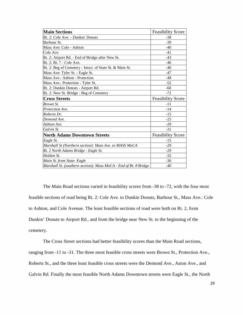
The Main Road sections varied in feasibility scores from -38 to -72, with the four most
feasible sections of road being Rt. 2: Cole Ave. to Dunkin Donuts, Barbour St., Mass Ave.: Cole
to Ashton, and Cole Avenue. The least feasible sections of road were both on Rt. 2, from
Dunkin’ Donuts to Airport Rd., and from the bridge near New St. to the beginning of the
cemetery.
The Cross Street sections had better feasibility scores than the Main Road sections,
ranging from -11 to -31. The three most feasible cross streets were Brown St., Protection Ave.,
Roberts St., and the three least feasible cross streets were the Demond Ave., Aston Ave., and
Galvin Rd. Finally the most feasible North Adams Downtown streets were Eagle St., the North
29
30
section of Marshall St., and Rt. 2: North Adams bridge – Eagle St., and the least feasible sections
were Holden St., Main St., and the South section of Marshall St.
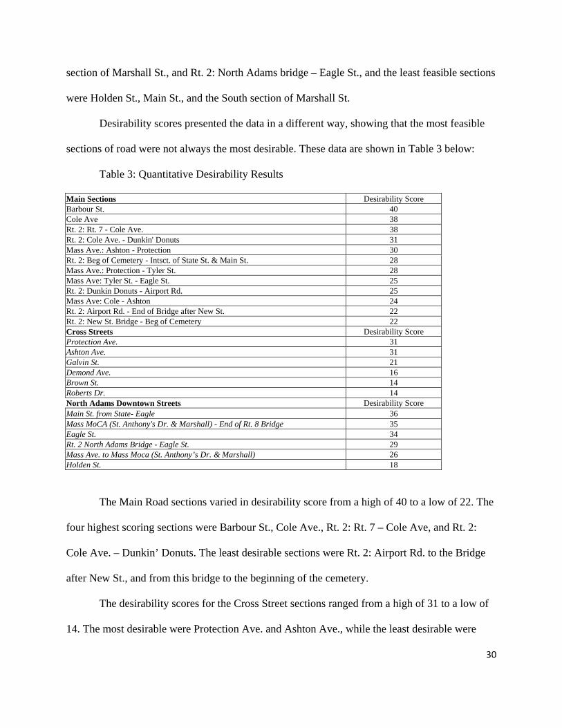
Desirability scores presented the data in a different way, showing that the most feasible
sections of road were not always the most desirable. These data are shown in Table 3 below:
Table 3: Quantitative Desirability Results
Main Sections Desirability Score Barbour St. 40 Cole Ave 38 Rt. 2: Rt. 7 - Cole Ave. 38 Rt. 2: Cole Ave. - Dunkin' Donuts 31 Mass Ave.: Ashton - Protection 30 Rt. 2: Beg of Cemetery - Intsct. of State St. & Main St. 28 Mass Ave.: Protection - Tyler St. 28 Mass Ave: Tyler St. - Eagle St. 25 Rt. 2: Dunkin Donuts - Airport Rd. 25 Mass Ave: Cole - Ashton 24 Rt. 2: Airport Rd. - End of Bridge after New St. 22 Rt. 2: New St. Bridge - Beg of Cemetery 22 Cross Streets Desirability Score Protection Ave. 31 Ashton Ave. 31 Galvin St. 21 Demond Ave. 16 Brown St. 14 Roberts Dr. 14 North Adams Downtown Streets Desirability Score Main St. from State- Eagle 36 Mass MoCA (St. Anthony's Dr. & Marshall) - End of Rt. 8 Bridge 35 Eagle St. 34 Rt. 2 North Adams Bridge - Eagle St. 29 Mass Ave. to Mass Moca (St. Anthony’s Dr. & Marshall) 26 Holden St. 18
The Main Road sections varied in desirability score from a high of 40 to a low of 22. The
four highest scoring sections were Barbour St., Cole Ave., Rt. 2: Rt. 7 – Cole Ave, and Rt. 2:
Cole Ave. – Dunkin’ Donuts. The least desirable sections were Rt. 2: Airport Rd. to the Bridge
after New St., and from this bridge to the beginning of the cemetery.
The desirability scores for the Cross Street sections ranged from a high of 31 to a low of
14. The most desirable were Protection Ave. and Ashton Ave., while the least desirable were

31
Brown St. and Roberts Drive. Scores for downtown North Adams streets varied from 18 to 36,
with the least desirable sections being Holden St. and the Northern section of Marshall St., and
the most desirable being Main St. and the Southern section of Marshall St.
Finally, the Combined Scores for the sections, shown below in Table 4, give a better idea
of the overall possibility of constructing a bike trail on the given section. These scores were
arrived at by adding the feasibility and desirability scores for each section.
Table 4: Quantitative Feasibility and Desirability Results, added to produce a combined score
Main Sections Feasibility Score Desirability Score Combined Score Barbour St. -39 40 1 Cole Ave -41 38 -3 Rt. 2: Cole Ave. - Dunkin' Donuts -38 31 -7 Rt. 2: Rt. 7 - Cole Ave. -46 38 -8 Mass Ave: Cole - Ashton -40 24 -16 Rt. 2: Beg of Cemetery - Intsct. of State St. & Main St. -46 28 -18 Mass Ave.: Ashton - Protection -48 30 -18 Rt. 2: Airport Rd. - End of Bridge after New St. -43 22 -21 Mass Ave: Tyler St. - Eagle St. -47 25 -22 Mass Ave.: Protection - Tyler St. -52 28 -24 Rt. 2: Dunkin Donuts - Airport Rd. -60 25 -35 Rt. 2: New St. Bridge - Beg of Cemetery -72 22 -50 Cross Streets Feasibility Score Desirability Score Combined Score Protection Ave. -14 31 17 Brown St. -11 14 3 Ashton Ave. -29 31 2 Roberts Dr. -15 14 -1 Demond Ave. -25 16 -9 Galvin St. -31 21 -10 North Adams Downtown Streets Feasibility Score Desirability Score Combined Score Eagle St. -15 34 19 Marshall St. (northern section): Mass Ave. to Mass Moca -29 26 -3 Marshall St. (southern section): MASS MoCA to End of Rt. 8 Bridge -40 35 -5 Rt. 2 North Adams Bridge - Eagle St. -29 29 -2 Main St. from State- Eagle -36 36 0 Holden St. -32 18 -14
The highest ranking of the Main Road sections were Barbour St., Cole Ave., and Rt. 2
from Rt. 7 to Dunkin Donuts. The highest rated, by far, of the Cross Streets was Protection Ave.,
followed by Brown St. and Ashton Ave. Finally, Eagle St. and the two Marshall St. sections
received the highest combined scores of the downtown North Adams streets.

32
Rating: The Red Light Green Light System
Clearly, the scores shown in Table 4 above are overwhelming and hard to analyze as they
are in raw form. For this reason, we created a visual system to aid in comparing different
sections. We dubbed this system the “Red Light, Green Light System,” and it separates every
road section into a red (don’t construct), yellow (construct with caution) or green (construct)
category for all three of its scores. The colors were assigned by the scheme outlined below:
Table 5: A color coded rating system
Main Sections Green Yellow Red Desirability (22->40) X>35 35>x>25 25>X
Feasability (-72->-38) X>-40 -40>X>-50 -50>X
Combined (-50->1) X>-10 -10>X>-20 -20>X Cross Streets Green Yellow Red
Desirability (14-31) X>27 27>X>20 20>X
Feasability (-29->-11) X>-15 -15>X>-25 -25>X
Combined (-9->17) X>0 0>X>-5 -5>X North Adams Downtown Streets Green Yellow Red
Desirability (18-36) X>30 30>X>20 20>X
Feasability (-40->-15) X>-20 -20>X>-30 -30>X
Combined (-14->19) X>0 0>X>-5 -5>X
The color categories indicate relative levels of feasibility, desirability, and combined
score, and take into account the distribution of all of the scores in the rating process. Below is a
graph showing the division of all road sections into these color categories:

33
Table 6: Quantitative results sorted into color coded categories
Main Sections Feasibility Score Desirability Score Combined ScoreBarbour St. -39 40 1 Cole Ave -41 38 -3 Rt. 2: Cole Ave. - Dunkin' Donuts -38 31 -7 Rt. 2: Rt. 7 - Cole Ave. -46 38 -8 Mass Ave: Cole - Ashton -40 24 -16 Rt. 2: Beg of Cemetery - Intsct. of State St. & Main St. -46 28 -18 Mass Ave.: Ashton - Protection -48 30 -18 Rt. 2: Airport Rd. - End of Bridge after New St. -43 22 -21 Mass Ave: Tyler St. - Eagle St. -47 25 -22 Mass Ave.: Protection - Tyler St. -52 28 -24 Rt. 2: Dunkin Donuts - Airport Rd. -60 25 -35 Rt. 2: New St. Bridge - Beg of Cemetery -72 22 -50 Cross Streets Feasibility Score Desirability Score Combined ScoreProtection Ave. -14 31 17 Brown St. -11 14 3 Ashton Ave. -29 31 2 Roberts Dr. -15 14 -1 Demond Ave. -25 16 -9 Galvin St. -31 21 -10 North Adams Downtown Streets Feasibility Score Desirability Score Combined ScoreEagle St. -15 34 19 Marshall St. (northern section): Mass Ave. to Mass Moca -29 26 -3 Marshall St. (southern section): South End of Rt. 8 Bridge To Mass Moca -40 35 -5 Rt. 2 North Adams Bridge - Eagle St. -29 29 -2 Main St. from State- Eagle -36 36 0 Holden St. -32 18 -14
XI. Recommendations
Our final recommendations are largely in reference to the current multi-use path plans
(provided by the BRPC) that contain the desired route, combining on and off-road sections.
While the current plans are for a path that is mostly off-road, there are a number of sections
where an on-road path seemed to be the only option, or an easily alternative option. Using our
analysis of on-road sections, we looked critically at the specific sections brought into question by

34
the desired plan in order to make recommendations with regard to the final path layout. Secondly,
once these sections were determined, we discussed the conflicts specific to these sections and the
resulting changes that need to be made, such that they become adequate for the construction of a
mixed-use path.
The preferred path route designated by the BRPC potentially includes or conflicts with
the following roads: 1) Route 2 from the traffic circle to Cole Ave. 2) Cole Ave 3) Route 2 from
The Spruces to Galvin Street 4) Galvin Road 5) Route 2: New Street Br. to the cemetery 6)
Brown St. 7) Marshall St. 8) Mass Ave from Brown St. to Marshall St. 9) Barbour St. A
proposed secondary route may include the following on road sections: 1) Route 2 from Galvin
Road to Phelps Ave 2) Mass Ave from Roberts St. to Brown St. All the roads in question are
discussed in order below. Visualization of these road sections and how they relate to the BRPC
proposed routes is enhanced by the use of the GIS map we created. Although we do not see it
practical to attach a map image of each section in this paper, we recommend that our analyses
our viewed in conjunction with these road sections on our GIS map.
1. Route 2 from the traffic circle to Cole Ave.: This section is particularly important
because it connects to downtown Williamstown, which our client explicitly stated as a
requirement for the final bike route. Fortunately, the section of road scored high in all
assessments (yellow feasibility, green desirability and green combined). Some notable positive
aspects of this section are that it has a significant amount of open green space surrounding the
road and it connects to cultural, commercial and educational places. Furthermore, the land
directly adjacent to the road is part of the town common. A few negative characteristics of the

section are that is has many crosswalks/pedestrian conflicts, a blind hill and steep slopes.
Cole Ave. Rt. 2: Rt.7 – Cole Ave21
2. Cole Ave: This is another important connecting route for the larger vision of the plan.
Ideally, it will connect downtown Williamstown to the Photech site (corner of Cole Ave and
North Hoosic) through which the BPRC preferred route is planned to pass. The connection of
this route to downtown Williamstown is an explicit goal of Lauren Gaherty and the BPRC, and
thus Cole Ave. holds great importance. The scores for the section are yellow feasibility and
green desirability/combined. Thus, this appears to be one of the roads that is better suited for the
mixed use path. Positives aspects of the section are it is wide and mostly flat. Problems may arise
in the construction of a trail, however, with regard to other conflict areas. Cole Avenue has
moderate levels of traffic which would be particularly troublesome to a bikeroute because of
numerous intersection and driveway crossings. Additionally, residential properties reach to the
road for almost the entirety of the road section, and the popular support for a trail encroaching on
these properties may not be high. Finally, on-street parking (or the elimination of this caused by
the creation of a bike trail) and an established storm drains system may cause additional 21 http://www.teresco.org/pics/commencement-20060603-04/DSCF0078.jpg&imgrefurl=http://www.teresco.org/pics/commencement-20060603-04/commencement.html
35
problems in path construction. An alternative to placing the connector route on Cole Ave. might
be to create a path through Linear Park, but this off-road option will have to be further explored
for wetland and property issues.
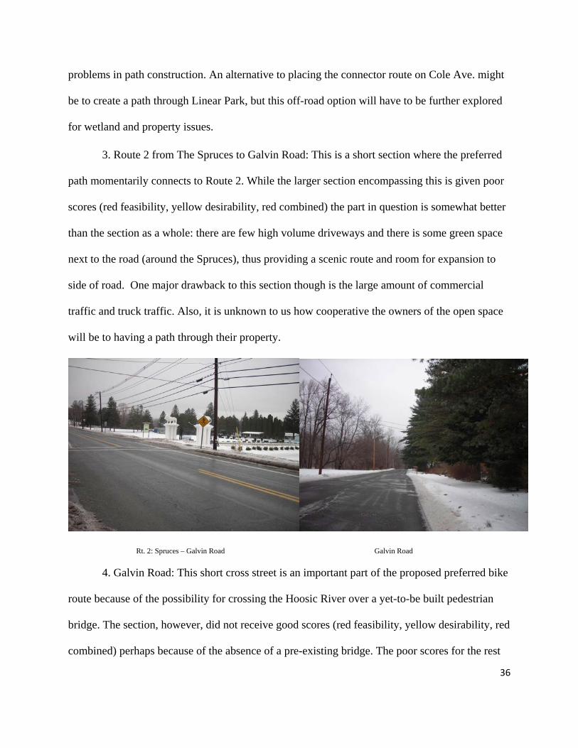
3. Route 2 from The Spruces to Galvin Road: This is a short section where the preferred
path momentarily connects to Route 2. While the larger section encompassing this is given poor
scores (red feasibility, yellow desirability, red combined) the part in question is somewhat better
than the section as a whole: there are few high volume driveways and there is some green space
next to the road (around the Spruces), thus providing a scenic route and room for expansion to
side of road. One major drawback to this section though is the large amount of commercial
traffic and truck traffic. Also, it is unknown to us how cooperative the owners of the open space
will be to having a path through their property.
Rt. 2: Spruces – Galvin Road Galvin Road
4. Galvin Road: This short cross street is an important part of the proposed preferred bike
route because of the possibility for crossing the Hoosic River over a yet-to-be built pedestrian
bridge. The section, however, did not receive good scores (red feasibility, yellow desirability, red
combined) perhaps because of the absence of a pre-existing bridge. The poor scores for the rest
36

37
of the section may be misleading. Though the road does not have an existing shoulder or
sidewalk, and may have some building space issues (another small bridge and residential
properties) there’s also so little traffic that constructing a completely off-road multiuse path in
the area might not be necessary to make the roadway safe for a family of four. The section also
has beautiful natural surroundings including rural views and access to a river trail.
5. Route 2: New Street Bridge to the Cemetery: The proposed preferred bike route skirts
a section of road starting at the bridge east of New St. on Rt. 2 and stretching to the bridge just
west of Barbour St. Though the proposed bike path does not actually touch Route 2 in this area,
we found it important to explicitly recommend against an on-road route in this section. The
section of Route 2 following the New St. Bridge received the lowest scores in all three categories,
as it encountered serious conflicts such as steep slopes, road expansion problems, multiple
bridges needing to be expanded, and many intersections and high volume driveways. Though
some of these conflicts could be abated by combining commercial and residential driveways, the
overall low ratings would not be greatly improved, and we recommend that the bike route instead
follow one of the proposed preferred routes skirting this area: one through the flood plain next to
the Hoosic River, or another on the opposite side of the Hoosic River starting on Barbour St.

Rt. 2: New St. – Cemetery Brown St.
6. Brown St.: One “preferred” route for the bike path crosses the Hoosic river just before
downtown North Adams on a short segment of Brown St. This section received a high feasibility
score, but low desirability score (green feasibility, red desirability, green combined). Again,
scores may be deceiving as they can weigh factors only to a certain extent. For example, Brown
Street contains both an extremely narrow underpass under the railroad and a bridge that might
need widening, and though these factors were surely given scores of 3 on the quantitative
analysis sheet, other conflicts were so low that the sections still got a green feasibility score. The
red desirability score for the section is probably due to mostly commercial surroundings and a
lack of connection to cultural and educational places.
7. Marshall St.: For the purpose of having the path end at (or go through) Mass Moca,
barring the creation of a new road, Marshall Street will have to be used as the connector street
from either Mass Ave or Route 2. Because each approach uses opposite ends of the street, the
analysis of Marshall Street was divided into two sections: Marshall from Mass Ave to Mass
38

Moca (the northern section), and Marshall from north end of the Route 8 bridge to Mass Moca
(the southern end) as divided by the light at the St. Anthony Street intersection. The Mass Ave
section received a yellow rating for feasibility, desirability and combined score, while the section
ending at the Route 8 Bridge received red feasibility, green desirability and yellow combined
scores. While the desirability of the southern section was ideal, the better feasibility of the
northern section makes us recommend the use of this as the more favorable option. This decision
was based on feasibility because the northern section is such a short section and the desirability
benefits (downtown North Adams/commercial center, etc.) of the southern section are not
actually lost; to walk from where the section ends to the southern section takes less than one
minute at a reasonable pace, thus, the desirability benefits are only marginally compromised.
Marshall St. Mass Ave. from Brown St. to Marshall St.
8. Mass Ave from Brown St. to Marshall St.: This section, in combination with the
northern section of Marshall Street, was highly recommended due to its connection to Mass
Moca. While it received a yellow feasibility, yellow desirability and red combined score, this
was largely due to the encroachment on residential properties on the north side of the street and
high number of high volume driveways. However, the south side of the street had a rather large
grass strip separating the road and the Hoosic River. This space is more than adequate (in terms
39
of width and length) for a separate mixed used path running parallel to Mass Ave down to
Marshall Street.
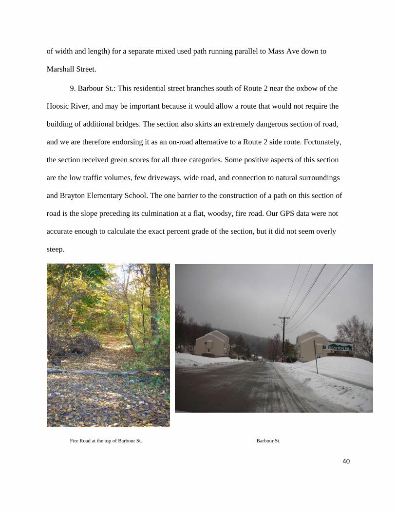
9. Barbour St.: This residential street branches south of Route 2 near the oxbow of the
Hoosic River, and may be important because it would allow a route that would not require the
building of additional bridges. The section also skirts an extremely dangerous section of road,
and we are therefore endorsing it as an on-road alternative to a Route 2 side route. Fortunately,
the section received green scores for all three categories. Some positive aspects of this section
are the low traffic volumes, few driveways, wide road, and connection to natural surroundings
and Brayton Elementary School. The one barrier to the construction of a path on this section of
road is the slope preceding its culmination at a flat, woodsy, fire road. Our GPS data were not
accurate enough to calculate the exact percent grade of the section, but it did not seem overly
steep.
Fire Road at the top of Barbour St. Barbour St.
40

A proposed secondary route may include the following on-road sections:
1. Route 2 from Galvin Road to Phelps Ave.: This section is the less optimal option when
considering an off-road option (that would be on the other side of the river) to avoid it. The piece
of road in question includes two different analyzed sections: Dunkin-Airport (which received red
feasibility, yellow desirability and red combined scores) and Airport Rd. to the New St. Bridge
(yellow feasibility, red desirability and red combined). The ratings of the sections encompassing
this stretch of road are not particularly helpful because the section in question is only the very
end one section and very beginning another adjacent section as analyzed. Nonetheless, this
section was not ideal: much of the surrounding areas is residential, the turn lane in front of Stop
and Shop results in a discontinuous shoulder and sidewalk, there are a number of intersections, it
is a high speed zone that receives heavy car and truck traffic and the majority of the surrounding
area is not very natural for much of the strip. Despite these drawbacks though, the section is very
flat, has access to a supermarket and has good views of local mountains around Mt. Greylock.
Although not part of our study, another mostly on-road option to pass the same section would
potentially be to take Airport Road in order to avoid the residential encroachment problems
The Route 2: Galvin Road to Phelps Road area Mass Ave: Roberts to Brown St.
41
42
2. Mass Ave from Roberts Drive to Brown St.: This section received the following scores:
red feasibility, yellow desirability and red combined. Many of the drawbacks to this section were
continuous over much of the road. For example, there were multiple (at least 3 separate) blind
curves and/or hills and the whole section is a steep slope. The whole section is a high speed zone
with no sidewalk and a very small shoulder at most. Furthermore, there were many areas where
there were rock outcroppings on the north side of the road and steep embankments and the south
side (require either significant blasting or filling to provide room for a path). However, this is
one of the most scenic sections, with very few driveways of any kind.
XII. Biases in Research Methods
In our methodology, there were certain aspects that at times produce an unrealistic
portrayal of the roadways we examined. These are especially apparent in our data collection. At
the beginning of our project, we were given an “On-Road Evaluation Form” by our client Lauren
Gaherty which had been used to evaluate potential paths before. The evaluation was divided
between Constraints and Opportunities. Constraints included safety and construction concerns
under both a “Physical & Built Environment” section and a “Building Considerations” section.
Opportunities contained both “Physical Amenities” and “Community Amenities.” The data for
each category within each section (e.g. the number of traffic lights in the “Physical & Built
Environment” section) was weighted on a 0-3 scale (with 0 having no effect and 3 having the
most effect) (weights were provided by the BRPC and previous assessments in order to have
continuity between the different assessments) and added together. The total score of the
Constraints was given a negative score as it represents negative aspects of a section and the
Opportunities a positive score because it represents the positive aspects; When added together,

43
the results was the combined score for a given section of road, which was helpful for comparing
sections of road against other sections, more than for evaluating a section of road on its own.
While this constituted a logical system for evaluating the roadways, there were a few
aspects that gave us more inaccuracies than what we believe would have been the most precise
analysis possible. For one, our Constraints section captured the volume of several road features
but not their severity or seriousness. For example, our data captured the density per mile of
driveways, high-volume or commercial driveways and traffic lights. While this gave us a
relatively useful measure of vehicle activity or possible vehicular interference with a path on a
section of roadway, it did not measure the degree to which these features might affect a path.
There could be one driveway that offers a significant obstacle to safety or construction, or one
commercial driveway that receives more traffic than another, or a residential driveway that has
even more traffic volume than a commercial one, and thus simply the quantity of driveways or
traffic lights is not always the best indicator of their status as conflict points that would provide a
hindrance to mixed-use path construction or the safety of its users.
The weight system also seemed to be inaccurate at times; specifically in its treatment of
bridges, under which we also included railroad tressels: this is significant given the proximity to
and frequent crossing over or under the rail lines as the roadways do. Although widening a
bridge to accommodate a mixed-use path would often seem prohibitively expensive given the
scale and financial backing of the project, it was only given a weight of 1, while high-volume
and commercial driveways were given a weight of 3. This was an especially large concern in
evaluating the cross streets, as several had to cross the river, the railroad tracks, or both, and if
both was the case there was no way to include both of those features in the data; they were
simply expressed under the “Bridges needing to be widened for bike lane” category. The best
44
example of this is Demond Avenue, which has few conflicts except the road passes under the
railroad tressel, and in the process narrows to a width that only accommodates one car at a time.
Construction would likely not only have to widen the road but widen it enough to accommodate
two cars and a mixed-use path with a five-foot gap between them or enough room for a solid
barrier. This is clearly a very serious construction issue, yet its severity cannot be accurately
expressed in our data analysis.
Thirdly, while it is important to remember that in a numerical evaluation system such as
ours, the absolute numbers are arbitrary and the only importance is the scores between road
sections, allowing us to create a ranking, there was no way to compare Constraints versus
Opportunities in an accurate fashion. We could not determine whether the fact that a road was
well-shaded and sheltered from the wind outweighed the fact that the road also had a high
density of on-street parking or driveways. For example, if the safety concerns of a section of
road make a path an unrealistic or possibly unlawful idea, does it matter what the opportunity
score is at all? Implied in this example is that a full cost-benefit analysis, which would be highly
useful for this type of project, was not made. While a C-B analysis is somewhat implicit in our
data analysis (ex. high-volume driveways being costly to deal with and thus given a high weight),
in other areas, such as bridge considerations, it was not as implicit, and while it is obvious that a
full cost-benefit analysis would give us a much better idea of how realistic path construction
along a certain roadway as well as its potential benefits, given the scale of the project, the time in
which the project needed to be completed, the resources available to the project team as well as
the lack of professional training in this type of analysis among the team, this was not realistic.
A full cost-benefit analysis, however, is likely the next step in the context of the larger project.

45
Other biases stem from the fact that we analyzed both sides of each given road section in
conjunction, rather than providing separate scores for each side. Since we are recommending a
separate path on one side of the road, and the road sections often differ from one side to another,
a more accurate analysis would have taken this into account. We found such a project beyond the
scale of our project.
XIII. Conclusion
The Hoosic River Valley between Williamstown and North Adams presents a rather
difficult planning situation when considering construction of a mixed-use path. The mountains
surrounding it are rather steep, and the valley itself is quite narrow, and most of the flat areas are
occupied by residential or commercial areas as well as roadways and railroads. It is also clear
that much of the existing roadways could not accommodate a mixed-use path. This is because of
safety concerns such as high traffic volume on Rte. 2 which does not comfortably accommodate
our target user of a family of four. This is also because of construction feasibility issues, such as
areas where bridges would need to be widened which would likely prove too costly to modify in
a cost-benefit analysis. Having examined the data we collected, it is clear that the majority of the
path will have to be off the roadways, where it is safer, easier to build, and more beautiful. This
is not a bad problem to have, as the goal is to provide the user with a recreational facility that
allows them to interact with the natural environment and explore the area from a different
perspective.
That being said, there are certain areas where the path will have to go along the roadways,
but hopefully not on them. The greatest prudence will be required in designing these sections of
trail, for no longer is the cyclist or the jogger alone in his or her surroundings, but joined by
motorists who are likely not anticipating any interaction with bicyclists or pedestrians in their

46
travel through this rural area. Separation from the motorway can be considered as a necessity for
the path, and this should be done primarily through physical distance instead of a physical barrier
directly on the roadway. Great care must also be taken in working with the surrounding
residents in these areas, as a path will likely interfere to some extent with the use of their
property, most likely in crossing their driveways. But if creativity is employed in the design of
the path, we believe that it will be able to bypass most of the more hazardous areas we evaluated
in our project, and utilize the safer and more favorable sections of road. We hope that our
analysis, including our on-road evaluations, bicyclists’ point-of-view, GIS map and written
report will be able to assist the creation of the Mohawk-Mohican Path as well as provide hard
data for further grant applications. We wish the individuals and groups that will be working on
this project from here on out good luck, and we hope we can witness some construction when we
come back for our five-year reunion.
XIV. Acknowledgements
We would like to acknowledge many individuals for helping us develop this report. First
of all, our professors Sarah Gardner and Elisabeth Goodman gave us the initial guidance to start
this project. Obviously, our client Lauren Gaherty and the rest of BRPC were essential in
directing our research. David Dethier provided the GPS unit that we used to collect data, and
Sharron Macklin taught us the GIS technology techniques which made our integrated analysis
methods possible, and Roger Bolton helped us piece together an appropriate quantitative method
of analysis.

ON-ROAD EVALUATION FORM Section: _____________ Explanation 1. Basic information was entered in the Data column Data is % with the factor unless otherwise noted. No = 1, Yes = 2
Length (miles): _____________ 2. The data was made comparable using a system of Points to reflect impacts or work required to develop the trail: 1=Little or no impact, 2=Moderate, 3=Major
3. Weights represent how item meets Goal of on-road recreational bike trail ( safely accommodate family of 4): 1=Least important, 2=Moderate, 3=Most important
4. The spreadsheet multiplies Points by Weight to give a Score. Subtotals go to the Summary sheet
FEASIBILITY
Safety
Factor Data Points x Weight = Score High traffic volumes Very high 3 2 6 Truck traffic allowed? 2 > # driveways 2 > # high volume driveways (retail, gas stations, etc) 20 / mile 3 3 9 > # road intersections 2 > # traffic lights 1 Turn lanes 2 On-street parking 2 Speed limit >40 mph 2 Accident Rating 2 Subtotals Constraints: Building Considerations
Grade >5% 3 Bridges needing to be widened for bike lane 1 Bike lane will encroach on residential properties 3 No existing paved shoulder within section 2 Has existing stormdrain system in path of bike travel 1 Currently not paved 1 Dangerous curves 2 Building demolition or rock blasting required 3 Subtotals
DESIRABILITY
Opportunities: Physical Amenities
Factor Data Points x Weight = Score
Shade/sheltered area from wind none 1 2 2 Interesting views/vistas 3 Goes through protected open space/APR 2 Undeveloped/natural surroundings 2 Existing raised or separate sidewalk 2 Street lighting 2 Subtotals
Opportunities: Community Amenities
Connects to other recreation/cultural places 2 Connects to areas of employment or school/college 1 Interesting features on or directly near road 2 Number of bus stops
Appendix 1: On Road Evaluation Form
47
Appendix 2: GPS Data Collection Sheet
Date Road Section GPS point # Point Type (#) side of road Notes
48


