

The Republic of the Union Myanmar
Ministry of Agriculture and Irrigation
Myanmar Agricultural Development Support Project
Social Assessment
Final report
October 31, 2014

i
Table of Contents Lists of Acronyms .......................................................................................................................................... v
Executive Summary ...................................................................................................................................... vi
Section 1: Introduction ................................................................................................................................. 1
1.1 The Project .......................................................................................................................................... 1
1.2 Objectives of the SA ............................................................................................................................ 3
1.3 Methodology ....................................................................................................................................... 4
1.3.1 Sampling ....................................................................................................................................... 5
1.3.2 Free, prior and informed consultations ....................................................................................... 5
1.3.3 Number of interviewees .............................................................................................................. 5
1.4 Limitations of the works ..................................................................................................................... 6
1.4.1 Time limitation ............................................................................................................................. 6
1.4.2 Difficulties in acquiring demographic data .................................................................................. 6
1.4.2 Need for site specific Social Assessment ..................................................................................... 6
Section 2: Legal, Policy and Institutional Framework ................................................................................... 7
Section 3: Sector Framework ........................................................................................................................ 8
Section 4: Geographic, Demographic and Socioeconomic Backgrounds of the Potential Project Areas ..... 9
4.1 Sagaing Region .................................................................................................................................... 9
4.1.1 Overview of the irrigable areas in Sagaing Region .................................................................... 12
4.2 Mandalay Region .............................................................................................................................. 15
4.2.1 Overview of the irrigable areas in Mandalay Region ................................................................. 17
4.3 Bago Region ...................................................................................................................................... 22
4.3.1 Overview of the irrigable areas in Bago Region ......................................................................... 24
Section 5: Overview of the Studied Irrigation Schemes ............................................................................. 29
5.1 Ethnic minorities in the studied schemes ......................................................................................... 30
5.1.1 Sin Thay ...................................................................................................................................... 30
5.1.2 North Yama ................................................................................................................................ 30
5.1.3 Swa Chaung ................................................................................................................................ 30
5.1.4 Male Nattaung ........................................................................................................................... 30
5.2 Religious minorities in studied irrigation areas ................................................................................ 30
ii
Section 6: Findings of Social Assessment - Socioeconomic Information .................................................... 31
6.1 Farming systems ............................................................................................................................... 31
6.1.1 Farmland types........................................................................................................................... 31
6.1.2 Access to land ............................................................................................................................ 31
6.1.3 Farmland distributions ............................................................................................................... 32
6.1.4 Cropping patterns ...................................................................................................................... 34
6.1.5 Farming techniques .................................................................................................................... 36
6.2 Market ............................................................................................................................................... 40
6.2.1 Input market .............................................................................................................................. 40
6.2.2 Credit market ............................................................................................................................. 42
6.2.3 Labour market ............................................................................................................................ 44
6.2.4 Product market .......................................................................................................................... 45
6.3 Access to irrigation water ................................................................................................................. 47
6.3.1 Villages with different levels of irrigated availability ................................................................. 47
6.3.2 Farming activities as per availability of irrigated water ............................................................. 48
6.3.3 Constraints to accessing irrigation water .................................................................................. 50
6.3.4 Socioeconomic differences caused by access to water ............................................................. 52
6.3.5 Impacts of limited water availability on social relations ........................................................... 54
6.3.6 Community water management system.................................................................................... 54
6.3.7 Community collective actions in seeking water......................................................................... 55
6.3.8 Payment for water ..................................................................................................................... 57
6.4 Access to extension services ............................................................................................................. 58
6.4.1 Attendance in agricultural training ............................................................................................ 59
6.5 Land ................................................................................................................................................... 59
6.5.1 Land tenure ................................................................................................................................ 59
6.5.2 Issues on land ............................................................................................................................. 60
6.5.3 Examples of land disputes originating from the military regime ............................................... 61
6.5.5 Reclassification of farmland type from Ya to Le and vice versa ................................................ 63
6.5.6 Land sold to outsiders ................................................................................................................ 63
6.5.7 Land improvements schemes .................................................................................................... 64
6.6 Indebtedness ..................................................................................................................................... 67
6.7 Migration ........................................................................................................................................... 68
iii
6.8 Vulnerability ...................................................................................................................................... 68
6.8.1 The vulnerable groups according to the community ................................................................. 68
6.8.2 Other vulnerable groups identified by the study ....................................................................... 69
6.9 Gender .............................................................................................................................................. 70
6.9.1 Women-headed households ...................................................................................................... 70
6.9.2 Gender in farm activities ............................................................................................................ 70
6.9.3 Women and inclusion ................................................................................................................ 71
6.10 Institutions ...................................................................................................................................... 72
6.10.1 Village level institutions ........................................................................................................... 72
6.10.2 Analysis of the roles and functions of key village institutions ................................................. 72
6.10.3 Inclusion in the village level institutions .................................................................................. 75
6.10.4 Inclusions of ethnic and religious minorities ........................................................................... 76
6.10.5 Township level institutions ...................................................................................................... 76
Section 7: Results of Free, Prior and Informed Consultations .................................................................... 82
7.1 Who we consulted at the community .............................................................................................. 82
7.1.1 Consultation with non-Bamar population ................................................................................. 82
7.2 People’s opinions about the project ................................................................................................. 83
7.2.1 Renovation of irrigation canals and building watercourses ...................................................... 83
7.2.3 People’s point of view on the water tax .................................................................................... 85
7.2.4 Right of Way ............................................................................................................................... 85
7.2.5 Land improvement schemes ...................................................................................................... 86
7.2.6 People opinions on farming technique ...................................................................................... 87
7.2.7 Preferred venues of agriculture training ................................................................................... 87
7.2.8 Timing of training ....................................................................................................................... 88
Section 8: Positive Impacts and Potential Social Risks of the Proposed Project ........................................ 89
8.1 Positive impacts of the projects ........................................................................................................ 89
8.2 Potential social risks .......................................................................................................................... 90
Section 9: Recommendations ..................................................................................................................... 92
9.1 For the whole project ........................................................................................................................ 92
9.2 Rehabilitation of canals and watercourses ....................................................................................... 93
9.3 Extension service............................................................................................................................... 93
9.4 Land improvement schemes ............................................................................................................. 94

iv
Annexes 1: Seasonal Calendars of Farming Activities ............................................................................. 95
Annex 2: Pictures of Land Improvement Schemes ................................................................................. 97

v
Lists of Acronyms ACC : Agricultural Coordination Committee
AE : Assistant Engineer
DOA : Department of Agriculture
DO : Direct Outlet
DY : Distributary canal
EMPF : Ethnic Minority Planning Framework
ESMF : Environmental and Social Management Framework
FAO : Food and Agriculture Organization
FGD : Focus Group Discussion
FS : Feasibility Study
GAD : General Administrative Department
GAP : Good Agricultural Practices
ID : Irrigation Department
IPM : Integrated Pest Management
JICA : Japan International Cooperation Agency
LRD : Land Record Department
M & E : Monitoring and Evaluation
MADB : Myanmar Agricultural Development Bank
MC : Main Canal
MOAI : Ministry of Agriculture and Irrigation
NPT : Nay Pyi Taw
PMU : Project Management Unit
RPF : Resettlement Policy Framework
SAE : Sub-Assistant Engineer
SA : Social Assessment
SLRD : Settlement and Land Record Department
UNDP : United Nations Development Program
VERP : Village Elderly and Respected Persons (Yat Mi Yat Pha)
VTA : Village Tract Administration
WUG : Water User Group

vi
Executive Summary Overview of irrigable areas of the regions studied
The main livelihood of the irrigable areas of three regions studied (Sagaing, Mandalay and Bago) are
paddy farming despite that Sagaing and Mandalay regions contain significant portion of dry land farming
which mainly includes such crops as sesame, peanuts, green gram, cotton and chickpea. The irrigable
area of each region covers 1/3 to 3/4 of the total agricultural areas. About 60% to 80% of the total
population in each region lives in the irrigable areas.
The irrigable areas of all three regions are generally located where the ethnic Bamar are the majority.
However, some other ethnic peoples could be found in some of the townships as separate community.
Areas near Chin State in Sagaing region, eastern and north eastern parts of Mandalay Regiony, and
western, northwestern and eastern parts near the Sittaung River are the areas where other ethnic
people such as Chin, Shan and Karen could be residing as separate communities.
Farming systems and farming techniques
Generally, two main types of farming system are found in the studied villages of the four schemes: Le
(paddy) only system, and the system where Le and Ya (rain fed upland crops) coexist1. Villages in two
townships - Yaetar Shay (East Bago) and Sint Kue - focused more on paddy farming and the other two
townships - Tat Kone (Southern Mandalay) and Pale (Southern Sagaing) - have the mixed system of Le
and Ya. Villages in the latter two townships also have a significant number of farming households who
only own Ya land.
The average land holding sizes of small, medium and large farmers, as locally defined, are 2–4 acres, 5-
8 acres and 10–17 acres, respectively. Villages in Pale township (southern Sagaing) is the area where
the land holding size is the largest while it is the smallest in Tat Kone Township (Southern Mandalay near
Nay Pyi Taw).
Generally, 43% of the villages have two crops annually, 36% grow three crops and the remaining
villages only grow one crop per annum. Villages with two crops mainly double-crop paddy – in
monsoon and summer, while villages with three crops grow additional field crops such as sesame,
beans, peanut and sugar cane. Those villages growing two-three crops have good water availability
while those with only one crop have poor availability of irrigation water.
Larger farmers are able to grow more diverse crops simultaneously than small and medium farmers.
Given that large farmers have two to five times of land more than medium and small farmers, they grow
one crop while the other crops are at the stage of nurseries or seeds for the next season are being
produced. For example, the study found that large farmers in those villages with Le and Ya combined
farming system grow six types of crops per year while small and medium farmers in the same villages
have a half number of types. Accordingly, large farmers are more resilient to climatic variations and
price fluctuations.
1 Explanation on Le and Ya farming is found in Section 2.

vii
Le type farming system is more mechanized than Ya type farming system. The power tiller is not
suitable for Ya lands which is not flat. For harvesting, all regions except three villages mainly used
human labour. Two villages in Yaetar Shay (Bago East) are seen using big harvesters through the private
services while the other one in Sint Kue used small harvesters. Still many small farmers only depend on
their own labor for harvesting. Most of the farmers in villages in three areas (Yaetar Shay, Tat Kone and
Sint Kue) use threshing machines. The villages studied in Pale Township, however, are still using human
labour for threshing because threshing machine breaks the stalks of paddy plants and the straw could
not be used as cow feed as a result.
Majority of farmers in villages studied still largely maintain traditional planting methods. However,
villages in Tat Kone Township use ‘Rope Line Method’ promoted by the agricultural department.
Farmers maintain traditional methods despite that they know about the new planting method because
this, in their perception, has many specifications. Laborers also do not want to use this method for the
same reason, and hiring farmers have to pay more if they want laborers to apply that method.
Labour is short in most villages in all four areas studied except those villages with bad water
availability. It is found that 50% villages are being faced with significant labour shortage and all of them
have good water availability. Labour shortage has been more obvious in Yaetar Shay and Tat Kone since
five years ago because of the migration.
Agricultural extension services are not accessible to most of the villages studied. The services usually
reach only to main tract villages. In Sint Kue and Yaetar Shay, the services do not reach regularly even to
main tract villages. Insufficiency of technical staff and budget for field visits are the main hindrances.
Successful outreach of extension is observed in villages in Tat Kone township which benefit from the
presence of agricultural outposts where department in-charge (department manager) comes frequently
while 7 to 8 agricultural extension workers are visiting fields every day. They give advice in response to
farmers’ need and give agricultural training three times per season to both farmers and the labourers
(Thoke group members).
Peer-to-peer learning especially learning from large farmers is a key to disseminating new techniques,
especially new seeds. Most of the famers grow new seeds when they see good results on the fields of
other farmers who in most of cases are large farmers with at least 10 acres of farmlands. They can
afford to test new seeds on a small portion of their land, say one acre. ‘Model farmers’ were found in
some villages: they are large farmers owning 10-40 acres and tend to be influential figures such as
village elderly and respected persons or educated persons. Those people have exposures dealing with
institutions outside the village, especially with government departments and the Yaesin Agricultural
University where they purchase new seeds.
Traders are also effective disseminators of new seeds to farmers. Some farmers say they have more
confidence to grow new types of paddy recommended by traders because they believe that the type of
paddy recommended by traders will be good in market demand. Regarding usage of fertilizers and
pesticides, farmer mainly try methods recommended by input market suppliers.

viii
Majority of farmers use improved rice seeds. There are three main types of sources from which farmers
access to seeds in all villages studied. They are: seed distributors especially large farmers in the areas,
the government nursery distributors and farmers in the same village. The first type of the source of
seeds is large farmers using seeds from the Yesin Agriculture University. Government nurseries exist in
township cities and are mainly depended by larger farmers and the village level seed distributors. The
third type of seed distributors - farmers in the same the village - are those large farmers who use first
generation seeds from the township nursery or private shops in main cities, who resell to fellow farmers
who mostly are medium and smaller farmers. This means that larger farmers are more accessible to
better seeds than medium and small farmers.
Private dealers are main distributors fertilizers at townships and villages. Large farmers usually
purchase directly from the township dealers on installments with no or a low interest rate while
medium and small farmers purchase from village dealers on credits with 7-10% interest rate. In fact,
large famers in many cases are the village level dealers of fertilizers who mainly sell to smaller farmers.
The products are purchased directly by brokerage houses and rice mills in all villages visited. Only
exceptions were beans and sesames in villages of Pale Township which farmers have to sell at the
township market. The study found that in villages with good water availability where socioeconomic
condition is good, large farmers are seen as product buyers and traders who purchase products at the
harvest time, store at home and sell when they get most favorable price.
Land
Land user certificates (LUCs) are being issued as one of the subsequent actions of the 2012 Farmland
Law. Farmers are entitled to transfer the user rights or use them as collateral in borrowing official loans
according to the new law although the state still is the ultimate owner of the land. Farmers especially
women, however, are found having little knowledge about the meaning and benefits of enhanced
user rights under the new law. They expressed insecurity on their land pointing out the state’s ultimate
ownership of the land.
Land issues were found in three forms. Land disputes are seen in three types: land disputes related to
land confiscations under the military regime in 1990s; land disputes among siblings and relatives; land
disputes related to farmland boundaries among neighboring farmers. Another type of land issue is that
reclassification of the land types from Le to Ya or vice versa is needed in several villages. Such disputes
are handled by land management committee of different levels.
Farmers who have not had experience with land improvement schemes expressed their interest to
participate in such activities. On the other hand, farmers who are already participating in land
improvement schemes expressed their concerns which are related to the low quality of works.
Nevertheless, the SA found that land improvement is a very profitable scheme improving product
marketing and production efficiency through mechanization. On the other hand, the schemes developed
by the government have two main constraints - challenges in land redistribution with the lack of precise
measurement before the implementation of the scheme, and quality short-falls with the lack of

ix
sufficient budget. In addition, farmers expressed their concerns on mandatory cultivation of “Pale Thwe”
paddy, the ministerial policy crop, upon completion of land improvement scheme.
Access to irrigated water
The study found that accessibility of irrigation water is the main determinant to farming systems and
that the socioeconomic conditions of villages with good availability differed from those with less
water availability. Half of the villages studied only had Ya farming before they started benefiting from
the irrigation. The rests used to have Le farming, but only with one crop of paddy. The former are able to
grow both paddy and other crops now, while the latter have been growing two crops of paddy since
they have gained access to irrigation water.
Various failures in irrigation system as well as neglect or disobediences of rules and regulations by
communities are revealed. These result in a lack of or limited/delayed irrigation water supply despite
that each scheme targets much larger areas than what is currently irrigated. The study found several
system failures, such as leakages and canals not built to be workable on various topographical
conditions or water velocity. And there is a lack of systematic maintenance by the irrigation department.
On failures of community compliance to rules, there are three main types: people’ arbitrary use of
irrigated water and infrastructure; failures in maintaining water courses; and undisciplined structuring of
farmland boundaries.
Social relations are inflicted with competition for irrigated water. There are intra- and inter-village
conflicts as people have to compete over irrigated water. Upstream farmers often take water first
resulting in shortage of water at downstream. As a result, farmers at medium and tail ends have to go as
a group to the village closer to the canal and request to open water ways. Frequently, such situations
lead to conflicts in which physical assaults can occur. Intra-village tensions upon acquiring irrigated
water are very commonly reported in every village visited. Those problems mainly involve plot-to-plot
water distribution and dispute between upstream and downstream users.
Systematic community water management system exists only in 43% of the villages studied. Water
user groups in those villages are formed as per watercourse or direct outlet. The water user groups are
called Myang Kaung groups. The groups are headed by Myaung Kaung (canal head) and comprise
farmers using a certain DO or watercourse. Myaung Khaungs are selected by farmers sharing a water
course or direct outlet. Myaung Kaungs are seen in effective role in water management in villages
where there are systematic water user groups. They organize farmers in their groups to clean or repair
watercourses and DOs before a crop season begins. In addition, they monitor water distribution so that
all farmers are able to get water as their turns. Usually, Myaung Kaung gives penalty to those who
violated turns by not giving water for two weeks. The study found that Myaung Kaung in villages where
there are water user groups are directly communicating with persons from irrigation department,
especially with SAEs and that there are close cooperation between the group and ID.
Water tax has not been collected since 2011. The water tax when it was last collected generally was
1,950 Kyat. People have no clear idea on why water tax was not collected for the last three years and

x
some thought it would be collected in sum for three years. On the other hand, people from irrigation
department said that it was people’s failures to pay taxes.
Vulnerability
Amounts of debt are higher than before. However, farmers in good water availability are able to repay
their loans which explain the lower interest rates charged by moneylenders. On the other hand, villages
with poor water availability are difficult to repay and found to be resorting to such coping mechanisms
as migration and land selling.
More migration has been taking place in almost all villages regardless of situations of irrigated water
availability. However, the nature of migration seemed different among villages with good and bad
water availability, which is the key determinant of people’s socioeconomic conditions. The study
surmises that people in villages with good water availability tend to migrate for capital- and skill-
intensive works while those in bad water availability go for labor intensive works.
The landholding size, and corresponding household wealth status, still determines price. Larger
farmers can afford to store their product until the price goes up in the market or at least paddy grains
are dried enough while the small and medium farmers cannot do so.
Two main types of vulnerability groups are found by SA as groups who could be covered by the
project.
1. Small farmers especially women headed small farmers with less than four acres of land in
bad water availability villages;
2. Small farmers who make share cropping in poor water availability villages
Gender
The average number of female headed household (FHHs) in villages studied are 16, which is 6% of the
average population. However 5% are considered as most vulnerable as they are small and landless
families. Villages where capital and skill intensive migrations are higher, incidence of women headed
households is also higher.
Gender division of labour in farming works has faded in all areas because of the labour shortages. The
study found that women have to take more and new roles in farming because of labour shortage and
migration of men. It is also found that women get the same wage as men for the same type of works.
Women are not found in key institutions and decision making roles of the community. The study
revealed that women are not seen as members of such key village institutions as village administration,
village development supportive committee, village land management committee. A few women are
seen as members of water user groups but no woman is seen as the leader. Women are seen as leaders
of the labour groups called Thoke groups.
SA also found several cases of migrations’ negative social impacts particularly in terms of separated
families and increase of women headed households. Given that more men migrate and, if they do, they

xi
migrate further and longer than women, it happen that they settle their lives in the destination places
by developing next marriages. Researchers have seen several cases of women headed households being
inflicted by this phenomenon.
Results of free, prior and informed consultations with villagers
Renovation of the Irrigated canals and building watercourses
People in the villages studied generally welcome rehabilitation of the irrigation canals regardless of
farming types and ethnicity. Most of the people recommend lining of the canals (in bricks and
concrete). More importantly the study revealed that small farmers especially those 2 acres and less
unlike other farmers have concern on giving up land when water courses are built. However, some
villagers including VERPs and administrators mentioned that the canal maps were already drawn, which
describe watercourses and canals. This is also acknowledged by farmers, and that there will be no
problem building water courses or enlarging the canals according to the design.
Laborers in the village also welcome the scheme pointing out that they can have more job
opportunities when large farmers benefit. Laborers in villages with limited water availability are
expecting to have more jobs through rehabilitation of the canals by the project.
Right of Way
Almost all farmers who are growing crops there said that they will remove crops from the area when
the canals are renovated. People generally acknowledge the right of way, but do not know the exact
areas. Persons from land record department also stated that the land entitlement given to the farmers
excluded the canal areas.
Land Improvement Schemes
People generally know that land improvements benefit them by developing a structure with more
accessibility to markets and enabling mechanized farming, which will result in more efficient
production. However, people who participated in completed land improvement schemes reported
challenges about the schemes: the quality of the scheme especially on land leveling, product roads and
canals is not good enough to grow crops or utilize; and disputes could arise on redistribution of land
after implementation of the scheme.
People opinion on provision of farming technique
Every method and seed which will have high yields and good in market demands will interest farmers.
Farmers insisted that they are interested in testing new methods which are not financially costly and not
particular in activities. Some large farmers are willing to do demonstration or field testing on their plots.
Small and medium farmers however expressed that they are not willing to take a risk of testing new
seeds or methods and that they will adopt depending on the results of the large farmers’ fields.

xii
On learning and knowledge sharing, farmers largely prefer methods which combine practical and
theoretical sessions. They highlighted that they wish to have demonstration plots in their own villages.
Regarding locations of training, most of them proposed using existing community buildings such as
“Dama Yone” (socio-religious places for Buddhists), monasteries and schools. People generally prefer
the former two to schools as they have more sense of community ownership over them. Some
respondents in three villages said that they could arrange space for building training schools in their
community owned space. Some in two other villages recommend renting a space for training. But no
one seems willing to offer or donate their private space or request others to donate theirs for the
purpose.
Recommendations
Participatory irrigation management
Roles of Water User Groups and ACC are important for successful participatory management of
irrigation structures. In order for WUGs to be truly represented by all farmers as well as vulnerable
ones, the leaders of the groups need to be elected by the farmers using water. A bylaw or ‘constitution’
will need to be developed to facilitate community management of irrigation water and minimize
disobedience with clearly agreed rules on: membership of WUGs; elections of water users groups; the
roles and responsibilities of members and leaders of WUGs; compensation for the leaders; the penalties
for breaching the rules of the WUGs; resource pool and management; decision making; complaints
mechanism (intra groups and regarding with the service providers); communication channels with
service providers; information giving mechanisms and record keeping. In addition, mechanisms on
decision making and complaints handling need to be carefully laid out especially from the viewpoint of
inclusion of vulnerable farmers.
ACC is very fundamental for the success of the project and its sustainability. ACC will have to play a focal
role bridging the service providers and the people. It is recommended that all WUG leaders in every
village participate in regular meeting with sub-ACC held at the outpost offices so that the voices of the
people are to be heard and responded. Capacity building and civic education targeted at both the
people and the service providers are essential for the long term success of the project.
In order for the project to be inclusive and responsive, capacity building component is essential. The
capacity building is to be targeted at both service providers and the farmers. For the service providers,
such concept as social inclusion, gender and accountability are to be provided. On the other hand, the
people (members of WUGs) are to be provided with education on Land Laws and Irrigation Laws,
concept of social inclusion, gender, leadership, record keeping and basic financial management and so
on. For trainings especially for the community, it is strongly recommended to use simplified literatures.
Rehabilitating canals and watercourses
Obtaining farmers’ agreements to remove crops on the Right of Way will not be difficult, but a
participatory process possibly facilitated by a civil society organization will be most effective. One
important thing recommended by some VERPs is to carry out the work through organizing people. This

xiii
means despite that people acknowledged about the canal areas, they do not wish their crops to be
removed by force but by soft ways, such as explaining about the project and its results. Such approach
can be better facilitated by some civil society organizations which are skillful in organizing the
community through participatory methods.
The scale of land loss for rehabilitation should be done equitably for the sake of vulnerable farmers,
particularly for those with one and less than one acres of farmland.
Extension Services
Theoretical and practical learning methods should be applied. More importantly, people’s most
suggested learning technique is learning while taking actions to the problems they are faced with in
reality. In order to fulfill this need the service providers need to be sensitive and closely in touch with
the community.
As SA found the gender based division of labor is much reduced, it is highly recommended to provide
women laborers with training on how to use and repair farm machineries.
It is recommended to conduct assessments on the types of seeds that farmers use and prefer in specific
locations so that the seeds department of MOAI could effectively support the types of seeds relevant to
the preferences of farmers in different areas. SA also recommends that timing of training should be
consulted with the people.
Farmers’ awareness on benefits of growing cash crops should be enhanced as access to water improves
and opportunities for diversification open up. Potential crops, such as onion, chili and other vegetables,
should be explored.
Land improvement schemes
SA recommends efforts to ensure quality work in order to make such schemes successful and acceptable
to farmers. Participating farmers would need to be convinced of the quality before implementation
starts. Precise measurement of land before implementation is also important and participation by
farmers in such exercises by the SLRD is recommended.
Applying the same portion of land deduction to construct product road and canals regardless of the
holding size would not be acceptable to smallholders and may lead to conflict and tensions. Measures to
find ‘fair’ distribution of land losses which is acceptable to the community need to be sought.
Consideration to exempt small farmers from application of the same proportionate reduction may be
considered.
Community consensus building on land improvements may require support by third-party entities, such
as civil society organizations, with experience in community mobilization and facilitation.

1
Section 1: Introduction
1.1 The Project
The Government of the Republic of the Union of Myanmar requested the World Bank to support
irrigation development. In response to this, the World Bank has conducted scoping missions and several
discussions with the Ministry of Agriculture and Irrigation (MOAI). It has been proposed that a project
called Agricultural Development Support Project will be implemented by the MOAI with the technical
and financial support of the World Bank and other international and local development partners.
The objective of the proposed project is to increase crop yields and cropping intensity in the selected
existing irrigation systems in Bago East, Nay Pyi Taw, Mandalay, and Sagaing Regions through the
improved irrigation and drainage management and complementary farm advisory and technical
services. The proposed project will be composed of four components of activities.
Component 1: Irrigation and Drainage Management
The component aims to enhance responsive and reliable provision of irrigation and drainage services in
the project areas to enable an increase in irrigation area coverage, a resulting better farm productivity
and better distribution of benefits between upstream and downstream users. It would address irrigation
and drainage management through the following supports.
The component will support the development of irrigation and drainage management institutions, their
human resources, data collection and management information systems and infrastructure. It will also
support the development and strengthening of the existing Agriculture Coordination Committee (ACC)
as stakeholder planning and decision making platform for irrigation management for farmers and
service delivery agencies. Moreover, the project will support the establishment and development of
about 280 Water Use Groups (WUGs), potentially utilizing facilitators from civil society organizations.
Capacity building of service delivery agencies at all levels, including WUGs, will be provided. Facilitators
will be trained in development of WUGs and creation of bridges between farmers and government
agencies. WUGs and agency officials will be trained in new technologies and management approaches
for improved service delivery and scheme management. In order to facilitate better information sharing
and more reliable provision of irrigation and drainage services, the project will also strengthen the
management capacity of the Irrigation Department (ID) of MOAI through provision of management
information and decision support systems, improvement of infrastructure and facilities and enhancing
mobility of field staff.
The component would also finance the improvement and rehabilitation of irrigation and drainage
infrastructure covering about 40,000 ha within eight selected schemes in four selected regions (Sagaing,
Mandalay, Nay Pyi Taw and Bago East). It would finance rehabilitation and improvement of main
conveyance, flow control and sediment management systems and de-siltation of irrigation and drainage
systems and dam safety enhancement measures. The project would also support development of on-
farm water management infrastructure and pilot land improvement in 2-3 selected systems, which is

2
needed for creating cropping flexibility for the farmers and ending their mutual dependence which
exists in the traditional field (and plot-to-plot) water conveyance systems. The project would strengthen
the capacity of the Settlement and Land Record Department (SLRD) in the MOAI and the existing
processes to improve land certification in the pilot land improvement sites. The infrastructure
rehabilitation investments will be based on special studies targeted at the selected irrigation schemes.
These could include, inter alia, feasibility studies, environmental and social assessments, options for
private public partnerships and improved cost recovery, performance assessment benchmarking and
scheme management improvement potential, asset management, disaster risk management, dam
safety and drainage master planning.
Component 2: Farm Advisory and Technical Services
This component seeks to enhance MOAI technology development and farm services at target townships
which host selected irrigation schemes to improve farmer crop choices and increase farm productivity.
An improvement of the selected irrigation schemes under Component 1 will result in increased water
availability and improved water control. The production and extension of improved technologies and
agronomic practices supported under Component 2 will enhance the economic and financial viability of
farming systems on these schemes. Farmers will have the capacity to improve cropping intensity and
where feasible diversify from growing rice to more water efficient crops such as legumes, oil seed crops
and vegetables. Increasing awareness of costs and benefits of improved varieties, good seed, and
upgraded fertilizer recommendations to take advantage of improved water conditions will also raise
productivity as will the introduction of other agronomic and farm mechanization practices. These
technologies will need to be adapted to the new agro-ecological environments in target irrigation
schemes and then extended to farmers.
The component would also support technology development and adoption activities in targeted
irrigation schemes (e.g. public goods), which would increase farm productivity and reduce production
costs of farming systems. It will build on the existing public extension system, which is relatively well
staffed but lacks operational funds, knowledge in modern technologies and farm practices, and
interaction skills with farmers. Functionally, it will support quality seed production (mainly non-hybrid
rice, beans and pulses, and oil crops that are not produced by private sector) by developing farmer-
based seed multiplication infrastructure and facilities and strengthen seed supply chains. This will foster
improvements in varietal development, on-farm seed multiplication, and distribution of improved seed
to farmers. Improved fertilizer applications which will be adopted to the variability in soil types in
targeted irrigation schemes are expected to increase yield response rate to appropriate nutrient
applications to reach full potential of new varieties, while reducing fertilizer costs. The potential risk of
crop losses due to insect pest and disease outbreaks will be addressed by improving the capacity of the
MOAI and farmers to protect both public health and the environment through the adoption of
Integrated Pest Management (IPM) techniques based on the specimen problem identification
collections of pests in projects townships. All these agricultural technology development activities and
knowledge of improved farming practices will be disseminated to target farmers through improved farm
advisory services which are based on farmers' needs and technical constraints, farming systems and
market opportunities. The project will support rehabilitation of village extension education centers,
3
establish field demonstration sites of improved technologies, expand training programs and provide
operational and mobility support to MOAI extension staff and subject matter specialists.
The component would also support training of MOAI mechanics, test and demonstrate new climate-
smart technologies suitable for smallholder farming systems, and provide mechanization services in the
target irrigation systems. It would upgrade the capacity of the Meikhtila Mechanization Training Center
in Mandalay region through introduction of the modern training methodologies, materials, and upgrade
repair workshops, in order to provide more and better vocational training to the staff of MOAI
Mechanization Service Stations, farmers, and private sector. It will also support four MOAI
Mechanization Service Stations in the project areas, through procurement of machine packages and
mobile repair workshops selected in collaboration with the private sectors in order to promote climate-
smart mechanization technologies to farmers, provide cost-effective services suitable for smallholder
farming systems in Dry Zone, and carry out farmer training.
Component 3: Project Coordination and Management
The Project Management Unit (PMU) will be established. It will include technical and fiduciary MOAI
staff who will be seconded to PMU at a full-time basis from the relevant implementing departments.
The implementation of individual project components and sub-components is being carried out through
departmental Project Implementation Units. The PMU will be responsible for the overall coordination of
the project implementation and fiduciary arrangements, including procurement, financial management,
management of safeguards issues, internal and external auditing and the establishment of the project
Monitoring and Evaluation (M&E) system. Outside consultants will be recruited in areas which require
strengthening of MOAI implementation capacity. The component would finance establishment of the
M&E and Management Information System and associated Technical Advisory (TA) services;
communication and consultation program; salaries of the externally recruited staff, related office
equipment and mobility.
Component 4: Emergency Contingency Response
The objective of this zero amount-budgeted component is to allow a rapid reallocation of loan proceeds
from other components to provide preparedness and rapid response support to disaster, emergency
and/or catastrophic events as needed.
1.2 Objectives of the SA
This Social Assessment (SA) was conducted as part of the project preparation in order to: (1) collect and
analyse socio-economic data and information about the project’s potential beneficiaries and the people
who may be negatively affected by the project to provide recommendations to maximise benefits to a
broad spectrum of beneficiaries and minimize and mitigate negative impacts that may occur; and (2)
assess situations and recommend actions in relation to two World Bank social safeguard policies
4
(Indigenous Peoples and Involuntary Resettlement)2. The SA was designed in the way that its findings
and recommendations will inform key designs in relation to beneficiary participation and inclusion. They
will also help identify and formulate specific actions and implementation arrangements with regards to
social aspects which would be incorporated in identification, screening and processing of irrigation
scheme proposals under the programmatic approach of the project. As such, it provides inputs to the
Resettlement Policy Framework (RPF), Environmental and Social Management Framework (ESMF) and
Ethnic Minority Planning Framework (EMPF).
This SA assessed four irrigation schemes that have been pre-identified for possible rehabilitation under
the project. These four irrigation schemes were selected because they demonstrate many
characteristics typical of the irrigation schemes in the three regions3 that have been selected as project
target regions. The socioeconomic, demographic and other relevant information about the four
schemes are therefore considered useful and relevant for any irrigation schemes that may be selected
during project implementation from within these regions. The project may rehabilitate any of these
four schemes if its feasibility is ascertained under a Feasibility Study (FS), to be conducted during the
implementation, based on a more detailed assessment of associated economic, technical, environment
and social issues. A full, site-specific Social Assessment will be conducted as part of the FS in line with
the World Bank Operational Policy 4.10, if an ethnic screening to be conducted during implementation
as per EMPF finds ethnic minority communities are present in the area of influence of the irrigation
schemes to be assessed under FS.
1.3 Methodology
The study mainly applied qualitative research methods. The SA applied such qualitative data collection
tools as literature review, focused group discussions, key informant interviews and self-observations. In
addition, the irrigation resources mapping exercises were also used at the community level in order to
understand the people’s point of view on realities of current irrigation schemes. The case studies are
also applied to reflect the general and specific findings of the study.
The study first assessed the broad socioeconomic, demographic and other relevant characteristics of the
project regions, and against the background collected the relevant information in the “irrigable areas”
within these regions. The irrigation schemes to be rehabilitated under the project will be located within
the “irrigable areas” which thus broadly constitute the potential project areas. The study carried out an
2 The two social safeguard policies are available on the following sites: OP 4.10 (Indigenous Peoples)
http://web.worldbank.org/WBSITE/EXTERNAL/PROJECTS/EXTPOLICIES/EXTOPMANUAL/0,,contentMDK:20553653~menuPK:4564185~pagePK:64709096~piPK:64709108~theSitePK:502184,00.html; and OP 4.12 (Involuntary Resettlement) http://web.worldbank.org/WBSITE/EXTERNAL/PROJECTS/EXTPOLICIES/EXTOPMANUAL/0,,contentMDK:20064610~menuPK:4564185~pagePK:64709096~piPK:64709108~theSitePK:502184,00.html 3 Sin The irrigation scheme is located in Nay Pyi Taw council which is administratively separate from but is similar in
demographic, socioeconomic, topographical and other relevant characteristics to Bago East Region. Separate socio-economic data and information for Nay Pyi Taw was not readily available. For secondary information, references are made to the three regions: Mandalay, Sagaing and Bago East.

5
in-depth assessment of the four irrigation schemes which, as mentioned above, demonstrate many
characteristics common among the irrigation schemes in the study regions.
1.3.1 Sampling
The unit of analysis for field data collection was the villages within pre-identified schemes which are selected in coordination with key stakeholders, the MOAI, the World Bank and the FAO4. The four pre-identified schemes are: Sin The (Tat Kone Township in Mandalay Region), Swa Chaung (Yaetar Shay Township in Bago East), Male Nattaung (Sint Kue Township in Mandalay Region) and North Yama (Pale Township in Sagaing Region) were selected for preliminary social assessment based on their regional socioeconomic and geographic differences.
Regarding the community level field data collection, three villages of each study scheme were selected
as per their distances to the main irrigation sources with a view to obtaining comparable sets of socio-
economic information which is influenced by access to irrigation water. Accordingly, one village close to
the main canal, one from medium distance to the main canal and the other one form the tail were
selected. In addition, the two villages – one in the Sin The scheme and the other in the Swa Chaung
scheme – were visited to carry out a pretest. As a result, the SA visited 14 villages for community field
data collection in total. Two field data collection teams made two days field consultation visits in each of
the 14 villages under the four irrigation schemes.
1.3.2 Free, prior and informed consultations
As part of SA, free, prior and informed consultations were carried out at the village level with farmers
with a different size of land ownership, landless labourers, women heads of households and village
leaders. SA teams met village formal and informal leaders who included village tract administrators,
100-Household leaders, Myaung Kaung (leaders of water user groups) and village elderly and respected
persons. More importantly, the team also met some ethnic and religious minority groups. As will be
mentioned below, there are not many ethnic minorities in the potential project area, however, a free,
prior and informed consultation was conducted with Shan ethnic group who live in the potential project
area. In addition, the Karen Language and Cultural Associations and leaders of Civil Society Organizations
representing Chin people were consulted to seek for information about Bago and Sagaing Regions
where Karen and Chin ethnic people are present.
1.3.3 Number of interviewees
Over 335 people at the village level were met during the community field data collection, of whom 20%
were female respondents. At the township level 15 personals from four key stakeholder government
departments mentioned above were interviewed.
4 The SA was conducted under a contract with FAO, which also provided technical support.

6
1.4 Limitations of the works
1.4.1 Time limitation
The biggest limitation of the study is time limitation in field data collection, particularly at the township
level. The field data collection in each village was conducted for two days while it was only one day at
the township level. Given that the township level State actors tend to have unexpected working agenda
they often could not give sufficient time to the SA teams. The time allocated for village level data
collection also was in fact not enough especially for those villages which grow summer paddy and early
monsoon crops. As people were occupied with their farm works in such villages when the study was
conducted, interviews and discussions were only possible in early evening. However, it was not very
convenient to organize focus group discussions (FGDs) in the night time when there was not sufficient
light. In addition, coordination with township level authorities to obtain permission for village visits
sometime required additional time and efforts.
1.4.2 Difficulties in acquiring demographic data
It was experienced in a couple of villages that demographic data could not be acquired from village tract
administrators as the data were not kept by the village tract administrators but only at the hands of
tract administrative clerks who did not live there or were absent at the time of the field data collection.
In fact, copies of the data should also be kept at the village administrative office. However, such offices
did not exist in most cases. This meant that if the village administrators are active and interested in
village affairs they keep data. If not, the data tends to be only at the hands of tract administrative clerks.
1.4.2 Need for site specific Social Assessment
It was suggested that a full Social Assessment should be conducted during implementation when project
irrigation schemes and pilot land improvement sites are identified according to the requirement of OP
4.10, Indigenous Peoples.

7
Section 2: Legal, Policy and Institutional Framework
According to official estimates, the population of Myanmar reached almost 60 million in 2010. The
Bamar is the largest ethnic group, comprising around two-thirds of the population. Various ethnic
minorities account for the rest. The majority Bamar population mainly lives in the central and delta
regions (divided into seven administrative Regions) while the ethnic minorities live mainly, however not
exclusively, in the seven States (Kayah, Kayin, Kachin, Chin, Mon, Rakhine, and Shan) along the borders.
The official population estimates of the main ethnic minority groups are roughly: Shan (9%), Kayin/Karen
(7%), Rakhine (4.5%), Chin (2%), Mon (2%), Kachin (1.4%), Kayah (1%). The eight “ethnic races,”
including the majority Bamar, are subdivided into 135 officially recognized ethnic groups and belong to
five linguistic families (Tibeto-Burman, Mon-Khmer, Tai-Kadai, Hmong-Mien, and Malayo-Polynesian).
There are no population figures available for ethnic minority sub-groups.
According to Chapter 1, Clause 22 of the 2008 Constitution of Myanmar, the Union Government of
Myanmar is committed to assisting in developing and improving the education, health, language,
literature, arts, and culture of Myanmar’s “national races.” It is stated, that the Union shall assist:
To develop language, literature, fine arts and culture of the national races;
To promote solidarity, mutual amity and respect and mutual assistance among the national
races; and
To promote socio-economic development including education, health, economy, transport and
communication, [and] so forth, of less-developed national races.
The constitution provides equal rights to the various ethnic groups included in the national races and a
number of laws and regulations aim to preserve their cultures and traditions. This includes the
establishment of the University for the Development of the National Races of the Union which was
promulgated in 1991 to, among other things, preserve and understand the culture, customs and
traditions of the national races of the Union, and strengthen the Union spirit in the national races while
residing in a friendly atmosphere and pursuing education at the University.
There is no central government agency with the responsibility for addressing particular issues pertaining
to ethnic minorities. The vast majority of Myanmar’s ethnic minorities live in the seven States and these
are in most cases led by the main ethnic minority in the respective States. In relation to previous
ceasefire agreements, ethnic minority groups were granted authority over political and economic affairs
in their areas, covering large areas of the States. Social and other public services were developed by
ethnic authorities, often with support from NGOs, and are still operating in many areas.
Under the current government, free media is developing and ethnic parties and associations are
politically active. Ethnic minority organizations may also play a stronger role going forward through the
current Government’s decentralization efforts which would afford States and Regions to play a more
prominent role in decision-making and implementation of various policies and programs.

8
Section 3: Sector Framework
Myanmar is an agricultural country and agriculture sector contributes 30% to the GDP (2010-2011);
13.7% of export earnings and employs over 60% of the labor force5. One of the major economic
objectives of the country is “to build the modern industrialized nation through the agricultural
development, and all-round development of other sectors of the economy”. In addition, agricultural
development has been undertaken since 1992-1993 by integrated development strategy on the basis of
the following policies – almost all of which are relevant to main themes of proposed project.
1) To emphasize production and utilization of high yielding and good quality seeds
2) To conduct training and education activities for farmers and extension staff to provide advanced
agricultural techniques
3) To inculcate agricultural knowledge into primary and secondary level students
4) To spawn qualified agricultural technicians from State Agricultural Institutes and the Yezin
Agricultural University
5) To implement research and development activities for sustainable agricultural development
6) To protect farmers’ rights and benefits
7) To assists farmers to receive fair price on their produce
8) To assist in reduction of production cost, increasing high quality crop production, strengthening
and developing the market infrastructure
9) To encourage transformation from conventional agricultural to mechanized agriculture
10) To undertake renovation and maintenance works for old irrigation, pumping and underground
water systems
11) To support rural development and poverty reduction activities through development of
agriculture sector
12) To help strengthen the market and allow the farmers freedom of choice in crop cultivation
13) To encourage local and international investment in agriculture sector
14) To appropriate and amend the existing agricultural laws and regulations in line with current
situations
The proposed project will be providing support in particular in realization of the points 1, 2, 6, 8, 9,10
and 12 above. In addition, the SA carries information and recommendation on the above mentioned
points of agricultural development policies. Since the proposed project has embedded the theme of
community based implementation and inclusion, the policies of the MOAI will be realized with inclusive
people’s participation, transparent and informed manners.
5 Myanmar Agriculture in Brief 2012, MOAI

9
Section 4: Geographic, Demographic and Socioeconomic
Backgrounds of the Potential Project Areas
The three regions (Sagaing, Mandalay and Bago6) is the home of nearly 21 million people constituting
35% of the total population of the country. The three regions are economically very significant for
Myanmar as they are producing agricultural goods commercially and agricultural markets are developed
in all three regions. The main agricultural products of Sagaing and Mandalay are paddy, peanuts, peas,
sesame, cottons, and fruits such as mangos. Mandalay produces more vegetables whereas Sagaing
produces more wheat. Bago on the other hand is mainly producing paddy, sugarcane and fruits, such as
durian, mangosteen, and rambutan.
Several farming types are seen in the three regions: Le, Ya, Kaine, Ma Yae Lae and garden plots. Le is
generally wet, muddy and flat land on which paddy mainly has to be grown. In Myanmar those land
plots which are recorded as Le land by the land record department are to be utilized only for growing
paddy. Le lands especially are located in the zones of good rainfall. Ya generally could be considered as
dry land in areas on hilly landscape. Ya land is located in arid and semi-arid regions with insufficient
rainfalls to grow paddy. Accordingly, on Ya land such upland crops as peanuts, sesame, peas, cotton and
corn are grown. Kaine and Ma Yae is seasonal farming on the silted land in the river. Kaine however is
more sandy and thus growsg such vegetables as onion, tomatoes and chili. Ma Yae farmlands are wet
silted land on the river banks where people mainly grow paddy in the later monsoon season once the
tide recedes.
Sagain and Mandalay have more Ya land, Kaine and Ma Yae land than Bago which has more Le land. In
fact, Mandalay and Sagaing, especially the latter, expanded Le land only after the irrigation schemes
were constructed during the 1990s and 2000s. Previously the two regions mainly focused on Ya farming.
Now the areas of Southern part of Sagaing have become the exporter of one of the World’s best quality
rice varieties which is locally called Shwebo Paw San.
4.1 Sagaing Region
Sagaing Region is situated in middle and north-west of Myanmar at latitude 21° 30’ North and longitude
95° 37’ East. Its total area is 935,271km2 (36,111 sq miles). The region is located between the
Ayeyarwaddy and Chindwin Rivers. Its northwesten part shares border with India. The region’s
population is 6,541,000 of which 5,360,000 are rural and 1,230,000 urban. Women and men account for
3,326,000 and 3,215,000 respectively7. Population density is 177 per square mile. Sagain is composed of
eight districts: Kale, Tamu, Mawlite, Kam Tee, Katha, Sagaing, Monywa, Shwebo.
Sagaing is a region of topographical varieties possessing mountains, plains and valleys. There is a 10,000
feet Patkwaing mountain range, and 8,000-feet-high Naga mountain ranges lie along the border with
India. In addition to those mountain ranges, other mountains such as Minwum, Ponnya and Phoe Win
6 Due to unavailability of separate information for Bago East and Bago West, most of the information and data in
the section refers to that of Bago. 7Myanmar Statistical Year Book 2011

10
and so on are located at different parts of the regions. There are also three rivers flowing across the
region, making famous fertile plains of Shwebo and Homlin, as well as such valleys as Myittha, Monywa-
Pale, Kabaw, Meza and Katha. The climate of Sagaing region can be differentiated into arid and hilly. The
average annual rain fall of the region 1981 to 2009 is as followed.
Table 1: Average rainfall in Sagaing Region (mm)
No Stations 1981 1991 2001 2009
1 Katha (Northeast) 1,269 1,332 2,087 1,369
2 Mawlaik (West) 1,465 1,880 1,566 1,371
3 Monywa (the South ,west coast of Chindwin River) 797 519 462 498
4 Shwebo (the South , west coast of Ayeyarwaddy
River) 2,152 749 646 748
5 Hkamti (the North) 3,004 5,746 3,351 3,086
Average 1,737 2,045 1,622 1,414
Source: Myanmar Agricultural Statics 1997-98 to 2009-10
Sagain is a region with ethnic diversity with such ethnic groups as Bamar, Shan, Naga, Chin and Gadu
and Ganan residing. In terms of ethnic distribution, the region could be divided into four parts: north,
north-east, south and west. The north and the west parts of the region are largely occupied by the Naga
group and part of which are shared with Chin people. The Northeast is populated by the Shan and the
Kachin who however are somewhat assimilated with the Bamar in the south.
There are 9.3 million acres of sown farmlands in 2009 which increased from 3.5 million acres in 1988.
The region in fact was a water scarcity area before 1988. The region at that time only had Ya farming
mostly of oil crops and beans. However, the region became one of the rice producing areas after mid
1990s because of the government investments in dams, river water pumping and underground water
pumping schemes (see Table 3 for dams in the region by construction year).
Thanks to the irrigation schemes, the Southern part of the region has experienced changes in its farming
system from Ya-focused to Le-focused system. In addition to this major change of farming system, it
increased crop intensity - from two to three crops. The multiple cropping area before 1988 was 0.55
million acres which increased to 4.1 million acres in 20098.
In terms of agro ecological zone, the region can be divided into two parts: the hilly north and west; and
the plains and the valleys of the east, south and the middle. The hilly north and west where Naga and
Chin ethnic groups are largely residing has three farming types: slash and burn, terrace farming and
garden lands (growing perennials). Of the three types, slash and burn is the most dominant system
where rice, corn and beans are produced. The terrace farming follwos where rice is the main crop.
Tangerines and coffee are produced in gardens which occupy only limited area of the region. The
8 Chronicle of National Development: Comparison between Period Preceding 1988 and after (up to 2009), Ministry
of Information

11
production in this hilly part of the region is not commercial because of the very limited market
accessibility.
Table 2: Districts in Sagaing and their agro-ecological zones
Districts Agro-ecological zones
Kale Hilly west
Tamu Hilly west
Mawlaik Between hilly west and the Chindwin (River valley)
Hkamti Hilly North
Sagaing South
Monywa South (Monywa-Pale plain/Chindwin river valley)
Shwebo South (Shwebo Plain, Ayeyarwaddy River valley)
Katha East (Katha river valley/Ayeyarwaddy river valley)
The region’s plains and river valleys are located mainly in its east, south and the middle parts, where
people mainly grow rice on both rainfed and irrigated areas (from different irrigation schemes, most of
which are located in southern and middle of the region). This area typically grows three crops per year:
sesame in early monsoon season, rice in raining season and such cash crops as peanuts, beans and
sesame in the winter depending on the market potentials. Some hilly areas and those not benefiting
from government irrigation schemes remained to be traditional Ya system which grows oil crops
(peanuts and sesame) and pulses relying on rain falls and mist. Most of the eastern part of the region
located in the Mu River valley focuses on paddy production.
Compared to other regions, poverty in Sagaing is not high according to the UNDP study based on 2009-
2010 data. Average poverty headcount in the eight districts was 17.98%. The region’s share to national
poverty is 0.87%. The district with highest poverty headcount is Kantee located in the northern part of
the region largely resided by the Naga. According to the FAO’s “Food Security Assessment Mission to
Myanmar: 2009 January”, Sagaing is one of the areas of high food security with 624.2 kg per capita
output of five major food crops Rice, maze, wheat, pulses, soybean. Sagaing on average has a large
agricultural land per household (8.51 acres of crop land per family).
People in areas of Ya farming system depending on the rain and natural climate are considered poor and
vulnerable. Socioeconomic conditions in those areas are worsening because of frequent crop failures as
a result of climatic irregularity occurred more obviously since over several years ago. Looking at the rain
fall data of the last four decades, it is clearly observable that people lacking access to irrigated water,
especially Ya farmers in Monywa and Shwebo, are facing difficulties because of the significant rain fall
decrease by 34% and 65%, respectively, 1981 and 2009.
In addition, people in Naga mountains are considered to be experiencing both food and cash poverty.
According to the above-mentioned UNDP report, Khamti (which is a district in Naga areas) has poverty
rate of 37%, more than double the regional average. Given that product markets are underdeveloped

12
and that there is a lack of labour market, farming is predominantly subsistence. People in the areas
experience food scarcity in raining season before harvest.
4.1.1 Overview of the irrigable areas in Sagaing Region
About one third of the region where irrigation schemes currently exist can be broadly considered as
potential “project areas”. There are 26 irrigation schemes in the region according to the data from the
MOAI in 20129. The 26 irrigation schemes in the regions are located in 14 townships – all but one are
located in the southern part of the region. In other words, majority of the dams are concentrated in the
southern part and only one dam is located in Tamu in the western part.
An estimated total population of the irrigable areas is about 60% of the total population. All of the
irrigated areas are located in the region’s much populated southern part in the Irrawaddy and Chin Dwin
River basins while the rest are in hilly topography where population density is low. The following maps
and table show the irrigable areas located in different townships within the regions10.
9 There are 56 river water pumping projects in Sagaing Region and the information on where they exactly are in
the regions have yet to receive by the SA. 10
The maps of irrigable areas of Sagaing, Mandalay and Bago are based on those created by the Myanmar Information Management Unit (MIMU). Modifications were made by marking townships where the proposed irrigation schemes are located according to the information fromMOAI.

13

14
Table 3: Irrigation schemes Sagaing Region
Township Number of Dams11 Scheme Location
1 A Yar Taw 2 Rehabilitation and Modernization Project Of Ye-U Canal System, A Yar Taw Dam
South
2 Bu Ta Lin 2 Ground Water Irrigation Project (1), Myothit Dam
South
3 Chaung-U 2 Ground Water Irrigation Project (1), Nwegwe Dam
South
4 De Pe Yin 1 Rehabilitation and Modernization Project Of Ye-U Canal System
Mid-South
5 Kant Ba Lu 3 Kyeepinakk Dam, Paykyi Dam, Lin Apn
Middle
6 Kyun Hla 2 Kindat Diversion Dam, Thaphanseik Dam
Middle
7 Monywa 4 Ground Water Irrigation Project (1), Thazi Dam, Htanzalote Dam, Bawditathaung
South
8 Myaung 1 Letyetma Dam South 9 Myin Mu 1 Latpan Dam South
10 Palae 3 Hlaing Chaung dam, Northyamar Dam(Modulating Dam), Kandaunt
South
11 Sar Lin Gyi 3 Ngwe Thar Dam,Sar Lin Gyi Dam,Phoung Ka Dar Dam
South
12 Ye-U 1 Rehabilitation And Modernization Project of Ye-U Canal System
Mid-South
13 Tamu 3 Tonekyaw Weir, Zayti Weir, Wetshoot Weir
West
14 Yinmarpin 2 Ywathaya (99) Ponds, Northyamar Dam
South
Source: Irrigation Works of Myanmar in Different Era, Sept 2011, MOAI, Irrigation Department.
The main farming system of the irrigable area is Ya farming as only 21% of the total agricultural land in
the region are irrigated12. However, Le farming in the South and Middle of the regions is the significant
income source of the region. In addition to the farming the region also are rich with minerals and the
region contained copper, gold, and jade mines. However, most of the mineral mines are located in the
hilly parts of North Eastern part of the region. Only the famous copper mine called Lat Pataung Taung,
Kye Sin Taung and Sape Taung are located in the Southern part of the regions specifically in Sar Lin Gyi
Townships. In addition, there is a industrial zone in Monywa which is also the capital city of the Region.
In addition, Monywa is also important place for tourism because of its famous Moe Nyin Than Bokdae.
In Myaung Township of the Southern part of the region there are traditional clay pot industries.
11
There are overlaps across township dam numbers as some schemes are located in more than one townships For example, Ground Water Irrigation Project 1 is located in three townships: Chaung U, Butalin and Myaung. 12
According to the Myanmar Agricultural Census, the total agricultural land holding of Sagaing region is 6,368,801 acres while the irrigated area is 1,371,295 acres (only dam and river pumping schemes).

15
Table 4: Dams in Sagaing region by construction year
Serial
No.
Commenced
Year
Completed
Year No. of Dams Name
1 1991-92 91-92 2 Zayti Weir, Wetshoot Weir
2 1983-84 91-92 1 Groundwater
3 1990-91 91-92 1 Letyetma Dam
4 1991-92 92-93 2 Tonekyaw Weir, Nwegwe Dam
5 1986-87 93-94 1 Rehavilitation and Modernization,
Project of Ye-u Canal System
6 1994-95 95-96 2 Thazi Dam , Ywathaya (99) Ponds
7 1994-95 96-97 2 Kindat Diversion Dam, Htanzaloted Dam
8 1996-97 01-02 2 Kyeepinakk Dam, Thaphanseik Dam
9 2002-03 03-04 1 Latpan Dam
10 2002-03 04-05 1 Ngwe Thar Dam
11 2003-04 04-05 2 Sar Lin Gyi Dam , Myothit Dam
12 2004-05 05-06 2 Phoung Ka Dar Dam, A Yar Taw Dam
13 2005-06 06-07 2 Paykyi Dam, Hlaing Chaung Dam
14 1994-95 97-98 1 Northyamar Dam
15 2005-06 07-08 1 Northyamar Dam (Modulating Dam)
16 2006-07 07-08 1 Bawditathaung
17 2006-07 08-09 1 Kandaunt
18 2006-07 09-10 1 Lin Pan
Source: Irrigation Works of Myanmar in Different Era, Sept 2011, MOAI, Irrigation Department.
The dams in Sagaing region were constructed during the 1990s and the 2000s: 11 dams were built in the
1990s and another 15 dams were built in the 2000s.
Generally speaking, the majority of ethnic populations in Sagaing are living in non-irrigable area that is
hilly parts of the west, north and north-east. However, it is known that there are Chin and Shan (Red
Shan) in Tamu and Kale in the western part of the region.
4.2 Mandalay Region
Mandalay is situated in central Myanmar at latitude 20° 0’ North and longitude 95° 45’ East. Mandalay
Region is surrounded by Sagaing, Shan and Magwe in its north, east, and west, and borders with Bago
and Kayin at its southern edge. Mandalay is a region which bears the fertile plains because of its
watershed favored by several big rivers and their tributaries. The Ayeyawaddy Plain is in the west,
Mandalay-Kyaukse plain is in the east and the Sitaung Plain is in the south. The famous tributaries of
Ayeyawaddy rivers – Dokhtawady, Panlaung and Myintnge – are also important rivers for the region’s
socioeconomic foundations. The Chindwin River also is included in the region joining the Ayeyawaddy
River near Myingyan Township.

16
Total area of the region is 37,021.29 km2 (1,429,400 sq miles). Its population is 8,422,000 of which
2,847,000 (34%) are urban and 5,575,000 (66%) are rural. Women account for 4,260,000 and men
4,162,000. The population density is 583 persons per square mile. Mandalay region comprises eight
districts: Mandalay City, Townships in Mandalay City, and districts of Kyaukse, Pyinoolwin, Meiktila,
Yamethin, Nyaung-U and Myingyan. Mandalay Region can be divided into two by its climatic
characteristics: arid north and semi-arid south. The north and middle of the region is arid and hot, while
the far south attached to Bago and Kayin is semiarid and subject to higher rain fall of monsoon. The
rainfall of Mandalay is variable depending on the location which in turn determines farming activities of
the areas. The annual rainfalls of the region for years as per its four weather stations are as followed.
Table 5: Average rainfall in Mandalay region (mm)
Serial No.
Station 1981 1991 2001 2009
1 Mandalay (Middle) 862 753 773 680
2 Pyinoolwin (the Northeast Hilly)
- - 1,559 960
3 Pyinmana (the South, Semiarid)
1,489 1,289 1,494 843
4 Nyaung-U (the West , arid and hot)
765 517 556 374
Average 973.75 799.69 1,095.5 714.25
Source: Myanmar Agricultural Statics (1997-98 to 2009-10)
Mandalay Region has a vast ethnic diversity with such groups as Bamar, Shan, Danu, Lisu, Palaung,
Kachin, Kayin and Chin. Ethnic people however are scattered in different parts of the region. Mandalay
can be divided into two areas depending on its ethnic distribution: north and north-east; and the rest.
The region’s north and north-eastern part, particularly the north-east, is populated by the Shan, Danu
and Palaung and some Kachin mixing with Bamar. The rest of the region is largely occupied by the
majority Bamar while such ethnic groups as Kayin are seen limitedly in the south of the region near its
border with the Kayin State. Mandalay Region had 6,746,270 acres of agricultural land in 2009, which
had doubled over two decades. This was because of development of dams and other irrigation schemes:
over 50 dams and 75 river pumping schemes were built over a 20-year timeframe.
In fact, a large part of Mandalay was growing rain-fed paddy on its fertile soil of the plains before those
irrigation schemes were built by the government after 1988. The region generally has similar agro-
ecological areas. Still it can be divided into three main parts based on its agro-ecology: (1) The North
and the east (2) the middle and the west and (3) the South. The north and the east and the south of the
region are areas focusing on paddy. In addition to its focus on paddy, the area, especially the south and
middle grows other cash crops such as sesame, beans and chili. A few hilly areas in those parts grow oil
crops and bean with a lack of sufficient water to grow rice. The western part of the region, with much
less rainfall and water availability to grow paddy, focuses on the Ya crops such as sesame, peanut and
beans. The north-east is special because of its very distinct climatic condition of highland. Given this

17
favorable condition, the area can produce perennial products and fruits such as coffee, tangerines and
other fruits, as well as berries which are finally processed into preserved foods. In addition, the area
produces rice and vegetables.
Table 6: Districts in Mandalay and their agro-ecological zones
District Agro-ecological zone
Mandalay City The middle
Mandalay city’s other township The middle and part of the east (part of Mandalay-
Kyaukse Plain and Ayeyawaddy Plain)
Kyaukse The East (Mandalay-Kyaunk Se Plain)
Pyinoolwin The north east (the hilly cold)
Meiktila The middle (Arid)
Yamethin The middle with orientation to the South (semi-arid)
Nyaung-U The west (arid and hot)
Myingyan The west (arid and hot)
Mandalay as the whole region is considered as medium high poverty level with its average poverty rate
of 26%. The region’s share to national poverty is 2.14%13. However, the three districts of high poverty
headcount - Meikhila and Nyaung-U and Myingyan - are included in its region constituting 45% and 41%
respectively. Those districts are resided largely by the Bamar who mainly depend on Ya without
sufficient rainfall and irrigation. In addition, those areas are within the dry zone and experience infliction
of climatic variations which result in significant and continuous crop failures. This is agreed by the
rainfall data of the region. The rainfall in Nyaung-U is 48% of the average: this is the most arid area of
the region where people largely depend on rain for their Ya farming. Those areas also have high
migration.
Mandalay has one of the highest incidences of landlessness with its 5 out of 25 township has 99%
landless rate14. In addition, Mandalay is also low in per household crop holding at 4.97 acres (Myanmar
Agriculture Census 2010). Regarding with food security, Mandalay, with 246 kg per capita output of five
crops (rice, maze, wheat, pulses, and soybean) is second lowest out of 17 regions15.
4.2.1 Overview of the irrigable areas in Mandalay Region
Most of the 57 irrigation schemes in the region are located relatively evenly throughout the region
except in the north and north-east. As such, it could be stated that three quarters of the region are
irrigable and thus constitute potential project areas. The 57 irrigation schemes in the region are located
in 12 townships mainly in the middle, the south and the western part of the region while only two dams
are located in the north and north east.
13
UNDP poverty headcount 2009-2010 14
http://usaidlandtenure.net/sites/default/files/country-profiles/fullreports/USAID_Land_Tenure_Burma_Profile.pdf 15
FAO’s “Food Security Assessment Mission to Myanmar: 2009 January”

18
An estimated total population of the irrigable areas could be 60% of the region’s total population
(8,422,000 persons). The following map shows the different townships where irrigation schemes are
located.

19

20
Table 7: Irrigation schemes in Mandalay Region
No Township Number of
Dams Scheme Location
1 Kyauk Padaung 3 Taungyay, Kyatmauktaung Dam,
Pinnchaung West
2 Kyaukse 2 Kinda Dam, Myogyi Weir Mideast
3 Leway 5 Thepyuu, Yanaungmyin, Madan Dam,
Yeni Dam,Chaungmange South
4 Mahlaing 3 Ponemakyi, Tyinnthar,Thin pone Middle
5 Meikhtila 3 (A) Nyaung Kone (Green), (B)
Letkhotpin, Shanmanga Middle
6 Myingyan 4
Sunlun Dam,Taungpinle Dam,
Myingyan Pump Irrigation,
Myaukpinele Dam
West
7 Myintthar 2 Kinda Dam, Thittatkone (Weir) Mideast
8 Ngahtoegyi 1 Zeetaw (Weir) Middle
9 Ngazun 3 Myothar, Phaungkataw, Natthartaw West
10 Ngathayyork 1 Ngathayyork West
11 Nyaung Oo 1 Myakan Tank Renovation West
12 Pyawbwe 4 Lonngin, Chaung Gauk Dam, Chaung
Gauk Weir, Thaphanchaung Dam Middle
13 Pyinmanar 4 Chaungmagyi(Pyimanar), Paung laung,
Tauk Pyo, Paung Laugn Weir South
14 Pyinoolwin 4
Doegwin
Dam,Sithar(Supplementary),Sin Lan,
Sithar
Northeast
15 Sink Kuu 1 Marlaenattaung North
16 TaDa-U 2 Chaungmanat, Kinda Dam North west
17 Tatkon 5 Sinthe (Weir), Myohla,Kintha Dam,
Monchaung Dam,Sinthe South
18 Taung Tha 6
Kyauktalone Dam, Sunkan
Embankment, Thametgu Dam,
Taungtha Dam, Ywelaung,
Kyauktalone (Supplementary)
West
19 Thazi 2 Samon Diversion, Thettaw Dam Middle
20 Wuntwin 2 Thapyayoe, Kinda Dam Middle
21 Yemethin 2 Yeboatchaung Dam, Lephyu Diversion
Dam Middle
Source: Irrigation Works of Myanmar in Different Era, Sept 2011, MOAI, Irrigation Department.

21
The main socioeconomic activity of the irrigable areas of the region is farming and only 25%16 of the
region’s farmlands are irrigated. As a result, most of the farming are still Ya-based and garden land
growing such perennial trees as mango. Within the irrigable areas of Mandalay manufacturing and
tourism industries are also located. In Meiktila and Tharzi in the middle part of the region have textile
and canning factories. There are traditional small scale textile factories as well. In Pyinmanar there is a
sugarcane factory. In addition, Mandalay is the region with famous tourism industries because of its hilly
resort in Pyinoolwin Township and Bagan (in Nyaung-U Township).
Table 8: Dams in Mandalay Region by construction year
No Commenced
Year
Completed
Year
No
of Dams Name
1 1980-81 89-90 1 Kinda Dam
2 1988-89 90-91 1 Thaphanchaung Dam
3 1990-91 94-95 1 Samon Diversion
4 1991-92 93-94 1 Sunlun Dam
5 1991-92 96-97 1 Kyauk Talone Dam
6 1993-94 93-94 1 Kintha Dam
7 1993-94 94-95 3 Taung Pinle Dam, Chaung Gauk Weir, Thet Taw
Dam
8 1993-94 95-96 1 Chaung Gauk Dam
9 1994-95 94-95 1 Doegwin Dam
10 1994-95 95-96 2 Yeniweir , Monchaung Dam
11 1994-95 96-97 1 Myauk Pinle Dam
12 1994-95 97-98 1 Thametgu Dam
13 1994-95 98-99 1 Taung Tha Dam
14 1994-95 01-02 1 Ywelaung
15 1995-96 95-96 3 Myingyan Pump Irrigation, Yeboatchaung Dam,
Lephyu Diversion Dam
16 1995-96 96-97 1 Sunkan Embankment
17 1996-97 96-97 1 Myakan Tank Renovation
18 1996-97 98-99 2 Pinnchaung, Sinthe
19 1996-97 99-00 1 Sinthe(Weir)
20 1998-99 99-00 2 Sithar, Thapyayoe
21 1998-99 04-05 1 Paunglaung
22 1999-00 99-00 1 Zeetaw(Weir)
23 1999-00 00-01 1 Thittatkone(Weir)
24 2000-01 93-94 1 Kyauk Talone Supplementary
25 2000-01 00-01 2 Ponemakyi, Myothar
26 2001-02 02-03 3 Tynnthar, Phaungkataw, Sinlan
27 2001-02 03-04 1 Yanaung Myin
16
Myanmar Agricultural Census

22
28 2002-03 03-04 3 Thinpone, Natthartaw, Chaung Ma Gyi
(Pyinmanar)
29 2002-03 04-05 1 Taungyay
30 2003-04 03-04 1 Chaung Manat
31 2003-04 04-05 1 Thephyuu
32 2003-04 05-06 1 Ngathayok
33 2003-04 06-07 1 Chaungmange
34 2003-04 09-10 1 Madan Dam
35 2004-05 05-06 4 (A) Nyaung Kone (Green), (B) Letkhotpin,(c)
Lonngin, Myo Hla
36 2004-05 07-08 1 Marlaenattaung
37 2005-06 05-06 1 Kyat Mauk Taung
38 2005-06 08-09 1 Paung Laung Weir
39 2006-07 07-08 2 Shanmanga, Sithar,
40 2006-07 09-10 1 Myo Gyi Weir
41 2007-08 08-09 1 Tauk Pyo
Source: Irrigation Works of Myanmar in Different Era, Sept 2011, MOAI, Irrigation Department
Most of the dams in Mandalay region were constructed during the 1990s and the 2000s. Only two dams
were constructed during the 1980s. It was found that 28 out of 57 dams were constructed during the
1990s while the rest (27) were built during the 2000s.
Most of the irrigable areas in Mandalay are located in the south, middle and western part of the region
where the majority belongs to the Bamar ethnic group. Only in the northeast where there are four dams
in Pyinoolwin Township, ethnic minorities especially Shan people could be living in mixing with the
majority Bamar.
4.3 Bago Region
Bago Region is located at latitude 17° 20' 12” North and longitude 96° 28' 47” East and the total area is
24,793 square miles. The total population is 6,008,000 and population density is 241 persons per square
miles. The population in urban areas is 1,492,000 (25% of the total) while rural population is 4,516,000
(75%). Women account for 2,988,000 and men 3,020,000. Bago Region is divided into east and west by
Bago Yoma (mountain range). The region is also favored by major rivers (Ayeyawaddy, Sittaung and
Bago), which created fertile agricultural lands.
Bago Region shares its borders with Magwe and Mandalay in the north, Kayin and Mon States in the
east, Yangon in its south and Rakhine and Ayeyawaddy Regions in its west. The region has four districts:
Pago, Taungoo, Pyay and Thayarwady – the first two are located in the east and the latter two are
located in the west.

23
The region climate in general is wet monsoon climate. The average annual rain fall of the region is 2,342
mm (2010)17. Bago East and West being separated by the Bago Yoma have different climatic conditions
determined mainly by the rainfall. The annual rainfall of the east is around 3,000mm while in the west it
is around 1,500 mm.
Table 9: Average rainfall in Bago Region (mm)
No Station 1981 1991 2001 2009
1 Bago (East) 3,549 2,999 3,618 2,854
2 Pyay (West) 1,284 1,082 1,228 1,059
Average 2,417 2,041 2,423 1,957
Source: Myanmar Agricultural Statics 1997-98 to 2009-10
Bago region is home to many ethnic groups, including the Kayin, the Bamar, the Mon, the Chin, the
Rakhine, the Shan and the Pao. Bago East is more culturally diversified than the west where the majority
Bamar are residing and a few population of the Chin and the Rakhine share the areas near borders with
Rakhine State and Magway Region. Bago East is more ethnically diversified as its borders are attached to
two main ethnic states – Mon and Kayin – in its east and south east. Those ethnic groups are mainly
settled on the eastern side of the Sittaung River18. The Pa O ethnic groups also reside in Bago East in a
more scattered way19. The cultivated area of the region is 6,998,264 acres in 2009, which was an
increase from 3,112,929 acres in 1988. Over one million acres are irrigated by 63 dams and 56 other
schemes.
Bago Region can be divided into two main agro-ecological zones based on farming activities: the east
and the west, divided by Bago Yoma mountain range. Bago East mainly focuses on paddy farming
because of its rain availability and access to irrigation. Bago East in fact could be seen to comprise two
parts: the east and west of the Sittaung River. The east of the Sittaung River is hilly and having more
rainfall and thus suitable for growing rubbers with rice being a secondary crop. The west of the Sittaung
River mainly focuses on rice farming. Rice is predominant in Bago West. However, the northern part of
Bago West has a significant portion of Ya farming because of its more arid climate and hilly topography.
17
Statistical Year Book 2011. It is the average annual rainfall of the two stations in 2010: one is in Bago and the other is in Pyay. 18
Accordingly, the Mon and the Kayin are not seen as communities in the Swa Chaung Dam irrigated and irrigable area which is located in the west of the Sittuang River. 19
Pa O is the ethnic group mainly resided in Shan South but they are also scattered in Kayin, Mon and Bago East.

24
Table 10: Four districts in Bago and their agro-ecological zones
District Agro-ecological zone
Bago The east of Bago Mountain Range and the west of the Sittaung River
Taungoo The North of the region. The east side of the Bago Mountain Range and the east side
of the Sittaung River
Pyay The North west of the region. Semiarid. The west side of the Bago Mountain Range
and east side of the Ayayawaddy River
Thayarwady The South of the region and the west side of the Bago Mountain Range
Bago as the whole region is considered as low in poverty level with average poverty rate being 17%. The
region’s contribution to national poverty is 1.8%. The poverty rates of Bago East and Bato West are 19%
and 14%, respectively. According to the Myanmar Agriculture Census, per household crop holdings of
Bago East and West are 8.45 acres and 5.95 acres, respectively. In terms of food security, Bago East and
West are the highest and the third highest with 791.4 kg and 708.1 kg per capita output of five major
food crops Rice, maze, wheat, pulses, soybean respectively. However, people living in the hills of Bago
Mountain range are considered poor - rather cash poor because they rely on the forest products such as
timber and bamboo shoots. In addition, having less rain, Bago West tends to face crop failures. People in
the northern part of Bago West are especially economically vulnerable compared to the rest of the area.
4.3.1 Overview of the irrigable areas in Bago Region
Most of the areas in Bago Region are irrigable. There are 48 irrigations schemes located in 22 townships
across the region: 12 in Bago West and 10 in Bago East. Accordingly, three quarters of the region can be
stated as the potential project area. The total population of the 22 townships is estimated at 80% of the
total population of the region. There are three important government industries in the region: sugar and
Ye Ni paper factories in Bago East and a textile factory is located in Shwe Taung township of Bago West.
The following table shows irrigation schemes in 22 townships of the region.

25
26
Table 11: Irrigation schemes in Bago Region20
Township No of Dams Scheme Location
1 Pyay 3 South Nawin dam, Kan Gyi Kone Dam, Ma
Taung Ta Weir South-west
2 Shwe Daung 2 Natmaw Pump, Shwe Daung Dam South-west
3 Pauk Khaung 2 South Nawin Diversion Dam, South Nawin
Dam South
4 Pa Daung 3 Kyibin Dam, Nyaung Kine Dam, Khawar Dam South-west
5 Oak Pho 3 Sintgu Chaung Gaung, Gamone Dam, Min Hla
Dam Mid-West
6 Thegon 1 South Nawin Dam South-west
7 Nat Talin 1 Taung Nyo Dam South-west
8 Paung Te 1 We Gyi Dam South-west
9 Latt Patan 1 The Kaw Dam Mid-west
10 Tharyawaddy 1 Thone Se Dam South-west
11 Gyo Pin Kauk 1 Baw Bin Dam and Supplementary dam Mid-west
12 Min Hla 1 Kan Tin Beelin Dam South-west
Bago East
1 Bago 6
Shwe Pyi (3) Dam, Zaung Tu Weir, Zalat Taw
Dam, Mazinn Dam,Alaingni Dam, War Katoke
Dam,
South
2 Dai Oo 4 Baw Ni Dam, Baidar Dam, Kawliya Dam, Baidar
Weir South-east
3 Kawa 2 Pai Kyon (Sulice Gate), Shwe Hlay (Sluice Gate) South-east
4 Oak Twin 5 Minye Dam, Sittaung River Pump, Yethoe
Dam, Khapaung Dam, Kaphaung Weir. North-east
5 Phyuu 1 Mgamwe Dam Mid-east
6 Kyauk Taka 2 Yenwe Dam, Yenwe Weir Mid-east
7 Taungoo 3 Kanni Weir, Sittaung River, Pump, Pathi Dam North-east
8 Thanat Pin 1 Tarwa Saluice Gate South-east
9 Waw 3 Shan Kine (Sluice), Moe Ywin Gyi Sluice gate,
Nagar Mouk Saluice gate South-east
10 Yaetarshay 2 Swar Chaung Dam, Chaungma Gyi (Myo Hla) North-east
Source: Irrigation Works of Myanmar in Different Era, Spet 2011, MOAI, Irrigation Department
The 20 schemes in Bago West are located mainly in the south-west and mid-west in 12 townships. The
schemes are based on the tributaries of the Ayayawaddy River. The main socioeconomic activities of the
irrigated and irrigable area of Bago West are Ya farming as only around 5% of the total farming
households in the region have irrigated lands. The rest cultivate on Ya land and silted land of the
Ayayawaddy River.
20
There are two additional dams namely Taung Mauk Dam and Seik Padaung Weir in the lists of irrigation schemes in Bago Region. However, information of their location was not available.

27
The 32 schemes located in Bago East are located dispersedly across this part of the region in another 10
townships, especially in the south-east and the mid-east. All the schemes are located on the western
bank of the Sittaung River, taking water from its tributaries. The main socioeconomic activity of irrigable
areas in Bago East is Le farming with paddy being the main crop. As only 8 % of the total farm are is
irrigated21, most of the Le farmlands are rain-fed. Farmers also grow sugarcane in their non-irrigated
farmland.
Most of the schemes are constructed in the 1990s with an exception of five dams in Bago West
constructed during the 1980s. In Bago East no dam was built during the socialist period of 1980s, but
over 40 dams were built between the 1990s and the 2000s.
Table 12: Dams in Bago Region by construction year
No Commenced
Year
Completed
Year No of Dams Scheme
Bago West 1 1981-82 90-91 1 Nathmaw Pump
2 1985-86 93-94 1 South Nawin Diversion Dam
3 1985-86 95-96 1 South Nawin Dam
4 1988-89 91-92 1 ShweDaung Dam
5 1989-90 90-91 1 Sintgychaung Gaung
6 1993-94 94-95 2 Kyi Bin Dam, Matauntta Weir
7 1994-95 95-96 1 TaungNyo Dam
8 1998-99 99-00 3 Myaung kine Dam, Wegyi Dam, Kngyikone Dam
9 1999-00 00-01 1 TheKaw Dam
10 1999-00 01-02 1 BawBin (Main Dam) (Supplementary)
11 2000-01 01-02 1 Thonese Dam
12 2000-01 02-03 1 Kantinbeelin Dam
13 2000-01 03-04 2 Gamone Dam, Minhla Dam
14 2001-02 02-03 1 Tarwa (Sluice Gate)
15 2002-03 04-05 1 Khawar Dam
Bago East
1 1993-94 94-95 2 Mynye Dam, Kanni Weir
2 1993-94 96-97 2 Zaungtu Weir, Pathi Dam
3 1995-96 95-96 1 Sittaung River Pump
4 1995-96 96-97 1 ShwePyi (3) Dam
5 1995-96 98-99 1 Bawni Dam
6 1996-97 97-98 1 Yethoe Dam
7 1997-98 97-98 1 Mganwe Dam
8 1997-98 98-99 1 Zalathtaw Dam
9 1998-99 01-02 1 Swar Chaung Dam
10 1999-00 00-01 1 Shankine (Sluice)
21
Myanmar Agricultural Census 2010

28
11 1999-00 02-03 1 Baidar Dam
12 2000-01 01-02 1 Pai Kyon(Sluice Gate)
13 2000-01 02-03 1 Kawliya Dam
14 2000-01 05-06 1 Yenwe Dam
15 2000-01 06-07 1 Baidar Weir
16 2001-02 02-03 1 Alaingin Dam, Tarwa (Sluice Gate)
17 2001-02 07-08 1 Khapaung Dam
18 2002-03 03-04 1 Shwerhlay (Sluice Gate), Chaung Ma Gyi(myohla)
19 2004-05 05-06 1 Moeywinkyi (Sluice Gate)
20 2004-05 07-08 1 Warkatoke Dam
21 2005-06 08-09 1 Khapaung Weir
22 2005-06 09-10 1 Yenwe Weir
23 2006-07 09-10 1 Nagarmauk Sluice Gate
Source: Irrigation Works of Myanmar in Different Era, Sept 2011, MOAI, Irrigation Department
There are ethnic people particularly the Kayin residing in the irrigable areas of Bago Region. In Bago
West, Kayin people live as significant communities in The Kone, Thayawaddy, Min Hla, Kyoe Pin Kauk
and Oak Phoe Townships. In Bago East, Ka Wa, Kyauk TaKa, Nyaung Lay Pin (not the township in
irrigable areas), Phyuu and Taungoo are the townships where the Kayin could be living in the irrigable
areas as significant separate communities. In Pyay, Pauk Kaung and Pa Taung Townships in Bago West,
there could be the Ahsho Chin (locally called Plain Chin) living and farming in irrigable areas although
most of them are engaged in Ya farming in hilly parts.

29
Section 5: Overview of the Studied Irrigation Schemes
As mentioned in the introductory section, an in-depth assessment was conducted under this SA in the
command areas of four selected irrigation schemes in order to identify and assess demographic,
socioeconomic and other relevant characteristics of the population in the project area. These four
schemes were selected since they were considered to demonstrate many characteristics that are
common among irrigation schemes in the project area.
The study found that the two schemes – Swa Chaung (Bago East) and North Yama (Sagaing) – are more
abundant in water than the other two: Sin Thay (Nay Pyi Taw) and Male Nattaung (Mandalay). The latter
have problems of insufficient water inflow and thus result in irregular supply of water to the farmlands.
The former two do not have such problem but because of different reasons. Swa Chaung Dam has
sufficient water inflow because of its high precipitation in its catchment area. For North Yama, it is
mainly thanks to its associated dam which can preserve water spilled over from the main dam which has
the capacity to store only 14,000 acre feet while the inflow is 130,000 acre feet. The associate dam was
built in 2006 to store 120,000 acre feet of spilled-over water thus has been providing irrigation to
additional 10,000 acres since 2007. The following table shows more detailed information of the four
schemes studied.
Table 13: Information of the four schemes studied
Scheme Sin Thay North Yama Swa Chaung Male Nattaung
Administrative Location
Nay Pyi Taw Council, Tat Kone
Sagaing, Monywa District, Pale
Township
Bago East, Taungoo District, Yaetar Shay
Township
Mandalay, Pyinoolwin District, Sint Kue Township
Year of construction 1996 2005 1998 2004 Net irrigable area (acres)
15,218 11,320 23,467 6,500
No. of Village Tracts 33 17 24 10 Number of villages 78 35 133 30 Name of the townships in the command area
Tat Kone, Pope Ba Thiri
Pale, Yinma Pin Yaetar Shay, Swa Sint Kue
Zone where the scheme is located
Southern part of Mandalay
22
Southern part of Sagaing
Bago East, western part of Sittaung
River
Northern part of Mandalay Region
Dam storage capacity (acre feet)
143,090 14,057 (associated
dam: 122,900) 216,350 57,470
Population in the command area (persons)
107,962 69,500 80,009 22,800
Number of HHs 22,640 12,500 16,319 5,700 No. of farmers (persons)
5,420 3,000 17,000 2,364
22
The area in fact used to be part of Mandalay Region. Under the new administrative structure, it is now included in Nay Pyi Taw Council.

30
5.1 Ethnic minorities in the studied schemes
5.1.1 Sin Thay
This irrigation scheme is located in the southern part of Mandalay Region which administratively is
located in the Nay Pyi Taw Council. The area is resided mainly by majority Bamar and no ethnic people
are residing as significant separate communities in both irrigated and irrigable area.
5.1.2 North Yama
This irrigation scheme is located in southern part of Sagaing Region. The southern part largely is resided
by the Bamar and its sub-ethnic groups called the Gadu and the Ganan. However, the Gadu and the
Ganan have been assimilated into the majority Bama and their existence remained only in the literature.
They speak the Bamar and conduct cultural practices like majority Bamar. As such, it is concluded that
no other ethnic groups but majority Bamar live in both irrigated and irrigable areas.
5.1.3 Swa Chaung
This irrigation scheme is located in Bato East on the west bank of the Sittaung River. Bago East has the
Kayin ethnic group, but they live on the east bank of the Sittaung River and on the hilly parts of East
Bago. As the proposed project is located in the flat plains on the west side of the Sittaung River, there is
no ethnic group residing significantly as separate communities in both irrigated and irrigable area. The
SA teams met a few Kayin and Shan ethnic people who reside within Bamar community. According to
them, it is learned that they are assimilated to Bamar, speak the Bamar as the main language and
practice similar cultural practices.
5.1.4 Male Nattaung
This irrigation scheme is located in the northern part of the Mandalay Region. Precisely, the irrigated
and irrigable area is located in the Ayayawaddy plains of the region next to Mandalay City. Tis area is
populated only by the majority Bamar and no other ethnic group is found significantly as separate
communities.
5.2 Religious minorities in studied irrigation areas
The SA found that Muslim people in the proposed project area. They live either together with the Bamar
or separately as their communities. One important thing is that they are not assimilated to majority
Bamar like other ethnic groups and maintain their religious and cultural practices. But their farming
practices are largely the same as those practiced by the Bamar. Christian and Hindu populations could
also be existing in the project area particularly in the command area of Swa Chaung (Bago East) although
they were not identified the SA researchers despite their attempts. It is very possible that Christian
populations live more in mixed communities with the Bamar compared to the other two religious
minorities.

31
Section 6: Findings of Social Assessment - Socioeconomic
Information
6.1 Farming systems
6.1.1 Farmland types
Farming system of the villages studied could be categorized into two groups based on their land types
and associated cropping patterns: Le-focused and Le-Ya combination. Generally, villages in two areas_
Yaetar Shay (Swa Chaung scheme) and Sint Kue (Male Nattaung scheme) are Le-focused while Tat Kone
(Sin Thay) and Pale (North Yama) belong to the Le-Ya combination pattern. Technically Le-focused land
grows paddy and Ya land can grow other crops like sesame, peanuts, bean and so on as they cannot
grow paddy because of the limited water availability or topology. As such, most of the farmland in
Yaetar Shay, Pale and Sin Kue Townships are Le land despite that one village in Sint Kue and one village
in Pale have Le-Ya combination type.
There are also peculiar cases regarding land patterns. For example, farmers in Pale Township grow Ya
crops on Le land despite that they are supposed to grow paddy twice. The other case is that the Le land
of one of the villages in Sint Kue is in fact Ma Yae type which is silted land right beside the Ayeyawaddy
River. The main difference of normal Le and Ma Ye Le is the timing of growing paddy: the latter is grown
at the at the end of raining season when the water level in the river recedes while paddy in normal Le is
in the rainy season (July to Oct/Nov) or at the end of winter (March to May/June).
6.1.2 Access to land
Majority of the farmers have land utilization certificates issued by State recently
The study found that the majority of the farmers in the villages studied regardless of their farmland
types (Le or Ya) were provided with land use certificates (LUCs) issued recently by the government after
new Farmland Law promulgated in March 2012 (for more details on the land tenure, see the Land
section below). All of the farmers in five villages have LUCs while in the rest 50% to 1% are yet to receive
them because of the several reasons including limited capacity of township land record department,
land disputes, entitlement transfers and the late applications.
Access to land as sharecropper found but not significant number
The study also found that some of the people also access land as sharecroppers who rent their land
from others informally. Generally, the number of sharecroppers is very small (3 to 4 sharecroppers in
each village). Sharecroppers in most cases are small farmers: there are comparatively less cases of
sharecropping by landless labourers as they lack farming tools and investment capital. Women headed
and aged landowners tend to have sharecroppers. Basically farmers with larger land holdings with less
labour tend to enter sharecropping arrangements. The study found that sharecropping mostly takes
place between next to kin. In addition, sharecropping is done particularly for summer crops which need
more attention than monsoon paddy by assuring water availability and giving more inputs, especially

32
the fertilizer. The sharecroppers usually sharecrop 2-3 acres of land. Terms of sharecropping are seen in
the table below.
Table 14: Terms of sharecropping in different areas
Region Paddy (Le) Sesame/Bean (Ya)
Sint Kue (Northern Mandalay) 12 baskets per acre
Pale (Southern Sagaing) 20 baskets per acre or
10,000 Kyat per acre
5 baskets for sesame
20 baskets for peanut
Yaetar Shay (Bago East) 25 baskets per acre
Tat Kone (Nay Pyi Taw) 1/3 of the output
Source: SA ADSP
It was learned that the terms of sharecropping is eased between the relatives. Related sharecroppers
can give installments while non-relatives have to pay in advance in some cases.
The practices of sharecropping decreased largely because of mechanization
People in the villages studied reported that practices of sharecropping decreased but for different
reasons. One of the main reasons is that farming is more mechanized. Lack of enough labour is a key
factor to encourage land owners to have sharecroppers, especially aged and women headed
households. However, this need can be solved with the help of farm machines lately. This was found
more obviously in Yaetar Shay. Sharecropping also declines because of the increased profits from their
own lands once they gain access to irrigation water. On the other hand villages with less water
availability also do not have much sharecropping because the tenants are afraid of risks which are
heightened by water unavailability. The weather was more predictable previously, they said. And more
importantly, people now have other choices of work, especially through migration.
6.1.3 Farmland distributions
The study found that farming system is not significantly determined by the land holding size as much as
by topography and water availability. However, the study also found some important variants of farming
practices under a certain type of farming system influence the holding size, such as planting methods,
choice of crops, types of tools and in some places cropping intensities. In order to explain how land
holdings create some variations in a certain main farming system, the landholding sizes of the areas
studied are first to be explained.
The average land holding sizes of small, medium and large farmers for all villages studied are 2 to 4
acres; 5 to 8 acres; and 10 to 17 acres23. According to the study, North Yama has the largest holding size
while Tat Kone is the smallest. The differences in land holding sizes by different areas are described in
the following table.
23
This classification was done by researchers’ reflections based on people’s perceptions.

33
Table 15: The average minimum and maximum land holding sizes
Township (Region) Scheme Large Medium Small
Max Min Max Min Max Min Sin Ku Male Nattaung 16 10 6 5 4 2 Pale North Yama 25 11 10 7 5 2 Yaetar Shay Swa Chaung 15.75 9.5 7.5 5 3.5 1.25 Tak Kone Sin Thay 14 8.5 7 4.5 4.5 2 Average 17 10 8 5 4 2
Source: SA (ADSP)
Landless are generally the dominant type in all villages studied
The most dominant household type in the villages studied is the landless households constituting 55% of
the total population. Not all landless are agricultural labourers especially in the peri-urban villages.
Medium farmers follow as the second largest portion, accounting for 21% of the total households. The
large farmers are the smallest portion with only 9% while the small farmers constitute 16% of the total
farming households with lands. According to the data, the landless population is the largest in Bago East
while Mandalay is the area where small farmers and landless population are higher. On the other hand
Sagaing has the largest share of the landed households but also a large portion of the landless, while in
Tat Kone medium, small and landless are fairly distributed.
Table 16: Distribution of four different types of farming household24
Township (Region) Average number of HHs with holdings of
Avg. Total
land
Large Medium Small Landless Avg.
Total HH (acres)
Sint Kue (Northern Mandalay) 11 27 41 254 335 901 Pale (Southern Sagaing) 34 110 43 77 266 3,083 Yaetar Shay (Bago East) 18 53 61 101 233 964 Tak Kone (Southern Mandalay Region/near NPT)
12 31 23 147 213 858
Average (all) 19 55 42 145 262 1451.5 Percentage (%) 7 21 16 55 100 -
Source: SA ADSP
Pure Ya farming households exist only in a few villages constituting 6% to 50% of total households
Pure Ya farmers exist in four villages – one in each region. In Tat Kone (southern part of Mandalay) and
Yaetar Shay (Bago East), farmers whose farmlands are pure Ya tend to be small farmers who own about
2-3 acres. Pure Ya farmers in Sint Kue and Pale on the other hand are not small farmers but are a
24
This is the average of the data of three-four villages studied both during the study and pretest.

34
mixture of large, medium and small holders. The following table shows how pure Ya land25 constitutes in
four villages studied.
Table 17: Pure Ya land estimated compositions in four villages
Village Township (Region) Total farming
HHs % of Pure Ya Households
Kun Ohn Yaetar Shay (Bago East) 51 6 Nyaung Lunt Tat Kone (Southern
Mandalay/NPT) 84 9
Ngwe Taung Sint Kue (Northern Mandalay) 92 20 Mon Thwin Pale (Southern Sagaing) 348 50
Source: SA ADSP
6.1.4 Cropping patterns
Rice generally is the main crop for half of the villages while the other half relies also on other crops such
as sesame, beans, peanut and sugar cane apart from the monsoon paddy. Generally speaking, Le-Ya
mixed villages which are also villages with poor access to irrigation have to rely on other crops with an
exception of two villages in Pale where villages grow cash crops despite that they receive irrigated
water.
Six out of the 14 villages studied have two crops annually; five have three crops; and the remaining
three only got one crop per annum. Villages where two crops are grown have mainly paddy both in
monsoon and summer, while villages with three crops grow other types of crops apart from monsoon
paddy. Two villages out of the villages where only one crop is grown plant monsoon paddy and
sugarcane. There is only one village in Yaetar Shay where farmers have only one crop per year. In this
village farmers are supposed to grow two crops of per annum – monsoon and summer paddy – and
farmers are making efforts to grow summer paddy. Unfortunately their summer paddy failed almost
every year because of unavailability of water from the irrigation scheme. The following table shows the
cropping patterns of villages studied (for more detailed crop patterns, see Annex 1 for seasonal
calendars).
Villages in Tat Kone (Southern Mandalay/NPT) and Pale (Southern Sagaing) have more secondary crops
than the other two areas – Sint Kue (Northern Mandalay) and Yaetar Shay (Bago East) – where rice is
grown both during monsoon and summer. Villages in former two areas grow only one paddy during
monsoon and, in summer, plant field crops such as sesame, beans, peanut, chick peas and vegetables.
Table 18: Cropping patterns in studied villages
Villages (Township) Le land Ya or other part of farmland
1. Pyi Soe Aung 2. Pin Le Gyi
2 crops (monsoon and summer paddy)
Pigeon peas and winter peanuts
25
Many Ya lands could be transformed into Le land after rehabilitation of the canals. Still pure Ya plots will remain if they are located in the upland which cannot irrigated.
(Sint Kue)
35
3. Nge Taung (Sint Kue) 1 crop (Mayae Paddy on the silted land)
Sugarcane
4. Kokosu 5. Ei Yaung
3 crops (early monsoon sesame, monsoon paddy and winter sesame or chickpeas)
6. Mon Thwin 3 crops (early monsoon sesame, monsoon paddy and winter sesame or chickpea)
2 crops (early monsoon sesame and chickpea in raining season)
7. Thapyay Tan (Yaetar Shay) 2 crops (monsoon and summer paddy)
8. Inn Kyin Kone (Yaetar Shay) 2 crops (monsoon and summer paddy)
9. Phoe Kyar Nyo (Yaetar Shay) 1 crops (summer crops tried every year but mostly failed)
10. Kun Ohn (Yaetar Shay) 1 crops (monsoon paddy) Sugarcane (2-year growth period)
11. Oakshit Kone 12. Inn Phat Kone
2 crops (monsoon paddy)
13. Nyaung Lunt
3 crops (monsoon paddy, green gram, bean/cabbage)
3 crops (green gram, cotton/chili, bean/peanut)
14. Kyar Thay Ei 3 crops (monsoon paddy, green gram, bean/cabbage)
3 crops (green gram together with corn, cotton, cabbage)
Source: SA ADSP
Large farmers have more multiple crops than smaller farmers
Main cropping patterns are not differed between large, medium and small farmers at the village level.
However, the study found that larger farmers mostly are able to grow more different crops
simultaneously than small and medium farmers. Given that large farmers have two to five times of land
more than medium and small farmers, they have sufficient space to grow one crop while the other crops
are at the stage of nurseries or seeds are being produced for next season. It was found that large
farmers in the villages with Le-Ya combination farming system grow six types of crops per year while
small and medium farmers in the same villages have a half. Accordingly, large farmers could be more
resilient to climatic variations and price fluctuations. Case studies in the box below The following boxes
are how large land holding sizes favored for more crops and productivity.
Box 1: Large farmers have more diverse cropping patterns
Case 1: Large farmers of Le focused farming in Tat Kone Township grow green gram in early monsoon season
May to mid-July while paddy is nurturing some part of their land.
Case 2: Large farmers of Le-Ya combination farming system grow green gram, corn, potato and chili
simultaneously on their Ya land at the early monsoon season. Then they grow cotton for five months. They
grow cabbage in winter. On Le land, large farmers grow green gram at the early monsoon season which is
followed by monsoon paddy and the cabbage at the later parts of the year. So, large farmers in this type of
land grow nine types of crops annually while small and medium farmers only have 3-4 types.
Pale
(Tat Kone)

36
Case 3: Large farmers in Sint Kue Township grow peanuts during early monsoon season while they are
working on nurseries for monsoon paddy. The peanut in this season in fact is a winter crop. On the other
hand, small farmers cannot grow peanut not only land holding size is unfavorable but also because of high
investment required (seed cost of peanuts is high at 32,000 Kyat per basket).
6.1.5 Farming techniques
Farming gear More mechanized than 3-5 years before in most villages
The study found that Yaetar Shay (Bago East) and Sint Kue (northern Mandalay) are more mechanized
than the other two areas Tat Kone (southern Mandalay near Nay Pyi Taw) and Pale (southern Sagaing).
The choise of farming gears – whether traditional manual ones or machines – in fact is largely related to
its farming types (Ya or Le), asset ownership and labour availability.
The villages in Yaetar Shay and Sint Kue use power tillers in plowing while the other two (Tat Kone and
Pale) still use drought cattle. This largely reflects the main type of farming system: the former two are
Le- focused and the latter two have Le and Ya mixed system. The power tiller is not suitable for Ya lands
which is not flat. People in the latter two areas where farmers tend to own their land in both types Le
and Ya therefore maintain drought cattle. On the other hand, the former two areas are obviously using
the power tillers in plowing on their Le land plots.
Cattles, traditional tillers and bullock carts are still used because of the systemic needs
Cattles, traditional tillers and bullock carts are still being used largely in Pale as well as other three areas
to a certain extent for several reasons. First of all, the power tillers according to the farmers cannot plow
as satisfactorily as cattle. Second, cattle and the bullock carts are more flexible to move from one plot to
another while machines are not so because of farming infrastructures and poor village roads. Third, the
traditional cattle and bullock cart are useful for carrying farming staff in their farmland. Finally,
maintenance cost is one of the significant issues that famers take into considerations for transforming
totally into mechanized farming. On the other hand, people are increasingly using machines because of
labour shortage, shortage of grazing land for animals and climatic variations.
Box 2: Farmers views on traditional vs mechanized farming
“Plowing with cattle is better. The land is well plowed by cattle (and traditional plowing tools). The cattle and
traditional wooden plowing machine plow more deeply than the machine does. The traditional plowing
breaks the land 6 inches while the machine only does 4 inches. As a result, the weeds are killed using
traditional ways and we don’t need to use weed killers”. (A farmer in Pale Township)
“Of course farmers want to transform into mechanized farming as labour is becoming scarce and expensive
and more difficult to have in times of urgency. Machines save time and waste of production. But initial cost of
the machine is high as well as repair cost which comes up unexpectedly. It is bad that farmers do not have
enough knowledge and skills on the machines as they do with their traditional tools” (Another farmer in Pale
Township)

37
Labourers are largely depended for growing and harvesting
All four regions transplant paddy seedlings and largely depend on women landless labourers for
transplanting. In regard to the harvesting, all villages except three mainly use human labour. Two
villages in Yaetar Shay are seen using big harvesters through the private services. The big harvesters
which also include threshing functions could be hired at 30,000 Kyat per acre. These two are located
right beside the Yangon-Mandalay No 2 Road, and they are primarily growing paddy with irrigated
water. The other village in Mandalay which has large farming areas on the silted land of the
Ayeyarwaddy River use small harvesters which do not have a thresher.
Threshing machines are widely used in three areas but one
Most of the farmers in villages in Yaetar Shay, Tat Kone and Sint Kue use threshing machines which are
more cost effective and reduce the waste compared to manual threshing. Villages studied in Pale
Township (southern Sagaing) however still use human labour for threshing because threshing machines
break paddy stalks, thus the straw cannot be used as cow feed. The cost for using a threshing machine is
four baskets of paddy for threshing 100 baskets in Sint Kue and 200 Kyat per basket (20,000 Kyat per 100
baskets) in Tat Kone and Yaetar Shay26. Manual threshing costs six baskets of paddy per acre which is
around 27,000 Kyat in cash (4,500 Kyat per basket of paddy). Using threshing machines is much more
cost effective.
Large farmers are more accessible to machines
Large farmers in Yaetar Shay, Tat Kone and Sint Kue tend to own power tillers and used both machines
and drought cattle in plowing. As cattle plow better than the power tillers, large farmers use both
machines and cattle in order to plow satisfactorily. In addition, big harvesters in Yaetar Shay are mainly
used by large farmers because those machines are only suitable for large land plots. On the other hand,
small and medium farmers who do not own farming gears hire them. As a result they are not able to
prepare or farm the land at the level satisfactory to them. In addition, they have to use different gears
depending on availability – sometimes they use machines first for the first stage of plowing while cattle
are used for refining (or vice versa). As a result, they have higher production costs and often are subject
to delays in farming activities while having to wait the gears to become available.
Farming methods Traditional planting methods largely remain
Farmers in villages of all studied areas except one still largely maintain traditional paddy transplanting
methods. Those in Tat Kone Township use a new method considered Good Agricultural Practices (GAP)
promoted by the department of agriculture (DOA). The practice is locally known as “Rope Line Method”
as ropes are used to line the rows.
26
The yield of paddy in Yaytar Shay and Tat Kone is 100 to 130 Baskets per acre while it is only 60-80 baskets per acres in Sint Kue and Pale Township.

38
Farmers in Tat Kone Township are using this new method for several reasons. First of all, most of the
farmers as well as labourers know very well about the practices because the DOA provides training on
the method very frequently to both farmers and the labourers who are members of planters groups
formed especially with the women. Secondly, DOA staff not only field extensionists but also officers at
the department are usually at the farmland looking after plantation of Pale Thwe variety, giving close
guidance to the farmers using the new method. People there came to apply the new transplanting
method not only to the Pale Thwe variety but also to other crops of their choice. Thirdly, farmers say
they like the new method for several reasons: they can see step-by-step progress of the plantation;
optimal yields can be assured; the labourers do not have a chance to cheat in planting; and the yield is
10-15 basket higher than the normal planting methods. Farmers ask the planters (women laoureres) to
plant according to the new method by paying more.
Farmers in other villages heard of the new method but do not know it very well
Famers who follow the traditional transplanting methods in fact have heard about the new method
because the DOA tries to promote the method while encouraging plantation of Pale Thwe. Most
farmers, however, have a perception that the new GAP method is in fact nothing special. In addition,
people do not like the particular requirements of the new method, especially the required planting
density (precisely 6 inches distant from each other). People also do not like the new method which is
more costly than the normal one. The following quotes reflect different points of view of the people on
the new method.
Box 3: Farmers are skeptical about a new transplanting method using ropes
“It is neither the method (rope line) nor the Pa Le Thwe (hybrid seeds encouraged by DOA) that makes higher
yield. But it is the fertilizer that makes the yield high. People here do not like the method of much
specification. The labourers also do not like that. If we pay 2,500 Kyat per day for normal transplanting
method, then we have to pay 3,000 Kyat per day for using “Rope Line Method”. (A farmer in Pale Township)
“As we are women, we do not know the method. We use the traditional ways and if we want to know
something we have to aske old farmers” (A woman head of household in Sint Kue Township)
Women heads of families reported that they have less knowledge on the farming methods. Women
respondent replied that they only use the traditional methods.
Most of the seeds used by farmers are not traditional
The study found that seeds of different crops grown by farmers are not traditional ones. The paddy
seeds grown in all villages studied are new types emerged lately – the earliest one emerged since 5
years ago and the latest ones are one year ago. Most of the famers use new seeds when they see good
results from other farmers who in most cases are large farmers who at least have 10 acres of farmland.
This is because large farmers can afford to test new seeds on one small plot (e.g. one acre).

39
Disseminators of new techniques Peer-to-peer learning especially from large farmers is a key to disseminating new varieties
The study identified farmers who can be considered as model farmers in four villages – two villages of
Yaetar Shay Township and two in two villages of Tat Kone. All of those farmers are large farmers with 10
to 40 acres of farmland. Those farmers tend to be influential figures in the village: village elderly and
respected persons or educated persons. They have experience dealing with institutions outside the
villages, especially government departments. In two cases, they held official or important positions,
such as members of cooperative committee, irrigation canal watch (appointed by the irrigation
department), and village administrators. One common finding of all four cases is that those farmers
purchase new seeds produced at the Yaesin Agricultural University. Two of them are seed producers and
distributors in the area. They also accepted to host a demonstration plot of Pale Thwe variety for the
government. Other farmers in the same villages came to grow new varieties of paddy and other
different crops when they looked at farms of those ‘model’ farmers or at their recommendations. In two
cases, farmers grow green gram and a new type of cotton after those pioneer farmers did in their
farmland. The study shows that farmers learn about new varieties in this way rather than farming
methods.
In other areas apart from the four villages mentioned, farmers start to grow new varieties by learning
from those who are already growing them. The pioneers tend to be large farmers. More importantly,
large farmers tend to be selling second generation of seeds of new varieties to medium and small
farmers.
Paddy traders are also key disseminators of new varieties to farmers
Farmers reported that they want to test new types of crops if paddy brokers recommend types popular
in market. Farmers have more confidence to grow new types of paddy recommended by traders
because they think there is market demand for such new varieties.
Input market suppliers are main disseminators of fertilizers and pesticide application
Regarding the methods of fertilizer and pesticide application, it was learned that the input market
suppliers are the main disseminators of information. In fact, the farmers use the method promoted by
the companies without having trust as it is only the representatives from companies who only reach to
them as disseminators of techniques. It is reported that the information on the methods given by input
suppliers are spread by word of mouth among farmers who tries using those methods without knowing
detailed specifications and thus resulting in crop failures.
Box 4: Farmers’ knowledge on fertilizer and pesticide application seems limited
“I use fertilizers as they (suppliers) come and sell at the village. It is not that I trusted them but they told us
how good it is and I used it as a test.” (a farmer in Yaetar Shay)

40
“I used washing powder as people said it killed pesticide. But the plants later became yellow and died” (a
women farmer in Sint Kue)
6.2 Market
6.2.1 Input market
are fertilizer and seeds, which are two other main inputs apart from labour and finance, are accessed
from different sources by different types of farmers. The study revealed that large farmers generally
have better access to inputs of better quality at more favorable terms than smaller farmers.
Seeds There are three main types of sources from which farmers access to seeds in the villages visited: seed
distributors, especially large farmers in the areas; government nursery distributors; and farmers in the
same village. The first source of seeds, that is large farmers, produces seeds by using seeds from the
Yaesin Agriculture University. Those seed producing and distributing farmers are mainly found in the
villages more accessible to cities, located beside the main roads. Most of the farmers in Yaetar Shay
(Bago East) and Tat Kone (southern Mandalay/NPT) purchase seeds from such seed farmers. This kind of
farmers were found in three villages studied – two in Yaetar Shay and one in Tat Kone. However, neither
Sint Kue (Mandalay) nor Pale (Sagaing) has such seed farmers.
Large farmers mostly purchase first generations seeds from government nurseries located at the
township or the Yaesin Agriculture University when they need to replace seeds every three years. This in
fact was the case in all four townships visited by the study. Large farmers mostly are accessible to better
seeds especially first generation seeds from guaranteed sources. On the contrary, small and medium
farmers generally are only accessible to second generation seeds redistributed by large farmers.
According to the farmers first generation seeds and second generation seeds differ in their resilience to
climatic conditions and yield. The first generation seeds produce 20-25 baskets more than the second
generation seeds.
One more important finding is that most of the large farmers can save seeds every year and they replace
seeds every three year. On the other hand, small farmers cannot save seed every season as they have to
sell all of their produce and thus they have to buy seeds especially from large farmers every season.
Table 19: Price difference of the seeds in villages and other primary sources

41
Townships (Region) Price of 2nd generation seeds (Kyat
per basket) Price of 1st generation seeds at main
source (Kyat per basket)
Yaetar Shay (Bago East) 6,000-6,500 7,500 (Yaesin University)
Tat Kone (Southern Mandalay/NPT)
5,000-7,000 7,500 (Tat Kone government Nursery Garden)
Sint Kue (Northern Mandalay)
6,000 15,000-17,000 (1.4 baskets) from Matayar and Kyaukse government nurseries
Pale (Southern Sagaing) 7,500 10,000 from Pale government nursery
Source: SA ADSP
Fertilizer
Fertilizer is purchased on in-kind credit from different sources, which are different by holding size (large,
medium and small). Same as seeds, large farmers can access to fertilizers in better terms than medium
and small farmers. Most of large and medium farmers access to fertilizers from input market
suppliers/traders at the township or the village tract level. They purchase in installments by paying only
a half of the amount in cash first and the rest after harvest. Small farmers purchase on credit and they
have to pay interests (see Credit market section for details).
In addition, some of large farmers tend to act as agents of input market suppliers at the township and
redistribute fertilizers especially to small farmers in the village. Small farmers largely purchase fertilizers
from those representatives at the village level on credit with interest rate. The study also found that
large farmers tend to purchase good quality fertilizers while small farmers have to use those made in
China which do not have any guarantee. Women small farmers like other small farmers are only
accessible to seeds and fertilizers at the village market.
Table 20: Price of fertilizers
Particular Price (Kyat) Remark
Pale fertilizer (one bag) 16,500-20,000 7-10 percent interest if it is on credit Compound (one bag) 30,000
Source: SA ADSP
The prices of the two main inputs, fertilizers and seeds, seemed to be stable for the last three years,
according to most of the farmer respondents. However, some farmers perceived that the prices of the
fertilizer, the ones with good quality that they initially used in fact are increased in prices. But the
companies substituted with lower quality ones with similar brands and are selling with the same prices.
This means that farmers are using lower quality fertilizers with the same prices that they initially paid for
better quality fertilizers.
Box 5: To farmers quality and price of fertilizers are not transparent
“The price is not different, but I think the quality declined. What I mean is the same brand sells at the same
price but in lower quality, and if you want better quality then you have to pay more for the other brand which
actually has the same quality as the one you used before” (One farmer in Yaetar Shay)

42
6.2.2 Credit market
The study found that credit market and credit availability are different between different landholding
farming as well as across the villages of different water availability. Interest rates were found different
between the two townships in upper Myanmar (Pale and Sint Kue) and those in lower Myanmar (Tat
Kone and Yaetar Shay).
Credit sources
MADB and input market suppliers are the main credit sources
The main credit source which is common in all the villages except two in Tat Kone is the loans from the
Myanmar Agricultural Development Bank (MADB). The two villages in Tat Kone are very good in
socioeconomic conditions and most of the farmers except small farmers do not take MADB loans which
for them are in very limited amounts. Another common credit source of credit is fertilizer shops and
dealers at the village who are mostly large farmers.
In addition, farmers also borrow from informal money lenders resided at the township and the village
level. Those credit sources are licensed pawn shops, informal private money lenders and friends and
relatives. Farmers take credit in cash mainly for financing at times of growing and harvesting.
The larger the farmer’s holding size is, the better his/her credit terms are
Large farmers rarely borrow in cash apart from loans from the MADB; they only buy fertilizers on credit.
Medium farmers borrow in kind from fertilizer shops at the township or village tract at an interest rate
of 3 – 7% per season (4 – 6 months). In addition, medium farmers borrow from private money lenders
whose interest rates are between 5 – 8 % per season. Private money lenders who medium farmers
especially depend on are those living in the township city, or large or medium farmers who on-lend
credit from those money lenders to others. Small farmers can access to credit only at the village level,
and they mainly borrow in the form of fertilizer from the village level dealers who mostly are large
farmers. Small farmers rarely borrow in cash for growing and harvesting as they much rely on their own
labour rather than hiring. Small farmers with 2 – 5 acres of land can access credit like medium farmers at
the same terms and sources as mentioned above. However, small farmers with very small land holdings
(1 acre or less) have to borrow from different sources, which are typically loans with daily interest rates
of 10 – 15%. Landless labourers also rely on this sort of loans.
Women have more limited credit sources
Women farmers rely on credit from very close relatives. If they are to borrow from others they usually
take loan within the same village. In many cases one of the influential persons from the village, such as
village elderly and respected persons (VERPs), needs to be a guarantor.

43
Table 21: Sources and terms of available credit
Credit sources Township Credit terms Remarks
Fertilizer shops Yaetar Shay 3% (3-6 months seasonal interest rate)
Medium farmers largely rely on this source
Fertilizer dealer in village
Yaetar Shay
3% (3-6 months seasonal interests) interest rate plus higher price of fertilizers
The fertilizer priced 16,500 Kyat in town is sold at 19,500 Kyat. Small farmers mostly rely on this source.
Fertilizer dealer in village
Tat Kone
5-7% (3-6 months seasonal interest). In addition to the interests, Fertilizer is priced higher than market price. Fertilizer priced at 24,000 Kyat in the township market is sold at 30,000 Kyat at the village.
Farmers in two other villages in this area rarely borrow as they are good in economic conditions.
Fertilizer dealer in the village
Sint Kue 7% (3-6 months seasonal interest rate)
All large, medium and small farmers rely on this source.
Fertilizer dealer in the village
Pale 5% (3-6 months seasonal interest rate)
7% in the village with poor irrigation water availability
Private money lenders (village or towns)
Yaetar Shay 4-10% monthly interest
Interest rates in the villages with poor water availability are 8 to 10%
Private money lenders (daily interest lenders)
Yaetar Shay and Tat Kone
10-15% daily interest This is the credit source on which very small land holders and labourers rely.
Loans form cooperatives
3 villages in Yaetar Shay and 3 villages in Pale
2.5% to 3% monthly interest
3 % is in Yaetar Shay. This loan is largely accessible by large and medium farmers.
Loans form army 2 villages in Yaetar Shay
3% monthly interest
This is also accessible by large and medium farmers. Some of them relend to small farmers and labourers fat 8% interest rate
Licensed pawn shop All areas 2-3% on gold collateral (monthly interest)
If the amount is 100,000-300,000 Kyat it is 3% interest and if it is over that amount the interest rate goes down to lowers to 2%
Source: SA ADSP
Higher interest rates and less availability of credit in villages with poor water availability
The study found that interest rates are higher in villages with poor irrigation water availability. The
interest rates in such villages are nearly double of those with good access to water. For example, two
villages in Yaetar Shay where the water availability has been getting worse in recently years, the interest
rate has gone up from 5% to 7%, while those with good water availability the rate has decreased from
4% to 3% for large farmers. Similarly the interest rates for small farmers in villages with poor access to

44
water have risen to 8-10%. In Sint Kue, while two villages with good water availability decreased interest
rate of private money lenders since 2008 from 10% to 5% while that in the village with bad water
availability is currently 15%. People from the former villages replied that people rarely have to take
those loans even though the interest rate decreased to 5%. On the other hand, farmers in the latter
village mentioned that credit is hardly available as they need even though the interest rate is high.
Perceived unequal accessibility to new credit sources was reported by small farmers and landless
labourers. One of the new credit sources - one from the army – is found in two villages. It was reported
in one village by small farmers and landless laborers that those credit sources are accessible to those
who personally have close connection with the influential persons in the village including village tract
administrators and some village elderly and respected persons. It was also reported that the mentioned
credit is accessed by some farmers at 3% per month and relend in the village at 8% interest per month.
6.2.3 Labour market
Labour is short in most villages in all the four regions studied except those villages with poor water
availability. The study learned that labour became scarce in most of the villages as farms are more
productive after irrigation water became available. In other words, improved access to irrigation
enhances productivity of farmland and thus requires higher laborer inputs. For example, farmers can
utilize all their lands when they have improved access to irrigation water while, in rain-fed systems, they
leave lands fallow when there is unreliability of sufficient water. Labour shortage has been more obvious
in Yaetar Shay and Tat Kone since five years ago because of the migration. Farmers in Yaetar Shay
reported that labourers in their own villages only cover one third of the work required at times of
summer paddy growing and harvesting. It was found that seven out of the 14 villages visited face
significant labour shortage and all of them have favourable water availability. Those villages always have
to rely on labour from villages nearby or other areas within the region. Situation in another four villages
is not bad, and most of the times the labourer availability within the village and the required amount
work match. Labourers in three other villages with poor water availability work in other villages and
sometimes in other areas within the region because of job scarcity in their own villages.
Organized labour groups exist in nine out of 14 villages studied: four in Yaetar Shay, four in Tat Kone and
one village in Sint Kue. The organized labour groups are called Thoke locally. There are 2-3 such labour
groups in each village, each consisting of around 20 labourers. The labour groups are organized by group
leaders who are mostly women. The leaders act as mediator between demand and supply sides. The
group leader receives an extra wage for one labour as a service fee. For example, if there are 10
labourers organized for 30,000 Kyat to harvest an acre of farmland, then the group leader gains extra
3000 Kyat in addition to her/his daily wage of 3,000 Kyat. It is learned that the labour leader usually
inherits the responsibility from their parent.
In two villages of Sint Kue there was a broker who contacts labour groups in other villages as there were
too few labourers to be organized as a group. Those villages are located near the Mandalay-Mogkok
Road and not far from Mandalay City. Those villages became urbanized and farm labourers became
scarce. In addition many labourers migrate to work at gold mines and logging.

45
Villages in Pale do not have organized labour groups, and it is farmers themselves who have to organize
farm labourers. Those areas in fact lacked organized labour market and farmers depended on labour
sharing. However, farmers started to depend on labour market since they began to grow paddy in 2007.
Still, small farmers depend largely on the labour sharing.
The labour wages increased by 50% to 100% within 1.5 years
It was reported that the labour wages have increased 50% to 100% within one and a half years in all
regions. Labour wages in times of urgency especially in times of summer paddy increased by 75% in
Yaetar Shay and Sint Kue. The following table shows daily labour wages in general for all four regions.
The wages in reality are differentiate according to work type (references on gender division of labour
are made in Gender section).
Table 22: Daily agricultural wages (Kyat)
Township (Region) Daily wage 2012-2013
Daily wage 2013-2014
Sint Kue (Northern Mandalay) 1,500-2,000 2,500-3,500 Pale (Southern Sagaing) 1,000-1,500 2,000-3,000 Yaetar Shay (East Bago) 1,500-2,000 2,500-3,000 Tat Kone (Sourthern Mandalay) 1,500-2,000 2,500-3,000
Source: SA ADSP
Farming holding size matters in accessing labour
Small and medium farmers reported during the study that they are not favored by labour market.
Especially women heads of family with small holdings face difficulties. Labourers give priority to large
farmers especially at the time of planting and harvesting. This is also because wages for these works are
paid lump sum per acre: for example, 25,000 Kyat per acre for growing or harvesting. Therefore
labourers gain more money if they work on more acres, so offers from large farmers are more attractive.
On the other hand small farmers with less than 3 acres of land do not face labour shortage because their
own family labour will be sufficient. However, those with 3 to 7 acres face difficulties in finding
labourers, and the worst of all are female-headed small farmers who do not have labour to share.
Gender role of is changing in the labour market and gender division in farm work declined
The study found that the gender role is changing in the labour market due mostly to male migration.
That means jobs previously done by males labourers are now increasingly undertaken by women
labourers. This is especially the case in Yaetar Shay and Tat Kone. For example, plowing is the work
usually done by male labourers, but now women also plow because of the shortage of male labourers as
a result of long-term migration of males.
6.2.4 Product market
Farm products are purchased directly by brokerage houses and rice mills in all villages visited. The
buyers’ representatives come directly to the village. There was only exception which relates to beans

46
and sesames in villages of Pale Township, where farmers sell these products at the township market.
The study found that in villages with good water availability where socioeconomic condition is good,
large farmers act as buyers and traders who purchase products after harvest, store at home and sell
when they get most favorable price.
Product market is quite fair because of the competitiveness
Farmers perceive product market is fair enough. This is because of competitive buyers at the villages.
The farmers can also access information from the township thanks to cell phone facilities. As a result,
farmers gain fair enough prices at their village.
Box 6: Farmers get competitive prices at village
“Several brokers (representative from brokerage houses and mills) come to the village even before harvest
season. We don’t need to go to township. If we go there, the price is not different and sometimes even less
because our bargaining power decreases once we got to the township as we cannot take back our product.
So, we sell only at the village”. (A large farmer in Yaetar Shay)
The price of paddy is more stable than other crops such as sesame and peanuts
It is reported that the price of paddy is more stable comparing to price of such other crop as sesame,
peanuts and green gram and pigeon pea as the former has very good domestic demand while the latter
depends much on foreign markets, especially in China and India.
Table 23: Prices of different crops (Kyat)
Township (Region) Type of product Farm gate price
Or rice variety 2012-2013 2013-2014
Yaetar Shay (paddy, 100 baskets)
Thai Kauk 220,00027 420,000
Yadanar Toe 400,000 400,000
Pale Thwe 400,000 400,000
Tat Kone (paddy, 100 baskets)
Thu Kha 400,000 400,000
Pale Thwe 450,000 500,000
Sint Kue (paddy, 100 baskets)
Ayeyar Min 470,000 500,000
Shwe Thwe Yin 350,000 470,000
Pale (paddy, 100 baskets)
Lone Thwe Mwe 600,000 750,000
Ayeyar Min 550,000 800,000
Pale and Sint Kue (Sesame, 1 basket)
Sesame 2,700 4,000
Pale (Chick pea) Chickpea 10,000 20,000
Source: SA ADSP
The size of landholding matters in product market. Larger farmers afford to store their product until the
price goes up or dries28 while small and medium farmers mostly are unable to do so.
27
The price decreased that much because of the bad crops due to irregularly heavy rain at the time of harvest.

47
6.3 Access to irrigation water The study found that accessibility to irrigation water is the main determinant to farming systems and
that the socioeconomic conditions of villages with good availability are much better than those with less
water availability. Half of the villages studied only had Ya farming before they benefited from the
irrigation. The rest of the villages used to have Le farming which only one crop of paddy was grown
annually. Now the former is able to grow both paddy and other crops, while the latter has been growing
two crops of paddy since they have gained access to irrigated water.
However, the study found villages with poor water availability despite their inclusion in the designed
irrigation area. Socioeconomic situations in those villages differ from those villages with good water
availability with an exception of one village where farmers grow crops relying on tube water. In villages
with poor water availability farmers are growing other crops rather than paddy ‘illegally’. Farmers there
are supposed to grow paddy as their lands are officially recorded as Le land since they are in the
irrigated area. But in reality they do not receive irrigated water sufficiently and as a result grow other
crops under a tacit agreement with the village tract and township level government.
Of the 14 villages SA teams visited, six are considered as ‘good’ in terms of water availability, three ‘not
bad’, two ‘bad’ and three ‘very bad’. Generally speaking, those villages accessing water from the main
canal (MC) or direct outlet (DO) usually have good water availability; those located at medium distance
(around 15 miles) from the main canals and accessible only to distributaries (DYs) are medium (not bad);
and those at the tail accessing water from minors or outlets of minors are usually bad and/or very bad in
water availability. This means that the irrigation infrastructures, such as canals, sluices etc., are not
functional or have technical errors. Thus those villages even near the main irrigation sources do not
necessarily have good water availability. The table below shows situations of water availability
depending on the distance from the main water sources.
Table 24: Water availability as per estimated distance to the irrigation sources
Good Fair Bad
Access to DOs and DYs 6 1 2 Access to Minors of the DYs 3 Access to Distributaries of Minors 2
Source: SA ADSP
6.3.1 Villages with different levels of irrigated availability
Villages with good water availability are those accessing water from DOs or DYs. Between 75% to 100%
of their farmlands are irrigated. They receive water once the water is released from the dam. In short,
villages with good water availability are accessing water not only from the systematic irrigation
infrastructure but also from other outflow channels using arbitrary means in order to get water to every
single plot of their farmland as much as they want.
28
Dried paddy is given higher price.

48
Villages with fair water availability are those accessing water from Minors and at the tails of DYs.
Between 59% to 100% of their farmlands are irrigated. However, they acquire sufficient amount of
water only during the monsoon season. This means farmers are receiving water only for monsoon
paddy. Farmers in such villages receive water not through irrigation canals but through other channels.
In other words, water in this kind of villages mainly comes not from the designed irrigation canals but
through drainages and other channels from which people seek to fetch water, using different and often
costly means. Many community collective initiations for getting water are largely seen in this type of
villages.
Villages with poor water availability are those accessing water from Minors and distributaries of the
minors (only one village with bad water availability in Pale Township is exceptional as it accesses water
from the main canal). In villages with bad water availability, 1% to 32% of the farmlands benefit from
irrigation. Farmers in those villages cannot depend on the water from irrigation even for the monsoon
crops. In fact, irrigated water is hardly seen for the majority of farmers in this type of villages. Farmers in
this type of villages do not in fact have much expectation for irrigation, and organize their farming works
without taking into consideration access to irrigation water. This however does not mean they do not
have expectation for rehabilitation of the canal system. They want canals to be rehabilitated in order
make water available. They also know that they can be more productive if they have access to irrigation.
6.3.2 Farming activities as per availability of irrigated water
Villages with good water availability are able to grow two corps fully: monsoon paddy and paddy or
other crops in summer time. This kind of villages in Yaetar Shay, Tat Kone and Sint Kue grow two crops.
Villages in Yaetar Shay and Tat Kone grow monsoon and summer paddy, while villages in Pale grow
monsoon paddy and other field crops such as sesame or chickpea in winter. One of the villages in Pale
Township even grow three crops. Villages with good water availability rarely experience delay in farming
activities as they receive irrigated water once the water is released when the season begins. Given that
farmers in villages with good water availability are able to grow crops in time, they are able to grow long
duration crops such as paddy with 110 to 120 days of growth period, which tends to have better prices
than short duration varieties.
Table 25: Information on villages with good water availability
Village Area Scheme
Estimated total
farmland (acre)
Irrigated area (acre)
% irrigated Farming activities
Pyi Soe Aung Sint Kue Male Nattaung
150 150 100 2 crops of paddy
Pin Lal Gyi Sint Kue Male Nattaung
852 660 77 2 crops of paddy
I Yaung Pale North Yama
1,950 1,900 97 3 crops (one crop of paddy and 2 other crops)
Inbetkone Tat Kone Sin Thay 370 370 100 2 crops of paddy
Ingyinkone Yaetar Shay Swa Chaung
500 500 100 2 crops of paddy

49
Oakshit Kone Tat Kone Sin Thay 1,200 900 75 2 crops of paddy
Source: SA ADSP
Villages with fair irrigated water availability mostly are able to grow one monsoon crop with the water
from irrigation. Only one third to half of the farmlands in the village can depend on irrigation water for
their summer crops. Farmers in these villages in fact expect water from irrigation for monsoon paddy in
case the rain is late or insufficient. Accordingly, this type of village can grow one crop fully that is
monsoon paddy and they grow such other crops as green gram, bean, sesame and chickpeas, depending
on the moisture. There is one exceptional case in which one village in Yaetar Shay is able to grow both
monsoon and summer paddy. They can do this by acquiring water from a channel made possible
through a costly, collective community action.
Given that this type of villages receives water one and a half months after release of water from the
dam, farmers especially for summer paddy are not able to grow long-duration crops as they worry that
harvest season and rain will be conflicting. As a result they grow paddy of 90-100 day growth periods.
Worst of all, many farmers in this type of villages frequently experience crop failures as they face water
shortage for summer crops at later stages of growth period. Irrigation water comes at the initial stage of
paddy growth, but becomes insufficient later.
Table 26: Information on villages with fair water availability
Village Township Scheme
Estimated total
farmland (acre)
Irrigated area (acre)
% irrigated Farming activities
Kokko Su Pale North Yama 4,500 4,500 100
One crop of paddy and 2 other crops. Only monsoon paddy receives water fully
Nyaung Lunt Tat Kone Sin Thay 860 510 59 One monsoon paddy and no summer paddy for 7 years
Phoe Kyar Nyo
Yaetar Shay
Swa Chaung 384 315 82
One monsoon paddy; only 1/3 grow summer paddy
Thapyay Tan Yaetar Shay
Swa Chaung 1,100 1,100 100
2 crops of paddy but 90% are depending on water coming from other channels outside the canals.
Source: SA ADSP
Villages with bad water availability cannot get sufficient water even for the monsoon paddy. Thus the
majority of farmers in those villages depend on other crops, such as sugarcane, sesame, chickpea, green
gram, cotton, chili and vegetables. There are two particular cases where farmers in this type of village
grow paddy: one grows paddy on their Ma Yae land (silted land) while the other grows paddy thanks to
the water from tube wells. A few farmers who grow monsoon paddy depending on irrigated water also
experience delay in their farming activities as the water only reaches 2 – 3 months after the opening of
the gate. Therefore farmers can only grow short-duration varieties of summer paddy.

50
Table 27: Information on villages with poor water availability
Village Area Scheme
Estimated total
farmland (acre)
Irrigated area
(acre)
% irrigated Farming activities
Ngwe Taung Sint Kue Male
Nattaung 1,700 20 1
Most of them grow Ma Yae paddy on the silted land near Ayeyarwaddy river. But the crop they rely on as their main income source is sugarcane.
Mon Thwin Pale North
Yama 1,800 314 17
Majority of farmers depend on the Ya land growing sesame, pigeon pea and peanut while they grow monsoon paddy on the Le land
Kyar Thay Ei Tat Kone Sin Thay 1,000 315 32
Only a few people grow monsoon paddy. Majority are growing green gram, cotton, beans and vegetables with pumped water from tube well
Kun Ohm
Yaetar Shay
Swa Chaung 1,800 300 17
Grow monsoon paddy and the rest are growing sugarcane
Source: SA ADSP
6.3.3 Constraints to accessing irrigation water
The study found various failures in irrigation systems as well as disobediences or violations of rules and
regulations by the communities. All kinds of failures result in a lack of, limited or delayed availability of
irrigation water on-farm. Regarding the irrigation system failures, the study found several types: the
water gates at the dam have leakages, the canals’ topographical conditions are not correct; the canals
are not strong enough to stand the water velocity; water gates and drainages are misplaced; drainages
are not systematically available; and there is a lack of systematic maintenance by the irrigation
department. In regard to lack of adherence to rules by the communities, the study revealed three main
types: people’ arbitrary use of irrigated water and infrastructure; failures in maintaining water courses;
and unsystematic development of farmland boundaries.
Reported system failures
Leakages in storage dams
Leakages in storage dames were reported in two schemes (Sin Thay in southern Mandalay/NPT; and
Male Nattaung in northern Mandalay) both by officers from the irrigation departments and people in
the communities. At the headwork of Sin Thay, leakage occurred because of failed rubber seals of the
water gate at the storage dam29. According to the officers from the irrigation department another 200
29
This problem is mainly caused by low quality rubber used, according to the information.

51
acres of farmland could be irrigated for summer crops if this leakage is repaired. The leakage in Male
Nattaung Dam is with concrete floor of the storage dam.
Misadjusted gravity canals
People in eight villages reported this kind of problems. Gravity errors in canals (DYs and Minors) were
reported in seven villages while in one village it was a problem with watercourses. Water cannot pass
well throughout the canals because of this problem. With such failures, the canals are broken at several
locations and loosing water, and irrigation water comes through drainage and spills away outside the
formal irrigation infrastructure. Farmers access water from drainage using different means.
Canals are not strong enough and easily broken
This problem also was largely reported especially in eight villages. In most cases people blame earth
canals for not being strong enough to stand the water coming through. Earthen canals are also easily
broken by people who want to block water ways.
Drainage problems
Drainage problems were reported in three villages. In two villages the drainage is not strong enough
against water flow causing floods in farmlands. In another village the drainage is misplaced and water
lies between the canals and the farmlands, and irrigation water flows through drainage canals.
Canals posing as obstacles to the natural water ways coming from the hills
In two villages, it was reported that the canals are in the positions deterring the water coming down
from the hill during rainy season. The canal was thus broken and farmlands were flooded.
Lack of repair and maintenance by irrigation department
People largely reported this kind of failures. It was reported that DYs and minors are not regularly
maintained or repaired by the irrigation department. When the irrigation department was asked to
provide services, they most of the times responded by saying they were unable to do so because of
budget limitations.

52
Noncompliance to rules by the community
People’s arbitrary use of irrigation water and infrastructure
The study found that people take water from irrigation systems arbitrarily using various means. This was
found more prevalent in villages with good water availability. In one such village the SA study team
witnessed that people are taking water from canals, watercourses and ‘outflow’ channels, using side
pipes. In one place it was seen water was taken across the village road thus destroying the road. In such
villages people try to get water to every single plot of their land.
People in almost all villages studied use different means in order to get more water to their farmland.
Taking water by placing various types of obstacles such as wooden plate, soils, and stones was observed.
Those materials are placed at outlets. In another attempt to take as much as water possible, people use
8-inche pipes where 4-inche pipe are to be used. In other villages, people’s attempts to influence
irrigation department staff to provide favourable conditions were reported.
Unsystematic building of farmland boundaries
It was also reported in a few villages that the watercourses could not be maintained straight because of
people’s unsystematic development of farmland boundary. This was also one of the reasons why
irrigation water cannot pass well and result in delay of water distribution in some instances.
Users’ failures to make regular maintenance
Farmers in half of the villages were found to have failed in regular collective maintenance of the water
courses. This results in degradation of watercourses rendering gradual misalignment. This also delays
water to reach at the tail end.
6.3.4 Socioeconomic differences caused by access to water
The study found socioeconomic differences between villages with good and bad access to irrigation
water. Obviously living conditions and assets holding are much better in villages with good water
availability. They have better and newly built houses and possess such assets as motor cycles, power
tillers and so on. People also mentioned that their living conditions improved significantly as a result of
irrigation development.
Box 7: Irrigation development’s impact on socioeconomic conditions is obvious
“We farmers in this village before never have eaten good quality rice. Sometimes we only ate boiled rice
when we only had Ya farming which depended much on rain and weather. Now we can produce and eat
best quality rice” (a farmer in a village of Pale Township)
Unpredictability is overwhelming in villages with bad water availability. The study found that farming
works for those who do not have access to irrigation water are very risky and unpredictable. They have
experienced recently frequent losses of crops because of late rain or irregularly heavy rain. The flowing

53
cases in the box below reflect strikingly different situations of two different farmers in the same village:
one with access to irrigation and the other without.
Box 8: Farming can be risky without irrigation
Farmers with irrigation starts growing early monsoon sesame in mid-April on irrigated plots. Now they have
harvested and received good yield. In fact the yield was better than last year because of less rain at the time
of harvest. They harvested 6-7 baskets per acre.
Farmers without irrigation could not plant sesame until June because of lack of rain although early monsoon
sesame should be planted in May. Now the crop failed because of insufficient rain.
When the SA research team visited the village, sesame was grown full and greenery in irrigated fields of the
village. On the other hand, farmers without water looked sad as they could not plant anything because of the
late rain. According to later phone interview with those villagers, farmers who had available water
responded happily about their good yields of sesame while other farmers replied sadly because of the crop
failures.
Farmers with limited availability of irrigation water carry out farming at higher costs because of the
efforts to get water through pumping or other collective efforts (for more information on collective
water management, see the community water management section). The following cases show how
farmers in the area with limited water availability seek to bring water to their farmland through
pumping.
Box 9: Some farmers bear heavy cost to grow paddy with water pumping
U K. G. is a large farmer who owns 16 acres of Le land and 16 acres of Ya land. He grows paddy by pumping
water from tube wells as water from the irrigation system is not guaranteed, not even during the monsoon.
However, small and majority of medium farmers in the same village are not able to grow paddy by pumping
water as the cost of digging tube well is around 150,000 Kyat. There are also costs for fuel. U K. G. had to dig
two tube wells to irrigate 16 acres of farmlands.
In 2013 he grew paddy only on 7 acres. The reason why he could not grow on all land was that he could not
afford the cost, especially that of fuel. For the summer paddy of that year, he had to pump water from the
nursery stage through growing period, using 100 gallons of fuel (500,000 Kyat in total as one gallon of fuel is
5000 Kyat). In fact, U K. G. was lucky in the 2013 summer season as he received water from the irrigation
system when the plants needed water at the final stage. Otherwise he would have had to pump water during
that stage, buying another 100 gallons of fuel.
He found out that he lost 50,000 Kyat in that summer paddy season. He harvested only 45 baskets per acre
which was only half of normal yield. This was in fact because of the insufficient water. His cost of production
per acre was 250,000 Kyat and he earned around 200,000 Kyat per acre as he got 4,500 kyat per basket.

54
6.3.5 Impacts of limited water availability on social relations
Villages with less favourable conditions, especially those villages with fair access to irrigation water,
have experienced frequent conflicts and tensions over water. They have both intra and inter-village
conflicts. Those who are closer to the water sources are acquiring water first despite the rule which says
that those at the tail should take water first. To make it even worse, some of those at the close
proximity of the canals take water even at the turn of other farmers located at the medium and far
distances by blocking the water ways. Farmers in the mid to tail locations of the canal at times of
planting season, particularly of summer paddy, as a group have to go to villages closer to the canal to
request to unblock water. Frequently such situations led to conflicts in which physical assaults occurred.
Inter-village conflicts were reported in four villages during the study. It was found that the irrigation
department at township plays a role in solving these reported conflicts and problems.
Intra-village tensions over water were very commonly reported in every village visited. Those problems
occur because of two main causes: plot-to-plot water distribution, disputes between upstream and
downstream farmers. In both types, those who can access water first deter water at the time of
broadcasting or nursery stage when farmers at downstream watercourses or plots are also in need of
water; and the former releases water after his/her turn and floods the plots of the latter who had
already gained water through other points as he/she could not wait. In addition, the problem of stealing
water (stealing turns) also frequently happens especially in villages with no water user groups. Farmers
have to watch their turn at night as stealing especially occurs at night. It is difficult for small, female-
headed households to watch water at night, but they cannot afford to hire a watch either.
Box 10: Stealing water happens at night
“We cannot sleep well in times of summer paddy growing season as we have to watch water at night.
Otherwise people steal turns” (A farmer in a village studied)
“I cannot watch water at night as we are only two women at home - me and my daughter. So, we cannot do
but let people steal water turn” (A women headed small farmers in a village studied)
6.3.6 Community water management system
Systematic community water management was observed in six out of 14 villages: three villages in Sint
Kue under the Male Nattaung Scheme (Mandalay), and another three villages in Tat Kone under the Sin
Thay Scheme (southern Mandalay/NPT). In those six villages there are water user groups operating at
watercourse or direct outlet level. The water user groups are called Myang Kaung groups. Each group is
headed by Myaung Kaung (meaning ‘canal head’) and comprises farmers using a certain direct outlet
(DO) or a watercourse. Typically there are four to five water user groups in each village. Myaung
Khaungs are selected by all farmers sharing a water course or direct outlet. In one exceptional case of
one village there is one influential person who is acting as head of all Myaung Kaung groups.
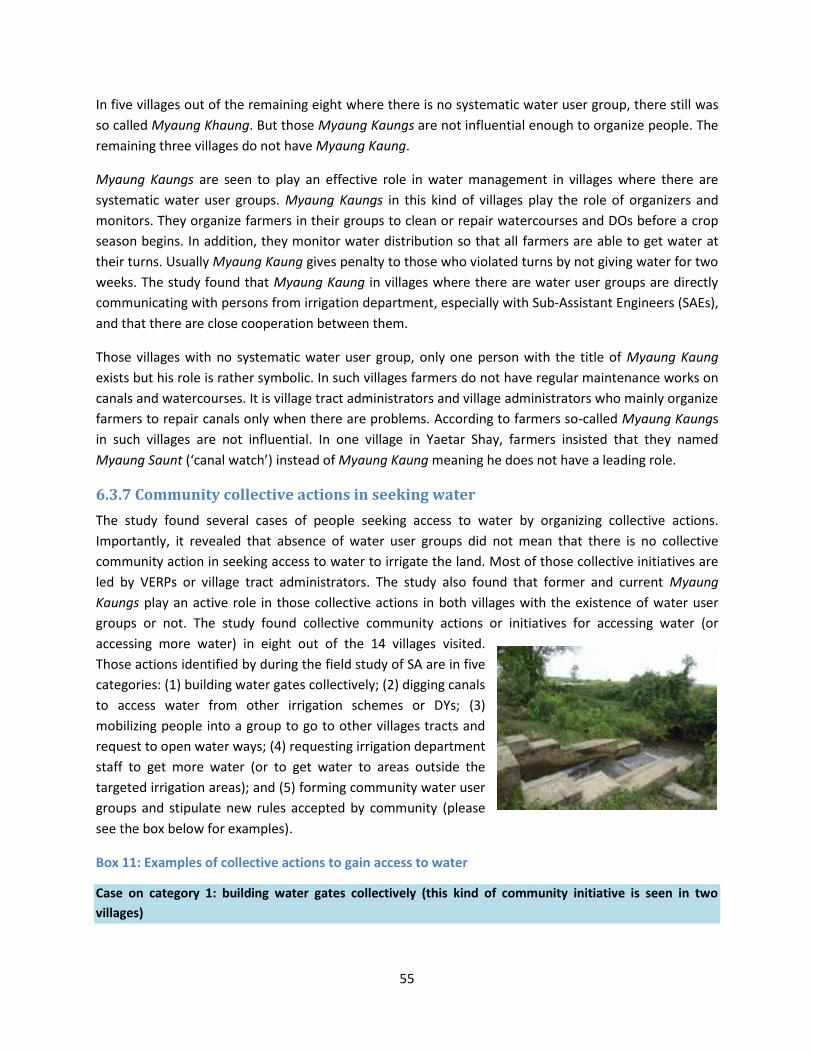
55
In five villages out of the remaining eight where there is no systematic water user group, there still was
so called Myaung Khaung. But those Myaung Kaungs are not influential enough to organize people. The
remaining three villages do not have Myaung Kaung.
Myaung Kaungs are seen to play an effective role in water management in villages where there are
systematic water user groups. Myaung Kaungs in this kind of villages play the role of organizers and
monitors. They organize farmers in their groups to clean or repair watercourses and DOs before a crop
season begins. In addition, they monitor water distribution so that all farmers are able to get water at
their turns. Usually Myaung Kaung gives penalty to those who violated turns by not giving water for two
weeks. The study found that Myaung Kaung in villages where there are water user groups are directly
communicating with persons from irrigation department, especially with Sub-Assistant Engineers (SAEs),
and that there are close cooperation between them.
Those villages with no systematic water user group, only one person with the title of Myaung Kaung
exists but his role is rather symbolic. In such villages farmers do not have regular maintenance works on
canals and watercourses. It is village tract administrators and village administrators who mainly organize
farmers to repair canals only when there are problems. According to farmers so-called Myaung Kaungs
in such villages are not influential. In one village in Yaetar Shay, farmers insisted that they named
Myaung Saunt (‘canal watch’) instead of Myaung Kaung meaning he does not have a leading role.
6.3.7 Community collective actions in seeking water
The study found several cases of people seeking access to water by organizing collective actions.
Importantly, it revealed that absence of water user groups did not mean that there is no collective
community action in seeking access to water to irrigate the land. Most of those collective initiatives are
led by VERPs or village tract administrators. The study also found that former and current Myaung
Kaungs play an active role in those collective actions in both villages with the existence of water user
groups or not. The study found collective community actions or initiatives for accessing water (or
accessing more water) in eight out of the 14 villages visited.
Those actions identified by during the field study of SA are in five
categories: (1) building water gates collectively; (2) digging canals
to access water from other irrigation schemes or DYs; (3)
mobilizing people into a group to go to other villages tracts and
request to open water ways; (4) requesting irrigation department
staff to get more water (or to get water to areas outside the
targeted irrigation areas); and (5) forming community water user
groups and stipulate new rules accepted by community (please
see the box below for examples).
Box 11: Examples of collective actions to gain access to water
Case on category 1: building water gates collectively (this kind of community initiative is seen in two
villages)

56
In one village in Yaetar Shay which accesses water from two minor canals of a DY, but one of them is not
functional. However, the water was seen flowing into a ‘spilled way’. A large farmer who is a former Myaung
Kaung whose farmlands are right next to the spilled way realized that water can be taken from there by
building a gate. He started building embankment on the spilled ways and built a gate/outlet. In order to
complete the whole process he also had to voluntarily give up one acre of his own farmland. A total of about
120 farmers having farms which could access to water from this scheme were also organized. This scheme
was gradually built over nearly 10 years. The scheme so far cost nearly 8 million Kyat and each farmer had to
pay over 60,000 Kyat. The scheme now provides water to 362 acres of farmland. Thanks to this community
initiation scheme, the yield increased three times higher than before (from 40 baskets to 100-120 basket per
acre).
Case on category 2: digging canals to access water from other irrigation schemes or DYs (in two villages)
The amount of water which Sin Thay Dam gives depends on the water available in the storage dam. A
number of villages especially those in the tail end cannot get enough water even for the monsoon paddy.
Kyar Thay Ei is one such village. Kyat Thay Ei accesses to water from the distributaries of Minor 8 of DY 1.
However, water cannot go to some sections of Minor 8 which are on upland. Therefore farmers in the village
have much difficulty to get water even for the monsoon paddy.
In 2009, one of the large farmers in that village who also was a Myaung Kaung for many years proposed to
the Agricultural Coordination Committee (ACC) to let them develop a canal directly accessing to the DY 1. The
ACC replied that if farmers could be organized they will provide machinery support. Then he organized 35
farmers, many of whom were unwilling as they had to give their land. But they contributed money in
anticipation of getting water. The scheme was successful and now 150 acres are irrigated. The canal is 8 feet
wide and 1 foot deep, and also includes roads for carts. It only cost around 300,000 Kyat - 200,000 Kyat was
for fuel for the machines from the irrigation department, and another 100,000 Kyat was for compensation for
a small farmer who had to give her land more than other people (0.05 acres). Accordingly 35 farmers
contributed 10,000 Kyat per household in cash.
Case on category 3: gathering people into a group to go to other village tracts and request to open water
ways (common in several villages in Yaetar Shay area)
This is a collective activity locally called “following the water”. Water level went down at the time of planting
season. Farmers were in trouble as they already had seedlings at nursery which would be wasted if they do
not receive water in time. They knew where the problem was as this was not an unusual one. Farmers in the
village tract located upstream farmers who were taking water arbitrarily and who did not let downstream
farmers take their turns. They already brought this issue to their own village tract administrator who could
not solve the problem through negotiation with his counterpart. As a result he called the SAE from the
township irrigation department and requested for help.
About 20 farmers including women carrying mattocks and chopping hoes had to march to the village
upstream the canal. The township ACC members also came to the village tract upstream. There the farmers
found as they had already expected that upstream farmers at were taking water when it was not their turn.
So downstream farmers had talks with upstream farmers with the support of ACC members. In addition,
farmers cleaned natural and manmade barriers along the canals which they observed when they marched
57
along the canal. Those clearances took around 20 days, by 20 farmers each day. The SAE and some other ACC
members came to the field every day and watched the canal cleaning process.
Case on category 5: forming community water user groups and stipulate new rules accepted by
community (this is a very rare case and reported only in one village)
In order to solve disputes related to irrigation water, the farmers formed a water user groups called “water
committee” under an initiative and dedicated supervision of a village elderly and respected person. They
worked out regulations that allow farmers from upstream and downstream take water for five days each.
Two persons from the water committee monitor rotation every day, and give penalty to those who violated
the rule by not giving a water turn for two weeks. It was reported by the farmers that the system works well.
6.3.8 Payment for water
It was reported that the water tax has not been collected for around three years since 2011. The water
tax when it was last collected generally was 1,950 Kyat per acre per season, but it varied between
monsoon paddy and summer paddy, or sesame and paddy. In Yaetar Shay, Tat Kone and Sint Kue it was
1,950 Kyat per acre for summer paddy and 950 Kyat for monsoon paddy. The lower amount for
monsoon paddy reflects less water requirements: monsoon paddy needs water at an early stage of
growth and sometimes before harvest. In Pale Township which is arid, however, it was 1,950 Kyat for
monsoon paddy because of higher water requirements. For other crops, such as sesame, which do not
need much water, 950 Kyat was levied.
The reason for not collecting water tax was differently cited by farmers and the irrigation department.
Farmers in fact did not know clearly why the tax was not collected. Some thought that it will be
collected in sum every two to three years. Some farmers from the area with limited water availability
believed that the irrigation department dared not collect as they were not able to give sufficient water.
On the other hand, irrigation department staff expressed people’s failures to pay. Many of them said
people challenge the power of authorities in the democratic era and fail to take their responsibility.
Box 12: Water taxes are not regularly collected
“First one or two people failed to pay and later other people followed as they apparently thought that it was
not a problem if they don’t pay. The water tax collection should be undertaken by the administration
department - township and village level administration should do that as people care more about
administration. In addition, the village administration should have the primary responsibility of tax collection
so the villagers cannot evade. The villagers avoid us when the collector from the irrigation department comes
to collect the tax. When the collector investigated a certain tax payer, for example U Chit, U Chit and the
collector personally met. But U Chit told the collector that U Chit is not at the village and traveling” (One SAE
from township irrigation department)
“The water tax is not collected this year. We have to pay 1,800-1,900 Kyat. I think the tax is collected every
three years. I think they are not coming as they cannot do anything (to give us enough water)”. (A large
farmer)

58
6.4 Access to extension services Availability of extension services varied across the villages studied. The study found that the best service
is available in villages of Tat Kone Township (southern Mandalay/NPT) where all three villages visited are
closely provided extension services by the Department of Agriculture (DOA). The rest reported that
agriculture extensionists visite some villages, especially village tracts and villages located by roads, and
that their focus is primarily on ‘policy crops’ (crops/varieties which are promoted by MOAI).
Services in Tat Kone - the best among the four regions
In Tat Kone farmers in all the villages visited reported that DOA provides close care and attention to
them. It was learned that every village has an agricultural outpost building where department in-charge
(department manager) comes frequently while seven to eight agricultural extension workers fisit fields
every day. Their priorities are to look after the fields of “Pale Thwe” and “Thukha” rice varieties.
However, they give advice whatever other aspects of agricultural work farmers wish to know. In addition
to such everyday services, the DOA gives agricultural training three times per season to both farmers
and the labourers (members of organized labourer groups - Thoke). In those trainings, the DOA staff
instructed the aforementioned ‘rope line’ transplanting method; characteristics of different varieties;
needs to replace seeds; fertilizer application; and how grow Pale Thwe and Thuka rice and so on. It was
learned from the farmers that Thukha rice variety project is meeting farmers’ needs: they said the
Thukha variety has good in market demand and farmers themselves like to eat it.
Farmers reported that the agriculture extension service not only gives advice on rice but also on green
gram. First they encouraged farmers to grow green gram in early monsoon season. In one village, one of
the large farmers who could be considered as a model farmer tested it first, and other farmers later
followed after seeing his success.
In addition, presence of extension workers at the village was reported to be helpful for farmers
especially at times of pest outbreaks as farmers can ask directly to the extension workers on suitable
methods of combatting a certain kind of pest. The labourers also apply the rope line method
systematically as they were instructed by the extensionists who also supervised the work.
Services in villages in Pale Township – the second best
In Pale Township extension services reach to all the three villages the SA team visited. But the service
provides more frequent and regular activities in two villages which have more Le-focused farming. It was
reported that the manager of agriculture department himself comes to the villages frequently and have
good relations with the villagers. In addition, agricultural trainings are given three times per crop season
in the same two villages, covering such subjects as rope line transplantation methods, how seeds
preparation, fertilizer application, suitable soil types for sesame and other crops, and methods of
planting sesame, weather forecasting as well as cultivation of Pale Thwe variety.
In Sint Kue and Yaetar Shay Townships, extension services only come to tract villages and villages
located right beside main roads

59
According to the interviewed farmers, extension workers in Yaetar Shay come only to the villages near
the main roads. It was also reported that the service only focuses on the Pale Thwe variety promotion
project. One or two large farmers offered a part of their farmland to grow Pale Thwe in response to the
strong request of agricultural departments.
The insufficient number of extension staff in township agriculture department was cited as one of the
reasons why frequent field visits cannot be organized. The following remark from a township agricultural
department highlights the problem: “there are 13 village tracts in the township and five to six villages in
each village tract. One extension worker is assigned to 25 villages. How s/he can go to every village. In
addition, they (extensionists) also have to give attention to the Pale Thwe project which is implemented
in villages right beside the main road. So, there is no time to go to other villages. In addition, the fuel
costs to go to field largely have to be borne by staff themselves.”
Some farmers in Sint Kue Township had heard about the extension service’s visit to the village tract
giving training mainly on Pale Thwe. In one village with poor water availability farmers said they had
never heard about extension services.
6.4.1 Attendance in agricultural training
Farmers’ attendance to agricultural training seemed to vary in all farming systems, suggesting that
interests are not related to certain farming systems. Generally speaking more male farmers attend such
training than female ones with an exception in Tat Kone, which has the strongest extension services,
where women’s attendance is higher than men’s because labourers who are mostly women also
participate in the training. According to one staff from the agriculture department in Tat Kone, they try
to make such village extension meetings more attractive by associating the occasions with agricultural
credit in order to promote higher participation.
6.5 Land
6.5.1 Land tenure
Land use certificate (LUC) issued to farmers as one of the
subsequent actions of the 2012 Farmland Law is literally termed as
“Land Use/Utilization Entitlement”. It mentions that the state is the
owner of the land. The document mentions the region, township,
the name of the farmer entitled to a certain farm plot, the number
of the field where a plot of a certain farmer exist (‘Kwin’ number30)
where the land is located, and the number of the plot (‘U Paing’
number). The land type - Le or Ya – is described on the certificate. A
map of the field and the plot location are also included.
30
The SLRD have developed a system of recording the each possession of farmlands through field number and plot numbers. The field number (“Kwin” Number) is number of the larger farm field which is composed of different sizes of farm plots hold by each farmer. The plot number (“U Paing” number is the number of a certain plot hold by each farmer).

60
According to the farmers and village administrators in most villages, township SLRD personnel did not
come to field to measure the plots before they prepared the certificates. This was reported to be mainly
because of the insufficient human resources in the land record department.
Box 12: Human resources constraints to issuing LUCs
“We cannot go to the field and measure the farmland in reality because of the insufficient people in our
department. If we have to do so, the process of land entitlement will last for years.” (One township SLRD)
“The process has been delayed because of the limited human resources; it is only one district in-charge (at
District SLRD) to scan and sign those thousands of applications.” (One village tract administrator)
People perceptions on land tenure security People have some general ideas about the new Farmland Law, especially in relation to its provisions on
transactions and transferable rights. But some said they still feel insecure about their land. People
largely appreciate transferability of the right, and some mentioned its usefulness as collateral in
acquiring credit. The study found in a few villages in Sint Kue and Pale Townships that people use copies
of LUC to pawn their land. Still people mentioned words of doubt on security of their land as the
ultimate owner of the land is the state. On farmer said, “we only had the land tax payment receipts
before. Now it said we own the land. But it is only the government which can determine, and we are
only subject to whatever they do.”
Many people especially women have little knowledge about the benefits of the new land law
The study found that farmers had little knowledge about land law. It was found that some farmers did
not even know what was written on the certificate. A small female farmer in Yaetar Shay remarked, “I
have never read the paper and do not know clearly what it says. I did not read it because I think there is
nothing new and it is ultimately the government which will do as it likes and we have to accept”.
6.5.2 Issues on land
The study found main land issues in two forms. The first form relates to land disputes. Land disputes
were reported in five villages. Land disputes are in three broad types: those related to land confiscations
under the military regime in the 1990s; (2) disputes among siblings and relatives; and (3) those involving
disputes over land boundaries among farmers. The first type was found in three villages, the second in
two villages, while the last one was commonly reported in all the villages studied. In one village,
disputes related to the past land confiscation was said to pose a delay in the process of LUC issuance. In
addition an issue related to reclassification of the land type (from Ya to Le or vise versa) was reported.
The SA also found possible issues related to farmland acquisitions for dam construction whereby proper
compensation was not reportedly made.
61
6.5.3 Examples of land disputes originating from the military regime
Three cases of land disputes were reported in villages in Yaetar Shay and Sint Kue as described in the
box below31.
Box 13: Some disputes from the past regime remain unresolved
Case 1: Farmers in two villages started farming on the forest lands in the 1950s: first informally and later by
paying tax (they have tax receipts). In 1986 the forest land was transferred to Industry No 1 (under the
Ministry of Industry) which developed a sugar factory. The farmers working on the 1,286 acres of farmlands
were removed from those lands in early 1990s. However, there still were extra lands after building the
sugarcane factory. Farmers were given 2 acres of plots from the extra land, while the rest was taken by the
army, township administration, the intelligent department and agriculture department. Those government
bodies leased the land to farmers, especially to large farmers. After the state declared return of the farmland,
land disputes occurred among three parties: government departments, the large farmers who rented the
lands from the government and the former farmers. The disputed area covers 500 acres of land belonging to
14 villages of four village tracts. Around 20 farmers of the villages studied are involved in the case. (Source:
a member of village development support committee)
Case 2: Another case was reported in two villages of Yaetar Shay in relation to the farmland taken in the
1990s for the development of new villages, mainly for army families32. The confiscated lands are utilized as
residential areas for army families and the rest are rented out for farming by the army. No land disputes
have occurred upon those lands. (Source: a member of village development support committee)
Case 3: A village in Sint Kue reported confiscation of 900 acres of land by the previous government for a
biodiesel plantation project (Kyet Su) which was followed by a cotton project. Later the lands were taken by
the army and rented out to farmers through auction. When land was returned recently, disputes emerged
between the former land users and those who rented the land through the auction. There are 15 farmers
from the village involved in the disputes. It was learned that 30 out of the total disputed area of 900 acres are
in the irrigated area. (Source: a member of land management committee)
How these issues are being addressed
For Case 1 in the above box, the three parties filed complaints to Central Land Management Committee.
But the issue is in a deadlock and no party is able to utilize the land. No reclamation case was filed for
Case 2 and, according to respondent, people are not willing to make any formal complaints. The two
parties of disputes of Case 3 filed a complaint to the Land Management Committee. Currently, the land
management committee at the township level is investigating the case whereas the village level land
management committee plays a role in gathering evidences by investigating the two sides.
The study team also learned about reported land disputes in relation to the studied irrigation schemes
31
The information is based on what the SA team collected through field interviews. The team was not able to objectively verify these stories. 32
The data is not available on how much acres of land were taken.

62
For the North Yama Scheme (Sagaing), no land acquisition nor physical population displacement took
place when the main dam was built. But six villages were relocated when an associated regulating dam
was built. The entire village population was relocated in three of the six villages removed. The
Government relocated all displaced people in one newly built village called Aye Chan Thar village, and
the irrigation department helped the construction of new village and relocation of the displaced people.
The village has roads and electricity; however, it was reported that the government did not provide
alternative agricultural land fully.
In regard to Male Nattaung Scheme (Mandalay), residents of two villages were physically displaced
when the main dam was built. The affected villagers were resettled in the areas beside the main dam
with the assistance from the irrigation department. Very small agricultural lands were acquired during
the construction and the land users have not been compensated. But people are tacitly allowed to grow
crops in the drawdown areas and fish in the dam which supplements their income. According to a
member of village tract land management committee, the government arranged resettlement of the
two villages by acquiring agricultural land of other farmers in the same township. Displaced families
were given money for the movement and provided with transportation. No other compensation was
given.
When the dam of Sin Thay Scheme (south Mandalay/NPT) was built, residents of nine villages were
physically displaced. Both agricultural and residential lands were acquired. About 700 households
reportedly moved to a newly developed village called Aye Chan Thar village33, while about 800 other
households chose to remain in their original villages since there still was sufficient residential and
agricultural land. They are allowed to farm on drawdown areas and fish in the reservoir. All displaced
households who moved to the resettlement village including the landless were reportedly provided
alternative residential and agricultural land. The landless and small holders received 0.5 acre and those
with large holdings received 2 acres. It is not clear if the alternative land provided was sufficient enough
to fully restore the livelihood of displaced people.
Seven villages were displaced when the main dam of Swa Chaung Scheme (Bago East) was build and
some agricultural lands were acquired as well. Displaced people were provided with a residential space
not very far from the reservoir and cash to cover the cost of the physical movement to the new
residential space, but were not given alternative agricultural land or costs to build houses. Many of them
reportedly are still without agricultural land or secure means of livelihood. Those affected people with
sufficient residential and agricultural land remain in their original villages and reportedly gain additional
income from employment at the hydro station, farming in drawdown areas and fishing in the reservoir.
As mentioned above, many people were displaced without proper compensation when the four studied
irrigation schemes and the dams that supply water to them were built about 10 – 15 years ago34, and
that livelihood remains to be fully recovered for many of them. Of particular concern is that, many
displaced people, including those who were displaced when Swa Chaung dam was built, reportedly do
33
The name of the newly developed village for those who displaced for Sin Thay Dam construction and that for North Yama is the same despite that it is not sure about the reason. 34
See Tables 13 for details on these dams.

63
not still have agricultural land of an adequate size and quality, or other secure sources of livelihood, and
their livelihood seems vulnerable. The study team did not come across active complaints from the
displaced people on the past land acquisition.
6.5.5 Reclassification of farmland type from Ya to Le and vice versa
The study found that farmlands in villages in Sint Kue and Pale Townships currently growing Le paddy
with irrigation. But some of those lands are still recorded as Ya land. People are now trying to change
that in order to get more loans from MADB which gives 100,000 Kyat per acre for Le land while it is only
30,000 kyat for Ya land. This reclassification is also one of the reasons why land certification processes
are taking time (in such cases the township SLRD has to measure the land). It was also reported that
farmers have to pay 5,000 kyat to township SLRD to come and measure the land.
On the other hand, farmers in two villages said they want to reclassify their lands from Le to Ya, as their
Le lands cannot grow paddy because no irrigation water is available. They currently grow other crops
such as sugarcane, sesame and beans with a tacit agreement with the government. Another village also
faces a similar case although that they did not mention reclassification of land into Ya as such.
Box 14: Farmers wish mismatches between land type on record and actual use to be reconciled
Case 1: In one village in Tat Kone Township, 400 acres are under the designed command area but only 200
acres benefit from irrigation. Therefore farmers want 200 acres to be reclassified as Ya land to grow several
multiple crops freely with the tube water.
Case 2: In another village in Tat Kone Township, 630 acres are in the irrigated area but 120 acres do not get
water. Farmers as a result grow such crops as green gram, cotton and other vegetables with a tacit
agreement of government authorities.
Case 3: In one village in Sint Kue Township, 69 acres of land are in the design command area but only 20
acres in fact can receive irrigation water. Those lands are classified as Le land on the land record as they are
in the irrigated areas despite that water is not available in reality. So, most of the farmers in the area are
growing sugarcane as their main income crop. But farmers are supposed to grow paddy since they are
included in the irrigated area. So, farmers in times applying land use certificate they want those land
classified as “Ya” land as they want to grow sugarcane freely.
6.5.6 Land sold to outsiders
Several cases of recent land sale were reported in villages located at the roadside near Nay Pyi Taw and
Mandalay. Land is priced at 10,000,000 to 20,000,000 Kyat per acre in the villages located right beside
the main road near NPT and Mandalay, and the SA team heard that business people are purchasing land
in those areas. The price of farmlands near NPT has increased because of the development of the inter-
regional highway road, and expansion of urban areas.
Given the better accessibility, the business people become interested in investments in the mentioned
areas. According to people in villages studied in Tat Kone (near NPT), some business people were said to

64
be interested in commercial, organized farming. It was also reported that the government is interested
in expanding integrated farming, facilitates changes in land titles and provides mechanical and technical
support. Three cases of this nature were reported in Tat Kone. Business people purchased 50 to 100
acres of land for the above-mentioned purpose. In Mandalay, on the other hand, business people who
purchased road side farmlands mostly developed private gas stations. There was one reported case of a
foreign investor who purchased over 100 acres of land and developed modernized farmland where
water melons and rice are grown.
Businesses interest in land seems higher than what local people are willing to sell. Only three cases of
land purchase by outsiders were heard during the SA study. This is because farmers also do not want to
sell their land although the prices increased many times than several years ago. They said they want to
wait and see if will increase even more. One interesting piece of local information, however, is that
more Ya land and non-irrigated Le land located on the NPT-Mandalay and Mandalay was sold than
irrigate land.
6.5.7 Land improvements schemes
The SA team assessed three completed land improvement schemes: a scheme in Yae Aye Village in Tat
Kone Township (Nay Pyi Taw), a scheme in Ah Lyin Lo village, and another scheme implemented with
the funding of JICA located near Ah Lyin Lo village in Zabu Thiri Township (in Nay Pyi Taw). People who
participated in these schemes as well as the personals from irrigation and agriculture departments who
oversaw and implemented them were consulted. In addition, the SA teams met with some villagers who
participated in other land improvement schemes including one in Khayansat Kone village in Tat Kone
Township and another which is locally called ‘288 Field’ near Ah Lyin Lo village. The scheme in Yae Aye
Village is in the command area of Sin Thay scheme, and the other one in Ah Lyin Lo and JICA-supported
one 35 are in the Nga Lite Dam irrigated area. The one Ah Lyin village was implemented in 1993 and the
rest of the schemes studied were implemented very recently between late 2013 and 2014. All schemes
recently implemented by government are similar in methods for organizing the community,
implementation techniques and qualities, but the scheme in Ah Lyin Lo and the JICA funded one are
different. One thing that is common is that farmlands owned by farmers from more than one village are
involved in each scheme.
Ways of organizing the community All land improvement schemes recently conducted by the government used similar method in organizing
the community. People were organized by township level personnel from the departments of irrigation,
farm mechanization and land record department, as well as township administrative departments. They
came to the village and talked about the scheme especially its advantages and how lands need to be
given up and redistributed. Such meetings were usually conducted twice in each village and people had
to give their signatures at the second meeting if they agreed. They had to sign and give names on a piece
of paper titled the “list of farmers agreed to the land improvement schemes”. According to farmers,
35
The so-called JICA land improvement scheme is located near Ah Lyin Lo village. The JICA scheme was built with the funding and macro management (that this organizing and negotiations with the beneficiaries) by JICA

65
specifications on the scheme implementation were not described on the paper. But in one agreement in
‘288 Field’ scheme, there is one clause describing that farmers agreed to give their land at a negotiated
specified rate if some part of their farmlands existed on others’ at the time lands were redistributed. For
example, if a small size of someone’s land, say 0.4 acres, was to be included in another’s in order to
systematically structure the plots, then the former has to sell that part of land at a price predetermined
before the scheme started. In JICA scheme, the price was predetermined at 3,000,000 Kyat per acre.
Ah Lyin and JICA-funded schemes used different approaches. Ah Lyin scheme started in 1993 and was
implemented without taking any agreement with villagers. On the other hand, the scheme implemented
with the funding of JICA applied different methods of organizing the community. The persons from JICA
themselves came to the village and organized the villagers. They first met the formal and informal
leaders in each village (village elderly and respected persons, members of land management committee
and development support committee) where land improvement schemes were to be implemented.
After organizing several meetings with village leaders, they met general village populations and acquired
their opinions and consensus. At the meeting villagers requested to implement the scheme in good
quality, especially for land levelling and building of watercourses strongly. The farmers agreed to skip
one farming season in order to better level the land and water courses.
Implementation and land redistribution All schemes developed one acre plots except for the scheme in Ah Lyin Lo and the other one in Yae Aye.
Ah Lyin Lo one has 0.5 acre plots and the other one is somewhat smaller than one acre (43,200 square
feet36). The schemes generally involve land levelling, development of water courses to feed water to all
plots equally, and construction of products roads. In order to build those infrastructures, farmers would
exchange plots which may well result in some farmers losing more land areas than others. Farmers
normally accept a small loss of farmland if it results in the improvement in productivity and income.
Technically, farmers do not contribute cash for land improvement schemes.
Advantages of land improvements
Advantages of the land improvement schemes were stated mainly by farmers in Ah Lyin Lo village.
Farmers are satisfied with the scheme because of higher production efficiency. According to farmers in
Ah Lyin Lo, regular-shaped large (0.5 acre) plots make them easy to hire labourers and to use machines.
Product roads also make it convenient to sell their products. The SA team observed that a buyer’s truck
came and collected the product right beside the farms. Farmers in the other village remarked that the
purpose of the schemes is really good if ‘there is no complication in reality’.
Realities and constraints of land improvement scheme
The common limitations of such schemes by the government are poor quality of civil work, especially
land leveling and building of product roads, earthen fences and water courses. According to farmers,
land was not level enough to grow crops, so they had to hire labourers and lease machines from
36
43,560 sqft is equivalent to one acre.

66
government. The product roads are not strong enough to bear the water coming down from the hill
during raining season. Similarly canals are not always strong enough when water flows.
One common challenging point for all the schemes is redistribution of the land after implementation. In
all schemes, participating farmers reported that significant negotiations were required at the time of
redistribution. The SA found two forms of management on land swap and give up: one is through
negotiation; the other involves monetary transactions (purchases). The price is predetermined before
the implementation started through negotiation among farmers. Sometimes village and township
authorities were involved in negations. It was reported in two schemes there were problems of land
redistribution in which some farmers disagreed to the size of redistributed land. They claimed that the
original size ws larger than the redistributed one although they had agreed to the size of the land they
had to give up for building product roads and canals. The SA found it difficult to resolve this kind of
problem because the SLRD did not make precise measurement of land during land registration process.
Another challenge relates to negotiations with people practicing different types of farming. For example
in the scheme called “288 Field”, there were flower growers, who did not want to participate in the
scheme. Finally, it was decided not to include them in the scheme and the problem was settled. But it
seems not always easy to settle such problems in this way. This time the problem was solved by letting
flower growers to quit from the scheme, which was only possible because their plots were located at
the edge of other people’s land.
SA found one of the schemes visited is incomplete and revealed that incomplete schemes can render
people’s distrust on the scheme as a whole, as well as potential problems related to land redistribution.
It was learned from staff of the irrigation department that the land improvement scheme in Yae Aye
village was only half completed because of insufficient budget. The implementer gave plots to the
farmers who occupied the completed part of the scheme.
Farmers in Yae Aye village reported that there are problems in redistribution of farmlands and with
quality of the schemes. Land improvement schemes are based on calculations of aggregate
measurement of all lands included in the schemes. Therefore land redistribution has to be made only
when the whole scheme is completed, so that deduction of lands for product roads and canals, and
subsequent negotiations and agreement could be done feasibly. However, plots from the completed
part of the scheme were returned, but some farmers did not accept reallocated plots insisting that the
size should be larger than the one returned even if deduction was proportionate. Finally as they
demanded more lands, implementers gave additional lands in order to settle the problem quickly. But
other farmers whose farmlands are on the incomplete part reported that they have concerns on
redistribution of farmland if other farmers from completed part did not accept redistributed farmland
and demand more.
In addition to the above-mentioned problems, villagers in Yae Aye village reported that the quality of
the scheme was not good enough for growing crops. They thought that this happened because the
scheme has not yet completed. The product roads and the canals systems especially are not strong
enough, they said.

67
Another concern expressed by villagers its linkage with the cultivation of Pale Thwe variety which is the
high yield paddy promoted by agricultural minister. People reported that Pale Thwe despite its high yield
has limited market demand, and its taste is not preferred by farmers. Farmers who have experiences
growing Pale Thwe in Yaetar Shay and Tat Kone reported that they have to search buyers for Pale Thwe
as the buyers were more interested in other types of paddy with good market demands. Some farmers
said they are worried that they have to grow Pale Thwe if land improvement schemes are implemented
at their villages.
6.6 Indebtedness Indebtedness of farmers increased since they started growing summer paddy (or paddy) after irrigation
development. However, farmers with good water availability are able to repay. On the other hand,
those in villages with poor water availability face difficulties to repay and were found to use such coping
mechanisms as migration and land sale. When indebtedness amounts of different types of farmers were
examined, it was found that the amount of large farmers in Tat Kone and and Sint Kue, the two areas of
less abundant water – was higher. It is believed to be caused by higher cost of pumping water.
Table 28: Average debt amounts of different farmers (Kyat)
Township Average debt of large
farmers Average debt of medium farmers
Average debt of small farmers
Yaetar Shay 760,000 600,000 430,000 Tat Kone 1,500,000 500,000 700,000 Sint Kue 1,100,000 560,000 360,000 Pale 700,000 660,000 360,000
Source: SA ADSP
The table below shows the debt amounts of farmers in villages by the condition of water availability. The
farmers in villages where water availability is not good (fair or bad) have much higher level of
indebtedness than those in good water conditions.
Table 29: Indebtedness amount of villages by water availability (Kyat)
Situation of water availability
Average debt of large farmers
Average debt of medium farmers
Average debt of small farmers
Good 460,000 400,000 250,000 Not Good 1,280,000 720,000 540,000
Source: SA ADSP
Landless labourers are never free from debt
Landless labourers reported that they have never been free from debt despite that they have less credit
sources. They are mainly indebted in kind to farmers, grocery shops and their group head. Their average
debt amount is between 10,000 to 50,000 Kyat. They in fact appeared to be in the debt cycle even
though they can largely repay with their labour.

68
6.7 Migration Migration is increasing in almost all villages regardless of situations of access to water. However, the
nature of migration seemed different between villages with good and bad water availability. The study
found that people in villages with good water availability tend to migrate for capital and skill intensive
works while those in bad water availability go for labor intensive works.
The first type of migration is seen in four villages with good water availability in Yaetar Shay, Tat Kone
and Sint Kue. People in Yaetar Shay and Tat Kone of this type go abroad to such countries as Thailand,
Malaysia and Korea while those in Sint Kue (Mandalay) migrate for works such as gold mining and illegal
logging in other states of Myanmar or within the region. Some of them in those areas also go for such
skilled works as masonry and carpentry in major cities like Yangon, Mandalay and Nay Pyi Taw.
The second type of migration cases was seen in four villages of bad water availability in Tat Kone, Yaetar
Shay and Pale Townships. People in those villages migrate for such kind of labour intensive works as in
construction sites and gem mines, and at restaurants in Shan, Kachin, and big cities like Yangon and
Mandalay. In this case, more men migrate than women and they go for a long period of time and thus
rendering negative social impacts on their families. Researchers have seen several cases of women
headed households inflicted by this phenomenon: eg. husband migrates for a long term and far away
from home, and enters a next marriage, leaving wife and children at his home village.
However in one village it was women who mostly migrate outside the region for seasonal farm work. It
happens during planting and harvesting seasons, each for two to three months.
In the meantime the study found very low level of migration in four villages: two of them are villages of
bad water availability and the remaining two are good in water availability. In one village of Ngwe
Taung job opportunities at stone mines in the neighboring area favor labourers and small farmers who
therefore do not need to migrate to areas further away. Few people migrate in another village with poor
water availability because their village is having multiple crops depending on pumping underground
water. People in another two villages in Pale rarely migrate as required farm works are sufficient enough
for the labourers in those villages.
6.8 Vulnerability
6.8.1 The vulnerable groups according to the community
The most vulnerable groups identified by the community first and foremost are the following three
types:
1. Landless labourers who themselves are not able to work as they are sick or looking after sick
spouse or bed-ridden old parents
2. Landless labourers with few people in the family to earn money but many dependents,
especially several children
3. Small farmers and medium farmers who only have to rely on Ya land with less than 5 acres
(especially in Sint Kue and Pale Townships)
69
The study found that the above mentioned families are worse off if headed by women. The community
members mentioned that those families cannot make meet ends and frequently skip meals. There are
two – three households in each village the SA team visited which fall under any of the three categories.
One important finding was that vulnerable women heads of family who separated from their husbands
were found in villages with bad water availability where people (both men and women) migrate. Men
migrate further in the country for longer-term works and often settle with a new partner, leaving behind
their wives in the native villages.
In Sint Kue and Pale, a significant number of farmers rely on Ya land only. The study found that those
farmers, particularly small farmers, are vulnerable to climatic irregularities since six to seven years ago.
They frequently experience crop losses especially because of late and insufficient rain. Small farmers
unlike large farmers do not have much land or investment by which they can grow multiple crops to
spread risks.
6.8.2 Other vulnerable groups identified by the study
The communities of the SA visited villages mentioned other vulnerable groups apart from the above-
mentioned ones. From the discussions and SA researchers’ own analysis and reflections, the following
two groups are also considered vulnerable:
3. Small farmers especially women headed ones with less than 4 acres of land in villages with
poor water availability
4. Small farmers who also sharecrop in villages with poor water availability
These groups experience high risks and less earning from growing paddy. They prepare seedlings at the
beginning of each monsoon season in anticipation of supplementary water from irrigation. But quite
often they do not receive it, meaning that seeds and labour are all wasted. Large farmers with capacity
to invest can pump water until irrigation water becomes available. Families with small landholdings
headed by women are more vulnerable because they have less employment opportunities outside the
farm work than males when their crop fails. In addition it is difficult for women to migrate as they have
to look after their children. Therefore women have to depend on works available within their own
village which pay less than farm works. Women have less ability to seek access to water compared to
men who can watch and secure their turns while women often cannot. As a result their plots are subject
to less water availability.
The rehabilitation of canals will enhance water availability and significantly reduce the vulnerability of
the second group of categories (No 3 and 4) mentioned above. Small farmers with surplus labour will
make more sharecropping with larger farming households who do not have sufficient labor. In this way,
smaller farmers can earn more. If water will be equally available, it is unlikely that women-headed holds
do not receive water at their rotational turns.
Irrigation rehabilitation will also reduce the vulnerability of the landless by creating more on-farm
employment opportunities for them. Although those with only Ya land may not directly benefit from
improved water accessibility as a result of irrigation rehabilitation, their access to improved extension

70
services can result in higher farm productivity and of better income earning activities. It is
recommended that the project incorporate a social inclusion framework to reduce social and economic
vulnerability of all the vulnerable groups.
6.9 Gender
6.9.1 Women-headed households
The average number of women-headed households (WHHs) per village was 16 and it constitutes 7% of
total household of the 12 villages that SA team visited37. The most vulnerable women headed
households constitute 5% of the total household and 67% of total women headed households as they
are small and landless families. When the numbers of WHHs were compared by township, it was found
that villages in Sint Kue (Mandalay) and (Yaetar Shay) had higher numbers, compared to the other two
regions. Villages where capital and skill intensive migrations are higher have higher incidences of WHHs.
The table below shows numbers of women headed households according to agricultural landholding
size.
Table 30: Women-headed households by landholding size
Township Avg. number of large farmer
WHHs
Avg. number of medium farmer
WHHs
Avg. number of small farmer
WHHs
Avg. number of landless WHHs
Yaetar Shay 2 4 2 11 Tat Kone 4 7 7 Sint Kue 13 6 3 14 Pale 3 5 3 6 Total Average 4 5 4 9
Source: SA ADSP
6.9.2 Gender in farm activities
Gender-based division of labour in farm work has become less important in all areas and particularly in Yaetar Shay because of the labour shortages. The study found that women have to take new and different roles in farming because of labour shortage and migration of men. It was also found that women receive the same wages as males for the same type of work. The nature of the gender division of labour in farm work differed between upcountry and lower country. Note Yaetar Shay (Bago East) and Tat Kone (southern Mandalay/NPT) are in the lower country, while the other two – Sint Kue (northern Mandalay) and Pale (southern Sagaing) – are in the upper part. The following table show gender role in farming activities by different regions.
Table 31: Gender-based roles in farm work
Gender division of labour
Activity Lower (Yaetar Shay and Tat Kone)
Upper (Sint Kue and Pale)
Remarks
Plowing Male and female Male In Yaetar Shay and Tat Kone this
37
Data on women headed households is available only for 12 villages.

71
work was previously conducted by males only
Broadcasting seeds/pulling-off nurtured plants
Male Male and female Pulling-off natured plants in fact needs masculine strength
Transplanting Male and female Male and female
Weeding Herbicide is used Females
In Yaetar Shay and Tat Kone, people use herbicides instead of human labour. It is men who especially do herbicides.
Fertilizer application
Male Male
Farmers say males do a better job applying fertilizers as they can spread farther and know better in measurement
Pesticide application
Male Male
Most of the people do not like the work because of the bad smell. This kind of work is considered more suitable for men because of the need to carry a heavy container
Clearing/repairing watercourses and embankment
Male Male
Harvesting Male and female Male and female Carrying the products
Male, female, children
Before only males were doing this kind of work
Source: SA ADSP
6.9.3 Women and inclusion
Generally speaking women were not found in key institutions or involved in decision making roles of the
community. The study did not find women in such key village institutions as village administration,
village development support committee and village land management committee. A few women were
seen as members of water user groups but leaders were all men. Leaders of the labour groups “Thoke”
were usually women.
The SA team learned that women participate in village mass meetings on behalf of their husbands.
However, it was learned quite often that they do not fully understand the main subjects of the
meetings. Women said they had to go to such meetings on behalf of their husbands even they did not
understand the topic. In one instance, women who attended the meeting on land improvements
seemed to give their signatures of agreement without knowing clearly about what it meant. A woman
from small holding household in Yaetar Shay told the SA team, “yes, I signed as other people also did.
When I returned home my husband asked me why I signed and I told him that I just followed the others.
My husband blamed me strongly for signing without understanding. He was also worried that our land
will be lost under the scheme.” Such examples seem to indicate that physical presence/participation of
women in meetings and their agreement may not be necessarily based on their informed decisions.

72
6.10 Institutions
6.10.1 Village level institutions
There are generally six types of village level institutions in each village: village administration, village
elderly and respected persons (VERPs), socio-religious, fire brigade, red cross and maternal and child
welfare associations. In addition to those, there are village development supports committees, Land
management committees, water user groups, loans and credit committee, committee formed by aid
provider exist in differently among the villages studied. Village development support committees and
land management committees usually exist at the tract village level. Those two organizations exist in
nine tract villages visited. The following table shows in more detail existence of the village level
institutions.
Table 32: Types of institutions at village level
Particular Number of
villages Remarks
1. Village administration 2. VERPs 3. Socio-religious 4. Fire-brigade 5. Red cross 6. Maternal and child welfare
14 These six organizations exists in all the 14 villages studied
Village development support committee
9 Only at tract village level
Village land management committee
9 Only at tract village level
Water user groups (Myaung Kaung group)
7 3 in Tat Kone, another 3 in Sint Kue and one in Pale
Single purpose groups (electricity or road committee or school committee
2 One in Sint Kue and another in Pale
Loans and credit 5 Cooperative credit 5 villages, Pact Myanmar in one village in Sint Kue
Source: SA ADSP
6.10.2 Analysis of the roles and functions of key village institutions
Village administration
The study found that generally speaking this is the most active and functional institution. In tract
villages, the village administration is headed by tract administrator while it is the 100-household leader38
38
10- Household leader the lowest political administrative unit in Myanmar. Households of each ward or villages are divided by ten households (the houses located in a close proximity as there no specifications on how each ten households are to be organized as ten household units. Regarding with the number of households per village or ward, it is varies from a few ten digits to over 500 households). 100 household leaders tends to be chosen by village tract administrator or village elderly and respected persons as they see necessary. However, according to

73
who heads the village administration in other villages. The village administration comprises village tract
administrator or 100-household leaders, a clerk and 10-household leaders.
The village administration is usually the only organization at the village level with key decision making
and organizational power. Still this power is reinforced by VERPs in most cases and in a few cases by
Buddhist monks. Being entrusted authorities from the state and reinforced with the support of VERPs
and monks, the village administration in all villages visited were regarded as the most powerful
institution in the community.
It is the village administrator who mainly communicates with township level state institutions. In many
villages except those where water user groups are systematically formed, it is the village administrator
who primarily deals with personnel from the irrigation department in an effort to get more water for
their village, as well as handles disputes on water.
Village Elderly and Respected Persons
This informal and traditional institution continues to remain influential. It is the VERPs who reinforce
the authority and power of the village administrator in organizing community members. Given that
VERPs are informal and traditional in nature, it is influential and active due to members’ personality and
capacity rather than as an institution. VERPs tend to be those who have large farm holding, wealth and
other assets. In most cases the members used to be formal village authorities or working for state
related institutions, such as cooperatives and irrigation department. In all villages, VERPs are also
members of village development support committee or land management committee (often the chair).
They are also involved in settling conflicts. More importantly, VERPs play the leading role for collective
actions not only limited to irrigation water but also on village development projects, such as electricity,
roads and school facilities.
Socio-religious groups (Tharyae Naryae)
This is the group where VERPs and youths work together for social and religious causes. This is a
traditional and informal but active institution found in all the villages studied. The group takes
responsibility for important social events, such as weddings and funerals, and religious occasions such as
donation ceremonies (Ah Lhu) and prayer ceremonies. This institution can be regarded as the social wing
of key players (VERPs) of the village. Youth members in this group tend to become core leaders of the
village later.
Village Development Support Committee
This committee was formed recently with the government instructions. In fact this is the village tract
level institution formed with five members. Usually, one of the VERPs of the tract village serves as
chairperson, and the secretary and other members are from the villages in the village tract. They are
the 2012 Village Tract and Ward Administrative Laws, the role of 100 Household leaders is not stipulated despite that it has role before this law.

74
selected at the village level by village tract administrators, VERPs and 10-household leaders. The
selection at the tract level needs to be endorsed by the township administration.
The study found that the village development support committees in most village tracts were not
functional. In only two out of the nine village tracts visited the committee was found active. In one
village, it was thanks to active youth members, its village development support committee was mainly
working, while it was VERPs in another village, under which the committee was functioning for village
development schemes such as electricity, roads and schools. In the remaining villages, only VERPs and
village administrators decide and undertake village core functions. It was revealed in several villages that
members on the development support committee did not know each other and its functionality was in
doubt. The researchers heard some remarks of villagers which indicated that this committee can be just
a nominal entity in certain locations. A 70-year old former village leader said, for example, “the village
development support committee was formed with the endorsement of the township authorities. The
VERPs on the committee are even listed at the township level. Two VERPs from this village (tract village)
are included. Whatever organizations are formed it is always the VERPs who mainly decide on any
matters in which financial expenses are included”. In one village secretary of the committee said he
didn’t know who were sitting in the committee.
Chairperson of development support committee tends to be a VERP or a person from the village tract.
Some villagers thought the state funding for community development (the 100 million Kyat) went only
to the tract village because chairmanship exists in tract village.
Land Management Committee
The land management committee is also a village tract level institution and comprises five members.
Unlike the village development support committee the village tract administrator takes the chairperson
position. Other members are one administrative clerk, staff from Township Land Record Department,
one of the VERPs and one farmer. The VERP and farmer members are selected by other VERPs and 10-
household leaders as well as by village tract administrator. Similar to the development support
committee, the land management committee was found mostly inactive except in two cases – one in Tat
Kone and another Sint Kue. In one village in Tat Kone it was reported that a land dispute between in-
laws was solved by the tract land management committee. The land management committee plays a
role of gathering evidence in case decisions are to be taken at a higher level, for example, at the
township-level committee (see Case 2 in Box below).
Box 15: Examples of work by land management committee
Case 1: How village tract level land management committee successfully solved a land dispute
A dispute happen between a widow aged 25 and her in-laws when the widow was about to sell the land
inherited from her husband’s parents. She had to sell the land to repay debts owed for the medical expenses
of her husband. At this point, her husband’s family reclaimed their rights to the lands and filed a complaint at
the land management committee of the village tract. The land management committee in fact took the role
of negotiator rather than making judgment. Finally, the widow was given the home and compound on which
she lived with her husband and family. In addition, she was provided two acres of land by her in-laws for

75
future livelihood. The negotiation took over two years. The widow is satisfied with the results and her in-laws
also accepted the negotiations of the land management committee.
Case 2: Village tract land management committee plays a role of collecting evidence
One of the villages reported 900 acres of land confiscation by the government for biodiesel plantation project
(Kyet Su) which was followed by a cotton project. Later the lands were taken by the army and rented out
farmers through auction. When land was dispossessed by the army recently, disputes emerge between
former land users and those who used land by renting land after the auction. There were 15 farmers involved
in the disputes. The village tract land management committee is now meeting with the two parties of the
disputes and taking evidences to hand over to the township level land management committee. A member of
the village tract land management committee remarked, “we are not in the position of making any judgment
or decisions on those disputes. We are only gathering evidences by meeting with parties of the disputes. We
then have to hand over those evidences to the township level land management committee”.
Water user groups
See the section on Access to irrigated water.
Semi-state institutions
Semi state institutions such as fire brigade, maternal and child welfare associations and red-cross exist in
all the village visited. They however were found to be inactive without regular activities.
Loan and credit associations
Two types of loan and credit associations were found in six of the villages studied. The so-called
“cooperative loans” were available in the six villages and one loan scheme of Pact Myanmar was found
in one village. Both schemes required the formation of peer groups in order to get loans. Anyone can be
a member regardless of gender. However, it was largely reported by the poor that they largely could not
access to those loans because it was difficult for them to become members.
6.10.3 Inclusion in the village level institutions
Generally speaking, the poorest of the poor and women were not present in the village core institutions
as well as key decision making processes. The village tract administrators were usually large farmers
while the poor were acting as 10-household leaders. Similarly, village development support committee
and land management committee include VERPs who are mostly large farmers. Ethnic minorities and
religious minorities were not found as members of such committees in locations where they were living.
One exceptional case, however, was that one Shan person served as village tract administrator in a
neighboring village of one of the studied villages.
Farmers of all types were found included water user groups. Some small farmers had the position of
Myaung Kaung. In addition, religious minorities were found to be playing the role of Myaung Kaung in
two villages.

76
Women were not seen in any of the above mentioned village institutions with the exception of their
participation in credit and loans groups, especially one by Pact Myanmar. Still, vulnerable women and
poorest of the poor reported that they cannot join those loans groups. They believe that those loans are
largely managed by village tract administrators and members are those who are affiliated to them. One
village tract administrator dismissed this by saying that very poor cannot be included because they were
instructed to give loans only to those who could be guaranteed to make repayment.
6.10.4 Inclusions of ethnic and religious minorities
The SA found insignificant population of two ethnic minorities - Kayin and Shan in Yaetar Shay Township
of East Bago within the irrigated area of Swa Chaung irrigation scheme. Both live in mixed communities
with majority Bamar and assimilated into Bamar speaking Burmese.
The SA found that the Kayin people were not included in any of the village institutions. The reason for
not participating in the village institutions according themselves were that they were not interested.
This could also be because of the very small population (only 3 households of Kayin people in the whole
community). For the Shan people, as mentioned earlier the SA team found that in one village tract the
administrator was a Shan. However, the SA team did not have a chance to investigate further if they
participate in other village institutions. The SA found that the Muslim minorities take the roles of 10-
household leaders and Myaung Kaung organizing the people of their own group.
6.10.5 Township level institutions
The study identified three township-level institutions as key stake holders relevant to the project: the
irrigation department, agricultural department, and land record department. In addition there is an
institution called Agricultural Coordination Committee (ACC) which comprises the three departments at
the township level.
The irrigation department
Structure and number of staff of the township irrigation department varies. The number of staff in the
irrigation department in four townships ranged from 21 to 110. The following figure shows a general
structure of the township irrigation department.
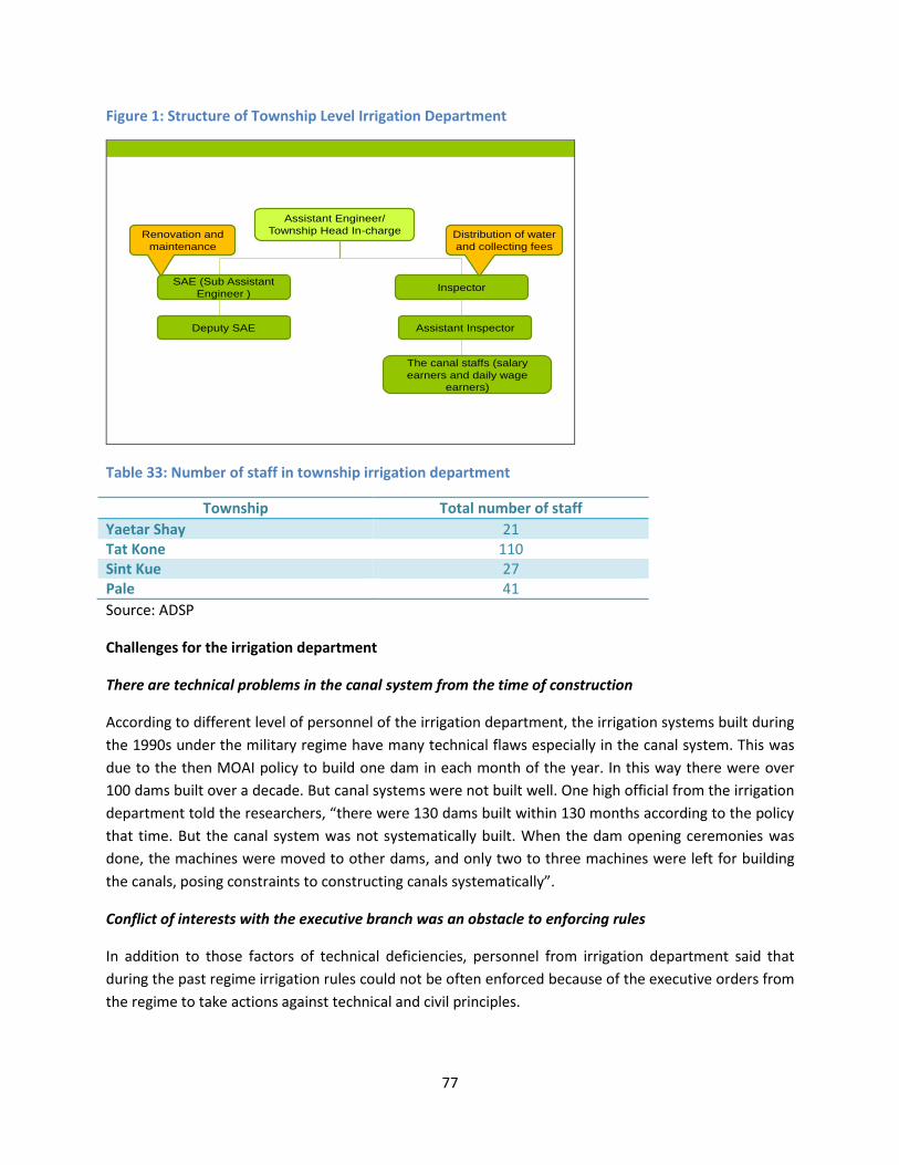
77
Figure 1: Structure of Township Level Irrigation Department
Assistant Engineer/
Township Head In-charge
SAE (Sub Assistant
Engineer )Inspector
Assistant InspectorDeputy SAE
The canal staffs (salary
earners and daily wage
earners)
Renovation and
maintenance
Distribution of water
and collecting fees
Table 33: Number of staff in township irrigation department
Township Total number of staff
Yaetar Shay 21 Tat Kone 110 Sint Kue 27 Pale 41
Source: ADSP
Challenges for the irrigation department
There are technical problems in the canal system from the time of construction
According to different level of personnel of the irrigation department, the irrigation systems built during
the 1990s under the military regime have many technical flaws especially in the canal system. This was
due to the then MOAI policy to build one dam in each month of the year. In this way there were over
100 dams built over a decade. But canal systems were not built well. One high official from the irrigation
department told the researchers, “there were 130 dams built within 130 months according to the policy
that time. But the canal system was not systematically built. When the dam opening ceremonies was
done, the machines were moved to other dams, and only two to three machines were left for building
the canals, posing constraints to constructing canals systematically”.
Conflict of interests with the executive branch was an obstacle to enforcing rules
In addition to those factors of technical deficiencies, personnel from irrigation department said that
during the past regime irrigation rules could not be often enforced because of the executive orders from
the regime to take actions against technical and civil principles.

78
Insufficient number of staff is a constraint
One township irrigation department said that the number of staff is not enough to carry out their tasks.
They cannot hire canal staff because of the budget limitation. The canal staff are currently paid 65,000
to 80,000 Kyat per month. It was learned the staff was reduced by 75% due to budget cut.
Agricultural Department
The number of staff in township agricultural department also varied across different townships.
According to one of the head of departments the township agricultural department has to include 36
technicians and 3 other staff (39 staff in total). However in reality the number ranged from 11 to 29.
Table 34: number of staffs of township agricultural department of townships
Township Total number of staff
Yaetar Shay 11 Tat Kone 29 Sint Kue 12 Pale 29
Source: SA ADSP
Figure 2: Structure of Township Level Agriculture Department
Township Head
Department
2 Deputy Heads of
Dept.
Assistant in-charge
Deputy Assistant in-
charge
Clerk
Challenges of township agricultural department
Insufficient number of staff was identified by two township agricultural departments as a major
challenge. Personnel from township agricultural departments said that their staff cannot be appointed
because of a lack of budget. One staff from township agricultural department was reflecting this

79
challenge when he said, “we have one head of department. There are supposed to be two deputy heads
of the department, but there is only one now. The number of assistant positions is nine, but we only
have two. There must be 24 deputy assistants but only 7 have been appointed. There is a junior clerk
position, but we cannot fill the post (because of lack of budget). In our organizational structure, there
are 31 posts, but we only have 12 staff.”
Implementation of ministerial policy
Township agriculture departments are expected to dedicate their human resources and time to the
model plots where Pale Thwe variety is grown whilst they have insufficient staff and resources.
Settlement and Land Record Department39
Settlement and Land record department (SLRD)’s functions at the township level include: land
registration; farm land type classification Le or Ya; classification of soil qualities; monitoring of
production/productivity of crops on different types of soil; and development of new cultivation areas if
increased population is demanding more cultivated areas40. The following figure shows the
organizational structure of township SLRD which in fact represent technical front of the township
SLRD41. The basic level of technical structure at the township level is commenced with Land
Measurement Level 4 which is a clerk position which could be applied university entrance exam. Those
worked as Land measurement level 4 for 2-3 can have a chance to attend training and sit a subsequent
exam and those who passed are elevated as Land Measurement Level 5 which is a senior clerk position.
In addition to technical staff, there are office administrative staff such as accountants and clerks.
39
The study team could not obtain much information from the township land record department because of the time limitation. The researchers nonetheless had a chance to meet with three township heads of the department of land record. 40
This happens because of increased population and subsequent extension of residential areas. 41
Administratively the basic level of the Land Record Department at the township level is Land Measurement Level 4 which is a clerk position. Those who worked at the position for 2-3 years can have a chance to attend training and sit a subsequent exam. Those who passed the exam are elevated as Land Measurement Level 5 which is a senior clerk position.

80
Figure 3: Structure of Township Level Land Record Department
Tsp. Head Department
Deputy Head of Dept.
Assistant head of
Dept.
Deputy Assistant
Head of Dept.
Land Measurement level 4
Land Measurement level 5
Township Agricultural Coordination Committee (ACC)
ACC is a township level coordination body composed of the four departments at the township level:
general administration, agriculture, irrigation and settlement and land records. Usually, the coordination
body is headed by the township administration, and the head of township agricultural department is its
secretary. The roles and functions of ACC are as follows:
Planning of agricultural activities based on the land and water availability
Working to promote productivity and high yield
Solving emergency issues regarding the agricultural activities, such as responses to floods
Solving conflicts related to irrigation water covering more than one villages
ACC according to the conversation with the heads of three township departments is not an
organizational entity with specific functions and regular activities. The ACC in fact does not have regular
meetings. Members of ACC meet at biweekly and especially monthly township administrative meetings
together with other township departments such as police, justice, customs and so on. According to
persons from the three township technical departments in Yaetar Shay, members have good
relationships.
However, the study found that the ACC in Tat Kone functions well with the formation of five sub-ACC
based outpost offices within the township. In each outpost office, one department head takes charge,
and deputies of other departments, field in-charges of agriculture department, village tract

81
development support committees of nearby tract villages join as sub-ACC members. They meet every
Sunday early morning and have discussions with farmers in the area on their difficulties and needs. The
following case shows how people can access to the ACC to voice their needs and request solutions.
Box 16: How ACC is working in coordination to address problems
A new railway was built recently in the farmland area posing disturbance to a canal. Concerned farmers put
forward the issue in one of sub-ACC meetings at its outpost office, and proposed to put a culvert. In response
to this proposal of farmers, the ACC made observation shortly. Then they reported to the township
administration and took permission to take necessary actions in coordination among the three departments
of ACC. The land record undertook necessary land measurement and irrigation department provided
mechanical and technical support. In this way, the problem of farmers was solved in time before the
monsoon paddy season.

82
Section 7: Results of Free, Prior and Informed Consultations
7.1 Who we consulted at the community In acquiring people’s opinion on the project, the SA research teams consulted with three categories of
stakeholders at the community level: socioeconomic groups i.e farming and landless laborers; the
vulnerable; and members of village institutions. With regards to the socioeconomic groups, the SA
teams met with large, medium and small farmers, as well as landless labourers. Of the vulnerable, the
SA researchers met with small women-headed households, very poor landless labourer families, and
farmers with small land holdings whose families bear a burden of taking care of the disabled, old or sick
people. SA also interviewed members of village institutions such as village administrations, water user
groups (Myaung Kaung), village development support committee, land management committee, labour
groups and so on.
7.1.1 Consultation with non-Bamar population
Free, prior and informed consultations were carried out with ethnic and non-Bamar people in the
villages studied or nearby villages. The SA researchers interviewed five non-Bamar people and eight
Muslim people. This may seem a very small portion comparing to the total respondents. However, the
initial desk review and the assessment of demographic data in the irrigable areas collected through
literature review and interviews with knowledgeable people indicated that there were only very few
ethnic people in the irrigable areas of the regions.
Ethnic and religious minorities met by SA researchers in the study irrigation areas
Kayin people
There were four households of the Kayin in a village with 195 households in Yaetar Shay. They were all
related and living in one compound. They had been in that village for three generations since their
grandparents. They are small farmer families. SA researchers met and interviewed two of them. They
said that they had been assimilated to the community and no longer kept cultural practices such as
spiritual beliefs and homage. They do not speak the Kayin language. One of the interviewees said, “we
are now just four families here and no more like the Kayin. We no longer carry out the Kayin spiritual
practices. We beccme Buddhists. We also do not speak the Kayin language.”
Shan people
Shan people that SA researchers met during the study lived outside the studied villages in a village tract
with over 200 households. Shan people in that village are in 10 households and all are large farmers. The
current village formal leader also is a Shan. They had been in that village for three generations since
their grandparents. The SA researchers met three Shan people including the village tract administrator –
two males and one female. The respondents stated that they had been very much assimilated to the
Bamar people and considered themselves as Bamar. They also do not speak Shan. One of them said, “we
were born and grew up here. We went schools here as well. So, we do not feel like we are Shan.”

83
Muslims42
The SA researchers met Muslin people in two villages: one of the studied villages in Sint Kue Township
and another one which was close to a study village in Tat Kone. The SA team met eight Muslim persons
in total: six medium farmers, one female-head of family with small holding, and one large farmer who
also is a Myaung Kaung. They have been living in the villages for many years over three to four
generations, they said. There are nearly 100 Muslim households the village in Sint Kue while the whole
population of the other in Tat Kone are Muslims. All the interviewed Muslims said they identify
themselves as Muslim Bamar.
Ethnic screening should be carried out during implementation under Feasibility Study against
eligibility criteria under OP 4.10
The ethnic minority people interviewed generally maintained that they are fully assimilated with Bamar
culture. In-depth analysis was not carried out under this SA to determine whether they meet the
eligibility criteria as Indigenous Peoples under the Bank’s Operational Policy 4.10. It is recommended
that an ethnic screening should be carried out as part of feasibility study for the area of influence of
project irrigation schemes and land improvement pilots, in order to determine if indigenous people
communities that trigger the aforementioned World Bank policy are present in or have collective
attachment in the project area of influence.
7.2 People’s opinions about the project
7.2.1 Renovation of irrigation canals and building watercourses
People in the villages studied generally welcome the rehabilitation of the existing irrigation canals
regardless of farm sizes, gender, ethnicity and religion. Almost all of them expressed their willingness to
cooperate with the project. The most common remark heard from the people was a request to make
sure that the canals will be good and strong enough.
Most of the people recommended lining of the canals with bricks and concrete. More importantly the
study revealed that small farmers especially those with 2 acres and less unlike other farmers have
concerns on giving up land when water courses are built. However, some villagers including VERPs and
administrators said that the canal maps exist showing the locations of watercourses, and that this
acknowledged by farmers. They said there will be no problem building watercourses or enlarging the
canals. Box below introduces some quotes of the villagers on the schemes:
Box 17: People’s expectations for irrigation rehabilitation
“The bricks and concrete canals will be the best form and watercourses should be built systematically.” (A
Kayin small farmer in Yaetar Shay)
42
Muslim people are considered as non-Bamar by most Bamar people although some of them, including those met by the SA teams, consider themselves as Muslim Bamar.

84
“If canals are to be renovated, they should be built with bricks and concrete so that people cannot break to
steal water. But there should be a 12 feet wide bridge across the canals so that farmers will not break the
canals to get to the road” (A medium farmer in Yaetar Shay)
“If we will get water enough, we are willing to give our land” (A small farmer in Pale Township)
“Renovating the canals as a project systematically will be good. We can donate land for the watercourses.”
(A large farmer in Sint Kue)
“We will give our land for the watercourses which are essential for changing the plot to plot distribution
system” (A small farmer in Sint Kue)
“It is good to rehabilitate the canals. But make sure that farmers do not need to develop canals by
themselves. Before the irrigation department only marked the canal area, and it was the farmers who had to
dig it.” (A large farmer in Pale)
While most of the farmers welcomed the development watercourses, some of them recommended to
carry it out with careful organizing strategy. Some also considered compensation for the land which
needs to be given up to develop watercourses. Others expressed concerns that some watercourses
gradually eroded and causing farmland erosion as well.
Labourers also welcomed the project idea pointing out that they can have more jobs when large farmers
benefit from the project. Villages with limited water availability can now only grow one monsoon crop surely
and they sometimes have problem even for this monsoon crops. As a result, laborers in those villages have to
migrate or can have much less paid works during summer. A female labourer in Tak Kone said, “if irrigation
water becomes available because of better canals, we will have more jobs. Now our village grows one crop of
paddy and we have to work for tobacco makers where we only earn 700 Kyat per day (compared to 2,000-
2,500 Kyat a day from farm works)”.
Despite those welcoming expression in all of the villages studied, people in one village in Sint Kue Township
under the Male Nattaung Dam expressed their concern on the project although they said wanted to have
good canals. This was because they had suffered from building DO 4A which is attached to the right main
canal of the dam. According to the villagers, DO 4A have a technical problem as it was built against water
ways from the hills, so when water comes down from the hills with strong speed, the canal gets damaged and
water spoils farmland downstream. In addition, despite its design to irrigate 63 acres, in reality, only 20 acres
are currently benefitting. Worst of all, farmers who used to grow sugarcane before DO 4A was built had to
remove their sugarcane plants and were instructed to grow paddy despite the fact that land does not receive
water. Farmers reported profound losses since sugarcane plantations were removed as the crop was
profitable. Since that time the village started experiencing economic downturn. Therefore farmers in this
village had strong concern and worried about potential negative impacts. Farmers openly expressed that if
the project cannot provide water to their fields, they prefer the current DO 4A to be removed.
Some people from non-irrigable areas have expressed concerns on negative impacts of irrigated areas.
One of the Kayin leaders residing in Bago East who were consulted on the existence of ethnic people in
all irrigable areas in the region reported they had experienced flood which they thought was an effect of
one irrigation scheme called Moe Yon Gyi Lake which feeds water to farmlands in Yangon Region. They

85
had frequently experienced floods as canals of the irrigation scheme and others were not good enough
to absorb water particularly during the rainy season. As a result, the people in the areas suffered floods
in both residential and agricultural areas during the rainy season including the one in 2014, which they
said was the worst in the last 20 years.
7.2.3 People’s point of view on the water tax
Many farmers said they do not mind paying water tax. More importantly, people from the villages with
poor water availability said they will pay more than current amount on the condition that they receive
enough water. Currently they pay over 200,000 Kyat per acre by pumping water from tube wells.
According to most of the farmers, the current amount of 1,950 - 2,000 Kyat per season per acre is fair
enough. Some people also expressed that they do not mind paying 1.5 times more (around 3,000 kyat
per acre for each season). However, many small farmers mentioned that they want to pay no more than
2,000 Kyat. All of them said they do not wish to pay for measures of their own initiatives if they have to
pay more for irrigation water from the formal system. Some farmers told that the collection of water tax
in every three years would pose a burden43.
7.2.4 Right of Way
The Right of Way44 (ROW) is specified as 75 feet on each side from the center if it is a main canal, 50 feet
for DYs and 25 feet for the minors. The study found that people generally acknowledge the existence of
the Right of Way. However, they did not know exact distances/widths of the ROW area. Persons from
the SLRD stated that the LUCs given to the farmers excluded the canal areas.
In Sint Kue Township it was reported that the area are marked but people still grow crops, knowing that
the area is part of the ROW. However, almost all of the farmers said they will remove their crops from
the area when the canals are renovated. In Pale Township, farmers themselves told that the irrigation
territories are already marked on maps, and that they will remove the crops if canals are rehabilitated.
But some farmers indicated a possibility of resuming cropping after rehabilitation. Farmers mentioned
that the most convenient time remove crops from ROW is after harvest time and before irrigation
service starts.
Box 18: People are willing to remove crops from ROW
“There are crops in right of ways; we have to remove them when the canal is rehabilitated. Time after
monsoon crop is a good time for us to do so, that is October to the end of November” (A medium farmer in
Yaetar Shay)
“There are land marks and sign boards for the right of way but farmers are still growing corps around it” (A
large farmer in Sint Kue)
43
According to the irrigation department in Yaetar Shay, there is a plan to collect water tax every three years. They said the township and village administrations will take responsibility for collecting the tax. 44
The Right of Way is termed in Burmese as “Sae Myaung Nae Namate/Sae Myaung Area”. And the people also locally used that word.

86
“Most of the areas of right of way are not free from crops. People grow crop despite their knowledge that
they should not do so. But they will understand if we explaine well” (A village tract administrator in Sint Kue)
“People know about the right of way but they are growing crop as there is no enforcement. But it will be fine
when the canals are renovated. Canal area maps were already drawn up. It is the village tract administrator
who has to organize (crop removal).” (A small farmer in Pale Township)
7.2.5 Land improvement schemes
Villages in Sint Kue (Mandalay region), Pale (Sagaing) and Yaetar Shay (Bago East) were generally
interested in land improvement schemes. However, villagers in Tat Kone said they were not interested
in the scheme as they had seen and heard more detailed practical issues related to such schemes, such
as low quality of work and problems of redistribution of plots as discussed earlier. In addition, farmlands
of some farmers in one of the villages studied were included in the scheme of a neighboring village
where quality was found to be disappointing. The box below highlights a case reported by one of the
farmers who experienced low quality implementation of the scheme.
Box 19: Some farmers involved in a land improvement scheme faced difficulty
One thousand-acre land improvement scheme was conducted in one village tract in Tat Kone Township, Nay
Pyi Taw Council in 2013 December. Around two hundred farmers from four villages were involved in the
scheme. Most of them are farmers owning 4-5 acres of land. Majority of them especially small farmers faced
difficulties because of the technical weaknesses of the scheme.
A farmer who owns 1 acre of Le land and 2 acres of Ya land is one of them. His Le plot was included in the
scheme. Farmers had to go without one summer paddy for implementation of the scheme which took over
five months before completion. When they had their plots returned in time for monsoon paddy, they learned
that scheme was not built well. The land levels differed in three parts; bunds were not high and strong
enough. It appeared that farmers had to take their own responsibility to correct those deficiencies. Some
farmers especially larger farmers reinforced bunds and leveled the land by paying 40,000 Kyat (10,000 Kyat
for each side) and 18,000 Kyat to agricultural mechanization department. But small farmers could not afford
such amounts, especially after they just missed summer paddy. There were other failures found in
watercourse system: his plot was at a higher level than watercourse, so water could not flow into his plot.
Finally 50 farmers including him denied to sign the paper of acceptance of the scheme.
Those who were keenly interested in the scheme were large farmers, while medium and small farmers
had concerns about losing their land. Labour shortage is one of the significant factors for farmers to
move forward with the land improvement scheme. Some large farmers, however, mentioned that they
do not want to grow policy crops such as Pale Thwe after scheme completion even if it is encouraged by
the agricultural department.
The study found that two villages in Yaetar Shay have signed agreement on land improvement schemes.
In one village, all farmers signed the agreement while it was only 75% of farmers singed in the other.
The rest did not sign as they had concerns about land loss. It was reported that persons from the

87
township irrigation department, agricultural mechanization department and Land record department
visited those villages twice and talked about the land improvement schemes. Farmers gave their
signatures after the second visit.
Box 20: Mixed views on land improvement schemes
“One acre development scheme will be great. We can use big harvesters (which includes a thresher).” (A large
Shan ethnic farmer in in Yaetar Shay)
“One acre development is good for farmers with large land holdings but will not be fine for those with small
lands” (A Muslim medium farmer in Yaetar Shay)
“One acre development is not good for small land holding farmers like us. Our land may be lost”. (A small
farmers with less than 2 acres of the land in both Yaetar Shay and Tat Kone)
“As the land types are not equally distributed and those who have better land do not want the bad one. So,
that seemed impossible”. (A large farmer in Sint Kue)
“If the government will implement, we want to cooperate. We can give land but we don’t have money to
contribute”. (A female household head with medium size holding in Sint Kue)
7.2.6 People opinions on farming technique
Every method and variety which will have high yields and market demands will interest the farmers.
Farmers said that they are interested in testing new methods which are not financially costly and
demanding in activities. Some large farmers are willing to organize demonstration or testing plots on
their land. Small and medium farmers, however, expressed that they cannot take a risk of testing new
varieties or methods and that they will practice depending on the results of the large farmers fields. As
discussed earlier, farmers in all visited areas except Tat Kone mentioned Pale Thwe and rope-line
method (GAP) being promoted by the township agricultural departments. But they have not adopted
these for several reasons. Pale Thwe has less market demand, so the farmers have to find the buyers
while other rice varieties can be easily purchased by local brokers who come to the village. The rope line
method is complicated with many specifications to follow, they said.
Regarding learning methods, farmers said they largely prefer a method that combines both practical and
theoretical aspects. They also highlighted that they do not want to learn from demonstration sites of
other areas but those on their own village soil. Some farmers also recommended to organize the
training covering a topic when the relevant problem occurs on the field, such as providing training on
pesticides at the time of its application. On use of hybrid seeds, several farmers pointed out that water
availability is a crucial factor to choose rice varieties, and said they would not like to plant long duration
varieties unless availability of water is guaranteed.
7.2.7 Preferred venues of agriculture training
Preferred arrangements for agriculture training locations varied among people even in the same village.
Most of them proposed to use existing community building such as “Dama Yone” (socio-religious places
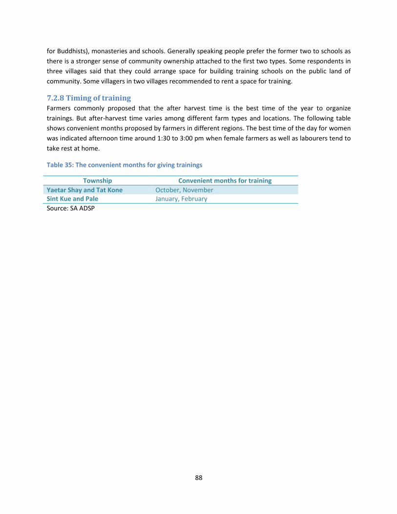
88
for Buddhists), monasteries and schools. Generally speaking people prefer the former two to schools as
there is a stronger sense of community ownership attached to the first two types. Some respondents in
three villages said that they could arrange space for building training schools on the public land of
community. Some villagers in two villages recommended to rent a space for training.
7.2.8 Timing of training
Farmers commonly proposed that the after harvest time is the best time of the year to organize
trainings. But after-harvest time varies among different farm types and locations. The following table
shows convenient months proposed by farmers in different regions. The best time of the day for women
was indicated afternoon time around 1:30 to 3:00 pm when female farmers as well as labourers tend to
take rest at home.
Table 35: The convenient months for giving trainings
Township Convenient months for training
Yaetar Shay and Tat Kone October, November Sint Kue and Pale January, February
Source: SA ADSP

89
Section 8: Positive Impacts and Potential Social Risks of the
Proposed Project
Discussions and interviews with stakeholders indicate more positive impacts of the project than
negative ones. Positive impacts include increase in income, development of community based water
management and responsive extension service provision. Practices of social inclusion are expected to be
strengthened because of the project.
There is, however, a risk on social cohesion of the community. There is a possibility of socioeconomic
gaps between Ya farmers, who have less possibility to benefit from the project, and Le farmers. The
project may widen tangible and intangible gaps between two groups in the same community unless
certain measures to promote the participation of Ya farmers, such as their inclusion in extension service,
are in place. It is therefore important that extension services reach out to both types of farmers and
cover other crops in addition to paddy.
Several potential risks were identified with regard to land improvement schemes. It is undeniable that
land improvement schemes will result in more efficient production for farmers. People’s high
expectations which have to be compromised in reality itself may create problems. One potential risk
relates to damages to social relations in the village as if land redistribution is not carried out well.
Another possibility is low quality civil works and subsequent tensions between implementers and
farmers. Another risk is potential land sale to outsiders as the value of the land will go up.
8.1 Positive impacts of the projects
Increased income and reduction of extra cost to obtain water
This is a very likely sustainable positive impact as was demonstrated by those which gained access to
water recently and increased income significantly as a result of cropping intensity and cultivation of
paddy, which has strong demands in both international and local markets. Those who currently have
limited access to irrigation and who need to spend extra money or efforts to water their fields can also
save money and increase overall well-beings of the family members.
Improving community based water management
The project will enhance community’s capacity in water management. This will give the farmers the
sense of ownership which is crucial for sustainable use of the infrastructures. More importantly, the
community’s capacity in dealing with service providers and expressing their needs will be enhanced by
the project.
Better social relations
As the project will result in more equal distribution of water, tensions generated by competition over
irrigation water supplies will be minimized, leading to better intra and inter-village relations.

90
Enhanced social inclusion
Since the project promotes social inclusion of people, especially the vulnerable, it is expected that the
formal and informal leaders of the community will gradually strengthen their views and positive actions
to promote social inclusion.
8.2 Potential social risks Possible acceleration of land sale
Better availability of irrigation water will increase the value of the land. Purchase of land by outsiders
particularly by business people and land speculators could happen. Although this is highly unlikely as the
SA findings indicated that people rarely want to sell their land, especially in the villages with good water
availability, as they know well that land is their main source sustainable livelihoods. However care
should be taken to make sure that farmers will be informed of consequences of land sale to outsiders.
It is possible that land improvement schemes could encourage purchase of land by business people
especially in townships in Mandalay Region which is more accessible to big agricultural markets. Land
improvement schemes in fact are more attractive for business people because of better facilities to
develop modern, commercialized farming. It is expected that prices of land in such schemes will increase
to a higher level than those lands in villages only with access to irrigation. Potential risks exist if
transactions are not performed in a fair and transparent manner and the farmers are not fully informed
of the consequences.
Economic and social gaps between beneficiaries and non-beneficiaries of irrigation rehabilitation
A small number of farmers who only have Ya land may not benefit from improved access to water. Since
Ya farmers have been experiencing declines of socioeconomic conditions because of the frequent
climatic variations over the last five years or so. One the other hand, people benefiting from irrigation in
the same village have improved their conditions. This creates social tensions between them particularly
in those villages with a significant portion of pure Ya farmers. In those villages where pure Ya land is not
significant, increased social tension is unlikely.
So far such social tensions between the two groups of farmers as a result of widened income gaps have
not materialized in villages with a significant portion of Ya farmers. Also Ya farmers may benefit from
working as labourers on Le farmers’ fields. However, Ya farmers expressed their increasing needs for
water because of higher climatic variations. It will be important that the project provides support to
such farmers especially through their inclusion in extension activities.
Land improvement schemes may damage social relations in the community if not implemented
carefully
The SA found a possibility of deterioration of social relations in the community especially as a result of
the way the land is redistributed after completion of land improvement schemes. Plot redistribution

91
after implementation requires negotiations and compromises among the farmers. As land plots are
currently not measured precisely, redistribution may become a contentious issue.
There is also a risk that small farmers suffer if the same proportion is applied to all the land to be given
up for infrastructure development regardless of the landholding size. The land improvement schemes
are implemented on the basis of calculation at aggregate level of the area to be treated. As such, space
given for product roads and canals are deducted proportionately as a standard practice. This is not a big
deal for large and medium farmers. However, small famers particularly those with less than 1 acre land
will face significant problems even if a small portion of the land is taken. The project should come up
with a measure to ensure ‘fair’ and acceptable distribution of the costs and benefits among the
beneficiaries.

92
Section 9: Recommendations
9.1 For the whole project Inclusion of the vulnerable groups
For the vulnerable groups to be included and benefit from the project, roles of Water User Groups
(WUGs) and ACC are important. WUGs should represent all farmers, including the vulnerable ones. The
leaders should be elected by all farmers using the water. If there is a higher level WUG at the village
level, its leadership should be also democratically elected.
There is a need to support WUGs develop its own rules and a bylaw, which specifies such aspects as
membership; the roles and responsibilities of members as well as leaders; compensation/incentives for
the leaders; penalties for breaching the rules; common resource mobilization and management;
decision making; grievance handling mechanism (inside the group and vis-a-vis service providers);
communications with service providers; information dissemination mechanisms and record keeping. In
order to make the WUGs inclusive of the vulnerable farmers, provisions on membership, decision
making and complaint handling mechanisms need to be carefully worked out in order to enable their full
participation.
It will be crucial that WUGs and ACC work in close coordination under the project. Their regular
interactions will be an important arrangement to make the project attentive and responsive to the
voices of the farmers. The WUG leaders should meet with ACC (or Sub-ACCs) regularly and communicate
with them on their needs and problems. The WUG leaders shall make sure that they will channel the
members’ voices to ACC by organizing internal WUG meetings.
Roles of ACC
Township-level ACC in a key institution for the success of the project and sustainability of its
investments. ACC will have to play a focal role bridging the service providers (different departmental
staff) to the people. ACC in Tat Kone serves as a good model which can be replicated in other townships.
Capacity building
In order for the project to be truly inclusive and responsive, capacity building component is essential.
The capacity building shall target both government service providers and the people. For the service
providers, such concept as social inclusion, gender and accountability need to be clearly explained and
understood. Members of WUGs need to be trained on such topics as land and irrigation related laws,
social inclusion, gender, leadership, record keeping and basic financial management, and so on. It is
recommended to use simplified materials for community-level trainings, taking into consideration the
existing relevant materials, such as those on land laws prepared by Food Security Working Group.
Capacity building of WUGs to develop internal rules to ensure equitable access to water is essential in
view of the cases of violation and lack of compliances in places where water is available.

93
Need for scheme specific Social Assessment
Site specific studies need to be conducted in order to obtain in more detail about the area’s socio-
economic, social and ethnic information, which will be used to refine project activities and support,
especially in relation to inclusion of the vulnerable groups and ethnic minorities, as appropriate.
9.2 Rehabilitation of canals and watercourses Removal of crops from the Right of Way
Obtaining farmers’ agreements to remove crops on the Right of Way will not be difficult, but a
participatory process possibly facilitated by a civil society organization will be most effective. The study
was informed that that ‘soft’ ways, using effective communications for consultation and explanation will
work better. Such process will be better facilitated by qualified third-party organizations with experience
in community mobilization and participation rather than conducted alone by the personnel of
government technical departments.
Land losses resulting from canal rehabilitation should be borne equitably
Small farmers may not be able to bear the same proportional reduction as large or medium farmers.
Land losses, therefore, should be managed equitably for vulnerable farmers particularly for those with 1
acre or less land.
9.3 Extension service Theoretical and practical learning methods should be applied for farmer training
Most frequently suggested approach to learning was to select topics which the farmers wish to learn
action for in view of the challenges they currently face. For example, farmers would typically wish to
learn how to handle a certain pest problem exactly when they have the pest problem on their farm. In
order to organize the training in such a responsive manner, service providers need to maintain close
contact with the community.
Human resources development for effective outreach
Insufficient number of staff and lack of budget pose major constraints to the agricultural department to
provide extension services effectively. It is therefore recommended that the project supports to
reinforce the human resources basis of agricultural department (both number of staff and their
capacities) to improve their outreach to the communities.
Training to female labourers on the use of farm machineries
The SA recommends the project to provide training to labourers on how to use farm machineries. As
mentioned earlier, gender division of labour has declined and opportunities have opened up for women
to take up new responsibilities. Acceleration of farm mechanization may lead to less manual labour and

94
it will be important that the labourers, especially women as they outnumber males, will be equipped for
such changes.
Choice of varieties
It is recommended that the above-mentioned site specific studies will highlight types of crops and rice
varieties preferred locally, so that MOAI could effectively support the crops and varieties of priorities in
the specific localities. SA also recommends that the content of the training should be also decided in
consultation with the farmers. Farmers should be also made aware of the benefits of growing cash crops
(such as onions, chili and other vegetables) on irrigated land rather than only focusing on paddy so that
their income will increase and its streams will be smoothed across the year.
9.4 Land improvement schemes Quality of civil works needs to be ensured
SA considers that quality of the work is essential for the farmers to agree to the scheme. Implementing
partners need to convince the farmers that high quality of civil works is guaranteed before
implementation starts.
Precise measurements of each plot prior to implementation
SA also highly recommends that SLRD make precise measurement of all land plots before
implementation. The farmers who will be participating in the scheme should join the SLRD team during
the exercise for consultation.
Ways need to be found to ensure fair distribution of costs and benefits among the farmers with
different landholdings and socio-economic conditions
As mentioned earlier, proportional deduction of land will pose more serious problems to small holders
than medium and large farmers. Their livelihood relying on small pieces of land may be negatively and
irreversibly impacted if operational holdings are reduced. The project should find means to enable the
community to come up with an acceptable approach to distributing the costs and benefits among the
participating farmers. It is recommended that small farmers with less than 1 acre of land should be
exempted from the proportionate reduction.

95
Annexes 1: Seasonal Calendars of Farming Activities
Yaetar Shay
Tat Kone
Pale

96
Sint Kue
Jan Feb March April May June July Aug Sept Oct Nov Dec Jan
Moonsoon paddy
summer paddy
Maye Paddy
sesame
Greengram

97
Annex 2: Pictures of Land Improvement Schemes
Ah Lyin Lo Scheme

98
JICA Scheme


