
Stone Creek
LittleMud Creek
Walsh Creek
Cold Creek
Do an Creek
WestLitt l e Walla Wa llaRiver
Pine CreekMudCreekBur lingame Ditch
TouchetRive
r
Walla Walla River
Walla Walla River
Mill Creek
Columbia River
Smith Harbor
Curlew Pond
Casey Pond
Burbank Slough
Snake Rive
r
J Line Pond
BadgerIsland
FoundationIsland
GooseIsland
HoodPark
PeavineIsland
Two RiversIslands
Charbonneau Park
FishhookPark
CrescentIsland
Ice HarborDam
Martin FieldAirport
PortKelley
BurbankHeights
TwoRivers
Sun Harbor Estates
Burbank
Wallula
Touchet
Lowden
VistaHermosa
Eureka
City OfCollege Place
City ofPasco
FranklinCounty
BentonCounty
Oregon
Frenc
htown
Rd
Old Hwy 12
Dodd Rd
AttaliaIndustrial UGA
Touc
hetR
iv er
£¤12
£¤730
£¤12
£¤12
¬«124
Dry Creek
Yellowhawk Creek
RC
RC
RC
RC
RC
RC
N
RC
N
RC
N
RC
N
RC
RR
HI
RR
N
HIN
N
RCRR
UC
NRC
RC
RC
HI
HI
RR
RR
RR
RR
RC
RC
N
N
RC
N
N
RC
RC
RC NRC
RCN
RC
UCHI
UC
N
N
N
N
HI
RCN
RC
RC
RC
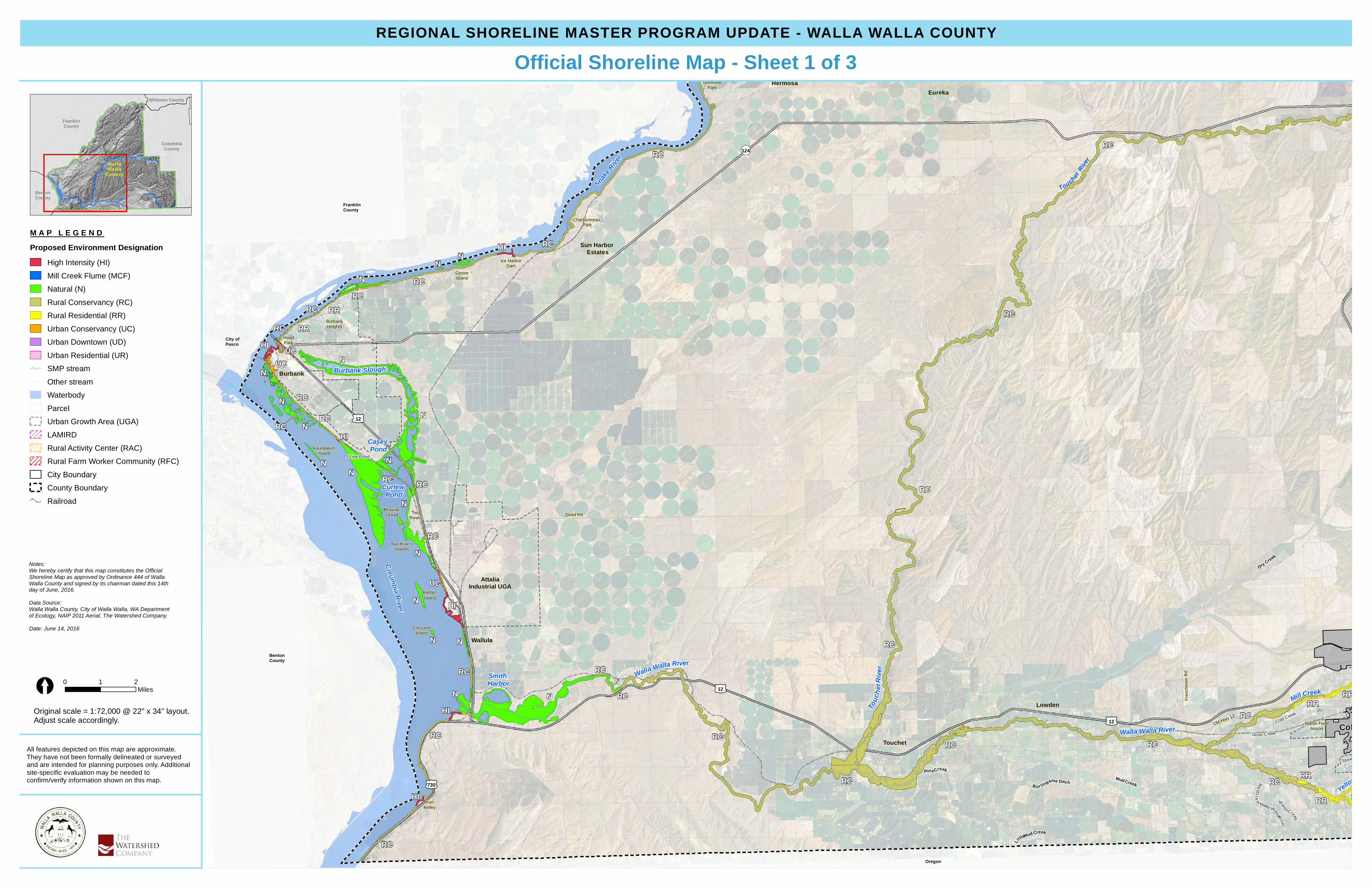
REGIONAL SHORELINE MASTER PROGRAM UPDATE - WALLA WALLA COUNTY
All features depicted on this map are approximate.They have not been formally delineated or surveyedand are intended for planning purposes only. Additionalsite-specific evaluation may be needed toconfirm/verify information shown on this map.
Official Shoreline Map - Sheet 1 of 3
Original scale = 1:72,000 @ 22" x 34" layout.Adjust scale accordingly.
Whitman County
FranklinCounty
BentonCounty
ColumbiaCounty
Wa l laWa l la
Coun ty
M A P L E G E N DProposed Environment Designation
High Intensity (HI)Mill Creek Flume (MCF)Natural (N)Rural Conservancy (RC)Rural Residential (RR)Urban Conservancy (UC)Urban Downtown (UD)Urban Residential (UR)SMP streamOther streamWaterbodyParcelUrban Growth Area (UGA)LAMIRDRural Activity Center (RAC)Rural Farm Worker Community (RFC)City BoundaryCounty BoundaryRailroad
Notes:We hereby certify that this map constitutes the OfficialShoreline Map as approved by Ordinance 444 of WallaWalla County and signed by its chairman dated this 14thday of June, 2016.Data Source:Walla Walla County, City of Walla Walla, WA Departmentof Ecology, NAIP 2011 Aerial, The Watershed Company.Date: June 14, 2016
0 1 2Miles[

Wh
etstone Hollow CreekFishhook
Park
LowerMonumental Dam
Ayer BoatBasin
Ayer
VistaHermosa
EurekaCity Of
Prescott
ColumbiaCounty
FranklinCounty
¬«124
Snak
e Rive
r
RC
RC
RC
HI
RC
RC
RC
RC
HI
RC
REGIONAL SHORELINE MASTER PROGRAM UPDATE - WALLA WALLA COUNTY
All features depicted on this map are approximate.They have not been formally delineated or surveyedand are intended for planning purposes only. Additionalsite-specific evaluation may be needed toconfirm/verify information shown on this map.
Official Shoreline Map - Sheet 2 of 3
Original scale = 1:72,000 @ 22" x 34" layout.Adjust scale accordingly.
Whitman County
FranklinCounty
BentonCounty
ColumbiaCounty
Wa l laWa l la
Coun ty
M A P L E G E N DProposed Environment Designation
High Intensity (HI)Mill Creek Flume (MCF)Natural (N)Rural Conservancy (RC)Rural Residential (RR)Urban Conservancy (UC)Urban Downtown (UD)Urban Residential (UR)SMP streamOther streamWaterbodyParcelUrban Growth Area (UGA)LAMIRDRural Activity Center (RAC)Rural Farm Worker Community (RFC)City BoundaryCounty BoundaryRailroad
Notes:We hereby certify that this map constitutes the OfficialShoreline Map as approved by Ordinance 444 of WallaWalla County and signed by its chairman dated this 14thday of June, 2016.Data Source:Walla Walla County, City of Walla Walla, WA Departmentof Ecology, NAIP 2011 Aerial, The Watershed Company.Date: June 14, 2016
0 1 2Miles[
Stone Creek
Yellow
hawk C
reek
Paradise CreekBe
nningt
on Lak
e Over
flow
LittleMud Creek
Gree
n Fork
Creek
North Russell Creek
Little BlueCreek
Cald w el l Cree
k
Walsh Creek
Whiskey Creek
Cold Creek
South Fork Dry Creek
Doan CreekWh
etstone Hollow Creek
South Russell Creek
Titus Creek
WestLitt l e Walla Wa llaRiverPine Creek
CottonwoodCreek
NorthFork Dry Creek
Rus sel lCreek
Reser Creek
Coppe iCreek
North Fork Coppei Creek
Blue Creek
So u th Fork CoppeiCreek
Dry Cre ek
MudCreekBur lingame Ditch
TouchetRive
r
Walla Walla River
Mill Creek
Mill Creek
Mill Creek
Bennington Lake
Mill CreekDiversion Dam
Martin FieldAirport
Walla WallaRegional Airport
Dixie
Lowden
Eureka
City OfWaitsburg
City OfPrescott
City OfCollege Place
City ofWalla Walla
Oregon
ColumbiaCounty
Old Milton Hwy
Frenc
htown
Rd
Old Hwy 12
Hart R
d
¬«124
¬«125
¬«125
¬«125
£¤12
£¤12
Mud Creek
Dry Creek
Yellowhawk Creek
RC
RC
RC
RR
RC
NRC
RC
RC
RR
RR
RC
RC
RC
RR
RR
RC
RR
RR
RR
HI
RC
RR
RR
RR
RR
RR RC
RCRRRC
RRRC
RC
RC
RC
RC
RRRR
RC
MCF
RC
RC
RC
RC
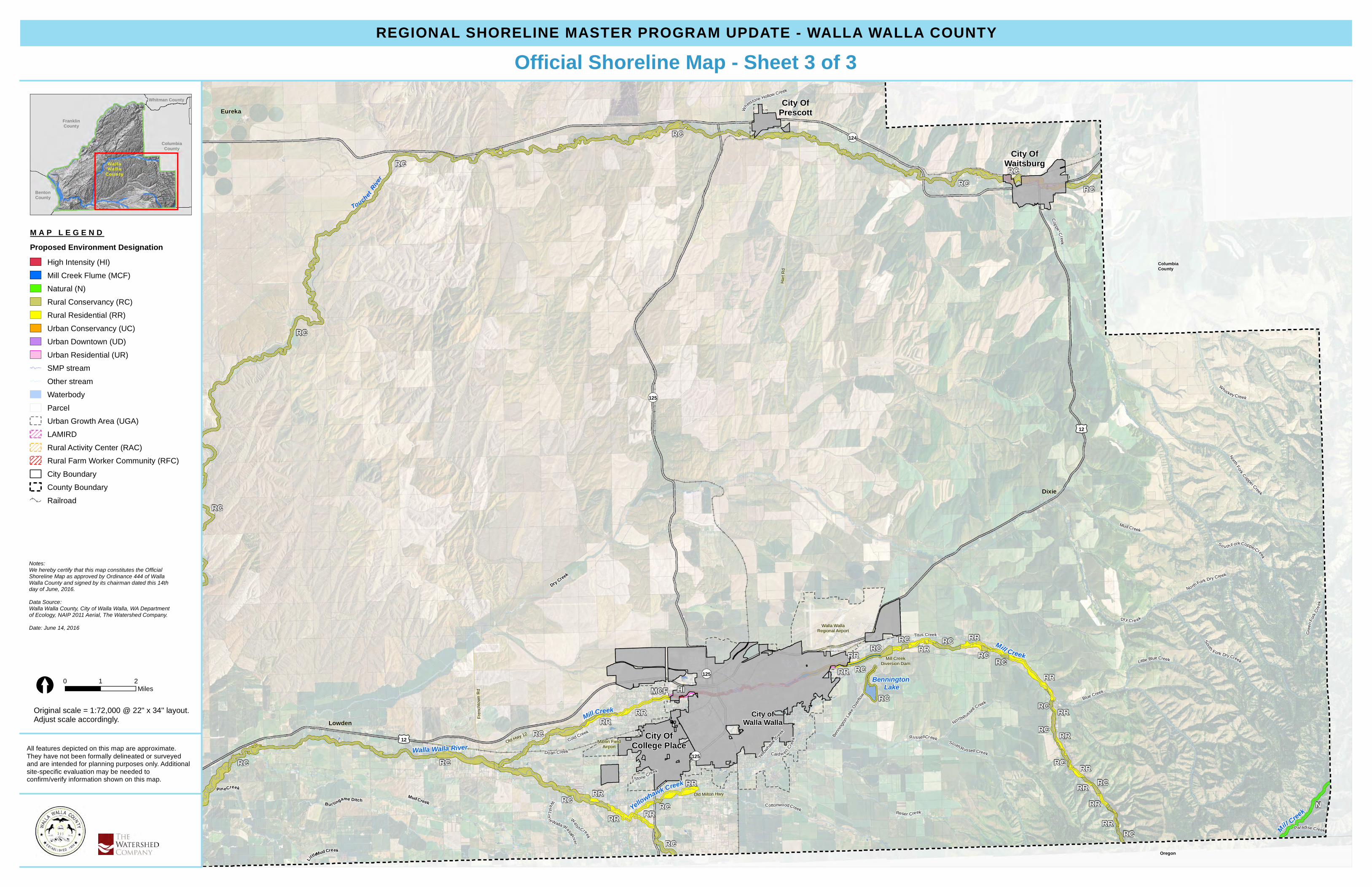
REGIONAL SHORELINE MASTER PROGRAM UPDATE - WALLA WALLA COUNTY
All features depicted on this map are approximate.They have not been formally delineated or surveyedand are intended for planning purposes only. Additionalsite-specific evaluation may be needed toconfirm/verify information shown on this map.
Official Shoreline Map - Sheet 3 of 3
Original scale = 1:72,000 @ 22" x 34" layout.Adjust scale accordingly.
Whitman County
FranklinCounty
BentonCounty
ColumbiaCounty
Wa l laWa l la
Coun ty
M A P L E G E N DProposed Environment Designation
High Intensity (HI)Mill Creek Flume (MCF)Natural (N)Rural Conservancy (RC)Rural Residential (RR)Urban Conservancy (UC)Urban Downtown (UD)Urban Residential (UR)SMP streamOther streamWaterbodyParcelUrban Growth Area (UGA)LAMIRDRural Activity Center (RAC)Rural Farm Worker Community (RFC)City BoundaryCounty BoundaryRailroad
Notes:We hereby certify that this map constitutes the OfficialShoreline Map as approved by Ordinance 444 of WallaWalla County and signed by its chairman dated this 14thday of June, 2016.Data Source:Walla Walla County, City of Walla Walla, WA Departmentof Ecology, NAIP 2011 Aerial, The Watershed Company.Date: June 14, 2016
0 1 2Miles[


