
Peopling of the northern Tibetan Plateau
P. Jeffrey Brantingham and Gao Xing
Abstract
Early archaeological investigations on the Tibetan Plateau concluded that this harsh, high-elevationenvironment was successfully colonized around 30,000 years ago. Genetic studies have tended to
support this view on the assumption that the uniquely evolved physiological capacities seen amongmodern Tibetan populations required long-term exposure to high-elevation selective pressures.Archaeological evidence amassed over the last decade suggests, however, that colonization leadingto full-time occupation occurred much later. Seasonal foraging forays into high-elevation settings at
c. 30 and 15 cal. ka appear to have been limited ‘adaptive radiations’ coincident, respectively, withthe appearance of early and late Upper Palaeolithic adaptations in low-elevation source areasaround the plateau. More permanent occupation of the plateau probably did not begin before
c. 8200 cal. BP and may have been driven by ‘competitive exclusion’ of late Upper Palaeolithicforagers from low-elevation environments by emerging settled agricultural groups. The appearanceof specialized epi-Palaeolithic blade and bladelet technologies on the high plateau, after 8200 cal. ka,
may indicate ‘directional selection’ impacting on these new full-time residents. An ‘adaptiveradiation’ of agriculturalists into the mid-elevations of the plateau, this time leading to year-roundoccupation, is again seen after 6000 cal. BP.
Keywords
Tibet; Palaeolithic; Neolithic; late Pleistocene; Holocene; palaeoclimate.
Introduction
It is generally agreed that the Tibetan Plateau was one of the last terrestrial environments
colonized by human foraging groups. The severity of environmental conditions on the
high plateau, with an average elevation of 5000m above sea level (asl), probably presented
a substantial biogeographic barrier to initial human colonists. Determining exactly when
colonization began, when permanent resident populations were firmly established and,
ultimately, what processes were responsible for driving dispersal has been hampered,
however, by a sparse archaeological record and a lack of reliable chronometric dates for
known sites. In the absence of direct archaeological evidence, people have tended to rely
World Archaeology Vol. 38(3): 387–414 Archaeology at Altitude
ª 2006 Taylor & Francis ISSN 0043-8243 print/1470-1375 online
DOI: 10.1080/00438240600813301
on the genetic evidence, which suggests that a substantial period of residence at elevation –
perhaps as long as 30,000 years – is necessary to explain the unique physiological
adaptations seen among contemporary Tibetan populations (Beall et al. 2004; Beall 2001;
Moore et al. 2000, 2004).
Recent research on the northern Tibetan Plateau provides an opportunity to update our
understanding of the timing and processes driving colonization of this extreme
environment. While the number of known sites remains small, the available chronometric
dates allow us to place some constraints on when different stages of colonization began.
The archaeological characteristics of these sites also allow us to say something about the
nature of human adaptations during different stages of colonization as well as the
connections between the northern plateau and low-elevation populations in portions of
north and north-west China. Below we outline a series of general colonization models and
their unique archaeological predictions. These models suggest that colonization of the
Tibetan Plateau may have been driven by: 1) the evolution of novel adaptations in low-
elevation environments; 2) strong selective pressures that produced successful colonists
from marginally adapted groups that ventured onto the plateau; or 3) competitive
exclusion of some groups from prime low-elevation habitats by groups who developed
superior adaptations. Following brief discussions of the topography, climate and
palaeoenvironment of the Tibetan Plateau, we present current archaeological evidence
documenting the colonization of the northern Tibetan Plateau. These data are used to
provide a preliminary evaluation of the proposed Plateau colonization models. We find
that early, seasonal forays onto the plateau before the Holocene were most likely a by-
product of the evolution of early and late Upper Palaeolithic adaptations in surrounding
low-elevation environments. We argue further that the first full-time occupation of the
Plateau probably occurred shortly after 8200 cal. BP and may represent the exclusion of
foragers from low-elevation habitats by emerging early agricultural populations in north
China. It is only after this time that directional selective pressures appear to have
generated unique behavioural adaptations to life in this high-elevation extreme
environment.
Plateau colonization models and archaeological predictions
The simplest possible model for the colonization of any environment envisions the area to
be colonized as connected to a large, stable metapopulation (MacArthur and Wilson 1967;
Hubbell 2001; Brown and Lomolino 1998). Colonists move from the metapopulation into
the recipient area according to some dispersal process, and either establish a successful
colony or fail to do so.
To operationalize this general model, we begin with the following assumptions about
initial conditions. First, assume that the core biogeographic problem lies in how human
groups, resident in the low-elevation source area surrounding the plateau, successfully
colonized any portion of the high plateau. We can represent the essential components of
this problem abstractly as two areas, one for the low-elevation source area and one for the
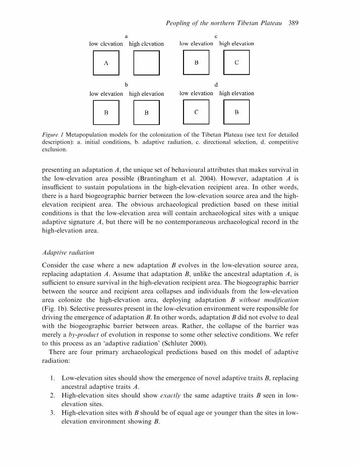
high-elevation recipient area to be colonized (Fig. 1a). The two areas are assumed to be
connected by one or more corridors. Initially, the source area is occupied by a population
388 P. Jeffrey Brantingham and Gao Xing
presenting an adaptation A, the unique set of behavioural attributes that makes survival in
the low-elevation area possible (Brantingham et al. 2004). However, adaptation A is
insufficient to sustain populations in the high-elevation recipient area. In other words,
there is a hard biogeographic barrier between the low-elevation source area and the high-
elevation recipient area. The obvious archaeological prediction based on these initial
conditions is that the low-elevation area will contain archaeological sites with a unique
adaptive signature A, but there will be no contemporaneous archaeological record in the
high-elevation area.
Adaptive radiation
Consider the case where a new adaptation B evolves in the low-elevation source area,
replacing adaptation A. Assume that adaptation B, unlike the ancestral adaptation A, is
sufficient to ensure survival in the high-elevation recipient area. The biogeographic barrier
between the source and recipient area collapses and individuals from the low-elevation
area colonize the high-elevation area, deploying adaptation B without modification
(Fig. 1b). Selective pressures present in the low-elevation environment were responsible for
driving the emergence of adaptation B. In other words, adaptation B did not evolve to deal
with the biogeographic barrier between areas. Rather, the collapse of the barrier was
merely a by-product of evolution in response to some other selective conditions. We refer
to this process as an ‘adaptive radiation’ (Schluter 2000).
There are four primary archaeological predictions based on this model of adaptive
radiation:
1. Low-elevation sites should show the emergence of novel adaptive traits B, replacing
ancestral adaptive traits A.
2. High-elevation sites should show exactly the same adaptive traits B seen in low-
elevation sites.
3. High-elevation sites with B should be of equal age or younger than the sites in low-
elevation environment showing B.
Figure 1 Metapopulation models for the colonization of the Tibetan Plateau (see text for detaileddescription): a. initial conditions, b. adaptive radiation, c. directional selection, d. competitive
exclusion.
Peopling of the northern Tibetan Plateau 389
4. To be uniquely representative of an adaptive radiation, sites in high-elevation areas
must be older than any sites in lower-elevation areas presenting additional novel
adaptations C (see below).
Directional selection
An alternative model also begins with a new adaptation B evolving in the low-elevation
source area. Adaptation B allows some limited expansion into the high-elevation recipient
area, but is insufficient on its own to ensure survival there. Unique traits evolve in the high-
elevation area and the resulting new adaptation C does ensure survival (Fig. 1c). In this
case, we can say that unique selective pressures in the high-elevation environment were
ultimately responsible for ensuring successful colonization. In other words, the observed
adaptive traits in the high-elevation are not a by-product of evolutionary processes opera-
ting in low-elevation environments, but a direct response to the biogeographic problem
of colonizing an extreme environment. We refer to this process as ‘directional selection’.
Four archaeological predictions arise from this simple model:
1. Low-elevation sites should show the emergence of novel adaptive traits B, replacing
ancestral adaptive traits A.
2. High-elevation sites should show novel adaptive features C not seen in low-
elevation sites.
3. The high-elevation sites with C should be of equal age or younger than sites with B
seen in low elevation.
4. The sites with novel features C should be either unique to the high-elevation area or
older than any sites with C seen in the low-elevation area.
Prediction 4 is necessary to allow for the possibility that specialized high-elevation
adaptations may have been subsequently exported to low-elevation environments.
Competitive exclusion
A final model also begins with the emergence of a new adaptation B in the low-elevation
source area. While this adaptation might have ensured a minimum level of survival within
the high-elevation area, little or no occupation actually ensues. At some later point in time,
a second novel adaptation C appears in the low-elevation area. Segments of the low-
elevation population retaining – for whatever reason – the ancestral adaptation B are
displaced or marginalized into the high-elevation area (Fig. 1d). In this case, we might say
that the evolution of adaptation B softened the biogeographic barrier between areas but
that additional demographic or cultural pressures in the low-elevation area were ultimately
necessary to drive the dispersal of individuals onto the high plateau. We refer to this
process as ‘competitive exclusion’.
Four archaeological predictions may be derived from this final model:
1. Low-elevation sites should show the emergence of novel adaptive traits B, replacing
ancestral adaptive traits A.
390 P. Jeffrey Brantingham and Gao Xing
2. Low-elevation sites should show emergence of a second set of novel adaptive traits
C, replacing adaptive traits B.
3. High-elevation sites will show retention of the ancestral traits B and should be
contemporaneous with or younger than sites with C seen in the low-elevation area.
4. Sites with features B should be confined to the high-elevation area, or be older than
any sites with C that appear subsequently in the high-elevation area.
Here we concentrate on evaluating the above models with data collected by us and other
researchers working in north-west China and the northern Tibetan Plateau. The arid
regions of north-west China, including portions of Xinjiang, Gansu, Inner Mongolia and
Ningxia, are treated as the potential source area for colonising populations. The northern
Tibetan Plateau, including all of Qinghai Province and portions of the Tibetan
Autonomous Region north of Seling Co (318 300 N), is defined as the recipient area for
colonization. Archaeological evidence from areas south of Seling Co is discussed only as
appropriate (see Aldenderfer and Zhang 2004).
Topography, environment and climate of the northern Tibetan Plateau
The northern Tibetan Plateau is divided into three elevational steps (Tapponnier
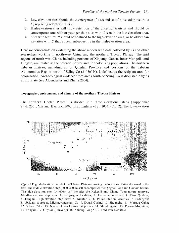
et al. 2001; Yin and Harrison 2000; Brantingham et al. 2003) (Fig. 2). The low-elevation
Figure 2Digital elevation model of the Tibetan Plateau showing the locations of sites discussed in thetext. The middle-elevation step (3000–4000m asl) encompasses the Qinghai Lake and Qaidam basins.
The high-elevation step (44000m asl) includes the Kekexili and Chang Tang nature reserves.Middle-elevation step sites: 1. Jiangxigou localities; 2. Heimahe localities; 3. Xiao Qaidam;4. Lenghu. High-elevation step sites: 5. Xidatan 2; 6. Police Station localities; 7. Erdaogou;
8. obsidian source at Migriggyangzham Co; 9. Dogai Coring; 10. Shuanghu; 11. Margog Caka;12. Yibug Caka; 13. Nyima. Low-elevation step sites: 14. Shuidonggou; 15. Pigeon Mountain;16. Tongxin; 17. Guyuan (Punyang); 18. Zhuang Lang 5; 19. Dadiwan Neolithic.
Peopling of the northern Tibetan Plateau 391
step (53000m asl) is represented by the margins of the plateau, including the arid
foothills of the eastern Kunlun-Altyn Tagh-Qilian Mountains, the adjacent deserts in
Xinjiang, Ningxia and Gansu, and the Western Loess Plateau in Gansu. Overall, the
low-elevation step of the plateau is characterized as a semi-arid to arid region (east to
west) with cold, dry winters and hot, dry summers (Winkler et al. 1993; Madsen et al.
1998; Ding et al. 1999). Biotic communities reflect these climatic conditions: desert
steppe in the east merges with largely unvegetated stony (gobi) and sandy deserts in
the west.
The middle-elevation step of the northern Tibetan Plateau, between c. 3000m and
4000m asl, is bounded by the Altyn Tagh-Qilian Mountain ranges in the north and the
Muzutag-Kunlun-Anyemaqen ranges in the south. These reach maximum elevations of
5500m and 7500m asl, respectively. Two large internal drainage basins dominate the
middle-elevation step, the Qinghai Lake basin in the east and greater Qaidam in the west.
The Qinghai Lake basin lies between about 368 190–378 190 N and 998 190–1018 190 E, andcontains the largest inland body of water in China. At an elevation between 3200m and
3400m asl, it has a cold, semi-arid climate with mean annual temperatures of about 08Cand average annual precipitation of about 350mm (Ni et al. 1999; Yu and Kelts 2002).
The basin ecology is currently characterized as a high, cold grassland meadow (Gong and
Jiang 1999).
The greater Qaidam basin is distributed between approximately 36–398 N and
91–988 E (Tapponnier et al. 2001; Tapponnier and Molnar 1977). The southern Qaidam
is dominated by a single, large drainage basin holding Qarhan Lake and salt flats (Yang
et al. 2004). Numerous small foreland basins in the northern Qaidam retain shallow saline
lakes (e.g. Toson Nur, Xiao Qaidam, Da Qaidam, Sogo Nur, Lenghu) (Metivier et al.
1998; Tapponnier et al. 2001). The greater Qaidam lies within the rain shadow of the
high step of the plateau. Mean annual precipitation ranges from 525mm, in the west, to
190mm, in the east. Mean annual temperatures are between 2 and 48C (Yang et al. 2004).
Permafrost is limited to the higher elevations in the surrounding mountain ranges, though
the entire middle-elevation step of the plateau experiences seasonally frozen ground
(Wu et al. 2005). Vegetation trends from steppe-grassland to desert steppe and gobi as one
moves from east to west (Lehmkuhl and Haselein 2000).
The Muzutag-Kunlun-Anyemaqen Mountain ranges serve as a prominent northern
boundary for the high-elevation step of the plateau. The Greater Himalaya form a
southern boundary, approximately 1000km to the south. The high plateau has an average
elevation of above 5000m asl with very little internal topographic relief (Fielding et al.
1994; Yin and Harrison 2000; Jin et al. 2005). The topographic boundaries, by contrast,
see large changes in elevation of 2000–3000m over distances of only 100–200km (Fielding
et al. 1994). Mean annual precipitation for the entire high plateau (c. 318mm) exceeds
that on the middle-elevation step (Morrill et al. 2003; Schaller 1998: 29). Precipitation in
the south east derives primarily from the South Asian summer monsoon, whereas along
the northern Muzutag-Kunlun-Anyemaqen boundary it derives from the westerly jet
stream (Benn and Owen 1998; Owen et al. in press). Mean annual temperatures are low
(c. 72 to 748C overall) and extensive soil permafrost is supported above 4400m
(Wu et al. 2005). Environments of the high plateau are characterized as alpine desert
steppe (Schaller 1998).
392 P. Jeffrey Brantingham and Gao Xing
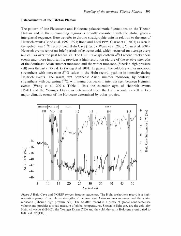
Palaeoclimates of the Tibetan Plateau
The pattern of late Pleistocene and Holocene palaeoclimatic fluctuations on the Tibetan
Plateau and in the surrounding regions is broadly consistent with the global glacial-
interglacial sequence. Here we refer to chrono-stratigraphic units in relation to the ages of
Heinrich events (Bond et al. 1992, 1993; Bond and Lotti 1995; Clarke et al. 2003) as seen in
the speleothem d18O record from Hulu Cave (Fig. 3) (Wang et al. 2001; Yuan et al. 2004).
Heinrich events represent brief periods of extreme cold, which occurred on average every
6–8 cal. ka over the past 60 cal. ka. The Hulu Cave speleothem d18O record tracks these
events and, more importantly, provides a high-resolution picture of the relative strengths
of the Southeast Asian summer monsoon and the winter monsoon (Siberian high pressure
cell) over the last c. 75 cal. ka (Wang et al. 2001). In general, the cold, dry winter monsoon
strengthens with increasing d18O values in the Hulu record, peaking in intensity during
Heinrich events. The warm, wet Southeast Asian summer monsoon, by contrast,
strengthens with decreasing d18O, with numerous peaks in intensity seen between Heinrich
events (Wang et al. 2001). Table 1 lists the calendar ages of Heinrich events
H5-H1 and the Younger Dryas, as determined from the Hulu record, as well as two
major climatic events of the Holocene determined by other proxies.
Figure 3 Hulu Cave and NGRIP oxygen isotope sequences. The Hulu speleothem record is a high-resolution proxy of the relative strengths of the Southeast Asian summer monsoon and the wintermonsoon (Siberian high pressure cell). The NGRIP record is a proxy of global continental ice
volume and provides a broad measure of global temperatures. Shown in light grey are the cold, dryHeinrich events (H1-H5), the Younger Dryas (YD) and the cold, dry early Holocene event dated to8200 cal. BP (EH).
Peopling of the northern Tibetan Plateau 393
Major characteristics of the low-elevation environments bordering the northern Tibetan
Plateau are controlled by the relative strength of the Southeast Asian summer monsoon
(Madsen et al. 1998; Winkler et al. 1993). The shifting balance between the warm, wet
summer and cold, dry winter monsoons drove changes in the sizes of internally draining
lakes and the distribution of flora and fauna. Northwest Chinese deserts were at least as
large as at present during the early Glacial, before H5 (c. 48 cal. ka), and again between
H2 and H1 (c. 24.2–15.8 cal. ka) (Ding et al. 1999; Bush et al. 2002; Xiao et al. 1995). They
were substantially smaller than at present during portions of MIS 3 and in the early
Holocene (11.5–8.2 cal. ka) (Ding et al. 1999). High lake stands are noted throughout
north-west China before H2, followed by desiccation between H2 and H1, and re-
emergence of lakes either during the terminal Pleistocene (between H1 and the Younger
Dryas), or early Holocene (Pachur and Wunnemann 1995; Fang 1991; Zhang et al. 2004).
In general, semi-arid steppe grasslands replaced deserts during the warm, wet events
immediately following H4 (38.8 cal. ka), H3 (30.5 cal. ka) H1 (15.8 cal. ka) and in the
early Holocene (c. 11.5–8.2 cal. ka). The Western Loess Plateau seems to have supported
Betulus, Quercus and Ulmus forests between the end of the Younger Dryas and a cold, dry
event at c. 8200 cal. BP (An et al. 2004), when unvegetated landscapes re-emerged in the
Tengger and steppe expanded on Western Loess Plateau (Chen et al. 2003). Both areas
experienced significant aridification c. 4000 cal. BP (An et al. 2005).
Climatic and environmental conditions on the middle- and high-elevation steps of the
plateau parallel those in the surrounding low-elevation areas. The large, internally
draining lake basins on the middle-elevation step appear to have reached maximum high
stands between H4 and H2, roughly 38–25 cal. ka (Fang 1991). Low stands correspond to
the Last Glacial Maximum, between H2 and H1, roughly 25–15 cal. ka. Moderately
large lakes may have been present on the high-elevation step of the plateau before H2
(c. 24.2 cal. ka) (Wang et al. 2002). These were greatly reduced in size between H2 and H1
and, following glacial termination at c. 15.8 cal. BP, expanded to reach their highest
recorded stands fed by abundant glacial meltwater (Wei and Gasse 1999). Most lakes for
which we have a record show progressive desiccation over the course of the Holocene.
Floral communities on the southern high plateau alternated between steppe and
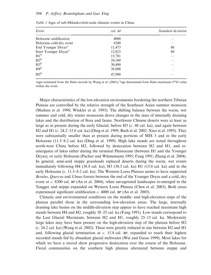
Table 1 Ages of sub-Milankovitch-scale climatic events in China
Event cal. BP Standard deviation
Holocene aridification 4000 –Holocene cold-dry event 8200 –
End Younger Dryasa 11,473 80Start Younger Dryasa 12,823 80H1b 15,781 –
H2b 24,180 –H3b 30,490 –H4b 38,800 –
H5b 47,990 –
aages estimated from the Hulu records by Wang et al. (2001); bage determined from Hulu maximum d18O value
within the event.
394 P. Jeffrey Brantingham and Gao Xing
desert-steppe during warm, wet and cold, dry events respectively (Vancampo and Gasse
1993; Yan et al. 1999). On the northern high plateau, where conditions are far more arid
today, the alternation may have been between desert-steppe and unvegetated landscapes.
Finally, despite forceful claims to the contrary (e.g. Kuhle 1999), at no point during the
late Pleistocene does there appear to have been a continent-sized ice sheet covering the
high-elevation step of the plateau (Benn and Owen 1998; Owen et al. 2003). Rather, glacial
advances were restricted to montane valleys (Owen et al. 2003). The important implication
here is that there was never a physical barrier to human movement onto the plateau.
Chronology and archaeology in the low-elevation source area
Numerous archaeological sites in north-west China are now confidently dated to the
period before H2, with the largest cluster of dated sites straddling H3 (c. 30.5 cal. ka)
(Barton et al. in press). The best-known site of this period is Shuidonggou, located
on the western margins of the Ordos desert, with dates ranging continuously from
c. 35–29 cal. ka (Madsen et al. 2001; Brantingham et al. 2001a; Ningxia Institute of
Archaeology 2003). Far fewer sites are assigned to the time period between H3 and H2
(c. 24.2 cal. ka), but several of these are in Ningxia and western Gansu (Barton et al.
in press; Gao et al. 2004). Shuidonggou Locality 2 contains occupations falling within the
earlier part of this period and Tongxin 3, Tongxin 8 and Guyuan 3 fall towards the end.
Farther to the east, the Xiachuan Localities 1 and 2 may have occupations representing
the period just prior to the Last Glacial Maximum (Chen and Wang 1989; Chung 2000).
Collectively, these sites are classified as initial or early Upper Palaeolithic (Brantingham
et al. 2001a). They are characterized by flat-faced core technologies, like those seen in the
Middle Palaeolithic, which were used to produce large, flat blades. The Upper Palaeolithic
designation is based on both the age of the assemblages and the technological focus on
blades. These were often retouched along one or both edges to form generic large blade
tools (Ningxia Institute of Archaeology 2003). Retouched tools are generic in character,
dominated by types that are considered diagnostic of the Middle Palaeolithic including
many side scrapers, denticulates and notches. At Shuidonggou, raw material usage
appears to focus on moderate-quality materials that are readily available in alluvial
deposits at the site. All of the known pre-H2 sites appear to be small, short-term campsites
representing small, mobile foraging groups (Madsen et al. 2001). Little is known about
their foraging activities, though there is some evidence that medium- and large-sized
ungulates featured prominently in the diet (Qi 1975; Ningxia Museum 1987).
There are nearly as many sites falling between H2 and H1 (24.2 to 15.8 cal. ka) – the
Last Glacial Maximum – as in the preceding period. Sites reported by Barton et al.
(in press) cluster in two events immediately following H2 (c. 24.2 cal. ka) and immediately
preceding H1 (c. 15.8 cal. ka) (Ji et al. 2005). Levallois-like large blades disappear and we
see a shift towards expedient core technologies and (possibly selective) use of poor-quality
raw materials. Zhuang Lang 5, dated to 22.7 cal. ka, for example, appears to represent a
small-scale occupation with an exclusive focus on bipolar reduction of quartz and fine-
grained quartzite cobbles (Barton et al. in press). Zhuang Lang 5 may reflect the
completion of a trend seen at Shuidonggou Locality 2. Madsen et al. (2001) suggest that
Peopling of the northern Tibetan Plateau 395
the turn to bipolar reduction of small chert and quartz pebbles at this site provided large
quantities of small, sharp debitage for use in inset tools, much like formal microblade
insets, but without all of the associated stone procurement and production costs (Elston
and Brantingham 2003).
A number of well-known low-elevation sites date to the period following glacial
termination. Xiaonanhai and Houtouliang contain stratigraphic components that date to
c. 15.8–11.4 cal. ka (Lie 1999). However, these sites lie far to the east of the Tibetan
Plateau. The Pigeon Mountain localities, by contrast, are located within the desert source
area of the plateau and are well dated to between 15.1 and 11.6 cal. ka (Elston et al. 1997;
Madsen et al. 1998). The period following H1 at this site is characterized by heavy-duty
macrolithic tools, as well as simple unifacial and bifacial points (Elston et al. 1997;
Zhang 1999). Intensification is signalled by the appearance of formal microblade
technologies and small, hand-held grinding stones. Microblade technology increases
dramatically in frequency in the Pigeon Mountain sequence between 13,510+ 136 and
11,608+ 183 cal. BP, coinciding with the Younger Dryas (Madsen et al. 1998; Elston et al.
1997).
Following the Younger Dryas there is a substantial gap in the record of dated sites,
which probably reflects a lack of research on deposits of the right age. Initial low-
level agricultural activities at sites such as Dadiwan (358 010 N, 1058 550 E, 1500m asl,
7800 cal. BP) are, within a millennium, converted into intensive agricultural adaptations
focused around large, complex, permanent settlements associated with Yangshao (6900–
5300 cal. BP) and Majiayao (5300–4200 cal. BP) cultures (An et al. 2004). The rapid
transition from semi-arid conditions to arid conditions around 4000 cal. BP may have
driven a reduction in the total number and distribution of agricultural settlements over the
Western Loess Plateau (An et al. 2005). Nomadic pastoralism appears to have become a
viable alternative to rain-fed agricultural sometime during the Qijia (c. 4300–3900 cal. BP).
Chronology and archaeology on the middle-elevation step
Two archaeological sites on the middle-elevation step of the Tibetan Plateau may
represent initial human forays onto the plateau prior to H2 (c. 24.2 cal. ka). Lenghu
locality 1 (388 510 0.000 N, 938 240 36.000 E, 2804m asl) is a small surface scatter of stone tools
found horizontally stratified between two well-preserved beach ridges that correspond to
lake high stands following H4 (c. 38.8 cal. ka) and H3 (c. 30.5 cal. ka) (Fig. 4) (Owen et al.
in press; Ma 1996). We therefore tentatively assign these materials a minimum age of
around 30.5 cal. ka and note that the degree of wind ablation seen on the artefacts is
consistent with a very long period of surface exposure. The Lenghu lithic specimens are
typologically indistinguishable from the Levallois-like blade technology seen at
Shuidonggou and other early Upper Palaeolithic occurrences in the low-elevation source
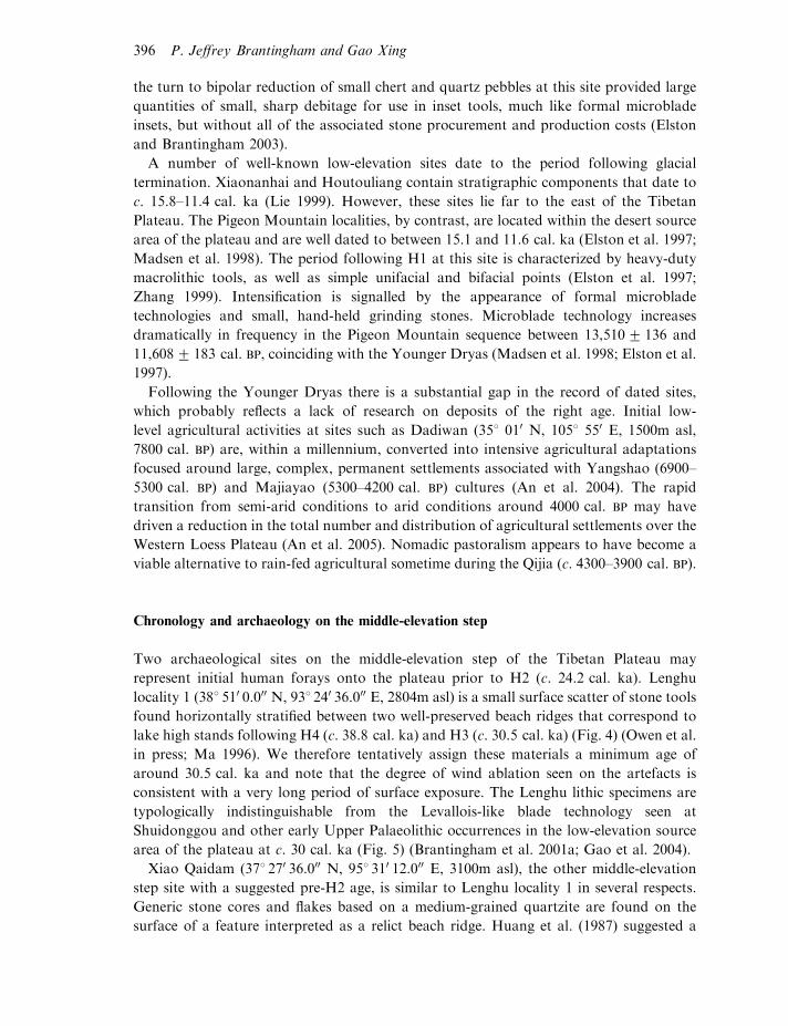
area of the plateau at c. 30 cal. ka (Fig. 5) (Brantingham et al. 2001a; Gao et al. 2004).
Xiao Qaidam (378 270 36.000 N, 958 310 12.000 E, 3100m asl), the other middle-elevation
step site with a suggested pre-H2 age, is similar to Lenghu locality 1 in several respects.
Generic stone cores and flakes based on a medium-grained quartzite are found on the
surface of a feature interpreted as a relict beach ridge. Huang et al. (1987) suggested a
396 P. Jeffrey Brantingham and Gao Xing
minimum age of c. 38 cal. ka for these materials based on a radiocarbon date on lake
sediments from the adjacent Da Qaidam basin. Our own field investigations identified
lithic technologies identical in character to those at Xiao Qaidam (e.g. raw material type,
size and shape, technological forms) in direct association with Han Dynasty (c. 2000 cal.
BP) ceramics in the nearby Iqe River (Yucha He) drainage. This association brings into
question the pre-H2 age assignment for the Xiao Qaidam materials.
Three sites in the Qinghai Lake basin register human occupation of the middle-elevation
step of the plateau in the interval between H1 (c. 15.8 cal. ka) and the beginning of the
Younger Dryas (c. 12.4 cal. ka) (Fig. 6) (Madsen et al. in press). Jiangxigou 1 (368 250 24.000
N, 1008 180 0.000 E, 3330m asl) is a buried archaeological site located at the head of a small
stream flowing north into Qinghai Lake. Charcoal recovered from two separate features
yielded AMS radiocarbon dates of 14,690+ 150 and 14,760+ 150 cal. BP, respectively
(Table 2). Similar ages have been obtained from a nearby site, Locality 93-13 (Porter et al.
2001; Madsen et al. in press). The two features represent unprepared hearths associated
with concentrations of stream cobbles, broken and burned bone, and small lithic scatters
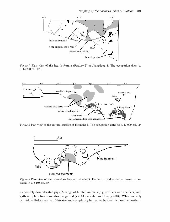
including microblades and related debitage (Fig. 7).
Heimahe 1 (368 430 48.000 N, 998 460 12.000 E, 3210m asl), 65km west of Jiangxigou 1, is
situated away from themountain front in the current flood plain of the smallHeimaheRiver.
Two buried hearth features are dated to c. 13,010+ 109 cal. BP (Table 2). The site is very
similar to Jiangxigou 1 in both its structure and contents (Fig. 8). Artefacts distributed on
the use surface include possible bifacial thinning flakes, microblade fragments, a bifacially
worked slate scraper and a ground stone cobble (Madsen et al. in press). Numerous burned
and/or calcined bone specimens represent a medium-sized ungulate, possibly gazelle and
several eggshell fragments from hen/duck-sized birds were also recovered.
An occupation signature is again detected on the middle-elevation step of the plateau
during the early Holocene (511.5 cal. ka). In the Qinghai Lake basin, two sites have been
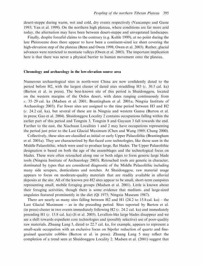
Figure 4 OSL, TL and radiocarbon dates for ice-wedge casts and other sedimentary features in the*45m beach (c. 2780m asl) at Lenghu. The OSL and TL dates indicate that the beach gravels must
have accumulated before H2 (24.2 cal. ka). The most likely timing for the *45m high stand is thewarm, wet event following H3 (30.5 cal. ka). The radiocarbon dated lake mud in this section maycorrespond to a lake high stand that formed the next highest beach, suggesting a correlation with the
warm event following H4 (38.8 cal. ka). Artefacts found on the surface above the *45m and belowthe *57m beach are assigned a minimum age of c. 28–30 cal. ka and maximum age of c. 37 cal. kabased on their horizontal stratigraphic position.
Peopling of the northern Tibetan Plateau 397
dated to this interval. Jiangxigou 2, across the drainage from locality 1, is a *1.2m thick
midden and ash deposit with abundant microblades (one specimen based on obsidian),
fragmentary faunal remains and at least two types of ceramics (see Fig. 6). Radiocarbon
dates suggest that the site was occupied, perhaps continuously, between 9140 and 5580 cal.
BP (Table 2). By contrast, Heimahe 3 (368 430 N, 998 470 E, 3202m asl) is contemporaneous
with Jiangxigou 2 but, like the earlier occupations in the area, Heimahe 3 is an
isolated hearth with a small collection of fragmentary bone, generalized flaked stone tools
and a small number of formal microblades (Fig. 9). It would appear that short-term
foraging camps focused on procurement and processing of a gazelle-sized ungulate
remained part of the settlement system of the middle step of the plateau until at least c.
8450 cal. BP, the calibrated radiocarbon age for Heimahe 3.
The earliest evidence for non-foraging adaptations at high elevation comes from
southern Tibetan Plateau, at an elevation similar to the middle-elevation step of the
northern plateau. Karou, dated to c. 5758 cal. BP, preserves formal architecture, storage
pits and a rich assemblage of ceramic, chipped stone and ground stone technologies
(CPAM 1985; Aldenderfer and Zhang 2004). Cultivated millet has been identified, as well
Figure 5 An early Upper Palaeolithic Levallois-like blade from Lenghu locality 1.
398 P. Jeffrey Brantingham and Gao Xing
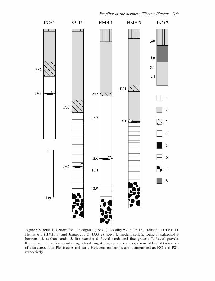
Figure 6 Schematic sections for Jiangxigou 1 (JXG 1), Locality 93-13 (93-13), Heimahe 1 (HMH 1),Heimahe 3 (HMH 3) and Jiangxigou 2 (JXG 2). Key: 1. modern soil; 2. loess; 3. palaeosol Bhorizons; 4. aeolian sands; 5. fire hearths; 6. fluvial sands and fine gravels; 7. fluvial gravels;8. cultural midden. Radiocarbon ages bordering stratigraphic columns given in calibrated thousands
of years ago. Late Pleistocene and early Holocene palaeosols are distinguished as PS2 and PS1,respectively.
Peopling of the northern Tibetan Plateau 399
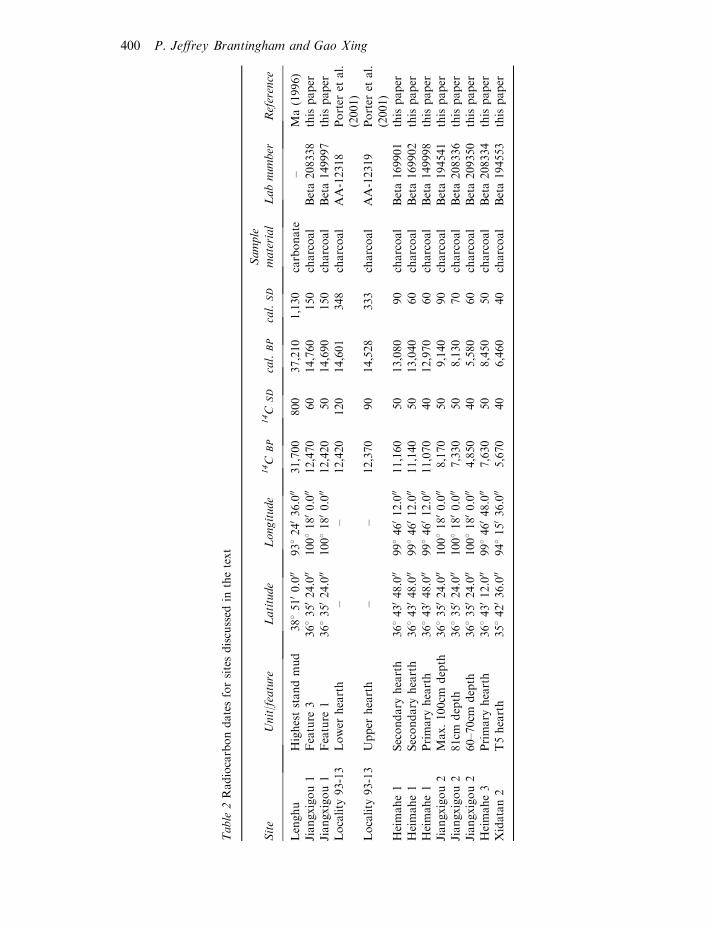
Table
2Radiocarbondatesforsitesdiscussed
inthetext
Site
Unit/feature
Latitude
Longitude
14C
BP
14C
SD
cal.
BP
cal.
SD
Sample
material
Labnumber
Reference
Lenghu
Higheststandmud
3885100.000
93824036.000
31,700
800
37,210
1,130
carbonate
–Ma(1996)
Jiangxigou1
Feature
336835024.000
10081800.000
12,470
60
14,760
150
charcoal
Beta208338
thispaper
Jiangxigou1
Feature
136835024.000
10081800.000
12,420
50
14,690
150
charcoal
Beta149997
thispaper
Locality
93-13
Lower
hearth
––
12,420
120
14,601
348
charcoal
AA-12318
Porter
etal.
(2001)
Locality
93-13
Upper
hearth
––
12,370
90
14,528
333
charcoal
AA-12319
Porter
etal.
(2001)
Heimahe1
Secondary
hearth
36843048.000
99846012.000
11,160
50
13,080
90
charcoal
Beta169901
thispaper
Heimahe1
Secondary
hearth
36843048.000
99846012.000
11,140
50
13,040
60
charcoal
Beta169902
thispaper
Heimahe1
Primary
hearth
36843048.000
99846012.000
11,070
40
12,970
60
charcoal
Beta149998
thispaper
Jiangxigou2
Max.100cm
depth
36835024.000
10081800.000
8,170
50
9,140
90
charcoal
Beta194541
thispaper
Jiangxigou2
81cm
depth
36835024.000
10081800.000
7,330
50
8,130
70
charcoal
Beta208336
thispaper
Jiangxigou2
60–70cm
depth
36835024.000
10081800.000
4,850
40
5,580
60
charcoal
Beta209350
thispaper
Heimahe3
Primary
hearth
36843012.000
99846048.000
7,630
50
8,450
50
charcoal
Beta208334
thispaper
Xidatan2
T5hearth
35842036.000
94815036.000
5,670
40
6,460
40
charcoal
Beta194553
thispaper
400 P. Jeffrey Brantingham and Gao Xing
as possibly domesticated pigs. A range of hunted animals (e.g. red deer and roe deer) and
gathered plant foods are also recognized (see Aldenderfer and Zhang 2004). While an early
or middle Holocene site of this size and complexity has yet to be identified on the northern
Figure 7 Plan view of the hearth feature (Feature 3) at Jiangxigou 1. The occupation dates toc. 14,700 cal. BP.
Figure 8 Plan view of the cultural surface at Heimahe 1. The occupation dates to c. 13,000 cal. BP.
Figure 9 Plan view of the cultural surface at Heimahe 3. The hearth and associated materials aredated to c. 8450 cal. BP.
Peopling of the northern Tibetan Plateau 401
plateau, Jiangxigou 2 (c. 9–6 cal. ka) is similar to Karou in many respects. Future research
at this site may clarify whether there are any domesticated plants or animals present in
addition to the ceramics already identified.
Chronology and archaeology on the high-elevation step
Several sites have been discussed as a representing possible pre-H2 occupation of the high-
elevation step of the northern plateau (Huang 1994; Aldenderfer and Zhang 2004;
Brantingham et al. 2001b; An 1982). Age assignments for most of them are based on lithic
techno-typological systematics, usually emphasizing the presence of Middle Palaeolithic-
type tools (e.g. side scrapers). Some sites in the Chang Tang, identified by Schaller (1998)
and reported by Brantingham et al. (2001b), have technological characteristics reminiscent
of Middle Palaeolithic Levallois technology, which might suggest an age of c. 30 cal. ka,
or even earlier (see Brantingham et al. 2001a). But, other assemblages present
characteristics that appear to be derived from the Northeast Asian early Upper
Palaeolithic, which lead Brantingham et al. (2001b) to suggest that they were Last
Glacial Maximum in age. However, current evidence suggests that these early age
assignments are not warranted. Rather, the lithic technologies seen at sites in the Kekexili,
Chang Tang and other areas of the high plateau are now reliably dated at one site to the
early Holocene.
Only one site on the entire plateau has been discussed as falling between H2 and H1,
24.2–15.8 cal. ka. Located approximately 85km outside Lhasa, at 4200m asl, Chusang (or
Quesang) consists of a series of hand and footprints and a possible hearth found in a
hardened spring travertine (Zhang and Li 2002; Aldenderfer and Zhang 2004). Zhang and
Li (2002) obtained OSL dates of between 20 and 22 cal. ka from sands imbedded in the
travertine sediments, providing possible maximum ages for the hand and footprints.
Taken at face value, these ages suggest that human populations may have ventured onto
the high plateau as early as 22 cal. ka. More recent age determinations suggest an age of
around 11 cal. ka (Aldenderfer in press). However, extensive replication of dates from this
site is necessary given the possibility that non-aeolian, detrital sand grains may make up a
fraction of the quartz being used for dating. Detrital sand is more likely to be unbleached,
leading to OSL ages that are too old. Unfortunately, no other archaeological remains have
been identified at Chusang. If evidence from the low-elevation source area is used as a
guide and the OSL ages are correct, then we might expect to see an emphasis on simple
bipolar technologies based on moderate- to low-quality raw materials (Barton et al.
in press). Such technological characteristics are, of course, not chronologically diagnostic,
making accurate geochronology and stratigraphic control essential for identifying any
H2-H1 occupations on the plateau.
No sites are known presently from the high-elevation step of the plateau dating to the
interval between H1 and the onset of the Younger Dryas, despite having deposits of
appropriate age (Brantingham et al. in prep.; Van Der Woerd et al. 2002), and neither area
has yet yielded sites falling within the Younger Dryas (c. 12,823–11,473 cal. BP).
The oldest, reliably dated site on the high-elevation step of the plateau is assigned to the
early Holocene. Xidatan 2 (358 420 36.000 N, 948 150 36.000 E, 4300m asl) lies on the middle
402 P. Jeffrey Brantingham and Gao Xing
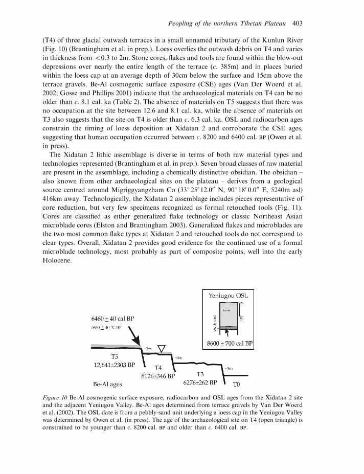
(T4) of three glacial outwash terraces in a small unnamed tributary of the Kunlun River
(Fig. 10) (Brantingham et al. in prep.). Loess overlies the outwash debris on T4 and varies
in thickness from 50.3 to 2m. Stone cores, flakes and tools are found within the blow-out
depressions over nearly the entire length of the terrace (c. 385m) and in places buried
within the loess cap at an average depth of 30cm below the surface and 15cm above the
terrace gravels. Be-Al cosmogenic surface exposure (CSE) ages (Van Der Woerd et al.
2002; Gosse and Phillips 2001) indicate that the archaeological materials on T4 can be no
older than c. 8.1 cal. ka (Table 2). The absence of materials on T5 suggests that there was
no occupation at the site between 12.6 and 8.1 cal. ka, while the absence of materials on
T3 also suggests that the site on T4 is older than c. 6.3 cal. ka. OSL and radiocarbon ages
constrain the timing of loess deposition at Xidatan 2 and corroborate the CSE ages,
suggesting that human occupation occurred between c. 8200 and 6400 cal. BP (Owen et al.
in press).
The Xidatan 2 lithic assemblage is diverse in terms of both raw material types and
technologies represented (Brantingham et al. in prep.). Seven broad classes of raw material
are present in the assemblage, including a chemically distinctive obsidian. The obsidian –
also known from other archaeological sites on the plateau – derives from a geological
source centred around Migriggyangzham Co (338 250 12.000 N, 908 180 0.000 E, 5240m asl)
416km away. Technologically, the Xidatan 2 assemblage includes pieces representative of
core reduction, but very few specimens recognized as formal retouched tools (Fig. 11).
Cores are classified as either generalized flake technology or classic Northeast Asian
microblade cores (Elston and Brantingham 2003). Generalized flakes and microblades are
the two most common flake types at Xidatan 2 and retouched tools do not correspond to
clear types. Overall, Xidatan 2 provides good evidence for the continued use of a formal
microblade technology, most probably as part of composite points, well into the early
Holocene.
Figure 10 Be-Al cosmogenic surface exposure, radiocarbon and OSL ages from the Xidatan 2 siteand the adjacent Yeniugou Valley. Be-Al ages determined from terrace gravels by Van Der Woerdet al. (2002). The OSL date is from a pebbly-sand unit underlying a loess cap in the Yeniugou Valley
was determined by Owen et al. (in press). The age of the archaeological site on T4 (open triangle) isconstrained to be younger than c. 8200 cal. BP and older than c. 6400 cal. BP.
Peopling of the northern Tibetan Plateau 403
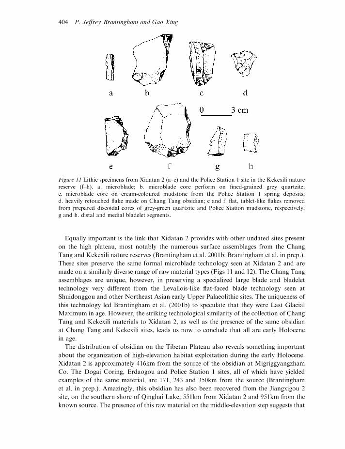
Equally important is the link that Xidatan 2 provides with other undated sites present
on the high plateau, most notably the numerous surface assemblages from the Chang
Tang and Kekexili nature reserves (Brantingham et al. 2001b; Brantingham et al. in prep.).
These sites preserve the same formal microblade technology seen at Xidatan 2 and are
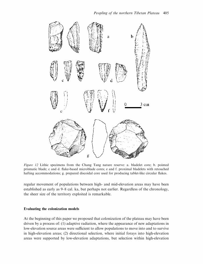
made on a similarly diverse range of raw material types (Figs 11 and 12). The Chang Tang
assemblages are unique, however, in preserving a specialized large blade and bladelet
technology very different from the Levallois-like flat-faced blade technology seen at
Shuidonggou and other Northeast Asian early Upper Palaeolithic sites. The uniqueness of
this technology led Brantingham et al. (2001b) to speculate that they were Last Glacial
Maximum in age. However, the striking technological similarity of the collection of Chang
Tang and Kekexili materials to Xidatan 2, as well as the presence of the same obsidian
at Chang Tang and Kekexili sites, leads us now to conclude that all are early Holocene
in age.
The distribution of obsidian on the Tibetan Plateau also reveals something important
about the organization of high-elevation habitat exploitation during the early Holocene.
Xidatan 2 is approximately 416km from the source of the obsidian at Migriggyangzham
Co. The Dogai Coring, Erdaogou and Police Station 1 sites, all of which have yielded
examples of the same material, are 171, 243 and 350km from the source (Brantingham
et al. in prep.). Amazingly, this obsidian has also been recovered from the Jiangxigou 2
site, on the southern shore of Qinghai Lake, 551km from Xidatan 2 and 951km from the
known source. The presence of this raw material on the middle-elevation step suggests that
Figure 11 Lithic specimens from Xidatan 2 (a–e) and the Police Station 1 site in the Kekexili nature
reserve (f–h). a. microblade; b. microblade core perform on fined-grained grey quartzite;c. microblade core on cream-coloured mudstone from the Police Station 1 spring deposits;d. heavily retouched flake made on Chang Tang obsidian; e and f. flat, tablet-like flakes removed
from prepared discoidal cores of grey-green quartzite and Police Station mudstone, respectively;g and h. distal and medial bladelet segments.
404 P. Jeffrey Brantingham and Gao Xing
regular movement of populations between high- and mid-elevation areas may have been
established as early as 9–8 cal. ka, but perhaps not earlier. Regardless of the chronology,
the sheer size of the territory exploited is remarkable.
Evaluating the colonization models
At the beginning of this paper we proposed that colonization of the plateau may have been
driven by a process of: (1) adaptive radiation, where the appearance of new adaptations in
low-elevation source areas were sufficient to allow populations to move into and to survive
in high-elevation areas; (2) directional selection, where initial forays into high-elevation
areas were supported by low-elevation adaptations, but selection within high-elevation
Figure 12 Lithic specimens from the Chang Tang nature reserve: a. bladelet core; b. pointedprismatic blade; c and d. flake-based microblade cores; e and f. proximal bladelets with retouchedhafting accommodations; g. prepared discoidal core used for producing tablet-like circular flakes.
Peopling of the northern Tibetan Plateau 405
environments ultimately led to the emergence of unique adaptive characteristics necessary
to ensure survival; or (3) competitive exclusion, where the evolution of superior adaptive
strategies in low-elevation environments pushed populations retaining ancestral adapta-
tions into suboptimal high-elevation habitats. We found evidence to support each of these
models during different stages of colonization.
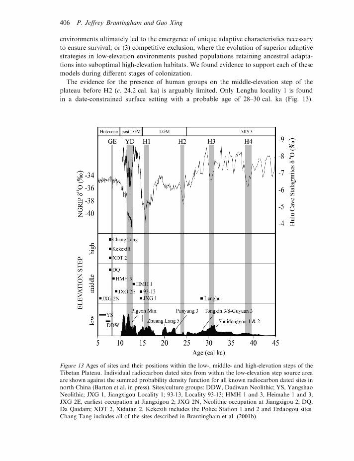
The evidence for the presence of human groups on the middle-elevation step of the
plateau before H2 (c. 24.2 cal. ka) is arguably limited. Only Lenghu locality 1 is found
in a date-constrained surface setting with a probable age of 28–30 cal. ka (Fig. 13).
Figure 13 Ages of sites and their positions within the low-, middle- and high-elevation steps of theTibetan Plateau. Individual radiocarbon dated sites from within the low-elevation step source areaare shown against the summed probability density function for all known radiocarbon dated sites in
north China (Barton et al. in press). Sites/culture groups: DDW, Dadiwan Neolithic; YS, YangshaoNeolithic; JXG 1, Jiangxigou Locality 1; 93-13, Locality 93-13; HMH 1 and 3, Heimahe 1 and 3;JXG 2E, earliest occupation at Jiangxigou 2; JXG 2N, Neolithic occupation at Jiangxigou 2; DQ,
Da Qaidam; XDT 2, Xidatan 2. Kekexili includes the Police Station 1 and 2 and Erdaogou sites.Chang Tang includes all of the sites described in Brantingham et al. (2001b).
406 P. Jeffrey Brantingham and Gao Xing
The Lenghu materials are thus the same age as or slightly younger than the oldest early
Upper Palaeolithic assemblages known in north-west China. The fact that the Lenghu
materials are also identical to the Levallois-like flat-faced blade technologies seen at
Shuidonggou and other early Upper Palaeolithic sites on the low-elevation step further
support a 28–30 cal. ka age assignment. Overall, the appearance of early Upper
Palaeolithic blade technologies on the middle-elevation step of the plateau is consistent
with an adaptive radiation model for colonization: specialized large blade technologies
appear first in low-elevation source areas and only subsequently in high-elevation recipient
areas with no apparent modification. The emergence of the early Upper Palaeolithic
appears to have lowered, at least partially, the biogeographic barrier to human movements
onto the middle-elevation step of the Tibetan Plateau. Selective pressures operating within
low-elevation environments are thus responsible for (small) changes in human biogeo-
graphic capacities at this time.
While there is no reliable evidence for human occupation anywhere on the plateau
between H2 and H1 (c. 24.2–15.8 cal. ka), there is growing evidence for a significant
presence of human groups on the middle-elevation step during the post-glacial period
(Fig. 13). These groups appear to have made use of specialized microblade technologies,
like those seen over a wide area of Northeast Asia, as well as more generic, heavy-duty
chipped stone tools and simple hand-held grinding equipment. Sites in the middle-
elevation step Qinghai Lake basin, which predate the Younger Dryas at c. 12.8 cal. ka,
represent short-term foraging camps where activities were centred around simple hearth
features and were focused on intensive processing of medium- and small-sized game. As
was the case earlier, the appearance of late Upper Palaeolithic adaptations on the middle-
elevation step of the Plateau, with little or no apparent modification and shortly after their
emergence in greater Northeast Asia, is strongly suggestive of a process of adaptive
radiation. Low elevation selective pressures drove the emergence of the late Upper
Palaeolithic and these adaptations (further) lowered the barrier to population movements
onto the Tibetan Plateau.
The situation may have been quite different during the early Holocene. At this time
we see the first unequivocal evidence for exploitation of the high-elevation step of the
Plateau. Buried archaeological materials at Xidatan 2 are dated between c. 8.2 and
6.4 cal. ka (Fig. 13). The Xidatan 2 assemblage is broadly similar to the late Upper
Palaeolithic in low-elevation environments. Shared technological attributes and stone
raw material types link sites in the Kekexili and Chang Tang to Xidatan 2. We now
believe that the former surface assemblages are all early Holocene in age (contra
Brantingham et al. 2001b).
If these early Holocene high-elevation sites were produced by dedicated, full-time
foragers, then it is possible to invoke a model of competitive exclusion to explain some
of their archaeological characteristics and spatiotemporal distribution. Xidatan 2 was
occupied at a time when early agricultural adaptations were coming to dominate
landscapes within the low-elevation source areas around the plateau (Fig. 13). The
Dadiwan Neolithic appears on the Western Loess Plateau abruptly around 7800 cal. BP,
but the initial steps towards a fully fledged agricultural adaptation should precede this
date by several centuries, if not several millennia. By 6800 cal. BP intensive settled
agricultural communities are found over a widespread area of north and north-west
Peopling of the northern Tibetan Plateau 407
China, all of which are generally assigned to the early Yangshao (An et al. 2004). We
believe that the emergence of agricultural adaptations in the low-elevation areas
surrounding the northern Tibet Plateau and the synchronous appearance of the first
well-dated examples of human exploitation of the high-elevation step of the plateau is
not coincidental. Both events fall towards the end of the regional Holocene optimum.
In low-elevation environments, warm, wet conditions dramatically increased the
productivity of proto-domesticated millet-making agricultural specialization feasible
(An et al. 2004; Richerson et al. 2001). In high-elevation environments, these same
warm, wet conditions may have stimulated the expansion of mesic (as opposed to arid)
steppe-grasslands and game populations would have flourished. Filling of low-elevation
environments with agricultural populations thus may have pushed foragers up onto the
plateau, while the pull of reasonably rich faunal communities at higher elevations may
have encouraged displacement, rather than outright replacement (Spielmann and Eder
1994). In sum, late Upper Palaeolithic adaptations prevalent in low-elevation environ-
ments surrounding the plateau, during and immediately after the Younger Dryas
(c. 12.8–11.4 cal. ka), may have provided some entrance into high-elevation environ-
ments. However, competitive exclusion from low-elevation environments by early
farming populations may have been responsible for making occupation of the high
plateau more permanent.
Several features of the assemblages seen on the high-elevation step of the plateau
suggest, however, that competitive exclusion was not the only process at play in driving
early Holocene colonization of the high-elevation step of the plateau. The large, flat
blade and bladelet technologies of the Chang Tang are derived from a late Upper
Palaeolithic substrate, but present attributes that are unknown in the low-elevation
environments that surround the plateau. Although these blade products tend to be
quite large, they appear to have been produced by methods similar to that used for
making microblades, but not regularly for large blades. Retouch patterns on some of
the Chang Tang specimens seem to suggest that large blades and bladelets were
sometimes end-hafted as spear points, also a pattern unseen in the early or late Upper
Palaeolithic of Northeast Asia. Finally, stone raw material transport patterns appear to
represent stone procurement distances that are at least an order of magnitude further
than anything previously documented in the Palaeolithic of Northeast Asia. All of
these features lead us to suggest that the early Holocene lithic assemblages from the
high-elevation step of the plateau represent uniquely evolved strategies linked to the
extreme selective pressures of high-elevation environments. Why these selective
pressures did not impact on earlier incursions onto the middle-elevation step of
the plateau remains an open question. The answer may lie, however, in the observation
that directional selection during the early Holocene may have followed immediately on
the heels of a period of competitive exclusion that necessitated more permanent
occupation of the plateau.
Finally, we note that the appearance of fully fledged agricultural settlements on the
plateau after 6000 cal. BP appears to reflect another period of adaptive radiation from low-
elevation source areas to middle-elevation sites, this time leading to successful establish-
ment of full-time, year-round occupations (Fig. 13). Karou, for example, shows a largely
unmodified low-elevation adaptive pattern based on permanent architecture, storage
408 P. Jeffrey Brantingham and Gao Xing
features and the use of low-elevation domesticated plants and animals. Less is known
about Jiangxigou 2 at Qinghai Lake, but the presence of large accumulations of debris
(ash, rock and animal bones) and the use ceramic vessels suggests lengthy, if not
permanent occupation. The impact of this adaptive radiation on resident foraging
populations, if they were present, is still unknown.
Acknowledgements
This work was supported by the US National Science Foundation (INT-0214870), Santa
Fe Institute, University of California Los Angeles, Desert Research Institute, University
of Nevada, University of Arizona, and A. Richard Diebold, Jr., USA, and by the Qinghai
Institute of Salt Lakes and the Institute of Vertebrate Palaeontology and Palaeoan-
thropology, Chinese Academy of Sciences, PR China. Numerous individuals contributed
directly to the research presented here, including Robert Finkel, Steve Forman, Donald
Grayson, Ma Haizhou, David Madsen, John Olsen, Lewis Owen, David Rhode, Zhang
Haiying and Zhang Xiying.
P. Jeffrey Brantingham,
Department of Anthropology, University of California, Los Angeles
Gao Xing,
Institute of Vertebrate Palaeontology and Palaeoanthropology,
Chinese Academy of Sciences, Beijing
References
Aldenderfer, M. in press. Modeling the Neolithic on the Tibetan Plateau. In Human Adaptation toClimate Change in Arid China (ed. D. B. Madsen).
Aldenderfer, M. and Zhang, Y. N. 2004. The prehistory of the Tibetan plateau to the seventh centuryAD: perspectives and research fromChina and theWest since 1950. Journal ofWorld Prehistory, 18(1):1–55.
An, C. B., Feng, Z. D. and Tang, L. Y. 2004. Environmental change and cultural response between8000 and 4000 cal. yr BP in the western Loess Plateau, northwest China. Journal of QuaternaryScience, 19(6): 529–35.
An, C. B., Tang, L. Y., Barton, L. and Chen, F. H. 2005. Climate change and cultural responsearound 4000 cal. yr BP in the western part of Chinese Loess Plateau. Quaternary Research, 63(3):
347–52.
An, Z. 1982. Paleoliths and microliths from Shenjia and Shuanghu, Northern Tibet. Current
Anthropology, 23: 493–9.
Barton, L., Brantingham, P. J. and Ji, D. in press. Late Pleistocene climate change and Paleolithiccultural evolution in northern China: implications from the Last Glacial Maximum. In Human
Adaptation to Climate Change in Arid China (ed. D. B. Madsen).
Beall, C. M. 2001. Adaptations to altitude: a current assessment. Annual Review of Anthropology, 30:
423–56.
Peopling of the northern Tibetan Plateau 409
Beall, C. M., Song, K. J., Elston, R. C. and Goldstein, M. C. 2004. Higher offspring survival among
Tibetan women with high oxygen saturation genotypes residing at 4,000m. Proceedings of theNational Academy of Sciences of the United States of America, 101(39): 14300–4.
Benn, D. I. and Owen, L. A. 1998. The role of the Indian summer monsoon and the mid-latitudewesterlies in Himalayan glaciation: review and speculative discussion. Journal of the GeologicalSociety of London, 155: 353–63.
Bond, G. C. and Lotti, R. 1995. Iceberg discharges into the North-Atlantic on millennial time scalesduring the Last Glaciation. Science, 267(5200): 1005–10.
Bond, G., Heinrich, H., Broecker, W., Labeyrie, L., McManus, J., Andrews, J., Huon, S.,Jantschik, R., Clasen, S., Simet, C., Tedesco, K., Klas, M., Bonani, G. and Ivy, S. 1992. Evidence formassive discharges of icebergs into the North-Atlantic Ocean during the Last Glacial period. Nature,
360(6401): 245–9.
Bond, G., Broecker, W., Johnsen, S., McManus, J., Labeyrie, L., Jouzel, J. and Bonani, G. 1993.Correlations between climate records from North Atlantic sediments and Greenland ice. Nature,
365(6442): 143.
Brantingham, P. J., Krivoshapkin, A. I., Li, J. and Tserendagva, Y. 2001a. The Initial Upper
Paleolithic in Northeast Asia. Current Anthropology, 42: 735–46.
Brantingham, P. J., Olsen, J. W. and Schaller, G. B. 2001b. Lithic assemblages from the Chang Tang
Region, Northern Tibet. Antiquity, 75: 319–27.
Brantingham, P. J., Haizhou, M. A., Olsen, J. W., Gao, X., Madsen, D. B. and Rhode, D. E. 2003.Speculation on the timing and nature of Late Pleistocene hunter-gatherer colonization of the Tibetan
Plateau. Chinese Science Bulletin, 48(14): 1510–16.
Brantingham, P. J., Kuhn, S. L. and Kerry, K. W. 2004. On the difficulty of the Middle-Upper
Paleolithic transitions. In The Early Upper Paleolithic beyond Western Europe (edsP. J. Brantingham, S. L. Kuhn and K. W. Kerry). Berkeley, CA: University of California Press.
Brantingham, P. J., Xing, G., Finkel, R. C., Haizhou, M., Van Der Woerd, J., Madsen, D. B.,Xiying, Z., Olsen, J. W. and Rhode, D. in prep. Epi-Paleolithic occupation of the northern TibetanPlateau dated by cosmogenic surface exposure.
Brown, J. H. and Lomolino, M. V. 1998. Biogeography. Sunderland: Sinauer Associates.
Bush, A. B. G., Rokosh, D., Rutter, N. W. and Moodie, T. B. 2002. Desert margins near the Chinese
Loess Plateau during the mid-Holocene and at the Last Glacial Maximum: a model-dataintercomparison. Global and Planetary Change, 32(4): 361–74.
Chen, C. and Wang, X. 1989. Upper Paleolithic microblade industries in North Chinaand their relationships with North East Asia and North America. Arctic Anthropology, 26(2):127–56.
Chen, F. H., Wu, W., Holmes, J. A., Madsen, D. B., Zhu, Y., Jin, M. and Oviatt, C. G. 2003. A mid-Holocene drought interval as evidenced by lake desiccation in the Alashan Plateau, Inner Mongolia,China. Chinese Science Bulletin, 48(14): 1401–10.
Chung, T. 2000. The Upper Paleolithic of North China: the Xiachuan Culture. Journal of East AsianArchaeology, 2: 37–49.
Clarke, G., Leverington, D., Teller, J. and Dyke, A. 2003. Superlakes, megafloods, and abruptclimate change. Science, 301(5635): 922–3.
CPAM 1985. Karou: A Neolithic Site in Tibet. Beijing: Cultural Relics Publishing House.
Ding, Z. L., Sun, J. M., Rutter, N. W., Rokosh, D. and Liu, T. S. 1999. Changes in sand content of
loess deposits along a north–south transect of the Chinese Loess Plateau and the implications fordesert variations. Quaternary Research, 52(1): 56–62.
410 P. Jeffrey Brantingham and Gao Xing
Elston, R. G. and Brantingham, P. J. 2003. Microlithic technology in Northeast Asia: a risk
minimizing strategy of the Late Paleolithic and Early Holocene. In Thinking Small: GlobalPerspectives on Microlithization (eds R. G. Elston and S. L. Kuhn), Archaeological Papers of theAmerican Anthropological Association, No 12.
Elston, R. G., Xu, C., Madsen, D. B., Zhong, K., Bettinger, R. L., Li, J., Brantingham, P. J.,Wang, H. and Yu., J. 1997. New dates for the Chinese Mesolithic. Antiquity, 71: 985–93.
Fang, J. 1991. Lake evolution during the past 30,000 years in China, and its implications forenvironmental change. Quaternary Research, 36: 37–60.
Fielding, E., Isacks, B., Barazangi, M. and Duncan, C. 1994. How flat is Tibet? Geology, 22(2):163–7.
Gao, X., Pei, S., Wang, H. and Zhong, K. 2004. A report on Paleolithic reconnaissance in Ningxia,North China. Acta Anthropologica Sinica, 23: 307–25.
Gong, A. and Jiang, J. 1999. Landscape ecology of the region around Qinghai Lake, Qinghai
Province of China based on remote sensing. Journal of Environmental Sciences, 11: 211–15.
Gosse, J. C. and Phillips, F. M. 2001. Terrestrial in situ cosmogenic nuclides: theory and application.
Quaternary Science Reviews: 1475–560.
Huang, W. 1994. The prehistoric human occupation of the Qinghai-Xizang Plateau. Gottinger
Geographische Abhandlungen, 95: 201–19.
Huang, W., Chen, K. and Yuan, B. 1987. Discovery of Paleolithic Artifacts in the Xiao Qaidam Lakearea, Qinghai Province. Beijing: Sciences Press.
Hubbell, S. P. 2001. The Unified Neutral Theory of Biodiversity and Biogeography. Princeton, NJ:Princeton University Press.
Ji, D., Chen, F., Bettinger, R. L., Elston, R. C., Geng, Z., Barton, L. W., Wang, H., An, C. andZhang, D. 2005. Human response to the Last Glacial Maximum: evidence from North China. Acta
Anthropologica Sinica, 24: 270–82.
Jin, Z. D., Wu, Y. H., Zhang, X. H. and Wang, S. M. 2005. Role of late glacial to mid-Holocene climate in catchment weathering in the central Tibetan Plateau. Quaternary Research,
63(2): 161–70.
Kuhle, M. 1999. Reconstruction of an approximately complete Quaternary Tibetan inland glaciation
between the Mt. Everest and Cho Oyu Massifs and the Aksai Chin: a new glaciogeomorphologicalSE–NW diagonal profile through Tibet and its consequences for the glacial isostasy and Ice Agecycle. GeoJournal, 47: 3–275.
Lehmkuhl, F. and Haselein, F. 2000. Quaternary paleoenvironmental change on the TibetanPlateau and adjacent areas (Western China and Western Mongolia). Quaternary International, 65–6:121–45.
Lie, D. 1999. The Transition from Foraging to Farming and the Origin of Agriculture in China.Oxford: British Archaeological Reports International Series 774.
Ma, H. 1996. Aspects of desert loess, lacustrine shorelines and fluvial terraces in the Qaidam basinand Huang Shui valley. Unpublished PhD dissertation, Lanzhou University, Lanzhou.
MacArthur, R. H. and Wilson, E. O. 1967. The Theory of Island Biogeography. Princeton, NJ:Princeton University Press.
Madsen, D. B., Li, J., Elston, R. G., Xu, C., Bettinger, R. L., Brantingham, P. J. and Zhong, K.1998. The loess/paleosol record and the nature of the Younger Dryas climate in central China.Geoarchaeology, 13: 847–69.
Madsen, D. B., Li, J., Brantingham, P. J., Gao, X., Elston, R. G. and Bettinger, R. L. 2001. DatingShuidonggou and the Upper Paleolithic blade industry in North China. Antiquity, 75: 706–16.
Peopling of the northern Tibetan Plateau 411
Madsen, D. B., Ma, H., Brantingham, P. J., Gao, X., Rhode, D., Haiying, Z. and Olsen, J. W.
in press. The Late Upper Paleolithic occupation of the Northern Tibetan Plateau margin.Journal of Archaeological Science.
Metivier, F., Gaudemer, Y., Tapponnier, P. and Meyer, B. 1998. Northeastward growth of the Tibetplateau deduced from balanced reconstruction of two depositional areas: the Qaidam and HexiCorridor basins, China. Tectonics, 17(6): 823–42.
Moore, L. G., Armaza, F., Villena, M. and Vargas E. 2000. Comparative aspects of high-altitudeadaptations in human populations. In Oxygen Sensing: From Molecule to Man (eds S. Lahiri,N. R. Prabhakar and R. E. Forster, II). New York: Kluwer Academic/Plenum.
Moore, L. G., Shriver, M., Bemis, L., Hickler, B., Wilson, M., Brutsaert, T., Parra, E. and Vargas, E.2004. Maternal adaptation to high-altitude pregnancy: an experiment of nature – a review. Placenta,
25(Supplement 1): S60.
Morrill, C., Overpeck, J. T. and Cole, J. E. 2003. A synthesis of abrupt changes in the Asian summermonsoon since the last deglaciation. Holocene, 13(4): 465–76.
Ni, S. X., Gong, A. Q., Jiang, J. J., Wang, W. J. and Wang, J. C. 1999. Ecological and environmentalproblems and their rehabilitation in the Qinghai Lake region. Resources Science, 21: 43–6.
Ningxia Institute of Archaeology 2003. A Report on the 1980 Excavations at Shuidonggou. Beijing:Chinese Sciences Press.
Ningxia Museum 1987. A report on the 1980 excavations at Shuidonggou. Kaogu Xue Bao, 4:439–49.
Owen, L. A., Finkel, R. C., Ma, H., Spencer, J. Q., Derbyshire, E., Barnard, P. L. and Caffee, M. W.2003. Timing and style of Late Quaternary glaciation in northeastern Tibet. Geological Society ofAmerica Bulletin, 115(11): 1356–64.
Owen, L. A., Finkel, R. C., Ma, H. and Barnard, P. L. in press. Late Quaternary landscapeevolution in the Kunlun Mountains and Qaidam Basin, Northern Tibet: a framework for examining
the links between glaciation, lake level changes and alluvial fan formation. Quaternary International.
Pachur, H.-J. and Wunnemann, B. 1995. Lake evolution in the Tenger Desert, Northwest China,during the last 40,000 years. Quaternary Research, 44: 171–80.
Porter, S. C., Singhvi, A., An, Z. and Lai, Z. 2001. Luminescence age and paleoenvironmentalimplications of a late Pleistocene ground wedge on the northeastern Tibetan Plateau. Permafrost and
Periglacial Processes, 12: 203–10.
Qi, G. 1975. Quaternary mammalian fossils from Salawusu River District, Nei Mongol. Vertebrata
Palasiatica, 13: 239–49.
Richerson, P. J., Boyd, R. and Bettinger, R. L. 2001. Was agriculture impossible during thePleistocene but mandatory during the Holocene? A climate change hypothesis. American Antiquity,
66(3): 387–411.
Schaller, G. B. 1998. Wildlife of the Tibetan Steppe. Chicago, IL: University of Chicago Press.
Schluter, D. 2000. The Ecology of Adaptive Radiation. Oxford: Oxford University Press.
Spielmann, K. A. and Eder, J. F. 1994. Hunters and farmers – then and now. Annual Review ofAnthropology, 23: 303–23.
Tapponnier, P. and Molnar, P. 1977. Active faulting and tectonics in China. Journal of Geophysical
Research, 82(20): 2905–30.
Tapponnier, P., Xu, Z. Q., Roger, F., Meyer, B., Arnaud, N., Wittlinger, G. and Yang, J. S.
2001. Geology – oblique stepwise rise and growth of the Tibet plateau. Science, 294(5547):1671–7.
412 P. Jeffrey Brantingham and Gao Xing
Vancampo, E. and Gasse, F. 1993. Pollen-inferred and diatom-inferred climatic and hydrological
changes in Sumxi Co Basin (Western Tibet) since 13,000 yr bp. Quaternary Research, 39(3): 300–13.
Van Der Woerd, J., Tapponnier, P., Ryerson, F. J., Meriaux, A. S., Meyer, B., Gaudemer, Y.,
Finkel, R. C., Caffee, M. W., Zhao, G. G. and Xu, Z. Q. 2002. Uniform postglacial slip-ratealong the central 600km of the Kunlun Fault (Tibet), from Al-26, Be-10, and C-14 dating of riseroffsets, and climatic origin of the regional morphology. Geophysical Journal International, 148(3):356–88.
Wang, Y. J., Cheng, H., Edwards, R. L., An, Z. S., Wu, J. Y., Shen, C. C. and Dorale, J. A. 2001. Ahigh-resolution absolute-dated Late Pleistocene monsoon record from Hulu Cave, China. Science,
294(5550): 2345–8.
Wang, R. L., Scarpitta, S. C., Zhang, S. C. and Zheng, M. P. 2002. Later Pleistocene/Holocene
climate conditions of Qinghai-Xizang Plateau (Tibet) based on carbon and oxygen stable isotopes ofZabuye Lake sediments. Earth and Planetary Science Letters, 203(1): 461–77.
Wei, K. and Gasse, F. 1999. Oxygen isotopes in lacustrine carbonates of West China revisited:
implications for post glacial changes in summer monsoon circulation. Quaternary Science Reviews,18(12): 1315–34.
Winkler, M. G., Wang, P. K., Wright, Jr., H. E., Kutzbach, J. E., Webb, III, T., Ruddiman, W. F.,Street-Perrott, F. A. and Bartlein, P. J. 1993. In The Late-Quaternary Vegetation and Climate ofChina. Minneapolis, MN: University of Minnesota Press.
Wu, T. H., Li, S. X., Cheng, G. D. and Nan, Z. T. 2005. Using ground-penetrating radar to detectpermafrost degradation in the northern limit of permafrost on the Tibetan Plateau. Cold RegionsScience and Technology, 41(3): 211–19.
Xiao, J., Porter, S. C., An, Z. S., Kumai, H. and Yoshikawa, S. 1995. Grain-size of quartz as anindicator of Winter Monsoon strength on the Loess Plateau of central China during the last 130,000-
yr. Quaternary Research, 43(1): 22–9.
Yan, G., Wang, F. B., Shi, G. R. and Li, S. F. 1999. Palynological and stable isotopic study of
palaeoenvironmental changes on the northeastern Tibetan plateau in the last 30,000 years.Palaeogeography Palaeoclimatology Palaeoecology, 153(1–4): 147–59.
Yang, B., Shi, Y. F., Braeuning, A. and Wang, J. X. 2004. Evidence for a warm-humid climate in
arid northwestern China during 40–30ka BP. Quaternary Science Reviews, 23(23–24): 2537–48.
Yin, A. and Harrison, T. M. 2000. Geologic evolution of the Himalayan-Tibetan orogen. Annual
Review of Earth and Planetary Sciences, 28: 211–80.
Yu, J. Q. and Kelts, K. R. 2002. Abrupt changes in climatic conditions across the late-glacial/
Holocene transition on the N. E. Tibet-Qinghai Plateau: evidence from Lake Qinghai, China.Journal of Paleolimnology, 28(2): 195.
Yuan, D., Cheng, H., Edwards, R. L., Dykoski, C. A., Kelly, M. J., Zhang, M., Qing, J., Lin, Y.,
Wang, Y., Wu, J., Dorale, J. A., An, Z. and Cai, Y. 2004. Timing, duration, and transitions of theLast Interglacial Asian Monsoon. Science, 304(5670): 575–8.
Zhang, D. D. and Li, S. H. 2002. Optical dating of Tibetan human hand- and footprints: animplication for the palaeoenvironment of the last glaciation of the Tibetan Plateau. GeophysicalResearch Letters, 29(5).
Zhang, H. C., Peng, J. L., Ma, Y., Chen, G. J., Feng, Z. D., Li, B., Fan, H. F., Chang, F. Q., Lei, G. L.and Wunnemann, B. 2004. Late quaternary palaeolake levels in Tengger Desert, NW China.Palaeogeography Palaeoclimatology Palaeoecology 211(1–2): 45–58.
Zhang, S. 1999. A study of stone artifacts found at the Xiaokouzi Prehistoric Site. ActaAnthropologica Sinica 18: 81–101.
Peopling of the northern Tibetan Plateau 413
P. Jeffrey Brantingham is Assistant Professor of Anthropology at the University of
California, Los Angeles. He co-directs the Tibet Paleolithic Project and conducts research
on late Pleistocene hunter-gatherers in arid regions of North China and Northeast Asia.
Gao Xing is Vice Director of the Institute of Vertebrate Paleontology and Paleoanthro-
pology, Chinese Academy of Sciences, and Director of the Paleolithic Archaeology
Department. He co-directs the Tibet Paleolithic Project and leads several other Paleolithic
research teams throughout China. He has recently completed a large-scale investigation at
the Upper Paleolithic site of Shuidonggou in northwest China.
414 P. Jeffrey Brantingham and Gao Xing


