

Prediction of rainfall induced landslide movements by artificial neural networks Janko Logar1, Goran Turk1, Peter Marsden2, Tomaž Ambrožič1 1Faculty of Civil and Geodetic Engineering, University of Ljubljana, Jamova cesta 2, 1000 Ljubljana, Slovenia 2 Coastal Management Isle of Wight Council, Salisbury Gardens, Dudley Road, Ventnor, Isle of Wight, PO38 1EJ, UK 5
Correspondence to: Janko Logar ([email protected])
Abstract. Many slow to moderate landslides are monitored in order to react on time and prevent loss of lives and reduce
material damage. In most of such cases there are very limited data on the geometry, hydrogeological and material properties
of the landslide. The aim of the paper is to test the ability of artificial neural networks (ANN) to make reliable short term
predictions of rainfall induced landslide movements based on normally available data: rainfall and measured displacements. 10
The back propagation artificial neural network was trained and tested for two sliding phenomena, which are very different in
nature. One is moderately moving earthflow and the other very slow landslide, with maximum rate of movements 600
mm/day and 0.094 mm/day, respectively. The results show that in both cases a trained ANN can predict landslide
movements with sufficient reliability and can therefore be used together with weather forecast to assist authorities when
faced with difficult decisions, such as evacuation. The accuracy of the ANN prediction of movements depends on the type 15
and architecture of ANN as well as on the organisation of the input data used for training, as it is shown by case histories.
1 Introduction
The assessment of landslide movements is a wide topic, addressed by a number of authors. This is not surprising since
landslides worldwide cause significant impact to build and natural environment and their mitigation has significant financial
consequences (Lacasse, 2013). The reliable prediction of landslide occurrence, its velocity and influence area still remains a 20
challenge (Yao et al. 2015). Thiebes et al. (2014) report on successful use of physically based slope stability model
combined with hydrological model as early warning system. Such approach is only possible in cases of existing landslides
for which the ground composition and properties are well investigated. For many landslides the available geological and
geotechnical data are very limited. However, there are numerous landslides with displacement monitoring systems. For such
landslides it shouldn’t be too difficult to study the evolution of its displacements vs. time taking into account relevant 25
influencing parameters with the aim to make the accurate short term prediction of their further movements. Reliable short
term predictions of landslide movements are of extreme importance for civil protection and stakeholders that have the
responsibility to decide on such extreme measures as evacuations or closing of roads/railways.
1
Nat. Hazards Earth Syst. Sci. Discuss., https://doi.org/10.5194/nhess-2017-253Manuscript under review for journal Nat. Hazards Earth Syst. Sci.Discussion started: 13 July 2017c© Author(s) 2017. CC BY 4.0 License.

Monitoring of surface movements of landslides, creeping slopes of viscous earthflows is normally put in place in order to
document the behaviour, delimit the stable and non-stable area, enhance understanding of landslide behaviour (e.g. establish
correlations with rainfall as the most often cause of movements), assess probable future behaviour, plan effective
engineering mitigation measures, issue warning when necessary.
The latter is of special importance when landslide or earthflow gradually progresses down the slope and poses a threat for 5
settlements along the streamline and/or below the front of the earthflow. In such cases it is essential to protect the lives and
property. Since the rate of movements of an earthflow or landslide depends on many factors (e.g. rainfall, topography,
geology, material properties, groundwater conditions) it is nearly impossible to predict these movements in advance with
required accuracy. When movements are monitored together with rainfall data and other relevant information in the course
of months and years a database of recorded movements together with main influencing parameters may be built, which could 10
present a valuable source of knowledge for the particular earthflow. The dependence between movements (rate of
movements), rainfall history, temperatures, slope inclination, and other data is usually very complex and can’t be written in a
closed mathematical form. One possible method to approximate the observed earthflow behaviour is to use the artificial
neural networks (ANN).
A number of papers report on successful use of machine learning procedures in order to map landslide prone areas or assess 15
landslide susceptibility (e.g. Conforti et al. 2014; Dou et al. 2015; Ermini et al. 2005; Goetz et al. 2015; Nourani et al. 2014;
Pradha et al. 2011; Pradhan and Lee, 2009; Wang et al. 2016), estimate slope stability (e.g. Alimohammadlou, 2014; Gelisli
et al. 2015; Li et al. 2014; Lu and Rosenbaum, 2003) or predict landslide movements (Chen and Zeng, 2013; Chen HQ et al.
2012; Chen J et al. 2015; Chen Y et al. 2012; Gao, 2010; Li et al. 2012; Lian et al. 2012a, 2012b, 2013, 2015; Mayoraz,
1996; Mayoraz and Vulliet, 2002; Ran et al. 2010; Yao et al. 2015, Zeng et al. 2008). 20
Mayoraz et al. (1996) and Mayoraz and Vulliet (2002) predicted slope movements by neural networks based on rainfall,
measured pore pressures and rate of displacements. The velocity of the sliding soil mass was predicted based on
meteorological and physical data and using different neural network configurations. Lu and Rosenbaum (2003) used the
combination of ANN and Grey Systems methods to predict the likely state of stability for a slope and landslide movements.
They state that the power of the ANN and Grey Systems approaches lies in employing the behaviour of the system rather 25
than knowledge of explicit relations. Zeng et al. (2008) adopted Radial Basis Function (RBF) neural network for the
assessment of landslide movement: The use of multivariable time series model was more successful than single variable time
series model. In addition to measured displacements, seepage pressures and forces in applied reinforcing structures were
used for training and testing of RBF neural network. Gao (2010) combined two methods for the prediction of landslide
movements: the trend of time series was extracted by Grey System while the deviations from trend were approximated by 30
the newly developed Evolutionary Neural Network. Similarly, Li et al. (2012) compared grey system theory and back
propagation neural network (BPNN) to predict Jinlong ditch landslide deformation. Ran et al. (2010) adopted the genetic
algorithm to optimize the architectural parameter of BPNN and improved the Sigmoid function. In this way they effectively
reduced the probability to get into the local minima while employing neural networks to forecast the landslide deformation
2
Nat. Hazards Earth Syst. Sci. Discuss., https://doi.org/10.5194/nhess-2017-253Manuscript under review for journal Nat. Hazards Earth Syst. Sci.Discussion started: 13 July 2017c© Author(s) 2017. CC BY 4.0 License.

and promoted the forecast precision. Chen Y et al. (2012) showed that Modular Neural Networks (MNN) perform better for
the prediction of landslide movements than more simple ANN. Chen and Zeng (2013) used the BPNN in the combination of
genetic algorithm and simulated annealing algorithm to optimize the weights and biases of the network. Such approach was
shown to enhance the learning rate and improve the predicting precision. Lian et al. (2012a), Lian et al. (2012b) divided total
accumulative displacement of landslide into the trend component and the periodic component, according to the response 5
relation between dynamic changes of landslide displacement and inducing factors. For the prediction of landslide
displacements, a novel ANN technique called Ensemble of extreme learning machine (E-ELM) was used. In their next paper
(Lian et al. 2013) an enhanced learning procedure Modified ensemble empirical mode decomposition (M-EEMD) was used
and showed consistently better results. Chen HQ et al. (2012) reported the successful use of Jordan net type of Recurrent
Neural Network (RNN) to reproduce the movements of Baishuihe landslide on the south bank of Yangtze river 56 km away 10
from Three Gorges dam. Also Yao et al. (2015) suggest that the use of RNN for dynamic processes as landslides should be
preferred over static feed-forward neural networks. Moreover, they proposed using interpolation technique in order to enrich
the training database. Chen et al. (2015) have also compared different machine learning strategies for the prediction of
landslide displacements: General functional networks, Associativity functional networks and BPNN were used to forecast
the same case history. General functional networks were found to perform consistently better than other approaches. 15
From this review it can be seen that a lot of research effort is used in order to find the most promising machine learning
algorithm. There are less reports on the optimum selection of input parameters, which is probably to the fact that this is very
site specific.
In our study, two case histories of rainfall induced landslides are presented and analysed: Macesnik earthflow in Northern
Slovenia and Ventnor Undercliff landslide in the Isle of Wight, UK. These two landslides are very different in nature. 20
Macesnik earthflow moved with the average rate of over 100 mm/day whereas the Ventnor Undercliff landslide is very slow
(5 mm/year on average). Simple multi-layer feed-forward artificial neural networks were employed as the approximators of
unknown functional relation between landslide movements and precipitations.
2 Methods
2.1 Selection of input parameters 25
In most cases, landslides and earthflows exhibit displacement rates that depend on rainfall and groundwater conditions.
Rainfall and displacements are the parameters that are usually monitored and available for earth masses in motion that
present a threat to human lives, infrastructure and properties. Some other parameters as e.g. temperature and
evapotranspiration may play an important role for the changes in the rate of landslide movements, especially in cases of
shallow processes. Depending on each specific case other factors that influence the rate of landslide movements can be 30
considered, e.g. landslide area and depth, slope inclination.
3
Nat. Hazards Earth Syst. Sci. Discuss., https://doi.org/10.5194/nhess-2017-253Manuscript under review for journal Nat. Hazards Earth Syst. Sci.Discussion started: 13 July 2017c© Author(s) 2017. CC BY 4.0 License.
Both our cases can be described as deep-seated landslides with constant area and depth during the observation period.
Neither human activities, nor earthquakes play any important role on the landslide movements or act as triggers of both
landslides. Therefore, rainfall data and data on previous movements were used as input, while current displacement or rate of
displacement was selected as output parameter.
2.2 Displacement and rainfall measurements 5
2.2.1 Macesnik landslide
Surface movements were monitored geodetically in ten cross sections. Each cross section had different length due to
different width of the earthflow and consisted of 4 to 13 geodetic points. Only the point with the highest intensity of
earthflow movements in individual cross-section was considered for the analysis. The repetitive geodetic measurements
began on 2000-11-13 and continued until 2003-12-13. They were performed once a month except during the first period 10
(2000-11-13 to 2001-2-21) where measurements were taken each 10 days. The profiles 1, 4, 5, 6, 8 and 9 (see Fig. 1) were
monitored from the beginning while other were added subsequently. All ten profiles were installed and observed from 2001-
7-23 on.
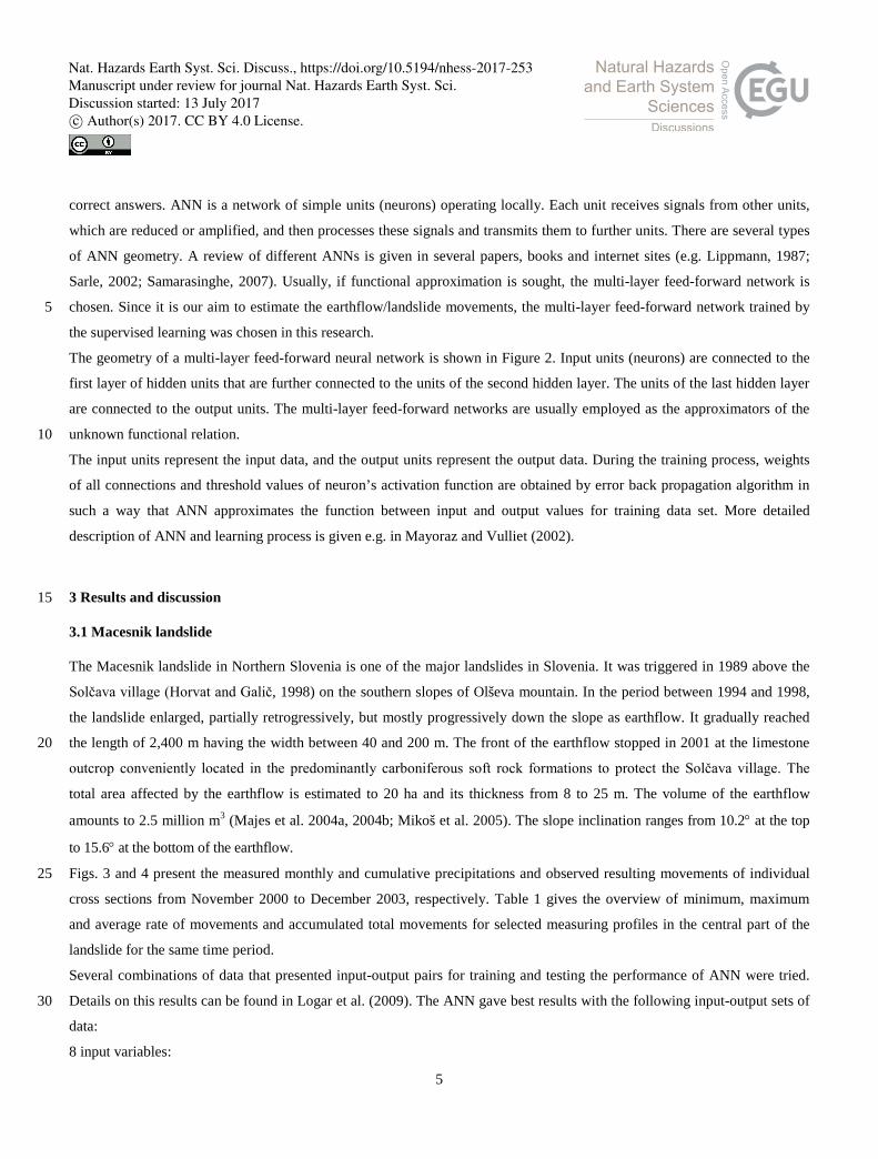
Local precipitations were measured by the rainfall gauging station in the Solčava village, approximately 1 km away from the
toe of the earthflow. 15
From February to August 2003 deep drainage trenches and drainage shafts were made between measuring sections 6 and 10
in order to stabilize the landslide. More details on the landslide and its rehabilitation can be found in Mikoš et al. (2005).
2.2.2 Ventnor Undercliff landslide
Extensive network of survey markers, piezometers, settlement cells and crack-meters to monitor ground movement is
maintained at the Undercliff landslide. 20
For the present study, the precise crack-meter data from Newport road (see Fig. 7) were used together with rainfall data
which is also measured daily within the landslide area.
Vibrating wire crackmeters were used for precise monitoring of movements. Readings were taken repetitively and collected
by datalogger in intervals of 3 hours (Carey, 2011). The data set from 1995 to 2004 was available for this study. The more
detailed description of the sensor, its installation and analyses of measurements are given in Carey (2011). 25
2.3 Multi-layer feed-forward artificial neural network
The motivation for the early development of artificial neural networks (ANN) was the study of the structure and processes in
human brain. The ANN is a mathematical formulation that simulates the processes between neurons in human brain. In both,
the ANN and the human brain neurons are interconnected. Similarly to a human brain, ANN has to be taught or trained. In
our work, supervised learning was used, in which a set of input and output data are known and where the ANN learns the 30
4
Nat. Hazards Earth Syst. Sci. Discuss., https://doi.org/10.5194/nhess-2017-253Manuscript under review for journal Nat. Hazards Earth Syst. Sci.Discussion started: 13 July 2017c© Author(s) 2017. CC BY 4.0 License.
correct answers. ANN is a network of simple units (neurons) operating locally. Each unit receives signals from other units,
which are reduced or amplified, and then processes these signals and transmits them to further units. There are several types
of ANN geometry. A review of different ANNs is given in several papers, books and internet sites (e.g. Lippmann, 1987;
Sarle, 2002; Samarasinghe, 2007). Usually, if functional approximation is sought, the multi-layer feed-forward network is
chosen. Since it is our aim to estimate the earthflow/landslide movements, the multi-layer feed-forward network trained by 5
the supervised learning was chosen in this research.
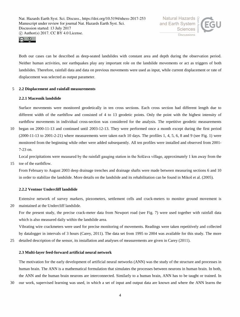
The geometry of a multi-layer feed-forward neural network is shown in Figure 2. Input units (neurons) are connected to the
first layer of hidden units that are further connected to the units of the second hidden layer. The units of the last hidden layer
are connected to the output units. The multi-layer feed-forward networks are usually employed as the approximators of the
unknown functional relation. 10
The input units represent the input data, and the output units represent the output data. During the training process, weights
of all connections and threshold values of neuron’s activation function are obtained by error back propagation algorithm in
such a way that ANN approximates the function between input and output values for training data set. More detailed
description of ANN and learning process is given e.g. in Mayoraz and Vulliet (2002).
3 Results and discussion 15
3.1 Macesnik landslide
The Macesnik landslide in Northern Slovenia is one of the major landslides in Slovenia. It was triggered in 1989 above the
Solčava village (Horvat and Galič, 1998) on the southern slopes of Olševa mountain. In the period between 1994 and 1998,
the landslide enlarged, partially retrogressively, but mostly progressively down the slope as earthflow. It gradually reached
the length of 2,400 m having the width between 40 and 200 m. The front of the earthflow stopped in 2001 at the limestone 20
outcrop conveniently located in the predominantly carboniferous soft rock formations to protect the Solčava village. The
total area affected by the earthflow is estimated to 20 ha and its thickness from 8 to 25 m. The volume of the earthflow
amounts to 2.5 million m3 (Majes et al. 2004a, 2004b; Mikoš et al. 2005). The slope inclination ranges from 10.2° at the top
to 15.6° at the bottom of the earthflow.
Figs. 3 and 4 present the measured monthly and cumulative precipitations and observed resulting movements of individual 25
cross sections from November 2000 to December 2003, respectively. Table 1 gives the overview of minimum, maximum
and average rate of movements and accumulated total movements for selected measuring profiles in the central part of the
landslide for the same time period.
Several combinations of data that presented input-output pairs for training and testing the performance of ANN were tried.
Details on this results can be found in Logar et al. (2009). The ANN gave best results with the following input-output sets of 30
data:
8 input variables:
5
Nat. Hazards Earth Syst. Sci. Discuss., https://doi.org/10.5194/nhess-2017-253Manuscript under review for journal Nat. Hazards Earth Syst. Sci.Discussion started: 13 July 2017c© Author(s) 2017. CC BY 4.0 License.

• cumulative amount of rainfall for 90 days (w90),
• cumulative amount of rainfall for 10 days (w10),
• cumulative amount of rainfall for 5 days (w5),
• components of rate of displacement in previous month (vy0, vx0, vH0),
• rate of displacement in horizontal plane in previous month (vyx0), 5
• rate of spatial displacement in previous month (vyxH0).
5 output variables:
• components of rate of displacement for next month (vy, vx, vH),
• rate of displacement in horizontal plane for next month (vyx),
• rate of spatial displacement for next month (vyxH). 10
Subscripts y, x and H refer to East-West, North-South and height coordinates of the national coordinate system, respectively.
It was interesting to note that even though 2 output variables are obviously calculated from other 3 (same is valid for
respective input variables) this repeated information to neural network considerably improved the performance of trained
ANN. This is in a way similar to the interpolation of additional training sets used by Yao et al. (2015) only that in our case
we strictly used only measured values. 15
Two sets of training were performed. Firstly, only measured data were used (denoted as “ANN” in figures). Secondly, one
additional data point was inserted that was not measured but it is obvious: if there is no rain and no previous movements (all
input data equal to 0) the expected rate of movement is also 0. The results obtained with this additional information is
denoted by “ANN+0” in graphs with results.
Different ANN geometries were initially used in training procedure. One or two hidden layers were used with 10 to 30 20
neurones in each layer. The presented results are obtained with neural network with two hidden layers each having 25
neurones.
Twenty seven series of measurements were available for the Macesnik landslide. In all examples the ANN was trained on a
selected number of input-output pairs from the beginning of measurements. First training was performed with first 14 input-
output pairs, then the displacements at the time of 15th and 16th measurement were predicted by ANN. In the next step, ANN 25
was trained on the set of first 16 input output pairs and ANN predicted the displacements at the 17th and 18th measurements,
etc. This procedure was repeated until February 2003 when construction works started for the installation of deep drainage
trench. After that the conditions on site were changed and previous “knowledge” on the earthflow behaviour could not be
used any more. Such a stepwise training procedure simulated the possible use of ANN in decision making process. In real
situations, all available past measurements would be used for training. Prediction of landslide movements would then be 30
made either by using the forecast rainfall or for a parametric study of different rainfall scenarios.
The results for the rate of horizontal displacement vxy is presented in Fig. 5. Two breaks in graph are consequence of
reinstallation of geodetic points due to large displacements of the earthflow. To obtain the results of ANN after the new zero
6
Nat. Hazards Earth Syst. Sci. Discuss., https://doi.org/10.5194/nhess-2017-253Manuscript under review for journal Nat. Hazards Earth Syst. Sci.Discussion started: 13 July 2017c© Author(s) 2017. CC BY 4.0 License.

readings, the predicted rates of displacements from ANN itself were used. From the results in Fig. 5 one can observe the
considerable influence of additional information used in second training set “ANN+0”. Fig. 6 compares the measured
displacements with those obtained from ANN predictions but includes also the period after the initiation of remediation
works. The agreement is very good until the start of works. After February 2003 the measured and predicted displacements
start to deviate. There are two reasons for such result: (i) the ANN was not trained additionally with new data and more 5
important (ii) extensive earthworks caused additional displacements during the construction period whereas after the
installation of the drainage trench the conditions on site changed considerably. By comparing both curves in Fig. 6 we can
observe exactly the expected behaviour. During remediation works the ANN prediction is below measured values since it
was done in relatively dry period but additional movements were caused by excavations. After the works were completed,
the ANN prediction suggests what would have occurred if there hadn’t been a drainage trench installed. 10
3.2 Ventnor Undercliff landslide
The Isle of Wight (UK) Undercliff is the largest urban landslide complex in north-western Europe and has been studied
extensively by the local authorities on the Isle of Wight as well as by the UK Department of the Environment (Marsden et al.
2009). Ventnor is the main town within the Undercliff with a population of 6,500 whilst approximately 12,000 residents in
total live in the Undercliff. The Ventnor Undercliff landslide complex was activated as a result of aggressive coastal erosion 15
following a rise in sea levels after the last ice age about 10,000 years ago. Slow intermittent ground movements in the
vicinity of the town of Ventnor have resulted in extensive damage to property and services over the last 200 years.
Field monitoring of ground movements, water levels and weather events is constantly carried out. Records of ground
movements were recognised as being important in understanding ground behaviour. This information is collected in the form
of an integrated geographical information system. 20
For our work we used the daily displacement measurements monitored by crackmeter on Newport Road, situated near the
city of Ventnor (Fig. 7), and the daily rainfall data measured within the studied area. The data for the period from December
1995 to September 2004 were available but there are some gaps due to technical reasons (see Fig. 8). The total
displacements, maximum, minimum and average rates of movements are given in Table 2. The rainfall data are available
continuously from March 1992 to August 2004. For this study we decided to use displacement and rainfall data from 1 25
September 2000 to 30 June 2001 (Fig. 8 and Fig. 9, respectively) where changes in displacement rate were observed. For this
period the complete set of data for training consisted of 272 points, one for each day.
For the Undercliff landslide a very simple configuration of ANN was used: 3 to 5 input neurons, 10 neurons in single hidden
layer and 1 output neuron (Fig. 10). Three different input-output sets were used and compared. In first case (denoted as
ANN3), 3 input parameters were: cumulative amount of rainfall for 10, 30 and 90 days (Rain 10, Rain 30 and Rain 90, 30
respectively). The only output variable was displacement for the next 10 days (Displacement). In second case (ANN4),
accumulated displacements in the last 90 days (Displace 90) was added as the fourth input parameter. In third case (ANN5)
accumulated displacements in the last 30 days (Displace 30) was used as fifth input parameter.
7
Nat. Hazards Earth Syst. Sci. Discuss., https://doi.org/10.5194/nhess-2017-253Manuscript under review for journal Nat. Hazards Earth Syst. Sci.Discussion started: 13 July 2017c© Author(s) 2017. CC BY 4.0 License.

The training and testing principle was the following (see also Fig. 11):
• training the ANN with data for 6 months from September 2000 to February 2001 – test on data from March 2001,
• training the ANN with data for 7 months from September 2000 to March 2001 – test on data from April 2001,
• similarly, two more steps were made to get the results also for May and June 2001.
The results obtained for individual months and for all three alternatives of input-output parameters are presented together 5
with measured data in Fig. 12. The correspondence between measurements and ANN predictions depends on the selection of
input data (ANN5 in our case). Again, a very good result can be obtained when the suitable set of input-output parameters is
found.
In this case, daily data were available and therefore considerably larger data base for training of ANN. As a result, very good
prediction was obtained with a simple ANN geometry. 10
4 Conclusion
The feed forward artificial neural network (ANN) was used to correlate the observed movements and rainfall data for two
very different slope instability phenomena. It was shown that trained ANN is able to accurately model the particular
landslide movements if adequately long series of reliable data on rainfall and displacements are available and optimum
combination of input – output data together with suitable ANN architecture is found. 15
Therefore, it is possible to make the predictions of landslide behaviour on the basis of previous observations and weather
forecast. Such tool can be a valuable decision support system for civil protection body and/or stakeholders responsible for
the population and properties in the risk area.
In such a way, the ANN is an alternative to the mathematical models which are mostly used for the assessment of the
landslide behaviour. Mathematical models have to take into account very simplified ground conditions and underground 20
water conditions with respect to the reality but rely on sound physical knowledge. On the other hand, ANN is a “black box”
but uses site specific measured input data without any further assumptions.
In this study it was also shown that the repetition of data within training data sets has a positive effect on the results.
Similarly, whenever possible, the training data set should include obvious and/or theoretically justified input sets.
25
Acknowledgments. Part of this research was conducted in the framework of FRANE research project financed by European
Commission – Communications and Civil Protection, Unit A5. Authors wish to express thanks to Diego Maccieri who
performed the ANN calculations for Undercliff landslide.
8
Nat. Hazards Earth Syst. Sci. Discuss., https://doi.org/10.5194/nhess-2017-253Manuscript under review for journal Nat. Hazards Earth Syst. Sci.Discussion started: 13 July 2017c© Author(s) 2017. CC BY 4.0 License.

References
Alimohammadlou, Y., Najafi, A., and Gokceoglu, C.: Estimation of rainfall-induced landslides using ANN and fuzzy
clustering methods: A case study in Saeen Slope, Azerbaijan province, Iran, Catena, 120, 149–162,
doi:10.1016/j.catena.2014.04.009, 2014.
Carey, J.M.: The Progressive Development and Post-failure Behaviour of Deep-seated Landslide Complexes, Durham 5
theses, Durham University, Available at Durham E-Theses Online, http://etheses.dur.ac.uk/3186/, 2011.
Chen, H.Q., Zeng, Z.G., and Tang, H.M.: Study on landslide deformation prediction based on recurrent neural network under
the function of rainfall, in: Huang, T.W. et al. (Eds.), ICONIP 2012, Part IV, LNCS 7666, pp. 683-690, doi:10.1007/978-3-
642-34478-7_83, 2012.
Chen, H.Q., and Zeng, Z.G.: Deformation Prediction of Landslide Based on Improved Back-propagation Neural Network, 10
Cogn. Comput., 5(1), 56–62, doi:10.1007/s12559-012-9148-1, 2013.
Chen, J., Zeng, Z., Jiang, P., and Tang, H.: Deformation prediction of landslide based on functional network,
Neurocomputing, 149, 151–157, doi:10.1016/j.neucom.2013.10.044, 2015.
Chen, Y., Wang, S., Chen, N., Long, X., and Tang, X.: Forecasting Cohesionless Soil Highway Slope Displacement Using
Modular Neural Network, Discrete Dynamics in Nature and Society, Volume 2012, Article ID 504574, 15 pages, Hindawi 15
Publishing Corporation, doi:10.1155/2012/504574, 2012.
Conforti, M., Pascale, S., Robustelli, G., and Sdao, F.: Evaluation of prediction capability of the artificial neural networks for
mapping landslide susceptibility in the Turbolo River catchment (northern Calabria, Italy), Catena, 113, 236–250,
doi:10.1016/j.catena.2013.08.006, 2014.
Dou, J., Yamagishi, H., Pourghasemi, H.R., Yunus, A.P., Song, X., Xu, Y., and Zhu, Z.: An integrated artificial neural 20
network model for the landslide susceptibility assessment of Osado Island, Japan, Nat. Hazards, 78, 1749–1776,
doi:10.1007/s11069-015-1799-2, 2015.
Ermini, L., Catani, F., and Casagli, N.: Artificial Neural Networks applied to landslide susceptibility assessment,
Geomorphology, 66, 327–343, doi:10.1016/j.geomorph.2004.09.025, 2005.
Gao, W.: Prediction of Landslide Based on Grey System and Evolutionary Artificial Neural Networks, in: International 25
Conference on System Science, Engineering Design and Manufacturing Informatization – Volume 02, pp. 64-67,
doi:10.1109/ICSEM.2010.106, 2010.
Gelisli, K., Kaya, T., and Babacan, A.E.: Assessing the factor of safety using an artificial neural network: case studies on
landslides in Giresun, Turkey, Environ. Earth Sci., 73, 8639–8646, doi:10.1007/s12665-015-4027-1, 2015.
Goetz, J.N., Brenning, A., Petschko, H., and Leopold, P.: Evaluating machine learning and statistical prediction techniques 30
for landslide susceptibility modelling, Comput. Geosci., 81, 1–11, doi:10.1016/j.cageo.2015.04.007, 2015.
Horvat, A., and Galič, R.: Sanacija Macesnikovega plazu pod Olševo = Rehabilitation of landslide near the Macesnik farm
below Olševa, Ujma, 12, 179-181, 1998.
9
Nat. Hazards Earth Syst. Sci. Discuss., https://doi.org/10.5194/nhess-2017-253Manuscript under review for journal Nat. Hazards Earth Syst. Sci.Discussion started: 13 July 2017c© Author(s) 2017. CC BY 4.0 License.

Lacasse, S.: Protecting society from landslides – the role of the geotechnical engineer, 8th Terzaghi Oration, in: Proceedings
of the 18th International Conference on Soil Mechanics and Geotechnical Engineering, Paris 2013, Vol. 1, pp. 15-34, 2013.
Li, R.Y., Ruan, Y.F., Li, S.S., and Wu, Y.H.: Study on Deformation Prediction of Landslide Based on Grey Theory and BP
Neural Network, Applied Mechanics and Materials, 204-208, 520-525, doi:10.4028/www.scientific.net/AMM.204-208.520,
2012. 5
Li, C., Tang, H., Ge, Y., Hu, X., and Wang, L.: Application of back-propagation neural network on bank destruction
forecasting for accumulative landslides in the three Gorges Reservoir Region, China, Stoch. Environ. Res. Risk Assess., 28,
1465–1477, doi:10.1007/s00477-014-0848-9, 2014.
Lian, C., Zeng, Z., Yao, W., and Tang, H.: Displacement Prediction Model of Landslide Based on Ensemble of Extreme
Learning Machine, in: Huang, T.W. et al. (Eds), ICONIP 2012, Part IV, LNCS 7666, pp. 240–247, doi:10.1007/978-3-642-10
34478-7_30, 2012a.
Lian, C., Zeng, Z., Yao, W., and Tang, H.: Displacement prediction model of landslide based on a modified ensemble
empirical mode decomposition and extreme learning machine, Nat. Hazards, 66(2), 759–771, doi:10.1007/s11069-012-0517-
6, 2012b.
Lian, C., Zeng, Z., Yao, W., and Tang, H.: Ensemble of extreme learning machine for landslide displacement prediction 15
based on time series analysis, Neural Comput. Applic., 24(1), 99-107, doi:10.1007/s00521-013-1446-3, 2013.
Lian, C., Zeng, Z., Yao, W., and Tang, H.: Multiple neural networks switched prediction for landslide displacement,
Engineering Geology, 186, 91–99, doi:10.1016/j.enggeo.2014.11.014, 2015.
Lippmann, R.P.: An Introduction to Computing with Neural Nets, IEEE ASSP Mag., 4(2), 4-22, 1987.
Logar, J., Turk, G., and Ambrožič, T.: Artificial neural network modelling of landslide movements, in: Future Risk 20
Assessment as a New European approach to landslide hazards, Communications and Civil Protection, Unit A5, pp. 215-235,
2009.
Lu, P., and Rosenbaum, M.S.: Artificial neural networks and Grey Systems for the prediction of slope stability, Nat.
Hazards, 30(3), 383-398, doi:10.1023/B:NHAZ.0000007168.00673.27, 2003.
Majes, B., Robas, A., Žigman, F., and Petkovšek, A.: Macesnikov plaz včeraj, danes in jutri = Macesnik landslide yesterday, 25
today and tomorrow, in: Razprave četrtega posvetovanja slovenskih geotehnikov, Rogaška Slatina, 9.-11. June 2004,
Slovenian Geotechnical Society, pp. 323-338, (In Slovene, English Summary), 2004.
Majes, B., Žigman, F., Fazarinc, R., Mikoš, M., Robas, A., and Petkovšek, A.: Investigations and mitigation of the Macesnik
landslide in Slovenia, in: Abstracts of the Contributions of the European Geosciences Union General Assembly 2004, EGU
General Assembly 2004, Katlenburg-Lindau, Geophysical Research Abstracts, Vol. 6, pp. 1-2, 2004. 30
Marsden, P., Fairbank, H., and Houghton, J.: Geotechnical study area G1 – Ventnor Undercliff landslide complex – an
overview, Isle of Wight, UK, in: Future Risk Assessment as a New European approach to landslide hazards,
Communications and Civil Protection, Unit A5, 2009.
10
Nat. Hazards Earth Syst. Sci. Discuss., https://doi.org/10.5194/nhess-2017-253Manuscript under review for journal Nat. Hazards Earth Syst. Sci.Discussion started: 13 July 2017c© Author(s) 2017. CC BY 4.0 License.

Mayoraz, F., Cornu, T., and Vulliet, L.: Using Neural Networks to Predict Slope Movements, in: Senneset, K. (Eds), Proc.
7th Int. Symp. On Landslides, Trondheim, 17-21 June 1996, pp. 295-300, 1996.
Mayoraz, F., and Vulliet, L.: Neural Networks for Slope Movement Prediction, Int. J. Geomech., 2(2), 153-173,
doi:10.1061/(ASCE)1532-3641(2002)2:2(153), 2002.
Mikoš, M., Fazarinc, R., Pulko, B., Petkovšek, A., and Majes, B.: Stepwise mitigation of the Macesnik landslide, N 5
Slovenia, Nat. Hazards Earth Syst. Sci., 5, 948-958, doi:1684-9981/nhess/2005-5-947, 2005.
Nourani, V., Pradhan, B., Ghaffari, H., and Sharifi, S.S.: Landslide susceptibility mapping at Zonouz Plain, Iran using
genetic programming and comparison with frequency ratio, logistic regression, and artificial neural network models, Nat.
Hazards, 71, 523–547, doi:10.1007/s11069-013-0932-3, 2014.
Pradhan, B., Mansor, S., and Pirasteh, S.: Landslide Susceptibility Mapping: an Assessment of the Use of an Advanced 10
Neural Network Model with Five Different Training Strategies, in: Chi Leung Patrick Hui (Eds.), Artificial Neural Networks
– Application, ISBN: 978-953-307-188-6, InTech, 2011.
Pradhan, B., and Lee, S.: Landslide risk analysis using artificial neural network model focussing on different training sites,
International Journal of Physical Sciences, 4(1), 1-15, 2009.
Ran, Y.F., Xiong, G.C., Li, S.S., and Ye, L.Y.: Study on deformation prediction of landslide based on genetic algorithm and 15
improved BP neural network, Kybernetes, 39(8), 1245-1254, doi:10.1108/03684921011063529, 2010.
Samarasinghe, S.: Neural networks for applied sciences and engineering: from fundamentals to complex pattern recognition,
Taylor & Francis group, ISBN:978-1-4200-1306-1, 2007.
Sarle, W.S.: Neural Network FAQ, Periodic posting to the Usnet newsgroup comp.ai.neural-nets, URL:
ftp://ftp.sas.com/pub/neural/FAQ.html, 2002. 20
Thiebes, B., Bell, R., Glade, T., Jäger, S., Mayer, J., Anderson, M., and Holcombe, L.: Integration of a limit-equilibrium
model into a landslide early warning system, Landslides, 11, 859–875, doi:10.1007/s10346-013-0416-2, 2014.
Wang, L.J., Guo, M., Sawada, K., Lin, J., and Zhang, J.: A comparative study of landslide susceptibility maps using logistic
regression, frequency ratio, decision tree, weights of evidence and artificial neural network, Geosciences Journal, 20(1), 117-
136, doi:10.1007/s12303-015-0026-1, 2016. 25
Yao, W., Zeng, Z., Lian, C., and Tang, H.: Training enhanced reservoir computing predictor for landslide displacement,
Engineering Geology, 188, 101–109, doi:10.1016/j.enggeo.2014.11.008, 2015.
Zeng, Y., Yan, E., Li, C.F., and Li, Y.: Application of Multivariable Time Series Based on RBF Neural Network in
Prediction of Landslide Displacement, in: Jie, Z.J. et al. (Eds.), ICYCS 2008, pp. 2707-2712, doi:10.1109/ICYCS.2008.163,
2008. 30
11
Nat. Hazards Earth Syst. Sci. Discuss., https://doi.org/10.5194/nhess-2017-253Manuscript under review for journal Nat. Hazards Earth Syst. Sci.Discussion started: 13 July 2017c© Author(s) 2017. CC BY 4.0 License.

Figure 1: Plan view of Macesnik landslide.
Profile 9Pr
ofile
10
Profile
8
Profile 7
Profile 6
Prof
ile 5
Prof
ile 4
Profile 3
Profile 2
Profile 1
PONTOON BRIDGE
RUINED PANORAMIC ROAD
ROCK OUTCROP
Profile 9Pr
ofile
10
Profile
8
Profile 7
Profile 6
Prof
ile 5
Prof
ile 4
Profile 3
Profile 2
Profile 1
Profile 9Pr
ofile
10
Profile
8
Profile 7
Profile 6
Prof
ile 5
Prof
ile 4
Profile 3
Profile 2
Profile 1
PONTOON BRIDGE
RUINED PANORAMIC ROAD
ROCK OUTCROP
12
Nat. Hazards Earth Syst. Sci. Discuss., https://doi.org/10.5194/nhess-2017-253Manuscript under review for journal Nat. Hazards Earth Syst. Sci.Discussion started: 13 July 2017c© Author(s) 2017. CC BY 4.0 License.
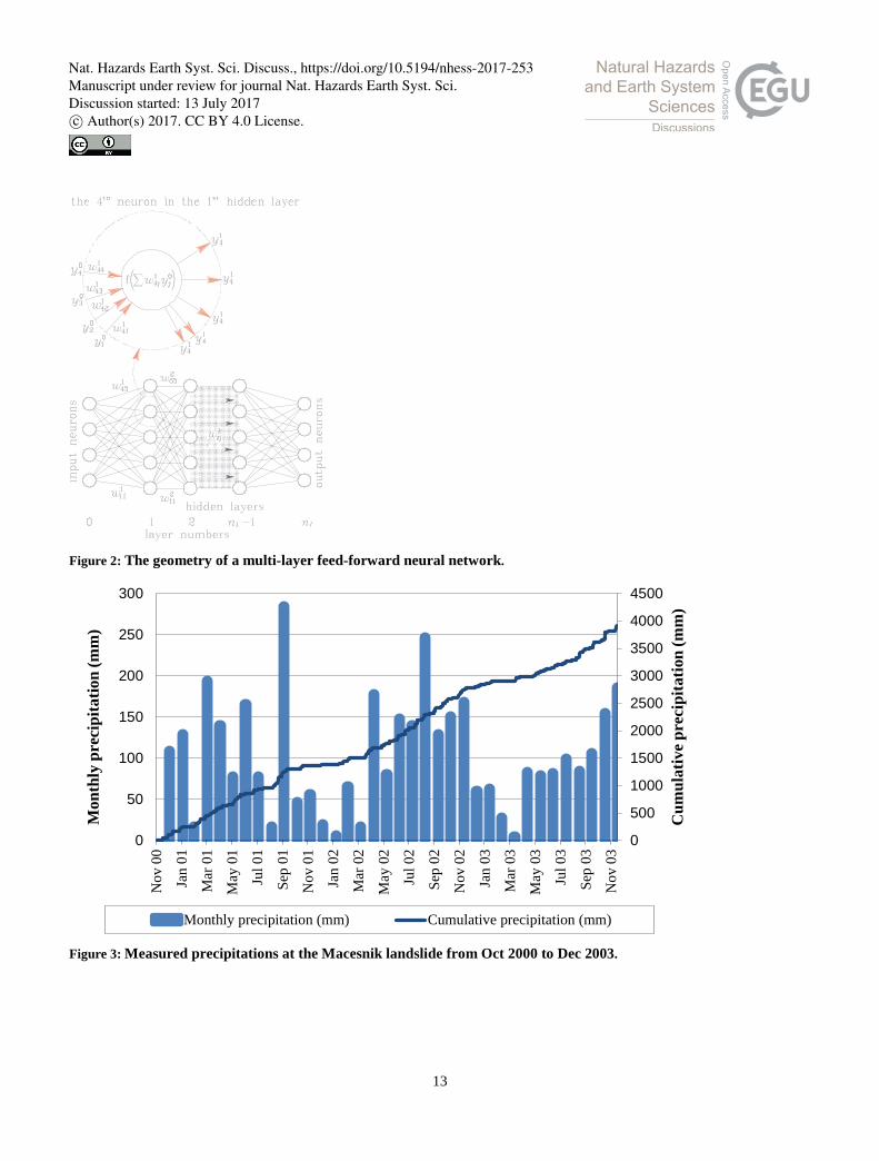
Figure 2: The geometry of a multi-layer feed-forward neural network.
Figure 3: Measured precipitations at the Macesnik landslide from Oct 2000 to Dec 2003.
0
500
1000
1500
2000
2500
3000
3500
4000
4500
0
50
100
150
200
250
300
Nov
00
Jan
01
Mar
01
May
01
Jul 0
1
Sep
01
Nov
01
Jan
02
Mar
02
May
02
Jul 0
2
Sep
02
Nov
02
Jan
03
Mar
03
May
03
Jul 0
3
Sep
03
Nov
03
Cum
ulat
ive
prec
ipita
tion
(mm
)
Mon
thly
pre
cipi
tatio
n (m
m)
Monthly precipitation (mm) Cumulative precipitation (mm)
13
Nat. Hazards Earth Syst. Sci. Discuss., https://doi.org/10.5194/nhess-2017-253Manuscript under review for journal Nat. Hazards Earth Syst. Sci.Discussion started: 13 July 2017c© Author(s) 2017. CC BY 4.0 License.

Figure 4: Measured displacements of Macesnik landslide from Oct 2000 to Dec 2003.
Figure 5: ANN predictions of the rate of horizontal movements – Macesnik earthflow.
0
20
40
60
80
100
120
140
160
180
200
Oct
00
Dec
00
Feb
01A
pr 0
1Ju
n 01
Aug
01
Oct
01
Dec
01
Feb
02A
pr 0
2Ju
n 02
Aug
02
Oct
02
Dec
02
Feb
03A
pr 0
3Ju
n 03
Aug
03
Oct
03
Dec
03
Dis
plac
emen
t (m
)
Profile 5 Profile 6 Profile 7 Profile 8
0102030405060708090
100
Oct
00
Jan
01
Apr
01
Jul 0
1
Nov
01
Feb
02
May
02
Sep
02
Dec
02
Mar
03
Rat
e of
mov
emen
ts (m
m/d
ay)
measured ANN ANN+0
14
Nat. Hazards Earth Syst. Sci. Discuss., https://doi.org/10.5194/nhess-2017-253Manuscript under review for journal Nat. Hazards Earth Syst. Sci.Discussion started: 13 July 2017c© Author(s) 2017. CC BY 4.0 License.
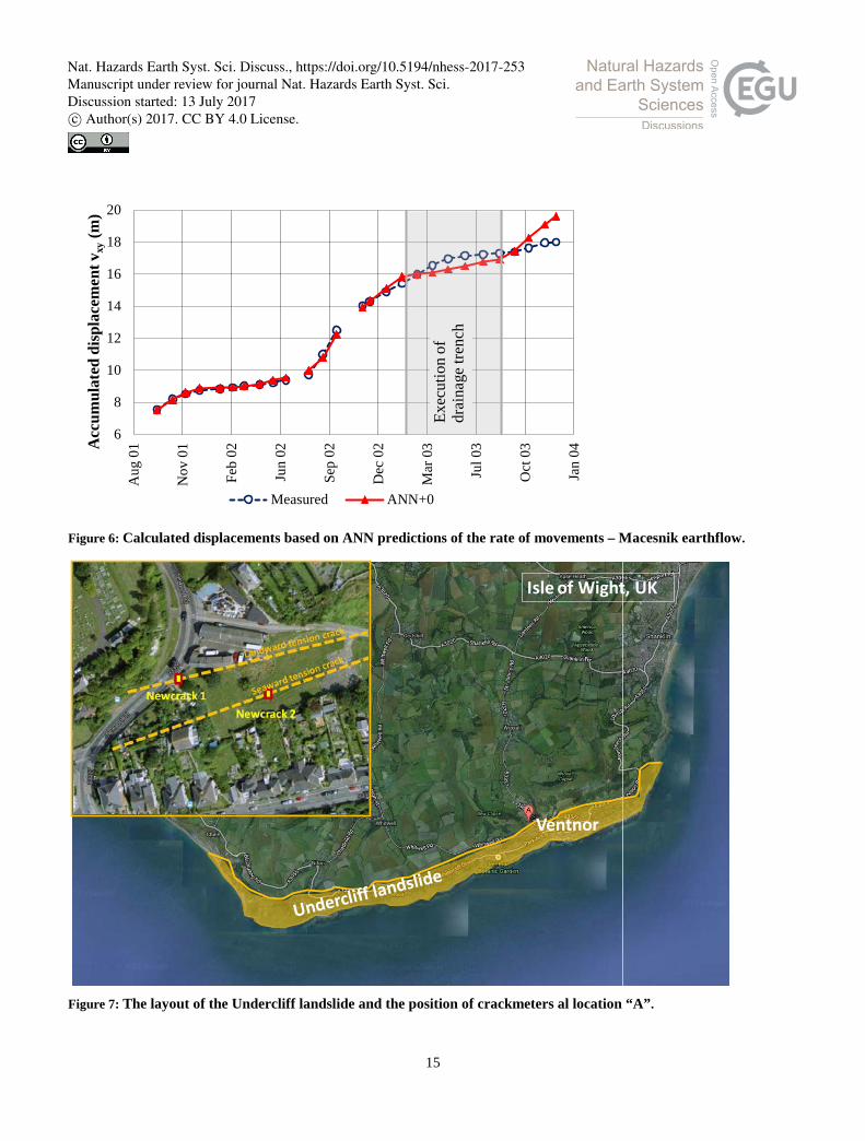
Figure 6: Calculated displacements based on ANN predictions of the rate of movements – Macesnik earthflow.
Figure 7: The layout of the Undercliff landslide and the position of crackmeters al location “A”.
6
8
10
12
14
16
18
20
Aug
01
Nov
01
Feb
02
Jun
02
Sep
02
Dec
02
Mar
03
Jul 0
3
Oct
03
Jan
04Acc
umul
ated
dis
plac
emen
t vxy
(m)
Measured ANN+0
Exec
utio
n of
dr
aina
ge tr
ench
Ventnor
Isle of Wight, UK
15
Nat. Hazards Earth Syst. Sci. Discuss., https://doi.org/10.5194/nhess-2017-253Manuscript under review for journal Nat. Hazards Earth Syst. Sci.Discussion started: 13 July 2017c© Author(s) 2017. CC BY 4.0 License.

Figure 8: Cumulative displacements measured by Crackmeter 1 – Undercliff, Isle of Wight, UK.
Figure 9: Precipitations – cumulative and for 30 day periods (Undercliff landslide).
0
10
20
30
40
50
60
70
Oct
95
Mar
97
Jul 9
8
Dec
99
Apr 0
1
Sep
02
Mea
sure
d di
spla
cem
ent (
mm
)
Con
side
red
for a
naly
sis
0
25
50
75
100
125
150
175
200
225
250
0
200
400
600
800
1000
1200
1400
1600
1800
2000
Mar
00
Apr 0
0
May
00
Jun
00
Jul 0
0
Aug
00
Sep
00
Oct
00
Nov
00
Dec
00
Jan
01Fe
b 01
Mar
01
Apr 0
1
May
01
Jun
01
Jul 0
1
Aug
01
Sep
01
Oct
01
30 d
ays p
reci
pita
tions
(mm
)
Cum
ulat
ive
prec
ipita
tions
(mm
)
30 days precipitations Cumulative precipitations
16
Nat. Hazards Earth Syst. Sci. Discuss., https://doi.org/10.5194/nhess-2017-253Manuscript under review for journal Nat. Hazards Earth Syst. Sci.Discussion started: 13 July 2017c© Author(s) 2017. CC BY 4.0 License.

Displace 90
Hidden 2
Displacement
Hidden 3
Hidden 4
Hidden 5
Hidden 6
Hidden 7
Hidden 8
Hidden 9
Hidden 10
Hidden 1
Rain 10
Displace 30
Rain 30
Rain 90
Figure 10: ANN architecture for the case ANN5 (Undercliff landslide).
Figure 11: Stepwise training – testing principle (Undercliff landslide).
17
Nat. Hazards Earth Syst. Sci. Discuss., https://doi.org/10.5194/nhess-2017-253Manuscript under review for journal Nat. Hazards Earth Syst. Sci.Discussion started: 13 July 2017c© Author(s) 2017. CC BY 4.0 License.

Figure 12: Displacements for a 4 month sequence – Undercliff landslide. ANN prediction in comparison with measured values by crackmeter.
Table 1: Movements and rates of movements of the central part of Macesnik landslide from November 2000 to December 2003. 5
Profile 5 6 7 8
Total movement (m) 15.6 172.3 39.7 81.3
Rate of movements (mm/day)
Maximum 50.0 600.0 160.0 310.0
Minimum 3.0 14.2 5.2 9.0
Average 14.5 164.9 60.5 85.1
Table 2: Movements and rates of movements observed by crackmeters 1 and 2 on Newport Road, Ventnor – Undercliff, Isle of Wight in the period between December 1995 and October 2002.
Crackmeter 1 2
Total movement (mm) 52.9 42.6
Rate of movements (mm/day)
Maximum 0.094 0.085
Minimum 0 0
Average 0.021 0.020
10
48
49
50
51
52
53
54
55
56
57
Feb
01
Mar
01
Mar
01
Apr 0
1
May
01
May
01
Jun
01
Jul 0
1
Dis
plac
emen
t (m
m)
ANN3
ANN4
ANN5
measured
18
Nat. Hazards Earth Syst. Sci. Discuss., https://doi.org/10.5194/nhess-2017-253Manuscript under review for journal Nat. Hazards Earth Syst. Sci.Discussion started: 13 July 2017c© Author(s) 2017. CC BY 4.0 License.


