
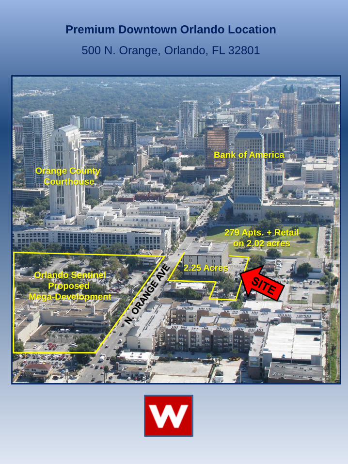
279 Apts. + Retail on 2.02 acres
Bank of America
Orange County Courthouse
Orlando Sentinel Proposed
Mega-Development
Premium Downtown Orlando Location
500 N. Orange, Orlando, FL 32801
2.25 Acres
Large Site with Desirable Dimensions
Perfect for Redevelopment
Crescent Central Station 279 Apartments + 12K SF Retail
on 2.02 Acres
2.25 Acres

Table of Contents
Project
Sponsor/Team
Location
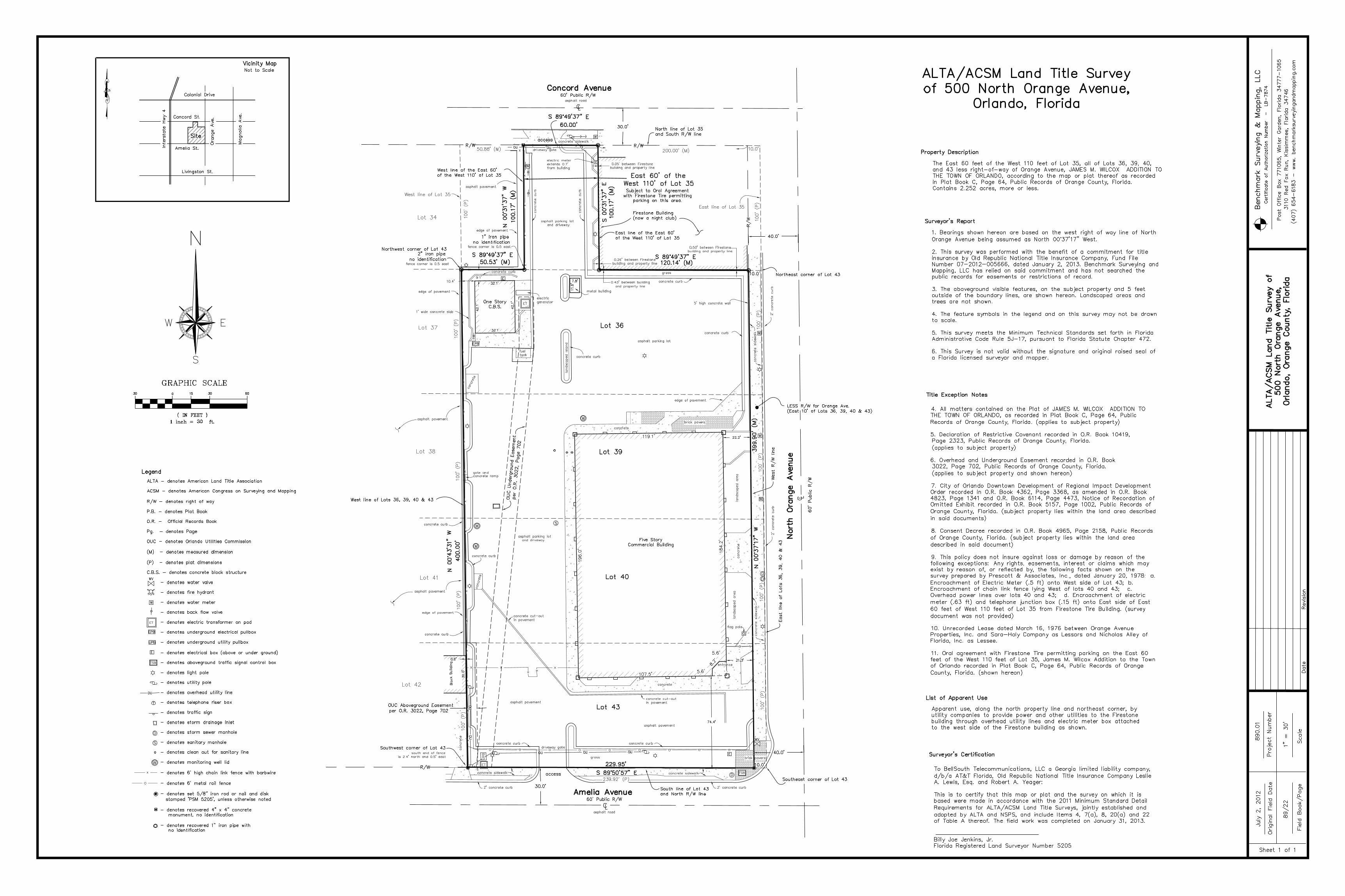
Survey
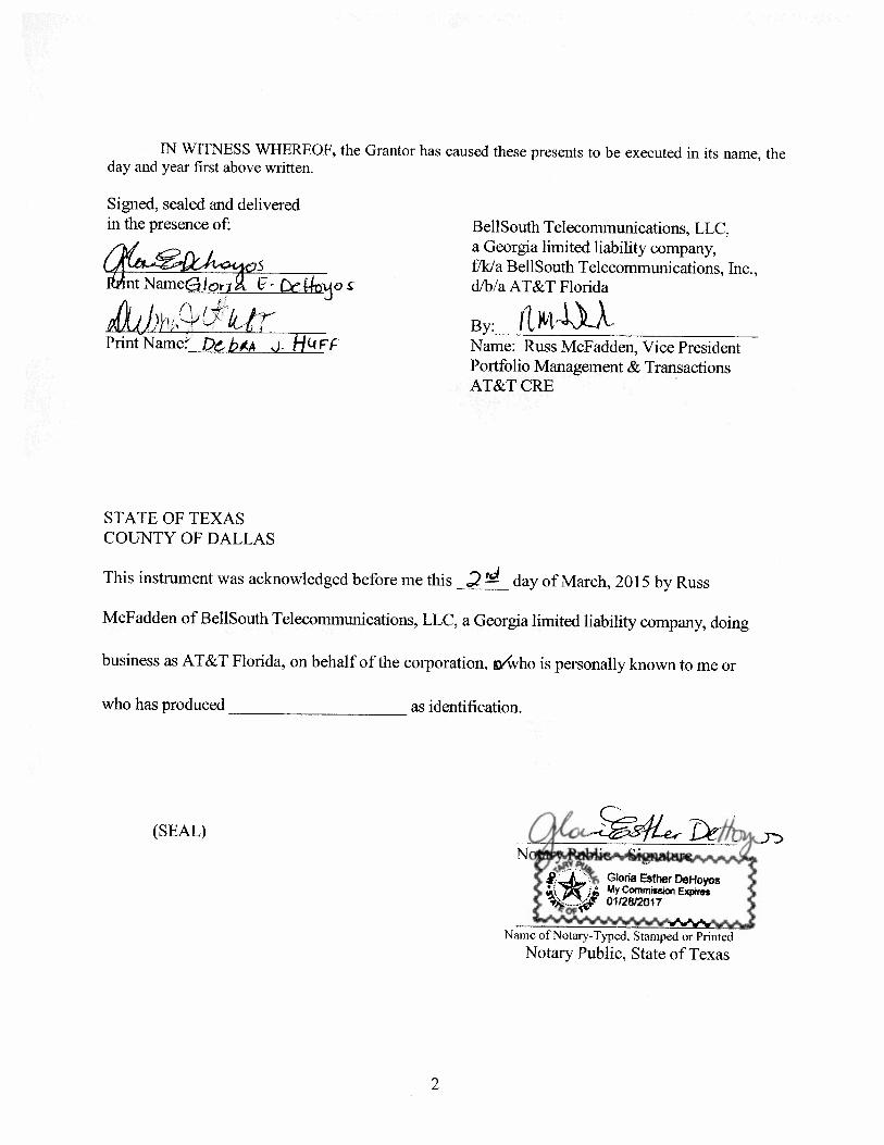
Special Warranty Deed
1
2
3
4
5
Section

Project Profile Site: The site is a 2.25 acre strategically located parcel at 500 N. Orange
Avenue in Orlando at the corner of Amelia Blvd. Project: The project will entail demolishing the existing 118,000 Sq. Ft. office
building, currently located on the site, and then constructing a 398 unit Residential Wrap project.
Zoning: The property is currently zoned AC-3A/T (Activity Center / Town Center).
The City of Orlando is extremely supportive of high density development at the Subject Site. The underlying zoning permits high density multifamily residential. Mixed use development of the site is encouraged by the Density of Intensity Bonus of the City of Orlando. Blending a mixture of uses at the property can result in an increase from 200 units per acre to 400 units per acre. The site permits construction to a maximum height of 400 feet. Based on the current zoning and site size, the property could yield up to 900 units.
Main & Main: The North Orange and Amelia intersection connects the financial district of the south CBD, Uptown to the north, and the newly proposed Creative Village (University of Central Florida) to the west.
It is at the crossroads of all the major development projects that have occurred and are proposed to occur in the future. Due to its unique geographic location and the continuing demand for residential units, the property is ideally suited for a high density multifamily project.
TOD: Due to the sites strategic location within 400 feet of the recently
constructed Lynx Central Station, this project is considered a Transportation Oriented Development (TOD).

Sponsor/Team Profile Company: West Second Street Associates (WSSA) is a Flint Michigan based
company specializing in investment, development and management of office, multifamily, and government office.
Development The principals of WSSA have managed construction and development Experience: projects totaling over 200M and have special expertise in building and
repositioning urban infill properties. Current Holdings: 1,462 unit multifamily portfolio in Houston, TX
15 Government (GSA) Leased Properties 18-Story repositioned office building in Birmingham Alabama 2 mixed-use buildings in Ann Arbor, MI
General We have yet to select a General Contractor but we have conducted Contractor: preliminary interviews with Brasfield & Gorrie and Winterpark
Construction. Architect: We are in the process of interviewing firms. Property WSSA intends to outsource the property management of the project after Management: completion to a “best in class” property manager with relevant and strategic experience in the downtown Orlando market. Discussions and
interviews have already begun with Greystar and Lincoln.

Location Profile Downtown Downtown Orlando is currently undergoing explosive growth Orlando: evidenced by the attached project map. Some of the most notable
planned projects include:
Creative Village: Spearheaded by the University of Central Florida, this project is located .2 miles west on Amelia. It is planned to include; 1M sf of office/creative space, 500,000 sf of higher education space, 25,000 sf of K-12 space, 1,500 residential units, 150,000 sf of retail space, 200 hotel rooms and multiple public parks and civic spaces.
Multifamily Growth: The CBD has spawned many extremely successful multifamily projects, and there are many others in the pipeline, including;
Complete Skyhouse 320 Units The Sevens 316 Units Steel House 326 Units Artisan 299 Units Crescent Station 279 Units Nora 246 Units Pending CitiTower 233 Units Eola Park 328 Units University Club 345 Units 520 Church 510 Units Cascades 219 Units Orlando Central 450 Units Monarch 270 Units
Lynx Central Station: The recently constructed Downtown Orlando Lynx Rail/Bus Terminal is located within 400 Feet of the subject site. This is the main downtown stop for the new Florida SunRail line. SunRail is a 61-mile, 17-stop commuter rail system connecting the cities of Orlando, Volusia, Seminole, Orange, and Osceola Counties.
Adjacent South: Immediately to the south of the subject site is the transportation Properties: oriented development (TOD) known as Crescent Central Station.
Crescent Central Station is a mixed-use development containing 279 apartment units, 14,680 sf of retail, and a seven story parking structure on 2.02 acres. Future phases call for a 125-room select service hotel, two office buildings with 260,000 sf of space and an adjoining parking deck.
Southeast: On the southeast corner of the North Orange and Amelia intersection is the Orange County Courthouse Complex. The property includes a 23-story courthouse tower, two five-story office buildings for the State Attorney and Public Defender, and a 1,500 car parking facility.
East: The Orlando Sentinel owns 2 blocks of property immediately east of the Subject Site. The Owners of the Sentinel Property recently approached the City of Orlando with a conceptual development plan depicting 746 apartments, 144 hotel rooms, 280,000 sf of office space, 56,000 sf of retail, and (2) parking garages containing 2,075 parking spaces.
D
D
WV
D
S
UPB
EPB
ALTA - denotes American Land Title Association
ACSM - denotes American Congress on Surveying and Mapping
R/W - denotes right of way
P.B. - denotes Plat Book
O.R. - Official Records Book
Pg. - denotes Page
OUC - denotes Orlando Utilities Commission
(M) - denotes measured dimension
(P) - denotes plat dimensions
C.B.S. - denotes concrete block structure
- denotes water valve
- denotes fire hydrant
- denotes water meter
- denotes back flow valve
- denotes electric transformer on pad
- denotes underground electrical pullbox
- denotes underground utility pullbox
- denotes electrical box (above or under ground)
- denotes aboveground traffic signal control box
- denotes light pole
- denotes utility pole
- denotes overhead utility line
- denotes telephone riser box
- denotes traffic sign
- denotes storm drainage inlet
- denotes storm sewer manhole
- denotes sanitary manhole
- denotes clean out for sanitary line
- denotes monitoring well lid
- denotes 6' high chain link fence with barbwire
- denotes 6' metal rail fence
- denotes set 5/8" iron rod or nail and disk stamped 'PSM 5205', unless otherwise noted
- denotes recovered 4" x 4" concrete monument, no identification
- denotes recovered 1" iron pipe with no identification
Legend
W
H
Y D
WV
T
D
Vicinity MapNot to Scale ALTA/ACSM Land Title Survey
of 500 North Orange Avenue, Orlando, Florida
4. All matters contained on the Plat of JAMES M. WILCOX ADDITION TO
THE TOWN OF ORLANDO, as recorded in Plat Book C, Page 64, Public Records of Orange County, Florida. (applies to subject property)
5. Declaration of Restrictive Covenant recorded in O.R. Book 10419, Page 2323, Public Records of Orange County, Florida. (applies to subject property)
6. Overhead and Underground Easement recorded in O.R. Book 3022, Page 702, Public Records of Orange County, Florida. (applies to subject property and shown hereon)
7. City of Orlando Downtown Development of Regional Impact Development Order recorded in O.R. Book 4362, Page 3368, as amended in O.R. Book 4823, Page 1341 and O.R. Book 6114, Page 4473, Notice of Recordation of Omitted Exhibit recorded in O.R. Book 5157, Page 1002, Public Records of Orange County, Florida. (subject property lies within the land area described in said documents)
8. Consent Decree recorded in O.R. Book 4965, Page 2158, Public Records of Orange County, Florida. (subject property lies within the land area described in said document)
9. This policy does not insure against loss or damage by reason of the following exceptions: Any rights, easements, interest or claims which may exist by reason of, or reflected by, the following facts shown on the survey prepared by Prescott & Associates, Inc., dated January 20, 1978: a. Encroachment of Electric Meter (.5 ft) onto West side of Lot 43; b. Encroachment of chain link fence lying West of lots 40 and 43; c. Overhead power lines over lots 40 and 43; d. Encroachment of electric meter (.63 ft) and telephone junction box (.15 ft) onto East side of East 60 feet of West 110 feet of Lot 35 from Firestone Tire Building. (survey document was not provided)
10. Unrecorded Lease dated March 16, 1976 between Orange Avenue Properties, Inc. and Sara-Holy Company as Lessors and Nicholas Alley of Florida, Inc. as Lessee.
11. Oral agreement with Firestone Tire permitting parking on the East 60 feet of the West 110 feet of Lot 35, James M. Wilcox Addition to the Town of Orlando recorded in Plat Book C, Page 64, Public Records of Orange County, Florida. (shown hereon)
The East 60 feet of the West 110 feet of Lot 35, all of Lots 36, 39, 40, and 43 less right-of-way of Orange Avenue, JAMES M. WILCOX ADDITION TO THE TOWN OF ORLANDO, according to the map or plat thereof as recorded in Plat Book C, Page 64, Public Records of Orange County, Florida.Contains 2.252 acres, more or less.
3110 Red Fox Run, Kissimmee, Florida 34746
Certificate of Authorization Number - LB-7874
Benchmark Surveying & Mapping, LLC
Post Office Box 771065, Winter Garden, Florida 34777-1065
(407) 654-6183 - www. benchmarksurveyingandmapping.com
Property Description
ALTA
/ACS
M La
nd T
itle
Sur
vey
of500 North Orange Avenue,
Orlando, Orange County, Florida
89/2
2
July 2, 2012
1" = 30'
890.01
Date Revision
Project Number
Sheet 1 of 1
Field Book/Page
Original Field Date
Scale
Surveyor's Report
1. Bearings shown hereon are based on the west right of way line of North Orange Avenue being assumed as North 00°37'17" West.
2. This survey was performed with the benefit of a commitment for title insurance by Old Republic National Title Insurance Company, Fund File Number 07-2012-005666, dated January 2, 2013. Benchmark Surveying and Mapping, LLC has relied on said commitment and has not searched the public records for easements or restrictions of record.
3. The aboveground visible features, on the subject property and 5 feet outside of the boundary lines, are shown hereon. Landscaped areas and trees are not shown.
4. The feature symbols in the legend and on this survey may not be drawn to scale.
5. This survey meets the Minimum Technical Standards set forth in Florida Administrative Code Rule 5J-17, pursuant to Florida Statute Chapter 472.
6. This Survey is not valid without the signature and original raised seal of a Florida licensed surveyor and mapper.
Surveyor's Certification
To BellSouth Telecommunications, LLC a Georgia limited liability company, d/b/a AT&T Florida, Old Republic National Title Insurance Company Leslie A. Lewis, Esq. and Robert A. Yeager:
This is to certify that this map or plat and the survey on which it is based were made in accordance with the 2011 Minimum Standard Detail
Requirements for ALTA/ACSM Land Title Surveys, jointly established and adopted by ALTA and NSPS, and include Items 4, 7(a), 8, 20(a) and 22 of Table A thereof. The field work was completed on January 31, 2013.
Billy Joe Jenkins, Jr.Florida Registered Land Surveyor Number 5205
Title Exception Notes15
30
603030 0
GRAPHIC SCALE
( IN FEET )1 inch = ft.
N
W E
S
OUC Underground Easement
per O.R. 3022, Page 702
per O.R. 3022, Page 702OUC Aboveground Easement Lot 43
Lot 40
Lot 39
Lot 36
East 60' of theWest 110' of Lot 35Subject to Oral Agreement
with Firestone Tire permittingparking on this area.
R/W
R/W
S 89°49'37" E
60.00'
S 00°31'37" E
100.17' (M)
S 89°49'37" E120.14' (M)
N 00°37'17" W
399.90' (M)
N 00°43'31" W
400.00'
S 89°49'37" E
50.53' (M)
N 00°31'37" W
100.17' (M)
Amelia Avenue
Concord Avenue
Nort
h Or
ange
Ave
nue
C
C
CWest line of Lots 36, 39, 40 & 43
South line of Lot 43
and North R/W line
North line of Lot 35
and South R/W line
West R/W line
East line of Lots 36, 39, 40 & 43
10.0'
10.0'
West line of the East 60'of the West 110' of Lot 35
East line of the East 60'of the West 110' of Lot 35
0.43' between buildingand property line
0.50' between Firestonebuilding and property line
0.26' between Firestonebuilding and property line
R/W R/W
30.0'
30.0'
40.0'
40.0'edge of pavement
access
access
West line of Lot 35
East line of Lot 35
100'
(P)
100'
(P)
100'
(P)
100'
(P)
100'
(P)
239.92' (P)
100'
(P)
100'
(P)
100'
(P)
100'
(P)
100'
(P)
200.00' (M) 10.0'50.88' (M)
W
W
W
W
W
E
OU
E
7.8'
11.6'32.1'
42.1'
119.1'
196.0' 18
4.2'
5.6'
8.2'
5.6'107.5'
22.2'
21.3'
74.4'
32.1'
42.1'
0.05' between Firestone building and property line
xx
xx
xx
xx
xx
xx
xx
xx
x x
xx
xx
x
x x
driveway gate
gate and
xx x
x
x
driveway gate
W
W
W
W
concrete ramp
concrete cut-out
in pavement
in pavementconcrete cut-out
ET
ET
UPB E
TSB
OU
OU
Lot 42
Lot 41
Lot 38
Lot 37
Lot 34
edge of pavement
2' concrete curb
2' concrete curb2' concrete curb
concrete sidewalk concrete sidewalk
asphalt pavement
asphalt pavement
asphalt parking lot
concrete curb
5' high concrete wall
concrete sidewalk
2' concrete curb
concrete sidewalk
land
scap
ed a
rea
land
scap
ed a
rea
Colonial Drive
Concord St.
Amelia St.Interstate Hwy 4
Orange Ave.
Magnolia Ave.
Site
Livingston St.
grass
concrete curbconcrete curb
concrete curb
entrance
concrete
Five Story Commercial Building
grass
concrete curb
One StoryC.B.S.
metal building
10.4'9.1'
concrete curb
concrete sidewalk
brick pavers
brick pavers
S 89°50'57" E
229.95'
asphalt road
asphalt road60' Public R/W
60' Public R/W
60' Public R/W
concrete curb
concrete curb
2" iron pipeno identification
fence corner is 0.5 east
fence corner is 0.5 east
1" iron pipeno identification
concrete
concrete curb
30.0'
Block Building
0.6'
concrete curb
asphalt pavement
asphalt pavement
asphalt pavement
edge of pavement
EPB
generatorelectric
ET
E
S
x
OU
asphalt parking lot
LESS R/W for Orange Ave.(East 10' of Lots 36, 39, 40 & 43)
concrete
concrete curb
landscaped island
asphalt parking lotand driveway
and driveway
concrete
south end of fenceis 2.4' north and 0.5' east
Southeast corner of Lot 43
Northeast corner of Lot 43
Northwest corner of Lot 43
Southwest corner of Lot 43
TSB
flag pole
concrete
edge of pavement
fuel
tank
1' wide concrete slab
electric meterextends 0.7'from building
OU OU OU
OU OU
concrete
List of Apparent Use
Apparent use, along the north property line and northeast corner, by utility companies to provide power and other utilities to the Firestone building through overhead utility lines and electric meter box attached to the west side of the Firestone building as shown.
Firestone Building(now a night club)


For more information please contact:
John Pavone 810-813-0533 [email protected]
Troy Farah 810-691-9041 [email protected]
2.25 Acres
Disclaimer: This document is for discussion purposes only. It is not intended to be construed as an offer to sell, transfer, partner with, joint venture, or otherwise develop a relationship with any party that gains possession of it. This document is for informational purposes only.


