

l a?NEQ001 P . l 1647 SNOOK L AKf 010
RADIOMETRIC SURVEY RKPORT
SNOOK LAKE GRANITE PROPERTY
SNOOK LAKE AREA
DISTRICT OK KENORA, ONTARIO
September 18, 1988
By: George R. Zebruck, B. Se.
g. 11647 SNOOK LAKE010C
TABLE OF CONTENTS
Page SUMMARY.................................................... l
INTRODUCTION . .. . .. ........... ............................. 3
LOCATION , ACCESS , TOPOGRAPHY............... ................ **
GEOLOGY . ..... .. ..... . ...... ......... .... .................. . 6
SURVEY PROCEEDURE.......................... .. .. ... .. .. . . . . . 7
DISCUSSION........ .. ....................................... 8
CONCLUSIONS AND RECOMMENDATIONS............................ 9
APPENDICES
I RADIOMETRIC SURVEY MAP . . . . . . . . . . . . . .. ... . . . . . ... ... i
II OUTCROP GEOLOGY MAP................................. ii
LIST OK FIGURES
Fig l Location Map .......................,........*.* 2
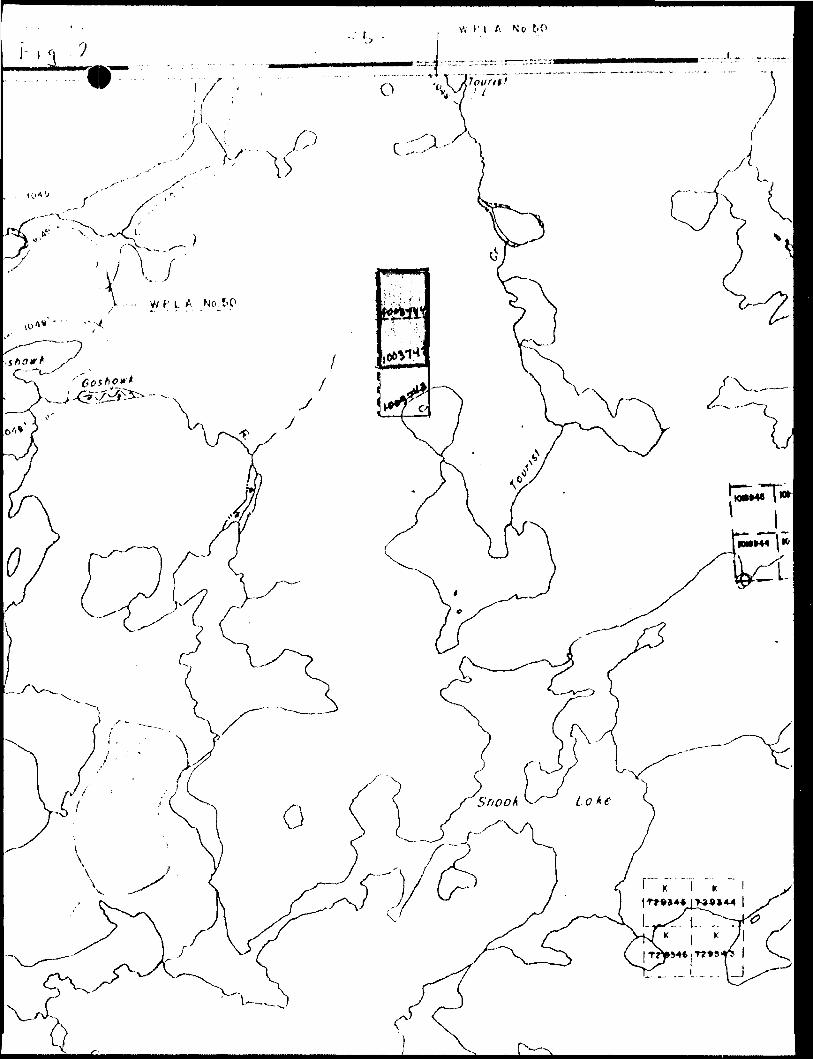
Fig 2 Claim Map ,. . ................................... 5
-l-'
SUMMARY
A radiometric eurvey was conducted during the summer of 1988 across two mining claims which make up the Snook Lake Oranite Property. Readings were taken at ?5 metre intervale along East-West pace and compass Ijnes spaced 100 metres apart. A Scintrex BQS-1 Scintillation Counter was used to obtain readings of total gamma-ray energy.
The result of this survey indicates that the red porphyritic granite has a significantly higher gamma-ray radiation count than the host gneisses. The Scintillation Counter then becomes a useful tool in mapping the contact of the main granite body in areas of shallow overburden and moss or lichen covered outcrop.

Figure 1: Location Map
SNOOK IAK1 GflANITE *PROPERTV l Sk O^ Thunder
Bay
O 100___200 300
miles

INTRODUCTION
The Snook Lake Granite Property consists of 2 contiguous
unpatented claims north of Snook Lake, Kenora Mining Division
Ontario ( see Fig 2), The deposit was discovered and staked by
the author in the summer of 198?.
The main granite body is an attractive reddish brown por
phyritic granite covering an area 500 ft. by 600 ft,, It is
found on a prominent hill rising 110 ft. above a swamp. Using
an average quarry depth of 70 ft. and a 50/6 waste factor the
deposit could contain in excess of 10 million cubic feet of
saleable stone.
A radiometric survey was conducted over the property in
order to determine;
a) Whether there was a significant difference in gamma-
ray count between the red porphyritic granite and the host
gneisses to be useful in mapping the boundaries of the granite
deposit, and
b) Whether there were areas within the granite containing
excessive amounts of uranium or thorium which would detract
from the marketability of this stone.

LOCATION, ACCESS, TOPOGRAPHY
The Snook Lake Granite Property is located north of Tourist
Lake in the Snook lake Area, Kenora Mining Division.
Accese to the property is via Highway 128 north of Kenora,
the English River Road, the Sand Lake Road, and the Snook Lake
Road a total of 88 Kilometres. The total distance is suitable for
travel by large logging trucks and or heavily loaded flat deck
trucks transporting stone. t-rdi^
The Topography of the area varies^flat deep organic soiled Black Spruce swamps and deep gravel soiled Jack Pine flats ( now
cutover ) to bare rock ledges supporting scattered stunted Pine.
A high ridge transects the property in a north south direction
attaining a hight in places in excess of 100 feet.

GEOLOGY
The Snook Lake Granite Property occurs within the English
Kivor Gneiss Belt, part of the Superior Province in the Canadian
Shield.
The geology of the property area consists mainly of gneiss
( possibly paragneiss ) and migmatites, red porphyritic granite
and minor granite pegmatites.
The rod pporphyritic granite contains potassium feldspar phenocrysts thai vary in size from l to 2 centimetree and make
up 50 to 80 cfa o f the stone. The fine grained matrix also contains
a large amount of potassium feldspar, biotite mica, fine flecks
of illmftnite, and other as yet undetermined minerals.
There are three main directions of jointing in the main
granite body 300, ^5|" and 8^! The dip of the joints is near ver
tical at 8? c , 85*, and 82 6. Joint spacing varies from about k to
20 metres. Sheeting appears to be near horizontal and sheet spac
ing is 2 to 3 metres.
Soil cover over the main granite zone is for the most part nil. Small depressions with shallow soil cover ( generally less
than 30 centiraetres)are scattered over the area.

-7-
SURVEY PROCEEDURE
The radiometric survey was conducted over the property
using a Scintrex BQS-1 Scintillation Counter. Readings were taken at 25 metre intervals along east-west pace and compass lines.
Total gamma-ray radiation readings, geological rock types,
and estimated depth of soil was noted at each station and are
retained as field notes.
Two property maps were produced at a scale of l - 2^00;
a) Radiometric Survey Map
b) Outcrop Geology Map
and are appended to the report.

-8-
DISCUSSION
There was a definite significant difference in radiometric
readings over areas of red porphyritic granite and areas of host
gneisses. In general readings over the red porphyritic granite
having no soil cover were in the range of 220 to 2^0 counts per second while readings over the host gneisses having no soil cover
were in the range of 150 to 180 counts per second. This was prob ably due to the much higher potassium feldspar content in the red
porphyritic granite. In fact most of the radiation is beleived to
be from potassium sources rather than uranium or thorium, because
of the everness of the readings ( a reflection of the homogenious nature of the granite body ). Radiation from uranium or thorium sources would in all probability have given higher and more
erratic results.

-9-
CONCLUSIONS AND RECOMMENDATIONS
The scintillometer has proven useful in mapping this granite
deposit and may prove useful in exploring for other granite
deposits where distinguishable differences in radioactivity exist between rock types.
It does not appear that the uranium or thorium content of
the granite is significant. A geochemical test to confirm this is
recommended.
The granite from the main zone ie attractive, massive, appears
to be fairly uniform, and suitable for the quarrying of large
blocks, It is recommended that further work be done on this deposit.
Work should consist of;
a) stripping of the quarry
b) removal of a number of large blocks for a market study and
for test purposes.
c) testing the physical properties and minerology of the
granite
d) drilling a number of diamond drill holes to confirm the
quarryable depth of the deposit, uniformity of material,
sheet spacing, etc.
Submitted Most Respectfully...
George R. Zebruck w. Se. R.P.F. Prospector

Ontario
' Ministry ot Norlhorn Development nml Minos x-
Report of Work(Geophysical, G p Geochomical aiul
Mining Act
2.11547 SNOOK LAKE 900
Do noi USP ttmdi-d nrcns bclomC/%-/'}
l yim ol Sti'vey(t)
f\ AOi O M t TKt C 2 . 1-1647 ^tor't Licence No.
H l c? o
Survey Company Dale of Survey (from 6/ to)
olNonio unri Ad d r on of Author (of Geo-1 echfticdl rtportl
/y O L.
Dny j Mo. j Yr. Doy | Mo. | YrS
Total Miles of line Cut
Credits Rcc|uestcd per Each Claim in Columns at right___ Mining Claims Traversed (List in numerical sequence)Special Piovitiom
For first survey:
Enter 4 0 d ays. (Thisincludes line cutting)
For each additional survey:using the same grid:
Enter 20 days (for each)
Man Days
Complete reverse side
and enter total(s) here
Airborne Credits
Note: Special provisions
credits do not applyto Airborne Surveys.
Geophyiical
- Electromagnetic
- Magnetometer
- Radiometric
- Other
Geological
Geochemical
Geophyticel
- Electromagnetic
- Magnetometer
- Radiometric
- Other
Geological
Geochemical
Electromagnetic
Magnetometer
Radionietric
Deyt perClaim
..
. -. ..-
Days perClaim
Days perClaim
-
Expenditures (excludes power stripping)Type of Work Porfofmed
Performed on CiaimUJ
Calculation of Expenditure Days Credits
Totel ExpendituresTotal
Day* Credits
InstructionsTotal Days Credits may be apportioned at the claim holder's choice. Enter number of days credits per claim selected in columns ei right.
Total number of mining claims covered by this report o( work.t OOZY 4
Recorrfid Holder or Ao*nt (SXinaWre
tifictftion Verifying Refiorttf Work
For OfficeJJseX)nlyTotal Days Cr. Recorded
wSteHicorded
Us.abyyYOatV\ \porovtci ai RetordedcZ^L- ?ftf
Q)^l hereby certify that l have a personal and Imimate knowledge of the facts set forth in the Report of Work annexed hereto, having performed the work or witnessed same during and/or after its completion and the annexed report is true.
Name and Poital Addreil of Ptrton Certifying
3e

Nixth*rn tTrd Mints
OnittiQ r-Mlnlny Act
- H humlxf ol mining eltlmi utv*ntisc**di ip*e* on Ihli form, tutch t i
: - Only riayi trtditi Mlculoipri In i"EKWnditUftl" Itclion tlmy tip tntui" Ihf "E*r*nrl. Onyi Ci." colum
- Do not uif ih*d*d prtat below.
V-l-l-" l? r'oi o* c To rVUctnc* ~N o.
l fi / O
uviy
..,.....^Nim* tno Xddr*ii o* Ai/thoi (of OtO'T*Chnlc*t rtpftrl)
6* tW. .-Tottl'Miltt c( (In* Cut"
Credits Requfrstad fxir tach Claim in Columns it r
Fof firlt (wtvty:
tnttr 4X) dtyi. (Thil includtt lint cutting!
For Hch tddltlontl turvty: Uiing tht Mm* grid:
tnt*r 20 tityt (for *Mti)
Win twyi
Complttt rivtnn lid*
tnd tnttr tottl(i) hit*
Not*: Special proviiioni ertcliu do not tpply to Airbornt Surviyi.
- H*cifc(TJfritilc
- M*gnttornntr
- ^tdiomt^rlc
Ctechtmiul
Otophytlctl
- Mignatamitir
- r\tdl0m*tric
Oth*f
Otolotittl
Ot(Xf)trV)lctl
t^tromt^ttlc
M.Bn.tom.t.'
fUdi^trie
Qht
0*yi p*ra*im
^0
Dty* p*f Cltlm
D*y p*fClllm
xpenditures (excludes power itripping)Tytxi o f Work Nrfor m*d
h*r*ormtd on Cltlmli)
Calculitkin o1 Expondltuti Da vi CridltiTewl
Total Cup-lndltut*! Ptyt CrfCllif
5 -4- 1G "IrxtrucTieni
Yotil D* y* Crtditl mi y b* pponlor.*d tt trit clllm holdtr't crvolet, Entf numdf o( d*yi cf*dlu p* r culm Ml*ct*d U\ column* tt right,
Mining Claims Tmytfted (List In numerictl scquencel
Certlffatlon Vferifvlnn R(f6ort df
/0637V Z Towl numbtr of mining Cl*iivv* eovtrtet by thli
o* work.
l hirtby certify thit t htvt t pt mont! md Intirmt* knowitdo^ of th* f tell Mt forth in tri* tupart of Work inntxtd htrtto. having p*r1orm*d tht work or wltnrotd wrrxi during md/or *ft*r id comptttion trvd tht inr*x*d report It t r o*.

XEROX 7ELFCOPIER 49U-I;?3- 9-88; 3:?8PM
SE-.NT HY:MINING WCOKPE'K ; 9-P3-88
8074689451*
8074689451-}
4169216926;# 4
4l692l6926;tt 4
RADIOMETRIC SURVEY REPORT
SNOOK LAKE ORANITE PROPERTY
SNOOK LAKE AREA
DISTRICT OF KENORA, ONTARIO
Septenb.r 18, 1988
By: George R. Z ebruck, B. Se.

o o O -g w"
o
M o
ro
m Cd
o-
w
O
. o *
ui IS
LH
O o o
- T
GA
T. r
-e -
:U
t O e
STO
P LA
KE
A
RE
A
G-2
523
91 (D.T
:
m*
5
mft
* E
* CO
i
S m
> r5
oo.
O
I O
l
O
i 'R
• i CO
r- a
* fr
msg?
m i"- M
or
00
2
SS
FC
X
W —
O 3
} f
~*o
-"-5
•05
5*~
Z o
1t.
p.
fiz O
Si
o z s
* f
- 5"
S-
— -
-r\
*i
~0
.-
c
O*
0S
i S
'o-o
o l CA
O *
* 3;
IP-t
y O
IB
Ci
™ f
e^ ^^
* ^
^ Tl
9
^^
O^
oc^
ro
?
5
tslT
crS
zscar.
~
o^IZ
m-J
O
T
O t
Jig
*
3-1
8
^^ ^
^^
^o—
* —
en
-S 2
-
* o
co
3Z*C
8
W S
fr
8?
*Jf!
o
W -
(--
l I?
s2
o
Sf
Z
-^
5 *? Ki i
* c
r-
. : u
* M
b
^5
* T
l C
I3
*
c
m
o
^5:
"^t
-^
^ "
^ "^
** ^
ozw
^r"
o "n-
l •^i r
z *
* ?"
f p
l '* li g " 5 D
3)
m
a b 11 o ^
5 x CA
O
33 m
•n
m x
m o m O)
^•ii
I"-
2 *
"<o sif
:i? Oo*
^J
0!R
Srt
*5
?
? :S S5?
?JS
?53
t^t
• i
o? <
v* n M * P O
r-ai
in
?0
*
Om
a
M o
2
m ? ; I! Sia
r
o
'. .5
r,-
-
"m
z
M
M2 Z
a l
x 3
! "*
g o?
;a
m m
i e
2 *
! 5?
s|5
3|2
?og
-* *
*^
o;
z
> m
)
188
?
a* a
5 "
" ^
Sfc?
5a
m
m
O
* *
5S?
2
H
?i..
5 **
z *
^ i
fto
^ *
2 D
^
m O C m Z
-4
-o-
O^e
-rV
r08
ft*
om
aeo*
M i
CO O
CO
S
C
o a c D
m
CV
) (D O a
8z
c i? •* n
i 8 3 CA
X m CA a
m
otA
O
c
*5 H
IJsl
so^I
z.a
-4a -*
Jm
^/"^
^
^
fT
I ^
Cr
t "l
n
m "
* - z
o^
o *"
5 —
S n
j Z
—
C*
CD
m"" i
r T
V)
ut m S
O
X2
Sm
J
a *
a J li en
oa
O z or r fi r a c
•i -*
.—

s
IM MrpkiflUi
N
lull 1 -2500
••tin
2. 11647
Q/R. ZEBRUCK * ASSOCIATES
Snook Lakt Oranite Deposit putt nil AMI linn . mini niiiiiM* \ *
OUTCROP GEOLOGY

, \
M
~f- " l .t- '*X";1 *
•'; "* If .i
N
-? T *' ..*. K r *.
/ . l l
I •*- J''f ,
' .-^
. - - .--.- '*.
'•"•f *
••^mr-^w^--'-*^' ': ;i,y: ^.'- ., ^--' -t -. i'fv.-A, ,^j*' . t
/LI} * * ^ * * i ^ffl.^ ' •^''w-i' './''ji * i•W .i^, 1* - ;"*'™rf '.' , " .tV -f *WH * AA!*** ' - -' '1 'rf ^ . - R' * ' w * -,' ," *T' *is2,; SK* rtfSM ' ' '^"-^.'•'ii^W^r* . :
j ~- T p '^*i J""W!
(r^ftyPW^^WpFr'f^.f i r- u 3*^*0Nh-
fjr** r
•*
2.11647i 4 - MV•r* -- , •' JV'*'
vi, f
^/:'tt.
sauaaNEeeei 2.116^7 SNOOK LAKE
.:f ' ' : ";^ T*i)fc^,"V • 1-
' ' - *' - • •'.- '
fIBftUCK A ASSOCIATES
Lake Qranitp) Dapotitlilt llit ri
fir090/88
IT l.Z,
li l LI1-2500
Ht521-211


