
Chittagong Hill Tract Development Facilities (CHTDF) United Nations Development Programme
Mai
n Re
port
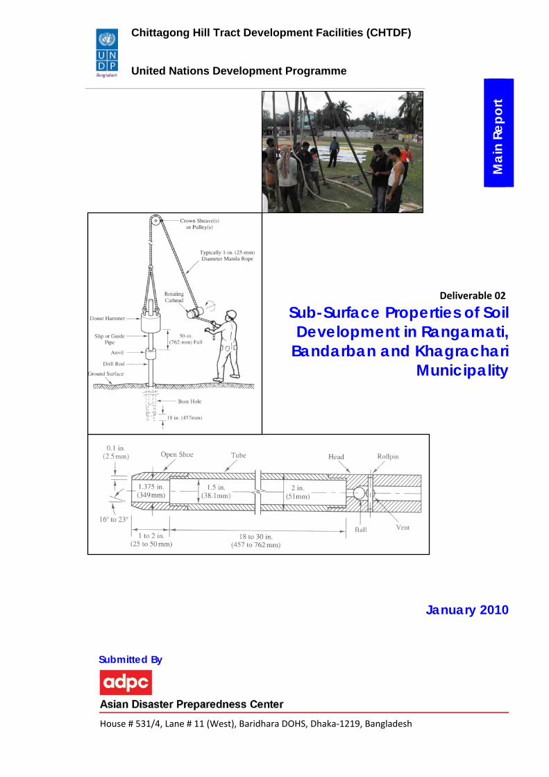
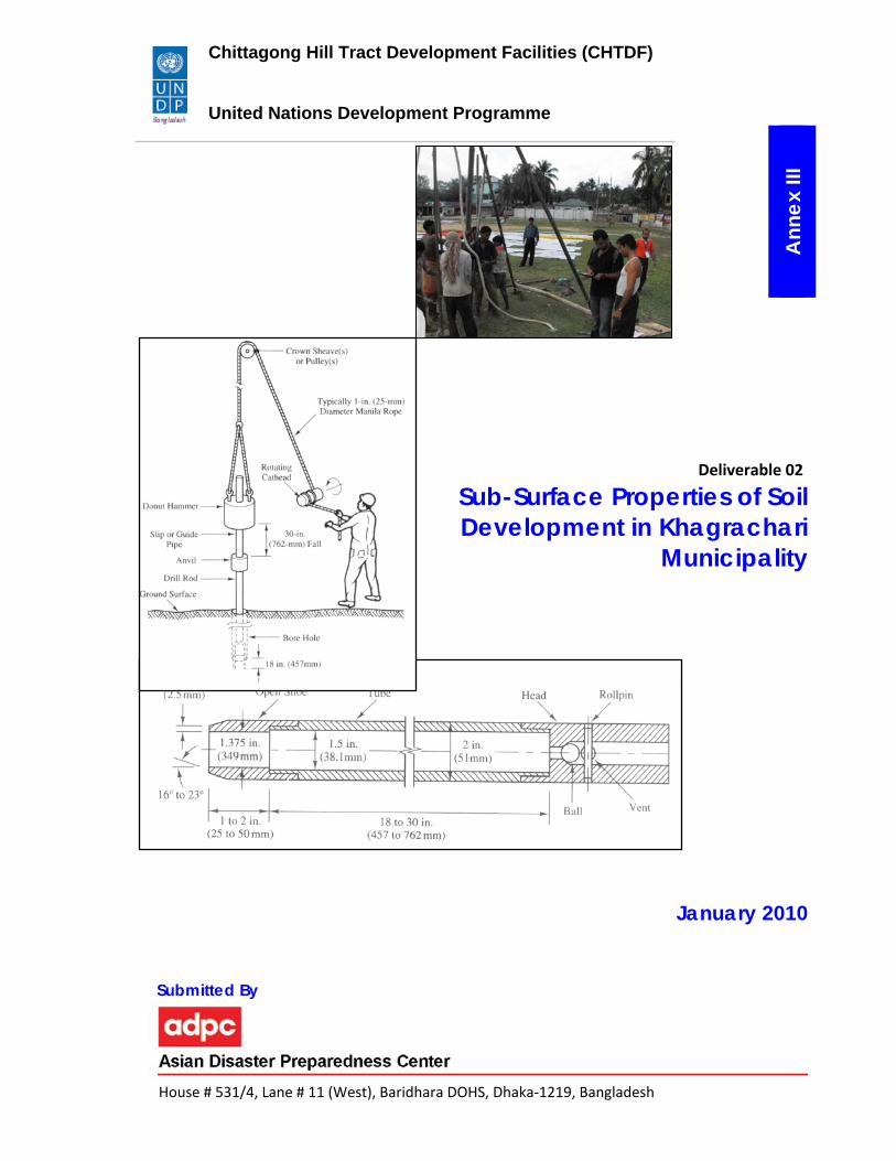
Deliverable 02 Sub-Surface Properties of Soil
Development in Rangamati, Bandarban and Khagrachari
Municipality
January 2010
Submitted By
House # 531/4, Lane # 11 (West), Baridhara DOHS, Dhaka‐1219, Bangladesh
Table of Content
Page No.
1. Introduction 1 1.1 Scope of Work 1 1.2 Borehole Locations and Selection Criteria 1 2. Methods and Materials 6 2.1. Field Work 6 2.1.1. Wash Boring 6 2.1.2. Soil Sampling 7 2.1.2.1. Thin walled Sampler 10 2.1.2.2. Split spoon Sampler 10 2.1.3. Standard Penetration Test (SPT) 11 3. Conclusion 14
List of Tables Table 1: Geotechnical borehole locations in Rangamati Town 3 Table 2: Geotechnical borehole locations in Bandarban Town 3 Table 3. Geotechnical borehole locations in Khagrachari Town. 4
List of Figures Figure 1: Wash Boring. 7 Figure 2. (a) Thin‐walled (Shelby Tube) Sampler, and (b) Split‐spoon Sampler. 10 Figure 3: Split‐spoon sampler 12 Figure 4: The SPT sampler in place in the boring. 13
List of Maps Map 1 : Borehole locations in Rangamati Municipality 2 Map 2: Geotechnical borehole locations are shown in Bandarban Town. 4 Map 3. Geotechnical borehole locations are shown in Khagrachari Town 5
Geotechnical Investigation using Standard Penetration Test (SPT) in Rangamati, Bandarban and Khagrachari Towns
1
1. Introduction
1.1 Scope of Work
The Asian Disaster Preparedness Centre (ADPC) is implementing the project “Seismic Hazard
and Vulnerability Mapping for Rangamati, Bandarban and Khagrachari Municipality”. One of
the major outcomes of the project is the development of seismic hazard maps of these three
municipalities. Subsurface geotechnical investigation is essential to determine engineering
properties of subsurface materials for the preparation of engineering geological and seismic
hazard maps. The objectives of the subsurface geotechnical investigation of Rangamati,
Bandarban and Khagrachari Towns include:
1. Construction of 10 (ten) SPT (Standard Penetration Test) boreholes using manual
wash boring method.
2. Collection of disturbed samples using split spoon sampler and undisturbed samples
using shelby tubing sampler.
3. Performance of geotechnical laboratory tests such as, moisture content, specific
gravity, Atterberg limits, unit weight, grain size analysis, unconfined compression
strength, direct shear, triaxial tests to determine physical and engineering properties,
and shear strength parameters of the collected disturbed and undisturbed
subsurface soil materials of Rangamati, Bandarban and Khagrachari Towns.
This report presents the initial findings from the boreholes conducted in the three
municipalities.
1.2 Borehole Locations and Selection Criteria
The geotechnical boreholes with Standard Penetration Test (SPT) have been conducted using
wash boring method. In this investigation, 09 (nine) boreholes in Rangamati Town, 10 (ten)
boreholes in Bandarban Town and 11 (eleven) boreholes in Khagrachari Town have been

Geotechnical Investigation using Standard Penetration Test (SPT) in Rangamati, Bandarban and Khagrachari Towns
2
prepared up to maximum 30 m depth. The borehole logs of three towns are enclosed in
Appendix.
Rangamati Response analysis will be conducted using SPT value to identify soft sedimentary soil which will amplify the seismic energy of the place. In Rangamati as the tertiary bed rocks are exposed in the hilly areas, there was no need for the SPT values in those areas.
Map 1 : Borehole locations in Rangamati Municipality

Geotechnical Investigation using Standard Penetration Test (SPT) in Rangamati, Bandarban and Khagrachari Towns
3
From the geomorphic assessment, Rangamati Municipality has been classified into 3
different classes viz. Valley Fill deposit, Erosional Slope Phase and Piedmond deposit other
than the Hilly areas. The selection criteria for the SPT locations are described as follows:
Table 1: Geotechnical borehole locations in Rangamati Town Borehole No.
Location Latitude Longitude Geomorphic Unit
01 Shadhonapur, Rangapani 22º38'19" 92º09'34.6" Erosional Slope Phase
02 Chompaknagar, Rangapani 22º38'41.8" 92º09'37.9" Erosional Slope Phase03 Monoghar, Vedvedi 22º38'59" 92º09'21.7" Valley Fill Deposit04 Montolla, Vedvedi 22º39'10.5" 92º09'39.5" Valley Fill Deposit05 Jhograbil, Thonchonkapara 22º37'31.6" 92º09'45.8" Piedmond Deposit06 Notunpara, Vedvedi 22º39'13.8" 92º09'09.3" Valley Fill Deposit07 Mitinga Chara Para, Thonchonkapara 22º36'55.7" 92º09'55.5" Piedmond Deposit08 Dakhin Thonchonkapara, Jograbil 22º37'42.9" 92º09'44.5" Piedmond Deposit09 BDR Sector Headquarters Gate 22º37'53.7" 92º11'15.9" Piedmond Deposit
Some locations have been avoided as there is no urbanization in those particular areas, i.e.
the seismic vulnerability is zero. To cross check and represent unique successive units, 2 or 3
boreholes have been selected from each class.
Bandarban In Bandarban 7 different geomorphic classes have been identified other than the hilly areas. The locations of SPT are discussed as follows: Table 2: Geotechnical borehole locations in Bandarban Town
Borehole No.
Location Latitude Longitude Geomorphic Unit
01 Rassel Colony, Army Para 22º11'35" 92º13'3.6" Erosional Slope Phase
02 Bandarban Govt. High School 22º11'49.69" 92º13'6.41" Flood Plane
03 Rajar Math 22º11'50.5" 92º13'15" Marshy Land
04 Girichaiya Police Quarter 22º11'40.6" 92º13'18.8" Erosional Slope Phase/ Valley Fill
05 Bandarban Stadium 22º11'31.78" 92º13'23.83" Level Hill 06 Kalaghata Notun Bridge 22º11'21.2 " 92º13'51.1" Piedmond Deposit07 Lushaibari 22º11'20.4" 92º13'07.7" Valley Fill 08 Shoiloshova Housing Society 22º12'44" 92º12'33" Flood Plane 09 Balaghata Muslim Para 22º13'03.1" 92º12'42.8" Erosional Slope Phase10 West Balaghata` 22º13'20.53" 92º12'09.56" Valley Fill
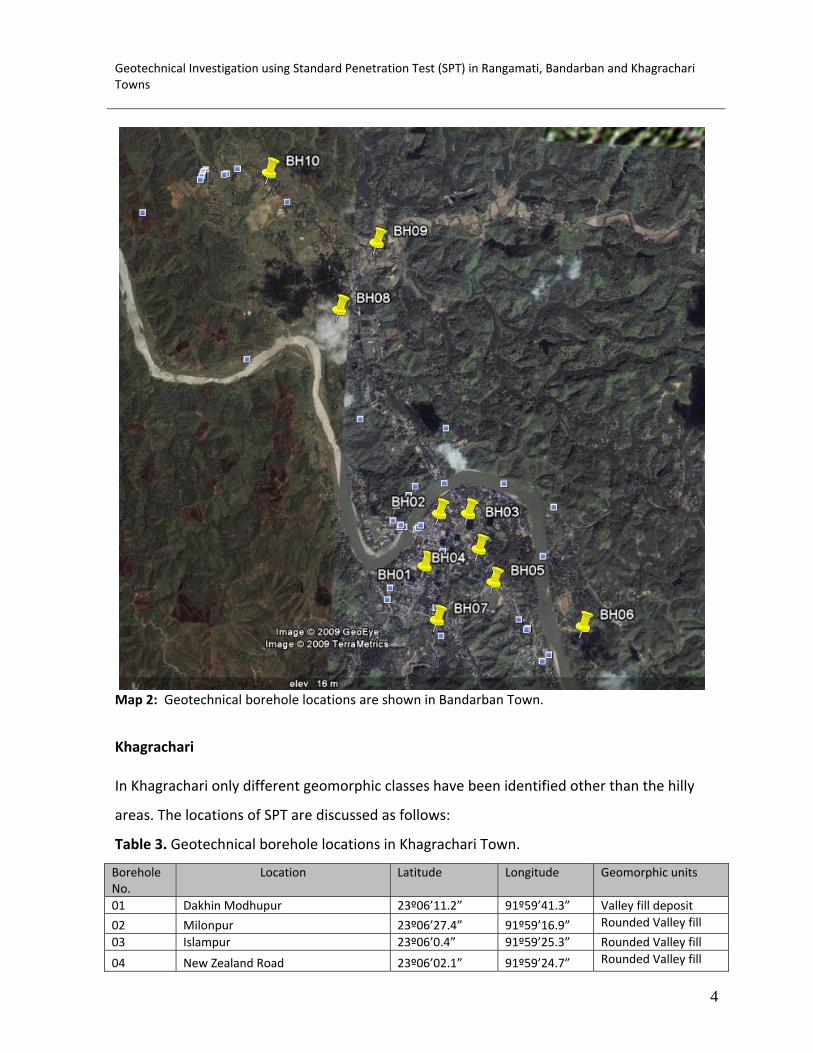
Geotechnical Investigation using Standard Penetration Test (SPT) in Rangamati, Bandarban and Khagrachari Towns
4
Map 2: Geotechnical borehole locations are shown in Bandarban Town.
Khagrachari In Khagrachari only different geomorphic classes have been identified other than the hilly
areas. The locations of SPT are discussed as follows:
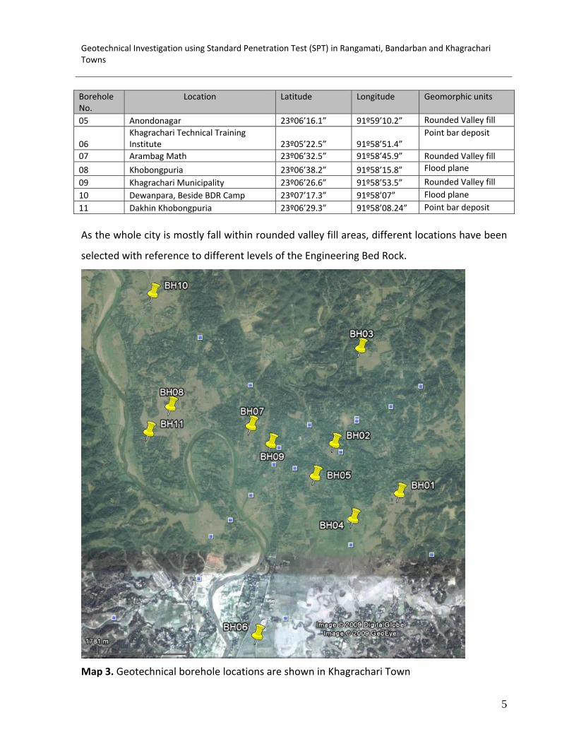
Table 3. Geotechnical borehole locations in Khagrachari Town.
Borehole No.
Location Latitude Longitude Geomorphic units
01 Dakhin Modhupur 23º06’11.2” 91º59’41.3” Valley fill deposit
02 Milonpur 23º06’27.4” 91º59’16.9” Rounded Valley fill
03 Islampur 23º06’0.4” 91º59’25.3” Rounded Valley fill
04 New Zealand Road 23º06’02.1” 91º59’24.7” Rounded Valley fill
Geotechnical Investigation using Standard Penetration Test (SPT) in Rangamati, Bandarban and Khagrachari Towns
5
Borehole No.
Location Latitude Longitude Geomorphic units
05 Anondonagar 23º06’16.1” 91º59’10.2” Rounded Valley fill
06 Khagrachari Technical Training Institute 23º05’22.5” 91º58’51.4”
Point bar deposit
07 Arambag Math 23º06’32.5” 91º58’45.9” Rounded Valley fill
08 Khobongpuria 23º06’38.2” 91º58’15.8” Flood plane
09 Khagrachari Municipality 23º06’26.6” 91º58’53.5” Rounded Valley fill10 Dewanpara, Beside BDR Camp 23º07’17.3” 91º58’07” Flood plane11 Dakhin Khobongpuria 23º06’29.3” 91º58’08.24” Point bar deposit
As the whole city is mostly fall within rounded valley fill areas, different locations have been
selected with reference to different levels of the Engineering Bed Rock.
Map 3. Geotechnical borehole locations are shown in Khagrachari Town
Geotechnical Investigation using Standard Penetration Test (SPT) in Rangamati, Bandarban and Khagrachari Towns
6
2. Methods and Materials The methods and materials used to carry out the geotechnical investigation have been
described below:
2.1. Field Work
A detail field work has been carried out to select the locations of geotechnical borehole in
different geomorphological and geological units of three towns. The locations of the
boreholes have been recorded using Global Positioning System (GPS). The boreholes have
been constructed in most of the geomorphological units of the towns. The geological
materials encountered in boreholes have been interpreted and classified in the field.
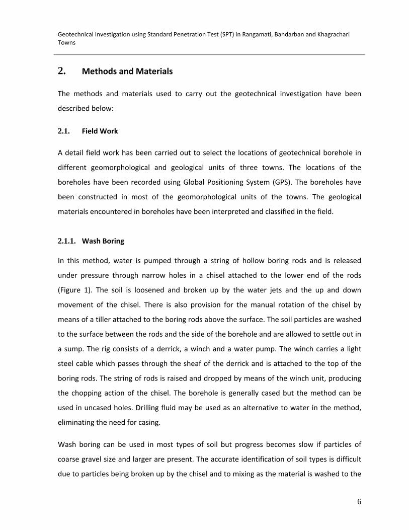
2.1.1. Wash Boring
In this method, water is pumped through a string of hollow boring rods and is released
under pressure through narrow holes in a chisel attached to the lower end of the rods
(Figure 1). The soil is loosened and broken up by the water jets and the up and down
movement of the chisel. There is also provision for the manual rotation of the chisel by
means of a tiller attached to the boring rods above the surface. The soil particles are washed
to the surface between the rods and the side of the borehole and are allowed to settle out in
a sump. The rig consists of a derrick, a winch and a water pump. The winch carries a light
steel cable which passes through the sheaf of the derrick and is attached to the top of the
boring rods. The string of rods is raised and dropped by means of the winch unit, producing
the chopping action of the chisel. The borehole is generally cased but the method can be
used in uncased holes. Drilling fluid may be used as an alternative to water in the method,
eliminating the need for casing.
Wash boring can be used in most types of soil but progress becomes slow if particles of
coarse gravel size and larger are present. The accurate identification of soil types is difficult
due to particles being broken up by the chisel and to mixing as the material is washed to the

Geotechnical Investigation using Standard Penetration Test (SPT) in Rangamati, Bandarban and Khagrachari Towns
7
Figure 1: Wash Boring.
surface: in addition, segregation of particles takes place as they settle out in the sump.
However, a change in the feel of the boring tool can sometimes be detected, and there may
be a change in the color of the water rising to the surface, when the boundaries between
different strata are reached. The method is unacceptable as a means of obtaining soil
samples. It is used only as a means of advancing a borehole to enable tube samples to be
taken or in‐situ tests such as Standard Penetration Test (SPT) to be carried out below the
bottom of the hole. An advantage of the method is that the soil immediately below the hole
remains relatively undisturbed.
2.1.2. Soil Sampling Soil samples are divided into two main categories, undisturbed and disturbed. Undisturbed
samples, which are required mainly for shear strength and consolidation tests, are obtained
Geotechnical Investigation using Standard Penetration Test (SPT) in Rangamati, Bandarban and Khagrachari Towns
8
by techniques which aim at preserving the in‐situ structure and water content of the soil. In
boreholes, undisturbed samples can be obtained by withdrawing the boring tools (except
when hollow‐stem continuous‐flight augers are used) and driving or pushing a sample tube
into the soil at the bottom of the hole. The sampler is normally attached to a length of
boring rod which can be lowered and raised by the cable of the percussion rig. When the
tube is brought to the surface, some soil is removed from each end and molten wax is
applied, in thin layers, to form a seal approximately 25mm thick: the ends of the tube are
then covered by protective caps. Undisturbed block samples can be cut by hand from the
bottom or sides of a trial pit. During cutting, the samples must be protected from water,
wind and sun to avoid any change in water content: the samples should be covered with
molten wax immediately they have been brought to the surface. It is impossible to obtain a
sample that is completely undisturbed, no matter how elaborate or careful the ground
investigation and sampling technique might be. In the case of clays, for example, swelling
will take place adjacent to the bottom of a borehole due to the reduction in total stresses
when soil is removed and structural disturbance may be caused by the action of the boring
tools; subsequently, when a sample is removed from the ground the total stresses are
reduced to zero.
Soft clays are extremely sensitive to sampling disturbance, the effects being more
pronounced in clays of low plasticity than in those of high plasticity. The central core of a
soft clay sample will be relatively less disturbed than the outer zone adjacent to the
sampling tube. Immediately after sampling, the pore water pressure in the relatively
undisturbed core will be negative due to the release of the in‐situ total stresses. Swelling of
the relatively undisturbed core will gradually take place due to water being drawn from the
more disturbed outer zone and resulting in the dissipation of the negative excess pore water
pressure: the outer zone of soil will consolidate due to the redistribution of water within the
sample. The dissipation of the negative excess pore water pressure is accompanied by a
corresponding reduction in effective stresses. The soil structure of the sample will thus offer
less resistance to shear and will be less rigid than the in‐situ soil.
Geotechnical Investigation using Standard Penetration Test (SPT) in Rangamati, Bandarban and Khagrachari Towns
9
A disturbed sample is one having the same particle size distribution as the in‐situ soil but in
which the soil structure has been significantly damaged or completely destroyed; in addition,
the water content may be different from that of the in‐situ soil. Disturbed samples, which
are used mainly for soil classification tests, visual classification and compaction tests, can be
excavated from trial pits or obtained from the tools used to advance boreholes (e.g. from
augers and the clay cutter). The soil recovered from the shell in percussion boring will be
deficient in fines and will be unsuitable for use as a disturbed sample. Samples in which the
natural water content has been preserved should be placed in airtight, non‐corrosive
containers: all containers should be completely filled so that there is negligible air space
above the sample.
All samples should be clearly labeled to show the project name, date, location, borehole
number, depth and method of sampling; in addition, each sample should be given a serial
number. Special care is required in the handling, transportation and storage of samples
(particularly undisturbed samples) prior to testing.
The sampling method used should be related to the quality of sample required. Quality can
be classified as follows, according to the uses to which the sample can be put:
Class 1: classification, water content, density, shear strength, deformation and consolidation
tests.
Class 2: classification, water content and density tests.
Class 3: classification and water content tests.
Class 4: classification tests only.
Class 5: strata identification only.
For Classes 1 and 2 the sample must be undisturbed. Samples of Classes 3, 4 and 5 may be
disturbed.
The types of tube samplers used in this study are described as follows.
Geotechnical Investigation using Standard Penetration Test (SPT) in Rangamati, Bandarban and Khagrachari Towns
10
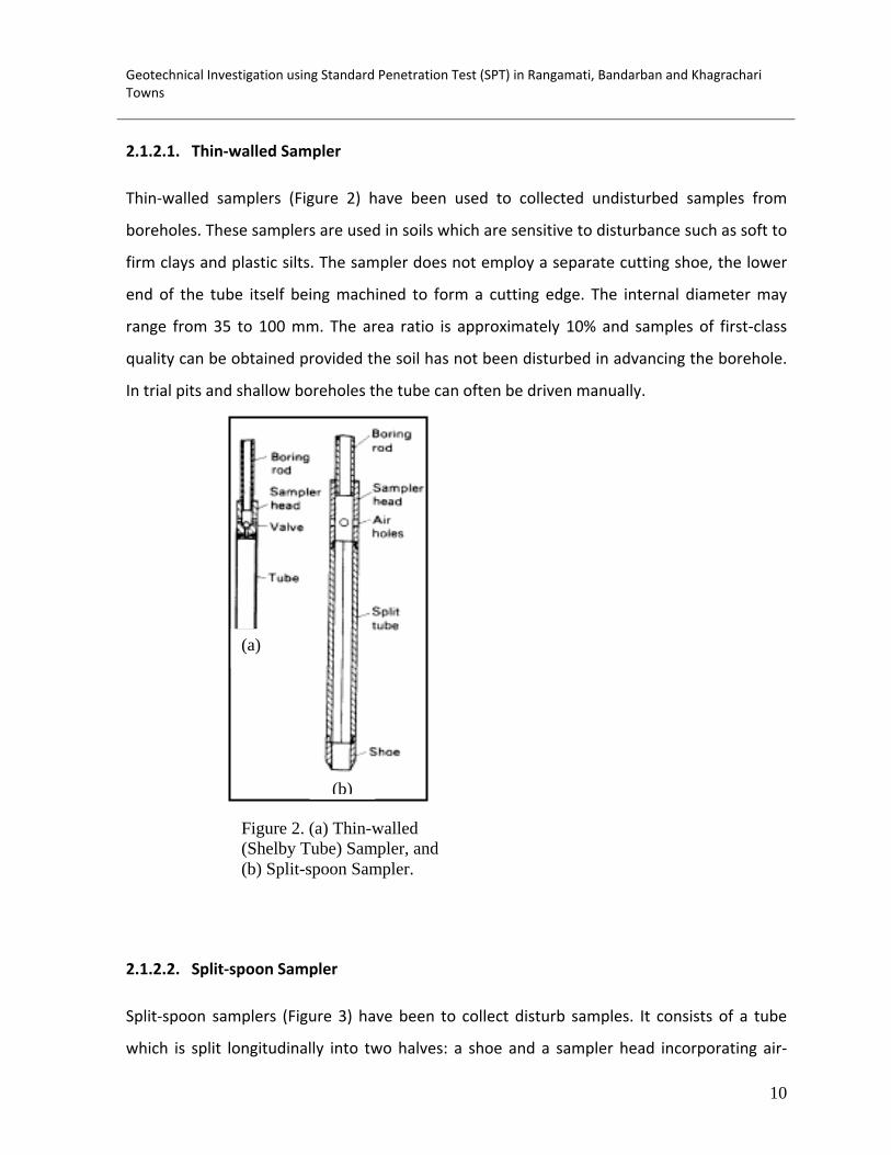
2.1.2.1. Thin‐walled Sampler
Thin‐walled samplers (Figure 2) have been used to collected undisturbed samples from
boreholes. These samplers are used in soils which are sensitive to disturbance such as soft to
firm clays and plastic silts. The sampler does not employ a separate cutting shoe, the lower
end of the tube itself being machined to form a cutting edge. The internal diameter may
range from 35 to 100 mm. The area ratio is approximately 10% and samples of first‐class
quality can be obtained provided the soil has not been disturbed in advancing the borehole.
In trial pits and shallow boreholes the tube can often be driven manually.
2.1.2.2. Split‐spoon Sampler
Split‐spoon samplers (Figure 3) have been to collect disturb samples. It consists of a tube
which is split longitudinally into two halves: a shoe and a sampler head incorporating air‐
Figure 2. (a) Thin-walled (Shelby Tube) Sampler, and (b) Split-spoon Sampler.
(a)
(b)
Geotechnical Investigation using Standard Penetration Test (SPT) in Rangamati, Bandarban and Khagrachari Towns
11
release holes are screwed onto the ends. The two halves of the tube can be separated when
the shoe and head are detached to allow the sample to be removed. The internal and
external diameters are 35 and 50 mm, respectively, the area ratio being approximately
100%, with the result that there is considerable disturbance of the sample (Class 3 or 4). This
sampler is used mainly in sands, being the tool specified in the standard penetration test
(SPT).
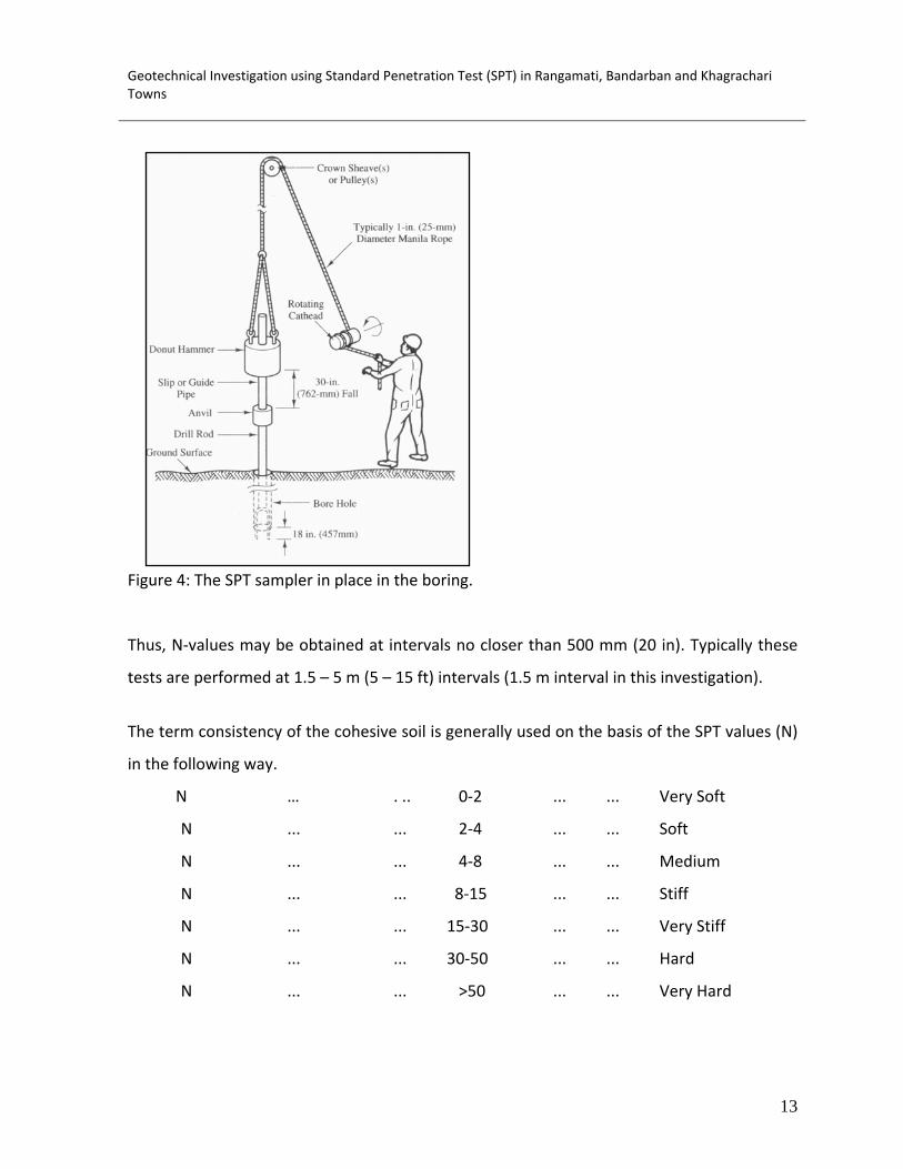
2.1.3. Standard Penetration Test (SPT) One of the oldest and most common in‐situ tests is the Standard Penetration Test or SPT
(Figure 7). It was developed in the late 1920s and has been used extremely in North and
South America, the United Kingdom, Japan, and elsewhere. Because of this long record of
experience, the SPT is well‐established in engineering practice. It is performed inside
exploratory boring using inexpensive and readily available equipment, and thus adds little
cost to a site characterization program.
Although the SPT also is plagued by many problems that affect its accuracy and
reproducibility, it probably will continue to be used for the foreseeable future, primarily
because of its low cost. However, it is partially being replaced by other test methods,
especially on larger and more critical projects.
The ASTM standard D1586 has been followed to carry out SPT. The procedure is as follows.
1. Drill a 60‐200 mm (2.5‐8 in) diameter exploratory boring to the depth of the first
test.
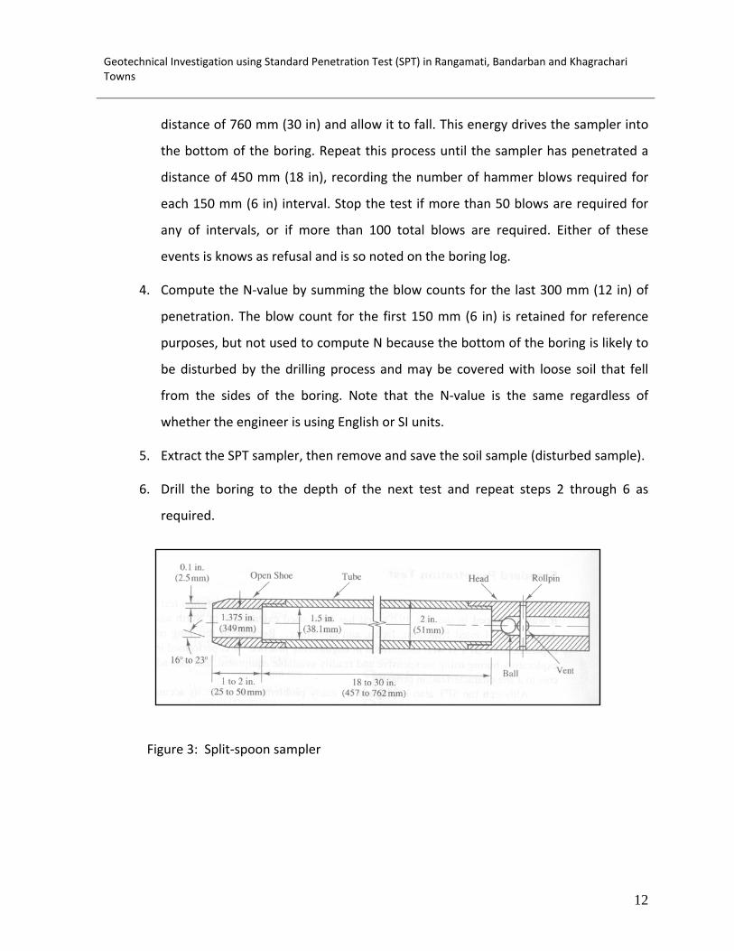
2. Insert the SPT sampler (also known as a Split‐spoon Sampler) into the boring. The
shape and dimensions of this sampler are shown in Figure 4. It is connected via
steel rods to a 63.5 kg (140 lb) hammer, as shown in Figure 5.
3. Using either a rope and cathead arrangement (in case of wash boring used this
technique in this investigation) or an automatic tripping mechanism (in case of
rotary drilling used this technique in this investigation), raise the hammer a
Geotechnical Investigation using Standard Penetration Test (SPT) in Rangamati, Bandarban and Khagrachari Towns
12
distance of 760 mm (30 in) and allow it to fall. This energy drives the sampler into
the bottom of the boring. Repeat this process until the sampler has penetrated a
distance of 450 mm (18 in), recording the number of hammer blows required for
each 150 mm (6 in) interval. Stop the test if more than 50 blows are required for
any of intervals, or if more than 100 total blows are required. Either of these
events is knows as refusal and is so noted on the boring log.
4. Compute the N‐value by summing the blow counts for the last 300 mm (12 in) of
penetration. The blow count for the first 150 mm (6 in) is retained for reference
purposes, but not used to compute N because the bottom of the boring is likely to
be disturbed by the drilling process and may be covered with loose soil that fell
from the sides of the boring. Note that the N‐value is the same regardless of
whether the engineer is using English or SI units.
5. Extract the SPT sampler, then remove and save the soil sample (disturbed sample).
6. Drill the boring to the depth of the next test and repeat steps 2 through 6 as
required.
Figure 3: Split‐spoon sampler
Geotechnical Investigation using Standard Penetration Test (SPT) in Rangamati, Bandarban and Khagrachari Towns
13
Figure 4: The SPT sampler in place in the boring.
Thus, N‐values may be obtained at intervals no closer than 500 mm (20 in). Typically these
tests are performed at 1.5 – 5 m (5 – 15 ft) intervals (1.5 m interval in this investigation).
The term consistency of the cohesive soil is generally used on the basis of the SPT values (N)
in the following way.
N … . .. 0‐2 ... ... Very Soft
N ... ... 2‐4 ... ... Soft
N ... ... 4‐8 ... ... Medium
N ... ... 8‐15 ... ... Stiff
N ... ... 15‐30 ... ... Very Stiff
N ... ... 30‐50 ... ... Hard
N ... ... >50 ... ... Very Hard

Geotechnical Investigation using Standard Penetration Test (SPT) in Rangamati, Bandarban and Khagrachari Towns
14
The term relative density for the non‐cohesive soil is used on the basis of the SPT values (N)
in the following way.
N … … 0‐4 ... … Very loose
N ... ... 4‐10 ... ... Loose
N ... ... 10‐30 ... ... Medium dense
N ... ... 30‐50 ... ... Dense
N ... ... >50 ... ... Very dense
3. Conclusion Subsurface geotechnical investigation is essential to determine engineering properties of
subsurface materials for the preparation of engineering geological and seismic hazard maps.
Detail field work has been carried out to select the locations of geotechnical borehole in
different geomorphological and geological units of three towns. The locations of the
boreholes have been recorded using Global Positioning System (GPS). The boreholes have
been constructed in most of the geomorphological units of the towns. The geological
materials encountered in boreholes have been interpreted and classified in the field. The
geotechnical boreholes with Standard Penetration Test (SPT) have been conducted using
wash boring method. In this investigation, 09 (nine) boreholes in Rangamati Town, 10 (ten)
boreholes in Bandarban Town and 11 (eleven) boreholes in Khagrachari Town have been
prepared up to maximum 30 m depth. Split‐spoon samplers have been used to collect
disturb samples. Disturbed samples are used mainly for soil classification tests, visual
classification. Thin‐walled samplers have been used to collected undisturbed samples from
boreholes. These samplers are used in soils which are sensitive to disturbance such as soft to
firm clays and plastic silts. Undisturbed samples are required mainly for shear strength.

Chittagong Hill Tract Development Facilities (CHTDF) United Nations Development Programme
Ann
ex I
Deliverable 02 Sub-Surface Properties of Soil
Development in Rangamati Municipality
January 2010
Submitted By
House # 531/4, Lane # 11 (West), Baridhara DOHS, Dhaka‐1219, Bangladesh
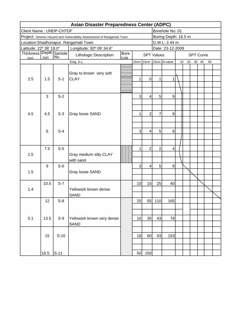
Depth Sample Bore (m) No. Log
15cm 15cm 15cm N-value
2.5 1.5 S-1 1 0 1 1
3 S-2 3 4 5 9
4.5 4.5 S-3 1 2 7 9
6 S-4 3 4 5 9
7.5 S-5 1 2 2 41.5
9 S-6 3 4 5 91.5
10.5 S-7 10 15 25 401.4
12 S-8 25 55 110 165
5.1 13.5 S-9 15 35 43 78
15 S-10 18 60 93 153
16.5 S-11 50 150
Asian Disaster Preparedness Center (ADPC)
Gray loose SAND
Yellowish brown very dense SAND
CLAY
Gray loose SAND
SANDYellowish brown dense
10 20 30 40 50
Lithologic DescriptionExtg. G.L
SPT Values SPT Curve
Gray to brown very soft
Gray medium silty CLAYwith sand
Location:Shadhonapur, Rangamati TownLatitude: 22º 38' 19.0"
Client Name : UNDP-CHTDF
Thickness (m)
Date: 23-12-2009 Longitude: 92º 09' 34.6"
Borehole No: 01Project: Seismic Hazard and Vulnerability Assessment of Rangamati Town Boring Depth: 16.5 m
G.W.L: 2.44 m

Thickness Depth Sample Bore (m) (m) No. Log
Extg. G.L 15cm 15cm 15cm N-value 10 20 30 40 50
2.31.5 S-1 2 3 3 6
3 S-2 1 2 1 33.2 Gray loose clayey SAND
4.5 S-3 2 3 4 7
1.5 6 S-4 Gray soft CLAY with peat 1 1 2 3
7.5 S-5 1 2 4 61.3 Gray loose SAND
9 S-6 30 70 130 200
3.7 10.5 S-7 15 25 32 57
12 S-8 30 130 150
Asian Disaster Preparedness Center (ADPC)Client Name : UNDP-CHTDF Borehole No: 02
Locatio:Chompoknagor,Rangapani, Rangamati TownBoring Depth: 12 mG.W.L: 1.83 m
Longitude: 92º 09' 37.9"
SPT Values
Gray very dense SAND
Latitude: 22º 38' 41.8"
Gray medium sandy CLAY
SPT CurveLithologic Description
Project: Seismic Hazard and Vulnerability Assessment of Rangamati Town
Date: 24-12-2009
Thickness Depth Sample Bore (m) (m) No. Log
Extg. G.L 15cm 15cm 15cm N-value 10 20 30 40 50
2 1.5 S-1 1 0 1 1
3 S-2 2 3 4 7
3.5 4.5 S-3 2 3 5 8
6 S-4 3 5 7 121.5
7.5 S-5 10 16 25 41
9 S-6 12 22 32 545
10.5 S-7 20 42 90 132
12 S-8 88 218
Yellowish brown mediumSAND
Yellowish brown dense tovery dense SAND
CLAY
Yellowish brown looseclayey SAND
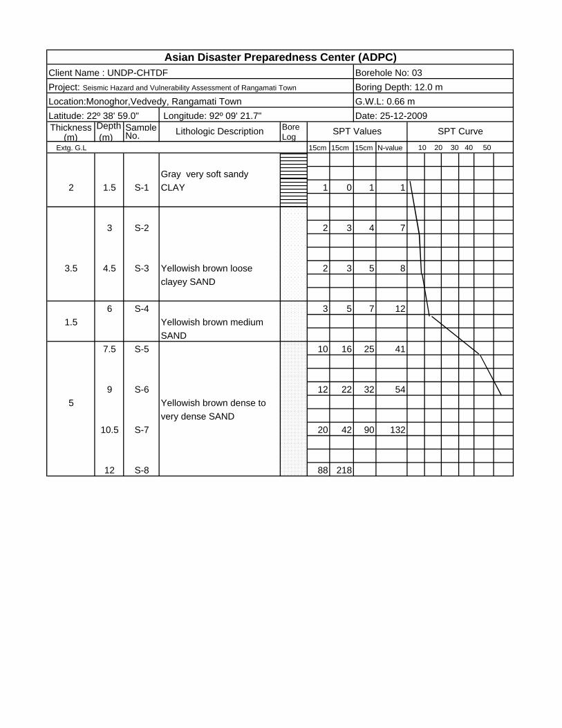
Client Name : UNDP-CHTDF
Location:Monoghor,Vedvedy, Rangamati TownProject: Seismic Hazard and Vulnerability Assessment of Rangamati Town
Longitude: 92º 09' 21.7"
Lithologic Description SPT Values
Latitude: 22º 38' 59.0"
Gray very soft sandy
Date: 25-12-2009
SPT Curve
G.W.L: 0.66 m
Borehole No: 03Asian Disaster Preparedness Center (ADPC)
Boring Depth: 12.0 m

Depth Sample Bore (m) No. Log
15cm 15cm 15cm N-value
2.5 1.5 S-1 1 2 2 4
3 S-2 6 9 10 191.5
4.5 S-3 9 22 34 56
6 S-4 25 40 50 90
6.47.5 S-5 dense SAND 15 36 57 93
9 S-6 31 175
10.5 S-7 45 220
Yellowish brown medium dense clayey SAND
Yellowish brown very
Extg. G.L 10 20 30 40 50
Gray very soft sandy CLAY
Thickness (m)
Lithologic Description SPT Values SPT Curve
Location:Monotola, Vedvedy, Rangamati Town G.W.L: 0.31 mLatitude: 22º39'10.5" Longitude: 92º 09' 39.5" Date: 26-12-2009
Client Name : UNDP-CHTDF Borehole No: 04Project: Seismic Hazard and Vulnerability Assessment of Rangamati Town Boring Depth: 10.5 m
Asian Disaster Preparedness Center (ADPC)
Depth Sample Bore (m) No. Log
15cm 15cm 15cm N-value
1.5 S-1 1 2 3 54
3 S-2 1 2 3 5
4.5 S-3 1 2 6 8
3 6 S-4 3 4 6 10
7.5 S-5 4 7 10 17
4.5 9 S-6 3 5 7 12
10.5 S-7 2 3 7 10
12 S-8 6 13 22 35
3.5 13.5 S-9 40 175 100
15 S-10 60 242 200
Yellowish brown dense to very dense SAND
Gray loose clayey SAND
Gray medium dense clayey SAND
Extg. G.L 10 20 30 40 50
Yellowish brown medium CLAY
Thickness (m)
Lithologic Description SPT Values SPT Curve
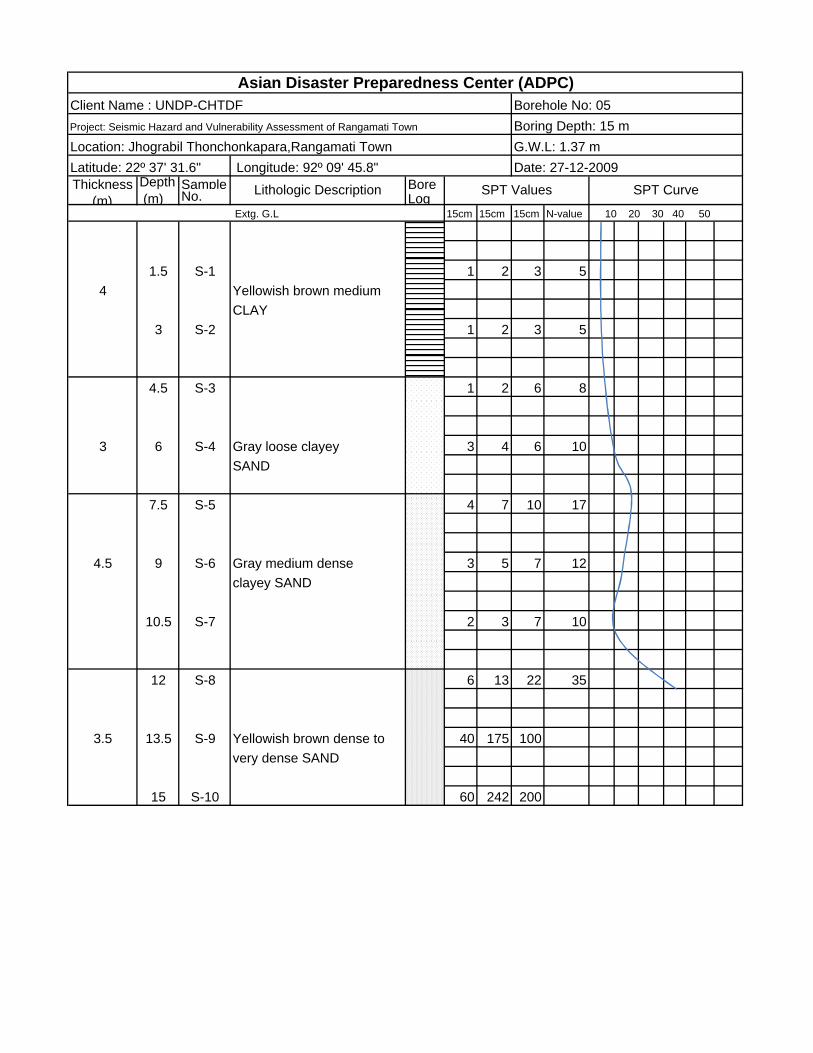
Location: Jhograbil Thonchonkapara,Rangamati Town G.W.L: 1.37 mLatitude: 22º 37' 31.6" Longitude: 92º 09' 45.8" Date: 27-12-2009
Client Name : UNDP-CHTDF Borehole No: 05Project: Seismic Hazard and Vulnerability Assessment of Rangamati Town Boring Depth: 15 m
Asian Disaster Preparedness Center (ADPC)

Depth Sample Bore (m) No. Log
15cm 15cm 15cm N-value
1.5 S-1 1 1 2 34
3 S-2 1 2 2 4
4.5 S-3 15 42 65 107
6 S-4 20 60 85 1455
7.5 S-5 80 200
9 S-6 150 100
Yellowish brown verydense SAND
Asian Disaster Preparedness Center (ADPC)
Extg. G.L 10 20 30 40 50
Gray soft to mediumsandy CLAY
Latitude: 22º 39' 13.8" Longitude: 92º 09' 09.3" Date: 31-12-2009Thickness
(m)Lithologic Description SPT Values SPT Curve
Project: Seismic Hazard and Vulnerability Assessment of Ragnamati Town Boring Depth: 9 mLocation:Notunpara, Vedvedy, Rangamati Town G.W.L: 2.44 m
Client Name : UNDP-CHTDF Borehole No: 06
Depth Sample Bore (m) No. Log
15cm 15cm 15cm N-value
5.5 1.5 S-1 2 3 4 7
3 S-2 2 3 3 6
4.5 S-3 2 3 3 6
6 S-4 1 2 3 51.5
7.5 S-5 65 200
3.5 9 S-6 370
10.5 S-7
Asian Disaster Preparedness Center (ADPC)
Yellowish brown looseSAND
Yellowish brown very dense SAND
Extg. G.L 10 20 30 40 50
Yellowish brown medium CLAY
Thickness (m)
Lithologic Description SPT Values SPT Curve
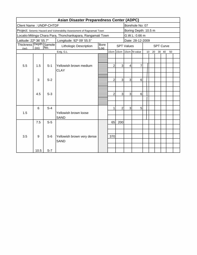
Locatio:Mitinga Chara Para, Thonchankapara, Rangamati Town G.W.L: 0.66 mLatitude: 22º 36' 55.7" Longitude: 92º 09' 55.5" Date: 28-12-2009
Client Name : UNDP-CHTDF Borehole No: 07Project: Seismic Hazard and Vulnerability Assessment of Ragnamati Town Boring Depth: 10.5 m
Depth Sample Bore (m) No. Log
15cm 15cm 15cm N-value
2.5 1.5 S-1 1 1 1 2
3 S-2 2 3 4 7
3 4.5 S-3 2 3 4 7
6 S-4 4 8 12 20
37.5 S-5 4 5 6 11
9 S-6 1 3 4 71.5
10.5 S-7 6 13 25 385
12 S-8 16 32 43 75
13.5 S-9 62 230
15 S-10 100 190
Asian Disaster Preparedness Center (ADPC)
Yellowish brown medium dense SAND
Yellowish brown loose SAND
very dense SAND
Yellowish brown loose clayey SAND.
Yellowish brown dense to
Extg. G.L 10 20 30 40 50
Yellowish brown soft sandy CLAY
Latitude: 22º 37' 49.9" Longitude: 92º 09' 44.5" Date: 29-12-2009Thickness
(m)Lithologic Description SPT Values SPT Curve
Project: Seismic Hazard and Vulnerability Assessment of Ragnamati Town Boring Depth: 15 mLocation: Jhograbil, Dakhin Tongchankapara, Rangamati Town G.W.L: 1.1 m
Client Name : UNDP-CHTDF Borehole No: 08

Thickness Depth Sample Bore (m) (m) No. Log
Extg. G.L 15cm 15cm 15cm N-value 10 20 30 40 50
1.5 S-1 1 1 1 23
3 S-2 1 1 2 3
3 4.5 S-3 3 5 5 10
6 S-4 2 3 4 7
7.5 S-5 6 10 18 28
9 S-6 12 18 30 487.5
10.5 S-7 12 25 37 62
12 S-8 13 26 37 63
13.5 S-9 35 105 232 337
to very dense SAND
Asian Disaster Preparedness Center (ADPC)Client Name : UNDP-CHTDF Borehole No: 9Project: Seismic Hazard and Vulnerability Assessment of Ragnamati Town Boring Depth: 13.5 mLocation:BDR sector Head quartergate,Rangamati Town G.W.L: 1.37 m
Longitude: 92º11'15.9" Date: 30-12-2009
Yellowish brown loose clayey SAND
Yellowish brown dense
Latitude: 22º 37' 53.0"
Reddish brown soft CLAY
Lithologic Description SPT Values SPT Curve

Chittagong Hill Tract Development Facilities (CHTDF) United Nations Development Programme
Ann
ex II
Deliverable 02 Sub-Surface Properties of Soil
Development in Bandarban Municipality
January 2010
Submitted By
House # 531/4, Lane # 11 (West), Baridhara DOHS, Dhaka‐1219, Bangladesh
Latitude: 22º 11' 35" Depth Sample Bore (m) No. Log
15cm 15cm 15cm N-value
1.5 S-1 1 2 3 5
4 Yellowish brown medium 3 S-2 stiff CLAY 1 1 1 2
4.5 S-3 1 2 3 5
4.3 6 S-4 2 3 3 6
7.5 S-5 2 2 3 5
9 S-6 3 3 5 8
5.7 10.5 S-7 3 3 6 9Yellowish brown loose tomedium SAND
12 S-8 4 5 7 12
13.5 S-9 3 5 8 13
2 15 S-10 Grey medium silty SAND 5 8 12 20with clay
16.5 S-11 8 12 28 40
18 S-12 15 22 35 57
8 19.5 S-13 Grey dense to very dense 15 27 3o 57SAND
21 S-14 17 25 33 58
22.5 S-15 30 71 92 163
24 S-16 105 147
Date: 23-11-2009
SPT Values SPT Curve
Longitude: 92º 13' 3.6"
10 20 30 40 50
Lithologic DescriptionThickness (m)
Asian Disaster Preparedness Center (ADPC)Client Name : UNDP-CHTDF Borehole No: 01Project: Seismic Hazard and Vulnerability Assessment of Bandarban Town Boring Depth: 24 mLocation:Rassel Colony, Armypara, Bandarban Town G.W.L: 3.05 m
Gray yellowish brown medium stiff silty CLAY
Extg. G.L
Latitude: 22º 11' 49.69" Depth Sample Bore (m) No. Log
15cm 15cm 15cm N-value
1.5 S-1 1 0 1 1
43 S-2 1 1 2 3
4.5 S-3 2 3 4 7
6 6 S-4 2 2 5 7
7.5 S-5 2 3 4 7
9 S-6 3 3 5 8
10.5 S-7 2 3 3 61.5
12 S-8 4 6 6 12
2.513.5 S-9 5 7 9 16
2 15 S-10 Grey hard clayey SILT 8 15 22 37
16.5 S-11 6 8 14 221.5
18 S-12 15 18 20 38
19.5 S-13 8 12 12 245.5
21 S-14 12 12 22 34
22.5 S-15 13 15 23 38
2 24 S-16 Gray very dense SAND 17 28 40 68
25.5 S-17 40 60 85 145
Grey medium SAND
Grey medium to dense silty SAND
Yellowish brown mediumSAND.
Grey to yellowish brown medium to stiff CLAY
Yellowish brown loose clayey SAND
Extg. G.L 10 20 30 40 50
Grey very soft to soft silty CLAY with sand
Thickness (m)
Lithologic Description SPT Values SPT Curve
Location:Bandarban Govt. High School, Bandarban Town G.W.L: 3.05 m Longitude: 92º 13' 6.41" Date: 20-11-2009
Asian Disaster Preparedness Center (ADPC)Client Name : UNDP-CHTDF Borehole No: 02Project: Seismic Hazard and Vulnerability Assessment of Bandarban Town Boring Depth: 25.5 m
Depth Sample Bore (m) No. Log
15cm 15cm 15cm N-value
1.5 S-1 1 2 2 4
8.653 S-2 1 2 3 5
4.5 S-3 4 5 6 11
6 S-4 4 5 7 12
7.5 S-5 3 5 7 12
9 S-6 3 4 6 10
10.5 S-7 3 4 6 109.05
12 S-8 3 4 5 9
13.5 S-9 3 4 5 9
.15 S-10 3 4 6 10
16.5 S-11 3 4 6 10
18 S-12 4 7 7 14
19.5 S-13 5 7 8 156.1
clayey SILT21 S-14 11 12 18 30
22.5 S-15 12 13 19 32
24 S-16 11 19 45 64
25.5 S-17 13 21 50 716.7 Gray very dense silty SAND
27 S-18 32 40 58 98
28.5 S-19 27 50 65 115
30 S-20 103 112
Gray to yellowish brown stiff silty CLAY.
Dark gray very stiff to hard
Grey medium to stiff silty CLAY
Longitude: 92º 13' 15.0"
Extg. G.L 10 20 30 40 50
Asian Disaster Preparedness Center (ADPC)Client Name : UNDP-CHTDF Borehole No: 03Project: Seismic Hazard and Vulnerability Assessment of Bandarban Town
Thickness (m)
Lithologic Description SPT Values
Boring Depth: 30 mLocation:Rajar Math, Bandarban Town G.W.L: 2.44 m Latitude: 22º 11' 50.5" Date: 17-11-2009
SPT Curve
Depth Sample Bore
(m) No. Log15cm 15cm 15cm N-value
2.5 1.5 S-1 Yellowish brown soft CLAY 1 1 1 2
3 S-2 2 3 5 8
4.5 S-3 3 5 6 11
5.5 6 S-4 Gray to yellowish brown 2 3 5 8stiff CLAY
7.5 S-5 3 5 6 11
9 S-6 4 6 10 16
3.5 Gray medium silty SAND10.5 S-7 4 7 10 17
12 S-8 3 4 5 9
13.5 S-9 3 4 6 10
15 S-10 4 5 6 11
9 Gray stiff to very stiff sandy16.5 S-11 CLAY 3 5 7 12
18 S-12 5 8 12 20
19.5 S-13 5 8 12 20
21 S-14 18 20 28 482 Gray very dense SAND
22.5 S-15 140
Location:Girichaiya Police Quarter, Bandarban Town
Asian Disaster Preparedness Center (ADPC)Client Name : UNDP-CHTDF Borehole No: 04Project: Seismic Hazard and Vulnerability Assessment of Bandarban Town Boring Depth: 22.5 m
G.W.L: 2.13 m Latitude: 22º 11' 40.6" Longitude: 92º 13' 18.8" Date: 25-11-2009
Thickness (m) Lithologic Description SPT Values SPT Curve
Extg. G.L 10 20 30 40 50
Depth Sample Bore (m) No. Log
15cm 15cm 15cm N-value
1.5 S-1 1 0 1 1
43 S-2 1 1 1 2
4.5 S-3 1 2 4 6
3.1 6 S-4 4 6 8 14
1.1 7.5 S-5 Gray loose SAND 2 3 4 7
2 9 S-6 Grey dense SAND 7 12 20 32
10.5 S-7 60 90
1.8 Grey very dense SAND 12 S-8 110 150
13.5 S-9 180
SPT Values SPT CurveThickness (m)
Gray loose to medium clayey SAND
Location:Bandarban Stadium, Bandarban Town
Asian Disaster Preparedness Center (ADPC)Client Name : UNDP-CHTDF Borehole No: 05Project: Seismic Hazard and Vulnerability Assessment of Bandarban Town Boring Depth: 13.5 m
G.W.L: 2.0 mLatitude: 22º 11' 31.78" Date: 18-11-2009 Longitude: 92º 13' 23.83"
Lithologic Description
very soft to soft silty CLAY
Extg. G.L
Grey to yellowish brown
10 20 30 40 50
Depth Sample Bore
(m) No. Log15cm 15cm 15cm N-value
2.0 1.5 S-1 1 1 2 3
3 S-2 3 4 6 103.2
stiff CLAY4.5 S-3 3 4 5 9
6 S-4 2 3 4 7
7.5 S-5 3 4 5 9
6.3 9 S-6 3 3 5 8
10.5 S-7 2 3 4 7
12 S-8 6 12 20 321.5
13.5 S-9 35 1202.0
15 S-10 200
Grey very dense SAND
Grey loose clayey SAND
Grey dense silty SAND
Grey to yellowish brown
Grey to yellowish brown medium stiff CLAY
Thickness (m) Lithologic Description SPT Values SPT Curve
Client Name : UNDP-CHTDF Borehole No: 06Project: Seismic Hazard and Vulnerability Assessment of Bandarban Town Boring Depth: 15.0 m
Extg. G.L 10 20 30 40 50
Asian Disaster Preparedness Center (ADPC)
Location:Kalaghata Notun Bridge, Bandarban Town G.W.L: 0.46 m Latitude: 22º 11' 21.2" Longitude: 92º 13' 51.1" Date: 19-11-2009

Asian Disaster Preparedness Center (ADPC)
Depth Sample Bore (m) No. Log
15cm 15cm 15cm N-value
1.5 S-1 2 3 4 7
3 S-2 2 3 4 7
8.5 4.5 S-3 Grey to yellowish gray 2 3 5 8medium stiff to stiff CLAY
6 S-4 3 4 7 11
7.5 S-5 3 5 5 10
9 S-6 3 5 6 111.5
10.5 S-7 2 3 6 91.5
12 S-8 5 6 9 151.5
13.5 S-9 3 4 6 104.5
15 S-10 3 3 5 8
16.5 S-11 6 12 22 34
2 Gray dense to very dense 18 S-12 SAND 50 115
Gray stiff silty CLAY
Gray stiff silty CLAY
Thickness (m)
Lithologic Description SPT Values SPT Curve
Client Name : UNDP-CHTDF Borehole No: 07Project: Seismic Hazard and Vulnerability Assessment of Bandarban Town Boring Depth: 18.0 mLocation:Lushaibari, Bandarban Town G.W.L: 2.44 mLatitude: 22º 11' 20.4" Longitude: 92º 13' 07.7" Date: 24-11-2009
Grey medium dense SAND
Extg. G.L 10 20 30 40 50
Gray stiff CLAY
Depth Sample Bore (m) No. Log
15cm 15cm 15cm N-value
1.5 S-1 1 1 2 3
43 S-2 1 1 2 3
4.5 S-3 1 2 3 5
3 Yellowish brown loose6 S-4 SAND 1 2 2 4
7.5 S-5 2 4 6 101.5
CLAY.9 S-6 1 2 3 5
2.8 Gray medium stiff 10.5 S-7 silty CLAY 2 3 3 6
12 S-8 6 9 15 24
13.5 S-9 6 10 16 26
6.7 15 S-10 Grey medium dense to very 6 10 15 25dense SAND
16.5 S-11 13 18 22 40
18 S-12 13 22 148 170
Yellowih brown stiff
Extg. G.L 10 20 30 40 50
Gray to yellowish brown soft CLAY
Thickness (m)
Lithologic Description SPT Values SPT Curve
Location:Shoiloshova Housing Society, Bandarban Town G.W.L: 2.44 m Latitude: 22º 12' 44.0" Longitude: 92º 12' 33.0" Date: 22-11-2009
Asian Disaster Preparedness Center (ADPC)Client Name : UNDP-CHTDF Borehole No: 08Project: Seismic Hazard and Vulnerability Assessment of Bandarban Town Boring Depth: 18 m

Depth Sample Bore (m) No. Log
15cm 15cm 15cm N-value
1.5 S-1 2 3 4 7
43 S-2 1 2 3 5
4.5 S-3 1 2 4 6
4.3 6 S-4 Yellowish brown loose 2 3 5 8SAND
7.5 S-5 3 4 5 9
9 S-6 2 2 3 5
10.5 S-7 1 2 3 5
12 S-8 2 3 5 8
9.2 13.5 S-9 2 3 6 9CLAY
15 S-10 3 4 6 10
16.5 S-11 3 5 7 12
0.5 18 S-12 30 40 70 110
Gray medium stiff to stiff
Grey very dense SAND
Extg. G.L 10 20 30 40 50
Gray to yellowish brown medium stiff CLAY
Latitude: 22º 13' 03.1" Longitude: 92º 12' 42.8" Date: 21-11-2009Thickness
(m)Lithologic Description SPT Values SPT Curve
Project: Seismic Hazard and Vulnerability Assessment of Bandarban Town Boring Depth:18 mLocation:Balaghata Muslimpara, Bandarban Town G.W.L: 2.29
Asian Disaster Preparedness Center (ADPC)Client Name : UNDP-CHTDF Borehole No: 09

Depth Sample Bore (m) No. Log
15cm 15cm 15cm N-value
1.5 S-1 1 2 3 5
3 S-2 1 2 4 6
4.5 S-3 1 2 3 5
6 S-4 1 2 3 5
107.5 S-5 2 3 4 7
9 S-6 2 3 4 7
10.5 S-7 3 3 6 9
12 S-8 2 4 6 106
13.5 S-9 3 5 5 10
15 S-10 3 5 6 11
0.5 16.5 S-11 Gray very dense SAND 28 45 85 130
Gray stiff CLAY
Extg. G.L
Latitude: 22º 13' 20.53" Longitude: 92º 12' 9.56"
Project: Seismic Hazard and Vulnerability Assessment of Bandarban Town
10 20 30 40 50
Yellowish brown medium stiff to stiff CLAY
Date: 21-11-2009Thickness
(m)Lithologic Description SPT Values SPT Curve
Boring Depth: 16.5 mLocation:West Balaghata (near Radio Station), Bandarban Town G.W.L: 3.05 m
Asian Disaster Preparedness Center (ADPC)Client Name : UNDP-CHTDF Borehole No: 10
Chittagong Hill Tract Development Facilities (CHTDF) United Nations Development Programme
Ann
ex II
I
Deliverable 02 Sub-Surface Properties of Soil
Development in Khagrachari Municipality
January 2010
Submitted By
House # 531/4, Lane # 11 (West), Baridhara DOHS, Dhaka‐1219, Bangladesh
Depth Sample Bore (m) No. Log
15cm 15cm 15cm N-value
21.5 S-1 1 1 2 3
3 S-2 1 2 2 4
5 4.5 S-3 medium stiff silty CLAY 2 3 4 7
6 S-4 2 2 2 4
7.5 S-5 2 3 5 81.5 Gray to yellowish brown
9 S-6 4 7 8 153
10.5 S-7 7 11 14 25
12 S-8 18 22 30 52
13.5 S-9 15 25 51 765 Yellowish brown very dense
SAND15 S-10 25 35 118 153
16.5 S-11 26 65 145 210
Asian Disaster Preparedness Center (ADPC)
G.W.L: 0.76 mDate: 15-12-2009 Longitude: 91º 59' 41.3"
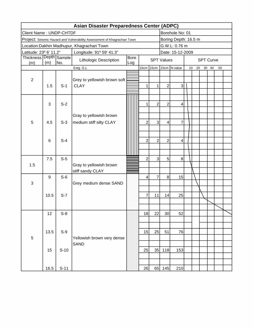
Client Name : UNDP-CHTDF Borehole No: 01Project: Seismic Hazard and Vulnerability Assessment of Khagrachari Town Boring Depth: 16.5 mLocation:Dakhin Madhupur, Khagrachari TownLatitude: 23º 6' 11.2"
10 20 30 40 50 Extg. G.L
CLAYGrey to yellowish brown soft
SPT CurveThickness (m)
Lithologic Description SPT Values
Gray to yellowish brown
Grey medium dense SAND
stiff sandy CLAY

Client Name : UNDP-CHTDF Borehole No: 02Boring Depth: 12.0 m
Location:Milonpur, Khagrachari Town G.W.L: 2.95 mLatitude: 23º 06' 27.4" Longitude: 91º 59' 16.9" Date: 20-12-2009Thickness Depth Sample Lithologi Bore
(m) No. LogExtg. G.L 15cm 15cm 15cm N-value 10 20 30 40 50
1.5 S-1 2 3 5 8
5.3 3 S-2 Yellowish brown stiff CLAY 2 5 6 11
4.5 S-3 3 4 6 10
6 S-4 10 15 19 34
3.17.5 S-5 20 24 36 60
9 S-6 33 55 88 143
3.610.5 S-7 30 56 90 146
12 22 80 241
Asian Disaster Preparedness Center (ADPC)
Yellowish brown very dense SAND
SPT Values SPT Curve
Yellowish brown denseto very dense SAND
Project: Seismic Hazard and Vulnerability Assessment of Khagrachari Town
Thickness Depth Sample Bore (m) (m) No. Log
Extg. G.L 15cm 15cm 15cm N-value 10 20 30 40 50
1.5 S-1 2 2 3 5Yellowish brown medium
4 stiff CLAY3 S-2 2 3 4 7
1.4 4.5 S-3 1 2 2 4CLAY
6 S-4 3 5 7 12
4.6 7.5 S-5 6 10 15 25
9 S-6 6 11 15 26
10.5 S-7 14 29 36 653.5
12 S-8 26 75 175 250
13.5 S-9 40 120 100 220
Grey to yellowish brown soft C
Yellowish brown very
Gray medium dense SAND
dense SAND
Longitude: 91º 59' 25.3"
Lithologic Description SPT Values SPT Curve
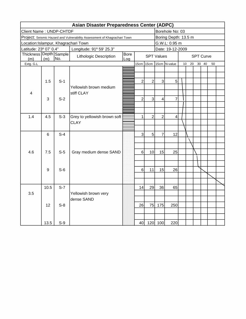
Asian Disaster Preparedness Center (ADPC)Borehole No: 03Client Name : UNDP-CHTDF
Location:Islampur, Khagrachari Town G.W.L: 0.95 m Boring Depth: 13.5 mProject: Seismic Hazard and Vulnerability Assessment of Khagrachari Town
Date: 19-12-2009Latitude: 23º 07' 0.4"
Asian Disaster Preparedness Center (ADPC)
Depth Sample Bore (m) No. Log
15cm 15cm 15cm N-value
1.5 S-1 2 2 2 44
3 S-2 2 2 2 4
4.5 S-3 2 2 3 5
36 S-4 2 2 2 4
7.5 S-5 3 4 5 9
39 S-6 3 4 5 9
10.5 S-7 7 10 19 291.5
SAND12 S-8 30 40 45 85
3.5 13.5 S-9 30 50 102 152SAND
15 S-10 65 106
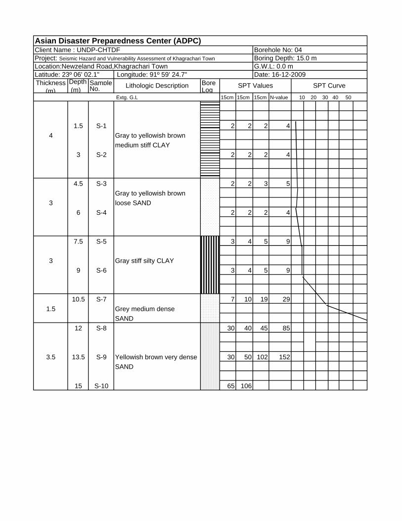
Client Name : UNDP-CHTDF Borehole No: 04Project: Seismic Hazard and Vulnerability Assessment of Khagrachari Town Boring Depth: 15.0 mLocation:Newzeland Road,Khagrachari Town G.W.L: 0.0 mLatitude: 23º 06' 02.1" Longitude: 91º 59' 24.7" Date: 16-12-2009Thickness
(m)Lithologic Description SPT Values SPT Curve
Extg. G.L 10 20 30 40 50
Gray to yellowish brown medium stiff CLAY
Gray to yellowish brown
Grey medium dense
loose SAND
Gray stiff silty CLAY
Yellowish brown very dense
Depth Sample Bore (m) No. Log
15cm 15cm 15cm N-value
1.5 S-1 1 2 2 4
5 3 S-2 Gray to yellowish brown 3 4 5 9soft to medium CLAY
4.5 S-3 2 3 5 8
6 S-4 3 5 8 133
7.5 S-5 10 13 18 31
9 S-6 5 9 23 32
5.510.5 S-7 10 11 26 37
very dense SAND12 S-8 10 35 50 85
13.5 S-9 20 80 160 240
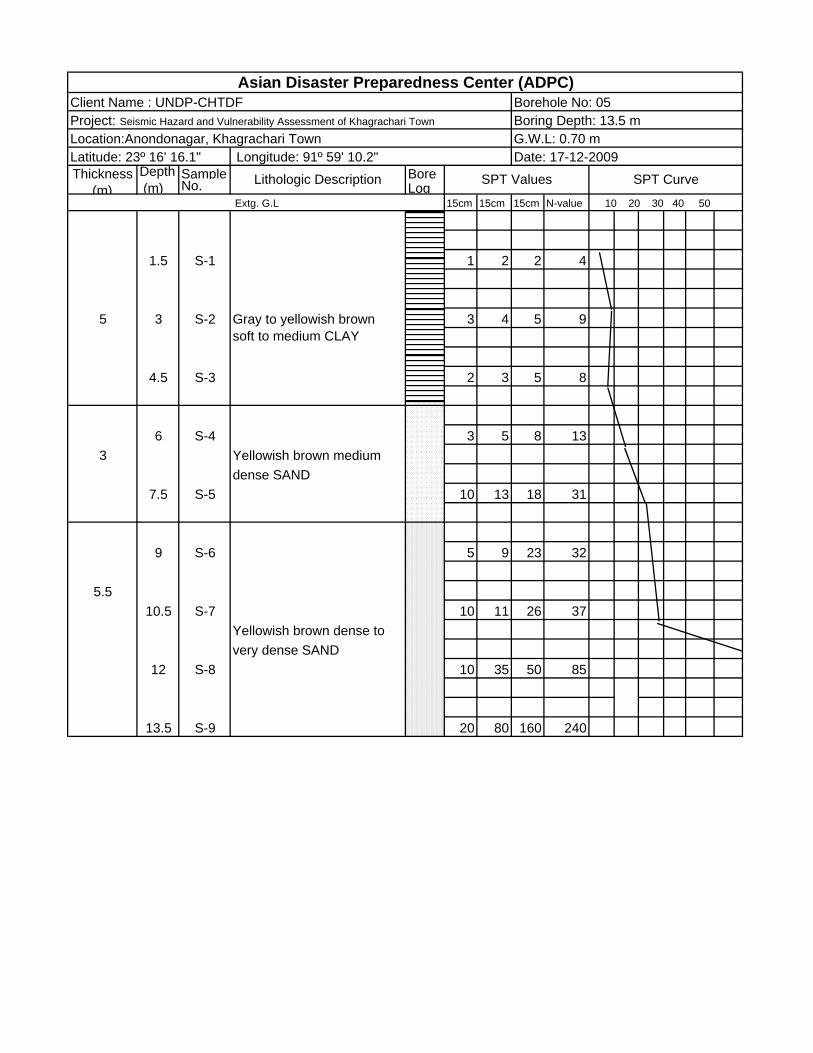
Client Name : UNDP-CHTDF Borehole No: 05Project: Seismic Hazard and Vulnerability Assessment of Khagrachari Town Boring Depth: 13.5 m
Asian Disaster Preparedness Center (ADPC)
Location:Anondonagar, Khagrachari Town G.W.L: 0.70 m Latitude: 23º 16' 16.1" Longitude: 91º 59' 10.2" Date: 17-12-2009Thickness
(m)Lithologic Description SPT Values SPT Curve
Extg. G.L 10 20 30 40 50
Yellowish brown medium dense SAND
Yellowish brown dense to
Thickness Depth Sample Bore (m) (m) No. Log
Extg. G.L 15cm 15cm 15cm N-value 10 20 30 40 50
Yellowish brown medium 2 1.5 S-1 1 2 2 4
2 3 S-2 3 6 10 16
4.5 S-3 2 3 4 7
3 6 S-4 3 4 5 9
7.5 S-5 8 11 14 25
39 S-6 6 16 18 34
10.5 S-7 12 32 50 82
5 12 S-8 12 20 12 35
with pebbles13.5 S-9 30 115 100 215
15 S-10 32 110
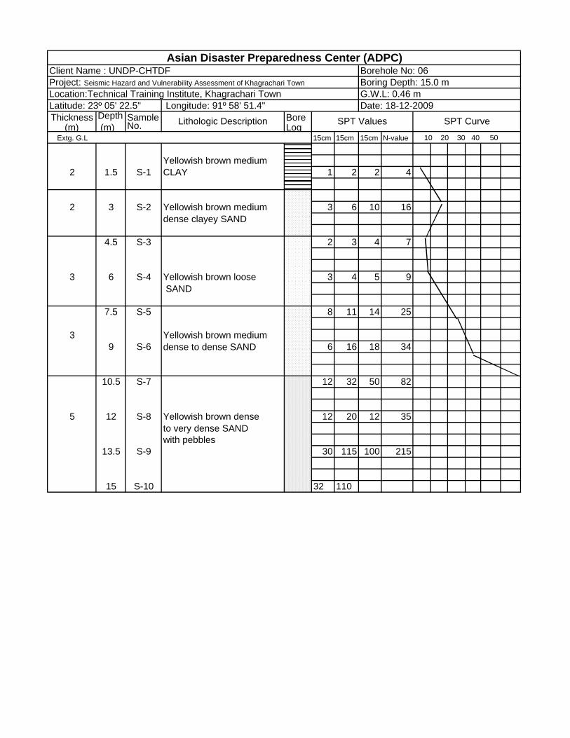
Asian Disaster Preparedness Center (ADPC)Borehole No: 06Boring Depth: 15.0 mG.W.L: 0.46 m
Client Name : UNDP-CHTDF
Location:Technical Training Institute, Khagrachari Town
CLAY
Yellowish brown mediumdense clayey SAND
Yellowish brown loose SAND
Yellowish brown mediumdense to dense SAND
Longitude: 91º 58' 51.4" Latitude: 23º 05' 22.5"
Lithologic Description SPT Values
Date: 18-12-2009
SPT Curve
Yellowish brown denseto very dense SAND
Project: Seismic Hazard and Vulnerability Assessment of Khagrachari Town

Depth Sample Bore (m) No. Log
15cm 15cm 15cm N-value
2 1.5 S-1 1 2 2 4
2 3 S-2 4 5 7 12
4.5 S-3 12 20 26 46
3 6 S-4 12 18 22 40
7.5 S-5 25 28 52 80
3.5 9 S-6 20 72 121 193
10.5 S-7 60 150
Borehole No: 07Asian Disaster Preparedness Center (ADPC)
Date: 12-12-2009
Project: Seismic Hazard and Vulnerability Assessment of Khagrachari Town Boring Depth: 10.5 mLocation:Arambag Math, Khagrachari Town G.W.L: 1.83 m
Thickness (m)
Lithologic Description
Latitude: 23º 6' 32.5" Longitude: 91º 58' 45.9"
Client Name : UNDP-CHTDF
SPT Values SPT Curve
Extg. G.L 10 20 30 40 50
Yellowish brown mediumCLAY
Yellowish brown dense
Yellowish brown mediumdense SAND
SAND
Yellowish brown very dense SAND

Depth Sample Bore (m) No. Log
15cm 15cm 15cm N-value
1.5 S-1 2 3 4 7
43 S-2 2 3 4 7
4.5 S-3 5 7 10 17
36 S-4 5 8 10 18
7.5 S-5 20 26 30 56
4.5 9 S-6 7 8 10 18
10.5 S-7 5 7 18 25
12 S-8 17 30 90 120
3.5 13.5 S-9 32 75 150 225
15 S-10 45 150
Client Name : UNDP-CHTDFAsian Disaster Preparedness Center (ADPC)
Borehole No: 08Project: Seismic Hazard and Vulnerability Assessment of Khagrachari Town Boring Depth: 15.0 mLocation:Khobongpuria, Khagrachari Town G.W.L: 1.90 mLatitude: 23º 06' 38.2" Longitude: 91º 58' 15.8" Date: 13-12-2009Thickness
(m)Lithologic Description SPT Values SPT Curve
Extg. G.L 10 20 30 40 50
Yellowish brown mediumCLAY
Gray medium dense SAND
Grey dense to very dense SILT and SAND
Yellowish brown very dense SAND
Depth Sample Bore (m) No. Log
15cm 15cm 15cm N-value
1.5 S-1 1 1 1 2
5.5 3 S-2 1 1 1 2
4.5 S-3 1 1 2 3
6 S-4 3 4 6 101.5
7.5 S-5 12 17 22 39
4.5 9 S-6 8 12 20 32SAND
10.5 S-7 12 18 25 43
0.5 12 S-8 Yellowsh brown very dense SAND 28 60 190 250
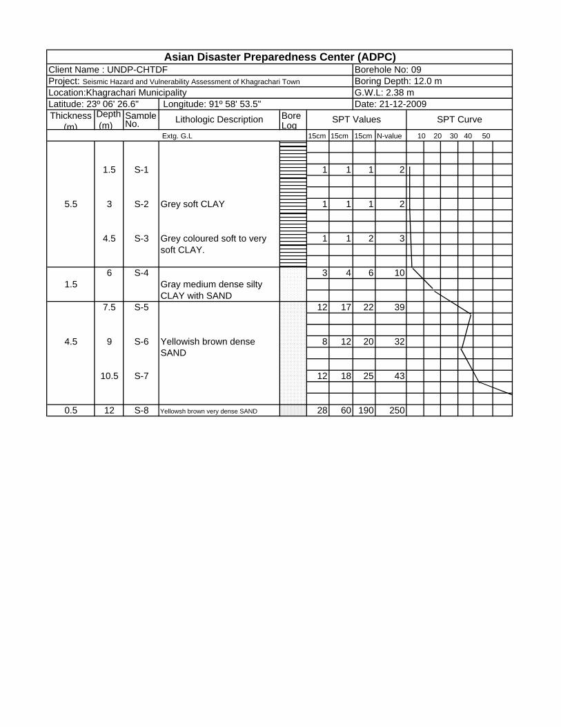
Client Name : UNDP-CHTDF Borehole No: 09
10 20 30 40 50
Project: Seismic Hazard and Vulnerability Assessment of Khagrachari Town Boring Depth: 12.0 mLocation:Khagrachari Municipality G.W.L: 2.38 mLatitude: 23º 06' 26.6" Longitude: 91º 58' 53.5" Date: 21-12-2009
Grey soft CLAY
Asian Disaster Preparedness Center (ADPC)
Thickness (m)
Lithologic Description SPT Values SPT Curve
Extg. G.L
soft CLAY.
Gray medium dense silty CLAY with SAND
Yellowish brown dense
Grey coloured soft to very
Depth Sample Bore (m) No. Log
15cm 15cm 15cm N-value
1.5 S-1 1 1 1 2
43 S-2 1 2 2 4
4.5 S-3 10 14 24 38
3 6 S-4 Gray to yellowish brown 8 12 15 27
7.5 S-5 12 22 35 57
3.5 9 S-6 Yellowish brown very 15 40 72 112
10.5 S-7 25 60 210 270
dense SAND
dense SAND
Asian Disaster Preparedness Center (ADPC)
Extg. G.L 10 20 30 40 50
Grey to yellowish brownsoft to medium CLAY
Thickness (m)
Lithologic Description SPT Values SPT Curve
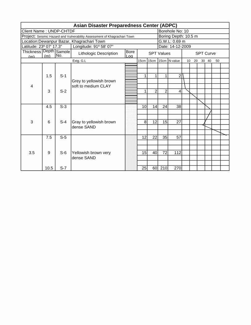
Project: Seismic Hazard and Vulnerability Assessment of Khagrachari TownClient Name : UNDP-CHTDF Borehole No: 10
Location:Dewanpur Bazar, Khagrachari Town G.W.L: 0.69 mLatitude: 23º 07' 17.3" Longitude: 91º 58' 07" Date: 14-12-2009
Boring Depth: 10.5 m
Asian Disaster Preparedness Center (ADPC)
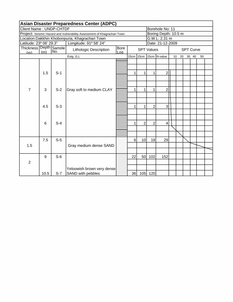
Depth Sample Bore (m) No. Log
15cm 15cm 15cm N-value
1.5 S-1 1 1 1 2
7 3 S-2 Gray soft to medium CLAY 1 1 1 2
4.5 S-3 1 1 2 3
6 S-4 1 2 2 4
7.5 S-5 6 10 19 291.5
9 S-6 22 50 102 1522
10.5 S-7 36 105 120Yeloowish brown very dense SAND with pebbles
Gray medium dense SAND
Extg. G.L 10 20 30 40 50
Thickness (m)
Lithologic Description SPT Values SPT Curve
Location:Dakkhin Khobonpuria, Khagrachari Town G.W.L: 2.31 mLatitude: 23º 06' 29.3" Longitude: 91º 58' 24" Date: 21-12-2009
Client Name : UNDP-CHTDF Borehole No: 11Project: Seismic Hazard and Vulnerability Assessment of Khagrachari Town Boring Depth: 10.5 m


