
79
RESEARCH METHODOLOGY
As the research design is the plan, structure and strategy of
investigation of answering the research questions and it is the overall
plan or blue print of the researcher (Basavathappa, 2005). This
chapter deals with the Objectives of the Study, Hypothesis, Research
Design, Area of Study, Selection of sample frame and size, Collection
of data and Limitations of the study.
The present study seeks to examine the role of Financial
Institutions for Economic Empowerment of Women in
Visakhapatnam District of Andhra Pradesh.
3.1 STATEMENT OF THE PROBLEM
Role of Financial Institutions for Economic Empowerment of
Women: A Study in Visakhapatanam District of Andhra Pradesh.
3.2 OBJECTIVES OF THE STUDY
The following objectives have been identified for the purpose of
the study:
1. To identify the role of financial institutions for the
empowerment of women entrepreneurship development.
2. To study the socio-economic dimensions of women
entrepreneurs.
3. To find out the motivational and facilitating factors of women
entrepreneurs.
4. To assess the dual role conflict between work and home among
women entrepreneurs.
80
5. To identify the problems being faced by women entrepreneurs
in undertaking economic enterprises.
6. To suggest the relevant measures to improve performance of
women entrepreneurs.
3.3 HYPOTHESES OF THE STUDY
The following are hypotheses formulated for testing.
1. Higher the socio-economic status of women entrepreneurs
higher will be their empowerment.
2. Level of motivational and facilitating factors differs from one
family to other family.
3. Dual role conflict among the women entrepreneurs will have
a negative influence on their development.
4. Family support, financial position, training and awareness
will solve entrepreneur’s problems.
3.4 SAMPLING
Application of appropriate methods and adoption of scientific
frame of mind is a sine-qua-non of a systematic inquiry. Collection of
reliable and accurate information is vital to draw valid conclusions.
The present study is based on both primary and secondary data.
The study entailed a good deal of preparation and planning in
order to secure the necessary up date data and information.
Considerable time has been invested to identify the respondents and
to establish personal contact with them. The fieldwork for the study
was staggered over more than a year. The inquiry process involved
the following three broad phases:

81
3.4.1 Collection of Primary Data
The primary data for the study are collected by using one
elaborate questionnaire for women entrepreneurs. The aspects on
which the data are sought to be collected from the sample
respondents include socio-economic status, migratory character,
household income, motivation and facilitating factors, performance,
role conflict and problems.
The tools used in exploration of the women entrepreneur’s
questionnaires were finalized on the basis of the experiences of the
pilot study, Thirty five women entrepreneurs of the selected sample
were covered during the pilot survey. In the light of the observations
and experiences of the pilot survey, necessary changes were
incorporated in the questionnaire. This phase of the research process
has helped a great deal in enhancing the contents of the schedules in
tune with objectives set out for the study.
3.4.2 Collection of Secondary Data
The process of gathering reliable and meaningful information is
the cardinal aspect of the enquiry and forms a central link in the
operational plan for the entire research design. City Industrial Center
and Andhra Pradesh State Financial Corporation Visakhapatnam is
of a great source to obtain a list of women entrepreneurs. The
secondary data are drawn from research reports published books,
journals, bulletins and internet. The libraries of Andhra University
(Dr.V.S. Krishna Library), Center for Women Studies, Center for
Population Studies, School of Economics, Andhra University,
82
Visakhapatnam, Osmania University Libraries, Hyderabad and the
Library and Center for Women’s Studies, Sri Padmavati Mahila Visva
Vidhyalayam, Tirupati are immensely used for the collection of
secondary data.
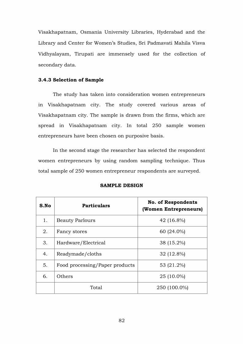
3.4.3 Selection of Sample
The study has taken into consideration women entrepreneurs
in Visakhapatnam city. The study covered various areas of
Visakhapatnam city. The sample is drawn from the firms, which are
spread in Visakhapatnam city. In total 250 sample women
entrepreneurs have been chosen on purposive basis.
In the second stage the researcher has selected the respondent
women entrepreneurs by using random sampling technique. Thus
total sample of 250 women entrepreneur respondents are surveyed.
SAMPLE DESIGN
S.No Particulars No. of Respondents
(Women Entrepreneurs)
1. Beauty Parlours 42 (16.8%)
2. Fancy stores 60 (24.0%)
3. Hardware/Electrical 38 (15.2%)
4. Readymade/cloths 32 (12.8%)
5. Food processing/Paper products 53 (21.2%)
6. Others 25 (10.0%)
Total 250 (100.0%)
83
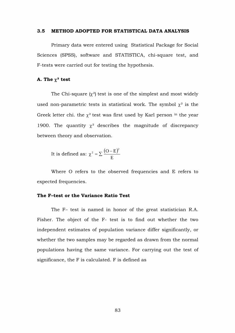
3.5 METHOD ADOPTED FOR STATISTICAL DATA ANALYSIS
Primary data were entered using Statistical Package for Social
Sciences (SPSS), software and STATISTICA, chi-square test, and
F-tests were carried out for testing the hypothesis.
A. The ² test
The Chi-square (²) test is one of the simplest and most widely
used non-parametric tests in statistical work. The symbol ² is the
Greek letter chi. the ² test was first used by Karl person in the year
1900. The quantity ² describes the magnitude of discrepancy
between theory and observation.
It is defined as:
E
EO2
2
Where O refers to the observed frequencies and E refers to
expected frequencies.
The F–test or the Variance Ratio Test
The F– test is named in honor of the great statistician R.A.
Fisher. The object of the F- test is to find out whether the two
independent estimates of population variance differ significantly, or
whether the two samples may be regarded as drawn from the normal
populations having the same variance. For carrying out the test of
significance, the F is calculated. F is defined as
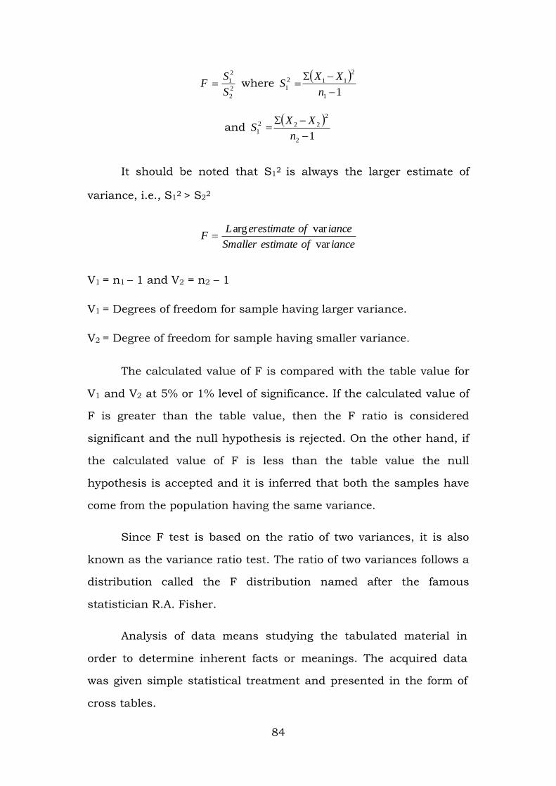
84
2
2
2
1
S
SF where
11
2
112
1
n
XXS
and
12
2
222
1
n
XXS
It should be noted that S12 is always the larger estimate of
variance, i.e., S12 > S2
2
ianceofestimateSmaller
ianceoferestimateLF
var
vararg
V1 = n1 – 1 and V2 = n2 – 1
V1 = Degrees of freedom for sample having larger variance.
V2 = Degree of freedom for sample having smaller variance.
The calculated value of F is compared with the table value for
V1 and V2 at 5% or 1% level of significance. If the calculated value of
F is greater than the table value, then the F ratio is considered
significant and the null hypothesis is rejected. On the other hand, if
the calculated value of F is less than the table value the null
hypothesis is accepted and it is inferred that both the samples have
come from the population having the same variance.
Since F test is based on the ratio of two variances, it is also
known as the variance ratio test. The ratio of two variances follows a
distribution called the F distribution named after the famous
statistician R.A. Fisher.
Analysis of data means studying the tabulated material in
order to determine inherent facts or meanings. The acquired data
was given simple statistical treatment and presented in the form of
cross tables.
85
The interpretations of tables are given under each table with
Chi-square values. The following chapters of the study contain the
tabulations of data, analysis and their interpretation.
3.6 LIMITATIONS OF THE STUDY
1. The present study will be confined to Visakhapatnam city
only.
2. The present work will be limited to few types of economic
enterprises which are managed by Women Entrepreneurs.
3. Out of many factors influencing the Women Entrepreneurs
in the area of study factors considered in the study are :
a) Social
b) Economical
c) Financial and
d) Environmental.
4. With regard to managerial and organizational performance
of the women entrepreneurs in their selected line of activity
have been taken into consideration.
5. In this study the weightage, marks obtained by the women
entrepreneurs in their performance relating to financial
factors will be taken as index of achievement.
86
3.7 PRESENTATION OF THE STUDY
CHAPTERIZATION
The total study consists of nine chapters with appendices.
Chapter-I : Presents about the women’s economic status for
women empowerment in India.
Chapter-II : Outlines of a brief review of literature viability to the
study purpose.
Chapter-III : Explains the Methodology of present study and
portrays the profile of Visakhapatnam District of
Andhra Pradesh.
Chapter-IV : Presents the socio-economic status of women
entrepreneurs.
Chapter-V : Deals with Perception, Motivation and Facilitating
Factors for women entrepreneurs.
Chapter-VI : Discusses the role conflict among women
entrepreneurs.
Chapter-VII : Outlines problems faced by women entrepreneurs.
Chapter-VIII : Presents testing of the Hypothesis.
Chapter-IX : Deals with major findings and suggestions emanating
from the present study. Apart from the nine chapters,
the Appendix contains a copy of the Interview
Questionnaire and the references made for the study
purpose were given in the Bibliography.

87
3.8 VISAKHAPATNAM DISTRICT HISTORICAL BACKGROUND
Geographic divisions. 1. Plains division which is a strip of
land along the Coast and interior. 2. Hilly area of the Eastern
Ghats flanking on North and West called Agency Division.
Inscriptions indicate that the District was originally a part of
Kalinga Kingdom subsequently conquered by the Eastern
Chalukyas in the 7th Century, A.D. who ruled over it with their
Head Quarters at Vengi. This District was also under the
occupation of various rulers such as the Reddy Rajahs of
Kondaveedu, the Gajapathis of Orissa, the Nawabs of Golkonda,
the Moghal Emperor Aurangazeb through a Subedar. This
territory passed on to French occupation in view of succession
dispute among Andhra Kings and finally it came under the
British Reign.
There were no geographical grafting till 1936 in which year,
consequent on the formation of Orissa State the Taluks namely
Bissiom, Cuttack, Jayapore, Koraput, Malkanagiri, Naurangapur,
Pottangi and Rayagad. Parvathipur Taluks were transferred to
Orissa State.
Geographical Description: Visakhapatnam District is one of
the North Eastern Coastal Districts of Andhra Pradesh and it lies
between 17° - 15° and 18°-32°, Northern Latitude and 18° -54°
and 83° - 30° in Eastern Longitude. It is bounded on the North
partly by the Orissa State and partly by Vizianagaram District, on
the South by East Godavari District, on the West by Orissa State
and on the East by Bay of Bengal.
88
3.9 PROFILE OF VISAKHAPATNAM
3.9.1 Location
Visakhapatnam is a coastal district of Andhra Pradesh with
two regions of contrasting ecological and topographical characteristic
distinct features. One which plain landscape extending from the sea
coast up to the foothills of Eastern Ghats with moderate
temperature and the other covered by the thick forests stop elevated
Eastern Ghats with cool temperature inhabited by the tribal people.
It lies between 17°-6’ and 18°-37’ of northern latitude and 81°-6’ and
83°-30’-57” of eastern longitude. It is bounded on the North by
Orissa State and Viziangaram district, East Godavari district on the
South Koraput district of Orissa on the West and the Bay of Bengal
on the East. The total geographical area of the district is 11161 sq.
km which is only 4.1 per cent of the area of the whole State. This is
one of the most industrialized districts of Andhra Pradesh where
important establishments of the State as well as of the country are
located.
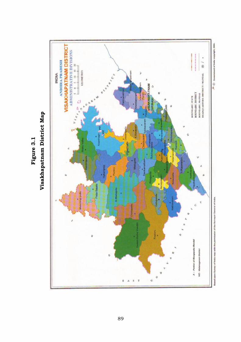
89
Fig
ure
3.1
Vis
akhapatn
am
Dis
tric
t M
ap

90
Figure 3.2
Visakhapatnam City Map
91
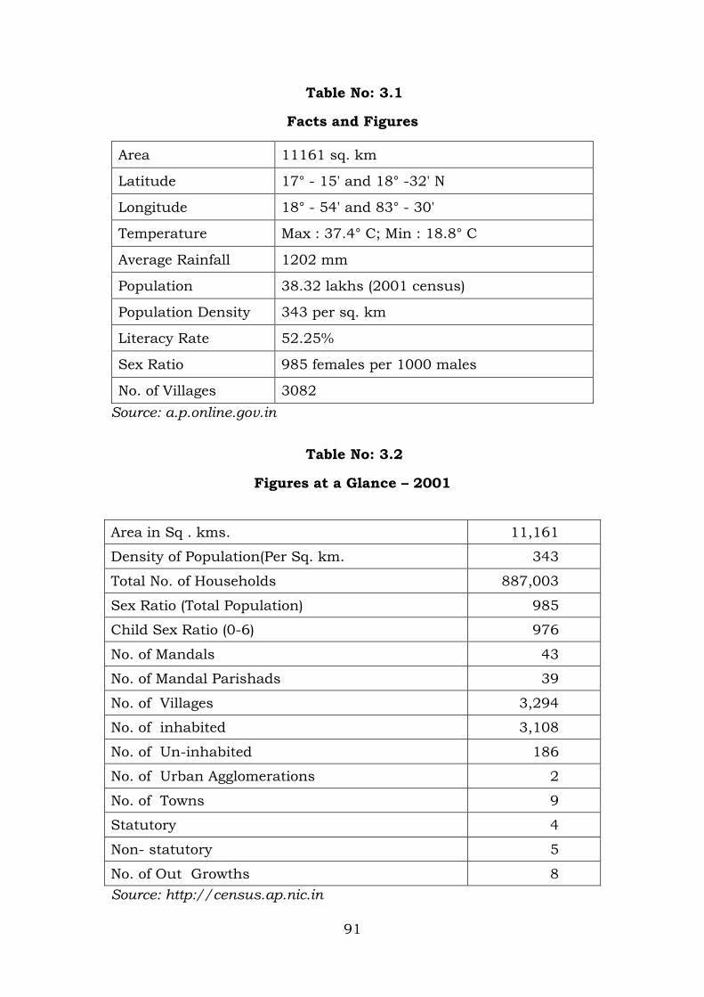
Table No: 3.1
Facts and Figures
Area 11161 sq. km
Latitude 17° - 15' and 18° -32' N
Longitude 18° - 54' and 83° - 30'
Temperature Max : 37.4° C; Min : 18.8° C
Average Rainfall 1202 mm
Population 38.32 lakhs (2001 census)
Population Density 343 per sq. km
Literacy Rate 52.25%
Sex Ratio 985 females per 1000 males
No. of Villages 3082
Source: a.p.online.gov.in
Table No: 3.2
Figures at a Glance – 2001
Area in Sq . kms. 11,161
Density of Population(Per Sq. km. 343
Total No. of Households 887,003
Sex Ratio (Total Population) 985
Child Sex Ratio (0-6) 976
No. of Mandals 43
No. of Mandal Parishads 39
No. of Villages 3,294
No. of inhabited 3,108
No. of Un-inhabited 186
No. of Urban Agglomerations 2
No. of Towns 9
Statutory 4
Non- statutory 5
No. of Out Growths 8
Source: http://census.ap.nic.in

92
Table No.3.3
Percentage of Total Population
(In percentages)
Persons Males Females
Scheduled Castes 7.60 7.61 7.59
Scheduled Tribes 14.55 14.42 14.68
0-6 Age Group 12.87 12.93 12.81
Literacy Rate 59.96 69.68 50.12
Work Participation Rate
41.82 55.41 28.03
Source: http://Census.ap.nic.in
Table No.3.4
Percentage of Total Workers
(In percentages)
Persons Males Females
Main Workers 81.46 87.12 70.10
Marginal Workers 18.54 12.88 29.90
Source: http://census.ap.nic.in
Table No: 3.5
Categories of Total Workers
(In percentages)
Persons Males Females
Cultivators 27.06 24.25 32.72
Agricultural Labourers 26.31 19.57 39.81
Household Industry Workers 3.52 2.86 4.83
Other Workers 43.11 53.32 22.64
Source: http://census.ap.nic.in
93
3.9.2 Area and Population
The district was reorganized in the year 1979 in the wake of
which six panchayat samithi blocks were separated to the
Vizianagaram district. The geographical area of the present
Visakhapatnam district is 11,161 square kilometers of which the
hilly regions i.e. the agency track cover 6298 kilometers. The total
population of the district as per 2001 Census is 25.76 lakhs. The
district has a density of population of 231 per square kilometers. Of
the total population, 68.7 per cent are living in rural areas, schedule
caste constitute 7.85 per cent of the population, while scheduled
tribes account for 13.74 per cent of the population of the district.
The literacy rate for the district is 27.72 per cent against the State
average of 29.70 per cent. The level of literacy is lower among
females being 19.40 per cent against 36.00 per cent of males.
3.9.3 Occupational Structure
The district has a working force of 9.91 lakhs constituting
about 39.29 per cent of the population. Among workers, the
cultivators constitute 41.85 per cent; agricultural labourers form 63
per cent. The high proportion of workers engaged in cultivation
which reveals the predominance of agriculture sector in the economy
of the district.
3.9.4 Administration
The district is divided into three revenue divisions which have
been further divided into 14 taluks consisting of 19 blocks. The
district has 3665 inhabited villages and 684 uninhabited villages.

94
These are grouped into three municipalities and 943 village
panchayats. Visakhapatnam is the most thickly populated taluk
(152 persons per square kilometer) while Chintapalli is the least
populated taluk (43 persons per square kilometer).
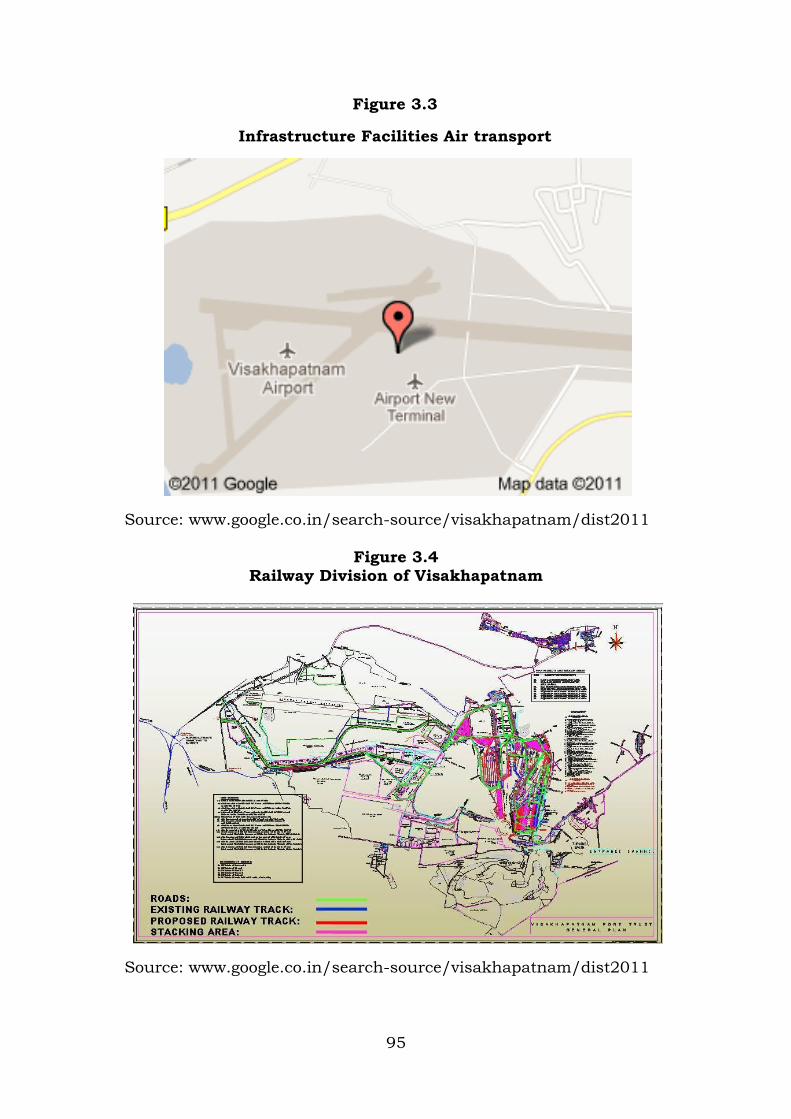
3.9.5. Infrastructure Facilities
The total road length in the district at the end of March 2001
was 4338 kilometers of which 134 kilometers was of national
highways, 1130 kilometers was of Public Works Department (PWD),
1166 kilometers was of Zilla Parishad and the remaining was of
Panchayat Samithi roads. The total railway length of the district is
177 kilometers which is completely covered under Broad gauge. The
number of railway stations located is 23. The district is blessed with
a natural harbour at Visakhapatnam. It is one of the major ports in
India and occupies significant place for marine trade and defense.
The recent additions of outer harbour, dry dock and fishing harbour
have enhanced its commercial prospects. Besides this, there is an
airport at Visakhapatnam. Other communication facilities available
include 653 post offices. 44 telegraph offices and 46 telephone
exchanges. The number of towns and villages and towns electrified
to the total is 19.9 per cent.
As on 31st December 1983, 28 commercial banks are operating
in the district with a network of 186 branches apart from 22 co-
operative banks. The population per bank office works out to 13,560,
18127 and 7919 for rural, semi – urban areas respectively as per
2001 Census. Sri Visakha Grameena Bank with its 42 branches in
the district occupied second place next to the State Bank of India.
95
Figure 3.3
Infrastructure Facilities Air transport
Source: www.google.co.in/search-source/visakhapatnam/dist2011
Figure 3.4 Railway Division of Visakhapatnam
Source: www.google.co.in/search-source/visakhapatnam/dist2011

96
Figure 3.5
Imports Exports Port of Visakhapatnam
Source: www.google.co.in/search-source/visakhapatnam/dist2011
Figure 3.6
Rail Transport Connectivity to other States
Source: www.google.co.in/search-source/visakhapatnam/dist2011

97
Figure 3.7
Road transport runs NH 5
Source: www.google.co.in/search-source/visakhapatnam/dist2011
Figure 3.8
Steel Plant of Visakhapatnam
Source: www.google.co.in/search-source/visakhapatnam/dist2011
98
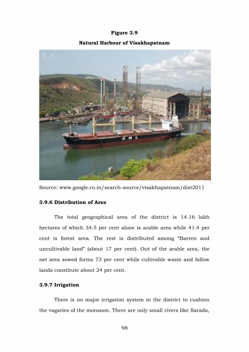
Figure 3.9
Natural Harbour of Visakhapatnam
Source: www.google.co.in/search-source/visakhapatnam/dist2011
3.9.6 Distribution of Area
The total geographical area of the district is 14.16 lakh
hectares of which 34.5 per cent alone is arable area while 41.4 per
cent is forest area. The rest is distributed among “Barren and
uncultivable land” (about 17 per cent). Out of the arable area, the
net area sowed forms 73 per cent while cultivable waste and fallow
lands constitute about 24 per cent.
3.9.7 Irrigation
There is no major irrigation system in the district to cushion
the vagaries of the monsoon. There are only small rivers like Sarada,

99
Varsha and Thandava apart from 29 PWD tanks and 3695 MT tanks
irrigating an extent of 100000 hectares. Another 10000 hectares of
land is served by wells. In the agency area about 13000 hectares is
irrigated by spring channels and other hill streams. Altogether about
123000 hectares of land is irrigated out of the net area sown of
285900 hectares. Thus, about 64 per cent of the cultivated area is
irrigated, while the rest of the area depends upon the monsoon. The
Geo-Engineering Research Laboratory of Andhra University and the
State Ground Water Department prepared preliminary reports which
reveals that there is large potential for the construction of dug wells/
dug-cum-bore wells, filter points and shallow tube wells and tube
wells over 50 meters depth.
3.9.8 Cropping Pattern
The net area sown in this district is 2.82 lakh hectares which
works out to 25.18 per cent of the geographical area. Food grains
account for 70.4 per cent of the total cropped area showing the
subsistence type of agriculture obtaining in the district. Among
principal crops grown, paddy constitutes 26.68 per cent of cropped
area followed by Bajra, Ragi, Groundnut, Ginger and Sugarcane.
3.9.9 Industries
Industrial development is conspicuous in Visakhapatnam with
the large scale industries like Hindustan Shipyard, Bharat Petroleum
Corporation, Coromandel Fertilizers, Bharat Heavy Plate and Vessels
Limited, Hindustan Polymers, Hindustan Zinc Plant, Giant Visakha
Steel Project and a host of ancillary industries. On countryside, the
agro based industries like sugar factories, jute mills and rice mills

100
are there besides brick and tile units sporadically. The district has
521 registered factories under Factories Act, The large scale
industries employ about 29,928 persons, while the small and cottage
industries engage a work force of 10,403.
3.9.10 Animal Husbandry
This is an important allied economic activity to agriculture
sector. Animals are main source of energy for agriculture, Milch
animals, sheep and goat are important for income generation of the
rural households. A sizeable number of households earn subsidiary
income by selling milk to Visakha dairy and in local markets. The
total livestock of this district is 10.00 lakhs of which draught
animals account for 4.13 lakhs while milch animals account for 1.93
lakhs. Goats and sheep totaling upto 3.48 lakh are important for the
livelihood of the considerable population. The Indo-Swiss project has
been functioning from 1978 with its headquarters at Visakhapatnam
looking after mainly livestock improvement, fodder production and
dairy development in the district. One chilling center at Narsipatnam
with a capacity of 12000 liters and other small chilling centers at
Paderu, Araku and Chintapalli were commissioned during 1979.
3.9.11 Fishing
Visakhapatnam district is one of the important marine
districts in Andhra Pradesh. There are 78 fisheries villages spread
over to length of 140 kilometers coastline covering the block of
Bhemunipatnam, Pendurthi, Kasimkota, Yelamanchili and
Nakkapalli. About 15000 fishermen families eke out their livelihood
from marine fishing. There is sample scope for the development of

101
marine fishing in the district. In addition 1117 fishing tanks are
existing in the district and 57 fishermen cooperative societies with a
membership of 8017 are functioning in the district. A fishing
harbour was carved out of the outer harbour water basically facilities
to accommodate 300 mechanized boats and 70 deep sea fishing
trawlers. At present 49 Mexican travelers and 250 mechanized boats
are operating from this harbour.


