
Route Weather Resilience and Climate Change Adaptation Plans
Scotland


Scotland Route: WRCCA plan
Network Rail 1
Contents
Director Route Asset Management statement 2
Executive summary 3
Introduction 4
Scotland Route WRCCA strategy 7
Scotland Route vulnerability assessment 8
Scotland Route impact assessment 19
Scotland Route WRCCA actions 35
Management and review 39
Purpose of this document
This document sets out a Weather Resilience and Climate Change Adaptation (WRCCA) plan
for Scotland Route supported by an evaluation of the resilience of rail infrastructure to historical
weather events and an awareness of potential impacts from regional climate change
projections. The resilience of rolling stock operating within the Route is not specifically
assessed.
The approach taken is consistent across all Network Rail’s Routes, and describes our current
planned mitigations, how we intend to develop the plans further, and how we are improving the
embedment of WRCCA across the business to deliver a railway fit for the future.

Scotland Route: WRCCA plan
Network Rail 2
Director Route Asset Management statement
Track washout at Dalguise, December 2006
Climate change presents us with an unprecedented challenge to understand how shifts in
temperature and rainfall will impact our network and to identify the actions we can take to
proactively increase our weather resilience.
In response to this challenge Scotland Route has developed a Weather Resilience and
Climate Change Adaptation (WRCCA) plan which incorporates a number of programmes
and initiatives designed to increase resilience of the railway in Scotland to effects of weather
and climate change.
Scotland is no stranger to the best and worst of the weather. In recent years we experienced
the prolonged spell of heavy snow fall in 2010/11 and the severe rain and wind in 2012 and
2013. Our ability to support the quality of rail service our customers expect is highly dependent
on the capability of our assets to be resilient and our operational responses to weather events
to minimise disruption.
Scotland Route has made significant investments in recent years to strengthen the railway
network against the effects of the weather. Examples include over £5m improving the
resilience of the railway to flooding risk at Dalmarnock, protecting Gourock from coastal
impacts and undertaking extensive drainage and earthworks at Drem. In CP5 we are
continuing to increase weather resilience through our investments, including drainage
improvements, installation of remote condition monitoring, earthwork renewals and improving
our real-time weather data.
We will do this in collaboration with our rail industry partners and other stakeholder
organisations.
Alan Ross
Director Route Asset Management
September 2014
Scotland Route: WRCCA plan
Network Rail 3
Executive summary
Weather events can cause significant disruption to the operation of train services and damage
to rail infrastructure. A move to a warmer climate and a variance in the pattern of precipitation
across the year, generally projected by the UK Climate Change Projections (UKCP09), could
result in changes in the frequency and intensity of extreme weather events and seasonal
patterns. A detailed understanding of the vulnerability of rail assets to weather events, and
potential impacts from climate change, are therefore needed to maintain a resilient railway.
In response to this challenge Scotland Route has developed a Weather Resilience and Climate
Change Adaptation (WRCCA) plan based on assessments of weather-related vulnerabilities,
identification of root causes of historical performance impacts and an understanding of
potential future impacts from regional climate change projections.
Using this information, Scotland Route has determined whether previous investments have
mitigated weather impact risks, if actions planned during Control Period 5 (2014 to 2019) are
addressing these vulnerabilities, and where additional actions could further enhance weather
and climate change resilience.
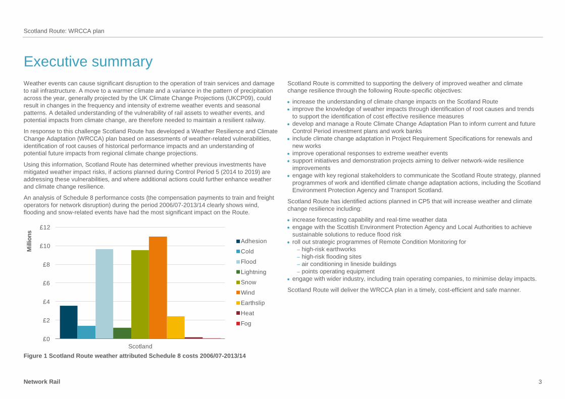
An analysis of Schedule 8 performance costs (the compensation payments to train and freight
operators for network disruption) during the period 2006/07-2013/14 clearly shows wind,
flooding and snow-related events have had the most significant impact on the Route.
£0
£2
£4
£6
£8
£10
£12
Scotland
Millio
ns
Adhesion
Cold
Flood
Lightning
Snow
Wind
Earthslip
Heat
Fog
Figure 1 Scotland Route weather attributed Schedule 8 costs 2006/07-2013/14
Scotland Route is committed to supporting the delivery of improved weather and climate
change resilience through the following Route-specific objectives:
increase the understanding of climate change impacts on the Scotland Route
improve the knowledge of weather impacts through identification of root causes and trends
to support the identification of cost effective resilience measures
develop and manage a Route Climate Change Adaptation Plan to inform current and future
Control Period investment plans and work banks
include climate change adaptation in Project Requirement Specifications for renewals and
new works
improve operational responses to extreme weather events
support initiatives and demonstration projects aiming to deliver network-wide resilience
improvements
engage with key regional stakeholders to communicate the Scotland Route strategy, planned
programmes of work and identified climate change adaptation actions, including the Scotland
Environment Protection Agency and Transport Scotland.
Scotland Route has identified actions planned in CP5 that will increase weather and climate
change resilience including:
increase forecasting capability and real-time weather data
engage with the Scottish Environment Protection Agency and Local Authorities to achieve
sustainable solutions to reduce flood risk
roll out strategic programmes of Remote Condition Monitoring for
– high-risk earthworks
– high-risk flooding sites
– air conditioning in lineside buildings
– points operating equipment
engage with wider industry, including train operating companies, to minimise delay impacts.
Scotland Route will deliver the WRCCA plan in a timely, cost-efficient and safe manner.

Scotland Route: WRCCA plan
Network Rail 4
Introduction
Weather events can be a cause of significant disruption to the railway network. Recent
prolonged periods of rainfall and severe storm events demonstrated much of the network
is resilient; however, asset failures such as flooding at Winchburgh and Dalguise, earthslips
at Loch Treig and on the West Coast Main Line, the cyclone of 3 January 2013 and the high
winds of 5 December 2013 when the Scotland network shut down due to severe high winds,
reveal the vulnerability of the rail network and the impact these weaknesses in resilience can
have on train services and our resources.
The impact of weather on the rail network is monitored using performance data. Schedule 8
costs; the compensation payments to train and freight operators for network disruption, are
used as a proxy for weather impacts due to greater granularity of root cause reporting.
Weather-related costs can also be captured within Schedule 4 payments; compensation to
train and freight operators for Network Rail’s possession of the network, and capital
expenditure required to reinstate the asset.
Over the past eight years, 2006/07 to 2013/14, the average annual performance cost attributed
to Schedule 8 weather for the whole network was over £50m. The data clearly includes the
impacts on train performance from the severe weather events during 2007, 2012 and 2013
from rainfall, and 2009 and 2010 from snowfall, Figure 2. In terms of the proportion of delay,
weather and seasonal events on average caused 12% of all delays experienced during this
eight-year period.
£0
£10
£20
£30
£40
£50
£60
£70
£80
£90
£100
2006-07
2007-08
2008-09
2009-10
2010-11
2011-12
2012-13
2013-14
Millio
ns
Fog
Heat
Earthslip
Wind
Snow
Lightning
Flood
Cold
Adhesion
Figure 2 Whole network weather attributed Schedule 8 delay costs, 2006/07 to 2013/14
Following the recent increase in the rate of these compensation payments (by around 62%),
the equivalent payments in future years would be over £80m per annum.
These levels of performance cost, consequential costs of repairing the rail infrastructure, and
wider socio-economic impacts in the UK, justify Network Rail’s enhanced investments to
increase weather resilience. The interdependencies within transport and infrastructure systems
similarly justifies Network Rails’ efforts to improve collaborative understanding of the wider
impacts of weather-related events and our role in supporting regional and national resilience.
Historical temperature records indicate that a significant relatively recent shift in climate has
occurred; Figure 3 clearly shows a rising trend in Scotland temperature over the past 40 years.
Figure 3 Annual mean temperature (°C) – Scotland1
1 Reproduced with kind permission of Adaptation Scotland, original data source Met Office

Scotland Route: WRCCA plan
Network Rail 5
Future climate change projections for the UK have been developed by the Met Office Hadley
Centre, UK Climate Projections 2009 (UKCP09). UKCP09 provides probabilistic sets of
projections based on low, medium or high greenhouse gas emission scenarios, for climate
periods of 30 years to the end of this century. For Network Rail, as a safety critical focused
organisation and major UK infrastructure manager, the high emissions scenario is an
appropriate benchmark on which to base evaluations and decisions.
UKCP09 projects an overall shift towards warmer climates with drier summers and wetter
winters, Figure 4 and Figure 5, with regional variations.
Figure 4 Change in summer mean maximum temperature (left 2020s, middle 2050s,
right 2080s) (© UK Climate Projections, 2009)
It must be noted that climate change projections include inherent uncertainties, associated with
natural climate variability, climate modelling and future emissions, and these uncertainties
increase with downscaling to local levels. However, the projections can be used by Network
Rail to provide a direction of where the UK climate is heading, and the Scotland Route Weather
Resilience and Climate Change plan uses the projections to support the prioritisation of
weather resilience actions.
Figure 5 Change in winter mean precipitation (left 2020s, middle 2050s, right 2080s)
(© UK Climate Projections, 2009)
To ensure weather resilience and climate change adaptation is approached consistently across
Network Rail, an iterative framework provides key management stages: set strategy, assess
vulnerability and impact, identify actions, and review, as seen in Figure 6. This framework has
been applied to develop the Scotland Route WRCCA plan.

Scotland Route: WRCCA plan
Network Rail 6
Strategy
and policy
Vulnerability
assessment
Adaptation
actions
Impact
assessment
Management
and review
Figure 6 Weather resilience and climate change adaptation framework
Network Rail weather resilience and climate change adaptation actions will include a range
of measures appropriate to the strength of evidence and level of risk:
soft – changes to processes, standards and specifications, increasing knowledge and skill
base
hard – engineered solutions to increase resilience; e.g. raising of sea walls and increasing
drainage capacity
‘do nothing/minimum’ – the option to ‘do nothing’ or ‘do minimum’ should be evaluated
‘no regrets’ – measures that increase the resilience of the assets to current and future
impacts
precautionary – investment into adaptation measures today in anticipation of risk in the future
managed adaptive – a staged approach incorporating uncertainties in future risk and current
investment funds, allowing assets to be retrofitted cost-effectively in the future.
The following sections provide findings from the Scotland Route vulnerability and impact
assessments, and details of the WRCCA actions; both completed and planned in Control
Period 5, and potential additional actions, that aim to increase weather and climate change
resilience.
Snow Avalanche near Tyndrum, February 2011
Scotland Route: WRCCA plan
Network Rail 7
Scotland Route WRCCA strategy
The Network Rail Sustainable Development Strategy outlines corporate weather resilience
and climate change adaptation objectives, and commits the business to:
understand our current weather resilience, and seek to optimise resilience and enhance
adaptation capability
develop a thorough understanding of the potential impacts of climate change in terms of
infrastructure performance, safety risks and costs
embed climate change adaptation within our asset policies and investment decisions
communicate the role that the rail network plays in supporting weather and climate
resilience across Great Britain, and support efforts to increase national resilience.
These objectives will support the long-term management of a weather resilient railway and
are fundamental steps towards achieving Network Rail’s sustainable development vision of
a railway fit for the future.
Scotland Route strategy
Scotland Route is committed to supporting the delivery of this strategy through Route-
specific weather resilience and climate change adaptation objectives:
increase the understanding of climate change impacts on the Scotland Route
improve the knowledge of weather impacts through identification of root causes and trends
to support the identification of cost effective resilience measures
develop and manage a Route Climate Change Adaptation Plan to inform current and
future Control Period investment plans and work banks
include climate change adaptation in Project Requirement Specifications for renewals and
new works
improve operational responses to extreme weather events
support initiatives and demonstration projects aiming to deliver network-wide resilience
improvements
engage with key regional stakeholders to communicate the Scotland Route strategy,
planned programmes of work and identified climate change adaptation actions, including
the Scotland Environment Protection Agency and Transport Scotland.
Through these objectives, Network Rail’s corporate commitments are applied in the context
of Scotland Route, supported by the opportunities to deal locally with challenges from a
changing regional climate. Meeting these objectives will contribute to the long-term
resilience and sustainability of Scotland Route and the whole railway network.
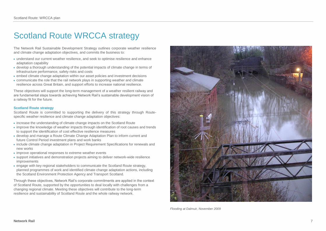
Flooding at Dalmuir, November 2009

Scotland Route: WRCCA plan
Network Rail 8
Scotland Route vulnerability assessment
This section provides the details of the general vulnerability of the rail network in Great Britain
and Scotland Route’s specific vulnerabilities to weather impacts, and regional climate change
projections.
Network-wide weather vulnerability
The challenge for Network Rail is to manage a complex and extensive portfolio of assets, with
variations in geographic location, age, deterioration rates and vulnerability to weather impacts.
Continual analysis of the vulnerability of rail assets to weather, and identification of trends and
characteristics of weather-triggered failures, improves our knowledge of the resilience of the
rail network. An understanding of current weather impacts is an essential platform to implement
cost-effective investments to adapt the network to future changes in climate.
The whole rail network is sensitive and exposed in some way to many primary climate drivers
and secondary impacts, including:
temperature
rainfall
wind gusts
flooding
landslips
soil moisture
sea level rise
coastal erosion.
Network Rail has moved from subjective and expert review-based knowledge of weather
and climate change risks to more detailed internal analysis of asset failure and weather data
to understand thresholds at which failure rates significantly change. Figure 7 provides an
illustrative example of the analysis identifying assets with higher sensitivity to weather impacts.
The horizontal lines are thresholds where there is ‘no significant’ (green), ‘significant’ (amber)
or ‘very significant’ change in incident rates (red). This deeper dive analysis is critical to
understanding the resilience of operational assets both today and potentially in future climates.
From this analysis it has been established that high temperatures have wider impacts across
assets, low temperature affecting track asserts particularly points, earthworks are the
predominant asset sensitive to rainfall and overhead line equipment (OLE) to wind gusts.
Rail asset and weather impact relationships are complex, as demonstrated in the case of OLE
where many wind-related failures are a result of vegetation incursion and not direct wind gusts
as the primary impact. Therefore any analysis of rail assets and weather vulnerability requires
deeper understanding of root causes to identify cost effective resilience actions.
Figure 7 Example of asset failure and weather analysis
Managing operational response to weather vulnerability
Network Rail manages risks from weather-related impacts through a range of asset
management tools, operational response standards and alert systems. Higher risk assets
are prioritised for investment within asset policies and proactively managed through
risk-based maintenance.
Defining ‘normal’, ‘adverse’ and ‘extreme’ weather conditions is fundamental to ensuring
effective coordination across the rail-industry. Network Rail and the National Task Force
(a senior rail cross-industry representative group) are currently reviewing weather thresholds
and definitions to improve the Extreme Weather Action Team (EWAT) process which manages
train services during extreme weather alerts.
Control rooms monitor and respond to real-time weather alerts through a range of action plans.
Operational response to the risks posed by weather events includes: temporary speed
restrictions (TSRs), deployment of staff to monitor the asset at risk, proactive management
of the asset: i.e. use of ice patrols to remove ice from OLE or protection of assets from flood
water, and in some cases where the risk dictates, full closure of the line. Increasing the
resilience of the infrastructure reduces the need for operational response; however, the range
of weather events experienced today, potential changes in the future, and the prohibitive scale
of investments required to mitigate all weather risks, means that operational response will
always be a critical process for Routes to manage safety risks.

Scotland Route: WRCCA plan
Network Rail 9
Network Rail seeks continuous improvement of weather-based decision support tools,
including flood, temperature, wind speed and rainfall alerts. A trial aiming to significantly
improve real-time weather forecasting has installed 102 weather stations on the Scotland rail
network, Figure 8. The pilot study is currently being evaluated to support a potential wider roll-
out of this level of weather service.
Figure 8 Scotland Route real-time weather monitor
For the management of operational flooding risk, Network Rail receives alerts through our
Flood Warning database. In locations where no national flood warnings are available, Network
Rail can arrange to receive alerts from bespoke river level monitoring equipment.
Longer-term flood risk management of rail assets is provided through geographic information
system (GIS) decision support tools including flood datasets, such as Network Rail’s Washout
and Earthflow Risk Mapping tool (WERM). Transformative asset information programmes are
currently aiming to improve weather-related hazard mapping in decision support tools.
Scotland Route weather stations
Improvements in our capability to receive weather forecasts and alerts in Scotland Route
is being provided by the recently installed 102 weather stations, Figure 9, around the route on
GSM-R Masts, lineside cabinets, lineside buildings and on the Forth Bridge and the Tay
Bridge.
There were a number of drivers for this initiative:
Office of Rail Regulation and Rail Accident Investigation Branch recommendations
knowledge of vulnerable assets could be improved
reduction of weather-related risk.
The aims of installing the weather stations were:
improved asset resilience during poor weather conditions
improved network performance
improved safety
improved stakeholder relations
improved design of renewals/enhancements.
Computer analysis of trends and statistics enables decisions to be made based on scientific
fact rather than experience or intuition. The weather stations will help develop accurate
forecasting which allows proactive and risk-based decisions for network operations. However,
in order to analyse data, we must first collect as much as we can.

Scotland Route: WRCCA plan
Network Rail 10
Figure 9 One of the 102 weather stations deployed around Scotland Route
Improving our network-wide resilience
A Weather Resilience and Climate Change (WRCC) programme is at the centre of Network
Rail’s delivery plans. Its importance is underlined by the fact that it is one of the Company’s top
15 business change projects. The programme was first identified in April 2013, but its priority
and profile were heightened as a result of the extreme weather that was experienced between
October 2013 and March 2014. The programme board and stakeholders include
representatives from across the rail industry.
The WRCC programme is founded on a bow tie risk assessment of weather-related disruption,
Figure 10 – this risk assessment methodology is used widely across Network Rail. The bow tie
assessment provides a detailed understanding of the adequacy of the controls that are in place
to reduce the causes of disruption and consequences and highlights those controls that need
to be enhanced.
Figure 10 Bow tie risk assessment
The programme consists of six sub-programmes and their 23 constituent projects; these are
described in Figure 11 below. Although the bulk of the outcomes that are currently defined
expect to be delivered within the next 18 months, the programme is expected to extend
throughout CP5.
It is important to emphasise the national-level programme supplements the work Routes are
completing under their CP5 business plans.

Scotland Route: WRCCA plan
Network Rail 11
WWRCC Sub-Programmes
Infrastructure
Resilience
Cross-industry
Resilience
Earthworks
Integrity
National Weather
Event Response
Climate Change
Adaptation
Information
Exploitation
1 2 3
4 5 6
1. Year 1 Enhanced vegetation management strategy
2. Sustainable vegetation strategy
3. Identifying Highest Risk assets Enhanced resilience to effects of:
4. Flooding5. Costal surge6. Snow, Ice and extreme
temperatures7. High winds
8. Property portfolio9. Fleet10. Timetabling-flexibility and
contingency planning11. Providing advice and
communicating with customers
12. Improved Earthworks Knowledge
13. Improved Drainage Knowledge and Management
14. Improved Earthworks Monitoring
15. Improved Earthworks Management
16. Weather Definitions and Thresholds
17. Weather Event Response 18. Weather Information and
Decision Support systems19. Strategic resource
management
20. Route Climate Change Adaptation Plans
21. Tomorrow’s Railway & Climate Change Adaptation project
22. Delivering supplementary information
23. Delivering Weather Resilience Intelligence
Figure 11 The constituent components of Network Rail’s WRCC programme
The WRCC programme is currently supporting the delivery of:
an enhanced vegetation management project: £10M of accelerated funding to address high
risk trees and mitigate the impact of both extreme winds and adhesion issues
points enhancements: Installation of up to 7,000 points heat insulation and covers in support
of Key Route Strategy
forensic investigation of earthworks failures in 2012/13 and 2013/14: The 261 failures that
occurred during this two year period have been investigated with Deep Dive analysis being
undertaken on 89 of them.
earthworks remote condition monitoring pilot: Involving 250 high risk sites across four Routes
(Scotland, LNE, Wessex and Western) starting in December 2014.
improved drainage management: mobile works tools and drainage competency
improvements by December 2014
agreed weather thresholds and definitions.
an enhanced extreme weather action team process: This will be reviewed and the improved
processes implemented into the first Route by end November 2014
aerial surveys of infrastructure using the Light Detecting and Ranging (LIDAR) technique;
This will be complete by December 2014
enhanced weather forecast service which will be in use from April 2015.
Route weather vulnerability
The geography of Scotland is highly varied, from rural lowlands to barren uplands and from
large cities to rural communities. The topography of Scotland is distinguished by the Highland
Boundary Fault which traverses the Scottish mainland from Helensburgh to Stonehaven.
This fault line separates two distinctively different regions: namely the Highlands to the north
and west and the lowlands to the south and east. The more rugged Highland region contains
the majority of Scotland's mountainous terrain, which in itself is difficult to manage a large and
exposed railway network, marry this with the abundance of rainfall we receive in Scotland and
it makes for a challenging environment.
Wind remains the primary vulnerability within the route, accounting for 28 per cent of the route
delay costs during 2006-2014. The vast majority of wind-related delay incidents are not wind
gust affecting the OLE, more often than not its objects being blown on to the line and in some
cases hitting the OLE and taking out a section.
In recent years we have had to deal with multiple third-party intrusion on OLE in periods of high
winds with various articles blowing on to the line around Scotland Route, including trampolines,
balloons, polythene sheets and garden sheds.
With further extension in the number of electrified routes in Scotland wind will continue to be
our number one priority.
Scotland Route is also vulnerable to the effects of heavy rainfall with flooding accounting for
23.6 per cent of delay minutes 2006/07 to 2013/14.
Scotland Route has established plans to mitigate the effects of these weather impacts and
continues to work proactively to further improve resilience.
Winter weather risk preparedness
Problems in Scotland Route are low adhesion to compacted snow and ice, icing of OLE, ice
on inside of tunnels, snow in the points, landslips, flooding and strong winds.
Scotland Route has a procedure for proactively maintaining the infrastructure during winter
months (Scotland Route: Winter Working Arrangements), which includes prompt reporting of
infrastructure failures due to the weather conditions and coordinating local actions for
maintenance staff reporting to sites. Improvement included the ability to remotely switch on
90 per cent of points heaters across the route without attending site and visiting the worst
affected wire runs each morning during severe cold.
The Route also has four snowploughs, Figure 12, available along with two snow blowers,
Figure 14, together with miniature snowploughs/route proving locos hired and stabled at
various locations as dictated by the weather forecast.

Scotland Route: WRCCA plan
Network Rail 12
Figure 12 Snowploughs are based at Slateford, Mossend, Inverness and Carlisle
The Snow Train or ‘Winter Development Vehicle’ as it is known, Figure 13, has been modified
to carry the modules, generator and hot air blowers and a Mark 2 British Rail ex-Radio Survey
Coach (with camera monitors, remote controls, GPS system installed etc). It was first
introduced to the Route (and the company) in Winter 2011/12 at a cost of £1.4m.
It is used to melt snow from sets of points and has been used at Midcalder Jn, Lanark Jn and
Law Jn. The train has the ability to sit over a set of points and blow warm air on to these,
melting the snow and drying the points out. It also has steam lances and compressed air
lances so the operators can clear the snow with more precision than the fixed hot air blower. It
can be used on any line of Route within Scotland to clear/defrost points and can also be
coupled with any of the snowploughs to provide a ‘one stop shop’ winter train.
Figure 13 Winter train located at Slateford
Winter preparedness for staff
The 2009/10, 2010/11 and 2013/14 winter seasons posed some of the most severe winter
conditions for Scotland Route staff to work in. This included difficulty for signallers getting to
work, maintenance staff responding to incidents and staff working in sub-zero temperatures for
long hours over a period of up to four months to assist in keeping the railway running.
As a result, several actions have been put in place to ensure if there is a severe winter the
Route will be better equipped to deal with staff and welfare issues. Staff working in any winter
conditions should always report at regular intervals to Scotland Infrastructure Control Centre
(ICC) especially when working alone at remote locations.
In particular, arrangements have been put in place for both lone workers on the railway and
signallers working in remote areas as the safety risks faced by lone workers on the railway
increases significantly during the winter season, especially during severe weather conditions.

Scotland Route: WRCCA plan
Network Rail 13
Figure 14 Two snow blowers are located at Kilmarnock and Inverness
Summer weather risk preparedness Scotland Route doesn’t suffer from a lot of heat-related problems; however we still take actions to ensure that potential problems do not arise.
The onset of summer brings with it a number of risks to the effective operation of the rail
network. The main risks are:
expansion of point work causing detection failures
closure of Intermediate Block Joints (IBJ) causing track circuit failures
air conditioning failure
heat effect on overhead line equipment
flooding
lightning strikes on the infrastructure
rail buckles due to high temperatures
staff working in outside locations experiencing sun exposure.
Scotland Route has a procedure (Scotland Route Summer Work Arrangements) for proactively
maintaining the infrastructure during summer and periods of hot weather; this is documented
and reviewed annually.
Scotland Route also priorities low CRT sites to ensure as few locations as possible on main
running lines require a CRT imposed on the hottest of days and weekly progress report on
summer preparedness (plate oiling, fish plate adjusting, CRTs, etc) is sent to relevant parties
to highlight any issues. The painting of rails white is a mitigation action to reduce high
temperature effects on points, Figure 15.
All of these actions help to ensure if the temperature does increase to a particular dangerous
level the Scotland route has already mitigated some of the potential issues.

Scotland Route: WRCCA plan
Network Rail 14
Figure 15 Rails painted white to reduce heat effects on points, Glasgow Central Station
Future climate change vulnerability
The relationship between weather events and climate is complex; therefore it is
understandable that climate change projections do not forecast future weather events.
However, Network Rail can use the climate projections to understand potential risks and make
informed strategic decisions to increase future weather resilience.
The UK Climate Change Projections (UKCP09) provides regional climate change projections
across 13 administrative regions in Great Britain, Figure 16. Scotland Route is divided into
three regions – Western Scotland, Eastern Scotland and Northern Scotland. Projections for
these are considered to be representative of the future climate changes within the Route.
Figure 16 UKCP09 administrative regions

Scotland Route: WRCCA plan
Network Rail 15
The following derived charts from UKCP09 data show the projected changes in temperature
and precipitation for the high emissions scenario, 50th percentile (10th and 90th percentile data
has been obtained). The projected changes are shown for future climate periods up to the
2080s (2070-2099) and are relative to the baseline climate of 1970s (1961-1990).
Mean daily maximum temperature change
Mean daily maximum temperatures for all parts of Scotland are projected to increase
throughout the year, with greater increases expected in the summer months.
In Eastern Scotland the average maximum daily temperature in July is expected to increase
by 2.6°C, reaching 19.6°C by the 2050s, and by 4.3°C, reaching 21.3°C by the 2080s. Average
maximum daily temperature in January is expected to increase by 1.8°C, reaching 6.1°C by the
2050s, and by 2.5°C, reaching 6.8°C by the 2080s, Figure 17.
0
0.5
1
1.5
2
2.5
3
3.5
4
4.5
5
Jan Feb Mar Apr May Jun Jul Aug Sep Oct Nov Dec
Tem
per
atu
re C
han
ge (
°C) 2080s
2070s
2060s
2050s
2040s
2030s
2020s
Figure 17 Scotland East, mean max temperature change (50th percentile)
The average maximum daily temperature in Northern Scotland in July is expected to increase
by 2.1°C, reaching 17.6°C by the 2050s, and by 3.5°C, reaching 19°C by the 2080s. Average
maximum daily temperature in January is expected to increase by 1.7°C, reaching 6.3°C by
the 2050s, and by 2.3°C, reaching 6.9°C by the 2080s, Figure 18.
0
0.5
1
1.5
2
2.5
3
3.5
4
Jan Feb Mar Apr May Jun Jul Aug Sep Oct Nov Dec
Tem
per
atu
re C
han
ge (
°C) 2080s
2070s
2060s
2050s
2040s
2030s
2020s
Figure 18 Scotland North, mean max temperature change (50th percentile)
The average maximum daily temperature in Western Scotland in July is expected to increase
by 2.2°C, reaching 19°C by the 2050s, and by 3.7°C, reaching 20.5°C by the 2080s. Average
maximum daily temperature in January is expected to increase by 1.9°C, reaching 7.2°C by
the 2050s, and by 2.8°C, reaching 8.1°C by the 2080s, Figure 19.
0
0.5
1
1.5
2
2.5
3
3.5
4
4.5
Jan Feb Mar Apr May Jun Jul Aug Sep Oct Nov Dec
Tem
per
atu
re C
han
ge (
°C) 2080s
2070s
2060s
2050s
2040s
2030s
2020s
Figure 19 Scotland West, mean max temperature change (50th percentile)

Scotland Route: WRCCA plan
Network Rail 16
Mean daily minimum temperature change
The mean daily minimum temperatures for all parts of Scotland are also projected to increase
throughout the year.
In Eastern Scotland the average minimum daily temperature in July is projected to increase
by 2.6°C, reaching 11.7°C by 2050s, and by 4.2°C reaching 13.3°C by the 2080s. Average
minimum daily temperature in January is projected to increase by 1.9°C, reaching 1.2°C by
2050s, and by 2.6°C, reaching 1.9°C by 2080s, Figure 20.
0
0.5
1
1.5
2
2.5
3
3.5
4
4.5
Jan Feb Mar Apr May Jun Jul Aug Sep Oct Nov Dec
Tem
per
atu
re C
han
ge (
°C) 2080s
2070s
2060s
2050s
2040s
2030s
2020s
Figure 20 Scotland East, mean min temperature change (50th percentile)
In Northern Scotland the average minimum daily temperature in July is projected to increase
by 2.3°C, reaching 11.3°C by 2050s, and by 3.8°C reaching 12.8°C by the 2080s. Average
minimum daily temperature in January is projected to increase by 1.8°C, reaching 1.7°C by
2050s, and by 2.4°C, reaching 2.3°C by 2080s, Figure 21.
0
0.5
1
1.5
2
2.5
3
3.5
4
Jan Feb Mar Apr May Jun Jul Aug Sep Oct Nov Dec
Tem
per
atu
re C
han
ge (
°C) 2080s
2070s
2060s
2050s
2040s
2030s
2020s
Figure 21 Scotland North, mean min temperature change (50th percentile)
In Western Scotland the average minimum daily temperature in July is projected to increase
by 2.4°C, reaching 12.2°C by 2050s, and by 3.8°C reaching 13.7°C by the 2080s. Average
minimum daily temperature in January is projected to increase by 2.4°C, reaching 2.9°C
by 2050s, and by 3.5°C, reaching 4°C by 2080s, Figure 22.
0
0.5
1
1.5
2
2.5
3
3.5
4
4.5
Jan Feb Mar Apr May Jun Jul Aug Sep Oct Nov Dec
Tem
per
atu
re C
han
ge (
°C) 2080s
2070s
2060s
2050s
2040s
2030s
2020s
Figure 22 Scotland West, mean min temperature change (50th percentile)

Scotland Route: WRCCA plan
Network Rail 17
Mean daily precipitation
Projections for mean daily precipitation for all parts of Scotland show a significant increase
in the winter months and a decrease in summer months.
In Eastern Scotland the greatest increase in daily precipitation is expected to occur in
November. Precipitation is projected to increase by 15 per cent, reaching 4.2mm per day
by the 2050s, and by 23 per cent, reaching 4.5mm per day by the 2080s. The month with
the greatest decrease in precipitation is likely to be June, when daily precipitation is projected
to decrease by 17 per cent by the 2050s, to 1.9mm per day, and by 25 per cent, to 1.7mm per
day by the 2080s, Figure 23.
-30
-20
-10
0
10
20
30
Jan Feb Mar Apr May Jun Jul Aug Sep Oct Nov Dec
Dai
ly P
reci
pit
atio
n C
han
ge (
%)
2080s
2070s
2060s
2050s
2040s
2030s
2020s
Figure 23 Scotland East, mean daily precipitation change (50th percentile)
In Northern Scotland the greatest increase in precipitation is expected to occur in December.
The mean daily precipitation is projected to increase by 20 per cent, reaching 7mm per day
by the 2050s, and by 40 per cent, reaching 8.1mm per day by the 2080s. The greatest
reduction is likely to occur in August, when the mean daily precipitation is projected to
decrease by 7 per cent by the 2050s, to 3.1mm per day, and by 11 per cent, to 2.9mm per day
by the 2080s, Figure 24.
-20
-10
0
10
20
30
40
50
Jan Feb Mar Apr May Jun Jul Aug Sep Oct Nov Dec
Dai
ly P
reci
pit
atio
n C
han
ge (
%)
2080s
2070s
2060s
2050s
2040s
2030s
2020s
Figure 24 Scotland North, mean daily precipitation change (50th percentile)
In Western Scotland the greatest increase in precipitation is expected to occur in December.
The mean daily precipitation is projected to increase by 20 per cent, reaching 7.3mm per day
by the 2050s, and by 40 per cent, reaching 8.5mm per day by the 2080s. Similar to Eastern
Scotland, here the greatest reduction is also likely to occur in June, when the mean daily
precipitation is projected to decrease by 16 per cent by the 2050s, to 2.4mm per day, and by
24 per cent, to 2.2mm per day by the 2080s, Figure 25.
-30
-20
-10
0
10
20
30
40
50
Jan Feb Mar Apr May Jun Jul Aug Sep Oct Nov Dec
Dai
ly P
reci
pit
atio
n C
han
ge (
%)
2080s
2070s
2060s
2050s
2040s
2030s
2020s
Figure 25 Scotland West, mean daily precipitation change (50th percentile)
Scotland Route: WRCCA plan
Network Rail 18
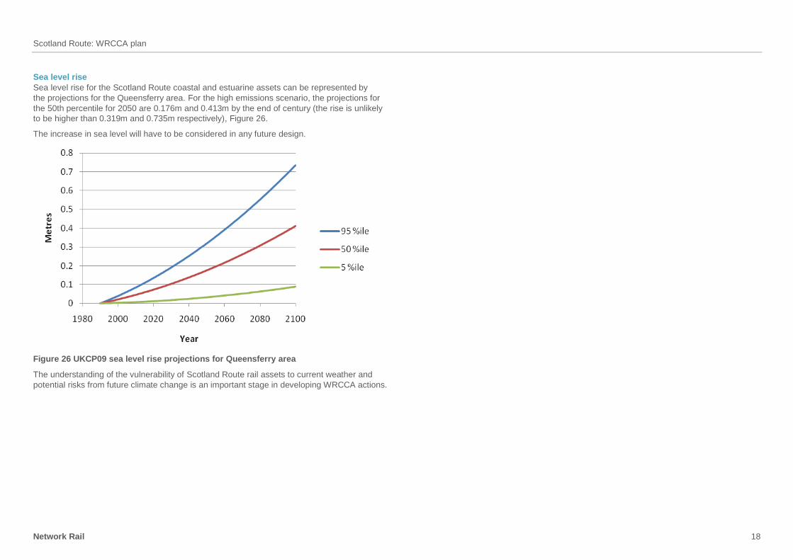
Sea level rise
Sea level rise for the Scotland Route coastal and estuarine assets can be represented by
the projections for the Queensferry area. For the high emissions scenario, the projections for
the 50th percentile for 2050 are 0.176m and 0.413m by the end of century (the rise is unlikely
to be higher than 0.319m and 0.735m respectively), Figure 26.
The increase in sea level will have to be considered in any future design.
Figure 26 UKCP09 sea level rise projections for Queensferry area
The understanding of the vulnerability of Scotland Route rail assets to current weather and
potential risks from future climate change is an important stage in developing WRCCA actions.
Scotland Route: WRCCA plan
Network Rail 19
Scotland Route impact assessment
This section provides the findings from the Scotland Route weather impact assessment,
including annual performance impacts and identification of high impact locations on the Route.
Performance impacts
The impact of weather on the rail network can be monitored within rail performance data.
Schedule 8 costs, the compensation payments to train and freight operators for network
disruption, are used as a proxy for weather impacts due to greater granularity of root cause
reporting.
Schedule 8 costs for the past eight financial years for the Scotland Route has been analysed
to provide an assessment of weather impacts, Figure 27.
‘flooding’ costs include delays due to a range of fluvial, pluvial, groundwater and tidal
flooding of assets
‘earthslip’ delays have been included due to internal analysis indicating primary triggers
of earthworks failures are weather-related
‘heat’ and ‘wind’ include direct impacts on assets and impacts on delay due to speed
restrictions implemented as part of Network Rail’s operational response during weather
events.
£0
£2
£4
£6
£8
£10
£12
Scotland
Mil
lio
ns
Adhesion
Cold
Flood
Lightning
Snow
Wind
Earthslip
Heat
Fog
Figure 27 Scotland Route weather attributed Schedule 8 costs 2006/07-2013/14
Over the past eight years, the average annual performance cost to the Scotland route, as a
result of weather-related events, has been almost £5m.
The analysis shows that wind, flooding and snow have been the most significant weather
impacts for the Route. Climate modelling cannot provide strong projections for future changes
to wind speeds, though; increased storm frequency is generally projected and may increase
the risk of wind-related incidents on the Route.
Table 1 Prioritisation of weather-related impacts on Scotland Route
Weather-
related
impact
Schedule 8
costs1 Projected future impacts Prioritisation
Wind £0.99m Wind changes difficult to project however generally
projected to increase
High
Flooding £0.91m Up to 25 per cent increase in February mean daily
precipitation2
High
Snow £0.98m Up to 3oC increase in January mean daily minimum
temperature1
Medium
Adhesion £0.16m Complex relationship between adhesion issues and
future climate change.
Medium
Earthslips £0.25m Up to 25 per cent increase in February mean daily
precipitation1
Medium
Heat £0.02m Up to 3.1oC increase in July mean daily maximum
temperature2
Medium
Sea level rise Not recorded 0.18m increase in sea level rise3 Medium
Cold £0.22m Up to 3oC increase in January mean daily minimum
temperature2
Low
Lightning £0.20m Storm changes difficult to project however generally
projected to increase
Low
Fog 2 mins delay Complex relationship; however, research suggests
fog events may decrease
Low
1 Annual average 2006/07 to 2013/14, 2 UKCP09 projection, 2050s
High emissions scenario, 50th percentile, against 1970s baseline
3 UKCP09 projection, 2050s High emissions scenario, 50th percentile, against 1990 baseline
Snow-related delays have been significant but are projected to decrease in the future.
However, extreme cold-related events are projected to continue to occur and actions to ensure
resilience to cold-related weather impacts should continue to be factored in future seasonal
preparedness and investment decisions.
Scotland Route: WRCCA plan
Network Rail 20
The impacts of changes in winter and summer precipitation on flooding patterns are complex;
however, it is expected that flooding events will increase in frequency and intensity, and
presents increased risk to the Scotland Route over the coming decades.
A combination of the analysis of weather impacts on the Scotland Route and regional climate
change vulnerability from UKCP09 can be used to prioritise weather resilience actions.
It is also worth noting the Schedule 8 cost per delay minute in CP5 will be on average
60 per cent higher, further reinforcing the importance of effective WRCCA actions.
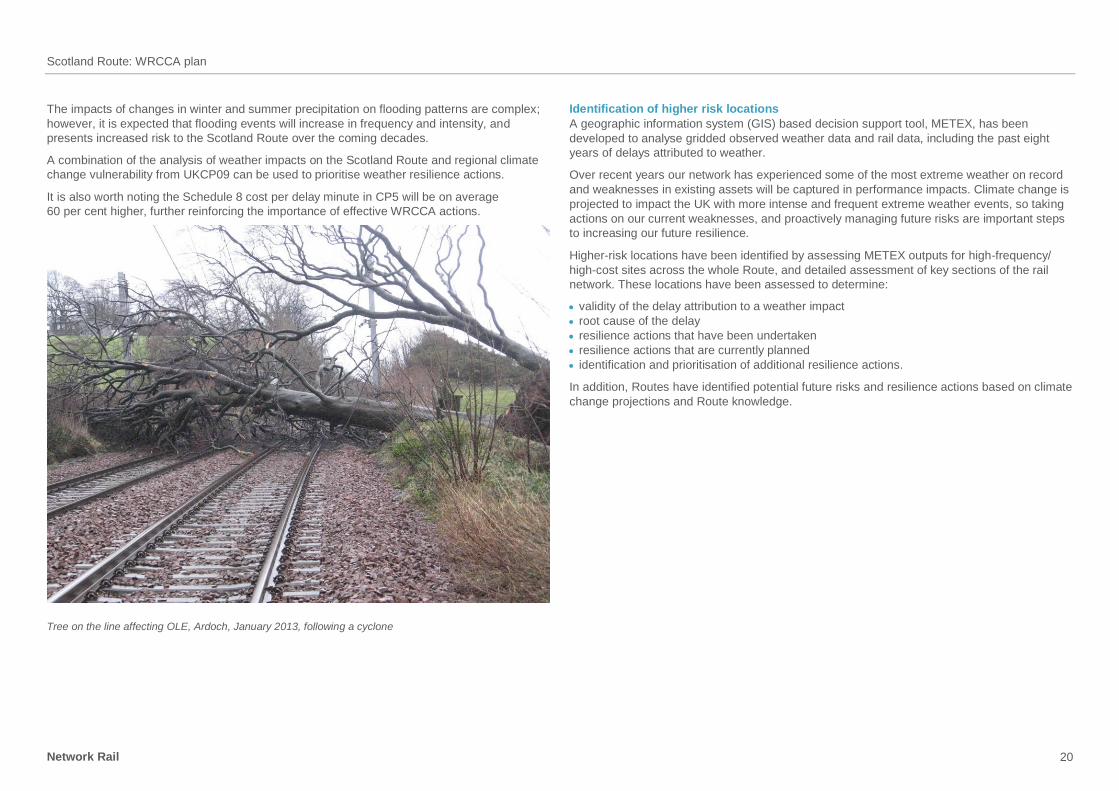
Tree on the line affecting OLE, Ardoch, January 2013, following a cyclone
Identification of higher risk locations
A geographic information system (GIS) based decision support tool, METEX, has been
developed to analyse gridded observed weather data and rail data, including the past eight
years of delays attributed to weather.
Over recent years our network has experienced some of the most extreme weather on record
and weaknesses in existing assets will be captured in performance impacts. Climate change is
projected to impact the UK with more intense and frequent extreme weather events, so taking
actions on our current weaknesses, and proactively managing future risks are important steps
to increasing our future resilience.
Higher-risk locations have been identified by assessing METEX outputs for high-frequency/
high-cost sites across the whole Route, and detailed assessment of key sections of the rail
network. These locations have been assessed to determine:
validity of the delay attribution to a weather impact
root cause of the delay
resilience actions that have been undertaken
resilience actions that are currently planned
identification and prioritisation of additional resilience actions.
In addition, Routes have identified potential future risks and resilience actions based on climate
change projections and Route knowledge.

Scotland Route: WRCCA plan
Network Rail 21
Wind impact assessment
Based on 2006/07 to 2013/14 data, wind-related delays total 56,106 minutes per year, costing
£0.99m per year in Schedule 8 costs. This is 28.5 per cent of weather-related delay minutes.
The following table is a list of our top ten most costly sites and the number of incidents we
responded to over period 2006/07-2013/14 as a direct result of high winds.
Location No. of incidents
Rutherglen East Jn 4
Drem to Dunbar 14
Lockerbie to Gretna Jn 1
Saltcoats 21
Anniesland 2
Winchburgh Jn 5
Gourock Station 1
Craigendoran Jn 7
Gailes 7
Dyce 4
Wind affects performance directly in that blanket speed restrictions are imposed when
thresholds are reached. Scotland Route has a High Wind Procedure involving live feeds
from weather stations and predefined trigger levels for wind gusts of 60mph+ or mean speed
of 47mph+.
Wind also affects performance indirectly, primarily as a result of damaging lineside trees which
then fall or drop branches on or near the line. Wind also moves other debris on to the line from
the line side environment, frequently from neighbouring sites, recent examples include
trampolines, balloons, polythene sheets and garden sheds, Figure 28.
High winds can also lead to significant waves to form even in waters protected from the open
sea, these can cause power trips in OLE areas and damage to the infrastructure.
A recent example of the effects of wind on Scotland route occurred on 4 December 2013.
An advanced weather warning was issued to media outlets in Scotland, stating that on the
morning of 5 December, due to forecast high winds, the rail network would be closed for much
of the day. On one particular part of the rail network in Markinch, Fife, over 60 large trees fell
on the railway completely blocking the line until operatives could get on site and clear the
debris. The rail network started to re-open in the early afternoon in some parts of the Route.
Closing the rail network for that one day due to high winds cost Network Rail over £1m in delay
attribution cost.
Figure 28 Hay bales on line just North of Newtonhill, Aberdeenshire, December 2013
Vegetation
The Route has commenced a proactive strategy to remove high-risk trees which are capable
of landing on the track if they fall. Clearing trees in danger of falling on or near the line is an
enormous undertaking with some trees protected and other trees forming an important visual
screen to our infrastructure.
A LIDAR (Light Detection and Ranging) survey was undertaken in July 2012 to identify trees
that were at risk of falling on to our infrastructure. It also provided data on the height of the tree
and where the trees are growing, for example an embankment or cuttings. A further LIDAR
survey is been undertaken this year which will also give us increased details of the trees that
are remaining, the results from this survey, available in Spring 2015, will be used by the Route
to target the areas at which the railway appears to be vulnerable.
Where it is not possible to remove a tree completely, work is undertaken to reduce the
crown size.
In addition, improvements to Asset Resilience and Vegetation Management will include:
development of vegetation encroachment risk model and risk-based prioritised vegetation
management plans are now in place
enhanced management process for trees in high winds introduced in the Route underpinned
by real time weather stations.
Scotland Route: WRCCA plan
Network Rail 22
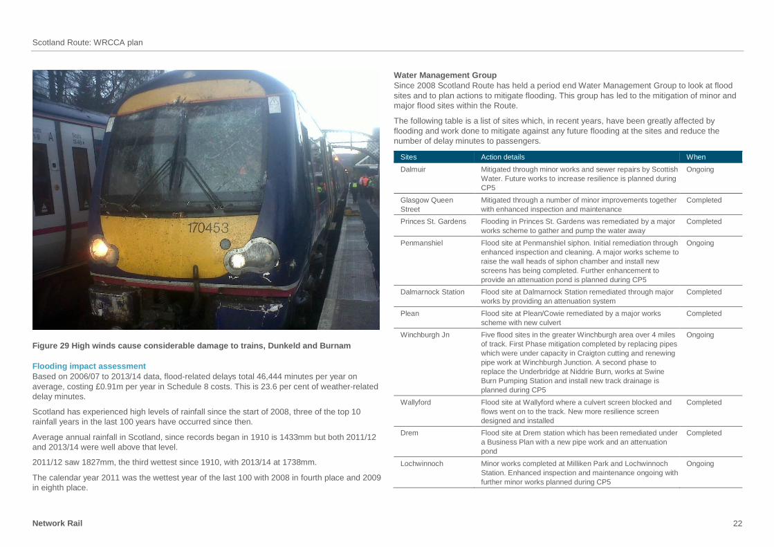
Figure 29 High winds cause considerable damage to trains, Dunkeld and Burnam
Flooding impact assessment
Based on 2006/07 to 2013/14 data, flood-related delays total 46,444 minutes per year on
average, costing £0.91m per year in Schedule 8 costs. This is 23.6 per cent of weather-related
delay minutes.
Scotland has experienced high levels of rainfall since the start of 2008, three of the top 10
rainfall years in the last 100 years have occurred since then.
Average annual rainfall in Scotland, since records began in 1910 is 1433mm but both 2011/12
and 2013/14 were well above that level.
2011/12 saw 1827mm, the third wettest since 1910, with 2013/14 at 1738mm.
The calendar year 2011 was the wettest year of the last 100 with 2008 in fourth place and 2009
in eighth place.
Water Management Group
Since 2008 Scotland Route has held a period end Water Management Group to look at flood
sites and to plan actions to mitigate flooding. This group has led to the mitigation of minor and
major flood sites within the Route.
The following table is a list of sites which, in recent years, have been greatly affected by
flooding and work done to mitigate against any future flooding at the sites and reduce the
number of delay minutes to passengers.
Sites Action details When
Dalmuir Mitigated through minor works and sewer repairs by Scottish
Water. Future works to increase resilience is planned during
CP5
Ongoing
Glasgow Queen
Street
Mitigated through a number of minor improvements together
with enhanced inspection and maintenance
Completed
Princes St. Gardens Flooding in Princes St. Gardens was remediated by a major
works scheme to gather and pump the water away
Completed
Penmanshiel Flood site at Penmanshiel siphon. Initial remediation through
enhanced inspection and cleaning. A major works scheme to
raise the wall heads of siphon chamber and install new
screens has being completed. Further enhancement to
provide an attenuation pond is planned during CP5
Ongoing
Dalmarnock Station Flood site at Dalmarnock Station remediated through major
works by providing an attenuation system
Completed
Plean Flood site at Plean/Cowie remediated by a major works
scheme with new culvert
Completed
Winchburgh Jn Five flood sites in the greater Winchburgh area over 4 miles
of track. First Phase mitigation completed by replacing pipes
which were under capacity in Craigton cutting and renewing
pipe work at Winchburgh Junction. A second phase to
replace the Underbridge at Niddrie Burn, works at Swine
Burn Pumping Station and install new track drainage is
planned during CP5
Ongoing
Wallyford Flood site at Wallyford where a culvert screen blocked and
flows went on to the track. New more resilience screen
designed and installed
Completed
Drem Flood site at Drem station which has been remediated under
a Business Plan with a new pipe work and an attenuation
pond
Completed
Lochwinnoch Minor works completed at Milliken Park and Lochwinnoch
Station. Enhanced inspection and maintenance ongoing with
further minor works planned during CP5
Ongoing

Scotland Route: WRCCA plan
Network Rail 23
Figure 30 Flooding at Bishopton, August 2012
Increasingly frequent and intense storms may have the effect of overwhelming the existing
drainage networks. This in turn could lead to service disruption and accelerated degradation
of other assets that depend on good drainage, for example geotechnical assets and the track
formation.
A recent example of this was 12 August 2014, at Kingussie when heavy rainfall caused local
rivers to flood and drainage systems to become overwhelmed. Restoration of services took
three days whilst recovery operations took place to reinstate ballast washouts and clear flood
debris from the line. This one event caused 761 delay minutes and cost over £150,000 in delay
attribution costs.
Track assets
Flooding can greatly affect the Track and its formation. There are a number of investigations
Scotland Route is proposing to undertake in order to better understand the impact of flooding
on the Track system:
ballast retention – in areas of high flood potential investigate means of ballast retention
to avoid loss of track formation as a result of wash out or scour investigate use of bituminous paving materials on sub grade to improve water run off and
avoid scour or earthworks failure ballast cleaning/replacement – model the probability of increased ballast fouling as a result
of regular flooding or increased rainfall, leading to reduced ballast life. In critical locations
outline what ballast replacement frequencies or methodology should be adopted.
Structures assets
The topography of the Route, with steep-sided mountainous terrain and high rainfall, together
with other significant precursors such as seasonal snow melt and sudden release of water from
hydroelectric scheme dams means that our assets are particularly susceptible to severe
localised weather events, as well as wider floodplain events.
Scotland Route contains a larger proportion of small diameter culverts on steep sidelong
ground than other routes. As a result, the route has an increased work bank of culvert repairs
identified in addition to those identified by the Network Rail Structures Policy.
The West Highland Line is a section of route with a significant number of such assets in poor
condition, and at risk of increased frequency of severe weather events. A specific asset
strategy has been developed and a remediation programme has commenced continuing
through to the end of CP6.
Due to their small size, culverts can also present constraints in flow capacity when considered
as part of an overall drainage system. During periods of exceptional rainfall this can lead to
overtopping of these assets or flooding of adjacent land.
Two culverts with multiple historic instances of flooding have been identified by the Route
Water Management Group for replacement. For example, the replacement of the culvert
crossing Keppen Burn, Figure 31, on the Kilwinning Jn to Largs Line at Fairlie is being jointly
developed with Transport Scotland (Trunk Roads Directorate) and North Ayrshire Council to
provide the optimum solution.

Scotland Route: WRCCA plan
Network Rail 24
Figure 31 Keppen Burn – downstream elevation
Underbridges
Underbridges historically experience scour and overtopping, which present a risk to the
operation of the railway.
We have an established programme to calculate the risk of scour damaging underbridges.
This programme is used to prioritise mitigation measures including physical works (scour
protection) and operational instructions.
The Route currently has 41 structures classified as higher risk. In addition, a further 72
structures have the potential to fall into the higher-risk category on the conclusion of more
detailed assessment.
The Route currently has plans to remediate 20 higher-risk sites in CP5. To further improve
weather resilience an additional 12 sites have been identified.
To address the risk of overtopping at two historically at risk sites, schemes to improve the flow
capacity are proposed.
The replacement of the underbridge crossing the Niddrie Burn, Figure 32, on the Edinburgh
Waverley to Glasgow Queen Street Line would benefit from additional investment.
By replacing the existing two-span structure by a single-span structure, the flow capacity can
be increased to reduce the frequency of flooding and to be able to accommodate additional
pumped flows from the upgraded track/tunnel drainage system. The opportunity to carry out
this work is available in 2015/16 during the blockade to carry out work in Winchburgh Tunnel
as part of the Edinburgh to Glasgow Improvement Programme (EGIP) Enhancement Scheme.
Figure 32 Niddrie Burn – downstream elevation
At Wamphray on the West Coast Main Line flow capacity is being increased by lowering
the river bed (renewal of existing concrete weir), this scheme is also replacing damaged
scour protection.
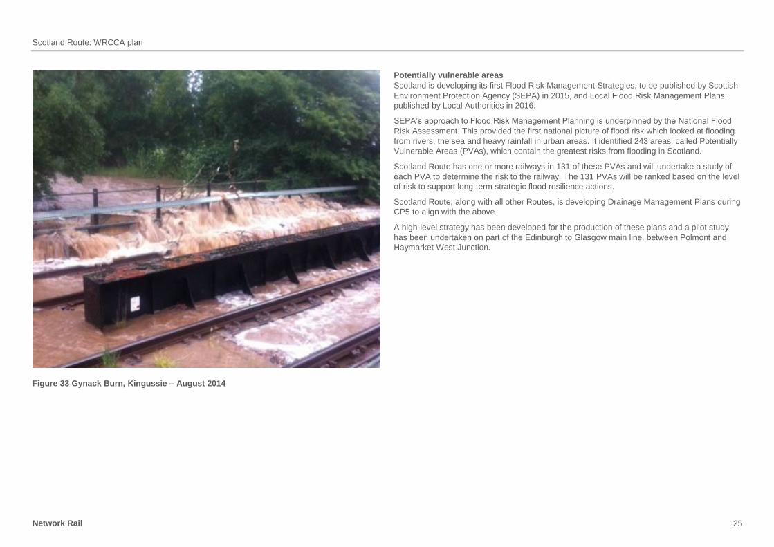
Where full renewal of a bridge or culvert cannot be achieved, Scotland Route has explored a
number of alternative options to improve resilience to flooding. One example is at the bridges
crossing the Gynack and Balavil Burns near Kingussie on the Highland line, Figure 33. These
bridges have special operating instructions to allow trains to continue to run safely when river
levels are high and have scour protection and holding down arrangements installed to prevent
them being washed away.
Scotland Route: WRCCA plan
Network Rail 25
Figure 33 Gynack Burn, Kingussie – August 2014
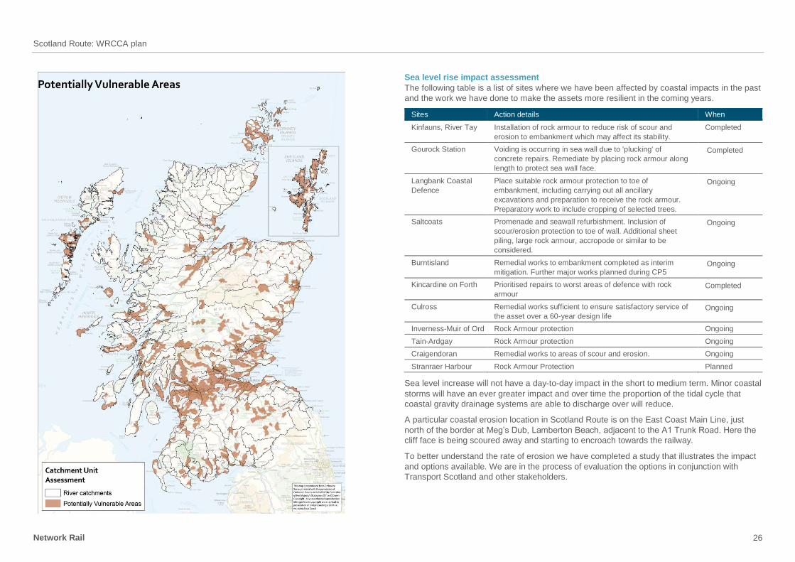
Potentially vulnerable areas
Scotland is developing its first Flood Risk Management Strategies, to be published by Scottish
Environment Protection Agency (SEPA) in 2015, and Local Flood Risk Management Plans,
published by Local Authorities in 2016.
SEPA’s approach to Flood Risk Management Planning is underpinned by the National Flood
Risk Assessment. This provided the first national picture of flood risk which looked at flooding
from rivers, the sea and heavy rainfall in urban areas. It identified 243 areas, called Potentially
Vulnerable Areas (PVAs), which contain the greatest risks from flooding in Scotland.
Scotland Route has one or more railways in 131 of these PVAs and will undertake a study of
each PVA to determine the risk to the railway. The 131 PVAs will be ranked based on the level
of risk to support long-term strategic flood resilience actions.
Scotland Route, along with all other Routes, is developing Drainage Management Plans during
CP5 to align with the above.
A high-level strategy has been developed for the production of these plans and a pilot study
has been undertaken on part of the Edinburgh to Glasgow main line, between Polmont and
Haymarket West Junction.
Scotland Route: WRCCA plan
Network Rail 26
Sea level rise impact assessment
The following table is a list of sites where we have been affected by coastal impacts in the past
and the work we have done to make the assets more resilient in the coming years.
Sites Action details When
Kinfauns, River Tay Installation of rock armour to reduce risk of scour and
erosion to embankment which may affect its stability.
Completed
Gourock Station Voiding is occurring in sea wall due to 'plucking' of
concrete repairs. Remediate by placing rock armour along
length to protect sea wall face.
Completed
Langbank Coastal
Defence
Place suitable rock armour protection to toe of
embankment, including carrying out all ancillary
excavations and preparation to receive the rock armour.
Preparatory work to include cropping of selected trees.
Ongoing
Saltcoats Promenade and seawall refurbishment. Inclusion of
scour/erosion protection to toe of wall. Additional sheet
piling, large rock armour, accropode or similar to be
considered.
Ongoing
Burntisland Remedial works to embankment completed as interim
mitigation. Further major works planned during CP5 Ongoing
Kincardine on Forth Prioritised repairs to worst areas of defence with rock
armour Completed
Culross Remedial works sufficient to ensure satisfactory service of
the asset over a 60-year design life Ongoing
Inverness-Muir of Ord Rock Armour protection Ongoing
Tain-Ardgay Rock Armour protection Ongoing
Craigendoran Remedial works to areas of scour and erosion. Ongoing
Stranraer Harbour Rock Armour Protection Planned
Sea level increase will not have a day-to-day impact in the short to medium term. Minor coastal
storms will have an ever greater impact and over time the proportion of the tidal cycle that
coastal gravity drainage systems are able to discharge over will reduce.
A particular coastal erosion location in Scotland Route is on the East Coast Main Line, just
north of the border at Meg’s Dub, Lamberton Beach, adjacent to the A1 Trunk Road. Here the
cliff face is being scoured away and starting to encroach towards the railway.
To better understand the rate of erosion we have completed a study that illustrates the impact
and options available. We are in the process of evaluation the options in conjunction with
Transport Scotland and other stakeholders.

Scotland Route: WRCCA plan
Network Rail 27
Coastal and estuarine defences
The Route manages 138 coastal and estuarine defence assets, a significant proportion of the
national portfolio, as many lines were built along the coast to avoid upland terrain. The baseline
programme of works for CP5 was based on specific work to key assets, and also a review of
risks by geographic/line of route groupings of assets. The former included a scheme to carry
out substantial repairs to Saltcoats Seawall, Figure 34. This mass concrete wall on the
Kilwinning Jn to Largs Line suffered significant damage during the winter storms of 2012 and
2013.
In areas where track is subjected to greater levels of salt water exposure there is an increased
risk of corrosion. Coated rail can be installed alongside non-corrosive fastenings to increase
resilience to the coastal impacts.
Figure 34 Saltcoats Seawall, January 2014
OLE assets
OLE assets are susceptible to the effects of sea spray. Scotland Route currently has a limited
number of locations which are vulnerable, Saltcoats, Craigendorand and Ardrossan. At
Saltcoats there is a history of performance incidents due to sea spray shorting out the OLE and
there have been 39 incidents in the past eight years of the line being closed due to this issue.
During development of the wall repairs scheme it has been identified that the effects of sea
spray could be reduced by incorporating a wave return wall into the promenade parapet at an
additional cost of £1.25m, including OLE work to further reduce impact.
Scotland Route has asset management plans for ongoing maintenance and repair of the
remaining coastal defence portfolio. Work has been identified at a number of key locations,
for example, the North bank of the Firth of Forth, Figure 35. This group of assets has increased
criticality following the introduction of coal flows serving Longannet Power Station.
Figure 35 Kincardine on Forth – typical coastal defects
Scotland Route: WRCCA plan
Network Rail 28
Earthslip impact assessment Based on 2006/07 to 2013/14 data, earthslip-related delays total 9,654 minutes per year on
average, costing £0.25m per year in Schedule 8 costs. This is 4.9 per cent of weather-related
delay minutes.
The following table is a list of sites which in recent years have been greatly affected by
earthslips, within the table we have outlined what work was carried out at each site and if
completed or ongoing.
Sites Action details When
Fishers’ Wood Earthslip was remediated. Completed
Helmsdale Works completed to reinstate slope. Future work to make the
slope more resilient is planned during CP5.
Ongoing
Carmont Remediation of cutting slope following emergency, after
mudslide due to flooding.
Completed
Arrochar Embankment slip was repaired with stone. Completed
Aberdeen to
Stonehaven
Minor works completed to reopen the line and followed by
further minor repairs on 20 no. sites
Completed
East Linton Earthslip was remediated. Completed
Dumfries Landslip and embankment failure. Gabion Baskets were
installed and the embankment was regraded.
Completed
Slochd Storm weather conditions in October 2009 resulted in a
number of reactive repairs at various locations which have
all been remediated.
Completed
Managing high-risk earthworks in heavy rainfall
Scotland Route maintains a live risk assessment of earthworks which it uses to produce a list
of cuttings and embankments which are vulnerable to heavy rainfall. Earthwork assets
vulnerability is likely to increase in periods of severe rainfall and so a weather alert system is
used to trigger the implementation of robust short-term control measures at high-risk earthwork
locations, involving regular inspection during the weather alert.
Network Rail uses the Met Office assessment of risk to infrastructure with warning thresholds
of amber and red as triggers for action. A forecast for each high-risk site on the asset list will
be sent to Scotland Route Control Centre 48 hours in advance. These forecasts are updated
every six hours to ensure ongoing accuracy.
Upon receiving a weather forecast that’s predicts an amber or red rainfall weather event for
one of more high-risk sites, an Extreme Weather Action Team (EWAT) will be called. During
the extreme weather event, resource requirements and the approach to be taken to the specific
weather event will be agreed by the EWAT.
Under the high-risk earthworks procedure an enhanced patrolling and monitoring regime
is implemented for earthworks deemed as ‘high risk’ when >25mm of rainfall over a
24-hour period.
Intense rain and flooding can cause the failure of geotechnical assets via a number of
mechanisms each with a different suit of mitigations:
washout failure due to water flowing over the crest of cuttings. Mitigated by increasing
capacity of crest drainage and works to stabilise cutting slopes
cutting failure due to saturation of face. Mitigated by slope face drainage and stabilisation
failure due to wet cutting toe, often accompanied with track quality problems. Mitigated by
improved cutting and track drainage
embankment failure due to saturation during rainfall events. These are very difficult to protect
against, often an engineered solution is required to restore support
embankment failure due to scour at the toe. This occurs where the toe of the embankment is
adjacent to a river stream or drainage ditch which conveys water at high velocity during storm
events, these failures can occur very quickly. Mitigated by installing scour protection.
Physical mitigations to reduce the risk of rock fall include vegetation management, removal
of loose or potentially loose material (descaling) and rock netting.
Earthslips and rock falls do not always occur on assets that Network Rail control. Scotland
Route has a high number of rural lines which pass through mountainous terrain and where the
land on either side of the railway is on naturally occurring sloping ground (natural slopes).
Where natural slopes present a risk from earthslip or rock fall Scotland Route has and will
continue to make contact with third-party landowners in order to better ascertain what work
they plan to undertake close to the railway boundary. Any drainage or vegetation management
work undertaken will be discussed at ongoing meetings with local protocols put in place to
prevent any negative impact to the railway which would compromise passenger safety.
In addition to this, Scotland Route is exploring the use of new technology to proactively alert
instances of earthslip and rock fall in remote locations. Distributed Acoustic Sensing (DAS)
technology is now being used as a detection system in an innovative trial which is proving
successful. Work on this system will continue through CP5 with the potential for a wider
deployment being considered.
We will continue to investigate other new and developing technology which would make the
railway more weather resilient. The Route is currently evaluating through a proof of concept
study the potential to utilise satellite imaging to help predict movement in natural slopes that
neighbour the rail network.
Scotland Route: WRCCA plan
Network Rail 29
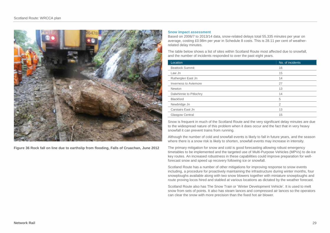
Figure 36 Rock fall on line due to earthslip from flooding, Falls of Cruachan, June 2012
Snow impact assessment
Based on 2006/7 to 2013/14 data, snow-related delays total 55,335 minutes per year on
average, costing £0.98m per year in Schedule 8 costs. This is 28.11 per cent of weather-
related delay minutes.
The table below shows a list of sites within Scotland Route most affected due to snowfall,
and the number of incidents responded to over the past eight years.
Location No. of incidents
Beattock Summit 16
Law Jn 15
Rutherglen East Jn 14
Inverness to Aviemore 27
Newton 13
Dalwhinnie to Pitlochry 14
Blackford 5
Newbridge Jn 2
Carstairs East Jn 13
Glasgow Central 15
Snow is frequent in much of the Scotland Route and the very significant delay minutes are due
to the widespread nature of this problem when it does occur and the fact that in very heavy
snowfall it can prevent trains from running.
Although the number of cold and snowfall events is likely to fall in future years, and the season
where there is a snow risk is likely to shorten, snowfall events may increase in intensity.
The primary mitigation for snow and cold is good forecasting allowing robust emergency
timetables to be implemented and the targeted use of Multi-Purpose Vehicles (MPVs) to de-ice
key routes. An increased robustness in these capabilities could improve preparation for well-
forecast snow and speed up recovery following ice or snowfall.
Scotland Route has a number of other mitigations for improving response to snow events
including, a procedure for proactively maintaining the infrastructure during winter months, four
snowploughs available along with two snow blowers together with miniature snowploughs and
route proving locos hired and stabled at various locations as dictated by the weather forecast.
Scotland Route also has The Snow Train or ‘Winter Development Vehicle’. It is used to melt
snow from sets of points. It also has steam lances and compressed air lances so the operators
can clear the snow with more precision than the fixed hot air blower.

Scotland Route: WRCCA plan
Network Rail 30
Figure 37 Two trains caught in heavy snow Carrbridge, March 2010
Cold impact assessment
Based on 2006/07 to 2013/14 data, cold-related delays total 12,864 minutes per year on
average, costing £0.22 per year in Schedule 8 costs. This is 6.5 per cent of weather-related
delay minutes.
The table below shows a list of sites within Scotland Route most affected by cold, and the
number of incidents responded to over the past eight years.
Location No. of incidents
Bowling 1
Motherwell 9
Carstairs 5
Rutherglen East Jn 2
Lenzie 2
Lugton 4
Edinburgh 4
Bellgrove 2
Aberdeen 3
Aberdour 1
Overall the risk of significant delays due to cold and snow is a reducing problem and significant
investment in expensive mitigations should probably not be a priority and moderate
investments in better procedures and relatively short-term investments such as more MPV
capacity etc should however be assessed.
We have a number of teams which make icicles patrols during times of very cold weather.
Points assets
One of Scotland Route’s primary weaknesses against cold weather is the failure of points.
There are several failure modes for points: compacted snow between the switch rail and the
stock rail; frozen point ends due to failed points heating; and frozen points operating
equipment (POE).
With potentially less frequent, more severe cold and snow events, it is imperative that points
are reliable in order to maintain an operational railway. Reliability is currently monitored, the
root cause of failures is established to improve asset knowledge and there is an appropriate
action plan:
to reduce the number of incidents associated with frozen POE, the Route is increasing the
number of POEs that have internal heating, with increased capacity for heat retention within
the points heaters and rail
snow compacted into point end will continue to be cleared by maintenance when snowfall
is predicted to overwhelm the points heating capability
points heating may fail for a number of reasons, however the majority of our installations
are monitored remotely which provides alarms and allows prompt interventions
every main line point end is fitted with Remote Condition Monitoring (RCM).

Scotland Route: WRCCA plan
Network Rail 31
Figure 38 Heavy snow at Corrour, West Highland Line, February 2014
Signalling assets
One of the route’s major signalling weaknesses against cold weather is manual signalling
and points rodding. This equipment is prone to freezing which can cause long delays, and
the Route has completed a renewal programme.
Structures assets
There have been incidents in the past eight years of icicles in tunnels and on bridges that have
caused delays, primarily posing a danger of damage to the train. These have been removed
by maintenance on a case by case basis in the past but with the addition of the Winter
Development Vehicle future work is likely to be less time consuming and reduces the risk
to operatives.
No one structure is particularly vulnerable currently and therefore proactive resilience is
currently difficult to target.
With an increase in winter temperature, icicles are unlikely to increase in regularity. However,
extreme cold events are predicted and so wet tunnels and structures, such as Haymarket
Tunnel and Queen Street Lower, will be a continual vulnerability. Scotland Route has a
programme of ice management removal undertaken throughout high-risk days. Areas with
OLE are particularly vulnerable to the impact of icicle formation and prioritised accordingly.
For tunnel structures in addition to the risk of icicles, ice can build up at track level and can
also cause damage to tunnel lining. Scotland Route is undertaking a programme of rock
stabilisation works in 12 unlined rock tunnels. This is driven by Unlined Tunnel Geological Risk
Assessment (UTGRA) recommendations on each structure, which was informed by a review of
the deterioration in rock condition over time due to freeze/thaw damage.
It is proposed to replace the drip shield structure at the west portal of Bishopton Tunnel, Figure
39. The current arrangement has proved to be susceptible to ice build up and there is the
potential that structural failure could result from severe ice jacking.
During the cold winter months of 2009/10 and 2012/12 there was a significant effect on station
platforms with frost heave causing the platform and copping at the platform edge to become
uneven and dangerous for station users. All these sites have been remediated.
Earthworks assets
Freeze-thaw action affects rock slopes, particularly those with heavily jointed configurations.
Mitigation includes enhanced examination for vulnerable assets and a programme of targeted
rock scaling, bolting and rock fall netting.

Scotland Route: WRCCA plan
Network Rail 32
Figure 39 Icicles at Bishopton, December 2010
Adhesion impact assessment
Based on 2006/07 to 2013/14 data, adhesion-related delays total 8,772 minutes per year on
average, costing £0.16m per year in Schedule 8 costs. This is 4.5 per cent of weather-related
delay minutes.
Adhesion is extremely complex with many interlinked causes, both infrastructure and
operational. Many cases of adhesion delays are attributed to a lack of appropriate rail head
treatment. The weather that causes the greatest adhesion problems are still and cold mornings
and evenings which promote heavy dew and if combined with leaf fall the railhead can become
contaminated.
The table below shows a list of sites and actions taken at those locations to address any
adhesion issues.
Site Action details
Inverness : Aviemore Traction Gel Applicator installed between Inverness and Culloden. Rail
Head Treatment Train runs increased on this section
Kirkcaldy : Inverkeithing Vegetation clearance and special attention paid by Leaf Fall teams and
Station Maintenance Teams to Dalgety Bay
Newton : Hamilton Central Additional works carried out during the autumn season to mitigate leaf fall.
Vegetation clearance
Falkland S.S. : Mauchline Three new Traction Gel Applicators installed. Rail Head Treatment
increased. Vegetation clearance
Usan : Carnoustie Rail Head Treatment increased at Carnoustie
Dalmuir Vegetation clearance
Dalwhinnie : Pitlochry Additional mitigation works carried out and adhesion modifier laid on the rail
throughout the section
The primary mitigation is tree removal in areas where the problem is persistent followed up
with a programme of railhead treatment, including rail cleaning to remove contamination and
application of adhesion gel. Increased Multi Purpose Vehicle (MPV) capacity can assist with
both rail head treatments. Plans to reduce the vegetation cover on the route will improve
matters also.
More modern rolling stock with wheel slip detection reduces the impact of railhead
contamination and good forecast and robust alternative timetables that build sufficient time
in to allow trains to slow and accelerate gently when conditions are poor can also significantly
reduce impact.
Scotland Route has implemented risk-based models to prioritise the removal of lineside
vegetation. This will assist in reducing adhesion issues Route wide.
Lightning impact assessment
Based on 2006/07 to 2013/14 data, lightning-related delays total 6,895 minutes per year on
average, costing £0.20m per year in Schedule 8 costs. This is 3.5 per cent of weather-related
delay minutes.
Where possible the Route has implemented measures to reduce the impact of lightning on
signalling and control systems. The ability to completely reduce the impact is however not
possible, particularly on older generations of equipment.
As signalling systems are replaced over time, new systems will be specified with a greater
degree of resilience including the provision of lightning surge arrestors. Current mitigation
is to ensure a good stock of vulnerable equipment spares are held to ensure service recovery
is swift.

Scotland Route: WRCCA plan
Network Rail 33
The table below shows locations around Scotland Route which have been affected by
lightning strikes and the actions taken at these locations to make our assets more resilient
to future strikes.
Site Action details
Highline Line (Dalwhinnie,
Blair Athol, Slochd,
Aviemore)
Easy Coast North Line,
(Laurencekirk, Aberdeen)
Scottish Central Main
Line, (Blackford)
These locations are Block Control areas. All utilise line pairs or occasionally
Earth returns for the Block Control circuits and are susceptible to induced
voltages causing equipment damage. These circuits are sensitive to Earth-
related faults and are primarily protected by in-line fusing. System
rectification time is usually primarily directly related to staff deployment and
failure point identification followed by service recovery as many are on
single lines
East Coast Main line,
(Reston)
Reston has a Frequency Division Multiplex (FDM) transmission system and
a significant delay incident occurred due to a large volume of FDM
equipment damage following a direct strike. This system uses a
sectionalised cable pair and due to the sensitivity to Earth faults, the
primary protection method is in-line fusing
West Coast Main line,
(Lockerbie)
The failure at Lockerbie was due to line fuses failing which would have an
impact on the signals affecting Cove MCB. The legacy TDM transmission
has since been replaced by a point-to-point digital system over Fixed
Telecoms Network (FTN) which has alleviated this issue
Heat impact assessment
Based on 2006/07 to 2013/14 data, heat-related delays total 723 minutes per year on average,
costing £0.02m per year in Schedule 8 costs. This is 0.37 per cent of weather-related delay minutes.
The following table shows the areas which have been affected by Heat, in some cases more
than once, over the period 2006/07 to 2013/14.
Location No. of incidents
Longniddry 2
Carstairs 1
Lenzie 3
Drem to Dunbar 2
Carrbridge 3
Law Jn 2
Reston to Grantshouse 1
Midcalder Jn 1
Laurencekirk 2
Carmuirs 1
There are several assets that are vulnerable to the effects of heat. There are proactive
measures in place currently to reduce the impact of heat on the railway system and
consideration has been given to the opportunities available to mitigate an increase in impact
as temperature increases.
Points
Currently, in conjunction with the Critical Rail Temperature (CRT) mitigations, the operations
of points is minimised during hot weather to reduce the risk of failure. The movement is
particularly restricted on Key Route Strategies (KRS) to enable flowing traffic. The mitigations
stated above are also being considered for points and the immediately adjacent sections to
reduce the need for restricted points operations.
At Haymarket East Jn, in order to keep the rails cool, there is a sprinkler system in place which
automatically detects the rail temperature and activates before a problem occurs.
Signalling assets
Electrical equipment in lineside buildings can be severely affected by high temperatures.
Currently the Relocatable Equipment Buildings (REBs) are air conditioned and are able to
maintain constant temperature conditions.
With an increase in temperature and more heat-generating technology in lineside REBs,
it is likely that the air conditioning requirements will increase. Remote condition monitoring
is currently installed and operated, and will be extended to more critical sites during CP5.
Air conditioning is to be a more valued asset within the route, as it is noted that it is critical
to the performance of the signalling assets.
Lineside location cabinets are also susceptible to failures due to overheating. To reduce the
failure frequency location cabinets are being painted white in an effort to reduce the effect of
direct sunlight and heat on the cabinet.
Electrification and plant assets
Currently, E&P assets are not largely affected by high ambient temperatures. Some batteries
and equipment in lineside buildings can have a reduced life span if they are kept at high
temperatures for a long period of time. However, this is not significant across the life span
of the asset.
At one location on the network, at Finnieston, the OLE equipment is of fixed termination
meaning it is susceptible to sag during hot weather. Mitigation to convert this to a more resilient
design (auto tension equipment) has been identified as part of this plan.

Scotland Route: WRCCA plan
Network Rail 34
Track assets
Track assets are vulnerable to the effects of increased temperatures. Mitigation is provided as
part of routine maintenance. Track maintenance teams put significant resource into managing
the track asset in a way that limits the number and length of speeds restrictions required due to
heat to manage safety. They are largely successful and the current impact is relatively small as
a result.
Mitigation actions have been to:
paint rails white to lower the temperature of the rails
prioritising low CRT sites to ensure as few locations as possible on main running lines
require a CRT imposed on the hottest of days
stress the track to ensure its robustness during hot weather.
In addition to the above mitigations, further work has been identified which would increase
knowledge and understanding of the effects of heat on track assets and could be used to
target future mitigation. These include:
a study to understand impact of temperature increases on optimal stressing regime.
Investigate whether an increased Stress Free Temperature provides more robust track asset
performance.
model impacts of expected durations of hotter and colder temperatures. Review the extents
and compare them to current levels. Understand the impact on Track Machine (Tamping and
Stone blowing) productivity.
temperature rate of change – break potential and monitoring of defect growth. Identify
if any proposed changes to the rate of temperature change will impact upon the rate of
defect propagation.
extreme temperature – Insulated Block Joint (IBJ) usage. Understand if extremes are likely
to result in increased risk of failure at an IBJ due to 'pulling apart' or crushing due to higher
forces and stresses in the rail. Consider whether alternative designs (such as the scarf type)
should be considered on specific locations.
Earthworks assets
South facing Rock Slopes and Soil/Rock Slopes are also becoming more vulnerable to rock fall
due to the drying effects from the increase in temperature. Targeted programmes of rock fall
netting have been completed with further sites planned during CP5, Figure 40. Additional
mitigation is being trialled in the form of rock fall detection using Distributed Acoustic Sensing
technology and the potential use in the longer term of satellite technology.
Figure 40 Rock fall netting near Bridge of Allan, May 2014
Fog impact assessment
The historical impact of fog on railway operations in Scotland is low.
Based on 2006/07 to 2013/14 data, fog-related delays total two minutes of delay per year. This
is 0.07 per cent of weather-related delay minutes.
Fog risk is expected to decrease as temperatures rise; current controls are adequate for future
management of fog.

Scotland Route: WRCCA plan
Network Rail 35
Scotland Route WRCCA actions
Network-wide weather and climate change resilience will be driven predominately by Network
Rail’s Central functions through revision to asset policies and design standards, technology
adoption and root cause analysis. The location specific nature of weather impacts will require
analysis and response at Route level.
This section is a concise summary of Scotland Route actions planned in CP5, Table 2, beyond
Business as Usual (BAU), and potential additional actions, Table 3, for consideration in CP5
and future Control Periods to increase weather and climate change resilience.
Table 2 Planned actions in CP5
Vulnerability Action to be taken By when
All impacts
Climatic conditions and
specific weather-related risks
are not clearly communicated
to asset renewal and
enhancement processes
Include clear requirements for climatic conditions and
resilience levels in Route Requirements Documents
Ongoing
Risk to staff from extreme
weather conditions
Staff trained to use and supplied with appropriate
equipment, e.g. life vests for flooding events, seasonal
PPE, offices and depots temperature controlled
Ongoing
Weather information
The provision of only cyclical
forecasts (e.g. daily general
forecast) limits the prediction
of weather impacts on
vulnerable assets
Use real-time weather data. Also radar services provided
by weather services contractor to confirm actual weather
conditions and assess asset vulnerability
New
contract in
place; 2015
Flooding
Safety risk to staff responding
to flooding sites and assessing
the condition of the railway
Install Remote Condition Monitoring on the most
frequently monitored 50 per cent of bridge structures in
the ‘flood plan’
End Y2 CP5
Provision of water safety equipment (lifejackets,
lifesaving rings) at repeat flood sites which require staff
attendance
End 2014
Staff who respond to flooding and assess flood risk to
receive Water Awareness Training
Ongoing
Vulnerability Action to be taken By when
Level of engagement with
flood risk management
authorities has to support
effective discussions
Continue to liaise with and build on relationships with
SEPA and Local Authorities through various local and
Scotland wide Liaison Groups on flood risk management
to share information and resolve issues, as in Scotland it
is the local authority who has responsibility for flooding.
Engage with Local flood resilience forums
Ongoing
Major repeat flood sites
Continue to investigate a resolve and undertake any
Flood Risk Assessments identified to guide mitigation
by Major/Minor Projects. Deliver the major projects
previously identified
Throughout
CP5
New flood sites:
Review new flood sites, identified at Water Management
Group and prioritise them for investigation, design,
development and remedial works
Throughout
CP5
Install any Remote Condition Monitoring identified, as
prioritised by the route
Throughout
CP5
Potentially Vulnerable Areas Analyse PVAs Identified by SEPA and determine the risk
to the railway and prioritise mitigation actions
End 2015
Coastal and estuarine
Potentially vulnerable areas From analysis of PVA determine any Coastal and
Estuarine locations at risk and prioritise mitigation
actions
Ongoing
Saltcoats Sea Wall Develop proposals for increasing the resilience of the
coastal railway at Saltcoats to include sea wall and OLE
End 2016
Seek funding for a rolling programme of resilience
improvement work for other at risk defences
From 2015
(mid CP5) to
end CP6
Signalling Relocate high-risk signalling equipment into storm
resilient cases and buildings
From 2015
(mid CP5) to
end CP6
Other route sections at
increased risk of flooding
following sea level rise due to
climate change
Develop from PVA and sea level rise predictions, a
Route Coastal, Estuarine and River Defence (CERD)
plan which details vulnerable coastal assets and their
management plan
From 2015
(mid CP5) to
end CP6
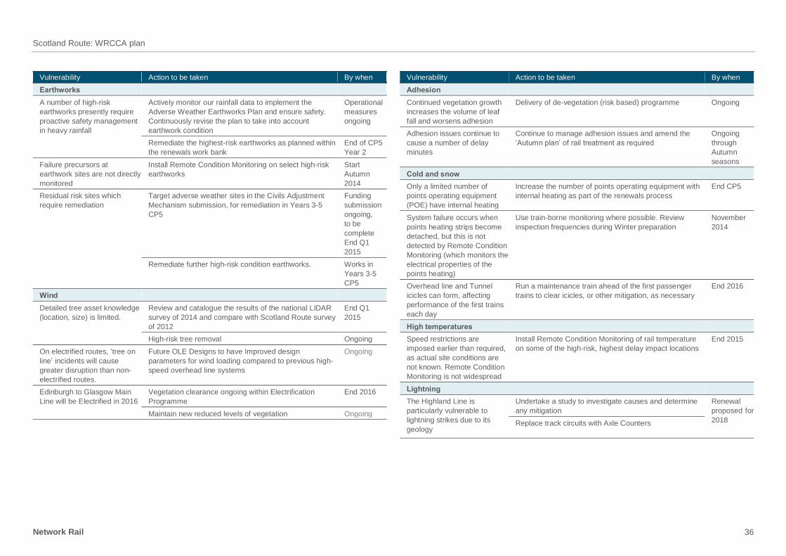
Scotland Route: WRCCA plan
Network Rail 36
Vulnerability Action to be taken By when
Earthworks
A number of high-risk
earthworks presently require
proactive safety management
in heavy rainfall
Actively monitor our rainfall data to implement the
Adverse Weather Earthworks Plan and ensure safety.
Continuously revise the plan to take into account
earthwork condition
Operational
measures
ongoing
Remediate the highest-risk earthworks as planned within
the renewals work bank
End of CP5
Year 2
Failure precursors at
earthwork sites are not directly
monitored
Install Remote Condition Monitoring on select high-risk
earthworks
Start
Autumn
2014
Residual risk sites which
require remediation
Target adverse weather sites in the Civils Adjustment
Mechanism submission, for remediation in Years 3-5
CP5
Funding
submission
ongoing,
to be
complete
End Q1
2015
Remediate further high-risk condition earthworks. Works in
Years 3-5
CP5
Wind
Detailed tree asset knowledge
(location, size) is limited.
Review and catalogue the results of the national LIDAR
survey of 2014 and compare with Scotland Route survey
of 2012
End Q1
2015
High-risk tree removal Ongoing
On electrified routes, ‘tree on
line’ incidents will cause
greater disruption than non-
electrified routes.
Future OLE Designs to have Improved design
parameters for wind loading compared to previous high-
speed overhead line systems
Ongoing
Edinburgh to Glasgow Main
Line will be Electrified in 2016
Vegetation clearance ongoing within Electrification
Programme
End 2016
Maintain new reduced levels of vegetation Ongoing
Vulnerability Action to be taken By when
Adhesion
Continued vegetation growth
increases the volume of leaf
fall and worsens adhesion
Delivery of de-vegetation (risk based) programme Ongoing
Adhesion issues continue to
cause a number of delay
minutes
Continue to manage adhesion issues and amend the
‘Autumn plan’ of rail treatment as required
Ongoing
through
Autumn
seasons
Cold and snow
Only a limited number of
points operating equipment
(POE) have internal heating
Increase the number of points operating equipment with
internal heating as part of the renewals process
End CP5
System failure occurs when
points heating strips become
detached, but this is not
detected by Remote Condition
Monitoring (which monitors the
electrical properties of the
points heating)
Use train-borne monitoring where possible. Review
inspection frequencies during Winter preparation
November
2014
Overhead line and Tunnel
icicles can form, affecting
performance of the first trains
each day
Run a maintenance train ahead of the first passenger
trains to clear icicles, or other mitigation, as necessary
End 2016
High temperatures
Speed restrictions are
imposed earlier than required,
as actual site conditions are
not known. Remote Condition
Monitoring is not widespread
Install Remote Condition Monitoring of rail temperature
on some of the high-risk, highest delay impact locations
End 2015
Lightning
The Highland Line is
particularly vulnerable to
lightning strikes due to its
geology
Undertake a study to investigate causes and determine
any mitigation
Renewal
proposed for
2018 Replace track circuits with Axle Counters

Scotland Route: WRCCA plan
Network Rail 37
In addition to the above actions in CP5, the following actions have been identified as
potential enhanced WRCCA actions, which will require business case evaluation and
funding submission.
Table 3 Potential additional WRCCA actions requiring further evaluation
Vulnerability Action to be evaluated
All impacts
Weather stations More robust IT architecture to support better real time data retrieval and
analysis
Communications migration from 3rd party mobile provider to
in-house Network Rail telecoms (FTN-X), thus enabling true real time
data retrieval
Reliability improvements to individual weather station sites
Flooding
Underbridges Continued scour protection at 12 number underbridges that have being
identified around the Scotland route as potential Scour Sites
Culverts/earthworks Continued protection and improvement around the Scotland Route of
Culverts, to protect against track washout and land slips
Flash floods Improvement to specific location around Scotland Route to further
improve the resilience of Track washout due to flash floods
Level crossings Improvement to specific level crossings around Scotland Route to further
improve flooding resilience
Low lying locations Improvement to specific location around Scotland Route to further
improve the resilience of Track washout in low-lying locations
Track Ballast retention – In areas of high flood potential investigate means of
ballast retention to avoid loss of track formation as a result of wash out or
scour
Investigate use of bituminous paving materials on sub grade to improve
water run off and avoid scour or earthworks failure
Ballast cleaning/replacement – model the probability of increased ballast
fouling as a result of regular flooding or increased rainfall. In critical
locations outline what ballast replacement frequencies or methodology
should be adopted
Sleeper Failure – Model the increase in sleeper failure where 'Alkali/Silica
Reaction' (ASR) is known to occur in concrete types. Include guidance to
the relevant Asset Management teams on recommended replacement
timescales
Vulnerability Action to be evaluated
High temperatures
Track signalling,
electrification and plant, and
telecoms
Improved resilience to heat within lineside building around Scotland Route
to further prevent problems with signalling equipment failure.
Track A study to understand impact of temperature increases on optimal
stressing regime. Investigate whether an increased stress-free
temperature provides more robust track asset performance.
Model impacts of expected durations of hotter and colder temperatures.
Review the extents and compare them to current levels. Understand the
impact on track machine (tamping and stone blowing) productivity.
Temperature rate of change – break potential and monitoring of defect
growth. Identify if any proposed changes to the rate of temperature
change will impact upon the rate of defect propagation.
Extreme temperature – Insulated Block Joint (IBJ) usage. Understand if
extremes are likely to result in increased risk of failure at an IBJ due to
'pulling apart' or crushing due to higher forces and stresses in the rail.
Consider whether alternative designs (such as the scarf type) should be
considered on specific locations.
Coastal and estuarine
Coastal and estuarine
defences
Continued protection around the Scotland Route of coastal defences, to
protect against track washout and scour
Track Wave height – avoiding rail corrosion. If the rail is likely to be subject to
greater levels of salt water exposure then make recommendations where
coated rail is to be used and when it is to be installed
Wave height – robust components. If the track is likely to be subject to
greater levels of salt water exposure then identify when to implement non-
corrosive fastenings to enable maintenance
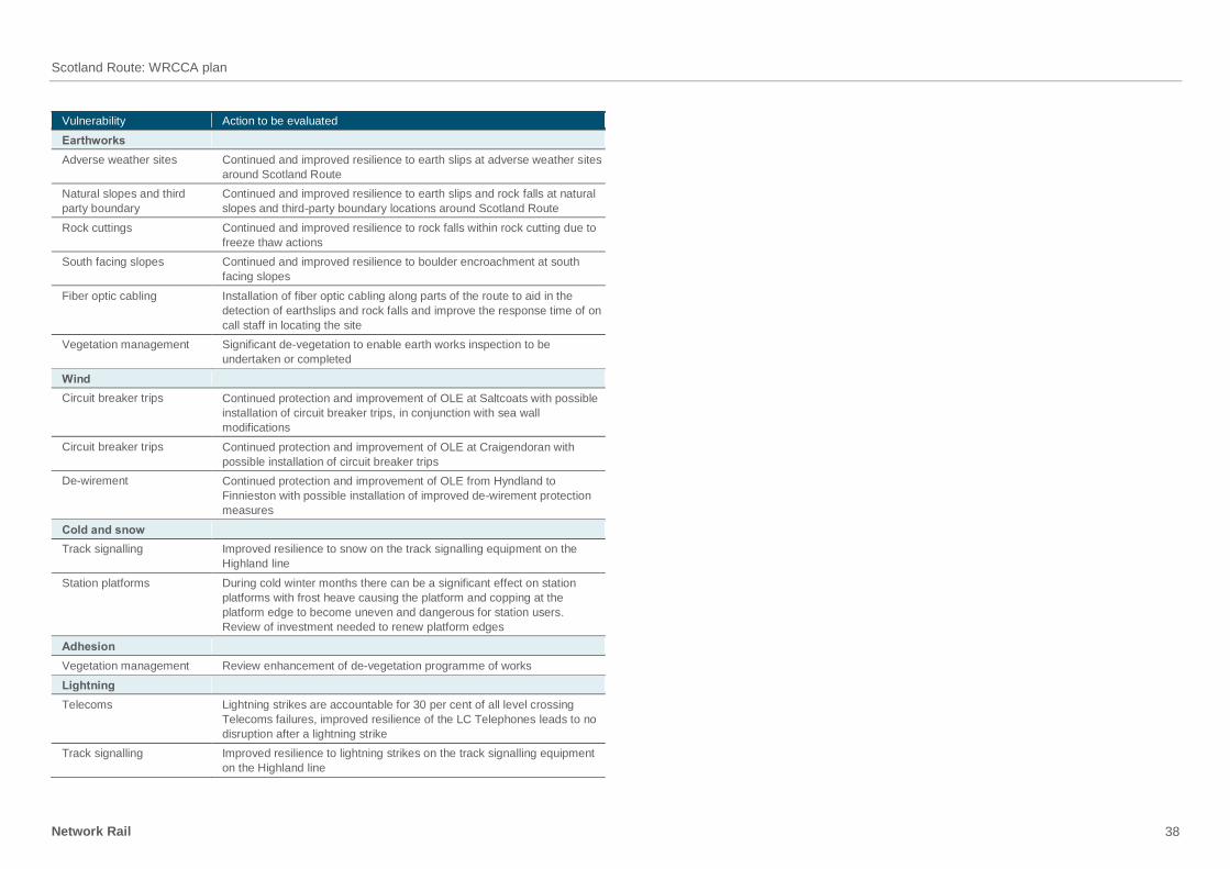
Scotland Route: WRCCA plan
Network Rail 38
Vulnerability Action to be evaluated
Earthworks
Adverse weather sites Continued and improved resilience to earth slips at adverse weather sites
around Scotland Route
Natural slopes and third
party boundary
Continued and improved resilience to earth slips and rock falls at natural
slopes and third-party boundary locations around Scotland Route
Rock cuttings Continued and improved resilience to rock falls within rock cutting due to
freeze thaw actions
South facing slopes Continued and improved resilience to boulder encroachment at south
facing slopes
Fiber optic cabling Installation of fiber optic cabling along parts of the route to aid in the
detection of earthslips and rock falls and improve the response time of on
call staff in locating the site
Vegetation management Significant de-vegetation to enable earth works inspection to be
undertaken or completed
Wind
Circuit breaker trips Continued protection and improvement of OLE at Saltcoats with possible
installation of circuit breaker trips, in conjunction with sea wall
modifications
Circuit breaker trips Continued protection and improvement of OLE at Craigendoran with
possible installation of circuit breaker trips
De-wirement Continued protection and improvement of OLE from Hyndland to
Finnieston with possible installation of improved de-wirement protection
measures
Cold and snow
Track signalling Improved resilience to snow on the track signalling equipment on the
Highland line
Station platforms During cold winter months there can be a significant effect on station
platforms with frost heave causing the platform and copping at the
platform edge to become uneven and dangerous for station users.
Review of investment needed to renew platform edges
Adhesion
Vegetation management Review enhancement of de-vegetation programme of works
Lightning
Telecoms Lightning strikes are accountable for 30 per cent of all level crossing
Telecoms failures, improved resilience of the LC Telephones leads to no
disruption after a lightning strike
Track signalling Improved resilience to lightning strikes on the track signalling equipment
on the Highland line

Scotland Route: WRCCA plan
Network Rail 39
Management and review
Corporate management and review
Weather resilience and climate change adaptation will require long-term commitment to
regular review and management across the business. The challenge for the industry, and for
all organisations managing assets vulnerable to weather events, is to develop cost-effective
strategies to accommodate climate change and implement these strategies in a timely
manner to avoid an unacceptable increase in safety risk, reduction in system reliability or
undeliverable downstream risk mitigation strategies.
Key actions being taken within corporate functions include:
Safety, Technical and Engineering – Review of weather and climate change within asset
policies and standards, and monitoring of WRCCA actions through the S&SD Integrated
Plan
Network Operations – Review of the Extreme Weather Action Team process and definition
of ‘normal’, ‘adverse’ and ‘extreme’ weather
Group Strategy – Delivery of future weather resilience in the Long-Term Planning Process
Infrastructure Projects – Review of weather and climate change within the Governance for
Railway Investment Projects (GRIP).
The progress on WRCCA actions is reported through Network Rail’s governance process to
the Executive Committee as part of regular Strategic Theme business management
updates.
Scotland Route management and review
Scotland Route is already committed to managing and reviewing the implementation
of weather-related resilience actions and has several forums in which risks are identified
and tracked.
The principal forums are:
Route Infrastructure Reliability Group (each period)
Asset Stewardship Group with TOCs, FOCs and other stakeholders (each period)
Review of Flooding Resilience Actions at Water Management Group (each period)
Joint Performance Improvement Plan (each period)
Actions from route reports and the above forums are tracked regularly to measure
the effectiveness of the resilience actions.
The Director Route Asset Management will undertake a six-monthly review of progress. The
six-monthly Scotland Route reviews of seasonal preparedness plans will continue to ensure
that all preparatory work has been completed.
Review of Route WRCCA plan actions
The actions within all eight Route WRCCA plans will be monitored through internal Network
Rail governance processes.
Route WRCCA plan progress will be reported every six months through the S&SD
Integrated Plan. The plan monitors the actions being taken across Network Rail delivering
safety and sustainable development objectives. The whole plan is monitored monthly by the
cross-functional S&SD Integration Group.
Enhancement of assets will be included in Network Rail workbanks and monitored through
our asset management processes.
Network Rail will also look to engage with the wider rail industry, specifically Train Operating
Companies and Freight Operating Companies, to discuss the Route WRCCA actions to
identify opportunities for collaboration to facilitate effective increase of rail system resilience.
We will also update the Office of Rail Regulation (ORR) on progress through regular
bilateral meetings.

Network Rail Buchanan House 58 Port Dundas Road Glasgow G4 0LQ
networkrail.co.uk


