
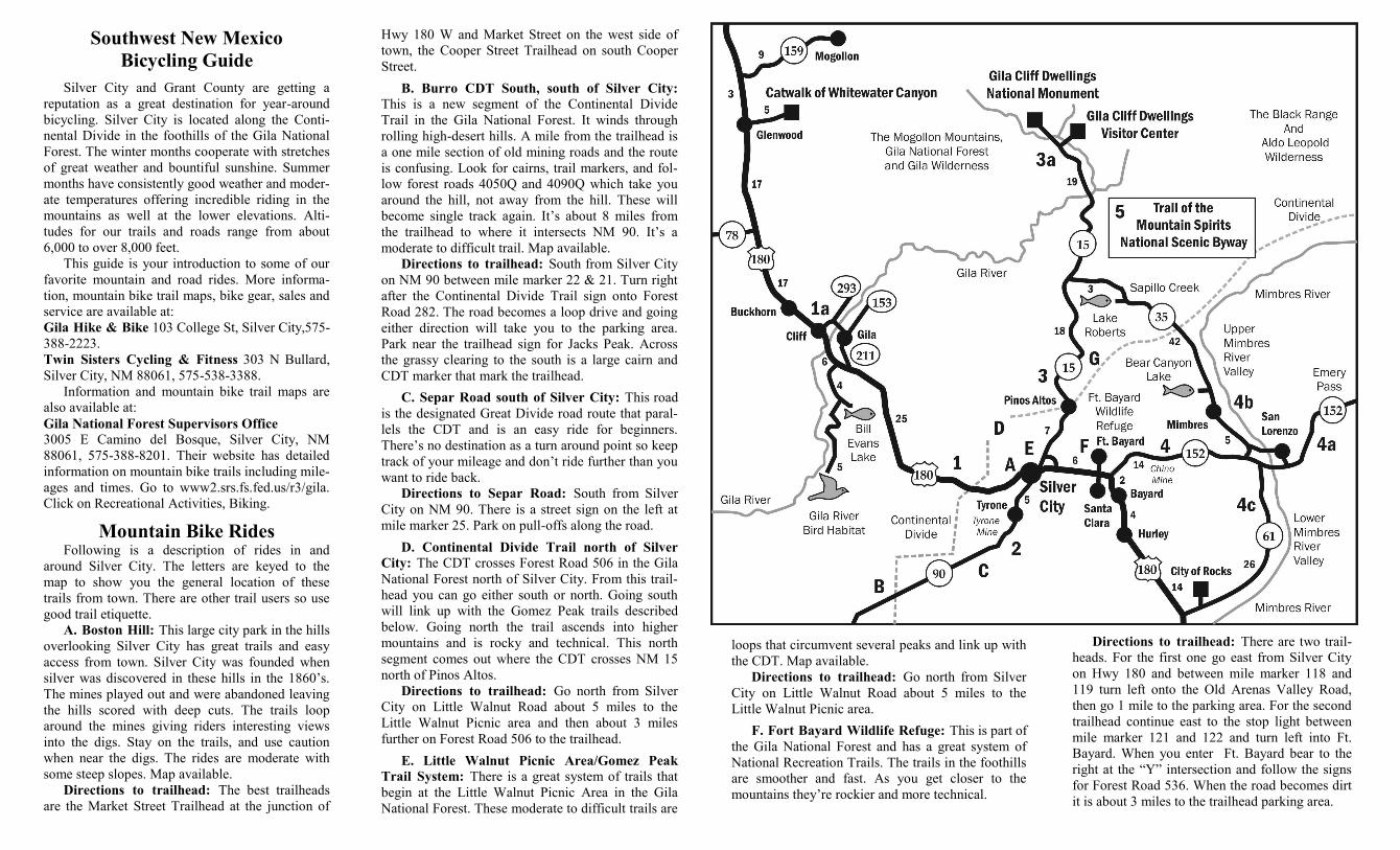
the weekends. From Silver City to Pinos Altos,
about 7 miles, the road is 2-lane with shoulders.
North of Pinos Altos the road becomes a narrow
2-way with no lane markings or shoulders. It winds
through the ponderosa pine forest with many blind
curves so you need to stay in your lane and look out
for oncoming traffic. It’s 18 miles from Pinos Altos
to the junction with NM 35. There are several good
turn-around points if you don’t want to go all the
way. The last 3-mile descent into Sapillo Creek is
steep with blind hair-pin curves.
Directions: Go north from Silver City on 15.
3a. NM 15 to the Gila Cliff Dwellings. From
the junction of NM 15 & 35 it’s about 19 miles to
the Gila Cliff Dwellings. This section of NM 15 is a
good paved 2-lane with continuous curves and long,
steep climbs. It’s about a 6-mile climb to the Clinton
P. Anderson Vista after which the road descends
steeply for about 9 miles to the Gila River Valley.
It’s 4 miles further to the end of the road and the
Cliff Dwellings. The climb back out is tough espe-
cially on a summer afternoon. This is a ride for ex-
perienced riders and a great training ride for racers.
Directions: Go north from Silver City on 15.
4. NM 152 to the Mimbres River Valley: This
ride takes you east of Silver City into the Mimbres
River Valley. Hwy 180 East leaving Silver City is a
busy 4-lane with shoulders that junctions with NM
152 five miles east of town. 152 is a lightly traveled
2-lane with shoulders. This road has many good
climbs and goes past a vista where you can view the
Chino Copper Mine. A couple miles past the mine
the road descends into the Mimbres River Valley. In
the valley, about 20 miles from Silver City, NM 152
junctions with NM 35 between mile marker 14 and
15. This is a good turn-around point.
Directions: Go east from Silver City on Hwy
180 than turn left onto NM 152 at the junction be-
tween mile marker 121 and 122.
Ride options in the Mimbres River Valley: In
the Mimbres River Valley you have three options:
Note: If you don’t want to ride to the Mimbres
River Valley from town you can drive out and park
in the gravel parking area at the junction of NM 152
and 61 at mile marker 15 and ride from there.
4a. Emory Pass: NM 152 continues across the
valley and then climbs 17 miles into the Black
Range to 8,000 ft. Emory Pass. This great mountain
G. Signal Peak: This is the location of the
Signal Peak Challenge Mountain Bike Race. This
mountainous pine and aspen forested county has
moderate to difficult trails and forest roads. Best
for riding in the summer and fall. Map available.
Directions to trailhead: Go north from Silver
City on NM 15. Between mile marker 15 and 16
there is a graded gavel road on the right and plenty
of room to park. From here you can follow the
road or the single tracks both of which will link to
other roads and trails.
________________________________________
Road Bike Rides
Lightly traveled roads and good pavement
make Silver City and Grant County a great place
for road bikes. The Tour of the Gila, an annual
5-day, pro road race takes place here. Our area is a
winter training destination for pro teams and a
great year-around destination for fitness and
recreational cyclists. In this guide mileages are
approximate and ride numbers are keyed to the
map on the other side. There are no maps specifi-
cally for these rides. You can get an area map
from the Silver City—Grant County Chamber of
Commerce or use a New Mexico highway map.
1. US 180 West (NM Bike Route 18): A light
to moderately traveled road with shoulders. After
a couple miles ascent from Silver City to the Con-
tinental Divide there’s a 9 mile descent to Mangas
Valley. The terrain then becomes valleys and
small hills with open country and scenic mountain
vistas. You can continue on 180 as far as you want
or you can do a loop (1A) through the towns of
Cliff and Gila and back to Silver City which will
give you about 60 miles.
Directions: Go west from Silver City on 180.
2. NM 90: A light to moderately traveled road
with shoulders. The road has some long moderate
grades and rolling hills up to the Continental Di-
vide between mile markers 22 and 21, about 22
miles from Silver City. After the Divide the hills
descend into the low desert to the town of Lords-
burg 44 miles from Silver City.
Directions: Go south from Silver City on 90.
3. NM 15 to Sapillo Creek: This is a local
favorite. Traffic is light with moderate traffic on
climb takes you into pine and aspen forest and is for
experienced riders. The first 6 miles of the ascent is
a wide 2-lane with shoulders but after the National
Forest boundary becomes a narrow 2-lane with blind
curves and some steep climbs. Traffic is light.
Directions: Continue east across the Mimbres
River Valley on NM 152.
4b. Mimbres River Valley north on NM 35:
NM 35 is an easy ride up the valley along the Mim-
bres River to the Continental Divide between mile
marker 15 and 16. It’s a short hill climb up to the
Divide. On the west side of the Divide is a short
descent into the Sapillo Creek valley. The next 8
miles to Lake Roberts is a beautiful, easy ride
through meadows and stands of ponderosa pine.
There are some short, steep climbs around Lake
Roberts. River Vista, a picnic area overlooking the
lake, has a toilet. A half mile further is Lake Roberts
store. About 3 miles further is the junction of NM 35
and NM 15. The road is a narrow 2-lane with light
traffic.
Directions: From the junction of NM 152 and
NM 35 go north on 35 up the Mimbres River Valley.
4c. Mimbres River Valley south on NM 61:
NM 61 is an easy ride that follows the lower Mim-
bres River Valley through high-desert hills. There
isn’t a turn-around destination so go as far as you
want. It’s about 26 miles to the junction with Hwy
180. If you want to make a big loop you can con-
tinue down NM 61 and return to Silver City on Hwy
180. It’s about a 75 mile loop. NM 61 is a narrow 2-
lane with a course asphalt surface and light traffic.
Hwy 180 is a heavy traffic two-lane with shoulders.
Directions: From the junction of NM 152 and
NM 61 go south on 61 down the river valley.
5. Trail of the Mountain Spirits National
Scenic Byway: NM 15, 35, 152 and Hwy 180 con-
nect to form the 74-mile loop through the mountains
of the Gila National Forest. The roads have been
described in 3 and 4 above.
Directions: From Silver City you can do this
loop by going north on NM 15 or east on Hwy 180
and linking up with NM 152 and 35.
Copyright 2015 by Jackie Blurton. No part of this
guide may be reprinted or used without the written
permission of the author. The author bears no re-
sponsibility for accidents, injuries, or loss from any
cause for anyone using this guide.
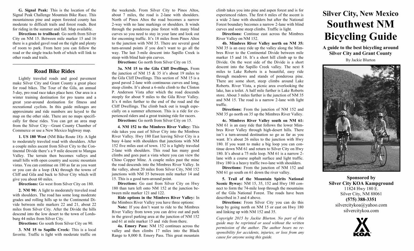
Silver City, New Mexico Southwest NM
Bicycling Guide A guide to the best bicycling around
Silver City and Grant County
By Jackie Blurton
Sponsored by
Silver City KOA Kampground 11824 Hwy 180 E.
Silver City, NM 88061
(575) 388-3351
silvercitykoa.com
Southwest New Mexico
Bicycling Guide
Silver City and Grant County are getting a
reputation as a great destination for year-around
bicycling. Silver City is located along the Conti-
nental Divide in the foothills of the Gila National
Forest. The winter months cooperate with stretches
of great weather and bountiful sunshine. Summer
months have consistently good weather and moder-
ate temperatures offering incredible riding in the
mountains as well at the lower elevations. Alti-
tudes for our trails and roads range from about
6,000 to over 8,000 feet.
This guide is your introduction to some of our
favorite mountain and road rides. More informa-
tion, mountain bike trail maps, bike gear, sales and
service are available at:
Gila Hike & Bike 103 College St, Silver City,575-
388-2223.
Twin Sisters Cycling & Fitness 303 N Bullard,
Silver City, NM 88061, 575-538-3388.
Information and mountain bike trail maps are
also available at:
Gila National Forest Supervisors Office 3005 E Camino del Bosque, Silver City, NM
88061, 575-388-8201. Their website has detailed
information on mountain bike trails including mile-
ages and times. Go to www2.srs.fs.fed.us/r3/gila.
Click on Recreational Activities, Biking.
Mountain Bike Rides Following is a description of rides in and
around Silver City. The letters are keyed to the
map to show you the general location of these
trails from town. There are other trail users so use
good trail etiquette.
A. Boston Hill: This large city park in the hills
overlooking Silver City has great trails and easy
access from town. Silver City was founded when
silver was discovered in these hills in the 1860’s.
The mines played out and were abandoned leaving
the hills scored with deep cuts. The trails loop
around the mines giving riders interesting views
into the digs. Stay on the trails, and use caution
when near the digs. The rides are moderate with
some steep slopes. Map available.
Directions to trailhead: The best trailheads
are the Market Street Trailhead at the junction of
loops that circumvent several peaks and link up with
the CDT. Map available.
Directions to trailhead: Go north from Silver
City on Little Walnut Road about 5 miles to the
Little Walnut Picnic area.
F. Fort Bayard Wildlife Refuge: This is part of
the Gila National Forest and has a great system of
National Recreation Trails. The trails in the foothills
are smoother and fast. As you get closer to the
mountains they’re rockier and more technical.
Hwy 180 W and Market Street on the west side of
town, the Cooper Street Trailhead on south Cooper
Street.
B. Burro CDT South, south of Silver City:
This is a new segment of the Continental Divide
Trail in the Gila National Forest. It winds through
rolling high-desert hills. A mile from the trailhead is
a one mile section of old mining roads and the route
is confusing. Look for cairns, trail markers, and fol-
low forest roads 4050Q and 4090Q which take you
around the hill, not away from the hill. These will
become single track again. It’s about 8 miles from
the trailhead to where it intersects NM 90. It’s a
moderate to difficult trail. Map available.
Directions to trailhead: South from Silver City
on NM 90 between mile marker 22 & 21. Turn right
after the Continental Divide Trail sign onto Forest
Road 282. The road becomes a loop drive and going
either direction will take you to the parking area.
Park near the trailhead sign for Jacks Peak. Across
the grassy clearing to the south is a large cairn and
CDT marker that mark the trailhead.
C. Separ Road south of Silver City: This road
is the designated Great Divide road route that paral-
lels the CDT and is an easy ride for beginners.
There’s no destination as a turn around point so keep
track of your mileage and don’t ride further than you
want to ride back.
Directions to Separ Road: South from Silver
City on NM 90. There is a street sign on the left at
mile marker 25. Park on pull-offs along the road.
D. Continental Divide Trail north of Silver
City: The CDT crosses Forest Road 506 in the Gila
National Forest north of Silver City. From this trail-
head you can go either south or north. Going south
will link up with the Gomez Peak trails described
below. Going north the trail ascends into higher
mountains and is rocky and technical. This north
segment comes out where the CDT crosses NM 15
north of Pinos Altos.
Directions to trailhead: Go north from Silver
City on Little Walnut Road about 5 miles to the
Little Walnut Picnic area and then about 3 miles
further on Forest Road 506 to the trailhead.
E. Little Walnut Picnic Area/Gomez Peak
Trail System: There is a great system of trails that
begin at the Little Walnut Picnic Area in the Gila
National Forest. These moderate to difficult trails are
Directions to trailhead: There are two trail-
heads. For the first one go east from Silver City
on Hwy 180 and between mile marker 118 and
119 turn left onto the Old Arenas Valley Road,
then go 1 mile to the parking area. For the second
trailhead continue east to the stop light between
mile marker 121 and 122 and turn left into Ft.
Bayard. When you enter Ft. Bayard bear to the
right at the “Y” intersection and follow the signs
for Forest Road 536. When the road becomes dirt
it is about 3 miles to the trailhead parking area.


