

So Much Ephing Land Considering Williams’s Resources
Prepared by: Allie Campbell ‘21
Amber Lee ‘21 Emma Levy ‘20 Jesus Payan ‘20
Hallie Whitmore ‘20
ENVI 302 | Environmental Planning Workshop Professor Henry “Hank” Art
Center for Environmental Studies December 2019

2
T able of Contents Acknowledgements 3
Introduction
Project Overview 4
Notes on Narrative 5
Property Map 7
Methodology
Interviews 9
Survey 16
Evaluation Matrices 18
Individual Land Reports
Cole Field 20
Berlin Mountain 27
Stone Hill 34
Pine Cobble 40
Mt. Hope Farm 46
Christmas Brook-Denison Park 52
Conclusions 58
Brochure 61
Works Cited 63

3
Land Acknowledgments
Our project, by nature of the assignment, is tangled in fraught questions around land
management. In addressing past and future use and “ownership” over these properties, it is
important to acknowledge that this land is un-ceded territory of the Mohican peoples, who are
presently based in what is known as Wisconsin. We recognize that Williams College was
founded upon and continues to profit from the exclusions and erasures of many Indigenous
peoples, whom we did not consult directly during this project. This acknowledgment serves to
recognize the work that still needs to be done to dismantle ongoing legacies of settler
colonialism, of which this land acknowledgment addresses only a sliver. We invite you to
meditate on and take seriously the broader meanings and implications of our project in this
context.
Team Acknowledgements
First and foremost, we would like to thank Professor Henry “Hank” Art for his guidance
and mentorship, without which this report would not have been possible. We would also like to
thank our main clients: Provost Dukes Love, President Maud Mandel, Vice President of Finance
Fred Puddester, and Associate Vice President of Finance Matt Sheehy for their assistance
throughout our project. Last and perhaps most importantly, we would like to thank everyone else
involved in our semester long project including those who completed our survey, our
interviewees, and those who participated in previous research projects related to the lands our
project is addressing.

4
Introduction Project Overview
Since it was founded, Williams College has acquired an impressive amount of land.
While some of these properties have been incorporated into the College’s central campus, others
have not. In fact, there are a number of land parcels that are owned by the College that are
neither a part of campus nor being used in any overtly meaningful way. This report will address
six of these properties and will include a series of recommendations to the College
administration regarding the optimal use and management of these lands moving forward. The
properties in question include sections of Cole Field, Berlin Mountain, Stone Hill, Pine Cobble,
Mount Hope Farm, and Denison Park and Christmas Brook.
We began this semester-long project by researching the past, current, and potential
management of each property. The bulk of this research consisted of in-person interviews and
email exchanges with clients and relevant stakeholders. One of the primary goals of this research
was to assess alternative management options for each property. Over the course of this research
process, we also assessed the priorities and values of our clients in order to determine more or
less what “optimal” management of these properties would actually entail. We learned through
our interviews that, when it comes to land management, the College’s top priorities are
sustainability, education, and community. Expanding on these values, we created an evaluation
matrix in order to quantify the relative values of each management alternative. After evaluating
each of the properties in this way, we determined the optimal management option(s) for each
property and compiled a series of recommendations to the College.

5
Notes on Narrative
We invite you to contemplate the role of narrative throughout our project. Being
deliberate about the stories we wanted to tell with our research was part and parcel of both our
process and takeaways during this semester-long endeavor. Our scope is large and the details
often divergent. For our report to be accessible to the widest audience, we urge our readers to
prioritize the following themes:
1. Visibility and Transparency: Because each of our land parcels comes with a unique,
complex history of acquisition, ownership, and (non)use, we found that most of the
College community is not well-informed about these resources. In fact, we found that
most of the student, staff, and faculty bodies did not even know that the College owned
these lands. Given that all land holds value and history, we find it of great importance to
raise awareness for these areas so that we can hold more intentional relationships with
them. Even for parcels for which we may recommend what is assumed to be a more
“passive” action, one of our central ethics is that decision-makers and those implicated in
College land use be knowledgeable about why the College holds ownership over it to
begin with.
2. Embracing Messiness: Similarly, we found that the messiness of each of the distinct
parcels was both humbling and reflective of the diversity that has swelled over the course
of the College’s history. Our class conversation with Project Manager Scott Henderson
and Professor of Art History E.J. Johnson was particularly formative for us, as we found
that both the campus architecture and landscaping had come to document the many eras
through which the College has passed. Perhaps the states of Mt. Hope Farm and Denison

6
Park vary drastically— our belief is that this is a virtue of the College, not a shortcoming.
The people who are enrolled in and employed by the College represent a pretty wide
range of backgrounds and beliefs about the world. We should honor that diversity in our
planning as well.
3. Reconsidering Resources and Power: Lastly, and importantly, we view this project as an
opportunity to confront the College’s vast land-based, social, and financial wealth and
power. We recognize that Williams sits in a much larger U.S. history of Indigenous land
dispossession and wealth inequality. As clients of the College’s administrators, we hold
tremendous power in our recommendations; as such, we urge the College to seriously
consider the possibility and consequences of relinquishing ownership of land, which
could demonstrate a long-term commitment to reparative projects such as decolonization
and reparations.
The Northeast Farmers of Color Land Trust generously shared with our team their
presentation, “5 Solutions for Land-Based Wealth Redistribution,” which has informed
much of our central ethic. Tracing a history of systemic racism forced by the white-
European U.S. settler nation-state, this presentation proposes the following five
restorative acts: 1) land return or rematriation, 2) reparations by way of restitution,
rehabilitation, compensation, satisfaction, and guarantees of non-repetition, 3) land trust
by donation or bequeathment,
4) conservation/cultural respect easement, and 5) treating land based on the concept of
personhood1. Logistically and financially, the idea of returning land to Indigenous people
1 Northeast Farmers of Color Land Trust. “5 Solutions for Land-Based Wealth Redistribution.” 2019. Restricted access granted by Stephanie Morningstar.

7
or rendering complete control and legal ownership of land may seem unappealing to
College administrators; nonetheless, as the NEFOC Land Trust holds, land-based wealth
accumulation is inextricable from wealth inequality, structural racism, settler colonialism,
and climate change. What would it would like for Williams to even consider identifying
its role in these broader systems, and how could we set a precedent for other elite
institutions?
Property Map
Below is a property map (provided to us courtesy of Fred Puddester) that includes all
campus and non-campus lands owned by Williams College, which are shaded in red. The parcels
that we were assigned for this project (Cole Field and Eph’s Pond, the Berlin Mountain Ski
Area, the Stone Hill woodlot or Cluett Estate, the Pine Cobble Housing Development, various
small parcels of Mount Hope Farm, and Christmas Brook and Denison Park) are all included on
this map and indicated with arrows and labels, with the exception of the Berlin Mountain Ski
Area, which is not pictured, but is located to the southwest of campus on the border of and in
New York state, indicated by the arrow. This particular project was not concerned with the
“Main Campus” lands, the Library Shelving Facility, or Hopkins Forest. Please refer to this map
throughout the report to specify the location of the various parcels if confusion arises.

8

9
Methodology Interviews
A major part of the research process for this project involved interviewing various
members of the College and Williamstown communities to determine their opinions on the
current and potential uses of the land parcels in question. These interviews were crucial to the
development and refinement of our own research questions, and really helped us get a better
sense of the history of the parcels, their current uses, and plans for future projects on the lands,
many of which were already considerably well-developed. We would like to sincerely thank each
one of our interviewees for dedicating their time and knowledge to this project, and acknowledge
that the conclusions we came to would not have been possible without their input.
In each of the following sections, we will summarize the main points gathered from each
interview, and reflect on how their input influenced the evolution of our vision for the project.
D ukes Love: Provost to Williams College
David “Dukes” Love serves as the Provost at Williams College, and was one of the
four main clients for this project. As Provost, he makes broad financial and administrative
decisions, as well as, more specifically, decisions concerning strategic planning and development
around the campus. Dukes has been Provost for four years, and sees his mission as primarily one
of support for the current student body. When asked about the land parcels in question, we were
relatively surprised to find that he had little knowledge of their existence, particularly the Berlin
Mountain Ski Area, Mount Hope parcels, and the Stone Hill woodlot. Cole Field, the Williams
Inn, and the Pine Cobble development he was aware of, due to their proximity to

10
campus, but still didn’t know much about any past, current, or future projects going on at the
sites. This was an important discovery for us, and sparked an important evolution in our research
question, as we began to question how a senior financial officer at the College could be unaware
of the existence of half of our parcels.
When asked about what he would do on the lands, Dukes responded that he would like to
see any current or future projects reflect the three main missions of the College: Research,
Community, and Sustainability. As we continued with the project, these broad goals framed the
majority of the plans that we considered for each site.
M att Sheehy: Associate Vice President of Finance
Matt Sheehy serves as the Associate VP of Finance at Williams College, and was the
second of our four main clients for this project. He has worked at the College for seven years,
and sees his position as being “octopus-like,” meaning he is involved in many different goals and
projects at the College, and must find balance and give voice to many different financial needs
across the board. Unlike Dukes Love, Sheehy was aware of the existence of all the land parcels
in question, as he has been involved in paying the taxes on the ownership of each. According to
Sheehy, each land parcel comes with its own caveats, potentials, and challenges, and must be
considered independently. While we had briefly considered developing a broader management
plan for all the land parcels at once, Sheehy’s input was useful, in that it showed us that we
would need to consider each parcel on its own.
Sheehy had knowledge of several projects that had been proposed on the land in the past,
including additional housing and solar installations, which have met with varying degrees of

11
success. His biggest goals for the College and tangentially for these lands are centered around the
current body of faculty, staff, and students, and how the College’s resources can best be utilized
to serve these groups. He was also interested in pursuing new, innovative ideas for the lands,
disliking the mindset of having “always” done something a certain way. He also was able to
provide us with specifics on the history and current uses of several land parcels.
S tephanie Boyd: member of COOL Committee, Conservation Commission (ConCom), and
Williamstown Planning Board
Stephanie Boyd, who served as the Director of the Zilkha Center at Williams College in
the past, is currently active in both the Williamstown and College communities, serving on the
COOL Committee, Conservation Committee, and the Williamstown Planning Board. She was
extremely helpful in providing specifics on the current projects planned for several of the lands,
especially the potential for a solar installation on the Stone Hill woodlot, and the boardwalk
planned for the area behind the new Williams Inn and Christmas Brook. As a member of the
community, she was also able to provide a different perspective on the use and value of the
lands: according to her, many of the lands are used (unofficially) by community members for
recreational purposes, such as hiking and dog-walking. As a member of the COOL Committee
and Con Com, Boyd also pushed us to question how the lands could be used to satisfy
sustainability goals.
H ank Art: ENVI 302: Environmental Planning Workshop Professor
Hank Art, an emeritus professor at Williams College in the Biology and Environmental
Studies departments, has worked at the College since 1970 and was our professor for this course.
In our various interviews with him, we were able to gain a better idea of the actors involved in

12
decision-making processes for these lands, and he provided us with important connections to
contact for further information. As a highly involved member of both the Town and College, his
input was also essential in that he was able to speak to the needs and involvement of both
communities, and as a resident for nearly fifty years, he also had an important perspective on the
history of the lands and how they have been and continue to be used today.
M aud Mandel: Williams College President
Maud Mandel serves as the current President of Williams College, and was the third of
our four main clients for this project. Like Dukes Love, she also was not aware of the non-campus lands until we brought them to her attention. Her missions for the College, and thus
potentially for the lands in question, were mostly longer-term, and involved considerations of the
strategic planning processes, sustainability, and tradeoffs. Mandel was particularly concerned
with the expense of development and renovation (especially in reference to the Mount Hope
lands), and pressed us to consider the value of unbuilt and undeveloped lands. This was certainly
an important goal to keep in mind, especially as our project began to evolve and we began to
broadly consider issues of power and accessibility as they related to land ownership. We also
considered, during our interview with President Mandel, how to make these lands more visible,
especially to members of the College community, for whom these lands seemed to be the most
invisible.
F red Puddester: Vice President of Finance
Fred Puddester serves as the Vice President for Finance at Williams College, and was the

13
fourth and final of our four main clients for this project. During this interview, we gained a much
better understanding of the specific legal and financial limitations on the Pine Cobble, Stone Hill,
Mount Hope, and Cole Field properties. In addition to suggesting an outdoor skating rink on the
tennis courts (like he enjoyed in his small hometown when he was younger), Puddester was also
able to give us more specific details on the current and future plans for several of the parcels. His
priorities for the lands had to do with academics, particularly research opportunities, and
sustainability goals.
J amie Art: General Counsel to the College
Jamie Art currently serves as the General Counsel to Williams College, but has also
worked in the Department of Real Estate and Legal Affairs, and served as a private lawyer in
Williamstown for several years. He was therefore extremely helpful in providing knowledge
about the legal and financial situations on each of the land parcels, particularly Pine Cobble and
Cole Field. Art was also able to provide us with further contacts in the community and beyond.
R ita Wallace: Executive Director of Design and Construction, Facilities
Rita Wallace currently serves as the Executive Director of Design and Construction in
Facilities at Williams College. She was aware of the various non-campus lands that are part of
this project, as well as several past and future plans for their use. Wallace’s main concerns for
any potential development have to do with expense; and like President Mandel, she also stressed
the importance of unbuilt lands. Her main goals for the College and these lands include

14
communication, collaboration, and input from students and community, and her input in this
arena in particular helped inform our questions concerning visibility, accessibility, and power.
S tephanie Morningstar: NEFOC Land Trust
Stephanie Morningstar (Oneida, Turtle Clan) serves as the Co-Coordinator of the
Northeast Farmers of Color Land Trust in addition to being an herbalist, scholar, student, and
Earth Worker. The NEFOC Land Trust is an alliance between Black, Latinx, Indigenous, and
Asian farmers in the Northeast region committed to land sovereignty and sacred relations to land.
Morningstar encouraged us to think about the campus’s role as a large land-owning institution
with the power to redistribute wealth and, integrally, consider building long-term, slow
relationships with regional farmers of color and the Stockbridge-Munsee Band of Mohican
Indians. Importantly, she shared with us the NEFOC Land Trust’s presentation on how to
meaningfully frame the question of land-based wealth redistribution.
A ndrew Groff: Director of Community Development for Williamstown
Andrew Groff currently serves as the Director for Community Development for the Town
of Williamstown. His perspective was particularly useful, in that he was able to provide insight
into the needs and desires of the Town, and had extensive knowledge of several projects that are
being implemented by members of the community already. His priorities concern addressing the
relationship between the College and Williamstown communities, and pinpointed Mount Hope
as the land with the most potential out of the given parcels.
15
K arro Frost: Conservation Botanist at MA NHESP
Karro Frost is a conservation botanist at the Massachusetts Natural Heritage and
Endangered Species Program, and we were able to interview her when she visited campus to
examine the hairy honeysuckle growing on the slopes of Pine Cobble. As will be discussed in
more depth later, the hairy honeysuckle is an endangered species in Massachusetts, and one of
the largest populations of this plant in the state exists on Pine Cobble, so any development on or
around that site is limited by where it grows. As we considered the management of the Pine
Cobble property, this knowledge was particularly useful, as it pointed at potential research and
educational opportunities in the future, and informed our decisions about how to approach any
further development at the site.
D an Levering: Assistant Director for Custodial Services and Special Functions, Facilities
Dan Levering, the Assistant Director for Custodial Services and Special Functions in
Facilities at Williams College, provided us with crucial information about the current
management of the College-owned parcels at Mount Hope Farm. Several of the parcels are used
for light farming, primarily haying, and one is used for facilities storage, and all of them are used
by community members for recreational purposes. Levering was particularly helpful in
illuminating the legal processes and limitations surrounding the Mount Hope parcels, how the
parcels are currently being put to necessary use by the College, and how those uses may now
have to be addressed in the wake of the death of Jim Sylvester, the previous caretaker of the
property.

16
Survey
To broaden the scope of the people involved in our project, we decided to distribute a
Google Forms survey2. Faculty, students and staff were asked to fill out various questions
regarding the six parcels in question. First, they were asked to identify their affiliation with the
college to determine the variety of opinions we were receiving and through what general
perspective. The results represented 123 responses, with the highest response rate (75.6%) from
students, followed by staff (17%) and faculty (6.5%). Then, they were asked if they had any prior
knowledge about any of the six parcels in which the results indicate 59.3% of people who
responded did not know about these places. We then had an open response question to ask what
they would do with the land if they could have anything. Many ideas revolved around better
access in terms of trails and recreation, while others acknowledged that the land was previously
owned and should be donated. Other prominent ideas were renewable energy and community
agriculture. Many creative responses were submitted that carefully acknowledged wants for
community engagement, sustainable management and environmentally just use of the land, as
well as create access to creative spaces (like art studios). Next, we asked respondents to rank
some ideas we had prepared including: solar panel additions, geothermal additions, affinity
housing, and selling/donating the land. Respondents were then asked what their favorite idea was
and a majority of people replied recreation, community agriculture, or donating the land. Finally,
people were asked if they would be personally interested in using the lands which had around
48% saying “No,” they would not.
2 “Williams College Land Parcels.” Survey results. December 2019. h ttps://forms.gle/kL3BMpFfHe8LHaGm8

17
There are many limitations to our survey. Firstly, the percent of students, faculty, and
staff that responded compared to the college whole is very small. By sending the survey out to
our five group members social circles, we acknowledge there is bias in these responses and it
may not represent the larger Williams College community. There is reason to believe that
various response biases may have influenced the proportion of people who filled out the survey;
we might even assume that the proportion of folks who knew about these lands is in reality even
smaller. In all, more people, and a more random sample of people would need to respond for our
data to show representative results. Although improvements to our survey strategy are necessary
for data, the open-ended questions added to our brainstorming as to what and how the lands
should be used. Donating the land being a popular choice led us to consider if and how donation
was possible and whether it would add or diminish social welfare for the people receiving the
land or the college.
Evaluation Matrix
While our interviews may have collected qualitative data, another metric we used to
determine alternative methods for management of these lands was an evaluation matrix. The
purpose of creating this matrix was to quantitatively represent options for each land parcel and
rate them to determine the best route for our recommendations. Because our project addresses six
land parcels, our evaluation strategy necessarily considers alternatives for each of these
properties. We evaluated alternatives according to five priorities: expressed interest,
sustainability, educational value, community benefit, and feasibility. Alternatives, for example:
solar arrays, agriculture uses, increased recreational management, and relinquishing land were

18
rated on the basis of these values. We then assigned each of these elements a score of one to five
depending on how well it reasonably they fulfilled the values that we prioritized. A score of one
meant that the alternative did not fulfill the needs of the values stated above. A score of five
meant that the choice was a perfect way to fulfill the goal. Expressed interest was influenced and
determined by our survey results as well as conversations in various interviews. For example
recreation on Stone Hill was ranked high because many people emphasized that they hike and
walk their dogs there. Sustainability was ranked on the basis of whether the alternative would be
a best practice for sustainable stewardship, trails and invasive species management were ranked
high. Solar options were ranked high in sustainability because they add to renewable energy
resources, yet maybe not a five because of the externalities that a solar array may create against
the environment, like cutting down forests for more space. Educational value was ranked on
notions that the alternative could broaden research at Williams for faculty or students. For
example, Mount Hope agriculture plans could be an opportunity for agriculture theses or general
research. Community benefit was based off of our interviews with community members.
Listening to the ways the community already uses the lands informed many of our ratings in terms of recreation management and clarity. Lastly feasibility was ranked because many
projects would be extremely expensive to implement like, renovating the dilapidated buildings
on the Mount Hope Piggery parcel. Each row was summed to determine a total score for each
alternative, the totals were then taken into consideration for our parcel recommendations.
In conclusion, our matrices helped us rate different alternatives and have productive
conversations as to the importance of different land management strategies. We recognize that it
is impossible to truly and objectively quantify a value for each alternative and that there are

19
inherent biases produced by our group. We chose the above method of evaluation in an attempt
to compare the relative value of each alternative and, in each case, select the option that best
meets our clients’ goals. Additionally, this method was useful to discuss and try to make
ourselves aware of the many costs, benefits, and stakeholders in Williams College land
management. Lastly, the recommendations based on the matrices are not mutually exclusive. We
believe that there are multiple choices that can be carried out, for example, a plan for an art walk
from the back of the new Williams Inn to the Clark Art Institute and a plan for the management
of invasive species in the area.

20
Individual Land Reports Cole Field

21
P hysical Description and Site History
Cole Field and Eph’s Pond are located to the north of the Williams campus, accessible
from Stetson Road, which extends from the rear of Mission Park, past Poker Flats, and
eventually down the hill to Cole Field. The land included in the parcel is currently occupied
primarily by athletic fields, but the parcel also includes the recreational paths that lead to the
Hoosic and are frequently used by College and Town community members alike, and the two
wetland areas on either side of Stetson Road. The first of these wetlands is the old hockey pond,
located to the west, and the second is Eph’s Pond, located to the east, directly down the steep
bank from the retirement housing community off Southworth Street. These wetland areas are
overgrown and largely inaccessible, as there are no visible paths or access points from the road.
Around the border of the hockey pond and other areas of Cole Field, there is a population of
hairy fruited sedge, (Carex trichocarpa) an endangered species in Massachusetts.
C onsiderations
There are several important considerations to keep in mind when discussing the
management and potential uses for Cole Field, which are listed below.
a. Wetland Protection Act: Eph’s Pond and the adjoining hockey pond to the west are both
classified as wetlands under the Massachusetts Wetlands Protection Act, and therefore
are protected. This limits the amount of development that can be completed on this
land. 3
3 “Wetlands Protections.” Protecting Wetlands in Massachusetts. 2019. h ttps://www.mass.gov/guides/protecting-wetlands-in-massachusetts#-wetlands-restrictions-

22
b. Hairy-fruited sedge (Carex trichocarpa): as a state-listed threatened species in
Massachusetts, the hairy fruited sedge has a detailed management plan that also limits the
amount and type of development that can be completed on land containing the sedge.4
c. 100-Year Floodplain: Cole Field is located on the Hoosic River floodplain, which is
classified by FEMA as a 100-Year Floodplain. Under FEMA, there are detailed
restrictions on activities and development that can be completed in this area.
Additionally, climate change is causing flooding to occur ever more frequently, meaning
that what may have once been considered a 100-year floodplain may soon become a 20-
or even a 5-year floodplain. This inevitably affects any decisions that may be made about
the management of Cole Field, which flooded most recently in 2011.5
d. Landfill cap: Cold Field was used as a landfill in the 1970s, and although it is no longer
used as such, the landfill was never capped. There is now a healthy forest growing over
the landfill site, so efforts to cap the landfill have been contentious, as it is believed that it
would be more damaging to destroy the forest than simply leaving the landfill uncapped.
Additionally, FEMA’s restrictions concerning the 100-year floodplain would also make
capping difficult.6
e. Skating pond: Eph’s Pond and the hockey pond were used in the 1930s as an outdoor
skating rink and a practice site for the Williams hockey team. However, this use was
4 “Mohawk Bicycle/Pedestrian Trail.” March 31, 2010. h ttp://berkshireplanning.org/images/uploads/documents/Mohawk_Bicycle_Pedestrian_Trail_Feasibility_and_Invest m ent_Study_report_03.31.2010.pdf 5 “Claiming the Williams Riverfront: A Cole Field Bike Path and Riverwalk Accessibility Study.” December 2014. h ttps://ces.williams.edu/files/2014/08/ColeFieldBikePathRiverwalkFinalReport-reduced.pdf 6 https://ces.williams.edu/files/2014/08/ColeFieldBikePathRiverwalkFinalReport-reduced.pdf

23
Abandoned over the past 30 years due to overgrowth of vegetation around the ponds,
and a lack of reliability concerning the thickness of the ice, which posed a danger to
skaters.7
f. Salt/sand runoff: A past ENVI 102 report, written in 2006, completed a comprehensive
study of the water quality of Eph’s Pond and found it relatively good; however, it was
adversely affected by runoff of salt and sand from the road during the winter. This is an
important thing to consider when discussing how to keep the ecosystems of both ponds
healthy for human and non-human inhabitants.8 Considerable amounts of sediments
are eroding into the southeast corner of Eph’s Pond from malfunctioning storm drains.
g. Historical importance: directly to the south of Eph’s Pond is a steep embankment that
some speculate was used in the 1910s for WWI training exercises. Due to this
historical use, it is possible that the site is protected by a historical preservation act.9
h. Birding: Eph’s Pond is a popular site for birding, and hosts many different species of
birds throughout the year. It is currently difficult to access or view the wetlands, but
birdwatchers have found they are able to observe some birds in the marshy vegetation
along the border of the Pond by the road.10
i. Hoosic River pollution: the Hoosic River is contaminated with PCBs, due to past
industrial runoff from the long-closed Sprague Electric factory in North Adams that
was discovered in the 1980s. Although this factory is no longer in operation, PCBs
still remain in the sediment and fauna of the Hoosic River.11
7 “Williams Outing Club History.” Williams College. https://woc.williams.edu/about-woc/history/ 8 “Water Chemistry of Eph’s Pond.” May 18, 2006. h ttps://web.williams.edu/wp-etc/ces/ephs-pond-4.pdf 9 “A Field Guide to Bluffs Forest.” h ttps://docs.google.com/document/d/1aol_npaukH48Celdm399l5bnNfbap79cr1FXwpczxQg/edit 10 “A GUIDE TO BIRD WATCHING IN WILLIAMSTOWN MASSACHUSETTS.” h ttp://mutualism.williams.edu/Links/birdtour.htm 11 “A snapshot of PCB levels in Hoosic River sediments, crayfish and brown trout in the tri-state area.” December 2005. h ttps://www.researchgate.net/publication/289811192_A_snapshot_of_PCB_levels_in_Hoosic_River_sediments_cra y fish_and_brown_trout_in_the_tri-state_area

24
E valuation Matrix and Recommendations
Taking sections a-i into consideration, our group developed a set of evaluation matrices
to determine how best to manage and use this land in the future. Our initial proposals fell broadly
into five categories: (1) status quo; (2) recreation; (3) renewable energy; (4) manage endangered
species; and (5) relinquish.
a. Option (1) would involve no change, and would allow the College to continue using the
area for athletic purposes, and visitors to continue using its hiking and dog-walking trails
around the Hoosic. Additionally, it would involve the construction of the proposed bike
path, which already has extensively detailed plans and will hopefully be completed in the
next few years. This option is feasible, but we believe that our plan would let the status
quo continue to exist, with the addition of more uses that would add to the value of the
space.
b. Option (2) would involve the introduction of additional and improved recreational uses,
such as the construction and installation of a boardwalk around Eph’s Pond that would
allow greater access to the pond for birding, skating, etc. This option has had a lot of
expressed interest, both from interviewees (Rita Wallace in Facilities was very much in
favor of the idea for a birding boardwalk) and the survey (many responses indicated that
an outdoor skating pond would be desired), and is relatively feasible, as the boardwalk
would not be particularly expensive, and we could receive advice from Sheep Hill on
how to successfully and cheaply build it. This option also has a lot of community and
educational value.

25
c. Option (3) was considered as a possibility by using the wetlands to produce geothermal
energy. This might be difficult due to their protected status under the Massachusetts
WPA. Additionally, while this option also had a lot of expressed interest, and would have
value for sustainability and community, it would be very expensive, could cause
ecological damage to the pond, and due to the small size might not produce as many
returns as desired.
d. Option (4) would involve the further management of the hairy fruited sedge, which is
already protected under the Massachusetts Rare and Endangered Species List. It is
possible that the sedge population could be used as an opportunity for research, which
would have both educational and community-based value. This is a relatively feasible
option, and also scored high under expressed interest.
e. Option (5) would involve the relinquishment of the land. Although this option did not
score particularly high, we found it important to consider the implications and results of
relinquishing ownership of each of the given land parcels. Cole Field did not score high
on this option because of its extensive current use by the College, its proximity to
campus, and its potential for additional, future use.
After assigning ranks to the various categories, (1) status quo and (2) recreation were
ranked the highest. We therefore recommend to the College and Williamstown that these options
be prioritized when considering how best to manage Cole Field and Eph’s Pond.

26
Cole Field
Expressed Interest
Sustainability
Educational Value
Community
Feasibility
Parcel Score
Status quo 2 2 2 4 5 15
Recreation 5 2 5 5 3 20

27
Renewable energy
4
5
3
1
1
14
Manage Endangered Species
4
3
2
2
4
15
Relinquish 1 2 1 1 2 7
T able 1. Cole Field Evaluation Matrix
**Note: these options are not mutually exclusive, and a management plan for the property could
include one or more of the alternative proposals.

28
Berlin Mountain
29
P hysical Description and Site History
Berlin Mountain is quite a large parcel of land owned by Williams College located
approximately 10-minutes away via vehicle from the central campus. It is a highly forested,
mountainous area with a number of hiking trails connecting it to surrounding properties. The
property was initially purchased by the college in the early 1960s with the intention of it being a
main training area for the College’s ski team and the College Ski Area. Then Williams College
ski coach Ralph Townsend helped establish skiing trails on the property for multiple types of
skiing. He and the college initially developed plans to install ski lifts for the central slopes and
develop the area similarly to the skiing properties of Dartmouth or Middlebury, but ultimately
this plan fell through. Despite the failure of this plan, use of the property continued as a handle
tow was installed around 1965 so the teams could get to the top of the slope for alpine or slalom
skiing. By the early 1970s, the college’s ski team stopped hosting trainings and Winter Carnival
at Berlin Mountain because the trail was deemed too steep and narrow for safe usage. The
handle tow was removed by about 1975, effectively ending the college sanctioned skiing on the
land parcel.12
Nowadays, Berlin Mountain remains a relatively active site in terms of recreational usage. The college owned property is home to a number of recreational activities including
hiking, mountain biking, and unauthorized motorized usage. Additionally, backcountry skiing
replaces hiking as the main activity during the winter season.
Berlin Mountain has been the subject of land management research for a number of years
in the Environmental Planning course at Williams College. These include a 2000 report on the
Taconic Crest Trail which details information on current and former use of the areas as well as a
12 “Williams College Ski Area.” NELSAP. h ttp://www.nelsap.org/ma/williamscollege.html

30
2013 report on Williamstown Open Space and Recreation Plan. More recently, a 2018 report
titled Proposal for Recreational Improvement at Berlin Mountain was conducted for Professor
Sarah Gardner’s ENVI 411 course.13 This report is extremely detailed and outlines very specific
recommendations for development of the land. We will refer to this report for specificity, details,
and recommendations and as such, we want to credit William Keating ‘19, Shauna Sullivan ‘19,
and Andrew West ‘19. Many of their recommendations were carried out in 2019.
C onsiderations
The Berlin Mountain property has quite a few unique characteristics that we had to take into
consideration in the development of our report.
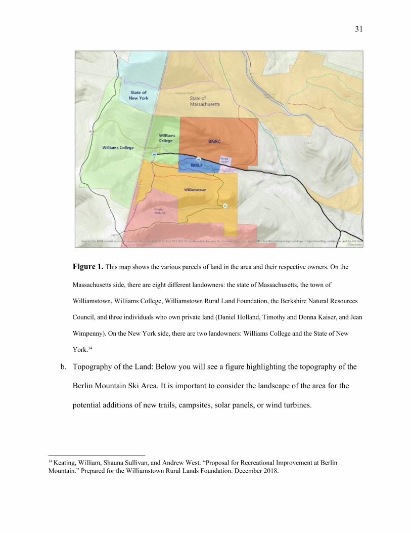
a. Ownership: While the main section we are looking at is owned by the college, the
property is surrounded by various land parcels with many distinct owners, many of which
are interconnected via the hiking trails, as highlighted in the figure below.
13 Keating, William, Shauna Sullivan, and Andrew West. “Proposal for Recreational Improvement at Berlin Mountain.” Prepared for the Williamstown Rural Lands Foundation. December 2018.
31
Figure 1. This map shows the various parcels of land in the area and their respective owners. On the
Massachusetts side, there are eight different landowners: the state of Massachusetts, the town of
Williamstown, Williams College, Williamstown Rural Land Foundation, the Berkshire Natural Resources
Council, and three individuals who own private land (Daniel Holland, Timothy and Donna Kaiser, and Jean
Wimpenny). On the New York side, there are two landowners: Williams College and the State of New
York.14
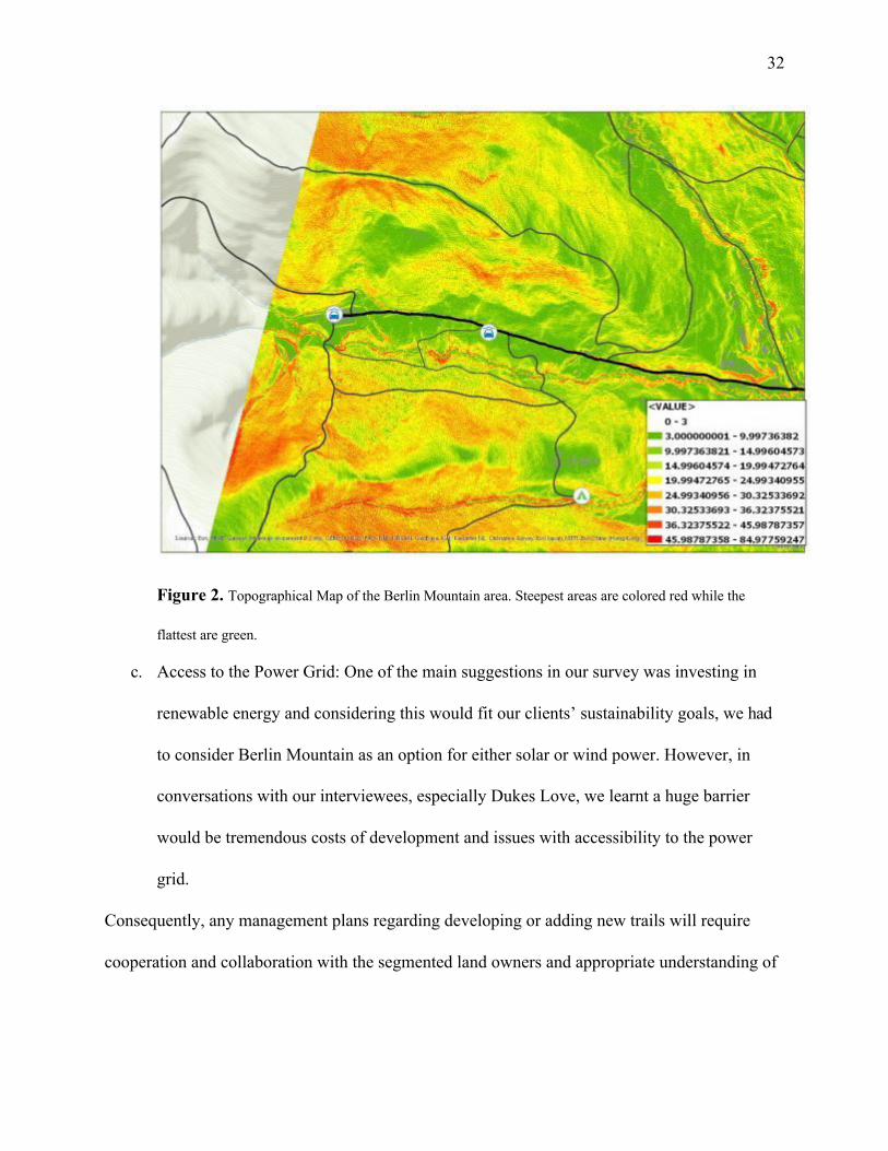
b. Topography of the Land: Below you will see a figure highlighting the topography of the
Berlin Mountain Ski Area. It is important to consider the landscape of the area for the
potential additions of new trails, campsites, solar panels, or wind turbines.
14 Keating, William, Shauna Sullivan, and Andrew West. “Proposal for Recreational Improvement at Berlin Mountain.” Prepared for the Williamstown Rural Lands Foundation. December 2018.
32
Figure 2. Topographical Map of the Berlin Mountain area. Steepest areas are colored red while the
flattest are green.
c. Access to the Power Grid: One of the main suggestions in our survey was investing in
renewable energy and considering this would fit our clients’ sustainability goals, we had
to consider Berlin Mountain as an option for either solar or wind power. However, in
conversations with our interviewees, especially Dukes Love, we learnt a huge barrier
would be tremendous costs of development and issues with accessibility to the power
grid.
Consequently, any management plans regarding developing or adding new trails will require
cooperation and collaboration with the segmented land owners and appropriate understanding of

33
the landscape. Beyond these aforementioned considerations, our project also drew from the 2018
report for economic considerations in potential development and maintenance of the land.
E valuation Matrix and Recommendations
Using the information we gathered from our interviews, past reports, and our survey, we
developed the following evaluation matrix to weigh the alternative use options for the Berlin
Mountain land parcel.
Berlin Mountain
Expressed Interest
Sustainability
Educational Value
Commu nity
Feasibilit y
Parcel Score
Status quo 4 2 3 4 5 18
Renewable energy
2
5
3
2
2
14
Recreation 5 2 4 5 4 20
Relinquish 1 2 1 3 2 9
Table 2. The options we considered for the land were: 1. Status quo, that is maintaining the land management plan
in place with current recreational uses of Berlin Mountain. 2. Developing renewable energy in the form of solar or
wind power. 3. Recreation, specifically improving current recreational uses and including new forms of recreation.4.
Relinquishing ownership of the land be it through donation or sale.
Renewable energy (3rd) and relinquishing (4th) the land both received rather low scores
in the evaluation matrix. While renewable energy did have some potential in sustainability goals
and educational value, there were a couple considerations we had to make in terms of community
value, expressed interest, and feasibility. Berlin Mountain is one of the more actively used
parcels in terms of various forms of recreation. Developing the lands for renewable energy could
potentially interfere with these uses and since we did not want to prohibit current uses of the
land, it received low scores for expressed interest and community. Additionally, feasibility was a

34
questionable factor due to financial limitations of developing solar or wind farms and connecting
the energy sources to the electricity grid. Pursuing either of these options would require
tremendous amounts of resources, especially financial ones. Relinquishing, on the other hand,
received low scores across the board due to the high use of the area and the many unknown
factors that would come with changing ownership of the land. One major complication that we
considered in feasibility is how would we find someone who actually wants to take land that
seems to be rather undevelopable beyond recreation.
As illustrated in the Table 2 above, the two best scoring options were recreation (1st) and
status quo (2nd), likely due to their similarities. As such, our recommendations for the Berlin
Mountain property are to follow suit with the short and long-term recommendations outlined in
their report, including but not limited to new trails, improving upkeep and signage of current
trails, and the addition of a campsite. Some portions of their recommendations are already well
under way, if not completed, such as a newly paved parking lot and a trailhead kiosk. Full
recommendations and other details including economic factors can be found in the in-depth
report located on the Williams College Center for Environmental Studies website.

35
Stone Hill: Kite Hill and Woodlot

36
P hysical Description and Site History
The Stone Hill land parcel encompasses both what is known as Kite Hill and the
neighboring woodlot to the west, both of which are situated near the Pine Cobble School and
Buxton School. Although most students are familiar with the part of Stone Hill that is visible
from the Clark Art Institute, fewer students and many local residents will be familiar with the
grassy field that comprises Kite Hill, as well as the quiet woods that we are terming the woodlot.
Local joggers, hikers, and dog-walkers have made recreational use of the trails through Stone
Hill, as the area is quite secluded and vast.
Environmental journalist and Class of 1946 Environmental Fellow-in-Residence
Elizabeth Kolbert said of Stone Hill’s soil composition: “Over the last 10,000 years, Stone Hill
has assumed many forms: lake bottom, forests, woodlots, and farms…. Each of these identities is
preserved in its soil—a history recorded in rot.”15 Near to the College-owned woodlot on Stone
Hill is a similar woodlot owned by the Town of Williamstown. A 1998 Environmental Planning
and Analysis Workshop student plan reported that the Conservation Commission manages the
lot, which was once owned by Amos Lawrence and Theresa B.Hopkins, then passed on to a few
hands before being given to the inhabitants of Williamstown. Although from the late 1960’s to
the early 1970’s the town considered logging the lot, ultimately the Stone Hill Forest
Management Plan deemed the forest health to be “fair” to “good,” and the lot was spared.16
Editor’s Note: The College-owned woodlot parcel is located to the south of the Town and Buxton
School woodlots, a was most recently logged in the mid-1970s, with the logs being dragged to the rear
of the Cluett Estate building (now Pine Cobble School). Currently the Williams Outing Club maintains
the Kite Hill and Hopkins-Gale trails on the property, part of the Stone Hill Trail Network. This is the
parcel in need of having a management plan, be it for timber harvest, carbon offset generation, or etc.
15 “The Significance of Place.” Williams College. August 16, 2016. h ttps://www.williams.edu/feature-stories/the-significance-of-place/ 16 Cook, Ellen, Kathleen Reardon, Kara Roggenkamp, Emily Simpson. “Management Plans for Conservation Commission Lands.”Fall 1998. https://web.williams.edu/wp-etc/ces/conservation-plan.pdf

37
C onsiderations
Given Stone Hill’s particular history and current status, we have found the following
considerations relevant to this area’s next steps, which are as follows. Regarding Kite Hill, we
have considered the importance of the formerly annual Kite Day tradition17, which was
commenced by H. Lee Hirsch and which lasted most prominently between 1961-1975. In 2016,
Rosenburg Professor of Environmental Studies and Biology Hank Art attempted to revive the
tradition, inviting Williams students to design and build their own kites and fly them on the
Clark Art Institute’s meadow along with other students and community members alike. Professor
Art has also admitted that it can be hard to sustain such traditions without a consistent body of
people or point-person to keep them going year after year. Nonetheless, history can hold
immense value in a town as small and old as Williamstown, and we would like to give weight to
this particular historical tradition.
Other considerations for Kite Hill involve historical resistance to constructing a solar
array at this particular site. It has been noted that in the past, local residents have expressed
concern over the construction of solar panels, counter to the COOL Committee’s interest— a
situation reminiscent of many NIMBY (short for “not in my backyard” in environmental justice
discourse) oppositions. In a similar vein, when considering constructing renewable energy farms
in the past, College administrators have ultimately decided that the financial and infrastructural
costs of these projects would outweigh the long-term sustainable benefits. Specifically, as Matt
Sheehy noted in our interview, constructing a solar array at the Berlin Ski Mountain proved to be
logistically unfeasible because of the site’s physical distance from the electric grid.
17 “Kite Day—Reimagined.” Williams College. September 28, 2016. h ttps://www.williams.edu/feature-stories/kite-day-reimagined/

38
Turning to the Stone Hill woodlot, primary concerns involve the College history of
timbering. Additionally, any interests in improving trail maintenance would have to finance
the costs of doing so. The 1998 student report claimed that it was unclear between
spokespeople from Buxton School and Clark Art whether the public or Clark personnel was
responsible for maintaining the trails. They recommended that a volunteer crew be tasked with
maintaining the trails, and that a partnership with Clark Art work to produce maps to raise
visibility for these trails. We have found that, since 2016 a collaboration between the
Williamstown Rural Lands Foundation, Williams College, Buxton School, The Town of
Williamstown, and the Clark Art Institute has helped streamline the trail system, as illustrated
by this on-line map: https://www.clarkart.edu/PDFs/2016/TRAILMAP.pdf.
E valuation Matrix and Recommendations We decided to evaluate four non-mutually exclusive possible alternative uses for Stone Hill,
which can be found in the table below.
Stone Hill
Expressed Interest
Sustainability
Educational Value
Commu nity
Feasibilit y
Parcel Score
Status quo 4 2 1 3 5 15
Renewable energy
3
5
3
4
2
17
Recreation 5 4 2 4 4 19
Relinquish 1 4 1 5 2 13
Table 3. Evaluation Matrix for four possible alternative uses on Stone Hill.
The suggestion that received the highest grade according to our evaluation methods was
further developing recreational opportunities in the area. Specifically, this would entail
improving the trails through the field and woodlot and reviving Kite Day in a more systematic
fashion, with the hopes that the tradition would continue past one or two years. Our survey and

39
interviews both revealed that many were in favor of increasing recreational use, so this option
received the highest marks for expressed interest. In the long-term, we do not imagine that
these efforts will alter the land, so it also received a relatively high mark for sustainability; in
fact, sustained efforts to encourage communal use of the land might actually ensure that local
and College-affiliated folks will maintain the area with respect and care. We found that
community value and feasibility were also relatively favorable for this land parcel, leaving only
educational value with a relatively low mark. In the table below, you can see some of the
incurred costs on stone hill trail updates that can be a guide for any future trail developments
both at Stone Hill and other parcels we are examining.
Table 4. Finances for previous Stone Hill trail system updates drawn from Berlin Mountain 2018 Report.18
The second highest option was to push for the installation of solar panels on Kite Hill,
which was controversial in expressed local interest but high in sustainability in the long run.
Despite controversial local opinions, we put forth that pushing the local area to commit to solar
18 Keating, William, Shauna Sullivan, and Andrew West. “Proposal for Recreational Improvement at Berlin Mountain.” Prepared for the Williamstown Rural Lands Foundation. December 2018.

40
energy, again in the long haul, would actually be more favorable to the community, as it would
drive down energy costs and decrease carbon emissions. Feasibility gained a low score because
of its associated financial and infrastructural costs. At one point, we would have liked to see the
College commit to local sustainability efforts by subsidizing the installation of a communal solar
farm to incentivize local neighbors, but from our conversations with administrators, we do not
foresee that the College will do so in the near future. Nonetheless, we believe it is important to
advocate for serious consideration of this option.
Lastly, we would also like to remark that relinquishing this land parcel received the
lowest grade in this matrix, primarily due to low expressed interest from College administrators
and local governing bodies, the little perceived educational value of this action, and the low
logistical feasibility of surrendering not only access but legal ownership to a regional land trust
or other stakeholder.

41
Pine Cobble Housing Development Forested Lands

42
P hysical Description and Site History
The portion of Pine Cobble owned by the College consists of both developed and
undeveloped, forested areas. Our assignment was to address only the forested portion of the
property. Nonetheless, we chose to consider the context and questions offered by the entire
property in the early stages of our project, as we found them relevant to the broader scope of our
assignment.
The developed portion consists of a neighborhood of homes, developed by the College in
the 1980s. Since construction, these lots have been available for faculty to purchase, occupy
during their tenure at Williams, and sell back to the College when appropriate for a guaranteed
fair market value. This system has proven costly to the College for several reasons.
Pine Cobble is an extremely steep property, making it practically and financially demanding to
maintain. Although residents pay taxes to the town of Williamstown, the College incurs the high
costs of maintaining the area, namely Pine Cobble Road. Not only does the college offer to sell
the homes at the lowest price afforded by the housing market and typically sell them back at a
significantly higher value, many of the homes are quite luxurious and were expensive to
construct in the first place (Jamie Art). Given these high costs, coupled with the fact that eleven
of these lots are currently unoccupied and on the market, it is worth asking whether this property
(unbuilt-upon areas) could be put to better use.
Behind these housing lots is a large area of undeveloped, forested land. Like the housing
lots, this land is very steep. It is intercrossed by a small trail system, enjoyed recreationally by
locals (Stephanie Boyd). One of the defining features of this property is its plant life. Pine
Cobble is home to the largest population of hairy honeysuckle (Lonicera hirsuta) in the state of
Massachusetts.

43
While hairy honeysuckle does not have federal endangered status, it is listed E (for endangered)
under Massachusetts state law. Since 2010, the Natural Heritage and Endangered Species
Program (NHESP) has worked on this property to promote the hairy honeysuckle growing there.
C onsiderations
Our project considers Pine Cobble from an ecological, topographic, and financial
perspective. As previously stated, this property is home to the largest population of hairy
honeysuckle in Massachusetts, an endangered species under state law. Despite NHESP’s efforts,
this population of hairy honeysuckle has decreased by about half since 2010. According to Karro
Frost (a conservation biologist who works with NHESP and has been involved with the Pine
Cobble hairy honeysuckle population for many years), there is a significant risk of losing the
species altogether. The Pine Cobble hairy honeysuckle population should be a priority
consideration for this property. Optimal management of this property moving forward will
require the College to continue to account for this feature.
We also found it relevant to take into account the topographic and financial aspects of
Pine Cobble. Namely, the property is extremely steep. This means that additional development
on this property would be extremely difficult from a practical as well as financial perspective.
Despite this, in the case that we made the unlikely decision to recommend the development of
additional housing lots on Pine Cobble Road, it was important for us to consider the
Williamstown zoning bylaws, specifically building codes. (2) As far as costs to the college are
concerns, Pine Cobble—especially the developed portion—offers a very poor return on
investment. However, Pine Cobble is managed moving forward, the significant costs already

44
incurred by the College in order to maintain this property should be taken into account and made
a priority consideration.
E valuation Matrix and Recommendations
Based on our interviews and survey, we determined the five most promising options for
managing Pine Cobble moving forward. These were (1) to allow the property to continue being
managed as it is currently (status quo), (2) to collaborate with NHESP to optimally manage the
property’s hairy honeysuckle population, (3) to revert the property to town ownership,
promoting current recreational use of the property, and (5) to relinquish the property to a
meaningful stakeholder.
There are currently rough plans in place in order to better preserve the Pine Cobble hairy
honeysuckle population. With additional support from the college, the feasibility and
educational, environmental, and community benefits of this option would likely be significant.
According to Fred Puddester, the College’s Vice President for Finance and Administration and
Treasurer, the town has little interest in acquiring Pine Cobble due to the logistical and financial
challenges of managing the property. Our survey displayed significant interest in allowing the
property to be used recreationally. Given that Pine Cobble is already enjoyed recreationally by
many community members, this would be a relatively easy change that would probably yield
many additional benefits. We have received very little feedback regarding the possibility of
relinquishing the property, however the environmental and community benefits of this option
could be significant. Based on these considerations, we rated these five management options
according to our evaluation matrix (See Table 1). According to this evaluation, managing the

45
property to preserve hairy honeysuckle and making improvements to facilitate greater
recreational use of the property proved to be the most promising management options. Since
these options are not mutually exclusive, we chose to recommend both to the College.
Pine Cobble
Expressed Interest
Sustainabi lity
Educational Value
Communi ty
Feasibili ty
Parcel Score
Status quo 2 3 1 2 5 13
Manage Endangered Species
4
5
5
3
3
20
Revert to town ownership
4
2
1
2
1
10
Recreation 4 3 2 5 4 18
Relinquish 1 3 1 3 2 10
Table 5. This table shows the ratings we assigned to each management alternative according to how well we
expected them fulfil the following priorities: expressed interest, sustainability, educational value, community, and
feasibility. According to this evaluation matrix, recreation and endangered species management are the
highest-scoring options.
Our primary recommendation for this property is to collaborate with NHESP in order to
optimally manage the hairy honeysuckle populating currently inhabiting the area. According to
Frost, the plant would benefit from periodic cutting and burning to open up the canopy, followed
by periods of no disturbance. In addition to the obvious ecological benefits of protecting this
population, this collaborative effort would offer valuable research opportunities to Williams
College students and staff interested in rare and endangered species. On behalf of NHESP, Frost
expressed considerable interest in partnering with the College on such research projects. There is
also an opportunity for students to assist NHESP with annual monitoring of Harry Honeysuckle
and other endangered species in the area in order to determine the effects of management. Lastly,
Pine Cobble homeowners who live in proximity to hairy honeysuckle should be educated about

46
what the plants look like, instructed to avoid dumping leaves or other yard waste in inappropriate
areas, and encouraged to allow the plants to grow on their property rather than pulling them out
like weeds. It is our hope that the College will accept these recommendations in order to preserve
the Pine Cobble hairy honeysuckle population and create valuable research opportunities for
students and faculty.
In addition to collaborating with NHESP, we recommend that the College take action to
improve the existing recreational opportunities offered by Pine Cobble. The property is currently
used recreationally by locals, mostly for hiking. We recommend a plan to facilitate this by
expanding the existing trail network, improving trail quality, and creating greater accessibility
via parking options and clear signage.
47
Mount Hope Farm
48
P hysical Description and Site History
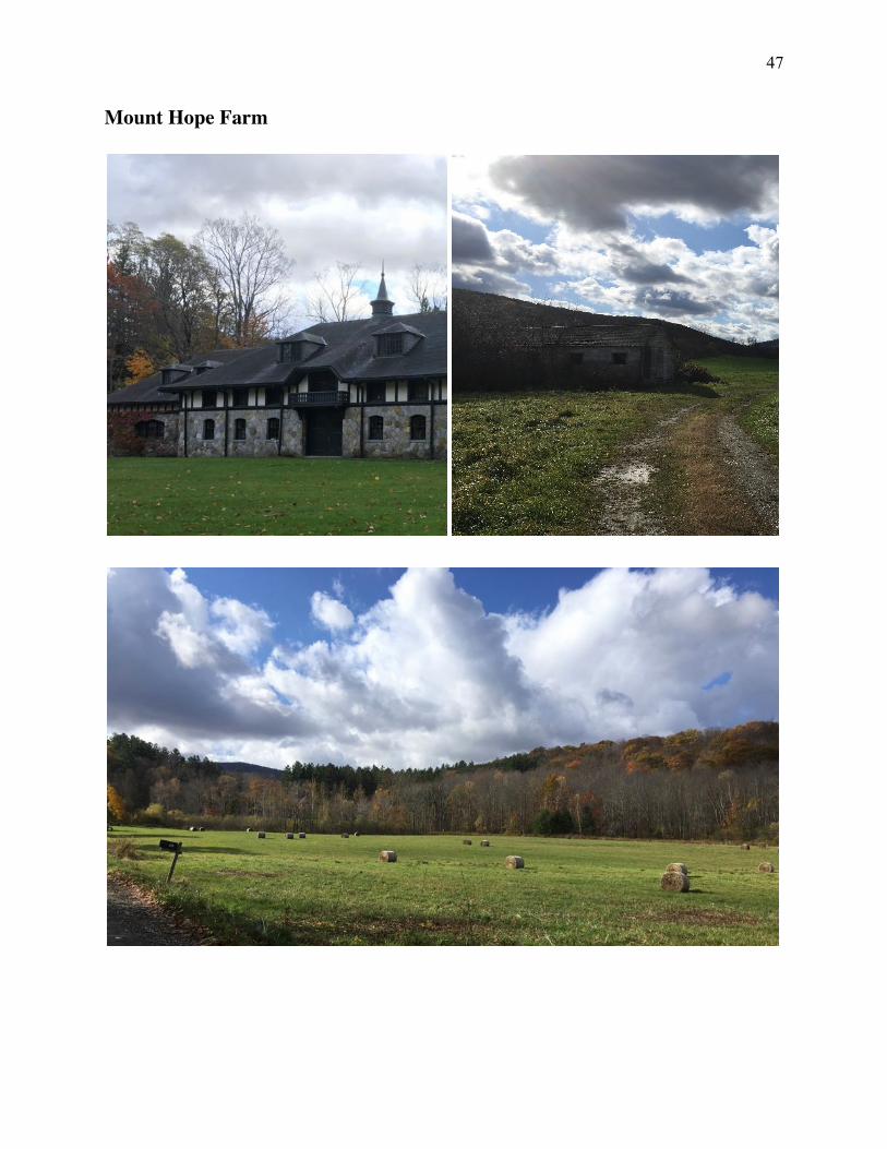
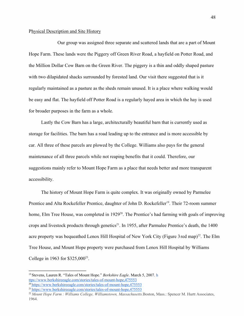
Our group was assigned three separate and scattered lands that are a part of Mount
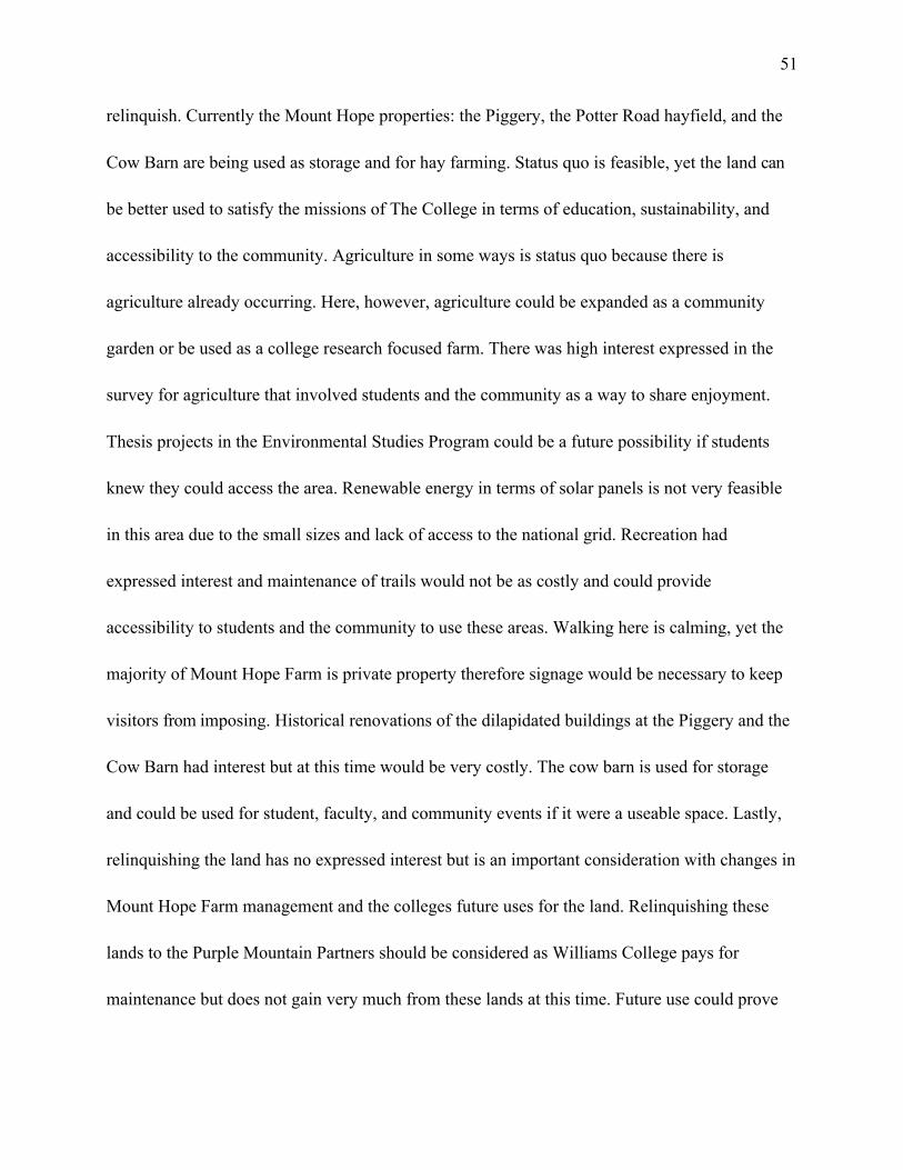
Hope Farm. These lands were the Piggery off Green River Road, a hayfield on Potter Road, and
the Million Dollar Cow Barn on the Green River. The piggery is a thin and oddly shaped pasture
with two dilapidated shacks surrounded by forested land. Our visit there suggested that is it
regularly maintained as a pasture as the sheds remain unused. It is a place where walking would
be easy and flat. The hayfield off Potter Road is a regularly hayed area in which the hay is used
for broader purposes in the farm as a whole.
Lastly the Cow Barn has a large, architecturally beautiful barn that is currently used as
storage for facilities. The barn has a road leading up to the entrance and is more accessible by
car. All three of these parcels are plowed by the College. Williams also pays for the general
maintenance of all three parcels while not reaping benefits that it could. Therefore, our
suggestions mainly refer to Mount Hope Farm as a place that needs better and more transparent
accessibility.
The history of Mount Hope Farm is quite complex. It was originally owned by Parmelee
Prentice and Alta Rockefeller Prentice, daughter of John D. Rockefeller19. Their 72-room summer
home, Elm Tree House, was completed in 192920. The Prentice’s had farming with goals of improving
crops and livestock products through genetics21. In 1955, after Parmalee Prentice’s death, the 1400
acre property was bequeathed Lenox Hill Hospital of New York City (Figure 3 red map)22. The Elm
Tree House, and Mount Hope property were purchased from Lenox Hill Hospital by Williams
College in 1963 for $325,00023.
19 Stevens, Lauren R. “Tales of Mount Hope.” Berkshire Eagle. March 5, 2007. h ttps://www.berkshireeagle.com/stories/tales-of-mount-hope,475553 20 https://www.berkshireeagle.com/stories/tales-of-mount-hope,475553 21 https://www.berkshireeagle.com/stories/tales-of-mount-hope,475553 22 Mount Hope Farm : Williams College, Williamstown, Massachusetts.Boston, Mass.: Spencer M. Hurtt Associates, 1964.

49
Figure 3 Historical Map of Mount Hope Farm showing Williams College purchased land in red
Uses for the property ranged from a farm, observatory and discussions progressed about
it being the place for a women’s college, graduate school, or arts institute24. The College
historically made the purchase in hopes to strengthen education and benefit the town. Since then
the College sold the property to August Mansker, who defaulted on his mortgage. Laer the
Purple Mountain Partners purchased the land and gave the parcels now owned by Williams,
including the Elm Tree House, back to The College.
23 Mount Hope Farm : Williams College, Williamstown, Massachusetts.Boston, Mass.: Spencer M. Hurtt Associates, 1964. 24 Mount Hope Farm : Williams College, Williamstown, Massachusetts.Boston, Mass.: Spencer M. Hurtt Associates, 1964.

50
Due to the nature of the current ownership, Williams pays a lot for the maintenance of
Mt. Hope Farm roads, the Elm Tree House, and the parcels they own, while there are people
affiliated with the college that do not know of its existence.
C onsiderations
Considerations for Mount Hope Farm management came from financial, ecological, and agricultural perspectives. From a financial point of view, renovations are wanted by many
people we interviewed 25. The problem with historical renovations specifically, is that the
buildings are quite old and not up to any safe building codes. Therefore, the cost of
implementing renovations would be too high for the college without alternative usage as a
pressing need. The Cow Barn is used for facilities storage and there is a need for that use, our
interviews with employees of facilities uncovered the fact that there is no where else for storing
all of the large items like refrigerators. A similar situation exists for the Piggery buildings, they
are in rough shape; therefore the financial inputs would be much greater than even rebuilding
new sheds if there became a demand. The Piggery and hayfield are currently being maintained
as farmland paid for by the college.
E valuation Matrix and Recommendations
From our evaluation matrix six possible plans for Mt. Hope Farm were devised: (1) status quo,
(2) agriculture, (3) renewable energy, (4) recreation, (5) historical renovations, and (6)
25 Interview with Rita Wallace
51
relinquish. Currently the Mount Hope properties: the Piggery, the Potter Road hayfield, and the
Cow Barn are being used as storage and for hay farming. Status quo is feasible, yet the land can
be better used to satisfy the missions of The College in terms of education, sustainability, and
accessibility to the community. Agriculture in some ways is status quo because there is
agriculture already occurring. Here, however, agriculture could be expanded as a community
garden or be used as a college research focused farm. There was high interest expressed in the
survey for agriculture that involved students and the community as a way to share enjoyment.
Thesis projects in the Environmental Studies Program could be a future possibility if students
knew they could access the area. Renewable energy in terms of solar panels is not very feasible
in this area due to the small sizes and lack of access to the national grid. Recreation had
expressed interest and maintenance of trails would not be as costly and could provide
accessibility to students and the community to use these areas. Walking here is calming, yet the
majority of Mount Hope Farm is private property therefore signage would be necessary to keep
visitors from imposing. Historical renovations of the dilapidated buildings at the Piggery and the
Cow Barn had interest but at this time would be very costly. The cow barn is used for storage
and could be used for student, faculty, and community events if it were a useable space. Lastly,
relinquishing the land has no expressed interest but is an important consideration with changes in
Mount Hope Farm management and the colleges future uses for the land. Relinquishing these
lands to the Purple Mountain Partners should be considered as Williams College pays for
maintenance but does not gain very much from these lands at this time. Future use could prove

52
benefits for the College owning the land. Even if there are no specific plans for the future, there
should be a management plan that exists and contacts so when questions arise, there are clear
answers. This would be useful if someone for example wanted to do a research project and
needed information and clearances for their wanted uses. Overall, after assigning ranks to the
matrix in each category, recreation and agriculture our most feasible recommendations. We do
believe that transparency of the knowledge of these lands needs to be the highest priority in
terms of Mount Hope Farm. Lastly, if relinquishing the land as a donation is a consideration in
the future, we ask that the administration take into account environmental justice in that costs of
maintaining and owning Mount Hope Farm may burden more than help a future land owner.
Historically the purposes of owning the acreage was to benefit education and community. It is
our hope that this may continue to be part of the Mount Hope Farm plans in the future.
Mt. Hope
Expressed Interest
Sustainabi lity
Educational Value
Communi ty
Feasibili ty
Parcel Score
Status quo 4 1 1 2 5 13
Agriculture 5 4 3 4 5 21
Renewable energy 4 5 5 2 2 18
Recreation 5 4 3 4 5 21
Historical renovations 3 1 3 4 2 13
Relinquish 2 2 2 4 2 12
Table 6. Evaluation matrix for Mount Hope that weighs Status Quo, Agriculture, Renewable Energy, Historical
Renovations, and Relinquish on a one to five scale.

53
Christmas Brook-Denison Park

54
P hysical Description and Site History
The Christmas Brook-Denison Park land parcel is one of the college’s oldest pieces of
lands and is located behind the new Williams Inn. Denison Park is a 16-acre area surrounding
Christmas Brook and includes a section of land classified as a woody swamp as per the
Massachusetts Department of Environmental Protection.26 The area is heavily wooded and parts
of the parcel are or have been overgrown with invasive plant species including shrubs and trees.
Christmas Brook was purchased by the college in the early 1850s as part of a larger land
purchase encompassing a huge portion of the college’s land south and east of Spring Street
including what we now know as Weston Field, Towne Field House, and many other well-known
parts of campus. At some point in time between the late 1800s and the mid-1900s, this parcel of
land was incorporated into the campus community as a larger park where Christmas Lake was
located on the north side of Latham Street.
This site was home to an ice skating pond in the winter and was a wildly popular campus
location.27 However, it slowly lost its attraction as the land became neglected and less used. Once
Before the construction of the Steam Plant in the 1920s and indoor ice rink in the 1960s,
Christmas Lake had been emptied and the brook put in a pipe, leaving only the section south of
Latham Street and the new Williams inn above ground. This is what now is known as
Christmas Brook.28 Over time, the Christmas Brook area has become a forgotten part of
Williams and was fittingly hidden behind the overgrown invasive plants. While Denison Park
sees some usage in terms of the Williamstown community walking their dogs and other forms of
recreation, it remains a virtually inaccessible yet beautiful part of Williamstown.
26""DEP"Wetlands"(1:12,000)"Change.""Office"of"Geographic"Information"(MassGIS)."Massachusetts"Departmen t"of" Environmental"Protection"Wetlands"Conservancy"Program,"2005. 27 Brooks, R.R. Williamstown: The First Two Hundred Years. Williamstown, Mass.: McCelland Press, 1953. 28 Goldstein-Kral, L., Elvin, A., & Baiu, A. A Trail Plan for Downtown Williamstown's Christmas Brook. A Trail Plan for Downtown Williamstown's Christmas Brook. Williams College. 2010.

55
C onsiderations
There are a couple of legal and technical considerations for this land parcel.
a. Wetland Protections Act: Any recommendations or land management plans must be
aware of and in compliance with the Wetland Protections Act given the woody swamp
classification of Christmas Brook. This can and will affect how sections of the parcel can
be developed and altered.
b. Invasive and Endangered Species: Any plan should incorporate the careful continued
management of both invasive exotic species as well as any rare and endangered species
located within Christmas Brook-Denison Park.
c. Accessibility: Given the distance and overgrown nature of this property, accessibility was
a large consideration in our project. In our conversations with clients and interviewees,
Christmas Brook-Denison Park was central to connecting students and community
members with The Clark Art Institute.
E valuation Matrix and Recommendations We decided to evaluate four possible alternative uses for Christmas Brook-Denison Park which
can be found in the table below.
Christmas Brook-Denison Park
Expressed Interest
Sustainabi lity
Educational Value
Communi ty
Feasibili ty
Parcel Score
Status quo 4 1 2 3 5 15
Recreation 5 2 4 5 3 19
Manage Invasive Species
5
4
2
4
3
18
Relinquish 1 2 2 3 2 10
56
Table 7. The evaluation matrix weighs the following four options: 1. Status Quo - Leave the park and wooded
swamp area as is with existing management plans. 2. Recreation - Further improving existing recreational uses. 3.
Managing Invasive Species along with rare and endangered species. 4. Relinquishing the land via donation or sale.
Recreation and management of invasive species as well as rare and endangered species
topped our alternative options. The main use of this land has historically been recreational
activities so it fittingly scored high in terms of interest, community, and value. Improving trail
access and publicity should be a top priority. While management of the plant species had not
been effectively done for long periods of time, there did not seem to be much of a downside to
this option. Instead, continuing to manage the vast overgrowth could improve accessibility,
value, and sustainability as we could reintroduce native species to the area. Lastly,
maintaining the status quo was not too far behind.
As such, our recommendations incorporate all three of these uses as they are not mutually
exclusive. According to Professor Hank Art, there is currently a management plan for invasive
shrubs in Christmas Brook that is progress. However, there is no current plan for the
management of invasive exotic trees. Therefore, we turned to previous environmental planning
reports conducted on this land parcel. A 2010 report titled “A Trail Plan for Downtown
Williamstown’s Christmas Brook” was completed by a group of students for ENVI 411. In this
report, they outline specific details on all of the common invasive and native species found in the
area and make recommendations on which plants should be increased, removed, or maintained as
is. The chart below offers a brief overview of their plan but we recommend reading their report
in full.

57
Table 8. A brief but accurate overview of recommendations for managing the vegetation of Christmas Brook
drawn from the 2010 Report previously mentioned.29
Rather than recreate all of their report’s recommendations, we suggest following their
proposals on managing the vegetation of Christmas Brook including both shrubs and trees as
well as utilizing the already existing management plan for invasive shrubs that Professor Art
informed us of. For full details, the report can be accessed online at the Williams College Center
for Environmental Studies website.
29 Goldstein-Kral, L., Elvin, A., & Baiu, A. A Trail Plan for Downtown Williamstown's Christmas Brook. A Trail Plan for Downtown Williamstown's Christmas Brook. Williams College. 2010.
58
As for recreation and status quo, our recommendation incorporates a combination of the
two. We discovered through our interviews that there are ongoing plans in motion to develop a
path between the new Williams Inn and The Clark, effectively connecting all of these properties
with the larger campus community. We completely support this idea and want to make sure that
the public is aware of these plans and can access the lands when they are complete. Detailed
notes including maps, project overview and narrative, information on Wetland Protection Act
compliance, and the notice of intent were made available to us by Andrew Groff and can be
accessed via the Williamstown Town Hall. Furthermore, we encourage these trail plans along
with the existing trails of Denison Park to add signage on local histories and plants so as to offer
educational value and preservation of rare and endangered local species. We believe that the
addition of a trail connecting the Inn with the Clark Art Institute through Christmas Brook-
Denison Park, along with managing the property’s vegetation and the inclusion of educational
signage, will be best for accessibility, sustainability, and community and educational value.
59
Conclusion
This project has undergone much in the way of change and evolution from the time we
were first provided with the original descriptor and research questions. Originally, our group felt
rather overwhelmed by the number and size of land parcels that we had been given to
investigate, and soon found that it would be difficult, if not impossible, to attempt to develop
explicitly detailed management plans for every one of the six groups of land parcels. Fortunately,
through our interview and research processes, we were able to discover many projects already
underway on several of the land parcels in question, as detailed above. For those parcels that did
not have explicit project plans already, we brainstormed possibilities, using knowledge gained
from our interviews, the campus-wide survey, and research completed both online and in the
College archives, to determine what would be feasible and what would best satisfy the needs and
the wants of the Williams communities. Ultimately, as can be seen in this report, making
suggestions for the management of the parcels we were assigned did constitute a significant
portion of our research and our project goals. However, we wanted to do something more.
That “something more” was guided primarily by the question that had arisen in our very first interview, which was conducted on October 1st with the Williams College Provost, Dukes
Love. We were surprised to find that Love did not have much, if any, knowledge concerning the
land parcels we had been assigned. Additionally, using the portion of students and faculty that
completed our survey as an estimate, we discovered that more than half of the campus is
unaware of these various non-campus lands -- and it should be mentioned that we, too, before
beginning this project, had never heard of, let alone visited, the majority of these lands. This to
us seemed significant, and remarkable. How was it that a group of upper-classmen

60
in an upper-level Environmental Studies class, 59.3% of the campus body, the Provost of the
College, and even the President herself were largely unaware that these lands existed?
That was the question that stuck most in our heads throughout the semester, and
ultimately, it became the question that most guided our vision for this project, as we discussed
how to address the issues of visibility, accessibility, transparency, and power that surrounded the
lands and Williams College’s ownership of them. Why was it that these lands felt largely
invisible to a large portion of the campus? Who is able to access these lands, and how does that
accessibility relate to power and privilege and knowledge? Whose voices are heard, and whose
are not, in discussions surrounding these lands? How could we give voice to those who remain
unheard? What was our role, our responsibility, and our positionality as a group in these
discussions? How could we, as a group, participate in improving the issues of visibility and
accessibility to these lands, and open them to a wider range of people? How could these lands be
used to satisfy needs and desires within and even (and especially) beyond our community? How
is the ownership and the use of these lands influenced by issues of power? What is the history of
these lands, and what histories and narratives do those lands preserve? Who benefits from these
lands now, and who could benefit from them in the future?
Later in the project, we received a particularly interesting question from one of our main clients, in response to this litany of questions we had begun to ask ourselves: essentially, was this
even a problem that really needed a solution? In other words, did we necessarily have to “do”
anything with these lands? This client pressed us to consider the inherent value in leaving these
lands undeveloped, open, “as is,” and to some extent we agreed, believing that there is value in
retaining unbuilt environments in the community -- especially given the large amount of “built”

61
environment that already exists at the College, and how much that environment has been
expanding in recent years. However, we still believe that our questions are ones that need a
solution -- or at the very least, a conversation. Because, after all, “doing nothing” in this case is
not really doing nothing, and leaving these lands unbuilt still involves making a decision and
taking action, even if that action can semantically be considered “inaction.” It also must be
considered that Williams College, as an institution, has a significant amount of power, money,
and privilege that allows it to own and operate these lands, and to leave them “as is” if it chooses
to do so. As we attempt to improve knowledge of and accessibility to these lands with this
project, we press the College to consider who owned the land before them, who it is serving now,
and how it could be used by them or others to serve a better and wider range of communities.
Going forward, we want this project most of all to have a life beyond us, and with our
final product we hope to invite many future generations of College and community members to
join in the conversation and discuss how best to use these lands. This final product, which will be
included below, is a brochure that includes pictures and descriptors of each of the properties we
were assigned, as well as directions to those properties and suggested recreational uses. We hope
to distribute this brochure as well as others like it in the mailboxes of incoming first-years, to
give students a better sense of the land-based opportunities accessible to them from their very
first days on campus. We hope that with this project and report, we can improve the visibility of
and access to these lands, and in doing so, open the conversations surrounding them to a wide
range of voices, both now and in the future.

62
The Brochure

63

64
Works Cited “A Field Guide to Bluffs Forest.”
h ttps://docs.google.com/document/d/1aol_npaukH48Celdm399l5bnNfbap79cr1FXwpczx Q g/edit
“A GUIDE TO BIRD WATCHING IN WILLIAMSTOWN MASSACHUSETTS.” h ttp://mutualism.williams.edu/Links/birdtour.htm
“A snapshot of PCB levels in Hoosic River sediments, crayfish and brown trout in the tri-state area.” December 2005. h ttps://www.researchgate.net/publication/289811192_A_snapshot_of_PCB_levels_in_Ho o sic_River_sediments_crayfish_and_brown_trout_in_the_tri-state_area
Brooks, R.R. Williamstown: The First Two Hundred Years. Williamstown, Mass.: McCelland Press, 1953.
“Claiming the Williams Riverfront: A Cole Field Bike Path and Riverwalk Accessibility Study.” December 2014. h ttps://ces.williams.edu/files/2014/08/ColeFieldBikePathRiverwalkFinalReport-reduced. p df
Cook, Ellen, Kathleen Reardon, Kara Roggenkamp, Emily Simpson. “Management Plans for Conservation Commission Lands.”Fall 1998. h ttps://web.williams.edu/wp-etc/ces/conservation-plan.pdf
""DEP"Wetlands"(1:12,000)"Change.""Office"of"Geographic"Information"(MassGIS)."Massac husetts"Department"of" Environmental"Protection"Wetlands"Conservancy"Program,"2005.
“Environmental Notification Form.” Subject File: Pine Cobble. Williams College Special Collections.
Goldstein-Kral, L., Elvin, A., & Baiu, A. A Trail Plan for Downtown Williamstown's Christmas Brook. Williams College. 2010.
Keating, William, Shauna Sullivan, and Andrew West. “Proposal for Recreational Improvement at Berlin Mountain.” Prepared for the Williamstown Rural Lands Foundation. December 2018.
“Kite Day—Reimagined.” Williams College. September 28, 2016. h ttps://www.williams.edu/feature-stories/kite-day-reimagined/
Northeast Farmers of Color Land Trust. “5 Solutions for Land-Based Wealth Redistribution.” 2019. Restricted access granted by Stephanie Morningstar.
“Mohawk Bicycle/Pedestrian Trail.” March 31, 2010. h ttp://berkshireplanning.org/images/uploads/documents/Mohawk_Bicycle_Pedestrian_Tr a il_Feasibility_and_Investment_Study_report_03.31.2010.pdf
Mount Hope Farm : Williams College, Williamstown, Massachusetts. Boston, Mass.: Spencer M. Hurtt Associates, 1964.
“Pine Cobble maps.” Subject File: Pine Cobble. Williams College Special Collections. “Proposed Cole Field House.” Subject File: Cole Field + Field House. Williams College Special
Collections. The Record clipping. Subject File: Cole Field + Field House. Williams College Special
Collections.
65
“The Significance of Place.” Williams College. August 16, 2016. h ttps://www.williams.edu/feature-stories/the-significance-of-place/
Stevens, Lauren R. “Tales of Mount Hope.” Berkshire Eagle. March 5, 2007. h ttps://www.berkshireeagle.com/stories/tales-of-mount-hope,475553
“Water Chemistry of Eph’s Pond.” May 18, 2006. h ttps://web.williams.edu/wp-etc/ces/ephs-pond-4.pdf
“Wetlands Protections.” Protecting Wetlands in Massachusetts. 2019. h ttps://www.mass.gov/guides/protecting-wetlands-in-massachusetts#-wetlands-restriction s -
“Williams College Land Parcels.” Survey results. December 2019. h ttps://forms.gle/kL3BMpFfHe8LHaGm8
“Williams College Ski Area.” NELSAP. http://www.nelsap.org/ma/williamscollege.html “Williams Outing Club History.” Williams College. https://woc.williams.edu/about-woc/history/


