

Southern Joint Development Assessment Panel Agenda
Meeting Date and Time: 25 August 2017; 10am Meeting Number: SJDAP/28 Meeting Venue: Department of Planning, Lands and Heritage
140 William Street, Perth
Attendance
DAP Members
Mr Eugene Koltasz (Presiding Member) Ms Jaqueline Jurmann (Deputy Presiding Member) Ms Shelley Shepherd (Specialist Member) Cr Craig Carbone (Local Government Member, Shire of Harvey) via teleconference Cr Tania Jackson (Local Government Member, Shire of Harvey) via teleconference
Officers in attendance via teleconference
Mr Ryan Djanegara (Shire of Harvey)
Department of Planning, Lands and Heritage Minutes Secretary
Mr Phil Goodwin Ms Michelle Tan
Applicants and Submitters
Mr Trent Durward (Megara) Mr Matthew Pickford (Megara)
Members of the Public / Media
Nil
1. Declaration of Opening
The Presiding Member declares the meeting open and acknowledges the pastand present traditional owners and custodians of the land on which the meetingis being held.
2. Apologies
Nil
3. Members on Leave of Absence
Nil
Version: 1 Page 1

4. Noting of Minutes
The Minutes of meeting no.27 held on 14 August 2017 were not available at time of Agenda preparation.
5. Declarations of Due Consideration
Any member who is not familiar with the substance of any report or other information provided for consideration at the DAP meeting must declare that fact before the meeting considers the matter.
6. Disclosure of Interests
Nil
7. Deputations and Presentations
Nil
8. Form 1 - Responsible Authority Reports – DAP Applications 8.1 Property Location: Portion of Lot 9508 Ditchingham Place,
Australind Application Details: Proposed Service Station Applicant: Megara Owner: Treendale Central Pty Ltd Responsible authority: Shire of Harvey DAP File No: DAP/17/01218
9. Form 2 – Responsible Authority Reports - Amending or cancelling DAP
development approval
Nil
10. Appeals to the State Administrative Tribunal
Nil
11. General Business / Meeting Closure In accordance with Section 7.3 of the DAP Standing Orders 2017 only the Presiding Member may publicly comment on the operations or determinations of a DAP and other DAP members should not be approached to make comment.
Version: 1 Page 2

Southern Joint Development Assessment Panel Agenda
Meeting Date and Time: 25 August 2017; 10am Meeting Number: SJDAP/28 Meeting Venue: Department of Planning, Lands and Heritage 140 William Street, Perth Attendance
DAP Members Mr Eugene Koltasz (Presiding Member) Ms Jaqueline Jurmann (Deputy Presiding Member) Ms Shelley Shepherd (Specialist Member) Cr Craig Carbone (Local Government Member, Shire of Harvey) via teleconference Ms Tania Jackson (Local Government Member, Shire of Harvey) via teleconference Officers in attendance via teleconference Mr Ryan Djanegara (Shire of Harvey) Department of Planning, Lands and Heritage Minutes Secretary Mr Phil Goodwin Ms Michelle Tan Applicants and Submitters Mr Trent Durward (Megara) Mr Matthew Pickford (Megara) Members of the Public / Media Nil 1. Declaration of Opening
The Presiding Member declares the meeting open and acknowledges the past and present traditional owners and custodians of the land on which the meeting is being held.
2. Apologies Nil
3. Members on Leave of Absence
Nil
Version: 1 Page 1

4. Noting of Minutes
The Minutes of meeting no.27 held on 14 August 2017 were not available at time of Agenda preparation.
5. Declarations of Due Consideration
Any member who is not familiar with the substance of any report or other information provided for consideration at the DAP meeting must declare that fact before the meeting considers the matter.
6. Disclosure of Interests
Nil
7. Deputations and Presentations
Nil
8. Form 1 - Responsible Authority Reports – DAP Applications 8.1 Property Location: Portion of Lot 9508 Ditchingham Place,
Australind Application Details: Proposed Service Station Applicant: Megara Owner: Treendale Central Pty Ltd Responsible authority: Shire of Harvey DAP File No: DAP/17/01218
9. Form 2 – Responsible Authority Reports - Amending or cancelling DAP
development approval Nil
10. Appeals to the State Administrative Tribunal Nil
11. General Business / Meeting Closure In accordance with Section 7.3 of the DAP Standing Orders 2017 only the Presiding Member may publicly comment on the operations or determinations of a DAP and other DAP members should not be approached to make comment.
Version: 1 Page 2

Meeting No.27 14 August 2017
Minutes of the Southern Joint Development Assessment Panel
Meeting Date and Time: 14 August 2017; 11.30am Meeting Number: SJDAP/27 Meeting Venue: Shire of Manjimup,
37-39 Rose Street, Manjimup
Attendance
DAP Members
Mr Eugene Koltasz (Presiding Member) Ms Jaqueline Jurmann (Deputy Presiding Member) Ms Shelley Shepherd (Specialist Member) Cr Paul Omodei (Local Government Member, Shire of Manjimup) Cr Dean Bavich (Local Government Member, Shire of Manjimup)
Officers in attendance
Mr Jason Giadresco (Shire of Manjimup) Mr Brian Robinson (Shire of Manjimup)
Local Government Minute Secretary
Ms Gaye Burridge (Shire of Manjimup)
Applicant and Submitters
Mr Marc Halsall (Halsall and Associates) Mrs Danny Layman (Summerstar Pty Ltd) Mr John Layman (Summerstar Pty Ltd)
Members of the Public / Media
Nil
1. Declaration of Opening
The Presiding Member, Mr Eugene Koltasz declared the meeting open at11.42am on 14 August 2017 and acknowledged the past and present traditionalowners and custodians of the land on which the meeting was being held.
The Presiding Member announced the meeting would be run in accordance withthe Development Assessment Panel Standing Orders 2017 under the Planningand Development (Development Assessment Panels) Regulations 2011.
The Presiding Member advised that the meeting is being audio recorded inaccordance with Section 5.16 of the Standing Orders 2017; No Recording of
Mr Eugene Koltasz Presiding Member, Southern JDAP Page 1

Meeting No.27 14 August 2017
Meeting, which states: 'A person must not use any electronic, visual or audio recording device or instrument to record the proceedings of the DAP meeting unless the Presiding Member has given permission to do so.' The Presiding Member granted permission for the minute taker to record proceedings for the purpose of the minutes only.
2. Apologies
Nil
3. Members on Leave of Absence
Nil
4. Noting of Minutes
Minutes of the Southern JDAP meeting No. 26 held on 8 August 2017 were notedby DAP members.
5. Declaration of Due Consideration
All members declared that they had duly considered the documents.
6. Disclosure of Interests
Nil
7. Deputations and Presentations
7.1 Mr Marc Halsall (Halsall and Associates) addressed the DAP in support ofthe application at Item 8.1.
8. Form 1 – Responsible Authority Reports – DAP Application
8.1 Property Location: Lots 302, 303, 540 & 541 Rest Point Road, Walpole
Application Details: Redevelopment and Improvements to Existing Caravan Park and Chalets
Applicant: Halsall & Associates Owner: Summerstar Pty Ltd Responsible Authority: Shire of Manjimup DAP File No: DAP/17/01217
REPORT RECOMMENDATION / PRIMARY MOTION
Moved by: Ms Jacqueline Jurmann Seconded by: Cr Dean Bavich
That the Southern JDAP resolves to:
1. Approve DAP Application reference DAP/17/01217 and accompanying plans at Attachment 6 of this report in accordance with Clause 68 of the Planning and Development (Local Planning Schemes) Regulations 2015 and the provisions of the Clause 10.3 of the Shire of Manjimup Local Planning Scheme No. 4, subject to the following conditions as follows:
Mr Eugene Koltasz Presiding Member, Southern JDAP Page 2

Meeting No.27 14 August 2017
Conditions
1. This decision constitutes planning approval only and is valid for a period of 5years from the date of approval. If the subject development is not substantiallycommenced within the 5 year period, the approval shall lapse and be of nofurther effect.
2. A Construction Management Plan is to be submitted for assessment of, andapproval by the Shire of Manjimup prior to issue of a Building Permit.
3. A Local Water Management Plan shall be prepared and implemented to thesatisfaction of the Department of Biodiversity, Conservation and Attractions,Department of Water and Environment Regulation and the Shire of Manjimupto ensure that any and all stormwater or other waste water flows are sufficientlyretained on site and treated prior to discharge off the property.
4. A Waste Management Plan is to be submitted for assessment and approvalprior to occupation of the facility and thereafter the Plan shall be implementedat all times to the satisfaction of the Shire of Manjimup.
5. Prior to the commencement of any site works, the proponent shall submit tolocal government a flora and fauna survey of the land and a management planidentifying measures to minimise the clearing of existing flora and to protectand/or relocate fauna. The survey and management plan shall be to thesatisfaction of the local government and shall be implemented to its satisfactionprior to the occupation of the land/development for its approved purpose andthereafter maintained, as appropriate, under the approved plan.
6. Prior to the commencement of works on site, the applicant shall prepare a planto the satisfaction of the Shire of Manjimup detailing the proposed staging ofdevelopment. Unless otherwise approved by the Shire, with the exception ofclearing associated with any approved effluent disposal system, the clearing ofland shall be restricted to the operative stage of work.
7. A Bushfire Management Plan for the subject site, detailing both the initial andongoing fire management procedures to be implemented, is to be prepared tomeet the requirements of both the local government and the Department of Fireand Emergency Services and be endorsed by those parties prior to thecommencement of any site works. Thereafter, the endorsed BushfireManagement Plan shall be implemented and subsequently maintained to thesatisfaction of the local government.
8. The accessways located within the application site, are to be constructed to asealed standard for its approved purpose and maintained to a trafficablestandard at all times to allow two wheel drive vehicles to pass and be ofsufficient width to allow a service truck and car to pass to the satisfaction of theShire of Manjimup.
9. The car parking spaces, access ways and vehicle manoeuvring areas shownon the approved plan shall be laid out and constructed at the time of thedevelopment and prior to the occupation of the land and/or buildings for theirapproved purpose and those areas shall thereafter be permanently maintainedby the owner/occupier as vehicle parking and manoeuvring areas to thesatisfaction of the Shire of Manjimup.
Mr Eugene Koltasz Presiding Member, Southern JDAP Page 3

Meeting No.27 14 August 2017
10. Prior to commencement of each stage of works, a detailed landscaping plan forthe related stage shall be prepared and submitted to, and approved by theShire of Manjimup. Such landscaping to be established on site within 60 daysof the practical completion of the civil works associated with the stage ofconstruction and from thereon in maintained to the satisfaction of the Shire ofManjimup.
11. Prior to occupation of the short stay accommodation units and/or caravanpark/camping ground sites, the applicant shall prepare an updated EmergencyEvacuation Response Plan to reflect the approved accommodation units. TheEmergency Evacuation Response Plan is to be displayed in all guest bedroomsat all times;
12. The Holiday Accommodation is not to be occupied by a person for more thanthree (3) months within any twelve (12) month period. In this regard, themanager/operator is to maintain a register of guests and the duration of theiroccupation to the satisfaction of the local government, and the register shall bemade available for perusal by Shire officers on demand;
13. In order to minimise the impact of the development and/or any guest on theadjacent foreshore, a Foreshore Management Plan shall be prepared andimplemented to the satisfaction of the Western Australian PlanningCommission, Department of Biodiversity, Conservation and Attractions and theShire of Manjimup. This plan shall be approved and implemented prior tooccupation of the development hereby approved, or at any other time as maybe agreed to by the approval authorities.
14. Prior to the occupation of any chalet, the chalet shall be provided with anadequate on-site potable water supply to the satisfaction of the Shire ofManjimup. This potable water system is to be extended so as to service theproposed Caravan Park/Camping Ground as may be required to service theproposed sites in accordance with the requirements of the Caravan Park andCamping Grounds Act 1995 and associated Regulations.
15. The development hereby approved shall be connected to an alternativedomestic wastewater treatment system (as approved by the Health Departmentof Western Australia) with an adequate phosphorus retention capacity asdetermined by the Environmental Protection Authority, and with the base of thesystem or the modified irrigation area being above the highest know watertable.
16. Prior to commencement of any site work:a) A site assessment shall be conducted on the advice of the Department of
Biodiversity, Conservation and Attractions to determine whether Acid Sulphate Soils are present on the land, and if present, their extent and severity;
b) If the site is found to contain acid sulphate soils, an Acid Sulphate SoilManagement Plan shall be submitted to and assessed and approved by theDepartment of Biodiversity, Conservation and Attractions; and
c) All development shall be carried out in accordance with the provisions of theapproved Management Plan.
Mr Eugene Koltasz Presiding Member, Southern JDAP Page 4

Meeting No.27 14 August 2017
AMENDING MOTION
Moved by: Eugene Koltasz Seconded by: Cr Dean Bavich
(i) To amend Condition 2 to read as follows:
A Construction Management Plan is to be submitted for assessment of, and approval by the Shire of Manjimup prior to commencement of works.
REASON: To allow for sufficient time for the applicant to prepare and the Shire to assess the Construction Management Plan. It is not considered necessary to have it submitted prior to the issue of a building permit.
(ii) To amend Condition 3 to read as follows:
Prior to commencement of works, a Local Water Management Plan shall be prepared and implemented to the satisfaction of the Shire of Manjimup, in consultation with Department of Water and Environment Regulation and Department of Biodiversity, Conservation and Attractions to ensure that stormwater or other waste water flows are sufficiently retained on site and/ or treated prior to discharge off the property.
REASON: The approval of third parties cannot be certain hence the condition is required to be to the satisfaction of the Shire of Manjimup.
(iii) To amend Condition 5 to read as follows:
Prior to the commencement of any site works south of Rest Point Road, the proponent shall submit to the Shire of Manjimup, in consultation with Department of Biodiversity, Conservation and Attractions, a flora and fauna survey of the land and a management plan identifying measures to minimise the clearing of existing flora and to protect and/or relocate fauna. The survey and management plan shall be implemented to the satisfaction of the Shire of Manjimup.
REASON: To ensure that the relevant authority is consulted on removal of vegetation and protection/relocation of fauna, if required.
(iv) To amend Condition 7 to read as follows:
Prior to commencement of site works, a Bushfire Management Plan for the subject site, detailing both the initial and ongoing fire management procedures to be implemented, is to be prepared to meet the requirements of the Shire of Manjimup in consultation with Department of Fire Emergency Services. Thereafter, the endorsed Bushfire Management Plan shall be implemented and subsequently maintained to the satisfaction of the Shire of Manjimup.
REASON: The approval of third parties cannot be certain hence the condition is required to be to the satisfaction of the Shire of Manjimup.
(v) To delete Condition 8 and renumber all remaining Conditions accordingly.
Mr Eugene Koltasz Presiding Member, Southern JDAP Page 5

Meeting No.27 14 August 2017
REASON: The requirements of that condition are covered in Condition 9 (now new condition 8).
(vi) To amend Condition 10 (now Condition 9) to read as follows:
Prior to commencement of each stage of works, a detailed landscaping plan for the related stage shall be prepared and submitted to, and approved by the Shire of Manjimup. Such landscaping to be established on site within 12 months of the practical completion of the civil works associated with the stage of construction and from thereon in maintained to the satisfaction of the Shire of Manjimup.
REASON: To take account of the likelihood that some stages may be completed in late spring or summer and therefore the establishment of plantings would be problematic without sufficient rainfall.
(vii) To amend Condition 12 (now Condition 11) to read as follows:
The Chalets are not to be occupied by a person for more than three (3) months within any twelve (12) month period. In this regard, the manager/operator is to maintain a register of guests and the duration of their occupation to the satisfaction of the local government, and the register shall be made available for perusal by Shire officers on demand.
REASON: To reflect the correct terminology for that type of accommodation.
(viii) To delete Condition 13 and renumber all remaining Conditions accordingly.
REASON: The foreshore is not owned by the applicant as does not form part of the application area.
(ix) To amend Condition 15 (now Condition 13) to read as follows:
The development hereby approved shall be connected to an alternative domestic wastewater treatment system to the satisfaction of the Shire of Manjimup.
REASON: The approval of third parties cannot be certain hence the condition is required to be to the satisfaction of the Shire of Manjimup.
(x) To amend Condition 16 (now Condition 14) to read as follows:
Prior to commencement of any ground disturbing activities requiring dewatering: a) A site assessment of those activities shall be conducted to the
requirements of WAPC and DBCA to determine whether acid sulphate soils are present. If acid sulphate soils are present a management plan shall be approved to the satisfaction of the Shire of Manjimup.
REASON: The approval of third parties cannot be certain hence the condition is required to be to the satisfaction of the Shire of Manjimup.
Mr Eugene Koltasz Presiding Member, Southern JDAP Page 6

Meeting No.27 14 August 2017
(xi) To include a new Condition 15 to read as follows:
A Heritage Impact Assessment is to be prepared by a suitably qualified heritage professional to the satisfaction of the Shire of Manjimup, prior to the demolition of Rest Point Guest House
REASON: To ensure an historical record is kept of the Rest Point Guest House.
The Amending Motion was put and CARRIED UNANIMOUSLY.
PRIMARY MOTION (AS AMENDED)
That the Southern JDAP resolves to:
1. Approve DAP Application reference DAP/17/01217 for Redevelopment and Improvements to existing Caravan Park and Chalets and accompanying plans at Attachment 6 of this report in accordance with Clause 68 of the Planning and Development (Local Planning Schemes) Regulations 2015 and the provisions of the Clause 10.3 of the Shire of Manjimup Local Planning Scheme No. 4, subject to the following conditions as follows:
Conditions
1. This decision constitutes planning approval only and is valid for a period of 5years from the date of approval. If the subject development is not substantiallycommenced within the 5 year period, the approval shall lapse and be of nofurther effect.
2. A Construction Management Plan is to be submitted for assessment of, andapproval by the Shire of Manjimup prior to commencement of works.
3. Prior to commencement of works, a Local Water Management Plan shall beprepared and implemented to the satisfaction of the Shire of Manjimup, inconsultation with Department of Water and Environment Regulation andDepartment of Biodiversity, Conservation and Attractions to ensure thatstormwater or other waste water flows are sufficiently retained on site and/ ortreated prior to discharge off the property.
4. A Waste Management Plan is to be submitted for assessment and approvalprior to occupation of the facility and thereafter the Plan shall be implementedat all times to the satisfaction of the Shire of Manjimup.
5. Prior to the commencement of any site works south of Rest Point Road, theproponent shall submit to the Shire of Manjimup, in consultation withDepartment of Biodiversity, Conservation and Attractions, a flora and faunasurvey of the land and a management plan identifying measures to minimisethe clearing of existing flora and to protect and/or relocate fauna. The surveyand management plan shall be implemented to the satisfaction of the Shire ofManjimup.
6. Prior to the commencement of works on site, the applicant shall prepare a planto the satisfaction of the Shire of Manjimup, detailing the proposed staging ofdevelopment. Unless otherwise approved by the Shire, with the exception of
Mr Eugene Koltasz Presiding Member, Southern JDAP Page 7

Meeting No.27 14 August 2017
clearing associated with any approved effluent disposal system, the clearing of land shall be restricted to the operative stage of work.
7. Prior to commencement, a Bushfire Management Plan for the subject site,detailing both the initial and ongoing fire management procedures to beimplemented, is to be prepared to meet the requirements of the Shire ofManjimup in consultation with Department of Fire Emergency Services.Thereafter, the endorsed Bushfire Management Plan shall be implemented andsubsequently maintained to the satisfaction of the Shire of Manjimup.
8. The car parking spaces, access ways and vehicle manoeuvring areas shownon the approved plan shall be laid out and constructed at the time of thedevelopment and prior to the occupation of the land and/or buildings for theirapproved purpose and those areas shall thereafter be permanently maintainedby the owner/occupier as vehicle parking and manoeuvring areas to thesatisfaction of the Shire of Manjimup.
9. Prior to commencement of each stage of works, a detailed landscaping plan forthe related stage shall be prepared and submitted to, and approved by theShire of Manjimup. Such landscaping to be established on site within 12months of the practical completion of the civil works associated with the stageof construction and from thereon in maintained to the satisfaction of the Shire ofManjimup.
10. Prior to occupation of the short stay accommodation units and/or caravanpark/camping ground sites, the applicant shall prepare an updated EmergencyEvacuation Response Plan to reflect the approved accommodation units. TheEmergency Evacuation Response Plan is to be displayed in all guest bedroomsat all times.
11. The Chalets are not to be occupied by a person for more than three (3) monthswithin any twelve (12) month period. In this regard, the manager/operator is tomaintain a register of guests and the duration of their occupation to thesatisfaction of the local government, and the register shall be made availablefor perusal by Shire officers on demand;
12. Prior to the occupation of any chalet, the chalet shall be provided with anadequate on-site potable water supply to the satisfaction of the Shire ofManjimup. This potable water system is to be extended so as to service theproposed Caravan Park/Camping Ground as may be required to service theproposed sites in accordance with the requirements of the Caravan Park andCamping Grounds Act 1995 and associated Regulations.
13. The development hereby approved shall be connected to an alternativedomestic wastewater treatment system to the satisfaction of the Shire ofManjimup.
14. Prior to commencement of any ground disturbing activities requiringdewatering:a) A site assessment of those activities shall be conducted to the
requirements of WAPC and DBCA to determine whether acid sulphate soilsare present. If acid sulphate soils are present a management plan shall beapproved to the satisfaction of the Shire of Manjimup.
Mr Eugene Koltasz Presiding Member, Southern JDAP Page 8

Meeting No.27 14 August 2017
15. A Heritage Impact Assessment is to be prepared by a suitably qualifiedheritage professional to the satisfaction of the Shire of Manjimup, prior to thedemolition of Rest Point Guest House.
REASON: In accordance with details contained in the Responsible Authority Report and Amending Motion/s.
The Primary Motion (as amended) was put and CARRIED UNANIMOUSLY.
9. Form 2 – Responsible Authority Reports – Amending or cancelling DAPdevelopment approval
Nil
10. Appeals to the State Administrative Tribunal
Nil
11. General Business / Meeting Close
There being no further business, the Presiding Member declared the meetingclosed at 1.47pm.
Mr Eugene Koltasz Presiding Member, Southern JDAP Page 9

Form 1 - Responsible Authority Report (Regulation 12)
Property Location: Portion of Lot 9508 Ditchingham Place, Australind
Development Description: Proposed Service Station DAP Name: Southern Joint Development Assessment
Panel Applicant: Megara Owner: Treendale Central Pty Ltd Value of Development: $2 million LG Reference: 17/15004 Responsible Authority: Shire of Harvey Authorising Officer: Manager Planning Services Department of Planning File No: DAP/17/01218 Report Due Date: 17 August 2017 Application Receipt Date: 17 May 2017 Application Process Days: 90 Days Attachment(s): 1: Location Plan
2: Development Plans and Elevations 3: Submission from Department of Water and
Environmental Regulation 4: Endorsed Structure Plan 5: Subdivision Plan (WAPC Ref: 155389) 6: Separation Distances 7: Subdivision Plan (WAPC Ref: 155476)
Officer Recommendation: That the Southern Joint Development Assessment Panel resolves to: Approve DAP Application reference DAP/17/01218 and accompanying plans Cover Sheet (Drawing No. AP-0000), Site Location (Drawing No. AP-1000), Site Plan (Drawing No. AP-1001), Floor Plan (Drawing No. AP-2000), Elevation (Drawing No. AP-4000), Small Store, Service Yard, Link Canopy Elevation (Drawing No. AP-4001) and Small Store Elevation (Drawing No. AP-4002) in accordance with Clause 68 of the Planning and Development (Local Planning Schemes) Regulations 2015 and the provisions of the Clause 2.4 of the Shire of Harvey District Planning Scheme No. 1, subject to the following conditions as follows: Conditions 1. The layout of the site and the size, design and location of the buildings and
works permitted must always accord with the endorsed plan and must not be altered or modified without the further written consent of Council;
2. The Applicant is to obtain a Building Permit from Council’s Building Department prior to the commencement of site works;
3. This decision constitutes development approval only and is valid for a period of 2 years from the date of approval. If the subject development is not
Page 1

substantially commenced within the 2 year period, the approval shall lapse and be of no further effect.
Prior to the Issue of a Building Permit 4. The applicant/landowner shall submit amended plans that:
a) provide pedestrian shade awnings along the western and southern
facades of the main building in the location(s) marked in red on the approved plans; and
b) clear signage along Grand Entrance that clearly illustrates a left turn only entrance and exit point;
to the satisfaction of the Shire’s Manager of Planning Services;
5. Detailed plans and specifications of the proposed method of stormwater disposal being submitted for approval by the Shire’s Executive Manager of Technical Services prior to the issue of a Building Permit. Such plans should identify invert levels, cover levels and pipe size and grade;
6. Compliance with the Department of Water’s requirements for evaluation and treatment of site contamination, stormwater treatment, storage of toxic or hazardous substances, tanks and pipe construction, ongoing maintenance of sumps and the tank systems and hydrocarbon management;
7. Submission and approval of a detailed landscaping plan. The Plan is to specify details of the vegetation to be provided on-site and on the verge and such details to be incorporated in the plans and specifications submitted for a Building Permit approval, and the landscaping, as shown and approved, to be established within 60 days of the practical completion of the development and from then on maintained to the specification and satisfaction of the Shire’s Manager of Planning Services. Such landscaping is to be fully reticulated;
8. Lodgement of a landscaping bond for $5,000 with the Shire of Harvey, to be held in trust subject to completion and the establishment of required works;
9. An acid sulfate soils self-assessment form and, if required as a result of the self-assessment, an acid sulfate soils report and an acid sulfate soils management plan be submitted to and approved by the Department of Water and Environmental Regulation before the development is commenced. Where an acid sulfate soils management plan is required to be submitted, all development is to be carried out in accordance with the approved management plan;
10. The southern crossover onto Grand Entrance being designed so that it
accommodates only left turning vehicles exiting the service station to the satisfaction of the Shire’s Executive Manager of Technical Services;
Prior to Issue of Occupancy Certificate 11. Car parking areas, crossovers and accessways to be suitably constructed,
sealed, drained, kerbed and line marked and maintained to the satisfaction of the Shire’s Executive Manager of Technical Services;
Page 2

12. Dimensions of parking spaces to be not less than 2.5m by 5.5m. A 6.5m manoeuvring area is to be provided for each parking space and a minimum of one (1) accessible parking/disabled access car space and set down bay is to be provided in accordance with AS 5431 for that exclusive use and is to be located as close as practicable to the front entrance to the building;
13. The Applicant obtaining a sign licence for the proposed advertising devices from the Shire’s Principal Building Surveyor;
14. The proposed development being connected to reticulated water and sewer;
15. The parking areas to be illuminated to the satisfaction of the Shire’s Executive Manager of Technical Services during the hours of darkness when they are in use or might be sought to be used by patrons;
Advice Notes
1. The Applicant is advised that any variation from the approved plans contained herein will require a separate Development Approval. Should the plans for a Building Permit differ from these plans, a Building Permit will not be issued until such time as a new Development Approval is granted;
2. The development is to comply with:
a) The Building Code of Australia; b) The Disability (Access to Premise Buildings) Standards 2010; and c) The Food Act 2008 and Health Act 1911.
3. The building and internal facilities are to be designed having particular regard
to the accessibility and convenience of disabled people in accordance with the Building Regulations 2012 and the Building Code of Australia;
4. The food business is required to be registered by the Shire of Harvey under the Food Act 2008 prior to the business commencing;
5. To mitigate against water contamination risks the developer should follow the Department of Water and Environmental Protection’s advice contained in the following Water Quality Protection Notes (WQPN): • WQPN 10 ‘Contaminant spills – emergency response’ • WQPN 49 ‘Service stations’ • WQPN 52 ‘Stormwater management at industrial sites’ • WQPN 61 ‘Tanks for groundwater level chemical storage’ • WQPN 62 ‘Tanks for underground chemical storage’ • WQPN 65 ‘Toxic and hazardous substances – storage and use’
6. The Department of Water and Environmental Protection advises that the subject lot falls within the Leschenault Inlet Management Area declared under the Waterways Conservation Act 1976. Any surface water leaving the proposed premises should be assessed and managed according to the ‘Stormwater Management Manual for WA 2007’.
Page 3

7. The subject land falls within the Bunbury Groundwater Area and is proclaimed under the Rights in Water and Irrigation Act 1914. Any groundwater abstraction/dewatering in this proclaimed area is subject to licensing by the Department of Water and Environmental Regulation.
8. The Department of Water and Environmental Regulation provides the following advice in relation to tank systems: a) Tanks should be located in stable compacted granular soils to prevent
tank movement. Soil in contact with the unprotected metal or concrete tank systems should not have chemical properties (salts or acids) that may cause tank or pipe work deterioration. Metal tanks in corrosive solids should have protective coatings and cathodic protection to prevent tank deterioration.
b) Tanks should not be located:
• In poorly compacted soil or one sites subject to seismic movement;
• With parts in contact with the water table (unless protected against buoyancy forces and corrosion) (it is likely that this will be an issue for this site and may require active management);
• Near sensitive water resources (tanks are likely to be placed within the proclaimed Perth Superficial Swan Aquifer).
c) All new tanks and their pipework should have double walled
construction, with an interstitial leak monitoring space. This is particularly important when located close to sensitive water resources and/or where the tanks may come into contact with the water table.
d) All tank systems shall be fitted with spill contaminant devices at each
fill point. Each spill containment device shall have a minimum capacity of 15L.
9. The following stormwater management advice is provided by the Department of
Water and Environmental Regulation: a) Measures should be taken to prevent uncontaminated external
surface water from entering the forecourt. These include:
• kerbing or grade changes for paved areas. • Installing and maintaining stormwater collection systems, such
as bio-retention gardens and soak wells to intercept roof and general runoff that would otherwise enter the forecourt.
• Establishing soaks that collect and permit infiltration of stormwater.
b) Stormwater that may be contaminated should pass through a well
maintained litter and sediment trap, then an appropriately designed and regularly maintained fuel and oil trap.
Page 4

c) Waste solids from the water treatment process should be collected and disposed of outside any sensitive environment, in accordance with the requirements of the local government.
d) Clean wastewater, that has been effectively treated and tested, may
be discharged to:
• On-site bio-retention gardens • On-site soak wells • On-site leach drains • A reticulated sewer where accepted by a service provider.
Details: outline of development application Zoning GBRS: Urban TPS: Other Commercial – Showroom and ‘Additional
Use A10’ Use Class: Service Station Development Scheme: Shire of Harvey District Planning Scheme No. 1 Lot Size: 3927m2 Existing Land Use: Vacant land The subject land is located on the corner of Grand Entrance and Centaurus Avenue, Australind (refer Attachment 1 – Location Plan). The Applicant seeks approval of a 24 hour Puma Service Station, which will offer 8 fuel bowsers and a convenience store with a gross floor area of 220m2 (refer Attachment 2 – Development Plans and Elevations). Access to the site is from a proposed cul-de-sac to be constructed connecting to Centaurus Avenue. The subject land is zoned ‘Other Commercial – Showroom’ and ‘Additional Use A10’ by the Shire of Harvey District Planning Scheme No. 1. A Service Station is defined in Schedule 11 ‘Interpretations’ of the Scheme as:
“means land and buildings used for the supply of petroleum products and motor vehicle accessories and for carrying out greasing, tyre repairs and minor mechanical repairs and may include a cafeteria, restaurant or shop incidental to the primary use; but does not include transport depot, panel beating, spray painting, major repairs or wrecking.”
A Service Station is listed as an ‘AA’ land use in Table 14 of the Scheme pertaining to the ‘Other Commercial – Showroom’ zone. An ‘AA’ land use is defined in Clause 4.2.2 of the Scheme as a use which the local government may, at its discretion, permit the use. Background: The subject land was rezoned from ‘General Farming’ to ‘Other Commercial – Showroom’ and ‘Additional Use A10’ by Amendment No. 90 to the Shire of Harvey District Planning Scheme No. 1, gazetted on 18th June 2013 (refer Attachment 3 – Zoning Plan). A structure plan over the subject land and land further west of the subject land was endorsed by the Western Australian Planning Commission (WAPC) on 12th August 2013. The structure plan is known as the Commercial – Light Industrial Precinct Structure Plan (refer Attachment 4 – Structure Plan).
Page 5

On 3rd July 2017 the Shire received a subdivision referral from the Western Australian Planning Commission proposing to subdivide Lot 9508 into 8 lots (refer Attachment 5 – Plan of Subdivision). At the time of writing this Report, a referral response has yet to be provided to the WAPC. The subject land to be used for the service station is identified as Lot 1 on the plan of subdivision. To the west of the site existing land uses include a car wash, fishing and camping store, KFC Fast Food Outlet, Woolworths Petrol service station, Tyrepower and an automotive repair business. The site can be described as flat with no significant vegetation. Legislation & policy: Legislation Planning and Development (Local Planning Schemes) Regulations 2015 Clause 27 (1) in Part 4, Schedule 2 - Deemed Provisions of the Regulations (Deemed Provisions) states that the decision maker for an application for development approval in an area that is covered by a structure plan is to have due regard to, but is not bound by, the structure plan when deciding the application. Clause 67 in Schedule 2 Part 9 of the Regulations lists the matters to be considered by a local government when assessing an application for development approval. Items (b), (h), (m), (o) and (t) are relevant to this application which state: “(b) the requirements of orderly and proper planning…” “(h) any structure plan, activity centre or local development plan that relates to the
development.” “(m) the compatibility of the development with its setting including the relationship
of the development to development on adjoining land or on other land in the locality including, but not limited to, the likely effect of the height, bulk, scale, orientation and appearance of the development.”
“(o) the likely effect of the development on the natural environment or water
resources and any means that are proposed to protect or to mitigate impacts on the natural environment or the water resource.”
“(t) the amount of traffic likely to be generated by the development, particularly in
relation to the capacity of the road system in the locality and the probable effect on traffic flow and safety.”
Greater Bunbury Region Scheme The subject land is zoned ‘Urban’ by the Greater Bunbury Region Scheme. The proposed development does not conflict with the purpose of the zone. Shire of Harvey District Planning Scheme No. 1 The subject land is zoned ‘Other Commercial – Showroom’ by the Shire of Harvey District Planning Scheme No. 1 (Scheme) and ‘Additional Use A10’. The policy statement pertaining to the zone states “intended for the establishment of showroom
Page 6

type uses, which are inappropriate to the Shop Zone because of the larger land areas required, but are not suited to Industrial Zones.” A ‘Service Station’ is an ‘AA’ land use in the ‘Other Commercial – Showroom’ zone which means that it may be approved by the local government at its discretion. Clause 2.1 of the Scheme states that where an application is made for development approval to commence or carry out development which involves an ‘AA’ use, the local government may advertise the proposal for public comment. The following ‘additional’ uses are permitted in area ‘A10’: Factory Unit Building Community Purpose Motor Vehicle Repair Station Car Wash Civic Use Public Purpose Educational Establishment Produce Market Structure Plans Treendale Commercial Light Industrial Precinct Structure Plan The site is located within the Treendale Commercial – Light Industrial Precinct Structure Plan (Structure Plan). The approved Structure Plan identifies a suggested road layout and lot boundary configuration. A subdivision application for the subject site is currently with the WAPC for consideration. Although the design of which from the subdivision layout proposed by the Structure Plan, the development needs to have due regard against the provisions of the structure plan, in particular those outlined in Figures 9 and 10 (refer Attachment 4 – Structure Plan). These requirements will be further explored in the Planning Assessment and Officer’s Comment section of this report. Local Policies Appendix C – Design Guidelines The Structure Plan also includes Appendix C – Design Guidelines which provides development standards and requirements in addition to those specified in the Scheme. The design guidelines have been prepared to address issues associated with land uses, setback, building form, access and to ensure a high quality interface with the adjoining district centre and residential areas and to minimise the potential for any land use conflict. These requirements will be further explored in the Officer’s Comment section of this report. Consultation: Public Consultation The proposal was advertised for public comment for 21 days. Advertising commenced on 26th May 2017 and concluded on 16th June 2017. Nearby
Page 7

landowners within 100 metres of the site were notified of the proposal in writing and invited to comment. Also an advertisement appeared in the South Western Times on 1st June 2017 and advertisements appeared in the Harvey Reporter and Bunbury Herald newspapers on 6th June 2017. At the close of advertising one submission of no objection was received from a member of the public. Issue Raised Officer’s comments Liquefied Petroleum Gas (LPG) Enquiry made on whether the service station will sell LPG as the existing service station in Treendale does not.
This is not a planning consideration, however the Applicant advises in the report submitted with the application that the proposed service station will offer unleaded, diesel and LPG.
Consultation with other Agencies or Consultants The proposal was advertised to Main Roads WA and the Department of Water. At the close of advertising a submission of no objection was received from the Department of Water. No response was received from Main Roads WA. Issue Raised Officer’s comments The Department of Water highlighted the issue of potential contaminant risk to water resources. Recommendations are provided in relation to tank systems, stormwater management and emergency response. Advice is provided in relation to the Rights in Water and Irrigation Act 1914 and the Leschenault Inlet Management Area declared under the Waterways Conservation Act 1976.
It is recommended that the following condition be imposed: “Compliance with the Department of Water’s requirements for evaluation and treatment of site contamination, stormwater treatment, storage of toxic or hazardous substances, tanks and pipe construction, ongoing maintenance of sumps and the tank systems and hydrocarbon management.” The following advice is recommended: a) “To mitigate against water
contamination risks the developer should follow the Department of Water and Environmental Protection’s advice contained in the following Water Quality Protection Notes (WQPN): • WQPN 10 ‘Contaminant spills
– emergency response’ • WQPN 49 ‘Service stations’ • WQPN 52 ‘Stormwater
management at industrial sites’ • WQPN 61 ‘Tanks for
groundwater level chemical storage’
• WQPN 62 ‘Tanks for
Page 8

Issue Raised Officer’s comments underground chemical storage’
• WQPN 65 ‘Toxic and hazardous substances – storage and use’
b) The Department of Water and
Environmental Protection advises that the subject lot falls within the Leschenault Inlet Management Area declared under the Waterways Conservation Act 1976. Any surface water leaving the proposed premises should be assessed and managed according to the ‘Stormwater Management Manual for WA 2007’.
c) The subject land falls within the Bunbury Groundwater Area and is proclaimed under the Rights in Water and Irrigation Act 1914. Any groundwater abstraction/dewatering in this proclaimed area is subject to licensing by the Department of Water and Environmental Regulation.
d) The Department of Water and Environmental Regulation provides the following advice in relation to tank systems: • Tanks should be located in
stable compacted granular soils to prevent tank movement. Soil in contact with the unprotected metal or concrete tank systems should not have chemical properties (salts or acids) that may cause tank or pipe work deterioration. Metal tanks in corrosive solids should have protective coatings and cathodic protection to prevent tank deterioration.
• Tanks should not be located:
o In poorly compacted soil or one sites subject to
Page 9

Issue Raised Officer’s comments seismic movement;
o With parts in contact with the water table (unless protected against buoyancy forces and corrosion) (it is likely that this will be an issue for this site and may require active management);
o Near sensitive water resources (tanks are likely to be placed within the proclaimed Perth Superficial Swan Aquifer).
• All new tanks and their
pipework should have double walled construction, with an interstitial leak monitoring space. This is particularly important when located close to sensitive water resources and/or where the tanks may come into contact with the water table.
• All tank systems shall be fitted
with spill contaminant devices at each fill point. Each spill containment device shall have a minimum capacity of 15L.
e) The following stormwater
management advice is provided by the Department of Water and Environmental Regulation: • Measures should be taken to
prevent uncontaminated external surface water from entering the forecourt. These include:
o kerbing or grade changes
for paved areas. o Installing and maintaining
stormwater collection systems, such as bio-retention gardens and soak wells to intercept roof and general runoff that would otherwise enter the
Page 10

Issue Raised Officer’s comments forecourt.
o Establishing soaks that collect and permit infiltration of stormwater.
• Stormwater that may be
contaminated should pass through a well maintained litter and sediment trap, then an appropriately designed and regularly maintained fuel and oil trap.
• Waste solids from the water
treatment process should be collected and disposed of outside any sensitive environment, in accordance with the requirements of the local government.
• Clean wastewater, that has
been effectively treated and tested, may be discharged to:
o On-site bio-retention
gardens o On-site soak wells o On-site leach drains o A reticulated sewer where
accepted by a service provider.”
Planning assessment: Local Planning Scheme The proposed development has been assessed in accordance with the requirements for a Service Station in the “Other Commercial – Showroom” zone as per the table below: Item Requirement Proposal Compliance Lot size Minimum 1500m2 3334.88m2 Compliant Frontage Minimum 40m 50m + 45m Compliant Setbacks 9m Front 9m + Compliant 3m Side 8m Compliant Car Parking 1 space per 50m2
display area GFA (i.e. 4 bays)
7 + 1 disabled bay
Compliant
Landscaping 10% of site (i.e. 333m2)
825m2 (25%) Compliant
Page 11

In light of the above, the development is consistent with the requirements specified in the Scheme. Treendale Commercial Light Industrial Precinct Structure Plan (Structure Plan) and Appendix C – Design Guidelines In addition to the Scheme requirements that have been addressed in the above table, the proposed development also needs to have due regard against the provisions outlined in Figures 9 and 10 of the Structure Plan (Attachment 4). Figure 9 provides generic development controls to any development within the Structure Plan area, including the requirement to comply with any approved Design Guidelines (i.e. Appendix C of the Structure Plan). Figure 10 delineates the overall area into two precincts, the “Western Precinct” and the “Eastern Precinct.” The subject site is located in the “Eastern Precinct.” The development is generally consistent with the provisions outlined in the above Figures. Notwithstanding this however, it is considered that the development does not adequately address the streetscape of Grand Entrance, which is a prominent entrance into the Treendale estate from Forrest Highway. This will be further explored in the Officer’s Comment section of this report. EPA Publication ‘Guidance for the Assessment of Environmental Factors: Separation Distances Between Industrial and Sensitive Land Uses’ According to this EPA Guidance Statement the impacts associated with a service station are noise, dust, odour, risk and gaseous emissions. The recommended separation distance between a service station and a sensitive land use is 50 metres, for a service station operating between 7am and 7pm Monday to Saturday. It is recommended that a separation distance of 100 metres for a 24 hour service station. The applicant is seeking to use the site on a 24 hourly basis and therefore a minimum 100 metres would be recommended. The separation distance between the property boundary of the site and the nearest sensitive land use (Lot 152 Grand Entrance, Australind) is approximately 80 metres (Refer Attachment 6 – Separation distances). Currently Lot 152 Grand Entrance, Australind is being used as a sales display office for the purposes of selling residential lots in Treendale. The distance between the existing office and the location of the Service Station (the store building) is proposed to be greater than 110m. Should Lot 152 Grand Entrance, Australind be redeveloped for residential purposes, it would still have a separation distance of approximately 100m (taking into consideration R20 residential setbacks). In addition, the WAPC will be considering a subdivision (WAPC: Ref 155476) for Lots 9257 and 9509 Grand Entrance and Pegasus Drive (Refer Attachment 7 – Subdivision Plan 155476). The proposed subdivision is located on the south east corner of Grand Entrance and Pegasus Drive and south of the subject site. Based on the subdivision plan, the development will have a separation distance greater than 100 metres. Based on the above, it is considered that the proposal is generally consistent with the separation distance recommendations of the EPA Guidance Statement.
Page 12

Officer Comments Streetscape and Built Form The statement of intent in the design guidelines is as follows:
“The Commercial Precinct is to provide a high quality streetscape and built form environment that compliments District centre activity and provides a positive interface with open space environments and responds sympathetically with adjoining residential landholdings.”
The Key Objective of the “Eastern Precinct” of Figure 10 states:
“To minimise potential for land use conflict between abutting land uses and provide an appropriate interface between the highway and future access into Treendale.”
Appendix C – Design Guidelines (guidelines) provide further guidance as to the visual appeal and built form. Element 1 – Streetscape and Built Form states that: Facades and Structures
a) All elevations visible from the street are to include a high degree of architectural design detail at the pedestrian scale;
b) Long straight, unrelieved, horizontal lines should be broken by interesting design devices to suit a pedestrian environment and the building;
c) Plant rooms, servicing and storage areas shall be screened from the
street environment; The Service Station will address three street frontages – Grand Entrance, Centaurus Avenue and a proposed cul-de-sac as a result of the proposed subdivision. The development has been designed such that it addresses the cul-de-sac entrance, with the main building and the servicing areas backing onto Grand Entrance. It is considered that the development does not adequately address the streetscape of Grand Entrance, which is a prominent entrance into the Treendale estate from Forrest Highway. Staff have requested the applicant to consider redesigning the Service Station such that it would face onto Centaurus Avenue or Grand Entrance instead. This would address the Shire’s concerns and provide a better streetscape. In response to this however, the applicant has advised that the design of the service station was based on the internal and external traffic flow and any amendments could have implications on traffic and safety. In order to address the Shire’s concerns, the applicant amended the rear and side facades of the building by installing high light windows and using two different materials. Whilst this is an improvement to the original submitted plans, it is further recommended that pedestrian awnings be provided along the footpaths identified on the plan, as well as significantly more landscaping. This could be addressed by the applicant submitting amended plans prior to the submission for a building permit.
Page 13

Entrance As previously identified, the Service Station will address three street frontages – Grand Entrance, Centaurus Avenue and a proposed cul-de-sac. The applicant has advised that patrons of the development will be able to have full access to the Service Station from the proposed cul-de-sac and a left only access/egress point from Grand Entrance. Provision 6) of Figure 9 states:
“All development with a street frontage, shall actively address the street environment, including a clear point of entry.”
Further the guidelines state that: Entrance
a) Entrances to a building should be clearly visible from the street environment and should not be obscured by columns, planting or other features. Major doorways should be evident as such, with minor entrances also easily seen;
It is considered that this design does not clearly identify a clear point of entry from Grand Entrance. In order to address this concern, it is recommended that signage be provided, which would also serve as an architectural feature that improves the streetscape addressing Grand Entrance. Council Recommendation: Based on the above, it is recommended the Development Application for the Service Station on Portion of Lot 9508 Ditchingham Place, Australind be approved subject to conditions. Conclusion: A detailed assessment of the above development application has been undertaken by the Shire of Harvey and the proposal to construct a Service Station on a portion of Lot 9508 Ditchingham Place, Australind, is consistent with the objectives of the Shire of Harvey District Planning Scheme No. 1. In light of the above, the application and associated plans (17/23015) is recommended for approval subject to conditions.
Authorising Name Signature Date
Reporting Officer
Simon Hall Manager Planning Services
Authorised By
Shane Collie A/Chief Executive Officer
Page 14

Portion of Lot 9508 Grand Entrance, Australind Location Plan 25/07/2017
1:2663
The linked image cannot be displayed. The file may have been moved, ren

PROJECT NUMBER:
PROJECT NAME:
DRAWING TITLE:
SCALE: DATE:DRAWING NUMBER: REVISION NUMBER
Level 1, 662 Newcastle StreetLeederville Western Australia 6902T 08 9230 3600F 08 9227 0611
07.08.2017 2Project Number
PUMA SERVICE STATION - TREENDALE
COVER SHEET
AP-0000Issue Revision Description Date1 For Planning Approval 21.07.20172 Windows added to elevations 07.08.2017
Planning Approval
SheetNumber Sheet Name
CurrentRevision Date
CurrentRevision Current Revision Description
AP-0000 COVER SHEET 07.08.2017 2 Windows added to elevationsAP-1000 SITE LOCATION 21.07.2017 1 For Planning ApprovalAP-1001 SITE PLAN 21.07.2017 1 For Planning ApprovalAP-2000 FLOOR PLAN 07.08.2017 2 Windows added to elevationsAP-4000 Service Station Elevation 21.07.2017 1 For Planning ApprovalAP-4001 Small Store, Service Yard, Link Canopy Elevation 07.08.2017 2 Windows added to elevationsAP-4002 Small Store Elevation 07.08.2017 2 Windows added to elevations

12.5
12.5
12 .5
12. 5
12 .5
12.5
12 .5
12 .5
12 .5
1 2 .5
12.5
12 .5
12 .5
12 .5
12.5
12 .5
13.0
13. 0
13 .0
13.0
13.0
13.0
13.0
13 .0
13.0
13.0
13.0
13. 0
13 .0
13.0
13 .0
13 . 0
13 .0
13.0
13 .0
13 .0
13
.0
13.
0
13.0
13 .0
13 .0
13.0
13.0
13. 0
13. 0
13. 0
13 .013 .0
13
. 0
13.0
13.0
13 . 0
13 .0
13.
0
13 . 0
13 .0
13 .0
13 .0
13.0
13.0
1 3 .5
13.5
13.5
13 .5
13 .5
13 .5
13 .5
13 .5
13.5
13 .5
13 . 5
13.5
13 .5
13. 5
13. 5
13.5
13.5
13.5
13.5
14 . 0
14.0
14.0
14 .0
14.
0
WATE
R CORPORATI
ON EASEMENT
179.0
33 283.317
14.135
8.485
83.040
3.702
7.370
85.
242
39.976
227.392
160.626
77
78
142°
9'31
"
141°14'18"
95°38'50"
159°
50'52
"
169°
49'44
"81°25'8"
121°44'4"
152°59'29"
31.349
95088.4532ha
PUMA SITELOCATION
0.32 ha
PROJECT NUMBER:
PROJECT NAME:
DRAWING TITLE:
SCALE: DATE:DRAWING NUMBER: REVISION NUMBER
Level 1, 662 Newcastle StreetLeederville Western Australia 6902T 08 9230 3600F 08 9227 0611
1 : 2000 21.07.2017 1Project Number
PUMA SERVICE STATION - TREENDALE
SITE LOCATION
AP-1000Issue Revision Description Date1 For Planning Approval 21.07.2017
1 : 2000
SITE LOCATION1

50702
8485
PROPOSED FUEL CANOPY
7.5 m LINKCANOPY
STOREMEDIUM FORMAT
PROPOSED U/G FUEL TANKS
VENT
FILL POINT
PROPOSEDMID PRICE SIGN
7500
29000
SERVICE VEHICLEDELIVERY AREA
HEAVY DUTYCONCRETECROSSOVER
AP-4001
8000
AP-40014
AP-4001
1
2
AP-4001
3
AP-4002 3
AP-4002
2
AP-40021
AP-4002
4
PROJECT NUMBER:
PROJECT NAME:
DRAWING TITLE:
SCALE: DATE:DRAWING NUMBER: REVISION NUMBER
Level 1, 662 Newcastle StreetLeederville Western Australia 6902T 08 9230 3600F 08 9227 0611
1 : 200 1Project Number
PUMA SERVICE STATION - TREENDALE
SITE PLAN
07/18/17AP-1001
1 : 200
SITE PLAN1
Issue Revision Description Date1 For Planning Approval 21.07.2017

CONFECTIONARY
COLD / AMBIENT
HOT HOT
DP DP
GOND
OLA
DISP
LAY
POS POS
BOOTH SEATING
HIGH BENCH
NESTING TABLES
MARKET DISPLAY
ICE CREAMFREEZER
SHELVINGRACK
SHELVINGRACK
SHELVINGRACK
SHEL
VING
RACK
3X UNDER BENCH U/B CIGARETTESDRAWERS
WORKSTATION
2XLOCKERS
BARREL
ATM
S/S WORK BENCH 2X BASIN SINK
SHEL
VING
RACK
SHEL
VING
RACK
SHELFLED SCREEN LED SCREEN X 2
BARREL
FREEZERATG
SALE
SSA
LES
SALE
SSA
LES
DOUB
LEDO
ORFR
IDGE
GOND
OLA
DISP
LAY
CANOPY OVER(SUPPORTED ON FRONT WALL OF BUILDING)
18.42m²
SERVICE AREA
3.70m²
AMBULANT TOILET
5.65m²
DISABLED TOILET
6.44m²
OFFICE
12.35m²
STORAGE13.03m²
BOH
15.10 m²COOL ROOM
1.86m²
FREEZER
95.11 m²C-STORE
SERVICEYARD
BIN AREA
7.5 m Link Canopy
29000
8000
50.70m
8.485m
36.2
48m
27.55
8m
45.138 m
26.089m
63 m
AP-4001
AP-40014
AP-4001
1
2
AP-4001
3
AP-4002 3
AP-4002
2
AP-40021
AP-4002
4
F.FL. 1770
Window
15301249
Window
2170 3010
Window
1570 3910
Window
1570 1245 346
1326
Win
dow
1029
1521
Win
dow
1029
1532
Win
dow
1019
4060
TREES - REFER PLANTINGSCHEDULE
SHRUBS - REFER PLANTINGSCHEDULE
GROUND COVER 1 - REFERPLANTING SCHEDULE
GROUND COVER 2 - GRASS
GROUND COVER 3 - CONCRETE
GROUND COVER 4 - SELECTEDPUBLIC PAVING
GROUND COVER 5 - SELECTEDMULCH
PROJECT NUMBER:
PROJECT NAME:
DRAWING TITLE:
SCALE: DATE:DRAWING NUMBER: REVISION NUMBER
Level 1, 662 Newcastle StreetLeederville Western Australia 6902T 08 9230 3600F 08 9227 0611
As indicated 2Project Number
PUMA SERVICE STATION - TREENDALE
FLOOR PLAN
07/17/17AP-2000
1 : 200
FLOOR PLAN1
Issue Revision Description Date1 For Planning Approval 21.07.20172 Windows added to elevations 07.08.2017
PLANTING SCHEDULE
Trees- 400mm PotBolivian Rosewood - Tipuana - Water WiseJacaranda - Jacaranda Mimosifolia - Water Wise
Shrub - 200 mm PotMelaleuca Green Globe - Melaleuca Armillaris - Water WiseAcacia Honey Bun - Acacia Howittii - Water WiseCommon Wooly Bush - Adenanthos Cygnorum - Water Wise
Ground Covers- 100 mm Pot (shown as mulch)Lemilight - Acacia Cognata - Water WiseSnake Wattle - Acacia Aculeatissima - Water Wise
PROJECT NUMBER:
PROJECT NAME:
DRAWING TITLE:
SCALE: DATE:DRAWING NUMBER: REVISION NUMBER
Level 1, 662 Newcastle StreetLeederville Western Australia 6902T 08 9230 3600F 08 9227 0611
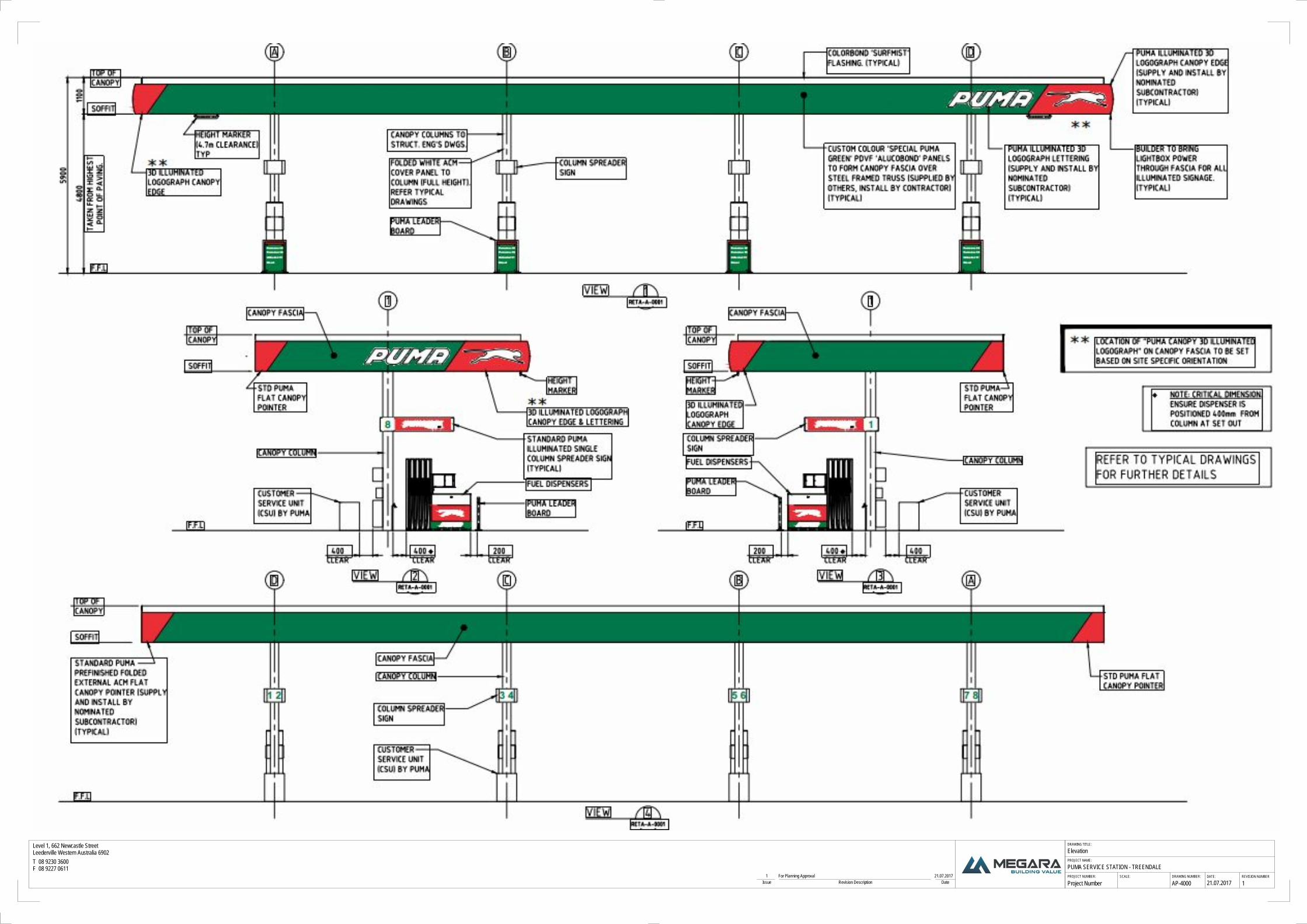
21.07.2017 1Project Number
PUMA SERVICE STATION - TREENDALE
Elevation
AP-4000Issue Revision Description Date1 For Planning Approval 21.07.2017

F.FL.
1770
F.FL.
1770
3954
5700
F.FL.
1770
F.FL.
1770
F.FL.
1770
F.FL.
1770
F.FL.
1770
F.FL.
1770
PROJECT NUMBER:
PROJECT NAME:
DRAWING TITLE:
SCALE: DATE:DRAWING NUMBER: REVISION NUMBER
Level 1, 662 Newcastle StreetLeederville Western Australia 6902T 08 9230 3600F 08 9227 0611
1 : 100 07.08.2017 2Project Number
PUMA SERVICE STATION - TREENDALE
Small Store, Service Yard, Link Canopy Elevation
AP-4001Issue Revision Description Date1 For Planning Approval 21.07.20172 Windows added to elevations 07.08.2017
1 : 100
Elevation 41
1 : 100
Elevation 22
1 : 100
Elevation 33
1 : 100
Elevation 14

F.FL.
1770
F.FL.
1770
F.FL.
1770
F.FL.
1770
PROJECT NUMBER:
PROJECT NAME:
DRAWING TITLE:
SCALE: DATE:DRAWING NUMBER: REVISION NUMBER
Level 1, 662 Newcastle StreetLeederville Western Australia 6902T 08 9230 3600F 08 9227 0611
1 : 100 07.08.2017 2Project Number
PUMA SERVICE STATION - TREENDALE
Small Store Elevation
AP-4002Issue Revision Description Date1 For Planning Approval 21.07.20172 Windows added to elevations 07.08.2017
1 : 100
Elevation 1 -Small Market1
1 : 100
Elevation 41-Small Market2 1 : 100
Elevation 3- Small Market3
1 : 100
Elevation 2- Small Market4

1
Shane Kirk
From: Email Journal
Sent: Tuesday, 6 June 2017 3:17 PM
To: Shane Kirk
Subject: FW: PROPOSED 24 HOUR SERVICE STATION – LOT 9508 DITCHINGHAM PLACE,
AUSTRALIND. - 17/17374
This has been saved to RecFind – See 17/17374
Jade
From: DERRINGTON Cathie [mailto:[email protected]]
Sent: Tuesday, 6 June 2017 2:36 PM
To: Shane Kirk; shire e-mail
Subject: RE: PROPOSED 24 HOUR SERVICE STATION – LOT 9508 DITCHINGHAM PLACE, AUSTRALIND.
6th
June 2017
Our Reference: RF835-24~14, PA014368
Your Reference: Job No. A015857
To: Shire of Harvey
From: Department of Water
Attention: Shane Kirk
RE: PROPOSED 24 HOUR SERVICE STATION – LOT 9508 DITCHINGHAM PLACE, AUSTRALIND.
The Department of Water (DoW) has reviewed the development application for a proposed 24 hour
Service Station on Lot 9508 Ditchingham Place, Australind.
Water quality risks
The Department of Water considers the development application to have a moderate level of risk to water
quality for the ground and surface water environments. The subject site is located on a multiple use
palusplain that is likely to have groundwater at or near surface and is adjacent to a waterway draining into
Collie River environment.
Service stations can pose a contaminant risk to water resources through:
• Leakage of fuels from storage tanks;
• Spillage of engine coolant, fuel, hydraulic fluid, lubricants or solvents on the forecourt areas;
• Inappropriate containment or disposal of waste products, and
• Wastewater disposal from the facility.
Managing the movement of waters from the facility is imperative to ensure receiving water bodies are not
contaminated. There are three types of water within the service station facility that require separate
treatment, they are:
• Clean roof run off;
• Contaminated stormwater from impervious surfaces, and
• Leakage from containment / treatment areas.

2
The development application provided some details of contaminated stormwater runoff but did not
contain any details of other water management at this site. Thus the department can only provide best
management practice advice for this development. To protect the above water resource and mitigate
against the risks stated, the Department of Water advises the following:-
Tank systems
1. Tanks should be located in stable compacted granular soils to prevent tank movement. Soil in
contact with the unprotected metal or concrete tank systems should not have chemical properties
(salts or acids) that may cause tank or pipe work deterioration. Metal tanks in corrosive solids
should have protective coatings and cathodic protection to prevent tank deterioration.
2. Tanks systems should not be located;
a. in poorly compacted soil or on sites subject to seismic movement;
b. with parts in contact with the water table (unless protected against buoyancy forces and
corrosion) (it is likely that this will be an issue for this site and require active management).
c. near sensitive water resources (tanks are likely to be placed within the proclaimed Perth –
Superficial Swan Aquifer).
3. All new tanks and their pipe work should have double-walled construction, with an interstitial leak
monitoring space. This is particularly important when located close to sensitive water resources
and/or where the tanks may come into contact with the water table.
4. All tank systems should have be fitted with spill contaminant devices at each fill point. Each spill
containment device should have a minimum capacity of 15L.
Stormwater management
5. Measures should be taken to prevent uncontaminated external surface water from entering the
forecourt. These include:
a. kerbing or grade changes for paved areas
b. installing and maintaining stormwater collection systems, such as bio-retention gardens
and soak wells to intercept roof and general runoff that would otherwise enter the
forecourt.
c. establishing soaks that collect and permit infiltration of stormwater.
6. Stormwater that maybe contaminated should pass through a well-maintained litter and sediment
trap, then an appropriately designed and regularly maintained fuel and oil trap (as indicated in
page 17 of the attached document ‘Development Application Lot 9208 Ditchingham Place,
Treendale, prepared for the Development Assessment Panel, May 2017, Megara)’.
7. Waste solids from the water treatment process should be collected and disposed of outside any
sensitive environment, in accordance with the requirements of the local government.
8. Clean wastewater, that has been effectively treated and tested, may be discharged to (in
preference):
a. onsite bio-retention gardens
b. onsite soak wells
c. onsite leach drains
d. a reticulated sewer where accepted by a service provider.
Emergency response

3
9. Site operators should prepare an emergency chemical spill response plan, install and retain
necessary response equipment on site, and train their staff in the plan’s effective implementation.
RIWI Act advice
Groundwater
The application falls under the Bunbury Groundwater Area and is proclaimed under the Rights in Water
and Irrigation Act 1914 (RIWI). Therefore any groundwater abstraction / dewatering in this proclaimed
area is subject to licensing by the department.
The proposal is located in the Kemerton South Subregion. No water is currently available in the Superficial,
Leederville and Yarragadee aquifers. If groundwater is required for this proposed development then
trading water will be required, otherwise scheme water through the Water Corporation piped network will
be the only option.
Waterways Conservation Act Advice
The subject lots falls within the Leschenault Inlet Management Area declared under the Waterways
Conservation Act 1976 (WWC). Water quality management is a priority for this area, thus any surface
water leaving the proposed premises should be assess and managed accordingly to the DoW ‘Stormwater
management manual for WA, 2007’.
The DoW has a number of Water Quality Protection Notes (WQPN) that are relevant to reducing
contaminates to waterways environments and stormwater management. The following notes should be
considered to ensure best management practice occurs with this development.
i. WQPN 52 ‘Stormwater management at industrial sites’
ii. WQPN 10 ‘Contaminant spills – emergency response’
iii. WQPN 65 ‘Toxic and hazardous substances – storage and use’
iv. WQPN 49 ‘Service stations’
v. WQPN 61 ‘Tanks for groundwater level chemical storage’
vi. WQPN 62 ‘Tanks for underground chemical storage’
WQPNs can be found at the link:
http://www.water.wa.gov.au/search-results?collection=wadow&query=
Please feel free to discuss this information further with this office, as required.
Yours faithfully,
Cathie Derrington
Environmental Officer / Integrated Land & Water
South West Region / Department of Water
PH: (08) 9726 4184
Fax:(08) 9726 4100
Email: [email protected]
-- This email was Malware checked by UTM 9. http://www.sophos.com

Com
mercial - Light Ind
ustrial PrecinctSTRUC
TURE PLAN
17
STRUCTURE PLAN POLICY STATEMENTS1) Development and subdivision shall be generally in accordance with the Commercial
Precinct Structure Plan Map and relevant Policy Statements.2) Design Guidelines shall be prepared prior to any development or subdivision
occurring to the satisfaction of the Local Government. The Guidelines shall have regard to relevant design principles and should include, but not be limited to the following elements of landscaping, building orientation, open space interface treatments and screening of servicing areas from streetscapes.
3) Road design and parking access/egress shall be designed and constructed in accordance with the requirements of Liveable Neighbourhoods and Austroads to the satisfaction of the Local Government.
4) Pedestrian and cyclist facilities and access into and around Commercial – Light Industrial Precinct Structure Plan is to be provided in accordance with the structure plan at the time of development or detailed subdivision.
5) Development shall demonstrate and implement best practice water sensitive urban design to the satisfaction of the Local Government, in consultation with Department of Water.
6) All development with a street frontage, shall actively address the street environment, including a clear point of entry.
7) All development is to be accompanied by the required level of parking to the satisfaction of the Local Government.
8) The permissibility of uses shall be in accordance with the respective zoning Tables under the Shire of Harvey Town Planning Scheme No.1.
9) Staging of development is to occur in an orderly and proper manner and shall demonstrate and implement adequate access, servicing and landscaping provision.
10) A Landscape Strategy shall be prepared and implemented at the time of development to ensure landscaping within public and private spaces is designed consistently for frontages along the southern and western street frontages.
11) The design of buildings adjoining public spaces shall have regard to providing adequate security and public safety in accordance with the principles established in Planning Bulletin No.79 Designing Out Crime Planning Guidelines.
12) Public Open Space reserve’s are to be vested to the Crown free of cost at the time of development or subdivision.
13) Solar design principles are encouraged. Figure 9Structure Plan Policy Statement
SHIRE ADOPTION
This Treendale District Centre Structure Plan has been
adopted by the Shire of Harvey on
WAPC ENDORSED STRUCTURE
PLANTo provide a framework for future detailed planning at the subdivsion and development stage.
Date
Delegated under s.16 of the Planning & Development Act 2005

Com
mercial - Light Ind
ustrial PrecinctSTRUC
TURE PLAN
18
Figure 10Precinct Plans and Statements
EASTERN PRECINCT
Statement of IntentThis precinct is to provide a range of commercial and limited light industrial uses to provide a transitional area between Treendale’s residential precincts and “Light Industrial” zoned land to the north.
Key ObjectiveTo minimise potential for land use confl ict between abutting land uses and provide an appropriate interface between the highway and future access into Treendale.
Design Principles• To provide a landscape buffer between the highway• Nursery uses to demonstrate compliance with buffer guidelines. When a nursery use proposes a reduced
buffer area, a site specifi c environmental assessment will be required to be undertaken to the satisfaction of the Shire.
Design Guidelines• Additional Uses of Transport Depot, Builders Yard, Vehicular Repair Station shall be contained within a built
form setting that: - Complies with the design guidelines - screens servicing and storage areas from the street environment;
- prohibits the display of goods within the front setback area
WESTERN PRECINCT
Statement of IntentThis precinct is to provide a high quality streetscape and built form environment that complements the functions and design elements of the District Centre
Key ObjectiveCreate a high quality street environment along the “Kingston Drive Extension”.
Design Principles• Building design along “Kingston Drive Extension” to acknowledge the importance of the road as a “gateway”
into the District Centre.• To provide a high standard of pedestrian and cycle linkage to the District Centre and residential surrounds• Car parking areas to be located and designed to ensure a high quality and safe streetscape.
Precinct Specifi c Design GuidelinesBuilding Facadesa) Facades visible from “Kingston Drive Extension” shall:
i. Demonstrate a high level of detailing or decoration in design, structure, colour and materials to provide and enhance interest and visual amenity;
ii. Include glazing for at least 40% of the total length of the building façade; iii. Include awnings/verandahs and other roof treatments to break vertical lines and provide shelter for
pedestrians; andiv. Restrict the use of roller doors to side or rear elevations.
Lightinga) Strobe lighting, to attract attention, will not be permitted.
Landscapinga) Landscaping within front setback areas for lots with frontages on “Kingston Drive Extension and Grand
Entrance shall be prepared and implemented in accordance with an approved landscape strategy to ensure consistency and a high amenity interface with the district centre and residential streets.

12 .5
12.5
12 .5
12. 5
12 .5
12.5
12 .5
12 .5
12 .5
1 2 .5
12.5
12 .5
12 .5
12 .5
12.5
12 .5
13.0
13. 0
13 .0
13.0
13.0
13.0
13.0
13
.0
13.0
13.0
13.0
13. 0
13.0
13.0
13 .0
13 . 0
13 .0
13.0
13 .0
13 .0
13
.0
13.
0
13.0
13.0
13 .0
13.0
13.0
13. 0
13. 0
13. 0
13 .013 .0
13
. 0
13.0
13.0
13 .0
13.0
13
.0
13 .0
13.
0
13 . 0
13 .0
13 .0
13 .0
13.0
13.0
13 .5
13.5
13.5
13 .5
13 .5
13 .5
13 .5
13 .5
13 .5
13 .5
13 .
5
13.5
13 .5
13. 5
13. 5
13.5
13.5
13.5
13.5
14. 0
14.0
14.0
14 .0
14.
0
WATE
R CO
RPORATI
ON E
ASEMENT
179
.033
283.317
14.135
8.485
67.
099
83.040
3.702
7.370
85.
242
39.976
227.392
160.626
77
78
135°
135°18'58"
142°
9'31
"
141°14'18"
95°38'50"
159°
50'5
2"
169°
49'4
4"81°25'8"
121°44'4"
152°59'29"
31.349 179°
12'6
"
95088.4532ha
Lot 61.82 ha
Lot 50.992 ha
Lot 40.992 ha
Lot 31.107 ha
Lot 20.605 ha
Lot 70.94 ha
Lot 80.88 ha
Lot 10.32 ha
155.
28m
153.
1 m
151.
88 m
64.2
08 m
66.0
26 m
19.3
2 m
8.56 m
156.27m
4.35m
59.46m
66.44m
58.44m
94.3m
38.68m
63.0
6 m
123.67 m
6.34
m
115.
63 m
14.135 m
CE
NTA
UR
US
Ave
DRAINAGE
LOT 23
LOT 151
DRAINAGE
LOT 9509
63.0
6 m
140.15 m
50.71m
8.48m
36.2
6 m
140.14m
34.77m27.56 m
GRANDENTRANCE
SALT
WO
OD D
R
LOT 101
LOT 17
LOT 15
LOT 102
LOT 103
DITCHINGHAMPLACE
THO
RN
BUR
Y D
R
PARENT Lot8.4532 ha
ROAD 1
ROAD 2
20 m
18 m
2.7 m 6.1 m5.6 m
5.3 m5.1 m
6.3
m
6.1 m 5.6 m5.3 m
5.1 m 6.3
m
65.68 m
63.8 m
83.9 m
68.4
9 m
62.1
9 m
73.8
3 m
39.976 m11.02 m8.40 m
72.0
7 m
7.37 m
LOT 9507LOT 95088.4532 ha
NORTH
DITCHINGHAM PLACE
PRIM
ARY
REG
ION
AL R
OAD
AUST
RAL
IND
BYP
ASS
GRAND ENTRANCE
CEN
TAU
RU
S AV
E
WATER MAINSEWER MAINSEWER PIPELINEELECTRICAL HIGH VOLTAGE UNDERGROUNDELECTRICAL LOW VOLTAGE UNDERGROUNDMETAL POLEPILLARTRANSFORMER SITE
PARENT LOT BOUNDARY
LEGEND
Level 1, 662 Newcastle StreetLeederville Western Australia 6902T 08 9230 3600F 08 9227 0611
PROJECT NUMBER:
PROJECT NAME:
DRAWING TITLE:
SCALE: DATE:DRAWING NUMBER: REVISION NUMBER
As indicatedProject Number
TEENDALE
PLAN OF SUBDIVISION- Lot 9508 Ditchingham Place, Australind
AP1000Issue Revision Description Date
1 : 2000
Subdivision Plan1
1 : 5000
PARENT LOT2
22/06/2017

100m 100m
110m
80m Indicative building location (store)
Potential location of future dwelling
Existing sales display office
96m
Indicative POS location

5451m²
4.9101ha(TOTAL 5.4552ha)
SUBJECT LAND
APPLICATION AREA
LOT 9509Existing Total Lot Area 5.455haBalance/Remaining Total Lot Area 0.8165ha
LOT 9527Existing Total Lot Area 8.295haBalance/Remaining Total Lot Area 2.0092ha
All areas and dimensions are subject to �nal survey
EXISTING LOT DETAILS
APPLICATION AREA


