

Sydney Growth Centres Strategic Assessment
Supplementary Report November 2010

Sydney Growth Centres Strategic Assessment - Supplementary Report
© State of New South Wales through the Department of Planning
www.planning.nsw.gov.au
November 2010
ISBN 978-1-74263-105-9
Disclaimer: While every reasonable effort
has been made to ensure that this
document is correct at the time of printing,
the State of New South Wales, its agents
and employees, disclaim any and all
liability to any person in respect of anything
or the consequences of anything done or
omitted to be done in reliance upon the
whole or any part of this document.

Sydney Growth Centres Supplementary Report
i | DECCW & DOP 2010
Contents Contents..................................................................................................................................................... i
1. Introduction ...............................................................................................................................1
1.1 The Sydney Growth Centres Program........................................................................................1
1.2 The EPBC Act and strategic assessment...................................................................................1
1.3 Current status of the strategic assessment ................................................................................2
1.4 Purpose of this report..................................................................................................................3
1.5 Actions and classes of actions....................................................................................................4
2. Program .....................................................................................................................................5
2.1 Government Directions and Policy Context ................................................................................5
2.2 Program elements within the Growth Centres............................................................................6
2.2.1 The North West Growth Centre................................................................................................8
2.2.2 The South West Growth Centre .............................................................................................13
2.3 Biodiversity Offset Program ......................................................................................................18
2.3.1 Conservation areas within the Growth Centres .....................................................................18
2.3.2 Conservation areas outside of the Growth Centres ...............................................................18
2.4 Summary of Program commitments for matters of national environmental significance .........21
3. Summary of submissions ......................................................................................................22
3.1 Support for the Program ...........................................................................................................22
3.1.1 The strategic assessment approach ......................................................................................23
3.1.2 Benefits compared to individual site-by-site assessments.....................................................23
3.1.3 Conservation of native vegetation..........................................................................................23
3.1.4 Cascading preference system for offsets...............................................................................24
3.2 Key issues.................................................................................................................................24

Sydney Growth Centres Supplementary Report
ii | DECCW & DOP 2010
4. Key issues ...............................................................................................................................25
4.1 Adequacy of conservation within the Growth Centres..............................................................25
4.1.1 Protection for species and ecological communities ...............................................................25
4.1.2 Analysis of potential impacts to additional flora species........................................................28
4.1.3 Management of conservation areas.......................................................................................35
4.2 Adequacy of offsets ..................................................................................................................39
4.2.1 Offset targets and objectives..................................................................................................39
4.2.2 Offsets for Turpentine Ironbark Forest ...................................................................................41
4.2.3 Uncertainty in what will be delivered......................................................................................42
4.2.4 Compulsory acquisition ..........................................................................................................43
4.2.5 Like for like outcome ..............................................................................................................43
4.2.6 Focus on protecting matters of national environmental significance .....................................46
4.2.7 Funding of the offsets program ..............................................................................................47
4.2.8 Derived grasslands.................................................................................................................47
4.3 Adequacy of assessment methods...........................................................................................48
4.3.1 Ground truthing ......................................................................................................................48
4.3.2 Management viability concept................................................................................................52
4.3.3 Priority conservation lands .....................................................................................................55
4.3.4 Comparison with Melbourne Strategic Assessment ..............................................................57
4.4 Impacts on development potential ............................................................................................58
4.4.1 Marsden Park Scheduled Lands ............................................................................................58
4.4.2 Priority Conservation Lands ...................................................................................................58
4.4.3 Mapping..................................................................................................................................59
4.4.4 Other land uses......................................................................................................................60
5. Protecting Cumberland Plain Woodland ..............................................................................62
5.1 Background...............................................................................................................................62

Sydney Growth Centres Supplementary Report
iii | DECCW & DOP 2010
5.2 Cumberland Plain Woodland Outcomes delivered through the Program.................................64
5.2.1 Additional HMV CPW Protection............................................................................................66
5.3 Joint Government delivery approach to protecting Cumberland Plain Woodland....................67
6. Outcomes for the Program ....................................................................................................69
6.1 Overall outcome........................................................................................................................69
6.2 Outcome for each matter of NES..............................................................................................69
7. Terms of Reference & Endorsement Criteria.......................................................................76
7.1 Terms of Reference ..................................................................................................................76
7.2 Endorsement Criteria ................................................................................................................80
8. Conclusion...............................................................................................................................82
9. References...............................................................................................................................85
Appendix A – Strategic Assessment Agreement................................................................................87
Appendix B – Public Exhibition ..........................................................................................................103
Appendix C – Summary of public submissions................................................................................104

Sydney Growth Centres Supplementary Report
iv | DECCW & DOP 2010
List of Figures
Figure 1: Location of the North West and South West Growth Centres ...................................................2
Figure 2: Boundaries of the North West Growth Centre ...........................................................................9
Figure 3: North West Structure Plan .......................................................................................................10
Figure 4: Indicative layout of development and protected areas within the North West Growth Centre 12
Figure 5: Boundaries of the South West Growth Centre.........................................................................14
Figure 6: South West Growth Centre Structure Plan ..............................................................................15
Figure 7: Indicative layout of development and protected areas within the South West Growth Centre 17
Figure 8: Schematic of the offset focus areas.........................................................................................20
Figure 9: Species distribution and location of NSW Wildlife Atlas records for Allocasuarina glareicola
within and immediately surrounding the North West Growth Centre....................................31
Figure 10: Species distribution and location of NSW Wildlife Atlas records for Pterostylis saxicola within
and immediately surrounding the Growth Centres ...............................................................34
Figure 11: Biodiversity value and ecological viability of CPW across the Cumberland Plain. ................63

Sydney Growth Centres Supplementary Report
v | DECCW & DOP 2010
Abbreviations
ABBREVIATION DESCRIPTION
CCC Cumberland Conservation Corridor
CPWEPBC Act listed Cumberland Plain Shale Woodlands and Shale Gravel Transition Forest
DECCW NSW Department of Environment, Climate Change and Water
DoP NSW Department of Planning
EP&A Act NSW Environmental Planning and Assessment Act 1979
EP&A Regulation NSW Environmental Planning and Assessment Regulation 2000
EPBC Act Commonwealth Environment Protection and Biodiversity Conservation Act 1999
Growth Centres SEPP
State Environmental Planning Policy (Sydney Region Growth Centres) 2006
HMV High Management Viability
MNES Matters of National Environmental Significance
NSW New South Wales
Offset Program Growth Centres Biodiversity Offset Program
RBMs Relevant Biodiversity Measures
SEWPaC (formerly DEWHA)
Commonwealth Government Department of Sustainability, Environment, Water, Population and Communities
The Program Sydney Growth Centres Program
ToR Terms of Reference
TSC Act NSW Threatened Species Conservation Act 1995

Sydney Growth Centres Supplementary Report
1 | DECCW & DOP 2010
1. Introduction
1.1 THE SYDNEY GROWTH CENTRES PROGRAM
In November 2009, the New South Wales (NSW) and Commonwealth Governments commenced a
strategic assessment under the Environment Protection and Biodiversity Conservation Act 1999 (EPBC
Act) of the potential impacts likely to arise through implementation of the Sydney Growth Centres
Program.
The Sydney Growth Centres Program (the Program) seeks to provide for residential, employment and
conservation areas and related infrastructure within the North West and South West Growth Centres of
Sydney (see Figure 1). It also seeks to provide for a range of conservation measures throughout
Western Sydney and the broader Sydney region.
Planning for the Growth Centres began in 2004 and evolved from the need to provide housing and
employment lands and associated infrastructure over the next 30+ years in Sydney. The 2005
Metropolitan Strategy: City of Cities - A Plan for Sydney’s Future identified the Growth Centres as the
preferred option for delivering these outcomes.
Since that time, the Program has been developed and approved under NSW planning and threatened
species legislation. It is now the subject of consideration by the Commonwealth.
The Sydney Growth Centres strategic assessment under the EPBC Act comprises three key
documents:
1. The Draft Strategic Assessment Report which was publicly exhibited and which provides a
detailed assessment of the proposed impacts of the Program for matters of national
environmental significance.
2. The Supplementary Assessment Report (this report) which addresses the issues raised in the
public exhibition process and analyses the outcomes of the Program.
3. The final Program Report which identifies the elements of the program and the commitments
and undertakings of the NSW Government for the protection and management of matters of
national environmental significance protected under the EPBC Act.
1.2 THE EPBC ACT AND STRATEGIC ASSESSMENT
The EPBC Act is the Commonwealth Government's key piece of environmental legislation. It protects
matters of national environmental significance which include:
World heritage sites;
National heritage places;
Wetlands of international importance;
Nationally threatened species and ecological communities;
Migratory species;
Commonwealth marine areas;

Sydney Growth Centres Supplementary Report
2 | DECCW & DOP 2010
Nuclear actions; and
The Great Barrier Reef Marine Park.
Strategic assessments occur under Part 10 of the EPBC Act. They provide a mechanism to move away
from site-by-site impact assessment and examine proposed developments at a landscape scale in
relation to the requirements of the EPBC Act.
The Commonwealth Government Department of Sustainability, Environment, Water, Population and
Communities (SEWPaC) administers the strategic assessment provisions of the EPBC Act and
provides advice to the Commonwealth Minister for Sustainability, Environment, Water, Population and
Communities throughout the process.
Figure 1: Location of the North West and South West Growth Centres
1.3 CURRENT STATUS OF THE STRATEGIC ASSESSMENT
The strategic assessment is being conducted in accordance with an agreement between the
Commonwealth and NSW Governments (see Appendix A). The agreement sets out a framework for the
assessment of the Program against the requirements of the EPBC Act and provides for:

Sydney Growth Centres Supplementary Report
3 | DECCW & DOP 2010
Detailed Terms of Reference (ToR) for the preparation of a Draft Strategic Assessment Report
and Supplementary Report.
Endorsement Criteria that must be met in order for the Commonwealth Government to endorse
the Program.
The draft ToR were publicly exhibited from 17 November to 23 December 2009 and were finalised
based on the outcomes of that process. The finalised ToR and Endorsement Criteria are available at
Appendix A.
The Draft Strategic Assessment Report was developed to address the ToR and was publicly exhibited
with the Draft Program Report from 24 May to 25 June 2010. Details of the public exhibition are
available at Appendix B.
That report sought to examine the combined impacts of actions likely to result from the proposed
developments outlined in the Program. It focused on the matters protected by the EPBC Act (i.e.
matters of national environmental significance) and assessed:
the matters of national environmental significance that occur within the vicinity of the Program
area;
potential impacts to those matters as a result of actions arising from the Program;
the proposed mitigation, management and offset measures that the NSW Government will put
in place to protect matters of national environmental significance; and
the overall conservation outcomes that will be achieved through the implementation of the
Program.
1.4 PURPOSE OF THIS REPORT
This report (the Supplementary Report) summarises and responds to the issues raised through the
public comment process. 70 submissions from the public were made on the Draft Strategic Assessment
Report and Draft Program Report. It also:
addresses any additional issues raised by SEWPaC; and
provides an analysis of the final Program and describes the outcomes for matters of national
environmental significance.
In conjunction with preparing the Supplementary Report, the draft Program Report was also amended in
response to issues raised in the public submissions and in response to the priorities of SEWPaC. The
final program is summarised in Section 2 of this report.
For a complete understanding of the strategic assessment and its outcomes, the three key reports
should be read in conjunction. These are:
1. The Draft Strategic Assessment Report.
2. The Supplementary Report (this report).
3. The final Program Report.
This Supplementary Report is structured as follows:
Section 1: provides an introduction to the program and the issues addressed in this report.

Sydney Growth Centres Supplementary Report
4 | DECCW & DOP 2010
Section 2: summarises the final program as revised after the public exhibition period.
Section 3: provides an overview of the submissions received on the Draft Strategic Assessment
Report and the draft Program Report.
Section 4: summarises and responds to the issues raised in the submissions and by SEWPaC.
Section 5: provides a discussion of the issues relating to the protection of Cumberland Plain
Woodland.
Section 6: provides a consolidated analysis of the outcomes of the final program in relation to
matters of national environmental significance.
Section 7: outlines how the Draft Strategic Assessment Report and this report (the
Supplementary Report) address the strategic assessment Terms of Reference and
Endorsement Criteria.
Section 8: provides a conclusion to the strategic assessment.
This report along with the Draft Strategic Assessment Report and final Program report will be provided
to the Commonwealth Minister for Sustainability, Environment, Water, Population and Communities for
consideration in endorsing the Program.
It is important to note that the Draft Strategic Assessment Report and the Supplementary Report do not seek to
address the requirements of NSW planning or environment legislation. Those requirements have been, and
continue to be, addressed through separate processes at the State level.
1.5 ACTIONS AND CLASSES OF ACTIONS
The actions and classes of actions that have been assessed for EPBC Act approval in relation to the
Program are described below. Endorsement of the Program and approval of the actions and classes of
actions by the Commonwealth Minister for Sustainability, Environment, Water, Population and
Communities will remove the need for further assessment and approval under the EPBC Act for those
actions and classes of actions.
The actions and classes of actions are:
All actions associated with urban development, undertaken in accordance with the Program,
within the North West and South West Growth Centres.

Sydney Growth Centres Supplementary Report
5 | DECCW & DOP 2010
2. Program As outlined in Section 1, the Sydney Growth Centres Program will provide for urban development and
conservation including:
residential, employment, open space, conservation and protected areas and related
infrastructure within the North West and South West Growth Centres (illustrated in Figure 2 and
Figure 5 respectively) over 30+ years; and
a $530 million (2005/06 dollars) biodiversity offsets package to protect high conservation value
areas both within and outside the Growth Centres.
The Program is described in detail in the Sydney Growth Centres Program Report which is
structured as follows:
Section 1 provides an introduction to the Program Report.
Section 2 provides a description of the Program.
Section 3 outlines the implementation of the Program. It includes: an overview of the
legislation; a description of the relevant planning tools; and detail about the processes
related to implementing the Program.
Section 4 provides the NSW commitments to conservation outcomes for the relevant matters
of national environmental significance.
Section 5 provides a description of the monitoring, evaluation and reporting elements that
will provide information on the progress of the program.
This section summarises the Program for the purposes of setting context for the assessment.
In order to ensure consistency between this report and the Program Report, text is drawn directly from
the Program Report. However, for full detail about the Program, reference should be made to the
Program Report itself.
2.1 GOVERNMENT DIRECTIONS AND POLICY CONTEXT
Based on the NSW Government projections, the population of Sydney is projected to grow by
1.7 million people to nearly 6 million by 2036, presenting significant challenges to governments to
provide appropriate and affordable housing, infrastructure and services. Both the NSW and
Commonwealth Governments have made public commitments supporting the streamlining of
development processes in order to improve land and housing supply and affordability, while ensuring
environmental outcomes.
In a move away from an ad hoc approach to greenfield housing development in Western Sydney, in
June 2005 the NSW Government exhibited draft plans for Managing Sydney’s Growth Centres. This
exhibition included planning and infrastructure reports outlining the NSW Government’s commitment to
adopting a new approach to land releases by identifying the North West and South West Growth
Centres in Western Sydney, to ensure that Sydney’s growth occurs in a sustainable way with new
infrastructure planned, funded and linked to the properly sequenced release of land.

Sydney Growth Centres Supplementary Report
6 | DECCW & DOP 2010
In December 2005, the Metropolitan Strategy: City of Cities was released. The Metropolitan Strategy
includes a range of actions and objectives supporting delivery of urban development within the Growth
Centres. In particular, the Metropolitan Strategy identifies the importance of focusing greenfield
development in the Growth Centres in order to protect other land of resource/agricultural and
environmental significance and to provide for the efficient use of infrastructure including the North West
and South West Rail Link, water, wastewater, road, education and health infrastructure. The
Metropolitan Strategy aims to address Sydney’s growing population by encouraging infill development
(to meet 60-70% of the population growth needs) and well-planned greenfields development for the
remainder.
Since then the NSW Government has commenced coordinated planning and infrastructure delivery in
the Growth Centres, to facilitate the supply of new land to the market as quickly and efficiently as
possible with the best use of Government resources. The Growth Centres will provide for 181,000
dwellings, at least 2,500 ha of land for employment and $7.5 billion in regional infrastructure to support
up to half a million additional residents over the next 30 years.
After several years of environmental studies and planning, public exhibition and the securing of a
conservation fund, Biodiversity Certification has been granted over the State Environmental Planning
Policy (Sydney Region Growth Centres) 2006 (Growth Centres SEPP), allowing development in the
Growth Centres to proceed without further NSW threatened species assessment on certified areas on
the basis that agreed conservation outcomes are delivered. Through levies on development in the
Growth Centres, $530 million (in 2005-06 dollars) will be provided to purchase land for conservation
within the Growth Centres and to obtain offsets outside the Growth Centres. The conservation levy
applies to all developable land within the Growth Centres (excluding public services and utilities etc)
resulting in the costs of conservation outcomes being equitably shared across the Growth Centres.
The Growth Centres Program represents a new approach to greenfield land release that aligns
population growth with the development of housing, employment, infrastructure and services and the
need for conservation. This approach is considered to derive strong environmental, social and
economic outcomes, all of which are considerations in decision making relating to strategic
assessments.
The outcomes of the EPBC Act strategic assessment of the Growth Centres are complementary with
the Biodiversity Certification of the Growth Centres SEPP. The Program provides the mechanism to
ensure the NSW Government’s commitments in relation to the EPBC Act are clear and (as far as
possible) consistent with the approach taken under the Biodiversity Certification.
2.2 PROGRAM ELEMENTS WITHIN THE GROWTH CENTRES
Within the Growth Centres, the Program comprises of three broad elements:
urban development (encompassing both residential and employment areas);
protected areas; and
infrastructure.
Urban development
The combined area of the North West and South West Growth Centres will provide residential and
employment areas for a population of around 500,000 people. This will include approximately 181,000
dwellings at a range of dwelling densities providing housing choice for the future residents of Western
Sydney.

Sydney Growth Centres Supplementary Report
7 | DECCW & DOP 2010
The Program includes plans for “walkable neighbourhoods” to provide unique and favourable access to
retail, service and community centres, which will assist the development of strong, cohesive
communities in an efficient and timely manner.
The key principles around urban development within the Growth Centres are:
better public transport with frequent buses that link into the rail system;
new urban areas connected with Sydney’s rail system via the existing Richmond line, the
proposed South West Rail Link and proposed North West Rail Link;
a range of housing types and densities to suit the needs of all members of the community;
streets and suburbs planned so that residents can walk to shops for their daily needs;
easy access to major town centres with a full range of shops, recreational facilities and services
along with smaller village centres and neighbourhood shops;
environmentally friendly homes that conform to BASIX (the NSW Government’s Building
Sustainability Index) requirements for water and energy savings;
jobs available locally and within the region, reducing the demand for transport services into
Sydney’s CBD and cutting travel times;
a range of land uses to provide the right mix of houses, jobs, services, open and recreational
spaces; and
protection of natural and cultural heritage values, waterways and conservation of biodiversity.
Protected areas
Both the North West and South West Growth Centres contain areas of important biodiversity value. As
many areas within the Growth Centres are degraded and fragmented, the Program provides for the
protection of the areas of highest conservation value in the Growth Centres.
In total within the Growth Centres, the Program will retain and protect a minimum of 2,000 ha of existing
native vegetation, including vegetation within the 1,000 ha of zoned conservation areas (described in
detail in Section 3 of the Program Report) to be acquired by the NSW Government.
Infrastructure
Both the North West and South West Growth Centres will require significant investment in the upgrade
and construction of infrastructure, including roads, rail, education, health, emergency and justice
services. The NSW Government will provide a substantial funding contribution to ensure that
infrastructure is provided efficiently and coordinated with urban development.
Key elements of the infrastructure component of the Program are:
Transport: upgrade and construction of new regional and local roads, rail and bus networks to
provide efficient transport links.
Health: improvements to existing hospitals and the construction of new community and health
centres.
Education: development of primary schools, high schools and TAFE facilities to service the new
communities.
Emergency services: provision of police, ambulance and fire stations as communities grow.

Sydney Growth Centres Supplementary Report
8 | DECCW & DOP 2010
Water, sewerage, and recycled water: integration of water and sewerage schemes.
Local facilities: provision of local parks, community centres, libraries and sports fields.
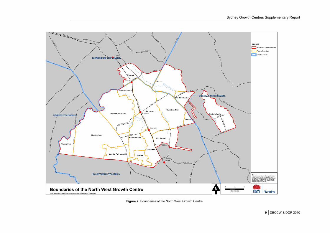
2.2.1 THE NORTH WEST GROWTH CENTRE
The North West Growth Centre is approximately 10,000 ha in size and is located within the boundaries
of Blacktown, Hawkesbury and Hills Shire local government areas. The Growth Centre is adjacent to
Rouse Hill Major Centre and is serviced by the existing Richmond rail line that has three stations within
the Growth Centre. The boundaries of the North West Growth Centre are shown in Figure 2.
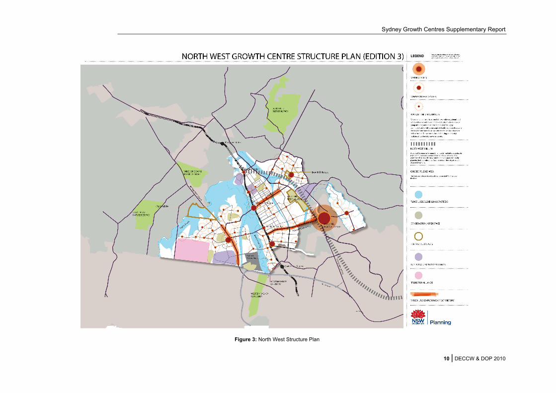
The North West Growth Centre is made up of 16 precincts and has an estimated dwelling yield of
70,000 dwellings.
The development of these precincts will be generally in accordance with the North West Structure Plan
(see Figure 3) which guides the location of town centres, neighbourhood centres, industrial and
conservation lands.
The land identified as being capable of urban development excludes those areas identified as having
high biodiversity significance or offering an opportunity to protect and maintain existing vegetation.
These areas and significant riparian corridors such as South Creek, Eastern Creek and Cattai Creek
have been protected through the vegetation clearing development controls under the Growth Centres
SEPP.
There will be a string of transit-oriented towns located on either side of the existing Richmond rail line,
and Rouse Hill Major centre will provide regional and higher order services for the North West Growth
Centre.
The eastern part of the North West Growth Centre includes North Kellyville and Box Hill. The North
West Transitway along Windsor Rd will provide the key public transport service connecting the Growth
Centre with Parramatta and Blacktown. The North West Rail Link will connect Rouse Hill to Epping and
the Sydney CBD. It will serve the future development within the North West Growth Centre and will
include stabling facilities to the west of Rouse Hill within the North West Growth Centre.
The central part of the Growth Centre is focused on the Richmond rail line. Opportunities for new
development have been identified in Vineyard, Riverstone, and Schofields to the south. These centres
and urban areas will take advantage of the existing transport links and its central location in the Growth
Centre.
The western part of Marsden Park provides for a town centre near Richmond Road and an employment
and industrial area.
The Growth Centre has been divided into local areas which are large enough to accommodate a critical
mass of population and development, and which will facilitate the provision of public transport.
A town centre providing a mix of services and facilities is identified for each of the local areas. The size
of each centre will depend on the size of its local area, being its primary retail catchment.
There are also several areas of employment-related or industrial land identified for larger-scale
enterprises. These areas are distributed to ensure that each part of the Growth Centre has a local
service industry area. They also have good access to major roads, and are generally able to be
separated from other activities. This is essential to ensure a range of employment opportunities are
provided for the future population.
Sydney Growth Centres Supplementary Report
9 | DECCW & DOP 2010
Figure 2: Boundaries of the North West Growth Centre
Sydney Growth Centres Supplementary Report
10 | DECCW & DOP 2010
Figure 3: North West Structure Plan

Sydney Growth Centres Supplementary Report
11 | DECCW & DOP 2010
Urban development and protected areas
The indicative layout for the North West Growth Centre showing development and protected lands is
shown in Figure 4. These boundaries are indicative as boundary changes may occur during the more
detailed planning processes.
Note: Reference should be made to the NSW Legislation website at www.legislation.nsw.gov.au for the
most current zoning and development control maps. The development control plans (DCPs) can be
accessed from the Department of Planning Growth Centres website at www.growthcentres.nsw.gov.au.
The development areas provide for residential and employment lands and related infrastructure, but will
also include areas of open space.
The protected areas under the State Environmental Planning Policy (Sydney Region Growth Centres)
2006 (Growth Centres SEPP) comprise:
Flood prone lands - Vegetation on these lands is protected through the vegetation clearing
development controls in the Growth Centres SEPP. Limited development may occur in these
areas, however any loss of vegetation is required to be offset, in accordance with the Growth
Centres Biodiversity Certification.
Conservation areas that have been rezoned through the SEPP. These areas will be brought
into public ownership overtime and be managed for conservation or recreation. Development in
these areas is restricted and native vegetation on these lands is to be retained and protected.
The areas include:
o Environmental conservation areas which have the main objective of protecting and
restoring areas with ecological, scientific or aesthetic value.
o Public recreation - regional areas which have the joint objectives of protecting natural
and heritage values of the land, as well as allowing sympathetic recreational uses.
There are also a range of existing protected areas within the North West Growth Centre that provide for
the protection of native vegetation. These are shown on Figure 4.

Sydney Growth Centres Supplementary Report
12 | DECCW & DOP 2010
Figure 4: Indicative layout of development and protected areas within the North West Growth Centre

Sydney Growth Centres Supplementary Report
13 | DECCW & DOP 2010
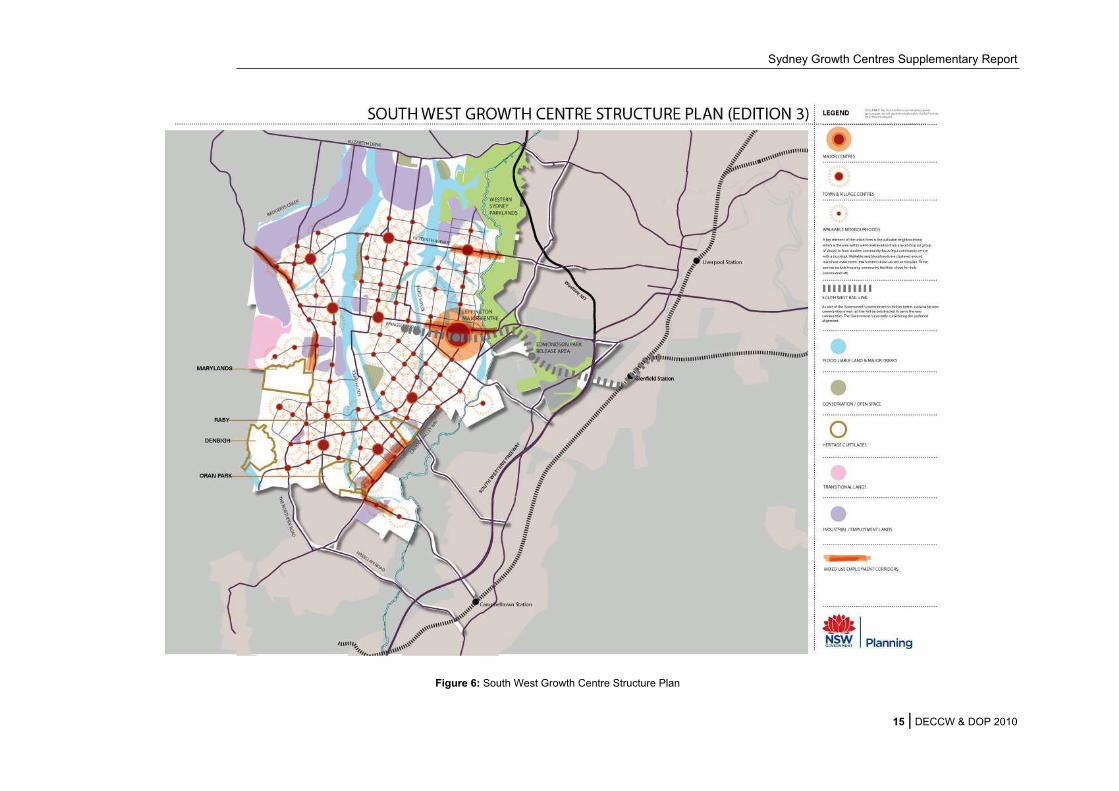
2.2.2 THE SOUTH WEST GROWTH CENTRE
The South West Growth Centre is within the boundaries of Camden, Campbelltown and Liverpool local
government areas. It is approximately 17,000 ha in size, will focus on the Major Centre of Leppington,
and the South West Rail Link will provide key public transport service connecting the Growth Centre
and Sydney. The boundaries of the South West Growth Centre are shown in Figure 5.
The South West Growth Centre is made up of 18 precincts and has an estimated dwelling capacity of
110,000 dwellings.
The development of these precincts will be generally in accordance with the South West Structure Plan
(see Figure 6) which guides the location of town centres, neighbourhood centres, industrial and
conservation lands.
The land identified as being capable of urban development excludes those areas identified as having
high biodiversity significance or offering an opportunity to strengthen existing vegetation. These areas
and significant riparian corridors such as South Creek and Kemps Creek have been protected through
the vegetation clearing development controls under the Growth Centres SEPP.
The proposed major centre of Leppington will be located within the Leppington North Precinct and will
be serviced by the South West Rail Link with new railway stations to be constructed at Leppington and
Edmondson Park. Ultimately, Leppington will provide for more than 8,000 new jobs and land for higher
order retail, civic and commercial uses which will support the population of the South West Growth
Centre.
The Growth Centre has been divided into local areas which are large enough to accommodate a critical
mass of population and development, and which will be structured to facilitate the provision of public
transport.
A town centre providing a mix of services and facilities is identified for each of the local areas. The size
of each centre will depend on the size of its local area, which is its primary retail catchment.
There are also several areas of employment and industrial land identified for larger-scale enterprises
and those with heavy truck use. These areas are distributed to ensure that each part of the Growth
Centre has a local service industry area. They also have good access to major roads, and are generally
able to be separated from other activities.

Sydney Growth Centres Supplementary Report
14 | DECCW & DOP 2010
Figure 5: Boundaries of the South West Growth Centre
Sydney Growth Centres Supplementary Report
15 | DECCW & DOP 2010
Figure 6: South West Growth Centre Structure Plan

Sydney Growth Centres Supplementary Report
16 | DECCW & DOP 2010
Urban development and protected areas
The indicative layout for the South West Growth Centre showing development and protected lands is
shown in Figure 7. Details of each of these protected areas are included in Section 3 of the Program
Report. These boundaries are indicative as boundary changes may occur following detailed planning
processes. This has already occurred as part of the detailed planning for the Edmondson Park, Oran
Park and Turner Road Precincts.
Note: Reference should be made to the NSW Legislation website at www.legislation.nsw.gov.au for the
most current zoning and development control maps. The development control plans (DCPs) can be
accessed from the Department of Planning Growth Centres website at www.growthcentres.nsw.gov.au.
The development areas provide for residential and employment lands and related infrastructure, but will
also include areas of open space.
The protected areas under the State Environmental Planning Policy (Sydney Region Growth Centres)
2006 (Growth Centres SEPP) comprise:
Flood prone lands. Vegetation on these lands is protected through the vegetation clearing
development controls in the Growth Centres SEPP. Limited development may occur in these
areas, however any loss of vegetation is required to be offset, in accordance with the Growth
Centres Biodiversity Certification.
Conservation areas zoned Public recreation – regional. This applies to three areas within the
South West. These areas will be brought into public ownership overtime and be managed for
conservation and recreation purposes. They have the joint objectives of protecting natural and
heritage values of the land, as well as allowing sympathetic recreational uses. Development in
these areas is limited and native vegetation on these lands is to be retained and protected.
There are also a range of existing protected areas within the South West Growth Centre that provide for
the protection of native vegetation. These are shown on Figure 7.

Sydney Growth Centres Supplementary Report
17 | DECCW & DOP 2010
Figure 7: Indicative layout of development and protected areas within the South West Growth Centre

Sydney Growth Centres Supplementary Report
18 | DECCW & DOP 2010
2.3 BIODIVERSITY OFFSET PROGRAM
The Program provides for a $530 million biodiversity offsets package to protect high conservation
value areas both within and outside the Growth Centres. 25% of this money will be used to secure
conservation areas within the Growth Centres and 75% will be used to secure high quality vegetation
remnants with similar ecological values outside the Growth Centres.
In addition to the $530 million, some of the conservation areas within the North West Growth Centre
are being purchased using other NSW Government revenue and by the local council.
2.3.1 CONSERVATION AREAS WITHIN THE GROWTH CENTRES
The conservation areas to be purchased within the Growth Centres are shown in Figure 4 and Figure
7. These areas cover a minimum of 1,000 ha and represent the highest quality vegetation within the
Growth Centres.
There are a range of processes to acquire the land (detailed in Section 3 of the Program Report) and
all areas are protected from vegetation clearing through development controls and will be managed in
the long term for conservation.
In addition to these areas there are lands within the Growth Centres that are currently in public
ownership or have been identified for acquisition. These areas include areas such as Rossmore
Grange, Kemps Creek Nature Reserve, and the Western Sydney Parklands. These areas are in
public ownership and are managed by NSW Government or local councils to meet conservation and
recreation objectives.
2.3.2 CONSERVATION AREAS OUTSIDE OF THE GROWTH CENTRES
The Program provides for the establishment of additional conservation areas throughout the
Cumberland Plain, the Hawkesbury Nepean Catchment and the Sydney Basin Bioregion (see Figure
8). The Program will provide 75% of the overall Conservation Fund ($397.5 million in 2005/06 dollars)
over 30+ years for the securing of offset lands of high conservation and similar ecological values
within these areas. This will be delivered through the Growth Centres Offset Program.
As a first preference, the funds will be invested within the priority areas on the Cumberland Plain
identified in the Hawkesbury Nepean Catchment Action Plan 2007-2016 (2008). The priority areas
within the Cumberland Plain were identified by DECCW as lands that could most effectively be
managed for threatened biodiversity. They represent the best remaining opportunities in the region to
maximise long term biodiversity benefits for the lowest possible cost, including the least likelihood of
restricting land supply. DECCW considers the remnant vegetation within these lands to be the highest
priority for future recovery efforts for the threatened biodiversity of the Cumberland Plain.
Criteria for guiding the spending of annual funding within this area include a consideration of reserve
design principles, conservation values and cost effectiveness. Preference will be given to protecting
the largest remnants of intact vegetation with the greatest potential for long-term retention of
biodiversity values.
If no suitable, cost effective lands are available in the areas of first preference, then priority areas
within the broader Hawkesbury Nepean catchment will be considered as a second preference. These
areas were identified as part of the development of the Hawkesbury Nepean Catchment Action Plan
and comprise a network of regional corridors and priority fauna habitats in the catchment.
Finally, as third and fourth preferences, funding can be spent to conserve grassy woodlands within the
Hawkesbury Nepean Catchment and then the Sydney Basin respectively. Grassy woodlands are a
Sydney Growth Centres Supplementary Report
19 | DECCW & DOP 2010
broad group of vegetation types, including Cumberland Plain Shale Woodlands and Shale Gravel
Transition Forest, which are under-represented in the State’s reserve system.
In summary, funding will be allocated within a cascading series of preferential areas as follows:
priority areas within the Cumberland Plain, as identified in the Hawkesbury Nepean
Catchment Action Plan; then
priority areas within the Hawkesbury Nepean catchment, as identified in the Hawkesbury
Nepean Catchment Action Plan; then
grassy woodlands within the Hawkesbury Nepean catchment; and then
grassy woodlands within the Sydney Basin.
In relation to offsets for matters of national environmental significance outside the Growth Centres, the
Program will allocate $278.25 million (as part of the $397.5 million) towards securing conservation
outcomes for matters protected under the EPBC Act. It should be noted that this commitment is
complementary with the objectives to provide offsets for the broader biodiversity values that are
protected under NSW legislation.

Sydney Growth Centres Supplementary Report
20 | DECCW & DOP 2010
Figure 8: Schematic of the offset focus areas

Sydney Growth Centres Supplementary Report
21 | DECCW & DOP 2010
2.4 SUMMARY OF PROGRAM COMMITMENTS FOR MATTERS OF
NATIONAL ENVIRONMENTAL SIGNIFICANCE
Under the Program, the NSW Government commits to deliver conservation outcomes for a range of
matters of national environmental significance that are relevant to the Growth Centres. Reference
should be made to the Program Report in order to understand the full details of these commitments.
However, in summary, through implementation of the Program the NSW Government will ensure that:
A minimum of 998 ha of Cumberland Plain Shale Woodlands and Shale Gravel Transition
Forest (CPW) will be retained and protected within the Growth Centres, including a minimum of
363 ha of high management viability (HMV) CPW.
At least 2,400 ha of either CPW or other grassy woodland communities which are similar to
CPW in floristic structure will be protected outside of the Growth Centres (preference will be
given to CPW followed by White Box, Yellow Box, Blakely’s Red Gum Grassy Woodland and
Derived Native Grassland). As part of this commitment at least 205 ha of additional HMV CPW
will be protected outside of the Growth Centres (see section 5.2.1).
A minimum of 58 ha of Shale Sandstone Transition Forest will be retained and protected within
the Growth Centre, and at least 132 ha will be protected outside of the Growth Centres.
At least 4.4 ha of Turpentine Ironbark Forest will be protected outside of the Growth Centres.
Offsets for other matters of national environmental significance will be obtained through the
expenditure of the Growth Centres Conservation Fund.

Sydney Growth Centres Supplementary Report
22 | DECCW & DOP 2010
3. Summary of submissions Seventy (70) public submissions were received on the Draft Strategic Assessment Report and the
draft Program Report. These submissions were made by a mixture of:
conservation groups;
Councils;
industry groups;
private property owners;
State agencies;
urban developers; and
a cross section of other members of the public.
All submissions received through the public consultation process have been provided to SEWPaC
and the Commonwealth Minister for Sustainability, Environment, Water, Population and Communities.
They are listed and summarised at Appendix C to this report.
The table below summarises the general views expressed in the submissions.
General views Number of
submissions
Supportive of the Growth Centres and the strategic assessment 7
Opposed to the Growth Centres and/or the strategic assessment:
Pro-forma submissions stating opposition in relation to impacts on
biodiversity27
Detailed submissions stating opposition for reasons ranging from
concern about impacts to biodiversity, impacts to agriculture, and
potential restrictions to development both within and outside the
Growth Centres
32
Other 4
Total 70
3.1 SUPPORT FOR THE PROGRAM
The seven submissions that indicated clear support for the program outlined four key areas of
support:
The strategic assessment approach.
Benefits compared to individual site-by-site assessments.
Conservation of native vegetation.
Cascading preference system for offsets.

Sydney Growth Centres Supplementary Report
23 | DECCW & DOP 2010
3.1.1 THE STRATEGIC ASSESSMENT APPROACH
A number of submissions indicated support for the strategic assessment approach that is being
undertaken for the Growth Centres Program.
Support was provided for a strategic approach to urban development that allows a balance to be
achieved between environmental, social and economic needs. In particular, submissions were
supportive of a balance between conservation and urban development. These submissions saw the
Growth Centres Program as an appropriate way to address biodiversity values and environmental
matters within the Growth Centres, and supported a strategic approach that maximises the
conservation of native vegetation and local biodiversity in situ.
A number of comments also supported the view that a strategic approach can provide an improved
outcome for biodiversity at the landscape scale.
3.1.2 BENEFITS COMPARED TO INDIVIDUAL SITE-BY-SITE ASSESSMENTS
A number of submissions referred to the benefits of a strategic assessment approach compared to the
alternative site-by-site assessment of individual developments that would otherwise be required.
Comments indicated support for a streamlining of the assessment of development applications where
there is adequate protection of biodiversity. The strategic assessment approach was seen to have
significant advantages over ad hoc referral and assessment under the EPBC Act, including:
Promotion of the principles of ecologically sustainable development.
Ability to consider matters of national environmental significance (MNES) early in the planning
process.
Capacity to achieve significant and real conservation outcomes.
Capacity to address cumulative impacts at the landscape scale.
Removes the need to assess and address conservation issues on an individual site by site
basis.
A number of submissions supported a streamlined assessment process that allowed development to
proceed without the need for numerous assessment and approval processes. Support was indicated
for an approach that removes the need for separate approvals under both NSW and Commonwealth
legislation. Such an approach was also recognised for preventing the need for offsets to be required
twice for the same action (once under NSW legislation and again under the EPBC Act).
From a development perspective, the benefits of streamlining the process as proposed in the strategic
assessment include:
Certainty for land use.
Reduction in the cost to government and industry by not having to undertake site by site
assessments.
Provision of affordable housing through a reduction in development costs, and an increase in
the supply (and rate of supply) of housing.
3.1.3 CONSERVATION OF NATIVE VEGETATION
It was noted in several submissions that that the Growth Centres Program facilitates the development
of the Growth Centres in an environmentally and economically sustainable way. Comments were
received in support of the retention and conservation of native vegetation within the Growth Centres
Sydney Growth Centres Supplementary Report
24 | DECCW & DOP 2010
and through the offsets program. The approach taken in the Program was seen to provide a balance
between identifying and conserving the highest quality remnants within the Growth Centres and
providing for effective offsets for lost biodiversity outside of the Growth Centres. Comments indicated
that significant environmental values will be retained within the Growth Centres.
Comments indicated that the Growth Centres Program provides greater security of environmental
outcomes, and particular mention was made of the recent purchase of the 181 ha Cranebrook site,
with the intention that it will become a new reserve and will be secured for long term conservation.
There was also support for the proposed public ownership model for the long term protection of land
containing threatened species and ecological communities.
3.1.4 CASCADING PREFERENCE SYSTEM FOR OFFSETS
A number of submissions stated that the cascading preference system that is proposed to continue for
the allocation of the conservation fund is an effective method to allocate funds in a way that will
achieve long term biodiversity conservation. It was noted that this system supports the Hawkesbury –
Nepean Catchment Action Plan.
3.2 KEY ISSUES
While there were a number of submissions demonstrating support for the Growth Centres Program
and Strategic Assessment process, the majority of submissions provided some level of qualified
opposition. This opposition related to a range of concerns and issues which can be categorised as
follows:
1. Adequacy of conservation within the Growth Centres.
2. Adequacy of offsets.
3. Adequacy of assessment methods.
4. Impacts on development potential.
In addition to the issues raised by the public, the Department of Sustainability, Environment, Water,
Population and Communities (SEWPaC) has also been consulted throughout the assessment process
and has raised a number of matters that require further assessment.
Each of these key issues (including a range of sub-issues) are summarised and addressed in
Section 4.

Sydney Growth Centres Supplementary Report
25 | DECCW & DOP 2010
4. Key issues The following section provides a summary of each of the key issues raised through the public
consultation process.
While every effort has been made to represent the issues and concerns expressed in the submissions
accurately, they are not presented here verbatim. This was necessary for confidentiality reasons and
so that responses could be provided with clarity.
Issues raised through the public submissions that do not relate to the Strategic Assessment are not
discussed here. Only those with relevance to the strategic assessment process under the EPBC Act
are included.
4.1 ADEQUACY OF CONSERVATION WITHIN THE GROWTH CENTRES
4.1.1 PROTECTION FOR SPECIES AND ECOLOGICAL COMMUNITIES
Summary of comments
A number of public submissions raised concerns over the level of protection provided for listed
threatened species and ecological communities within the Growth Centres. The majority of
submissions focused on the potential impacts to ecological communities and threatened flora with
little mention of potential impacts to threatened fauna.
These comments can be summarised as follows:
The extent of clearing of ecological communities and threatened species habitat was seen to
be too high. Some submissions argued that the reported loss puts the persistence of
communities listed as endangered and critically endangered at risk, particularly in the
perceived absence of any clear commitment to “true” like-for-like offset targets.
Suggestion that there is a lack of representative protection to conserve the full biodiversity of
listed communities within the Growth Centres. There was concern over the loss of smaller
remnants which may support rare and threatened flora and which are potentially important in
a local context.
Concerns that adequate measures to first avoid, then mitigate impacts to listed communities
and threatened species were not demonstrated before offsets were used to compensate for
these impacts.
Suggestion that the protected network within the Growth Centres needs to conserve corridors
of listed communities or ‘stepping stones’ of protected areas to provide better connectivity in
the landscape.
Concern over the level of uncertainty which exists in relation to a number of the proposed
conservation outcomes. For instance, the outcomes for a number of the Relevant Biodiversity
Measures are not defined, and are instead provided through words such as “...protect to the
satisfaction of DECCW...”.
A view that the Program should address impacts to those ecological communities currently
nominated for listing under the TSC Act and the EPBC Act and which are being considered by
the Commonwealth Threatened Species Scientific Committee and the NSW Scientific
Committee.
Sydney Growth Centres Supplementary Report
26 | DECCW & DOP 2010
Response
The key matters of national environmental significance that are relevant to the Program are:
three ecological communities, including ‘Cumberland Plain Shale Woodland and Shale Gravel
Transition Forest (CPW)’, ‘Shale-Sandstone Transition Forest’ and ‘Turpentine Ironbark
Forest’;
eleven threatened flora species, including Acacia pubescens, Allocasuarina glareicola,
Darwinia biflora, Dillwynia tenuifolia, Grevillea parviflora subsp. parviflora, Micromyrtus
minutiflora, Persoonia hirsuta, Persoonia nutans, Pimelea spicata, Pterostylis saxicola and
Pultenaea parviflora; and
four threatened fauna species, including the Swift Parrot, Green and Golden Bell Frog, Large-
eared Pied Bat and Grey-headed Flying-fox.
Outcomes for species and ecological communities
The Growth Centres Program has been developed to reconcile both planning and conservation
objectives. Within this context, a range of impacts on the environment are unavoidable in planning for
and accommodating Sydney’s projected population growth over the next 30 years. For this reason,
environmental planning within the Growth Centres has focused on the retention and protection of
areas with the highest biodiversity and the best long-term prospects for management and viability.
Impacts from development within the Growth Centres have therefore been concentrated, wherever
possible, in the more degraded and disconnected areas which have long-term management
limitations.
The principles guiding this approach to priority conservation planning are well established.
Specifically, the principle that the protection and management of larger, intact remnants is more
effective and efficient than for smaller, fragmented remnants; and the principle that active
management to best practice standards is needed to prevent the degradation of bushland in a
fragmented landscape (DECCW, 2009). These principles are particularly relevant within the context of
the following constraints to effective implementation of recovery efforts on the Cumberland Plain:
resources and funding are significant, but not unlimited, while land values are high;
the landscape is highly fragmented and many bushland remnants are degraded;
active management is limited which means many remnants continue to be degraded through
weed invasion, inappropriate use and other ‘edge effects’; and
much of the remaining bushland occurs on privately owned land.
It is recognised that there is an alternative conservation planning model which direct recovery efforts
to incorporate smaller remnants with broader biodiversity values and create networks of connected
protected areas. While this model is useful in other contexts, priority conservation planning is more
applicable and achievable in the context of competing land uses, high land costs and limited
resources and funding. In addition, while connectivity is recognised as an important principle in much
of conservation planning, its relevance on the Cumberland Plain is diminished; many animal species
on the Cumberland Plain have been severely depleted due to the extent of clearing and fragmentation
of vegetation (DECCW 2009b). Many mammal species declined to extinction in the decades after
settlement and bird species diversity collapsed across most of Western Sydney in the 1970s. For this
reason, the preservation of connectivity across the Cumberland Plain is less relevant than in other
parts of Australia.
Sydney Growth Centres Supplementary Report
27 | DECCW & DOP 2010
As such, impacts to the areas of highest viability were avoided wherever possible within the Growth
Centres, with around 90% of the EPBC listed threatened ecological communities determined to have
‘High Management Viability’ (HMV) being retained and protected. In summary, the Program provides
the following outcomes for matters of national environmental significance which include outcomes
both within and outside of the Growth Centres:
Retention and protection of a minimum of 998 ha of CPW within the Growth Centres,
including a minimum of 363 ha of HMV CPW.
Protection of at least 2,400 ha of either CPW or other grassy woodland communities which
are similar to CPW in floristic structure outside of the Growth Centres (preference will be
given to CPW followed by White Box, Yellow Box, Blakely’s Red Gum Grassy Woodland and
Derived Native Grassland). As part of this commitment at least 205 ha of additional HMV
CPW will be protected outside of the Growth Centres (see section 5.2.1).
Retention and protection of a minimum of 58 ha of Shale Sandstone Transition Forest within
the Growth Centres.
Protection of at least 132 ha of Shale Sandstone Transition Forest outside of the Growth
Centres.
Protection of at least 4.4 ha of Turpentine Ironbark Forest outside of the Growth Centres.
A range of mechanisms to provide outcomes for relevant threatened flora and fauna both
within and outside of the Growth Centres.
In relation to offsets for matters of national environmental significance outside the Growth Centres, the
Program will allocate $278.25 million (as part of the $397.5 million for offsets outside of the Growth
Centres) towards securing conservation outcomes for matters protected under the EPBC Act. As
outlined above, this funding will be allocated in accordance with the framework established by the
Biodiversity Certification.
These measures are considered to provide the best opportunity for good long term conservation
outcomes for matters of national environmental significance. Importantly, the approaches applied to
develop the Program and the outcomes to be achieved are consistent with the Draft Cumberland
Plain Recovery Plan (DECCW 2009).
Certainty of conservation outcomes
A number of the Relevant Biodiversity Measures (RBMs) provide a process for delivering outcomes
for threatened species (in particular) that are subject to a number of different scenarios. For example,
several areas in the Growth Centres must be surveyed to determine the presence of Acacia
pubescens. If this species is found to be present, an area of suitable habitat must be protected “to the
satisfaction of DECCW” (RBM 17).
This approach is applied to a number of other species and is considered to be appropriate. Definitive
outcomes cannot be defined without first understanding the relative values of an area for these
species taking into account the total local population (i.e. through the survey results and assessment
of all available data). Once defined, DECCW is then in the best position to determine the size and
location of the habitat to be protected for each of the species.
Reporting on the implementation of the RBMs and Program commitments will provide an ongoing
mechanism to understand the outcomes provided by applying this approach.

Sydney Growth Centres Supplementary Report
28 | DECCW & DOP 2010
Threatened species and ecological community nominations
In relation to species and ecological communities nominated for listing under the TSC Act, RBMs 36
and 37 specifically outline the approach that the NSW Government will take to consider these issues.
RBM 36 requires that where a preliminary determination to list additional species, populations or
ecological communities that may occur in the Growth Centres is made under the TSC Act, DoP must
provide advice to DECCW on whether:
the species, population or ecological community is known or likely to be present in the Growth
Centres;
it was considered during the preparation of the draft Growth Centres Conservation Plan; and
whether the SEPP, and related measures, provides adequate protection for the species,
population or ecological community.
Based on the information provided by DoP (and any other relevant information), DECCW in
accordance with RBM 37 will advise the NSW Minister for the Environment whether to formally
review, maintain, modify, suspend or revoke the biodiversity certification of the SEPP if the species,
population or ecological community is listed under the Act.
This process is also expected to address species and ecological communities nominated for listing
under the EPBC Act due to the high degree of overlap between the two listings.
4.1.2 ANALYSIS OF POTENTIAL IMPACTS TO ADDITIONAL FLORA SPECIES
Following completion of the Draft Strategic Assessment Report, two additional EPBC Act listed
threatened flora species were identified as potentially occurring within the vicinity of the area affected
by the Program. The species are Allocasuarina glareicola and Pterostylis saxicola. A risk assessment
for these two species consistent with that undertaken for all species at section 3.2.2 of the Draft
Strategic Assessment Report is provided below.
It should be noted that:
there are no NSW Atlas records for either species within the Growth Centres; and
the EPBC Act Environmental Reporting Tool did not identify either species as potentially
being present within the area affected by the Program at the time of the assessment.
Allocasuarina glareicola
Species Description
Allocasuarina glareicola is a smooth barked, small shrub that grows to 1-2 m high and is listed as
endangered under the EPBC Act and the NSW TSC Act.
Most of the known populations are restricted to the North-West Cumberland Plain. However, one
population is known to exist in the Holsworthy Military Area at Voyager Point, Liverpool (TSSC, 2008).
The total estimated range of the species is 36 km2 (SEWPaC, 2010a).
A. glareicola is predominantly found on alluvial gravels, lateritic or yellow clay soils within Castlereagh
open woodland. This habitat type is characterised by open eucalypt woodland where the over-story is
dominated by species such as Eucalyptus parramattensis, Eucalyptus fibrosa, Angophora bakeri and
Eucalyptus sclerophylla (DECC, 2005a). A. glareicola is also often found in association with Dillwynia
tenuifolia.

Sydney Growth Centres Supplementary Report
29 | DECCW & DOP 2010
Reproduction of A. glareicola is often by vegetative dispersal through sucker roots to a maximum of
3 m from the parent plant. As such, clone populations often establish which may mean that even
though a patch may contain more than 100 stems, only one genetic individual may actually be
represented. The species is currently represented by 457 known groups, of which each may represent
only one individual (SEWPaC, 2010a).
The major threats to A. glareicola include clearing, weed invasion, unrestricted access and a fire
regime that is too frequent (TSSC, 2008a).
Allocasuarina glareicola within the Growth Centres
There are no known populations of A. glareicola within the Growth Centres. However, there are
several NSW Wildlife Atlas records within areas of Castlereagh woodland west of the North West
Growth Centre (see Figure 9).
Within the Growth Centres, there are several areas of potential habitat for this species which are
associated with the presence of Castlereagh Woodland and known populations of Dillwynia tenuifolia.
The North West Growth Centre contains several patches of Castlereagh Woodland, the largest of
which occurs within the Air Services Australia Site at Shanes Park and the environmental
conservation area in Marsden Park North Precinct (both areas support known populations of
D. tenuifolia). The South West Growth Centre contains an isolated patch of Castlereagh woodland
within the Public Recreation - Regional zone within the Kemps Creek Precinct (this area also supports
known records of D. tenuifolia).
These three key areas within the Growth Centres identified as potentially supporting habitat for A.
glareicola have all been subject to a reasonable level of survey effort due to their designation for
environment conservation. For this reason, the lack of known records is considered to be a good
indication that the species is unlikely to occur there and suggests that the Growth Centres does not
provide any important areas for A. glareicola.
Potential impacts to Allocasuarina glareicola as a result of development within the Growth
Centres
There are no known records of A. glareicola within the Growth Centres and therefore development will
not directly impact on this species.
A number of areas within the Growth Centres associated with Castlereagh woodland and D. tenuifolia
may potentially support this species. However, the key areas identified (including the Air Services
Australia Site at Shanes Park, the environmental conservation area in Marsden Park North Precinct
and an isolated patch of Castlereagh woodland within the Public Recreation - Regional zone within
the Kemps Creek Precinct) are all zoned for the purposes of environment conservation. Therefore, it
is considered that any potential impacts to these areas will be minimal.
Proposed measures to prevent, mitigate and manage potential impacts to Allocasuarina
glareicola
While there are no known records for the species within the Growth Centres, the retention and
protection of areas of potentially suitable habitat is considered to be a positive outcome for the
species. As discussed, key areas of suitable habitat are predominantly located within the Air Services
Australia Site at Shanes Park, the environmental conservation area in the Marsden Park North
precinct and the Public recreation-regional zone within the Kemps Creek Precinct. All of these areas
have been afforded a level of protection through the Program.

Sydney Growth Centres Supplementary Report
30 | DECCW & DOP 2010
Proposal to offset potential impacts to Allocasuarina glareicola
Given that residual impacts to A. glareicola are considered unlikely, it is not considered necessary to
provide offsets for this species.
Conservation outcome for Allocasuarina glareicola
The conservation outcome is considered to be a good one for this species.
There is currently a draft recovery plan for the Cumberland Plain which addresses A. glareicola as a
component of the threatened biodiversity on the Cumberland Plain (DECCW 2009).
The conservation activities and outcomes for this species that will occur as a consequence of the
Program are not inconsistent with this draft recovery plan.

Sydney Growth Centres Supplementary Report
31 | DECCW & DOP 2010
Figure 9: Species distribution and location of NSW Wildlife Atlas records for Allocasuarina glareicola within and immediately surrounding the North West Growth Centre

Sydney Growth Centres Supplementary Report
32 | DECCW & DOP 2010
Pterostylis saxicola (Sydney Plains Greenhood)
Species Description
Pterostylis saxicola, known as the Sydney Plains Greenhood, is a small ground orchid which flowers
from September to November. Aside from the flowering period, little about the ecology of this species
is known. As with other Pterostylis species, P. saxicola is a tuberous orchid, which has defined above
ground growth phases characterised by few leaves and a flower spike around 35 cm tall (NSWSC,
1997). P. saxicola is listed as an endangered species under the EPBC Act and the NSW TSC Act.
P. saxicola has a known population size of only 500 individuals from five locations all within the
greater Western Sydney area and Hawkesbury-Nepean Natural Resource Management area. The
species extends from Freemans Reach in the North to Picton in the south (DECC, 2005b). There are
known records within the Georges River National Park (single population), Ingleburn, Peter Meadows
Creek, Holsworthy, and St Marys Towers (TSSC, 2008b). The largest known population occupies an
area that is only 20 x 15 m (NSW SC, 1997). Due to the small population size and its restricted
distribution, the species is susceptible to changes in environmental and demographic conditions.
P. saxicola lives predominantly in shallow soils of flat sandstone shelves which can form part of cliff
lines or mossy rock gullies. This habitat occurs within sclerophyll forest or woodland and usually on
shale/sandstone transitional soils or shale soils often near streams (DECC, 2005b, NSWSC, 1997).
The only population of P. saxicola that is currently conserved is that within the Georges River National
Park, containing 40 individuals which constitute 8% of the total known population (NSWSC, 1997).
Major threats to the existence of P. saxicola are grazing, weed invasion, feral pigs, habitat loss and
habitat degradation due to development, as well as inappropriate fire regimes (TSSC 2008b, DECC
2005b).
Pterostylis saxicola within the Growth Centres
There are no known populations of P. saxicola within the Growth Centres. However, the five known
NSW Wildlife Atlas records all occur within the vicinity of the South West Growth Centre (see Figure
10).
Potential habitat for P. saxicola is considered to be minimal throughout most of the Growth Centres.
The largest area of potential habitat within the Growth Centres occurs within North Kellyville precinct
in the form of Shale Sandstone Transition Forest, with isolated small patches also occurring within the
Box Hill Precinct, Riverstone East Precinct and Area 20 Precinct. Surveys undertaken within the North
Kellyville Precinct did not indicate the presence of P. saxicola. However, given the ephemeral nature
of the species, surveys undertaken may not have recorded the species as present if the brief
flowering period was missed.
Potential habitat may also occur around creek lines and drainage areas where there is emergent rock
and shallow soils in both the North West and South West Growth Centres.
Potential impacts to Pterostylis saxicola as a result of development within the Growth Centres
There are no known records of P. saxicola within the Growth Centres. The potential habitat for the
species occurs primarily around the outer edges of the Cumberland Plain and is only represented in a
small portion of the Growth Centres. However, some level of impact may occur to potential habitat for
this species within the North Kellyville Precinct, as well as small patches within Box Hill Precinct,
Riverstone East Precinct and Area 20 Precinct.
Sydney Growth Centres Supplementary Report
33 | DECCW & DOP 2010
Proposed measures to prevent, mitigate and manage potential impacts to Pterostylis saxicola
The key measure to prevent, mitigate and manage potential impacts to P. saxicola is the retention and
protection of Shale Sandstone Transition Forest and riparian zones. The environmental management
area of North Kellyville Precinct includes a large patch of Shale Sandstone Transition Forest, which is
linked to a native vegetation retention area centred on creek lines which border the precinct.
Marginal potential habitat that occurs around creek lines and drainage areas where there is emergent
rock and shallow soils in both the North West and South West Growth Centres will also be afforded a
level of protection from development through designation as Flood Prone and Major Creeks land.
It is therefore considered that potential habitat for P. saxicola will be conserved throughout both
Growth Centres.
Proposal to offset potential impacts to Pterostylis saxicola
As the Program will not impact on any known populations of P. saxicola, and the majority of areas of
potential habitat within the Growth Centres will be retained, it is not considered necessary to provide
offsets for this species.
Despite this, the proposed offsets for Shale Sandstone Transition Forest may provide additional
benefits for P. saxicola. Under the Program, the NSW Government has committed to the protection of
at least 132 ha of Shale Sandstone Transition Forest outside of the Growth Centres.
Conservation outcome for Pterostylis saxicola
Direct impacts on known populations of P. saxicola will not occur as there are no known records of the
species within the Growth Centres. Impacts in relation to potential habitat may occur. However,
potential habitat is considered to be minimal throughout most of the Growth Centres, and a number of
areas of potential habitat that do exist will be retained. It is therefore considered unlikely for significant
impacts to result from the Program.
There is currently a draft recovery plan for the Cumberland Plain which addresses P. saxicola as a
component of the threatened biodiversity on the Cumberland Plain (DECCW 2009).
The conservation activities and outcomes for this species that will occur as a consequence of the
Program are not inconsistent with this draft recovery plan.

Sydney Growth Centres Supplementary Report
34 | DECCW & DOP 2010
Figure 10: Species distribution and location of NSW Wildlife Atlas records for Pterostylis saxicola within and immediately
surrounding the Growth Centres

Sydney Growth Centres Supplementary Report
35 | DECCW & DOP 2010
4.1.3 MANAGEMENT OF CONSERVATION AREAS
Summary of comments
A number of submissions raised concerns over the level of protection and management that will be
provided within the non-certified areas of the Growth Centres which are being retained to conserve
their biodiversity value. The following issues were outlined in these submissions:
A need for clarity over the differing levels of protection and permissible activities within the
three zones of ‘Environmental conservation’, ‘Public recreation – regional’ and ‘Public
recreation – local’ and the areas identified as ‘Flood prone and major creeks land’ and
‘Transitional land’. A number of submissions called for stronger conservation objectives and
greater restrictions on the type of recreation related permissible activities.
A need for further information regarding the level of security of protected areas. In particular,
there were concerns that land can be rezoned in the future under the existing NSW planning
system and that the planning system has mechanisms to restrict or suspend the application of
existing covenants, agreements and planning instruments currently protecting conservation
areas.
Concern over the level of uncertainty which exists in relation to conservation outcomes. For
instance, the outcomes for a number of Relevant Biodiversity Measures are not defined, and
are instead provided through words such as “...protect to the satisfaction of DECCW...”.
A need for further information in relation to how protected areas will be managed and funded
into the future to conserve particular biodiversity values. Concern that funding for
management, responsibility for management, on-ground management and monitoring
programs have not been defined and allocated (including management of land that will remain
in private ownership).
Concern over the potential degradation over time of the biodiversity values of land which is
acquired progressively within the Growth Centres. Further information is needed to better
understand how these areas will be managed before they are acquired in their entirety.
Response
A variety of measures are employed by the Program to protect areas of biodiversity value. In order to
satisfy both conservation and other planning objectives, it is considered a legitimate approach to apply
a range of land-use zonings and development controls to protect the environment.
However, it is important to clarify that the primary objective of each of the areas designated for
protection is environment conservation.
A number of public submissions expressed particular concern over the conservation certainty within
the Public Recreation zone. While the permissible activities within this zone do allow for recreation
related facilities, the land can only be used for recreational purposes that are compatible with the
protection of its natural values. Furthermore, these lands will be brought into public ownership
overtime through the expenditure of the $132.5 million (2005/06 dollars) of the conservation fund
allocated for securing conservation lands inside the Growth Centres.
In response to these concerns over the perceived broad nature of permissible activities within some
zones used for environment protection, NSW Department of Planning have committed to a review of
the Environment Conservation and Public Recreation (Regional) zones in the Growth Centres SEPP
within 12 months to ensure the activities permitted are compatible with conservation objectives.

Sydney Growth Centres Supplementary Report
36 | DECCW & DOP 2010
The following response to concerns over the management and protection of conservation areas within
the Growth Centres is provided through:
clarification of the different types of protected areas;
a discussion around the on-going security of existing zones;
information about management, funding and responsibility arrangements for protected areas;
and
a discussion of how potential degradation over time of biodiversity values within the protected
areas will be managed.
Types of protected areas
The following is provided to clarify the range of mechanisms that will be employed through the
Program to provide for protection of areas that will be retained for their conservation value.
There are three broad mechanisms through which 2,000 ha of native vegetation will be retained within
the Growth Centres. These mechanisms are:
1. Zoning and tenure – management of land zoned under the SEPP as either Environment
Conservation, Public Recreation – Regional, E3 – Environmental Management and E2 –
Environmental Conservation. These zones apply to approximately 1,000 ha of land. Land
within these zones is subject to the acquisition provisions of the Growth Centres SEPP, and
ultimately will be brought into public ownership. The stated objectives for all of these zones
are to protect and restore these areas to restore environmental values.
2. Development controls - vegetation is protected by the SEPP within zoned areas, flood-prone
and major creeks land and the transitional land at Lowes Creek. The TSC Act also continues
to apply and under the Biodiversity Certification any clearing required for essential
infrastructure must be offset in accordance with the Relevant Biodiversity Measures. The
Growth Centres SEPP includes the following controls on development within these areas:
o Clause 20 – requires consent authorities to consider whether development in flood-
prone and major creeks land will cause destruction of riparian vegetation.
o Clause 22 – requires consent to be obtained for the clearing of native vegetation
within the land zoned, flood-prone and major creeks lands, and transitional lands.
o Clause 23 requires consent authorities to be satisfied of certain outcomes prior to the
granting of such consent, including the minimisation of impacts to bushland, the re-
instatement of vegetation or offsetting of impacts to avoid net loss of bushland, and a
cap on clearing of ‘no more than 0.5 ha of bushland’ unless it is essential for a
previously permitted use of the land.
3. Protection through existing reservations, zonings or related measures. These include:
o Existing public reserves either in council or state government ownership.
o Existing zoned lands within Edmondson Park Precinct.
o Areas identified as offsets from the impacts of the M7 road construction.
o Vegetation clearing controls applying to native vegetation retention areas which
prohibit the clearing of vegetation.
o Vegetation clearing controls applying to existing native vegetation retention areas.

Sydney Growth Centres Supplementary Report
37 | DECCW & DOP 2010
Specific mechanisms for protection under the Growth Centres SEPP are discussed below. The
Growth Centres SEPP is an environmental planning instrument prepared under the plan making
provisions in the EP&A Act. The protected areas are non certified under the Growth Centres
Biodiversity Certification and the TSC Act continues to apply. The Growth Centres SEPP will
ultimately establish the land use zoning and development controls for all the land within the Growth
Centres. Consent authorities, such as local councils, must apply the provisions and consider the
objectives of the Growth Centres SEPP when they assess development proposals within the Growth
Centres.
Environmental Conservation Zones
The objectives for the ‘environment conservation’ zone relate to the protection and restoration of
areas of special ecological, scientific or aesthetic values and to conserve biological diversity, native
vegetation corridors, aboriginal heritage, cultural values and scenic qualities. Any development within
this zone is restricted and native vegetation is to be retained and protected. Since the finalisation of
the Draft Strategic Assessment Report for public exhibition, the two conservation areas within the
Riverstone Precinct have been rezoned to ‘E2 Environmental Conservation’ under the Riverstone
Precinct Plan (Appendix 4 of the Growth Centres SEPP). These areas were previously zoned
Environment Conservation and Public Recreation – Local. This land will ultimately be brought into
public ownership.
Public Recreation Zones – Regional
The objectives of the ‘Public Recreation zones’ (regional) are to enhance, restore and protect the
natural and cultural heritage values and to enable the land to be used for open space and recreational
purposes that are consistent with the protection of natural and cultural values. This land will ultimately
be brought into public ownership.
Final responsibility for the ongoing management of these areas is to be determined. Until a final
decision is made responsibility will remain with the NSW Government.
Flood prone and major creeks land
The Growth Centres SEPP identifies the flood prone and major creeks land within the Growth
Centres. This land is located along important creek and riparian corridors and is within the 1 in 100
year flood level and for these reasons has limited development potential. These areas have been
identified at a regional scale and may require further detailed analysis during precinct planning. The
Growth Centres SEPP introduces development controls to retain and protect existing native
vegetation within these areas. Until precinct planning is completed, the underlying LEP zone, which is
usually rural, continues to apply alongside the additional vegetation clearing controls. Following the
completion of precinct planning, vegetation within the flood prone and major creeks land is likely to be
protected through a combination of zoning and development controls.
The SEPP requires consent to be granted for the removal of any native vegetation from properties
within the flood prone and major creeks lands. Before the consent authority can approve development
in these areas it must be satisfied that the proposed impact on native vegetation is minimised and any
loss is compensated to avoid any net loss, as well as whether the development will adversely impact
the floodplain environment and flood behaviour.
Transitional Lands
The Growth Centres SEPP also identifies ‘transitional lands’. These areas are considered to be
constrained by environmental factors including topography and potentially significant vegetation and
therefore are not considered suitable for extensive urban development. The SEPP introduces
development controls to retain and protect existing native vegetation within these areas.

Sydney Growth Centres Supplementary Report
38 | DECCW & DOP 2010
In addition, further protection and enhancement of native vegetation within these areas will be
addressed during the precinct planning.
The SEPP requires consent to be granted for the removal of any native vegetation from properties
within the transitional lands. Before the consent authority can approve development in these areas it
must be satisfied that the proposed impact on native vegetation is minimised and any loss is
compensated to avoid any net loss.
On-going security of existing zoning
The Environmental Planning and Assessment Act 1979 (EP&A Act) establishes the process for the
rezoning of land. While it is possible that future proposals may seek to rezone the conservation areas,
the Minister for Planning must approve such proposals. Furthermore there are local planning (section
117) directions that planning proposals (draft LEPs) must give effect to, such as Direction 2.1
Environment Protection Zones, which requires planning proposals to include provisions that facilitate
the protection and conservation of environmentally sensitive areas. For these reasons there is
considered to be limited risk of the rezoning of conservation areas for another purpose occurring.
The EP&A Act also allows consent authorities to suspend covenants and agreements for the purpose
of enabling permissible development to be carried out. In order to do so, the relevant environmental
planning instrument must include a ‘suspension of covenants’ clause which is required to be approved
by the Governor. However, these clauses do not allow the suspension of: any conservation
agreement within the meaning of the National Parks and Wildlife Act 1974; any trust agreement within
the meaning of the Nature Conservation Trust Act 2001; any property vegetation plan within the
meaning of the Native Vegetation Act 2003; any biobanking agreement within the meaning of Part 7A
of the Threatened Species Conservation Act 1995 or any planning agreement within the meaning of
Division 6, Part 4 of the Environmental Planning and Assessment Act 1979. Such exclusions ensure
that covenants or agreements for conservation purposes will remain in perpetuity.
Management and funding arrangements for protected areas
Final responsibility for the ongoing management of these areas is to be determined. Until a final
decision is made responsibility will remain with the NSW Government. Where the land is to be
acquired by the local council, it is expected that responsibility for the ongoing management of the area
will remain with the local Council.
It is expected that the areas will be managed under Plans of Management. For example, it is likely
that Shanes Park will be managed under the NSW National Parks and Wildlife Act 1974 which has
clear requirements around the management of protected areas. For areas acquired by a local council,
a plan of management under the Local Government Act 1993 will be prepared. The NSW TSC Act
continues to apply and threatened species assessments are required to be undertaken where
development is likely to have a significant effect on threatened species.
Managing against the loss of biodiversity values over time
It is acknowledged that in the absence of active management the ecological values of land may
change overtime. The subject land has already been zoned for conservation and appropriate clearing
controls apply. The zone objectives and limited permissible land uses should ensure that any
proposed interim use of land is compatible with the conservation values. The NSW TSC Act continues
to apply and threatened species assessments are required to be undertaken where development is
likely to have a significant effect on threatened species.Once acquired by the NSW Government land
will be managed for conservation purposes.

Sydney Growth Centres Supplementary Report
39 | DECCW & DOP 2010
4.2 ADEQUACY OF OFFSETS
4.2.1 OFFSET TARGETS AND OBJECTIVES
Summary of comments
Issues relating to offset targets were raised in a number of the submissions. One of the key concerns
was the need for a commitment to a minimum target for offsets to ensure that the amount and type of
offsets would be commensurate with the relevant impacts. This concern was most often raised in
relation to CPW (see Section 5).
A range of other issues were raised in relation to the design and use of offsets, including views that:
existing conservation areas should not contribute to the overall offset target delivered through
the Program, as this is seen as “double-dipping”;
offsets should be acquired to create or maintain corridors between priority areas and other
conservation areas;
the Program should provide for the protection of the ‘Cumberland Conservation Corridor’; and
certain areas which are particularly important for reasons of high biodiversity value should be
specifically sought for acquisition through the offsets program - for instance, the Crown Lands
claimed by the Deerubbin Local Aboriginal Land Council and Orchard Hills.
Response
Offset targets
The importance of providing greater clarity in relation to offset targets within the Program is
acknowledged. Following the completion of the public exhibition process, the NSW Government has
undertaken further work to define offsets targets for the Program in relation to matters of national
environmental significance and in particular CPW (see Section 5).
The offsets fund will operate according to the framework established by the Biodiversity Certification.
In summary, as a first preference, the offset funds will be invested within the priority areas on the
Cumberland Plain identified in the Hawkesbury Nepean Catchment Action Plan (2008). Criteria for
guiding the spending of annual funding within this area include a consideration of reserve design
principles, conservation values and cost effectiveness. If no suitable lands are available in the areas
of first preference, then a series of areas will be considered in the following sequence to protect land
within:
priority areas within the Hawkesbury Nepean catchment, as identified in the Hawkesbury
Nepean Catchment Action Plan; then
grassy woodlands within the Hawkesbury Nepean catchment; and then
grassy woodlands within the Sydney Basin.
In relation to offsets for matters of national environmental significance outside the Growth Centres, the
Program will allocate $278.25 million (as part of the $397.5 million for offsets outside of the Growth
Centres) towards securing conservation outcomes for matters protected under the EPBC Act. As
outlined above, this funding will be allocated in accordance with the framework established by the
Biodiversity Certification.

Sydney Growth Centres Supplementary Report
40 | DECCW & DOP 2010
The outcomes that will be delivered for matters of national environmental significance as part of the
overall biodiversity offsets package have been refined in response to public comments and input from
SEWPaC. The outcomes will include:
The protection of at least 2,400 ha of either CPW or other grassy woodland communities which
are similar to CPW in floristic structure outside of the Growth Centres (preference will be given
to CPW followed by White Box, Yellow Box, Blakely’s Red Gum Grassy Woodland and Derived
Native Grassland). As part of this commitment at least 205 ha of additional HMV CPW will be
protected outside of the Growth Centres (see section 5.2.1). The concepts relating to HMV are
explained in Section 4.3.
The protection of at least 132 ha of Shale Sandstone Transition Forest.
The protection of at least 4.4 ha of Turpentine Ironbark Forest.
The acquisition of offsets for other matters of national environmental significance through the
expenditure of the Growth Centres Conservation Fund.
In addition to the outcomes to be delivered by the Program, the NSW and Commonwealth
Governments have agreed to identify joint government measures in a Memorandum of Understanding
(MoU) or exchange of letters that will be implemented to ensure retention of HMV CPW within the
Priority Conservation Lands that are beyond the scope of the Program. This is an important outcome
of the strategic assessment process which identified both the need and challenges in providing
landscape scale outcomes for CPW. See section 5 of this report for a further discussion of this
outcome.
Other issues
It is recognised that including existing conservation areas as part of the package delivered through the
Program may not be consistent with conventional offsetting principles that offsets should be
supplementary to previously established conservation outcomes. However the Growth Centres
package including the SEPP identified areas for development and areas for conservation all within the
broader objective of sustainably managing the growth of Sydney. The Growth Centres will provide up
to 30% of new housing with the majority of new housing being provided in established areas. The
Strategic Assessment is based on this package of which some of the conservation outcomes have
been secured early in the planning process to provide certainty.
However, unlike a site-by-site level assessment, the inclusion of existing conservation areas provides
part of the picture for a large-scale strategic assessment. One of the key motivations behind
undertaking a strategic assessment is the delivery of a landscape-scale conservation outcome. For
this to be achieved, the overall level of vegetation protection needs to be considered and accounted.
To ensure transparency in this accounting, the Draft Strategic Assessment Report clearly
differentiates between existing protection and additional protection delivered through the Program.
Other comments received in relation to offset targets and objectives suggest alternative approaches
for identifying priorities for conservation. These include the approach of directing acquisition of land to
provide corridors or linkages between priority areas, protection of the Cumberland Conservation
Corridor (CCC) and protection of specific areas seen to be important for reasons of high biodiversity
value and potential connectivity for some animals.
It is acknowledged that each of these suggestions have some level of conservation merit. However,
while conservation or biodiversity values is a key driver in identifying offset areas, the criteria for
guiding spending of the Growth Centres offsets fund needs to incorporate a range of factors in
addition to this. These include reserve design principles relating to management viability, cost
Sydney Growth Centres Supplementary Report
41 | DECCW & DOP 2010
effectiveness and availability of land or willingness of landowners to engage in recovery actions.
Within the context of these sometimes competing interests, the priority lands that have been identified
in the Hawkesbury Nepean Catchment Action Plan (2008) are expected to represent the most
appropriate areas for conservation investment.
The Western Sydney Conservation Alliance has proposed the creation of a Cumberland Conservation
Corridor (CCC) with the vision of creating a continuous connection between Mulgoa and Agnes Banks
Nature Reserves. There is considerable overlap between the CCC concept and the Offset Program,
and to a lesser extent, the Strategic Assessment Program.
Much of the bushland within the CCC is of high conservation value, including some relatively small
areas of CPW which may contribute to the offset commitments in the Program, and is within the
priority conservation lands. It is important to note that the Offset Program considers available
properties for purchase or conservation agreements against other parcels within all priority
conservation lands in the Cumberland Plain. The priorities for investment each year are determined
by considering a range of factors specified in the biodiversity certification of the Growth Centres
SEPP, including conservation outcomes, configuration and cost effectiveness. Specific properties may
have high biodiversity values but if they are very small, poorly configured (for example, very narrow)
or very expensive these are not likely to be pursued by the Offset Program.
There are practical problems with some aspects of the CCC as proposed which restrict the potential
contribution of these aspects to the Program. A considerable portion of the CCC is privately owned,
cleared land already zoned for urban development. Pursuing any form of conservation investment in
these areas is not feasible because their market value is extremely high. The CCC also includes
considerable areas of former farmland dominated by improved pasture. The section along the
riparian zone of South Creek between the Orchard Hills and ADI sites is one example. There is little
evidence that improved pasture can be restored to any endangered ecological community, hence
these areas would not be suitable for funding from nor contribute to offsetting commitments in the
Program. It is acknowledged that such areas may contribute significantly to broader biodiversity and
public amenity objectives.
Crown lands that have been subject to land claims and that are no longer publicly owned will be
considered in the same way as any other privately owned land across the Cumberland Plain. DECCW
have identified the Priority Conservation Lands as the best remaining opportunities to maximise long
term biodiversity benefits for the lowest possible costs, including the least likelihood of restricting land
supply.
4.2.2 OFFSETS FOR TURPENTINE IRONBARK FOREST
Summary of comments
One of the public submissions suggested that offsets should be required to compensate for loss of
2.2 ha of Turpentine Ironbark Forest within the North West Growth Centre.
Response
On the basis of public comments and input from SEWPaC in relation to this issue, the NSW
Government has revised the Program and incorporated offsets for Turpentine Ironbark Forest. The
Program will protect at least 4.4 ha of the EPBC listed ecological community. This outcome is
considered to be appropriate given the scale and nature of the impacts.

Sydney Growth Centres Supplementary Report
42 | DECCW & DOP 2010
4.2.3 UNCERTAINTY IN WHAT WILL BE DELIVERED
Summary of comments
The level of uncertainty in the relation to the conservation outcomes which will be delivered through
the Offset Program outside of the Growth Centres was raised as an issue in a number of the public
submissions. Comments addressing this issue are summarised as follows:
Requirements to audit and report on offset outcomes need to be better defined, and
information needs to be provided outlining what measures will be followed should problems
arise in offset delivery or compliance and what the consequences of this will be.
Further information is needed in relation to how offset areas will be managed and funded into
the future. Concern that funding for management, responsibility for management, on-ground
management and monitoring programs have not been defined and allocated.
Concern that areas identified for acquisition through the offset program will degrade over time
in the absence of active management, and will no longer be suitable as biodiversity offsets
when funding becomes available.
Response
Reporting offset outcomes
The reporting requirements in relation to offsets are established in both the RBMs and the Program.
These requirements include public annual reports that present (among other things):
the amount of money spent on offsets in the previous financial year; and
a summary of the conservation outcomes achieved by that expenditure.
In relation to the issue of offset delivery, as outlined previously the Offset Program provides for a
cascading set of preferences for the purchase of offsets. This approach has been designed to ensure
that appropriate offsets can be delivered over the life of the Program to provide appropriate
conservation outcomes.
Funding and management of offset areas
The NSW Government recognises the importance of ongoing management of the offset areas. Given
that the Offset Program is based on both the acquisition and establishment of biobanking agreements,
there will be a range of ongoing management approaches to ensure the maintenance of
environmental values of the offset areas. These approaches will include (among other things)
management of offsets under the National Parks and Wildlife Act 1974 (e.g. National Park) and
management under the biobanking framework. The RBMs of the Biodiversity Certification also allows
for a proportion of the Conservation Fund to be allocated for the initial management costs where land
is purchased.
While the details of these mechanisms cannot be defined prior to the establishment of offsets,
because these arrangements are finalised through voluntary negotiations with landholders,
management of these areas is a key focus and appropriate mechanisms will be established to ensure
that the long term conservation values of the offset areas are maintained.
Suitability of offset areas
It is acknowledged that in the absence of active management the ecological values of land may
change overtime. However, given that the majority of potential offset areas exist on private land, the
NSW Government cannot ensure active management of these areas prior to the land being acquired.

Sydney Growth Centres Supplementary Report
43 | DECCW & DOP 2010
In order to ensure that the conservation values of offset areas are suitable, DECCW will undertake
detailed investigations prior to proceeding with an acquisition or biobanking agreement through the
Offset Program. RBM 33 establishes criteria to be considered in the targeting of particular lands.
This framework for the assessment of offsets prior to purchase will ensure that only suitable areas will
be subject to offsetting.
4.2.4 COMPULSORY ACQUISITION
Summary of comments
A number of the public submissions suggested that compulsory acquisition should be used. It was
argued that this will allow commitments to conservation and offset targets and ensure certainty of
delivery.
Response
Compulsory acquisition is not proposed as part of the Growth Centres Program. RBM 33 explicitly
states that ‘no land is intended to be compulsorily acquired in order to meet any of the conditions of
biodiversity certification’. The approach of purchasing land over time as it becomes available is
considered to be appropriate given that:
it provides an efficient mechanism for allocating the offset funds over the life of the Program
to ensure the maximum offset area is purchased;
there are a range of environmental values that need to be incorporated into the offset areas
which means that a wide variety of land will be suitable for purchase; and
the framework of cascading preferences for purchasing offsets ensures that there will be
suitable areas for purchase.
4.2.5 L IKE FOR LIKE OUTCOME
Summary of comments
The ‘like-for-like principle’ is the concept that offsetting should be targeted to the specific
environmental value being impacted by a development. Perceived failure to meet this principle
for species and ecological communities was a key issue raised in many of the public submissions.
Most of these submissions argued that offsetting outside of the Cumberland Plain does not provide a
‘like-for-like’ outcome. It was argued that many of the rare and threatened flora that will be impacted
within the Growth Centres are endemic to the Cumberland Plain and will be lost without adequate
protection elsewhere.
There was concern that as a consequence of including cost effectiveness as one of the criteria to
guide the spending of the offsets fund, offsetting within the Cumberland Plain will be minimal, as land
prices are considerably more expensive than other areas supporting grassy woodlands within the
Sydney Basin more broadly.
Submissions highlighted the implications of not being able to offset on a ‘like-for-like’ basis. It was
suggested that an inability to compensate for the loss of particular threatened species and ecological

Sydney Growth Centres Supplementary Report
44 | DECCW & DOP 2010
communities with habitat which supports those same threatened species and ecological communities
indicates that the extent of development and associated clearing is too great.
Response
The importance of ensuring appropriate conservation outcomes within the Cumberland Plain as well
as more broadly across the Sydney Basin is acknowledged. As discussed previously, since the
completion of the public exhibition process the NSW Government has undertaken further work to
define offsets targets for the Program in relation to matters of national environmental significance.
This particularly relates to offset targets focused on environmental values present on the Cumberland
Plain (e.g. CPW). See Section 4.1.
In relation to offsetting for species, the Program proposes measures for impact avoidance, mitigation
and offsetting for each relevant endemic species of flora and fauna. In identifying the priority
conservation lands within the Growth Centres, identified populations of such species were included,
regardless of vegetation communities present. These will be considered as first priority when looking
for offsetting opportunities outside the Growth Centres. NSW has already demonstrated that this
approach can work to secure protection of endemic plants. For example, the Growth Centres Offsets
Fund contributed to the purchase of land at Cranebrook, which has several very significant
populations of endemic and Commonwealth listed plants. Where species occur both within and
outside the Cumberland Plain, offsets will be sought within the Cumberland Plain first, and then in the
broader region.
Applying the “like-for-like” concept too rigidly to vegetation communities is problematic, both
scientifically and practically. Firstly, vegetation communities are not like species; they are not discrete
entities like animals and plants. Vegetation communities are identified based on expert opinion and do
not generally have discrete boundaries, but grade from one into the next. They can be defined by law,
and these legal criteria can be used to identify them in the field and to evaluate them in studies, but
the names and identities of vegetation communities can and do change as new information comes to
light.
The species making up Cumberland Plain Woodland are not generally endemic, and occur beyond
the Cumberland Plain. Many of the same plants found in Cumberland Plain Woodland are found in
other grassy woodlands. Some other areas are very similar to Cumberland Plain Woodlands, and are
not very far away, including the Capertee Valley, 90 kilometres to the northwest of Richmond, and in
the Burragorang Valley, 45 kilometres to the southwest of Picton. The analysis of the similarity is very
solid scientifically, based on 10,000 vegetation plot data sets within the Sydney Basin.
Ecological communities are important habitats, based on characteristics such as the structure of the
canopy, the degree of understorey, and the presence of tree hollows. The Cumberland Plain
Woodland was once habitat for many animal species which are generally no longer present, whereas
in the grassy woodlands elsewhere these species are still found. “The Fauna of Greater Southern
Sydney” (DECC 2007) recognised that grassy box woodlands between the Burragorang Valley and
the Cumberland Plain supported very similar assemblages of woodland birds. The status of these bird
species is well recognised as a group of species known as “declining woodland birds”, and many are
listed as threatened under the NSW Threatened Species Conservation Act 1995.
A final practical consideration is cost. It is accepted that land in the Cumberland Plain is very
expensive compared to other areas. This does not mean the offsets will not be sought there; in fact,
this year a Biobanking agreement was established over 80 ha within the Cumberland Plain through
the Offset Program. Consideration of cost-effectiveness will take into account independent land
valuation compared to other Cumberland Plain opportunities, as well as the benefits of protection. The
lack of specificity about what cost-effectiveness means is also important to ensure that cost of

Sydney Growth Centres Supplementary Report
45 | DECCW & DOP 2010
conservation in the Cumberland Plain does not simply rise to some threshold, resulting in less money
available for conservation.
As with any policy principle, consideration of the like-for-like concept should not be simply applied
disregarding all other considerations and the likely consequences of its use in a particular
circumstance. Discretion needs to be maintained so that poor outcomes do not result from good
intentions. The draft Program concludes that the approach of only allowing offsets for impacts on
ecological communities within the Cumberland Plain would have a worse outcome for animal
populations, protect a much smaller area of land, and be much more expensive to manage. The
conservation rationale for maintaining the flexibility for offsetting within and outside of the Cumberland
Plain was addressed in the Draft Program Report and the discussion from that document (which
remains relevant) has been reproduced in the text box below.
Conservation rationale for offsetting both within and outside of the Cumberland Plain
The Growth Centres Conservation Fund is focused on securing cost-effective offsets inside and
outside of the Growth Centres that provide large remnants of intact native vegetation with the greatest
potential for retaining biodiversity values over time.
While there has been an emphasis in the past on only obtaining offsets near to where impacts occur
in the same habitats (“like-for-like”), generally driven by local interest, this approach would severely
limit the potential for the Fund to secure large tracts of vegetation for the future. The Fund is therefore
structured to provide a balanced approach to securing offsets both within and outside of the
Cumberland Plain to provide the maximum biodiversity benefit.
The priorities of the Fund are twofold. Inside the Growth Centres it is to progressively acquire and
manage land for offsets. This land has been zoned under the Growth Centres SEPP for
environmental conservation. The first priority for the Fund for offsets outside the Growth Centres is to
find and secure offset areas within the priority conservation lands on the Cumberland Plain. This
approach provides the opportunity to secure the best remaining vegetation (of a similar type to the
Growth Centres) within a fragmented and degraded landscape.
As a second preference, the Fund then focuses more broadly to allow for the protection of larger,
more cost-effective offset areas within the wider Sydney Basin Bioregion and the Hawkesbury-
Nepean Catchment. There is a strong rationale for this approach based on trends in climate change
adaptation, conservation theory, and cost effectiveness.
Over time, climate change is likely to result in changes in areas where plants and animals occur.
Securing real corridors known to be used by animals within the wider Sydney Basin Bioregion and the
Hawkesbury-Nepean Catchment would support the ecological functioning of some of the priority
conservation lands within the Cumberland Plain.
Ecological communities are generally described as lists of plant species. This is the standard practice
for both the NSW and Commonwealth Governments. The Commonwealth ecological community of
CPW listed under the EPBC Act is the most prevalent Commonwealth ecological community in the
Growth Centres. By comparing the typical composition of CPW with the composition of grassy
woodlands elsewhere in the Sydney Basin Bioregion and Hawkesbury Nepean Catchments, it is
possible to identify vegetation assemblages which have a similar composition to CPW. Unlike species
descriptions, the taxonomy of vegetation communities is an inexact science. This is a result of the fact
that vegetation “communities” are assemblages of co-occurring species whose habitat requirements
and ranges overlap.

Sydney Growth Centres Supplementary Report
46 | DECCW & DOP 2010
A further argument in favour of allowing offsets for CPW to occur outside the Cumberland Plain
relates to the function of vegetation as a surrogate for animal habitat. Species-specific habitat
relationships between birds, reptiles or mammals and plants are rare in Australian systems; the
physical structure of vegetation communities is the primary driver for what species occur there. In
general, grassy woodlands in Sydney Basin Bioregion and Hawkesbury Nepean Catchments provide
habitat for woodland birds and other native animals, many of which are already extinct or rare on the
Cumberland Plain.
While it is crucial to continue to identify the best remaining opportunities for conservation within the
Cumberland Plain, the securing of offset lands in the broader area provides the opportunity to protect
much larger areas of remnant native vegetation. For example, the cost of Cranebrook was more than
$96,000 per hectare, compared to approximately $1,500 per hectare for a proposed new reserve in
the Capertee Valley, which is a ratio of 64 to 1. Of course, this simple comparison does not take into
account the unique biodiversity of each property but it provides an indication of the high cost of
Western Sydney land. The approach presented in the Program will ensure that, over the more than
30+ year life of the Program, the best opportunities for conservation in the Cumberland Plain are
taken, while significant areas of other EPBC-listed grassy woodlands are also conserved.
4.2.6 FOCUS ON PROTECTING MATTERS OF NATIONAL ENVIRONMENTAL
SIGNIFICANCE
Summary of comments
A number of submissions raised concerns over the allocation of a proportion of the offset funding to
protect matters of national environmental significance. It was suggested that this change in focus of
the offset funding is inconsistent with commitments made through Biodiversity Certification.
It was also argued that tying biodiversity investment from the offset fund to matters of national
environmental significance would result in a negative conservation outcome compared with
maintaining the funding direction dedicated under Biodiversity Certification. This is because the NSW
TSC Act is seen to contain a more accurate, comprehensive and broader listing for species and
ecological communities.
Response
The proportion of the offset funding allocated to protecting matters of national environmental
significance is 70% of the funding to be spent outside of the Growth Centres, which equates to
$278.25 million.
This amount represents a pro-rata proportion of the conservation funding. That is, 1,270 ha of EPBC
listed communities will be impacted within the Growth Centres, which equates to approximately 70%
of all vegetation impacted.
Importantly, the spending of this offset funding is still required to be consistent with the preferences
and locations defined under Biodiversity Certification. The considerable overlap between listings
under the TSC Act and the EPBC Act enables a proportion of the funding to be directed towards
protecting matters of national environmental significance without being incompatible or undermining
the commitments and objectives made under Biodiversity Certification. This approach does, however,
provide a greater level of certainty specifically around outcomes for matters of national environmental
significance.

Sydney Growth Centres Supplementary Report
47 | DECCW & DOP 2010
4.2.7 FUNDING OF THE OFFSETS PROGRAM
Summary of comments
A number of submissions requested further information to understand how the offset funding was
determined and how the calculations deal with increasing property prices and indexation of funds over
the 30 year period.
Response
The $530 million (2005/06 dollars) Conservation Fund was established to fund the Growth Centres
Biodiversity Certification. The $397.5 million (2005/06 dollars) is allocated for offsets outside the
Growth Centres.
The funding is required to be allocated annually proportional to the extent of development expected to
occur within the Growth Centres. The funding projections are calculated annually based on the
predicted lot yields within the Growth Centres and an index which accounts for changing land values.
The purpose of the index is to ensure that the conservation funding retains an equivalent ability to
purchase land over the life of the Offset Program. The funding for the Offset Program is allocated in
accordance with a ten year payment timetable which is updated annually (in accordance with RBM
22).
The Annual Reporting requirements under RBM 31 require DECCW to publish a report that includes
details of the: amount of funding provided from the Conservation Fund; the amounted expended and
the predicted funding provision from the Offset Program for the next 10 years. This information is
published in the Growth Centres Biodiversity Offset Program Annual Report. A copy is available on
the DECCW website at http://www.environment.nsw.gov.au/biocertification/growthcentres.htm.
4.2.8 DERIVED GRASSLANDS
Summary of comments
A few of the public submissions raised issues relating to derived grasslands. It was suggested that a
better understanding of the distribution of derived grasslands is needed to better understand the
relationship between these areas and wooded remnants. This information may potentially be used to
broaden the scope of offsets.
Response
While the biodiversity value of derived grasslands on the Cumberland Plain is acknowledged, the
focus of EPBC Act offsets within the Cumberland Plain remains targeted to matters of national
environmental significance. Derived grasslands are excluded from the EPBC Act definition of CPW
and are therefore not considered under the Program as a target for offsetting.
Rather, offsets within the Cumberland Plain are primarily focused on:
CPW;
Shale Sandstone Transition Forest;
Turpentine Ironbark Forest; and
habitat for a range of threatened species.
Sydney Growth Centres Supplementary Report
48 | DECCW & DOP 2010
4.3 ADEQUACY OF ASSESSMENT METHODS
4.3.1 GROUND TRUTHING
Summary of comments
A number of submissions raised a view that the landscape scale data used in the assessment was not
appropriate. Specific issues that were raised included:
A view that the age of the data that was used to inform the NSW vegetation mapping was out
of date.
A view that on-ground, site-specific assessments (ground truthing) should be carried out
within the Growth Centres. This is because the lack of ground truthing may:
o lead to a failure to detect the presence of biodiversity values, including populations of
threatened species, on land earmarked for development. A failure to identify the
presence of these values could mean that they are not protected from development
and are therefore lost; and
o conversely lead to a failure to detect degraded vegetation on land that has been
earmarked for conservation due to its perceived high biodiversity value. If this were
the case, it would not contribute towards a good conservation outcome, and would
unnecessarily impede development potential. There was a view that any limitations
on development potential should be based on supporting detailed assessment.
A suggestion that further data should be accessed from experts and consultants to inform the
assessment. Particularly in relation to threatened flora records.
A view that previous survey effort should be evaluated to better understand potential data
gaps within the Growth Centres.
Comments that the Program needs to identify how any unexpected new information, such as
a new sighting of a threatened species, will be dealt with.
Comments that the vegetation within the transitional lands at Lowes Creek is in poor condition
and has limited conservation value.
A concern was raised in relation to the different boundaries of the Cumberland Plain that were
used in the mapping in the Draft Strategic Assessment Report and the implications that may
have for the identification of the EPBC Act listed threatened ecological communities.
Response
Mapping at different scales is a common practice in conservation planning globally. For strategic,
landscape level planning, mapping based primarily on aerial photography or satellite imagery is
standard.
The vegetation mapping by Tozer (2000) was used to define good condition Cumberland Plain
Woodland. The vegetation in this region mainly occurs on private land and hence the majority had not
been subject to on-ground biological survey. There was no prospect of achieving access for surveys
due to the large number of landowners (more than 20,000 individual lots). The method of prioritisation
used was appropriate since it could be applied consistently throughout the Cumberland Plain.
Because the vast majority of properties have not been surveyed by a qualified ecologist, it is likely that
there will be some areas mapped incorrectly. For this reason, the strategic level mapping alone
cannot be used to make final decisions about a particular property, such as incentive funding or

Sydney Growth Centres Supplementary Report
49 | DECCW & DOP 2010
development application decisions; for such decisions surveys of the property will be necessary. This
is a common problem in conservation planning and is not unique to the Cumberland Plain.
The strategic assessment of the Growth Centres Program provides an opportunity to consider
development and conservation at a landscape scale across large parts of western Sydney. As
outlined previously, this approach enables a consideration of issues at a scale that cannot be
achieved through site-by-site assessment. A key benefit of a strategic approach to planning and
environmental assessment is the ability to look across the landscape and identify the priorities for
conservation both within and outside the Growth Centres.
The assessment approach that has been applied throughout the process has therefore been designed
around the need to examine outcomes at a landscape scale. For each of the relevant matters of
national environmental significance the following general issues were considered:
the values of the matter in relation to the Growth Centres (e.g. distribution, presence,
important areas etc);
potential impacts to the matter;
proposed measures to mitigate and manage potential impacts;
proposed offset measures; and
the conservation outcome for the matter.
A key issue in undertaking the assessment was ensuring that appropriate data was available to
understand issues at a landscape scale. Fortunately, comprehensive landscape scale vegetation
mapping exists for the Cumberland Plain which provided a sound basis for undertaking the
assessment.
It is recognised that the data used in the assessment process may not be appropriate for a site-by-site
scale assessment of an issue. Site-by-site assessments do offer the opportunity to examine
environmental attributes at a much finer scale. However, as outlined above, the downside of site-by-
site assessment is the inability to address conservation issues strategically and the constraints of
cost, timing and access to privately owned land make comprehensive ground truthing an impractical
exercise at the regional scale.
The following response to specific concerns over a lack of ground truthing within the Growth Centres
is provided through a discussion of:
the adequacy of the vegetation mapping used; and
the type of threatened species information used and how this manages risks associated with
a lack of ground truthing.
Vegetation mapping
Vegetation mapping used in the Draft Strategic Assessment Report is drawn from NSW Government
data on remnant vegetation across the Cumberland Plain (NPWS 2002). Further detail can be found
in the Native Vegetation Maps of the Cumberland Plain Western Sydney – Interpretation Guidelines
(NPWS 2002).
In summary, the mapping was developed for all remnant vegetation across the Cumberland Plain
using a combination of both aerial photograph interpretation (API) and on-ground data. The mapping
identifies all intact remnants greater than 0.5 ha in size from 1:16 000 scale stereo aerial photographs
(taken in Nov 97 – March 98). Field surveys were carried out at over 400 sites to provide detailed

Sydney Growth Centres Supplementary Report
50 | DECCW & DOP 2010
floristic information to input into the mapping. A range of attributes (e.g. canopy species and
understory characteristics) were applied to the mapped vegetation data.
Since the completion of the original mapping in 2002, the mapped extent of Cumberland Plain
Woodland (as listed in NSW) was updated using 2007 imagery, and in 2009 the extent of clearing in
the Growth Centres was monitored.
The limitations of API mapping are well understood by technical users. For example, mapping across
large landscapes will always result in some level of misinterpretation of the vegetation on the ground.
For this reason, where land is being acquired for the purposes of conservation, on-ground survey data
will be obtained to confirm the presence of mapped biodiversity values.
However, in order to conduct a landscape scale assessment across the whole of the Growth Centres
and Cumberland Plain more broadly, mapping at this scale is essential. Site by site survey data is not
possible for a range of reasons (e.g. access to land, cost) and the NSW mapping is recognised as
providing an outstanding resource for mapping native vegetation across the Cumberland Plain.
The update of the extent of Cumberland Plain Woodland using 2007 imagery provides the required
currency to the data, increasing its reliability for this assessment.
The mapping has been used to identify the extent of the relevant EPBC Act listed ecological
communities. The NSW and Commonwealth definitions for Shale Sandstone Transition Forest and
Turpentine-Ironbark Forest in the Sydney Basin Bioregion are very similar and the correlation of the
mapping was considered to be adequate.
The EPBC Act definition of Cumberland Plain Shale Woodlands and Shale Gravel Transition Forest
was recently changed by the Commonwealth Government. DECCW (2009) developed an agreed
approach with the Commonwealth (for the purposes of the strategic assessment) to use the NSW
mapping data to identify the extent of the EPBC listed ecological community. The results of this
approach provide sufficient reliability for the landscape scale assessment applied in this report.
Threatened species information
Comprehensive site by site survey information for threatened species within the Growth Centres is not
available. The analysis undertaken in the Draft Strategic Assessment Report uses various sources of
information to understand the importance of the Growth Centres as potential threatened species
habitat.
A key part of this approach is information from the Atlas of NSW Wildlife (the Atlas). The Atlas is a
database of flora and fauna records across NSW. It is a condition of a scientific licence under the
NSW National Parks and Wildlife Act 1974, which are routinely held by consultants, experts and
scientists working in native vegetation regardless of land tenure, that any observations of threatened
species or ecological communities be reported. It currently holds over 4 million records and is
managed and maintained by DECCW. Atlas records come from a variety of sources and can be of
varying reliability. The records used in this project were ‘cleaned’ by DECCW to ensure that low
reliability records were not used.
Given that the Cumberland Plain has been the subject of extensive monitoring over the years, the
Atlas records provide a strong (if not complete) indication of the potential importance of the Growth
Centres for threatened species. It is recognised however that areas of the Growth Centres have not
been surveyed and may provide habitat for threatened species.
In order to supplement the Atlas information, two additional sources of information on threatened
species were used:

Sydney Growth Centres Supplementary Report
51 | DECCW & DOP 2010
1. survey data that is available for Precincts that have been or are undergoing detailed planning;
and
2. input from experts in relation to selected threatened species.
Discussions with species experts (e.g. in relation to Green and Golden Bell Frog and the majority of
the flora species) provided the opportunity to undertake a risk based approach to identifying
potentially important areas within the Growth Centres that had not been identified through the Atlas
records. There is a wealth of unpublished information available through academics, consultants and
DECCW staff. Where possible, relevant experts were consulted to supplement the published
information.
In addition to Atlas records, previous survey data and consultation with species experts, the Program
also identifies the areas where further on ground investigations are required for the following
threatened flora species: Acacia pubescens; Grevillea parviflora subsp. parviflora; Persoonia nutans;
and Pimelea spicata as part of the detailed precinct planning. These species are listed under both the
EPBC Act and TSC Act and surveys at the precinct planning stage will provide the potential for further
conservation outcomes for these species.
While comprehensive site by site information is not available for the Growth Centres, it is considered
that the approach as described above is adequate for a landscape scale assessment of the potential
impacts to threatened species and that this approach sufficiently negates the risks of failing to detect
important areas for these species.
Transitional Lands
Vegetation within transitional lands at Lowes Creek is identified in the Growth Centres Biodiversity
Certification and the Strategic Assessment as areas to be retained. Protection and retention of
vegetation within the transitional lands will contribute towards the 2,000ha of existing native
vegetation to be protected under the Growth Centres Biodiversity Certification.
However before a final decision is made to protect vegetation on this land, ground truthing will be
undertaken as part of the precinct planning process to confirm the nature and extent of the vegetation.
If confirmed through precinct planning then the vegetation will be retained through a combination of
zoning and development controls.
Cumberland Plain Boundary
Two different boundaries for the Cumberland Plain were used in the Draft Strategic Assessment
Report. The first (used in Figures 10 and 11) provides a broad overview of the Cumberland Plain and
is appropriate for the scale of the maps that it is used for. In the other figures in the report, a more
detailed boundary of the Cumberland Plain was used. Both are correct (and consistent) but are useful
at different scales and applications.
In relation to the potential implications for the identification of the EPBC Act listed threatened
ecological communities which occur on the Cumberland Plain, the key issue is that the vegetation
mapping used in the report is the most up-to-date and accurate available. As discussed in Section 9.2
of the Draft Strategic Assessment Report, the vegetation mapping used in the report is drawn from
NSW Government data on remnant vegetation across the Cumberland Plain (NPWS 2002). While the
limitations of API (aerial photograph interpretation) mapping are well understood, the mapping is
recognised as providing an outstanding resource for identifying native vegetation across the
Cumberland Plain.

Sydney Growth Centres Supplementary Report
52 | DECCW & DOP 2010
4.3.2 MANAGEMENT VIABILITY CONCEPT
Summary of comments
A number of submissions expressed a view that the management viability concept applied to
understanding the long term viability of vegetation is inappropriate. There was criticism of the
methodology used and therefore the decision on which areas should be retained and lost.
A number of comments suggested that it is inaccurate to assume that vegetation patches less than
4 ha in size are unlikely to be viable. Particular issues with this assumption included:
A view that the 4 ha minimum patch size cannot be reconciled with listings for CPW under the
TSC Act (which specifies no threshold) and the EPBC Act (which specifies a 0.5 ha
threshold).
A suggestion that there are published examples of local government authorities in western
Sydney actively managing smaller remnants for conservation values.
A view that small remnants may still contain important biodiversity values, and some small
remnants will contain higher values than some larger remnants. Smaller remnants can be
species rich, resilient and viable, and many regionally rare species are restricted to smaller
remnants. For this reason, it was suggested that protected areas should comprise both
priority and support conservation lands, particularly for communities and species not well
represented in the priority lands or DECCW estate.
A view that in determining the viability of small vegetation patches, key factors such as
connectivity, vegetation condition, and the condition of neighbouring vegetation patches
should be the primary consideration, as opposed to patch size.
Other issues that were raised in public comments include:
The assessment does not define the concept of viability.
Concern that the proposed plan allows the further clearing of endangered ecological
communities on the basis that remnants now fail the ‘viability test’ because they are
degraded, fragmented and too expensive to protect.
Concern that the assessment of condition and conservation value has not taken into
consideration the present state of individual communities, i.e. what equates to ‘poor condition’
in one community may be considered ‘good condition’ in a highly degraded community. In
reality, remnant ‘condition’ is determined by multiple variables and one single index may not
adequately assess the importance of all vegetation remnants.
The assessment did not discuss the level of protection required to ensure the survival and
biodiversity of each threatened ecological community.
It is unclear whether land tenure influenced management viability value. Land tenure can
influence a remnant’s security and prospect for protection and management.
Response
The management viability concept relates to the identification of vegetation within the landscape that
is more likely to provide greater biodiversity value and long-term ecological viability. This process was
considered to be important in the development of the Draft Strategic Assessment Report as it
provides a clear way of understanding the relative viability of vegetation across a highly variable
landscape.

Sydney Growth Centres Supplementary Report
53 | DECCW & DOP 2010
From an ecological perspective, targeted retention of areas that are more likely to be viable in the
long-term and considered more likely to lead to the long-term survival of the various ecological
communities. This can be compared with the history of ad-hoc, non-strategic conservation planning
and the gradual, largely unregulated loss of vegetation within western Sydney over a long period of
time.
Nevertheless, NSW threatened species legislation and in some areas the Native Vegetation Act 2003,
as well as tree protection orders, continue to apply to small remnants in the Cumberland Plain.
In developing the criteria for management viability, it was important to use criteria that were:
based on remotely sensed information (i.e. landscape scale mapping). This was critical in
order to provide a consistent and applicable methodology at a large scale. As outlined in the
previous section, comprehensive ground truthing across the Growth Centres is neither
practical or necessary for landscape scale environmental assessment; and
informative about the likely future viability of the vegetation (i.e. looked at the different
elements that can influence whether an area can be effectively managed and maintained into
the future).
Explanation behind the management viability methodology
As outlined in the draft strategic assessment report, management viability of the EPBC Act listed
threatened ecological communities was mapped into three categories – high, moderate and low long-
term management viability.
The criteria used to define the management viability of each patch of vegetation included:
Condition of the vegetation. Only good quality patches (based on the existing vegetation
mapping) were incorporated into either high or moderate long-term management viability
areas. All other areas of EPBC Act listed ecological communities were mapped as low long-
term management viability. The rationale for this approach is that areas that are currently in
poor condition are considered less likely to be viable in the long-term. The existing vegetation
mapping broadly maps areas with canopy cover greater than 10% as good condition and this
is considered an appropriate indicator of ecological community condition at the landscape
scale for the communities assessed within the Growth Centres.
Patch size. Vegetation remnants that are equal to or greater than 4 ha were incorporated into
either high or moderate long-term management viability areas. All other areas of EPBC Act
listed ecological communities were mapped as low long-term management viability. While it is
acknowledged that some smaller patches of vegetation may contain high biodiversity values,
patch size is an important indicator of long-term resilience and the ability for vegetation to be
managed successfully in the long-term. Particularly in an urban context where edge effects
can be intense.
The patch size threshold was chosen after taking into account the fragmented nature of the
remaining vegetation on the Cumberland Plain, the relative biodiversity values of larger
patches compared to smaller patches in Western Sydney, and the likely pressures on small
remnants within the Growth Centres once they are surrounded by intensive urban
development. The 4 ha threshold was applied in the Conservation Plan (GCC 2007) and is
supported by work on fragmentation which suggests that remnant area is the best predictor of
species richness (Drinnan 2005).


