

THE A9 AND A86 TRUNK ROADS
(CRUBENMORE TO KINCRAIG)
COMPULSORY PURCHASE ORDER 201[ ]
Made 201[ ]
The Roads (Scotland) Act 1984 and the Acquisition of Land (Authorisation Procedure)
(Scotland) Act 1947.
The Scottish Ministers (hereinafter referred to as “the acquiring authority”) in exercise of the
powers conferred by sections 103 to 108 inclusive as read with section 110(2) of the Roads
(Scotland) Act 1984 hereby make the following compulsory purchase order-
1. This Order may be cited as The A9 and A86 Trunk Roads (Crubenmore to Kincraig)
Compulsory Purchase Order 201[ ].
2. Subject to the provisions of this Order, the acquiring authority are hereby authorised to
purchase compulsorily for the purpose of improving and constructing new lengths of the
M9/A9 Edinburgh – Stirling – Thurso Trunk Road between Crubenmore and Kincraig in the
vicinity of Crubenmore, Highland and the A86 Spean Bridge – Kingussie Trunk Road in the
vicinity of Kingussie, Highland, the land and servitude rights, which are described in the
Schedule hereto and are shown delineated in red and coloured pink and blue respectively on
the map signed with reference to this Order and marked “Map referred to in The A9 and A86
Trunk Roads (Crubenmore to Kincraig) Compulsory Purchase Order 201[ ]”.
3. In relation to the foregoing purchase section 70 of the Railways Clauses Consolidation
(Scotland) Act 1845 and sections 71 to 78 of that Act as originally enacted and not as amended
for certain purposes by section 15 of the Mines (Working Facilities and Support) Act 1923 are
hereby incorporated with the enactment under which the said purchase is authorised, subject to
the modifications that references in the said sections to the company shall be construed as
references to the acquiring authority and references to the railway or works shall be construed
as references to the land authorised to be purchased and any building or works constructed or
to be constructed thereon.
4. For the purpose of the said section 71 of the Railways Clauses Consolidation (Scotland)
Act 1845, as incorporated in this Order, the prescribed distance in relation to any seam of
minerals lying under land adjoining the works to be constructed upon the land described in the
Schedule hereto shall be such a lateral distance from the said works on every side thereof as is
equal at every point along the said works to one half of the depth of the

seam below the natural surface of the ground at that point or 37 metres (40 yards), whichever
is the greater.
Subscribed by, , Chief Road Engineer of Transport Scotland, being an
officer of the Scottish Ministers at Glasgow on the day of Two Thousand
and , before the witness , Civil Servant, Buchanan House.
______________________________
INSERT NAME
______________________________
Witness

This is the Schedule referred to in the foregoing A9 and A86 Trunk Roads (Crubenmore
to Kincraig) Compulsory Purchase Order 201[ ].
SCHEDULE
In this Schedule: -
1. All the land described is situated in the County of Inverness.
2. “the A9” means that part of the existing M9/A9 Edinburgh – Stirling – Thurso Trunk
Road between Crubenmore and Kincraig in the vicinity of Crubenmore, Highland.
3. “the A86” means that part of the existing A86 Spean Bridge – Kingussie Trunk Road
in the vicinity of Kingussie, Highland.
4. Where all or part of a plot forms part of a title or titles registered in the Land Register
of Scotland, the Land Register of Scotland Title Number is given at the end of the
description.
5. The number of the individual sheet (herein after referred to as “CPO sheet”) within the
said map on which the plot is shown is given at the end of the description.
Number
on Map
Description of the land or
servitude right
Owners Lessees and Occupiers
1 to 100 Numbers not allocated. - -
101 78,363 square metres or thereby
of scrubland and woodland and
the bed and banks of two
unnamed watercourses lying to
the east of the A9 and to the east
of the C1137 Glentruim –
Catlodge Road.
CPO Sheet 1 of 10
The Honourable Michael
John Samuel
24 Hyde Park Gate
London
SW7 5DH
1. Owner
2. Scottish and Southern
Energy PLC
Company No.
SC117119
Inveralmond House
200 Dunkeld Road
Perth
PH1 3AQ
102 A heritable and irredeemable
servitude right over 734 square
metres or thereby of operational
railway land forming part of the
Highland Railway Line, including
embankments thereof and
drainage culvert below the
Highland Railway Line lying to
the west of the A9, to the east of
the C1137 Glentruim – Catlodge
Road and to the east of
Invernahavon Caravan Site,
Network Rail
Infrastructure Limited
Company No. 02904587
1 Eversholt Street
London
NW1 2DN
Owner

Number
on Map
Description of the land or
servitude right
Owners Lessees and Occupiers
Glentruim, Newtonmore, PH20
1BE (which subjects are, for the
purposes of this servitude right,
hereby nominated as, and
hereafter referred to as, the
“burdened property”), to
construct a ditch or to lay down
drainage apparatus to convey road
and other drainage from the
benefited property (as hereinafter
defined) in and through the
burdened property on a line at the
discretion of the acquiring
authority or their successors as
proprietors of the benefited
property with power to the
acquiring authority and their
successors as aforesaid and those
authorised by them, their
employees and contractors, to
enter on the burdened property for
the purpose of construction of said
ditch or laying down said drainage
apparatus and thereafter
inspecting, maintaining,
improving, repairing and
renewing same.
For the purposes of this servitude
right the following subjects are
hereby nominated and identified
as, and in the foregoing
description referred to as, “the
benefited property”:
(i) The subjects numbered plots
101 more particularly described in
this schedule and shown on the
said map
(ii) ALL and WHOLE the
subjects owned by the Scottish
Ministers described in the General
Vesting Declaration by The
Secretary of State for Scotland for
The London – Edinburgh –
Thurso Trunk Road (Crubenmore
to North of Kingussie)

Number
on Map
Description of the land or
servitude right
Owners Lessees and Occupiers
Compulsory Purchase Order
1977, recorded in the General
Register of Sasines for the County
of Inverness 18 April 1977, and
General Vesting Declaration 1978
recorded in the General Register
of Sasines for the County of
Inverness 25 January 1978.
(iii) ALL and WHOLE the
subjects owned by the Scottish
Ministers, registered under
Registers of Scotland Title
Number INV26648.
CPO Sheet 1 of 10
103 627 square metres or thereby of
scrubland and woodland and the
bed and banks of one unnamed
watercourse lying to the west of
the A9, to the west of the Highland
Railway Line and to the east of
Invernahavon Caravan Site,
Glentruim, Newtonmore, PH20
1BE.
Land Register of Scotland
Title Number INV26648
CPO Sheet 1 of 10
The Honourable Michael
John Samuel
24 Hyde Park Gate
London
SW7 5DH
1. Owner
2. Occupied by the
Scottish Ministers as
roads authority. Interest
currently held by the
acquiring authority.
104 1,367 square metres or thereby of
woodland, scrubland and the bed
and banks of one unnamed
watercourse, lying to the west of
the A9, to the south-east of the
C1137 Glentruim – Catlodge
Road and to the east of
Invernahavon Caravan Site,
Glentruim, Newtonmore, PH20
1BE.
CPO Sheet 1 of 10
The Honourable Michael
John Samuel
24 Hyde Park Gate
London
SW7 5DH
1. Owner
2. Occupied by the
Scottish Ministers as
roads authority. Interest
currently held by the
acquiring authority.
105 356 square metres or thereby of
the solum and verges of the
C1137 Glentruim – Catlodge
Road and the bed and banks of
one unnamed watercourse, lying
to the west of the A9, to the east
Unknown Occupied by The Highland
Council as local roads
authority. Interest of local
roads authority not being
acquired.

Number
on Map
Description of the land or
servitude right
Owners Lessees and Occupiers
of the River Truim and to the east
of Invernahavon Caravan Site,
Glentruim, Newtonmore, PH20
1BE.
CPO Sheet 1 of 10
106 18 square metres or thereby of the
northern verge of the C1137
Glentruim – Catlodge Road lying
to the west of the A9, to the west
of the Highland Railway Line and
to the east, south-east of
Invernahavon Caravan Site,
Glentruim, Newtonmore, PH20
1BE.
CPO Sheet 1 of 10
Unknown
Occupied by The Highland
Council as local roads
authority. Interest of local
roads authority not being
acquired.
107 14,246 square metres or thereby
of woodland, scrubland and the
bed and banks of one unnamed
watercourse lying to the west of
the A9, to the north of the C1137
Glentruim – Catlodge Road and to
the east of Invernahavon Caravan
Site, Glentruim, Newtonmore,
PH20 1BE.
CPO Sheet 1 of 10
The Honourable Michael
John Samuel
24 Hyde Park Gate
London
SW7 5DH
Owner
108 A heritable and irredeemable
servitude right over 1,622 square
metres or thereby of operational
railway land forming part of the
Highland Railway Line including
embankments thereof lying to the
west of the A9, to the north-west
of the C1137 Glentruim –
Catlodge Road and to the east,
north-east of Invernahavon
Caravan Site, Glentruim,
Newtonmore, PH20 1BE (which
subjects are, for the purposes of
this servitude right, hereby
nominated as, and hereafter
referred to as, the “burdened
property”), to connect the
benefited property (as hereinafter
defined) and to provide pedestrian
and vehicular access to, from and
Network Rail
Infrastructure Limited
Company No. 02904587
1 Eversholt Street
London
NW1 2DN
Owner

Number
on Map
Description of the land or
servitude right
Owners Lessees and Occupiers
between the benefited property by
means of a bridge carrying a road
and associated equipment and
apparatus through the airspace
above the burdened property with
power to the acquiring authority
and their successors as proprietors
of the benefited property and
those authorised by them, their
employees and contractors, to
enter on the burdened property for
the purpose of constructing said
bridge, road associated drainage
and others and thereafter
inspecting, maintaining,
improving, repairing and
renewing same.
For the purposes of this servitude
right the following subjects are
hereby nominated and identified
as, and in the foregoing
description referred to as, “the
benefited property”:
(i) the subjects numbered plots
103, 104, 105, 107, 109, 110, 111,
118 and 125 more particularly
described in this Schedule and
shown on the said map.
(ii) ALL and WHOLE the
subjects owned by the Scottish
Ministers described in the General
Vesting Declaration by The
Secretary of State for Scotland for
The London – Edinburgh –
Thurso Trunk Road (Crubenmore
to North of Kingussie)
Compulsory Purchase Order
1977, recorded in the General
Register of Sasines for the County
of Inverness 18 April 1977, and
General Vesting Declaration 1978
recorded in the General Register
of Sasines for the County of
Inverness 25 January 1978.

Number
on Map
Description of the land or
servitude right
Owners Lessees and Occupiers
(iii) ALL and WHOLE the
subjects owned by the Scottish
Ministers, registered under
Registers of Scotland Title
Number INV26648.
(iv) ALL and WHOLE described
in the Conveyance by Mrs
Theresa Connolly in favour of
The Secretary of State for
Scotland, recorded in the General
Register of Sasines for the County
of Inverness on 9 August 1978.
CPO Sheet 1 of 10
109 1,393 square metres or thereby of
woodland and scrubland lying to
the west of the A9, to the east of
the Highland Railway Line and to
the north-east of Invernahavon
Caravan Site, Glentruim,
Newtonmore, PH20 1BE.
CPO Sheet 1 of 10
The Honourable Michael
John Samuel
24 Hyde Park Gate
London
SW7 5DH
Owner
110 306 square metres or thereby of
operational railway land comprising
the Highland Railway Line, lying
to the west of the A9, to the north-
west of the C1137 Glentruim –
Catlodge Road and to the east,
north-east of Invernahavon
Caravan Site, Glentruim,
Newtonmore, PH20 1BE.
CPO Sheet 1 of 10
Network Rail
Infrastructure Limited
Company No. 02904587
1 Eversholt Street
London
NW1 2DN
Owner
111 4,036 square metres or thereby of
the A9 and scrubland and the bed
and banks of one unnamed
watercourse lying to the east of
the Highland Railway Line and to
the north-east of Invernahavon
Caravan Site, Glentruim,
Newtonmore, PH20 1BE.
CPO Sheet 1 of 10
Unknown 1. Occupied by the
Scottish Ministers as
roads authority. Interest
currently held by the
acquiring authority.
2. BT Group PLC
Company No.
04190816
BT Centre
81 Newgate Street
London

Number
on Map
Description of the land or
servitude right
Owners Lessees and Occupiers
EC1A 7AJ
112 5,919 square metres or thereby of
scrubland and woodland lying to
the west of the A9, to the east of
the Highland Railway Line and to
the north-east of Invernahavon
Caravan Site, Glentruim,
Newtonmore, PH20 1BE.
CPO Sheet 1 of 10
The Honourable Michael
John Samuel
24 Hyde Park Gate
London
SW7 5DH
Owner
113 720 square metres or thereby of
the access road lying to the east of
the A9, to the east of the Highland
Railway Line and to the north-east
of Invernahavon Caravan Site,
Glentruim, Newtonmore, PH20
1BE.
CPO Sheet 1 of 10
The Honourable Michael
John Samuel
24 Hyde Park Gate
London
SW7 5DH
1. Owner
2. The Highland Council
Glenurquhart Road
Inverness
IV3 5NX
114 12,790 square metres or thereby
of scrubland and woodland lying
to the east of the A9, to the east of
the Highland Railway Line and to
the east of Invernahavon Caravan
Site, Glentruim, Newtonmore,
PH20 1BE.
CPO Sheet 1 of 10
The Honourable Michael
John Samuel
24 Hyde Park Gate
London
SW7 5DH
1. Owner
2. Scottish and Southern
Energy PLC
Company No.
SC117119
Inveralmond House
200 Dunkeld Road
Perth
PH1 3AQ
115 202 square metres or thereby of
access road lying to the west of
the A9, to the east of the Highland
Railway Line and to the north-east
of Invernahavon Caravan Site,
Glentruim, Newtonmore, PH20
1BE.
CPO Sheet 1 of 10
The Honourable Michael
John Samuel
24 Hyde Park Gate
London
SW7 5DH
1. Owner
2. Network Rail
Infrastructure Limited
Company No.
02904587
1 Eversholt Street
London
NW1 2DN
116 2,457 square metres or thereby of
woodland lying to the west of the
A9, to the east of the Highland
Railway Line and to the north-east
of Invernahavon Caravan Site,
Glentruim, Newtonmore, PH20
1BE.
The Honourable Michael
John Samuel
24 Hyde Park Gate
London
SW7 5DH
Owner

Number
on Map
Description of the land or
servitude right
Owners Lessees and Occupiers
CPO Sheet 1 of 10
117 3,817 square metres or thereby of
scrubland lying to the west of the
A9, to the west of the Highland
Railway Line, to the east of the
River Truim and to the north,
north-east of Invernahavon
Caravan Site, Glentruim,
Newtonmore, PH20 1BE.
CPO Sheet 1 of 10
The Honourable Michael
John Samuel
24 Hyde Park Gate
London
SW7 5DH
Owner
118 2,288 square metres or thereby of
cycle track and the bed and banks
of an unnamed watercourse lying
to the west of the A9, to the east
of the Highland Railway Line and
to the north-east of Invernahavon
Caravan Site, Glentruim,
Newtonmore, PH20 1BE.
CPO Sheet 1 of 10
Unknown 1. Occupied by the
Scottish Ministers as
roads authority. Interest
currently held by the
acquiring authority.
2. Sustrans Scotland
Rosebery House
9 Haymarket Terrace
Edinburgh
EH12 5EZ
119 140 square metres or thereby of
access road lying to the west of
the A9, to the west of the
Highland Railway Line and to the
north, north-east of Invernahavon
Caravan Site, Glentruim,
Newtonmore, PH20 1BE.
CPO Sheet 1 of 10
The Honourable Michael
John Samuel
24 Hyde Park Gate
London
SW7 5DH
Owner
120 1,816 square metres or thereby of
scrubland lying to the west of the
A9, to the west of the Highland
Railway Line and to the north,
north-east of Invernahavon
Caravan Site, Glentruim,
Newtonmore, PH20 1BE.
CPO Sheet 1 of 10
The Honourable Michael
John Samuel
24 Hyde Park Gate
London
SW7 5DH
Owner
121 A heritable and irredeemable
servitude right of access over 67
square metres or thereby of road
below operational railway land
forming part of the Highland
Railway Line lying to the west of
the A9, to the east of the River
The Honourable Michael
John Samuel
24 Hyde Park Gate
London
SW7 5DH
1. Owner
2. Network Rail
Infrastructure Limited
Company No.
02904587
1 Eversholt Street

Number
on Map
Description of the land or
servitude right
Owners Lessees and Occupiers
Truim and to the north, north–east
of Invernahavon Caravan Site,
Glentruim, Newtonmore, PH20
1BE (which subjects are, for the
purposes of this servitude right,
hereby nominated as, and
hereafter referred to as, the
“burdened property”), to connect
the benefited property (as
hereinafter defined) and to
provide pedestrian and vehicular
access to, from and between the
benefited property by means of
the bridge carrying the road below
the operational railway land,
together with a right to inspect,
maintain, improve, repair and
renew an access road on the
burdened property, with power to
the acquiring authority and their
successors as proprietors of the
benefited property and those
authorised by them, their
employees and contractors, to
enter on the burdened property for
said purposes.
For the purposes of this servitude
right the following subjects are
hereby nominated and identified
as, and in the foregoing
description referred to as, “the
benefited property”:
(i) the subjects numbered plots
115, 117, 118, 119, 120, 122, 126,
127 and 136 more particularly
described in this Schedule and
shown on the said map.
(ii) ALL and WHOLE the
subjects owned by the Scottish
Ministers described in the General
Vesting Declaration by The
Secretary of State for Scotland for
The London – Edinburgh –
Thurso Trunk Road (Crubenmore
to North of Kingussie)
London
NW1 2DN

Number
on Map
Description of the land or
servitude right
Owners Lessees and Occupiers
Compulsory Purchase Order
1977, recorded in the General
Register of Sasines for the County
of Inverness 18 April 1977, and
General Vesting Declaration 1978
recorded in the General Register
of Sasines for the County of
Inverness 25 January 1978.
CPO Sheet 1 of 10
122 1,046 square metres or thereby of
woodland lying to the west of the
A9, to the east of the Highland
Railway Line and to the north-east
of Invernahavon Caravan Site,
Glentruim, Newtonmore, PH20
1BE.
CPO Sheet 1 of 10
The Honourable Michael
John Samuel
24 Hyde Park Gate
London
SW7 5DH
Owner
123 48 square metres or thereby of
woodland lying to the west of the
A9, to the east of the Highland
Railway Line and to the north-east
of Invernahavon Caravan Site,
Glentruim, Newtonmore, PH20
1BE.
CPO Sheet 1 of 10
The Honourable Michael
John Samuel
24 Hyde Park Gate
London
SW7 5DH
Owner
124 352 square metres or thereby of
woodland lying to the west of the
A9, to the east of the Highland
Railway Line and to the north-east
of Invernahavon Caravan Site,
Glentruim, Newtonmore, PH20
1BE.
CPO Sheet 1 of 10
The Honourable Michael
John Samuel
24 Hyde Park Gate
London
SW7 5DH
Owner
125 87 square metres or thereby of
cycle track lying to the west of the
A9, to the east of the Highland
Railway Line and to the north-east
of Invernahavon Caravan Site,
Glentruim, Newtonmore, PH20
1BE.
CPO Sheet 1 of 10
Unknown 1. Occupied by the
Scottish Ministers as
roads authority. Interest
currently held by the
acquiring authority
2. Sustrans Scotland
Rosebery House
9 Haymarket Terrace
Edinburgh
EH12 5EZ

Number
on Map
Description of the land or
servitude right
Owners Lessees and Occupiers
126 91 square metres or thereby of
access road and cycle track lying
to the west of the A9, to the east
of the Highland Railway Line and
to the north-east of Invernahavon
Caravan Site, Glentruim,
Newtonmore, PH20 1BE.
CPO Sheet 1 of 10
Unknown 1. Occupied by the
Scottish Ministers as
roads authority. Interest
currently held by the
acquiring authority
2. Sustrans Scotland
Rosebery House
9 Haymarket Terrace
Edinburgh
EH12 5EZ
3. Network Rail
Infrastructure Limited
Company No.
02904587
1 Eversholt Street
London
NW1 2DN
4. The Honourable
Michael John Samuel
24 Hyde Park Gate
London
SW7 5DH
127 249 square metres or thereby of
access road lying to the west of
the A9, to the east of the Highland
Railway Line and to the north-east
of Invernahavon Caravan Site,
Glentruim, Newtonmore, PH20
1BE.
CPO Sheet 1 of 10
The Honourable Michael
John Samuel
24 Hyde Park Gate
London
SW7 5DH
1. Owner
2. Network Rail
Infrastructure Limited
Company No.
02904587
1 Eversholt Street
London
NW1 2DN
128 306 square metres or thereby of
cycle track lying to the west of the
A9, to the east of the Highland
Railway Line and to the north-east
of Invernahavon Caravan Site,
Glentruim, Newtonmore, PH20
1BE.
CPO Sheet 1 of 10
Unknown 1. Occupied by the
Scottish Ministers as
roads authority. Interest
currently held by the
acquiring authority.
2. Sustrans Scotland
Rosebery House
9 Haymarket Terrace
Edinburgh
EH12 5EZ
129 A heritable and irredeemable
servitude right over 642 square
metres or thereby of operational
Network Rail
Infrastructure Limited
Company No. 02904587
Owner

Number
on Map
Description of the land or
servitude right
Owners Lessees and Occupiers
railway land forming part of the
Highland Railway Line
embankments and the bed and
banks of an unnamed watercourse
lying to the west of the A9, to the
north-west of the C1137
Glentruim – Catlodge Road and to
the east, north-east of
Invernahavon Caravan Site,
Glentruim, Newtonmore, PH20
1BE (which subjects are, for the
purposes of this servitude right,
hereby nominated as, and
hereafter referred to as, the
“burdened property”), to connect
the benefited property (as
hereinafter defined) and to
provide pedestrian and vehicular
access to, from and between the
benefited property, together with a
right to inspect, maintain,
improve, repair and renew an
access road embankment thereon,
with power to the acquiring
authority and their successors as
proprietors of the benefited
property and those authorised by
them, their employees and
contractors, to enter on the
burdened property for the said
purposes.
For the purposes of this servitude
right the following subjects are
hereby nominated and identified
as, and in the foregoing
description referred to as, “the
benefited property”:
(i) the subjects numbered plots
109, 110, 111, 118 and 125 more
particularly described in this
Schedule and shown on the said
map.
(ii) ALL and WHOLE the
subjects owned by the Scottish
Ministers described in the General
Vesting Declaration by The
1 Eversholt Street
London
NW1 2DN
Number
on Map
Description of the land or
servitude right
Owners Lessees and Occupiers
Secretary of State for Scotland for
The London – Edinburgh –
Thurso Trunk Road (Crubenmore
to North of Kingussie)
Compulsory Purchase Order
1977, recorded in the General
Register of Sasines for the County
of Inverness 18 April 1977, and
General Vesting Declaration 1978
recorded in the General Register
of Sasines for the County of
Inverness 25 January 1978.
CPO Sheet 1 of 10
130 to
135
Numbers not allocated - -
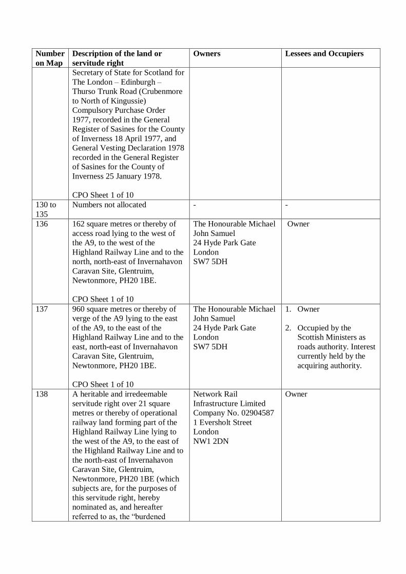
136 162 square metres or thereby of
access road lying to the west of
the A9, to the west of the
Highland Railway Line and to the
north, north-east of Invernahavon
Caravan Site, Glentruim,
Newtonmore, PH20 1BE.
CPO Sheet 1 of 10
The Honourable Michael
John Samuel
24 Hyde Park Gate
London
SW7 5DH
Owner
137 960 square metres or thereby of
verge of the A9 lying to the east
of the A9, to the east of the
Highland Railway Line and to the
east, north-east of Invernahavon
Caravan Site, Glentruim,
Newtonmore, PH20 1BE.
CPO Sheet 1 of 10
The Honourable Michael
John Samuel
24 Hyde Park Gate
London
SW7 5DH
1. Owner
2. Occupied by the
Scottish Ministers as
roads authority. Interest
currently held by the
acquiring authority.
138 A heritable and irredeemable
servitude right over 21 square
metres or thereby of operational
railway land forming part of the
Highland Railway Line lying to
the west of the A9, to the east of
the Highland Railway Line and to
the north-east of Invernahavon
Caravan Site, Glentruim,
Newtonmore, PH20 1BE (which
subjects are, for the purposes of
this servitude right, hereby
nominated as, and hereafter
referred to as, the “burdened
Network Rail
Infrastructure Limited
Company No. 02904587
1 Eversholt Street
London
NW1 2DN
Owner

Number
on Map
Description of the land or
servitude right
Owners Lessees and Occupiers
property”), of laying down and
maintaining drainage apparatus to
convey road and other drainage
from the benefited property (as
hereinafter defined) in and
through the burdened property to
discharge into the unnamed
watercourse and that on a line at
the discretion of the acquiring
authority or their successors as
proprietors of the benefited
property with power to the
acquiring authority and their
successors as aforesaid and those
authorised by them, their
employees and contractors, to
enter on the burdened property for
the purpose of laying down said
drainage apparatus and thereafter
inspecting, maintaining,
improving, repairing and
renewing same.
For the purposes of this servitude
right the following subjects are
hereby nominated and identified
as, and in the foregoing
description referred to as, “the
benefited property”:
i) the subjects numbered plots
114, ,122, 124, 128, 201, 202 and
206 more particularly described in
this Schedule and shown on the
said map.
(ii) ALL and WHOLE the
subjects owned by the Scottish
Ministers described in the General
Vesting Declaration by The
Secretary of State for Scotland for
The London – Edinburgh –
Thurso Trunk Road (Crubenmore
to North of Kingussie)
Compulsory Purchase Order
1977, recorded in the General
Register of Sasines for the County
of Inverness 18 April 1977, and

Number
on Map
Description of the land or
servitude right
Owners Lessees and Occupiers
General Vesting Declaration 1978
recorded in the General Register
of Sasines for the County of
Inverness 25 January 1978.
CPO Sheet 2 of 10
139 to
200
Numbers not allocated - -
201 721 square metres or thereby of
scrubland and woodland lying to
the north-west of the A9, to the
south-east of the Highland
Railway Line and to the south-
west of Ralia Cafe and Tourist
Information, Newtonmore, PH20
1BD.
CPO Sheet 2 of 10
The Honourable Michael
John Samuel
24 Hyde Park Gate
London
SW7 5DH
Owner
202 4,374 square metres or thereby of
the solum and verges of the
U3011 Raliabeag Road, the bed
and banks of the Allt Torran
Daimh and the bed and banks of
two unnamed watercourses lying
to the north-west of the A9, to the
south of the Highland Railway
Line and to the south, south-west
of Ralia Cafe and Tourist
Information, Newtonmore, PH20
1BD.
CPO Sheet 2 of 10
Unknown 1. Occupied by Highland
Council as local roads
authority. Interest of
local roads authority
not being acquired.
2. Sustrans Scotland
Rosebery House
9 Haymarket Terrace
Edinburgh
EH12 5EZ
3. BT Group PLC
Company No.
04190816
BT Centre
81 Newgate Steet
London
EC1A 7AJ
203 16,324 square metres or thereby
of scrubland and woodland lying
to the north-west of the A9, to the
south-east of the Highland
Railway Line and to the south-
west of Ralia Cafe and Tourist
Information, Newtonmore, PH20
1BD.
CPO Sheet 2 of 10
The Honourable Michael
John Samuel
24 Hyde Park Gate
London
SW7 5DH
Owner
Number
on Map
Description of the land or
servitude right
Owners Lessees and Occupiers
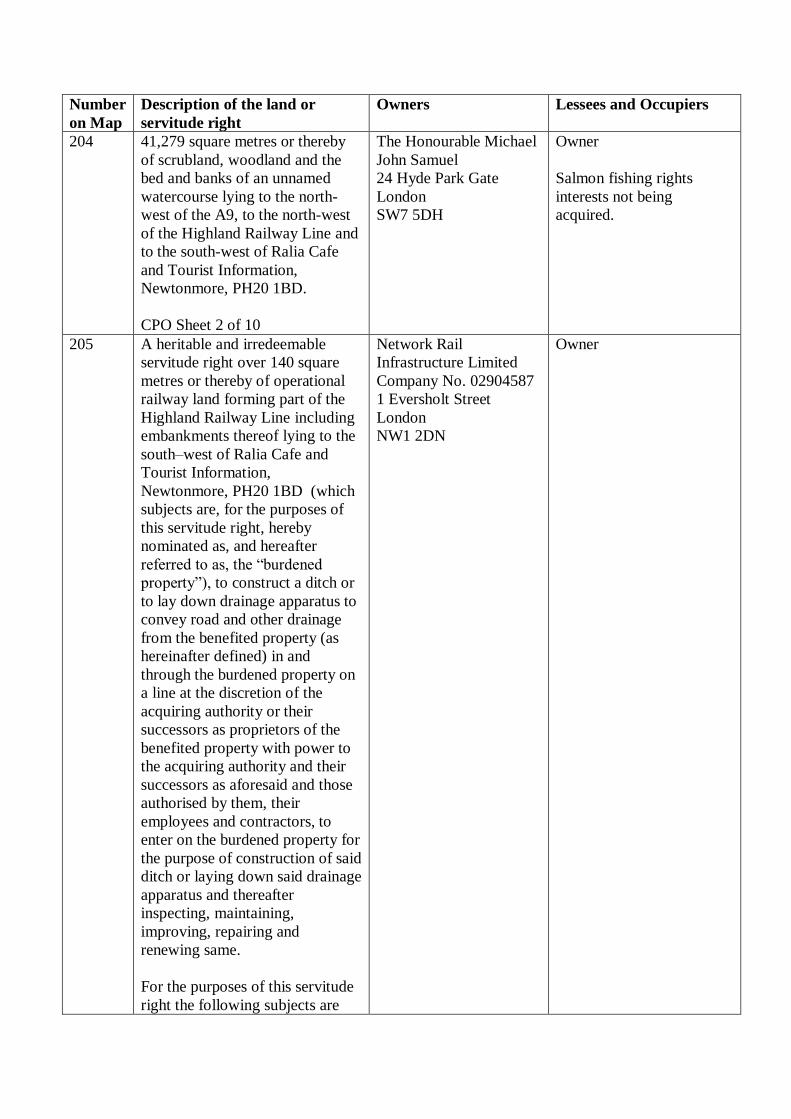
204 41,279 square metres or thereby
of scrubland, woodland and the
bed and banks of an unnamed
watercourse lying to the north-
west of the A9, to the north-west
of the Highland Railway Line and
to the south-west of Ralia Cafe
and Tourist Information,
Newtonmore, PH20 1BD.
CPO Sheet 2 of 10
The Honourable Michael
John Samuel
24 Hyde Park Gate
London
SW7 5DH
Owner
Salmon fishing rights
interests not being
acquired.
205 A heritable and irredeemable
servitude right over 140 square
metres or thereby of operational
railway land forming part of the
Highland Railway Line including
embankments thereof lying to the
south–west of Ralia Cafe and
Tourist Information,
Newtonmore, PH20 1BD (which
subjects are, for the purposes of
this servitude right, hereby
nominated as, and hereafter
referred to as, the “burdened
property”), to construct a ditch or
to lay down drainage apparatus to
convey road and other drainage
from the benefited property (as
hereinafter defined) in and
through the burdened property on
a line at the discretion of the
acquiring authority or their
successors as proprietors of the
benefited property with power to
the acquiring authority and their
successors as aforesaid and those
authorised by them, their
employees and contractors, to
enter on the burdened property for
the purpose of construction of said
ditch or laying down said drainage
apparatus and thereafter
inspecting, maintaining,
improving, repairing and
renewing same.
For the purposes of this servitude
right the following subjects are
Network Rail
Infrastructure Limited
Company No. 02904587
1 Eversholt Street
London
NW1 2DN
Owner

Number
on Map
Description of the land or
servitude right
Owners Lessees and Occupiers
hereby nominated and identified
as, and in the foregoing
description referred to as, “the
benefited property”:
(i) the subjects numbered plots
101, 103, 104, 105, 106, 107, 109,
110, 111, 112, 113, 114, 115, 116,
118, 121, 123, 124, 125, 126, 127,
128, 201, 202, 203, 204, 206 and
208 more particularly described in
this Schedule and shown on the
said map.
(ii) ALL and WHOLE the
subjects owned by the Scottish
Ministers described in the General
Vesting Declaration by The
Secretary of State for Scotland for
The London – Edinburgh –
Thurso Trunk Road (Crubenmore
to North of Kingussie)
Compulsory Purchase Order
1977, recorded in the General
Register of Sasines for the County
of Inverness 18 April 1977, and
General Vesting Declaration 1978
recorded in the General Register
of Sasines for the County of
Inverness 25 January 1978.
CPO Sheet 2 of 10
206 29,902 square metres or thereby
of scrubland and woodland lying
to the south-east of the A9, to the
south-east of the Highland
Railway Line and to the south,
south-west of Ralia Cafe and
Tourist Information,
Newtonmore, PH20 1BD.
CPO Sheet 2 of 10
The Honourable Michael
John Samuel
24 Hyde Park Gate
London
SW7 5DH
1. Owner
2. Scottish and Southern
Energy PLC
Company No.
SC117119
Inveralmond House
200 Dunkeld Road
Perth
PH1 3AQ
207 4,506 square metres or thereby of
woodland, scrubland and the bed
and banks of the Allt Torran
Daimh lying to the north-west of
the A9, to the south-east of the
Highland Railway Line and to the
The Highland Council
Glenurquhart Road
Inverness
IV3 5NX
Owner

Number
on Map
Description of the land or
servitude right
Owners Lessees and Occupiers
south-west of Ralia Cafe and
Tourist Information,
Newtonmore, PH20 1BD.
CPO Sheet 2 of 10
208 11 square metres or thereby of
verge of the A9 lying to the north-
west of the A9, to the south-east
of the Highland Railway Line and
to the south–west of Ralia Cafe
and Tourist Information,
Newtonmore, PH20 1BD.
CPO Sheet 2 of 10
Unknown Occupied by the Scottish
Ministers as roads
authority. Interest currently
held by the acquiring
authority.
209 5,431 square metres or thereby of
woodland, scrubland, track and
the bed and banks of the Allt
Torran Daimh watercourse lying
to the north-west of the A9, to the
south-east of the Highland
Railway Line and south-west of
Ralia Cafe and Tourist
Information, Newtonmore, PH20
1BD.
Land Register of Scotland
Title Number INV26470
CPO Sheet 2 of 10
Robert Andrew Lambie
Mid Mains
Duffus
IV30 5PU
Owner
210 15,420 square metres or thereby
of scrubland, woodland and the
bed and banks of an unnamed
watercourse lying to the south-
east of the A9 and to the south of
Ralia Cafe and Tourist
Information, Newtonmore, PH20
1BD.
CPO Sheet 2 of 10
The Highland Council
Glenurquhart Road
Inverness
IV3 5NX
1. Owner
2. Scottish and Southern
Energy PLC
Company No.
SC117119
Inveralmond House
200 Dunkeld Road
Perth
PH1 3AQ
211 A heritable and irredeemable
servitude right over 202 square
metres or thereby of scrubland
lying to the north-west of the A9,
to the north-west of the Highland
Railway Line and to the south-
west of Ralia Cafe and Tourist
Information, Newtonmore, PH20
1BD (which subjects are, for the
The Honourable Michael
John Samuel
24 Hyde Park Gate
London
SW7 5DH
Owner
Salmon fishing rights
interests not being
acquired.

Number
on Map
Description of the land or
servitude right
Owners Lessees and Occupiers
purposes of this servitude right,
hereby nominated as, and
hereafter referred to as, the
“burdened property”), to construct
a ditch or to lay down drainage
apparatus to convey road and
other drainage from the benefited
property (as hereinafter defined)
in and through the burdened
property to discharge into the
River Spey and that on a line at
the discretion of the acquiring
authority or their successors as
proprietors of the benefited
property with power to the
acquiring authority and their
successors as aforesaid and those
authorised by them, their
employees and contractors, to
enter on the burdened property for
the purpose of construction of said
ditch or laying down said drainage
apparatus and thereafter
inspecting, maintaining,
improving, repairing and
renewing same.
For the purposes of this servitude
right the following subjects are
hereby nominated and identified
as, and in the foregoing
description referred to as, “the
benefited property”:
(i) the subjects numbered plots
101, 103, 104, 105, 106, 107, 109,
110, 111, 112, 113, 114, 115, 116,
118, 121, 123, 124, 125, 126, 127,
128, 201, 202, 203, 204, 206 and
208 more particularly described in
this Schedule and shown on the
said map.
(ii) ALL and WHOLE the
subjects owned by the Scottish
Ministers described in the General
Vesting Declaration by The
Secretary of State for Scotland for

Number
on Map
Description of the land or
servitude right
Owners Lessees and Occupiers
The London – Edinburgh –
Thurso Trunk Road (Crubenmore
to North of Kingussie)
Compulsory Purchase Order
1977, recorded in the General
Register of Sasines for the County
of Inverness 18 April 1977, and
General Vesting Declaration 1978
recorded in the General Register
of Sasines for the County of
Inverness 25 January 1978.
CPO Sheet 2 of 10
212 A heritable and irredeemable
servitude right over 1,110 square
metres or thereby of operational
railway land forming part of the
Highland Railway Line including
embankments thereof, scrubland,
woodland lying to the north-west
of the A9 and to the south–west of
Ralia Cafe and Tourist
Information, Newtonmore, PH20
1BD (which subjects are, for the
purposes of this servitude right,
hereby nominated as, and
hereafter referred to as, the
“burdened property”), of laying
down and maintaining drainage
apparatus to convey road and
other drainage from the benefited
property (as hereinafter defined)
in and through the burdened
property to discharge into an
unnamed watercourse and that on
a line at the discretion of the
acquiring authority or their
successors as proprietors of the
benefited property with power to
the acquiring authority and their
successors as aforesaid and those
authorised by them, their
employees and contractors, to
enter on the burdened property for
the purpose of laying down said
drainage apparatus and thereafter
inspecting, maintaining,
Network Rail
Infrastructure Limited
Company No. 02904587
1 Eversholt Street
London
NW1 2DN
Owner

Number
on Map
Description of the land or
servitude right
Owners Lessees and Occupiers
improving, repairing and
renewing same.
For the purposes of this servitude
right the following subjects are
hereby nominated and identified
as, and in the foregoing
description referred to as, “the
benefited property”:
i) the subjects numbered plots
202, 207, 209 and 210 more
particularly described in this
Schedule and shown on the said
map.
(ii) ALL and WHOLE the
subjects owned by the Scottish
Ministers described in the General
Vesting Declaration by The
Secretary of State for Scotland for
The London – Edinburgh –
Thurso Trunk Road (Crubenmore
to North of Kingussie)
Compulsory Purchase Order
1977, recorded in the General
Register of Sasines for the County
of Inverness 18 April 1977, and
General Vesting Declaration 1978
recorded in the General Register
of Sasines for the County of
Inverness 25 January 1978.
CPO Sheet 2 of 10
213 44 square metres or thereby of
access road lying to the north-
west of the A9 and to the south-
west of Ralia Cafe and Tourist
Information, Newtonmore, PH20
1BD.
Land Register of Scotland
Title Number INV26470
CPO Sheet 2 of 10
Robert Andrew Lambie
Mid Mains
Duffus
IV30 5PU
1. Owner
2. The Highland Council
Glenurquhart Road
Inverness
IV3 5NX
214 27 square metres or thereby of
septic tank, scrubland and tracks
lying to the north-west of the A9,
1. Robert Andrew
Lambie
Mid Mains
Owner

Number
on Map
Description of the land or
servitude right
Owners Lessees and Occupiers
to the south-east of the Highland
Railway Line and to the south-
west of Ralia Cafe and Tourist
Information, Newtonmore, PH20
1BD.
Land Register of Scotland
Title Number INV26470
CPO Sheet 2 of 10
Duffus
IV30 5PU
2. The Highland
Council
Glenurquhart Road
Inverness
IV3 5NX
215 A heritable and irredeemable
servitude right over 412 square
metres or thereby of operational
railway land forming part of the
Highland Railway Line lying to
the north-west of the A9 and to
the south-west of Ralia Cafe and
Tourist Information,
Newtonmore, PH20 1BD (which
subjects are, for the purposes of
this servitude right, hereby
nominated as, and hereafter
referred to as, the “burdened
property”), of laying down and
maintaining drainage apparatus to
convey road and other drainage
from the benefited property (as
hereinafter defined) in and
through the burdened property to
discharge into the unnamed
watercourse and that on a line at
the discretion of the acquiring
authority or their successors as
proprietors of the benefited
property with power to the
acquiring authority and their
successors as aforesaid and those
authorised by them, their
employees and contractors, to
enter on the burdened property for
the purpose of laying down said
drainage apparatus and thereafter
inspecting, maintaining,
improving, repairing and
renewing same.
For the purposes of this servitude
right the following subjects are
Network Rail
Infrastructure Limited
Company No. 02904587
1 Eversholt Street
London
NW1 2DN
Owner

Number
on Map
Description of the land or
servitude right
Owners Lessees and Occupiers
hereby nominated and identified
as, and in the foregoing
description referred to as, “the
benefited property”:
i) the subjects numbered plots
114, 122, 124, 128, 201, 202 and
206 more particularly described in
this Schedule and shown on the
said map.
(ii) ALL and WHOLE the
subjects owned by the Scottish
Ministers described in the General
Vesting Declaration by The
Secretary of State for Scotland for
The London – Edinburgh –
Thurso Trunk Road (Crubenmore
to North of Kingussie)
Compulsory Purchase Order
1977, recorded in the General
Register of Sasines for the County
of Inverness 18 April 1977, and
General Vesting Declaration 1978
recorded in the General Register
of Sasines for the County of
Inverness 25 January 1978.
CPO Sheet 2 of 10
216 2,603 square metres or thereby of
woodland, scrubland, access roads
and car park lying to the north-
west of the A9, to the south-east
of the Highland Railway Line and
to the north-west of Ralia Cafe
and Tourist Information,
Newtonmore, PH20 1BD.
Land Register of Scotland
Title Number INV26470
CPO Sheet 2 of 10
Robert Andrew Lambie
Mid Mains
Duffus
IV30 5PU
Owner
217 846 square metres or thereby of
tracks, woodland and grassland
lying to the north-west of the A9,
to the south-east of the Highland
Railway Line and to the north-
west of Ralia Cafe and Tourist
The Highland Council
Glenurquhart Road
Inverness
IV3 5NX
Owner

Number
on Map
Description of the land or
servitude right
Owners Lessees and Occupiers
Information, Newtonmore, PH20
1BD.
CPO Sheet 2 of 10
218 599 square metres or thereby of
woodland and scrubland lying to
the north-west of the A9 and to
the south-east of the Highland
Railway Line and to the north-east
of Ralia Cafe and Tourist
Information, Newtonmore, PH20
1BD.
Land Register of Scotland
Title Number INV26470
CPO Sheet 2 of 10
Robert Andrew Lambie
Mid Mains
Duffus
IV30 5PU
Owner
219 228 square metres or thereby of
woodland and scrubland lying to
the north-west of the A9, to the
south-east of the River Spey and
to the east, north-east of Ralia
Cafe and Tourist Information,
Newtonmore, PH20 1BD.
CPO Sheet 2 of 10
1. Alasdair Findlay
Ralia Lodge
Ralia
Newtonmore
PH20 1BD
2. James Gavin Morton
Chiene + Tait
61 Dublin Street
Edinburgh
EH3 6NL
and
Robert Ramsey
Maitland
St Nicholas House
68 Station Road
Banchory
AB31 5YJ
and
Allan William
MacPherson-Fletcher
Croftcarnoch
Balavil Estate
Kingussie
PH21 1LU
Owners

Number
on Map
Description of the land or
servitude right
Owners Lessees and Occupiers
as trustees acting
under Deed of Trust
by Eira Drysdale.
220 1,860 square metres or thereby of
scrubland and woodland lying to
the south-east of the A9, to the
south-east of the Highland
Railway Line and to the south-
east of Ralia Cafe and Tourist
Information, Newtonmore, PH20
1BD.
CPO Sheet 2 of 10
The Honourable Michael
John Samuel
24 Hyde Park Gate
London.
SW7 5DH
Owner
221 25,011 square metres or thereby
of scrubland and woodland lying
to the south-east of the A9 and to
the south-east of Ralia Cafe and
Tourist Information,
Newtonmore, PH20 1BD.
CPO Sheet 2 of 10
The Honourable Michael
John Samuel
24 Hyde Park Gate
London
SW7 5DH
1. Owner
2. Scottish and
Southern Energy
PLC
Company No.
SC117119
Inveralmond House
200 Dunkeld Road
Perth
PH1 3AQ
222 538 square metres or thereby of
the solum and verges of the
U3011 Raliabeag Road lying to
the north-west of the A9 and to
the south-east of the Highland
Railway Line.
CPO Sheet 2 of 10
Unknown 1. Occupied by The
Highland Council
as local roads
authority. Interest
of local roads
authority not being
acquired.
2. BT Group PLC
Company No.
04190816
BT Centre
81 Newgate Steet
London
EC1A 7AJ
3. Sustrans Scotland
Rosebery House
9 Haymarket
Terrace
Edinburgh
EH12 5EZ
223 578 square metres or thereby of
scrubland lying to the north-west
1. Alasdair Findlay
Ralia Lodge
Owners

Number
on Map
Description of the land or
servitude right
Owners Lessees and Occupiers
of the A9, to the south-east of the
Highland Railway Line and to the
east, north-east of Ralia Cafe and
Tourist Information,
Newtonmore, PH20 1BD.
CPO Sheet 2 of 10
Ralia
Newtonmore
PH20 1BD
2. James Gavin Morton
Chiene + Tait
61 Dublin Street
Edinburgh
EH3 6NL
and
Robert Ramsey
Maitland
St Nicholas House
68 Station Road
Banchory
AB31 5YJ
and
Allan William
MacPherson-Fletcher
Croftcarnoch
Balavil Estate
Kingussie
PH21 1LU
as trustees acting
under Deed of Trust
by Eira Drysdale.
224 1,524 square metres or thereby of
scrubland and woodland lying to
the north-west of the A9, to the
south-east of the Highland
Railway Line and to the east,
north-east of Ralia Cafe and
Tourist Information,
Newtonmore, PH20 1BD.
CPO Sheet 2 of 10
1. Alasdair Findlay
Ralia Lodge
Ralia
Newtonmore
PH20 1BD
2. James Gavin Morton
Chiene + Tait
61 Dublin Street
Edinburgh
EH3 6NL
and
Robert Ramsey
Maitland
St Nicholas House
Owners

Number
on Map
Description of the land or
servitude right
Owners Lessees and Occupiers
68 Station Road
Banchory
AB31 5YJ
and
Allan William
MacPherson-Fletcher
Croftcarnoch
Balavil Estate
Kingussie
PH21 1LU
as trustees acting
under Deed of Trust
by Eira Drysdale.
225 1,213 square metres or thereby of
the solum and verges of the
U3011 Raliabeag Road and
B9150 Ralia – Newtonmore Road
lying to the north-west of the A9,
to the south-east of the Highland
Railway Line and to the east,
north-east of Ralia Cafe and
Tourist Information,
Newtonmore, PH20 1BD.
CPO Sheet 2 of 10
Unknown 1. Occupied by Highland
Council as local roads
authority. Interest of
local roads authority
not being acquired.
2. Sustrans Scotland
Rosebery House
9 Haymarket Terrace
Edinburgh
EH12 5EZ
226 286 square metres or thereby of
woodland lying to the north-west
of the A9, to the south-east of the
B9150 Ralia – Newtonmore Road
and to the north-east of Ralia Cafe
and Tourist Information,
Newtonmore, PH20 1BD.
CPO Sheet 2 of 10
1. Alasdair Findlay
Ralia Lodge
Ralia
Newtonmore
PH20 1BD
2. James Gavin Morton
Chiene + Tait
61 Dublin Street
Edinburgh
EH3 6NL
and
Robert Ramsey
Maitland
St Nicholas House
68 Station Road
Banchory
AB31 5YJ
Owners
Number
on Map
Description of the land or
servitude right
Owners Lessees and Occupiers
and
Allan William
MacPherson-Fletcher
Croftcarnoch
Balavil Estate
Kingussie
PH21 1LU
as trustees acting
under Deed of Trust
by Eira Drysdale.
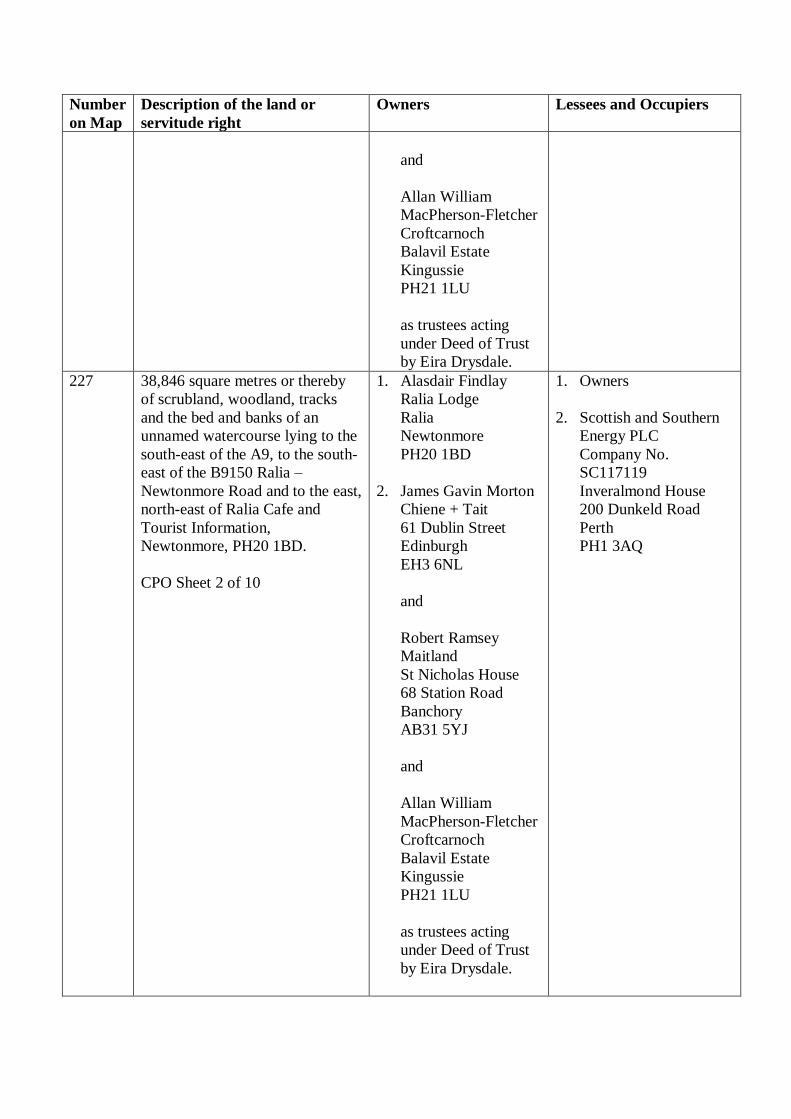
227 38,846 square metres or thereby
of scrubland, woodland, tracks
and the bed and banks of an
unnamed watercourse lying to the
south-east of the A9, to the south-
east of the B9150 Ralia –
Newtonmore Road and to the east,
north-east of Ralia Cafe and
Tourist Information,
Newtonmore, PH20 1BD.
CPO Sheet 2 of 10
1. Alasdair Findlay
Ralia Lodge
Ralia
Newtonmore
PH20 1BD
2. James Gavin Morton
Chiene + Tait
61 Dublin Street
Edinburgh
EH3 6NL
and
Robert Ramsey
Maitland
St Nicholas House
68 Station Road
Banchory
AB31 5YJ
and
Allan William
MacPherson-Fletcher
Croftcarnoch
Balavil Estate
Kingussie
PH21 1LU
as trustees acting
under Deed of Trust
by Eira Drysdale.
1. Owners
2. Scottish and Southern
Energy PLC
Company No.
SC117119
Inveralmond House
200 Dunkeld Road
Perth
PH1 3AQ
Number
on Map
Description of the land or
servitude right
Owners Lessees and Occupiers
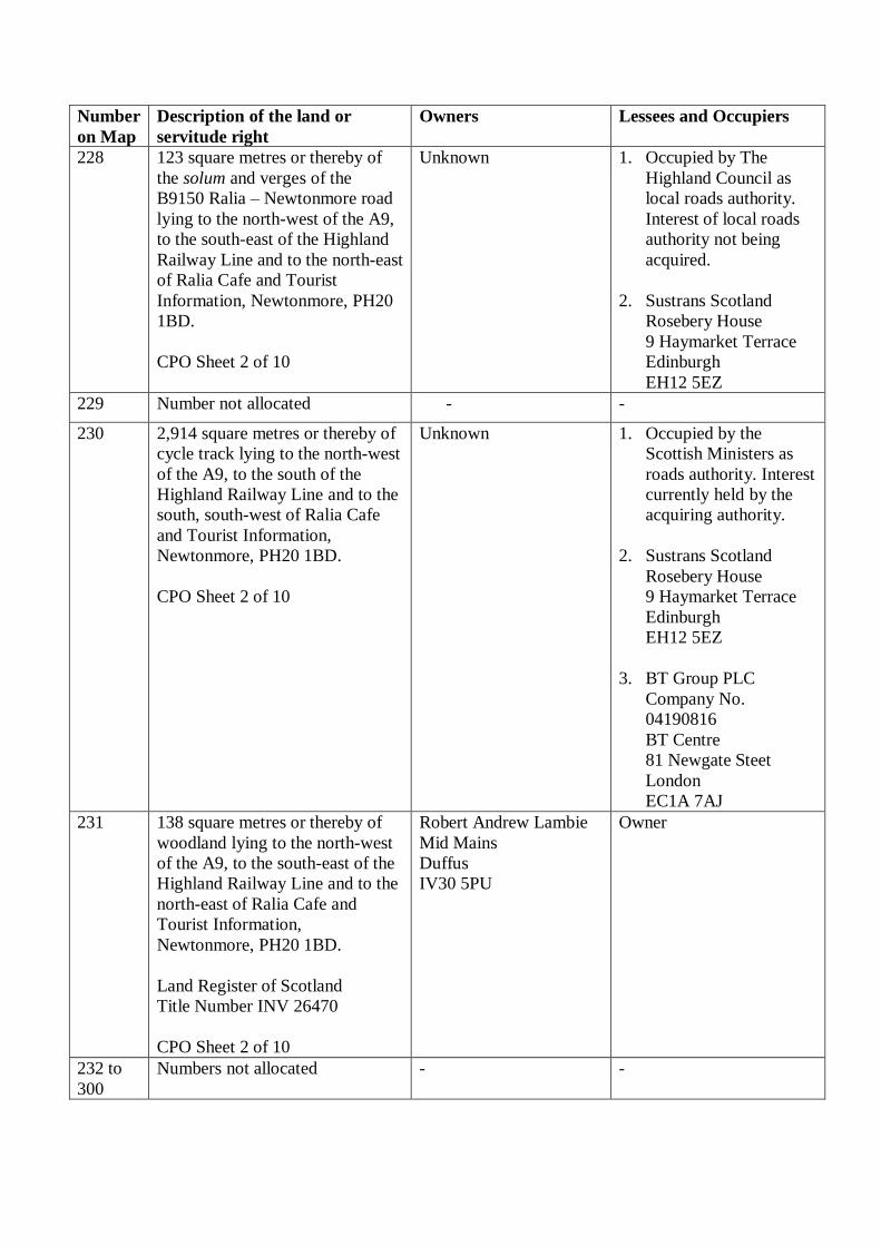
228 123 square metres or thereby of
the solum and verges of the
B9150 Ralia – Newtonmore road
lying to the north-west of the A9,
to the south-east of the Highland
Railway Line and to the north-east
of Ralia Cafe and Tourist
Information, Newtonmore, PH20
1BD.
CPO Sheet 2 of 10
Unknown 1. Occupied by The
Highland Council as
local roads authority.
Interest of local roads
authority not being
acquired.
2. Sustrans Scotland
Rosebery House
9 Haymarket Terrace
Edinburgh
EH12 5EZ
229 Number not allocated - -
230 2,914 square metres or thereby of
cycle track lying to the north-west
of the A9, to the south of the
Highland Railway Line and to the
south, south-west of Ralia Cafe
and Tourist Information,
Newtonmore, PH20 1BD.
CPO Sheet 2 of 10
Unknown 1. Occupied by the
Scottish Ministers as
roads authority. Interest
currently held by the
acquiring authority.
2. Sustrans Scotland
Rosebery House
9 Haymarket Terrace
Edinburgh
EH12 5EZ
3. BT Group PLC
Company No.
04190816
BT Centre
81 Newgate Steet
London
EC1A 7AJ
231 138 square metres or thereby of
woodland lying to the north-west
of the A9, to the south-east of the
Highland Railway Line and to the
north-east of Ralia Cafe and
Tourist Information,
Newtonmore, PH20 1BD.
Land Register of Scotland
Title Number INV 26470
CPO Sheet 2 of 10
Robert Andrew Lambie
Mid Mains
Duffus
IV30 5PU
Owner
232 to
300
Numbers not allocated - -

Number
on Map
Description of the land or
servitude right
Owners Lessees and Occupiers
301 82,150 square metres or thereby
of scrubland, woodland and the
bed and banks of three unnamed
watercourses lying to the south-
east of the A9, to the south-east of
the U3063 Ralia – Nuide Road
and to the south-east of the
Highland Railway Line.
Land Register of Scotland
Title Number INV28008
CPO Sheet 3 of 10
1. Alasdair Findlay
Ralia Lodge
Ralia
Newtonmore
PH20 1BD
2. James Gavin Morton
Chiene + Tait
61 Dublin Street
Edinburgh
EH3 6NL
and
Robert Ramsey
Maitland
St Nicholas House
68 Station Road
Banchory
AB31 5YJ
and
Allan William
MacPherson-Fletcher
Croftcarnoch
Balavil Estate
Kingussie
PH21 1LU
as trustees acting
under Deed of Trust
by Eira Drysdale.
1. Owners
2. Scottish and Southern
Energy PLC
Company No.
SC117119
Inveralmond House
200 Dunkeld Road
Perth
PH1 3AQ
3. Colin MacKenzie
Stewart
Coru
Newtonmore
PH20 1BD
302 15,806 square metres or thereby
of woodland and the bed and
banks of an unnamed watercourse
lying to the north-west of the A9,
to the south, south-east of the
B9150 Ralia – Newtonmore Road
and to the west, south-west of
Ralia Lodge, Ralia, Newtonmore,
PH20 1BD.
CPO Sheet 3 of 10
1. Alasdair Findlay
Ralia Lodge
Ralia
Newtonmore
PH20 1BD
2. James Gavin Morton
Chiene + Tait
61 Dublin Street
Edinburgh
EH3 6NL
and
Owners

Number
on Map
Description of the land or
servitude right
Owners Lessees and Occupiers
Robert Ramsey
Maitland
St Nicholas House
68 Station Road
Banchory
AB31 5YJ
and
Allan William
MacPherson-Fletcher
Croftcarnoch
Balavil Estate
Kingussie
PH21 1LU
as trustees acting
under Deed of Trust
by Eira Drysdale.
303 4,005 square metres or thereby of
the solum and verges of the
B9150 Ralia – Newtonmore Road
lying to the north-west of the A9,
to the south-east of the Highland
Railway Line and to the west,
south-west of Ralia Lodge, Ralia,
Newtonmore, PH20 1BD.
CPO Sheet 3 of 10
Unknown 1. Occupied by The
Highland Council as
local roads authority.
Interest of local roads
authority not being
acquired.
2. Sustrans Scotland
Rosebery House
9 Haymarket Terrace
Edinburgh
EH12 5EZ
304 2,048 square metres or thereby of
scrubland lying to the north-west
of the A9, to the south of the
River Spey and to the west, south-
west of Ralia Lodge, Ralia,
Newtonmore, PH20 1BD.
CPO Sheet 3 of 10
1. Alasdair Findlay
Ralia Lodge
Ralia
Newtonmore
PH20 1BD
2. James Gavin Morton
Chiene + Tait
61 Dublin Street
Edinburgh
EH3 6NL
and
Robert Ramsey
Maitland
St Nicholas House
Owners

Number
on Map
Description of the land or
servitude right
Owners Lessees and Occupiers
68 Station Road
Banchory
AB31 5YJ
and
Allan William
MacPherson-Fletcher
Croftcarnoch
Balavil Estate
Kingussie
PH21 1LU
as trustees acting
under Deed of Trust
by Eira Drysdale.
305 19,227 square metres or thereby
of scrubland and woodland lying
to the north-west of the A9, to the
south of the River Spey and to the
west, south-west of Ralia Lodge,
Ralia, Newtonmore, PH20 1BD.
CPO Sheet 3 of 10
1. Alasdair Findlay
Ralia Lodge
Ralia
Newtonmore
PH20 1BD
2. James Gavin Morton
Chiene + Tait
61 Dublin Street
Edinburgh
EH3 6NL
and
Robert Ramsey
Maitland
St Nicholas House
68 Station Road
Banchory
AB31 5YJ
and
Allan William
MacPherson-Fletcher
Croftcarnoch
Balavil Estate
Kingussie
PH21 1LU
Owners

Number
on Map
Description of the land or
servitude right
Owners Lessees and Occupiers
as trustees acting
under Deed of Trust
by Eira Drysdale.
306 187 square metres or thereby of
track lying to the north-west of
the A9, to the north-west of the
B9150 Ralia – Newtonmore Road
and to the west, south-west of
Ralia Lodge, Ralia, Newtonmore,
PH20 1BD.
Land Register of Scotland
Title Number INV7202
Title Number INV17502
Title Number INV17504
CPO Sheet 3 of 10
1. Alasdair Findlay
Ralia Lodge
Ralia
Newtonmore
PH20 1BD
2. James Gavin Morton
Chiene + Tait
61 Dublin Street
Edinburgh
EH3 6NL
and
Robert Ramsey
Maitland
St Nicholas House
68 Station Road
Banchory
AB31 5YJ
and
Allan William
MacPherson-Fletcher
Croftcarnoch
Balavil Estate
Kingussie
PH21 1LU
as trustees acting
under Deed of Trust
by Eira Drysdale.
1. Owners
2. Keith Adrian Halls
Glen View
Ralia
Newtonmore
PH20 1BD
3. John Robert Raw and
Frances Margaret Raw
Birchwood
Ralia
Newtonmore
PH20 1BD
4. George Thomas Gibson
and Helen McKendrick
Rintoul Invermore
Lodge
Newtonmore
PH20 1BD
5. Network Rail
Infrastructure Limited
Company No.
02904587
1 Eversholt Street
London
NW1 2DN
307 64 square metres or thereby of the
solum and verges of the B9150
Ralia – Newtonmore Road lying
to the north-west of the A9, to the
north-west of the Highland
Railway Line and to the west,
north-west of Ralia Lodge, Ralia,
Newtonmore, PH20 1BD.
CPO Sheet 3 of 10
Unknown 1. Occupied by The
Highland Council as
local roads authority.
Interest of local roads
authority not being
acquired.
2. Sustrans Scotland
Rosebery House
9 Haymarket Terrace
Edinburgh
EH12 5EZ

Number
on Map
Description of the land or
servitude right
Owners Lessees and Occupiers
308 68 square metres or thereby of
track lying to the north-west of
the A9, to the north-west of the
B9150 Ralia – Newtonmore Road
and to the west, south-west of
Ralia Lodge, Ralia, Newtonmore,
PH20 1BD.
CPO Sheet 3 of 10
1. Alasdair Findlay
Ralia Lodge
Ralia
Newtonmore
PH20 1BD
2. James Gavin Morton
Chiene + Tait
61 Dublin Street
Edinburgh
EH3 6NL
and
Robert Ramsey
Maitland
St Nicholas House
68 Station Road
Banchory
AB31 5YJ
and
Allan William
MacPherson-Fletcher
Croftcarnoch
Balavil Estate
Kingussie
PH21 1LU
as trustees acting
under Deed of Trust
by Eira Drysdale.
1. Owners
2. Network Rail
Infrastructure Limited
Company No.
02904587
1 Eversholt Street
London
NW1 2DN
309 Number not allocated - -
310 A heritable and irredeemable
servitude right over 82 square
metres or thereby of operational
railway land forming part of the
Highland Railway Line, including
embankments thereof, woodland
and track lying to the north-west
of the A9, to the south-east of the
River Spey and to the north,
north-west of Invermore Lodge,
Ralia, Newtonmore, PH20 1BD
(which subjects are, for the
purposes of this servitude right,
Network Rail
Infrastructure Limited
Company No. 02904587
1 Eversholt Street
London
NW1 2DN
Owner

Number
on Map
Description of the land or
servitude right
Owners Lessees and Occupiers
hereby nominated as, and
hereafter referred to as, the
“burdened property”), of laying
down and maintaining drainage
apparatus to convey road and
other drainage between the
benefited property (as hereinafter
defined) in and through the
burdened property and that on a
line at the discretion of the
acquiring authority or their
successors as proprietors of the
benefited property with power to
the acquiring authority and their
successors as aforesaid and those
authorised by them, their
employees and contractors, to
enter on the burdened property for
the purpose of laying down said
drainage apparatus and thereafter
inspecting, maintaining,
improving, repairing and
renewing same.
For the purposes of this servitude
right the following subjects are
hereby nominated and identified
as, and in the foregoing
description referred to as, “the
benefited property”:
i) the subjects numbered plots
222, 223, 224, 226, 227, 301, 302,
303, 304, 305, 306, 307, 313, 318,
329, 339, 340, 342, 347 and 348
more particularly described in this
Schedule and shown on the said
map.
(ii) ALL and WHOLE the
subjects owned by the Scottish
Ministers described in the General
Vesting Declaration by The
Secretary of State for Scotland for
The London – Edinburgh –
Thurso Trunk Road (Crubenmore
to North of Kingussie)
Compulsory Purchase Order

Number
on Map
Description of the land or
servitude right
Owners Lessees and Occupiers
1977, recorded in the General
Register of Sasines for the County
of Inverness 18 April 1977, and
General Vesting Declaration 1978
recorded in the General Register
of Sasines for the County of
Inverness 25 January 1978.
CPO Sheet 3 of 10
311 A heritable and irredeemable
servitude right over 862 square
metres or thereby of woodland
lying to the north-west of the A9,
to the north-west of the B9150
Ralia – Newtonmore Road and to
the north-west of Invermore
Lodge, Ralia, Newtonmore, PH20
1BD (which subjects are, for the
purposes of this servitude right,
hereby nominated as, and
hereafter referred to as, the
“burdened property”), of laying
down and maintaining drainage
apparatus to convey road and
other drainage from the benefited
property (as hereinafter defined)
in and through the burdened
property to discharge into the
River Spey and that on a line at
the discretion of the acquiring
authority or their successors as
proprietors of the benefited
property with power to the
acquiring authority and their
successors as aforesaid and those
authorised by them, their
employees and contractors, to
enter on the burdened property for
the purpose of laying down said
drainage apparatus and thereafter
inspecting, maintaining,
improving, repairing and
renewing same.
For the purposes of this servitude
right the following subjects are
hereby nominated and identified
as, and in the foregoing
1. Alasdair Findlay
Ralia Lodge
Ralia
Newtonmore
PH20 1BD
2. James Gavin Morton
Chiene + Tait
61 Dublin Street
Edinburgh
EH3 6NL
and
Robert Ramsey
Maitland
St Nicholas House
68 Station Road
Banchory
AB31 5YJ
and
Allan William
MacPherson-Fletcher
Croftcarnoch
Balavil Estate
Kingussie
PH21 1LU
as trustees acting
under Deed of Trust
by Eira Drysdale.
Owners
Salmon fishing rights
interests not being
acquired.

Number
on Map
Description of the land or
servitude right
Owners Lessees and Occupiers
description referred to as, “the
benefited property”:
i) the subjects numbered plots
222, 223, 224, 226, 227, 301, 302,
303, 304, 305, 306, 307, 313, 318,
329, 339, 340, 342, 347 and 348
more particularly described in this
Schedule and shown on the said
map.
(ii) ALL and WHOLE the
subjects owned by the Scottish
Ministers described in the General
Vesting Declaration by The
Secretary of State for Scotland for
The London – Edinburgh –
Thurso Trunk Road (Crubenmore
to North of Kingussie)
Compulsory Purchase Order
1977, recorded in the General
Register of Sasines for the County
of Inverness 18 April 1977, and
General Vesting Declaration 1978
recorded in the General Register
of Sasines for the County of
Inverness 25 January 1978.
CPO Sheet 3 of 10
312 Number not allocated - -
313 3,363 square metres or thereby of
woodland and scrubland lying to
the north-west of the U3063 Ralia
– Nuide Road, to the south-west
of the Highland Railway Line and
to the east of Invermore Lodge,
Ralia, Newtonmore, PH20 1BD.
CPO Sheet 3 of 10
Alasdair Findlay
Ralia Lodge
Ralia
Newtonmore
PH20 1BD
Owner
314 20,034 square metres or thereby
of grassland, scrubland and the
bed and banks of an unnamed
watercourse lying to the north-
west of the A9, to the south-east
of the Highland Railway Line and
to the east, north-east of Ralia
1. Alasdair Findlay
Ralia Lodge
Ralia
Newtonmore
PH20 1BD
2. James Gavin Morton
Chiene + Tait
Owners

Number
on Map
Description of the land or
servitude right
Owners Lessees and Occupiers
Lodge, Ralia, Newtonmore, PH20
1BD.
CPO Sheet 3 of 10
61 Dublin Street
Edinburgh
EH3 6NL
and
Robert Ramsey
Maitland
St Nicholas House
68 Station Road
Banchory
AB31 5YJ
and
Allan William
MacPherson-Fletcher
Croftcarnoch
Balavil Estate
Kingussie
PH21 1LU
as trustees acting
under Deed of Trust
by Eira Drysdale.
315 171 square metres or thereby of
woodland, scrubland and the bed
and banks of an unnamed
watercourse lying to the north-
west of the A9, to the north-west
of the U3063 Ralia – Nuide Road
and to the west, south-west of
Ralia Lodge, Ralia, Newtonmore,
PH20 1BD.
CPO Sheet 3 of 10
Alasdair Findlay
Ralia Lodge
Ralia
Newtonmore
PH20 1BD
Owner
316 15,167 square metres or thereby
of grassland and woodland lying
to the north-west of the A9, to the
south-east of the River Spey and
to the north-east of Milton Lodge,
Ralia, Newtonmore, PH20 1BD.
CPO Sheet 3 of 10
1. Alasdair Findlay
Ralia Lodge
Ralia
Newtonmore
PH20 1BD
2. James Gavin Morton
Chiene + Tait
61 Dublin Street
Edinburgh
EH3 6NL
Owner
Salmon fishing rights
interests not being
acquired.

Number
on Map
Description of the land or
servitude right
Owners Lessees and Occupiers
and
Robert Ramsey
Maitland
St Nicholas House
68 Station Road
Banchory
AB31 5YJ
and
Allan William
MacPherson-Fletcher
Croftcarnoch
Balavil Estate
Kingussie
PH21 1LU
as trustees acting
under Deed of Trust
by Eira Drysdale.
317 136 square metres or thereby of
woodland lying north-west of the
A9, to the south-east of the
Highland Railway Line and to the
west, south-west of Ralia Lodge,
Ralia, Newtonmore, PH20 1BD.
CPO Sheet 3 of 10
Alasdair Findlay
Ralia Lodge
Ralia
Newtonmore
PH20 1BD
Owner
318 684 square metres or thereby of
the solum and verges of the
U3063 Ralia – Nuide Road lying
to the north-west of the A9, to the
south-east of the Highland
Railway Line and to the east,
south-east of Invermore Lodge,
Ralia, Newtonmore, PH20 1BD.
CPO Sheet 3 of 10
Unknown Occupied by The Highland
Council as local roads
authority. Interest of local
roads authority not being
acquired.
319 975 square metres or thereby of
woodland and the bed and banks
of an unnamed watercourse lying
to the south-east of the U3063
Ralia – Nuide Road, to the north-
west of the A9 and to the south of
Ralia Lodge, Ralia, Newtonmore,
PH20 1BD.
Alasdair Findlay
Ralia Lodge
Ralia
Newtonmore
PH20 1BD
Owner

Number
on Map
Description of the land or
servitude right
Owners Lessees and Occupiers
CPO Sheet 3 of 10
320 195 square metres or thereby of
woodland lying to the south-east
of the U3063 Ralia – Nuide Road,
to the north-west of the A9 and to
the east, south-east of Ralia
Lodge, Ralia, Newtonmore, PH20
1BD.
CPO Sheet 3 of 10
Alasdair Findlay
Ralia Lodge
Ralia
Newtonmore
PH20 1BD
Owner
321 Number not allocated - -
322 254 square metres or thereby of
woodland lying to the north-west
of the U3063 Ralia – Nuide Road,
to the north-west of the A9 and to
the east of Ralia Lodge, Ralia,
Newtonmore, PH20 1BD.
CPO Sheet 3 of 10
Alasdair Findlay
Ralia Lodge
Ralia
Newtonmore
PH20 1BD
Owner
323 10,092 square metres or thereby
of grassland and scrubland lying
to the north-west of the A9, to the
south-east of the Highland
Railway Line and to the east,
south-east of Milton Lodge, Ralia,
Newtonmore, PH20 1BD.
Land Register of Scotland
Title Number INV519
CPO Sheet 3 of 10
James Anthony Findlay
50 Chelsea Square
London
SW3 6LH
1. Owner
2. Alasdair Findlay
Ralia Lodge
Ralia
Newtonmore
PH20 1BD
324 3 square metres or thereby of
track lying to the north-west of
the A9, to the south-east of the
Highland Railway Line and to the
east, south-east of Milton Lodge,
Ralia, Newtonmore, PH20 1BD.
Land Register of Scotland
Title Number INV519
CPO Sheet 3 of 10
James Anthony Findlay
50 Chelsea Square
London
SW3 6LH
1. Owner
2. Alasdair Findlay
Ralia Lodge
Ralia
Newtonmore
PH20 1BD
325 to
326 Numbers not allocated - -
327 81 square metres or thereby of
track lying to the north-west of
the A9, to the south-east of the
James Anthony Findlay
50 Chelsea Square
London
1. Owner
2. Alasdair Findlay

Number
on Map
Description of the land or
servitude right
Owners Lessees and Occupiers
Highland Railway Line and to the
east, south-east of Milton Lodge,
Ralia, Newtonmore, PH20 1BD.
Land Register of Scotland
Title Number INV519
CPO Sheet 3 of 10
SW3 6LH Ralia Lodge
Ralia
Newtonmore
PH20 1BD
328 30 square metres or thereby of
scrubland lying to the north-west
of the A9, to the south-east of the
Highland Railway Line and to the
east, south-east of Milton Lodge,
Ralia, Newtonmore, PH20 1BD.
CPO Sheet 3 of 10
James Anthony Findlay
50 Chelsea Square
London
SW3 6LH
Owner
329 3,204 square metres or thereby of
scrubland lying to the north-west
of the A9 and to the south-east of
the Highland Railway Line and to
the south-east of Milton Lodge,
Ralia, Newtonmore, PH20 1BD.
CPO Sheet 3 of 10
1. Alasdair Findlay
Ralia Lodge
Ralia
Newtonmore
PH20 1BD
2. James Gavin Morton
Chiene + Tait
61 Dublin Street
Edinburgh
EH3 6NL
and
Robert Ramsey
Maitland
St Nicholas House
68 Station Road
Banchory
AB31 5YJ
and
Allan William
MacPherson-Fletcher
Croftcarnoch
Balavil Estate
Kingussie
PH21 1LU
Owners
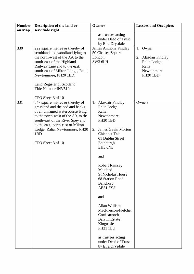
Number
on Map
Description of the land or
servitude right
Owners Lessees and Occupiers
as trustees acting
under Deed of Trust
by Eira Drysdale.
330 222 square metres or thereby of
scrubland and woodland lying to
the north-west of the A9, to the
south-east of the Highland
Railway Line and to the east,
south-east of Milton Lodge, Ralia,
Newtonmore, PH20 1BD.
Land Register of Scotland
Title Number INV519
CPO Sheet 3 of 10
James Anthony Findlay
50 Chelsea Square
London
SW3 6LH
1. Owner
2. Alasdair Findlay
Ralia Lodge
Ralia
Newtonmore
PH20 1BD
331 547 square metres or thereby of
grassland and the bed and banks
of an unnamed watercourse lying
to the north-west of the A9, to the
south-east of the River Spey and
to the east, north-east of Milton
Lodge, Ralia, Newtonmore, PH20
1BD.
CPO Sheet 3 of 10
1. Alasdair Findlay
Ralia Lodge
Ralia
Newtonmore
PH20 1BD
2. James Gavin Morton
Chiene + Tait
61 Dublin Street
Edinburgh
EH3 6NL
and
Robert Ramsey
Maitland
St Nicholas House
68 Station Road
Banchory
AB31 5YJ
and
Allan William
MacPherson-Fletcher
Croftcarnoch
Balavil Estate
Kingussie
PH21 1LU
as trustees acting
under Deed of Trust
by Eira Drysdale.
Owners

Number
on Map
Description of the land or
servitude right
Owners Lessees and Occupiers
332 323 square metres or thereby of
scrubland and woodland lying to
the north-west of the A9, to the
south-east of the River Spey and
to the east, south-east of Milton
Lodge, Ralia, Newtonmore, PH20
1BD.
CPO Sheet 3 of 10
1. Alasdair Findlay
Ralia Lodge
Ralia
Newtonmore
PH20 1BD
2. James Gavin Morton
Chiene + Tait
61 Dublin Street
Edinburgh
EH3 6NL
and
Robert Ramsey
Maitland
St Nicholas House
68 Station Road
Banchory
AB31 5YJ
and
Allan William
MacPherson-Fletcher
Croftcarnoch
Balavil Estate
Kingussie
PH21 1LU
as trustees acting
under Deed of Trust
by Eira Drysdale.
Owners
333 Number not allocated - -
334 493 square metres or thereby of
scrubland and woodland lying to
the north-west of the A9, to the
south-east of the River Spey and
to the east, south-east of Milton
Lodge, Ralia, Newtonmore, PH20
1BD.
CPO Sheet 3 of 10
1. Alasdair Findlay
Ralia Lodge
Ralia
Newtonmore
PH20 1BD
2. James Gavin Morton
Chiene + Tait
61 Dublin Street
Edinburgh
EH3 6NL
Owners

Number
on Map
Description of the land or
servitude right
Owners Lessees and Occupiers
and
Robert Ramsey
Maitland
St Nicholas House
68 Station Road
Banchory
AB31 5YJ
and
Allan William
MacPherson-Fletcher
Croftcarnoch
Balavil Estate
Kingussie
PH21 1LU
as trustees acting
under Deed of Trust
by Eira Drysdale.
335 to
336
Numbers not allocated - -
337 6,890 square metres or thereby of
woodland lying to the north-west
of the A9, to the south-east of the
River Spey and to the east, north-
east of Milton Lodge, Ralia,
Newtonmore, PH20 1BD.
CPO Sheet 3 of 10
1. Alasdair Findlay
Ralia Lodge
Ralia
Newtonmore
PH20 1BD
2. James Gavin Morton
Chiene + Tait
61 Dublin Street
Edinburgh
EH3 6NL
and
Robert Ramsey
Maitland
St Nicholas House
68 Station Road
Banchory
AB31 5YJ
and
Allan William
MacPherson-Fletcher
Owners

Number
on Map
Description of the land or
servitude right
Owners Lessees and Occupiers
Croftcarnoch
Balavil Estate
Kingussie
PH21 1LU
as trustees acting
under Deed of Trust
by Eira Drysdale.
338 393 square metres or thereby of
the solum and verges of the
U3063 Ralia – Nuide Road and
the bed and banks of the Caochan
Riabhack watercourse lying to the
north-west of the A9, to the south-
east of the Highland Railway Line
and to the west, south-west of
Ralia Lodge, Ralia, Newtonmore,
PH20 1BD.
CPO Sheet 3 of 10
Unknown Occupied by The Highland
Council as local roads
authority. Interest of local
roads authority not being
acquired.
339 125 square metres or thereby of
the track road lying to the north-
west of the B9150 Ralia –
Newtonmore Road and to the
north-west of the A9 and to the
south-east of the River Spey.
Land Register of Scotland
Title Number INV17502
Title Number INV17504
CPO Sheet 3 of 10
1. Alasdair Findlay
Ralia Lodge
Ralia
Newtonmore
PH20 1BD
2. James Gavin Morton
Chiene + Tait
61 Dublin Street
Edinburgh
EH3 6NL
and
Robert Ramsey
Maitland
St Nicholas House
68 Station Road
Banchory
AB31 5YJ
and
Allan William
MacPherson-Fletcher
Croftcarnoch
Balavil Estate
Kingussie
1. Owners
2. Keith Adrian Halls,
Glen View
Ralia
Newtonmore
PH20 1BD
3. John Robert Raw and
Frances Margaret Raw
Birchwood
Ralia
Newtonmore
PH20 1BD
4. Network Rail
Infrastructure Limited
Company No.
02904587
1 Eversholt Street
London
NW1 2DN

Number
on Map
Description of the land or
servitude right
Owners Lessees and Occupiers
PH21 1LU
as trustees acting
under Deed of Trust
by Eira Drysdale.
340 241 square metres or thereby of
track lying to the north-west of
the A9, to the north-west of the
B9150 Ralia – Newtonmore Road
and to the west, south-west of
Ralia Lodge, Ralia, Newtonmore,
PH20 1BD.
CPO Sheet 3 of 10
1. Alasdair Findlay
Ralia Lodge
Ralia
Newtonmore
PH20 1BD
2. James Gavin Morton
Chiene + Tait
61 Dublin Street
Edinburgh
EH3 6NL
and
Robert Ramsey
Maitland
St Nicholas House
68 Station Road
Banchory
AB31 5YJ
and
Allan William
MacPherson-Fletcher
Croftcarnoch
Balavil Estate
Kingussie
PH21 1LU
as trustees acting
under Deed of Trust
by Eira Drysdale.
1. Owners
2. John Robert Raw and
Frances Margaret Raw
Birchwood
Ralia
Newtonmore
PH20 1BD
3. Network Rail
Infrastructure Limited
Company No.
02904587
1 Eversholt Street
London
NW1 2DN
341 Number not allocated - -
342 301 square metres or thereby of
woodland lying to the north-west
of the A9 and to the south-east of
the River Spey and to the north of
Invermore Lodge, Ralia,
Newtonmore, PH20 1BD.
CPO Sheet 3 of 10
1. Alasdair Findlay
Ralia Lodge
Ralia
Newtonmore
PH20 1BD
2. James Gavin Morton
Chiene + Tait
Owners

Number
on Map
Description of the land or
servitude right
Owners Lessees and Occupiers
61 Dublin Street
Edinburgh
EH3 6NL
and
Robert Ramsey
Maitland
St Nicholas House
68 Station Road
Banchory
AB31 5YJ
and
Allan William
MacPherson-Fletcher
Croftcarnoch
Balavil Estate
Kingussie
PH21 1LU
as trustees acting
under Deed of Trust
by Eira Drysdale.
343 370 square metres or thereby of
the solum and verges of the
U3063 Ralia – Nuide Road lying
to the north-west of the A9, to the
south-east of the Highland
Railway and to the south-west of
Ralia Lodge, Ralia, Newtonmore,
PH20 1BD.
CPO Sheet 3 of 10
Unknown Occupied by The Highland
Council as local roads
authority. Interest of local
roads authority not being
acquired.
344 449 square metres or thereby of
the solum and verges of the
U3063 Ralia – Nuide Road lying
to the north-west of the A9, to the
south-east of the Highland
Railway Line and to the south-
east of Ralia Lodge, Ralia,
Newtonmore, PH20 1BD.
CPO Sheet 3 of 10
Unknown Occupied by The Highland
Council as local roads
authority. Interest of local
roads authority not being
acquired.
345 300 square metres or thereby of
the solum and verges of the
U3063 Ralia – Nuide Road lying
Unknown Occupied by The Highland
Council as local roads
authority. Interest of local

Number
on Map
Description of the land or
servitude right
Owners Lessees and Occupiers
to the north-west of the A9, to the
south-east of the Highland
Railway Line and to the south,
south-west of Milton Lodge,
Ralia, Newtonmore, PH20 1BD.
CPO Sheet 3 of 10
roads authority not being
acquired.
346 307 square metres or thereby of
the solum and verges of the
U3063 Ralia – Nuide Road lying
to the north-west of the A9, to the
south-east of the Highland
Railway Line, and to the east,
south-east of the Milton Lodge,
Ralia, Newtonmore, PH20 1BD.
CPO Sheet 3 of 10
Unknown Occupied by The Highland
Council as local roads
authority. Interest of local
roads authority not being
acquired.
347 370 square metres or thereby of
the solum and verges of the
U3063 Ralia – Nuide Road lying
to the north-west of the A9, to the
south-east of the River Spey and
to the east, south-east of Milton
Lodge, Ralia, Newtonmore, PH20
1BD.
CPO Sheet 3 of 10
Unknown Occupied by The Highland
Council as local roads
authority. Interest of local
roads authority not being
acquired.
348 672 square metres or thereby of
the solum and verges of the
U3063 Ralia – Nuide Road lying
to the north-west of the A9, to the
south-east of the River Spey and
to the east, south-east of Milton
Lodge, Ralia, Newtonmore, PH20
1BD.
CPO Sheet 3 of 10
Unknown Occupied by The Highland
Council as local roads
authority. Interest of local
roads authority not being
acquired.
349 414 square metres or thereby of
the solum and verges of the
U3063 Ralia – Nuide Road lying
to the north-west of the A9, to the
south-east of the River Spey and
to the east of Milton Lodge, Ralia,
Newtonmore, PH20 1BD.
CPO Sheet 3 of 10
Unknown Occupied by The Highland
Council as local roads
authority. Interest of local
roads authority not being
acquired.
350 493 square metres or thereby of
the solum and verges of the
Unknown Occupied by The Highland
Council as local roads

Number
on Map
Description of the land or
servitude right
Owners Lessees and Occupiers
U3063 Ralia – Nuide Road lying
to the north-west of the A9, to the
south-east of the River Spey and
to the east, north-east of Milton
Lodge, Ralia, Newtonmore, PH20
1BD.
CPO Sheet 3 of 10
authority. Interest of local
roads authority not being
acquired.
351 427 square metres or thereby of
the solum and verges of the
U3063 Ralia – Nuide Road lying
to the north-west of the A9, to the
south-east of the River Spey and
to the east, north-east of Milton
Lodge, Ralia, Newtonmore, PH20
1BD.
CPO Sheet 3 of 10
Unknown Occupied by The Highland
Council as local roads
authority. Interest of local
roads authority not being
acquired.
352 233 square metres or thereby of
the solum and verges of the
U3063 Ralia – Nuide Road lying
to the north-west of the A9, to the
south-east of the River Spey and
to the east, north-east of Milton
Lodge, Ralia, Newtonmore, PH20
1BD.
CPO Sheet 3 of 10
Unknown Occupied by The Highland
Council as local roads
authority. Interest of local
roads authority not being
acquired.
353 to
400
Numbers not allocated - -
401 1,891 square metres or thereby of
scrubland and woodland lying to
the south-east of the U3063 Ralia
– Nuide Road, to the north-west
of the A9 and to the west of
Milton of Nuide, Kingussie, PH21
1NR.
CPO Sheet 4 of 10
1. Alasdair Findlay
Ralia Lodge
Ralia
Newtonmore
PH20 1BD
2. James Gavin Morton
Chiene + Tait
61 Dublin Street
Edinburgh
EH3 6NL
and
Robert Ramsey
Maitland
St Nicholas House
68 Station Road
Owners

Number
on Map
Description of the land or
servitude right
Owners Lessees and Occupiers
Banchory
AB31 5YJ
and
Allan William
MacPherson-Fletcher
Croftcarnoch
Balavil Estate
Kingussie
PH21 1LU
as trustees acting
under Deed of Trust
by Eira Drysdale.
402 Number not allocated - -
403 6,700 square metres or thereby of
the solum and verges of the
U3063 Ralia – Nuide Road, the
bed and banks of the Allt
Eoghainn and the bed and banks
of an unnamed watercourse lying
to the north-west of the A9, to the
south-east of the River Spey and
to the north-west of Milton of
Nuide, Kingussie, PH21 1NR.
CPO Sheet 4 of 10
Unknown Occupied by The Highland
Council as local roads
authority. Interest of local
roads authority not being
acquired.
404 A heritable and irredeemable
servitude right over 315 square
metres or thereby of grassland and
the bed and banks of an unnamed
watercourse lying to the north-
west of the A9, to the north-west
of the U3063 Ralia – Nuide Road
and to the south-east of the River
Spey (which subjects are, for the
purposes of this servitude right,
hereby nominated as, and
hereafter referred to as, the
“burdened property”), of laying
down and maintaining drainage
apparatus to convey road and
other drainage from the benefited
property (as hereinafter defined)
in and through the burdened
property to discharge into the said
1. Alasdair Findlay
Ralia Lodge
Ralia
Newtonmore
PH20 1BD
2. James Gavin Morton
Chiene + Tait
61 Dublin Street
Edinburgh
EH3 6NL
and
Robert Ramsey
Maitland
St Nicholas House
68 Station Road
Banchory
Owners

Number
on Map
Description of the land or
servitude right
Owners Lessees and Occupiers
unnamed watercourse and that on
a line at the discretion of the
acquiring authority or their
successors as proprietors of the
benefited property with power to
the acquiring authority and their
successors as aforesaid and those
authorised by them, their
employees and contractors, to
enter on the burdened property for
the purpose of laying down said
drainage apparatus and thereafter
inspecting, maintaining,
improving, repairing and
renewing same.
For the purposes of this servitude
right the following subjects are
hereby nominated and identified
as, and in the foregoing
description referred to as, “the
benefited property”:
i) the subjects numbered plots
403, 405 and 416 more
particularly described in this
Schedule and shown on the said
map.
(ii) ALL and WHOLE the
subjects owned by the Scottish
Ministers described in the General
Vesting Declaration by The
Secretary of State for Scotland for
The London – Edinburgh –
Thurso Trunk Road (Crubenmore
to North of Kingussie)
Compulsory Purchase Order
1977, recorded in the General
Register of Sasines for the County
of Inverness 18 April 1977, and
General Vesting Declaration 1978
recorded in the General Register
of Sasines for the County of
Inverness 25 January 1978.
CPO Sheet 4 of 10
AB31 5YJ
and
Allan William
MacPherson-Fletcher
Croftcarnoch
Balavil Estate
Kingussie
PH21 1LU
as trustees acting
under Deed of Trust
by Eira Drysdale.

Number
on Map
Description of the land or
servitude right
Owners Lessees and Occupiers
405 5,341 square metres or thereby of
grassland, scrubland, woodland
and the bed and bank of an
unnamed watercourse lying to the
north-west of the A9, to the south-
east of the U3063 Ralia – Nuide
Road and to the west of Milton of
Nuide, Kingussie, PH21 1NR.
CPO Sheet 4 of 10
1. Alasdair Findlay
Ralia Lodge
Ralia
Newtonmore
PH20 1BD
2. James Gavin Morton
Chiene + Tait
61 Dublin Street
Edinburgh
EH3 6NL
and
Robert Ramsey
Maitland
St Nicholas House
68 Station Road
Banchory
AB31 5YJ
and
Allan William
MacPherson-Fletcher
Croftcarnoch
Balavil Estate
Kingussie
PH21 1LU
as trustees acting
under Deed of Trust
by Eira Drysdale.
Owners
406 Number not allocated - -
407 209 square metres or thereby of
grassland lying to the north-west
of the A9, to the south-east of the
U3063 Ralia – Nuide Road and to
the west of Milton of Nuide,
Kingussie, PH21 1NR.
CPO Sheet 4 of 10
1. Alasdair Findlay
Ralia Lodge
Ralia
Newtonmore
PH20 1BD
2. James Gavin Morton
Chiene + Tait
61 Dublin Street
Edinburgh
EH3 6NL
and
Owners

Number
on Map
Description of the land or
servitude right
Owners Lessees and Occupiers
Robert Ramsey
Maitland
St Nicholas House
68 Station Road
Banchory
AB31 5YJ
and
Allan William
MacPherson-Fletcher
Croftcarnoch
Balavil Estate
Kingussie
PH21 1LU
as trustees acting
under Deed of Trust
by Eira Drysdale.
408 264 square metres or thereby of
grassland lying to the north-west
of the A9, to the south-east of the
U3063 Ralia – Nuide Road and to
the west, north-west of Milton of
Nuide, Kingussie, PH21 1NR.
CPO Sheet 4 of 10
1. Alasdair Findlay
Ralia Lodge
Ralia
Newtonmore
PH20 1BD
2. James Gavin Morton
Chiene + Tait
61 Dublin Street
Edinburgh
EH3 6NL
and
Robert Ramsey
Maitland
St Nicholas House
68 Station Road
Banchory
AB31 5YJ
and
Allan William
MacPherson-Fletcher
Croftcarnoch
Balavil Estate
Kingussie
Owners

Number
on Map
Description of the land or
servitude right
Owners Lessees and Occupiers
PH21 1LU
as trustees acting
under Deed of Trust
by Eira Drysdale.
409 349 square metres or thereby of
grassland and scrubland lying to
the north-west of the U3063 Ralia
– Nuide Road and to the north-
west of Milton of Nuide,
Kingussie, PH21 1NR.
CPO Sheet 4 of 10
1. Alasdair Findlay
Ralia Lodge
Ralia
Newtonmore
PH20 1BD
2. James Gavin Morton
Chiene + Tait
61 Dublin Street
Edinburgh
EH3 6NL
and
Robert Ramsey
Maitland
St Nicholas House
68 Station Road
Banchory
AB31 5YJ
and
Allan William
MacPherson-Fletcher
Croftcarnoch
Balavil Estate
Kingussie
PH21 1LU
as trustees acting
under Deed of Trust
by Eira Drysdale.
Owners
410 357 square metres or thereby of
track lying to the south-east of the
A9, to the north-east of the Allt
Eoghainn and to the west, north-
west of Milton of Nuide,
Kingussie, PH21 1NR.
CPO Sheet 4 of 10
1. Alasdair Findlay
Ralia Lodge
Ralia
Newtonmore
PH20 1BD
2. James Gavin Morton
Chiene + Tait
61 Dublin Street
Edinburgh
1. Owners
2. Scottish and Southern
Energy PLC
Company No.
SC117119
Inveralmond House
200 Dunkeld Road
Perth
PH1 3AQ

Number
on Map
Description of the land or
servitude right
Owners Lessees and Occupiers
EH3 6NL
and
Robert Ramsey
Maitland
St Nicholas House
68 Station Road
Banchory
AB31 5YJ
and
Allan William
MacPherson-Fletcher
Croftcarnoch
Balavil Estate
Kingussie
PH21 1LU
as trustees acting
under Deed of Trust
by Eira Drysdale.
411 358 square metres or thereby of
scrubland lying to the north-west
of the A9, to the north-west of the
U3063 Ralia – Nuide Road and to
the west, north-west of Milton of
Nuide, Kingussie, PH21 1NR.
CPO Sheet 4 of 10
1. Alasdair Findlay
Ralia Lodge
Ralia
Newtonmore
PH20 1BD
2. James Gavin Morton
Chiene + Tait
61 Dublin Street
Edinburgh
EH3 6NL
and
Robert Ramsey
Maitland
St Nicholas House
68 Station Road
Banchory
AB31 5YJ
and
Allan William
MacPherson-Fletcher
Owners

Number
on Map
Description of the land or
servitude right
Owners Lessees and Occupiers
Croftcarnoch
Balavil Estate
Kingussie
PH21 1LU
as trustees acting
under Deed of Trust
by Eira Drysdale.
412 292 square metres or thereby of
scrubland lying to the north-west
of the A9, to the south-east of the
U3063 Ralia – Nuide Road and to
the west, north-west of Milton of
Nuide, Kingussie, PH21 1NR.
CPO Sheet 4 of 10
1. Alasdair Findlay
Ralia Lodge
Ralia
Newtonmore
PH20 1BD
2. James Gavin Morton
Chiene + Tait
61 Dublin Street
Edinburgh
EH3 6NL
and
Robert Ramsey
Maitland
St Nicholas House
68 Station Road
Banchory
AB31 5YJ
and
Allan William
MacPherson-Fletcher
Croftcarnoch
Balavil Estate
Kingussie
PH21 1LU
as trustees acting
under Deed of Trust
by Eira Drysdale.
Owners
413 37,175 square metres or thereby
of scrubland, woodland and
grassland, the bed and banks of
the Allt Eoghainn and the bed and
banks of two unnamed
watercourses lying to the north-
1. Alasdair Findlay
Ralia Lodge
Ralia
Newtonmore
PH20 1BD
Owners

Number
on Map
Description of the land or
servitude right
Owners Lessees and Occupiers
west of the A9, to the south-east
of the U3063 Ralia – Nuide Road
and to the north-west of Milton of
Nuide, Kingussie, PH21 1NR.
CPO Sheet 4 of 10
2. James Gavin Morton
Chiene + Tait
61 Dublin Street
Edinburgh
EH3 6NL
and
Robert Ramsey
Maitland
St Nicholas House
68 Station Road
Banchory
AB31 5YJ
and
Allan William
MacPherson-Fletcher
Croftcarnoch
Balavil Estate
Kingussie
PH21 1LU
as trustees acting
under Deed of Trust
by Eira Drysdale.
414 14,487 square metres or thereby
of scrubland, grassland, the bed
and banks of the Allt Eoghainn
and the bed and banks of an
unnamed watercourse lying to the
north-west of the A9, to the north-
west of the U3063 Ralia – Nuide
Road and to the north-west of
Milton of Nuide, Kingussie, PH21
1NR.
CPO Sheet 4 of 10
1. Alasdair Findlay
Ralia Lodge
Ralia
Newtonmore
PH20 1BD
2. James Gavin Morton
Chiene + Tait
61 Dublin Street
Edinburgh
EH3 6NL
and
Robert Ramsey
Maitland
St Nicholas House
68 Station Road
Banchory
AB31 5YJ
Owners
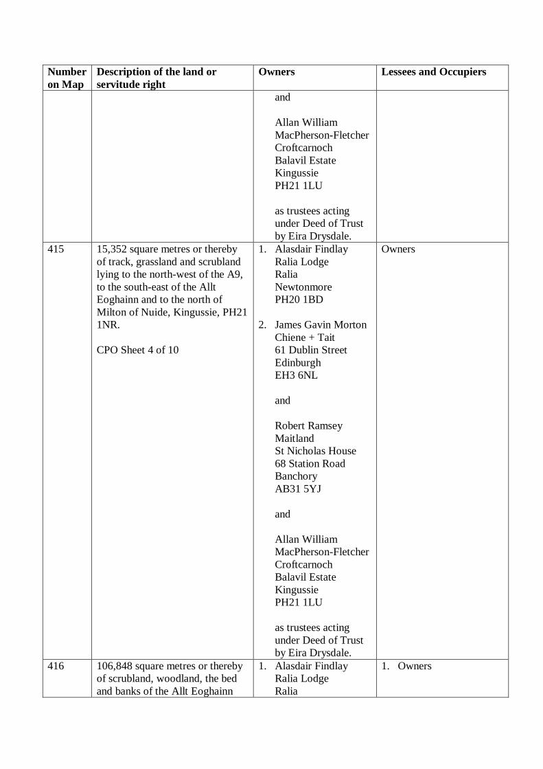
Number
on Map
Description of the land or
servitude right
Owners Lessees and Occupiers
and
Allan William
MacPherson-Fletcher
Croftcarnoch
Balavil Estate
Kingussie
PH21 1LU
as trustees acting
under Deed of Trust
by Eira Drysdale.
415 15,352 square metres or thereby
of track, grassland and scrubland
lying to the north-west of the A9,
to the south-east of the Allt
Eoghainn and to the north of
Milton of Nuide, Kingussie, PH21
1NR.
CPO Sheet 4 of 10
1. Alasdair Findlay
Ralia Lodge
Ralia
Newtonmore
PH20 1BD
2. James Gavin Morton
Chiene + Tait
61 Dublin Street
Edinburgh
EH3 6NL
and
Robert Ramsey
Maitland
St Nicholas House
68 Station Road
Banchory
AB31 5YJ
and
Allan William
MacPherson-Fletcher
Croftcarnoch
Balavil Estate
Kingussie
PH21 1LU
as trustees acting
under Deed of Trust
by Eira Drysdale.
Owners
416 106,848 square metres or thereby
of scrubland, woodland, the bed
and banks of the Allt Eoghainn
1. Alasdair Findlay
Ralia Lodge
Ralia
1. Owners

Number
on Map
Description of the land or
servitude right
Owners Lessees and Occupiers
and the bed and banks of three
unnamed watercourses lying to
the south-east of the A9, to the
south-east of the U3063 Ralia –
Nuide Road and to the north-west
of Milton of Nuide, Kingussie,
PH21 1NR.
CPO Sheet 4 of 10
Newtonmore
PH20 1BD
2. James Gavin Morton
Chiene + Tait
61 Dublin Street
Edinburgh
EH3 6NL
and
Robert Ramsey
Maitland
St Nicholas House
68 Station Road
Banchory
AB31 5YJ
and
Allan William
MacPherson-Fletcher
Croftcarnoch
Balavil Estate
Kingussie
PH21 1LU
as trustees acting
under Deed of Trust
by Eira Drysdale.
2. Scottish and Southern
Energy PLC
Company No.
SC117119
Inveralmond House
200 Dunkeld Road
Perth
PH1 3AQ
417 165 square metres or thereby of
woodland lying to the north-west
of the A9, to the south-east of the
River Spey and to the west of
Milton of Nuide, Kingussie, PH21
1NR.
CPO Sheet 4 of 10
1. Alasdair Findlay
Ralia Lodge
Ralia
Newtonmore
PH20 1BD
2. James Gavin Morton
Chiene + Tait
61 Dublin Street
Edinburgh
EH3 6NL
and
Robert Ramsey
Maitland
St Nicholas House
68 Station Road
Owners

Number
on Map
Description of the land or
servitude right
Owners Lessees and Occupiers
Banchory
AB31 5YJ
and
Allan William
MacPherson-Fletcher
Croftcarnoch
Balavil Estate
Kingussie
PH21 1LU
as trustees acting
under Deed of Trust
by Eira Drysdale.
418 412 square metres or thereby of
verge of the A9 and the bed and
banks of an unnamed watercourse
lying to the north-west of the A9,
to the south-east of the U3063
Ralia – Nuide Road and to the
west, north-west of Milton of
Nuide, Kingussie, PH21 1NR.
CPO Sheet 4 of 10
1. Alasdair Findlay
Ralia Lodge
Ralia
Newtonmore
PH20 1BD
2. James Gavin Morton
Chiene + Tait
61 Dublin Street
Edinburgh
EH3 6NL
and
Robert Ramsey
Maitland
St Nicholas House
68 Station Road
Banchory
AB31 5YJ
and
Allan William
MacPherson-Fletcher
Croftcarnoch
Balavil Estate
Kingussie
PH21 1LU
as trustees acting
under Deed of Trust
by Eira Drysdale.
1. Owners
2. Occupied by the
Scottish Ministers as
roads authority. Interest
currently held by the
acquiring authority.
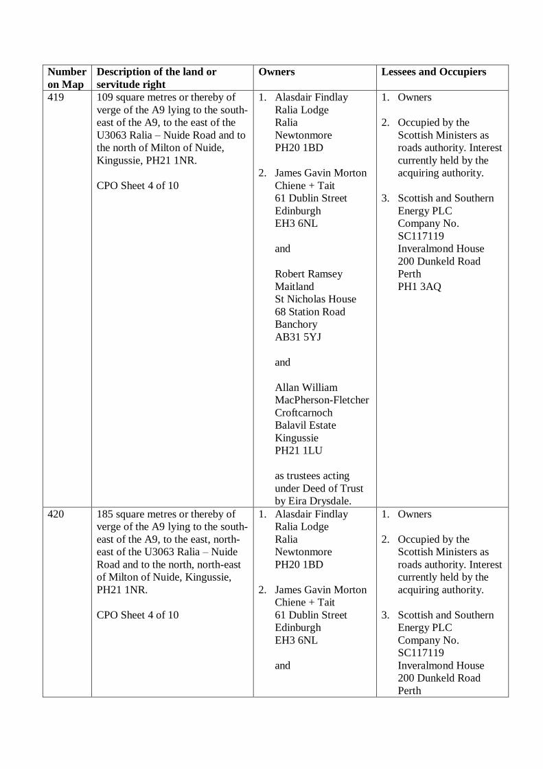
Number
on Map
Description of the land or
servitude right
Owners Lessees and Occupiers
419 109 square metres or thereby of
verge of the A9 lying to the south-
east of the A9, to the east of the
U3063 Ralia – Nuide Road and to
the north of Milton of Nuide,
Kingussie, PH21 1NR.
CPO Sheet 4 of 10
1. Alasdair Findlay
Ralia Lodge
Ralia
Newtonmore
PH20 1BD
2. James Gavin Morton
Chiene + Tait
61 Dublin Street
Edinburgh
EH3 6NL
and
Robert Ramsey
Maitland
St Nicholas House
68 Station Road
Banchory
AB31 5YJ
and
Allan William
MacPherson-Fletcher
Croftcarnoch
Balavil Estate
Kingussie
PH21 1LU
as trustees acting
under Deed of Trust
by Eira Drysdale.
1. Owners
2. Occupied by the
Scottish Ministers as
roads authority. Interest
currently held by the
acquiring authority.
3. Scottish and Southern
Energy PLC
Company No.
SC117119
Inveralmond House
200 Dunkeld Road
Perth
PH1 3AQ
420 185 square metres or thereby of
verge of the A9 lying to the south-
east of the A9, to the east, north-
east of the U3063 Ralia – Nuide
Road and to the north, north-east
of Milton of Nuide, Kingussie,
PH21 1NR.
CPO Sheet 4 of 10
1. Alasdair Findlay
Ralia Lodge
Ralia
Newtonmore
PH20 1BD
2. James Gavin Morton
Chiene + Tait
61 Dublin Street
Edinburgh
EH3 6NL
and
1. Owners
2. Occupied by the
Scottish Ministers as
roads authority. Interest
currently held by the
acquiring authority.
3. Scottish and Southern
Energy PLC
Company No.
SC117119
Inveralmond House
200 Dunkeld Road
Perth

Number
on Map
Description of the land or
servitude right
Owners Lessees and Occupiers
Robert Ramsey
Maitland
St Nicholas House
68 Station Road
Banchory
AB31 5YJ
and
Allan William
MacPherson-Fletcher
Croftcarnoch
Balavil Estate
Kingussie
PH21 1LU
as trustees acting
under Deed of Trust
by Eira Drysdale.
PH1 3AQ
421 127 square metres or thereby of
scrubland, grassland and the bed
and banks of the Allt Eoghainn
lying to the north-west of the A9,
to the north-west of the U3063
Ralia – Nuide Road and to the
north-west of Milton of Nuide,
Kingussie, PH21 1NR.
CPO Sheet 4 of 10
1. Alasdair Findlay
Ralia Lodge
Ralia
Newtonmore
PH20 1BD
2. James Gavin Morton
Chiene + Tait
61 Dublin Street
Edinburgh
EH3 6NL
and
Robert Ramsey
Maitland
St Nicholas House
68 Station Road
Banchory
AB31 5YJ
and
Allan William
MacPherson-Fletcher
Croftcarnoch
Balavil Estate
Kingussie
PH21 1LU
Owners

Number
on Map
Description of the land or
servitude right
Owners Lessees and Occupiers
as trustees acting
under Deed of Trust
by Eira Drysdale.
422 to
500
Numbers not allocated - -
501 13,236 square metres or thereby
of track, grassland and scrubland
lying to the north-west of the A9,
to the south-west of the Burn of
Inverton and to the west, south-
west of Knappach Cottage,
Kingussie, PH21 1NR.
CPO Sheet 5 of 10
1. Alasdair Findlay
Ralia Lodge
Ralia
Newtonmore
PH20 1BD
2. James Gavin Morton
Chiene + Tait
61 Dublin Street
Edinburgh
EH3 6NL
and
Robert Ramsey
Maitland
St Nicholas House
68 Station Road
Banchory
AB31 5YJ
and
Allan William
MacPherson-Fletcher
Croftcarnoch
Balavil Estate
Kingussie
PH21 1LU
as trustees acting
under Deed of Trust
by Eira Drysdale.
Owners
502 20,903 square metres or thereby
of scrubland, the bed and banks of
the Milton Burn and the bed and
banks of three unnamed
watercourses lying to the south-
east of the A9, to the north-west
of the General Wade’s Military
Road and to the west, south-west
1. Alasdair Findlay
Ralia Lodge
Ralia
Newtonmore
PH20 1BD
2. James Gavin Morton
Chiene + Tait
61 Dublin Street
1. Owners
2. Scottish and Southern
Energy PLC
Company No.
SC117119
Inveralmond House
200 Dunkeld Road
Perth

Number
on Map
Description of the land or
servitude right
Owners Lessees and Occupiers
of Knappach Cottage, Kingussie,
PH21 1NR.
CPO Sheet 5 of 10
Edinburgh
EH3 6NL
and
Robert Ramsey
Maitland
St Nicholas House
68 Station Road
Banchory
AB31 5YJ
and
Allan William
MacPherson-Fletcher
Croftcarnoch
Balavil Estate
Kingussie
PH21 1LU
as trustees acting
under Deed of Trust
by Eira Drysdale.
PH1 3AQ
503 1,597 square metres or thereby of
access road and the bed and banks
of an unnamed watercourse lying
to the north-west of the A9, to the
north-west of the Burn of Inverton
and to the west, south-west of
Knappach Cottage, Kingussie,
PH21 1NR.
CPO Sheet 5 of 10
Unknown 1. Alasdair Findlay
Ralia Lodge
Ralia
Newtonmore
PH20 1BD
2. James Gavin Morton
Chiene + Tait
61 Dublin Street
Edinburgh
EH3 6NL
and
Robert Ramsey
Maitland
St Nicholas House
68 Station Road
Banchory
AB31 5YJ
and

Number
on Map
Description of the land or
servitude right
Owners Lessees and Occupiers
Allan William
MacPherson-Fletcher
Croftcarnoch
Balavil Estate
Kingussie
PH21 1LU
as trustees acting under
Deed of Trust by Eira
Drysdale.
504 2,840 square metres or thereby of
scrubland and woodland and the
bed and west bank of the Burn of
Inverton lying to the north-west of
the A9, to the south-west of the
Burn of Inverton and to the west,
south-west of Knappach Cottage,
Kingussie, PH21 1NR.
CPO Sheet 5 of 10
1. Alasdair Findlay
Ralia Lodge
Ralia
Newtonmore
PH20 1BD
2. James Gavin Morton
Chiene + Tait
61 Dublin Street
Edinburgh
EH3 6NL
and
Robert Ramsey
Maitland
St Nicholas House
68 Station Road
Banchory
AB31 5YJ
and
Allan William
MacPherson-Fletcher
Croftcarnoch
Balavil Estate
Kingussie
PH21 1LU
as trustees acting
under Deed of Trust
by Eira Drysdale.
Owners
505 16,065 square metres or thereby
of scrubland and woodland and
the bed and banks of the Burn of
Inverton and the bed and banks of
1. Alasdair Findlay
Ralia Lodge
Ralia
Newtonmore
Owners

Number
on Map
Description of the land or
servitude right
Owners Lessees and Occupiers
an unnamed watercourse lying to
the north-west of the A9, to the
south-east of the Burn of Inverton
and to the west, south-west of
Knappach Cottage, Kingussie,
PH21 1NR.
CPO Sheet 5 of 10
PH20 1BD
2. James Gavin Morton
Chiene + Tait
61 Dublin Street
Edinburgh
EH3 6NL
and
Robert Ramsey
Maitland
St Nicholas House
68 Station Road
Banchory
AB31 5YJ
and
Allan William
MacPherson-Fletcher
Croftcarnoch
Balavil Estate
Kingussie
PH21 1LU
as trustees acting
under Deed of Trust
by Eira Drysdale.
506 201 square metres or thereby of
scrubland and woodland lying to
the north-west of the A9, to the
south-west of the River Spey and
to the west, south-west of
Knappach Cottage, Kingussie,
PH21 1NR.
CPO Sheet 5 of 10
Thomas Nathaniel Hone
Bosbury House
Ledbury
Hertfordshire
HR8 1JZ
Owner
507 10,067 square metres or thereby
of scrubland and woodland lying
to the south-west of the A9, to the
west of the General Wade’s
Military Road and to the west,
south-west of Knappach Cottage,
Kingussie, PH21 1NR.
CPO Sheet 5 of 10
Thomas Nathaniel Hone
Bosbury House
Ledbury
Hertfordshire
HR8 1JZ
1. Owner
2. Scottish and Southern
Energy PLC
Company No.
SC117119
Inveralmond House
200 Dunkeld Road
Perth
PH1 3AQ

Number
on Map
Description of the land or
servitude right
Owners Lessees and Occupiers
508 1,162 square metres or thereby of
grassland and woodland lying to
the north-west of the A9, to the
south of the River Spey and to the
west, north-west of Knappach
Cottage, Kingussie, PH21 1NR.
CPO Sheet 5 of 10
Thomas Nathaniel Hone
Bosbury House
Ledbury
Hertfordshire
HR8 1JZ
Owner
Salmon fishing rights
interests not being
acquired.
509 505 square metres or thereby of
scrubland and the bed and banks
of an unnamed watercourse lying
to the north-west of the A9, to the
north of General Wade’s Military
Road and to the south-east of the
Lochan an Tairbh.
CPO Sheet 5 of 10
Thomas Nathaniel Hone
Bosbury House
Ledbury
Hertfordshire
HR8 1JZ
Owner
510 639 square metres or thereby of
track lying to the south-east of the
A9, to the south of the Lochan an
Tairbh and to the west, south-west
of Knappach Cottage, Kingussie,
PH21 1NR.
CPO Sheet 5 of 10
Unknown Thomas Nathaniel Hone
Bosbury House
Ledbury
Hertfordshire
HR8 1JZ
511 3,924 square metres or thereby of
scrubland and woodland lying to
the south-east of the A9, to the
north-west of the General Wade’s
Military Road and to the west,
south-west of Knappach Cottage,
Kingussie, PH21 1NR.
CPO Sheet 5 of 10
Thomas Nathaniel Hone
Bosbury House
Ledbury
Hertfordshire
HR8 1JZ
Owner
512 9,716 square metres or thereby of
grassland, scrubland and
woodland and the bed and banks
of an unnamed watercourse lying
to the north-west of the A9, to the
south-east of the River Spey and
to the north-west of Knappach
Cottage, Kingussie, PH21 1NR.
CPO Sheet 5 of 10
Thomas Nathaniel Hone
Bosbury House
Ledbury
Hertfordshire
HR8 1JZ
Owner
513 Number not allocated - -
514 686 square metres or thereby of
track and General Wade’s
Unknown Thomas Nathaniel Hone
Bosbury House
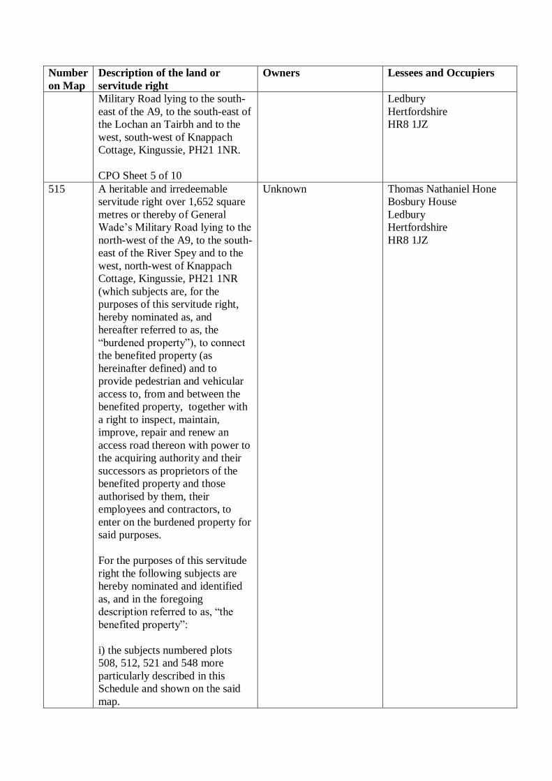
Number
on Map
Description of the land or
servitude right
Owners Lessees and Occupiers
Military Road lying to the south-
east of the A9, to the south-east of
the Lochan an Tairbh and to the
west, south-west of Knappach
Cottage, Kingussie, PH21 1NR.
CPO Sheet 5 of 10
Ledbury
Hertfordshire
HR8 1JZ
515 A heritable and irredeemable
servitude right over 1,652 square
metres or thereby of General
Wade’s Military Road lying to the
north-west of the A9, to the south-
east of the River Spey and to the
west, north-west of Knappach
Cottage, Kingussie, PH21 1NR
(which subjects are, for the
purposes of this servitude right,
hereby nominated as, and
hereafter referred to as, the
“burdened property”), to connect
the benefited property (as
hereinafter defined) and to
provide pedestrian and vehicular
access to, from and between the
benefited property, together with
a right to inspect, maintain,
improve, repair and renew an
access road thereon with power to
the acquiring authority and their
successors as proprietors of the
benefited property and those
authorised by them, their
employees and contractors, to
enter on the burdened property for
said purposes.
For the purposes of this servitude
right the following subjects are
hereby nominated and identified
as, and in the foregoing
description referred to as, “the
benefited property”:
i) the subjects numbered plots
508, 512, 521 and 548 more
particularly described in this
Schedule and shown on the said
map.
Unknown
Thomas Nathaniel Hone
Bosbury House
Ledbury
Hertfordshire
HR8 1JZ

Number
on Map
Description of the land or
servitude right
Owners Lessees and Occupiers
(ii) ALL and WHOLE the
subjects owned by the Scottish
Ministers described in the General
Vesting Declaration by The
Secretary of State for Scotland for
The London – Edinburgh –
Thurso Trunk Road (Crubenmore
to North of Kingussie)
Compulsory Purchase Order
1977, recorded in the General
Register of Sasines for the County
of Inverness 18 April 1977, and
General Vesting Declaration 1978
recorded in the General Register
of Sasines for the County of
Inverness 25 January 1978.
CPO Sheet 5 of 10
516 435 square metres or thereby of
access road lying to the south-east
of the A9 and to the north-east of
Knappach Cottage, Kingussie,
PH21 1NR.
CPO Sheet 5 of 10
Unknown Thomas Nathaniel Hone
Bosbury House
Ledbury
Hertfordshire
HR8 1JZ
517 14,360 square metres or thereby
of grassland and woodland lying
to the north-east of the A9, to the
south-east of the River Spey and
to the north of Knappach Cottage,
Kingussie, PH21 1NR.
CPO Sheet 5 of 10
Thomas Nathaniel Hone
Bosbury House
Ledbury
Hertfordshire
HR8 1JZ
Owner
518 54,194 square metres or thereby
of track, grassland, scrubland and
woodland lying to the south-east
of the A9 and to the west, north
and east of Knappach Cottage,
Kingussie, PH21 1NR.
CPO Sheet 5 of 10
Thomas Nathaniel Hone
Bosbury House
Ledbury
Hertfordshire
HR8 1JZ
Owner
519 453 square metres or thereby of
scrubland and grassland lying to
the south-east of the A9, to the
south-east of the River Spey and
to the north-east of Knappach
Cottage, Kingussie, PH21 1NR.
Ivy Morris and David
William Morris
Ruthven Farm
Kingussie
PH21 1NR
Owner

Number
on Map
Description of the land or
servitude right
Owners Lessees and Occupiers
CPO Sheet 5 of 10
520 A heritable and irredeemable
servitude right over 117 square
metres or thereby of access road,
bridge and the bed and banks of
the Burn of Inverton lying to the
north-west of the A9, to the south-
west of the Burn of Inverton and
to the west, south-west of
Knappach Cottage, Kingussie,
PH21 1NR (which subjects are,
for the purposes of this servitude
right, hereby nominated as, and
hereafter referred to as, the
“burdened property”), to connect
the benefited property (as
hereinafter defined) and to
provide pedestrian and vehicular
access to, from and between the
benefited property, together with
a right to inspect, maintain,
improve, repair and renew an
access road thereon, with power
to the acquiring authority and
their successors as proprietors of
the benefited property and those
authorised by them, their
employees and contractors, to
enter on the burdened property for
said purposes.
For the purposes of this servitude
right the following subjects are
hereby nominated and identified
as, and in the foregoing
description referred to as, “the
benefited property”:
(i) the subjects numbered plots
503, 504 and 505 more
particularly described in this
Schedule and shown on the said
map.
(ii) ALL and WHOLE the
subjects owned by the Scottish
Ministers described in the General
Unknown 1. Alasdair Findlay
Ralia Lodge
Ralia
Newtonmore
PH20 1BD
2. James Gavin Morton
Chiene + Tait
61 Dublin Street
Edinburgh
EH3 6NL
and
Robert Ramsey
Maitland
St Nicholas House
68 Station Road
Banchory
AB31 5YJ
and
Allan William
MacPherson-Fletcher
Croftcarnoch
Balavil Estate
Kingussie
PH21 1LU
as trustees acting under
Deed of Trust by Eira
Drysdale.

Number
on Map
Description of the land or
servitude right
Owners Lessees and Occupiers
Vesting Declaration by The
Secretary of State for Scotland for
The London – Edinburgh –
Thurso Trunk Road (Crubenmore
to North of Kingussie)
Compulsory Purchase Order
1977, recorded in the General
Register of Sasines for the County
of Inverness 18 April 1977, and
General Vesting Declaration 1978
recorded in the General Register
of Sasines for the County of
Inverness 25 January 1978.
CPO Sheet 5 of 10
521 1,070 square metres or thereby of
General Wade’s Military Road
lying to the north-east of the A9,
to the south-east of the River Spey
and to the north of Knappach
Cottage, Kingussie, PH21 1NR.
CPO Sheet 5 of 10
Unknown Thomas Nathaniel Hone
Bosbury House
Ledbury
Hertfordshire
HR8 1JZ
522 178 square metres or thereby of
track lying to the south-east of the
A9 and to the east, north-east of
Knappach Cottage, Kingussie,
PH21 1NR.
CPO Sheet 5 of 10
Thomas Nathaniel Hone
Bosbury House
Ledbury
Hertfordshire
HR8 1JZ
Owner
523 67 square metres or thereby of
scrubland lying to the south-east
of the A9 and to the east, north-
east of Knappach Cottage,
Kingussie, PH21 1NR.
CPO Sheet 5 of 10
Thomas Nathaniel Hone
Bosbury House
Ledbury
Hertfordshire
HR8 1JZ
Owner
524 -
530
Numbers not allocated - -
531 15,218 square metres or thereby
of scrubland and grassland lying
to the south of the A9, to the
south-east of the River Spey and
to the south of Knappach Cottage,
Kingussie, PH21 1NR.
CPO Sheet 5 of 10
Thomas Nathaniel Hone
Bosbury House
Ledbury
Hertfordshire
HR8 1JZ
1. Owner
2. Scottish and Southern
Energy PLC
Company No.
SC117119
Inveralmond House
200 Dunkeld Road
Perth

Number
on Map
Description of the land or
servitude right
Owners Lessees and Occupiers
PH1 3AQ
532 Number not allocated - -
533 3,438 square metres or thereby of
woodland and grassland lying to
the south-east of the A9 and to the
south-east of Knappach Cottage,
Kingussie, PH21 1NR.
CPO Sheet 5 of 10
Thomas Nathaniel Hone
Bosbury House
Ledbury
Hertfordshire
HR8 1JZ
Owner
534 to
535
Numbers not allocated - -
536 2,300 square metres or thereby of
grassland and woodland lying to
the south-east of the A9 and to the
south-east of Knappach Cottage,
Kingussie, PH21 1NR.
CPO Sheet 5 of 10
Thomas Nathaniel Hone
Bosbury House
Ledbury
Hertfordshire
HR8 1JZ
1. Owner
2. Scottish and Southern
Energy PLC
Company No.
SC117119
Inveralmond House
200 Dunkeld Road
Perth
PH1 3AQ
537 1,071 square metres or thereby of
grassland lying to the south-east
of the A9 and to the south-east of
Knappach Cottage, Kingussie,
PH21 1NR.
CPO Sheet 5 of 10
Thomas Nathaniel Hone
Bosbury House
Ledbury
Hertfordshire
HR8 1JZ
1. Owner
2. Scottish and Southern
Energy PLC
Company No.
SC117119
Inveralmond House
200 Dunkeld Road
Perth
PH1 3AQ
538 10,035 square metres or thereby
of grassland and woodland lying
to the south-east of the A9 and to
the south-east of Knappach
Cottage, Kingussie, PH21 1NR.
CPO Sheet 5 of 10
Thomas Nathaniel Hone
Bosbury House
Ledbury
Hertfordshire
HR8 1JZ
1. Owner
2. Scottish and Southern
Energy PLC
Company No.
SC117119
Inveralmond House
200 Dunkeld Road
Perth
PH1 3AQ
539 800 square metres or thereby of
grassland and track lying to the
south-east of the A9 and to the
south-east of Knappach Cottage,
Kingussie, PH21 1NR.
Thomas Nathaniel Hone
Bosbury House
Ledbury
Hertfordshire
HR8 1JZ
1. Owner
2. Scottish and Southern
Energy PLC

Number
on Map
Description of the land or
servitude right
Owners Lessees and Occupiers
CPO Sheet 5 of 10
Company No.
SC117119
Inveralmond House
200 Dunkeld Road
Perth
PH1 3AQ
540 A heritable and irredeemable
servitude right over 1,014 square
metres or thereby of the access
road lying to the north-west of the
A9, to the south-east of the River
Spey and to the west, north-west
of Knappach Cottage, Kingussie,
PH21 1NR (which subjects are,
for the purposes of this servitude
right, hereby nominated as, and
hereafter referred to as, the
“burdened property”), to connect
the benefited property (as
hereinafter defined) and to
provide pedestrian and vehicular
access to, from and between the
benefited property, together with a
right to inspect, maintain,
improve, repair and renew an
access road thereon, with power
to the acquiring authority and
their successors as proprietors of
the benefited property and those
authorised by them, their
employees and contractors, to
enter on the burdened property for
said purposes.
For the purposes of this servitude
right the following subjects are
hereby nominated and identified
as, and in the foregoing
description referred to as, “the
benefited property”:
i) the subjects numbered plots
503, 504 and 505 more
particularly described in this
Schedule and shown on the said
map.
Unknown 1. Alasdair Findlay
Ralia Lodge
Ralia
Newtonmore
PH20 1BD
2. James Gavin Morton
Chiene + Tait
61 Dublin Street
Edinburgh
EH3 6NL
and
Robert Ramsey
Maitland
St Nicholas House
68 Station Road
Banchory
AB31 5YJ
and
Allan William
MacPherson-Fletcher
Croftcarnoch
Balavil Estate
Kingussie
PH21 1LU
as trustees acting under
Deed of Trust by Eira
Drysdale.

Number
on Map
Description of the land or
servitude right
Owners Lessees and Occupiers
(ii) ALL and WHOLE the
subjects owned by the Scottish
Ministers described in the General
Vesting Declaration by The
Secretary of State for Scotland for
The London – Edinburgh –
Thurso Trunk Road (Crubenmore
to North of Kingussie)
Compulsory Purchase Order
1977, recorded in the General
Register of Sasines for the County
of Inverness 18 April 1977, and
General Vesting Declaration 1978
recorded in the General Register
of Sasines for the County of
Inverness 25 January 1978.
CPO Sheet 5 of 10
541 555 square metres or thereby of
grassland lying to the south of the
A9, to the south-east of the River
Spey and to the south-west of
Knappach Cottage, Kingussie,
PH21 1NR.
CPO Sheet 5 of 10
Thomas Nathaniel Hone
Bosbury House
Ledbury
Hertfordshire
HR8 1JZ
Owner
542 1,068 square metres or thereby of
track lying to the south-east of the
A9 and to the south-east of
Knappach Cottage, Kingussie,
PH21 1NR.
CPO Sheet 5 of 10
Thomas Nathaniel Hone
Bosbury House
Ledbury
Hertfordshire
HR8 1JZ
Owner
543 102 square metres or thereby of
verge of the A9 and the bed and
banks of an unnamed watercourse
lying to the south-west of the A9,
to the west of the General Wade’s
Military Road and to the west,
south-west of Knappach Cottage,
Kingussie, PH21 1NR.
CPO Sheet 5 of 10
Thomas Nathaniel Hone
Bosbury House
Ledbury
Hertfordshire
HR8 1JZ
1. Owner
2. Occupied by the
Scottish Ministers as
roads authority. Interest
currently held by the
acquiring authority.
3. Scottish and Southern
Energy PLC
Company No.
SC117119
Inveralmond House
200 Dunkeld Road
Perth

Number
on Map
Description of the land or
servitude right
Owners Lessees and Occupiers
PH1 3AQ
544 386 square metres or thereby of
verge of the A9 lying to the south-
west of the A9, to the west of the
General Wade’s Military Road
and to the west, south-west of
Knappach Cottage, Kingussie,
PH21 1NR.
CPO Sheet 5 of 10
Thomas Nathaniel Hone
Bosbury House
Ledbury
Hertfordshire
HR8 1JZ
1. Owner
2. Occupied by the
Scottish Ministers as
roads authority. Interest
currently held by the
acquiring authority.
3. Scottish and Southern
Energy PLC
Company No.
SC117119
Inveralmond House
200 Dunkeld Road
Perth
PH1 3AQ
545 223 square metres or thereby of
verge of the A9 lying to the south-
west of the A9, to the west of the
General Wade’s Military Road
and to the west, south-west of
Knappach Cottage, Kingussie,
PH21 1NR.
CPO Sheet 5 of 10
Thomas Nathaniel Hone
Bosbury House
Ledbury
Hertfordshire
HR8 1JZ
1. Owner
2. Occupied by the
Scottish Ministers as
roads authority. Interest
currently held by the
acquiring authority.
3. Scottish and Southern
Energy PLC
Company No.
SC117119
Inveralmond House
200 Dunkeld Road
Perth
PH1 3AQ
546 662 square metres or thereby of
verge of the A9 lying to the south-
west of the A9, to the west of the
General Wade’s Military Road
and to the west, south-west of
Knappach Cottage, Kingussie,
PH21 1NR.
CPO Sheet 5 of 10
Thomas Nathaniel Hone
Bosbury House
Ledbury
Hertfordshire
HR8 1JZ
1. Owner
2. Occupied by the
Scottish Ministers as
roads authority. Interest
currently held by the
acquiring authority.
3. Scottish and Southern
Energy PLC
Company No.
SC117119
Inveralmond House
200 Dunkeld Road

Number
on Map
Description of the land or
servitude right
Owners Lessees and Occupiers
Perth
PH1 3AQ
547 Number not allocated - -
548 2,989 square metres or thereby of
grassland, scrubland and
woodland and the bed and banks
of an unnamed watercourse lying
to the north-west of the A9, to the
south-east of the River Spey and
to the north-west of Knappach
Cottage, Kingussie, PH21 1NR.
CPO Sheet 5 of 10
Thomas Nathaniel Hone
Bosbury House
Ledbury
Hertfordshire
HR8 1JZ
Owner
549 to
600
Numbers not allocated - -
601 10,515 square metres or thereby
of grassland and scrubland lying
to the north-west of the A9, to the
east of the River Spey and to the
west, south-west of Ruthven
Barracks, Kingussie.
CPO Sheet 6 of 10
Thomas Nathaniel Hone
Bosbury House
Ledbury
Hertfordshire
HR8 1JZ
Owner
602 705 square metres or thereby of
scrubland lying to the north-west
of the A9, to the south-west of the
B970 Ruthven Road and to the
west, south-west of Ruthven
Barracks, Kingussie.
CPO Sheet 6 of 10
Thomas Nathaniel Hone
Bosbury House
Ledbury
Hertfordshire
HR8 1JZ
Owner
603 383 square metres or thereby of
the solum and verges of the B970
Ruthven Road under the A9
bridge structure lying to the south-
east of the River Spey and to the
west, south-west of Ruthven
Barracks, Kingussie.
CPO Sheet 6 of 10
Unknown 1. Occupied by The
Highland Council as
local roads authority.
Interest of local roads
authority not being
acquired
2. Occupied by the
Scottish Ministers as
roads authority. Interest
currently held by the
acquiring authority.
604 5 square metres or thereby of
grassland lying to the south-east
of the A9, to the north-west of the
Church of Scotland
General Trustees
121 George Street
1. Owner

Number
on Map
Description of the land or
servitude right
Owners Lessees and Occupiers
Burn of Ruthven and to the north
of Ruthven Barracks, Kingussie.
CPO Sheet 6 of 10
Edinburgh
EH2 4YR
2. Royal Society for the
Protection of Birds
RSPB
North Scotland
Regional Office
Etive House
Beechwood Park
Inverness
IV2 3BW
3. The Badenoch Angling
Association
Secretary
120 Clune Terrace
Newtonmore
PH20 1DY
605 2,347 square metres or thereby of
grassland and scrubland lying to
the north-west of the A9, to the
east of River Spey and to the
north-west of Ruthven Barracks,
Kingussie.
CPO Sheet 6 of 10
Royal Society for the
Protection of Birds
RSPB North Scotland
Regional Office
Etive House
Beechwood Park
Inverness
IV2 3BW
Owner
606 A heritable and irredeemable
servitude right over 290 square
metres or thereby of grassland
lying to the north-west of the A9,
to the south-east of the River Spey
and to the north, north-west of
Ruthven Barracks, Kingussie
(which subjects are, for the
purposes of this servitude right,
hereby nominated as, and
hereafter referred to as, the
“burdened property”), of laying
down and maintaining drainage
apparatus to convey road and
other drainage between the
benefited property (as hereinafter
defined) in and through the
burdened property and that on a
line at the discretion of the
acquiring authority or their
successors as proprietors of the
benefited property with power to
the acquiring authority and their
successors as aforesaid and those
Royal Society for the
Protection of Birds
RSPB North Scotland
Regional Office
Etive House
Beechwood Park
Inverness
IV2 3BW
Owner

Number
on Map
Description of the land or
servitude right
Owners Lessees and Occupiers
authorised by them, their
employees and contractors, to
enter on the burdened property for
the purpose of laying down said
drainage apparatus and thereafter
inspecting, maintaining,
improving, repairing and
renewing same.
For the purposes of this servitude
right the following subjects are
hereby nominated and identified
as, and in the foregoing
description referred to as, “the
benefited property”:
i) the subjects numbered plots 624
and 633 more particularly
described in this Schedule and
shown on the said map.
(ii) ALL and WHOLE the
subjects owned by the Scottish
Ministers described in the General
Vesting Declaration by The
Secretary of State for Scotland for
The London – Edinburgh –
Thurso Trunk Road (Crubenmore
to North of Kingussie)
Compulsory Purchase Order
1977, recorded in the General
Register of Sasines for the County
of Inverness 18 April 1977, and
General Vesting Declaration 1978
recorded in the General Register
of Sasines for the County of
Inverness 25 January 1978.
CPO Sheet 6 of 10
607 A heritable and irredeemable
servitude right over 71 square
metres or thereby of grassland, the
bed and bank of the River Spey,
lying to the north-west of the A9,
to the south-east of the River Spey
and to the north, north-west of
Ruthven Barracks, Kingussie
(which subjects are, for the
purposes of this servitude right,
Thomas Nathaniel Hone
Bosbury House
Ledbury
Hertfordshire
HR8 1JZ
Owner
Salmon fishing rights
interests not being
acquired.

Number
on Map
Description of the land or
servitude right
Owners Lessees and Occupiers
hereby nominated as, and
hereafter referred to as, the
“burdened property”), of laying
down and maintaining drainage
apparatus to convey road and
other drainage from the benefited
property (as hereinafter defined)
in and through the burdened
property to discharge into the
River Spey and that on a line at
the discretion of the acquiring
authority or their successors as
proprietors of the benefited
property with power to the
acquiring authority and their
successors as aforesaid and those
authorised by them, their
employees and contractors, to
enter on the burdened property for
the purpose of laying down said
drainage apparatus and thereafter
inspecting, maintaining,
improving, repairing and
renewing same.
For the purposes of this servitude
right the following subjects are
hereby nominated and identified
as, and in the foregoing
description referred to as, “the
benefited property”:
i) the subjects numbered plots 624
and 633 more particularly
described in this Schedule and
shown on the said map.
(ii) ALL and WHOLE the
subjects owned by the Scottish
Ministers described in the General
Vesting Declaration by The
Secretary of State for Scotland for
The London – Edinburgh –
Thurso Trunk Road (Crubenmore
to North of Kingussie)
Compulsory Purchase Order
1977, recorded in the General
Register of Sasines for the County

Number
on Map
Description of the land or
servitude right
Owners Lessees and Occupiers
of Inverness 18 April 1977, and
General Vesting Declaration 1978
recorded in the General Register
of Sasines for the County of
Inverness 25 January 1978.
CPO Sheet 6 of 10
608 38 square metres or thereby of
grassland lying to the south-west
of the A9, to the south-east of the
River Spey and to the north,
north-west of Ruthven Barracks,
Kingussie.
CPO Sheet 6 of 10
Royal Society for the
Protection of Birds
RSPB North Scotland
Regional Office
Etive House
Beechwood Park
Inverness
IV2 3BW
Owner
609 30,633 square metres or thereby
of grassland lying to the north-
west of the A9, to the south-east
of the Highland Railway Line and
to the north of Ruthven Barracks,
Kingussie.
CPO Sheet 6 of 10
Church of Scotland
General Trustees
121 George Street
Edinburgh
EH2 4YR
1. Owner
2. Royal Society for the
Protection of Birds
RSPB North Scotland
Regional Office
Etive House
Beechwood Park
Inverness
IV2 3BW
3. Francis Duncan Stuart
Black
Laintachan
Nethy Bridge
PH25 3EE
610 231 square metres or thereby of
scrubland and woodland lying to
the west of the A9, to the south-
east of the A86 and to the north,
north-east of Ruthven Barracks,
Kingussie.
CPO Sheet 6 of 10
The Highland Council
Glenurquhart Road
Inverness
IV3 5NX
Owner
611 21,824 square metres or thereby
of grassland and woodland lying
to the south-east of the A9, to the
south-west of the B970 Ruthven
Road and to the west, south-west
of Ruthven Barracks, Kingussie.
CPO Sheet 6 of 10
Ivy Morris and David
Morris
Ruthven Farm
Kingussie
PH21 1NR
Owner

Number
on Map
Description of the land or
servitude right
Owners Lessees and Occupiers
612 2,418 square metres or thereby of
scrubland and woodland lying to
the west of the A9, to the south-
east of the A86 and to the north of
Ruthven Barracks, Kingussie.
CPO Sheet 6 of 10
Unknown Unknown
613 65 square metres or thereby of
access road lying to the west of
the A9, to the north-west of the
A86 and to the north of Ruthven
Barracks, Kingussie.
CPO Sheet 6 of 10
Unknown 1. Davall Developments
Limited
Company No.
SC312640
Myrtlefield House
Grampian Road
Aviemore
PH22 1RH
2. Ranita Management SA
Company No. 525860
16 Floor Mmg Tower
50 Third E Street
Urbanizacion
Marbella
Republic of Panama
614 923 square metres or thereby of
access road lying to the west of
the A9, to the north-west of the
A86 and to the north of Ruthven
Barracks, Kingussie.
Land Register of Scotland
Title Number INV27158
Title Number INV17539
CPO Sheet 6 of 10
Davall Developments
Limited
Company No. SC312640
Myrtlefield House
Grampian Road
Aviemore
PH22 1RH
1. Owner
2. Ranita Management SA
Company No. 525860
16 Floor Mmg Tower
50 Third E Street
Urbanizacion
Marbella
Republic of Panama
615 140 square metres or thereby of
the solum and verges of the A86
and A9 and the bed and banks of
an unnamed watercourse lying to
the north-west of the Highland
Railway Line and to the north,
north-east of Ruthven Barracks,
Kingussie.
CPO Sheet 6 of 10
Unknown Occupied by the Scottish
Ministers as roads
authority. Interest currently
held by the acquiring
authority.
616 175 square metres or thereby of
access road lying to the south-east
of the A9 and to the south-west of
Ruthven Barracks, Kingussie.
Unknown Thomas Nathaniel Hone
Bosbury House
Ledbury
Hertfordshire

Number
on Map
Description of the land or
servitude right
Owners Lessees and Occupiers
CPO Sheet 6 of 10
HR8 1JZ
617 156 square metres or thereby of
grassland lying to the south-east
of the A9 and to the south-west of
Ruthven Barracks, Kingussie.
CPO Sheet 6 of 10
Thomas Nathaniel Hone
Bosbury House
Ledbury
Hertfordshire
HR8 1JZ
Owner
618 224 square metres or thereby of
grassland lying to the south-east
of the A9 and to the south-west of
Ruthven Barracks, Kingussie.
CPO Sheet 6 of 10
Thomas Nathaniel Hone
Bosbury House
Ledbury
Hertfordshire
HR8 1JZ
Owner
619 57 square metres or thereby of
access road lying to the west of
the A9, to the north-west of the
A86 and to the north of Ruthven
Barracks, Kingussie.
Land Register of Scotland
Title Number INV27158
CPO Sheet 6 of 10
Davall Developments
Limited
Company No. SC312640
Myrtlefield House
Grampian Road
Aviemore
PH22 1RH
Owner
620 384 square metres or thereby of
scrubland and woodland lying to
the west of the A9, to the south-
east of the A86 and to the north
of Ruthven Barracks, Kingussie.
CPO Sheet 6 of 10
The Highland Council
Glenurquhart Road
Inverness
IV3 5NX
Owner
621 243 square metres or thereby of
woodland and north bank of the
River Spey lying to the west,
north-west of the A9, to the west
of the Burn of Ruthven and to the
north-west of Ruthven Barracks,
Kingussie.
CPO Sheet 6 of 10
Church of Scotland
General Trustees
121 George Street
Edinburgh
EH2 4YR
Owner
Salmon fishing rights
interests not being
acquired.
622 A heritable and irredeemable
servitude right over 108 square
metres or thereby of scrubland
lying to the north-west of the A9,
to the south-west of the B970
Ruthven Road and to the west,
south-west of Ruthven Barracks,
Kingussie (which subjects are, for
Thomas Nathaniel Hone
Bosbury House
Ledbury
Hertfordshire
HR8 1JZ
Owner

Number
on Map
Description of the land or
servitude right
Owners Lessees and Occupiers
the purposes of this servitude
right, hereby nominated as, and
hereafter referred to as, the
“burdened property”), of laying
down and maintaining drainage
apparatus to convey road and
other drainage from the benefited
property (as hereinafter defined)
in and through the burdened
property to discharge into the
River Spey and that on a line at
the discretion of the acquiring
authority or their successors as
proprietors of the benefited
property with power to the
acquiring authority and their
successors as aforesaid and those
authorised by them, their
employees and contractors, to
enter on the burdened property for
the purpose of laying down said
drainage apparatus and thereafter
inspecting, maintaining,
improving, repairing and
renewing same.
For the purposes of this servitude
right the following subjects are
hereby nominated and identified
as, and in the foregoing
description referred to as, “the
benefited property”:
i) the subjects numbered plots
601, 602, 611 and 623 more
particularly described in this
Schedule and shown on the said
map.
(ii) ALL and WHOLE the
subjects owned by the Scottish
Ministers described in the General
Vesting Declaration by The
Secretary of State for Scotland for
The London – Edinburgh –
Thurso Trunk Road (Crubenmore
to North of Kingussie)
Compulsory Purchase Order

Number
on Map
Description of the land or
servitude right
Owners Lessees and Occupiers
1977, recorded in the General
Register of Sasines for the County
of Inverness 18 April 1977, and
General Vesting Declaration 1978
recorded in the General Register
of Sasines for the County of
Inverness 25 January 1978.
CPO Sheet 6 of 10
623 253 square metres or thereby of
scrubland and the bed and south
bank of the River Spey, lying to
the north-west of the A9, to the
south-west of the B970 Ruthven
Road and to the west, south-west
of Ruthven Barracks, Kingussie.
CPO Sheet 6 of 10
Thomas Nathaniel Hone
Bosbury House
Ledbury
Hertfordshire
HR8 1JZ
Owner
Salmon fishing rights
interests not being
acquired.
624 51,474 square metres or thereby
of grassland, scrubland and
woodland lying to the south-east
of the A9, to the west of the Burn
of Ruthven and to the north-west
of Ruthven Barracks, Kingussie.
CPO Sheet 6 of 10
Royal Society for the
Protection of Birds
RSPB North Scotland
Regional Office
Etive House
Beechwood Park
Inverness
IV2 3BW
Owner
625 6,480 square metres or thereby of
grassland, scrubland and
woodland and the bed and banks
of the River Spey lying to the east
of the A9, to the south-east of the
Highland Railway Line and to the
north of Ruthven Barracks,
Kingussie.
CPO Sheet 6 of 10
Unknown Royal Society for the
Protection of Birds
RSPB North Scotland
Regional Office
Etive House
Beechwood Park
Inverness
IV2 3BW
Salmon fishing rights
interests not being
acquired.
626 A heritable and irredeemable
servitude right over 67 square
metres or thereby of the north
bank of the River Spey lying to
the south-east of the A9 and to the
north, north-east of Ruthven
Barracks, Kingussie (which
subjects are, for the purposes of
this servitude right, hereby
nominated as, and hereafter
Unknown Royal Society for the
Protection of Birds
RSPB North Scotland
Regional Office
Etive House
Beechwood Park
Inverness
IV2 3BW

Number
on Map
Description of the land or
servitude right
Owners Lessees and Occupiers
referred to as, the “burdened
property”), of laying down and
maintaining drainage apparatus to
convey road and other drainage
from the benefited property (as
hereinafter defined) in and
through the burdened property to
discharge into the River Spey and
that on a line at the discretion of
the acquiring authority or their
successors as proprietors of the
benefited property with power to
the acquiring authority and their
successors as aforesaid and those
authorised by them, their
employees and contractors, to
enter on the burdened property for
the purpose of laying down said
drainage apparatus and thereafter
inspecting, maintaining,
improving, repairing and
renewing same.
For the purposes of this servitude
right the following subjects are
hereby nominated and identified
as, and in the foregoing
description referred to as, “the
benefited property”:
i) the subjects numbered plots 609
and 627 more particularly
described in this Schedule and
shown on the said map.
(ii) ALL and WHOLE the
subjects owned by the Scottish
Ministers described in the General
Vesting Declaration by The
Secretary of State for Scotland for
The London – Edinburgh –
Thurso Trunk Road (Crubenmore
to North of Kingussie)
Compulsory Purchase Order
1977, recorded in the General
Register of Sasines for the County
of Inverness 18 April 1977, and
General Vesting Declaration 1978
Salmon fishing rights
interests not being
acquired.

Number
on Map
Description of the land or
servitude right
Owners Lessees and Occupiers
recorded in the General Register
of Sasines for the County of
Inverness 25 January 1978.
CPO Sheet 6 of 10
627 24,962 square metres or thereby
of grassland, north bank of the
River Spey and the bed and banks
of an unnamed watercourse lying
to the south-east of the A9 and to
the north, north-east of Ruthven
Barracks, Kingussie.
CPO Sheet 6 of 10
Church of Scotland
General Trustees
121 George Street
Edinburgh
EH2 4YR
1. Owner
2. Royal Society for the
Protection of Birds
RSPB North Scotland
Regional Office
Etive House
Beechwood Park
Inverness
IV2 3BW
Salmon fishing rights
interests not being
acquired.
628 A heritable and irredeemable
servitude right over 447 square
metres or thereby of operational
railway land forming part of the
Highland Railway Line including
embankments lying to the north-
west of the A9 and to the south-
east of the River Spey (which
subjects are, for the purposes of
this servitude right, hereby
nominated as, and hereafter
referred to as, the “burdened
property”), to connect the
benefited property (as hereinafter
defined) and to provide pedestrian
and vehicular access to, from and
between the benefited property
with power to the acquiring
authority and their successors as
proprietors of the benefited
property and those authorised by
them, their employees and
contractors, to enter on the
burdened property for the purpose
of demolishing an existing bridge
in the burdened property and for
working space for constructing
said and thereafter inspecting,
maintaining, improving, repairing,
Network Rail
Infrastructure Limited
Company No. 02904587
1 Eversholt Street
London
NW1 2DN
1. Owner
2. Occupied by the
Scottish Ministers as
roads authority. Interest
currently held by the
acquiring authority.

Number
on Map
Description of the land or
servitude right
Owners Lessees and Occupiers
demolishing and renewing a
bridge, road associated drainage
and others in the subjects
numbered plots 627, 629, 642 and
643.
For the purposes of this servitude
right the following subjects are
hereby nominated and identified
as, and in the foregoing
description referred to as, “the
benefited property”:
(i) the subjects numbered plots
609 and 620more particularly
described in this Schedule and
shown on the said map.
(ii) ALL and WHOLE the
subjects owned by the Scottish
Ministers described in the General
Vesting Declaration by The
Secretary of State for Scotland for
The London – Edinburgh –
Thurso Trunk Road (Crubenmore
to North of Kingussie)
Compulsory Purchase Order
1977, recorded in the General
Register of Sasines for the County
of Inverness 18 April 1977, and
General Vesting Declaration 1978
recorded in the General Register
of Sasines for the County of
Inverness 25 January 1978.
CPO Sheet 6 of 10
629 10,988 square metres or thereby
of grassland and the bed and
banks of an unnamed watercourse
lying to the south-east of the A9,
to the north of the Highland
Railway Line and to the north,
north-east of Ruthven Barracks,
Kingussie.
CPO Sheet 6 of 10
Church of Scotland
General Trustees
121 George Street
Edinburgh
EH2 4YR
Owner
630 503 square metres or thereby of
the solum and verges of the B970
Unknown Occupied by The Highland
Council as local roads

Number
on Map
Description of the land or
servitude right
Owners Lessees and Occupiers
Ruthven Road lying to the south-
east of the River Spey and to the
west, south-west of Ruthven
Barracks, Kingussie.
CPO Sheet 6 of 10
authority. Interest of local
roads authority not being
acquired
631 158 square metres or thereby of
access road lying to the south-east
of the A9 and to the west, south-
west of Ruthven Barracks,
Kingussie.
CPO Sheet 6 of 10
Thomas Nathaniel Hone
Bosbury House
Ledbury
Hertfordshire
HR8 1JZ
Owner
632 56 square metres or thereby of
verge of the A9 lying to the south-
east of the River Spey and to the
west, south-west of Ruthven
Barracks, Kingussie.
CPO Sheet 6 of 10
Ivy Morris and David
Morris
Ruthven Farm
Kingussie
PH21 1NR
1. Owner
2. Occupied by the
Scottish Ministers as
roads authority. Interest
currently held by the
acquiring authority.
633 2,659 square metres or thereby of
verge of the A9 lying to the south-
east of the River Spey and to the
west, south-west of Ruthven
Barracks, Kingussie.
CPO Sheet 6 of 10
Royal Society for the
Protection of Birds
RSPB North Scotland
Regional Office
Etive House
Beechwood Park
Inverness
IV2 3BW
1. Owner
2. Occupied by the
Scottish Ministers as
roads authority. Interest
currently held by the
acquiring authority.
634 160 square metres or thereby of
scrubland under the A9 bridge
structure lying to the south of the
Highland Railway Line and to the
north of Ruthven Barracks,
Kingussie.
CPO Sheet 6 of 10
Unknown 1. Occupied by the
Scottish Ministers as
roads authority. Interest
currently held by the
acquiring authority.
2. Royal Society for the
Protection of Birds
RSPB North Scotland
Regional Office
Etive House
Beechwood Park
Inverness
IV2 3BW
635 155 square metres or thereby of
scrubland under the A9 bridge
structure lying to the south of the
Highland Railway Line and to the
north of Ruthven Barracks,
Kingussie.
Unknown 1. Occupied by the
Scottish Ministers as
roads authority. Interest
currently held by the
acquiring authority.

Number
on Map
Description of the land or
servitude right
Owners Lessees and Occupiers
CPO Sheet 6 of 10
2. Royal Society for the
Protection of Birds
RSPB North Scotland
Regional Office
Etive House
Beechwood Park
Inverness
IV2 3BW
636 156 square metres or thereby of
grassland and south bank of the
River Spey under the A9 bridge
structure lying to the south of the
Highland Railway Line and to the
north of Ruthven Barracks,
Kingussie.
CPO Sheet 6 of 10
Unknown 1. Occupied by the
Scottish Ministers as
roads authority. Interest
currently held by the
acquiring authority.
2. Royal Society for the
Protection of Birds
RSPB North Scotland
Regional Office
Etive House
Beechwood Park
Inverness
IV2 3BW
Salmon fishing rights
interests not being
acquired.
637 162 square metres or thereby of
the south bank and bed of the
River Spey under the A9 bridge
structure lying to the south of the
Highland Railway Line and to the
north of Ruthven Barracks,
Kingussie.
CPO Sheet 6 of 10
Unknown 1. Occupied by the
Scottish Ministers as
roads authority. Interest
currently held by the
acquiring authority.
2. Royal Society for the
Protection of Birds
RSPB North Scotland
Regional Office
Etive House
Beechwood Park
Inverness
IV2 3BW
Salmon fishing rights
interests not being
acquired.
638 221 square metres or thereby of
the north bank and bed of the
River Spey under the A9 bridge
structure lying to the south of the
Unknown 1. Occupied by the
Scottish Ministers as
roads authority. Interest

Number
on Map
Description of the land or
servitude right
Owners Lessees and Occupiers
Highland Railway Line and to the
north of Ruthven Barracks,
Kingussie.
CPO Sheet 6 of 10
currently held by the
acquiring authority.
2. Royal Society for the
Protection of Birds
RSPB North Scotland
Regional Office
Etive House
Beechwood Park
Inverness
IV2 3BW
Salmon fishing rights
interests not being
acquired.
639 2,240 square metres or thereby of
grassland, scrubland and
woodland and the south bank of
the River Spey lying to the west
of the A9, to the south-east of the
Highland Railway Line and to the
north of Ruthven Barracks,
Kingussie.
CPO Sheet 6 of 10
Unknown Royal Society for the
Protection of Birds
RSPB North Scotland
Regional Office
Etive House
Beechwood Park
Inverness
IV2 3BW
Salmon fishing rights
interests not being
acquired.
640 89 square metres or thereby of
grassland and the north bank of
the River Spey under the A9
bridge structure lying to the south-
east of the A9 and to the north,
north-east of Ruthven Barracks,
Kingussie.
CPO Sheet 6 of 10
Church of Scotland
General Trustees
121 George Street
Edinburgh
EH2 4YR
1. Owner
2. Occupied by the
Scottish Ministers as
roads authority. Interest
currently held by the
acquiring authority.
3. Royal Society for the
Protection of Birds
RSPB North Scotland
Regional Office
Etive House
Beechwood Park
Inverness
IV2 3BW
Salmon fishing rights
interests not being
acquired.

Number
on Map
Description of the land or
servitude right
Owners Lessees and Occupiers
641 65 square metres or thereby of
verge of the A9 lying to the north,
north-east of the River Spey and
to the north, north-west of
Ruthven Barracks, Kingussie.
CPO Sheet 6 of 10
Church of Scotland
General Trustees
121 George Street
Edinburgh
EH2 4YR
1. Owner
2. Occupied by the
Scottish Ministers as
roads authority. Interest
currently held by the
acquiring authority.
3. Royal Society for the
Protection of Birds
RSPB North Scotland
Regional Office
Etive House
Beechwood Park
Inverness
IV2 3BW
4. Francis Duncan Stuart
Black
Laintachan
Nethy Bridge
PH25 3EE
642 A heritable and irredeemable
servitude right over 1,820 square
metres or thereby of operational
railway land forming part of the
Highland Railway Line including
embankments lying to the north-
east of the A9 and to the south-
east of the River Spey (which
subjects are, for the purposes of
this servitude right, hereby
nominated as, and hereafter
referred to as, the “burdened
property”), to connect the
benefited property (as hereinafter
defined) and to provide pedestrian
and vehicular access to, from and
between the benefited property by
means of a bridge carrying a road
and associated equipment and
apparatus through the airspace
above the burdened property with
power to the acquiring authority
and their successors as proprietors
of the benefited property and
those authorised by them, their
employees and contractors, to
Network Rail
Infrastructure Limited
Company No. 02904587
1 Eversholt Street
London
NW1 2DN
Owner

Number
on Map
Description of the land or
servitude right
Owners Lessees and Occupiers
enter on the burdened property for
the purpose of constructing said
bridge, road associated drainage
and others and thereafter
inspecting, maintaining,
improving, repairing, demolishing
and renewing same.
For the purposes of this servitude
right the following subjects are
hereby nominated and identified
as, and in the foregoing
description referred to as, “the
benefited property”:
(i) the subjects numbered plots
609, 620, 627, 629, and 641 more
particularly described in this
Schedule and shown on the said
map.
(ii) ALL and WHOLE the
subjects owned by the Scottish
Ministers described in the General
Vesting Declaration by The
Secretary of State for Scotland for
The London – Edinburgh –
Thurso Trunk Road (Crubenmore
to North of Kingussie)
Compulsory Purchase Order
1977, recorded in the General
Register of Sasines for the County
of Inverness 18 April 1977, and
General Vesting Declaration 1978
recorded in the General Register
of Sasines for the County of
Inverness 25 January 1978.
CPO Sheet 6 of 10
643 A heritable and irredeemable
servitude right over 905 square
metres or thereby of operational
railway land forming part of the
Highland Railway Line including
embankments lying to the north-
west of the A9 and to the north-
east of the River Spey (which
subjects are, for the purposes of
Network Rail
Infrastructure Limited
Company No. 02904587
1 Eversholt Street
London
NW1 2DN
Owner
Number
on Map
Description of the land or
servitude right
Owners Lessees and Occupiers
this servitude right, hereby
nominated as, and hereafter
referred to as, the “burdened
property”), to connect the
benefited property (as hereinafter
defined) and to provide pedestrian
and vehicular access to, from and
between the benefited property
with power to the acquiring
authority and their successors as
proprietors of the benefited
property and those authorised by
them, their employees and
contractors, to enter on the
burdened property for the purpose
of demolishing an existing bridge
in the subjects numbered plot 628
and for working space for
constructing said and thereafter
inspecting, maintaining,
improving, repairing, demolishing
and renewing a bridge, road
associated drainage and others in
the subjects numbered plots 627,
629 and 642.
For the purposes of this servitude
right the following subjects are
hereby nominated and identified
as, and in the foregoing
description referred to as, “the
benefited property”:
(i) the subjects numbered plots
609, 620, 627, 629 and 641 more
particularly described in this
Schedule and shown on the said
map.
(ii) ALL and WHOLE the
subjects owned by the Scottish
Ministers described in the General
Vesting Declaration by The
Secretary of State for Scotland for
The London – Edinburgh –
Thurso Trunk Road (Crubenmore
to North of Kingussie)
Compulsory Purchase Order

Number
on Map
Description of the land or
servitude right
Owners Lessees and Occupiers
1977, recorded in the General
Register of Sasines for the County
of Inverness 18 April 1977, and
General Vesting Declaration 1978
recorded in the General Register
of Sasines for the County of
Inverness 25 January 1978.
CPO Sheet 6 of 10
644 A heritable and irredeemable
servitude right over 476 square
metres or thereby of grassland, the
bed and north bank of the River
Spey, lying to the east of the A9,
to the north of the River Spey and
to the north, north-east of Ruthven
Barracks, Kingussie (which
subjects are, for the purposes of
this servitude right, hereby
nominated as, and hereafter
referred to as, the “burdened
property”), of laying down and
maintaining drainage apparatus to
convey road and other drainage
from the benefited property (as
hereinafter defined) in and
through the burdened property to
discharge into the River Spey and
that on a line at the discretion of
the acquiring authority or their
successors as proprietors of the
benefited property with power to
the acquiring authority and their
successors as aforesaid and those
authorised by them, their
employees and contractors, to
enter on the burdened property for
the purpose of laying down said
drainage apparatus and thereafter
inspecting, maintaining,
improving, repairing and
renewing same.
For the purposes of this servitude
right the following subjects are
hereby nominated and identified
as, and in the foregoing
Unknown Unknown

Number
on Map
Description of the land or
servitude right
Owners Lessees and Occupiers
description referred to as, “the
benefited property”:
i) the subjects numbered plot 627
more particularly described in this
Schedule and shown on the said
map.
(ii) ALL and WHOLE the
subjects owned by the Scottish
Ministers described in the General
Vesting Declaration by The
Secretary of State for Scotland for
The London – Edinburgh –
Thurso Trunk Road (Crubenmore
to North of Kingussie)
Compulsory Purchase Order
1977, recorded in the General
Register of Sasines for the County
of Inverness 18 April 1977, and
General Vesting Declaration 1978
recorded in the General Register
of Sasines for the County of
Inverness 25 January 1978.
CPO Sheet 6 of 10
645 A heritable and irredeemable
servitude right over 841 square
metres or thereby of access road
lying to the south-east of the A9
and to the south-west of Ruthven
Barracks, Kingussie (which
subjects are, for the purposes of
this servitude right, hereby
nominated as, and hereafter
referred to as, the “burdened
property”), to connect the
benefited property (as hereinafter
defined) and to provide pedestrian
and vehicular access to, from and
between the benefited property,
together with a right to inspect,
maintain, improve, repair and
renew an access road thereon,
with power to the acquiring
authority and their successors as
proprietors of the benefited
property and those authorised by
Thomas Nathaniel Hone
Bosbury House
Ledbury
Hertfordshire
HR8 1JZ
Owner

Number
on Map
Description of the land or
servitude right
Owners Lessees and Occupiers
them, their employees and
contractors, to enter on the
burdened property for said
purposes.
For the purposes of this servitude
right the following subjects are
hereby nominated and identified
as, and in the foregoing
description referred to as, “the
benefited property”:
i) the subjects numbered plots
512, 516, 517, 518, 519, 521 and
616 more particularly described in
this Schedule and shown on the
said map.
CPO Sheet 6 of 10
646 A heritable and irredeemable
servitude right over 2,158 square
metres or thereby of access road
lying to the south-east of the A9
and to the south-west of Ruthven
Barracks, Kingussie (which
subjects are, for the purposes of
this servitude right, hereby
nominated as, and hereafter
referred to as, the “burdened
property”), to connect the
benefited property (as hereinafter
defined) and to provide pedestrian
and vehicular access to, from and
between the benefited property,
together with a right to inspect,
maintain, improve, repair and
renew an access road thereon, with
power to the acquiring authority
and their successors as proprietors
of the benefited property and those
authorised by them, their
employees and contractors, to
enter on the burdened property for
said purposes.
For the purposes of this servitude
right the following subjects are
hereby nominated and identified
Thomas Nathaniel Hone
Bosbury House
Ledbury
Hertfordshire
HR8 1JZ
1. Owner
2. Arthur George Duffus
and Carol Ann Duffus
Kennels Cottage
Balavil Estate
Kingussie
PH21 1NX

Number
on Map
Description of the land or
servitude right
Owners Lessees and Occupiers
as, and in the foregoing description
referred to as, “the benefited
property”:
i) the subjects numbered plots 512,
516, 517, 518, 519, 521 and 616
more particularly described in this
Schedule and shown on the said
map.
Land Register of Scotland
Title Number INV36423
CPO Sheet 6 of 10
647 to
700
Numbers not allocated - -
701 20 square metres or thereby of
grassland lying to the west of the
A9, to the south-west of Kerrow
Cottage, Kingussie, PH21 1LS
and to the west, south-west of
Laggan Cottage, Kingussie, PH21
1LS.
Land Register of Scotland
Title Number INV27158
CPO Sheet 7 of 10
Davall Developments
Limited
Company No. SC312640
Myrtlefield House
Grampian Road
Aviemore
PH22 1RH
Owner
702 383 square metres or thereby of
access road lying to the west of
the A9, to the south-west of
Kerrow Cottage, Kingussie, PH21
1LS and to the west, south-west of
Laggan Cottage, Kingussie, PH21
1LS.
Land Register of Scotland
Title Number INV27158
Title Number INV17539
CPO Sheet 7 of 10
Davall Developments
Limited
Company No. SC312640
Myrtlefield House
Grampian Road
Aviemore
PH22 1RH
1. Owner
2. Ranita Management SA
Company No. 525860
16 Floor Mmg Tower
50 Third E Street
Urbanizacion
Marbella
Republic of Panama
703 2,460 square metres or thereby of
scrubland and grassland lying to
the south-east of the A9, to the
north-west of the B9152
Kingussie – Granish Road and to
Balavil Estate Limited
Company No. 1872252
C/O Summit Trust
International SA
6, place des Eaux-Vives
1207 Geneva
Owner

Number
on Map
Description of the land or
servitude right
Owners Lessees and Occupiers
the north-east of Laggan Cottage,
Kingussie, PH21 1LS.
Land Register of Scotland
Title Number INV34695
CPO Sheet 7 of 10
Switzerland
704 1,870 square metres or thereby of
scrubland and track to the west of
the A9, to the north-west of the
B9152 Kingussie – Granish Road
and to the west of Laggan
Cottage, Kingussie, PH21 1LS.
Land Register of Scotland
Title Number INV27158
CPO Sheet 7 of 10
Davall Developments
Limited
Company No. SC312640
Myrtlefield House
Grampian Road
Aviemore
PH22 1RH
Owner
705 6,360 square metres or thereby of
grassland and woodland, lying to
the south-east of the A9, to the
south-east of Kerrow Cottage,
Kingussie, PH21 1LS and to the
west, south-west of Laggan
Cottage, Kingussie, PH21 1LS.
CPO Sheet 7 of 10
Unknown Unknown
706 11,417 square metres or thereby
of scrubland, grassland and
woodland and the bed and banks
of an unnamed watercourse lying
to the south-east of the A9, to the
north-west of Highland Railway
Line and to the west, south-west
of Laggan Cottage, Kingussie,
PH21 1LS.
CPO Sheet 7 of 10
Church of Scotland
General Trustees
121 George Street
Edinburgh
EH2 4YR
Owner
707 3 square metres or thereby of
grassland lying to the south-east
of the A9, to the north-west of the
B9152 Kingussie – Granish Road
and to the north of Laggan
Cottage, Kingussie, PH21 1LS.
CPO Sheet 7 of 10
Unknown Unknown
708 991 square metres or thereby of
scrubland, woodland and the bed
Clare Anne Anderson
Grieves House
Owner

Number
on Map
Description of the land or
servitude right
Owners Lessees and Occupiers
and banks of two unnamed
watercourses lying to the south-
east of the A9, to the north-west
of the Highland Railway Line and
to the west, south-west of Laggan
Cottage, Kingussie, PH21 1LS.
CPO Sheet 7 of 10
Kinclune Farm
Kingoldrum
Kirriemuir
DD8 5HX
709 Number not allocated - -
710 221 square metres or thereby of
scrubland and woodland lying to
the south-east of the A9, to the
north-west of the B9152
Kingussie – Granish Road and to
the west, south-west of Laggan
Cottage, Kingussie, PH21 1LS.
CPO Sheet 7 of 10
Unknown Unknown
711 273 square metres or thereby of
access road lying to the south-east
of the A9 and to the north-west of
the B9152 Kingussie – Granish
Road.
Land Register of Scotland
Title Number INV6041
CPO Sheet 7 of 10
John Alexander
Mackintosh
Annandale
Gordonhall Farm
Ruthven
Kingussie
PH21 1NR
Owner
712 4,202 square metres or thereby of
scrubland, woodland and the bed
and banks of two unnamed
watercourses lying to the south-
east of the B9152 Kingussie –
Granish Road, to the north-west
of the Highland Railway Line and
to the west, south-west of Laggan
Cottage, Kingussie, PH21 1LS.
CPO Sheet 7 of 10
Clare Anne Anderson
Grieves House
Kinclune Farm
Kingoldrum
Kirriemuir
DD8 5HX
Owner
713 944 square metres or thereby of
grassland, lying to the south-east
of the A9, to the east, north-east
of Kerrow Cottage, Kingussie,
PH21 1LS and to the west, north-
west of Laggan Cottage,
Kingussie, PH21 1LS.
Unknown Unknown
Number
on Map
Description of the land or
servitude right
Owners Lessees and Occupiers
CPO Sheet 7 of 10
714 12,537 square metres or thereby
of grassland, lying to the south-
east of the A9, to the east of
Kerrow Cottage, Kingussie, PH21
1LS and to the west, north-west of
Laggan Cottage, Kingussie, PH21
1LS.
Land Register of Scotland
Title Number INV27158
CPO Sheet 7 of 10
Davall Developments
Limited
Company No. SC312640
Myrtlefield House
Grampian Road
Aviemore
PH22 1RH
Owner
715 21 square metres or thereby of
access road lying to the south-east
of the A9 and to the north-west of
the B9152 Kingussie – Granish
Road.
Land Register of Scotland
Title Number INV28590
CPO Sheet 7 of 10
Unknown Nicola Ann Byrne
1 Laggan Croft
Kingussie
PH21 1LS
716 25,722 square metres or thereby
of grassland, scrubland woodland
and the bed and banks of the Allt
Ceaglgach lying to the south-east
of the A9, to the north-west of the
B9152 Kingussie – Granish Road
and to the north of Laggan
Cottage, Kingussie, PH21 1LS.
Land Register of Scotland
Title Number INV6041
CPO Sheet 7 of 10
John Alexander
Mackintosh
Annandale
Gordonhall Farm
Ruthven
Kingussie
PH21 1NR
Owner
717 1,278 square metres or thereby of
grassland and scrubland lying to
the south-east of the A9, to the
east of Kerrow Cottage,
Kingussie, PH21 1LS and to the
west of Laggan Cottage,
Kingussie, PH21 1LS.
Land Register of Scotland
Title Number INV6041
John Alexander
Mackintosh
Annandale
Gordonhall Farm
Ruthven
Kingussie
PH21 1NR
Owner

Number
on Map
Description of the land or
servitude right
Owners Lessees and Occupiers
CPO Sheet 7 of 10
718 2,818 square metres or thereby of
grassland lying to the south-east
of the A9, to the east of Kerrow
Cottage, Kingussie, PH21 1LS
and to the west of Laggan
Cottage, Kingussie, PH21 1LS.
Land Register of Scotland
Title Number INV17539
CPO Sheet 7 of 10
Unknown Ranita Management SA
Company No. 525860
16 Floor Mmg Tower
50 Third E Street
Urbanizacion
Marbella
Republic of Panama
719 12,792 square metres or thereby
of grassland, scrubland and
woodland lying to the south-east
of the A9, to the north-west of
B9152 Kingussie – Granish Road
and to the north-west of Laggan
Cottage, Kingussie, PH21 1LS.
CPO Sheet 7 of 10
Clare Anne Anderson
Grieves House
Kinclune Farm
Kingoldrum
Kirriemuir
DD8 5HX
Owner
720 2,214 square metres or thereby of
scrubland, track and woodland
and the bed and banks of an
unnamed watercourse, lying to the
south-east of the A9, to the north-
west of B9152 Kingussie –
Granish Road and to the north-
west of Laggan Cottage,
Kingussie, PH21 1LS.
Land Register of Scotland
Title Number INV28590
CPO Sheet 7 of 10
Unknown 1. Clare Anne Anderson
Grieves House
Kinclune Farm
Kingoldrum
Kirriemuir
DD8 5HX
2. Nicola Ann Byrne
1 Laggan Croft
Kingussie
PH21 1LS
721 2,582 square metres or thereby of
scrubland, grassland and
woodland lying to the north-west
of the A9, to the north-east of
Kerrow Cottage, Kingussie, PH21
1LS and to the north-west of
Laggan Cottage, Kingussie, PH21
1LS.
CPO Sheet 7 of 10
Clare Anne Anderson
Grieves House
Kinclune Farm
Kingoldrum
Kirriemuir
DD8 5HX
Owner
722 167 square metres or thereby of
access road lying to the south-east
John Alexander
Mackintosh
1. Owner

Number
on Map
Description of the land or
servitude right
Owners Lessees and Occupiers
of the A9 and to the north-west of
the B9152 Kingussie – Granish
Road.
Land Register of Scotland
Title Number INV6041
Title Number INV16395
CPO Sheet 7 of 10
Annandale
Gordonhall Farm
Ruthven
Kingussie
PH21 1NR
2. Susan Mary Jane Clark
and Ian John Clark
The Three Bridges
Laggan 2
Kingussie
PH21 1LS
723 272 square metres or thereby of
access track and the bed and
banks of an unnamed watercourse
lying to the north-west of the A9,
to the north-east of Kerrow
Cottage, Kingussie, PH21 1LS
and to the north-west of Laggan
Cottage, Kingussie, PH21 1LS.
Land Register of Scotland
Title Number INV28677
CPO Sheet 7 of 10
Clare Anne Anderson
Grieves House
Kinclune Farm
Kingoldrum
Kirriemuir
DD8 5HX
1. Owner
2. Nicola Ann Byrne
1 Laggan Croft
Kingussie
PH21 1LS
and
Clare Anne Anderson
Grieves House
Kinclune Farm
Kingoldrum
Kirriemuir
DD8 5HX
724 91 square metres or thereby of
scrubland, grassland lying to the
north-west of the A9, to the north-
east of Kerrow Cottage,
Kingussie, PH21 1LS and to the
north-west of Laggan Cottage,
Kingussie, PH21 1LS.
CPO Sheet 7 of 10
Clare Anne Anderson
Grieves House
Kinclune Farm
Kingoldrum
Kirriemuir
DD8 5HX
Owner
725 446 square metres or thereby of
scrubland, grassland and the bed
and banks of an unnamed
watercourse lying to the north-
west of the A9, to the north-east
of Kerrow Cottage, Kingussie,
PH21 1LS and to the north, north-
west of Laggan Cottage,
Kingussie, PH21 1LS.
CPO Sheet 7 of 10
Clare Anne Anderson
Grieves House
Kinclune Farm
Kingoldrum
Kirriemuir
DD8 5HX
Owner
726 3,545 square metres or thereby of
scrubland, grassland, woodland
and the bed and banks of the Allt
Ceaglgach lying to the north-west
Clare Anne Anderson
Grieves House
Kinclune Farm
Kingoldrum
Owner

Number
on Map
Description of the land or
servitude right
Owners Lessees and Occupiers
of the A9, to the north-east of
Kerrow Cottage, Kingussie, PH21
1LS and to the north, north-east of
Laggan Cottage, Kingussie, PH21
1LS.
CPO Sheet 7 of 10
Kirriemuir
DD8 5HX
727 2,740 square metres or thereby of
track and the solum and verges of
the A86, lying to the south-east of
the A9, to the south-east of
Kerrow Cottage, Kingussie, PH21
1LS and to the west, south-west of
Laggan Cottage, Kingussie, PH21
1LS.
CPO Sheet 7 of 10
Unknown Occupied by the Scottish
Ministers as roads
authority. Interest currently
held by the acquiring
authority.
728 46,286 square metres or thereby
of scrubland, track, grassland,
woodland and the bed and banks
of six unnamed watercourses
lying to the north-west of the A9,
to the north of the B9152
Kingussie – Granish Road and to
the north-east of Laggan Cottage,
Kingussie, PH21 1LS.
Land Register of Scotland
Title Number INV34695
CPO Sheet 7 of 10
Balavil Estate Limited
Company No. 1872252
C/O Summit Trust
International SA
6, place des Eaux-Vives
1207 Geneva
Switzerland
1. Owner
2. Occupied by the
Scottish Ministers as
roads authority. Interest
currently held by the
acquiring authority.
729 5,003 square metres or thereby of
scrubland, woodland, the bed and
banks of the Allt Cealgach and the
bed and banks of an unnamed
watercourse lying to the south-
east of the A9, to the north of the
B9152 Kingussie – Granish Road
and to the north-east of Laggan
Cottage, Kingussie, PH21 1LS.
CPO Sheet 7 of 10
Royal Society for the
Protection of Birds,
RSPB North Scotland
Regional Office
Etive House
Beechwood Park
Inverness
IV2 3BW
Owner
730 518 square metres or thereby of
scrubland and woodland lying to
the south-east of the A9, to the
north of the B9152 Kingussie –
Granish Road and to the north-
Balavil Estate Limited
Company No. 1872252
C/O Summit Trust
International SA
6, place des Eaux-Vives
1207 Geneva
Owner

Number
on Map
Description of the land or
servitude right
Owners Lessees and Occupiers
east of Laggan Cottage,
Kingussie, PH21 1LS.
Land Register of Scotland
Title Number INV34695
CPO Sheet 7 of 10
Switzerland
731 A heritable and irredeemable
servitude right over 681 square
metres or thereby of scrubland
and the bed and banks of an
unnamed watercourse lying to the
south-east of the A9, to the north
of B9152 Kingussie – Granish
Road and to the north-east of
Laggan Cottage, Kingussie, PH21
1LS (which subjects are, for the
purposes of this servitude right,
hereby nominated as, and
hereafter referred to as, the
“burdened property”), to construct
a ditch or to lay down drainage
apparatus to convey road and
other drainage from the benefited
property (as hereinafter defined)
in and through the burdened
property into the unnamed pond
and on that line at the discretion
of the acquiring authority or their
successors as proprietors of the
benefited property with power to
the acquiring authority and their
successors as aforesaid and those
authorised by them, their
employees and contractors, to
enter on the burdened property for
the purpose of construction of said
ditch or laying down said drainage
apparatus and thereafter
inspecting, maintaining,
improving, repairing and
renewing same.
For the purposes of this servitude
right the following subjects are
hereby nominated and identified
as, and in the foregoing
Royal Society for the
Protection of Birds,
RSPB North Scotland
Regional Office
Etive House
Beechwood Park
Inverness
IV2 3BW
Owner

Number
on Map
Description of the land or
servitude right
Owners Lessees and Occupiers
description referred to as, “the
benefited property”:
(i) the subjects numbered plot 728
more particularly described in this
Schedule and shown on the said
map.
(ii) ALL and WHOLE the
subjects owned by the Scottish
Ministers, registered under
Registers of Scotland Title
Number INV39806
CPO Sheet 7 of 10
732 A heritable and irredeemable
servitude right over 1,962 square
metres or thereby of scrubland
and woodland lying to the south-
east of the A9, to the north of
B9152 Kingussie – Granish Road
and to the north-east of Laggan
Cottage, Kingussie, PH21 1LS
(which subjects are, for the
purposes of this servitude right,
hereby nominated as, and
hereafter referred to as, the
“burdened property”), to construct
a ditch or to lay down drainage
apparatus to convey road and
other drainage between the
benefited property (as hereinafter
defined) in and through the
burdened property on a line at the
discretion of the acquiring
authority or their successors as
proprietors of the benefited
property with power to the
acquiring authority and their
successors as aforesaid and those
authorised by them, their
employees and contractors, to
enter on the burdened property for
the purpose of construction of said
ditch or laying down said drainage
apparatus and thereafter
inspecting, maintaining,
Balavil Estate Limited
Company No. 1872252
C/O Summit Trust
International SA
6, place des Eaux-Vives
1207 Geneva
Switzerland
Owner
Number
on Map
Description of the land or
servitude right
Owners Lessees and Occupiers
improving, repairing and
renewing same.
For the purposes of this servitude
right the following subjects are
hereby nominated and identified
as, and in the foregoing
description referred to as, “the
benefited property”:
(i) the subjects numbered plot 728
more particularly described in this
Schedule and shown on the said
map.
(ii) ALL and WHOLE the
subjects owned by the Scottish
Ministers, registered under
Registers of Scotland Title
Number INV39806.
Land Register of Scotland
Title Number INV34695
CPO Sheet 7 of 10
733 54 square metres or thereby of
grassland and woodland lying to
the south-east of the A9, to the
north-east of the B9152 Kingussie
– Granish Road and to the east,
north-east of Laggan Cottage,
Kingussie, PH21 1LS.
Land Register of Scotland
Title Number INV34695
CPO Sheet 7 of 10
Balavil Estate Limited
Company No. 1872252
C/O Summit Trust
International SA
6, place des Eaux-Vives
1207 Geneva
Switzerland
Owner
734 113 square metres or thereby of
scrubland lying to the south-east
of the A9 and to the north-east of
the B9152 Kingussie – Granish
Road.
CPO Sheet 7 of 10
Unknown Unknown
735 1,238 square metres or thereby of
scrubland and the bed and banks
of an unnamed watercourse, lying
to the south-east of the A9, to the
Unknown Unknown

Number
on Map
Description of the land or
servitude right
Owners Lessees and Occupiers
south-east of Kerrow Cottage,
Kingussie, PH21 1LS and to the
west, south-west of Laggan
Cottage, Kingussie, PH21 1LS.
CPO Sheet 7 of 10
736 192 square metres or thereby
of track, lying to the south-east of
the A9, to the south-east of
Kerrow Cottage, Kingussie, PH21
1LS and to the west, south-west of
Laggan Cottage, Kingussie, PH21
1LS.
CPO Sheet 7 of 10
Unknown Church of Scotland
General Trustees
121 George Street
Edinburgh
EH2 4YR
737 4 square metres or thereby of
scrubland lying to the north-west
of the A9, to the north of the
B9152 Kingussie – Granish Road
and to the north-east of Laggan
Cottage, Kingussie, PH21 1LS.
CPO Sheet 7 of 10
Unknown Unknown
738 826 square metres or thereby
of grassland and woodland, lying
to the south-east of the A9, to the
south-east of Kerrow Cottage,
Kingussie, PH21 1LS and to the
west, south-west of Laggan
Cottage, Kingussie, PH21 1LS.
CPO Sheet 7 of 10
Unknown Unknown
739 1,355 square metres or thereby of
track and the solum and verges of
the B9152 Kingussie – Granish
Road, lying to the south-east of
the A9, to the south-east of
Kerrow Cottage, Kingussie, PH21
1LS and to the west, south-west of
Laggan Cottage, Kingussie, PH21
1LS.
CPO Sheet 7 of 10
Unknown Occupied by The Highland
Council as local roads
authority. Interest of local
roads authority not being
acquired.
740 726 square metres or thereby of
grassland and scrubland lying to
the north-west of the A9, to the
north of the B9152 Kingussie –
Granish Road and to the north-
Unknown Unknown

Number
on Map
Description of the land or
servitude right
Owners Lessees and Occupiers
east of Laggan Cottage,
Kingussie, PH21 1LS.
CPO Sheet 7 of 10
741 1 square metre or thereby of
scrubland lying to the north-west
of the A9, to the north of the
B9152 Kingussie – Granish Road
and to the north-east of Laggan
Cottage, Kingussie, PH21 1LS.
CPO Sheet 7 of 10
Unknown Unknown
742 24 square metres or thereby of
scrubland and woodland lying to
the south-east of the A9, to the
north of the B9152 Kingussie –
Granish Road and to the north-
east of Laggan Cottage,
Kingussie, PH21 1LS.
Land Register of Scotland
Title Number INV34695
CPO Sheet 7 of 10
Balavil Estate Limited
Company No. 1872252
C/O Summit Trust
International SA
6, place des Eaux-Vives
1207 Geneva
Switzerland
Owner
743 1 square metre or thereby of
grassland and woodland lying to
the south-east of the A9, to the
north-east of the B9152 Kingussie
– Granish Road and to the east,
north-east of Laggan Cottage,
Kingussie, PH21 1LS.
CPO Sheet 7 of 10
Unknown Unknown
744 to
800
Numbers not allocated - -
801 133,040 square metres or thereby
of access road, grassland,
woodland, the bed and banks of
the Raitts Burn and the bed and
banks of two unnamed
watercourses lying to the north-
west of the A9, to the north-west
of the Highland Railway Line and
to the south-west of Balavil
House, Kingussie, PH1 1LU.
Land Register of Scotland
Title Number INV34695
Balavil Estate Limited
Company No. 1872252
C/O Summit Trust
International SA
6, place des Eaux-Vives
1207 Geneva
Switzerland
1. Owner
2. Owen James Caldwell
and Kimberley Plimley
Railway Cottage
Balavil
Kingussie
PH21 1LU

Number
on Map
Description of the land or
servitude right
Owners Lessees and Occupiers
Title Number INV29623
CPO Sheet 8 of 10
802 318 square metres or thereby of
verge of the A9 and woodland
lying to the north-west of the A9,
to the north-west of the Highland
Railway Line and to the south-
west of Balavil House, Kingussie,
PH1 1LU.
CPO Sheet 8 of 10
Unknown Occupied by the Scottish
Ministers as roads
authority. Interest currently
held by the acquiring
authority.
803 904 square metres or thereby of
the solum and verges of the A9
and the bed and banks of the
Raitts Burn lying to the north-
west of the Highland Railway
Line and to the south-west of
Balavil House, Kingussie, PH1
1LU.
CPO Sheet 8 of 10
Allan William
MacPherson-
Fletcher and Marjorie
MacPherson-Fletcher
Croftcarnoch
Balavil Estate
Kingussie
PH21 1LU
1. Owner
2. Occupied by the
Scottish Ministers as
roads authority. Interest
currently held by the
acquiring authority.
804 171 square metres or thereby
of verge of the A9 and the bed
and banks of the Raitts Burn lying
to the north-west of the A9 and to
the south, south-west of Balavil
House, Kingussie, PH1 1LU.
CPO Sheet 8 of 10
Unknown 1. Occupied by the
Scottish Ministers as
roads authority. Interest
currently held by the
acquiring authority.
2. Owen James Caldwell
and Kimberley Plimley
Railway Cottage
Balavil
Kingussie
PH21 1LU
805 277 square metres or thereby of
verge of the A9 lying to the north-
west of the A9, to the north-east
of Raitts Burn and to the south of
Balavil House, Kingussie, PH1
1LU.
CPO Sheet 8 of 10
Unknown Occupied by the Scottish
Ministers as roads
authority. Interest currently
held by the acquiring
authority.
806 578 square metres or thereby of
verge of the A9 lying to the north-
west of the A9, to the north-east
of Raitts Burn and to the south,
Unknown Occupied by the Scottish
Ministers as roads
authority. Interest currently
held by the acquiring
authority.
Number
on Map
Description of the land or
servitude right
Owners Lessees and Occupiers
south-east of Balavil House,
Kingussie, PH1 1LU.
CPO Sheet 8 of 10
807 456 square metres or thereby of
verge of the A9 lying to the north-
west of the A9, to the north-east
of Raitts Burn and to the south-
east of Balavil House, Kingussie,
PH1 1LU.
CPO Sheet 8 of 10
Unknown Occupied by the Scottish
Ministers as roads
authority. Interest currently
held by the acquiring
authority.
808 1,797 square metres or thereby of
verge of the A9, scrubland and the
bed and banks of an unnamed
watercourse lying to the north-
west of the A9, to the north-east
of Raitts Burn and to the east of
Balavil House, Kingussie, PH1
1LU.
CPO Sheet 8 of 10
Unknown Occupied by the Scottish
Ministers as roads
authority. Interest currently
held by the acquiring
authority.
809 2 square metres or thereby of
scrubland, access road and the bed
and banks of an unnamed
watercourse lying to the south of
the A9, to the north of the B9152
Kingussie – Granish Road and to
the south-west of Balavil House,
Kingussie, PH1 1LU.
CPO Sheet 8 of 10
Unknown Unknown
810 1,734 square metres or thereby of
access road, grassland, woodland
and the bed and banks of an
unnamed watercourse lying to the
south of the A9, to the north of
B9152 Kingussie – Granish Road
and to the south-west of Balavil
House, Kingussie, PH1 1LU.
Land Register of Scotland
Title Number INV34695
CPO Sheet 8 of 10
Balavil Estate Limited
Company No. 1872252
C/O Summit Trust
International SA
6, place des Eaux-Vives
1207 Geneva
Switzerland
Owner
811 139 square metres or thereby
of verge of the A9 and the bed
and banks of an unnamed
Balavil Estate Limited
Company No. 1872252
1. Owner

Number
on Map
Description of the land or
servitude right
Owners Lessees and Occupiers
watercourse lying to the south of
the A9, to the north of the B9152
Kingussie – Granish Road and to
the south-west of Balavil House,
Kingussie, PH1 1LU.
Land Register of Scotland
Title Number INV34695
CPO Sheet 8 of 10
C/O Summit Trust
International SA
6, place des Eaux-Vives
1207 Geneva
Switzerland
2. Occupied by the
Scottish Ministers as
roads authority. Interest
currently held by the
acquiring authority.
812 618 square metres or thereby
of the solum and verge of the
B9152 Kingussie – Granish Road
lying to the south of the A9, to the
north-west of the B9152
Kingussie – Granish Road and to
the south-west of Balavil House,
Kingussie, PH1 1LU.
CPO Sheet 8 of 10
Unknown Occupied by The Highland
Council as local roads
authority. Interest of local
roads authority not being
acquired.
813 3,917 square metres or thereby of
woodland and the bed and banks
of an unnamed watercourse lying
to the south-east of the B9152
Kingussie – Granish Road, to the
north-west of the Highland
Railway Line and to the south-
west of Balavil House, Kingussie,
PH1 1LU.
Land Register of Scotland
Title Number INV34695
CPO Sheet 8 of 10
Balavil Estate Limited
Company No. 1872252
C/O Summit Trust
International SA
6, place des Eaux-Vives
1207 Geneva
Switzerland
Owner
814 A heritable and irredeemable
servitude right over 2,028 square
metres or thereby of operational
railway land forming part of the
Highland Railway Line, including
embankments thereof and
drainage culvert below the
Highland Railway Line lying to
the south-east of the B9152
Kingussie – Granish Road, to the
north-west of the Highland
Railway Line and to the south-
west of Balavil House, Kingussie,
PH1 1LU (which subjects are, for
Network Rail
Infrastructure Limited
Company No. 02904587
1 Eversholt Street
London
NW1 2DN
Owner

Number
on Map
Description of the land or
servitude right
Owners Lessees and Occupiers
the purposes of this servitude
right, hereby nominated as, and
hereafter referred to as, the
“burdened property”), to
construct a ditch or to lay down
drainage apparatus to convey road
and other drainage from the
benefited property (as hereinafter
defined) in and through the
burdened property on a line at the
discretion of the acquiring
authority or their successors as
proprietors of the benefited
property with power to the
acquiring authority and their
successors as aforesaid and those
authorised by them, their
employees and contractors, to
enter on the burdened property for
the purpose of construction of said
ditch or laying down said drainage
apparatus and thereafter
inspecting, maintaining,
improving, repairing and
renewing same.
For the purposes of this servitude
right the following subjects are
hereby nominated and identified
as, and in the foregoing
description referred to as, “the
benefited property”:
(i) The subjects numbered plots
801, 812, 813, 815 and 836 more
particularly described in this
schedule and shown on the said
map
ii) ALL and WHOLE the subjects
owned by the Scottish Ministers,
registered under Registers of
Scotland Title Number
INV39806.
CPO Sheet 8 of 10
815 24,877 square metres or thereby
of grassland and scrubland lying
Balavil Estate Limited
Company No. 1872252
Owner

Number
on Map
Description of the land or
servitude right
Owners Lessees and Occupiers
to the south-east of the A9, to the
north-west of the Highland
Railway Line and to the south-
west of Balavil House, Kingussie,
PH1 1LU.
Land Register of Scotland
Title Number INV34695
CPO Sheet 8 of 10
C/O Summit Trust
International SA
6, place des Eaux-Vives
1207 Geneva
Switzerland
816 103 square metres or thereby of
track lying to the south-east of the
A9, to the north-west of the
Highland Railway Line and to the
south-west of Balavil House,
Kingussie, PH1 1LU.
Land Register of Scotland
Title Number INV34695
Title Number INV16497
Title Number INV3148
Title Number INV16934
CPO Sheet 8 of 10
Balavil Estate Limited
Company No. 1872252
C/O Summit Trust
International SA
6, place des Eaux-Vives
1207 Geneva
Switzerland
1. Owner
2. Bryan Leslie Briddon
and Christine Margaret
Briddon
14 McInnes Place
Aviemore
PH22 1TG
3. Jean Mitchell
19 Godrer Coed
Gwernymyndd
Mold
Clwyd
4. Michael William
Braidwood and Judith
Elizabeth Braidwood
Villa 1348
Road 3231
A'Ali 732
Bahrain
817 318 square metres or thereby of
grassland and woodland lying to
the south-east of the A9, to the
north-west of the B9152
Kingussie – Granish Road and to
the south-west of Balavil House,
Kingussie, PH1 1LU.
Land Register of Scotland
Title Number INV34695
CPO Sheet 8 of 10
Balavil Estate Limited
Company No. 1872252
C/O Summit Trust
International SA
6, place des Eaux-Vives
1207 Geneva
Switzerland
Owner
818 157 square metres or thereby of
the solum and verges of the
B9152 Kingussie – Granish Road
lying to the south-east of the A9,
Unknown Occupied by The Highland
Council as local roads
authority. Interest of local

Number
on Map
Description of the land or
servitude right
Owners Lessees and Occupiers
to the north-west of the Highland
Railway Line and to the south,
south-west of Balavil House,
Kingussie, PH1 1LU.
CPO Sheet 8 of 10
roads authority not being
acquired.
819 6,862 square metres or thereby of
grassland, woodland, track and
the bed and banks of the Raitts
Burn lying to the south-east of the
A9, to the north-west of the
Highland Railway Line and to the
south, south-west of Balavil
House, Kingussie, PH1 1LU.
Land Register of Scotland
Title Number INV34695
CPO Sheet 8 of 10
Balavil Estate Limited
Company No. 1872252
C/O Summit Trust
International SA
6, place des Eaux-Vives
1207 Geneva
Switzerland
1. Owner
2. Owen James Caldwell
and Kimberley Plimley
Railway Cottage
Balavil
Kingussie
PH21 1LU
820 140 square metres or thereby
of verge of the A9 and the bed
and banks of the Raitts Burn lying
to the south-east of the A9 and to
the south, south-west of Balavil
House, Kingussie, PH1 1LU.
CPO Sheet 8 of 10
Unknown 1. Occupied by the
Scottish Ministers as
roads authority. Interest
currently held by the
acquiring authority.
2. Owen James Caldwell
and Kimberley Plimley
Railway Cottage
Balavil
Kingussie
PH21 1LU
821 2,674 square metres or thereby of
the solum and verges of the
B9152 Kingussie – Granish Road
lying to the south-east of the A9,
to the north-west of the Highland
Railway Line and to the south,
south-east of Balavil House,
Kingussie, PH1 1LU.
CPO Sheet 8 of 10
Unknown Occupied by The Highland
Council as local roads
authority. Interest of local
roads authority not being
acquired.
822 17,547 square metres or thereby
of grassland lying to the south-
east of the A9, to the north-west
of the Highland Railway Line and
to the south of Balavil House,
Kingussie, PH1 1LU.
Balavil Estate Limited
Company No. 1872252
C/O Summit Trust
International SA
6, place des Eaux-Vives
1207 Geneva
Switzerland
Owner

Number
on Map
Description of the land or
servitude right
Owners Lessees and Occupiers
Land Register of Scotland
Title Number INV34695
CPO Sheet 8 of 10
823 497 square metres or thereby of
scrubland and woodland lying to
the south-east of the A9, to the
north-west of the Highland
Railway Line and to the south-
east of Balavil House, Kingussie,
PH1 1LU.
CPO Sheet 8 of 10
Royal Society for the
Protection of Birds
RSPB North Scotland
Regional Office
Etive House
Beechwood Park
Inverness
IV2 3BW
Owner
824 161 square metres or thereby of
scrubland and woodland lying to
the south-east of the A9, to the
north-west of the Highland
Railway Line and to the south-
east of Balavil House, Kingussie,
PH1 1LU.
Land Register of Scotland
Title Number INV34695
CPO Sheet 8 of 10
Royal Society for the
Protection of Birds
RSPB North Scotland
Regional Office
Etive House
Beechwood Park
Inverness
IV2 3BW
Owner
825 A heritable and irredeemable
servitude right over 79 square
metres or thereby of the B9152
Kingussie – Granish Road, lying
to the south-east of the A9, to the
north-west of the Highland
Railway Line and to the east,
south-east of Balavil House,
Kingussie, PH1 1LU (which
subjects are, for the purposes of
this servitude right, hereby
nominated as, and hereafter
referred to as, the “burdened
property”), to construct a ditch or
to lay down drainage apparatus to
convey road and other drainage
between the benefited property (as
hereinafter defined) in and
through the burdened property on
a line at the discretion of the
acquiring authority or their
successors as proprietors of the
benefited property with power to
Unknown Unknown

Number
on Map
Description of the land or
servitude right
Owners Lessees and Occupiers
the acquiring authority and their
successors as aforesaid and those
authorised by them, their
employees and contractors, to
enter on the burdened property for
the purpose of construction of said
ditch or laying down said drainage
apparatus and thereafter
inspecting, maintaining,
improving, repairing and
renewing same.
For the purposes of this servitude
right the following subjects are
hereby nominated and identified
as, and in the foregoing
description referred to as, “the
benefited property”:
(i) the subjects numbered plots
801 and 807 more particularly
described in this Schedule and
shown on the said map.
(ii) ALL and WHOLE the
subjects owned by the Scottish
Ministers, registered under
Registers of Scotland Title
Number INV39806.
CPO Sheet 8 of 10
826 A heritable and irredeemable
servitude right over 191 square
metres or thereby of scrubland
lying to the south-east of the A9,
to the north-west of the Highland
Railway Line and to the south-
east of Balavil House, Kingussie,
PH1 1LU (which subjects are, for
the purposes of this servitude
right, hereby nominated as, and
hereafter referred to as, the
“burdened property”), to construct
a ditch or to lay down drainage
apparatus to convey road and
other drainage from the benefited
property (as hereinafter defined)
in and through the burdened
Royal Society for the
Protection of Birds
RSPB North Scotland
Regional Office
Etive House
Beechwood Park
Inverness
IV2 3BW
Owner

Number
on Map
Description of the land or
servitude right
Owners Lessees and Occupiers
property to discharge into
unnamed watercourse and that on
a line at the discretion of the
acquiring authority or their
successors as proprietors of the
benefited property with power to
the acquiring authority and their
successors as aforesaid and those
authorised by them, their
employees and contractors, to
enter on the burdened property for
the purpose of construction of said
ditch or laying down said drainage
apparatus and thereafter
inspecting, maintaining,
improving, repairing and
renewing same.
For the purposes of this servitude
right the following subjects are
hereby nominated and identified
as, and in the foregoing
description referred to as, “the
benefited property”:
(i) the subjects numbered plots
801 and 807 more particularly
described in this Schedule and
shown on the said map.
(ii) ALL and WHOLE the
subjects owned by the Scottish
Ministers, registered under
Registers of Scotland Title
Number INV39806.
Land Register of Scotland
Title Number INV34695
CPO Sheet 8 of 10
827 A heritable and irredeemable
servitude right over 127 square
metres or thereby of scrubland
and track lying to the south-east
of the A9, to the north-west of the
Highland Railway Line and to the
east, south-east of Balavil House,
Kingussie, PH1 1LU (which
Unknown Unknown

Number
on Map
Description of the land or
servitude right
Owners Lessees and Occupiers
subjects are, for the purposes of
this servitude right, hereby
nominated as, and hereafter
referred to as, the “burdened
property”), to construct a ditch or
to lay down drainage apparatus to
convey road and other drainage
between the benefited property (as
hereinafter defined) in and
through the burdened property on
a line at the discretion of the
acquiring authority or their
successors as proprietors of the
benefited property with power to
the acquiring authority and their
successors as aforesaid and those
authorised by them, their
employees and contractors, to
enter on the burdened property for
the purpose of construction of said
ditch or laying down said drainage
apparatus and thereafter
inspecting, maintaining,
improving, repairing and
renewing same.
For the purposes of this servitude
right the following subjects are
hereby nominated and identified
as, and in the foregoing
description referred to as, “the
benefited property”:
(i) the subjects numbered plots
801 and 807 more particularly
described in this Schedule and
shown on the said map.
(ii) ALL and WHOLE the
subjects owned by the Scottish
Ministers, registered under
Registers of Scotland Title
Number INV39806.
CPO Sheet 8 of 10
828 2,799 square metres or thereby of
grassland, woodland and the bed
and banks of an unnamed
Balavil Estate Limited
Company No. 1872252
Owner

Number
on Map
Description of the land or
servitude right
Owners Lessees and Occupiers
watercourse lying to the south of
the A9, to the north-east of Raitts
Burn and to the east of Balavil
House, Kingussie, PH1 1LU.
Land Register of Scotland
Title Number INV34695
CPO Sheet 8 of 10
C/O Summit Trust
International SA
6, place des Eaux-Vives
1207 Geneva
Switzerland
829 128 square metres or thereby of
track lying to the south-east of the
A9, to the north-west of the
Highland Railway Line and to the
south-west of Balavil House,
Kingussie, PH1 1LU.
Land Register of Scotland
Title Number INV34695
CPO Sheet 8 of 10
Balavil Estate Limited
Company No. 1872252
C/O Summit Trust
International SA
6, place des Eaux-Vives
1207 Geneva
Switzerland
1. Owner
2. The Highland
Council
Glenurquhart Road
Inverness
IV3 5NX
3. Scottish Water
Castle House
6 Castle Drive
Carnegie Campus
Dunfermline
KY11 8GG
830 to
835
Numbers not allocated - -
836 920 square metres or thereby of
scrubland and grassland lying to
the south-east of the B9152
Kingussie – Granish Road and to
the south-east of the Highland
Railway line and to the south-west
Balavil House, Kingussie, PH1
1LU.
Land Register of Scotland
Title Number INV34695
CPO Sheet 8 of 10
Royal Society for the
Protection of Birds
RSPB North Scotland
Regional Office
Etive House
Beechwood Park
Inverness
IV2 3BW
Owner
837 198 square metres or thereby of
woodland lying to the south-east
of the A9, to the north-west of the
Highland Railway Line and to the
east, south-east of Balavil House,
Kingussie, PH1 1LU.
CPO Sheet 8 of 10
Unknown Unknown
838 756 square metres or thereby of
woodland lying to the south-east
Balavil Estate Limited
Company No. 1872252
Owner

Number
on Map
Description of the land or
servitude right
Owners Lessees and Occupiers
of the A9, to the north-west of the
Highland Railway Line and to the
east, south-east of Balavil House,
Kingussie, PH1 1LU.
Land Register of Scotland
Title Number INV34695
CPO Sheet 8 of 10
C/O Summit Trust
International SA
6, place des Eaux-Vives
1207 Geneva
Switzerland
839 A heritable and irredeemable
servitude right over 162 square
metres or thereby of track lying to
the south-east of the B9152
Kingussie – Granish Road, to the
north-west of the Highland
Railway Line (which subjects are,
for the purposes of this servitude
right, hereby nominated as, and
hereafter referred to as, the
“burdened property”), to connect
the benefited property (as
hereinafter defined) and to
provide pedestrian and vehicular
access to, from and between the
benefited property, together with
a right to inspect, maintain,
improve, repair and renew an
access road thereon, with power
to the acquiring authority and
their successors as proprietors of
the benefited property and those
authorised by them, their
employees and contractors, to
enter on the burdened property for
said purposes.
For the purposes of this servitude
right the following subjects are
hereby nominated and identified
as, and in the foregoing
description referred to as, “the
benefited property”:
i) the subjects numbered plots
812, 813 and 836 more
particularly described in this
Schedule and shown on the said
map.
Balavil Estate Limited
Company No. 1872252
C/O Summit Trust
International SA
6, place des Eaux-Vives
1207
Geneva
Switzerland
1. Owner
2. Royal Society for the
Protection of Birds
RSPB North Scotland
Regional Office
Etive House
Beechwood Park
Inverness
IV2 3BW
3. Network Rail
Infrastructure Limited
Company No.
02904587
1 Eversholt Street
London
NW1 2DN
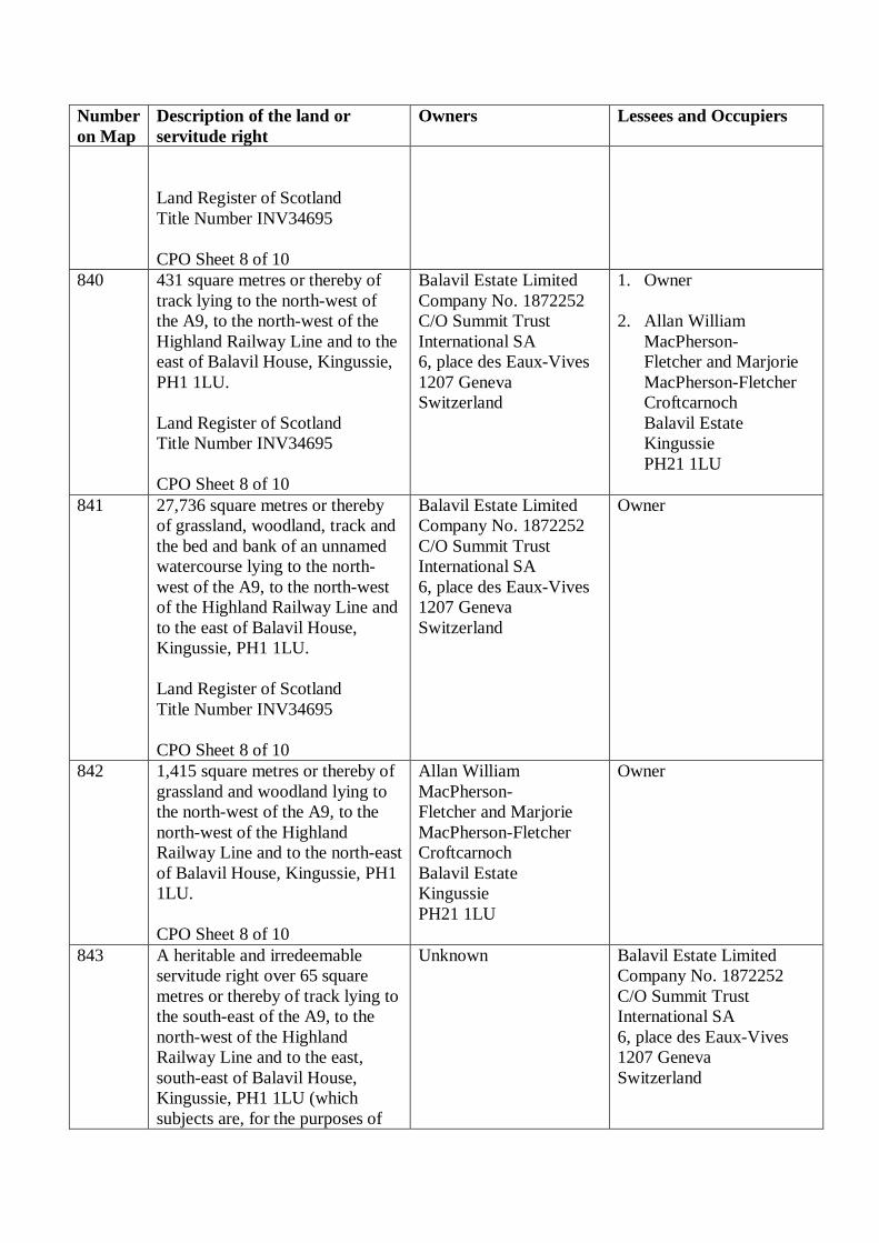
Number
on Map
Description of the land or
servitude right
Owners Lessees and Occupiers
Land Register of Scotland
Title Number INV34695
CPO Sheet 8 of 10
840 431 square metres or thereby of
track lying to the north-west of
the A9, to the north-west of the
Highland Railway Line and to the
east of Balavil House, Kingussie,
PH1 1LU.
Land Register of Scotland
Title Number INV34695
CPO Sheet 8 of 10
Balavil Estate Limited
Company No. 1872252
C/O Summit Trust
International SA
6, place des Eaux-Vives
1207 Geneva
Switzerland
1. Owner
2. Allan William
MacPherson-
Fletcher and Marjorie
MacPherson-Fletcher
Croftcarnoch
Balavil Estate
Kingussie
PH21 1LU
841 27,736 square metres or thereby
of grassland, woodland, track and
the bed and bank of an unnamed
watercourse lying to the north-
west of the A9, to the north-west
of the Highland Railway Line and
to the east of Balavil House,
Kingussie, PH1 1LU.
Land Register of Scotland
Title Number INV34695
CPO Sheet 8 of 10
Balavil Estate Limited
Company No. 1872252
C/O Summit Trust
International SA
6, place des Eaux-Vives
1207 Geneva
Switzerland
Owner
842 1,415 square metres or thereby of
grassland and woodland lying to
the north-west of the A9, to the
north-west of the Highland
Railway Line and to the north-east
of Balavil House, Kingussie, PH1
1LU.
CPO Sheet 8 of 10
Allan William
MacPherson-
Fletcher and Marjorie
MacPherson-Fletcher
Croftcarnoch
Balavil Estate
Kingussie
PH21 1LU
Owner
843 A heritable and irredeemable
servitude right over 65 square
metres or thereby of track lying to
the south-east of the A9, to the
north-west of the Highland
Railway Line and to the east,
south-east of Balavil House,
Kingussie, PH1 1LU (which
subjects are, for the purposes of
Unknown Balavil Estate Limited
Company No. 1872252
C/O Summit Trust
International SA
6, place des Eaux-Vives
1207 Geneva
Switzerland

Number
on Map
Description of the land or
servitude right
Owners Lessees and Occupiers
this servitude right, hereby
nominated as, and hereafter
referred to as, the “burdened
property”), to connect the
benefited property (as hereinafter
defined) and to provide pedestrian
and vehicular access to, from and
between the benefited property,
together with a right to inspect,
maintain, improve, repair and
renew an access road thereon,
with power to the acquiring
authority and their successors as
proprietors of the benefited
property and those authorised by
them, their employees and
contractors, to enter on the
burdened property for said
purposes.
For the purposes of this servitude
right the following subjects are
hereby nominated and identified
as, and in the foregoing
description referred to as, “the
benefited property”:
i) the subjects numbered plots 828
and 838 more particularly
described in this Schedule and
shown on the said map.
(ii) ALL and WHOLE the
subjects owned by the Scottish
Ministers, registered under
Registers of Scotland Title
Number INV39806.
Land Register of Scotland
Title Number INV34695
CPO Sheet 8 of 10
844 A heritable and irredeemable
servitude right over 663 square
metres or thereby of track lying to
the south-east of the A9, to the
north-west of the Highland
Railway Line and to the east,
Balavil Estate Limited
Company No. 1872252
C/O Summit Trust
International SA
6, place des Eaux-Vives
1207 Geneva
Owner

Number
on Map
Description of the land or
servitude right
Owners Lessees and Occupiers
south-east of Balavil House,
Kingussie, PH1 1LU (which
subjects are, for the purposes of
this servitude right, hereby
nominated as, and hereafter
referred to as, the “burdened
property”), to connect the
benefited property (as hereinafter
defined) and to provide pedestrian
and vehicular access to, from and
between the benefited property,
together with a right to inspect,
maintain, improve, repair and
renew an access road thereon,
with power to the acquiring
authority and their successors as
proprietors of the benefited
property and those authorised by
them, their employees and
contractors, to enter on the
burdened property for said
purposes.
For the purposes of this servitude
right the following subjects are
hereby nominated and identified
as, and in the foregoing
description referred to as, “the
benefited property”:
i) the subjects numbered plots 828
and 838 more particularly
described in this Schedule and
shown on the said map.
(ii) ALL and WHOLE the
subjects owned by the Scottish
Ministers, registered under
Registers of Scotland Title
Number INV39806.
Land Register of Scotland
Title Number INV34695
CPO Sheet 8 of 10
Switzerland
845 2 square metres or thereby of
track lying to the south-east of the
A9, to the north-east of Raitts
Unknown Balavil Estate Limited
Company No. 1872252

Number
on Map
Description of the land or
servitude right
Owners Lessees and Occupiers
Burn and to the south of Balavil
House, Kingussie, PH1 1LU.
Land Register of Scotland
Title Number INV34695
CPO Sheet 8 of 10
C/O Summit Trust
International SA
6, place des Eaux-Vives
1207 Geneva
Switzerland
846 49 square metres or thereby of
woodland lying to the south-east
of the A9, to the north-east of
Raitts Burn and to the south of
Balavil House, Kingussie, PH1
1LU.
CPO Sheet 8 of 10
Unknown Unknown
847 12 square metres or thereby of
track lying to the south-east of the
A9, to the north-east of Raitts
Burn and to the south of Balavil
House, Kingussie, PH1 1LU.
Land Register of Scotland
Title Number INV34695
CPO Sheet 8 of 10
Balavil Estate Limited
Company No. 1872252
C/O Summit Trust
International SA
6, place des Eaux-Vives
1207 Geneva
Switzerland
Owner
848 607 square metres or thereby of
woodland lying to the south-east
of the A9, to the north-east of
Raitts Burn and to the south of
Balavil House, Kingussie, PH1
1LU.
Land Register of Scotland
Title Number INV34695
CPO Sheet 8 of 10
Balavil Estate Limited
Company No. 1872252
C/O Summit Trust
International SA
6, place des Eaux-Vives
1207 Geneva
Switzerland
Owner
849 A heritable and irredeemable
servitude right over 51 square
metres or thereby of track lying to
the south-east of the B9152
Kingussie – Granish Road, to the
north-east of the Highland
Railway Line (which subjects are,
for the purposes of this servitude
right, hereby nominated as, and
hereafter referred to as, the
“burdened property”), to connect
the benefited property (as
Unknown 1. Owner
2. Royal Society for the
Protection of Birds
RSPB North Scotland
Regional Office
Etive House
Beechwood Park
Inverness
IV2 3BW
3. Network Rail

Number
on Map
Description of the land or
servitude right
Owners Lessees and Occupiers
hereinafter defined) and to
provide pedestrian and vehicular
access to, from and between the
benefited property, together with
a right to inspect, maintain,
improve, repair and renew an
access road thereon, with power
to the acquiring authority and
their successors as proprietors of
the benefited property and those
authorised by them, their
employees and contractors, to
enter on the burdened property for
said purposes.
For the purposes of this servitude
right the following subjects are
hereby nominated and identified
as, and in the foregoing
description referred to as, “the
benefited property”:
i) the subjects numbered plots
812, 813 and 836 more
particularly described in this
Schedule and shown on the said
map.
CPO Sheet 8 of 10
Infrastructure Limited
Company No.
02904587
1 Eversholt Street
London
NW1 2DN
850 3 square metres or thereby of
woodland lying to the north-west
of the A9, to the north-west of the
Highland Railway Line and to the
south-west of Balavil House,
Kingussie, PH1 1LU.
CPO Sheet 8 of 10
Unknown Unknown
851 1 square metre or thereby of
woodland lying to the north-west
of the A9, to the north-west of the
Highland Railway Line and to the
south-west of Balavil House,
Kingussie, PH1 1LU.
CPO Sheet 8 of 10
Unknown Unknown
852 1 square metre or thereby of
woodland lying to the south of the
Unknown Unknown

Number
on Map
Description of the land or
servitude right
Owners Lessees and Occupiers
A9, to the north-west of the
Highland Railway Line and to the
south-west of Balavil House,
Kingussie, PH1 1LU.
CPO Sheet 8 of 10
853 8 square metres or thereby of
woodland lying to the south-east
of the A9, to the west of Raitts
Burn and to the south of Balavil
House, Kingussie, PH1 1LU.
CPO Sheet 8 of 10
Unknown Unknown
854 4 square metres or thereby of
woodland lying to the south-west
of the A9, to the north-west of the
Highland Railway Line and to the
south-west of Balavil House,
Kingussie, PH1 1LU.
CPO Sheet 8 of 10
Unknown Unknown
855 to
900
Numbers not allocated - -
901 1,367 square metres or thereby of
verge of the A9 lying to the north-
west of the A9, to the north-west
of the B9152 Kingussie – Granish
Road and to the south of
Croftcarnoch, Kingussie, PH21
1LU.
CPO Sheet 9 of 10
Unknown Occupied by the Scottish
Ministers as roads
authority. Interest currently
held by the acquiring
authority.
902 27,348 square metres or thereby
of grassland, track and the bed
and banks of an unnamed
watercourse lying to the north-
west of the A9, to the north-west
of the B9152 Kingussie – Granish
Road and to the south and east of
Croftcarnoch, Kingussie, PH21
1LU.
Land Register of Scotland
Title Number INV34695
CPO Sheet 9 of 10
Balavil Estate Limited
Company No. 1872252
C/O Summit Trust
International SA
6, place des Eaux-Vives
1207 Geneva
Switzerland
Owner
903 8,663 square metres or thereby of
track, grassland and the bed and
Allan William
MacPherson-
Owner

Number
on Map
Description of the land or
servitude right
Owners Lessees and Occupiers
banks of two unnamed
watercourses lying to the north-
west of the A9, to the north-west
of the B9152 Kingussie – Granish
Road and to the north of
Croftcarnoch, Kingussie, PH21
1LU.
CPO Sheet 9 of 10
Fletcher and Marjorie
MacPherson-Fletcher
Croftcarnoch
Balavil Estate
Kingussie
PH21 1LU
904 179 square metres or thereby of
grassland and track lying to the
north-west of the A9, to the north-
west of the B9152 Kingussie –
Granish Road and to the north-
east of Croftcarnoch, Kingussie,
PH21 1LU.
Land Register of Scotland
Title Number INV34695
CPO Sheet 9 of 10
Balavil Estate Limited
Company No. 1872252
C/O Summit Trust
International SA
6, place des Eaux-Vives
1207 Geneva
Switzerland
Owner
905 1,800 square metres or thereby of
scrubland and woodland lying to
the north-west of the A9, to the
north-west of the B9152
Kingussie – Granish Road and to
the north-east of Meadowside
House, Kingussie, PH21 1LX.
CPO Sheet 9 of 10
John Charles Forbes-
Leith
Dunachton
Kingussie
PH21 1LY
Owner
906 4,229 square metres or thereby of
scrubland and woodland lying to
the north-west of the A9, to the
north-west of the B9152
Kingussie – Granish Road and to
the east of Croftcarnoch,
Kingussie, PH21 1LU.
CPO Sheet 9 of 10
John Charles Forbes-
Leith
Dunachton
Kingussie
PH21 1LY
1. Owner
2. Royal Zoological
Society of Scotland
Estates Department
c/o Edinburgh Zoo
134 Corstorphine Road
EH12 6TS
907 3,167 square metres or thereby of
scrubland and woodland lying to
the south of the A9, to the north-
west of the B9152 Kingussie –
Granish Road and to the south-
east of Croftcarnoch, Kingussie,
PH21 1LU.
Land Register of Scotland
Balavil Estate Limited
Company No. 1872252
C/O Summit Trust
International SA
6, place des Eaux-Vives
1207 Geneva
Switzerland
Owner
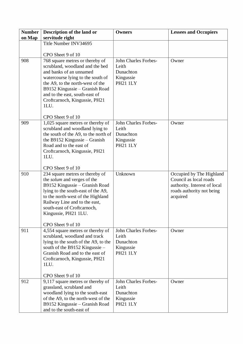
Number
on Map
Description of the land or
servitude right
Owners Lessees and Occupiers
Title Number INV34695
CPO Sheet 9 of 10
908 768 square metres or thereby of
scrubland, woodland and the bed
and banks of an unnamed
watercourse lying to the south of
the A9, to the north-west of the
B9152 Kingussie – Granish Road
and to the east, south-east of
Croftcarnoch, Kingussie, PH21
1LU.
CPO Sheet 9 of 10
John Charles Forbes-
Leith
Dunachton
Kingussie
PH21 1LY
Owner
909 1,025 square metres or thereby of
scrubland and woodland lying to
the south of the A9, to the north of
the B9152 Kingussie – Granish
Road and to the east of
Croftcarnoch, Kingussie, PH21
1LU.
CPO Sheet 9 of 10
John Charles Forbes-
Leith
Dunachton
Kingussie
PH21 1LY
Owner
910 234 square metres or thereby of
the solum and verges of the
B9152 Kingussie – Granish Road
lying to the south-east of the A9,
to the north-west of the Highland
Railway Line and to the east,
south-east of Croftcarnoch,
Kingussie, PH21 1LU.
CPO Sheet 9 of 10
Unknown Occupied by The Highland
Council as local roads
authority. Interest of local
roads authority not being
acquired
911 4,554 square metres or thereby of
scrubland, woodland and track
lying to the south of the A9, to the
south of the B9152 Kingussie –
Granish Road and to the east of
Croftcarnoch, Kingussie, PH21
1LU.
CPO Sheet 9 of 10
John Charles Forbes-
Leith
Dunachton
Kingussie
PH21 1LY
Owner
912 9,117 square metres or thereby of
grassland, scrubland and
woodland lying to the south-east
of the A9, to the north-west of the
B9152 Kingussie – Granish Road
and to the south-east of
John Charles Forbes-
Leith
Dunachton
Kingussie
PH21 1LY
Owner

Number
on Map
Description of the land or
servitude right
Owners Lessees and Occupiers
Meadowside House, Kingussie,
PH21 1LX.
CPO Sheet 9 of 10
913 7,843 square metres or thereby of
scrubland and woodland lying to
the north-west of the A9, to the
north-west of the Highland
Railway Line and to the south-
east of Meadowside House,
Kingussie, PH21 1LX.
CPO Sheet 9 of 10
John Charles Forbes-
Leith
Dunachton
Kingussie
PH21 1LY
Owner
914 78 square metres or thereby of
scrubland and woodland lying to
the north-west of the A9, to the
north-west of the Highland
Railway Line and to the east,
north-east of Meadowside House,
Kingussie, PH21 1LX.
CPO Sheet 9 of 10
John Charles Forbes-
Leith
Dunachton
Kingussie
PH21 1LY
Owner
915 1,100 square metres or thereby of
the solum and verges of the
B9152 Kingussie – Granish Road
and the bed and banks of an
unnamed watercourse lying to the
south-east of the A9, to the north-
west of the Highland Railway
Line and to the east of
Meadowside House, Kingussie,
PH21 1LX.
CPO Sheet 9 of 10
Unknown Occupied by The Highland
Council as local roads
authority. Interest of local
roads authority not being
acquired.
916 600 square metres or thereby of
scrubland, woodland and the bed
and banks of an unnamed
watercourse lying to the south-
east of the A9, to the north-west
of the Highland Railway Line and
to the east of Meadowside House,
Kingussie, PH21 1LX.
CPO Sheet 9 of 10
John Charles Forbes-
Leith
Dunachton
Kingussie
PH21 1LY
Owner
917 2,023 square metres or thereby of
access road lying to the north-
west of the A9, to the north-west
of the Highland Railway Line and
John Charles Forbes-
Leith
Dunachton
Kingussie
1. Owner
2. Royal Zoological
Society of Scotland

Number
on Map
Description of the land or
servitude right
Owners Lessees and Occupiers
to the south-east of Meadowside
House, Kingussie, PH21 1LX.
CPO Sheet 9 of 10
PH21 1LY Estates Department
c/o Edinburgh Zoo
134 Corstorphine Road
EH12 6TS
918 808 square metres or thereby of
building and garden ground
forming the property known as
Coulintyre, Kincraig, PH21 1LX,
lying to the south-east of the A9,
to the north-west of the B9152
Kingussie – Granish Road and to
the east of Meadowside House,
Kingussie, PH21 1LX.
CPO Sheet 9 of 10
Iain Morris McFie and
Fiona Annabella McFie
Coulintyre
Kincraig
PH21 1LX
Owner
919 3,134 square metres or thereby of
scrubland and woodland lying to
the south-east of the A9, to the
south-east of the B9152 Kingussie
– Granish Road and to the east of
Meadowside House, Kingussie,
PH21 1LX.
CPO Sheet 9 of 10
John Charles Forbes-
Leith
Dunachton
Kingussie
PH21 1LY
Owner
920 3,564 square metres or thereby of
scrubland and woodland lying to
the north-west of the A9, to the
north-west of the Highland
Railway Line and to the east,
north-east of Meadowside House,
Kingussie, PH21 1LX.
CPO Sheet 9 of 10
John Charles Forbes-
Leith
Dunachton
Kingussie
PH21 1LY
Owner
921 878 square metres or thereby of
scrubland and woodland lying to
the north-west of the A9, to the
north-west of the Highland
Railway Line and to the east,
north-east of Meadowside House,
Kingussie, PH21 1LX.
CPO Sheet 9 of 10
John Charles Forbes-
Leith
Dunachton
Kingussie
PH21 1LY
Owner
922 124 square metres or thereby of
scrubland and woodland lying to
the north-west of the A9, to the
north-west of the Highland
Railway Line and to the east,
John Charles Forbes-
Leith
Dunachton
Kingussie
PH21 1LY
Owner

Number
on Map
Description of the land or
servitude right
Owners Lessees and Occupiers
north-east of Meadowside House,
Kingussie, PH21 1LX.
CPO Sheet 9 of 10
923 254 square metres or thereby of
scrubland and woodland lying to
the north-west of the A9, to the
north-west of the Highland
Railway Line and to the east,
north-east of Meadowside House,
Kingussie, PH21 1LX.
CPO Sheet 9 of 10
John Charles Forbes-
Leith
Dunachton
Kingussie
PH21 1LY
1. Owner
2. Iain Morris McFie and
Fiona Annabella McFie
Coulintyre
Kincraig
PH21 1LX
924 22 square metres or thereby of
scrubland and woodland lying to
the north-west of the A9, to the
north-west of the Highland
Railway Line and to the east,
north-east of Meadowside House,
Kingussie, PH21 1LX.
CPO Sheet 9 of 10
John Charles Forbes-
Leith
Dunachton
Kingussie
PH21 1LY
1. Owner
2. Iain Morris McFie and
Fiona Annabella McFie
Coulintyre
Kincraig
PH21 1LX
925 134 square metres or thereby of
grassland, scrubland and
woodland lying to the south-east
of the A9, to the north-west of the
B9152 Kingussie – Granish Road
and to the east of Meadowside
House, Kingussie, PH21 1LX.
CPO Sheet 9 of 10
John Charles Forbes-
Leith
Dunachton
Kingussie
PH21 1LY
1. Owner
2. Iain Morris McFie and
Fiona Annabella McFie
Coulintyre
Kincraig
PH21 1LX
926 54 square metres or thereby of
scrubland and woodland lying to
the south-east of the A9, to the
north-west of the B9152
Kingussie – Granish Road and to
the east of Meadowside House,
Kingussie, PH21 1LX.
CPO Sheet 9 of 10
John Charles Forbes-
Leith
Dunachton
Kingussie
PH21 1LY
1. Owner
2. Iain Morris McFie and
Fiona Annabella McFie
Coulintyre
Kincraig
PH21 1LX
927 875 square metres or thereby of
access road lying to the north-
west of the B9152 Kingussie to
Granish Road, to the north-west
of the Highland Railway Line and
to the east of Meadowside House,
Kingussie, PH21 1LX.
John Charles Forbes-
Leith
Dunachton
Kingussie
PH21 1LY
1. Owner
2. Royal Zoological
Society of Scotland
Estates Department
c/o Edinburgh Zoo
134 Corstorphine Road
EH12 6TS

Number
on Map
Description of the land or
servitude right
Owners Lessees and Occupiers
CPO Sheet 9 of 10
3. Breedon Northern
Limited
Company No.
SC144788
Ethiebeaton Quarry
Kingennie
Monifieth
Angus
DD5 3RB
928 4,256 square metres or thereby of
scrubland and woodland lying to
the south-east of the A9, to the
north-west of the B9152
Kingussie – Granish Road and to
the south-east of Meadowside
House, Kingussie, PH21 1LX.
CPO Sheet 9 of 10
John Charles Forbes-
Leith
Dunachton
Kingussie
PH21 1LY
Owner
929 1,587 square metres or thereby of
the access road under the A9
bridge structure lying to the north-
west of the B9152 Kingussie to
Granish Road, to the north-west
of the Highland Railway Line and
to the east of Meadowside House,
Kingussie, PH21 1LX.
Land Register of Scotland
Title Number INV39806
CPO Sheet 9 of 10
John Charles Forbes-
Leith
Dunachton
Kingussie
PH21 1LY
1. Owner
2. Occupied by the
Scottish Ministers as
roads authority. Interest
currently held by the
acquiring authority.
3. Royal Zoological
Society of Scotland
Estates Department
c/o Edinburgh Zoo
134 Corstorphine Road
EH12 6TS
4. Breedon Northern
Limited
Company No.
SC144788
Ethiebeaton Quarry
Kingennie
Monifieth
Angus
DD5 3RB
930 992 square metres or thereby of
the solum and verges of the
B9152 Kingussie – Granish Road
lying to the south-east of the A9,
to the north-west of the Highland
Unknown Occupied by The Highland
Council as local roads
authority. Interest of local
roads authority not being
acquired.
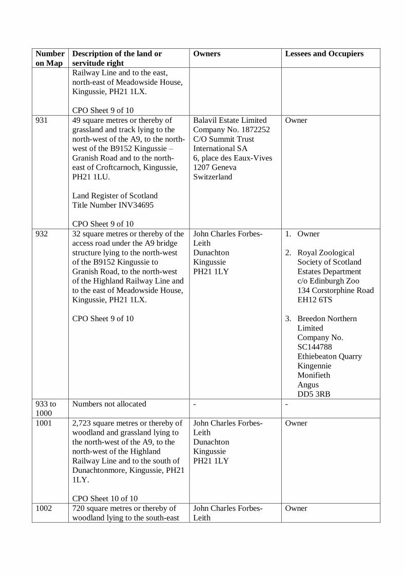
Number
on Map
Description of the land or
servitude right
Owners Lessees and Occupiers
Railway Line and to the east,
north-east of Meadowside House,
Kingussie, PH21 1LX.
CPO Sheet 9 of 10
931 49 square metres or thereby of
grassland and track lying to the
north-west of the A9, to the north-
west of the B9152 Kingussie –
Granish Road and to the north-
east of Croftcarnoch, Kingussie,
PH21 1LU.
Land Register of Scotland
Title Number INV34695
CPO Sheet 9 of 10
Balavil Estate Limited
Company No. 1872252
C/O Summit Trust
International SA
6, place des Eaux-Vives
1207 Geneva
Switzerland
Owner
932 32 square metres or thereby of the
access road under the A9 bridge
structure lying to the north-west
of the B9152 Kingussie to
Granish Road, to the north-west
of the Highland Railway Line and
to the east of Meadowside House,
Kingussie, PH21 1LX.
CPO Sheet 9 of 10
John Charles Forbes-
Leith
Dunachton
Kingussie
PH21 1LY
1. Owner
2. Royal Zoological
Society of Scotland
Estates Department
c/o Edinburgh Zoo
134 Corstorphine Road
EH12 6TS
3. Breedon Northern
Limited
Company No.
SC144788
Ethiebeaton Quarry
Kingennie
Monifieth
Angus
DD5 3RB
933 to
1000
Numbers not allocated - -
1001 2,723 square metres or thereby of
woodland and grassland lying to
the north-west of the A9, to the
north-west of the Highland
Railway Line and to the south of
Dunachtonmore, Kingussie, PH21
1LY.
CPO Sheet 10 of 10
John Charles Forbes-
Leith
Dunachton
Kingussie
PH21 1LY
Owner
1002 720 square metres or thereby of
woodland lying to the south-east
John Charles Forbes-
Leith
Owner

Number
on Map
Description of the land or
servitude right
Owners Lessees and Occupiers
of the A9, to the north-west of the
Highland Railway Line and to the
south of Dunachtonmore,
Kingussie, PH21 1LY.
CPO Sheet 10 of 10
Dunachton
Kingussie
PH21 1LY
1003 2,895 square metres or thereby of
woodland and scrubland lying to
the south-east of the A9, to the
north-west of the Highland
Railway Line and to the south of
Dunachtonmore, Kingussie, PH21
1LY.
CPO Sheet 10 of 10
John Charles Forbes-
Leith
Dunachton
Kingussie
PH21 1LY
Owner
1004 402 square metres or thereby of
the solum and verges of the
B9152 Kingussie – Granish Road
lying to to the south-east of the
A9, to the north-west of the
Highland Railway Line and to the
south of Dunachtonmore,
Kingussie, PH21 1LY.
CPO Sheet 10 of 10
Unknown Occupied by The Highland
Council as local roads
authority. Interest of local
roads authority not being
acquired.
1005 18 square metres or thereby of
woodland lying to the south-east
of the A9, to the north-west of the
Highland Railway Line and to the
east, south-east of
Dunachtonmore, Kingussie, PH21
1LY.
CPO Sheet 10 of 10
John Charles Forbes-
Leith
Dunachton
Kingussie
PH21 1LY
Owner
1006 75 square metres or thereby of
woodland lying to the south-east
of the A9, to the north-west of the
Highland Railway Line and to the
east, south-east of
Dunachtonmore, Kingussie, PH21
1LY.
CPO Sheet 10 of 10
John Charles Forbes-
Leith
Dunachton
Kingussie
PH21 1LY
Owner

Number
on Map
Description of the land or
servitude right
Owners Lessees and Occupiers
1007 69 square metres or thereby of the
B9152 Kingussie – Granish Road
lying to the south-east of the A9,
to the north-west of the Highland
Railway Line and to the south of
Dunachtonmore, Kingussie, PH21
1LY.
CPO Sheet 10 of 10
Unknown Occupied by The Highland
Council as local roads
authority. Interest of local
roads authority not being
acquired.
1008 211 square metres or thereby of
woodland lying to the south-east
of the A9, to the north-west of the
Highland Railway Line and to the
east, south-east of
Dunachtonmore, Kingussie, PH21
1LY.
CPO Sheet 10 of 10
John Charles Forbes-
Leith
Dunachton
Kingussie
PH21 1LY
Owner

![SharePoint 2010: The Business [TITLE] Collaboration ...download.microsoft.com/download/a/d/7/ad763779-a86... · Payroll Management Delivery Scheduling ... Citizen Portals Project](https://static.documents.pub/doc/80x56/5ec02c6f377aa975771c1786/sharepoint-2010-the-business-title-collaboration-payroll-management-delivery.jpg)


