
Topsail Inlet, Banks Connector Channel, Topsail Creek, Cut Through Channel,Beach Fill and Dredging of areas including:
WINTER 2018DREDGE PLANS
TOPSAIL BEACH NOURISHMENT AND
TABLE OF CONTENTSTABLE OF CONTENTS
PENDER COUNTY, NORTH CAROLINA
Banks Channel, and Banks Side Channels 1 & 2
CHANNEL DREDGING PROJECT
11x17 Plotted to Half Scale136
SHEET 3 SHEET 4SHEET 5
SHEET 6
SHEET 7SHEET 8
SHEET 9
SHEET 10
Atlantic Ocean
Atla
ntic
Intra
coasta
l Wate
rway
DA
-203
D
A
-189
Jolly Roger Fishing Pier
Beach Fill Area
T
o
p
s
a
i
l
Beach Fill Area
B
a
n
ks C
o
n
n
e
cto
r
T
o
p
s
a
i
l
I
n
l
e
t
C
h
a
n
n
e
l
Topsail Inlet
S
id
e
C
h
a
n
n
e
l 1
TB-1
TB-2
TB-3
TB-4
TB-5
TB-6
TB-7
TB-8 TB-9
TB-10 TB-11 TB-12
TB-13
TB-14
TB-15
TB-16 TB-17
TB-18
TB-19TB-20
TB-21
TB-22
TB-23
TB-24
TB-25
TB-26TB-27
NTI-7
NTI-6
NTI-5
NTI-4
NTI-3
NTI-2
NTI-1
BCC-7
BCC-6
BCC-4
BCC-3
BCC-2
BCC-1
TC-1
TC-2
TC-3
TC-4
TC-5
TC-6
TC-7
TC-8
TC-9
TC-10
TC-11
TC-12
TC-13
TC-14
TC-15
TC-16
SC1-1
SC1-2
SC2-1
SC2-3
SC2-5
S
H
E
E
T
14 &
15
C
r
e
e
k
S
H
E
E
T
19 &
20
S
H
E
E
T
21 &
22
SHEET 31 &
32
SHEET 31 &
32
C
u
t
T
h
r
o
u
g
h
S
id
e
C
h
a
n
n
e
l 2
Banks Channel
B
a
n
k
s
C
h
a
n
n
e
l
Banks Channel
B
a
n
k
s
C
h
a
n
n
e
l
BCC-5
CT-1
CT-2
SC1-3
SC1-4
SC2-2
SC2-4BC-1
BC-3
BC-4
BC-5
BC-6
BC-2
BC-7
BC-8
BC-9 BC-10
BC-11
BC-12
BC-13
BC-14
BC-15
SHEET 33 &
34
SHEET 33 &
34
SHEET: 2 OF 40
387-B N. Green Meadows Dr.Wilmington, NC 28405
Vertical Datum
Mean High Water
Conversion
Graphic ScaleTI Coastal Services, Inc.
910.821.1358SCALE: 1" = 1,200'
TI Coastal Services, Inc.0' 600' 1,200' 2,400'
Scale: 1" = 1,200'
Notes:1. Horizontal Datum: NC State Plane - Zone 3200, NAD83, Feet2. Vertical Datum: NAVD883. Data collected by TI Coastal in November 2016 (post Hurricane Matthew) and
represent conditions at that time.4. Soundings are expressed in feet and tenths.5. Aerial photography performed by TerraLina Mapping Consultants, Inc. on May 15,
2016 and represent conditions at that time.
DWG NAME: Topsail Beach Construction Plans 2018.dwgSURVEY DATE: August 2017
TOWN OF TOPSAIL BEACH
Channel Dredging and Coastal Storm Damage Reduction Project
2018 BEACH NOURISHMENT PROJECTPender County, NC
Project Layout and Control DWG DATE: December 1, 2017
1.20'
NAVD 1988
2.54'
Mean Low Water
3.74'
Christian L. Gibson, P.E. No. 02627311x17 Plotted to Half Scale
137
O
c
e
a
n
B
lv
d
Drum
A
ve
Spot Blvd
Landward Extent
of Fill
of Berm (5.5' NAVD)
Seaward Crest
of Fill
Seaward Toe
VE
HIC
LE
/E
QU
IP
ME
NT
BE
AC
H A
CC
ES
S
DR
UM
A
VE
NU
E
Existing
Under R
oad S
leeve
TB-1
TB-2
TB-3
TB-4
4+74.34
21+79.67
5+00
Slope 1:20
Start
of Dune C
onstructio
n
Taper into
Existin
g Dune F
eature
25' Dune Crest
25' Dune C
rest
25' Dune C
rest
Fill Area
See Cross Sectio
ns
10+00
10+98.10
15+00
20+00
25+00
0+00
SHEET: 3 OF 40
387-B N. Green Meadows Dr.Wilmington, NC 28405
Vertical Datum
Mean High Water
Conversion
Graphic ScaleTI Coastal Services, Inc.
910.821.1358SCALE: 1" = 100'
TI Coastal Services, Inc.0' 50' 100' 200'
Scale: 1" = 100'
Notes:1. Horizontal Datum: NC State Plane - Zone 3200, NAD83, Feet2. Vertical Datum: NAVD883. Data collected by TI Coastal in November 2016 (post Hurricane Matthew) and
represent conditions at that time.4. Soundings are expressed in feet and tenths.5. Aerial photography performed by TerraLina Mapping Consultants, Inc. on May 15,
2016 and represent conditions at that time.
DWG NAME: Topsail Beach Construction Plans 2018.dwgSURVEY DATE: August 2017
TOWN OF TOPSAIL BEACH
Channel Dredging and Coastal Storm Damage Reduction Project
2018 BEACH NOURISHMENT PROJECTPender County, NC
Plan View - Beach Template and Bathymetry DWG DATE: December 1, 2017
1.20'
NAVD 1988
2.54'
Mean Low Water
3.74'
Christian L. Gibson, P.E. No. 02627311x17 Plotted to Half Scale138
Ocean Blvd
Clark A
ve
Sm
ith A
ve
Darden A
ve
Ocean Blvd
S. Anderson Blvd
Seaward Crest
of Fill
Landward Extent
Seaward Toe
of Fill
of Berm (5.5' NAVD)
TB-5
TB-6
TB-7
32+19.12
42+39.76
52+39.47
30+00
35+00
40+00
45+00
50+00
55+00
60+00
Slope 1:20
Slope 1:20
25' Dune Crest
25' Dune Crest
25' Dune Crest
25' Dune Crest
25' Dune Crest
Fill Area
See Cross Sections
SHEET: 4 OF 40
387-B N. Green Meadows Dr.Wilmington, NC 28405
Vertical Datum
Mean High Water
Conversion
Graphic ScaleTI Coastal Services, Inc.
910.821.1358SCALE: 1" = 100'
TI Coastal Services, Inc.0' 50' 100' 200'
Scale: 1" = 100'
Notes:1. Horizontal Datum: NC State Plane - Zone 3200, NAD83, Feet2. Vertical Datum: NAVD883. Data collected by TI Coastal in November 2016 (post Hurricane Matthew) and
represent conditions at that time.4. Soundings are expressed in feet and tenths.5. Aerial photography performed by TerraLina Mapping Consultants, Inc. on May 15,
2016 and represent conditions at that time.
DWG NAME: Topsail Beach Construction Plans 2018.dwgSURVEY DATE: August 2017
TOWN OF TOPSAIL BEACH
Channel Dredging and Coastal Storm Damage Reduction Project
2018 BEACH NOURISHMENT PROJECTPender County, NC
Plan View - Beach Template and Bathymetry DWG DATE: December 1, 2017
1.20'
NAVD 1988
2.54'
Mean Low Water
3.74'
Christian L. Gibson, P.E. No. 02627311x17 Plotted to Half Scale139
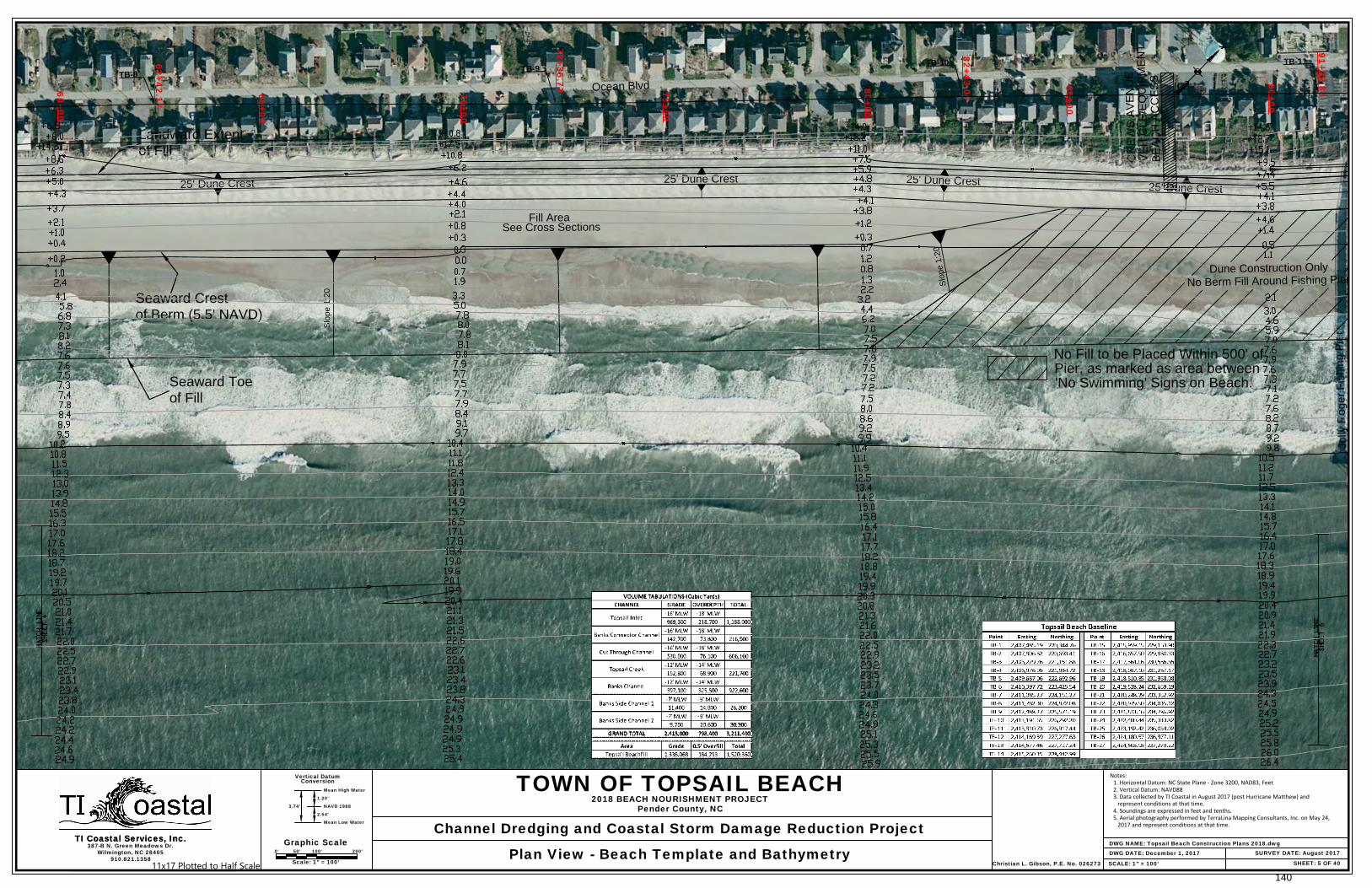
Ocean Blvd
Jolly R
oger F
ishing P
ier
Seaward Crest
of Fill
Landward Extent
Seaward Toe
of Fill
of Berm (5.5' NAVD)
VE
HIC
LE
/E
QU
IP
ME
NT
BE
AC
H A
CC
ES
S
CR
EW
S A
VE
NU
E
Fill Area
See Cross Sections
No Fill to be Placed Within 500' of
Pier, as marked as area between
'No Swimming' Signs on Beach.
TB-8
TB-9
TB-10
TB-1162+42.17
72+35.73
82+43.00
91+22.8860+00
65+00
70+00
75+00
80+00
85+00
90+00
S
lo
p
e
1
:2
0
Slope 1:20
Dune Construction Only
No Berm Fill Around Fishing Pier
25' Dune Crest
25' Dune Crest
25' Dune Crest
25' Dune Crest
SHEET: 5 OF 40
387-B N. Green Meadows Dr.Wilmington, NC 28405
Vertical Datum
Mean High Water
Conversion
Graphic ScaleTI Coastal Services, Inc.
910.821.1358SCALE: 1" = 100'
TI Coastal Services, Inc.0' 50' 100' 200'
Scale: 1" = 100'
DWG NAME: Topsail Beach Construction Plans 2018.dwgSURVEY DATE: August 2017
TOWN OF TOPSAIL BEACH
Channel Dredging and Coastal Storm Damage Reduction Project
2018 BEACH NOURISHMENT PROJECTPender County, NC
Plan View - Beach Template and Bathymetry DWG DATE: December 1, 2017
1.20'
NAVD 1988
2.54'
Mean Low Water
3.74'
Christian L. Gibson, P.E. No. 026273
Notes:1. Horizontal Datum: NC State Plane - Zone 3200, NAD83, Feet2. Vertical Datum: NAVD883. Data collected by TI Coastal in August 2017 (post Hurricane Matthew) and
represent conditions at that time.4. Soundings are expressed in feet and tenths.5. Aerial photography performed by TerraLina Mapping Consultants, Inc. on May 24,
2017 and represent conditions at that time.
11x17 Plotted to Half Scale140

Jolly R
oger F
ishing P
ier
Ocean Blvd
S. Anderson Blvd
Flake A
ve
S. Anderson Blvd
Seaward Crest
of Fill
Landward Extent
Seaward Toe
of Fill
of Berm (5.5' NAVD)
TB-11
TB-12
TB-13
TB-14
TB-15
91+22.88
96+31.18
102+31.00
112+27.52
122+31.53
95+00
105+00
110+00
115+00
120+00
Slope 1:20
Slope 1:20
Dune Construction Only
No Berm Fill Around Fishing Pier
25' Dune C
rest
25' Dune C
rest
25' Dune Crest
25' Dune Crest
25' Dune Crest
Fill Area
See Cross Sections
100+00
SHEET: 6 OF 40
387-B N. Green Meadows Dr.Wilmington, NC 28405
Vertical Datum
Mean High Water
Conversion
Graphic ScaleTI Coastal Services, Inc.
910.821.1358SCALE: 1" = 100'
TI Coastal Services, Inc.0' 50' 100' 200'
Scale: 1" = 100'
DWG NAME: Topsail Beach Construction Plans 2018.dwgSURVEY DATE: August 2017
TOWN OF TOPSAIL BEACH
Channel Dredging and Coastal Storm Damage Reduction Project
2018 BEACH NOURISHMENT PROJECTPender County, NC
Plan View - Beach Template and Bathymetry DWG DATE: December 1, 2017
1.20'
NAVD 1988
2.54'
Mean Low Water
3.74'
Christian L. Gibson, P.E. No. 026273
Notes: 1. Horizontal Datum: NC State Plane - Zone 3200, NAD83, Feet 2. Vertical Datum: NAVD88 3. Data collected by TI Coastal in August 2017 (post Hurricane Matthew) and represent conditions at that time. 4. Soundings are expressed in feet and tenths. 5. Aerial photography performed by TerraLina Mapping Consultants, Inc. on May 24, 2017 and represent conditions at that time.
11x17 Plotted to Half Scale141

S. Anderson Blvd
N. Anderson Blvd
Seaward Crest
of Fill
Landward Extent
Seaward Toe
of Fill
of Berm (5.5' NAVD)
TB-16
TB-17
TB-18
122+31.53
132+32.29
142+31.20
152+37.80
125+00
130+00
135+00
140+00
145+00
150+00
155+00
Slope 1:20
25' Dune Crest
25' Dune Crest25' Dune Crest25' Dune Crest
25' Dune Crest
Fill Area
See Cross Sections
SHEET: 7 OF 40
387-B N. Green Meadows Dr.Wilmington, NC 28405
Vertical Datum
Mean High Water
Conversion
Graphic ScaleTI Coastal Services, Inc.
910.821.1358SCALE: 1" = 100'
TI Coastal Services, Inc.0' 50' 100' 200'
Scale: 1" = 100'
DWG NAME: Topsail Beach Construction Plans 2018.dwgSURVEY DATE: August 2017
TOWN OF TOPSAIL BEACH
Channel Dredging and Coastal Storm Damage Reduction Project
2018 BEACH NOURISHMENT PROJECTPender County, NC
Plan View - Beach Template and Bathymetry DWG DATE: December 1, 2017
1.20'
NAVD 1988
2.54'
Mean Low Water
3.74'
Christian L. Gibson, P.E. No. 026273
Notes: 1. Horizontal Datum: NC State Plane - Zone 3200, NAD83, Feet 2. Vertical Datum: NAVD88 3. Data collected by TI Coastal in August 2017 (post Hurricane Matthew) and represent conditions at that time. 4. Soundings are expressed in feet and tenths. 5. Aerial photography performed by TerraLina Mapping Consultants, Inc. on May 24, 2017 and represent conditions at that time.
11x17 Plotted to Half Scale142

N. Anderson Blvd
Bare F
oot Ln
N. Anderson Blvd
Sunset A
ve
Seaward Crest
of Fill
Landward Extent
Seaward Toe
of Fill
of Berm (5.5' NAVD)
Existing
Under R
oad S
leeve
TB-19
TB-20
TB-21
162+24.68
172+27.78
182+27.64
155+00
160+00
165+00
170+00
175+00
180+00
185+00
Slope 1:20
Slope 1:20
25' Dune Crest
25' Dune Crest
25' Dune Crest
25' Dune Crest
25' Dune Crest
Fill Area
See Cross Sections
SHEET: 8 OF 40
387-B N. Green Meadows Dr.Wilmington, NC 28405
Vertical Datum
Mean High Water
Conversion
Graphic ScaleTI Coastal Services, Inc.
910.821.1358SCALE: 1" = 100'
TI Coastal Services, Inc.0' 50' 100' 200'
Scale: 1" = 100'
DWG NAME: Topsail Beach Construction Plans 2018.dwgSURVEY DATE: August 2017
TOWN OF TOPSAIL BEACH
Channel Dredging and Coastal Storm Damage Reduction Project
2018 BEACH NOURISHMENT PROJECTPender County, NC
Plan View - Beach Template and Bathymetry DWG DATE: December 1, 2017
1.20'
NAVD 1988
2.54'
Mean Low Water
3.74'
Christian L. Gibson, P.E. No. 026273
Notes: 1. Horizontal Datum: NC State Plane - Zone 3200, NAD83, Feet 2. Vertical Datum: NAVD88 3. Data collected by TI Coastal in August 2017 (post Hurricane Matthew) and represent conditions at that time. 4. Soundings are expressed in feet and tenths. 5. Aerial photography performed by TerraLina Mapping Consultants, Inc. on May 24, 2017 and represent conditions at that time.
11x17 Plotted to Half Scale143
N. Anderson Blvd
N. Anderson Blvd
Seaward Crest
Seaward Crest
Landward Extent
of Fill
Seaward Toe
of Fill
of Berm (5.5' NAVD)
of Berm (5.5' NAVD)
TB-22
TB-23
TB-24
192+27.97
203+50.25
211+52.75
185+00
190+00
195+00
200+00
205+00
210+00
215+00
Slope 1:20
Slope 1:20
25' Dune Crest
25' Dune Crest
25' Dune Crest
25' Dune Crest
25' Dune Crest
Fill Area
See Cross Sections
SHEET: 9 OF 40
387-B N. Green Meadows Dr.Wilmington, NC 28405
Vertical Datum
Mean High Water
Conversion
Graphic ScaleTI Coastal Services, Inc.
910.821.1358SCALE: 1" = 100'
TI Coastal Services, Inc.0' 50' 100' 200'
Scale: 1" = 100'
Notes: 1. Horizontal Datum: NC State Plane - Zone 3200, NAD83, Feet 2. Vertical Datum: NAVD88 3. Data collected by TI Coastal in November 2016 (post Hurricane Matthew) and represent conditions at that time. 4. Soundings are expressed in feet and tenths. 5. Aerial photography performed by TerraLina Mapping Consultants, Inc. on May 15, 2016 and represent conditions at that time.
DWG NAME: Topsail Beach Construction Plans 2018.dwgSURVEY DATE: August 2017
TOWN OF TOPSAIL BEACH
Channel Dredging and Coastal Storm Damage Reduction Project
2018 BEACH NOURISHMENT PROJECTPender County, NC
Plan View - Beach Template and Bathymetry DWG DATE: December 1, 2017
1.20'
NAVD 1988
2.54'
Mean Low Water
3.74'
Christian L. Gibson, P.E. No. 02627311x17 Plotted to Half Scale144
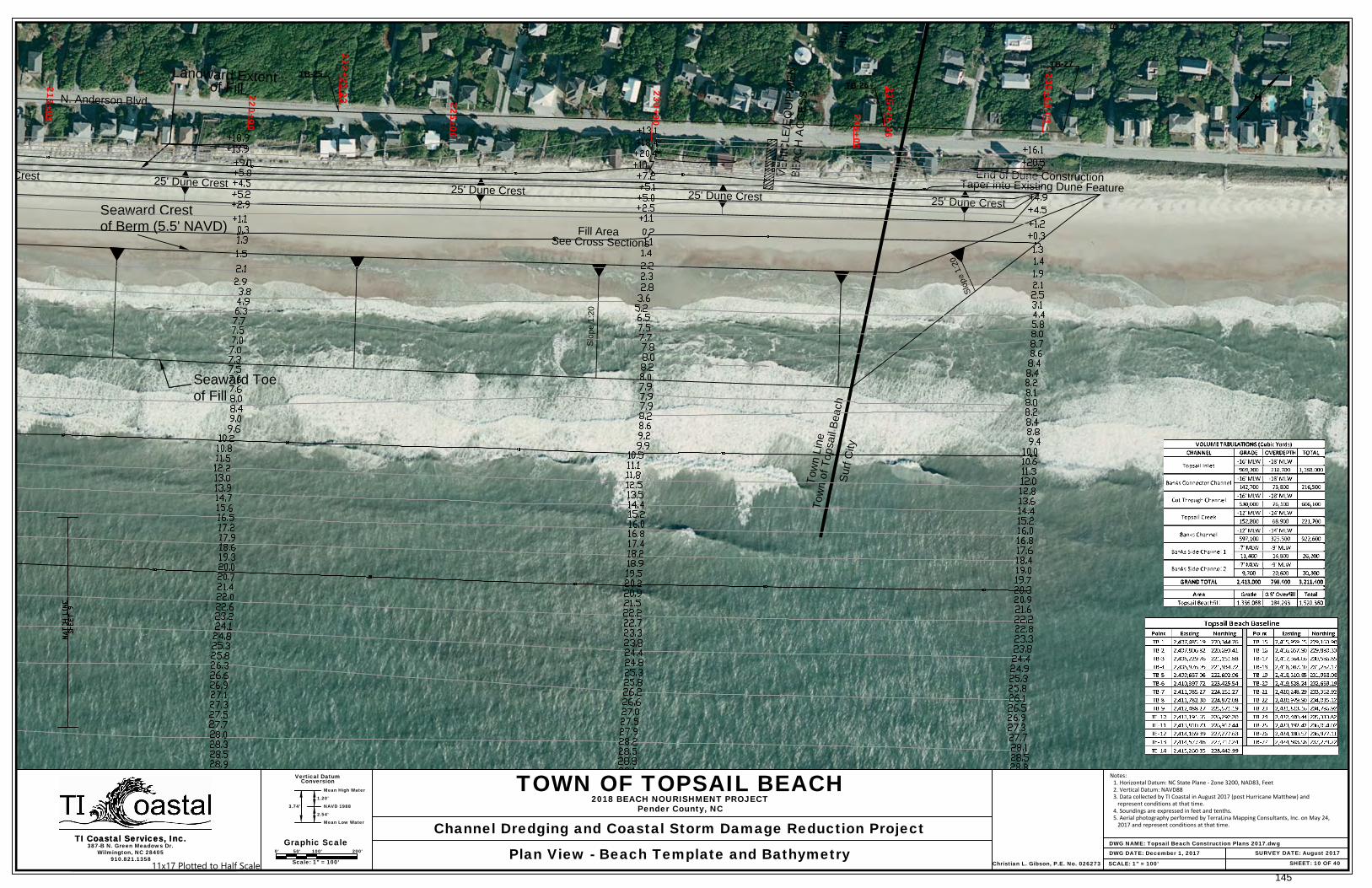
N. Anderson Blvd
S
traw
berry Ln
H
um
phrey A
ve
H
ispaniola Ln
B
eachw
ood D
r
C
rutchfield A
ve
Seaward Crest
Landward Extent
of Fill
Seaward Toe
of Fill
of Berm (5.5' NAVD)
VE
HIC
LE
/E
QU
IP
ME
NT
BE
AC
H A
CC
ES
S
Slope 1:20
S
l
o
p
e
1
:
2
0
TB-25
TB-26
TB-27
222+23.23
235+75.46
239+68.03
215+00
220+00
225+00
230+00
235+00
End of Dune Construction
Taper into Existing Dune Feature
25' Dune Crest
25' Dune Crest
25' Dune Crest
25' Dune Crest
25' Dune Crest
Fill Area
See Cross Sections
T
o
w
n
L
in
e
T
o
w
n
o
f T
o
p
s
a
il B
e
a
c
h
S
u
rf C
ity
SHEET: 10 OF 40
387-B N. Green Meadows Dr.Wilmington, NC 28405
Vertical Datum
Mean High Water
Conversion
Graphic ScaleTI Coastal Services, Inc.
910.821.1358SCALE: 1" = 100'
TI Coastal Services, Inc.0' 50' 100' 200'
Scale: 1" = 100'
DWG NAME: Topsail Beach Construction Plans 2017.dwgSURVEY DATE: August 2017
TOWN OF TOPSAIL BEACH
Channel Dredging and Coastal Storm Damage Reduction Project
2018 BEACH NOURISHMENT PROJECTPender County, NC
Plan View - Beach Template and Bathymetry DWG DATE: December 1, 2017
1.20'
NAVD 1988
2.54'
Mean Low Water
3.74'
Christian L. Gibson, P.E. No. 026273
Notes:1. Horizontal Datum: NC State Plane - Zone 3200, NAD83, Feet2. Vertical Datum: NAVD883. Data collected by TI Coastal in August 2017 (post Hurricane Matthew) and
represent conditions at that time.4. Soundings are expressed in feet and tenths.5. Aerial photography performed by TerraLina Mapping Consultants, Inc. on May 24,
2017 and represent conditions at that time.
11x17 Plotted to Half Scale145

SHEET: 11 OF 40
387-B N. Green Meadows Dr.Wilmington, NC 28405
Vertical Datum
Mean High Water
Conversion
Graphic ScaleTI Coastal Services, Inc.
910.821.1358SCALE: As Shown
TI Coastal Services, Inc.0' 50' 100' 200'
DWG NAME: Topsail Beach Construction Plans 2018.dwgSURVEY DATE: August 2017
TOWN OF TOPSAIL BEACH
Channel Dredging and Coastal Storm Damage Reduction Project
2018 BEACH NOURISHMENT PROJECTPender County, NC
Station 0+00 to 80+00 - Beach Template and Cross Sections DWG DATE: December 1, 2017
1.20'
NAVD 1988
2.54'
Mean Low Water
3.74'
Christian L. Gibson, P.E. No. 026273
Horizontal
0' 5' 10' 20'Vertical
Notes:1. Horizontal Datum: NC State Plane - Zone 3200, NAD83, Feet2. Vertical Datum: NAVD883. Data collected by TI Coastal in August 2017 (post Hurricane Matthew) and
represent conditions at that time.4. Soundings are expressed in feet and tenths.5. Aerial photography performed by TerraLina Mapping Consultants, Inc. on May 24,
2017 and represent conditions at that time.
11x17 Plotted to Half Scale146
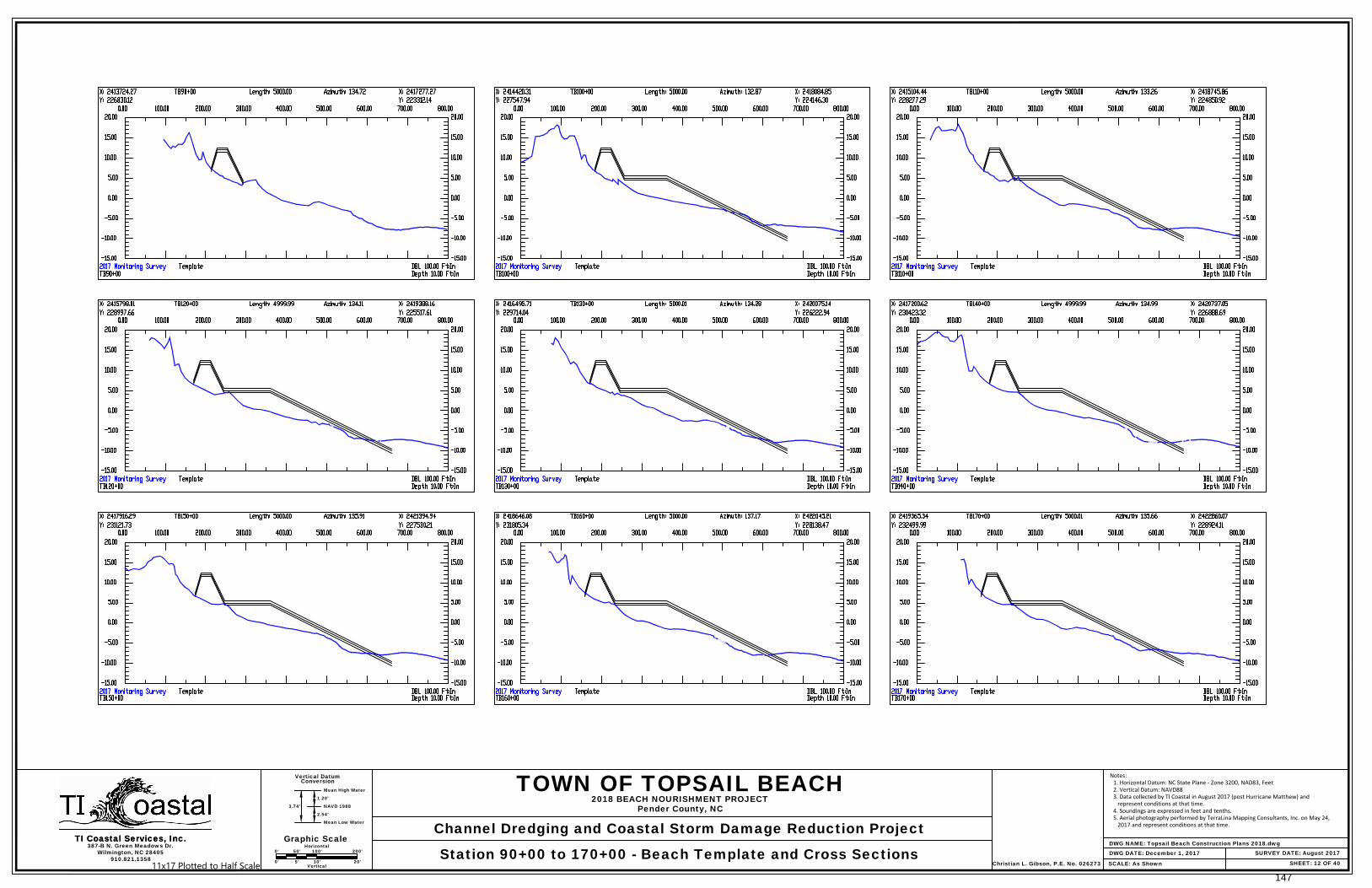
SHEET: 12 OF 40
387-B N. Green Meadows Dr.Wilmington, NC 28405
Vertical Datum
Mean High Water
Conversion
TI Coastal Services, Inc.
910.821.1358SCALE: As Shown
TI Coastal Services, Inc.DWG NAME: Topsail Beach Construction Plans 2018.dwg
SURVEY DATE: August 2017
TOWN OF TOPSAIL BEACH
Channel Dredging and Coastal Storm Damage Reduction Project
2018 BEACH NOURISHMENT PROJECTPender County, NC
Station 90+00 to 170+00 - Beach Template and Cross Sections DWG DATE: December 1, 2017
1.20'
NAVD 1988
2.54'
Mean Low Water
3.74'
Christian L. Gibson, P.E. No. 026273
Graphic Scale0' 50' 100' 200'
Horizontal
0' 5' 10' 20'Vertical
Notes:1. Horizontal Datum: NC State Plane - Zone 3200, NAD83, Feet2. Vertical Datum: NAVD883. Data collected by TI Coastal in August 2017 (post Hurricane Matthew) and
represent conditions at that time.4. Soundings are expressed in feet and tenths.5. Aerial photography performed by TerraLina Mapping Consultants, Inc. on May 24,
2017 and represent conditions at that time.
11x17 Plotted to Half Scale147
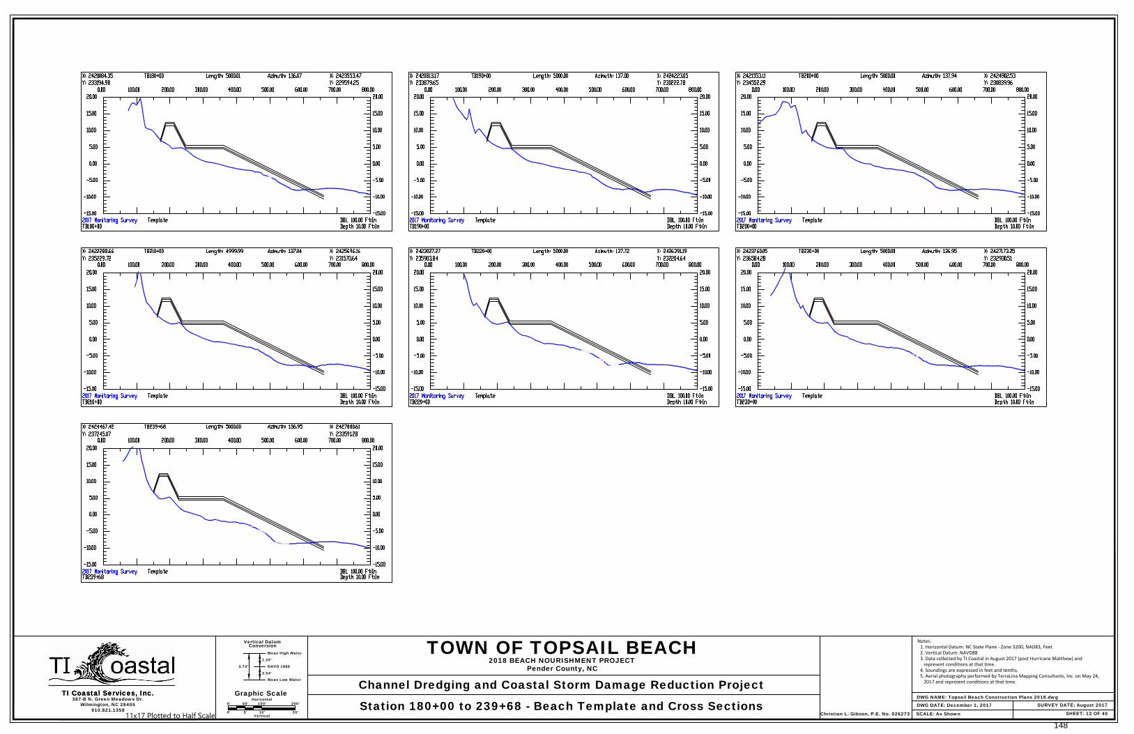
SHEET: 13 OF 40
387-B N. Green Meadows Dr.Wilmington, NC 28405
Vertical Datum
Mean High Water
Conversion
TI Coastal Services, Inc.
910.821.1358SCALE: As Shown
TI Coastal Services, Inc.DWG NAME: Topsail Beach Construction Plans 2018.dwg
SURVEY DATE: August 2017
TOWN OF TOPSAIL BEACH
Channel Dredging and Coastal Storm Damage Reduction Project
2018 BEACH NOURISHMENT PROJECTPender County, NC
Station 180+00 to 239+68 - Beach Template and Cross Sections DWG DATE: December 1, 2017
1.20'
NAVD 1988
2.54'
Mean Low Water
3.74'
Christian L. Gibson, P.E. No. 026273
Graphic Scale0' 50' 100' 200'
Horizontal
0' 5' 10' 20'Vertical
Notes: 1. Horizontal Datum: NC State Plane - Zone 3200, NAD83, Feet 2. Vertical Datum: NAVD88 3. Data collected by TI Coastal in August 2017 (post Hurricane Matthew) and represent conditions at that time. 4. Soundings are expressed in feet and tenths. 5. Aerial photography performed by TerraLina Mapping Consultants, Inc. on May 24, 2017 and represent conditions at that time.
11x17 Plotted to Half Scale148
N
e
w
T
o
p
s
a
i
l
I
n
l
e
t
Topsail Creek
T
o
p
s
a
i
l
C
r
e
e
k
N
T
I-1
N
T
I-2
B
C
C
-4
B
C
C
-3
B
C
C
-2
B
C
C
-1
B
C
-1
T
C
-1
0
T
C
-1
1
T
C
-1
2
T
C
-1
3
T
C
-1
4
T
C
-1
5
T
C
-1
6
T
C
-L
1
1
T
C
-L
1
2
T
C
-L
1
3
T
C
-L
1
4
T
C
-L
1
5
T
C
-R
1
5
T
C
-R
1
4
T
C
-R
1
3
T
C
-R
1
2
T
C
-R
1
1
T
I-R
1
T
I-R
2
T
I-L
3
T
I-L
2
T
I-L
1
B
C
C
-R
4
B
C
C
-R
2
B
C
C
-R
1
10+00
5+00
55+00
85+00
10+0
0
15+0
0
T
C
-R
1
6
T
C
-L
1
6
B
C
C
-5
B
C
C
-R
3
B
C
C
-R
5
C
T
-1
C
T
-R
1
C
T
-R
2
C
T
-R
3
C
T
-R
4
C
T
-R
5
C
T
-R
6
C
T
-L
1
C
T
-L
2
C
T
-L
3
C
T
-L
4
T
C
-R
1
0
T
C
-L
9
T
C
-L
1
0
B
C
-L
1
B
C
-L
2
B
C
-L
3
C
u
t
T
h
r
o
u
g
h
C
h
a
n
n
e
l
40+00
35+00
0+00
80+00
75+00
70+00
60+00
65+00
0+00
5+00
50+0
0
45+0
0
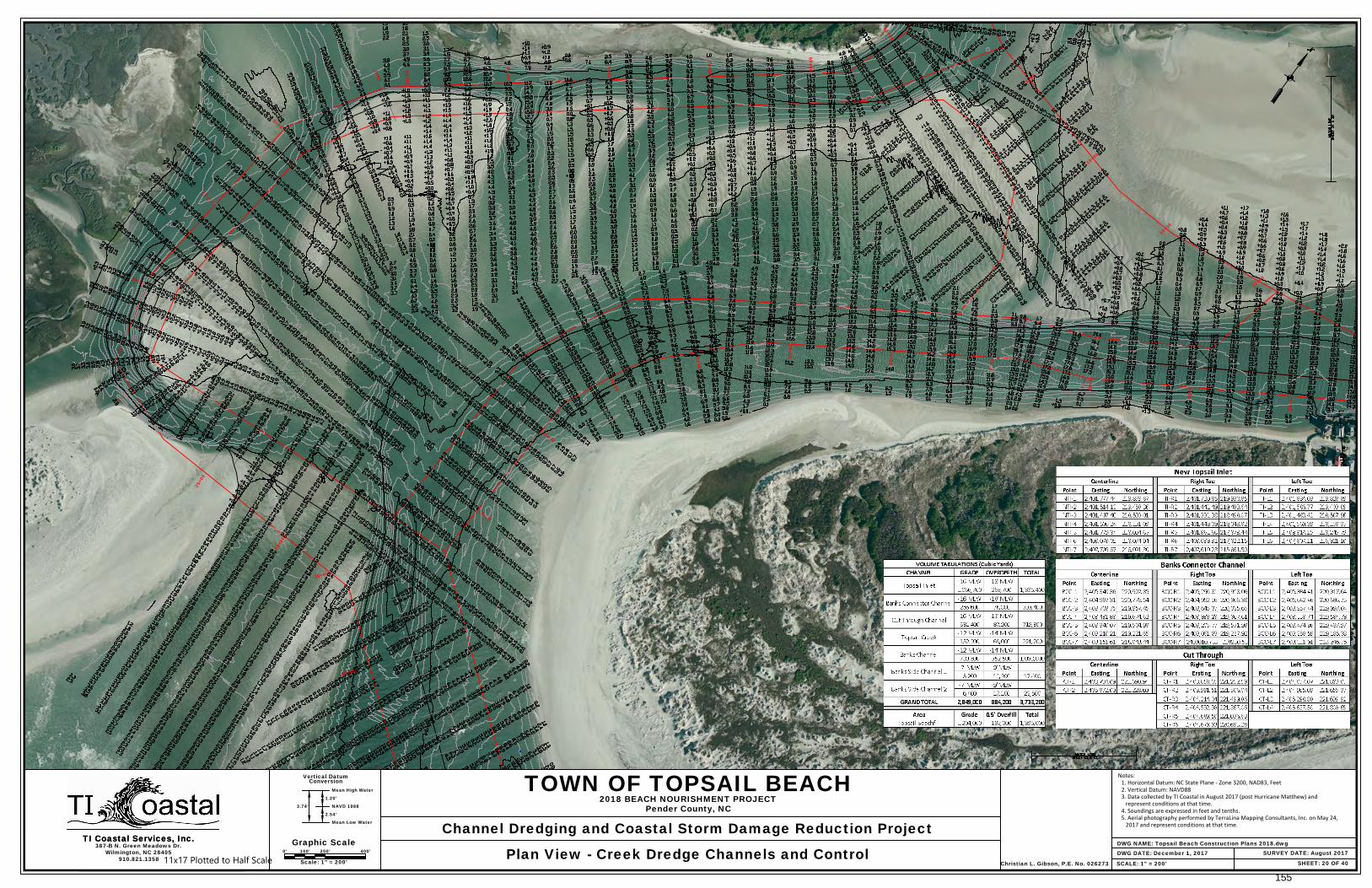
20+00
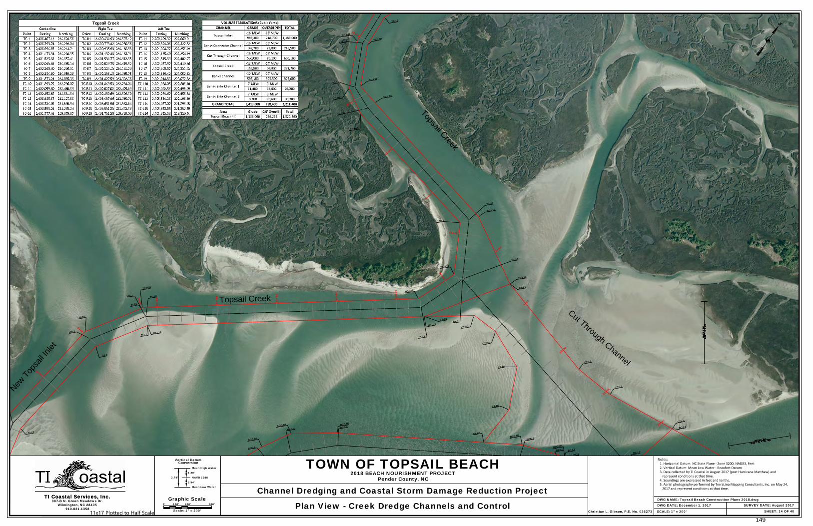
SHEET: 14 OF 40
387-B N. Green Meadows Dr.Wilmington, NC 28405
Vertical Datum
Mean High Water
Conversion
Graphic ScaleTI Coastal Services, Inc.
910.821.1358SCALE: 1" = 200'
TI Coastal Services, Inc.0' 100' 200' 400'
Scale: 1" = 200'
DWG NAME: Topsail Beach Construction Plans 2018.dwgSURVEY DATE: August 2017
TOWN OF TOPSAIL BEACH
Channel Dredging and Coastal Storm Damage Reduction Project
2018 BEACH NOURISHMENT PROJECTPender County, NC
Plan View - Creek Dredge Channels and Control DWG DATE: December 1, 2017
1.20'
NAVD 1988
2.54'
Mean Low Water
3.74'
Christian L. Gibson, P.E. No. 026273
Notes:1. Horizontal Datum: NC State Plane - Zone 3200, NAD83, Feet2. Vertical Datum: Mean Low Water - Beaufort Datum3. Data collected by TI Coastal in August 2017 (post Hurricane Matthew) and
represent conditions at that time.4. Soundings are expressed in feet and tenths.5. Aerial photography performed by TerraLina Mapping Consultants, Inc. on May 24,
2017 and represent conditions at that time.
11x17 Plotted to Half Scale149
10+00
5+00
55+00
85+00
10+0
0
15+0
0
40+00
35+00
0+00
80+00
75+00
70+00
60+00
65+00
0+00
5+00
50+0
0
45+0
0
20+00
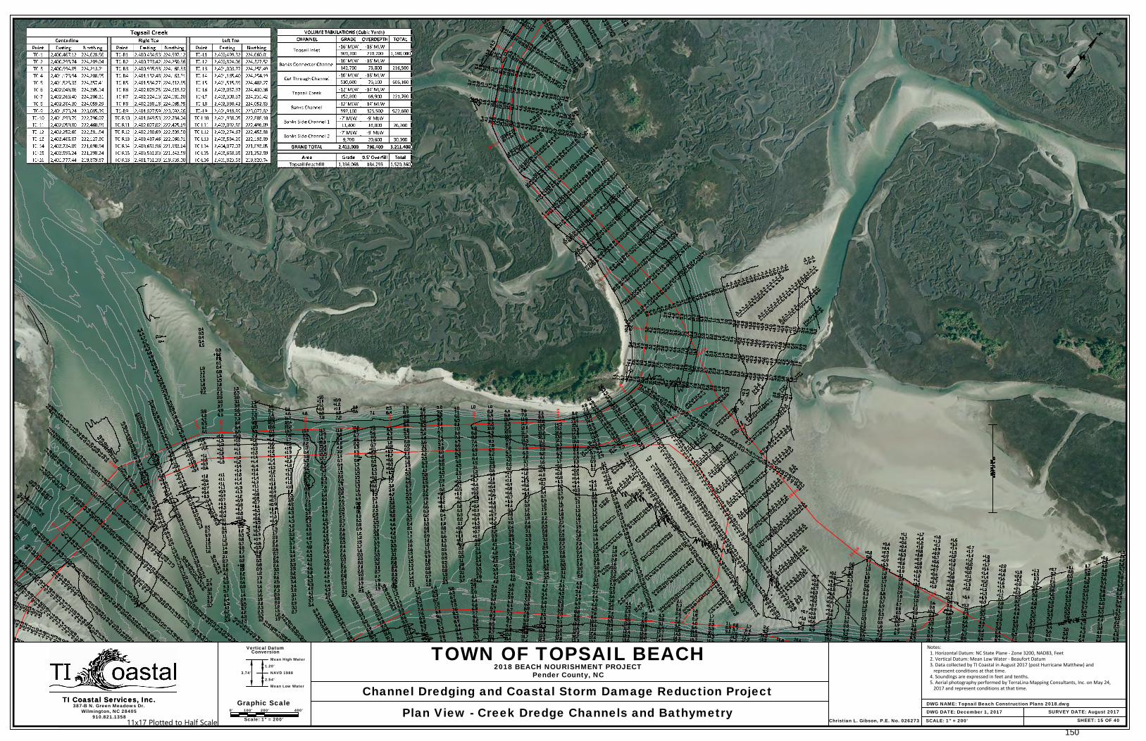
SHEET: 15 OF 40
387-B N. Green Meadows Dr.Wilmington, NC 28405
Vertical Datum
Mean High Water
Conversion
Graphic ScaleTI Coastal Services, Inc.
910.821.1358SCALE: 1" = 200'
TI Coastal Services, Inc.0' 100' 200' 400'
Scale: 1" = 200'
DWG NAME: Topsail Beach Construction Plans 2018.dwgSURVEY DATE: August 2017
TOWN OF TOPSAIL BEACH
Channel Dredging and Coastal Storm Damage Reduction Project
2018 BEACH NOURISHMENT PROJECTPender County, NC
Plan View - Creek Dredge Channels and Bathymetry DWG DATE: December 1, 2017
1.20'
NAVD 1988
2.54'
Mean Low Water
3.74'
Christian L. Gibson, P.E. No. 026273
Notes:1. Horizontal Datum: NC State Plane - Zone 3200, NAD83, Feet2. Vertical Datum: Mean Low Water - Beaufort Datum3. Data collected by TI Coastal in August 2017 (post Hurricane Matthew) and
represent conditions at that time.4. Soundings are expressed in feet and tenths.5. Aerial photography performed by TerraLina Mapping Consultants, Inc. on May 24,
2017 and represent conditions at that time.
11x17 Plotted to Half Scale150

SHEET: 16 OF 40
387-B N. Green Meadows Dr.Wilmington, NC 28405
Vertical Datum
Mean High Water
Conversion
TI Coastal Services, Inc.
910.821.1358SCALE: As Shown
TI Coastal Services, Inc.
Notes:1. Horizontal Datum: NC State Plane - Zone 3200, NAD83, Feet2. Vertical Datum: Mean Low Water - Beaufort Datum3. Data collected by TI Coastal in August 2017 (post Hurricane Matthew) and
represent conditions at that time.4. Soundings are expressed in feet and tenths.5. Aerial photography performed by TerraLina Mapping Consultants, Inc. on May 24,
2017 and represent conditions at that time.
DWG NAME: Topsail Beach Construction Plans 2018.dwgSURVEY DATE: August 2017
TOWN OF TOPSAIL BEACH
Channel Dredging and Coastal Storm Damage Reduction Project
2018 BEACH NOURISHMENT PROJECTPender County, NC
Station 32+00 to 55+00 - Topsail Creek Cross Sections DWG DATE: December 1, 2017
1.20'
NAVD 1988
2.54'
Mean Low Water
3.74'
Christian L. Gibson, P.E. No. 026273
Graphic Scale0' 100' 200' 400'
Horizontal
0' 5' 10' 20'Vertical11x17 Plotted to Half Scale
151
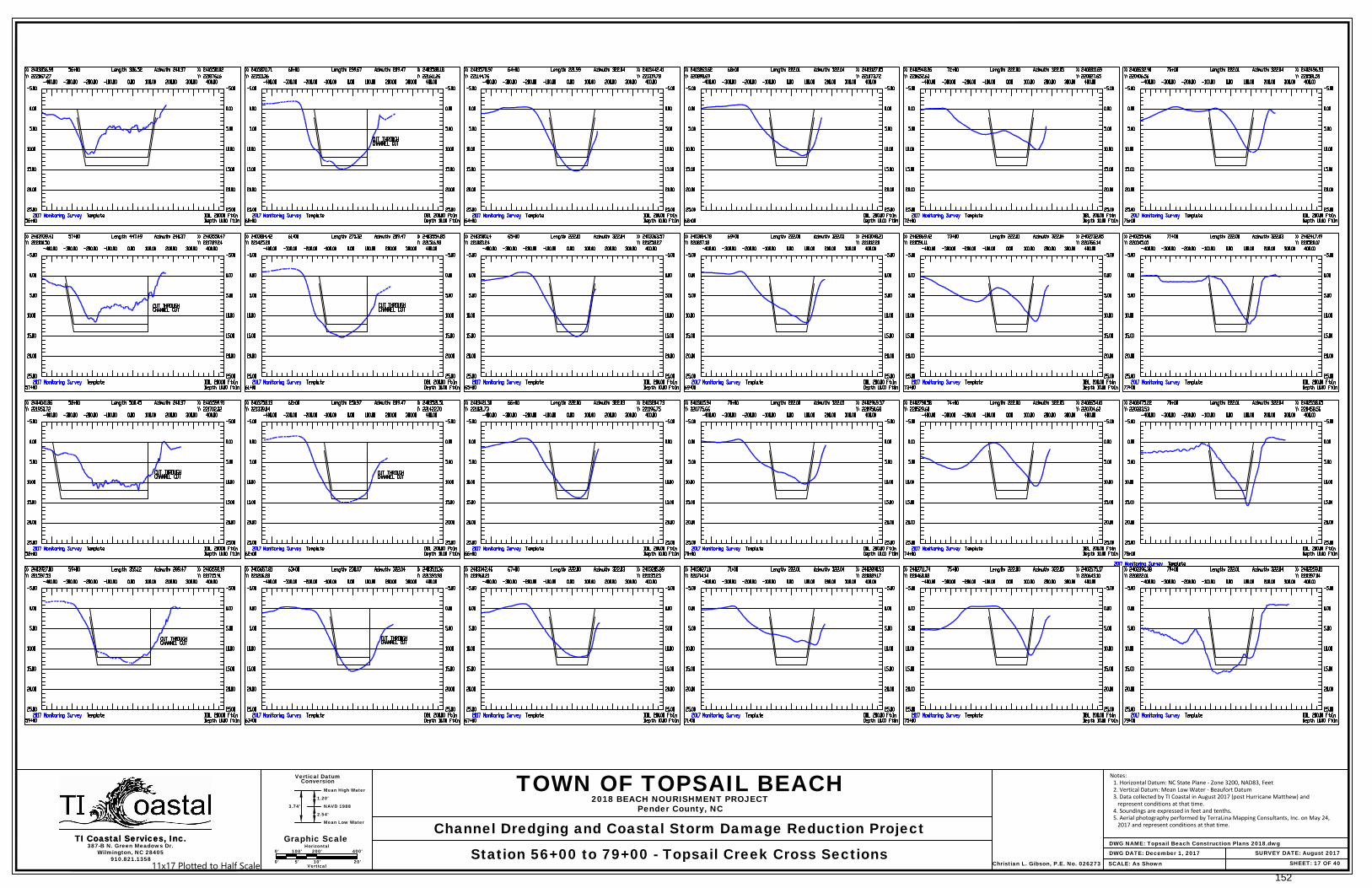
SHEET: 17 OF 40
387-B N. Green Meadows Dr.Wilmington, NC 28405
Vertical Datum
Mean High Water
Conversion
TI Coastal Services, Inc.
910.821.1358SCALE: As Shown
TI Coastal Services, Inc.DWG NAME: Topsail Beach Construction Plans 2018.dwg
SURVEY DATE: August 2017
TOWN OF TOPSAIL BEACH
Channel Dredging and Coastal Storm Damage Reduction Project
2018 BEACH NOURISHMENT PROJECTPender County, NC
Station 56+00 to 79+00 - Topsail Creek Cross Sections DWG DATE: December 1, 2017
1.20'
NAVD 1988
2.54'
Mean Low Water
3.74'
Christian L. Gibson, P.E. No. 026273
Graphic Scale0' 100' 200' 400'
Horizontal
0' 5' 10' 20'Vertical
Notes:1. Horizontal Datum: NC State Plane - Zone 3200, NAD83, Feet2. Vertical Datum: Mean Low Water - Beaufort Datum3. Data collected by TI Coastal in August 2017 (post Hurricane Matthew) and
represent conditions at that time.4. Soundings are expressed in feet and tenths.5. Aerial photography performed by TerraLina Mapping Consultants, Inc. on May 24,
2017 and represent conditions at that time.
11x17 Plotted to Half Scale152
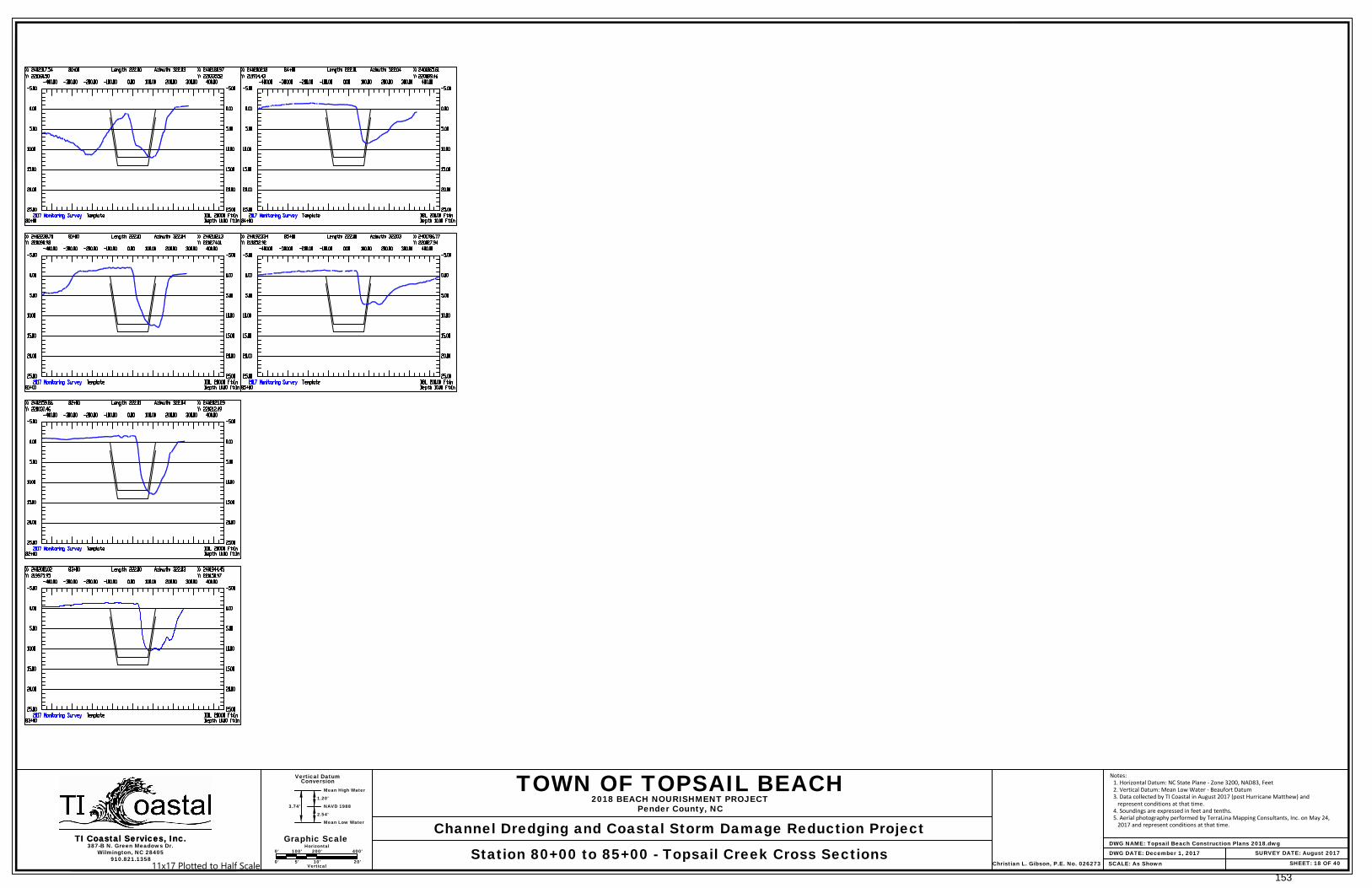
SHEET: 18 OF 40
387-B N. Green Meadows Dr.Wilmington, NC 28405
Vertical Datum
Mean High Water
Conversion
TI Coastal Services, Inc.
910.821.1358SCALE: As Shown
TI Coastal Services, Inc.DWG NAME: Topsail Beach Construction Plans 2018.dwg
SURVEY DATE: August 2017
TOWN OF TOPSAIL BEACH
Channel Dredging and Coastal Storm Damage Reduction Project
2018 BEACH NOURISHMENT PROJECTPender County, NC
Station 80+00 to 85+00 - Topsail Creek Cross Sections DWG DATE: December 1, 2017
1.20'
NAVD 1988
2.54'
Mean Low Water
3.74'
Christian L. Gibson, P.E. No. 026273
Graphic Scale0' 100' 200' 400'
Horizontal
0' 5' 10' 20'Vertical
Notes:1. Horizontal Datum: NC State Plane - Zone 3200, NAD83, Feet2. Vertical Datum: Mean Low Water - Beaufort Datum3. Data collected by TI Coastal in August 2017 (post Hurricane Matthew) and
represent conditions at that time.4. Soundings are expressed in feet and tenths.5. Aerial photography performed by TerraLina Mapping Consultants, Inc. on May 24,
2017 and represent conditions at that time.
11x17 Plotted to Half Scale153

Banks C
hannel
Connecto
r Channel
B
a
n
k
s
C
h
a
n
n
e
l
C
o
n
n
e
c
t
o
r
C
h
a
n
n
e
l
N
e
w
T
o
p
s
a
i
l
I
n
l
e
t
Topsail Creek
N
T
I-1
N
T
I-2
N
T
I-3
N
T
I-4
N
T
I-5
N
T
I-6
B
C
C
-7
B
C
C
-6
B
C
C
-4
B
C
C
-3
B
C
C
-2
B
C
C
-1
B
C
-1
T
C
-1
5
T
C
-1
6
T
B
-1
B
C
-2
T
C
-L
1
4
T
C
-L
1
5
T
C
-R
1
5
T
I-R
1
T
I-R
2
T
I-R
3
T
I-R
4
T
I-R
5
T
I-R
6
T
I-L
5
T
I-L
4
T
I-L
3
T
I-L
2
T
I-L
1
B
C
C
-L
7
B
C
C
-L
4
B
C
C
-L
2
B
C
C
-L
1
B
C
C
-R
4
B
C
C
-R
2
B
C
C
-R
1
10+00
15+00
20+00
25+0
0
30+0
0
35+00
5+00
85+00
0+00
5+00
10+00
15+0020+00
25+00
30+00
35+00
10+0
0
15+0
0
T
C
-R
1
6
T
C
-L
1
6
B
C
C
-5
B
C
C
-L
3
B
C
C
-R
3
B
C
C
-R
7
B
C
C
-L
5
B
C
C
-L
6
B
C
C
-R
5
B
C
C
-R
6
C
T
-1
C
T
-R
1
C
T
-R
2
C
T
-R
3
C
T
-R
4
C
T
-R
5
C
T
-R
6
C
T
-L
1
C
T
-L
2
C
T
-L
3
C
T
-L
4
B
C
-R
1
B
C
-L
1
B
C
-R
2
B
C
-L
2
B
C
-L
3
C
u
t
T
h
r
o
u
g
h
C
h
a
n
n
e
l
0+00 5+00 10+00
0+00
80+00
75+00
70+00
60+00
65+00
5+00
20+00
40+00
45+00
SHEET: 19 OF 40
387-B N. Green Meadows Dr.Wilmington, NC 28405
Vertical Datum
Mean High Water
Conversion
Graphic ScaleTI Coastal Services, Inc.
910.821.1358SCALE: 1" = 200'
TI Coastal Services, Inc.0' 100' 200' 400'
Scale: 1" = 200'
DWG NAME: Topsail Beach Construction Plans 2018.dwgSURVEY DATE: August 2017
TOWN OF TOPSAIL BEACH
Channel Dredging and Coastal Storm Damage Reduction Project
2018 BEACH NOURISHMENT PROJECTPender County, NC
Plan View - Creek Dredge Channels and Control DWG DATE: December 1, 2017
1.20'
NAVD 1988
2.54'
Mean Low Water
3.74'
Christian L. Gibson, P.E. No. 026273
Notes:1. Horizontal Datum: NC State Plane - Zone 3200, NAD83, Feet2. Vertical Datum: NAVD883. Data collected by TI Coastal in August 2017 (post Hurricane Matthew) and
represent conditions at that time.4. Soundings are expressed in feet and tenths.5. Aerial photography performed by TerraLina Mapping Consultants, Inc. on May 24,
2017 and represent conditions at that time.
11x17 Plotted to Half Scale
154
10+00
15+00
20+00
25+0
0
30+0
0
35+00
5+00
85+00
0+00
5+00
10+00
15+0020+00
25+00
30+00
35+00
10+0
0
15+0
0
0+00 5+00 10+00
0+00
80+00
75+00
70+00
60+00
65+00
5+00
20+00
40+00
45+00
SHEET: 20 OF 40
387-B N. Green Meadows Dr.Wilmington, NC 28405
Vertical Datum
Mean High Water
Conversion
Graphic ScaleTI Coastal Services, Inc.
910.821.1358SCALE: 1" = 200'
TI Coastal Services, Inc.0' 100' 200' 400'
Scale: 1" = 200'
DWG NAME: Topsail Beach Construction Plans 2018.dwgSURVEY DATE: August 2017
TOWN OF TOPSAIL BEACH
Channel Dredging and Coastal Storm Damage Reduction Project
2018 BEACH NOURISHMENT PROJECTPender County, NC
Plan View - Creek Dredge Channels and Control DWG DATE: December 1, 2017
1.20'
NAVD 1988
2.54'
Mean Low Water
3.74'
Christian L. Gibson, P.E. No. 026273
Notes: 1. Horizontal Datum: NC State Plane - Zone 3200, NAD83, Feet 2. Vertical Datum: NAVD88 3. Data collected by TI Coastal in August 2017 (post Hurricane Matthew) and represent conditions at that time. 4. Soundings are expressed in feet and tenths. 5. Aerial photography performed by TerraLina Mapping Consultants, Inc. on May 24, 2017 and represent conditions at that time.
11x17 Plotted to Half Scale
155

N
e
w
T
o
p
s
a
il In
le
t
N
T
I-7
T
I-R
7
T
I-L
6
45+00
50+00
55+00
60+00
65+00
70+00
75+00
SHEET: 21 OF 40
387-B N. Green Meadows Dr.Wilmington, NC 28405
Vertical Datum
Mean High Water
Conversion
Graphic ScaleTI Coastal Services, Inc.
910.821.1358SCALE: 1" = 200'
TI Coastal Services, Inc.0' 100' 200' 400'
Scale: 1" = 200'
DWG NAME: Topsail Beach Construction Plans 2018.dwgSURVEY DATE: August 2017
TOWN OF TOPSAIL BEACH
Channel Dredging and Coastal Storm Damage Reduction Project
2018 BEACH NOURISHMENT PROJECTPender County, NC
Plan View - Creek Dredge Channels and Control DWG DATE: December 1, 2017
1.20'
NAVD 1988
2.54'
Mean Low Water
3.74'
Christian L. Gibson, P.E. No. 026273
Notes: 1. Horizontal Datum: NC State Plane - Zone 3200, NAD83, Feet 2. Vertical Datum: NAVD88 3. Data collected by TI Coastal in August 2017 (post Hurricane Matthew) and represent conditions at that time. 4. Soundings are expressed in feet and tenths. 5. Aerial photography performed by TerraLina Mapping Consultants, Inc. on May 24, 2017 and represent conditions at that time.
11x17 Plotted to Half Scale
156
45+00
50+00
55+00
60+00
65+00
70+00
75+00
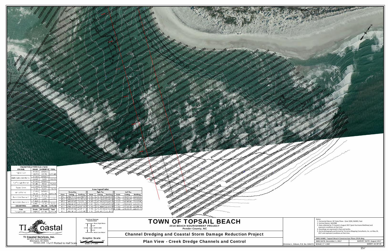
SHEET: 22 OF 40
387-B N. Green Meadows Dr.Wilmington, NC 28405
Vertical Datum
Mean High Water
Conversion
Graphic ScaleTI Coastal Services, Inc.
910.821.1358SCALE: 1" = 200'
TI Coastal Services, Inc.0' 100' 200' 400'
Scale: 1" = 200'
DWG NAME: Topsail Beach Construction Plans 2018.dwgSURVEY DATE: August 2017
TOWN OF TOPSAIL BEACH
Channel Dredging and Coastal Storm Damage Reduction Project
2018 BEACH NOURISHMENT PROJECTPender County, NC
Plan View - Creek Dredge Channels and Control DWG DATE: December 1, 2017
1.20'
NAVD 1988
2.54'
Mean Low Water
3.74'
Christian L. Gibson, P.E. No. 026273
Notes: 1. Horizontal Datum: NC State Plane - Zone 3200, NAD83, Feet 2. Vertical Datum: NAVD88 3. Data collected by TI Coastal in August 2017 (post Hurricane Matthew) and represent conditions at that time. 4. Soundings are expressed in feet and tenths. 5. Aerial photography performed by TerraLina Mapping Consultants, Inc. on May 24, 2017 and represent conditions at that time.
11x17 Plotted to Half Scale
157
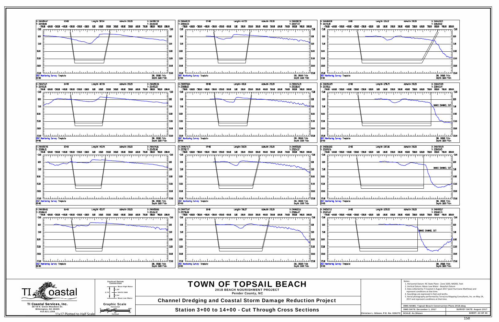
SHEET: 23 OF 40
387-B N. Green Meadows Dr.Wilmington, NC 28405
Vertical Datum
Mean High Water
Conversion
TI Coastal Services, Inc.
910.821.1358SCALE: As Shown
TI Coastal Services, Inc.DWG NAME: Topsail Beach Construction Plans 2018.dwg
SURVEY DATE: August 2017
TOWN OF TOPSAIL BEACH
Channel Dredging and Coastal Storm Damage Reduction Project
2018 BEACH NOURISHMENT PROJECTPender County, NC
Station 3+00 to 14+00 - Cut Through Cross Sections DWG DATE: December 1, 2017
1.20'
NAVD 1988
2.54'
Mean Low Water
3.74'
Christian L. Gibson, P.E. No. 026273
Graphic Scale0' 100' 200' 400'
Horizontal
0' 5' 10' 20'Vertical
Notes: 1. Horizontal Datum: NC State Plane - Zone 3200, NAD83, Feet 2. Vertical Datum: Mean Low Water - Beaufort Datum 3. Data collected by TI Coastal in August 2017 (post Hurricane Matthew) and represent conditions at that time. 4. Soundings are expressed in feet and tenths. 5. Aerial photography performed by TerraLina Mapping Consultants, Inc. on May 24, 2017 and represent conditions at that time.
11x17 Plotted to Half Scale158
SHEET: 24 OF 40
387-B N. Green Meadows Dr.Wilmington, NC 28405
Vertical Datum
Mean High Water
Conversion
TI Coastal Services, Inc.
910.821.1358SCALE: As Shown
TI Coastal Services, Inc.DWG NAME: Topsail Beach Construction Plans 2018.dwg
SURVEY DATE: August 2017
TOWN OF TOPSAIL BEACH
Channel Dredging and Coastal Storm Damage Reduction Project
2018 BEACH NOURISHMENT PROJECTPender County, NC
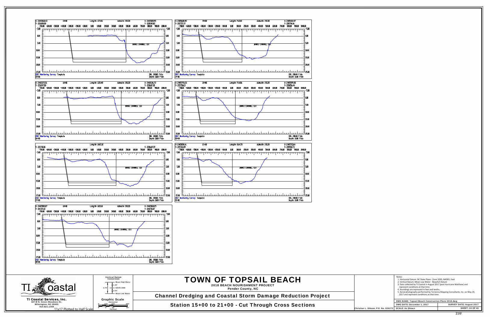
Station 15+00 to 21+00 - Cut Through Cross Sections DWG DATE: December 1, 2017
1.20'
NAVD 1988
2.54'
Mean Low Water
3.74'
Christian L. Gibson, P.E. No. 026273
Graphic Scale0' 100' 200' 400'
Horizontal
0' 5' 10' 20'Vertical
Notes: 1. Horizontal Datum: NC State Plane - Zone 3200, NAD83, Feet 2. Vertical Datum: Mean Low Water - Beaufort Datum 3. Data collected by TI Coastal in August 2017 (post Hurricane Matthew) and represent conditions at that time. 4. Soundings are expressed in feet and tenths. 5. Aerial photography performed by TerraLina Mapping Consultants, Inc. on May 24, 2017 and represent conditions at that time.
11x17 Plotted to Half Scale159

SHEET: 25 OF 40
387-B N. Green Meadows Dr.Wilmington, NC 28405
Vertical Datum
Mean High Water
Conversion
TI Coastal Services, Inc.
910.821.1358SCALE: As Shown
TI Coastal Services, Inc.DWG NAME: Topsail Beach Construction Plans 2018.dwg
SURVEY DATE: August 2017
TOWN OF TOPSAIL BEACH
Channel Dredging and Coastal Storm Damage Reduction Project
2018 BEACH NOURISHMENT PROJECTPender County, NC
Station 0+00 to 23+00 - Banks Connector Channel Cross Sections DWG DATE: December 1, 2017
1.20'
NAVD 1988
2.54'
Mean Low Water
3.74'
Christian L. Gibson, P.E. No. 026273
Graphic Scale0' 100' 200' 400'
Horizontal
0' 5' 10' 20'Vertical
Notes: 1. Horizontal Datum: NC State Plane - Zone 3200, NAD83, Feet 2. Vertical Datum: Mean Low Water - Beaufort Datum 3. Data collected by TI Coastal in August 2017 (post Hurricane Matthew) and represent conditions at that time. 4. Soundings are expressed in feet and tenths. 5. Aerial photography performed by TerraLina Mapping Consultants, Inc. on May 24, 2017 and represent conditions at that time.
11x17 Plotted to Half Scale160

SHEET: 26 OF 40
387-B N. Green Meadows Dr.Wilmington, NC 28405
Vertical Datum
Mean High Water
Conversion
TI Coastal Services, Inc.
910.821.1358SCALE: As Shown
TI Coastal Services, Inc.DWG NAME: Topsail Beach Construction Plans 2018.dwg
SURVEY DATE: August 2017
TOWN OF TOPSAIL BEACH
Channel Dredging and Coastal Storm Damage Reduction Project
2018 BEACH NOURISHMENT PROJECTPender County, NC
Station 24+00 to 39+00 - Banks Connector Channel Cross Sections DWG DATE: December 1, 2017
1.20'
NAVD 1988
2.54'
Mean Low Water
3.74'
Christian L. Gibson, P.E. No. 026273
Graphic Scale0' 100' 200' 400'
Horizontal
0' 5' 10' 20'Vertical
Notes: 1. Horizontal Datum: NC State Plane - Zone 3200, NAD83, Feet 2. Vertical Datum: Mean Low Water - Beaufort Datum 3. Data collected by TI Coastal in August 2017 (post Hurricane Matthew) and represent conditions at that time. 4. Soundings are expressed in feet and tenths. 5. Aerial photography performed by TerraLina Mapping Consultants, Inc. on May 24, 2017 and represent conditions at that time.
11x17 Plotted to Half Scale161
SHEET: 27 OF 40
387-B N. Green Meadows Dr.Wilmington, NC 28405
Vertical Datum
Mean High Water
Conversion
TI Coastal Services, Inc.
910.821.1358SCALE: As Shown
TI Coastal Services, Inc.DWG NAME: Topsail Beach Construction Plans 2018.dwg
SURVEY DATE: August 2017
TOWN OF TOPSAIL BEACH
Channel Dredging and Coastal Storm Damage Reduction Project
2018 BEACH NOURISHMENT PROJECTPender County, NC
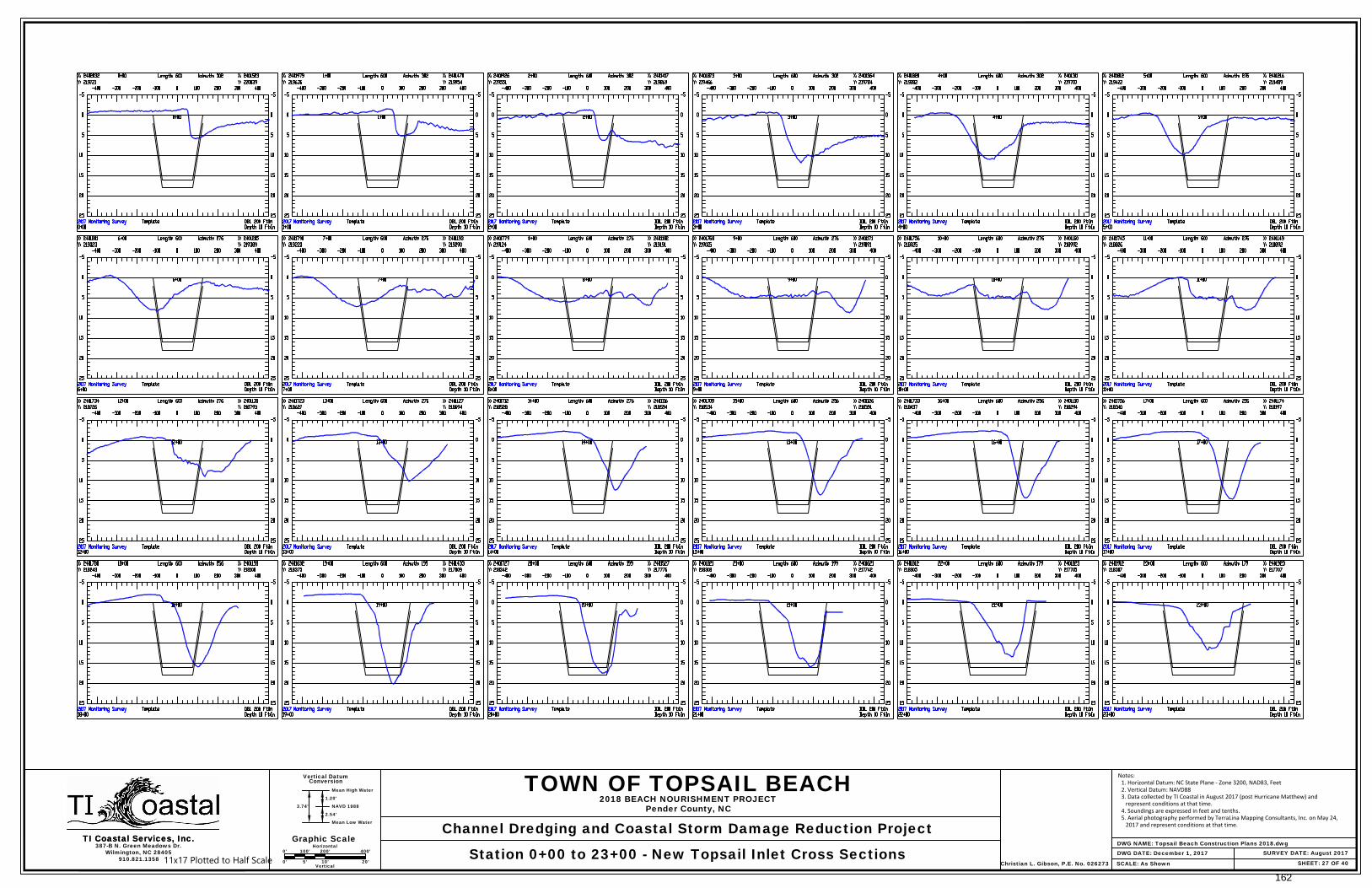
Station 0+00 to 23+00 - New Topsail Inlet Cross Sections DWG DATE: December 1, 2017
1.20'
NAVD 1988
2.54'
Mean Low Water
3.74'
Christian L. Gibson, P.E. No. 026273
Graphic Scale0' 100' 200' 400'
Horizontal
0' 5' 10' 20'Vertical
Notes: 1. Horizontal Datum: NC State Plane - Zone 3200, NAD83, Feet 2. Vertical Datum: NAVD88 3. Data collected by TI Coastal in August 2017 (post Hurricane Matthew) and represent conditions at that time. 4. Soundings are expressed in feet and tenths. 5. Aerial photography performed by TerraLina Mapping Consultants, Inc. on May 24, 2017 and represent conditions at that time.
11x17 Plotted to Half Scale
162

SHEET: 28 OF 40
387-B N. Green Meadows Dr.Wilmington, NC 28405
Vertical Datum
Mean High Water
Conversion
TI Coastal Services, Inc.
910.821.1358SCALE: As Shown
TI Coastal Services, Inc.DWG NAME: Topsail Beach Construction Plans 2018.dwg
SURVEY DATE: August 2017
TOWN OF TOPSAIL BEACH
Channel Dredging and Coastal Storm Damage Reduction Project
2018 BEACH NOURISHMENT PROJECTPender County, NC
Station 24+00 to 47+00 - New Topsail Inlet Cross Sections DWG DATE: December 1, 2017
1.20'
NAVD 1988
2.54'
Mean Low Water
3.74'
Christian L. Gibson, P.E. No. 026273
Graphic Scale0' 100' 200' 400'
Horizontal
0' 5' 10' 20'Vertical
Notes: 1. Horizontal Datum: NC State Plane - Zone 3200, NAD83, Feet 2. Vertical Datum: NAVD88 3. Data collected by TI Coastal in August 2017 (post Hurricane Matthew) and represent conditions at that time. 4. Soundings are expressed in feet and tenths. 5. Aerial photography performed by TerraLina Mapping Consultants, Inc. on May 24, 2017 and represent conditions at that time.
11x17 Plotted to Half Scale
163
SHEET: 29 OF 40
387-B N. Green Meadows Dr.Wilmington, NC 28405
Vertical Datum
Mean High Water
Conversion
TI Coastal Services, Inc.
910.821.1358SCALE: As Shown
TI Coastal Services, Inc.DWG NAME: Topsail Beach Construction Plans 2018.dwg
SURVEY DATE: August 2017
TOWN OF TOPSAIL BEACH
Channel Dredging and Coastal Storm Damage Reduction Project
2018 BEACH NOURISHMENT PROJECTPender County, NC
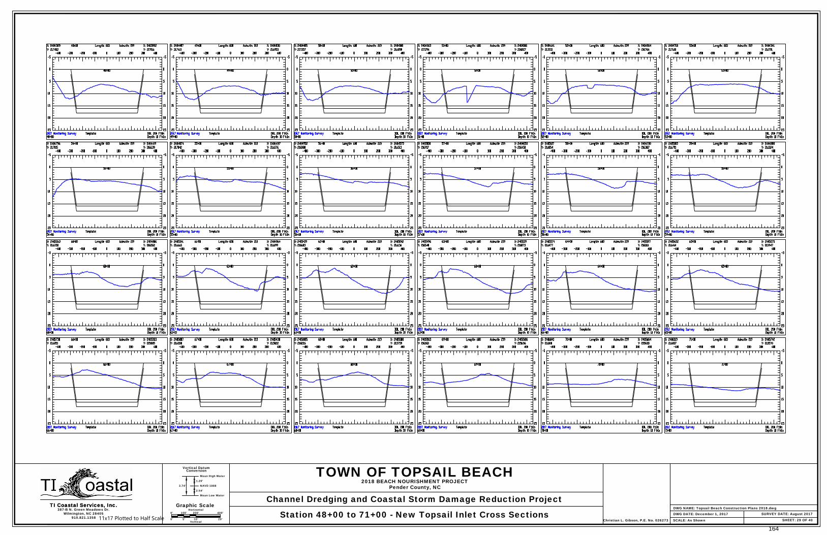
Station 48+00 to 71+00 - New Topsail Inlet Cross Sections DWG DATE: December 1, 2017
1.20'
NAVD 1988
2.54'
Mean Low Water
3.74'
Christian L. Gibson, P.E. No. 026273
Graphic Scale0' 100' 200' 400'
Horizontal
0' 5' 10' 20'Vertical
11x17 Plotted to Half Scale
164
SHEET: 30 OF 40
387-B N. Green Meadows Dr.Wilmington, NC 28405
Vertical Datum
Mean High Water
Conversion
TI Coastal Services, Inc.
910.821.1358SCALE: As Shown
TI Coastal Services, Inc.DWG NAME: Topsail Beach Construction Plans 2018.dwg
SURVEY DATE: August 2017
TOWN OF TOPSAIL BEACH
Channel Dredging and Coastal Storm Damage Reduction Project
2018 BEACH NOURISHMENT PROJECTPender County, NC
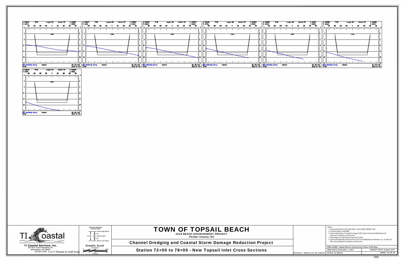
Station 72+00 to 78+00 - New Topsail Inlet Cross Sections DWG DATE: December 1, 2017
1.20'
NAVD 1988
2.54'
Mean Low Water
3.74'
Christian L. Gibson, P.E. No. 026273
Graphic Scale0' 100' 200' 400'
Horizontal
0' 5' 10' 20'Vertical
Notes: 1. Horizontal Datum: NC State Plane - Zone 3200, NAD83, Feet 2. Vertical Datum: NAVD88 3. Data collected by TI Coastal in August 2017 (post Hurricane Matthew) and represent conditions at that time. 4. Soundings are expressed in feet and tenths. 5. Aerial photography performed by TerraLina Mapping Consultants, Inc. on May 24, 2017 and represent conditions at that time.
11x17 Plotted to Half Scale
165
S
h
o
r
e
L
in
e
D
r
iv
e
O
c
e
a
n
B
lv
d
Goodw
in A
ve
T
o
p
s
a
il D
r
iv
e
McLeod A
ve
Boryk A
ve
C
arolin
a B
lvd
Trout A
ve
Drum
A
ve
Florida A
ve
S
. A
n
d
e
rso
n
B
lvd
Spot Blvd
Clark A
ve
C
arolin
a B
lvd
Sm
ith A
ve
Darden A
ve
S. Anderson Blvd
Carolina Blvd
Crocker A
ve
Channel Blvd
Pipeline C
rossing
VE
HIC
LE
/E
QU
IP
ME
NT
BE
AC
H A
CC
ES
S
Under R
oad S
leeve
BC-3
BC-4
TB-4
4+74.34
21+79.67
42+39.76
BC-2
SC1-2
SC1-R2
SC1-R1
SC1-L2
SC1-L1
SC1-1
B
a
n
k
s
S
id
e
C
h
a
n
n
e
l 1
BC-R2
BC-R3
BC-L4
BC-L5
BC-L6
BC-R4
BC-L7
SC1-L3
SC1-L4
SC1-R3
SC1-R4
SC1-3
SC1-4
Banks Channel
25+00
30+00
35+00
40+00
45+00
50+00
55+00
60+00
65+00
70+00
75+00
15+00
20+00
5+00
10+00
15+00
20+00 25+00
10+98.10
Scott A
ve
Carolina Blvd
S. Anderson Blvd
Hines A
ve
Crew
s A
ve
Carolina Blvd
Channel Blvd
Ward A
ve
Davis A
ve
Hayw
ood A
ve
B
rid
g
e
rs A
ve
Pearson A
ve
Em
pie A
ve
Bridgers Ave
Rocky M
t A
ve
Barw
ick
BC-5
BC-6
SC2-R1
SC2-1
SC2-3
SC2-3
SC2-R3
SC2-L3
SC2-L1
B
a
n
ks S
id
e
C
h
a
n
n
e
l 2
BC-R5
BC-R6
BC-L8
BC-L9
SC2-2
SC2-R2
SC2-L2
SC2-4
SC2-R4
SC2-L4
SC2-R5
SC2-L5
B
a
n
k
s
C
h
a
n
n
e
l
80+00
90+00
95+00
100+00
105+00
110+00
115+00
120+00
125+00
130+00 135+00
140+00
145+00
5+00 15+00
20+00
25+00
30+00
35+00
40+00
10+00
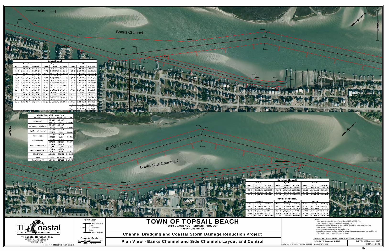
SHEET: 31 OF 40
387-B N. Green Meadows Dr.Wilmington, NC 28405
Vertical Datum
Mean High Water
Conversion
Graphic ScaleTI Coastal Services, Inc.
910.821.1358SCALE: 1" = 200'
TI Coastal Services, Inc.0' 100' 200' 400'
Scale: 1" = 200'
DWG NAME: Topsail Beach Construction Plans 2018.dwgSURVEY DATE: August 2017
TOWN OF TOPSAIL BEACH
Channel Dredging and Coastal Storm Damage Reduction Project
2018 BEACH NOURISHMENT PROJECTPender County, NC
Plan View - Banks Channel and Side Channels Layout and Control DWG DATE: December 1, 2017
1.20'
NAVD 1988
2.54'
Mean Low Water
3.74'
Christian L. Gibson, P.E. No. 026273
Notes:1. Horizontal Datum: NC State Plane - Zone 3200, NAD83, Feet2. Vertical Datum: Mean Low Water - Beaufort Datum3. Data collected by TI Coastal in August 2017 (post Hurricane Matthew) and
represent conditions at that time.4. Soundings are expressed in feet and tenths.5. Aerial photography performed by TerraLina Mapping Consultants, Inc. on May 24,
2017 and represent conditions at that time.
11x17 Plotted to Half Scale166

S
h
o
r
e
L
in
e
D
r
iv
e
O
c
e
a
n
B
lv
d
Goodw
in A
ve
T
o
p
s
a
il D
r
iv
e
McLeod A
ve
Boryk A
ve
C
arolin
a B
lvd
Trout A
ve
Drum
A
ve
Florida A
ve
S
. A
n
d
e
rso
n
B
lvd
Spot Blvd
Clark A
ve
C
arolin
a B
lvd
Sm
ith A
ve
Darden A
ve
S. Anderson Blvd
Carolina Blvd
Crocker A
ve
Channel Blvd
Pipeline C
rossing
VE
HIC
LE
/E
QU
IP
ME
NT
BE
AC
H A
CC
ES
S
Under R
oad S
leeve
4+74.34
21+79.67
42+39.76
25+00
30+00
35+00
40+00
45+00
50+00
55+00
60+00
65+00
70+00
75+00
15+00
20+00
5+00
10+00
15+00
20+00 25+00
10+98.10
Scott A
ve
Carolina Blvd
S. Anderson Blvd
Hines A
ve
Crew
s A
ve
Carolina Blvd
Channel Blvd
Ward A
ve
Davis A
ve
Hayw
ood A
ve
B
rid
g
e
rs A
ve
Pearson A
ve
Em
pie A
ve
Bridgers Ave
Rocky M
t A
ve
Barw
ick
80+00
90+00
95+00
100+00
105+00
110+00
115+00
120+00
125+00
130+00 135+00
140+00
145+00
5+00 15+00
20+00
25+00
30+00
35+00
40+00
10+00
SHEET: 32 OF 40
387-B N. Green Meadows Dr.Wilmington, NC 28405
Vertical Datum
Mean High Water
Conversion
Graphic ScaleTI Coastal Services, Inc.
910.821.1358SCALE: 1" = 200'
TI Coastal Services, Inc.0' 100' 200' 400'
Scale: 1" = 200'
DWG NAME: Topsail Beach Construction Plans 2018.dwgSURVEY DATE: August 2017
TOWN OF TOPSAIL BEACH
Channel Dredging and Coastal Storm Damage Reduction Project
2018 BEACH NOURISHMENT PROJECTPender County, NC
Plan View - Banks Channel and Side Channels Bathymetry DWG DATE: December 1, 2016
1.20'
NAVD 1988
2.54'
Mean Low Water
3.74'
Christian L. Gibson, P.E. No. 026273
Notes: 1. Horizontal Datum: NC State Plane - Zone 3200, NAD83, Feet 2. Vertical Datum: Mean Low Water - Beaufort Datum 3. Data collected by TI Coastal in August 2017 (post Hurricane Matthew) and represent conditions at that time. 4. Soundings are expressed in feet and tenths. 5. Aerial photography performed by TerraLina Mapping Consultants, Inc. on May 24, 2017 and represent conditions at that time.
11x17 Plotted to Half Scale167
B
r
id
g
e
r
s
A
v
e
Barw
ick
S. Anderson Blvd
Monroe Ln
Canady A
ve
N. Anderson Blvd
N. Anderson Blvd
Gaye A
ve
Bare F
oot Ln
N. Anderson Blvd
Sunset A
ve
Pipeline C
rossing
Under R
oad S
leeve
Queen's Grant
Sub Division
BC-7
BC-8
BC-9
BC-R7
BC-R8
BC-L10
BC-L11
BC-R9
BC-L12
Banks C
hannel
145+00
150+00
155+00
160+00
165+00
170+00
175+00
180+00
185+00
190+00
195+00
200+00
210+00
N
ix
o
n
A
v
e
S
id
b
u
ry
A
v
e
C
a
th
e
rin
e
A
v
e
N. A
nders
on B
lvd
B
e
e
c
h
w
o
o
d
D
r
F
ie
ld
s
A
v
e
S
tra
w
b
e
rry
L
n
H
u
m
p
h
re
y
A
v
e
H
is
p
a
n
io
la
L
n
B
e
a
c
h
w
o
o
d
D
r
C
ru
tc
h
fie
ld
A
v
e
S
u
rf C
ity
T
o
p
s
a
il B
e
a
c
h
Town Line
V
E
H
IC
LE
/E
Q
U
IP
M
E
N
T
B
E
A
C
H
A
C
C
E
S
S
BC-10
BC-R10
BC-L13
Banks Channel
215+00
220+00
225+00
230+00
235+00
240+00
245+00
250+00
255+00
260+00
265+00
270+00
210+00
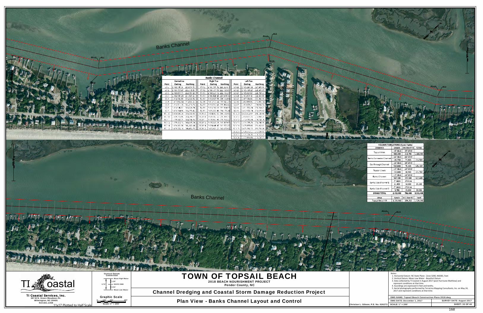
SHEET: 33 OF 40
387-B N. Green Meadows Dr.Wilmington, NC 28405
Vertical Datum
Mean High Water
Conversion
Graphic ScaleTI Coastal Services, Inc.
910.821.1358SCALE: 1" = 200'
TI Coastal Services, Inc.0' 100' 200' 400'
Scale: 1" = 200'
DWG NAME: Topsail Beach Construction Plans 2018.dwgSURVEY DATE: August 2017
TOWN OF TOPSAIL BEACH
Channel Dredging and Coastal Storm Damage Reduction Project
2018 BEACH NOURISHMENT PROJECTPender County, NC
Plan View - Banks Channel Layout and Control DWG DATE: December 1, 2017
1.20'
NAVD 1988
2.54'
Mean Low Water
3.74'
Christian L. Gibson, P.E. No. 026273
Notes: 1. Horizontal Datum: NC State Plane - Zone 3200, NAD83, Feet 2. Vertical Datum: Mean Low Water - Beaufort Datum 3. Data collected by TI Coastal in August 2017 (post Hurricane Matthew) and represent conditions at that time. 4. Soundings are expressed in feet and tenths. 5. Aerial photography performed by TerraLina Mapping Consultants, Inc. on May 24, 2017 and represent conditions at that time.
11x17 Plotted to Half Scale168
B
r
id
g
e
r
s
A
v
e
Barw
ick
S. Anderson Blvd
Monroe Ln
Canady A
ve
N. Anderson Blvd
N. Anderson Blvd
Gaye A
ve
Bare F
oot Ln
N. Anderson Blvd
Sunset A
ve
BC-7
BC-8
BC-9
BC-R7
BC-R8
BC-L10
BC-L11
BC-R9
BC-L12
Banks C
hannel
145+00
150+00
155+00
160+00
165+00
170+00
175+00
180+00
185+00
190+00
195+00
200+00
210+00
N
ix
o
n
A
v
e
S
id
b
u
ry
A
v
e
C
a
th
e
rin
e
A
v
e
N. A
nders
on B
lvd
B
e
e
c
h
w
o
o
d
D
r
F
ie
ld
s
A
v
e
S
tra
w
b
e
rry
L
n
H
u
m
p
h
re
y
A
v
e
H
is
p
a
n
io
la
L
n
B
e
a
c
h
w
o
o
d
D
r
C
ru
tc
h
fie
ld
A
v
e
S
u
rf C
ity
T
o
p
s
a
il B
e
a
c
h
Town Line
215+00
220+00
225+00
230+00
235+00
240+00
245+00
250+00
255+00
260+00
265+00
270+00
210+00
SHEET: 34 OF 40
387-B N. Green Meadows Dr.Wilmington, NC 28405
Vertical Datum
Mean High Water
Conversion
Graphic ScaleTI Coastal Services, Inc.
910.821.1358SCALE: 1" = 200'
TI Coastal Services, Inc.0' 100' 200' 400'
Scale: 1" = 200'
DWG NAME: Topsail Beach Construction Plans 2018.dwgSURVEY DATE: August 2017
TOWN OF TOPSAIL BEACH
Channel Dredging and Coastal Storm Damage Reduction Project
2018 BEACH NOURISHMENT PROJECTPender County, NC
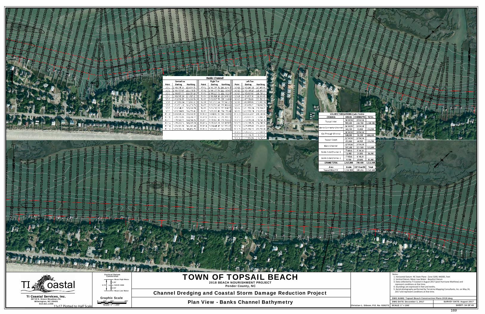
Plan View - Banks Channel Bathymetry DWG DATE: December 1, 2017
1.20'
NAVD 1988
2.54'
Mean Low Water
3.74'
Christian L. Gibson, P.E. No. 026273
Notes: 1. Horizontal Datum: NC State Plane - Zone 3200, NAD83, Feet 2. Vertical Datum: Mean Low Water - Beaufort Datum 3. Data collected by TI Coastal in August 2017 (post Hurricane Matthew) and represent conditions at that time. 4. Soundings are expressed in feet and tenths. 5. Aerial photography performed by TerraLina Mapping Consultants, Inc. on May 24, 2017 and represent conditions at that time.
11x17 Plotted to Half Scale169

SHEET: 35 OF 40
387-B N. Green Meadows Dr.Wilmington, NC 28405
Vertical Datum
Mean High Water
Conversion
TI Coastal Services, Inc.
910.821.1358SCALE: As Shown
TI Coastal Services, Inc.DWG NAME: Topsail Beach Construction Plans 2018.dwg
SURVEY DATE: August 2017
TOWN OF TOPSAIL BEACH
Channel Dredging and Coastal Storm Damage Reduction Project
2018 BEACH NOURISHMENT PROJECTPender County, NC
Station 0+00 to 115+00 - Banks Channel Cross Sections DWG DATE: December 1, 2017
1.20'
NAVD 1988
2.54'
Mean Low Water
3.74'
Christian L. Gibson, P.E. No. 026273
Graphic Scale0' 100' 200' 400'
Horizontal
0' 5' 10' 20'Vertical
Notes:1. Horizontal Datum: NC State Plane - Zone 3200, NAD83, Feet2. Vertical Datum: Mean Low Water - Beaufort Datum3. Data collected by TI Coastal in August 2017 (post Hurricane Matthew) and
represent conditions at that time.4. Soundings are expressed in feet and tenths.5. Aerial photography performed by TerraLina Mapping Consultants, Inc. on May 24,
2017 and represent conditions at that time.
11x17 Plotted to Half Scale170
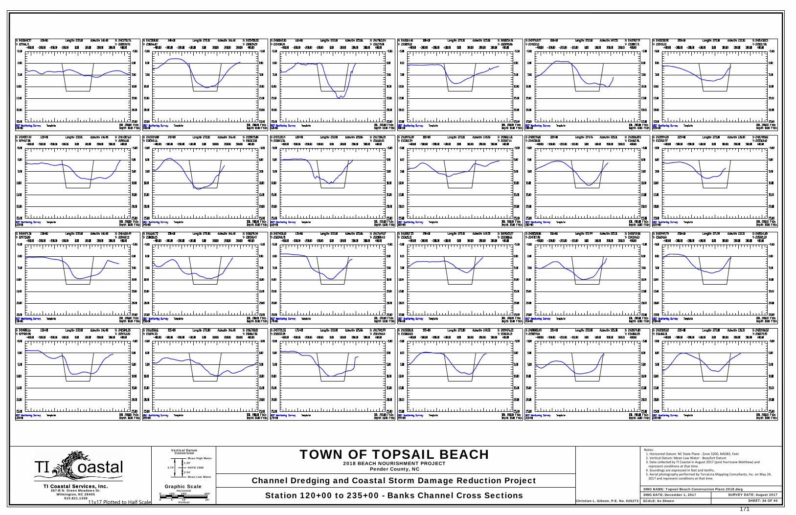
SHEET: 36 OF 40
387-B N. Green Meadows Dr.Wilmington, NC 28405
Vertical Datum
Mean High Water
Conversion
TI Coastal Services, Inc.
910.821.1358SCALE: As Shown
TI Coastal Services, Inc.DWG NAME: Topsail Beach Construction Plans 2018.dwg
SURVEY DATE: August 2017
TOWN OF TOPSAIL BEACH
Channel Dredging and Coastal Storm Damage Reduction Project
2018 BEACH NOURISHMENT PROJECTPender County, NC
Station 120+00 to 235+00 - Banks Channel Cross Sections DWG DATE: December 1, 2017
1.20'
NAVD 1988
2.54'
Mean Low Water
3.74'
Christian L. Gibson, P.E. No. 026273
Graphic Scale0' 100' 200' 400'
Horizontal
0' 5' 10' 20'Vertical
Notes: 1. Horizontal Datum: NC State Plane - Zone 3200, NAD83, Feet 2. Vertical Datum: Mean Low Water - Beaufort Datum 3. Data collected by TI Coastal in August 2017 (post Hurricane Matthew) and represent conditions at that time. 4. Soundings are expressed in feet and tenths. 5. Aerial photography performed by TerraLina Mapping Consultants, Inc. on May 24, 2017 and represent conditions at that time.
11x17 Plotted to Half Scale171
SHEET: 37 OF 40
387-B N. Green Meadows Dr.Wilmington, NC 28405
Vertical Datum
Mean High Water
Conversion
TI Coastal Services, Inc.
910.821.1358SCALE: As Shown
TI Coastal Services, Inc.DWG NAME: Topsail Beach Construction Plans 2018.dwg
SURVEY DATE: August 2017
TOWN OF TOPSAIL BEACH
Channel Dredging and Coastal Storm Damage Reduction Project
2018 BEACH NOURISHMENT PROJECTPender County, NC
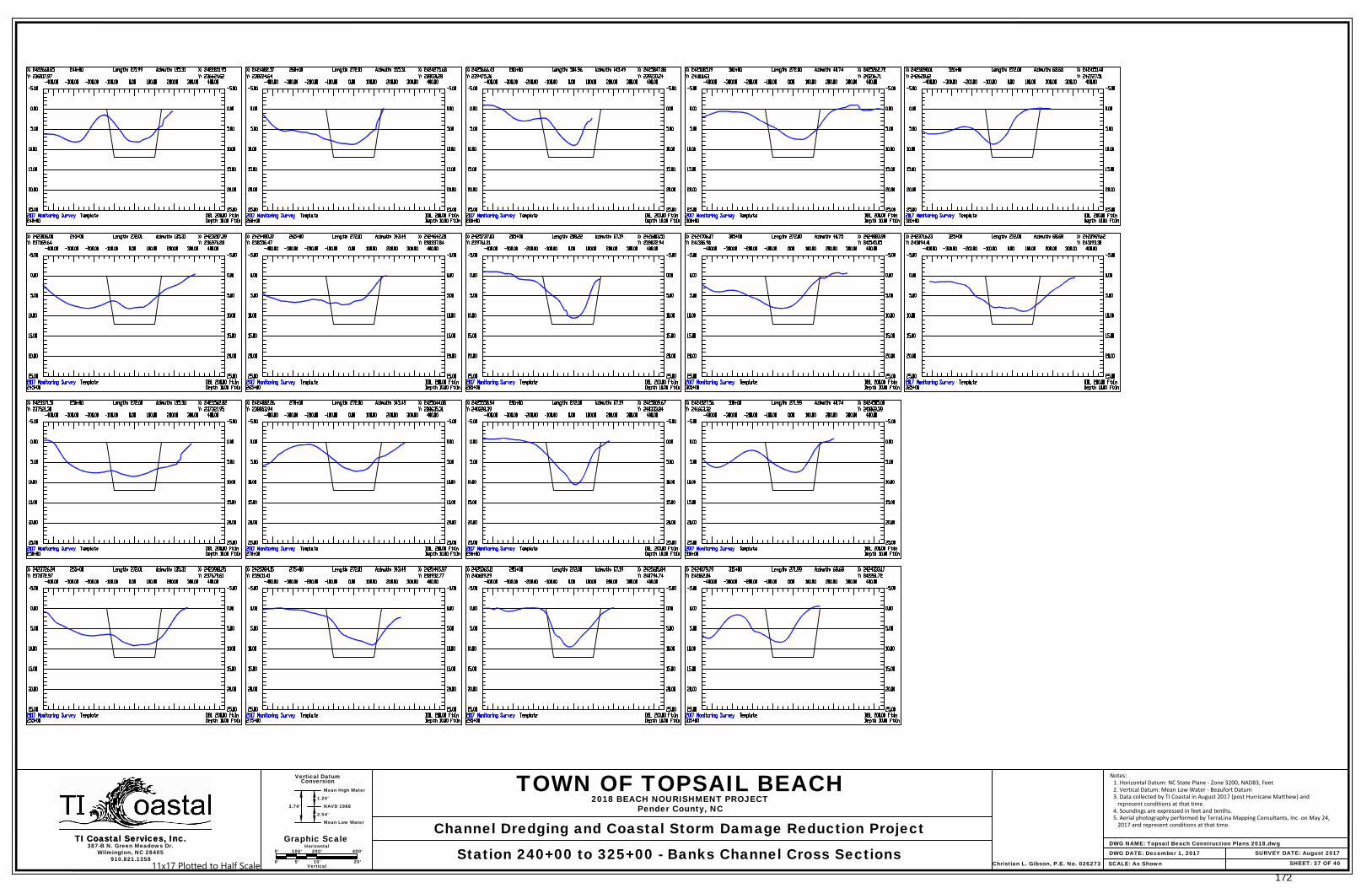
Station 240+00 to 325+00 - Banks Channel Cross Sections DWG DATE: December 1, 2017
1.20'
NAVD 1988
2.54'
Mean Low Water
3.74'
Christian L. Gibson, P.E. No. 026273
Graphic Scale0' 100' 200' 400'
Horizontal
0' 5' 10' 20'Vertical
Notes: 1. Horizontal Datum: NC State Plane - Zone 3200, NAD83, Feet 2. Vertical Datum: Mean Low Water - Beaufort Datum 3. Data collected by TI Coastal in August 2017 (post Hurricane Matthew) and represent conditions at that time. 4. Soundings are expressed in feet and tenths. 5. Aerial photography performed by TerraLina Mapping Consultants, Inc. on May 24, 2017 and represent conditions at that time.
11x17 Plotted to Half Scale172
SHEET: 38 OF 40
387-B N. Green Meadows Dr.Wilmington, NC 28405
Vertical Datum
Mean High Water
Conversion
TI Coastal Services, Inc.
910.821.1358SCALE: As Shown
TI Coastal Services, Inc.
Notes:1. Horizontal Datum: NC State Plane - Zone 3200, NAD83, Feet2. Vertical Datum: Mean Low Water - Beaufort Datum3. Data collected by TI Coastal in November 2016 (post Hurricane Matthew) and
represent conditions at that time.4. Soundings are expressed in feet and tenths.5. Aerial photography performed by TerraLina Mapping Consultants, Inc. on May 15,
2016 and represent conditions at that time.
DWG NAME: Topsail Beach Construction Plans 2018.dwgSURVEY DATE: August 2017
TOWN OF TOPSAIL BEACH
Channel Dredging and Coastal Storm Damage Reduction Project
2018 BEACH NOURISHMENT PROJECTPender County, NC
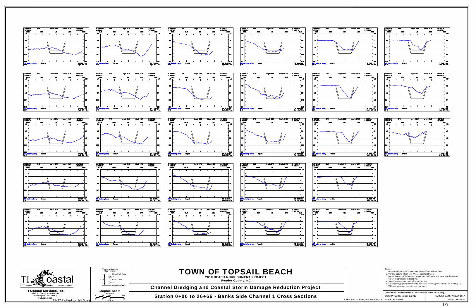
Station 0+00 to 26+66 - Banks Side Channel 1 Cross Sections DWG DATE: December 1, 2017
1.20'
NAVD 1988
2.54'
Mean Low Water
3.74'
Christian L. Gibson, P.E. No. 026273
Graphic Scale0' 50' 100' 200'
Horizontal
0' 5' 10' 20'Vertical11x17 Plotted to Half Scale
173

SHEET: 39 OF 40
387-B N. Green Meadows Dr.Wilmington, NC 28405
Vertical Datum
Mean High Water
Conversion
TI Coastal Services, Inc.
910.821.1358SCALE: As Shown
TI Coastal Services, Inc.DWG NAME: Topsail Beach Construction Plans 2018.dwg
SURVEY DATE: August 2017
TOWN OF TOPSAIL BEACH
Channel Dredging and Coastal Storm Damage Reduction Project
2018 BEACH NOURISHMENT PROJECTPender County, NC
Station 0+00 to 35+00 - Banks Side Channel 2 Cross Sections DWG DATE: December 1, 2017
1.20'
NAVD 1988
2.54'
Mean Low Water
3.74'
Christian L. Gibson, P.E. No. 026273
Graphic Scale0' 50' 100' 200'
Horizontal
0' 5' 10' 20'Vertical
Notes:1. Horizontal Datum: NC State Plane - Zone 3200, NAD83, Feet2. Vertical Datum: Mean Low Water - Beaufort Datum3. Data collected by TI Coastal in August 2017 (post Hurricane Matthew) and
represent conditions at that time.4. Soundings are expressed in feet and tenths.5. Aerial photography performed by TerraLina Mapping Consultants, Inc. on May 24,
2017 and represent conditions at that time.
11x17 Plotted to Half Scale174
SHEET: 40 OF 40
387-B N. Green Meadows Dr.Wilmington, NC 28405
Vertical Datum
Mean High Water
Conversion
TI Coastal Services, Inc.
910.821.1358SCALE: As Shown
TI Coastal Services, Inc.DWG NAME: Topsail Beach Construction Plans 2018.dwg
SURVEY DATE: August 2017
TOWN OF TOPSAIL BEACH
Channel Dredging and Coastal Storm Damage Reduction Project
2018 BEACH NOURISHMENT PROJECTPender County, NC
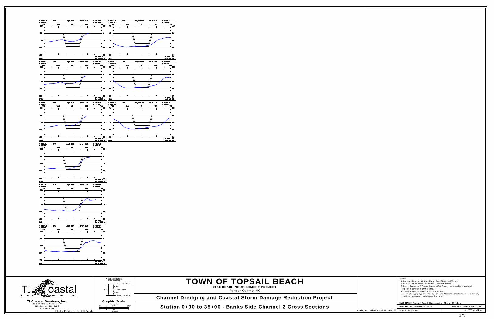
Station 0+00 to 35+00 - Banks Side Channel 2 Cross Sections DWG DATE: December 1, 2017
1.20'
NAVD 1988
2.54'
Mean Low Water
3.74'
Christian L. Gibson, P.E. No. 026273
Graphic Scale0' 50' 100' 200'
Horizontal
0' 5' 10' 20'Vertical
Notes:1. Horizontal Datum: NC State Plane - Zone 3200, NAD83, Feet2. Vertical Datum: Mean Low Water - Beaufort Datum3. Data collected by TI Coastal in August 2017 (post Hurricane Matthew) and
represent conditions at that time.4. Soundings are expressed in feet and tenths.5. Aerial photography performed by TerraLina Mapping Consultants, Inc. on May 24,
2017 and represent conditions at that time.
11x17 Plotted to Half Scale175


