

#
#
#
#
#
#
##
#
#
##
#
#
#
##
###
##
#
##
#
#
##
#
#
#
#
#
#
#
##
#
#
#
# #############
#
###
#
####
####
#
##
!"
!! !
" !
!
"!
!
!" ""
!
"
"
!
!!
"
"
!"
"
"
"
"
!
"
! !!
!
!
!
! !
!
!
!
! !
!
!
!
!
!
!
!
!
!!
!
!
!
!
!
!
!
!
!
!
!
!
!
!
!
!
!!!!
!
!
!
!
!
!
!
!
!
!
!!
!!
!!
!
!!
!
!
!!
!
!
!
!
!
!
!
!
!
!
!
!!
!
!
!
!
!
!
!
!
!!
!
!
!
!
!
!!
!
!
!
!
!
!
!
!
!
!
!
!
!
!!
!
!
!
!
!
!
!
!
!
!
!
!
!
!
!
!
!
!
!
!
!
!
!
!!
!
!
!
!
!
!
!
!
!
!
!
!
!
!
!
!
!
!
!
!
!
!
!
!
!!
!
!
!
!
!
!
!
!!
!
!
!
!
!
!
!
!
!
!
!
!!
!
!!
!
!
!
!
!
!
!
!
!
!
!
!
!
!
!
!
!
!
!
!
!
!
!
!
!
!
!
!
!
!
!
!
!
!
!
!
!
!
!
!!
!
!
!
!
!
!
!
!
!
!
!
!
!
!
!!
!
!
!
!
!
!
!
! !
!
!
!
!
!
!
!
!
!
!
!
!
!
!
!
!
!
!
!!
!
!
!
!
!
!
!
!
!
!
!
!
!
!
!
!
!
!
!
!
!
!
!
!
!
!
!
!
!
!
!
! !
!
!
!
!
!
!
!
!
!
!
!
!
!
!
!
!
!
!
!
!!
!
!
!
!
!
!
!
!
!!
!
!
!
!
!
!
!
! !
!
!
!
!! !
!
!
!
!
!
!
!
!
!
!
!
!
!
!
!
!
!
! !
!
!
!
!
!
!!
!
!
!
!
!!
!
!
!
!
!! !
!
!
!
!
!
!
!
!
!
!
!
!
!
!
LakeTana
Blue Nile
White Nile
LakeAlbert
LakeVictoria
Aden
Suez
Mecca
Asyût
Jeddah
Medina
Kananga
Mombasa
Benghazi
Kisangani
Al BasrahPort Said
Mbuji-Mayi
Alexandria
Sanaa
Cairo
Amman
Kigali
Asmera
Riyadh
Nairobi
Kampala
Djibouti
Khartoum
Bujumbura
Mogadishu
Addis Ababa
Dar es Salaam
Jerusalem
Dodoma
Indeterminateboundary
Administrativeboundary
Administrativeboundary
United Republic of Tanzania
Kenya
Ethiopia
Democratic Republic of the Congo
Uganda
Sudan
Eritrea
Egypt
Rwanda
Burundi
40°E30°E20°E
30°N
20°N
10°N
0°
0 250 500 750 1 000
Kilometres
! Meteorological station" Capital city
! Other city# River gauging station
Nile BasinNational boundary
Transboundary aquifers and river basins
The Nile River Basin Project
The importance of understanding the hydrology of the Nile Basin cannot be overstated. Providing an adequate
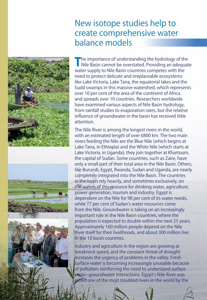
water supply to Nile Basin countries competes with the need to protect delicate and irreplaceable ecosystems like Lake Victoria, Lake Tana, the equatorial lakes and the Sudd swamps in this massive watershed, which represents over 10 per cent of the area of the continent of Africa and spreads over 10 countries. Researchers worldwide have examined various aspects of Nile Basin hydrology, from rainfall studies to evaporation rates, but the relative influence of groundwater in the basin has received little attention.
The Nile River is among the longest rivers in the world, with an estimated length of over 6800 km. The two main rivers feeding the Nile are the Blue Nile (which begins at Lake Tana, in Ethiopia) and the White Nile (which starts at Lake Victoria, in Uganda); they join together at Khartoum, the capital of Sudan. Some countries, such as Zaire, have only a small part of their total area in the Nile Basin. Others, like Burundi, Egypt, Rwanda, Sudan and Uganda, are nearly completely integrated into the Nile Basin. The countries in the basin rely heavily, and sometimes exclusively, on the waters of this resource for drinking water, agriculture, power generation, tourism and industry. Egypt is dependent on the Nile for 98 per cent of its water needs, while 77 per cent of Sudan’s water resources come from the Nile. Groundwater is taking on an increasingly important role in the Nile Basin countries, where the population is expected to double within the next 25 years. Approximately 160 million people depend on the Nile River itself for their livelihoods, and about 300 million live in the 10 basin countries.
Industry and agriculture in the region are growing at breakneck speed, and the constant threat of drought increases the urgency of problems in the valley. Fresh surface water is becoming increasingly unusable because of pollution, reinforcing the need to understand surface water–groundwater interactions. Egypt’s Nile River was called one of the most troubled rivers in the world by the
New isotope studies help to create comprehensive water balance models

World Commission on Water, which reported that only 10 per cent of the Nile’s waters reach the Mediterranean Sea, and what does finally arrive is polluted with industrial, agricultural and municipal waste.
Adding a ‘groundwater dimension’ to joint planning and management of the Nile Basin is the goal of an IAEA project approved in 2006 and started in 2009, undertaken in conjunction with Nile Basin countries, funded by the Global Environment Facility (GEF) and implemented by the United Nations Development Programme (UNDP). The project works towards assisting Nile Basin countries in the management of rivers, lakes and wetlands by conducting water balance studies to evaluate the relative influence of groundwater. These water balance models, which integrate isotope data, are a highly effective way to understand interactions between surface water and groundwater. In their simplest form, they account for all the inputs and outputs of water in a given system, such as rainfall, river flow, evaporation, recharge to groundwater aquifers and discharge of groundwater, and they can be conducted on a variety of scales. Other goals include assessing the interaction between major tributaries of the Nile River and groundwater and between wetlands and groundwater.
Since water balance modelling integrates nearly every form of water quantity data, the project allows the IAEA, through its nuclear applications and technical cooperation programmes, to compile an unprecedented library of data on the hydrology of the Nile Basin. Historical data sets are being obtained through cooperation with national hydrological and meteorological organizations in each project member country. Field campaigns are also under way or being planned for all project member countries. Modelling of the Nile system will initially focus on small sub-basins such as Lake Victoria and Lake Tana in the Ethiopian highlands. After testing and validating sub-basin models, a water balance model of the entire Nile Basin will be developed.
Isotopes will characterize the role of groundwater in the wetlands and the Sudd swamps in the regional water cycle, improve assessment of groundwater–surface water interactions as well as losses to and gains from groundwater in basin rivers and lakes, and improve the use of water balance models in estimating basin-wide monthly and annual water balances.
CONTACT US:Isotope Hydrology SectionDivision of Physical and Chemical SciencesDepartment of Nuclear Sciences and ApplicationsInternational Atomic Energy AgencyVienna International Centre, P.O. Box 1001400 Vienna, AustriaPhone: +431 2600 21736, Fax: +431 [email protected] www.iaea.org/water
Data sources: ESRI, NOAA, UNGIWG, USGS, www.landcover.org, IAEA-TC Project RAF/8/042. The designations employed and the presentation of material on this map do not imply the expression of any opinion whatsoever on the part of the Secretariats of the United Nations or the International Atomic Energy Agency concerning the legal status of any country, territory, city or area or of its authorities, or concerning the delimitation of its frontiers or boundaries. Country names and national boundaries as of January 2011.
The results of two sampling campaigns undertaken by the IAEA in 2005 and 2006 at selected sites along the Blue Nile, starting from the Ethiopian border to the junction at Khartoum, have added value to the current project. The project has created baseline information on the interaction between Lake Victoria and surrounding waters.
There are still many gaps in information that need to be addressed, including the contribution of major wetlands to basin water balances. More information is needed on unsaturated zones near rivers and streams to determine the rates of recharge under agricultural land, and through this to have a better understanding of the transport of agricultural contaminants.


