

TRIMBLE MARINE CONSTRUCTION SYSTEMS

A COMPLETE SOLUTION FOR MARINE CONSTRUCTION
Trimble® Site Positioning System GNSS receivers and antennas are advanced positioning systems developed by the leader in GNSS technology for marine solutions. Whatever
your unique marine construction need, and no matter how simple or complex your projects, Trimble has the flexible, high-performance positioning system for you. Trimble
offers a complete solution, one that includes both hardware and software. Trimble receivers can also be easily incorporated into system-integrator solutions.
Trimble Tablet: This advanced, extremely rugged computer combined with HYDROpro software, a
GNSS receiver, and other sensors provides an efficient, highly portable marine positioning solution
for a wide range of applications. For shore-based work, Trimble Tablet also runs Trimble SCS900
Site Controller Software for measurement and stakeout operations.
Trimble marine GNSS receivers and antennas offer cost-effective solutions for permanent or temporary
installations. Shown here: The SPS461 GPS Heading Receiver.
Trimble Site Positioning Systems optimally partner with Trimble HYDROpro™ marine software.
Trimble HYDROpro features dedicated configurations for specific applications, as well as for single
beam hydrographic surveys and environmental data collection and processing.
RAPID DEPLOYMENT, EASY INTEgRATION
Just One ReceiveR fOR fast installatiOn
Perhaps your business requires a permanently
installed GNSS heading and positioning solution.
Or do changing application needs demand a
flexible system that can be quickly deployed to
different vessels?
Trimble offers a range of receivers offering
cost-effective solutions for permanent or
temporary installations.
easy integRatiOn with OtheR systems
All Trimble SPS receivers share a common
interface and accessories. Each receiver is
therefore easily integrated with other Trimble
systems: You can reuse data and accessories
across multiple applications. Users familiar
with one Trimble system require minimal
training with another. They can start working
with a new receiver immediately.
Quickly and easily
determine vessel position,
heading, and pitch or roll.
HIgH-PRECISION HEADINg…FAST
Dual l1/l2 antennas: Key tO PRecisiOn,
flexibility
The Trimble SPS361/SPS461 system is a modular,
dual-frequency solution employing separate
plug-in dual-frequency antennas. This antenna
configuration offers significant benefits over
single-frequency and fixed baseline systems:
• More precise GNSS heading—flexible
antenna separation enables users to
maximize precision.
• Dual-frequency ensures faster initialization
and re-acquisition.
EASILY DETERMINE THE POSITION OF OTHER SENSORS ON A VESSEL
a cOmPlete heaDing sOlutiOn
Built on the success of the Trimble SPS555H GNSS
Add-on Heading Receiver, the SPS361/SPS461
combines the same precision and reliability in a
single receiver. This results in a compact solution
that is easy to mobilize.
One system DeliveRs POsitiOn, heaDing,
anD attituDe
The dual antennas of the Trimble SPS361/
SPS461 provide vessel position, heading, and
pitch or roll. So just one cost-effective system
is needed. You can then use Trimble HYDROpro
software in combination with the receiver data
and other sensors, for example, an echosounder,
to determine real-time position, heading, and
precise elevation of the target surface.
Trimble marine construction systems deliver the accuracy and reliability you need, and with their exceptional
performance and our unsurpassed technical support, they provide total peace of mind.

PRODUCTS DEDICATED TO MARINE APPLICATIONS; A COMPANY COMMITTED TO ITS MARINE CUSTOMERS.
PRECISE gPS FOR TIDE
The Trimble SPS855 GNSS Modular Receiver
lets you immediately determine water level
wherever you are. It makes measuring tidal
height on location significantly more precise
and cost-effective than with conventional
methods. Tide gauges and associated radio
links are no longer essential.
MSK BEACON SUPPORT
The MSK Beacon service is a free-to-air
correction signal, and MSK transmissions are
available in many coastal regions and inland
waterways around the world. A receiver such
as the Trimble SPS351 or SPS361 with its GA530
antenna and internal Beacon receiver makes
effective use of the MSK Beacon service.
PUT TRIMBLE TECHNOLOgY AND ExPERIENCE TO WORK IN YOUR MARINE APPLICATION
Trimble heading receivers provide precise navigation that is
vessel-centric. Marine operators receive simple forward/back,
port/starboard, and clockwise/anti-clockwise guidance, which
allows them to position the vessel quickly and efficiently.
Driving piles into a seabed requires great accuracy in a harsh
environment. Trimble SPS systems utilize precision GNSS,
heading sensors, and integrated software to get the job
done right.
The Trimble SPS system provides the 3D position of the dredge
head and displays it with the channel design. Precise information
gives marine operators "eyes under water", to see exactly where
material should be dredged.
Trimble SPS systems support a diverse range of hydrographic
surveys, including port and harbor maintenance, environmental,
cable and pipe maintenance, and buoy mooring.
THE POSITION ACCURACY YOU NEED
flexible, scalable, uPgRaDable
Trimble modular receivers provide position accuracy
to suit most applications—up to precise GNSS
accuracy (centimeter-accurate). Simply upgrade
to the level of precision you require. Most Trimble
receivers support the following correction sources:
• Satellite-based Augmentation Systems such
as WAAS, EGNOS, MSAS, and QZSS
• MSK Beacon (free-to-air)
• OmniSTAR VBS, XP, or HP
• Precision GNSS (RTK) base station
• DGPS using UHF radio links (RTCM)
• Virtual Reference Station (VRS)
• Trimble Internet Base Station Service (IBSS)
Corrections are accessible via internal radio or
demodulator, external radio, or via the Internet.
Optional UHF radios in Trimble SPS GNSS receiver
ensure easier integration, fewer cables, and more
compact receivers. The Trimble TDL 450 Series Radios
provide robust UHF frequency solutions for use as
repeaters or for work at longer ranges.
Trimble marine systems meet the demands of a wide range of marine construction and
hydrographic survey applications, including:
• Precise placement of marine structures such as breakwaters, bridges, caissons, piles, marina
piers and coastal defences
• Dredge vessel positioning
• Positioning and tracking of barges, tugs and other construction vessels
• Offshore-rig-positioning and anchor-handling applications
• Hydrographic surveys for applications such as channel maintenance, dredging progress,
environmental surveys, and bed erosion
© 2012, Trimble and the Globe & Triangle logo are trademarks of Trimble Navigation Limited, registered in the United States and other
countries. HYDROpro, Zephyr and OmniSTAR are trademarks of Trimble Navigation Limited. PN 022482-1623B-4 (04/12)
YOUR LOCAL TRIMBLE OFFICE OR REPRESENTATIVE
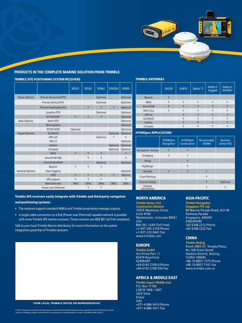
Trimble SPS receivers easily integrate with Trimble and third-party navigation
and positioning systems:
• The receivers support standard NMEA and Trimble proprietary message outputs.
• A single-cable connection to a PoE (Power over Ethernet) capable network is possible with some Trimble SPS marine receivers. Those receivers are IEEE 801.3af PoE compliant.
Talk to your local Trimble Marine distributor for more information on the system integration potential of Trimble receivers.
SPS351 SPS361 SPS461 SPS555H SPS855
Rover Options Precise Horizontal RTK Optional Optional
Precise Vertical RTK Optional Optional
Precise Heading/Vector Y Y Y Optional
Location RTK Optional Optional
RTCM DGPS Y Y Y OptionalBase Options Static RTK Optional
Moving Base OptionalRTCM DGPS Optional Optional
Signal Options GLONASS Optional OptionalGPS L2C Optional Y YGPS L5 OptionalGalileo Optional Optional
Compass Optional OptionalSBAS Y Y Y Y
OmniSTAR VBS Y Y Y
OmniSTAR HP/XP Optional OptionalBeacon Y Y Y
General Options Data logging Optional1PPS Y Y Y Y Marine
VRS support Y Y Y YMax Data rate 10Hz 20Hz 20Hz 20Hz 20Hz
Power over Ethernet Y Y
NORTH AMERICATrimble Heavy Civil Construction Division 10355 Westmoor Drive, Suite #100Westminster, Colorado 80021USA800-361-1249 (Toll Free)+1-937-245-5154 Phone+1-937-233-9441 Faxwww.trimble.com
EUROPETrimble GmbH Am Prime Parc 1165479 RaunheimGERMANY+49-6142-2100-0 Phone+49-6142-2100-550 Fax
AFRICA & MIDDLE EASTTrimble Export Middle EastP.O. Box 17760LOB18 1606 / 1607JAFZ ViewDubaiUAE+971-4-886-5410 Phone+971-4-886-5411 Fax
HYDROpro Navigation
HYDROpro Construction
Terramodel HDMS
Business Center-HCE
Navigation / Survey Y Y
Dredging Y Y
Piling Y
Rig/Barge Y
NavEdit Y Y Y
Chart Plotting Y
Channel design Y OptionalVolume
calculations Y Y
ASIA-PACIFICTrimble Navigation Singapore PTE Ltd.80 Marine Parade Road, #22-06Parkway ParadeSingapore, 449269SINGAPORE+65 6348 2212 Phone+65 6348 2232 Fax
CHINATrimble BeijingRoom 2805-07, Tengda Plaza,No.168 Xiwai StreetHaidian District, Beijing,CHINA 100044+86-10-8857-7575 Phone+86-10-8857-7161 Faxwww.trimble.com.cn
PRODUCTS IN THE COMPLETE MARINE SOLUTION FROM TRIMBLE
TRIMBLE SITE POSITIONINg SYSTEM RECEIVERS
GA530 GA810 Zephyr ™2Zephyr 2 Rugged
Zephyr 2 Geodetic
Beacon Y
SBAS Y Y Y Y YOmniSTAR Y Y Y Y Y
GPS L1/L2 Y Y Y Y YGPS L5 Y Y Y Y
GLONASS Y Y Y YGalileo Y Y Y Y
Compass Y Y Y Y
TRIMBLE ANTENNAS
HYDROpro APPLICATIONS


