

UKCS Frontier Basins and
Licensing APPEX Conference 2016
2nd March 2016

UKCS Frontier Basins & Plays
Frontiers should also be defined in Three Dimensions
BGS Gravity Map Low vs High Well Density Seismic Acquired 2005-2015
ESP
MNSH
RB
62N
SCS
WAB

OGA Monthly Performance Pack 2015
Government-Funded Seismic Programme 2015
12 months from Funding to Data Delivery
• 8896 km 2015 Broadband PSTM
• 1117 km 2014 Broadband PSTM
• Approx. 5000 km Legacy Data, some reprocessed
Rockall Basin
Mid-North Sea High
• 10849 km 2015 Broadband PSTM
• Approx. 10000 km Legacy Data, some reprocessed
Almost 40,000 km total
seismic data package
Free Subsurface Data Packages available end March 2016
MNSH
Rockall

Data Delivery Survey on OGA
Website.

Data Analysis Competition
More Information on www.gov.uk/oga on 7th March 2016
Phase 1 (March to April) • Submit expression of interest and project
plan • Best proposals will be awarded up to £30,000
seed money
Phase 2 (April to July) • Successful applicants develop initial analyses
or products
Phase 3 (July to November) • Two winners will be awarded up to £100,000
each to fully develop or extend analyses or products (one award for each area)
Aim: Stimulate small business and academic start-up activity in UKCS
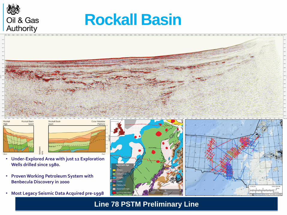
Rockall Basin
Line 78 PSTM Preliminary Line
• Under-Explored Area with just 12 Exploration Wells drilled since 1980.
• Proven Working Petroleum System with Benbecula Discovery in 2000
• Most Legacy Seismic Data Acquired pre-1998

Mid North Sea High
Line 58 PSTM Preliminary Line
• Broadband Technology Applied to Improve Imaging
• Acquired and Reprocessed Data Close to Shore to Transfer Critical Onshore Knowledge
• Breagh & Pegasus Discoveries. Extending the Carboniferous Play to the North
• Link with BGS-managed 21st Century Roadmap Project on Palaeozoic Prospectivity

21 CXRM Palaeozoic Project
Next Technical Meeting: Thursday 17th March 2016

29th Frontier Round
29th Round will focus on Under-Explored Frontier Areas
N.B. Timing subject to completion of Strategic Environmental Assessment
Nominated Areas
29th Round Areas
Areas to be included in 29th Licensing Round: • Rockall Basin • Mid North Sea High Basin • East Shetland Platform (part)
Improved, Flexible Licenses to be made available.

Innovate License
Phase A Phase B Phase C Studies & Reprocessing Seismic Programme Drill E&A Wells
SEA & AA SEA* SEA*
Financial Viability Financial Viability Financial Capacity, plus Technical, Environmental and Safety Competence
INITIAL TERM: Period up to a maximum of 9 years
No compulsory relinquishment Relinquish to prospective field area
Innovate Licence Advantages
• Lowers Entry Hurdles: Reduced Access Costs, Deferred Capacity/Competence Tests
• Flexibility: Design Licence around the Work Programme (no shoehorning).
• Broader Areas: Available everywhere on UKCS, Larger Tranches on Offer
• Faster Awards: OGA and OGED expediting AA Process
Innovate exploration license offers a flexible & pragmatic approach
* AA in some areas
Will largely be implemented for 29th Round, full implementation for 30th Round
Up to 75% negotiable
Ongoing initiatives to improve access to data and studies

Example Innovate Licences
Flexible Durations:
• Initial Term (up to 9 Years)
• Second Term (4 to 6 Years)
Three-Phase Initial Term:
• Phase A – for studies and reprocessing
• Phase B – for shooting new seismic
• Phase C – for drilling wells
Decision Gate at end of each Phase:
• Proceed or Drop
If Phases A or B not required, can enter
straight into Phase C
Slide 6

Government-Funded Seismic Programme 2016
Focus on Frontier Basins & Plays
£20m of new funding for a second round of new seismic surveys to
unlock new exploration activity on the UK Continental Shelf
Acquisition, Processing and Reprocessing must be completed by
end March 2017.
Interest Shown by Industry in: • East Irish Sea Basin • Cardigan Basin, incl. South Celtic Sea • SW Approaches Basin

Focus on Frontier Basins & Plays
South Celtic Sea Basin/Cardigan Basin
• Principal Reservoir: Lower Triassic Sherwood Sandstone
• Top Seal: Triassic Mercia Mudstone Group (incl. evaporites)
• Main Source Rock: Lias Group Mudstones

South Celtic Sea Basin
Focus on under-explored frontier areas
• Working Hydrocarbon System in Ireland
• Dragon Gas Discovery in UK • Most UK wells drilled along
main Inversion Axis

SW Approaches Basin
Focus on under-explored frontier areas
After Evans (1990)
Chapman (1989)
• No Seismic acquired in last two decades
• No Wells since 1980s • 3 wells with oil shows and
1 with gas shows in UK waters
• 8 wells with oil/gas shows in French waters
• Principal Reservoir: Lower Triassic Sherwood Sandstone
• Top Seal: Triassic Mercia Mudstone Group (incl. evaporites)
• Source Rock: Lias Group Mudstones
• Tilted Fault Blocks, Four-Ways and Stratigraphic Traps
• Complex Structural History

East Orkney & East Shetland
Focus on under-explored frontier areas
• Principal Reservoir: Devonian Fluvial Sandstone
• Top Seal: Intra-Devonian Shales
• Source Rock: Primarily Devonian Shales, Local Presence of mature Upper Jurassic Source? • Sparse Seismic Data • Gravity Maps suggest deep basins • Abundant oil seeps in some areas
Richardson, Allen & Underhill, 2002

Data Delivery Survey on OGA
Website.


