

Welcome
Dupont Street Study
Community Consultation Meeting #2
April 28, 2014

Agenda
1. Introductions
2. Schedule Review
3. Rail Meeting – May 14th
4. Updated Study Website
5. Crowd Map
6. Community Services and
Facilities Needs Assessment
Report 1
7. Applications and Preliminary
Proposals
8. Topic Areas and Preliminary Options
• Open Space
• Streetscape
• Transportation
• Built Form
9. Questions and Comments
10. Table Feedback

Introductions

Further Information around the room
What we heard at the first meeting – how we will address those
comments
Retail precedent sizes
Map showing application locations and conversion requests
Display sheets with the information in the presentation
Make comments, write on the sheets etc.

Schedule Review

Rail Safety and Mitigation Meeting
May 14th, 2014
7:00 p.m.
Sacre Couer School – 99 Essex Street
Agenda – Presentation by the City’s rail consultant on the findings of
their study followed by a questions and answer period

Updated Website and Crowd map
The study website is updated on a regular basis
www.toronto.ca/planning/dupontstudy
Crowd Map
https://dupont.crowdmap.com/

Community Services and Facilities Assessment Area bounded by Davenport, Avenue, Bloor and Dufferin
Summary of Demographics
– Compared to the city, lower # of children, more 20-34, fewer 45-59
– Highest # of dwellings are in apartments, less than 5 storeys (42.7%)
Summary of resources
– Schools
– Daycares
– Libraries
– Parks/Open Spaces/Recreation Centres
– Places of Worship
Analysis is coming

Applications and Preliminary
Proposals

Application: 840-860 Dupont Street Up to 13 storeys and 46 metres

Preliminary Proposal : 328-374 Dupont Street Up to 19 storeys and 65 metres
15 storeys 15 storeys 19
9 storeys

Preliminary Proposal : 740 Dupont Street Up to 12 storeys and 46 metres

Topic Areas – Open Space

Open Space
City can take either land for parks on-site, or cash-in-lieu
Parkland dedication - up to 15% of the area of the lot for any
property over 1 hectare
Loblaws and Sobeys sites are examples of properties that meet this
threshold
Sobeys – 1287 square metres parkland dedication
Cash in lieu for smaller properties
Open space priorities for the area include dog off leash areas and
playgrounds

Open Space Example 1200 m2 – Margaret Fairley Park (Brunswick and Ulster St)

Open Space Continuous green connector
Existing buildings & crossing the street

Topic Areas – Streetscape

Streetscape - Existing Conditions
Two general conditions that affect the streetscape character &
dimension
1. Residential adjacency (front and side yards)
2. Commercial adjacency (wide lots & narrow lots)

Streetscape - Existing Conditions
1. Residential adjacency (front and side yards)
Front yard condition
2.2m
0.9 – 1m
Side yard condition
2.2m
1 m
at locations with raised planters

Streetscape - Existing Conditions
2. Commercial adjacency (wide lots)
Sobeys example
1.5m sidewalk
3.5m to property line

Streetscape Commercial adjacency (wide lots)
• Length of properties allows for
consistent treatment
• Generally a curb to building face
depth of between 4.8 m and 6m
allows for pedestrian clearway
and tree planting
• Deeper sites may be able to
provide a wider setback
Residential Adjacency
• Longer term solutions
• Options for greening

Streetscape Precedents

Topic Areas – Transportation

24
Main Transportation Issues From Previous
Meeting
Transportation Services
Traffic conditions along Dupont Street and how can
they be improved
TTC service along Dupont Street
Installation of new traffic control signals or controlled
pedestrian crossings along Dupont Street

25
Existing Traffic Conditions Along Dupont
Street Transportation Services
Capacity/Level-of-Service (LOS) analysis are the main
performance measures used to assess traffic operations
of an intersection Assessment is typically done for the Morning Peak Hour
(1 hour between 7:00-9:00 AM during a typical weekday)
and the Afternoon Peak Hour (1 hour between 4:00-6:00
PM during a typical weekday) Objective: Evaluate traffic operations during “typical”
peak hour periods

26
Existing Traffic Conditions Along Dupont
Street Transportation Services
Capacity
Quantitative measure used to determine the
utilization of an intersection
Probabilistic model since it cannot account for all
variations in traffic conditions.
LOS
Qualitative measure which attempts to describe
traffic flow conditions at an intersection
A function of Average Delay

27
Summary of Existing Traffic Conditions Along
Dupont Street Transportation Services
Peak Hour Intersection Average Control
Delay Level-of-Service
AM
Dupont Street/Ossington Avenue 21.0 C
Dupont Street/Shaw Street 14.4 B
Dupont Street/Christie Street 42.9 D
Dupont Street/Hammond Place 16.7 B
Dupont Street/Bathurst Street 27.6 C
Dupont Street/Howland Street 39.6 D
Dupont Street/Spadina Road 34.5 C
PM
Dupont Street/Ossington Avenue 13.8 B
Dupont Street/Shaw Street 13.9 B
Dupont Street/Christie Street 68.7 E
Dupont Street/Hammond Place 22.6 C
Dupont Street/Bathurst Street 66.8 E
Dupont Street/Howland Street 9.9 A
Dupont Street/Spadina Road 24.0 C

28
New Traffic Control Signals or Controlled
Pedestrian Crossings Transportation Services
Typically assessed on a case by case basis and
installed where appropriate
Must take into account:
Potential interruptions in traffic flow/progression
(Dupont Street is classified as a major arterial
roadway)
Adjacency to existing signalized intersections
Are technical warrants satisfied?
Safety implications?

29
TTC Service Along Dupont Street Transportation Services
TTC operates bus service along Dupont Street seven
days a week via Route No. 26
Current service levels are approximately every 14
minutes in the eastbound and westbound directions
Service levels are usually reviewed and adjusted in
response to demand

Topic Areas – Built Form

Built Form Characteristics
1. Streetwall Height
2. Articulation - Active Uses & Rhythm
3. Building Length - Separation of Buildings / Open Space breaks
4. Building Materials & Character
5. Overall height

Mid-Rise Guidelines
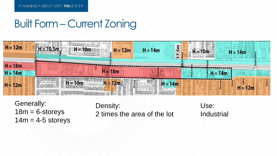
Built Form – Current Zoning
Generally:
18m = 6-storeys
14m = 4-5 storeys
Density:
2 times the area of the lot
Use:
Industrial

As-of-right Built Form 14 metres, 2X density 18 metres, 2X density

+/- 21m / 5 storeys

+/- 16m / 4 storeys

+/- 13m / 2 storeys
+/- 9m / 2 storeys

4 storeys / 18 m
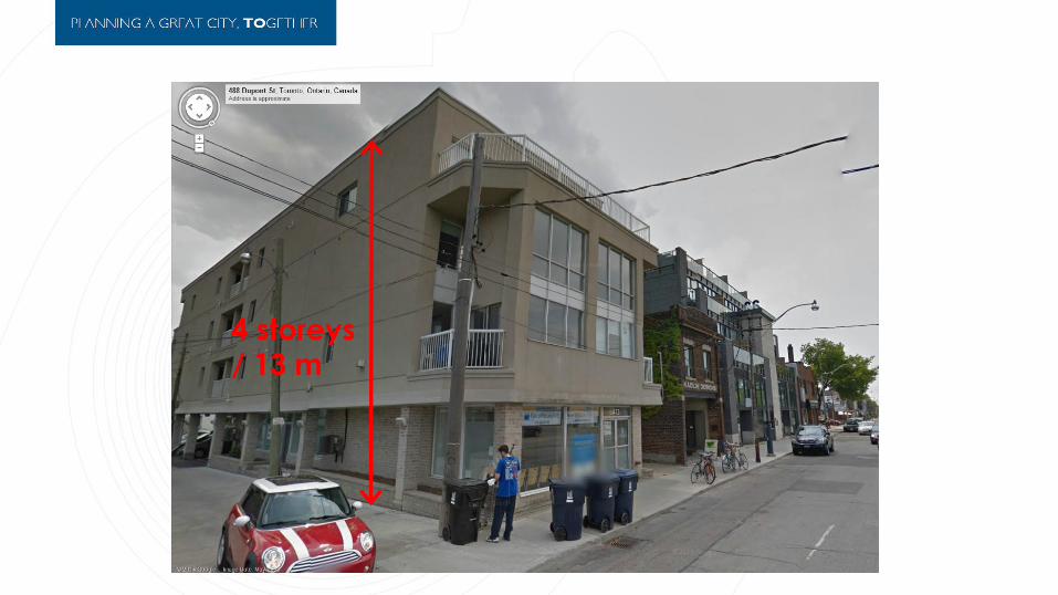
4 storeys / 13 m

Built Form Options

Built Form Option 1 Mid-Rise Guidelines Applied

Built Form Option 2 Deep front step-back and 3-storey streetwall

Built Form Option 3 Deep front step-back, 4-storey streetwall and side step-back
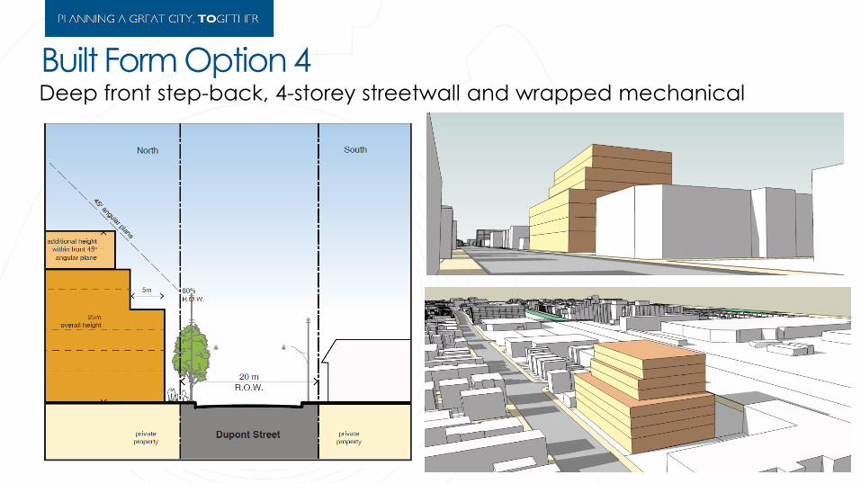
Built Form Option 4 Deep front step-back, 4-storey streetwall and wrapped mechanical

Summary of Built Form Options
1 2
3 4

Questions and Comments
www.toronto.ca/planning/dupontstudy


