
11
Welcome to the Presentation Welcome to the Presentation onon
Necessity of WaterNecessity of Water--related disaster related disaster management management
in in BangladeshBangladesh
ByByMd. Abdul Md. Abdul HyeHyeExecutive Engineer & Chief Staff OfficerExecutive Engineer & Chief Staff OfficerBangladesh Water Development BoardBangladesh Water Development Board
01 December 200701 December 2007
22
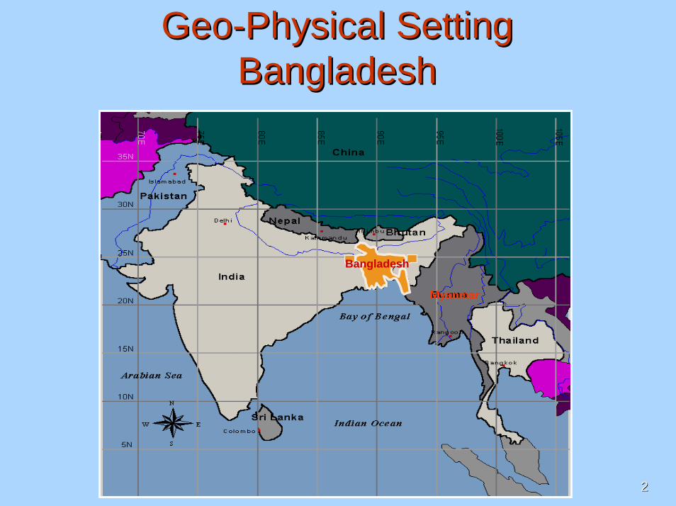
GeoGeo--Physical Setting Physical Setting BangladeshBangladesh
Bangladesh
Myanmar

33
Bangladesh at a glanceBangladesh at a glance[[Water Sector]Water Sector]
Total area : 1,47,570 Total area : 1,47,570 sq.kmsq.km..Arable land: 82,400 sq.km.(8.24 Million ha)Arable land: 82,400 sq.km.(8.24 Million ha)Population: 145 Million (approx.)Population: 145 Million (approx.)Population density: 950 persons/ sq. km.Population density: 950 persons/ sq. km.Poverty level: 49.8% (as per BBS/WB).Poverty level: 49.8% (as per BBS/WB).Total food production: 46.17 Million Mt.Total food production: 46.17 Million Mt.Ground Elevation (in PWD):
0-5m – 30%5-30m – 45%>30m – 25%

44
Cherapunji (in INDIA)Worlds highest rainfall
A riverine country with 310 rivers
• Total river length : 24,000 km
• Trans-boundary rivers : 57 nos. - 54 from India and
- 3 from Myanmar River erosionRiver erosion-- Annual land loss: 10,000 Annual land loss: 10,000
ha.ha.-- Annual displacement of Annual displacement of
population: 64,000.population: 64,000.-- Annual accretion in the Annual accretion in the
MeghnaMeghna estuary: 1,880 ha.
46004200
2600
2200
1500
1700
1900
2100
2000
2800
2900
estuary: 1,880 ha.

55
India Nepal
evsjv‡`k
Ganges CatchmentMeghna Catchment
Brahmaputra Catchment
Bhutan
Ganges, Brahmaputra & Meghna Basin AreaGanges, Brahmaputra & Meghna Basin Area
Catchment of main three rivers is 1.72 million sq. km, of which only 7% lies within Bangladesh
Bangladesh

66
Main Features of Major Rivers of BangladeshBrahmaputraBrahmaputra GangesGanges MeghnaMeghna
Length of River (km)Length of River (km) 2,9002,900 2,5502,550 900900
Length within Bangladesh (km)Length within Bangladesh (km) 270 270 (9.3%)(9.3%) 260 260 (10.2%)(10.2%)
400 400 (44.44%)(44.44%)
Total Basin Area (kmTotal Basin Area (km22)) 552,000552,000 1,087,0011,087,001 82,00082,000
Basin Area within Bangladesh (kmBasin Area within Bangladesh (km22)) 39,100 39,100 (7%)(7%) 46,300 46,300 (4%)(4%)
35,000 35,000 (43%)(43%)
Highest Recorded Discharge (mHighest Recorded Discharge (m33/s)/s) 98,30098,300 76,00076,000 19,80019,800
Lowest Recorded Discharge (mLowest Recorded Discharge (m33/s)/s) 2,860 2,860 (2.9%)(2.9%) 261 261 (0.34%)(0.34%)
Tidal Tidal ((------))
Annual Sediment Transport (Annual Sediment Transport (MtonMton)) 600600 286286
Annual River flows 1200 BCM
Stored over Bangladesh floodplain would have about 9.0 m water depth
Annual Sediment flows 1.8-2.0 Billion Tons
Stored over Bangladesh floodplain would have about 1.60 m thick sedimentation

77
Integrated Water Resources Management (IWRM)Integrated Water Resources Management (IWRM) is a well coordinated and participatory approach of a multi-functional system of water, man, land and related resources, to ensure a sustainable utilization of the water resources and an equitable distribution of its benefits, which optimally contribute to the social and economic development of the society; without compromising the sustainability of the vital eco-system.

88
The most important elements of Water Resources Management, that need to be
integrated are:
• Efforts of man• Water quality and quantities• Technical, environmental and social issues• Land and water use• River basin, estuary and coastal zone• Legal frame work• Community based national and international
water management and cooperation
Integrated Water Resources Management
99
Key Challenges of Water Resources Management in the 21st Century
Meet demand for human systemProtect Nature and nurture the natural systemPolitical will.Uncertainty on availability of Water and sensitivities of Trans boundary River issues. Sustainable developmentProfessional needcommunication skillsin-depth knowledge of policy, finance and public involvement

1010
Natural Disasters/VulnerabilitiesNatural Disasters/Vulnerabilities
• Flood - Flood occurs in Bangladesh regularly.- 1954, ’55, ’74, ’87, ’88, ’98,’04 & 07 floods were
catastrophic.Drought
- About 25% of the country suffer water stress in dry season.• River erosion
- About 10,000 ha agricultural land erodes every year. - Bank erosion ranges from 250-800 m every year.
• Sedimentation- Loss of navigability.
1111
Natural Disasters/Vulnerabilities Natural Disasters/Vulnerabilities (cont(cont’’d..)d..)
• Salinity intrusion- Severe environmental degradation in SW areas.
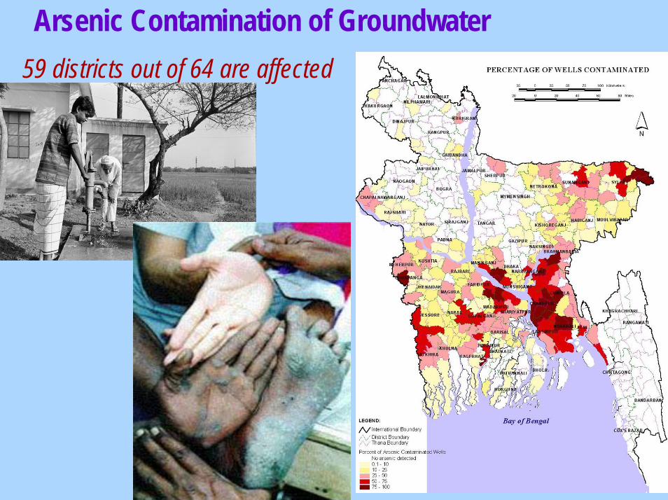
• Arsenic contamination- 59 district out of 64 are affected.
• Desertification- Reduction of dry season flow induces creeping desertification in the Ganges dependent area.
• Cyclonic surge- Annual phenomenon, however cyclone 1970, 1991 & 2007 were catastrophic.
• Climate change- 1.5 m sea level rise would affect 15% of the total population &
16% of the land area.

1212
Disasters in Bangladesh Disasters in Bangladesh

1313
Flood
Flood occurs in Flood occurs in Bangladesh Bangladesh regularlyregularlyBeing lowBeing low--lying lying country, average country, average 22% area is 22% area is flooded every yearflooded every yearIn case of severe In case of severe flood, 66% area flood, 66% area inundatedinundated1954,1954,’’55,55,’’74,74,’’87, 87, ’’88,88,’’98, 2004 & 98, 2004 & 2007 floods were 2007 floods were catastrophiccatastrophic

1414
Causes of FloodsCauses of Floods
Unique Geographical LocationUnique Geographical LocationExcessive runExcessive run--off from upstreamoff from upstreamLow topographyLow topographyRiver River siltationsiltationSea swell during monsoonSea swell during monsoonHydraulic CharacteristicsHydraulic Characteristics––low gradients of major riverslow gradients of major rivers
Ganges: 4 cm/km, Ganges: 4 cm/km, B.PutraB.Putra: 8 cm/km, : 8 cm/km, MeghnaMeghna: 3 cm/km: 3 cm/km

1515
Flood ManagementFlood Management
StructuralStructuralNonNon--structuralstructural

1616
StructuralStructural
Building Embankments Building Embankments Different Hydraulic StructuresDifferent Hydraulic StructuresReservoirsReservoirsDamsDamsGroynesGroynesSpursSpurs

1717
NonNon--structuralstructural
Flood Forecasting & Flood Forecasting & Warning Warning Erosion Prediction Erosion Prediction Environmental MonitoringEnvironmental MonitoringWatershed ManagementWatershed ManagementPlanning & Development Planning & Development Policy Policy
1818
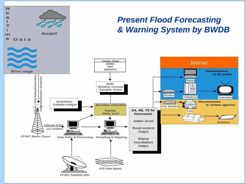
Indian DataWMOJRC
WARPO
FFWC Radio Tower
FFWC Satellite dish
24, 48, 72 hrforecasts
water level
flood extentmaps
thanainundation
maps
Telephone
Fax
Fax Modem
ModemTelevision
Bulletine
GIS data layers
Radio
wire
less c
om
mu
nic
atio
n
via modemmanual entry
Te
lem
etry
/Da
ta b
ox / V
oic
e
SPARRSOSattelite images
BMDWeather forecastSynoptic charts
Boundary estimation
Rainfal,Water level
Data Entry & Processing Modelling & Mapping
River stage
Rainfall
RealTime D a t a
Dissemination to the public
Dissemination to various agencies
Internet
Present Flood Forecasting& Warning System by BWDB

1919
River ErosionRiver ErosionRiver erosion is an inevitable natural River erosion is an inevitable natural phenomenon and causes human sufferingsphenomenon and causes human sufferings70,000 ha lost in 70,000 ha lost in Jamuna/BrahammaputraJamuna/Brahammaputraonly (1970only (1970--1998)1998)Severe cut in living standardSevere cut in living standardLoss of life, valuable assets, crops, Loss of life, valuable assets, crops, livelihoodlivelihoodDisplaced to city slums & unending miseryDisplaced to city slums & unending miseryDisplaced as high as 24 times in life spanDisplaced as high as 24 times in life spanRiver course stabilization is needed for flood River course stabilization is needed for flood mitigation and effective developmentmitigation and effective development

2020
River Bank ErosionRiver Bank Erosion

2121
River Bank Protection Project along the R/B of Brahmmaputra-Jamuna River
Revetment Length : 2550 mCost : 332.57 croreCost per meter length:1.30million/meter
Sirajgonj Hard Point

2222
Contribution of BWDB through River Bank Protection Work (Since inception)
Revetment Revetment (km)(km)
Groynes/Groynes/Spurs (Nos)Spurs (Nos)
220220 40,00040,0003,7843,784468468River bank River bank protection protection workwork
Value of Value of assets assets
protectedprotected(Tk. in Crore)(Tk. in Crore)
ExpenditureExpenditure(Tk. in (Tk. in Crore)Crore)
Type of protection workType of protection workFacilitiesFacilities
About 30 district Head quarters , 70 upazila Head quarters and 100 commercial installations are fully or partly protected through the aforesaid works.

2323
DroughtDrought……To minimize drought effect, no To minimize drought effect, no measures have yet to be measures have yet to be followed while Bangladesh followed while Bangladesh faced significant loss in the faced significant loss in the last few years.last few years.
–– The most drought prone area in The most drought prone area in Bangladesh is north western region.Bangladesh is north western region.
–– Even in irrigated areas sometimes drought occurs because of Even in irrigated areas sometimes drought occurs because of improper irrigation scheduling. improper irrigation scheduling.

2424
Drought
About 25% of the country sufferwater stress in dry season
2525
River SedimentationRiver Sedimentation1.8 to 2.0 billion tons of sediment are carried 1.8 to 2.0 billion tons of sediment are carried by the three river systems annuallyby the three river systems annually
Sedimentation is very acute in the river Sedimentation is very acute in the river system in the south west region, because of system in the south west region, because of decrease in discharge in the Ganges during decrease in discharge in the Ganges during low flowlow flow
Sedimentation is also acute in the major Sedimentation is also acute in the major distributariesdistributaries
2626
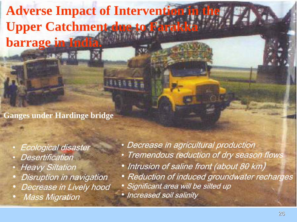
Adverse Impact of Intervention in the Upper Catchment due to Farakkabarrage in India.
• Ecological disaster• Desertification• Heavy Siltation• Disruption in navigation• Decrease in Lively hood• Mass Migration
• Decrease in agricultural production• Tremendous reduction of dry season flows• Intrusion of saline front (about 80 km)• Reduction of induced groundwater recharges• Significant area will be silted up• Increased soil salinity
Ganges under Hardinge bridge
2727
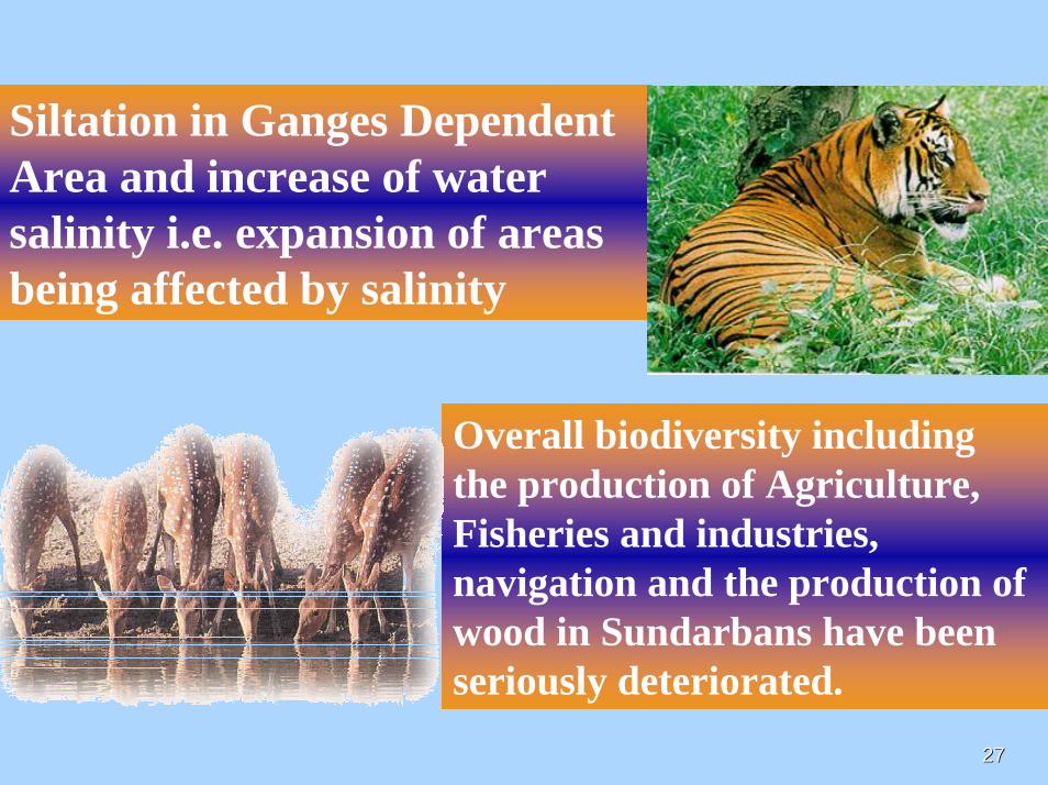
Siltation in Ganges Dependent Area and increase of water salinity i.e. expansion of areas being affected by salinity
Overall biodiversity including the production of Agriculture, Fisheries and industries, navigation and the production of wood in Sundarbans have been seriously deteriorated.
2828
Arsenic Contamination of Groundwater59 districts out of 64 are affected
2929
Upp
er M
eghn
a Ri
ver
Chandna R iverNabaganga R
Kumar R iver
Gorai Riv er
Jam
una
Rive
r
Padma Rive r
Ganges R ive r
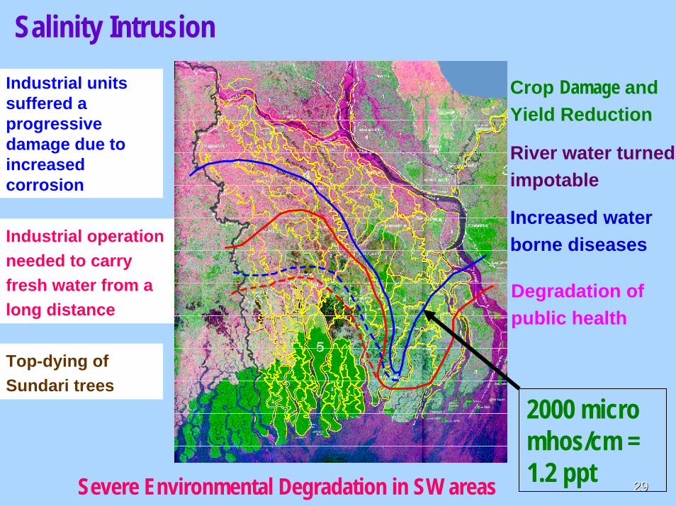
Crop Damage and Yield Reduction
River water turned impotable
Increased water borne diseases
Degradation of public health
Industrial units suffered a progressive damage due to increased corrosion
Industrial operation needed to carry fresh water from a long distance
Top-dying of Sundari trees
Salinity Intrusion
Severe Environmental Degradation in SW areas
2000 micro mhos/cm = 1.2 ppt
3030
India’s proposed mega-project for interlinking its rivers
It is reported that India has proposed project for interlinking its rivers to resolve it’s water crisis in the next 10 years. Thirty seven Indian rivers will be linked under this project.
It has been proposed to divert the waters of the major tributaries of the Ganges in India to the south. It also envisages to divert waters of the Manas and Sankosh, Dharla, Dudhkumar etc. - the tributaries of the Brahmaputra to West Bengal and to Godavari-Krishna in South India.

3131
Indian River Linking Project Major Threats.

3232
Treaty
In 1996, Bangladesh and India signed a thirty year agreement regarding sharing of the Ganges water. This is the only existing agreement between the two countries regarding sharing of the water of one of their common rivers. The sharing between India and Bangladesh of the Ganges water is on the basis of agreed division of flow at Farakka by ten day periods from 1st January to 31st May every year.
International Treaties and Protocols

3333
Negotiation on 7 rivers with India is going on with priority to Teesta. Other rivers are Dharala, Dudkumar, Manu, Khowai, Gumti, Muhuri

3434
Cyclone and Tidal SurgesCyclone and Tidal Surges
Catastrophic Cyclone and Tidal Surges Catastrophic Cyclone and Tidal Surges occurred in the year 1970 (12occurred in the year 1970 (12thth , ,
Nov),1991(29Nov),1991(29thth April) and 2007(15April) and 2007(15thth Nov)Nov)

3535
Disaster and Bangladesh
Recent major disasters
Year Year Disaster Disaster Deaths Deaths 1970 1970 Cyclone Cyclone 300,000+300,000+1988 1988 CycloneCyclone 6,000+6,000+1991 1991 CycloneCyclone 140,000+140,000+1997 1997 CycloneCyclone 600+ 600+ 20072007 CycloneCyclone 4000+4000+

3636
Tidal Surges
CycloneAbout 1/4 th of the countrysusceptible to tidal surges

3737
Cyclone
Cyclone SIDR hit on 15th November at 9 . P.M. local time during ebb tide with 5m to 8 m storm surge

3838
Cyclone Surges Area
Bay of Bengal
3939
Integrated Coastal zone Integrated Coastal zone management Projectmanagement Project
Coastal Zone policy (CZP) adopted by Coastal Zone policy (CZP) adopted by GoBGoB..Coastal Development Strategy (CDS) Coastal Development Strategy (CDS) approved by approved by GoBGoB..Priority Investment Project Portfolio Priority Investment Project Portfolio formulated.formulated.Large scale Investment need Donors Large scale Investment need Donors involvement.involvement.

4040
Total Polder=102

4141
Landmark Projects of BWDBLandmark Projects of BWDB

4242
TeestaTeesta Barrage ProjectBarrage Project
Teesta Barrage
Teesta CHR
•A pride project and symbol of self
reliance.
•Constructed solely by local engineers,
technocrats and contractors

4343
Gross Benefited Area
748990 ha ( Phase I & II)
Irrigable Area
540486 ha (Phase I & II)
Phase-I
Gross Benefited Area
1,54,250 ha
Irrigable Area
1,11,406 ha
Annual increased food grain production:2.77 lakhtons
Project FeaturesProject Features

4444
Long Term ProjectsLong Term Projects
1.1. Ganges Barrage Project.Ganges Barrage Project.2.2. Dhaka Integrated Flood Control Embankment Dhaka Integrated Flood Control Embankment
cum Eastern Bypass Road Multipurpose Project.cum Eastern Bypass Road Multipurpose Project.3.3. Water Management Improvement Project Water Management Improvement Project
(WMIP)(WMIP)4.4. Pani Pani BhabanBhaban..
5.5. Integrated Coastal Zone Management Project Integrated Coastal Zone Management Project (ICZMP)(ICZMP)
6.6. Brahmaputra Barrage Project.Brahmaputra Barrage Project.

4545
Proposed Ganges Barrage
Kushtia,Jessore,Jhinaidaha,
Faridpur,Madaripur,
Shariatpur,Rajshahi,Pabna,
Natore,Khulna,Sathkhira,
Chudanga,Magura,Meherpur,Narail,Gopalgonj,Nawabgonj,Rajbari,Barisal.
Benefited Districts:19 nos.
• Barrage length - 1.94 km• Capacity of diversion structure - 1200 m3/s• Irrigation Canal - 131 km• Irrigation command area - 1.35 Mha• Drainage & FC area - 1.50 Mha• Storage capacity - 290 m3/s in April

4646
Concluding Remarksi) Basin wide Water Resources
Management with its neighbors through regional cooperation for integrated development of trans-boundary river resources is very much essential:
ii)Water issues between Bangladesh and India is very crucial; International Community has a role to play

4747
Concluding Remarks (Cont.)
iii) Existing Laws and regulations need to be reviewed and updated/furnish new laws to meet the present or future day demand;
iv) Enforcement of the Policy,regulation and Laws is the main issue;
v) Exchange of data and informations on water related disasters amongs the co-riparinecountries would help to mitigate the sufferings of the people living in the river basin.

4848
Thank youThank you


