
WINNETKA 2020
COMPREHENSIVE PLAN FOR THEVILLAGE OF WINNETKA
A REPORT OF
THE WINNETKA PLAN COMMISSION
NINETEEN HUNDRED NINETY-NINE
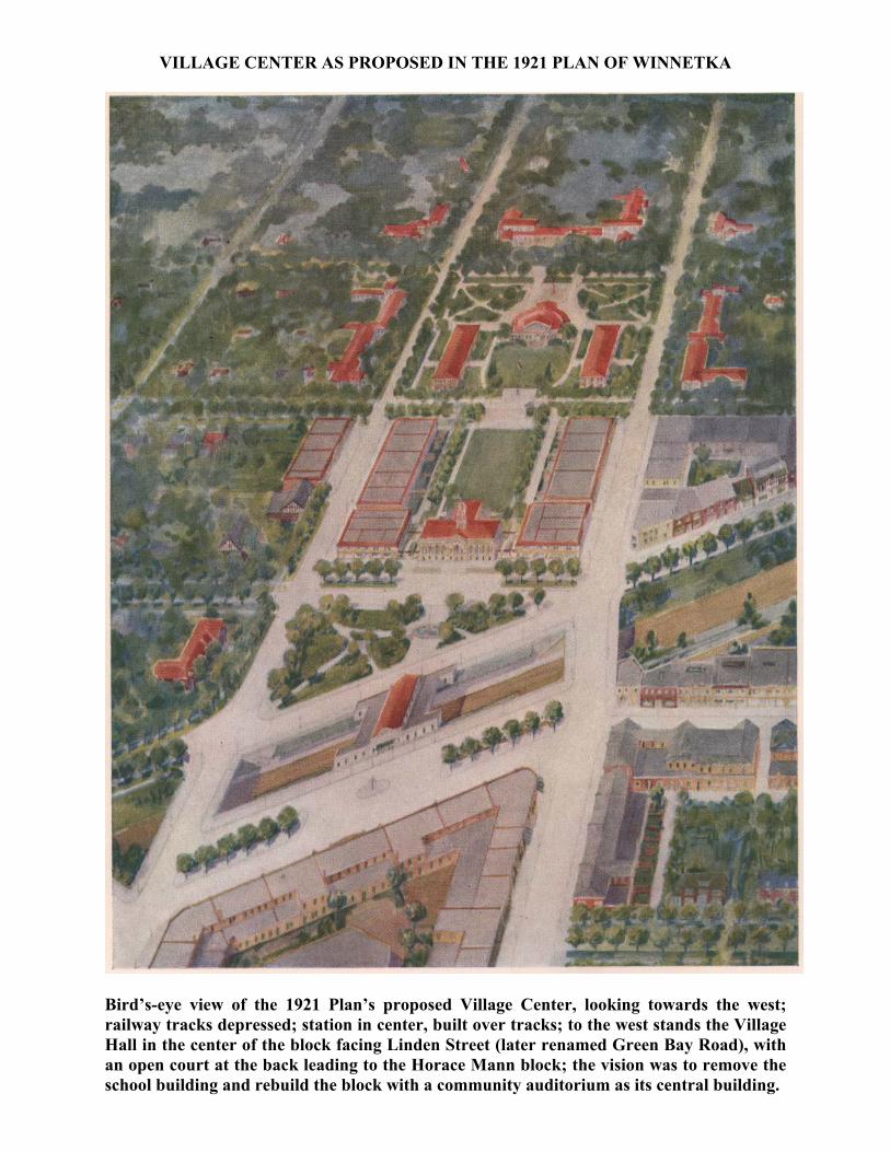
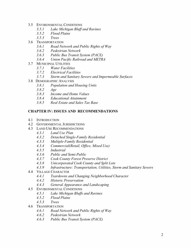
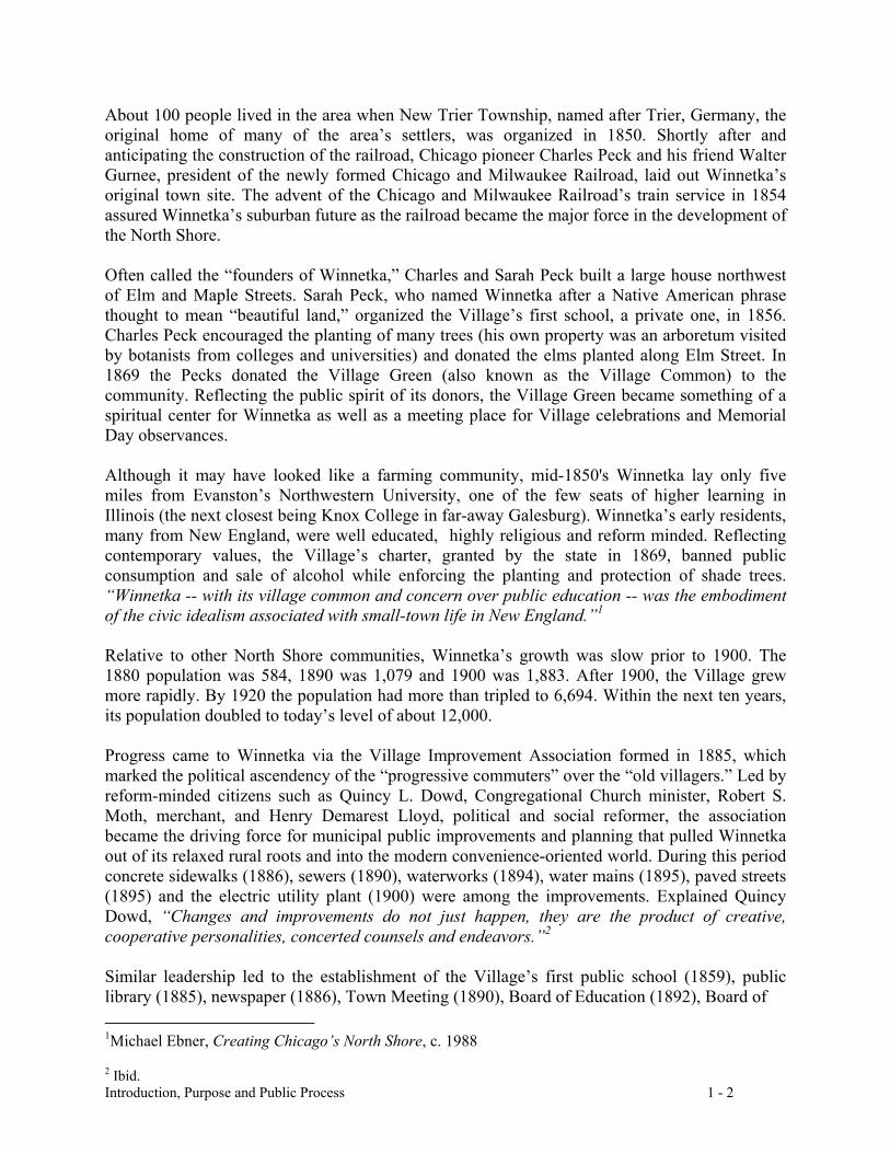
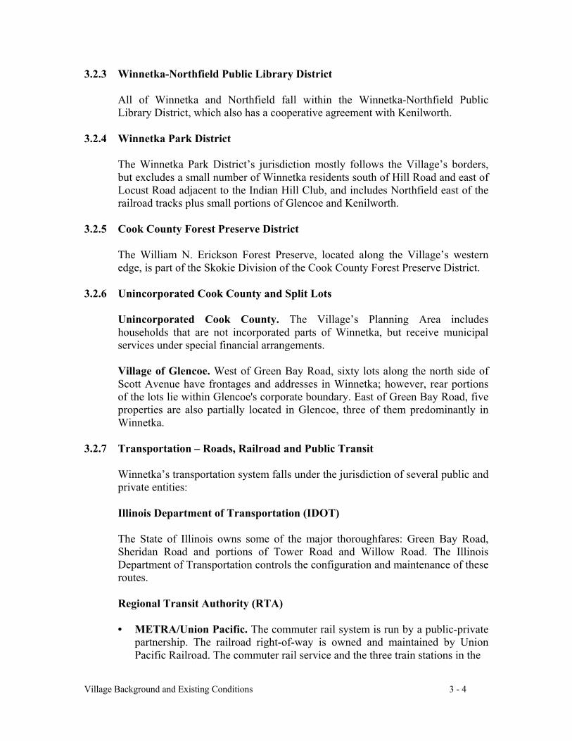
VILLAGE CENTER AS PROPOSED IN THE 1921 PLAN OF WINNETKA
Bird’s-eye view of the 1921 Plan’s proposed Village Center, looking towards the west;railway tracks depressed; station in center, built over tracks; to the west stands the VillageHall in the center of the block facing Linden Street (later renamed Green Bay Road), withan open court at the back leading to the Horace Mann block; the vision was to remove theschool building and rebuild the block with a community auditorium as its central building.
WINNETKA PLAN COMMISSION
Bernard F. Sergesketter, CHAIRMAN *Nan Greenough, VICE CHAIRMAN AND EDITOR-IN-CHIEF *
Penfield S. Lanphier, ASSOCIATE EDITOR *Stewart Early, PAST CHAIRMAN *
Phyllis C. Myers, PAST VICE CHAIRMAN *
Members during the period in which the plan was written:
Ann S. Alexander John H. Holcomb Ken S. RoffeDorothy B. Anderson Edith F. Howell Phyllis S. ThomasJohn J. Berwanger * John D. Lien Peter WempleKathleen A. Duey Maureen A. Mitchel Jack L. Wentz *Joan A. Fragen * Frank T. Nesbitt Edmund C. Woodbury
* denotes members of the COMPREHENSIVE PLAN SUB-COMMITTEE
Copyright © 1999 by the Village of Winnetka

Stew EarlyChairman of the Plan Commission (1996-98)
Phyllis MyersVice-Chairman of the Plan Commission (1996-98)
Nan GreenoughVice Chairman of the Plan Commission
Editor-in-Chief of WINNETKA 2020
Penny LanphierAssociate Editor of WINNETKA 2020

TO THE COUNCIL AND CITIZENS OF WINNETKA:
The Winnetka Plan Commission is pleased to present a comprehensive plan for theVillage of Winnetka that will guide land use decisions for the next twenty years. The first planfor Winnetka was written in 1921, and the many recommendations that were implemented fromthat plan have greatly enriched the quality of life in our community. In this plan we haveprovided an historical context for what has previously occurred in the development of Winnetkaalong with recommendations for the future.
Many people participated in the development of this plan, and we thank all of them. Thecredit for the idea to create a new plan belongs to Stew Early and Phyllis Myers, who wereChairman and Vice-Chairman of the Commission in 1996 when this process started. NanGreenough did a major part of the writing along with a superb job of editing. Village TrusteePenny Lanphier, our liaison with the Village Council, provided valuable insights along withsignificant contributions of writing, editing, and organization. The Village Council, under thethoughtful and excellent leadership of Village President Louise Holland, shared ideas andreviewed our drafts as we proceeded. Village Manager Doug Williams provided us withvaluable input and perspectives. A special thanks goes to Cindy McCammack, Director ofCommunity Development, who was with us every step of the way and whose wisdom andknowledge of land use issues were critical. Tom Dyke of Thompson Dyke & Associates wasespecially helpful in providing ideas and guidance throughout the writing of the report. Finally,we thank the citizens of Winnetka who participated in the focus groups, completed thequestionnaires, and came to the meetings to ask questions and share their thoughts. Theresidents of the Indian Hill neighborhood were particularly helpful.
It is a tradition in our community that a large number of our citizens are involved incommunity affairs. We hope this plan will provide input and ideas that will make theircontributions even more valuable.
The Plan Commission will formally review the plan annually and reassess the priorities.We encourage ongoing input from the community to make these reviews more responsive to theneeds of the Village and to help focus the allocation of scarce resources.
WINNETKA PLAN COMMISSIONBERNARD F. SERGESKETTER, CHAIRMANOCTOBER 1999
WINNETKA 2020A COMPREHENSIVE PLAN FOR THE VILLAGE OF WINNETKACONTENTS
CHAPTER I: INTRODUCTION, PURPOSE AND PUBLIC PROCESS
CHAPTER II: VISION, GOALS AND OBJECTIVES
2.1 A 2020 VISION FOR WINNETKA2.2 COMMUNITY GOALS2.3 VILLAGE CHARACTER AND APPEARANCE2.4 RESIDENTIAL AREAS2.5 LOCAL GOVERNMENT2.6 EDUCATIONAL AND COMMUNITY INSTITUTIONS2.7 PARKS, OPEN SPACE, RECREATION AND ENVIRONMENT2.8 TRANSPORTATION2.9 GROWTH MANAGEMENT
CHAPTER III: VILLAGE BACKGROUND AND EXISTING CONDITIONS
3.1 ELEMENTS OF A LAND USE SYSTEM3.2 GOVERNMENTAL JURISDICTIONS/PUBLIC FACILITIES
3.2.1 Village Of Winnetka3.2.2 Public Schools3.2.3 Winnetka-Northfield Public Library District3.2.4 Winnetka Park District3.2.5 Cook County Forest Preserve District3.2.6 Unincorporated Cook County and Split Lots3.2.7 Transportation – Roads, Railroad and Public Transit
3.3 EXISTING LAND USE: INVENTORY AND CONTEXT3.3.1 Land Use Survey
3.3.2 Detached Single-Family Residential3.3.3 Multiple-Family Residential3.3.4 Commercial(Retail, Office, Mixed Use)3.3.5 Industrial3.3.6 Public and Semi-Public3.3.7 Cook County Forest Preserve District3.3.8 Unicorporated Cook County and Split Lots3.3.9 Infrastructure:Transportation,Utilities,Storm and Sanitary Sewers
3.4 VILLAGE CHARACTER3.4.1 Single-Family Neighborhood Character: Bulk, Density and Subdivisons3.4.2 Historic Preservation3.4.3 General Appearance and Landscaping
2
3.5 ENVIRONMENTAL CONDITIONS3.5.1 Lake Michigan Bluff and Ravines3.5.2 Flood Plains3.5.3 Trees
3.6 TRANSPORTATION3.6.1 Road Network and Public Rights of Way3.6.2 Pedestrian Network3.6.3 Public Bus Transit System (PACE)3.6.4 Union Pacific Railroad and METRA
3.7 MUNICIPIAL UTILITIES3.7.1 Water Facilities3.7.2 Electrical Facilities3.7.3 Storm and Sanitary Sewers and Impermeable Surfaces
3.8 DEMOGRAPHIC ANALYSIS3.8.1 Population and Housing Units3.8.2 Age3.8.3 Income and Home Values3.8.4 Educational Attainment3.8.5 Real Estate and Sales Tax Base
CHAPTER IV: ISSUES AND RECOMMENDATIONS
4.1 INTRODUCTION4.2 GOVERNMENTAL JURISDICTIONS4.3 LAND USE RECOMMENDATIONS
4.3.1 Land Use Plan4.3.2 Detached Single-Family Residential4.3.3 Multiple-Family Residential4.3.4 Commercial(Retail, Office, Mixed Use)4.3.5 Industrial4.3.6 Public and Semi-Public4.3.7 Cook County Forest Preserve District4.3.8 Unicorporated Cook County and Split Lots4.3.9 Infrastructure: Transportation, Utilities, Storm and Sanitary Sewers
4.4 VILLAGE CHARACTER4.4.1 Teardowns and Changing Neighborhood Character4.4.2 Historic Preservation4.4.3 General Appearance and Landscaping
4.5 ENVIRONMENTAL CONDITIONS4.5.1 Lake Michigan Bluffs and Ravines4.5.2 Flood Plains4.5.3 Trees
4.6 TRANSPORTATION4.6.1 Road Network and Public Rights of Way4.6.2 Pedestrian Network4.6.3 Public Bus Transit System (PACE)
3
4.6.4 Union Pacific Railroad and METRA4.6.5 Taxis and Limousines4.6.6 New Trier Township Dial-a-Ride
4.7 UTILITIES4.7.1 Water Facilities4.7.2 Electricial Facilities4.7.3 Storm and Sanitary Sewers and Impermeable Surfaces
CHAPTER V: GREEN BAY ROAD CORRIDOR & BUSINESS DISTRICTSISSUES AND RECOMMENDATIONS
5.1 INTRODUCTION5.2 GREEN BAY ROAD CORRIDOR5.3 GREEN BAY ROAD AND GENERALCORRIDOR ISSUES
5.3.1 Existing Land Use Conditions - Issues and Opportunities5.3.2 Goal, Objectives and Policies5.3.3 Recommendations
5.4 BUSINESS DISTRICTS5.4.1 Existing Conditions: Issues and Opportunities5.4.2 Goal,Objectives and Recommendations
5.5 HUBBARD WOODS PLANNING SUB-AREA5.5.1 Existing Conditions5.5.2 Objectives and Recommendations
5.6 WEST ELM STREET BUSINESS DISTRICT PLANNING SUB-AREA5.6.1 Existing Conditions5.6.2 Objectives and Recommendations
5.7 EAST ELM STREET BUSINESS DISTRICT PLANNING SUB-AREA5.7.1 Existing Conditions5.7.2 Objectives and Recommendations
5.8 INDIAN HILL BUSINESS DISTRICT PLANNING SUB-AREA5.8.1 Existing Conditions5.8.2 Objectives and Recommendations
5.9 THE EFFECT OF GREEN BAY ROAD RECOMMENDATIONS
4
VI APPENDIX
1. CITIZEN SURVEY RESULTS2. PARKS WITHIN THE VILLAGE3. WATER SUPPLY SYSTEM4. ELECTRIC SUPPLY SYSTEM5. STREET SYSTEM OBJECTIVES AND GUIDELINES6. PRIORITY ASSESSMENT OF PLAN RECOMMENDATIONS
VII MAPS
1. JURISDICTIONS2. EXISTING LAND USE3. PUBLIC/SEMI PUBLIC AND OPEN SPACE4. MUNICIPAL SERVICES BEYOND VILLAGE BOUNDARY5. TRANSPORTATION6. LAND USE PLAN7. EXISTING LAND USE - HUBBARD WOODS8. EXISTING LAND USE - EAST AND WEST ELM STREET9. EXISTING LAND USE - INDIAN HILL10. LAND USE PLAN - HUBBARD WOODS11. LAND USE PLAN - EAST AND WEST ELM STREET12. LAND USE PLAN - INDIAN HILL13. ZONING DISTRICTS14. ZONING DISTRICTS - HUBBARD WOODS15. ZONING DISTRICTS - EAST AND WEST ELM STREET16. ZONING DISTRICTS- INDIAN HILL17. COLLECTOR STREETS
Introduction, Purpose and Public Process 1 - 1
WINNETKA 2020A COMPREHENSIVE PLAN FOR THE VILLAGE OF WINNETKA
CHAPTER I: INTRODUCTION, PURPOSE AND PUBLIC PROCESS
INTRODUCTION
The Winnetka Plan Commission, working with Village staff and consultants, has revised theOfficial Comprehensive Plan, first adopted in 1921 and last updated in 1993. This document,WINNETKA 2020, will guide development and land use in the Village through the year 2020.
Winnetka is a village of fine residences, tree-lined streets, excellent schools, attractive publicbuildings, neighborhood parks, forest preserves and four distinctive pedestrian-scaledcommercial districts. Nestled along the Lake Michigan shoreline in the heart of the North Shore,it is located just 17 miles from Chicago’s business center. Over time the Village has graduallydeveloped a cohesive land use pattern that largely succeeds in separating different types of landuses. Since most of the Village was built before 1930, prior to the automobile becoming theprimary mode of transportation, Winnetka was designed so that its residents could walk to trains,schools, parks and shops. Today much of the Village’s charm, in both commercial andresidential areas, flows from this pedestrian orientation, an attribute that distinguishes Winnetkafrom many suburbs in the Chicago metropolitan area.
As shifting economic, cultural, social and physical conditions affect the characteristics of acommunity, there is a need to prepare a plan that can guide the Village through change.Currently, the Village is facing substantial redevelopment pressure in both residentialneighborhoods and business districts. There are physical limits to growth. Because Winnetka issubstantially built out, land is scarce; infrastructure is used nearly to capacity. The purpose ofrewriting the Plan now is to help the Village manage redevelopment in ways that preserve andenhance the qualities that define Winnetka’s unique character in the context of scarce resources.
This Official Comprehensive Plan, WINNETKA 2020, was formally adopted by the WinnetkaVillage Council on November 16, 1999 in accordance with the provisions of the IllinoisCompiled Statutes.
HISTORICAL BACKGROUND
In 1836 the Erastus Patterson family arrived in Winnetka via ox-drawn wagon after a one-thousand-mile journey from Woodstock, Vermont. Near the Green Bay Trail on a bluffoverlooking Lake Michigan, somewhat east of the present Christ Church on Sheridan Road, thePattersons built a log tavern to provide food and shelter for travelers. In 1847 John and SusannahGarland and their eight children bought the tavern, which they enlarged. They also built a sawmill, a red brick house for themselves and, eventually, Winnetka’s first church on the ChristChurch site in 1869.
Introduction, Purpose and Public Process 1 - 2
About 100 people lived in the area when New Trier Township, named after Trier, Germany, theoriginal home of many of the area’s settlers, was organized in 1850. Shortly after andanticipating the construction of the railroad, Chicago pioneer Charles Peck and his friend WalterGurnee, president of the newly formed Chicago and Milwaukee Railroad, laid out Winnetka’soriginal town site. The advent of the Chicago and Milwaukee Railroad’s train service in 1854assured Winnetka’s suburban future as the railroad became the major force in the development ofthe North Shore.
Often called the “founders of Winnetka,” Charles and Sarah Peck built a large house northwestof Elm and Maple Streets. Sarah Peck, who named Winnetka after a Native American phrasethought to mean “beautiful land,” organized the Village’s first school, a private one, in 1856.Charles Peck encouraged the planting of many trees (his own property was an arboretum visitedby botanists from colleges and universities) and donated the elms planted along Elm Street. In1869 the Pecks donated the Village Green (also known as the Village Common) to thecommunity. Reflecting the public spirit of its donors, the Village Green became something of aspiritual center for Winnetka as well as a meeting place for Village celebrations and MemorialDay observances.
Although it may have looked like a farming community, mid-1850's Winnetka lay only fivemiles from Evanston’s Northwestern University, one of the few seats of higher learning inIllinois (the next closest being Knox College in far-away Galesburg). Winnetka’s early residents,many from New England, were well educated, highly religious and reform minded. Reflectingcontemporary values, the Village’s charter, granted by the state in 1869, banned publicconsumption and sale of alcohol while enforcing the planting and protection of shade trees.“Winnetka -- with its village common and concern over public education -- was the embodimentof the civic idealism associated with small-town life in New England.”1
Relative to other North Shore communities, Winnetka’s growth was slow prior to 1900. The1880 population was 584, 1890 was 1,079 and 1900 was 1,883. After 1900, the Village grewmore rapidly. By 1920 the population had more than tripled to 6,694. Within the next ten years,its population doubled to today’s level of about 12,000.
Progress came to Winnetka via the Village Improvement Association formed in 1885, whichmarked the political ascendency of the “progressive commuters” over the “old villagers.” Led byreform-minded citizens such as Quincy L. Dowd, Congregational Church minister, Robert S.Moth, merchant, and Henry Demarest Lloyd, political and social reformer, the associationbecame the driving force for municipal public improvements and planning that pulled Winnetkaout of its relaxed rural roots and into the modern convenience-oriented world. During this periodconcrete sidewalks (1886), sewers (1890), waterworks (1894), water mains (1895), paved streets(1895) and the electric utility plant (1900) were among the improvements. Explained QuincyDowd, “Changes and improvements do not just happen, they are the product of creative,cooperative personalities, concerted counsels and endeavors.”2
Similar leadership led to the establishment of the Village’s first public school (1859), publiclibrary (1885), newspaper (1886), Town Meeting (1890), Board of Education (1892), Board of 1Michael Ebner, Creating Chicago’s North Shore, c. 1988
2 Ibid.
Introduction, Purpose and Public Process 1 - 3
Health (1892), public kindergarten (1896), decision making by referendum (1896), high school(1901), Park District (1904), Winnetka Woman’s Club (1908), Community House (1911),Neighborhood Circles (1914), Parent-Teachers Association (1914), council-manager form ofgovernment (1915), caucus system (1915), Plan Commission (1917), comprehensive plan (1921)and zoning ordinance (1922).
STATEMENT OF PURPOSE
This Comprehensive Plan, WINNETKA 2020, is intended to serve as the principal policydocument to guide the location of future land uses within Winnetka’s planning area and to act asthe basis for resource management decisions by Village officials. During the annual budgetdevelopment process, it is assumed that Village government department heads will incorporateprojects recommended by the Plan in a consistent and timely manner.
WINNETKA 2020 updates the 1979 Statement of Community Objectives and provides directionregarding development and change in the Village. The Plan is general and advisory. It is not aregulatory document designed to control the precise form of development on individual lots, afunction that is performed by various Village regulations including the Zoning and SubdivisionOrdinances, but it does provide a context in which regulatory changes can be made.
The Plan consists of Chapter Two, a vision for the future with goals and objectives designed toachieve that vision, Chapter Three, a history and analysis of existing land uses, Chapter Four,a discussion of issues and recommendations and Chapter Five, a plan for the Green Bay RoadCorridor and its business districts.
WINNETKA 2020 recognizes that a mature, built-out community needs a plan that identifiescommunity assets worthy of protection and areas in need of improvement. The public processleading to the formulation of this Plan clearly indicated a desire on the part of Village residentsto maintain the scale and charm of the community, with minimal change in the existing mix ofland uses. The purpose of this Plan is to provide a guide for managing redevelopment andencouraging reinvestment in the community that does not lead to overbuilding or altering thecharacter of the community.
THE RELATIONSHIP OF THE PLAN TO PREVIOUS PLANS
Today’s Winnetka did not come about by accident. Edward H. Bennett, co-author of the 1909Plan of Chicago with Daniel Burnham, wrote Winnetka’s first long-range comprehensive plan in1921. The 1921 Plan, one of the earliest prepared for any community in the Midwest, wasremarkably well timed to anticipate the decade of the Village’s most dramatic growth. Majorrecommendations of the 1921 Plan included railroad track depression (completed in 1943), thelocation and design of Village Hall (built in 1925), the acquisition of Crow Island as a site for afuture park and school and acquisition by the Cook Country Forest Preserve District of theSkokie Marsh to provide a green buffer on the Village’s western edge.
Other 1921 Plan recommendations included burying overhead power lines and installingornamental lighting in the Village, projects that continue to receive support from manyWinnetkans and that are included in this Plan. In addition, the importance of the Village’s three
Introduction, Purpose and Public Process 1 - 4
railroad stations to the development and ambience of the community continues to be emphasized,as do efforts to maintain the character of the Village and the elements that distinguish it from thetypical suburban appearance of many Chicago metropolitan communities. These issues havereceived significant attention during the writing of the Plan.
This Plan continues a tradition of community planning that has played a critical role in thedevelopment of the Winnetka we see today. Recommendations from previous plans continue toreceive expression here: building upon past achievements and carrying important traditions intothe future. An objective is to provide Village decision makers with a guide towards maintainingWinnetka’s character, while accommodating changes in technology and lifestyle over the next 25years.
THE PLAN PREPARATION PROCESS
In June 1997, the Village retained plan consultant Thompson Dyke and Associates, Ltd. andarchitectural consultant Johnson-Lasky Architects to assist the Plan Commission with thepreparation of a Comprehensive Plan.
From the outset, citizen participation played a central role in the formulation of this Plan.Participation was achieved through the use of focus group sessions, individual interviews, aVillage-wide citizen survey and numerous public meetings and hearings. Every attempt wasmade to ensure that the Plan reflects the views and concerns of the Village’s citizens.
CITIZEN PARTICIPATION IN THE PLAN DEVELOPMENT PROCESS
Individual interviews and six focus group sessions involving 90 citizens helped define issues andareas of concern that became the foundation for a survey that was mailed to all households andbusinesses in the Village. Via media coverage, posters and highly visible “return boxes” placedthroughout the Village, everyone was strongly encouraged to participate.
Several public meetings were held during the two and one-half year planning process. The PlanCommission held 24 such meetings at which land use and development planning scenarios werepresented. The feedback from residents and business owners at those meetings helped theCommission to refine concepts and develop alternatives. A sub-committee of the PlanCommission held 44 open meetings where the draft chapters were prepared for theCommission’s consideration. In addition to these meetings the Village Council held three publicmeetings and 5 public hearings.
1997 VILLAGE CITIZEN SURVEY - SUMMARY OF FINDINGS
Of the 6,000 survey questionnaires mailed, 875 were completed and returned, a response rate ofabout 15%. This response, in combination with other forms of feedback, provided a good basisfor determining community opinion. See Appendix 1, Citizen Survey Data.
GENERAL ISSUES
Certain questions required multiple answers; therefore totals may exceed 100%.
Introduction, Purpose and Public Process 1 - 5
• 71% of respondents said they moved to Winnetka for the school system, 44% for itsaccessibility to Chicago, 43% for Village character and charm and 13% for the people.
• 42% of respondents stated they have remained in the Village because of its high-qualityschool system, 39% for Village character and charm, 34% for accessibility to Chicago and33% because they like the people.
HOUSING AND RESIDENTIAL NEIGHBORHOODS
• 60% of respondents believed there is a sufficient range of housing options in Winnetka,while 25% felt there are not enough houses for young families and senior citizens.
• With respect to new house construction, 83% indicated that the lot coverage and buildingfootprints are excessive, 82% thought that scale is too large and 79% felt that the side yardsetback requirements are inadequate.
• Attitudes towards schools and religious institutions were substantially more supportive: over80% felt that institutional buildings, mostly located in single-family neighborhoods, areattractive and that the lot coverage, scale, front and side yard setbacks are satisfactory.
• 65% of those responding agreed that the Village should encourage additions to existinghomes on smaller lots as an alternative to teardowns and rebuilds; only 27% disagreed.
• Respondents like the appearance of residential neighborhoods, with landscaping and streettrees rated as the most important and successful elements. 57% rated burying overhead powerlines as the most-needed improvement.
• 55% of respondents either mildly agreed (33%) or strongly agreed (22%) that the Villageshould encourage townhouses rather than apartment-style condominiums to provide for agreater variety of housing options in the Village.
• 81% felt that it is either important (31%) or very important (50%) to preserve the traditionalappearance of the Village, which was developed prior to heavy reliance on cars.
Business
• 91% of respondents shop regularly in at least one of the Village’s four business districts.
• Respondents indicated that a wide variety of retail commercial uses is important, withrestaurants (89%) as the most popular.
• 72% felt that mixed-use development (some combination of residential, retail, parks, officespace, parking and public uses) is the most appropriate use for the Post Office site when thelease expires in 2007.
• 48% indicated that the maximum height of new development on the Post Office site shouldbe 3 stories with another 32 % expressing a preference for 2 stories. Only 13% indicatedsupport for a height over 3 stories.
Introduction, Purpose and Public Process 1 - 6
• 75% of respondents favored a Post Office site development similar in style to Lake Forest’sMarket Square with its open central plaza.
• More than 50% felt that the maximum height of buildings in the four business districtsshould be limited to 3 stories; another 30% favored a limitation of 2 stories.
• 68% of respondents considered recent development in the Indian Hill Business District to beattractive and 60% thought the scale was appropriate for the area.
• A mixture of uses considered appropriate for the Indian Hill District included restaurants(55%) ranking first and rental apartments (25%) last.
PARKING
• Of those respondents with an opinion, well over half rated parking ample or adequate forcommuters, customers and employees in all four-business districts.
• Nearly 60% of those who expressed an opinion (about 15% of all respondents) regardingadequacy of staff and student parking at New Trier High School considered parking facilitiesinadequate.
BEAUTIFICATION
• Tree planting or replacement (80%) and burying power lines (72%) were by far the mostpopular projects for improving the appearance of the Village overall. There was alsoconsiderable support for the planting of additional seasonal flowers in the business districts(68%), better design and maintenance at commuter railroad stations (66%), replacing chain-link fencing with an attractive alternative (62%) and low illumination decorative streetlighting (60%).
• Tree planting and replacement (75%), burying power lines (66%) and additional landscaping(65%) were rated the best ways to improve the appearance of the Green Bay Road Corridor.There was also support for ornamental signs to direct pedestrians and bicyclists (60%).
• Among the four business districts, respondents ranked the Indian Hill Business District as atop priority for a beautification program.
• Over half felt that at least some naturalistic enhancement is required for Forest Way andadjacent open space and natural habitat areas. There was very little support for a moremanicured appearance.
• About half considered proliferation of public regulatory signs a problem, but indicated thataddressing this is not the highest priority.
SUMMARY
A plan is a vision for a community as expressed by its citizens. The key to creating a vision iseffective public participation throughout the plan development process.
Introduction, Purpose and Public Process 1 - 7
Planning does not take place in a vacuum; it is driven by physical realities and communityphilosophy. An effective plan helps Village leaders make informed decisions by providing aninventory of the values shared by residents as well as an inventory of the community's physicalattributes. A successful plan captures the imagination of residents, merchants and local officials,while reflecting a consensus view that allows diverse members of the community to supportactions for the common good.
Vision, Goals and Objectives 2 - 1
CHAPTER II: VISION, GOALS AND OBJECTIVES
2.1 A 2020 VISION FOR WINNETKA
As a basis for the development of goals, objectives and policies for Winnetka, a visionwas developed to convey the desirable characteristics of the Village:
…a village in a natural setting committed to its tradition ofresidential neighborhoods, citizen involvement, local shops
and educational excellence...
2.2 COMMUNITY GOALS
Purpose and Formulation Procedure
Goals and objectives provide the foundation for the Plan recommendations. Goals arelong-range ideals that set the framework for public policy. Objectives are more specific,representing opportunities for achieving goals.
The goals and objectives that follow were prepared for the Village as a whole and aredesigned to achieve the ideals expressed in the Vision Statement.
Community goals appear below. Objectives designed to support these goals are listed inthe remainder of this chapter under each community goal heading. Goals, objectives andpolicies relating to the Green Bay Road Corridor and its four business districts appear inChapter Five.
Village Character and Appearance: Preserve and enhance those public assets, publiclands, natural resources and architecturally significant structures that create the attractiveappearance and peaceful, single-family residential character of the Village.
Residential Areas: Preserve a high-quality residential community. Encourage a range ofhousing types and sizes to meet the needs of residents of all ages.
Local Government: Plan for and provide appropriate government facilities and servicesthat will accommodate the needs of the Village. Encourage a high degree of citizenconcern for and participation in local government.
Educational and Community Institutions: Support educational excellence and theenrichment of Winnetka's religious and cultural environment.
Parks, Open Space, Recreation and Environment: Preserve or expand the quantity,quality and distribution of open space and recreational opportunities. Protect the Village'snatural features and environmental resources.
Transportation: Provide for safe pedestrian, bicycle and vehicular movement consistentwith the scale and peaceful character of the Village.
Vision, Goals and Objectives 2 - 2
Growth Management: Limit commercial, institutional and residential developmentwithin the Village to minimize potentially adverse impacts on adjacent residentialneighborhoods and to prevent the need for significant increases in infrastructure (streets,parking, utilities, sewers) and other community resources (schools, parks, recreationalfacilities, etc.). Provide for Village expansion via annexation if deemed appropriate.
2.3 VILLAGE CHARACTER AND APPEARANCE
Goal: Preserve and enhance those public assets, public lands, natural resources andarchitecturally significant structures that create the attractive appearance and peaceful,single-family residential character of the Village.
Objectives
1. Ensure that commercial, institutional and residential development is appropriate tothe character of and minimizes the adverse impact on its surrounding neighborhood.
2. Place overhead utility lines underground along major streets: Willow, Sheridan,Green Bay, Hibbard, Winnetka/Hill, Elm and Tower by 2010. Place other utilitylines underground, beginning with parks and open spaces, after the major streets arecompleted.
3. Recognize the critical role of the Village’s historic architecture in definingWinnetka’s unique character in public, institutional, commercial and residential areasand encourage its preservation.
4. Require the screening and buffering of off-street parking lots while considering thesafety of pedestrians and motorists.
5. Continue to implement and supplement the Village’s tree planting program on allpublic rights-of-way. Encourage tree planting on private property.
6. Encourage landscaping of public and private properties that complements andenhances the mature character of existing plantings and provides a buffer as analternative to walls and fences.
7. Encourage organizations, schools, religious institutions, businesses and citizens intheir efforts to beautify the Village.
8. Strictly enforce the Village’s sign regulations and minimize the number of regulatorysigns.
9. Encourage and cooperate with METRA to improve the appearance and function ofthe three train stations in the Village and to improve the appearance of the railroadright-of-way.
10. Encourage and cooperate with PACE to improve the appearance, safety and functionof bus stop shelters.
Vision, Goals and Objectives 2 - 3
11. Reduce and control light pollution, preserving property rights for natural light andcontrolling the use and location of artificial lighting.
12. Reduce and control noise pollution.
13. Use high quality design and materials when constructing public improvements.Enhance the beauty of the improvements with appropriate decorative details, artworkor sculpture.
2.4 RESIDENTIAL AREAS
Goal: Preserve a high-quality residential community. Encourage a range of housing typesand sizes to meet the needs of residents of all ages.
GENERAL RESIDENTIAL OBJECTIVES
1. Maintain the Village’s traditional dwelling density patterns by limiting the scale anddensity allowed in developments and renovations.
2. Require any new residential development and redevelopment to provide adequate andappropriate landscaping and, where appropriate, to preserve existing vegetation.
3. Encourage residential development that provides an appropriate transition betweenlow-density and higher-density areas.
SINGLE-FAMILY RESIDENCE OBJECTIVES
1. Preserve the predominant defining character of Winnetka as a community for owner-occupied high quality single-family residences. Maintain the proportion of single-family detached housing in excess of 80 percent of the total Village housing units.
2. Retain the character of existing residential neighborhoods. Assure that newconstruction and additions to existing houses respect the scale of neighboring houses,setbacks, open spaces, parkway trees and the pedestrian orientation of theneighborhoods.
3. Protect residential neighborhoods and homes from the encroachment of incompatibleland uses and traffic patterns.
4. Encourage the preservation of older houses that contribute to the character of theneighborhood through additions and improvements as an alternative to new houseconstruction.
5. Maintain the quiet ambience of residential neighborhoods.
MULTIPLE-FAMILY RESIDENCE OBJECTIVES
1. Ensure that multiple-family development provides a variety of housing choices for
Vision, Goals and Objectives 2 - 4
residents of all ages.
2. Ensure that the density of multiple-family development provides an appropriatetransition to adjacent single-family neighborhoods.
3. Ensure that multiple-family buildings complement adjacent single-family residencesin scale and architectural style and that architectural styles complement the historiccharacter of the village.
4. Require that multiple-family development be of high quality materials and design,combined with adequately screened or underground parking and substantiallandscaping.
5. Encourage an appropriate number of rental units compatible with the predominantlysingle-family residential character of the Village.
6. Study the possibility of bringing an assisted-care facility for senior citizens toWinnetka.
2.5 LOCAL GOVERNMENT
Goal: Plan for and provide appropriate government facilities and services that willaccommodate the needs of the Village. Encourage a high degree of citizen concern forand participation in local government.
Objectives
1. Encourage local governmental bodies to help implement the community goals andobjectives in this document.
2. Maintain and encourage the location of public buildings in the Village Center toprovide centralized and convenient services.
3. Maintain and upgrade the Village's infrastructure in keeping with Village characterand high community standards.
4. If the water plant and electric plant are no longer needed to provide electric power orwater service to the Village, a re-use plan should be drafted for the property to servepublic purposes.
5. Ensure that municipal buildings and properties exhibit design excellence that respectsthe character and enhances the appearance of the Village.
6. Ensure that the closed landfill on Willow Road is effectively managed andattractively landscaped.
7. Encourage on-going study and cooperation to bring the latest telecommunicationtechnologies to the Village, while preserving the Village’s appearance.
Vision, Goals and Objectives 2 - 5
2.6 EDUCATIONAL AND COMMUNITY INSTITUTIONS
Goal: Support educational excellence and the enrichment of Winnetka's religious andcultural environment.
Objectives
1. Recognize the critical importance of educational, religious and other communityinstitutions to Village residents.
2. Maintain an atmosphere in which diverse cultural, educational and religiousorganizations may flourish and in which special activities for residents of all agesmay be enhanced.
3. Engage in a public process that balances institutional goals and minimizes anyadverse impact to the character of the adjacent residential neighborhood.
4. Recognize that standards of educational excellence may change with time, thusnecessitating changes in physical and financial resources.
5. Ensure safe and attractive access to educational and community institutions. Pursueimprovements that address public safety as well as traffic, congestion and parking.
6. Cooperate with school districts to make school facilities available for othercommunity needs and emphasize this dual use in future planning and design.
7. Encourage the continued vitality of the Winnetka Community House as a communityfacility for a variety of programs accessible to all residents.
8. Encourage the preservation of the excellent facilities, central location and availabilityof the Winnetka-Northfield Public Library District resources.
2.7 PARKS, OPEN SPACE, RECREATION AND ENVIRONMENT
Goal: Preserve or expand the quantity, quality and distribution of open space andrecreational opportunities. Protect our natural features and environmental resources.
Objectives
1. Increase the amount of property that is designated as public or private open space topreserve the natural character of the community.
2. Provide, where possible, open space (public, semi-public or private) between low-density and higher-density land uses.
3. Preserve and enhance natural features such as ravines, woodlands, bluffs, beaches andthe Lake Michigan shoreline.
Vision, Goals and Objectives 2 - 6
4. Preserve significant trees and encourage new tree planting on public and privateproperties to the greatest extent possible.
5. Support the development of recreational facilities to meet the needs of residents of allages.
6. Engage in a public process that balances institutional goals and minimizes anyadverse impact to the character of the adjacent residential neighborhood.
7. Encourage the Cook County Forest Preserve District to improve the naturalappearance of the public right-of-way and the property adjacent to Willow Road,Forest Way and Tower Road, west of Forest Way.
8. Foster greater cooperation among all institutions--private and public--in the joint useof their recreational facilities.
9. Encourage the preservation of open space inside and outside the Village.
2.8 TRANSPORTATION
Goal: Provide for safe pedestrian, bicycle and vehicular movement consistent with thescale and peaceful character of the Village.
Objectives
1. Improve major streets, especially their intersections, to enhance traffic flow, safetyand appearance, as well as use by pedestrians and bicyclists.
2. Ensure safe, efficient and convenient access to all areas of the Village.
3. Develop comprehensive programs to promote traffic safety and to slow traffic.
4. Explore ways to decrease the flow of regional traffic through the Village.
5. Promote alternatives to motor vehicles such as bicycling and walking.
6. Enhance and expand the Village’s bike route system.
7. Restrict “cut-through” truck traffic in residential neighborhoods and regional trucktraffic on village thoroughfares.
8. Ensure good condition of streets, curbs and sidewalks.
9. Encourage the maintenance and improvement of a rapid and comfortable commuterservice to and from all three Village train stations.
10. Foster improvement in public transportation and cooperate with adjacentcommunities in anticipating future needs and means.
Vision, Goals and Objectives 2 - 7
11. Provide for adequate parking in commercial areas. Require people who work in thecommercial districts to park in employee-designated off-street or undergroundparking areas.
12. Provide adequate off-street or underground parking for Winnetka commuters.
13. Enhance the overall appearance and environmental quality of public rights-of-way,including the railroad right-of-way.
14. Provide ease of access to the Edens Expressway (Interstate 94).
2.9 GROWTH MANAGEMENT
Goal: Limit commercial, institutional and residential development within the Village tominimize potentially adverse impacts on adjacent residential neighborhoods and toprevent the need for significant increases in infrastructure (streets, parking, utilities,sewers) and other community resources (schools, parks, recreational facilities, etc.).Provide for Village expansion via annexation if deemed appropriate.
Objectives
1. Ensure that development proposals minimize the potential adverse impact they mighthave on residential neighborhoods, including the impact on pedestrian character, on-site parking, traffic patterns, congestion, open space, storm water management andVillage infrastructure.
2. Ensure that annexation of properties will not adversely affect the Village’s ability toservice existing residences and businesses. Continue to review those unincorporatedareas within the jurisdictional planning area that draw upon Village services andresources and ensure that any proposed annexation is compatible with the character ofthe Village.
3. Ensure that the Village keeps informed about neighboring communities’ plans forgrowth, changes in existing infrastructure or for new infrastructure.
Village Background and Existing Conditions 3 - 1
CHAPTER III: VILLAGE BACKGROUND AND EXISTING CONDITIONS
3.1 ELEMENTS OF A LAND USE SYSTEM - AN OVERVIEW
The physical character of a community is determined by the interrelationship offactors that affect how land is used. A comprehensive plan describes these factorsin the local context and discusses issues and opportunities stemming from currentconditions. A comprehensive plan provides for the balance of land use patternsdesired by the community and thereafter is used to guide municipal land usepolicy.
The elements of a land use system are:
1. Local government units: responsible for providing public facilities,infrastructure and services to the community.
2. Land use: the type of activity that occurs on each parcel. In Winnetka,land uses include single-family and multiple-family residences; commercial(office, retail and service business space); light industrial activity; public andsemi-public uses such as schools, religious institutions and municipalfacilities; and parks and open space. These uses place demands on localinfrastructure and services and may have a positive or negative impact onsurrounding parcels.
3. Intensity of development on a parcel: the size and number of buildings peracre, and the amount of activity (such as vehicular and pedestrian traffic)associated with the development. Intensity can vary substantially within thesame category of land use. Zoning and other regulations control theseelements to provide continuity within districts.
4. Natural features: trees, watercourses, flood plains, ravines and lake bluffs.Geography and landscape affect the appropriateness or intensity of specificland uses.
5. Infrastructure: streets, sewers, utilities and transportation systems supportland uses.
This Chapter provides background on these elements. Recommendations appearin Chapter Four. Chapters Three and Four cover the same topics with the samenumbering and subheading system to facilitate cross referencing betweenchapters.
The Green Bay Road Corridor and issues relating to the four business districtsare covered separately in Chapter Five.
Village Background and Existing Conditions 3 - 2
3.2 GOVERNMENTAL JURISDICTIONS/PUBLIC FACILITIES
Map 1, Jurisdictions illustrates the boundaries of the various units of localgovernment that serve Village residents and business owners. This sectionidentifies where Winnetka’s land use policy could affect other jurisdictions andwhere government jurisdictions other than the Village government affectWinnetka’s land use system.
3.2.1 Village Of Winnetka
The land use decision-making bodies for the Village are:
• Village Council. The Village Council first met in 1869. Land use decisions inWinnetka are made by the six elected members of the Village Council, theelected Village President and various appointed commissions. The underlyingcontrol comes from the Zoning Ordinance, enacted by the Village Council in1922. Because substantial development had occurred prior to that date, allnon-conformities were “grandfathered” and recognized as legal non-conforming uses as long as structures are maintained in their existing form.Commissions that carry out land use policy are appointed by the Council; theirdecisions can be appealed to the Council.
• Zoning Board of Appeals (ZBA). The ZBA was formed in 1922. The ZoningOrdinance allows property owners to seek relief from the regulations if theycan demonstrate "particular hardship or practical difficulty" associated withbuilding on their land. The 7-member Zoning Board of Appeals reviews allvariation requests. Variation requests that are less than a 20% variation fromthe zoning requirement can be decided by the ZBA. Larger variation requestsare decided by the Village Council after the ZBA makes its recommendation.All floor area ratio variations go to the Village Council.
• Plan Commission. The first Plan Commission was appointed in 1917. This13-member body is responsible for writing and interpreting the Village'sComprehensive Plan, which provides the vision for the Village's physicallayout and how the community's land resources are to be used. Requests forsubdivision, re-zoning and special use permits must be reviewed by the PlanCommission to determine whether the proposals are compatible with theComprehensive Plan. The recommendations of the Plan Commission areadvisory to the Village Council.
• Landmark Preservation Commission. This seven-member body carries outthe duties outlined in the Landmark Preservation Ordinance, which wasadopted in 1991. The ordinance contains criteria for evaluating landmarkeligibility, reviewing exterior alterations to designated landmarks and outlinescommission responsibilities such as public education. The Commission'srecommendations are advisory to the Village Council.
Village Background and Existing Conditions 3 - 3
• Design Review Board (DRB). Formed in 1967 as the Architecture andEnvironment Board/Sign Board of Appeals, the Board's name was changed in1981. This 7-person board reviews plans for new construction and renovationof commercial, multiple-family and institutional buildings in order toencourage design excellence and to maintain the character of the Village.Proposals that meet the criteria described in the ordinance are issued acertificate of appropriateness. Members of the DRB also serve on the SignBoard of Appeals, which evaluates whether proposed commercial or publicsigns meet Village ordinance criteria.
• Forestry Commission. This 7-member board, first appointed in 1992,reviews applications for removal of trees that are greater than ten inches indiameter and develops the strategy for Village reforestation, assuring adequatespecies diversity.
• Building Review Committee. Formed in 1989, this 3-member committeereviews demolition permits for buildings or houses. The Committee can delaythe issuance of a demolition permit for up to 90 days if it determines that theproperty has historical or architectural significance and that additional timemay allow for exploration of alternatives to demolition.
3.2.2 Public Schools. The public school districts in Winnetka are:
New Trier Township High School District 203. This School District servesapproximately 3,500 students from Glencoe, Kenilworth, Wilmette, Winnetka,eastern portions of Glenview and Northfield, and approximately 2 square miles ofunincorporated Cook County.
Winnetka Elementary School District 36. District 36 serves 1,925 students. Theboundaries of the district are approximately those of the Village, except for theareas south of Hill Road (Avoca School District 37) and south of WinnetkaAvenue (Kenilworth School District 38). Winnetka schools also serve a small areaof Glencoe, north of Scott Avenue, east of Green Bay Road.
Avoca Elementary School District 37. This District serves western Wilmette,small portions of Northfield, plus Winnetka residents who live south of Hill Roadand on the west side of Church Road, as well as Woodley Road residents inunincorporated Cook County between Locust and Hibbard Road. The elementaryand junior high schools are in the Village of Wilmette.
Kenilworth Elementary School District 38. The District 38 boundary generallyfollows the Kenilworth village boundary, but includes Winnetka households southof Winnetka Avenue from the east side of Church Road to Essex Road. TheJoseph Sears School, District 38’s only school, is two blocks south of theWinnetka border.
Village Background and Existing Conditions 3 - 4
3.2.3 Winnetka-Northfield Public Library District
All of Winnetka and Northfield fall within the Winnetka-Northfield PublicLibrary District, which also has a cooperative agreement with Kenilworth.
3.2.4 Winnetka Park District
The Winnetka Park District’s jurisdiction mostly follows the Village’s borders,but excludes a small number of Winnetka residents south of Hill Road and east ofLocust Road adjacent to the Indian Hill Club, and includes Northfield east of therailroad tracks plus small portions of Glencoe and Kenilworth.
3.2.5 Cook County Forest Preserve District
The William N. Erickson Forest Preserve, located along the Village’s westernedge, is part of the Skokie Division of the Cook County Forest Preserve District.
3.2.6 Unincorporated Cook County and Split Lots
Unincorporated Cook County. The Village’s Planning Area includeshouseholds that are not incorporated parts of Winnetka, but receive municipalservices under special financial arrangements.
Village of Glencoe. West of Green Bay Road, sixty lots along the north side ofScott Avenue have frontages and addresses in Winnetka; however, rear portionsof the lots lie within Glencoe's corporate boundary. East of Green Bay Road, fiveproperties are also partially located in Glencoe, three of them predominantly inWinnetka.
3.2.7 Transportation – Roads, Railroad and Public Transit
Winnetka’s transportation system falls under the jurisdiction of several public andprivate entities:
Illinois Department of Transportation (IDOT)
The State of Illinois owns some of the major thoroughfares: Green Bay Road,Sheridan Road and portions of Tower Road and Willow Road. The IllinoisDepartment of Transportation controls the configuration and maintenance of theseroutes.
Regional Transit Authority (RTA)
• METRA/Union Pacific. The commuter rail system is run by a public-privatepartnership. The railroad right-of-way is owned and maintained by UnionPacific Railroad. The commuter rail service and the three train stations in the
Village Background and Existing Conditions 3 - 5
Village are owned and operated by METRA, an arm of the Regional TransitAuthority (RTA).
• PACE. Public bus service along the main corridors is provided by PACE, alsoa part of the RTA.
PACE, METRA and their parent, the RTA, are agencies chartered and funded bythe state legislature and supported by regional gas tax revenues and federaltransportation funds. The Governor appoints the members of the three publicagency boards.
3.3 EXISTING LAND USE: INVENTORY AND CONTEXT
The Village's development pattern reflects the model laid out in the 1921 Plan inwhich the railroad station is the natural center of the retail business area, withstores located along the streets leading to the station. Winnetka is unusual in thatit has three railroad stations serving its relatively small population. Because ofthis, Winnetka’s commercial activity is not concentrated in one central location,but divided among the three railroad station sites. This has resulted in smallercommercial areas conveniently located for pedestrian access from near-byresidential neighborhoods. Each has a distinctive neighborhood flavor that wouldnot exist in a larger, centralized commercial area. The influence that thisarrangement has had on defining Winnetka’s character cannot be overemphasized.An analysis of the elements that contribute to the character of the Village’scommercial districts appears in Chapter Five, section 5.3.1.D.
The 1921 Plan drew upon a residential community ideal of a small village whereall residents can walk to the train station conveniently and on a regular basis. ThePlan placed denser uses, such as apartment buildings, within or next to the Villagecenters and smaller subdivisions of single-family residences within reasonablewalking distance of the railroad stations. Larger residential lots were placedfarther from the stations. This “concentric” arrangement of decreasing dwellingand population density as the distance from the railroad stations increasescharacterizes much of Winnetka’s subsequent development.
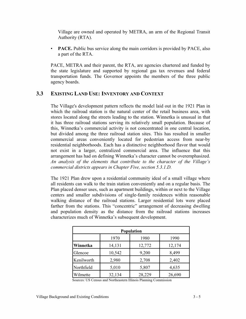
Sources: US Census and Northeastern Illinois Planning Commission
1970 1980 1990Winnetka 14,131 12,772 12,174Glencoe 10,542 9,200 8,499Kenilworth 2,980 2,708 2,402Northfield 5,010 5,807 4,635Wilmette 32,134 28,229 26,690
Population
Village Background and Existing Conditions 3 - 6
Sources: US Census and Northeastern Illinois Planning Commission
Most of Winnetka's development occurred between 1910 (pop. 3,168) and 1930(pop. 12,219) and the Village reflects that era’s architectural styles, scale andmaterials, as well as a planning configuration that was established on thepedestrian-oriented model that existed before today’s heavy reliance onautomobiles. The zoning districts created by the 1922 Zoning Ordinance providethe regulatory structure for creating neighborhood character. The description ofland uses in this section therefore follows the zoning categories within each useand enumerates the salient characteristics of the various districts.
3.3.1 Land Use Survey
Single-family residential neighborhoods, along with the parks, schools, religiousinstitutions and other institutions that serve them, constitute the overwhelmingpercentage of land area in the Village. Only along the Green Bay Road Corridorand in its associated business districts are there significant multiple-family or non-residential land uses. An unusual feature of Winnetka is that, while they are notpart of the Village, the Cook County Forest Preserve, the Indian Hill Club andLake Michigan provide significant open space on the west, south and east sides ofthe Village.
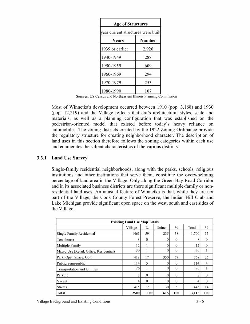
Years Number
1939 or earlier 2,926
1940-1949 288
1950-1959 609
1960-1969 294
1970-1979 253
1980-1990 107
Age of Structures
year current structures were built
Village % Uninc. % Total %Single Family Residential 1465 59 235 38 1,700 55Townhouse 8 0 0 0 8 0Multiple Family 12 1 0 0 12 0Mixed Use (Retail, Office, Residential) 30 1 0 0 30 1
Park, Open Space, Golf 418 17 350 57 768 25Public/Semi-public 114 5 0 0 114 4Transportation and Utilities 26 1 0 0 26 1
Parking 8 0 0 0 8 0Vacant 4 0 0 0 4 0Streets 415 17 30 5 445 14Total 2500 100 615 100 3,115 100
Existing Land Use Map Totals
Village Background and Existing Conditions 3 - 7
Map 2 illustrates Existing Land Uses in the Village: residential, commercial,public and semi-public.
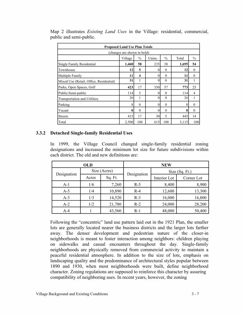
3.3.2 Detached Single-family Residential Uses
In 1999, the Village Council changed single-family residential zoningdesignations and increased the minimum lot size for future subdivisions withineach district. The old and new definitions are:
Following the “concentric” land use pattern laid out in the 1921 Plan, the smallerlots are generally located nearer the business districts and the larger lots fartheraway. The denser development and pedestrian nature of the closer-inneighborhoods is meant to foster interaction among neighbors: children playingon sidewalks and casual encounters throughout the day. Single-familyneighborhoods are physically removed from commercial activity to maintain apeaceful residential atmosphere. In addition to the size of lots, emphasis onlandscaping quality and the predominance of architectural styles popular between1890 and 1930, when most neighborhoods were built, define neighborhoodcharacter. Zoning regulations are supposed to reinforce this character by assuringcompatibility of neighboring uses. In recent years, however, the zoning
Acres Sq. Ft. Interior Lot Corner LotA-1 1/6 7,260 R-5 8,400 8,900 A-5 1/4 10,890 R-4 12,600 13,300 A-3 1/3 14,520 R-3 16,000 16,800 A-2 1/2 21,780 R-2 24,000 28,200 A-4 1 43,560 R-1 48,000 50,400
Size (Sq. Ft.)NEW
Designation DesignationSize (Acres)
OLD
Village % Uninc. % Total %Single Family Residential 1,460 58 235 38 1,695 54Townhouse 12 5 0 0 12 0Multiple Family 11 4 0 0 11 0Mixed Use (Retail, Office, Residential) 31 1 0 0 31 1
Parks, Open Spaces, Golf 423 17 350 57 773 25Public/Semi-public 114 5 0 0 114 4Transportation and Utilities 26 1 0 0 26 1
Parking 8 0 0 0 8 0Vacant 0 0 0 0 0 0Streets 415 17 30 5 445 14Total 2,500 100 615 100 3,115 100
Proposed Land Use Plan Totals (changes are shown in bold)
Village Background and Existing Conditions 3 - 8
regulations have not prevented the overbuilding that has distinctly altered thecharacter of individual blocks. This issue is further explored in section 3.4.1 ofthis Chapter.
The 1990 census recorded 3,849 single-family houses. Since then, approximately35 additional new single-family houses have been added as a result of vacant lotdevelopment or resubdivisions and about 183 new houses have replaceddemolished houses.
R-5 (formerly one-sixth acre, A-1). This zoning district contains the largestnumber of residential parcels in the Village. The Zoning Code describes thepurpose of this district as a single-family residential neighborhood of relativelyintense suburban character where the buildings and pavement are in approximatebalance with the landscape area.
The original one-sixth-acre lots were 50 feet wide and 150 to 200 feet deep.Typically, the block face is oriented towards the north or south. Setbacks of 30 to40 feet from the street give the block face a pleasing rhythm. The close proximityof the houses promotes interaction among neighbors. Deep back yardsunobstructed by fences were designed to form a core of green space in the block’scenter, allowing residents to enjoy the views and privacy afforded by theneighborhood's trees and landscaping.
Traditionally detached garages were built in the rear of the property, allowing thefront of the house to be defined by the front door and landscaping. Because thelots are narrow, shared driveways are not uncommon. Although alleys wereplatted throughout the Village, only a few were built, primarily in the 12 blocksbounded by Pine, Locust, Willow and Glendale. A few alleys exist east of GreenBay Road.
R-4 (formerly one-quarter acre, A-5). This zoning district was added in 1989 inresponse to proposed subdivisions that would have resulted in additional housesfacing the Village Green. Portions of the one-sixth acre district east of Green BayRoad and in scattered areas in west Winnetka had substantially oversized lots.Subdivision into true one-sixth acre lots would have interrupted the rhythm of theneighborhood and one-quarter acre zoning was considered more appropriate forthese neighborhoods. The R-4 characteristics are similar to R-5, albeit with morespace between houses, more trees and landscaping.
R-3 (formerly one-third acre, A-2). This district has a moderately intensesuburban character where buildings and pavement upon an individual parcel ofland are generally subordinate to the landscape. Two of the smallest R-3 districtsare located east and west of Hubbard Woods. Other R-3 districts are located eastand west of the Green Bay Road Corridor between the Hubbard Woods and theElm Street Business District. The balance of the R-3 district is located betweenHill Road and Ash Street, east of Birch Street and west of Ridge Avenue. Since
Village Background and Existing Conditions 3 - 9
the lots in the R-3 district are larger, so are the houses and the distance betweenthem. A greater amount of green space and foliage surrounding the houses is animportant feature of this district.
R-2 (formerly one-half acre, A-3). This area has a small estate character:buildings on the property are generally subordinate to the landscape. All lakefrontand ravine properties are zoned R-2, as are some of the properties along theIndian Hill Club golf course and Forest Preserve. Properties served primarily byprivate streets in the southwestern portion of the Village and in the Ardsley Roadarea (from Pine Street north to Tower Road) are in R-2 zoning districts. Houseswith large yards and an abundance of trees characterize this district. Manyproperties along Lake Michigan are comprised of one or more acres, giving themthe characteristics of the R-1 district described below.
R-1 (formerly one acre, A-4). This district is limited to a small area west of theIndian Hill Club house and south of Hill Road. The zoning designation wascreated for Indian Hill properties annexed in two parts, one in section in 1989 andthe other in 1990, to preserve their estate character: large houses set on amplegrounds.
3.3.3 Multiple-family Residential
Multiple-family residential uses are primarily located along the Green Bay RoadCorridor or within the Village's business districts. The 1990 census lists 481multiple-family (condominium) units in the Village. Multiple-family dwellingsaddress a number of community needs. From a planning point of view, multiple-family residential zones provide a transition between commercial districts andsingle-family neighborhoods.
From a social perspective, multiple-family units can provide empty-nester orlower-cost housing. In Winnetka, however, multiple-family options are limited.Older couples often find few housing alternatives in the Village at a time in theirlives when they seek simplified living arrangements.
In addition to condominium units, the 1990 Census states there are 525 rentalsingle-family and multiple-family residential units in Winnetka. These can servean important social purpose, for example, when divorced parents want to continueto live near their children.
Low Density Multiple-family District (B-1). This zoning classification providesa land use buffer between commercial and detached single-family land uses, andbetween vehicular traffic along Green Bay Road and detached single-family landuses. A “buffer” smoothes the transition between different land uses so thatadjacent land uses are compatible.
Consequently the B-1 District encourages the development of two-family, low-
Village Background and Existing Conditions 3 - 10
density multiple-family and, where appropriate, other low-intensity land uses thatare compatible with adjacent detached single-family residential neighborhoods.Eighteen to 24 units per acre are allowed versus 4 to 6 homes per acre in theadjoining single-family R-4 and R-5 districts.
This District encompasses two types of multiple-family developments:townhouses and low-density apartment or condominium buildings, which producevery different building configurations and relationships with adjacent single-family neighborhoods, although both are monitored under the B-1 zoningregulations.
Townhouses. About 147 townhouses have been built in a generally unobtrusiveway along the Green Bay Road corridor, providing a buffer between single-familyhouses and commercial or large multiple-family residential buildings. Severalclusters of townhouses are located between Westmoor Road and El Dorado Street.Townhouses are also clustered around the Public Library in the West Elm StreetDistrict. Townhouses also act as transitional buffers in the East Elm Street andIndian Hill business districts.
Low density apartment or condominium buildings consolidate units into largerbuildings, where multiple dwellings are accessed from a central entryway. Thebuildings look less like single-family residences, but the required articulation inexterior walls is intended to make the apparent scale blend with the surroundingneighborhood
Higher Density Multiple-Family Residential District (B-2). These largercondominium buildings house up to 30 units per acre. All B-2 buildings werebuilt to the maximum four-story, 42 foot height allowed at the time. Thesebuildings are located on Green Bay Road, north of Pine (The Mews), at 711 OakStreet (at the corner of Lincoln Avenue), at Green Bay and Willow Road(Hedgerow) and on Green Bay Road between Sunset Road and Winnetka Avenue(The Chimneys and Hemphill House).
These buildings seem quite large when built at the edge of single-familyneighborhoods. As a result of community concern over the bulk characteristics ofthese buildings, the height limit for B-2 developments was reduced to 2 ½ stories(35 feet) in 1998.
Multiple-family Residential Units over Commercial Uses (C-1 and C-2).Commercial zoning regulations allow apartments or condominiums on upperstories. Most multiple-story buildings in Hubbard Woods and the East and WestElm Street business districts have residential units above the ground floor, as doesThe Feigenheimer Building at 454-462 Winnetka Avenue in the Indian HillBusiness District.
Village Background and Existing Conditions 3 - 11
3.3.4 Commercial (Retail, Office, Mixed Use)
Mixed-use buildings are typical of the Winnetka business districts and helpestablish the compact, attractive small town character of the Village. Commercialuses on the first floor with office or residential above provides complementaryuses. Residents living in or near one of the business districts can combine trips towork and errands without the need for an automobile. Residents and visitorsarriving by car can consolidate trips after parking, thus reducing congestion andmaximizing the benefits of a pedestrian environment. Because Winnetka was builtbefore extensive use of the automobile, most of its commercial buildings front onthe sidewalk, forming a cohesive pedestrian environment without the interruptionsof curb cuts for parking lots on each parcel.
Commercial buildings are permitted to cover 90% of a lot, and until recently wereallowed a height of 4 stories or 42 feet. Recent concern about redevelopment thatcould significantly alter the scale and intensity of the business districts plus theassociated increase in traffic led the Village Council in 1998 to reduce allowableheight to 2-½ stories or 35 feet. Developers must provide parking for upper flooruses, but not for first floor tenants.
Limited Retail Commercial District (C-1): This zoning designation provides aneighborhood service district, complemented by multiple-family residential uses,that offers retail convenience goods and provides personal services toaccommodate the day-to-day shopping or service needs of persons living orworking within or near the District. Retail, service or office uses are permitted onthe first floor; office or multi-family residential units are allowed on upper floors.
The entire C-1 District is located in Indian Hill. Because of its close proximity tosingle-family neighborhoods, permitted uses are limited. Other commercial usesrequire a special use permit approval based on the compatibility of the proposeduse with its residential surroundings.
General Retail Commercial District (C-2): This zoning classification creates acommunity commercial district that offers a wide range of goods and services forresidents of the village and a wider market area.
Portions of this District (a subdistrict called the C-2 overlay district) requireretailing and personal services businesses on the ground floor in order toencourage a clustering of such uses, to provide for a wide variety of retail shopsand expose such shops to maximum foot traffic, while keeping that traffic inconcentrated areas throughout the District. Offices or professional services areallowed as first floor uses outside the retail overlay district. Hubbard Woods andboth Elm Street business districts are zoned C-2.
Please refer to Chapter Five for a discussion of C-1 and C-2 in the individualbusiness district sections.
Village Background and Existing Conditions 3 - 12
3.3.5 Industrial
Light Industrial District (D): The Village has a very small zoning district forindustrial uses in a portion of the Hubbard Woods Business District running alongthe railroad embankment north of Tower Road. Currently, the only industrial usein this district is the presence of underground fuel storage tanks that are connectedto the electric power plant via pipeline.
3.3.6 Public and Semi Public
Map 3, Public/Semi-Public and Open Space, depicts the publicly ownedproperties in the Village: properties owned by the Village, school districts,Winnetka Park District, Cook County Forest Preserve District and Federal andlocal governments as well as those parcels used for public assembly such as theCommunity House and religious institutions. This map illustrates that theVillage’s physical and social infrastructure, developed over the life of thecommunity, is conveniently located in its residential neighborhoods. The mapshows that each facility is surrounded by developed residential properties andthere is little room to expand. The map also illustrates that major public facilitiesare centrally located in or near the business districts.
Nearly all of the public and semi-public uses predate the Zoning Ordinance andthe buildings are over-sized for residential areas. Many of the facilities are locatedwithin quiet residential neighborhoods, which must absorb the impact of trafficcongestion and parking. Because of this, institutions are regulated by a “specialuse permit process” and requests are treated on a case-by-case basis.
A. Village of Winnetka
The Village’s properties include:
• Village Hall. Village Hall is a designated Winnetka landmark. It wasdesigned by Edwin H. Clark and constructed in 1925 as a result of a 1921Plan recommendation. It is expected to serve the needs of the Village forthe foreseeable future.
• Public Safety Building. The Police and Fire Departments’ building onGreen Bay Road was completely renovated in 1996. It is expected toprovide public safety services to the Village for the foreseeable future.
• Water and Electrical Plant. The Water and Electrical Plant, located onthe lake at Tower Road Beach, provides essential services to thecommunity and occupies a key location on the lake.
Village Background and Existing Conditions 3 - 13
• Public Works and Landfill Site (Village Yards). The Public WorksDepartment and the landfill are located on the south side of Willow Road,adjacent to the Cook County Forest Preserve. The Public Works andWater and Electric facilities are expected to remain at this location for theforeseeable future. The building's facilities, built in 1971, are seriouslyoutdated and in need of substantial rehabilitation.
The landfill site has been recently capped and landscaped. Future uses ofthe landfill will likely be limited to public open space because of settling,topography, gaseous byproducts and prohibitions against penetrating thecap with foundations. The minimum closure required by the EPA of thelandfill will extend through 2009.
• The Village Green and Sheridan Park (at Sheridan Road and MapleStreet) are owned by the Village and maintained by the Park District.
• Storm Water Pumping Station at Winnetka Avenue and the SkokieRiver. The Village leases this site from the Cook County Forest PreserveDistrict.
• Electrical Substation (Happ Road at the Skokie River in Northfield). TheVillage has a 50-year lease from the Cook County Forest Preserve Districtfor this site.
B. Public Schools
School districts in mature communities such as Winnetka typically experiencecycles of enrollment growth and decline. Young families move in, replacing“empty nester” households causing an enrollment surge as the children movethrough the school system. If a large portion of parents subsequently remain inthe family home as empty-nesters, school enrollment will temporarily decline.While the cyclical nature of demographic trends can be anticipated to somedegree, the timing and size of the shifts are difficult to predict as they arebased on economic forces and personal preferences that affect family planningand housing choices.
• New Trier Township High School District 203. New Trier High Schoolis considered to be one of the finest high schools in the country. The firstNew Trier High School opened in 1901 (in its east location) in a buildingdesigned by Norman S. Patten to resemble the town hall of Trier,Germany. This building was replaced by a larger facility that opened in1956.
Village Background and Existing Conditions 3 - 14
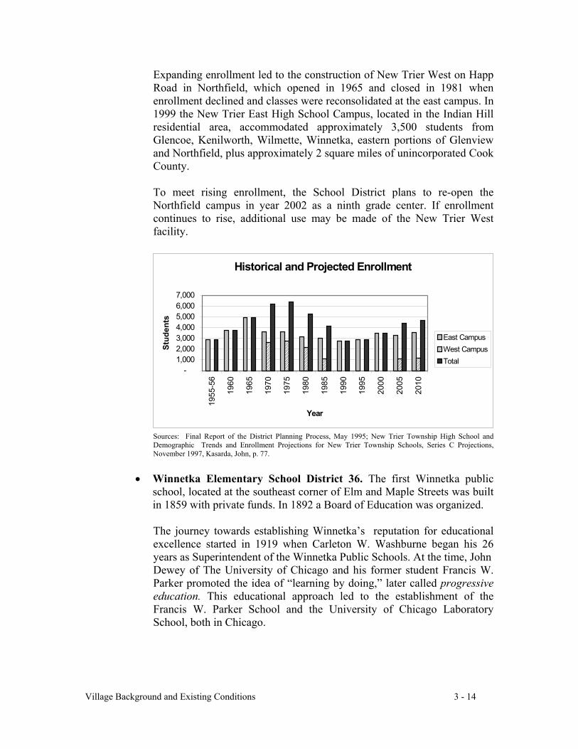
Expanding enrollment led to the construction of New Trier West on HappRoad in Northfield, which opened in 1965 and closed in 1981 whenenrollment declined and classes were reconsolidated at the east campus. In1999 the New Trier East High School Campus, located in the Indian Hillresidential area, accommodated approximately 3,500 students fromGlencoe, Kenilworth, Wilmette, Winnetka, eastern portions of Glenviewand Northfield, plus approximately 2 square miles of unincorporated CookCounty.
To meet rising enrollment, the School District plans to re-open theNorthfield campus in year 2002 as a ninth grade center. If enrollmentcontinues to rise, additional use may be made of the New Trier Westfacility.
Sources: Final Report of the District Planning Process, May 1995; New Trier Township High School andDemographic Trends and Enrollment Projections for New Trier Township Schools, Series C Projections,November 1997, Kasarda, John, p. 77.
• Winnetka Elementary School District 36. The first Winnetka publicschool, located at the southeast corner of Elm and Maple Streets was builtin 1859 with private funds. In 1892 a Board of Education was organized.
The journey towards establishing Winnetka’s reputation for educationalexcellence started in 1919 when Carleton W. Washburne began his 26years as Superintendent of the Winnetka Public Schools. At the time, JohnDewey of The University of Chicago and his former student Francis W.Parker promoted the idea of “learning by doing,” later called progressiveeducation. This educational approach led to the establishment of theFrancis W. Parker School and the University of Chicago LaboratorySchool, both in Chicago.
������������
����������������
���������
������
������
������
Historical and Projected Enrollment
-1,0002,0003,0004,0005,0006,0007,000
1955
-56
1960
1965
1970
1975
1980
1985
1990
1995
2000
2005
2010
Year
Stud
ents
East Campus����
West CampusTotal
Village Background and Existing Conditions 3 - 15
Washburne, a Parker disciple, is famous for his “individual promotion”program in which a child learns at his own pace, rather than at somepredetermined “lockstep” pace. This method of learning facts not by rotebut through independent research and group discussion was designed topromote self-motivation and personal responsibility. Within a few years,the “Winnetka System” became known throughout the world for itsprogressive approach, resulting in the creation of a Graduate Teachers’
College at Skokie School from 1932 to 1955, where teachers from everypart of the U.S. and various foreign countries came to learn progressiveteaching methods. This teaching philosophy evolved into the“developmental” approach for which District 36 is so well known today.
Facility expansion. The school buildings are operating at the limit of theircapacity due to several factors:
School enrollment is cyclical by nature, with significant peaks and valleys,due to demographic and economic changes. Winnetka enrollment iscurrently in an upswing, expected to peak in 2005. Although Winnetka ismostly "built out,” new homes on subdivided lots and larger housesreplacing smaller ones can contribute more students to the public schools.When the enrollment cycle is at its peak, these incremental additions canoverburden already-full schools. Modern technology and special educationprograms require additional classroom space.
District 36 has three elementary schools serving grades kindergartenthrough five that are designed on a neighborhood model, with no homemuch more than a mile from school:
• Samuel Sewell Greeley School, built in 1912 and designed bydistinguished architects William Otis and Edwin Clark, servesneighborhoods north of Winnetka Avenue, east of Green Bay Roadand south of Tower Road.
• Hubbard Woods School, built in 1915 and designed by DwightPerkins, serves the area west of Green Bay Road and north of PineStreet plus the area east of Green Bay Road and north of Tower Road.
• Crow Island School serves the area west of Green Bay Road andsouth of Pine Street. Built in 1939 and designed by Eliel and EeroSaarinen with Perkins, Wheeler & Will, this was CarletonWashburne’s dream school. Based on Washburne’s educational
Village Background and Existing Conditions 3 - 16
theories and input from the faculty, its award-winning architecturaldesign reinvented school design principles influencing most schoolbuildings constructed in the country after World War II. Thisdistinction earned it a listing on the National Register of HistoricPlaces and designation as a National Historic Landmark. It is also thesite of the first jungle gym, built of iron pipes by Washburne and itsinventor, Theodore Hinton.
The District has two village-wide middle schools that share a campusbounded by Hibbard Road, Elm Street, Glendale Avenue and Oak Street.
• The Skokie School, built in 1921 and paid for with private funds, wasdesigned by Dwight Perkins as one of the first middle schools in thecountry. Declining enrollment led to the closing of Skokie School in1982 when fifth graders returned to the elementary schools and sixthgraders were transferred to Washburne. The building was saved fromdemolition by The Skokie School Foundation, which renovated theKuppenheimer Auditorium. During the time that the School Districtdid not use the building, it leased space to Cove School, othereducational groups, the Winnetka Historical Society and the WinnetkaPark District.
Another population surge required the reopening of The Skokie Schoolfor sixth graders in 1998, with the anticipated addition of fifth gradersstarting in the fall of 2000.
• Carleton W. Washburne Middle School, designed by Perkins &Will, was built in 1968 as a District-wide seventh and eighth gradeschool, leaving The Skokie School as a fifth and sixth grade facility.Sixth graders were transferred to Washburne in 1982, and back toSkokie in 1998.
C. Winnetka-Northfield Public Library District
The Winnetka Library was organized in 1885. In 1974 the Winnetka-Northfield Public Library District was created, serving residents within thevillage boundaries of Winnetka and Northfield. Households in unincorporatedCook County that have Winnetka addresses may contract with the LibraryDistrict for an annual fee. In addition, the Library District has a cooperativeagreement with Kenilworth. The District operates two facilities: the 20,500square foot main library at the southeast corner of Oak Street and LindenAvenue (at the southern edge of the West Elm Street business district) and the4,100 square foot branch on the northwest corner of Happ Road and OrchardLane in Northfield. The District serves a resident population of approximately17,000.
Village Background and Existing Conditions 3 - 17
D. Winnetka Park District and Open Space
The Winnetka Park District was organized in 1904 to acquire the triangular lotnow known as Station Park west of the Elm Street railroad station. TheDistrict is responsible for providing and maintaining adequate parks andrecreational facilities within its jurisdiction. A unique characteristic of thePark District is that, together with affiliated organizations, it providescompetitive team sports that are usually provided by school districts in othercommunities.
The Park District owns or maintains approximately 234.5 acres within theVillage. It owns approximately 220.5 acres and maintains approximately 14acres owned by the Village of Winnetka: Bradstreet Park, the Village Green,Sheridan Park and the Green Bay Trail.
Although Winnetka is characterized by relatively intense land uses for asuburban community, residents cite the abundance of parks and green space asone of its most attractive features. Winnetka’s open spaces are well-plannedand spread throughout the community. Parks within the Village are listed inAppendix 2.
While most of Winnetka’s open space is owned by the Park District, theVillage owns key pieces of property including the Village Green, the closedland-fill site and the water and electric plant on Tower Road Beach, as well assmaller, undeveloped rights-of-way and pocket parks scattered throughout theVillage. Grounds and playfields owned by the school districts also provideneeded open space.
The Park District adopted a Master Plan in 1997 that sets out a strategy for themaintenance and enhancement of parks and recreation facilities through theyear 2001. The Park District is currently developing a master plan for itslargest site, the Skokie Playfield property, which currently accommodates an18-hole and a 9-hole par 3 course, the Nielsen Tennis Center, the Ice Arenaand sports fields.
E. Non-Government Institutions
In addition to the variety of governmental entities that serve the Village,Winnetka has a number of private institutions that provide social, cultural,religious and educational resources to its residents. The strong support shownin the community survey for schools, religious institutions and communitybuildings in the Village demonstrates residents’ appreciation of the highquality architectural design of these buildings, a recognition of institutionalefforts to fit into a neighborhood setting and support of the organizations’missions.
Village Background and Existing Conditions 3 - 18
Parochial and Private Schools
• The School of Saints, Faith, Hope and Charity, located at RidgeAvenue and Hill Road, was founded in 1939 and serves kindergartenthrough 8th grade.
• The Sacred Heart School, located at Burr Avenue and Gage Street inHubbard Woods, was founded in 1902 as the first free Catholic school inthe Diocese of Chicago. The present building, built in 1952, serveskindergarten through 8th grade.
• The North Shore Country Day School, a private school at the southwestcorner of Green Bay and Willow Roads designed by Edwin Clark, wasformed in 1919 and serves kindergarten through the twelfth grade. Itsfounding headmaster, Perry Dunlap Smith, an early student of Francis W.Parker, was an educational innovator as well as a philosophicalcontemporary and close friend of Carleton W. Washburne. The school’s16-acre campus includes a substantial amount of open space that is usedfor community activities such as youth athletics.
• Preschool programs in the Village include: the Winnetka Public NurserySchool at Skokie School, Winnetka Community Nursery School at theWinnetka Community House, Harkness House adjacent to the WinnetkaCommunity House, Willow Wood Preschool at Christ Church ParishHouse and Sacred Heart School. A variety of other preschool programsare available through the Winnetka Community House and organizationscurrently housed at Skokie School. All are adjacent to or in single familyneighborhoods.
• The Music Institute of Chicago, a private music school founded in the1930's by Dorothy and David Dushkin in their house at Glendale and ElmStreet, moved to its current location on the east side of the North ShoreCountry Day School campus in 1956. It is the oldest and largestcommunity music school in Illinois, now serving more than 1,600 studentsof all ages and abilities at five Chicago area campuses. The MusicInstitute’s Institute for Therapy Through the Arts is a leader in the fieldof creative therapy, providing performing arts and art therapy for 1,100clients of all ages.
• Hadley School for the Blind, 700 Elm Street, founded in 1921, is thelargest worldwide educator of blind and visually impaired people, offeringmore than 90 tuition-free correspondence courses in Braille, large printand on audio cassette.
Village Background and Existing Conditions 3 - 19
• Creator Arts Center of the Winnetka Bible Church, 555 Birch Street,offers early childhood music lessons and musical instrument, voice, dramaand art lessons for students of all ages.
Religious Institutions
Religious institutions are located on the edges of business districts or insingle-family neighborhoods and represent a substantial part of the Village’ssocial infrastructure. Sacred Heart is on the west side of the Hubbard WoodsBusiness District. The Winnetka Bible Church, the First Church of ChristScientist and the Winnetka Japanese Christian Church are located on theedges of the West Elm Street Business District. The WinnetkaCongregational Church and Christ Church Parish House are at oppositeends of the East Elm Street Business District. The Winnetka PresbyterianChurch is west, at Hibbard and Willow Roads. Christ Church is east, onSheridan Road at Humboldt Street. Ss. Faith, Hope and Charity is south, onHill Road between Ridge Avenue and Linden Street. Two congregationsworship at the Winnetka Community House, Congregation Hakafa and theLake Shore Unitarian Society.
Other Institutions
The Winnetka Community House, at the northern edge of the East ElmStreet Business District, was founded by the Winnetka Congregational Churchin 1911 as a non-denominational community facility. Its first building waspartly destroyed by fire in 1930 and replaced in 1932 by the building nowstanding. Patterned after “settlement houses” in Chicago, it created a modelfor community centers across the country. It receives no tax support, buthouses five theater groups, six tenants, twelve affiliates and approximately500 recreational programs each year.
The Winnetka Historical Society was founded in 1932 to collect, preserveand present artifacts representing Winnetka history and to increase publicknowledge about the community. Artifacts were stored for almost thirty yearsin the Public Library basement until the Historical Society and the Village ofWinnetka established a museum at The Skokie School. In 1999, the HistoricalSociety began another search for a museum site in anticipation of The SkokieSchool’s north wing returning to use as a fifth grade center.
The Winnetka Woman’s Club, at the southern edge of the East Elm StreetBusiness District, was founded in 1908 to provide educational, cultural,recreational and social activities. The present club house was purchased in1911.
Village Background and Existing Conditions 3 - 20
3.3.7 Cook County Forest Preserve District
The 1921 Plan strongly recommended the purchase and preservation of the openspace on the western edge of the Village, known as the Skokie Valley, by theCook County Forest Preserve. As a result, Winnetkans now enjoy the William N.Erickson Forest Preserve, part of the Skokie Division of the Cook County ForestPreserve District. It includes the Skokie Lagoons, boating ramps and bicycletrails. Approximately 150 acres of the Forest Preserve’s property lie withinVillage boundaries.
In the 1930's, Winnetka resident Harold L. Ickes was Secretary of the Interior inPresident Roosevelt’s cabinet. Ickes proposed a drainage program for the Skokiemarsh that gathered hundreds of Civilian Conservation Corps workers to dig outthe swamp with shovels. They built an elevated, drier Tower Road, a curvingForest Way and, together with Forest Preserve heavy machinery, seven lagoons.This land, providing 190 acres of recreational resources, acts as a landscapedbuffer for the Village’s western boundary, blocks some noise from the EdensExpressway and defines the western approaches to the Village. The ForestPreserve is the last vestige of the wetlands system that once covered westernWinnetka and it continues to provide a retention area for storm water.
3.3.8 Unincorporated Cook County and Split Lots
The Village supplies electric power, water and/or fire and police protectionservices to a significant number of households outside the Village limits. Map 4,Municipal Services Beyond Village Boundary, illustrates important communityfacilities and the extent of public sewer, water and electrical supply by theVillage. The Village does not provide sewer service for the Woodley Roadunincorporated area, however, the area does use a small portion of Village linesfor sewage disposal.
Unincorporated Cook County. Included in the Village’s Planning Area arehouseholds that receive municipal services but are located outside the corporateboundary of Winnetka. These areas include properties south of the Village thatborder Kenilworth, Wilmette, Northfield and the Indian Hill Club as well as theWoodley Road and Longmeadow areas southwest of the Village
Village of Glencoe. West of Green Bay Road, sixty lots along the north side ofScott Avenue have frontages and addresses in Winnetka, but substantial portionsof the lots lie within Glencoe's Village boundaries. East of Green Bay Road, fiveproperties cross into Glencoe. Three of these properties (94 Mary and 1150 and1120 White Bridge Lane) are predominately in Winnetka. With the exception oftwo Glencoe properties that are east of Green Bay Road, Winnetka provides allpublic services to these sixty three residences (police and fire protection, garbagepick-up, water, electricity, and sewer), it only receives tax revenue for the
Village Background and Existing Conditions 3 - 21
proportional amount of the lot that lies in Winnetka. In 1995, approximately$68,000 in property taxes went to Glencoe, which provided no services to thesehouseholds. See Map 4, Municipal Services Beyond Village Boundary.
3.3.9 Infrastructure: Transportation, Utilities, Storm and Sanitary Sewers
See Section 3.6 for transportation and Section 3.7 for utilities and sewers.
3.4 VILLAGE CHARACTER
3.4.1 Single-Family Neighborhood Character: Bulk, Density and Subdivisions
Teardowns and Changing Neighborhood Character. With nearly all of thecurrently platted lots built upon, new single-family houses will result primarilyfrom the subdivision of existing lots or from teardowns (demolition) of existinghouses. This section examines teardowns and subdivisions and their effect onVillage character.
The Village’s decades of greatest growth were from 1910 to 1930. Seventy toninety years later, homeowners must decide how best to deal with an aginghousing stock. For houses of good quality construction and design, rehabilitationmakes sense. On the other hand, economics point toward replacement of housesthat were poorly built or badly designed. The central “teardown” question is howto replace old inadequate houses with new houses that are sensitive to theirsurroundings.
Perceived negative effects of teardowns were cited frequently in the public inputphase of the Plan update. Older one-and-one-half story cottages with the frontdoor as focal point set the tone for many Winnetka neighborhoods, where facadesrelate comfortably to a pedestrian-oriented street. Demolishing smaller houses andreplacing them with houses of often twice the square footage result in:
• taller, bulkier houses with a looming presence on the street scene that blocklight and air from neighboring houses
• newer houses that tend to extend farther into back yards, destroying the openspace of the inner block
• large replacement houses that may encourage the tear down of older, smallerhouses nearby because the smaller houses look “out of place”
• front-loaded attached garages that detract from the street scene and itspedestrian orientation
• basements that rise too far out of the ground leading to inconsistent stoopheights and disrupting the rhythm of the block face along the street
• house designs that are more characteristic of newer communities don’t blendwell with the aesthetics of 70 to 100-year-old neighborhoods
• more intense development that creates more impermeable surface, which canexacerbate neighborhood drainage problems
Village Background and Existing Conditions 3 - 22
• larger, more expensive replacement houses that reduce the variety of housingstock in the Village. People of modest income, such as young families andempty-nester older adults, can be priced out of the market. This potentiallimitation of socio-economic diversity among residents is an unacceptablesocial cost.
An analysis of 31 new houses built between 1990 and 1998 in the R-5 district(formerly A-1) was prepared to help determine whether changes to the bulkregulations in the Village’s zoning ordinance were required. Prior to 1999, the R-5 district had a minimum lot size of 7,260 square feet, with typical lot sizes of9,350 square feet. The analysis indicates that for new houses the average roofedlot coverage was over 23.3%, very close to the maximum allowable of 25%. Floorarea ratios for the same new houses averaged 0.383 compared to an averageallowable FAR of 0.393 or about 98% of the maximum.
Sixteen teardowns in the same R-5 zoning district demonstrate that the gross floorarea of demolished houses averaged 1,643 square feet, with a gross floor area of0.18. The replacement houses averaged 3,860 gross square feet, with an averagefloor area of 0.42.
Clearly, older houses in the district were modest in size and did not approach thebulk allowed under the zoning ordinance. When these houses were replaced withhouses designed to maximize development under the zoning ordinance, the visualcharacter of the neighborhoods began to change and the light and air ofneighboring houses was compromised.
After extensive public input and analysis, in 1999 the Village increased minimumlot sizes in single-family residential districts, reduced floor area ratio maximumsfor new houses and implemented additional regulations to ensure adequate lightand air for houses on the smaller lots in the Village.
Subdivisions. Future residential growth in the single-family residential districtscan be expected to occur from the redevelopment and re-subdivision of oversizedlots. Subdivisions cause concern when:• resulting lots barely meet minimum subdivision requirements,• rectangular corner lots are divided into two square lots and• “flag lot” subdivisions divide interior lots by running a driveway or “flagpole”
along the edge of the front lot to the rear parcel.
These types of subdivisions alter the historic rhythm and orientation of housesalong street frontages. In 1999, the Village Council changed the SubdivisionOrdinance to address these problems more restrictively. Lots that are alreadysubdivided but not built upon, however, can still be developed.
Village Background and Existing Conditions 3 - 23
3.4.2 Historic Preservation
The Landmark Commission is responsible for public education and for the studyand inventory of the Village's architectural and historic resources. In 1995 thelandmark preservation ordinance received State approval for the property taxassessment freeze, which provides potential tax benefits to property owners whoengage in substantial rehabilitation of a designated landmark according to the U.S. Secretary of the Interior’s Guidelines for Rehabilitation. The freeze program isadministered by the Illinois Historic Preservation Agency.
The following buildings are designated Winnetka landmarks: 594 Elm Street,830 Sheridan Road (also listed on the National Register of Historic Places), 500Maple Street, 950 Hill Road, 510 Green Bay Road (Village Hall), 11 Indian HillRoad, 978 Euclid Avenue, 915 Sheridan Road, 939 Tower Road and 930 FisherLane.
In addition, 42 Abbotsford Road, a house designed by Walter Burley Griffin, andCrow Island School are listed on the National Register of Historic Places. Due toits pioneering contribution in reinventing school design principles, Crow IslandSchool is also designated a National Historic Landmark.
3.4.3 General Appearance and Landscaping
Mature landscaping helps define the character of the Village, which is noted forabundant green space and a mature canopy of trees. Landscaping provides aneffective buffer between different land uses, softens the stark impact of largewalls and preserves privacy. The Village requires commercial and multiple-family building developers to submit landscape plans for approval. There are nolandscaping requirements for single-family residences, although most houses inthe Village have a substantial amount of mature landscaping.
Despite individual efforts, there is no systematic approach to communitylandscaping other than the high priority given to trees. In specific locations,private garden clubs or the Park District provide landscaping or plant seasonalflowers. Other areas, such as major entryways into the Village, are ignored.
In the business districts, the Sign Ordinance has served the Village well in mutingthe visual impact of commercial signs. See Chapter Five, sections 5.3.1.C and D,5.3.2.C and 5.3.3.C for further discussion of Green Bay Road Corridor andbusiness district aesthetics.
Village Background and Existing Conditions 3 - 24
Efforts have also been made to control light pollution. Streetlights inneighborhoods are color-corrected sodium vapor. These lights are purposely dimand tinted yellow or orange. These bulbs were chosen for cost savings and forcolor rendition, although some still find the color harsh. Commercial lighting canprove invasive to adjoining single-family neighborhoods and needs to beevaluated for its impact.
Technology, in terms of balancing government requirements (for cell sites,telephone transmitters, etc.) and aesthetics, is a problem and will remain so.
3.5 ENVIRONMENTAL CONDITIONS
Winnetkans have a high regard for the natural beauty of their community. Itslocation along the lake, its quantity of green space and the predominance ofmature trees attract people to the Village. Early Village plans advised maintainingthe "rural nature" of the community, but the implementation of one-sixth acrezoning lots in most of the Village in the 1920's created a semi-urban character.Nevertheless, maintaining the natural features of the Village for the enjoyment offuture generations remains a high priority.
3.5.1 Lake Michigan Bluff and Ravines
The Lake Michigan bluffs and the ravines leading to the lake are importantfeatures of the Village, providing pleasant wooded areas and affording beautifulviews of the lake. Bluffs and ravines are fragile ecological resources that must beproperly managed. Building too close to the edge of a bluff or ravine can weakenit, possibly leading to collapse and affecting neighboring properties. Failure tomaintain proper plantings on the slope can lead to erosion. Lake Michigan bluffs,if not properly protected from waves and high water, can be severely eroded bythe lake. The bluff line is shown on Map 3, Public, Semi-Public and Open Space.
3.5.2 Flood Plains
The southwestern residential portion of Winnetka and the Skokie Playfields wereoriginally a part of "the Skokie," a great marsh that extended through the SkokieValley. Landfill from the excavation of the railroad tracks in the 1930's togetherwith the Civilian Conservation Corps project that dredged the Skokie Lagoonsallowed development of this area. However, it is still a low-lying area with someof the land falling in the Federal government’s designated Skokie River one-hundred-year flood plain.
Federal requirements for flood plains: The Federal government will guaranteeflood insurance for structures in the designated flood plain only if the localmunicipality abides by strict development controls. Flood insurance is required bylending institutions for mortgage approval on properties in the flood plain.
Village Background and Existing Conditions 3 - 25
Current buildings are legally grandfathered, but new construction and significantimprovements are precluded from having basements, even if compensatory stormwater storage is created. Any violations of the federal building regulations couldresult in flood insurance being denied all properties in the Village.
3.5.3 Trees
Trees have always been a focus of passion and attention in the Village. Duringearly settlement, the area was covered with a dense growth of trees, mostly oaks,which were cut down to build houses and supply firewood. In the 1850's CharlesPeck, often referred to as the Village’s founder, planted so many trees around hishouse at Maple and Elm Streets that the property became known as an arboretum.The Village’s charter, granted in 1869, has a special section requiring the plantingof shade trees along the streets and the ability to punish the unauthorized cuttingof shade trees. Dutch elm disease has wiped out many beautiful trees on theparkways and on private property; the Village works actively to protect theremaining inventory of elms.
The survey that accompanied the updating of this Plan identified trees as the mostpopular feature of the Village. Winnetka residents continue to feel strongly thatthe Village's trees and the natural look they provide should be preserved. Aerialphotos document the density of the tree cover.
As the yards in the R-5 and R-4 districts are relatively small, each tree on aproperty makes a difference to the character of the neighborhood, providing shadeand softening the line of house facades. Parkway trees along the street have asimilar impact.
Street tree planting program: The perception of abundant green space isenhanced by the Village’s program to plant trees on public property. The programevolved from a cost-sharing partnership with residents interested in parkway treesinto a systematic plan with 250 or more trees planted annually.
Goals of the program include:
- filling all tree voids along the parkways over time,- maintaining a master tree list,- selecting those species most tolerant of the unnatural urban environment,
including trees that can tolerate salt and are compatible with utility wireswhere needed,
- spacing trees to minimize root zone competition,- minimizing vulnerability of street trees to disease or insect infestation by
limiting any species to no more than 10% of the total inventory and- planting more trees than are removed annually.
Village Background and Existing Conditions 3 - 26
Tree protection ordinance: The Village requires approval for removal of alltrees over 10 inches in diameter and replacement is required for any healthy treetaken down. Specific regulations govern protection of trees on construction sites,which are monitored by the Village Forester.
3.6 TRANSPORTATION ANALYSIS
The transportation systems in Winnetka are the major influence on the Village'sgrowth and development. The transportation network is comprised of the road andrail system, sidewalks and pathways.
3.6.1 Road Network and Public Rights of Way
Winnetka’s streets, featuring sidewalks and tree-lined parkways, were laid outbefore the current high level of auto traffic. The 1921 Plan stated that an 18 footwidth was sufficient for minor residential streets and a 36 foot width forthoroughfares. Relatively narrow residential streets, which maximize the width ofparkways and green space, contribute toward the pedestrian ambience of theneighborhoods and are a defining characteristic of Winnetka. Narrow streetssuccessfully slow traffic since parked cars leave only one lane available fortraffic, a natural “traffic calming” device.
Replacing a portion of the original Green Bay Trail, Sheridan Road was theearliest north-south roadway along the shoreline. Formed from local streets, it hasa distinctive meandering quality. Green Bay Road, also created out ofdiscontinuous local roads, was designed to siphon interregional traffic off ofSheridan Road, while linking the Village’s commercial districts with each otherand with neighboring villages. The Edens Expressway, opened in 1951, divertedmost north-south traffic to the west of the Village.
The core of the road network in the Village is a grid system, with blocks laid outin a consistent rectangular form. This system distributes residential traffic fairlyevenly throughout the neighborhoods and is easily navigated. Only in the ravinearea to the north and in the private road areas in southwest Winnetka, do streetsmeander. The railroad bisects the Village. Most east-west streets are cut off at theembankment and resume on the opposite side of Green Bay Road.
Superimposed on the local grid is a hierarchy of streets: minor, collector, andprimary. "Minor" or neighborhood streets carry traffic from the homes to"collector" streets that accommodate traffic from two or more neighborhoods andcarry traffic to primary streets. "Collector" streets as shown on Map 17, CollectorStreets, provide crossings over the railroad tracks at Cherry, Oak, Pine, andEldorado Streets. “Collector” streets serve to and feed traffic onto "primary"streets that link Winnetka to adjacent suburbs and the regional highway system.“Primary” streets are highlighted on Map 5, Transportation. Four of these
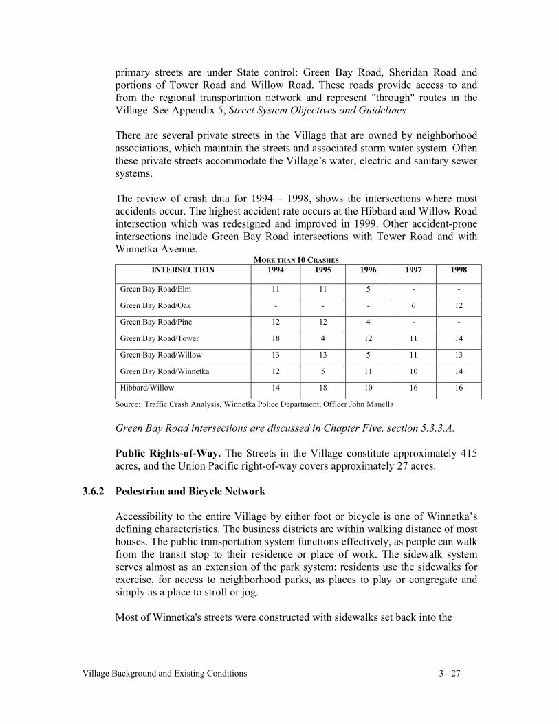
Village Background and Existing Conditions 3 - 27
primary streets are under State control: Green Bay Road, Sheridan Road andportions of Tower Road and Willow Road. These roads provide access to andfrom the regional transportation network and represent "through" routes in theVillage. See Appendix 5, Street System Objectives and Guidelines
There are several private streets in the Village that are owned by neighborhoodassociations, which maintain the streets and associated storm water system. Oftenthese private streets accommodate the Village’s water, electric and sanitary sewersystems.
The review of crash data for 1994 – 1998, shows the intersections where mostaccidents occur. The highest accident rate occurs at the Hibbard and Willow Roadintersection which was redesigned and improved in 1999. Other accident-proneintersections include Green Bay Road intersections with Tower Road and withWinnetka Avenue.
MORE THAN 10 CRASHESINTERSECTION 1994 1995 1996 1997 1998
Green Bay Road/Elm 11 11 5 - -
Green Bay Road/Oak - - - 6 12
Green Bay Road/Pine 12 12 4 - -
Green Bay Road/Tower 18 4 12 11 14
Green Bay Road/Willow 13 13 5 11 13
Green Bay Road/Winnetka 12 5 11 10 14
Hibbard/Willow 14 18 10 16 16
Source: Traffic Crash Analysis, Winnetka Police Department, Officer John Manella
Green Bay Road intersections are discussed in Chapter Five, section 5.3.3.A.
Public Rights-of-Way. The Streets in the Village constitute approximately 415acres, and the Union Pacific right-of-way covers approximately 27 acres.
3.6.2 Pedestrian and Bicycle Network
Accessibility to the entire Village by either foot or bicycle is one of Winnetka’sdefining characteristics. The business districts are within walking distance of mosthouses. The public transportation system functions effectively, as people can walkfrom the transit stop to their residence or place of work. The sidewalk systemserves almost as an extension of the park system: residents use the sidewalks forexercise, for access to neighborhood parks, as places to play or congregate andsimply as a place to stroll or jog.
Most of Winnetka's streets were constructed with sidewalks set back into the

Village Background and Existing Conditions 3 - 28
parkway along at least one side, except for neighborhoods west of Birch and southof Willow, along Pine Street west of Rosewood and on private streets in thewestern and northernmost sections of the Village. Subdivisions constructed in the1950's and later were built at a time when reliance on automobiles increased andproviding a sidewalk system was not a priority.
Winnetka also enjoys the Green Bay Trail pedestrian and bicycle path that runsparallel to the tracks in the railroad right-of-way, with access at a limited numberof locations along the east side of the railroad cut. The land is owned by theVillage and leased by the Park District. While it is primarily used for recreationalpurposes, it also provides a safe and direct pedestrian or bicycle link among thebusiness districts, other communities and New Trier High School.
3.6.3 Public Bus Transit System (PACE)
PACE provides bus service to Winnetka along two routes providing north-southand east-west connections. These two routes, shown on Map 5, Transportation,are within walking distance of a large number of Winnetka residences and provideconnections to all three train stations. The public bus system links Winnetka toother communities, regional shopping malls and the RTA’s “L” service at LindenStreet in Wilmette. It also provides a transportation option among Winnetka'scommercial districts and serves The Skokie School, Washburne Middle School,New Trier High School and North Shore Country Day School.
Average Daily PACE Ridership
3.6.4 Union Pacific Railroad and METRA
The commuter train service is operated by METRA. The tracks and railroad rightof way are owned by Union Pacific.
Winnetka’s convenient access to Chicago via passenger railroad is one of theVillage’s defining elements. Winnetka was a farming community in its early days,but the arrival of the first train in 1854 guaranteed that Winnetka would evolveinto a Chicago-oriented suburb.
Route 1994 1995 1996 1997 1998
213 Green Bay
Weekdays 985 1514 1656 1605 1679
Saturdays 517 714 789 725 733
423 Sheridan
Weekdays 832 746 682 656 646
Saturdays 149 135 132 111 113
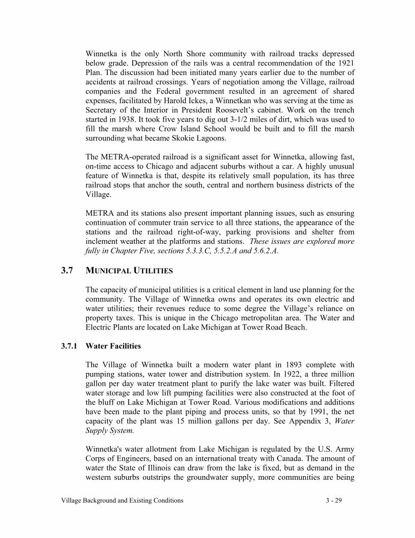
Village Background and Existing Conditions 3 - 29
Winnetka is the only North Shore community with railroad tracks depressedbelow grade. Depression of the rails was a central recommendation of the 1921Plan. The discussion had been initiated many years earlier due to the number ofaccidents at railroad crossings. Years of negotiation among the Village, railroadcompanies and the Federal government resulted in an agreement of sharedexpenses, facilitated by Harold Ickes, a Winnetkan who was serving at the time asSecretary of the Interior in President Roosevelt’s cabinet. Work on the trenchstarted in 1938. It took five years to dig out 3-1/2 miles of dirt, which was used tofill the marsh where Crow Island School would be built and to fill the marshsurrounding what became Skokie Lagoons.
The METRA-operated railroad is a significant asset for Winnetka, allowing fast,on-time access to Chicago and adjacent suburbs without a car. A highly unusualfeature of Winnetka is that, despite its relatively small population, its has threerailroad stops that anchor the south, central and northern business districts of theVillage.
METRA and its stations also present important planning issues, such as ensuringcontinuation of commuter train service to all three stations, the appearance of thestations and the railroad right-of-way, parking provisions and shelter frominclement weather at the platforms and stations. These issues are explored morefully in Chapter Five, sections 5.3.3.C, 5.5.2.A and 5.6.2.A.
3.7 MUNICIPAL UTILITIES
The capacity of municipal utilities is a critical element in land use planning for thecommunity. The Village of Winnetka owns and operates its own electric andwater utilities; their revenues reduce to some degree the Village’s reliance onproperty taxes. This is unique in the Chicago metropolitan area. The Water andElectric Plants are located on Lake Michigan at Tower Road Beach.
3.7.1 Water Facilities
The Village of Winnetka built a modern water plant in 1893 complete withpumping stations, water tower and distribution system. In 1922, a three milliongallon per day water treatment plant to purify the lake water was built. Filteredwater storage and low lift pumping facilities were also constructed at the foot ofthe bluff on Lake Michigan at Tower Road. Various modifications and additionshave been made to the plant piping and process units, so that by 1991, the netcapacity of the plant was 15 million gallons per day. See Appendix 3, WaterSupply System.
Winnetka's water allotment from Lake Michigan is regulated by the U.S. ArmyCorps of Engineers, based on an international treaty with Canada. The amount ofwater the State of Illinois can draw from the lake is fixed, but as demand in thewestern suburbs outstrips the groundwater supply, more communities are being
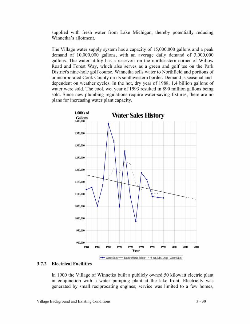
Village Background and Existing Conditions 3 - 30
supplied with fresh water from Lake Michigan, thereby potentially reducingWinnetka’s allotment.
The Village water supply system has a capacity of 15,000,000 gallons and a peakdemand of 10,000,000 gallons, with an average daily demand of 3,000,000gallons. The water utility has a reservoir on the northeastern corner of WillowRoad and Forest Way, which also serves as a green and golf tee on the ParkDistrict's nine-hole golf course. Winnetka sells water to Northfield and portions ofunincorporated Cook County on its southwestern border. Demand is seasonal anddependent on weather cycles. In the hot, dry year of 1988, 1.4 billion gallons ofwater were sold. The cool, wet year of 1993 resulted in 890 million gallons beingsold. Since new plumbing regulations require water-saving fixtures, there are noplans for increasing water plant capacity.
3.7.2 Electrical Facilities
In 1900 the Village of Winnetka built a publicly owned 50 kilowatt electric plantin conjunction with a water pumping plant at the lake front. Electricity wasgenerated by small reciprocating engines; service was limited to a few homes,
Water Sales History
900,000
950,000
1,000,000
1,050,000
1,100,000
1,150,000
1,200,000
1,250,000
1,300,000
1,350,000
1,400,000
1984 1986 1988 1990 1992 1994 1996 1998 2000 2002 2004Year
1,000's of Gallons
Water Sales Linear (Water Sales) 5 per. Mov. Avg. (Water Sales)
Village Background and Existing Conditions 3 - 31
commercial uses and street lighting. The electric plant has experienced a gradualbut steady evolution over the years until it has become a modern steam and dieselinstallation. In 1998, the capacity of Winnetka's electric plant was demonstratedto be 31,249 kilowatts. See Appendix 4, Electric Supply System.
Electricity generated by the electric plant is transmitted by underground cablesfrom the plant to various load centers. The electric utility connects to the regionalpower system at a substation on Happ Road in Northfield and at the Glencoewater tower near the Edens Expressway and Tower Road. A distribution station islocated west of West Elm Street Park. Except in portions of Winnetka where theelectric distribution system is underground, overhead wires transmit electricity toall parts of the Village and to a few customers in the Indian Hill and Woodley
Road area located outside Village corporate limits. The entire electricaldistribution system is owned and maintained by the Village of Winnetka. Theremay be future opportunities to extend this system beyond its current boundary.
As a member of the Illinois Municipal Electric Agency (IMEA), the Villagepurchases its electric power from this not-for-profit consortium of municipalgovernments. IMEA’s primary purpose is to provide municipally operated electricutilities with their wholesale power needs. Contractually, IMEA is required tosupply 100% of the Village's electric needs until March 2006, but the Villagereceives substantial credits for keeping its power plant operable to supplement theIMEA power supply at times of peak demand. If necessary, the Village cangenerate enough power to meet Village demand on all but the very hottest days ofthe year.
kWH Sales
70,000,000
75,000,000
80,000,000
85,000,000
90,000,000
95,000,000
100,000,000
105,000,000
110,000,000
115,000,000
120,000,000
1985 1987 1989 1991 1993 1995 1997 1999 2001 2003 2005
Year
Sale
s
High Projection
Low Projection
Village Background and Existing Conditions 3 - 32
There are increasing demands for electricity in the Village. Older, smaller housesare being expanded or replaced with much larger ones that have full air-conditioning, more lighting and outlets to service household and technologyneeds. Businesses and institutions are undergoing similar changes. Total demandhas increased approximately 18% over the last 10 years, and is expected toincrease by at least 1.5% per year into the foreseeable future.
Increased competition resulting from the deregulation of electric utilities in theyear 2006 is likely to result in lower power prices. The Village prepared a 10-Year Strategic Plan in 1997 to compete in the era of deregulation and continues toevaluate its options in light of changing technology.
3.7.3 Sewer Systems
In Winnetka, the system for collection and treatment of sanitary sewage isseparate from the collection system for storm water. Sanitary sewage isdischarged from the Village system into the large intercepting sewers of theMetropolitan Water Reclamation District of Greater Chicago (MWRDGC) andcarried to the Northside Sewage Treatment Plant outside Winnetka’s corporatelimits. Storm water is discharged either east into Lake Michigan or west into theSkokie River. However, an area west of the railroad tracks along the Green Baycorridor discharges storm water into an MWRDGC interceptor sewer.
Sanitary sewers: The Winnetka sanitary sewer system is relatively old; amajority of its sewer lines have been in place for over fifty years. The majorproblems are those of infiltration and inflow. Infiltration occurs when groundwater enters defective sanitary sewer lines and manholes. Inflow occurs whenrainwater runoff enters the sanitary sewer system directly through the streets,gutters and sump pumps or cross connections between sanitary and storm sewers.
In the 1990’s, the Village rehabilitated the sanitary sewer system to reduceinfiltration and storm water inflow, to improve overall water quality and to reducethe frequency of basement backups and associated health risks from exposure towaste water. Ongoing monitoring and maintenance activities continue to improvethe condition of the sanitary sewer system, making incidents of basement floodingrelating to the Village’s sewer system infrequent.
Storm sewers: The natural divide for drainage in Winnetka roughly parallels theshore of Lake Michigan, west of the Union Pacific Railroad. The area east of thedivide drains to the lake; the area west drains to the Skokie River.
The topography of the east area has sufficient difference in elevation between theland and the lake level to afford ample grades and depths for storm sewers. Due tolimited sewer capacities, some portions of the east area experience temporaryponding of water on the streets during periods of heavy storms.
Village Background and Existing Conditions 3 - 33
Over time, additional land fill has slightly raised the grade of the original swamparea in the western area of Winnetka, however, the low-lying character of the landdoes not allow enough of a drop in elevation for storm sewers to naturally drain tothe Skokie River. The storm sewer system built in the 1940's and 1950's did nothave sufficient gradient or capacity. During periods of heavy storms, storm seweroutlet valves at the Skokie River closed to prevent rising river water from flowinginto the Winnetka system. This also prevented storm water from emptying intothe river.
Significant capital projects in the 1990's, including two pumping stations plus theuse of Duke Childs Field as a temporary detention area, have improved the area’sdrainage, but the system still has limitations. In heavy rain, some portions of thewest area may still experience temporary ponding of water on the streets and inyards. Some basement flooding may also occur.
Impermeable surfaces: In an effort to reduce potential overland runoff and limitthe volume of the initial rush of storm water, the Winnetka Zoning ordinancecontains maximum lot coverage provisions that apply to buildings, roofed areasand other impermeable surfaces. In addition, the Village Code places strictrequirements upon drainage and control of surface water runoff generated bydevelopment, including retention areas for lots in the flood plain.
3.8 DEMOGRAPHIC ANALYSIS
It is helpful to compare Winnetka to its neighboring villages over the last twodecades in order to see whether Winnetka is experiencing trends based onregional or local conditions. Along with its neighbors, Winnetka is a highly-educated, affluent community that reached substantial build out in the 1920’s. Thepopulation has fluctuated only modestly since. Winnetka and most of itsneighbors rely substantially on their residential real estate tax base to fund publicexpenditures.
3.8.1 Population and Housing Units
Winnetka's population has been relatively constant since 1930, when it reached12,166. Its population peaked at 14,131 in 1970. Since then, Winnetka'spopulation declined to 12,772 in 1980 and to 12,174 in 1990, very close to its1930 level. Glencoe, Kenilworth and Wilmette have also experienced the samedecline in population. While Northfield experienced a substantial population gainbetween 1970 and 1980, its population also declined substantially between 1980and 1990.
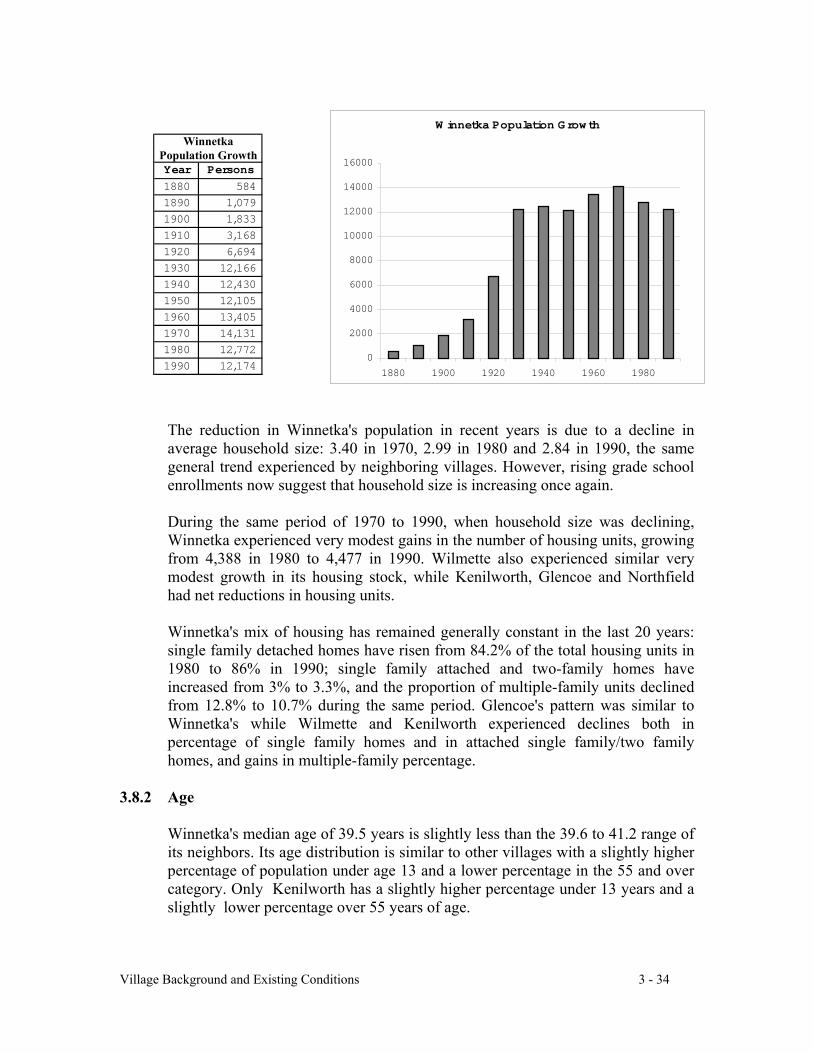
Village Background and Existing Conditions 3 - 34
The reduction in Winnetka's population in recent years is due to a decline inaverage household size: 3.40 in 1970, 2.99 in 1980 and 2.84 in 1990, the samegeneral trend experienced by neighboring villages. However, rising grade schoolenrollments now suggest that household size is increasing once again.
During the same period of 1970 to 1990, when household size was declining,Winnetka experienced very modest gains in the number of housing units, growingfrom 4,388 in 1980 to 4,477 in 1990. Wilmette also experienced similar verymodest growth in its housing stock, while Kenilworth, Glencoe and Northfieldhad net reductions in housing units.
Winnetka's mix of housing has remained generally constant in the last 20 years:single family detached homes have risen from 84.2% of the total housing units in1980 to 86% in 1990; single family attached and two-family homes haveincreased from 3% to 3.3%, and the proportion of multiple-family units declinedfrom 12.8% to 10.7% during the same period. Glencoe's pattern was similar toWinnetka's while Wilmette and Kenilworth experienced declines both inpercentage of single family homes and in attached single family/two familyhomes, and gains in multiple-family percentage.
3.8.2 Age
Winnetka's median age of 39.5 years is slightly less than the 39.6 to 41.2 range ofits neighbors. Its age distribution is similar to other villages with a slightly higherpercentage of population under age 13 and a lower percentage in the 55 and overcategory. Only Kenilworth has a slightly higher percentage under 13 years and aslightly lower percentage over 55 years of age.
Year Persons
1880 584
1890 1,079
1900 1,833
1910 3,168
1920 6,694
1930 12,166
1940 12,430
1950 12,105
1960 13,405
1970 14,131
1980 12,772
1990 12,174
WinnetkaPopulation Growth
W innetka Population Grow th
0
2000
4000
6000
8000
10000
12000
14000
16000
1880 1900 1920 1940 1960 1980
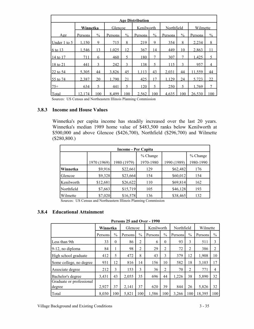
Village Background and Existing Conditions 3 - 35
3.8.3 Income and House Values
Winnetka's per capita income has steadily increased over the last 20 years.Winnetka's median 1989 home value of $483,500 ranks below Kenilworth at$500,000 and above Glencoe ($426,700), Northfield ($296,700) and Wilmette($280,800.)
3.8.4 Educational Attainment
Winnetka Glencoe Kenilworth Northfield Wilmette
Persons % Persons % Persons % Persons % Persons %
Under 1 to 5 1,150 9 715 8 219 9 354 8 2,234 8
6 to 13 1,546 13 1,025 12 367 14 449 10 2,863 11
14 to 17 711 6 460 5 180 7 307 7 1,425 5
18 to 21 441 3 242 3 138 5 115 3 957 4
22 to 54 5,305 44 3,826 45 1,113 43 2,031 44 11,559 44
55 to 74 2,387 20 1,790 21 425 17 1,129 24 5,723 22
75+ 634 5 441 5 120 5 250 5 1,769 7
Total 12,174 100 8,499 100 2,562 100 4,635 100 26,530 100Sources: US Census and Northeastern Illinois Planning Commission
Age Distribution
Age
Persons % Persons % Persons % Persons % Persons %
Less than 9th 33 0 86 2 6 0 93 3 511 3
9-12, no diploma 84 1 98 2 29 2 72 2 386 2
High school graduate 412 5 472 8 43 3 379 12 1,908 10
Some college, no degree 931 12 816 14 156 10 582 18 3,103 17
Associate degree 212 3 153 3 36 2 70 2 771 4
Bachelor's degree 3,431 43 2,055 35 696 44 1,226 38 5,890 32Graduate or professional degree 2,927 37 2,141 37 620 39 844 26 5,826 32
Total 8,030 100 5,821 100 1,586 100 3,266 100 18,395 100
Northfield WilmettePersons 25 and Over - 1990
Winnetka Glencoe Kenilworth
% Change % Change1970 (1969) 1980 (1979) 1970-1980 1990 (1989) 1980-1990
Winnetka $9,916 $22,661 129 $62,482 176Glencoe $9,328 $23,664 154 $60,012 154Kenilworth $12,681 $26,622 110 $69,814 162Northfield $7,663 $15,719 105 $46,128 193Wilmette $7,020 $16,578 136 $38,465 132Sources: US Census and Northeastern Illinois Planning Commission
Income - Per Capita
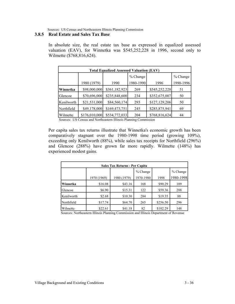
Village Background and Existing Conditions 3 - 36
Sources: US Census and Northeastern Illinois Planning Commission3.8.5 Real Estate and Sales Tax Base
In absolute size, the real estate tax base as expressed in equalized assessedvaluation (EAV), for Winnetka was $545,252,228 in 1996, second only toWilmette ($768,816,624).
Per capita sales tax returns illustrate that Winnetka's economic growth has beencomparatively stagnant over the 1980-1998 time period (growing 109%),exceeding only Kenilworth (88%), while sales tax receipts for Northfield (296%)and Glencoe (288%) have grown far more rapidly. Wilmette (148%) hasexperienced modest gains.
Sources: Northeastern Illinois Planning Commission and Illinois Department of Revenue
% Change % Change
1980 (1979) 1990 1980-1990 1996 1990-1996
Winnetka $98,000,000 $361,182,923 269 $545,252,228 51
Glencoe $70,696,000 $235,848,600 234 $352,675,007 50
Kenilworth $21,531,000 $84,560,174 293 $127,129,206 50
Northfield $49,178,000 $169,473,751 245 $285,875,941 69
Wilmette $176,010,000 $534,772,033 204 $768,816,624 44Sources: US Census and Northeastern Illinois Planning Commission
Total Equalized Assessed Valuation (EAV)
% Change % Change
1970 (1969) 1980 (1979) 1970-1980 1998 1980-1998Winnetka $16.08 $43.16 168 $90.29 109
Glencoe $6.90 $15.31 122 $59.36 288
Kenilworth $2.68 $10.30 284 $19.35 88
Northfield $17.74 $64.70 265 $256.50 296
Wilmette $22.61 $41.18 82 $102.29 148
Sales Tax Returns - Per Capita
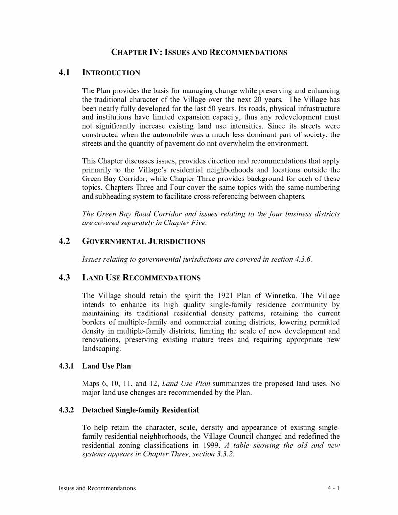
Issues and Recommendations 4 - 1
CHAPTER IV: ISSUES AND RECOMMENDATIONS
4.1 INTRODUCTION
The Plan provides the basis for managing change while preserving and enhancingthe traditional character of the Village over the next 20 years. The Village hasbeen nearly fully developed for the last 50 years. Its roads, physical infrastructureand institutions have limited expansion capacity, thus any redevelopment mustnot significantly increase existing land use intensities. Since its streets wereconstructed when the automobile was a much less dominant part of society, thestreets and the quantity of pavement do not overwhelm the environment.
This Chapter discusses issues, provides direction and recommendations that applyprimarily to the Village’s residential neighborhoods and locations outside theGreen Bay Corridor, while Chapter Three provides background for each of thesetopics. Chapters Three and Four cover the same topics with the same numberingand subheading system to facilitate cross-referencing between chapters.
The Green Bay Road Corridor and issues relating to the four business districtsare covered separately in Chapter Five.
4.2 GOVERNMENTAL JURISDICTIONS
Issues relating to governmental jurisdictions are covered in section 4.3.6.
4.3 LAND USE RECOMMENDATIONS
The Village should retain the spirit the 1921 Plan of Winnetka. The Villageintends to enhance its high quality single-family residence community bymaintaining its traditional residential density patterns, retaining the currentborders of multiple-family and commercial zoning districts, lowering permitteddensity in multiple-family districts, limiting the scale of new development andrenovations, preserving existing mature trees and requiring appropriate newlandscaping.
4.3.1 Land Use Plan
Maps 6, 10, 11, and 12, Land Use Plan summarizes the proposed land uses. Nomajor land use changes are recommended by the Plan.
4.3.2 Detached Single-family Residential
To help retain the character, scale, density and appearance of existing single-family residential neighborhoods, the Village Council changed and redefined theresidential zoning classifications in 1999. A table showing the old and newsystems appears in Chapter Three, section 3.3.2.
Issues and Recommendations 4 - 2
The demolition of older houses, particularly in the R-5 (former one-sixth acre)and R-4 (former one-quarter acre) zoning districts, concerns many Winnetkansbecause replacement houses generally do not reflect the historic character of theVillage. The height and bulk of new construction block light and air fromneighboring houses and are generally incompatible with the scale of olderneighborhoods.
The problem stems from the desire to build large houses on lots that aren’t largeenough to support them. This issue is explored further in section 4.4.1 of thisChapter.
Monitor the effect of the zoning ordinance on preserving neighborhoodcharacter.
4.3.3 Multiple-Family Residential
The purpose of multiple-family zoning districts is to buffer single-familyneighborhoods from commercial areas and the traffic noise of Green Bay Roadand the railroad. In theory, multiple-family development should provide a“transition” that is compatible with adjacent single-family use.
New development, particularly with higher-density multiple family buildings, canoverburden existing infrastructure and public services. This places a financialburden on the Village and other local entities when new tax revenues generatedby the development are insufficient to cover the cost of public improvements andadditional services for the development.
Multiple-family residential buildings provide homes for older residents and thosewith modest incomes. Rental units provide an important element of diversity inhousing options. Only limited new multiple-family development is anticipated,either as a component of a mixed use building within a business district or alongselected portions of Green Bay Road.
Encourage designs for multiple-family developments that provide a variety ofhousing for residents of all ages.
Consider impact fees for new replacement housing that places an additionalburden on public services: infrastructure, schools, parks, etc. Impact feesshould not be extended to renovations since the Village would like toencourage improvement of existing housing stock.
Require development to be appropriate to the character of its surroundings;the development should interface with its surrounding neighborhood, ratherthan exist as an isolated complex. The architectural design of multiple-familybuildings is of vital importance in maintaining the character of the Village.New multiple-family development should be designed to complement the
Issues and Recommendations 4 - 3
historic character of the Village, constructed of high quality materials,providing below-grade parking.
Create design standards that would assist the Design Review Board inevaluating project proposals for commercial, institutional and multiple-familybuildings. Design standards should be consistent with the analysis ofWinnetka’s architectural character described in section 5.3.1.D of ChapterFive and Community Goals and Objectives sections 2.2 and 2.3 in ChapterTwo.
Require that new multiple-family developments outside of the businessdistricts provide extensive landscaping as part of the overall design.Landscaping should reflect the mature character of landscaping in the Village.Landscaping buffers are preferable to fences.
Provide, where possible, open space (whether public, quasi-public or private)between low-density and high-density land uses.
Limit and screen surface parking. It should be well screened from both thepublic right-of-way and adjacent single-family neighborhoods.
B-1 zoning district. The district includes both attached single-familydevelopments (townhouses) and apartment buildings. These uses are too disparatefor one zoning district. Townhouses are built at a density of 8 to 10 units per acre,less than half the current density of the B-1 district, which allows between 18 and24 units per acre. Parking requirements may be quite different, as townhousesmay have individual driveways or garages, whereas an apartment building willhave a common parking area.
As land use buffers between commercial and single-family neighborhoods,townhouses may be preferred over apartment-style buildings due to their lowerdensity, increased articulation and reduced bulk, all of which better support the B-1 district purpose.
Townhouses may be especially desirable along Green Bay Road south ofWinnetka Avenue in the Indian Hill Business District.
Townhouses may also be desirable along the west side of Green Bay Road (northof The Mews condominiums and south of Chatfield Road), which is alreadyzoned B-1. Currently, a number of single-family houses are located in this B-1district, which marks the transition from the heavily traveled Green Bay Road tothe single-family neighborhood to the west. This area may be redeveloped overthe life of this Plan.
Study whether the B-1 zoning district should be split into separate districts:apartment buildings and townhouses and, if so, how the existing B-1 zones
Issues and Recommendations 4 - 4
should be redesignated, for example, should existing townhouse developmentsbe consistently re-zoned as townhouse-only zones.
Study whether the existing B-1 district on Green Bay Road, north of TheMews condominiums and south of Chatfield Road, would be better served bylow-density apartment-style buildings or by townhouse development.
Retain the B-1 designation where existing B-1 parcels provide transitionalbuffers between commercial districts and single-family neighborhoods.
Maintain the 2-½ story limit on B-1 buildings.
B-2 zoning district. The B-2 zoning district allows too much density for a smallsuburban village. Although no vacant or underdeveloped property exists in the B-2 district, re-zoning requests for B-2 designation remain possible.
Develop an appropriate district purpose and standards for the B-2 zoningdistrict so that the district provides an effective transition between single-family and commercial districts, or eliminate the B-2 designation and create aB-2 overlay district that is folded into the current B-1 designation.
Maintain the 2-½ story limit on B-2 buildings.
Assisted-care living. Currently, the Village has no such facility and residentsrequiring care must move out of town. Similarly, Winnetka residents who wouldlike to have aging relatives close by cannot place them in the Village.
Study the possibility of bringing to Winnetka an assisted-care facility forsenior citizens.
4.3.4 Commercial (Retail, Office, Mixed Use)
Commercial development issues are addressed in Chapter Five within eachbusiness district section.
Ensure that there is an appropriate transition to buffer single-familyneighborhoods from commercial districts.
Minimize the potential adverse impact of commercial activity upon residentialneighborhoods.
Maintain the 2-½ story limit on commercial buildings.
Create design standards that would assist the Design Review Board inevaluating project proposals for commercial, institutional or multiple-familybuildings. Design standards should be consistent with the analysis of
Issues and Recommendations 4 - 5
Winnetka’s architectural character described in section 5.3.1.D and CommunityGoals and Objectives in sections 2.2 and 2.3 of Chapter Two.
4.3.5 Industrial
The “D” district in Hubbard Woods functions as part of the C-2 District. So longas the “D” designation remains, proposals incompatible with current retail andresidential uses are possible. In the Village-owned portion of the "D" district,there are underground diesel fuel storage tanks that are connected to the ElectricPlant by pipeline. This is a permitted use in the "D" District, but not in the C-2District. If the Village were to eliminate the entire "D" District, the tanks couldnot be replaced.
Maintain the “D” industrial designation for Village-owned property only.
4.3.6 Public and Semi-Public
Map 3, Public/Semi-Public and Open Space, shows the public and semi-publicinstitutional properties in the Village. The map illustrates that this socialinfrastructure, developed over the life of the community, is conveniently locatedin residential neighborhoods, that each facility is surrounded by developedresidential properties and that there is little or no room to expand.
Traffic and Parking. Winnetka’s institutions were established primarily to servethe local community. Institutional buildings were constructed in residentialneighborhoods before increased reliance on the automobile and therefore haveinsufficient space for parking or automobile pick-up and drop-off.
Due to the growth of their missions and constituencies, many of these institutionsnow attract a large number of non-residents. The increased activity generated byfacilities in or near residential neighborhoods attracts traffic and parkingcongestion to otherwise quiet neighborhoods.
Encourage governmental and non-governmental institutions to work with theirconstituents, neighbors and the Village to minimize the impact of traffic andparking on the surrounding residential streets and to develop on-site solutionswhere appropriate.
Ensure that proposals don't have an adverse impact on the residential characterof the surrounding residential neighborhoods.
Facility Expansion, Open Space and Institutional Uses. As with schools,institutional buildings generally greatly exceed the floor area ratio requirements ofthe single family districts in which they are located, creating zoning non-conformities and making the possibility for future expansion problematic.

Issues and Recommendations 4 - 6
Currently, all institutional and governmental uses are evaluated under a specialuse permit process that requires Village boards to review permit requests basedupon the institution’s unique circumstances. This works quite well since most ofthese uses pre-date the Zoning Ordinance and many are located in single familyneighborhoods, where the impact of institutional programs can be significant,particularly as it relates to parking and traffic.
Re-evaluate for effectiveness how residential bulk standards are applied toinstitutional buildings within the special use permit process.
Evaluate for adequacy the special use permit standards as they apply to openspace and institutional properties. Strengthen the standards by which parkingand traffic issues are evaluated.
Consider preserving open space by building underground if additionalinstitutional capacity is needed and if drainage conditions allow.
A. Village of Winnetka
Naturalize the landscaping of the landfill on Willow Road.
Ensure that the design of public infrastructure such as bridges, streetscapesand public buildings conforms to the high standards the Village sets forprivate development.
Require proper maintenance of public properties. Maintenance should keeppublic lands and infrastructure functioning well and strive for anappearance that reflects the high standards met by private property owners.Special attention should be paid to sidewalks, trails, pedestrian tunnels,bridges and street rights-of-way.
Rehabilitate the substantially deteriorated and outdated Villagemaintenance facility at the Village Yards on Willow Road.
B. Public Schools
New Trier Township High School District #203
The East Campus on Winnetka Avenue east of Green Bay Road is expected tomaintain high attendance levels no matter how the West Campus in Northfieldis used. A factor affecting any discussion of New Trier is the proximity of twoelementary schools, Greeley and Sears, and the impact that the three schools’traffic patterns have on each other.
Because New Trier High School has such a significant effect on the IndianHill District, discussion of New Trier issues appears in Chapter Five, section5.8.
Issues and Recommendations 4 - 7
Winnetka Elementary School District 36
Facility expansion: The elementary schools are operating at the limit of theirbuilding capacity. Hubbard Woods and Greeley Elementary Schools have fewoptions for future expansion. Additional building will encroach into theiralready small playground areas. Creating permanent space for peak enrollmentresults in excess capacity when enrollment declines. Given these factors, theVillage should:
Consider impact fees as discussed in section 4.4.1.
Cooperate with the School District in planning for periods of high studentenrollment.
Support the Village's commitment to high quality education.
Traffic and Parking: When the neighborhood schools were built prior to1940, little provision was made for automobile drop-off and pick-up or forvisitor parking. Now that many families drive their children to school andschool staffing requirements have increased, traffic and parking demand affectsurrounding residential streets. Difficulties will increase as school enrollmentrises.
Encourage schools to work with the Village, neighborhoods, parents andstudents to reduce parking and traffic problems.
Encourage alternatives to individual families driving to school.
C. Winnetka-Northfield Public Library District
Facility location/capacity: The Winnetka Library is centrally located and acritical anchor for the West Elm Business District. However, the building haslittle space to expand its facilities on the current property: for every volume itadds to its collection, it must discard another. Technology is rapidly changing,making it unclear what the space needs of the "library of tomorrow" will be.
Encourage the Library District to maintain a convenient central location.
Consider the Library District's needs when evaluating any major centralbusiness district redevelopment.
Consider converting to library space other appropriate institutionalproperty that might become available.
Parking: The parking lot is frequently full and the on-street parking supplyaround the Library is limited. The small site provides no additional room forparking.
Issues and Recommendations 4 - 8
Include the District in any planning for below-grade parking under StationPark or any other project in close proximity to the Library. Such parkingmight include an underground corridor connected to the Library.
D. Winnetka Park District and Open Space
Balance between providing recreational opportunities for Villageresidents and impact on the neighborhood: Over the years, the WinnetkaPark District has responded to residents’ requests for additional sports andrecreation programs for adults and children. The increasing demand forfacilities and programming is exacerbated by the current demographicupswing noted in the schools section. The Park District had used vacant spacein The Skokie School for its offices and recreational facilities, but wasrequired to move when the Winnetka School District reclaimed the space forthe expanding elementary school population. As a result, the Park Districtproposed building additional facilities on the Skokie Playfields.
Changes that intensify the use of Skokie Playfields, including noise, trafficcongestion, bright lighting for nighttime use, extended periods of operationand additional impermeable surface, adversely affect the quality of life forsurrounding residents.
The two Park District facilities that currently generate the most traffic, theSkokie Playfields and Nick Corwin Park, cannot handle peak weekendparking demand on-site, causing significant on-street parking and trafficcongestion in the surrounding residential neighborhoods.
Cooperate with the Winnetka Park District in achieving the District’s goalof providing Village residents with high quality recreational programs andopen space.
Work with the Park District to minimize the impact of existing programson adjacent neighborhoods.
Coordinate planning for any new facilities and programs to balancerecreational needs of the community with the residential character of thesurrounding neighborhood.
Ensure that street and parking infrastructure are adequate and that otherancillary effects such as artificial lighting, noise and water run-off are heldto acceptable levels.
Traffic and Parking: District facilities were constructed before today'sincreased reliance on the automobile and before District programs became sopopular with nonresidents. Increased traffic and parking demand haveresulted.
Issues and Recommendations 4 - 9
Ensure that the recommendations outlined in section 4.3.6 are followed.
Acquisition of open space or additional parkland: While parks are spreadthroughout the Village, some areas are inadequately served. The 1935 Plannoted that “additional play space to keep the children off the street” would bedesirable in the areas with a high concentration of small lots. Other parcelsthat are used as open space currently rest in private hands, making futuredevelopment a possibility.
Cooperate with the Park District to acquire additional properties,especially in the following locations, only if they become available:
1. The southwest corner of Oak and Linden (at the bend in Green BayRoad, currently used for community notices).
2. Any portion of the North Shore Country Day School campus.
3. The east side of Sheridan Road, between Centennial and Elder parks.
4. The southeast corner of Green Bay Road and Winnetka Avenue.
5. The west side of Birch between Oak and Elm Streets.
6. The northeast corner of Spruce and Birch Streets.
7. Corner lot parcels for pocket parks in the densely developedneighborhoods.
8. Any other substantial portion of property that might become available,particularly along the lake.
Private Open Space easements:
Create a voluntary open space, conservation and scenic easement programfor property owners who wish to retain private ownership, but would liketo guarantee that portions of their property remain as open space inperpetuity.
E. Non-Governmental Public Institutions
Recommendations are discussed at the beginning of section 4.3.6
The Winnetka Community House is discussed in Chapter Five, East ElmBusiness District, section 5.7.2.A.
Help the Winnetka Historical Society in its efforts to find a permanenthome.
Issues and Recommendations 4 - 10
4.3.7 Cook County Forest Preserve District
Proliferation of non-native plants: Non-native weed species such as buckthornand garlic mustard thrive at the expense of indigenous plant species. Theaggressive invasion of buckthorn has destroyed the natural diet for deer, forcingthem into private yards in search of food.
Encourage the Forest Preserve District to implement a comprehensive naturalplant restoration program.
Encourage the Chicago Botanical Garden to work with the Forest PreserveDistrict in managing the Skokie Lagoons area.
Western approaches to the Village: The entrances to Winnetka on Tower andWillow Road at Forest Way need substantial physical and aesthetic improvement.The road shoulders, although heavily used by bikers and for parking, are not welldefined, generally consisting of scattered gravel, dirt or mud.
Request cooperation from the Cook County Forest Preserve District inenhancing the landscape design at the entrances to the Village at the ForestWay intersections of Tower and Willow Roads.
Enhance the natural appearance of the public right-of-way through ForestPreserve property at the western edge of the Village.
Encourage the Forest Preserve to build a bike path along Forest Way betweenWillow and Tower to complete the circuit around the Skokie Lagoons.
4.3.8 Unincorporated Cook County and Split Lots
Contractual Service to Unincorporated properties: The Village providespolice, fire, paramedic and/or utility service on a fee basis to many unincorporatedproperties to the south of the Village. See Map 4, Municipal Services BeyondVillage Boundary.
Ensure that the fee structure for non-resident services covers the cost of theservice. Winnetka residents should not subsidize these services.
Ensure that additional services do not overburden Village capacity.
Potential for requests for annexation: These unincorporated areas currentlyenjoy their status of being unattached to a municipality, with the freedom ofcontracting for public services. However, circumstances may change, encouragingsome property owners to open annexation discussions with the Village.
If Winnetka is approached by residents of unincorporated areas for annexation, amajor consideration is the ability of the Village to supply utilities in the near term
Issues and Recommendations 4 - 11
and long term. It appears that the present capacity of the Village infrastructure andemergency services could handle current development in the areas it is presentlyserving. However, there are issues to be considered:
Assess the condition of street and utility infrastructure in area of possibleannexation.
Assess the potential for subdivision in this area and additional pressure itwould place on existing infrastructure.
Village of Glencoe: Winnetka has not reached an agreement with Glencoe aboutadjusting the corporate boundaries on Scott Street so that the residential lots onthe north side are entirely within one village. The current split-lot status of theseproperties needs resolution so that one municipality provides necessary municipalservices and receives the full real estate tax payments to support those services.See Map 4, Municipal Service Beyond Village Boundary.
Find a solution that either adjusts the municipal boundaries or addresses thefinancial inequity of the split lots.
4.3.9 Infrastructure: Transportation, Utilities, Storm and Sanitary Sewers
See transportation discussion in section 4.7, Utilities and Sewer discussion insection 4.8 and Green Bay Road Corridor transportation discussion in ChapterFive, section 5.3.3.A.
4.4 VILLAGE CHARACTER
4.4.1 Teardowns and Changing Neighborhood Character
Construction of replacement houses is likely to continue where it is moreeconomical than the extensive renovation of small, outmoded houses. But thedemolition of older houses, particularly in the R-5 (formerly titled “one-sixthacre”) and R-4 (formerly “one-quarter acre”) zoning districts, concerns manyWinnetkans because replacement houses often fail to reflect the historic characterof the Village. The height and bulk of some new construction often blocks lightand air from neighboring houses and is incompatible with the scale of olderneighborhoods. Since residents have stated that they like the character of theVillage, the goal should be to retain the scale, density and overall appearance ofexisting single-family residential neighborhoods.
Encourage new construction and additions that are sensitive to neighborhoodcharacter and that follow good design principles.
Ensure that new construction and additions respect the scale of neighboringhouses, as well as setbacks, public parkways, open spaces, trees and thepedestrian orientation of the neighborhoods.
Issues and Recommendations 4 - 12
Encourage appropriate landscaping for new residential development.
Consider impact fees for new replacement housing that places an additionalburden on public services: infrastructure, schools, parks, etc. Impact feesshould not be extended to renovations since the Village would like toencourage improvement of existing housing stock.
Character of neighborhood streets: The street frontage is an important elementof Winnetka neighborhoods, where the harmony of house facades andneighborhood use of the public parkways foster a sense of community that is animportant characteristic of the Village.
Retain the integrity of front yards by placing automobile uses to the rear ofhouses or lots where possible. Discourage front-loaded attached garages thatoverwhelm the front façade.
Encourage porches and architectural features that promote use of the front ofthe house and informal interaction among neighbors.
Provide sidewalks along at least one side of public streets to enhance safetywhile walking around the neighborhood and to other parts of the Village.
Reduce on-street parking along narrow streets within residentialneighborhoods.
Maintain existing street widths, which allow reasonable traffic movementwithout endangering pedestrians or reducing green space.
Create streetscape guidelines for residential neighborhoods as a part of aVillage-wide beautification effort.
Zoning and Subdivision Ordinances regulating bulk and density: The Villagehas made comprehensive changes to the residential portions of its Zoning andSubdivision Ordinances to reflect the community’s desire for up-to-date, well-maintained housing that blends with the historic scale and character of theneighborhood. However, Winnetka’s efforts to control overbuilding in a fully-developed community require a new generation of zoning regulation that is justemerging. The full array and impact of regulations designed to retain the characterof older communities has not yet fully evolved.
Ensure that the zoning and subdivision regulations fulfill the goals andobjectives outlined in Chapter Two.
Monitor the impact of the zoning and subdivision regulations to ensure theycontrol overbuilding without causing unintended architectural design orcausing improvements in existing Winnetka housing stock to beuneconomical.
Issues and Recommendations 4 - 13
Assess the impact of the new ordinances on encouraging renovation orrehabilitation over new construction.
Keep abreast of zoning innovations in similar communities across the country.
Impermeable surfaces: See section 4.7.3 on storm water management.
Property Maintenance: High quality maintenance of residential properties hasbeen an important feature of the Village, sustaining housing values and the qualityof life.
Encourage a high percentage of owner-occupied housing.
Create regulations that address derelict properties.
4.4.2 Historic Preservation
Recognize the role of the Village’s historic architecture in definingWinnetka’s unique residential character and encourage its preservation.
Promote historic preservation as a contributor to the quality and character ofthe Village by encouraging the study and inventory of existing houses andcommercial buildings that define Village character.
Support the Landmark Commission’s work in public education, in research, inrecommending landmarks and in providing technical assistance for renovatingolder properties.
Investigate methods of promoting the restoration or rehabilitation oflandmark-eligible properties -- residential and commercial -- including waysto help property owners qualify for financial incentives.
Incorporate historic preservation as a standard component of all elements ofVillage planning.
4.4.3 General Appearance and Landscaping
Design principles help define the character of a community and contribute to itsaesthetics. This Comprehensive Plan has incorporated certain principles into itsrecommendations, including:
- aesthetically defining the Village’s entrances ;- enhancing the Village’s distinctive identity;- providing focal points in strategic locations;- using public architecture to define public spaces;- emphasizing the quality of building materials;
Issues and Recommendations 4 - 14
- landscaping along the borders of zoning districts as an alternative to walls andfences; and
- implementing streetscape improvements.
Beautification Committee: The new Village Beautification Committee shouldprepare a comprehensive strategy for improving the general appearance of thepublic ways and spaces, with emphasis on improving neglected areas.
Chapter Five discusses beautification of the Green Bay Corridor and its BusinessDistricts.
Create a strategic plan for landscaping and other aesthetic improvements forpublic ways and spaces throughout the Village.
Include improvements of the Forest Way intersections at both Tower Roadand Willow Road, as well as along the north side of Willow Road, whichborders of Duke Childs Field.
Study ways to minimize regulatory signs.
Choose new light fixtures that are compatible with Village character.
Funding:
Create a vehicle to encourage gifts and charitable contributions for publicbeautification projects or to acquire property for public use.
Landscaping:
Support the Design Review Board’s focus on high quality landscaping incommercial and multiple-family developments.
Promote high quality landscaping as part of the planning of new orsubstantially rehabbed residences.
Encourage planting buffers as alternatives to fences.
Improve the appearance of dead-end streets at the Lake front
Light pollution:
Reduce light pollution. Balance the need for safety against the communitydesire for a low level of outdoor lighting.
Prevent lighting from commercial and multiple-family buildings or the publicright-of-way from negatively affecting residences.
Issues and Recommendations 4 - 15
Shield light glare and bulbs in parking garages and ramps from external view.
Seek alternatives to the orange-hued sodium vapor lights; find a hue as closeto white incandescent as possible.
Visual pollution:
Minimize the visual impact of communications antennae and other visualpollution when building infrastructure for new technology.
Avoid unsightly appurtenances to multiple-family and commercial buildings;require mechanical housing to be hidden by appropriate architectural featuresor landscaping.
4.5 ENVIRONMENTAL CONDITIONS
4.5.1 Lake Michigan Bluffs and Ravines
Erosion: Maintaining the integrity of bluffs and ravines is important forindividual property owners and for the stability of neighboring properties.
Review the zoning code periodically to ensure that state-of-the-art bluff andravine management standards are being met.
Subdivision: Many riparian and ravine lots in Winnetka appear to have sufficientacreage for subdivision. However, many lots do not have adequate tableland forbuilding, particularly considering the need for bluff stability. This reduces thepossibilities for subdivision.
Review standards for subdivision to ensure that adequate consideration isgiven to bluff and ravine stability.
4.5.2 Flood Plains
The boundaries of the flood plain are being updated by the Federal EmergencyManagement Agency (FEMA) based on Army Corps of Engineers’ data. Thenew data indicates more rain runoff into the Skokie River as a result of moreintense development upstream. The flood plain boundary has shifted eastwardfrom the Skokie River and Skokie Lagoons.
The Village staff is working with both FEMA and the Army Corps of Engineersto ensure an accurate representation of Village topographical data. The staff isalso investigating whether dikes along the Skokie Lagoons could reduce thedesignated flood plain area.
Continue to work toward minimizing the area in the Federally designatedflood plain.
Issues and Recommendations 4 - 16
4.5.3 Trees
Nurturing the mature tree canopy and planting trees are crucial to maintaining theVillage’s natural setting, particularly as a large portion of the trees on publicproperty reach maturity.
Support the efforts of the Village’s Forestry Commission and the VillageForester.
Strengthen the Tree Enhancement and Preservation Ordinance that regulatesthe planting, protection and removal of trees on public and private property.
Support the parkway tree planting program.
4.6 TRANSPORTATION
Increase in regional traffic: The traditional traffic patterns and volumes inWinnetka have changed in recent years, particularly as regional traffic seeking toavoid back-ups on the Edens Expressway (Interstate 94) cuts through the Village.The cut-through traffic uses Tower, Hibbard and Willow Roads to get to GreenBay Road or Sheridan Road. This has a serious impact because, other than GreenBay Road, all of Winnetka’s primary roadways are residential streets designed tocarry local, not regional, traffic. East-bound Tower Road and Green Bay Road inHubbard Woods experience significant back-ups during evening rush hour.
Work with the Illinois Department of Transportation, the NorthwestMunicipal Conference, the Cook County Department of Transportation andother regional groups to alleviate congestion on regional highways.
Work with the Illinois Department of Transportation and the Village ofNorthfield to provide a traffic signal at the intersection of Willow Road andForest Way.
Assess the impact of proposed changes in regional routes outside Winnetka asto the likelihood of additional traffic being funneled into the Village’sresidential primary roadways.
Study traffic calming techniques.
Increase in local traffic: Winnetka’s character is partly defined by convenientpedestrian access to most parts of the Village. To maintain this quality of life,alternatives to automobile use for short trips should be encouraged.
Encourage schools to work with students and families to reduce auto use.
Complete a pedestrian and bicycle network to ensure safe and convenientaccess throughout the Village.
Issues and Recommendations 4 - 17
Encourage residents to take advantage of the “walk-to” businesses andservices the community offers.
Encourage the Park and School Districts to make their facilities safe andaccessible for children and adults on bike or foot.
Truck traffic: Truck noise and pollution disturb the quiet ambience of residentialand commercial neighborhoods.
Review the truck routing system and take appropriate steps to reduce trucktraffic in residential neighborhoods.
Investigate ways of preventing regional truck traffic from travelling throughWinnetka.
4.6.1 Road Network
All major streets, with the exception of Green Bay Road, are primarily residentialstreets. One of the defining characteristics of the Village is the relatively narrowwidth of its residential streets, providing room for wider parkways and promotinga pedestrian-oriented ambience. See Appendix 5, Street System Objectives andGuidelines.
Retain the existing street widths.
Maintain the integrity of the street system's grid plan.
Retain Winnetka’s tiered system of minor, collector and primary streets.
Encourage traffic patterns that follow the road classification system.
Keep alleys open and attractively maintained to facilitate service functionsand to relieve pressure on the roadway system.
Impact of traffic on residential neighborhoods: It is likely that additionaltraffic will continue to disrupt the quiet ambience that has characterized theVillage. The goal of traffic calming devices would be to find a better balanceamong users: addressing the safety and convenience of bicyclists, pedestrians andautomobile users.
Identify locations where traffic calming techniques might alleviate problems ofspeeding traffic.
Implement traffic-calming devices where needed.
Issues and Recommendations 4 - 18
4.6.2 Pedestrian and Bicycle Network
Completing sidewalk network: The current policy for the Village is for allprimary and collector streets to have sidewalks on both sides of the street and forminor streets to have sidewalks on at least one side. However, a number of blocksin the Village do not conform to this policy.
There is a tension between the need for sidewalks for public safety and the benefitof leaving the full parkway as green space. Issues include protecting mature treesthat would be harmed by sidewalk construction, providing adequate setback forhomes on shallow lots and maintaining a country feeling.
Continue assessing the need for sidewalks on blocks of primary and collectorstreets that do not have sidewalks on both sides and minor streets that lacksidewalks on at least one side. Priority ranking should be given to areas nearschools, commuter stops and parks.
Maintain sidewalks to promote safety and enhance appearance.
Bike Trails: No designated link exists between the Green Bay Trail to the eastand the Forest Preserve trail system on the west side of the Village. Bike riding isdifficult on two-lane east-west primary roadways; riding on the sidewalk creates ahazard for pedestrians.
Create an east-west bike trail in Winnetka that would link the two north-southbike routes.
Study ways to make Sheridan Road safer for bicycle use.
Create designated bicycle routes around schools, where feasible.
4.6.3 PACE
Increasing ridership: Good public transit provides access for those withoutautomobiles, reduces air pollution, supports the business districts and reducestraffic congestion. Increased use of PACE buses could help substantially inalleviating parking shortages in the Indian Hill area for New Trier High Schoolstudents.
Explore the potential for additional routes through the Village on majorstreets.
Work with PACE to improve bus amenities, as discussed below.
Adequacy of bus shelters: The bus shelters provide minimal protection frominclement weather and are unattractive. The shelters are particularly inadequate
Issues and Recommendations 4 - 19
around New Trier High School, North Shore Country Day School and Washburneand Skokie Schools, where large numbers of students wait for the bus at the endof the school day. Some primary bus stops in the business districts have noshelters at all.
Consider adding to or improving bus shelters at high volume stops.
Route information: Information about bus routes and schedules is difficult tofind. Whereas the train stations post information, only the number of the bus routeis posted, with no supporting information for those unfamiliar with PACE service.
Post information at Gage Street and Green Bay Road, Elm Street and ChestnutStreet, and Elm Street and Green Bay Road, as well as at bus shelters.
4.6.4 Union Pacific/METRA
Issues relating to the railroad stations and the railroad right-of-way arediscussed in Chapter Five, sections 5.3.3.C, 5.5.2.A and 5.6.2.A.
4.6.5 Taxis and limousines: Private taxi and livery services provide an important partof the transportation network: on-demand service to take a passenger to any pointin Winnetka or around the metro area. Reliable service is important for allmembers of the community, but particularly for older citizens and, increasingly,for school students.
Encourage availability of dependable taxi and limousine service.
4.6.6 New Trier Township Dial-a-Ride
Support Township programs that provide door-to-door transport services forthe elderly and disabled.
4.7 UTILITIES
4.7.1 Water Facilities
System capability to meet demand: Based on existing trends, the populationwithin the Winnetka water service area is projected to increase only slightly bythe year 2020.
Winnetka water supply is limited by the allocation by the Illinois Department ofNatural Resources. 2.425 million gallons per day (gpd) will be allocated in 2000and 2.610/mgd in 2015.
Water plant: Other than routine repair, replacement and updating of existingequipment, the Water Plant has no need to expand capacity in order to meetanticipated demand.
Issues and Recommendations 4 - 20
Distribution system: The design of the Winnetka water main system has beensufficient to meet Village water needs. Although the system is generally in goodcondition, over 90% of the system was installed prior to 1930. Some areas haveconsiderable deterioration of the cast iron mains; other areas have undersizedmains for current water flow requirements. The system is being upgraded toprovide the water flows necessary for fire protection and to provide a betterconnection with adjacent villages for emergency water supply. A systematicreplacement program will be needed some time in the future. See Appendix 3,Water Supply System.
Upgrade the fire protection and the bulk water transfer capabilities of thedistribution system.
Plan for systematic water main replacement program in conjunction with thestreet replacement and renovation program.
Loop water distribution and eliminate dead-ends to reduce pockets of stalewater and to increase the reliability of supply.
4.7.2 Electrical Facilities
Power supply: The Village has three sources of power: the power plant at TowerRoad Beach and two connections to the Commonwealth Edison power grid inNorthfield and in Glencoe. These provide Winnetka with unusual flexibility andreliability, as well as substantial capacity.
Alternate use for power plant property: Changing technology for generating,transmitting and storing electric power may change the use of the power plant atTower Road Beach, however, the power plant is integral to the operation of theWater Department and to the distribution system of the Electric Department. Evenif generation of electricity were to cease, the building with its electrical and waterfunctions would still be needed.
Distribution system: Burying power lines, the beautification improvement mostpopular with residents, would also improve service reliability. The Village hasmade a financial commitment to bury all overhead utility facilities on SheridanRoad, Green Bay Road, Hibbard Road, Winnetka Avenue/Hill Road, Willow andTower Road by the year 2010. See Appendix 4, Electric Supply System.
Adopt a plan to bury power lines for the remainder of the streets after thecurrent phase is completed, while considering financial implications in arapidly changing environment for the utility.
Continue the policy of screening power substations with fencing andlandscaping.
Issues and Recommendations 4 - 21
Ensure that aesthetics are maintained or improved as technological upgradesare installed.
4.7.3 Storm and Sanitary Sewer and Impermeable Surfaces
Storm water drainage for low-lying areas: The western portion of Winnetka islow and flat; storm water does not naturally drain out of this area. Althoughsignificant capital programs have greatly improved drainage, limitations stillexist.
To maximize system capacity and to minimize the impact of drainage ondownstream communities, storm water from significant rains will continue to beheld in retention areas on residential properties until it dissipates naturally.Temporary ponding of this nature is considered acceptable. Flooded basementsand impassable streets are not acceptable.
To develop specific options for improvement of the storm sewer system,Winnetka should:
Survey the storm sewer system to identify areas of the Village served byundersized or inadequate sewers.
Investigate whether storm water discharge problems could be mosteconomically and effectively reduced by:
• additional storm water pumping capabilities at the outlets along the NorthBranch of the Skokie River,
• additional storm water detention areas near the Village Yards or at variouslocations throughout the Village, such as joint-use facilities (i.e. acombination recreational field/storm water detention facility) or
• dredging portions of the North Branch of the Skokie River and the lagoonsto increase their carrying capacity (a remote option, considering cost andinter-governmental approval required).
Impact of increasing impermeable surfaces in low-lying areas: For manyyears, the Village has been conscious of the potentially negative effect of newbuildings or additions to existing homes in the flood plain and in areas with poordrainage. As a result, the Village has strict requirements for compensatory waterstorage and grading for new structures. However, increasing intensity ofdevelopment in the low-lying western part of Winnetka adds impermeablesurfaces that cannot absorb rainwater and therefore increases the number ofstructures that may be affected by heavy rains.
Monitor the effect of construction and development in problem areas andmonitor the impact of storm water detention regulation.
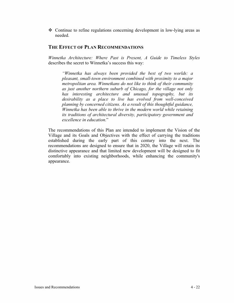
Issues and Recommendations 4 - 22
Continue to refine regulations concerning development in low-lying areas asneeded.
THE EFFECT OF PLAN RECOMMENDATIONS
Winnetka Architecture: Where Past is Present, A Guide to Timeless Stylesdescribes the secret to Winnetka’s success this way:
“Winnetka has always been provided the best of two worlds: apleasant, small-town environment combined with proximity to a majormetropolitan area. Winnetkans do not like to think of their communityas just another northern suburb of Chicago, for the village not onlyhas interesting architecture and unusual topography, but itsdesirability as a place to live has evolved from well-conceivedplanning by concerned citizens. As a result of this thoughtful guidance,Winnetka has been able to thrive in the modern world while retainingits traditions of architectural diversity, participatory government andexcellence in education.”
The recommendations of this Plan are intended to implement the Vision of theVillage and its Goals and Objectives with the effect of carrying the traditionsestablished during the early part of this century into the next. Therecommendations are designed to ensure that in 2020, the Village will retain itsdistinctive appearance and that limited new development will be designed to fitcomfortably into existing neighborhoods, while enhancing the community'sappearance.
The Green Bay Road Corridor and Business Districts- Issues and Recommendations 5 - 1
CHAPTER V: THE GREEN BAY ROAD CORRIDOR & BUSINESS DISTRICTS
ISSUES AND RECOMMENDATIONS
5.1 INTRODUCTION
The Green Bay Road Corridor encompasses Green Bay Road from the northern border tothe southern border of the Village and the Village's four business districts. This Chaptercovers Corridor issues and general business district issues, followed by individualsections for each business district.
Green Bay Road is Winnetka’s “axis,” bisecting the Village, linking Winnetka’s severalcommercial districts and connecting Winnetka to the downtown business areas ofneighboring communities. The creation of Green Bay Road from a patchwork of pre-existing streets was recommended by the Winnetka Plan of 1921 to siphon regionaltraffic off Sheridan Road. It was designed to concentrate commercial development alongthe Corridor next to the Union Pacific/METRA railroad tracks (hence an early streetname, Railroad Avenue), thus creating a central north-south transportation corridor.
The business districts connected by Green Bay Road are important to Winnetka’s vitality.They provide convenient shopping and services for the everyday needs of residents aswell as opportunities for residents to meet and interact, thereby furthering a sense ofcommunity. The sales tax revenues generated by local retail businesses help pay forVillage services, reducing the Village’s real estate tax requirements.
The Village confines multiple-family development to the Corridor in response to the1921 Plan’s “concentric” land use organization that keeps high-density developmentclose to the train stations and business districts, where multiple-family buildings buffersingle-family neighborhoods from Green Bay Road traffic, passenger trains andcommercial districts. Higher-density multiple-family districts and commercial buildingsalong the Corridor attract heavier traffic, diverting it from quiet residential streets.
5.2 GREEN BAY ROAD CORRIDOR
This chapter of the Plan gives guidance for changes that may occur in the future along theGreen Bay Road Corridor and within its commercial districts. The issues andopportunities of existing land use are discussed, Village objectives and policies arepresented, along with general recommendations. Specific discussions of individualbusiness districts complete the Chapter.
5.3 GREEN BAY ROAD AND GENERAL CORRIDOR ISSUES
5.3.1 EXISTING LAND USE CONDITIONS - ISSUES AND OPPORTUNITIES
A. Transportation and Parking
Green Bay Road is a state route that was designed to handle a large volume of
The Green Bay Road Corridor and Business Districts- Issues and Recommendations 5 - 2
regional traffic. Green Bay Road also serves the Village, providing centralizedtransportation for its residents and access to its business districts.
The width of Green Bay Road varies within the Village. In Hubbard Woods, GreenBay Road functions as a local commercial street: the cross sections are narrow, trafficis slower and on-street parking serves existing businesses. South of Tower Road, theroad is wider and traffic speed is greater. In Indian Hill, Green Bay Road is wider yet,allowing parallel parking on both sides of the street and four lanes of traffic. Here, thetraffic speed tends to be the greatest.
Because Green Bay Road was created from several pre-existing streets, it suffersfrom discontinuities that can confuse newcomers and jeopardize safety. There are nosigns to help nonresidents navigate the twists and turns of Green Bay Road.
The Green Bay Trail, a paved bike path parallel to the railroad tracks, provides a safealternative for bicyclists, walkers and joggers, including those who want an auto-freepassage among the Village’s business districts or to neighboring villages. However,access to and from the trail is limited.
Trains and buses provide mass transit. The railroad tracks and three train stationsdominate the north-south core of the Village and are discussed in Chapter Three,section 3.6.4 and Chapter Five, including sections 5.3.2.C, 5.3.3.C, 5.5.2.A and5.6.2.A.
PACE buses travel on Green Bay Road and east-west on major streets. They arediscussed in Chapter Three, section 3.6.3 and Chapter Four, section 4.6.3.
B. Commercial Development and Multiple-Family Land Use
Several of the Village’s larger multiple-family buildings are located on Green BayRoad: The Mews north of Pine Street, Hedge Row condominiums north of WillowRoad, The Chimneys and Hemphill House, both north of Winnetka Avenue.
In 1998, to soften the impact of both multiple-family and commercial buildings onthe village’s appearance and infrastructure, as well as on adjoining single-familyneighborhoods, the Village Council reduced the allowable building height to 2-1/2stories or 35 feet.
Several townhouse developments have been built along or near Green Bay Roadbetween Chatfield Road on the north and Winnetka Avenue on the south.Townhouses provide lower-density transitional areas between commercial districtsand single family neighborhoods.
Properties on the west side of Green Bay Road south of Chatfield Road and north ofPine Street are zoned for multiple-family development but currently host a mix ofuses including a greenhouse/florist, an office, single family houses and lower-densitymultiple-family buildings. These properties are likely to be redeveloped between theyears 2000 and 2020.
The Green Bay Road Corridor and Business Districts- Issues and Recommendations 5 - 3
C. General Appearance and Landscaping
Other than the “Winnetka” sign that displays the Indian Trail Tree, there is nothing tomark the entrance to the Village from either Glencoe or Kenilworth. Since the sign iseasy to miss, it can be confusing for people trying to find a destination in Winnetka orin adjoining communities.
The landscaping along the Corridor and the appearance of the railroad right-of-wayhave been largely neglected. Another aesthetic issue within the Corridor is theproliferation of unattractive regulatory street signs.
D. Architecture and Design
Winnetka has avoided many of the suburban design trends of the last forty years. Thisis due in large measure to the creation and acceptance of the 1921 Plan. The BoalBlock (at the northeast corner of Elm Street and Lincoln Avenue), built in 1913 anddesigned by Chatten & Hammond, provided a model for successful retail design inWinnetka. Lake Forest’s Market Square, built 1916 and designed by Howard vanDoren Shaw, provided further inspiration.
The established architectural style of the commercial districts is based on EnglishTudor Revival. These commercial masonry and half-timber structures are similar tothose found in English villages. Alongside are examples of Arts and Crafts designs,which also emanated from England in the late 19th and early 20th centuries. Adheringto these styles gave Winnetka’s commercial districts a coherent, picturesqueappearance within an urban street pattern. The blocks thus created contain a pleasingpattern of storefronts that relate to the sidewalk and pedestrians. The consistency ofdesign results in a powerful statement of the “village” as it was originally conceived.
Georgian and Classic Revival styles were selected for larger government structuresand the railroad stations. These are also consistent with the Village character for theyare of masonry construction and represent good examples of revival styles. There arealso examples of modern design, which do not always blend successfully with thescale and character of the Village.
The character of the Village is molded by the arrangement of the buildings and theirindividual design. The distinct commercial districts arranged around the three railroadstations reflect the convenience limits of neighborhoods, the importance oftransportation and the social and cultural habits of the villagers. These districts arestill viable and have allowed Winnetka to avoid one large town center, which wouldhave substantially changed the village character of Winnetka.
Consistency of design and the use of picturesque styles combine to give Winnetka’scommercial districts a pleasing quality, consistent with the Village’s residentialcharacter. Winnetka remains a model of successful development for Chicago suburbs.
The Winnetka Historical Society’s 1990 publication, Winnetka Architecture: WherePast is Present, A Guide to Timeless Styles says, “the variety and quality of
The Green Bay Road Corridor and Business Districts- Issues and Recommendations 5 - 4
architecture in Winnetka make the Village a ‘living museum’ of styles.” ManyVillage commercial buildings exhibit exceptional design and materials; there is ampleprecedent for design excellence for both public and private buildings.
5.3.2 GREEN BAY ROAD CORRIDOR GOAL AND OBJECTIVES AND POLICIES
Goal: Ensure a balanced and attractive pattern of land uses, development andinfrastructure along Green Bay Road, the railroad facilities and adjacent residentialneighborhoods running from the north to the south gateways of the Village (the“Corridor.”)
Objectives and Policies:
A. Transportation and Parking
Assure a better balance in the use of Green Bay Road that addresses the safety andconvenience of motorists, bicyclists and pedestrians.
Explore methods to reduce traffic speed on Green Bay Road.
Ensure the safe, efficient movement of vehicles within the Corridor and cooperatewith the railroad and State or County highway agencies to improve the road and railsystem.
Discourage cut-through traffic and vehicular congestion on residential streets adjacentto the Corridor and limit non-residential parking on residential streets throughout theCorridor. Discourage regional cut-through traffic on Village thoroughfares.
Encourage bicycling and walking as alternatives to motor vehicles within theCorridor.
Encourage the use of existing mass transit within the Corridor and provide forexpanded services if needed.
Improve the safety and appearance of pedestrian walkways and street crossings alongthe Corridor.
B. Commercial Development and Multiple-Family Land Use
Provide for a wide range of office/service and retail commercial land uses anddevelopment within the existing business districts in the Corridor.
Provide for low-to-medium-density multiple-family townhouse and condominiumdevelopments within the Corridor as indicated on the Comprehensive Plan Map.Ensure compatibility of land uses and a smooth transition between single familyresidential neighborhoods and all other uses.
The Green Bay Road Corridor and Business Districts- Issues and Recommendations 5 - 5
C. General Appearance and Landscaping
Improve the design of the north and south entries to the Village, including moreattractive and prominent placement of the Winnetka signs.
Develop a program of beautification and functional improvements for both public andprivate property throughout the Corridor, with special emphasis on landscaping, treeplanting, public rights-of-way, street crossings, parking lots, ornamental lighting,railroad stations and signs.
D. Architecture and Design
Create design review standards as described in section 5.3.3.D.
5.3.3 GREEN BAY ROAD CORRIDOR RECOMMENDATIONS
A. Transportation and Parking
The following Green Bay Road intersections require attention to reduce the vehicularaccident rate and/or improve pedestrian safety.
Green Bay Road - Tower Road: Because Green Bay Road bends to an east-westdirection for one block, there are two Green Bay Road-Tower Road intersections,which can be confusing and hazardous for pedestrians and drivers alike. Conduct atraffic study at these intersections to address pedestrian safety and traffic flow.
The Village should undertake a program of beautification for the parking lot south ofTower Road as indicated in other sections of this Plan.
Consider signs that direct traffic to the Edens Expressway northbound entrance.
Green Bay Road - Spruce (and Chestnut) Streets: Redesign this intersection toimprove safety and traffic flow. Currently, the intersection accommodates five curbcuts and three streets. The cross section of Spruce Street is so wide that pedestriancrossing is difficult and even veteran drivers are confused as to who has the right ofway. Many drivers are not aware of the shopping center’s one-way entrances andexits since the signs don’t attract their attention. The configuration of the intersectionshould be redesigned to promote safety and a better appearance, which could includethe creation of a pocket park.
Green Bay Road - Elm Street: Redesign this intersection, which is exceptionallywide for a pedestrian crossing and complicated by two railroad station parking lotentrances. Improve its safety and appearance.
Green Bay Road - Willow Road: This is a major intersection leading to the EdensExpressway southbound entrance, yet nothing identifies it. Consider a major sign orlandmark that will highlight this intersection. The double stop sign at the Willow-
The Green Bay Road Corridor and Business Districts- Issues and Recommendations 5 - 6
Green Bay intersection is not universally noticed nor understood. Increased trafficvolume may require consideration of a traffic light or a left-hand turn lane for north-bound traffic turning west onto Willow Road.
Green Bay Road - Church Road: Install a 90-degree intersection at this junction tocreate a safer intersection and to slow southbound Church Road traffic.
Green Bay Road - Winnetka Avenue: Undertake a traffic study to enhance safetyand to determine whether turns from Green Bay Road onto Winnetka Avenue andBrier Street can be more safely accommodated. This intersection is exceptionallywide for pedestrian crossing and is complicated by a right hand turn curb cut on thesoutheast corner. The extreme width includes both Green Bay Road and Brier Streetand additional curb cuts for a convenience store and a service station. The intersectionmust accommodate a high volume of New Trier High School students, both in carsand as pedestrians. A traffic study must address existing conditions as well as theimpact of new development that may be proposed in the future.
Explore “traffic calming” methods that will slow down traffic on Green Bay Road.
Review pedestrian underpasses for safety, security, lighting, aesthetics, landscapingand condition. Improve maintenance and appearance.
Create signs that help nonresidents follow Green Bay Road’s twists and turns.
Parking issues are examined in the individual business district sections.
B. Multiple-Family Land Use and Development
Where existing B-1 parcels in the districts provide transitional buffers betweencommercial districts and single-family neighborhoods, the B-1 designation should beretained.
Reduce density and add green space, providing a better balance between open spaceand building mass. Future redevelopment should avoid overwhelming Green BayRoad with bulky multiple-family developments and should devote more attention tolandscaping.
Redevelopment should be held to the design standards displayed by the rest of thecommunity, providing a friendly street presence, so that the entire length of GreenBay Road will be visually appealing as a “Winnetka Street.”
Require below-grade parking facilities for new developments along the Corridor.Where surface parking lots are appropriate, assure that they are thoroughly screenedwith landscaping preferred to walls or fences.
The Green Bay Road Corridor and Business Districts- Issues and Recommendations 5 - 7
C. General Appearance and Landscaping
The Public Works and Police Departments should create a master map of regulatorysigns, indicating location and type. The Design Review Board should review locationand frequency of sign placement according to accepted standards to evaluate whetherthere is unnecessary proliferation.
Streetscape Improvements: The newly formed Village Beautification Committeeshould create and implement a beautification strategy for the Corridor and its businessdistricts. The Committee could work with the Winnetka Garden Council on selectedprojects.
Seek State agreement to replace the guardrail located on the east side of Green BayRoad between Elm Street and Tower Road with something more appropriate to thelook of the Village.
Remove all chain-link fencing throughout the Corridor and, if needed, replace it withdecorative fencing more appropriate to the character of the Village.
Implement a program of landscape improvements to the railroad right-of-way alongthe Green Bay Trail with Union Pacific/METRA’s assistance.
D. Architecture and Design
Design Review Guidelines: Create design standards that would assist the DesignReview Board in evaluating project proposals for commercial, institutional ormultiple-family buildings. Design standards should be consistent with the analysis ofWinnetka’s architectural character described in section 5.3.1.D and in the CommunityGoals and Objectives in sections 2.2 and 2.3 of Chapter Two.
5.4 THE FOUR VILLAGE BUSINESS DISTRICTS
5.4.1 EXISTING CONDITIONS; ISSUES AND OPPORTUNITIES
The Green Bay Corridor includes four distinct business districts with a diversity rarelyfound in similar-sized communities: Hubbard Woods on the north, West and East ElmStreet districts in the center and Indian Hill to the south. A railroad station serves eachlocation. The business districts display a variety of land uses, building heights and onstreet and parking options. See Maps 7, 8 and 9, Existing Land Use.
Planning Sub-Areas: Planning Sub-Areas are defined as the business district core plusthe adjacent single-family neighborhoods that are affected by commercial activity. Thisensures that the impact on single-family neighborhoods is considered when reviewingcommercial district projects. No extension of the commercial districts is recommended inthis Plan nor implied by the Planning Sub-Area boundaries.
Most of the Hubbard Woods and Elm Street business districts are subject to C-2 retailoverlay zoning that encourages retail uses on the first floor and prohibits drive-through
The Green Bay Road Corridor and Business Districts- Issues and Recommendations 5 - 8
services. The policy keeps service offices on the periphery of or on upper floors withinthe commercial districts and promotes creation of a “critical mass” of retail shops thatwill attract customers. The existing offices within the overlay district pre-date this userequirement.
In recent years, the village has lost essential shops including four pharmacies, a varietystore, a hardware store and an appliance store, potentially harming the optimal businessmix needed to keep residents shopping in town and to attract non-residents to specialtystores.
The commercial districts and most of their architecturally distinctive buildings weredeveloped in the 1920’s. The buildings front on the sidewalks with tenant parking placedto the rear, invisible from the street. Some portions of the districts are served by alleys,which siphon off some parking demand, allow off-street loading and unloading ofmerchandise, and provide hidden areas for refuse storage and pick up. These featuresenhance the pedestrian character of the business districts and contribute to their charm.However, more reliance on the automobile has increased the demand for parking.
To encourage the development of a retail core that achieves a “critical mass” and todiscourage strip-mall type development, the Village does not require onsite parking forfirst floor commercial use. Traditionally, the business districts have been served by on-street parking. Over time, the Village has developed off-street parking lots on theperiphery of the districts that accommodate employee, commuter and shoppers’ needs. Inthe 1980's, the Village built a two-tier parking deck in Hubbard Woods. In addition, in1998, the Village began requiring underground parking to be provided for new upper andlower level uses.
Commercial and multifamily zoning districts allowed 4-story, 42 foot high buildings until1998 when, in response to public concern over bulk, the Village Council lowered theheight limit to 2-1/2 stories or 35 feet.
5.4.2 BUSINESS DISTRICTS: GOAL AND OBJECTIVES AND RECOMMENDATIONS
Goal: Promote a strong community identity and opportunities for residents to interactwhile building a healthy commercial tax base. Provide a broad range of goods andservices so that Winnetka residents can satisfy most of their ordinary shoppingrequirements in the Village and so that non-residents will come to the Village forspecialty goods and services.
Objectives and Recommendations
Economic Vitality
Maintain the essential quality, viability and attractiveness of Winnetka's business districtswhile encouraging new economic development consistent with the character of theVillage and the individual business districts.
Recognize the importance of retaining a grocery store in the Village.
The Green Bay Road Corridor and Business Districts- Issues and Recommendations 5 - 9
Encourage Village residents to patronize Village businesses.
Encourage the cooperation and effective organization of private and public resources tokeep Winnetka's business districts vital.
Assess the overall vitality of the commercial areas within the Village and the need forsome level of economic development support.
Enhance communication and cooperation between the Village and the businesscommunity.
Environment
Control the use and location of commercial lighting so that it does not impair thetranquility of single family neighborhoods.
Reduce and control noise from the commercial districts that affects adjacentneighborhoods.
Consider the environmental impact of commercial development, including its effect ondrainage, noise and air pollution. Additional impermeable surface could exacerbatedrainage problems.
A. Transportation and Parking
Provide adequate and convenient public parking, assure that longer-term parkingneeds be met by off-street and underground or deck facilities and that parking is paidfor primarily by those who benefit from it.
Retain the present policy that requires developers to provide parking for uses aboveand below the first floor, but not for first floor commercial use (to avoid strip-malldevelopment).
Encourage pedestrian and bicycle accessibility, safe crossings at major intersections,convenience, safety and amenities in all business districts.
Encourage the provision of on-site parking at the rear of buildings, with access viaalleys or private driveways, to reduce demand for on-street parking.
B. Commercial Development and Multiple Family Land Use
See Maps 10, 11, and 12, Land Use Plan
Encourage development that is appropriate for the scale and intensity of commercialactivity and consistent with the Comprehensive Plan Map.
Require all commercial and multi-family buildings to be buffered from residentialareas through the use of landscaping and/or other design techniques.
The Green Bay Road Corridor and Business Districts- Issues and Recommendations 5 - 10
Maintain the Village Zoning regulations that limit the height of new buildings oradditions to two-and-one-half stories to encourage gabled or pitched roofs, with rearbuilding height scaled down to meet the scale of immediately adjoining single-familyneighborhoods.
Review Winnetka zoning regulations to protect the quality of business districts.Promote the compatibility and continuity of retail activities on ground floors. Controland limit drive-through businesses and continue to require retail uses on the groundfloors in both the Hubbard Woods and Elm Street business districts. Evaluate specialuse permit standards for effectiveness.
Minimize the number of curb cuts to help retain block face continuity in the businessdistricts.
Ensure that new development does not decrease public parking supply, particularlyon-street parking that supports retail use.
Maintain and enhance existing alleys, which absorb some parking demand, provideoff-street loading and unloading and accommodate refuse storage and pickup. Garageentry should be accessed from alleys whenever possible. Recognize that alleys are asignificant business district resource.
C. General Appearance and Landscaping
See Corridor recommendation, section 5.3.3.C of this Chapter.
D. Architecture and Design
Preserve existing historical commercial buildings and require new development to becompatible with the historic character of the business districts.
5.5 HUBBARD WOODS BUSINESS DISTRICT PLANNING SUB-AREA
5.5.1 EXISTING CONDITIONS
The Hubbard Woods Business District Planning Sub-Area1 extends from Scott Street onthe north to Chatfield Road on the south, from the railroad tracks on the east to GordonTerrace on the west. The District is linear with most businesses located along Green BayRoad. Integral to the character of the Hubbard Woods shopping district is the relativelynarrow cross section of Green Bay Road, making it function more like a local street thana state highway. See Map 7, Existing Land Use.
The predominant features of the district include Hubbard Woods Park, a railroad station,a post office branch, several bank offices, a variety of specialty shops including antique
1 “Planning Sub-Area” is defined as the business district core plus the adjacent single-
family neighborhoods that are affected by commercial area activity. See section 5.4.1.
The Green Bay Road Corridor and Business Districts- Issues and Recommendations 5 - 11
stores, boutiques and other retail shops, restaurants, medical offices, multiple-familyresidences and automobile services. Sacred Heart Church and its school are located onthe west side of the Planning Sub-Area. Buildings range from one story to 3-1/2 stories inheight. The Sub-Area is distinguished by many distinctive half-timber Tudor Revivalbuildings, as well as several fine Art Deco limestone buildings and vintage red brickcommercial buildings.
Parking in the District includes on-street and alley parking, limited private off-streetparking and three Village-owned facilities: a parking deck adjacent to the HubbardWoods train station, a lot adjacent to the railroad right-of-way, north of Tower Road anda lot south of Tower Road at the foot of the business district. The Village parking lotsprovide important parking for the area’s businesses during the day and for nearbymultiple-family dwellings at night.
Hubbard Woods has become a thriving business area in the past several years due in partto increased parking availability provided by the Village and a comprehensive effort bythe Chamber of Commerce to upgrade the business district. Contributing featuresincluded building a gazebo and upgrading the playground in Hubbard Woods Park andrecruiting an anchor tenant for the first floor of the Packard building at 925 Green BayRoad.
5.5.2 OBJECTIVES AND RECOMMENDATIONS
A. Transportation and Parking
Address safety and pedestrian accessibility at the two Tower Road and Green Bayintersections as outlined in section 5.3.3.A.
Cooperate with Union Pacific/METRA on a program to improve the appearance andfunctionality of the Hubbard Woods train station. The Village should considerrenovating the building and providing a new canopy on the west side for the pick-upand drop-off of passengers. The newspaper stands are unattractive and should beplaced wherever their impact can be minimized. The grounds should be enhancedwith low maintenance plantings and irrigation.
B. Commercial Development and Multiple-Family Land Use
No recommendations. See Map 10, Land Use Plan.
C. General Appearance and Landscaping
Streetscape Elements: Upgrade streetscape elements as outlined in section 5.3.3.C.
Sidewalk trees failed to flourish because the species chosen was inappropriate for theconditions, which include utilities running under the sidewalk that can constrict rootsystems.
Encourage proposals to construct a focal point at Green Bay and Tower Roads. Such
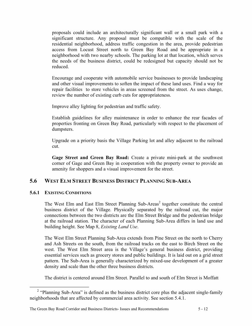
The Green Bay Road Corridor and Business Districts- Issues and Recommendations 5 - 12
proposals could include an architecturally significant wall or a small park with asignificant structure. Any proposal must be compatible with the scale of theresidential neighborhood, address traffic congestion in the area, provide pedestrianaccess from Locust Street north to Green Bay Road and be appropriate in aneighborhood with two nearby schools. The parking lot at that location, which servesthe needs of the business district, could be redesigned but capacity should not bereduced.
Encourage and cooperate with automobile service businesses to provide landscapingand other visual improvements to soften the impact of these land uses. Find a way forrepair facilities to store vehicles in areas screened from the street. As uses change,review the number of existing curb cuts for appropriateness.
Improve alley lighting for pedestrian and traffic safety.
Establish guidelines for alley maintenance in order to enhance the rear facades ofproperties fronting on Green Bay Road, particularly with respect to the placement ofdumpsters.
Upgrade on a priority basis the Village Parking lot and alley adjacent to the railroadcut.
Gage Street and Green Bay Road: Create a private mini-park at the southwestcorner of Gage and Green Bay in cooperation with the property owner to provide anamenity for shoppers and a visual improvement for the street.
5.6 WEST ELM STREET BUSINESS DISTRICT PLANNING SUB-AREA
5.6.1 EXISTING CONDITIONS
The West Elm and East Elm Street Planning Sub-Areas2 together constitute the centralbusiness district of the Village. Physically separated by the railroad cut, the majorconnections between the two districts are the Elm Street Bridge and the pedestrian bridgeat the railroad station. The character of each Planning Sub-Area differs in land use andbuilding height. See Map 8, Existing Land Use.
The West Elm Street Planning Sub-Area extends from Pine Street on the north to Cherryand Ash Streets on the south, from the railroad tracks on the east to Birch Street on thewest. The West Elm Street area is the Village’s general business district, providingessential services such as grocery stores and public buildings. It is laid out on a grid streetpattern. The Sub-Area is generally characterized by mixed-use development of a greaterdensity and scale than the other three business districts.
The district is centered around Elm Street. Parallel to and south of Elm Street is Moffatt
2 “Planning Sub-Area” is defined as the business district core plus the adjacent single-family
neighborhoods that are affected by commercial area activity. See section 5.4.1.
The Green Bay Road Corridor and Business Districts- Issues and Recommendations 5 - 13
Mall, which defines an east-west axis running from the Georgian Revival-styled VillageHall on the east to the current Post Office block on the west. The 1921 Planrecommended that this east-west axis be extended to the east with a train station spanningthe tracks (not built), through Village Hall, Moffatt Mall and to a Civic Auditorium (notbuilt) west of the current Post Office building.
The predominant features of the district include Station Park, Dwyer Park, a railroadstation, public buildings (Village Hall, the Winnetka-Northfield Public Library and thePost Office), two churches, grocery stores, several banks, boutique retail stores,restaurants, book and toy stores, real estate offices, medical offices and multiple-familyresidences. Most buildings have retail shops or restaurants on the ground floor andmultiple-family dwellings or offices upstairs. The buildings range from single story tofour stories in height, with a large number of buildings between two and three stories inheight. The area has many exceptional Tudor Revival mixed-use buildings, all built in the1920’s. West of Chestnut on Elm are several high-quality one-story commercialstorefronts, also built in the 1920s.
Parking in the Sub-Area is comprised of on-street parking, municipal parking lots nextto the train station, and north and south of the Post Office. Employee-only parking islocated immediately south of the Village Hall, on Dwyer Court and on Birch Street.
There is some hidden off-street private parking, accessible by alleys, but most of thedevelopment in the Sub-Area, including many multiple-family dwellings, is notsupported by private off-street parking.
Unique to the West Elm district are two large parcels that are significantly underusedrelative to the rest of the district. The first parcel is the Post Office block, owned by theVillage, on Chestnut Street between Elm and Oak. The Post Office lease for this land willexpire in year 2007. While the Post Office retail desk and postal boxes are important forvillage residents, the larger distribution and sorting facility requires significant spacedevoted to truck parking and loading 24 hours a day. This light industrial use isincompatible with other business district functions and its proximity to single-familyneighborhoods.
The second large parcel is the suburban-style shopping center on Green Bay Roadbetween Spruce and Pine Streets. Currently anchored by a grocery store, the centerprovides Village residents with convenient shopping and on-site parking. While theperimeter of the site is landscaped, the street-side location of the large parking lot breaksup the pedestrian nature of the central business district and is inconsistent with Villagecharacter.
There are several one or two-story buildings in the West Elm district that may beredeveloped in the next 20 years, particularly along Oak Street near the Village Hall. Thealleys from Oak Street and Elm Street to Moffatt Mall should be retained.
5.6.2 OBJECTIVES AND RECOMMENDATIONS
A. Transportation and Parking
The Green Bay Road Corridor and Business Districts- Issues and Recommendations 5 - 14
Study the intersection of Green Bay Road and Elm Street to address pedestriancrossing difficulties, as outlined in section 5.3.3.A.
Study the intersection of Green Bay Road, Spruce Street and Chestnut Street toimprove traffic flow and vehicle and pedestrian safety, as outlined in section 5.3.3.A.
Elm Street Station: Explore alternatives that link the two Elm Street businessdistricts such as cooperating with METRA to redevelop the railroad station into acommercial-retail structure that spans the railroad tracks. As in Hubbard Woods, thestation, which is situated prominently, is not attractive. The Village has at least twooptions for addressing railroad station needs. Either option holds the potential forlocating parking structures below grade level, open to the railroad cut for light andair, on both the east and west sides of the tracks. This would minimize surfacecommuter parking and allow expansion of the existing park, providing more greenspace in the center of the Village.
The first option is to renovate the existing building and provide a new canopy on thewest side for the pick-up and drop-off of passengers. All features, includingstairways, shelters and fences, should be substantially upgraded with high qualitydesign and materials. Additional retail or service commercial uses could be added tothe building. A wider, more attractive pedestrian bridge connecting the east and westsides of the tracks could encourage greater pedestrian movement from one side of thetracks to the other. Overall maintenance of the grounds should be enhanced with lowmaintenance plantings, including irrigation. Newspaper stands should be placedwherever their impact can be minimized.
A more ambitious plan would construct a station that spans the tracks connecting theEast and West Elm Business Districts as first recommended in the 1921 Plan. Retailspace would serve commuters. The space could also accommodate seasonal “festival”use: for example, farmers’ markets in the summer or holiday shopping in December.A committee should be formed to study this option.
C. Commercial Development and Multiple Family Land Use
See Map 11, Land Use Plan.
Post Office Site: The Post Office lease will expire in 2007 and the site will revertback to Village control. This strategic location could accommodate a mix ofcommercial uses capable of attracting users into the area and ensuring the viabilityand vitality of the District.
At present, apart from the Village Hall, there is no central visual focal point in theVillage. There appears to be widespread consensus that the redevelopment of the PostOffice site, coupled with other streetscape improvements, presents the Village with anopportunity to create a special central core area that could accomplish many goals atonce: aesthetic, economic, parking and social. This is perhaps the single mostimportant land use issue in the Village.
The Green Bay Road Corridor and Business Districts- Issues and Recommendations 5 - 15
Form a Village committee in the year 2000 to assess the options for this strategiclocation and to manage the process. The Committee’s recommendations shouldinclude:
• Whether the Village should retain ownership of the property, leasing it to thedeveloper.
• Retaining a retail Post Office facility.
• Conduct a widely publicized design-build competition to attract the mostcreative thinking available.
• Proposals should provide for a mixture of high quality residential, public, parkand retail uses based on a Market Square or central plaza model. An option forassisted-care facilities for senior citizens should be considered.
• Proposals should retain the open axis from Village Hall through ChestnutCourt, extending it to Dwyer Park.
• Proposals must address the impact on adjacent single family residential areasand may include the use of transitional townhouse zones.
• Retain the current quantity of customer and employee parking. Theredeveloped block should include both below-grade parking for employeesand building residents and surface parking, possibly in the form of diagonalon-street spaces, for retail customers.
North Side of Spruce and West of Green Bay Road: The small, suburban styleshopping center at the north end of the Sub-Area provides on-site parking for aconvenient grocery and other shops. The perimeter of the site is landscaped, but theparking lot remains the prominent feature, highly visible from the roadway. A moresubstantial landscape screening effort for the parking lot, possibly in conjunction withVillage efforts, could better integrate this convenient shopping location with the moretraditional pedestrian shopping areas south of Spruce Street. Redevelopment at thissite should encourage buildings that front on the Green Bay Road and Spruce Streetsidewalks, with parking located to the rear. Existing parking availability should bemaintained.
North Side of Oak Street between Linden and Chestnut Streets: The single-storycommercial buildings on the north side of Oak Street between the alley and ChestnutStreet do not reflect the permitted development intensity. Development proposals arelikely during the life of this Plan. Redevelopment proposals should be an attractivemixed-use development compatible with the character of Village Hall. A potentialland use should be explored now. This could be as simple as maintaining the existingcommercial designation of the parcels and review of development proposals as theyare presented or by taking a more proactive approach and providing developmentguidance. Ground floor retail with dwelling units or office uses on the upper floorsshould be encouraged. The alley should be retained.
The Green Bay Road Corridor and Business Districts- Issues and Recommendations 5 - 16
D. General Appearance and Landscaping
The central business district of the Village deserves the best possible aesthetictreatment to create a physical setting for pedestrian activity that is comfortable,convenient, visually interesting and secure.
Streetscape elements: Upgrade streetscape elements as outlined in section 5.3.3.C.
Village Hall Parking Lot: If and when parking can be located in a nearby below-grade facility, consider creating a small park at the corner of Green Bay Road andOak Street immediately south of the Village Hall, possibly incorporating a sculptureor monument, seating areas and other aesthetic features.
Southwest Corner of Oak and Linden: The small private green space on the cornerprovides valuable open space for the Village. Should development of the parcel beproposed, the Village should take appropriate steps to preserve it.
Dwyer Park: Cooperate with the Winnetka Park District, along with the GardenCouncil and local garden clubs, to develop and implement improvements for DwyerPark that complement the redevelopment of the Post Office site.
5.7 EAST ELM STREET BUSINESS DISTRICT PLANNING SUB-AREA
5.7.1 EXISTING CONDITIONS
The East Elm Planning Sub-Area3 extends from Pine Street on the north to Cherry andAsh Streets on the south, from the railroad tracks on the west to Arbor Vitae, Maple andCedar Streets on the east. The East Elm Sub-Area has a markedly different characterfrom the West Elm Street area, as it is smaller and less densely developed. See Map 8,Existing Land Use.
The predominant uses at ground floor level are retail specialty shops including a numberof antique stores, restaurants, many real estate brokers, medical offices and apparelstores. A mixed-use building with underground parking is currently under construction onthe west side of Lincoln Avenue. The Village Green anchors the Sub-Area’s easternboundary. Public and semi-public buildings include the New Trier Township offices, twochurches, the Winnetka Woman’s Club and the Winnetka Community House.
The East Elm Street Business District is comprised largely of 1 and 2-story buildingswith a 4-story multifamily building at Lincoln and Oak and a 3-story building on thenorth side of Elm between Arbor Vitae and Lincoln. The buildings north of Elm on eitherside of Lincoln are all between 1 and 2-1/2 stories and contribute to a character that isless intensive than the West Elm Planning Sub-Area.
3 “Planning Sub-Area” is defined as the business district core plus the adjacent single-
family neighborhoods that are affected by the commercial area activity. See section 5.4.1.
The Green Bay Road Corridor and Business Districts- Issues and Recommendations 5 - 17
Exceptional architectural features of the business district include the two-story BoalBlock (northeast corner of Elm and Lincoln) and the matching one-story Arts and Craftsbuildings to its north. East of Lincoln Avenue on the north side of Elm Street is aneclectic mix of styles and heights, including Tudor Revival and some red brick andlimestone commercial buildings, all dating from the 1920’s. The Tudor Revival-styledWinnetka Community House, which offers diverse programs for all age groups, and theGeorgian-styled Winnetka Congregational Church sit to the north at Lincoln Avenue andPine Street. Christ Church parish house, in the Gothic Revival style, sits at Maple andOak Streets towards the south and houses Willow Wood Nursery School.
Public parking in the Planning Sub-Area consists of on-street parking and municipalparking lots south of the Community House and on the south side of Elm Street acrossfrom Arbor Vitae Street.
5.7.2 OBJECTIVES AND RECOMMENDATIONS
A. Transportation and Parking
Parking Structure: Consider the parking needs of commuters, shoppers andemployees. If demand dictates, consider replacing the surface parking lot south of theCommunity House with an underground or decked parking structure that is open tothe railroad embankment. While a 1996 survey concluded that a parking structurewould not be used by shoppers in the District, the situation could change over the lifeof the Plan, particularly if additional parking is needed to serve the needs of theCommunity House, commuters and/or employees. An attractively designed parkingstructure, located at the existing parking lot, but open to the light and air of the “cut,”would allow a level or two of parking below grade with height above grade limited to1 ½ to 2 stories.
B. Commercial Development and Multiple Family Land Use
See Map 11, Land Use Plan.
Elm Street (south side) Single-story Commercial Buildings: The single-storycommercial buildings on the south side of Elm east of Lincoln are less intensive thanallowed by the District zoning regulations and do not reflect the aesthetic character ofthe Village. If proposals for the redevelopment of this block are presented within thelife of the Plan, the Village should require development that is compatible andarchitecturally harmonious with the less intense character of this portion of theVillage.
Lincoln Street Frontage Development: Consider proposals for improving theappearance from the street of the surface parking lot on the west side of LincolnAvenue (just south of the Community House) with a new building or substantialbuffering, leaving room for an access drive to the existing parking lot (or futureparking structure). A building would obscure the view of surface parking or a futureparking structure, while providing additional business floor space that couldcontribute to the vitality of the street. Alternatives could include a decorative wall or
The Green Bay Road Corridor and Business Districts- Issues and Recommendations 5 - 18
extensive landscaping that extends the block face to screen the lot from LincolnAvenue and to continue the attractive pedestrian-friendly streetscape
C. General Appearance and Landscaping
Streetscape Elements: Upgrade streetscape elements as outlined in section 5.3.3.C.
5.8 INDIAN HILL BUSINESS DISTRICT PLANNING SUB-AREA
5.8.1 EXISTING CONDITIONS
The Indian Hill Planning Sub-Area4 extends from Sunset Road and the Chimneysapartment building on the north to the Village boundary with Kenilworth on the south. Itextends west to Church Road and east to include Indian Hill Park and the grounds of NewTrier High School. See Map 9, Existing Land Use.
The predominant uses in the Planning Sub-Area include New Trier High School, IndianHill Park, a railroad station and low-density commercial facilities. Individual uses includea car dealership, a convenience store, a dry cleaning shop, banks, restaurants, medical andreal estate offices, an automobile repair business and multiple-family residences. Thetrain station and New Trier High School attract significant traffic to the area onweekdays.
The Sub-Area is comprised of buildings that range in height from one to 3-½ stories, withthe large majority of the structures at one or two stories. The district has severaloutstanding Tudor Revival buildings dating from 1920’s, including the Chimneysapartments and its adjacent office building, the Feigenheimer Building at 454-462Winnetka Avenue and the Tudor Row business condominiums at 38-50 Green Bay Road.Recently, a bank made a considerable investment in a new 2-1/2 story building.
Public parking in the Sub-Area is provided by a large lot north of Winnetka Avenueadjacent to the train station, which provides parking for both commuters and New TrierHigh School. It is sporadically screened by a variety of foliage, some professionallylandscaped, some weed species. A smaller single-row lot along the railroad embankmentsouth of Winnetka Avenue provides commuter, employee and customer parking forbusinesses. It is not landscaped. There is also on-street parking on both sides of GreenBay Road, which is not desirable because of the speed of the traffic.
Indian Hill is different from the other three districts as it is extremely linear withbuildings only on the west side of Green Bay Road (facing the railroad tracks to the east),plus a 3-1/2 story building east of the railroad underpass at 454-462 Winnetka Avenue.All of the Indian Hill Business District is zoned C-1. It does not have the C-2 zoningoverlay that covers most of the other business districts and therefore non-retail uses areallowed on the first floor.
4 “Planning Sub-Area” is defined as the business district core plus the adjacent single
family neighborhoods that are affected by commercial area activity. See section 5.4.1.
The Green Bay Road Corridor and Business Districts- Issues and Recommendations 5 - 19
The wide cross section of Green Bay Road in the Indian Hill area overwhelms thepedestrian character of this district. Largely due to the 3,500 persons attending New TrierHigh School each weekday, the Indian Hill Planning Sub-Area suffers from both trafficand parking problems.
The shallow, small commercial lots do not allow for buildings with desirable off-streetparking. The lots back up to a well-established single-family neighborhood with only afence and alley for separation, thus additional intensity on the commercial properties hassignificant impact upon adjacent houses. The alley stops abruptly before it reaches theKenilworth border, interfering with service access to some commercial buildings.
Because the commercial lots are shallow and parking adjacent to the businesses islimited, it appears unlikely that development of significantly higher intensities will occurin the area.
5.8.2 OBJECTIVES AND RECOMMENDATIONS
A. Transportation and Parking
Traffic and pedestrian safety: Redesign the intersection of Green Bay Road andWinnetka Avenue to improve flow and safety of vehicular and pedestrian traffic.
Winnetka Avenue Underpass: Improve lighting and pigeon control for the WinnetkaAvenue underpass east of Green Bay Road.
Traffic Calming: Explore methods to slow down traffic on Green Bay Road.
New Trier High School: Pursue, in cooperation with New Trier High School,improvements that address traffic and pedestrian congestion, traffic circulation andparking demand and supply in the District. New Trier traffic affects theneighborhoods of both Greeley and Joseph Sears elementary schools.
There is insufficient parking for New Trier students on the campus. Therefore, theneighborhood is burdened with illegal on-street parking, which creates congestion andadversely affects single-family residences in otherwise quiet neighborhoods. Workactively with New Trier High School to develop an effective means of parkingmanagement and encourage alternative means of getting to school, particularly the useof mass transit (PACE and METRA), bicycles, etc.
Kenilworth Elementary District 38: District 38's population is small; anydevelopment in the Indian Hill portion of Winnetka that would attract families withschool-aged children could have a significant impact on the Sears School. KeepDistrict 38 officials informed of development proposals
B. Commercial Development and Multiple Family Land Use
See Map 12, Land Use Plan.
The Green Bay Road Corridor and Business Districts- Issues and Recommendations 5 - 20
Retain the Feigenheimer Building’s (454-462 Winnetka Avenue) C-1 zoningdesignation. Encourage proposals from New Trier High School or other publicagencies for the first floor use of this building.
Guide any redevelopment of the Indian Hill Business District so as to preserve theresidential character of the adjacent neighborhood.
Encourage developers to orient building frontages along the sidewalk and parking tothe side or rear of the buildings.
Encourage proposals for the redevelopment of property on the west side of Green BayRoad, both north and south of Winnetka Avenue that will address traffic circulation,parking and landscape buffering. Redevelopment should be multiple-family units withunderground parking or town houses with individual parking garages. Commercialand retail development should primarily serve local neighborhood needs.
Brier Street Alley: The alley behind the homes on Brier Street, backing up tocommercial uses on Green Bay, should be opened all the way to Exmoor Road andthe alley in Kenilworth. This important public right-of-way should be maintained forpublic purposes and not ceded to adjoining property owners.
C. General Appearance and Landscaping
Streetscape Elements: Plant sidewalk trees and upgrade streetscape elements asoutlined in section 5.3.3.C.
Southeast of Green Bay Road / Winnetka Avenue - Parking Lot: Implement aprogram of substantial beautification, landscaping and pedestrian access improvementto this area. The parking lot needs considerable upgrading and could be madeattractive by constructing a decorative wall along Green Bay Road, lowering theparking level to grade (thus making the cars less visible to passers by), installingdecorative lighting and moving the parking area several feet into the railroadembankment. This would provide adequate space between Green Bay Road and theparking lot to install a wall, trees, additional landscaping and an irrigation system.
Southeast Corner of Green Bay Road / Winnetka Avenue: Encourage andcooperate with the automobile service business at the southeast corner of theintersection of Green Bay Road and Winnetka Avenue to provide landscaping andother visual improvements to soften the impact of this land use. Encourage a changein the existing land use from a commercial auto repair facility to a Village park thatcould also provide a visible gateway directing visitors to New Trier High School tothe east.
5.9 EFFECT OF GREEN BAY ROAD CORRIDOR RECOMMENDATIONS
The Green Bay Road Corridor plan is intended to reclaim Green Bay Road as a Winnetkastreet, both functionally and visually, serving the needs of Winnetka residents andstrengthening the pedestrian character of each of the four business districts.
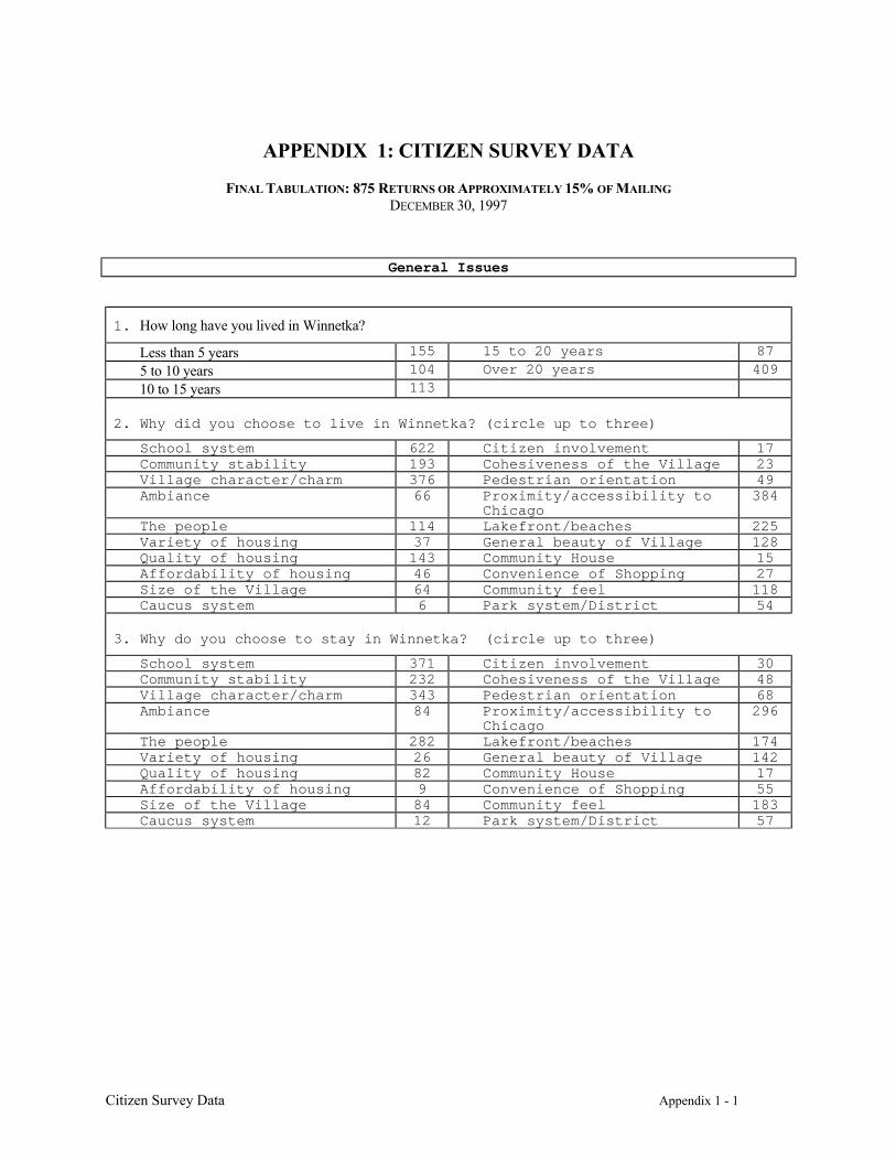
Citizen Survey Data Appendix 1 - 1
APPENDIX 1: CITIZEN SURVEY DATA
FINAL TABULATION: 875 RETURNS OR APPROXIMATELY 15% OF MAILINGDECEMBER 30, 1997
General Issues
1. How long have you lived in Winnetka?
Less than 5 years 155 15 to 20 years 87
5 to 10 years 104 Over 20 years 409
10 to 15 years 113
2. Why did you choose to live in Winnetka? (circle up to three)
School system 622 Citizen involvement 17Community stability 193 Cohesiveness of the Village 23Village character/charm 376 Pedestrian orientation 49Ambiance 66 Proximity/accessibility to
Chicago384
The people 114 Lakefront/beaches 225Variety of housing 37 General beauty of Village 128Quality of housing 143 Community House 15Affordability of housing 46 Convenience of Shopping 27Size of the Village 64 Community feel 118Caucus system 6 Park system/District 54
3. Why do you choose to stay in Winnetka? (circle up to three)
School system 371 Citizen involvement 30Community stability 232 Cohesiveness of the Village 48Village character/charm 343 Pedestrian orientation 68Ambiance 84 Proximity/accessibility to
Chicago296
The people 282 Lakefront/beaches 174Variety of housing 26 General beauty of Village 142Quality of housing 82 Community House 17Affordability of housing 9 Convenience of Shopping 55Size of the Village 84 Community feel 183Caucus system 12 Park system/District 57
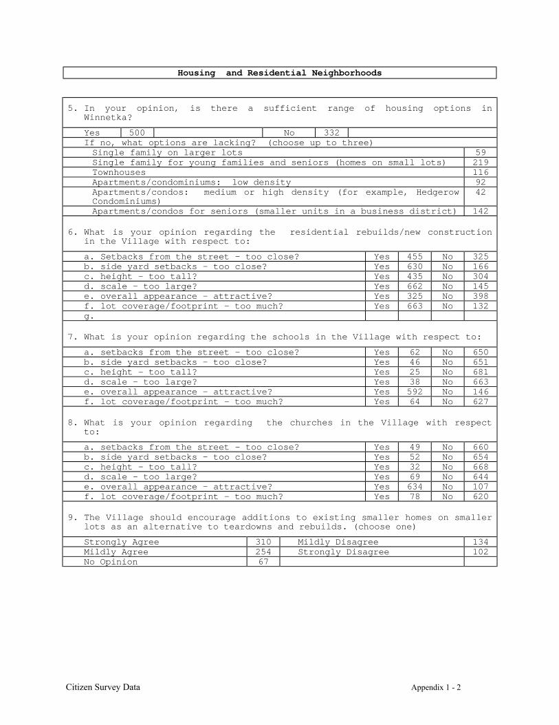
Citizen Survey Data Appendix 1 - 2
Housing and Residential Neighborhoods
5. In your opinion, is there a sufficient range of housing options inWinnetka?
Yes 500 No 332If no, what options are lacking? (choose up to three)Single family on larger lots 59Single family for young families and seniors (homes on small lots) 219Townhouses 116Apartments/condominiums: low density 92Apartments/condos: medium or high density (for example, HedgerowCondominiums)
42
Apartments/condos for seniors (smaller units in a business district) 142
6. What is your opinion regarding the residential rebuilds/new constructionin the Village with respect to:
a. Setbacks from the street – too close? Yes 455 No 325b. side yard setbacks - too close? Yes 630 No 166c. height - too tall? Yes 435 No 304d. scale - too large? Yes 662 No 145e. overall appearance – attractive? Yes 325 No 398f. lot coverage/footprint - too much? Yes 663 No 132g.
7. What is your opinion regarding the schools in the Village with respect to:
a. setbacks from the street - too close? Yes 62 No 650b. side yard setbacks - too close? Yes 46 No 651c. height - too tall? Yes 25 No 681d. scale - too large? Yes 38 No 663e. overall appearance - attractive? Yes 592 No 146f. lot coverage/footprint - too much? Yes 64 No 627
8. What is your opinion regarding the churches in the Village with respectto:
a. setbacks from the street - too close? Yes 49 No 660b. side yard setbacks - too close? Yes 52 No 654c. height - too tall? Yes 32 No 668d. scale - too large? Yes 69 No 644e. overall appearance - attractive? Yes 634 No 107f. lot coverage/footprint - too much? Yes 78 No 620
9. The Village should encourage additions to existing smaller homes on smallerlots as an alternative to teardowns and rebuilds. (choose one)
Strongly Agree 310 Mildly Disagree 134Mildly Agree 254 Strongly Disagree 102No Opinion 67
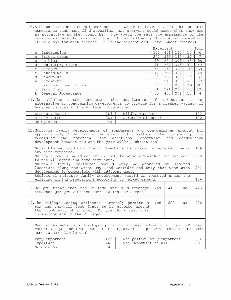
Citizen Survey Data Appendix 1 - 3
10.Although residential neighborhoods in Winnetka have a scale and generalappearance that many find appealing, not everyone would agree that they areas attractive as they could be. How would you rate the appearance of theresidential neighborhoods in terms of the following streetscape elements? (Circle one for each element: 5 is the highest and 1 the lowest rating.)
Excellent Poora. Landscaping 153 451 180 15 6b. Street trees 251 378 143 35 7c. Curbing 79 264 303 97 50d. Regulatory Signs 71 257 308 104 44e. Garages 38 168 390 148 39f. Fences/walls 47 232 364 113 29g. Sidewalks 68 267 309 118 36h. Pavements 60 213 312 163 43i. Overhead Power Lines 18 92 230 194 263j. Lamp Posts 54 244 279 133 101k. General Appearance 85 450 231 16 4
11.The Village should encourage the development of townhouses as analternative to condominium developments to provide for a greater variety ofhousing choices in the Village (choose one)
Strongly Agree 186 Mildly Disagree 111Mildly Agree 283 Strongly Disagree 120No Opinion 148
12.Multiple family developments of apartments and condominiums account forapproximately 12 percent of the homes in the Village. What is your opinionregarding the potential for additional apartment and condominiumdevelopment between now and the year 2020? (choose one)
No additional multiple family developments should be approved underany circumstances.
186
Multiple family buildings should only be approved within and adjacentto the Village’s business districts.
238
Multiple family buildings should only be approved at limitedlocations along the Green Bay Road Corridor and only then when suchdevelopment is compatible with adjacent uses.
241
Additional multiple family development should be approved under theexisting zoning regulations according to market demand. 196
13. Do you think that the Village should discourageattached garages with the doors facing the street?
Yes 413 No 423
14. The Village Zoning Ordinance currently permits asix and one-half foot fence to be erected aroundthe front yard of a home. Do you think that thisis appropriate in the Village?
Yes 327 No 486
15.Much of Winnetka was developed prior to a heavy reliance on cars. To whatextent do you believe that it is important to preserve this traditionalappearance? (Circle one)
Very important 425 Not particularly important 68Important 261 Not important at all 31No Opinion 56
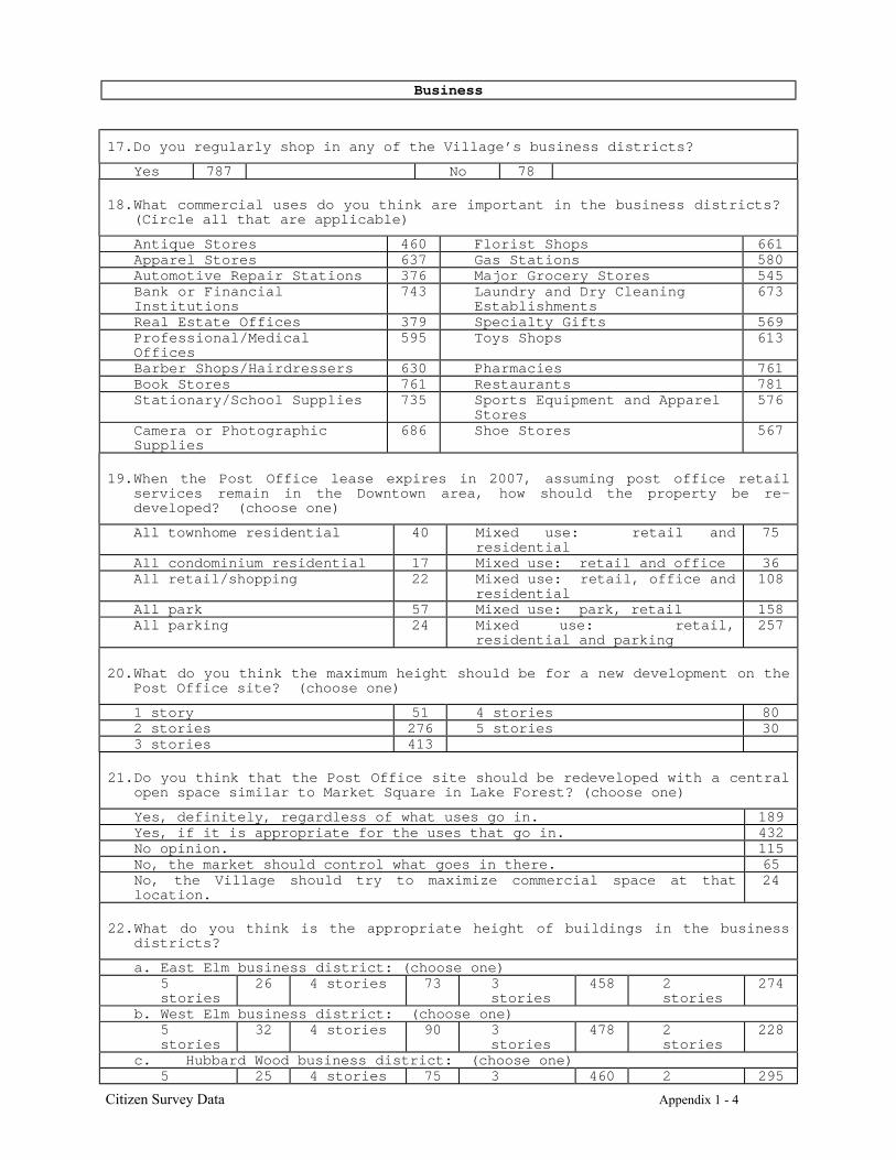
Citizen Survey Data Appendix 1 - 4
Business
17.Do you regularly shop in any of the Village’s business districts?
Yes 787 No 78
18.What commercial uses do you think are important in the business districts? (Circle all that are applicable)
Antique Stores 460 Florist Shops 661Apparel Stores 637 Gas Stations 580Automotive Repair Stations 376 Major Grocery Stores 545Bank or FinancialInstitutions
743 Laundry and Dry CleaningEstablishments
673
Real Estate Offices 379 Specialty Gifts 569Professional/MedicalOffices
595 Toys Shops 613
Barber Shops/Hairdressers 630 Pharmacies 761Book Stores 761 Restaurants 781Stationary/School Supplies 735 Sports Equipment and Apparel
Stores576
Camera or PhotographicSupplies
686 Shoe Stores 567
19.When the Post Office lease expires in 2007, assuming post office retailservices remain in the Downtown area, how should the property be re-developed? (choose one)
All townhome residential 40 Mixed use: retail andresidential
75
All condominium residential 17 Mixed use: retail and office 36All retail/shopping 22 Mixed use: retail, office and
residential108
All park 57 Mixed use: park, retail 158All parking 24 Mixed use: retail,
residential and parking257
20.What do you think the maximum height should be for a new development on thePost Office site? (choose one)
1 story 51 4 stories 802 stories 276 5 stories 303 stories 413
21.Do you think that the Post Office site should be redeveloped with a centralopen space similar to Market Square in Lake Forest? (choose one)
Yes, definitely, regardless of what uses go in. 189Yes, if it is appropriate for the uses that go in. 432No opinion. 115No, the market should control what goes in there. 65No, the Village should try to maximize commercial space at thatlocation.
24
22.What do you think is the appropriate height of buildings in the businessdistricts?
a. East Elm business district: (choose one)5stories
26 4 stories 73 3stories
458 2stories
274
b. West Elm business district: (choose one)5stories
32 4 stories 90 3stories
478 2stories
228
c. Hubbard Wood business district: (choose one)5 25 4 stories 75 3 460 2 295
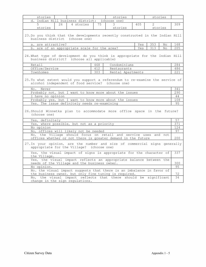
Citizen Survey Data Appendix 1 - 5
stories stories storiesd. Indian Hill business district: (choose one)
5stories
26 4 stories 75 3stories
405 2stories
309
23.Do you think that the developments recently constructed in the Indian Hillbusiness district (choose one)
a. are attractive? Yes 353 No 168b. are of an appropriate scale for the area? Yes 313 No 205
24.What type of development do you think is appropriate for the Indian Hillbusiness district? (choose all applicable)
Retail 468 Condominiums 284Office/Service 412 Restaurants 486Townhomes 303 Rental Apartments 221
25.To what extent would you support a referendum to re-examine the service ofalcohol independent of food service? (choose one)
No. Never 341Probably not, but I want to know more about the issues 290I have no opinion 44Probably yes, but I want to know more about the issues 108Yes. The issue definitely needs re-examining 95
26.Should Winnetka plan to accommodate more office space in the future? (choose one)
Yes, definitely 57Yes, where possible, but not as a priority 371No opinion 124No, offices will likely not be needed 97No, the Village should focus on retail and service uses and notoffices whether or not there is greater demand in the future 200
27.In your opinion, are the number and size of commercial signs generallyappropriate for the Village? (choose one)
Yes, the visual impact of signs is appropriate for the character ofthe Village.
337
Yes, the visual impact reflects an appropriate balance between theneeds of the Village and the business owner. 300No opinion. 95No. the visual impact suggests that there is an imbalance in favor ofthe business owner, but only fine tuning is required. 72No, the visual impact reflects that there should be significantchange in the sign regulations.
34
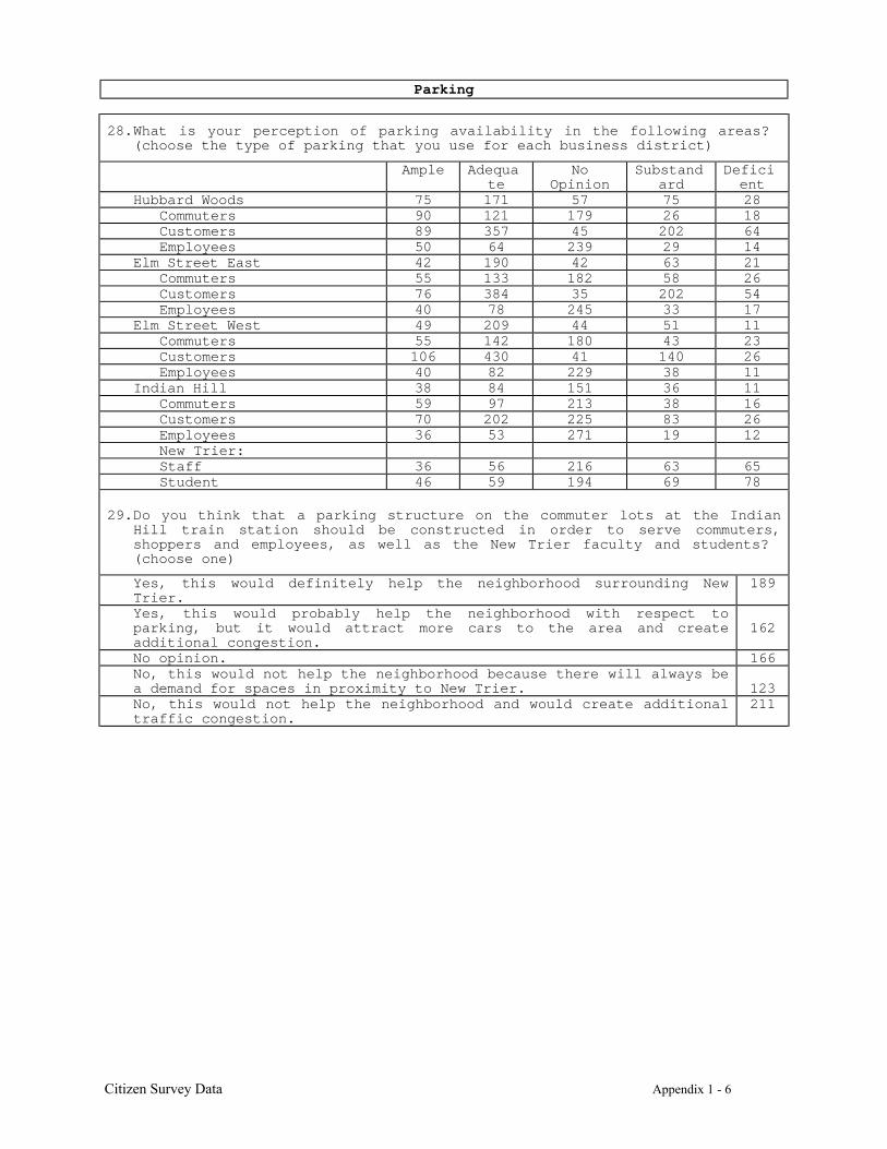
Citizen Survey Data Appendix 1 - 6
Parking
28.What is your perception of parking availability in the following areas? (choose the type of parking that you use for each business district)
Ample Adequate
NoOpinion
Substandard
Deficient
Hubbard Woods 75 171 57 75 28Commuters 90 121 179 26 18Customers 89 357 45 202 64Employees 50 64 239 29 14
Elm Street East 42 190 42 63 21Commuters 55 133 182 58 26Customers 76 384 35 202 54Employees 40 78 245 33 17
Elm Street West 49 209 44 51 11Commuters 55 142 180 43 23Customers 106 430 41 140 26Employees 40 82 229 38 11
Indian Hill 38 84 151 36 11Commuters 59 97 213 38 16Customers 70 202 225 83 26Employees 36 53 271 19 12New Trier:Staff 36 56 216 63 65Student 46 59 194 69 78
29.Do you think that a parking structure on the commuter lots at the IndianHill train station should be constructed in order to serve commuters,shoppers and employees, as well as the New Trier faculty and students? (choose one)
Yes, this would definitely help the neighborhood surrounding NewTrier.
189
Yes, this would probably help the neighborhood with respect toparking, but it would attract more cars to the area and createadditional congestion.
162
No opinion. 166No, this would not help the neighborhood because there will always bea demand for spaces in proximity to New Trier. 123No, this would not help the neighborhood and would create additionaltraffic congestion.
211
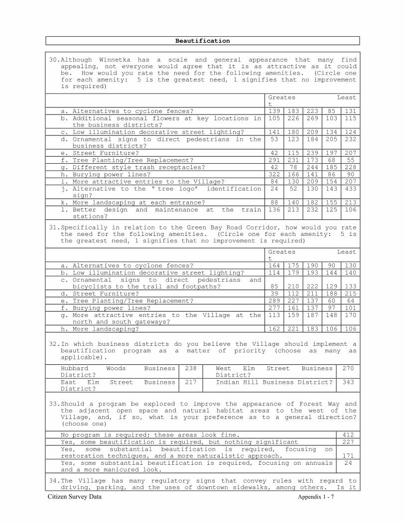
Citizen Survey Data Appendix 1 - 7
Beautification
30.Although Winnetka has a scale and general appearance that many findappealing, not everyone would agree that it is as attractive as it couldbe. How would you rate the need for the following amenities. (Circle onefor each amenity: 5 is the greatest need, 1 signifies that no improvementis required)
Greatest
Least
a. Alternatives to cyclone fences? 139 183 223 85 131b. Additional seasonal flowers at key locations in
the business districts?105 226 269 103 115
c. Low illumination decorative street lighting? 141 180 209 134 124d. Ornamental signs to direct pedestrians in the
business districts?53 123 184 205 232
e. Street Furniture? 42 115 239 197 207f. Tree Planting/Tree Replacement? 291 231 173 68 55g. Different style trash receptacles? 42 78 244 185 228h. Burying power lines? 322 166 141 86 90i. More attractive entries to the Village? 84 130 209 154 207j. Alternative to the “ tree logo” identification
sign?24 52 130 143 433
k. More landscaping at each entrance? 88 140 182 155 213l. Better design and maintenance at the train
stations?136 213 232 125 106
31.Specifically in relation to the Green Bay Road Corridor, how would you ratethe need for the following amenities. (Circle one for each amenity: 5 isthe greatest need, 1 signifies that no improvement is required)
Greatest
Least
a. Alternatives to cyclone fences? 164 175 190 90 130b. Low illumination decorative street lighting? 114 179 193 144 140c. Ornamental signs to direct pedestrians and
bicyclists to the trail and footpaths? 85 210 222 129 133d. Street Furniture? 39 112 211 188 215e. Tree Planting/Tree Replacement? 289 227 137 60 64f. Burying power lines? 277 161 137 97 101g. More attractive entries to the Village at the
north and south gateways?113 159 187 148 170
h. More landscaping? 162 221 183 106 106
32.In which business districts do you believe the Village should implement abeautification program as a matter of priority (choose as many asapplicable).
Hubbard Woods BusinessDistrict?
238 West Elm Street BusinessDistrict?
270
East Elm Street BusinessDistrict?
217 Indian Hill Business District? 343
33.Should a program be explored to improve the appearance of Forest Way andthe adjacent open space and natural habitat areas to the west of theVillage, and, if so, what is your preference as to a general direction?(choose one)
No program is required; these areas look fine. 412Yes, some beautification is required, but nothing significant 227Yes, some substantial beautification is required, focusing onrestoration techniques, and a more naturalistic approach. 171Yes, some substantial beautification is required, focusing on annualsand a more manicured look.
24
34.The Village has many regulatory signs that convey rules with regard todriving, parking, and the uses of downtown sidewalks, among others. Is it

Citizen Survey Data Appendix 1 - 8
your opinion that: (choose one)
Yes, there are many signs that detract from the appearance of theresidential and commercial neighborhoods, and I support a program foreither reducing the number or otherwise making such signs moreattractive.
191
Yes, public signs are a problem, but it should not be a priority 229I have no opinion. 150No, although existing signs are not as attractive as they might be,no program should be considered.
245
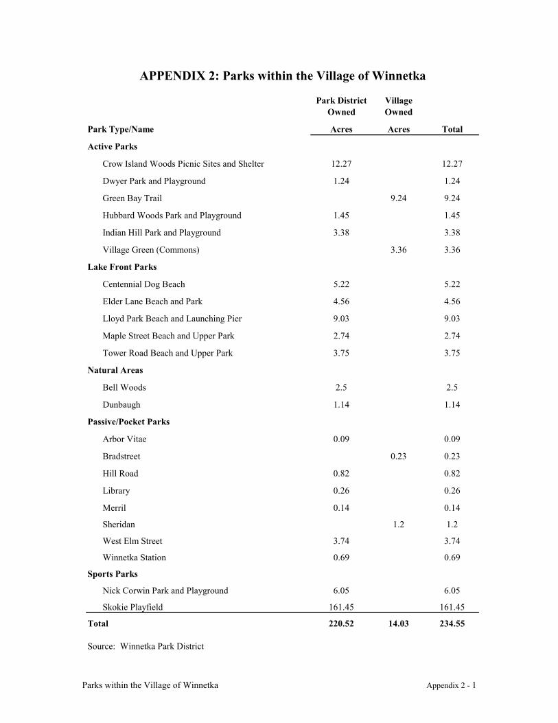
Parks within the Village of Winnetka Appendix 2 - 1
Park District Owned
Village Owned
Park Type/Name Acres Acres Total
Active Parks
Crow Island Woods Picnic Sites and Shelter 12.27 12.27
Dwyer Park and Playground 1.24 1.24
Green Bay Trail 9.24 9.24
Hubbard Woods Park and Playground 1.45 1.45
Indian Hill Park and Playground 3.38 3.38
Village Green (Commons) 3.36 3.36
Lake Front Parks
Centennial Dog Beach 5.22 5.22
Elder Lane Beach and Park 4.56 4.56
Lloyd Park Beach and Launching Pier 9.03 9.03
Maple Street Beach and Upper Park 2.74 2.74
Tower Road Beach and Upper Park 3.75 3.75
Natural Areas
Bell Woods 2.5 2.5
Dunbaugh 1.14 1.14
Passive/Pocket Parks
Arbor Vitae 0.09 0.09
Bradstreet 0.23 0.23
Hill Road 0.82 0.82
Library 0.26 0.26
Merril 0.14 0.14
Sheridan 1.2 1.2
West Elm Street 3.74 3.74
Winnetka Station 0.69 0.69
Sports Parks
Nick Corwin Park and Playground 6.05 6.05
Skokie Playfield 161.45 161.45
Total 220.52 14.03 234.55
Source: Winnetka Park District
APPENDIX 2: Parks within the Village of Winnetka
Water Supply System Appendix 3 - 1
APPENDIX 3: WATER SUPPLY SYSTEM
EXISTING FACILITIES
Lake Michigan is the raw water source for the treatment plant. Water is supplied by a 3000 footlong 20 inch intake and a 30 inch tap into the 1500 foot long 60 inch cooling water intake for theWinnetka Electric Plant. The 30 inch tap is used to supplement the capacity of the smaller intakewhich is insufficient to meet Winnetka's needs.
Low lift pumps transport the lake water from the intake well to the treatment plant. Thesepumps have a total capacity of 18 million gallons per day at 38 feet of head.
To make the water safe, clear and free from taste and odor, three basic treatments take place:
• Chlorine is added to kill bacteria, plant growth and micoorganisms.
• Sulfate of alumina is added to clarify the water and when required, activated carbon isused to improve palatability.
• Sodium silicofluoride (fluoride) is added for dental cavity control in children.
• Activated carbon is added, when needed for control of tastes and odors.
• Poly ortho-phosphates are added for corrosion control of service lines and plumbingfixtures
Water is next stirred in mixing tanks and sent to settling basins where suspended impurities areremoved. To give it sparkling clarity the water is then filtered through multimedia garnet andanthracite filters. An underground system collects this fully treated water and carries it to thereservoir, a covered concrete tank with a capacity of more than two million gallons. Anadditional three million gallon reservoir is located at the western Village limits north of WillowRoad for periods of heavy demand.
The reaction and sedimentation basins, designed for a flow of 6 million gallons per day, have notbeen expanded since 1931.
The filtration system consists of eight filters. These filters were originally sand filters with acapacity of 0.75 million gallons per day each for a total filter capacity of 6 million gallons perday. In 1967 filters four filters were converted to multimedia filters The remaining filters wereconverted to multimedia filters in 1991. All the multimedia filters have been operated at twomillion gallons per day each since their conversion.
The filter plant now has a demonstrated net capacity of 15 million gallons per day, two and a halftimes the original design capacity. Hydraulic constraints restrict operation of the plant beyondthis level.
Water Supply System Appendix 3 - 2
Finished water storage includes three interconnected ground level reservoirs at the treatmentplant site with a combined capacity of 2.32 million gallons. An additional three million gallonreservoir is located near the western Village limits at Willow Road, across from the VillageYards.
High lift pumps, one of which is over forty years old, get the treated water up the bluff andpressurize the distribution system. These pumps are constant speed centrifugal pumps with atotal rated capacity of 18 million gallons per day at 200 feet of head. The specific discharge rateis varied by controlling the speed of the pumps.
The water distribution system itself consists of a network of interconnected cast iron and ductileiron pipes located under the streets of the Village. The total length of this system amounts toapproximately 325,000 feet of mains, over 568 fire hydrants and 660 valves.
Operating Procedures
The water treatment plant is separated into two facilities; the low lift pumping/water treatmentfacility, operated by the water plant staff, and the high lift pumping facility, operated by theelectric plant staff.
The low lift pumping water treatment facility is operated by a staff of five, including asuperintendent and four plant operators. Operating objectives consist of maintaining the clearwell near full capacity treating water, and testing to ensure finished water quality. Duringperiods of extremely high use, the plant operates twenty-four hours per day. During theremaining months of the year, the plant operates two eight hour shifts.
The monitoring and operation of the high lift pumping facilities is an additional duty of thepower plant supervisor. No personnel are assigned solely for the high lift pumping facility. Theoperating objective of this facility is to maintain adequate pressure in the water distribution bysystem by maintaining the high lift pump discharge pressure within a prescribed range.
Historical and Projected Water Requirements
Winnetka provides water service to residents, businesses and Institutions within its corporatelimits, the unincorporated areas of Indian Hill and Woodley Woods and the Village ofNorthfield. Winnetka and the unincorporated areas are landlocked and cannot increase in landarea. Northfield, on the other hand, is expected to expand into unincorporated areas along itswestern boundary.
Based upon existing trends, the population within the Winnetka water service area is projected toincrease only slightly by the year 2020. The historic and projected populations are summarizedas follows:
Year Winnetka Indian Hill Northfield Total
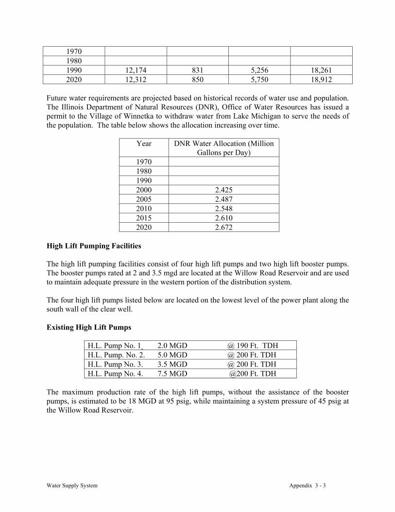
Water Supply System Appendix 3 - 3
197019801990 12,174 831 5,256 18,2612020 12,312 850 5,750 18,912
Future water requirements are projected based on historical records of water use and population.The Illinois Department of Natural Resources (DNR), Office of Water Resources has issued apermit to the Village of Winnetka to withdraw water from Lake Michigan to serve the needs ofthe population. The table below shows the allocation increasing over time.
Year DNR Water Allocation (MillionGallons per Day)
1970198019902000 2.4252005 2.4872010 2.5482015 2.6102020 2.672
High Lift Pumping Facilities
The high lift pumping facilities consist of four high lift pumps and two high lift booster pumps.The booster pumps rated at 2 and 3.5 mgd are located at the Willow Road Reservoir and are usedto maintain adequate pressure in the western portion of the distribution system.
The four high lift pumps listed below are located on the lowest level of the power plant along thesouth wall of the clear well.
Existing High Lift Pumps
H.L. Pump No. 1 2.0 MGD @ 190 Ft. TDHH.L. Pump. No. 2. 5.0 MGD @ 200 Ft. TDHH.L. Pump No. 3. 3.5 MGD @ 200 Ft. TDHH.L. Pump No. 4. 7.5 MGD @200 Ft. TDH
The maximum production rate of the high lift pumps, without the assistance of the boosterpumps, is estimated to be 18 MGD at 95 psig, while maintaining a system pressure of 45 psig atthe Willow Road Reservoir.
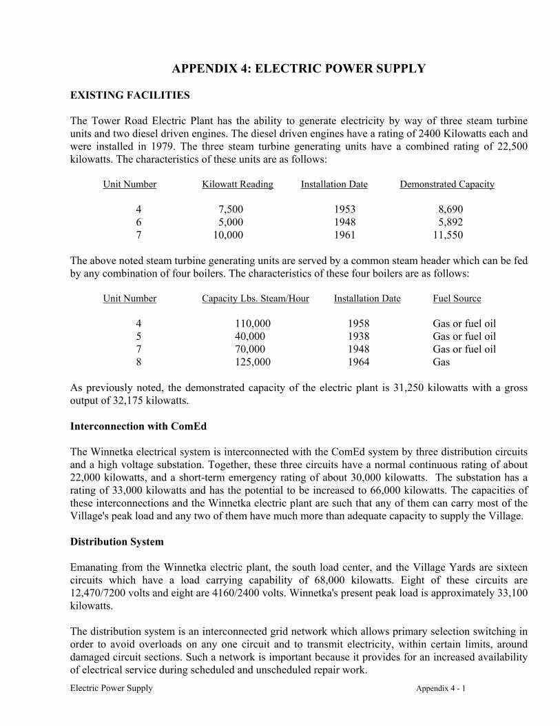
Electric Power Supply Appendix 4 - 1
APPENDIX 4: ELECTRIC POWER SUPPLY
EXISTING FACILITIES
The Tower Road Electric Plant has the ability to generate electricity by way of three steam turbineunits and two diesel driven engines. The diesel driven engines have a rating of 2400 Kilowatts each andwere installed in 1979. The three steam turbine generating units have a combined rating of 22,500kilowatts. The characteristics of these units are as follows:
Unit Number Kilowatt Reading Installation Date Demonstrated Capacity
4 7,500 1953 8,6906 5,000 1948 5,8927 10,000 1961 11,550
The above noted steam turbine generating units are served by a common steam header which can be fedby any combination of four boilers. The characteristics of these four boilers are as follows:
Unit Number Capacity Lbs. Steam/Hour Installation Date Fuel Source
4 110,000 1958 Gas or fuel oil5 40,000 1938 Gas or fuel oil7 70,000 1948 Gas or fuel oil8 125,000 1964 Gas
As previously noted, the demonstrated capacity of the electric plant is 31,250 kilowatts with a grossoutput of 32,175 kilowatts.
Interconnection with ComEd
The Winnetka electrical system is interconnected with the ComEd system by three distribution circuitsand a high voltage substation. Together, these three circuits have a normal continuous rating of about22,000 kilowatts, and a short-term emergency rating of about 30,000 kilowatts. The substation has arating of 33,000 kilowatts and has the potential to be increased to 66,000 kilowatts. The capacities ofthese interconnections and the Winnetka electric plant are such that any of them can carry most of theVillage's peak load and any two of them have much more than adequate capacity to supply the Village.
Distribution System
Emanating from the Winnetka electric plant, the south load center, and the Village Yards are sixteencircuits which have a load carrying capability of 68,000 kilowatts. Eight of these circuits are12,470/7200 volts and eight are 4160/2400 volts. Winnetka's present peak load is approximately 33,100kilowatts.
The distribution system is an interconnected grid network which allows primary selection switching inorder to avoid overloads on any one circuit and to transmit electricity, within certain limits, arounddamaged circuit sections. Such a network is important because it provides for an increased availabilityof electrical service during scheduled and unscheduled repair work.
Electric Power Supply Appendix 4 - 2
ELECTRIC LOAD FORECASTING
Electric Distribution System
Winnetka's electric distribution system is more than ample to serve the requirements for Winnetkansfor the foreseeable future. From an aesthetic perspective, there has been and continues to be a desire toimprove the appearance of the Village. Over the years the aesthetics in a number of areas have beenimproved by the removal of above ground electric poles and lines. The Village has made a commitmentto remove all overhead facilities from primary streets by 2010.
Within its ability to fund such projects it is an objective of the utility to underground distribution lines.Assuming a cost of $150 per foot to put lines underground, it would cost the utility $24,000,000 toachieve a totally underground distribution system. Clearly, given the ability to fund such projects, itwill take many years for the utility to achieve this objective.
Winnetka System Facilities
Future requirements of the electric plant will involve the normal renewal and replacement ofequipment. It is estimated that expenditures for such renewal and replacement will be a minimum of$350,000 per year. Some renewal beyond normal renewal, such as turbine blading, can also beexpected and is very expensive. Other additional capital expenditures may become necessary to meetenvironmental rules and regulations.
Any additions or alterations to the existing electric plant which change its exterior appearance shouldbe designed to enhance the architectural design of the structure.
Purchase of Power
Since the contract with the Illinois Municipal Electric Agency expires in 2000, it will be necessary toevaluate other power suppliers in 2006. The contract with the IMEA requires a five year notice ofintent to terminate. Given the estimated cost of power from the Agency of under three cents perkilowatt hour, it is unlikely the Village will be able to find lower costs.
CONCLUSIONS
The Village of Winnetka has managed its electric supply facilities during the 1970's , 1980's and 1990'sby being flexible and responsive to drastic price fluctuations. It has also had the financial strength totake advantage of opportunities. It is the objective of the utility to stabilize electric costs for consumersby maintaining all options available to the utility, whether those options are buying, generating or acombination of both.
The Village has historically demonstrated that the electric system can both function as an integral partof the village's governmental organization and meet the needs of the community for reliable residentialand commercial electric service at competitive rates. Also, it is the policy of the Village to comply withall current environmental rules and regulations. There is no reason to believe that the anticipatedchanges in consumer demands will present major problems in the future.
Street System Objectives and Guidelines Appendix 5 - 1
APPENDIX 5: STREET SYSTEM OBJECTIVES AND GUIDELINES
Introduction
The primary functions of a street system are to carry vehicular and pedestrian traffic(emergency and non-emergency) and to provide access to adjacent property. Other vitalfunctions of a street system include the provision of:
(a) easements for utilities, both below and above ground;(b) a major portion of the open space between buildings;(c) areas which are conducive to the casual, informal and unplanned gathering and
meeting of neighbors; and(d) corridors from which both residents and nonresidents view the community.
The street system design incorporates existing and anticipated land use patterns withengineering standards. Attention is given to vehicular and pedestrian safety, efficiency ofservice, livability and amenities, and efficiency of resulting construction and land use.
Street System Objectives
The primary objective of Winnetka’s street system is to provide maximum ease of use whilecomplementing Village character, modifying the existing street system as needed andplanning for likely future development.
As there is very little vacant land available for development within the Village, anysignificant new development will be on the site of existing structures, mostly within theboundaries of Winnetka's existing business districts and along the Green Bay corridor. Asignificant limit to development will be the capacity of the streets within the area to carry theadditional traffic associated with any such development.
The basic street system is in place and there is little need for major additions or alterations toit. The primary objective of this plan is to modify the street system in subtle ways in an effortto eliminate or reduce its negative characteristics. By more precisely defining the function ofa particular street it is possible to introduce more variety (i.e., a tailoring of street design)into the street system without adversely affecting street efficiency, effectiveness or safety.
Street System Classifications
To distinguish between the functions of various streets, and guide future modifications to thestreet system, the Winnetka street system is divided into the following classificationhierarchy.
a. Primary Street: A primary street serves as more than a residential street byconnecting Village streets with state and interstate roadways and/or connectingvarious sections of the Village with one another. A primary street may, in fact, be astate roadway. See Map 5, Transportation.
Street System Objectives and Guidelines Appendix 5 - 2
b. Collector Street: Usually the major street within a residential area. While providingaccess to abutting property, a collector street also serves to carry traffic betweenconnecting minor and primary streets and/or around an activity center. See Map 17,Collector Streets.
c. Minor Street: A minor street primarily gives access to abutting property.
Principles Of Street System Layout And Design
The Village of Winnetka recognizes the following basic principles when establishing andimplementing various policies pertaining to its street system. When principles conflict inpractical application, Village officials will determine the relative importance of theprinciples in the given situation, considering the impact upon all citizens.
a. To serve the needs of visitors, delivery trucks, emergency vehicles, and localresidents, the street system should be logical and comprehensible. The street nameand numbering system should be simple, consistent, and understandable. Streetswhich dead-end and then resume elsewhere, and streets which wander directionallyor which turn back on themselves tend to be confusing, and should be avoided.
b. The arrangement of streets should result in practical patterns, shapes, and sizes of
development parcels. Adequate vehicular and pedestrian access should be provided toall parcels.
c. To reduce construction and maintenance costs, a minimum amount of land should be
devoted to street use. d. The number of intersections should minimized. e. The street system should not rely on extensive traffic signage regulations to function
efficiently and safely. The street configuration and design controls should generallybe sufficient.
f. Where possible, land development patterns and minor and collector streets should notdetract from the efficiency of primary streets. This may involve control of the numberand location of driveways, intersection placement, and access to and from primarystreets. Whenever possible, driveways should compliment, not conflict with, othernearby points of access.
g. Driveways or other access points to intensely developed property should be limitedand carefully located to minimize the impact upon traffic on the adjacent streets.Within the business districts, similar controls would serve to protect the pedestriancontinuity of the block faces.
h. Traffic generators within residential areas should be considered when designatingcollector streets.
Street System Objectives and Guidelines Appendix 5 - 3
i. The design and construction of Minor, Collector and Primary streets should clearlyindicate their function. Streets should not be over-designed or overbuilt, andappurtenances should be in keeping with the character of the area through which astreet passes.
j. Minor and Collector streets should be designed for a relatively uniform and lowvolume of traffic.
k. Minor streets should be designed to discourage excessive speeds.
l. Pedestrian-vehicular conflict points should be minimized through special pedestrianroutes or walkways as appropriate.
m. Because through traffic on residential streets has an adverse effect on the safety andquiet of residential neighborhoods, such traffic should be discouraged by appropriatetraffic calming techniques in the street system.
n. Consistent with other principles, the street system should minimize cut-through
vehicular traffic.
o. The design of primary and collector streets should provide for transit service.
p. Wherever possible, all streets shall be improved with curbs. Curbs provide bettercontrol of drainage and better protection for pedestrians, street trees, utilities andsigns. Edges of pavement without curbs disintegrate, posing a maintenance problem.
q. The development of private roadways shall be prohibited. The Village encouragesbringing existing private streets under municipal control.
Policy On Private Streets
a. Prohibit the establishment of any additional private streets; if any are permitted, theyshall comply with applicable Village standards.
b. Encourage the vacation of platted or described private streets which have not been
developed.
c. Encourage the dedication of existing private streets to the Village if:
1) The existing easement for a private street is dedicated to the Village by a plat ofdedication. Easements shall be at least twenty feet in width.
2) Where right-of-way widths are below Village standards, additional easements forutilities, repair of roadways, etc. are provided adjacent to the street easement.
3) Cul-de-sacs or hammerhead turnarounds exist or can be developed according toVillage standards at a street end.
Street System Objectives and Guidelines Appendix 5 - 4
4) The street base and pavement are bought up to Village construction standards.
5) The storm sewers are brought up to Village construction standards.
The costs of such improvements shall be paid for in a manner as prescribed byordinance. If the improvements are funded by special assessment, the Village shallnot assume any maintenance or other responsibilities for the private street until theimprovements have been completed and the street dedication accepted by the village.
Policy On Cul-De-Sacs
a. Cul-de-sacs for a street will be considered upon submission of a petition with signaturesof at least 75% of the street’s residents and proper public notification.
b. Consideration of a cul-de-sac request will include the following criteria:
1) Does the street have an identifiable traffic hazard,2) Would the traffic diverted by a cul-de-sac affect other residential areas,3) Would access by emergency and essential non-emergency services be
significantly affected,4) Would new traffic hazards be created,5) Would the proposed cul-de-sac have an adequate turnaround (see design
guidelines below)
c. The Village Council has the sole discretion to approve the creation of cul-de-sacs.
Policy On Alleys
The owners of property adjacent to non-paved alleys shall pay for the required pavedsurface, less the portion attributable to the public benefit.
Street Design Guidelines
Angle of Intersection
A ninety-degree angle of intersection for new connecting streets is preferable. The angle ofintersection of newly created streets shall never be less than seventy-five degrees. Wherepracticable, existing connecting streets with an angle of intersection of less than seventy-fivedegrees shall be eliminated.
Cul-de-sacs
Street System Objectives and Guidelines Appendix 5 - 5
Streets with only one outlet run the risk of temporary street blockage; the hazard increases bythe number of homes served by the street. The maximum length of a cul-de-sac should beapproximately one thousand feet.
To allow for the turning movement of small trucks and small fire vehicles, the minimumcul-de-sac right-of-way radius shall be fifty feet. If no parking is allowed at the end of acul-de-sac, the curb radius may be reduced to forty feet.
Sidewalks
Sidewalks protect children and adult pedestrians from vehicular traffic while they arewalking to and from school, parks, transit stops, and shopping areas. Sidewalks alsointernally connect neighborhoods, and connect these neighborhoods with cultural,educational, commercial and religious institutions within the Village.
a) Sidewalk design should maximize pedestrian safety from vehicular traffic.
b) Minor streets should have a sidewalk along at least one side.
c) Collector and Primary streets should have sidewalks along both sides.
d) Sidewalks should be constructed of Portland cement, at least five feet in width, andshould be located near the inside edge of the street right-of-way.
e) Sidewalk location should minimize potential conflicts with the storage of snowplowed from the street.
Curbs
Wherever possible, Village streets shall be improved with curbs. Roll-type curbs may bepermitted on Minor streets and vertical-type curbs shall be preferred on Collector andPrimary streets.
Alleys
Newly developed alleys shall have a minimum right-of-way width of twenty feet. All alleysshall be improved with an all-weather paved surface.
Parkways
Parkways provide locations for locating trees, sidewalks, street lights, traffic control devicesand other appurtenances. Buildings, fences, walls, mailboxes, railroad ties, rocks and othersimilar structures shall not be erected, constructed, placed or maintained within public streetrights-of-way.
Street System Objectives and Guidelines Appendix 5 - 6
Street Maintenance
The Village Council recently adopted a program for continuing and regular streetmaintenance. The initial phase of this program will be implemented over the next fifteenyears, allowing the costs for street maintenance to be spread over a period of time. Anongoing regular commitment toward street maintenance will protect the Village’sinfrastructure investment and assure a high quality street system into the next century.
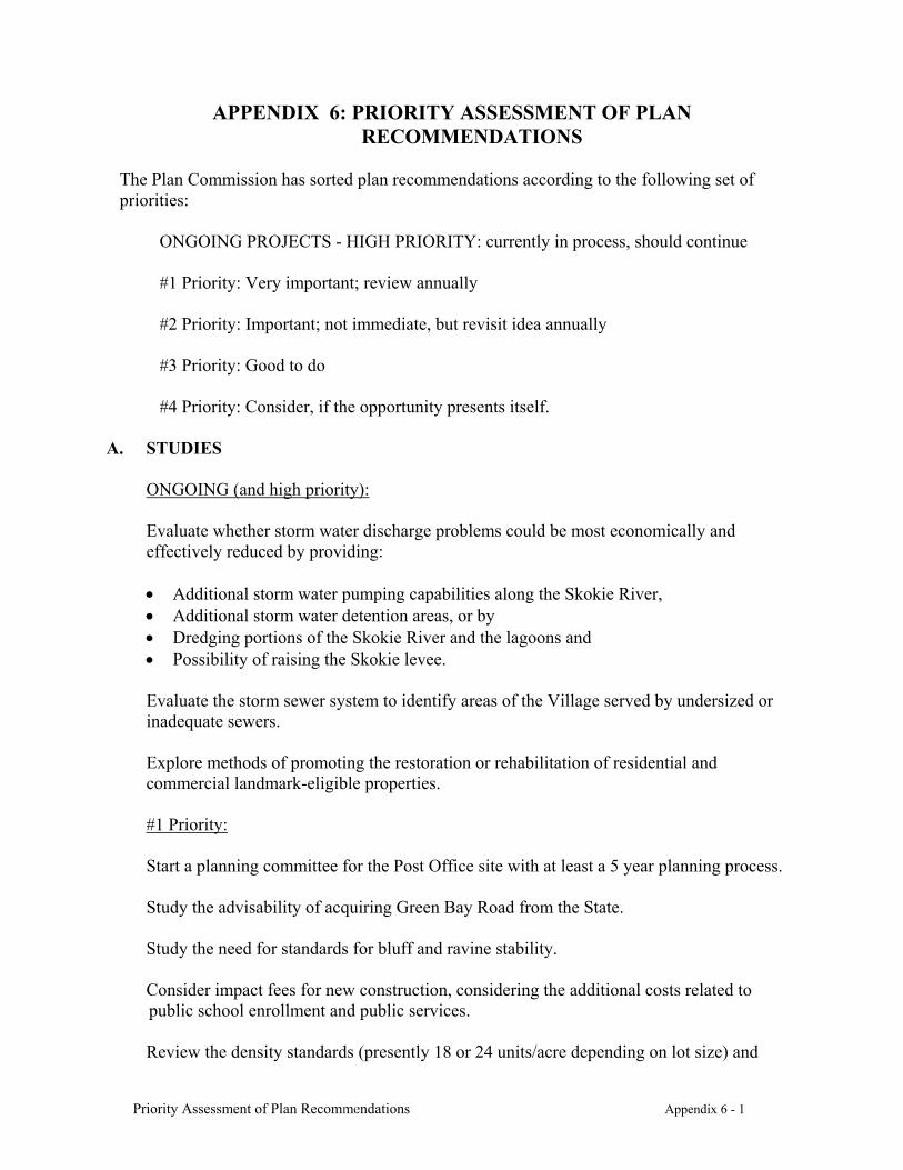
Priority Assessment of Plan Recommendations Appendix 6 - 1
APPENDIX 6: PRIORITY ASSESSMENT OF PLANRECOMMENDATIONS
The Plan Commission has sorted plan recommendations according to the following set ofpriorities:
ONGOING PROJECTS - HIGH PRIORITY: currently in process, should continue
#1 Priority: Very important; review annually
#2 Priority: Important; not immediate, but revisit idea annually
#3 Priority: Good to do
#4 Priority: Consider, if the opportunity presents itself.
A. STUDIES
ONGOING (and high priority):
Evaluate whether storm water discharge problems could be most economically andeffectively reduced by providing:
• Additional storm water pumping capabilities along the Skokie River,• Additional storm water detention areas, or by• Dredging portions of the Skokie River and the lagoons and• Possibility of raising the Skokie levee.
Evaluate the storm sewer system to identify areas of the Village served by undersized orinadequate sewers.
Explore methods of promoting the restoration or rehabilitation of residential andcommercial landmark-eligible properties.
#1 Priority:
Start a planning committee for the Post Office site with at least a 5 year planning process.
Study the advisability of acquiring Green Bay Road from the State.
Study the need for standards for bluff and ravine stability.
Consider impact fees for new construction, considering the additional costs related topublic school enrollment and public services.
Review the density standards (presently 18 or 24 units/acre depending on lot size) and
Priority Assessment of Plan Recommendations Appendix 6 - 2
location of the B-1 Multiple Family Zoning District. Review the advisability of creating aseparate townhouse district. Create a district purpose for the B-2 Multiple Family Zoningdistrict (30 units/acre) or consider the advisability of folding the B-2 designation into theexisting B-1 District with a higher-density B-2 overlay.
Review special use permit standards for parking, traffic and bulk issues.
Study how to strengthen the special use permit standard as they relate to institutions inresidential neighborhoods.
#2 Priority:
Study, with Glencoe, solutions to change the municipal boundaries or address the financialinequity of the Glencoe split lots.
Consider a voluntary open space, conservation and/or scenic easement program.
#3 Priority:
Study the options for an assisted-care facility for senior citizens.
Study ways to minimize regulatory signs (by Design Review).
B. ALLEYS
Priority #3
Improve the alley between the Brier Street houses and the Green Bay Road commercialuses, opening it to Kenilworth.
Priority #4
Establish guidelines for alley maintenance.
Improve the lighting for commercial district alleys.
C. LAND ACQUISITIONS (only if they become available)
Give highest priority to:
The east side of Sheridan Road, between Centennial and Elder parks;
Corner lot parcels for pocket parks in the densely developed neighborhoods;
The southeast corner of Green Bay Road and Winnetka Avenue; and
Any other substantial portion of property, particularly along the lake.
Priority Assessment of Plan Recommendations Appendix 6 - 3
Other recommended properties:
The southwest corner of Oak and Linden (at the bend in Green Bay Road, currently usedfor community notices);
Any portion of the North Shore Country Day School campus;
The west side of Birch between Oak and Elm Streets;
The northeast corner of Spruce and Birch Streets.
D. BEAUTIFICATION
Place greater emphasis on the beautification of the Village since these projects providea very high impact for a relatively low expenditure.
#1 Priority:
Create a vehicle to encourage gifts and charitable contributions for beautification purposes.
Create design standards for commercial, institutional multiple-family buildings and publicspaces.
Create Village entrances at the Forest Way intersections of Tower and Willow Roads (withgreater priority given to Tower) and at the Green Bay Road entrances at the Kenilworthborder and at Scott Avenue.
Create a strategic plan for landscaping and other aesthetic improvements for public waysand spaces.
Replace or screen the guardrail located along Green Bay Road between Elm Street andTower Road.
Beautify the parking lot southeast of Green Bay Road/Winnetka Avenue.
Beautify the three railroad stations.
Improve the appearance of dead-end streets at the Lake front referred to in the Plan.
#2 Priority:
Remove the chain-link fencing throughout the Corridor and, if needed, replace it withfencing more appropriate.
Improve the parking lot south of Tower Road.
Priority Assessment of Plan Recommendations Appendix 6 - 4
Adopt and enforce regulations that address derelict properties.
#3 Priority:
Encourage Cook County Forest Preserve District to enhance the natural appearance of theForest Way right-of-way.
Improve the landscaping in the cut along the railroad right-of-way.
Naturalize the landfill’s landscaping.
#4 Priority:
Provide a major design feature at Green Bay and Willow Roads.
Provide streetscape guidelines for residential neighborhoods.
E. BICYCLE TRAILS
#1 Priority:
Create a bicycle trail network including an east-west bike trail to link the two north-southbike routes.
Create designated bicycle routes around and to schools, where feasible.
Study ways to make Sheridan Road safe for bicycle use.
Improve landscaping along the Green Bay Trail.
F. SIDEWALKS
ONGOING AND HIGH PRIORITY:
Provide sidewalks along at least one side of public streets to enhance safety especially nearschools, commuter stops and parks.
Maintain sidewalks to promote safety and enhance appearance.
G. SIGNS
#1 Priority:
Priority Assessment of Plan Recommendations Appendix 6 - 5
To direct traffic to the Edens Expressway southbound (at Willow) and northbound (atTower) entrances.
Encourage the Design Review Board to manage efforts to reduce the proliferation ofregulatory street signs within the Village.
#4 Priority:
Provide signs to help nonresidents follow Green Bay Road’s twists and turns.
H. STREETS / INTERSECTIONS
#1 Priority:
Review pedestrian, bicycle and vehicular safety at the following intersections:• The two Green Bay Road and Tower Road intersections;• Green Bay Road, Spruce Street and Chestnut Street;• Green Bay Road and Elm Street;,• Green Bay Road and Willow Road;• Green Bay Road and Church Street;• Green Bay Road, Winnetka Avenue, and Brier Street; and• Willow Road and Forest Way (even though this is outside the Village boundary).
Allow on-street parking along only one side of narrow streets within residentialneighborhoods.
Institute traffic calming strategies.
Discourage regional truck traffic from traveling through Winnetka on minor and collector streets.
Improve lighting for the Winnetka Avenue underpass.

Priority Assessment of Plan Recommendations Appendix 6 - 6
I. OTHER PUBLIC / QUASI PUBLIC FACILITIES
#1 Priority:
Upgrade the Hubbard Woods alley parking lot and alley north of Tower Road, adjacent tothe railroad cut.
Rehabilitate the Public Works building and yards.
#2 Priority:
If demand dictates, consider replacing the surface parking lot south of the CommunityHouse with an underground or decked parking structure that is open to the railroadembankment.
#4 Priority:
Redevelop the Elm Street Metra Station into a commercial-retail structure that spans the railroad tracks.


