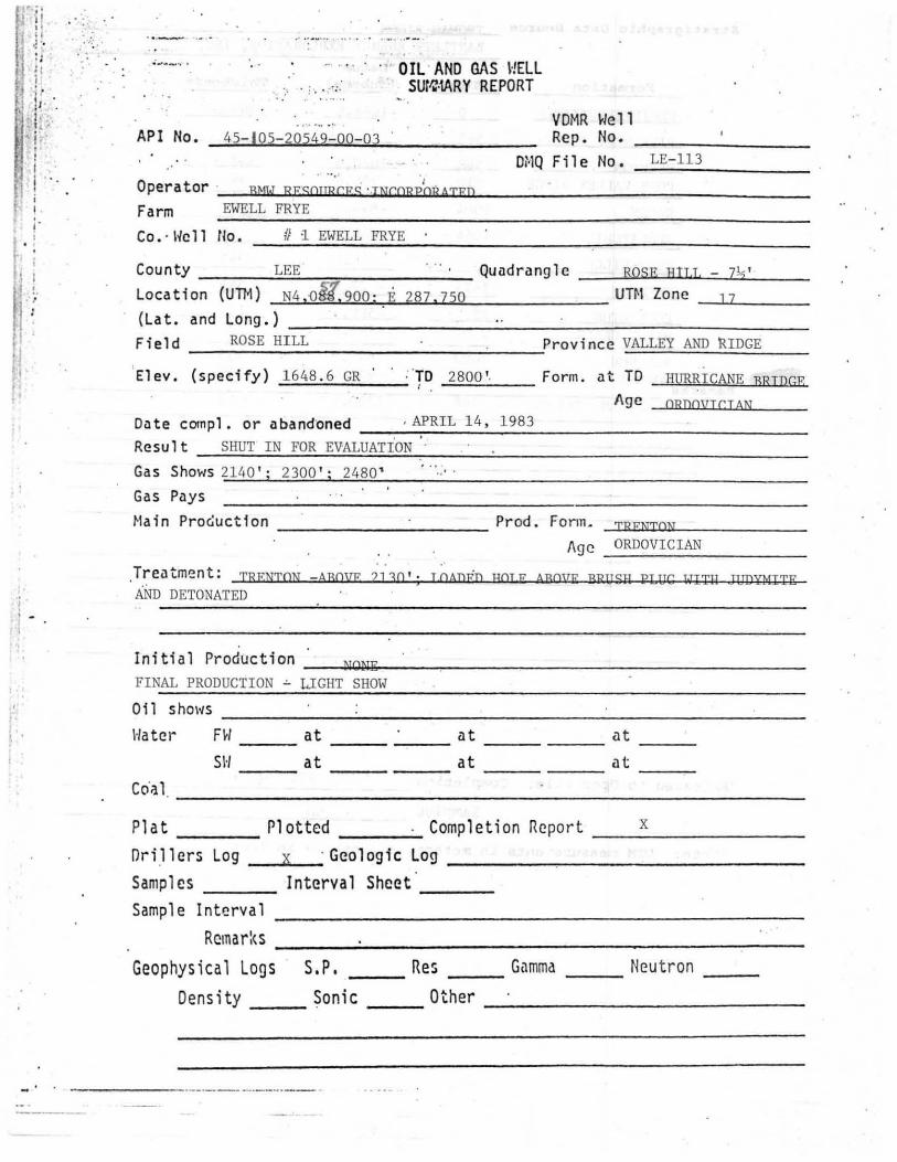
ROSE HILL 9- 45 API No. 45 - 105 - 20549 - 00 - 03 Operator BMW RESOURCES INCORPORATED Farm EWELL FRYE Co. /lo. ttl EWELL FRYE VDMR Well Rep. No. ______ _ DflQ F i1 e No. __ __ _ Cou nty LEE Quadrang 1 e E ",--" H "",- IL ",, L ,,--_ 7 .r...; 1 2,. ? _ ' __ Location (UTM) ..... .... ; ____ Zone __ _ (Lat. and Long.) ____________________ _ Field ROSE HILL Province VALLEY AND RIDGE Elev. (specify) 1648 .6 GR TO 2800' Form. at TO HURRICANE BRIDGE Age ORDOVICIAN Da te comp 1. 0 r a band oned ___________ _ Result SHUT IN FOR EVALUATION Gas Shows 2140' i 2300' ; 2480 ' Gas Pays Main Procluctlon __________ Prod. Form . --' T "" R "' E "' N "' T ,.., O '-'- N=--___ _ Age ORDOVICIAN Trea tme nt: TRENTON- ABO. VE 2130 '; LOADED HOLE ABOVE BRUSH PLUG WITH JUDYMITE AND DETONATED In i ti a 1 Product ion -..IN ''''O ''' N ''''E ''--__________________ _ FINAL PRODUCTION - LIGHT SHOW Oil _________________ . ________ _ 1 · /a tel" H/ ___ at ______ at ______ at __ _ SH at at at --- Coal Plat Plott ed Completion Report __ _____ _ Drillers Log X Geologic Log _______________ _ Samples In te rval Sheet ' --- --- Sample Interval Remarks ___ --' ___________________ _ Geophysical Logs S. P. ___ Res ___ Gamma ---" X "--_ Neutron __ _ Density ___ Sonic ___ Other TEMPERATURE . FRACTURE IDENTI- FICATION
Transcript
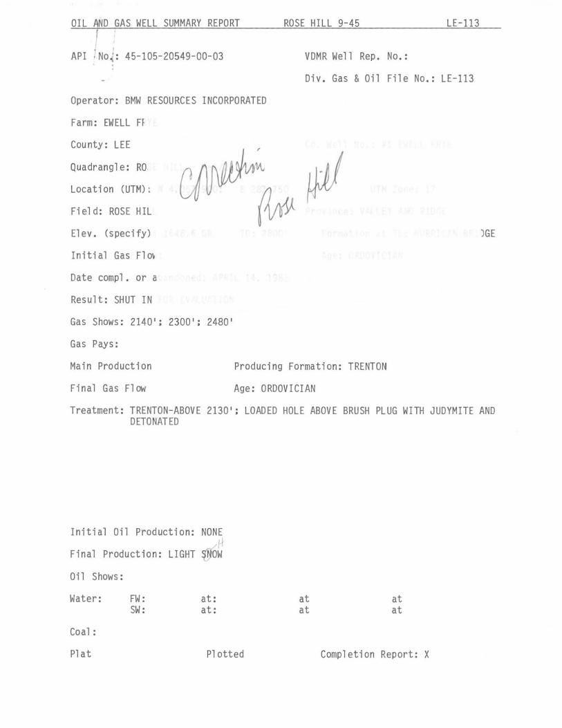
ROSE HILL 9-45
API No. 45 - 105 - 20549 - 00 - 03
Operator BMW RESOURCES INCORPORATED
Farm EWELL FRYE
Co. ' I~ell /lo. ttl EWELL FRYE
VDMR Well Rep. No. ______ _
DflQ F i1 e No. __ Il.LrE~-::..11...1!.,.,3,--__ _
Cou nty LEE Quadrang 1 e _R~O~S E",--"H"",-IL",,L,,--_7.r...;12,.? _' __
Location (UTM) ....::.N4~! 0~5::..!7 ..... !~9..:::0,,"0 .... ; --"E::.:2:..::8:..:.7...z.!~7.::.5 :::.0 ____ UT~1 Zone ~1 -,-7 __ _ (Lat. and Long.) ____________________ _
Field ROSE HILL Province VALLEY AND RIDGE
Elev. (specify) 1648 . 6 GR TO 2800' Form. at TO HURRICANE BRIDGE
Age ORDOVICIAN
Da te comp 1. 0 r a band oned ---"A:!.P,-,R",I",L,,-,1,,-,4;!C.!>-..:1,-,9::.:8::.:3~ ___________ _
Result SHUT IN FOR EVALUATION
Gas Shows 2140' i 2300' ; 2480 '
Gas Pays
Main Procluctlon __________ Prod. Form . --'T""R"'E"'N"'T,..,O'-'-N=--___ _
BEN HUR 2490 - 841 . 4 135 Remar ksWOODWAY '. 2625 - 976.4 143
. HURRICANE BRIDGE 2768 1110 . 4 32
. Rofor cncc s __________ ~~ ____________________________________________ __
, .
Released t o Open File : Completion ____ ~JUL~~Y_1~3~,~1~9~8~3 __________________ _
SampleD NO
(Note . UTM meas uremonts in meters, nil others i n feet)
II
fORM, 5 (Draft 07-09-82)
LOliludt 3C;;-40'00 'f
J/7 t
"",
/ '<'" ,~
ewell ~ J?ub y Frye. 9,,5, 1'13 /!3.51'5
71(0, ')7'
:.. ..
L6 -113
Cor, Po>+
(FOR OFFtCE (USE ONLY :
API Well No. ~- l os - .:2ClS1f State County Permit
Date: _tk.",,' ' :::::'.b""'---LI __ , 191:?:::--
Operator's ~ Well No. HI Ewell3/1:J<-'
. VIRGINIA OIL AND GAS INSPECTOR DEPARTMENT OF LABOR AND INDUSTRY
DIVISION OF HINES
U //3
219 Wood Avenue Big Stone Gap, Virginia 24219-1799
Phone 703-523-0335
WELL PLAT
+ Denotes location, of well on United States Topographic Maps, scale 1 to 24,000. , Latitude and longitude lines are represented by border, lines as shown.
This plat is new ~ ~pd;ted_' __ '
This plat is ___ ' is not ./I based on a mine coordinate system established for the areas of the well location.
Well opera tor 8 .M. kI. -<'? ~s 0(1 rc e 5
.35.3¢: 8. Cave. -5<1 11"", CIO Address hlt/sllN 7CKaS 7874<7, Farm cove ll E e"w 6 .. V<:. Tract Acres Z.3.S Lease No. Elevation / c <:<8. C ---------Quadrangle Rose fI,// County Lee District .ease !-I.1l Registered Engineer Registration NO. ____ ~~ Certified Land Surveyor......... Cert. No. oo/~/<=. File No. Drawing No. o -/19- -t-s -ze Date ;YOI!. IB , 198z.. Scale _ I<-.··..::::.L;:..O:;.O=-· __ -'-___
Certification of Well Plat
I, the underSigned, hereby certify that this plat is correct to the best of my knowledge and belief, and shows all the information required by law ·and the regulations of the Virginia Well Review Board •.•
~~,~~ .• ~ •..•. , Re~ed En~ineer or C!~fied Land su~6~ in Charge = ~ \ ".
1Il'1 I,' ,d .l 1\0 . I,S _ _ _ Sta l e County re~mit
DDt e: Apr.=i.=1_1=.4'-L' ___ _ 19 83
L~-113 Oftern tor ' s /,tlQ /fILl. -71:./1{ e 11 No . _..::.#=..1 -=EI::;.:;e:.::l=..l...::.F."-'ry<...;:eC-__
~
VIRGINIlI OlIo 111\0 GIIS I1\SPECTOR DEPARnlF.NT OF LABOR liND INDUSTRY
DI VISION OF HINES 219 lIood lIvenue
Big Stone .. Gop, V irgi"ia ... 24219 -2799 Phone 703-523-0335
REPORT OF COHPLETION OF HELL I{oRK
Pur·s nant to Regulation 1,.06 of the Regulations under the Virginia Oil and Gas Act. the u nders ign ed ",e ll operator reports completion of the type (s) of ",e ll work speci fied b e lDl' on the referenced well in Rose Hill Distric·t,
I£e County # Virgillin:
HELL TYPE: 011 X I Gns I Enhanced recovery I I{aste disposal I I f I'Gos II, Pr oduction / UndCl"SliOund ' storagc __ 1 --
Exempt by Code § 45.1-300.B.l from gene ral oil and gas con se~vation law: Yes __ l N0-X..I
\{ELL \{oR!: : Drill_x..! Deepen I RedriU I Stimu1ate X I Plug off old formation __ 1 Perforate new forma tion __ 1 Plug __ 1 Rcplu& __ 1 Other physicnl change in woll (spec ify)
The well work was done as s h DlOl1 in the Appendix (es) applicable to the type(s) of well work involved. If the "ell "ark included the drilling of a new we ll, the certificat ion of the location i s on . tlie reve r se h e r eof.
CONFIDENTI lILITY STilTUS UNDER CODE OF VIRGINIlI § 45.1- 332 :
~Ninety days fr om the filin~ of t his r eport,
or
Two yea rs from _-:-:-____ -:- ,19, the date on «hich th e referenced (Jell ~·" s complet.ed, the (,ell be ing an exploratory well ns defined in Cod e of .Virginia § 45 .. 1 -288.21.
IIPPLICI\NT : BMW ResouTces, Inc .
By . Frank N .~W~a~l_d_ro~p~ ______________________ ___ It ,,--PTesl.dent
lIddress: 3534 Bee Caves Road , Aus tin, Texas 78746
T" l cpho ne: (512) 327 - 8940
HEVEKSE
CERTlFICATlON OF LOCATION OF !. ~:,:\,: \':~;LL -----_._--------------
I, the undersigned, hereby cert.i fy 'that I "nl fnnl ,i.linr "ith the I,ell pInt Sl lO',.,Ting ' the permitted ] ocntion of the n( ~t ... \, 0. 11 referencecl on the obverse hereof; and thnt I Dm the cngin9-cr __ 1 Slll:vcyo r __ 1 who verified thDt the actual surface l ocation of the n . .:plncccl stllkc __ I ' \\'cll __ /) of tel' the ,,Jell site ,.,'" s cleare.d 'and readied, docs in fact comp ly ~jtll the ,standard of Regulation 4.02 of the Regulations under the Virginia Oil and Gas Act, liS .follO\~s :
within three feet of the l ocation desig-__ . __ ·-·~=t..od. on the I,'ell pi..,.t 'in an aren .. underlllin --- by knolm coal seams identified 'by the Chief
of the Di v ision of Hines pUl'slIant to Code of Virgin'ia § 45.1-333, or
within ten feet of the location des~gnated by the well plat in other areas.
( Name)
JiJ'j'J': r" J) x - TYI'E 1\, SIIJ:ET /. (OBV}':J(SE)
I'RCLHIlNAl{Y INFOIWATION
Is the s ubject ,,'ell unqerlaid by the red shales? 1 f "y " 1 ' , . 1 cs • wns n con protect 1011 strlllg set tq t 10
PRQt;RNI DETAILS ..-'
Yes_I No~1 red shales? Yes __ 1 N0-'LI
Perforated Size Top Bottom Length From To
Conducto r
9 5/8" surf ace SO' , 50'
Casing ' circulated and . celnentcd in to the surface:
7" surface 515' 515' ,
Coal protection casing se.t under the special rule of Code of Virginia § 45.1-334.B:
None
Other casin~ and tuhing left in the well:
Liners left in well, under Code of Virginia : § 45.1-336 ~r otherwise:
Other casing used in drilling but not left· in the I<ell:
Packers or bri<!.ge plug;?,: Kind ' --.---- Size Set At