14
. INITIAL RECEIPT
. INITIAL RECEIPT
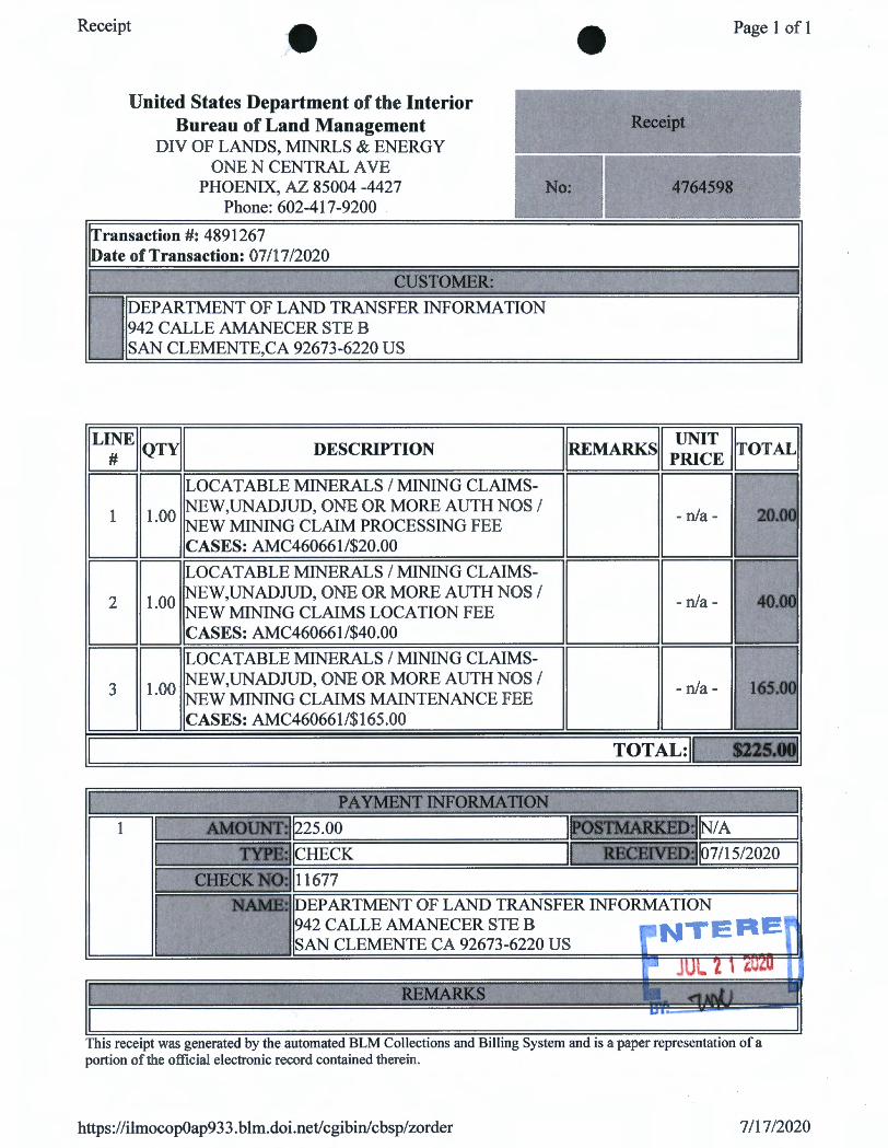
Receipt ~· • Page 1 of 1
United States Department of the Interior Bureau of Land Management Receipt
DIV OF LANDS, MINRLS & ENERGY ONE N CENTRAL A VE
PHOENIX, AZ 85004 -4427 No: 4764598 Phone: 602-417-9200 .
Transaction#: 4891267 Date of Transaction: 07/17/2020
I CUSTOMER: I
D DEPARTMENT OF LAND TRANSFER INFORMATION 942 CALLE AMANECER STE B SAN CLEMENTE,CA 92673-6220 US
ILI:EIIQTYII DESCRIPTION IIREMARKsll P~~~ IITOTALI
DB LOCATABLE MINERALS / MINING CLAIMS-
•EJ NEW,UNADJUD, ONE OR MORE AUTH NOS/ 20.0C NEW MINING CLAIM PROCESSING FEE CASES: AMC460661/$20.00
DB LOCATABLE MINERALS / MINING CLAIMS-
•EJG NEW,UNADJUD, ONE OR MORE AUTH NOS/ INEW MINING CLAIMS LOCATION FEE CASES: AMC460661/$40.00
DB LOCATABLE MINERALS / MINING CLAIMS-
•EJB NEW,UNADJUD, ONE OR MORE AUTH NOS/ NEW MINING CLAIMS MAINTENANCE FEE CASES: AMC460661/$165.00
I TOTAL:11 $225.00
PA YMBNT INFORMATION •
1 I AMOUNT: ~25.00 I POSTMARKED: jN/A I TYPE: !CHECK I RECEIVED: ~7 /15/2020 I
CHECK NO: 111677 I NAME: DEPARTMENT OF LAND TRANSFER INFORMATION
942 CALLE AMANECER STE B • NTEFIE1
~
SAN CLEMENTE CA 92673-6220 US 1 ..J JUL z l ,u,u
·: ItEMARKS • ~ll\l;J I
UI
This receipt was generated by the automated BLM Collections and Billing System and is a paper representation of a portion of the official electronic record contained therein.
https://ilmocop0ap93 3. blm.doi.net/cgibin/cbsp/zorder 7/17/2020

CORRESPONDENCE
TRANSFERS
MAINTENANCE FEES
WAIVERS
POL/NOi

MISCELLANEOUS
• • • DEPARTMENT OF LAND TRANSFER INFORMATION
PROTECTING AMERICA1
S RESOURCES TEL 949.361.6618
FAX 949.366.9945
www.LANDTRANSFER.US.COM
942 CALLE AMANECER SUITE B
SAN CLEMENTE, CA 92673
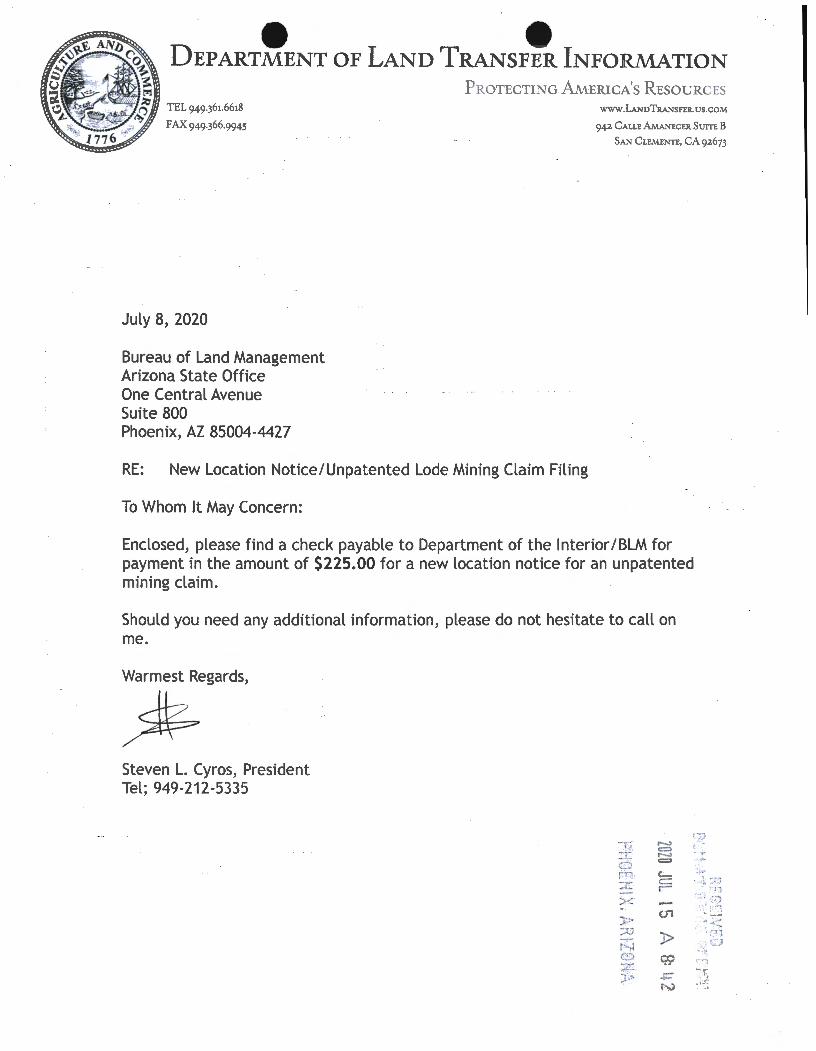
July 8, 2020
Bureau of Land Management Arizona State Office One Central Avenue Suite 800 Phoenix, AZ 85004-4427
RE: New Location Notice/Unpatented Lode Mining Claim Filing
To Whom It May Concern:
Enclosed, please find a check payable to Department of the Interior/ BLM for payment in the amount of $225.00 for a new location notice for an unpatented mining claim.
Should you need any additional information, please do not hesitate to call on me.
Warmest Regards,
% Steven L. Cyros, President Tel; 949-212-5335
,.... c:::::> ,.... = Cc:: r-
(J1
)> .,,;< ',,, ·, o
LOCATION NOTICES
AMENDMENTS
STATUS SHEET
GEO REPORT/MTP

• • MINING CLAIM STATUS REPORT- Assessment Year 2020
Data Entered: '1 {v. [ 1,01.D ~
LEAD SERIAL NUMBER:
NUMBER OF CLAIMS & TYPE:
___ { _ LODE
PLACER ----
AMC
ASSOCIATION PLACER ----MILLSITE ----TUNNEL SITE ----
TOTAL ACREAGE: {Placer Only)
Per Claim - - -----
NUMBER OF LOCATORS:
DOCUMENTS RECEIVED VIA : Over-the-Counter [ ]
LEGAL DESCRIPTION: T J/V R
T R ---- ----T R ----T R - - --T R ----
BLM [ ] FOREST SERVICE [
WILDERNESS AREA [ ]
.MTP Checked By: ~ GEO Checked By: -,pj}i--..-::~----
~------
thru AMC
CHARGES:
Processing Fee @ $20 = $ Jo Location Fee @ $40 = $
Maintenance Fee @ $165 = $
Add'I Ma int Fee for Assoc Placer= $
SUBTOTAL $
Other Fees $
Other Fees $
TOTAL $
Mail[ri- TIMELY FILED: Yes ~ No [ ]
SEC ___ ef~~+----------SEC --------------------SEC ------- -------------SEC --------------------SEC
SUBJ TO PL 359: Yes [ ] No [ ]
----- --------------------SPLIT ESTATE: N/A [ ] sx [ PX [ ] OTHER [ ]
SRHA [ Was proper Notice filed if located on SHRA Land? Yes [ ] No [
RECONVEYED MINERALS ON BLM LAND REQUIRE OPENING ORDER FROM 1944 TO 1993:
Open to Entry On ______ _ _ N/ A [ ]
COMMENTS/STATUS: VOID [ ] PARTIALLY VOID [ ] PVT MINERALS [ WITHDRAWN LANDS [ ]
OTHER [ ]
{ J Claimant acknowledges that portions of the following claim(s) site(s) may be void or voidable.
Printed Name of Claimant Signature of Claimant
********************FINAL ADJUDICATION********************
DATE INITIALS
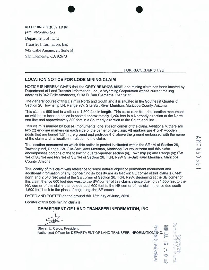
• RECORDING REQUESTED BY:
(Mail recording to;)
Department of Land
Transfer Information, Inc.
942 Calle Amanecer, Suite B
San Clemente, CA 92673
LOCATION NOTICE FOR LODE MINING CLAIM
•
FOR RECORDER' S USE
NOTICE IS HEREBY GIVEN that the GREY BEARD'S MINE lode mining claim has been located by Department of Land Transfer Information, Inc., a Wyoming Corporation whose current mailing address is 942 Calle Amanecer, Suite B, San Clemente, CA 92673.
The general course of this claim is North and South and it is situated in the Southeast Quarter of Section 26, Township 5N , Range 9W, Gila-Salt River Meridian, Maricopa County, Arizona.
This claim is 600 feet in width and 1,500 feet in length . This claim runs from the location monument on which this location notice is posted approximately 1,200 feet in a Northerly direction to the North end line and approximately 300 feet in a Southerly direction to the South end line.
This claim is marked by four (4) monuments, one at each corner of the claim. Additionally, there are two (2) end-line markers on each side of the center of the claim. All markers are 4" x 4" wooden posts that are buried 1.5' in the ground and protrude 4.5' above the ground embossed with the name of the claim and its location in relation to the claim. J::>
The location monument on which this notice is posted is situated within the SE 1/4 of Section 26, Township 5N, Range 9W, Gila-Salt River Meridian, Maricopa County Arizona and this claim encompasses portions of the following quarter-quarter section (s) , Township (s) and Range (s); SW 1/4 of SE 1/4 and NW 1/4 of SE 1/4 of Section 26, T5N , R9W Gila-Salt River Meridian, Maricopa County, Arizona.
The locality of this claim with reference to some natural object or permanent monument and additional information (if any) concerning its· locality are as follows: SE corner of this claim is O feet north and 2,040 feet west of the SE corner of Section 26, T5N , R9W. Beginning at the SE corner of this claim thence 600 feet due west to the SW corner of this claim, thence due north 1,500 feet to the NW corner of this claim, thence due east 600 feet to the NE corner of this claim, thence due south 1,500 feet back to the place of beginning, the SE corner.
DATED AND POSTED on the ground this 15th day of June, 2020.
Locator of this lode mining claim is:
DEPARTMENT OF LAND TRANSFER INFORMATION, INC.
d? 7:; r-.. Steven L. Gyros, President ... fi{- ~ Authorized Officer for DEPARTMENT OF LAND TRANSFER INFORMATIO ;·. {;NC. c._
:;l: ;=
U1
)>
..... .,. . . '} ..

•
MINING CLAIM MAP
1 mile
•
Lode ~ Placer ( ) Millsi.te ( )
--------------------------------------1------------------1--------------------------------------------·
Cl) -·-E
Scale: 1" = 2000 feet
. : 1 -'r:1
~ ' ·-t.;> c.n _:..• I
:~- . . ~ """.; 1. The above map depicts the (j~\S'.Y O.Eo..12..o's M, ,..,,~ mining claim, which is locate,djn Se°ttion (sf 6
~ Co 'Township S" ~ I Range 9. w I Gt'--&>- - .S.t:--C...'f"~ \ ~ erl~ian,
Mo..J\...\t. 0 (->A-- County, t>r2- Totalclaimacreageis :20 .~~ p.-cf\...~S.. I",-.)
2. The type of corner and location monuments used are as follows: '-f" a,f. t./ '' vuoo O c_.._, (? <::>S,-t"~
3. The bearings and distances in degrees and feet between claim corners and to a public land survey monument
are as depicted on the map.
4. If the claim is a placer or millsite claim with exterior limits conforming to legal subdivisions of the public survey,
provide a legal description of the claim ~~ c o ~r----e~ o ~ 7\k• S:. e c.- c. , ,..., 1 ~ ¢ f cc T ,-.,, o IUltf
"1.. (""--\. ' 0 ..,~ ' t)... ~ Form MCFl00a
Revised Oct 2018
This form is available from the Arizona Geology Survey and may be reproduced.
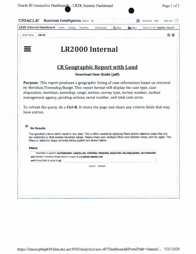
Oracle BI Interactive Dashboar, - LR2K Internal Dashboard - Page 1 of 1
ORACLE' Business Intelligence Search All + Advanced Help Sign Out 9
LR2K Internal Dashboard Home catalog Favorites Dashboards : llo New / ii Open I Signed In As cabelin, Zeus D
LR2K Home CR-24
--- LR2000 Internal
CR Geographic Report with Land Download User Guide (pdf)
Purpose: This report produces a geographic listing of case information based on retrieval by Meridian/Township/Range. This report format will display the case type, case disposition, meridian, township, range, section, survey type, survey number, surface management agency, pending actions, serial number, and total case acres.
To refresh the query, do a Ctrl-R. It resets the page and clears any criteria fields that may have entries.
• No Results
The specified criteria didn't result in any data. This is often caused by applying filters and/or selection steps that are too restrictive or that contain incorrect values. Please check your analysis filters and selection steps, and try again. The filters or selection steps currently being applied are shown below.
Filters - - ---
Disposition is equal to AUTHORIZED, CANCELLED, EXPIRED, PENDING, REJECTED, REUNQUISHED, WITHDRAWN .
and Meridian Township Range Section is equal to 14 OOSON 0090W 026
and Admin State is equal to AZ
. Return - Refresh
https:/ /ilmocop0ap65 9. blm.doi.net: 9 503/analytics/saw .dll ?Dashboard&PortalPath=/shared/... 7/21/2020

TOWNSHIP 5 NORTH RANGE 9 WEST OF THE GILA AND SALT RIVER MERIDIAN, ARIZONA
MARICOPA COUNTY NASSIIYAMJ"A rnDarncc
========~-~-~=~~=~~~~=~~~~--~=~=~==~~~==~~-~--~~~~~,--,-=,-----,-,----c=-r.-=c=-~= ~ TON I 't" 4 44.~ J 41.02 2 4$.20 I 45.37 4 ~" J .. , _74 2 41.12 1 '6.11 4 .... 25 J 46.Jl 2 48.4,J I -46~ 4 46.64 J '6.78 2 '6,94 1 '7.08 4 .t0.711 J 40.60 2 .t0.40 I 40. 2:2 T 5N
i i' ... ,.+ i F"'n"1
i740.75"1
L ._ . 1 40.?J
2 40.87"1
J 40.61 "1
4 40.55 "1
1 40.'-i
240.4J ~
J ,l().J7 "1
4 "ll.Jl "1
--1 140.27
240.2!1"1
_j_ _j__J J l . ...,
,,.,. ,..,. _»tl~lilln$~
18
,~9
4 ~ -21 "1
T".o:ii
240.1 1!1"1
340.111"1
440_11 "1
__J 1-40.IJ
2.t0.~"1
340.00"1
439.93"1
30
31
R 10w IR ~w
, ..
_j_ _j_
5
8
20
29
32
_,,.,., ,,_ AIMh
_j_ _j_ _j_ _j_ _j_
PHX 07""4 g,.-_. ,., .,.
21
28
33
$CAL£ In chains
22
27
34
_j_
f»-111-0041 D..,-t:
23
26
35
_j_ _j_ _j_ _j_
24
25
36
llA ,,,_,,
-~Spmp~
PHK 07556~
, 46.2712 4e.24 ll 46.22 --r.. -46}" -
!!!:'j j.....:.. I La t
~STA'IDIOi'T n,,i.p1v1111_.,,_,,•lt- vfTitls. --1Mu ... o,,1,.,. 0.,.apnc....,,.oti,,eu,.,,..,._,~.,11ec-•"-"_,,_...,.,.ftect UtloaC,,O,,,,.• ~-y-1,-, ilffacted ty iotn ....,_,,.,,. ol rt-. o, olhr IHHII• M ,.,rt ... ltet..tothe-trol-,.fotofflclal..,.,.ylnlormotlan.
Loo9
R aw
JJ'4J'J2"N
11''0B·1s·w
STATUS Of PUBLIC DOMAIN LAND AND MINERAL TITLES
INDEX TO SE GREGA TEO TRACTS RE~'A:Y ORIQNAL ~YO'
TRACTJrtO ' R SEC .........
FOR ORD£HS AFFECT/NC DISPOSAL QR l/SE OF IJNl0£NT1F/£0 LANDS MTHOl?Atw FOR Q.ASSlflCAllCW,
41/NERALS. WA T£R ANO/qi' OTHER P(J8t.JC PURPOSES. RCFER TO IN0£K OF lrl!SC£L/.AN£0l/S OOCVMENTS
Crozin2_ Oist No 2
CURRENT TO NW GSR Mer
12-27-2011 ACAD T ~ c_ _____ ,L ____ _j R-LI'!
7
-
-

c'.:J L, • ~ . ;:: , L~ l: <..:~ ... (:. t.!".: .. ,
...
Department of Land Transfer 942 Calle Amanecer Suite B San Clemente, CA 926 73
N :::t •:_ (
~ -v .... . (;)
<( 1";.J u::
Lf) .;.(
- X _J -:::> X -, t:::J
= ,. . t-.1 ~ j = t-.1 t;I_ ..... ,.
PH C1'END( AZ 852
fb! .JtJit 2C120 PM 3 L
Bureau of Land Management Arizona State Office One Central Avenue Suite 800 Phoenix, AZ 85004-4427
SSi:ti:;::+-442 ·?1_1:_c ,,, "'' 1 I 1li 11111ii1'1 11111 11 1111 1'1 1'111'1 ' I 11,,,, 11,, ,, , llhP•
r
I el
-


