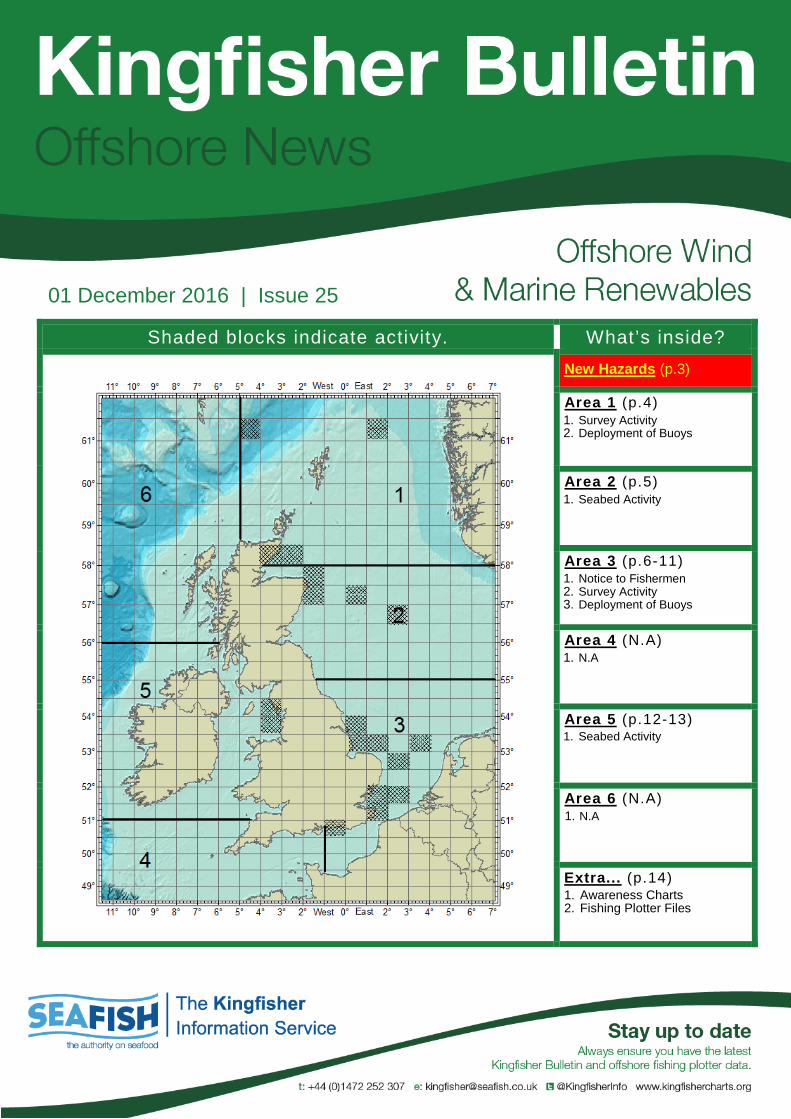
The Kingfisher Bulletin is provided by the Kingfisher Information Service of Seafish, to promote the awareness of offshore hazards to fishing, new structures and zones and conflicting offshore operations. Support for the production of renewable industry information is received from The Crown Estate.
Information Information contained within the Kingfisher Bulletin comes from a variety of sources, although is in the majority, supplied directly to Kingfisher from the offshore operating industry, or government licensing authorities. Coordinates within the Kingfisher Bulletin are converted into World Geodetic System 1984 (WGS84) and displayed as degrees, minutes and decimal minutes, to three decimal places (ddd°mm.mmm’). Route or boundary coordinates may be simplified for ease of use.
Disclaimer and Limitation of Liability Whilst reasonable steps have been taken to ensure its accuracy, the data contained in this Bulletin (“Bulletin Data”) is not verified. Neither Seafish nor The Crown Estate (together the “Parties” and each a “Party”) makes any warranty, express or implied, as to accuracy, completeness or suitability for any particular purpose of the Bulletin Data. Except for any liability which cannot be excluded or limited by applicable law, none of the Parties shall have any liability to You, meaning any person, firm, partnership, corporate body or any other legal person receiving or otherwise using, or benefitting from the use of, Bulletin Data for any damage or losses (including indirect, incidental, special or consequential loss or damage) caused by any: (i) use of the Bulletin Data, or (ii) error or omission in the Bulletin Data. Notwithstanding the foregoing exclusion of liability, in the event that any of the Parties are found liable to You, then the Parties’ entire liability in such event, whether in contract, delict (including negligence) or otherwise, shall not exceed £1,000. The Admiralty Notices to Mariners should also be consulted.
3 of 15
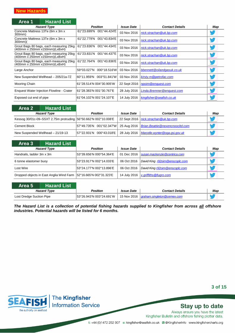
Area 1 Hazard List Hazard Type Position Issue Date Contact Details Map
Concrete Mattress 13Te (6m x 3m x 300mm)
61°23.699'N 001°44.424'E 03 Nov 2016 [email protected] Concrete Mattress 13Te (6m x 3m x 300mm)(
61°22.779'N 001°43.834'E 03 Nov 2016 [email protected] Grout Bags 80 bags, each measuring 25kg (400mm x 250mm x150mm)(LxBxH)
61°23.836'N 001°44.434'E 03 Nov 2016 [email protected] Grout Bags 80 bags, each measuring 25kg (400mm x 250mm x150mm)(LxBxH)
61°23.831'N 001°44.437'E 03 Nov 2016 [email protected] Grout Bags 80 bags, each measuring 25kg (400mm x 250mm x150mm)(LxBxH)
Area 3 Hazard List Hazard Type Position Issue Date Contact Details Map
Handrails, ladder 3m x 3m 53°39.656’N 000°54.364’E 01 Dec 2016 [email protected] 6 tonne elastomer buoy 53°23.917’N 002°14.033’E 06 Oct 2016 David King [email protected] Lost Wire 53°24.177’N 002°13.896’E 06 Oct 2016 David King [email protected] Dropped objects in East Anglia Wind Farm 52°16.665’N 002°31.323’E 14 July 2016 [email protected]
Area 5 Hazard List Hazard Type Position Issue Date Contact Details Map
Lost Dredge Suction Pipe 53°26.943’N 003°24.691’W 15 Nov 2016 [email protected]
The Hazard List is a collection of potential fishing hazards supplied to Kingfisher from across all offshore industries. Potential hazards will be listed for 6 months.
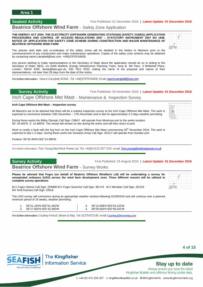
Seabed Activity First Published: 01 December 2016 | Latest Update: 01 December 2016
Beatrice Offshore Wind Farm – Safety Zone Application
THE ENERGY ACT 2004: THE ELECTRICITY (OFFSHORE GENERATING STATIONS) (SAFETY ZONES) (APPLICATION PROCEDURES AND CONTROL OF ACCESS) REGULATIONS 2007 – STATUTORY INSTRUMENT 2007 NO 1948. NOTICE OF APPLICATION FOR SAFETY ZONE SCHEME DURING CONSTRUCTION AND MAJOR MAINTENANCE OF BEATRICE OFFSHORE WIND FARM The precise start date and co-ordinates of the safety zones will be detailed in the Notice to Mariners prior to the commencement of any construction and major maintenance operations. Copies of the safety zone scheme may be obtained by contacting [email protected], +44(0)7979704635. Any person wishing to make representations to the Secretary of State about the application should do so in writing to the Secretary of State, BEIS, c/o Keith Welford, Energy Infrastructure Planning Team, Area B, 4th Floor, 3 Whitehall Place, London, SW1A 2AW, [email protected], 020 7811 5253, stating the name of the proposal and nature of their representations, not later than 28 days from the date of this notice.
For further information: Naomi Campbell, BOWL. Tel: +44(0)7979704635, Email: [email protected]
Survey Activity First Published: 03 November 2016 | Latest Update: 01 December 2016
Inch Cape Offshore Met Mast – Maintenance & Inspection Survey
Inch Cape Offshore Met Mast – Inspection survey All Mariners are to be advised that there will be a subsea inspection survey at the Inch Cape Offshore Met Mast. The work is expected to commence between 10th December – 17th December and to last for approximately 2-3 days weather permitting. During these works the Bibby Olympic Call Sign: C6BX7 will operate from Montrose port to the works location: 56° 26.404’N 2° 14.489’W. The vessel will remain on site during the works and will then return to port. Work to rectify a fault with the fog horn on the Inch Cape Offshore Met Mast commencing 30th November 2016. The work is expected to last 1-2 days. During these works the Smeaton Array Call Sign: 2EZU7 will operate from Dundee port. Position: 56°26.404'N 002°14.489'W
For further information: Tom Young Red Rock Power Ltd, Tel: +44(0) 0131 557 7101 email: [email protected]
Survey Activity First Published: 25 August 2016 | Latest Update: 01 December 2016
Beatrice Offshore Wind Farm – Survey Works
Please be advised that Fugro (on behalf of Beatrice Offshore Windfarm Ltd) will be undertaking a survey for unexploded ordnance (UXO) across the wind farm development zone. Three different vessels will be utilised to complete survey operations M.V Fugro Helmet Call Sign: ZDNM8 M.V Fugro Searcher Call Sign: 3EUY6 M.V Meridian Call Sign: ZDJC9 MV Smit Kamara Call Sign: ORLB The UXO survey will commence during an appropriate weather window following 01/09/2016 and will continue over a planned minimum period of 16 weeks, weather permitting.
Notice to Fishermen First Published: 20 October 2016 | Latest Update: 01 December 2016
Race Bank Offshore Wind Farm – Lost Anchor Recovered
Lost Anchor Recovered
53°15.310’N 00°52.230’E
For further information: Rebecca Goff, DONG, Tel: 0044 776 170914 [email protected]
Notice to Fishermen First Published: 20 October 2016 | Latest Update: 28 November 2016
Race Bank Offshore Wind Farm – Entire Fishing Clearance Zone Closed
The Fishing Clearance Zone shown in the below chart remains closed to all forms of fishing, and is expected to remain closed until February 2018. The deployment of any fishing gear, or fishing anywhere within, the Fishing Clearance Zone is strictly prohibited. Fishing vessels are able to transit through the Fishing Clearance Zone. However, all fishing vessels must maintain a safe distance from, and not disrupt, any vessel engaged in, or supporting, Race Bank construction operations. CONSTRUCTION ACTIVITIES CONTINUE AT THE RACE BANK OFFSHORE WIND FARM AND ALONG THE ENTIRE LENGTH OF THE EXPORT CABLE All wind turbine foundations have been installed, one of two offshore substations has been installed and the met mast decommissioning works were completed last week. Array cable installation has paused and will continue next year. Export cable burial works are continuing. The Havilla Phoenix is currently installing export cable. The Taccola is dredging cable joints along the export cable. They both require a wide berth. Primary activities over the next month include: 1. Wind turbine transition piece installation – Neptune 2. Export cable burial - Havilla Phoenix 3. Export cable joint burial at KP8 – Taccola 4. Export cable joint burial at KP27 – Taccola
The Entire Fishing Clearance Zone will be CLOSED to the fishing industry
For further information: Hywel Roberts, DONG Energy, Tel: +44(0)20 7811 5486 email: [email protected] Website: http://www.dongenergy.com/en/Search?&k=race%20bank
Seabed Activity First Published: 17 November 2016 | Latest Update: 01 December 2016
Race Bank Offshore Wind Farm – Unlit Monopiles
Navigational frame recovery campaign at the Race Bank Offshore Wind Farm Marine Licence. now have functioning lights at all monopiles. guard vessel Helen Mary will continue to monitor the situation. As far as recovery of dropped navigational frames one frame remaining for pickup at positions J05 and at L04. The vessel Neptune will collect those remaining frames at the respective monopiles during transition piece installation over the next 12 months.
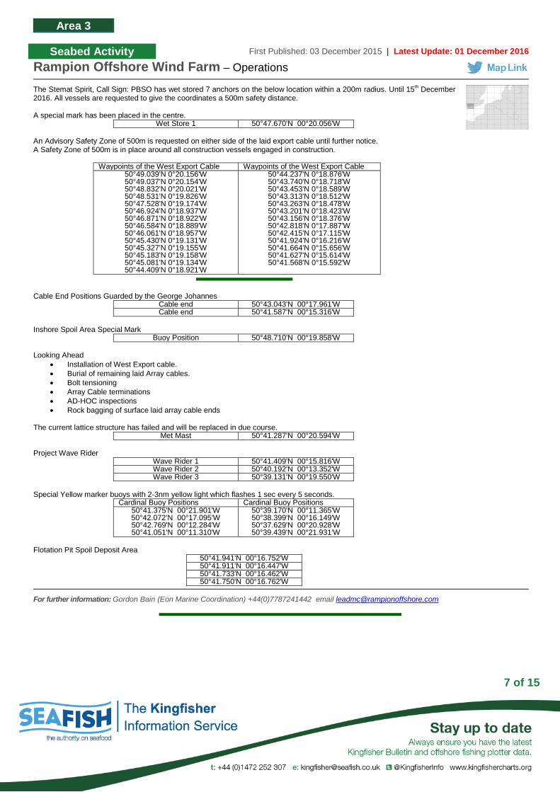
Seabed Activity First Published: 03 December 2015 | Latest Update: 01 December 2016
Rampion Offshore Wind Farm – Operations
The Stemat Spirit, Call Sign: PBSO has wet stored 7 anchors on the below location within a 200m radius. Until 15th December 2016. All vessels are requested to give the coordinates a 500m safety distance. A special mark has been placed in the centre.
Wet Store 1 50°47.670'N 00°20.056'W An Advisory Safety Zone of 500m is requested on either side of the laid export cable until further notice. A Safety Zone of 500m is in place around all construction vessels engaged in construction.
Waypoints of the West Export Cable Waypoints of the West Export Cable 50°49.039'N 0°20.156'W 50°49.037'N 0°20.154'W 50°48.832'N 0°20.021'W 50°48.531'N 0°19.826'W 50°47.528'N 0°19.174'W 50°46.924'N 0°18.937'W 50°46.871'N 0°18.922'W 50°46.584'N 0°18.889'W 50°46.061'N 0°18.957'W 50°45.430'N 0°19.131'W 50°45.327'N 0°19.155'W 50°45.183'N 0°19.158'W 50°45.081'N 0°19.134'W 50°44.409'N 0°18.921'W
Cable End Positions Guarded by the George Johannes
Cable end 50°43.043'N 00°17.961'W Cable end 50°41.587'N 00°15.316'W
Inshore Spoil Area Special Mark
Buoy Position 50°48.710'N 00°19.858'W Looking Ahead
• Installation of West Export cable. • Burial of remaining laid Array cables. • Bolt tensioning • Array Cable terminations • AD-HOC inspections • Rock bagging of surface laid array cable ends
The current lattice structure has failed and will be replaced in due course.
Met Mast 50°41.287'N 00°20.594'W Project Wave Rider
Seabed Activity First Published: 03 November 2016 | Latest Update: 24 November 2016
Greater Gabbard Offshore Wind Farm – Jack Up Barge Operations
Jack-up Barge operations will commence on Wednesday 16th November 2016 on the Greater Gabbard offshore windfarm. The work is expected to last until 31st December 2016. The following wind turbines and co-ordinates are where the operations will take place A 500 meters exclusion zone will be in force around the Jack-up barge SEAJACKS LEVIATHAN at all times, If you need to approach the barge please contact them on VHF ch16.
For further information: Lee Brown, SSE Wind Generation, Tel: +44(0)1502 524001 email: [email protected]
Seabed Activity First Published: 03 November 2016 | Latest Update: 29 November 2016
Galloper Offshore Wind Farm–Monopile Foundation & Transition Installation
Please be advised that from circa 1st week December 2016, the installation of 56 monopile foundation & transition pieces is expected to commence within the Galloper Offshore Wind Farm area that is demarcated by the navigational cardinal buoys. Works shall be carried out from the Heavy Lift Jack Up Vessel “Innovation” and shall also be supported by the Crew Transfer Vessel (CTV) “Arista”. Innovation shall be carrying out regular cycle’s infield while returning to the Port of Vlissingen to reload components. Arista shall be operating from the Port of Lowestoft primarily on a dayshift only basis. Both vessels request a 500m safety radius with permission to enter being given direct via the vessel which can be contacted on VHF 16
Seabed Activity First Published: 10 March 2016 | Latest Update: 30 November 2016
Dudgeon Offshore Wind Farm – Construction Works
Construction activities are in progress at the Dudgeon Offshore Wind Farm and Export Cable Corridor. Foundation installation is completed and the offshore substation has been installed. Inter array cable burial and preparation for wind turbine generators is ongoing. Wind turbine generators will be installed in the first half of 2017. All construction work is planned to be completed in late 2017. Service Operation Vessel The ESVAGT NJORD will be performing preparation support for the operation of the wind farm and will be in regular transit between the Dudgeon site and Great Yarmouth. Inter-Array Cable Burial The GRAND CANYON will perform the burial of the Inter-Array Cables to connect the wind turbines to the offshore substation. This operation is ongoing and expected to be completed mid December 2016. Accommodation Vessel The SEA CHALLENGER will be used as accommodation at the Offshore Substation until mid-December 2016, and will then be used to install the wind turbine generators from January 2017 until Q3-2017. Commissioning Activites For the commissioning work there are several Crew Transfers Vessels operating in the wind farm area on a daily basis. This activity is ongoing and will continue until commissioning is completed in Q4 2017. Guard Vessel The RESOLUTE has relieved GV ADVENTURE as a guard vessel to safe guard the wind farm area. The ADVENTURE is planned to be back on the field mid December 2016. During port calls, the ADVANCE will be used as back-up. Dudgeon Wave Buoy Partrac will recover the wave measurement buoy at the location below. The measurement buoy will then be re-deployed.
53°17.471'N 01°24.629'E
The vessel MV SPECTRUM 1 will be used for this work. All vessels are requested to keep clear by a minimum of 500 metres or 1/3 of a mile.
Mark Name Cordinates Status Flash Character Special Mark DOW - SM - N 53°17.631'N 01°23.919'E Temporary Fl.Y.5s North Cardinal NE - DOW 53°16.277'N 01°26.691'E Temporary VQ East Cardinal E- DOW 53°14.320'N 01°27.123'E Temporary VQ(3).5s South Cardinal S-DUDGEON 53°12.470'N 01°25.617'E Permanent VQ(6) long Fl.10s Special Mark DOW - SM - S 53°14.012'N 01°22.132'E Temporary Fl.Y.5s South Cardinal SW - DOW 53°15.451'N 01°19.188'E Temporary Q(6) long Fl.15s
Please be advised that from circa mid-October 2016 for approx. 6 weeks, scour protection installation works are expected to commence within the Galloper Offshore Wind Farm area that is demarcated by the navigational cardinal buoys. Survey Vessel “Spectrum 1” operating within the Galloper Wind Farm export cable route at the following locations: The vessel shall be engaged in laid mattress survey works within these areas, and requests an advisory safety zone of 500m. The vessel will be operating from the Port of Lowestoft. Operations are expected to commence on or around 19th October 2016. Spectrum 1 can be contacted on VHF 16 if required.
Name Coordinates Concerto 1 North Cable Crossing 52°11.600'N 01°41.700'E Concerto 1 South Cable Crossing 52°10.700'N 01°42.300'E BT Farland Cable Crossing 52°04.900'N 01°47.500'E
For further information: Lee Cornwell, Galloper Wind Farm Limited, Mob: +44 (0)7917 474352, Email: [email protected]
Seabed Activity First Published: 19 May 2016 | Latest Update: 27 November 2016
London Array Offshore Wind Farm – Wave Buoy Deployment
Please be advised that an additional wave rider buoy has been deployed within the area of London Array Offshore Wind Farm, designation – Long Sand Middle New Wave Buoy
Identity Coordinates Light Long Sand (Middle) 51°40.828'N 01°31.177'E Fl (5) Y 20s 2nm
Description of wave rider buoy: Yellow spherical buoy, transparent top dome with solar panels and flashing light. Existing Wave Buoy
Identity Coordinates Light Knock Deep (North) 51°37.064'N 01°30.364'E Fl (5) Y 20s 2nm
The Knock Deep North wave rider buoy is protected by 2 guard buoys stationed approximately 50 - 100 meters to the North and South.
Description of wave rider buoy: Yellow spherical buoy, transparent top dome with solar panels and flashing light. Description of guard buoys: Yellow spar with flashing light and radar reflector.
For further information: Duty Marine Coordinator, Tel: +44 1843 855 795 email: [email protected]
Seabed Activity First Published: 22 September 2016 | Latest Update: 22 September 2016
Gunfleet Sands OWF – Array Cable Burial
Recent surveys at Gunfleet Sands offshore wind farm have illustrated that some array/in-field cables are lying exposed on the seabed and are no longer buried and there is one freespan. These are the following cables located in the eastern part of Gunfleet Sands 1 and the north eastern part of Gunfleet Sands 2
Location Start of Exposure End of Exposure Cable between turbines C06-D06 51°44.590'N 01°14.923'E 51°44.383'N 01°15.101'E Cable between turbines F09-F08 51°44.736'N 01°17.428'E 51°44.481'N 01°16.772'E Cable between turbines F08-F07 51°44.481'N 01°16.772'E 51°44.225'N 01°16.115'E Cable between turbines F07-F06 51°44.225'N 01°16.115'E 51°43.969'N 01°15.459'E Cable between turbines G08-G07 51°44.274'N 01°16.950'E 51°44.018'N 01°16.294'E
There is a freespan at the following array cable location
Location Start of Exposure End of Exposure Length Height Cable between turbines C06-D06 51°44.590'N 01°14.923'E 51°44.383'N 01°15.101'E 4m 0.17m
Mariners are advised to be aware of these areas which may represent a hazard to fishing.
For further information: Merlin Jackson, Tel: 07989520484 email: [email protected] or Anthony Mayhew / Steve Breeden, Dong Tel: +44(0)1206 307915 email: [email protected]
Deployment of Buoys First Published: 03 November 2016 | Latest Update: 03 November 2016
Hornsea One & Two Offshore Wind Farm – Wave Monitoring
The following Notice of Marine Operations (NoMO) pertains to the deployment of one wave and current measuring buoy at the Hornsea 02 Offshore Windfarm. The equipment is due to be deployed on 29 October 2016. The buoy is yellow, complete with solar panels and tripod mast, discus shaped and 1.8 m in diameter. The buoy is equipped with an amber LED source navigation light with a visibility of four (4) nautical miles. The light is configured to flash in accordance with IALA standards: five (5) flashes at one (1) Hertz, every twenty (20) seconds.. The deployment locations of the seabed frames are as follows:
Name Coordinates Wave Buoy HOW02 53°54.925' N 001°36.870' E
Please note: we kindly request a 300 metre clearance distance to be given to the wave buoy to avoid risk of collision or entanglement
For further information: Matthew Linham (Fugro EMU Project Manager, +44 (0)2392 205503, [email protected] or Fugro EMU’s Coastal Oceanography department (+44 2392 205 510, [email protected]
The vessel “NORDNES” will be working offshore on the Walney Extension site from the 11th December 2016. The vessel will be depositing scour protection at the locations listed below. No scour protection will be deposited on the export cable during this time. Operations are scheduled to last for approximately 2 months, although the vessel will not be present at site for the entirety of this time.
For further information: Tom Watson: Tel: 01253 875565, Mob: 07903 173 624
Seabed Activity First Published: 01 December 2016 | Latest Update: 01 December 2016
Burbo Bank 2 (Extension) Offshore Wind Farm – Installation of Mono Piles and Transition Pieces
Twenty-two of the Wind Turbine generators as well as the Sub-Station have now been installed B01, B02, C01, C02, C03, C04, D04, E05, F04, F05, G02, G05, H04, HO5, J01, J02, J03, J05, K04, K05, L05 and M05 There are ten remaining Wind Turbine positions with only Mono-Piles and Transition Pieces installed – A01, A02, C02, E01, E03, F01, F02, G01, G03, and H01. The Turbine installation vessel ‘SEA INSTALLER’ is back on site after re-loading in Belfast with more Tower sections, Nacelles and Blades and will continue with the installations at selected Turbine positions as weather and conditions permit. All of the Inter-Array (Infield) Cables as well as the Export Cable have been laid. CTV’s and other service craft will transit to the site from the Cammel Lairds shipyard on a regular basis as weather and conditions permit. Two survey vessels ‘GEOSURVEY X1’ and ‘DEEP VOLANS’ (Jan de Nul survey) are also on site as well as ‘WILLEM De VLAMINGH’.
For further information: Tom Watson: Tel: 01253 875565, Mob: 07903 173 624
Seabed Activity First Published: 06 October 2016 | Latest Update: 14 November 2016
Robin Rigg Offshore Wind Farm – Loss of Marker Buoy
The buoy mentioned below has been lost in the recent bad weather and the underwater hazard is no longer marked. All mariners are requested and advised to note the position of the hazard, as the position of Turbine A1, mark it on their charts/plotters and take extra precaution to keep clear when in the area and note that this hazard is protruding approx. 2 / 3 meters above the seabed. A new buoy will be placed in position as soon as practical. A yellow and lit marker buoy, 1 meter in diameter at the waterline with characteristics Fl. Y 5s has been dropped to mark the position of a temporary underwater obstruction at the partially removed turbine a1 Position of Turbine A1 : 54°46.3N 003°42.1W Further notice will be issued on the continuation of the de-commissioning works at Turbine positions A1 and B1. All mariners are requested and advised to keep clear of, and not enter, the Northern end of the Wind Farm during this period of work and in particular fishermen are requested and advised not to set any gear in the Northern end of this Wind Farm, North of the D Row.
For further information: Tom Watson, Tel: 01253 875565, Mob: 07903 173 624
Deployment of Buoys First Published: 01 December 2016 | Latest Update: 01 December 2016
West of Duddon Sands Offshore Wind Farm – Flidar Buoy & Wave Buoy
DONG Energy will shortly be deploying two FLiDAR BUOYS, each with an associated marker or pendant buoy, and one WAVE BUOY in the area just outside of the NW corner of the WEST of DUDDON SANDS WIND FARM, opposite the Met Mast. The Buoys are scheduled to be deployed on or around Monday 19th December and will remain in position for a period of approx. six months. Please mark these positions on your charts/[plotters and keep clear Positions of flidar buoys
Name Coordinates FLiDAR 1 54°00.061'N 003°33.600'W FLiDAR 2 54°00.178'N 003°33.618'W
Seabed: The mooring system for each floating LIDARs will consist of cast iron sinkers of approx. 4T weight and approx. 80m of mooring chain with various shackles and swivels. Some of the chain will lie on the seabed, the proportion of chain on the seabed will be dependent and drift and tide Surface: Each buoy will have a surface marker, or Pendant Buoy, denoting the position of the 2nd 4T seabed sinker weight. Positions of marker or pendant buoys
Name Coordinates Pennant 1 54°00.095'N 003°33.499'W Pennant 2 54°00.245'N 003°33.590'W
Position of wave buoy
Coordinates 54°00.021'N 003°33.425'W
Seabed: Mooring: The mooring connection to the buoy is made with a 12mm stainless steel swivel. Ultrahigh molecular weight polyethylene line (UHMWPE) is used for the mooring line and the mooring is anchored to the ground using up to 600kg of heavy chain.
For further information: Tom Watson, Tel: 01253 875565, Mob: 07903 173 624
Area 5
14 of 15
Local Awareness Charts
Chart Area Location Turbines Developer Completed Link Barrow 5 7km dudgeon Island 30 DONG Energy 1 Jul 2006 Download Burbo Bank 5 5.2km Crosby 25 DONG Energy 27 Oct 2007 Download Galloper 3 27km off Suffolk Coast 56 Galloper Wind Farm Ltd - Download Greater Gabbard 3 26km off Orford, Sufflk 140 SSE & RWE Npower Ren 7 Sept 2012 Download Gwynt y Mor 5 13km off N Wales Cst 160 RWE Innogy / SWM / Siemens 18 Jun 2015 Download Gunfleet Sands 1, 2 & 3 3 8.5km off Clacton-On-S 50 DONG Energy 19 April 2010 Download Humber Gateway 3 8km off Holdrnss Cst 73 E.ON UK 5 Jun 2015 Download Kentish Flats 3 9km off Whitstable 30 Vattenfall 1 Oct 2015 Download Lincs 3 8km off Skegness 75 Centrica / DONG / Siemens 10 Oct 2013 Download London Array 3 24km off Clacton-on-S 175 DONG Energy / E.On / Masdar 1 May 2013 Download Lynn and Inner Dowsing 3 5km off Skegness 54 Centrica 30 Mar 2009 Download
Download North Hoyle 5 7.5km off Prestatyn 30 RWE Npower Renewables 1 Dec 2003 Download Ormonde 5 off Walney Island 30 Vattenfall 22 Feb 2012 Download Rhyl Flats 5 8km Abergele 25 RWE Npower Renewables 2 Dec 2009 Download Robin Rigg 5 9.5km Maryport 60 E.ON UK Renewables 16 Apr 2010 Download Scroby Sands 3 3km NE Great Yarmth 30 E.ON UK Renewables 1 Mar 2004 Download Sheringham Shoal 3 Sheringham, Grtr Wash 88 Scira Offshore Energy Ltd 27 Sep 2007 Download Teeside 3 1.5km NE Teesmouth 27 EdF ER 1 Aug 2013 Download Thanet 3 11km Foreness Point 100 Vatenfall 23 Sept 2010 Download Walney 1 & 2 5 14km Walney Island 102 DONG Energy / SSE (+ prtnrs) 9 Jan 2012 Download West of Duddon Sands 5 14km Walney Island 108 Scottish Power / DONG Energy 30 Oct 2014 Download Westermost Rough 3 25km north of Spurn P 35 DONG Energy 26 Mar 2015 Download
National Awareness Charts
Chart Link North West Approaches & North Sea North Download North Sea Central Download North Sea South Download English Channel Download South Western Approaches Download Irish Sea Download
National Fishing Plotter Files
File Link Kingfisher Fishing Plotter Files – KIS-ORCA January 2016 (Subsea Cables and Wind Farms) Download