1 Coal and coal seam gas resource assessment for the Namoi subregion Product 1.2 for the Namoi subregion from the Northern Inland Catchments Bioregional Assessment 29 October 2014 A scientific collaboration between the Department of the Environment, Bureau of Meteorology, CSIRO and Geoscience Australia
Transcript
1 Coal and coal seam gas resource assessment for the Namoi subregion Product 1.2 for the Namoi subregion from the Northern Inland Catchments Bioregional Assessment
29 October 2014
A scientific collaboration between the Department of the Environment, Bureau of Meteorology, CSIRO and Geoscience Australia
The Bioregional Assessment Programme The Bioregional Assessment Programme is a transparent and accessible programme of baseline assessments that increase the available science for decision making associated with coal seam gas and large coal mines. A bioregional assessment is a scientific analysis of the ecology, hydrology, geology and hydrogeology of a bioregion with explicit assessment of the potential direct, indirect and cumulative impacts of coal seam gas and large coal mining development on water resources. This Programme draws on the best available scientific information and knowledge from many sources, including government, industry and regional communities, to produce bioregional assessments that are independent, scientifically robust, and relevant and meaningful at a regional scale.
The Programme is funded by the Australian Government Department of the Environment. The Department of the Environment, Bureau of Meteorology, CSIRO and Geoscience Australia are collaborating to undertake bioregional assessments. For more information, visit <http://www.bioregionalassessments.gov.au>.
Department of the Environment The Office of Water Science, within the Australian Government Department of the Environment, is strengthening the regulation of coal seam gas and large coal mining development by ensuring that future decisions are informed by substantially improved science and independent expert advice about the potential water related impacts of those developments. For more information, visit <http://www.environment.gov.au/coal-seam-gas-mining/>.
Bureau of Meteorology The Bureau of Meteorology is Australia’s national weather, climate and water agency. Under the Water Act 2007, the Bureau is responsible for compiling and disseminating Australia's water information. The Bureau is committed to increasing access to water information to support informed decision making about the management of water resources. For more information, visit <http://www.bom.gov.au/water/>.
CSIRO Australia is founding its future on science and innovation. Its national science agency, CSIRO, is a powerhouse of ideas, technologies and skills for building prosperity, growth, health and sustainability. It serves governments, industries, business and communities across the nation. For more information, visit <http://www.csiro.au>.
Geoscience Australia Geoscience Australia is Australia’s national geoscience agency and exists to apply geoscience to Australia’s most important challenges. Geoscience Australia provides geoscientific advice and information to the Australian Government to support current priorities. These include contributing to responsible resource development; cleaner and low emission energy technologies; community safety; and improving marine planning and protection. The outcome of Geoscience Australia’s work is an enhanced potential for the Australian community to obtain economic, social and environmental benefits through the application of first class research and information. For more information, visit <http://www.ga.gov.au>.
ISBN-PDF 978-1-4863-0400-4
Citation Northey J, Pinetown K and Sander R (2014) Coal and coal seam gas resource assessment for the Namoi subregion. Product 1.2 for the Namoi subregion from the Northern Inland Catchments Bioregional Assessment. Department of the Environment, Bureau of Meteorology, CSIRO and Geoscience Australia, Australia.
Authorship is listed in relative order of contribution.
Disclaimer The information contained in this report is based on the best available information at the time of publication. The reader is advised that such information may be incomplete or unable to be used in any specific situation. Therefore decisions should not be made based solely on this information or without seeking prior expert professional, scientific and technical advice. The Bioregional Assessment Programme is committed to providing web accessible content wherever possible. If you are having difficulties with accessing this document please contact <[email protected]>.
Cover photograph Gulligal Lagoon, which is located about half way between Gunnedah and Boggabri on the western side of the Namoi River, New South Wales, 2005
Credit: Courtesy of Neal Foster, NSW Office of Water
1.2.3.2 Coal seam gas ............................................................................................................ 31
1.2.3.2.1 Narrabri Gas Project ........................................................................................... 32
Coal and coal seam gas resource assessment for the Namoi subregion | i
1.2.3.2.2 Bibblewindi Gas Exploration Pilot wells ............................................................. 35
1.2.3.2.3 Dewhurst Gas Exploration Pilot wells ................................................................. 35
1.2.3.2.4 Narrabri Coal Seam Gas Utilisation Project ........................................................ 35
1.2.3.2.5 Glasserton and Kahlua pilot wells ....................................................................... 36
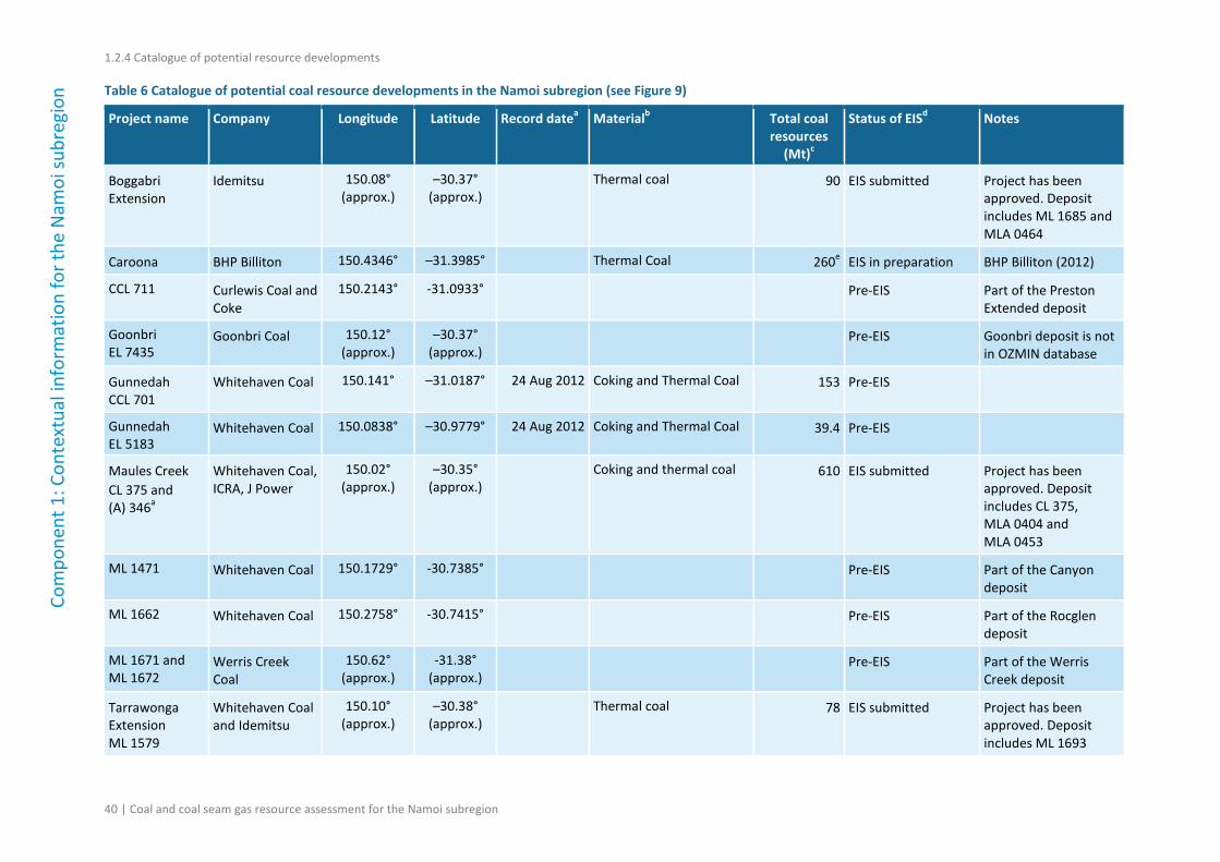
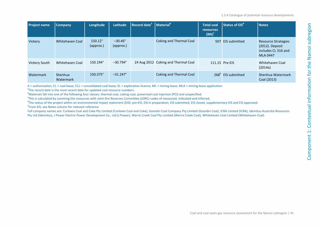
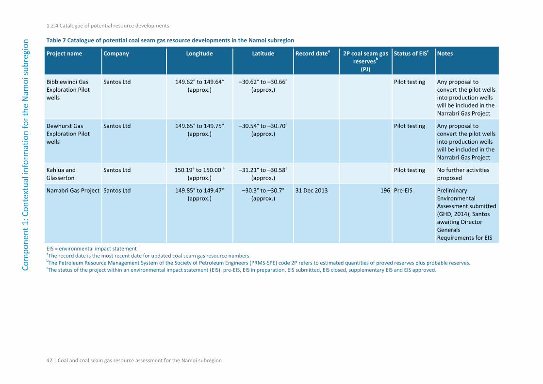
1.2.4 Catalogue of potential resource developments ................................................................ 39
ii | Coal and coal seam gas resource assessment for the Namoi subregion
Figures
Figure 1 Schematic diagram of the bioregional assessment methodology ......................................... 2
Figure 2 The simple decision tree indicates the flow of information through a bioregional assessment ........................................................................................................................................... 5
Figure 3 Geological basins of the Namoi subregion including the Surat Basin and Gunnedah Basin ..................................................................................................................................................... 9
Figure 4 Division of the Gunnedah Basin into sub-basins ................................................................. 11
Figure 5 Stratigraphy of the Namoi subregion .................................................................................. 12
Figure 6 Isopach map of the Hoskissons Coal in the Namoi subregion ............................................. 13
Figure 7 Isopach map of the Melvilles Coal Member in the Namoi subregion ................................. 14
Figure 8 Location of coal tenements and operating and historical (closed) mines in the Namoi subregion ........................................................................................................................................... 20
Figure 9 Map showing coal mining and resources in the Namoi subregion ...................................... 27
Figure 10 Location of the proposed mining areas for the Watermark Coal Project in the Namoi subregion ........................................................................................................................................... 29
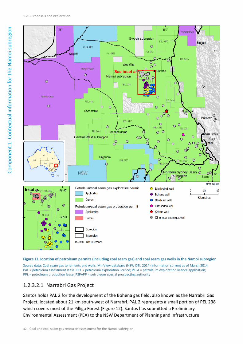
Figure 11 Location of petroleum permits (including coal seam gas) and coal seam gas wells in the Namoi subregion.......................................................................................................................... 32
Figure 12 Map showing the location of the Narrabri Gas Project area, existing pipeline network and tenement boundary in the Namoi subregion ............................................................................. 34
Coal and coal seam gas resource assessment for the Namoi subregion | iii
Tables
Table 1 Methodologies and associated technical products listed in Table 2 ...................................... 3
Table 2 Technical products being delivered as part of the Northern Inland Catchments Bioregional Assessment ....................................................................................................................... 6
Table 3 Summary of operating coal mines in the Namoi subregion ................................................. 21
Table 4 Mining leases granted and under application in the Namoi subregion ................................ 23
Table 5 Summary of recently approved coal mines in the Namoi subregion.................................... 26
Table 6 Catalogue of potential coal resource developments in the Namoi subregion (see Figure 9) ............................................................................................................................................. 40
Table 7 Catalogue of potential coal seam gas resource developments in the Namoi subregion ..... 42
iv | Coal and coal seam gas resource assessment for the Namoi subregion
Coal and coal seam gas resource assessment for the Namoi subregion | v
Contributors to the Technical Programme
The following individuals have contributed to the Technical Programme, the part of the Bioregional Assessment Programme that undertakes bioregional assessments. Leaders are underlined.
Assistant Secretary Department of the Environment: Gayle Milnes
Programme Director Department of the Environment: Edwina Johnson
Technical Programme Director
Bureau of Meteorology: Bronwyn Ray
Projects Director CSIRO: David Post
Principal Science Advisor Department of the Environment: Peter Baker
Science Directors CSIRO: Brent Henderson
Geoscience Australia: Trevor Dhu
Integration Lead Bureau of Meteorology: Richard Mount
Programme management
Bureau of Meteorology: Graham Hawke, Louise Minty
CSIRO: Paul Hardisty, Warwick McDonald
Geoscience Australia: Stuart Minchin
Project Leaders CSIRO: Tim McVicar, David Rassam, Wendy Welsh
Geoscience Australia: Hashim Carey, Kriton Glenn
Assets and receptors Bureau of Meteorology: Richard Mount
Department of the Environment: Rachel Carter, Larry Guo, Brad Moore, Jin Wang
Geoscience Australia: Joe Bell
Bioregional Assessment Information Platform
Bureau of Meteorology: Brian Cannell, Trevor Christie-Taylor, Mark Hatcher
CSIRO: David Lemon
Department of the Environment: Geraldine Cusack
Geoscience Australia: Neal Evans
Communications Bureau of Meteorology: Mel Martin
CSIRO: Tsuey Cham, Leane Regan
Department of the Environment: Sophie Alexander, Milica Milanja, Kirsty Rolls
Geoscience Australia: David Beard, Chris Thompson
vi | Coal and coal seam gas resource assessment for the Namoi subregion
Coordination Bureau of Meteorology: Julie Burke, Sarah van Rooyen
CSIRO: Ruth Palmer
Department of the Environment: James Hill, Sunita Johar, Broni McMaster, Carolyn Paris, Craig Watson
Geoscience Australia: Tenai Luttrell
Ecology CSIRO: Tanya Doody, Brendan Ebner, Alexander Herr, Kate Holland, Craig MacFarlane, Tracey May, Patrick Mitchell, Justine Murray, Anthony O'Grady, Chris Pavey, Jodie Pritchard, Nat Raisbeck-Brown, Ashley Sparrow, Georg Wiehl
Geology CSIRO: Deepak Adhikary, Luke Connell, Emanuelle Frery, Jane Hodgkinson, James Kear, Zhejun Pan, Kaydy Pinetown, Matthias Raiber, Hayley Rohead-O'Brien, Regina Sander, Peter Schaubs, Garth Warren, Paul Wilkes, Andrew Wilkins, Yanhua Zhang
Geoscience Australia: Tim Evans, Steven Lewis, John Magee, Martin Smith
Geography Bureau of Meteorology: Natasha Herron
Geographic information systems
CSIRO: Caroline Bruce, Jody Bruce, Malcolm Hodgen, Steve Marvanek
Groundwater modelling CSIRO: Olga Barron, Russell Crosbie, Tao Cui, Warrick Dawes, Lei Gao, Sreekanth Janardhanan, Luk Peeters, Praveen Kumar Rachakonda, Wolfgang Schmid, Saeed Torkzaban, Chris Turnadge, Binzhong Zhou
Geoscience Australia: Wenping Jiang
Hydrogeology CSIRO: Konrad Miotlinski
Geoscience Australia: Rebecca Cassel, Jim Kellett, Sarah Marshall, Rebecca Norman, Jessica Northey, Tim Ransley, Martin Smith, Baskaran Sundaram, KokPiang Tan, Luke Wallace, Gabrielle Yates
Information management
Bureau of Meteorology: Belinda Allison, Jill McNamara, Brendan Moran
CSIRO: Nick Car, Phil Davies, Andrew Freebairn, Mick Hartcher, Geoff Hodgson, Brad Lane, Ben Leighton, Trevor Pickett, Ramneek Singh, Matt Stenson, Garry Swan
Geoscience Australia: Luke Caruana, Penny Kilgour, Matti Peljo
Products CSIRO: Maryam Ahmad, Daniel Aramini, Heinz Buettikofer, Simon Gallant, Karin Hosking, Frances Marston, Linda Merrin, Becky Schmidt, Sally Tetreault-Campbell, Catherine Ticehurst
Geoscience Australia: Veronika Galinec, Daniel Rawson
Risk and uncertainty CSIRO: Simon Barry, Jeffery Dambacher, Jess Ford, Keith Hayes, Geoff Hosack, Yang Liu, Warren Jin, Dan Pagendam, Carmel Pollino
Surface water hydrology CSIRO: Santosh Aryal, Mat Gilfedder, Fazlul Karim, Lingtao Li, Dave McJannet, Jorge Pena Arancibia, Xiaogang Shi, Tom Van Niel, Neil Viney, Bill Wang, Ang Yang, Yongqiang Zhang
Coal and coal seam gas resource assessment for the Namoi subregion | vii
Acknowledgements
This technical product was reviewed by several groups:
• Discipline Leaders: Steven Lewis (geology, Geoscience Australia), Becky Schmidt (Products Manager, CSIRO)
• Senior Science Leaders: David Post (Projects Director, CSIRO), Trevor Dhu (Science Director, Geoscience Australia), Brent Henderson (Science Director, CSIRO)
• Technical Assurance Reference Group: Chaired by Peter Baker (Principal Science Advisor, Department of the Environment), this group comprises officials from the NSW, Queensland, South Australian and Victorian governments
• Additional reviewers: These companies provided feedback on the accuracy of our descriptions of their operations: Boggabri Coal, Caroona, Santos, Shenhua Watermark, Whitehaven.
viii | Coal and coal seam gas resource assessment for the Namoi subregion
Introduction
The Independent Expert Scientific Committee on Coal Seam Gas and Large Coal Mining Development (IESC) was established to provide advice to the federal Minister for the Environment on potential water-related impacts of coal seam gas (CSG) and large coal mining developments.
Bioregional assessments (BAs) are one of the key mechanisms to assist the IESC in developing this advice so that it is based on best available science and independent expert knowledge. Importantly, technical products from BAs are also expected to be made available to the public, providing the opportunity for all other interested parties, including government regulators, industry, community and the general public, to draw from a single set of accessible information. A BA is a scientific analysis, providing a baseline level of information on the ecology, hydrology, geology and hydrogeology of a bioregion with explicit assessment of the potential direct, indirect and cumulative impacts of CSG and coal mining development on water resources.
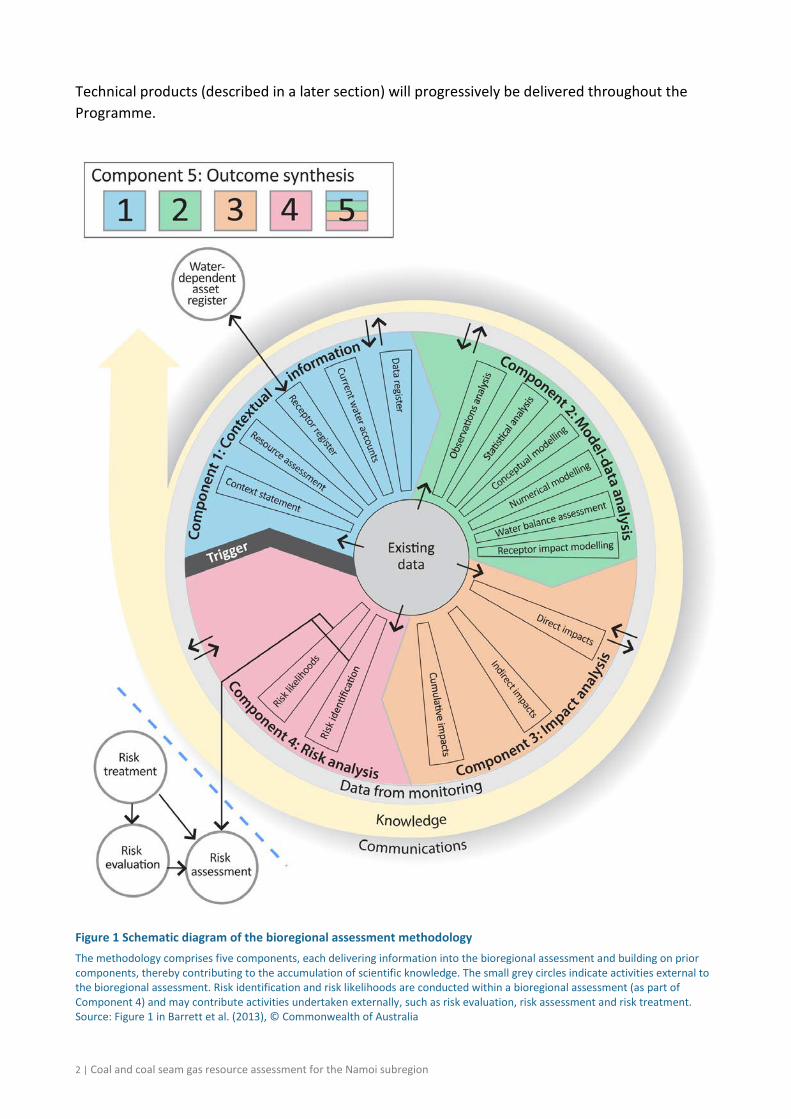
The IESC has been involved in the development of Methodology for bioregional assessments of the impacts of coal seam gas and coal mining development on water resources (the BA methodology; Barrett et al., 2013) and has endorsed it. The BA methodology specifies how BAs should be undertaken. Broadly, a BA comprises five components of activity, as illustrated in Figure 1. Each BA will be different, due in part to regional differences, but also in response to the availability of data, information and fit-for-purpose models. Where differences occur, these are recorded, judgments exercised on what can be achieved, and an explicit record is made of the confidence in the scientific advice produced from the BA.
The Bioregional Assessment Programme The Bioregional Assessment Programme is a collaboration between the Department of the Environment, the Bureau of Meteorology, CSIRO and Geoscience Australia. Other technical expertise, such as from state governments or universities, is also drawn on as required. For example, natural resource management groups and catchment management authorities identify assets that the community values by providing the list of water-dependent assets, a key input.
The Technical Programme, part of the Bioregional Assessment Programme, will undertake BAs for the following bioregions and subregions:
• the Galilee, Cooper, Pedirka and Arckaringa subregions, within the Lake Eyre Basin bioregion
• the Maranoa-Balonne-Condamine, Gwydir, Namoi and Central West subregions, within the Northern Inland Catchments bioregion
• the Clarence-Moreton bioregion
• the Hunter and Gloucester subregions, within the Northern Sydney Basin bioregion
• the Sydney Basin bioregion
• the Gippsland Basin bioregion.
Coal and coal seam gas resource assessment for the Namoi subregion | 1
Technical products (described in a later section) will progressively be delivered throughout the Programme.
2 | Coal and coal seam gas resource assessment for the Namoi subregion
Methodologies For transparency and to ensure consistency across all BAs, submethodologies have been developed to supplement the key approaches outlined in the Methodology for bioregional assessments of the impact of coal seam gas and coal mining development on water resources (Barrett et al., 2013). This series of submethodologies aligns with technical products as presented in Table 1. The submethodologies are not intended to be ‘recipe books’ nor to provide step-by-step instructions; rather they provide an overview of the approach to be taken. In some instances, methods applied for a particular BA may need to differ from what is proposed in the submethodologies – in this case an explanation will be supplied. Overall, the submethodologies are intended to provide a rigorously defined foundation describing how BAs are undertaken.
Table 1 Methodologies and associated technical products listed in Table 2
Code Proposed title Summary of content Associated technical product M01 Methodology for A high-level description of the scientific and All bioregional assessments intellectual basis for a consistent approach of the impacts of coal to all bioregional assessments seam gas and coal mining development on
water resources
M02 Compiling water-dependent assets
Describes the approach for determining water-dependent assets
1.3 Description of the water-dependent asset register
M03 Assigning receptors and impact variables to water-dependent assets
Describes the approach for determining receptors associated with water-dependent assets
1.4 Description of the receptor register
M04 Developing a coal resource development pathway
Specifies the information that needs to be collected and reported in product 1.2 (i.e. known coal and coal seam gas resources as well as
1.2 Coal and coal seam gas resource assessment
current and potential resource developments). Describes the process for determining the coal resource development pathway (reported in product 2.3)
2.3 Conceptual modelling
M05 Developing the conceptual model for causal pathways
Describes the development of the conceptual model for causal pathways, which summarises how the ‘system’ operates and articulates the links between coal resource developments and impacts on receptors
2.3 Conceptual modelling
M06 Surface water modelling Describes the approach taken for surface water modelling across all of the bioregions and subregions. It covers the model(s) used, as well as whether modelling will be quantitative or qualitative.
2.6.1 Surface water numerical modelling
M07 Groundwater modelling Describes the approach taken for groundwater modelling across all of the bioregions and subregions. It covers the model(s) used, as well as whether modelling will be quantitative or qualitative. It also considers surface water – groundwater interactions, as well as how the groundwater modelling is constrained by geology.
2.6.2 Groundwater numerical modelling
Coal and coal seam gas resource assessment for the Namoi subregion | 3
Code Proposed title Summary of content Associated technical product M08 Receptor impact modelling Describes how to develop the receptor impact
models that are required to assess the potential impacts from coal seam gas and large coal mining on receptors. Conceptual, semi-quantitative and quantitative numerical models are described.
2.7 Receptor impact modelling
M09 Propagating uncertainty through models
Describes the approach to sensitivity analysis and quantifying uncertainty in the modelled hydrological response to coal and coal seam gas development
M10 Risk and cumulative Describes the process to identify and 3 Impact analysis
impacts on receptors analyse risk 4 Risk analysis
M11 Hazard identification Describes the process to identify potential 2 Model-data analysis water-related hazards from coal and coal 3 Impact analysis
seam gas development 4 Risk analysis
M12 Fracture propagation Describes the likely extent of both vertical and 2 Model-data analysis and chemical horizontal fractures due to hydraulic stimulation 3 Impact analysis
concentrations and the likely concentration of chemicals after production of coal seam gas
4 Risk analysis
Each submethodology is available online at <http://www.bioregionalassessments.gov.au>. Submethodologies might be added in the future.
Technical products The outputs of the BAs include a suite of technical products variously presenting information about the ecology, hydrology, hydrogeology and geology of a bioregion and the potential direct, indirect and cumulative impacts of CSG and coal mining developments on water resources, both above and below ground. Importantly, these technical products are available to the public, providing the opportunity for all interested parties, including community, industry and government regulators, to draw from a single set of accessible information when considering CSG and large coal mining developments in a particular area.
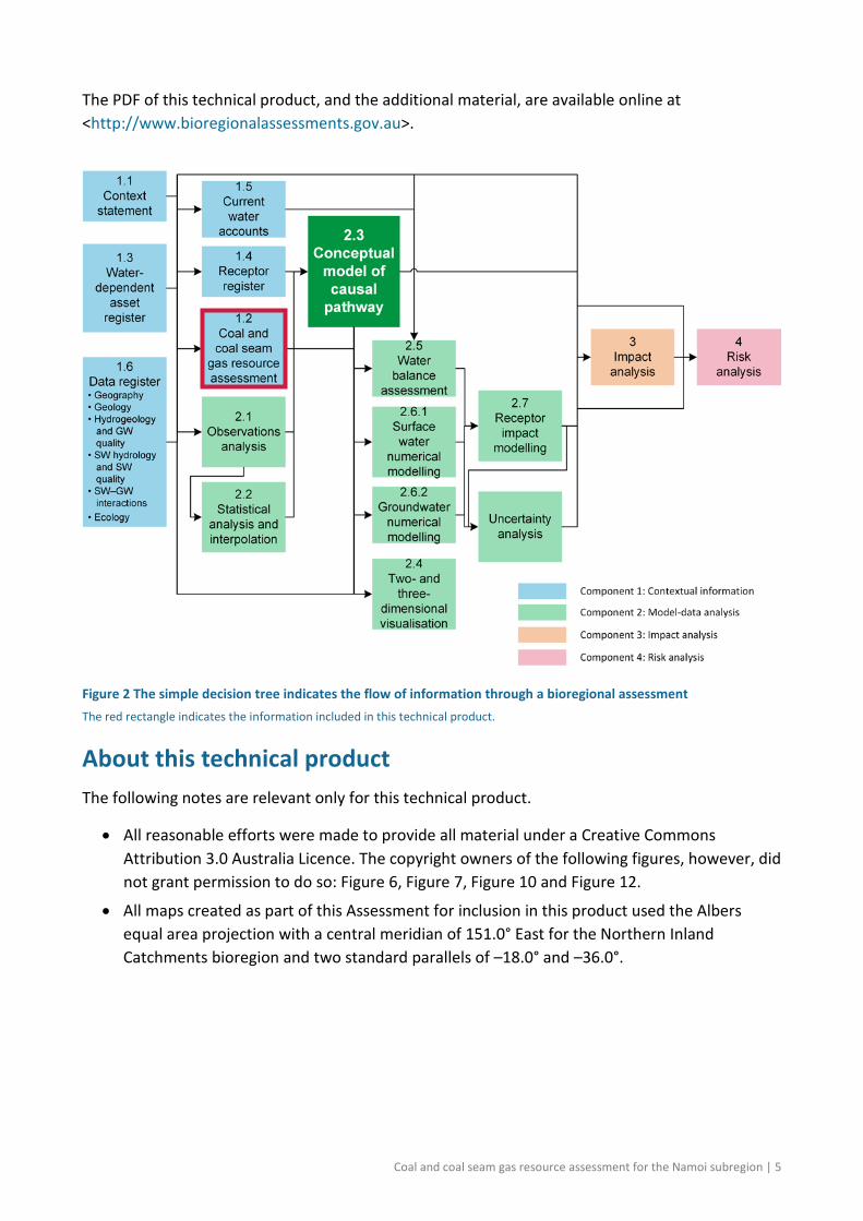
The information included in the technical products is specified in the BA methodology. Figure 2 shows the information flow within a BA. Table 2 lists the content provided in the technical products, with cross-references to the part of the BA methodology that specifies it. The red rectangles in both Figure 2 and Table 2 indicate the information included in this technical product.
This technical product is delivered as a report (PDF). Additional material is also provided, as specified by the BA methodology:
• all unencumbered data syntheses and databases
• unencumbered tools, model code, procedures, routines and algorithms
• unencumbered forcing, boundary condition, parameter and initial condition datasets
• the workflow, comprising a record of all decision points along the pathway towards completion of the BA, gaps in data and modelling capability, and provenance of data.
4 | Coal and coal seam gas resource assessment for the Namoi subregion
The PDF of this technical product, and the additional material, are available online at <http://www.bioregionalassessments.gov.au>.
Figure 2 The simple decision tree indicates the flow of information through a bioregional assessment The red rectangle indicates the information included in this technical product.
About this technical product The following notes are relevant only for this technical product.
• All reasonable efforts were made to provide all material under a Creative Commons Attribution 3.0 Australia Licence. The copyright owners of the following figures, however, did not grant permission to do so: Figure 6, Figure 7, Figure 10 and Figure 12.
• All maps created as part of this Assessment for inclusion in this product used the Albers equal area projection with a central meridian of 151.0° East for the Northern Inland Catchments bioregion and two standard parallels of –18.0° and –36.0°.
Coal and coal seam gas resource assessment for the Namoi subregion | 5
Table 2 Technical products being delivered as part of the Northern Inland Catchments Bioregional Assessment For each subregion in the Northern Inland Catchments Bioregional Assessment, technical products will be delivered as data, summaries and reports (PDFs) as indicated by in the last column of Table 2. The red rectangle indicates the information covered in this technical product. A suite of other technical and communication products – such as maps, registers and factsheets – will also be developed through the bioregional assessments.
Component Product code
Information Section in the BA methodologya
Report
Component 1: Contextual information for the Namoi subregion
1.1 Context statement 2.5.1.1, 3.2
1.2 Coal and coal seam gas resource assessment 2.5.1.2, 3.3
1.3 Description of the water-dependent asset
register 2.5.1.3, 3.4
1.4 Description of the receptor register 2.5.1.4, 3.5
1.5 Current water accounts and water quality 2.5.1.5
1.6 Data register 2.5.1.6
Component 2: Model-data analysis for Namoi subregion
2.1-2.2 Observations analysis, statistical analysis and interpolation 2.5.2.1, 2.5.2.2
2.3 Conceptual modelling 2.5.2.3, 4.3
2.4 Two- and three-dimensional representations 4.2 b
2.5 Water balance assessment 2.5.2.4
2.6.1 Surface water numerical modelling 4.4
2.6.2 Groundwater numerical modelling 4.4
2.7 Receptor impact modelling 2.5.2.6, 4.5
Component 3: Impact analysis for the Namoi subregion 3 Impact analysis 5.2.1
Component 4: Risk analysis for the Namoi subregion 4 Risk analysis 2.5.4, 5.3
Component 5: Outcome synthesis for the Northern Inland Catchments bioregion
5 Outcome synthesis 2.5.5
aBarrett et al. (2013) bThe two- and three-dimensional representations will be delivered in products such as 2.3, 2.6.1 and 2.6.2.
References
Barrett DJ, Couch CA, Metcalfe DJ, Lytton L, Adhikary DP and Schmidt RK (2013) Methodology for bioregional assessments of the impacts of coal seam gas and coal mining development on water resources. A report prepared for the Independent Expert Scientific Committee on Coal Seam Gas and Large Coal Mining Development through the Department of the Environment. Department of the Environment, Australia. Viewed 29 October 2014, <http://www.environment.gov.au/coal-seam-gas-mining/pubs/methodology-bioregional-assessments.pdf>.
6 | Coal and coal seam gas resource assessment for the Namoi subregion
1.2 Coal and coal seam gas resource assessment for the Namoi subregion
The coal and coal seam gas resource assessment summarises the known coal and coal seam gas resources, and developments both now and potentially in the future. The following data and information are presented:
• the geology and spatial distribution of known coal resources
• the baseline of current coal and coal seam gas extraction
• exploration and mining tenements
• proposed future developments (both new developments and expansion or closure of existing developments), including details of location, timing, methods and extraction volumes as determined from proposed development plans.
This information will be used to develop the coal resource development pathway (as reported in product 2.3), which articulates the most likely combination of developments at a subregion or bioregion scale, including all individual coal and coal seam gas resource projects that are expected.
Coal and coal seam gas resource assessment for the Namoi subregion | 7
1.2.1 Available coal and coal seam gas resources Co
mpo
nent
1: C
onte
xtua
l inf
orm
atio
n fo
r the
Nam
oi su
breg
ion 1.2.1 Available coal and coal seam gas resources
Summary
The Namoi subregion is underlain by the geological Gunnedah and Surat basins, both major coal-bearing basins in eastern Australia. The Gunnedah Basin has a history of coal and conventional petroleum exploration, and coal mining, and more recently the basin’s potential coal seam gas (CSG) targets have attracted much interest in the Namoi subregion. Coal and CSG exploration in the Surat Basin in Queensland has focused on areas of the basin where it overlies the Bowen Basin. Surat Basin coals in NSW are thin (Goscombe and Coxhead, 1995) and thermally immature (Stewart and Alder, 1995), and are therefore not a major focus for CSG production. Thus, Section 1.2.1 focuses on the distribution and development of coal and CSG resources in the Gunnedah Basin strata only.
Economic coal deposits are located mainly within the Maules Creek and Mullaley sub-basins of the Gunnedah Basin, where the Maules Creek Formation and the Black Jack Group host numerous coal seams varying in thickness and quality.
The coals in the Namoi subregion have attained thermal maturities indicative of the potential to produce significant volumes of thermogenic gas. Furthermore, numerous igneous intrusions into the coal measure sequences have resulted in local enhancements of coal rank, and possibly also the gas generation and storage potential of the coals. The limited number of studies that have been conducted on CSG resources in the basin report gas contents that range from approximately 4 m3/t to as high as 19 m3/t, with gas compositions varying between predominantly methane (CH4) and predominantly carbon dioxide (CO2). High concentrations of carbon dioxide are associated with areas where igneous intrusions are present.
1.2.1.1 Coal
The Gunnedah Basin (Figure 3) is estimated to contain an Economic Demonstrated Resource (EDR) of 1647 Mt (44,469 PJ) of predominantly thermal black coal, approximately 3% of the Australian black coal EDR. The Sub-Economic Demonstrated Resource (SDR) for the Gunnedah Basin is 40 Mt (1077 PJ), with an inferred resource of 710 Mt (19,170 PJ) (Geoscience Australia and BREE, 2014). The coal resources of the Gunnedah Basin are located in two sub-basins, separated by a structural high, the Boggabri Ridge. The Maules Creek sub-basin is located to the east of the Boggabri Ridge, and the Mullaley sub-basin to the west of the Boggabri Ridge (Figure 4, and see Figure 18 in companion product 1.1 for the Namoi subregion (Welsh et al., 2014)).
8 | Coal and coal seam gas resource assessment for the Namoi subregion
1.2.1 Available coal and coal seam gas resources
Component 1: Contextual inform
ation for the Nam
oi subregion
Figure 3 Geological basins of the Namoi subregion including the Surat Basin and Gunnedah Basin
1.2.1.1.1 Maules Creek sub-basin
The major coal deposits of the Gunnedah Basin are shown in Figure 5 and are hosted within the Maules Creek Formation and the Black Jack Group (Tadros, 1993) of the Maules Creek sub-basin, a narrow north-south oriented trough (Figure 4, and see Figure 18 in companion product 1.1 for the Namoi subregion (Welsh et al., 2014)). The Maules Creek Formation contains up to 25 correlated coal seams that are generally thickest close to the Boggabri Ridge.
Most of the seams are more than 3.5 m thick, with the Braymont Coal Member being the thickest (up to 9 m) in the Maules Creek and Boggabri areas. Coals of the Maules Creek Formation are rich in vitrinite (up to 80%) and also contain high liptinite contents, with vitrinite reflectance values ranging between 0.5 and 0.9%. These coals are typically low-ash, high-volatile, low-sulfur thermal and coking coals.
1.2.1.1.2 Mullaley sub-basin
The Mullaley sub-basin is a wider trough than the Maules Creek sub-basin and is located between the Boggabri Ridge and the Rocky Glen Ridge. It is divided into a series of smaller troughs and
Coal and coal seam gas resource assessment for the Namoi subregion| 9
1.2.1 Available coal and coal seam gas resources Co
mpo
nent
1: C
onte
xtua
l inf
orm
atio
n fo
r the
Nam
oi su
breg
ion associated features including the Bohena, Bando and Bellata troughs, and the associated Narrabri
High and Walla Walla Ridge (see Figure 18 in companion product 1.1 for the Namoi subregion (Welsh et al., 2014)) (Ward and Kelly, 2012). Coal seams in the Maules Creek Formation are best developed south of Gunnedah. The Brown Seam is generally of good quality with a working section of up to 4 m and raw coal ash of 8 to 11% (Tadros, 1995).
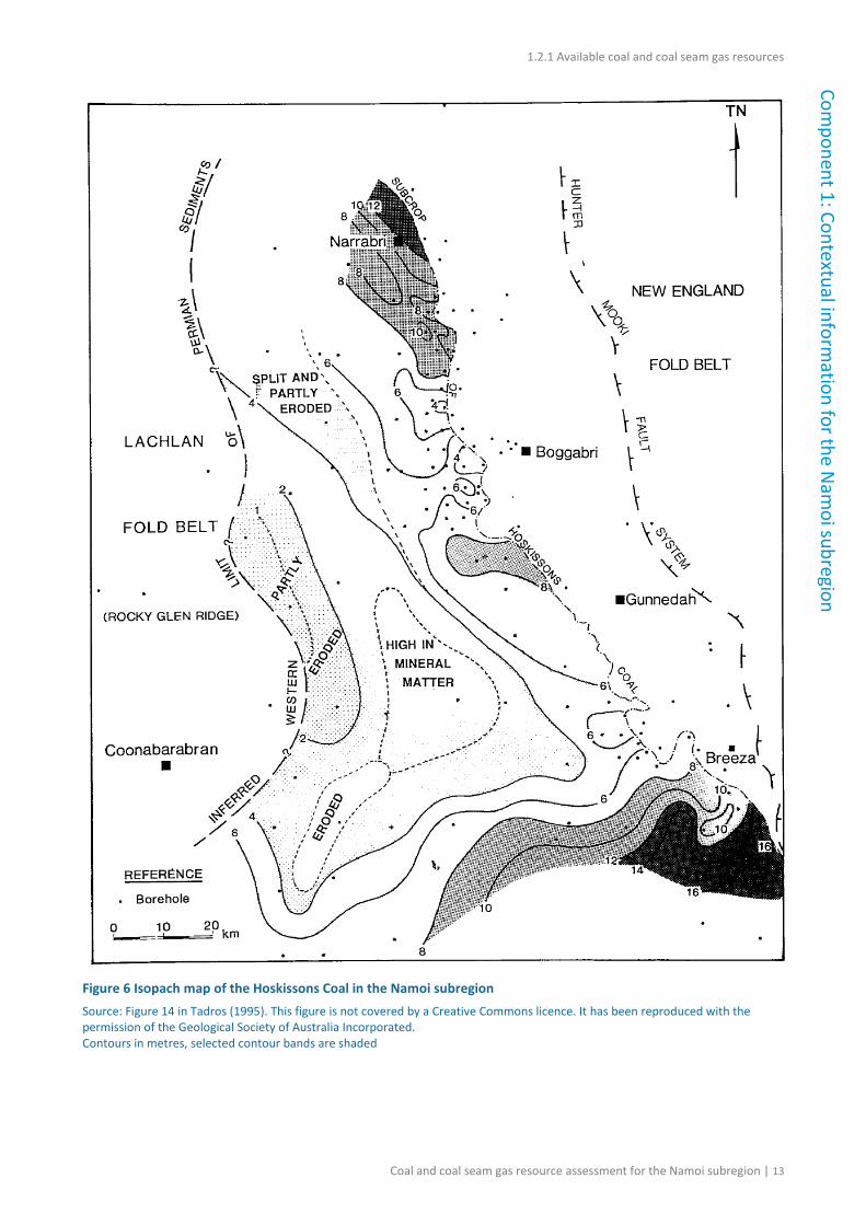
Within the Black Jack Group, significant coal resources are contained within the Hoskissons Coal and Melvilles Coal Member. The Hoskissons Coal varies in maximum thickness from 1 m in the west to greater than 12 m in the north and 17 m in the south-east, as shown in the isopach map (Figure 6). It is laterally extensive from the Hunter-Mooki Thrust System to east of the Rocky Glen Ridge system. The seam is characterised by a low-sulfur content (<0.5%), with raw coal ash ranging from 12 to greater than 50% (Tadros, 1995). The Melvilles Coal Member is about 2.5 to 3.5 m thick in the eastern part of the Mullaley sub-basin and thickens towards the south-west of Boggabri (Figure 7). It is developed over large areas of the sub-basin and has raw coal ash ranging from 9.5 to 33% (Tadros, 1995).
10 | Coal and coal seam gas resource assessment for the Namoi subregion
1.2.1 Available coal and coal seam gas resources
Component 1: Contextual inform
ation for the Nam
oi subregion
Figure 4 Division of the Gunnedah Basin into sub-basins Source data: Geoscience Australia (2014)
Coal and coal seam gas resource assessment for the Namoi subregion| 11
1.2.1 Available coal and coal seam gas resources Co
mpo
nent
1: C
onte
xtua
l inf
orm
atio
n fo
r the
Nam
oi su
breg
ion
Figure 5 Stratigraphy of the Namoi subregion This figure has been optimised for printing on A3 paper (297 mm x 420 mm). The younger sediments overlying the Surat and Gunnedah basins are not shown. Source data: derived from data presented in McKellar (1998), Totterdell et al. (2009), Cook and Draper (2013) and the Australian Stratigraphic Unit Database (2013)
12 | Coal and coal seam gas resource assessment for the Namoi subregion
1.2.1 Available coal and coal seam gas resources
Component 1: Contextual inform
ation for the Nam
oi subregion
Figure 6 Isopach map of the Hoskissons Coal in the Namoi subregion Source: Figure 14 in Tadros (1995). This figure is not covered by a Creative Commons licence. It has been reproduced with the permission of the Geological Society of Australia Incorporated. Contours in metres, selected contour bands are shaded
Coal and coal seam gas resource assessment for the Namoi subregion | 13
1.2.1 Available coal and coal seam gas resources Co
mpo
nent
1: C
onte
xtua
l inf
orm
atio
n fo
r the
Nam
oi su
breg
ion
Figure 7 Isopach map of the Melvilles Coal Member in the Namoi subregion Source: Figure 12 in Tadros (1995). This figure is not covered by a Creative Commons licence. It has been reproduced with the permission of the Geological Society of Australia Incorporated. Contours in metres, selected contour bands are shaded
14 | Coal and coal seam gas resource assessment for the Namoi subregion
1.2.1 Available coal and coal seam gas resources
Component 1: Contextual inform
ation for the Nam
oi subregion
1.2.1.2 Coal seam gas
The Gunnedah Basin has approximately 4% of the 2P (proved and probable) CSG reserves in Australia, approximately 1520 PJ (Geoscience Australia and BREE, 2012).
Stewart and Alder (1995) regarded the Black Jack Group as the prime target for CSG extraction in the Gunnedah Basin, as it hosts numerous seams with net coal thicknesses varying between 50 and 60 m. The Hoskissons Coal is particularly well developed in the south-east and thicker coals associated with thickening of the Black Jack Group are adjacent to the Hunter-Mooki Thrust Fault System. With non-anomalous vitrinite reflectance values ranging between 0.5 and 0.7% in the basin, significant thermogenic gas generation has likely taken place. In local zones where intrusions have heated the coal measures, vitrinite reflectance values of up to 1.3% have been measured. Stewart and Alder (1995) therefore recognised the need to further investigate the extent and influence of increased maturation on the gas generation potential of the Gunnedah Basin coals. Scott and Hamilton (2008) undertook a preliminary desktop study to identify potential CSG exploration targets. Two areas were identified in the Namoi subregion, one in the Maules Creek sub-basin and the other in the Mullaley sub-basin, coincident with existing coal mining and CSG exploration.
Decker (1999) reported mean gas contents of 14.8 m3/t (raw basis) for coals in the northern part of the basin, with raw gas contents for the Black Jack Group coals of around 9.1 m3/t. In the south, Milligan and Bunny (1996), Bunny and Milligan (1997), and also confidential company reports, as cited in Gurba and Weber (2001), reported raw gas contents of 8.9 m3/t for the Black Jack Group coals.
Gurba and Weber (2001) postulated that igneous intrusions in the Gunnedah Basin have had beneficial effects on CSG potential, assisting with gas generation and acting as impermeable seals. The study stressed the need to recognise additional sources of gas beyond those generated initially during coalification to achieve high gas content following basin uplift and cooling. The study found that gas contents within the thermal aureoles of heat-affected coal seams were substantially higher above and below the sills compared to unaffected coal seams, ranging from 6 to 7 m3/t (dry, ash-free) for the unaffected coal seams to 10 to 15 m3/t (dry, ash-free) in heat-affected coals. The intrusions had little effect on the gas composition with the gas in both affected and unaffected coals consisting of 95% methane. Mechanisms of gas generation and accumulation in the Gunnedah Basin thus include:
• local or regional enhancement of secondary thermogenic gas due to heat from igneous intrusions
• generation of secondary biogenic gases or by diffusion
• migration over long distances (Gurba, 2012).
In a study of the carbon dioxide sequestration potential of the Gunnedah Basin, Gurba et al. (2009) reported gas contents between approximately 4 and 7 m3/t for the Hoskissons Coal, between approximately 4 and 9 m3/t for the Maules Creek Formation, and between approximately 11 and 19 m3/t for the Bohena Seam. The composition of these gases varies from around 60% methane to up to 98% carbon dioxide. According to Gurba et al. (2009), gas content and
Coal and coal seam gas resource assessment for the Namoi subregion | 15
1.2.1 Available coal and coal seam gas resources Co
mpo
nent
1: C
onte
xtua
l inf
orm
atio
n fo
r the
Nam
oi su
breg
ion composition in the Gunnedah Basin are unpredictable with composition varying both laterally and
vertically within the coal measures.
References
Australian Stratigraphic Unit Database (2013) Viewed 30 November 2013, <http://dbforms.ga.gov.au/www/geodx.strat_units.int>.
Bunny M and Milligan I (1997) Australian coalbed methane petroleum exploration licences 1, 10, 12 and 286 Sydney-Gunnedah basins, NSW, Report A398. Earth Resources Australia, Chatswood, New South Wales.
Cook AG and Draper JJ (2013) Surat Basin. In: Jell PA (ed) Geology of Queensland. Geological Survey of Queensland, Brisbane, 533–539.
Decker D (1999) Discovery and geology of Narrabri gas fields. Oil and gas in south-east Australia: new ideas, new data, new interpretations, new production and markets. University of Sydney, Sydney.
Geoscience Australia (2014) Australian Geological Provinces. Viewed 1 June 2014, <http://www.ga.gov.au/products-services/data-applications/australian-geological-provinces.html>.
Geoscience Australia and BREE (2012) Australian gas resource assessment 2012, Canberra. Geoscience Australia, GeoCat # 74032.
Geoscience Australia and BREE (2014) Australian Energy Resource Assessment. 2nd Ed. Geoscience Australia, Canberra.
Gurba LW and Weber CR (2001) Effects of igneous intrusions on coalbed methane potential, Gunnedah Basin, Australia. International Journal of Coal Geology 46, 113–131.
Gurba LW, Golab A and Douglass J (2009) CO2 geological storage opportunities in the Gunnedah Basin, and the southern Bowen Basin, NSW status report, report RPT09-1456. CO2CRC, Australia.
McKellar JL (1998) Late early to late Jurassic palynology, biostratigraphy and palaeogeography of the Roma Shelf area, northwestern Surat Basin, Queensland, Australia. PhD Thesis, University of Queensland, Department of Geology and Mineralogy, Brisbane.
Milligan I and Bunny M (1996) Australian coalbed methane petroleum exploration licences 1, 10, and 286 Gunnedah Basin, NSW, Report A395. Earth Resources Australia, Chatswood, New South Wales.
NSW Department of Trade and Investment (2011) NSW Coal Industry Profile, 2010. NSW Department of Trade and Investment, Maitland, 302 pp.
Scott AR and Hamilton DS (2008) Targeting Sydney-Gunnedah Basin Coal Seam Methane Exploration Fairways and Sweetspots Based on Coalbed Methane Exploration Model: Phase II Lower Coal Measures. A report prepared for the NSW Department of Primary Industries, Mineral Resources.
16 | Coal and coal seam gas resource assessment for the Namoi subregion
1.2.1 Available coal and coal seam gas resources
Component 1: Contextual inform
ation for the Nam
oi subregion
Stewart JR and Alder JD (1995) New South Wales petroleum potential – Sydney Basin. Department of Mineral Resources, Sydney.
Tadros NZ (1993) The Gunnedah Basin, New South Wales, Memoir 12. Geological Survey of New South Wales, Sydney.
Tadros NZ (1995) Gunnedah Basin. In: CR Ward, HJ Harrington, CW Mallett and JW Beeston (eds). Geology of Australian Coal Basins, Special Publication No. 1. Geological Society of Australia Incorporated Coal Group, Australia, 247–298.
Totterdell JM, Moloney J, Korsch RJ and Krassay AA (2009) Sequence stratigraphy of the Bowen-Gunnedah and Surat Basins in NSW, Aust Jour Earth Science, 56(3), 433–459.
Ward CR and Kelly BFJ (2013) Background Paper on New South Wales Geology, with a focus on basins containing coal seam gas resources. Prepared for the Office of the NSW Chief Scientist and Engineer. School of Biological, Earth and Environmental Sciences, University of New South Wales. Unisearch Expert Opinion Services.
Welsh W, Hodgkinson J, Strand J, Northey J, Aryal S, O’Grady A, Slatter E, Herron N, Pinetown K, Carey H, Yates G, Raisbeck-Brown N and Lewis S (2014) Context statement for the Namoi subregion. Product 1.1 from the Northern Inland Catchments Bioregional Assessment. Department of the Environment, Bureau of Meteorology, CSIRO and Geoscience Australia, Australia. Viewed 17 July 2014, <http://www.bioregionalassessments.gov.au/products.shtml#namoi>.
Coal and coal seam gas resource assessment for the Namoi subregion | 17
1.2.1 Available coal and coal seam gas resources Co
mpo
nent
1: C
onte
xtua
l inf
orm
atio
n fo
r the
Nam
oi su
breg
ion
18 | Coal and coal seam gas resource assessment for the Namoi subregion
1.2.2 Current activity and tenements Com
ponent 1: Contextual information for the N
amoi subregion
1.2.2 Current activity and tenements
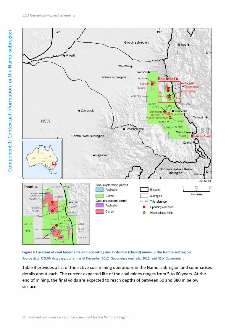
Summary
Section 1.2.2 focuses on the coal and coal seam gas (CSG) resources in the geological Gunnedah Basin strata only, as this is where the current and historical mining activity occurs. Coal is mined in the central and eastern parts of the Gunnedah Basin using mainly open-cut methods, although one underground mine is in operation. Section 1.2.2 includes information on all the currently operating coal mines and CSG operations. For a development to be considered current, commercial production for that particular well or mine must have commenced prior to December 2012.
There is currently no CSG production for commercial purposes in the Namoi subregion. Some CSG production is occurring for appraisal and pilot testing and this information is discussed in Sections 1.2.3 and 1.2.4.
1.2.2.1 Coal
Coal was first discovered in the Gunnedah region in 1877 and the Centenary (Preston) Colliery commenced production of coal in 1889. Coal production increased in the 1890s with the opening of the Gunnedah and Black Jack Collieries. Coal mining in the Namoi subregion has consisted of three small scale operations (Vickery, Preston and Gunnedah) around the Gunnedah area until a few decades ago (NSW Department of Mineral Resources, 2002). As the demand for coal has increased over the past decade, mining activity in the subregion has increased.
Figure 8 shows the location of coal tenements, and operating and historical (closed) coal mines in the Namoi subregion. There are currently six operating coal mines in the Namoi subregion. Five of these are open-cut (Boggabri, Tarrawonga, Rocglen, Werris Creek and Sunnyside) and the sixth is an underground mine (Narrabri). Three mines in the Namoi subregion have closed: Canyon (2000 to 2009), Gunnedah Colliery Underground Mine (closed in 2000) and Preston Extended (closed in 1998). The Vickery Coal Mine originally operated from 1986 to 1998, was reopened in 2008 and closed again in 2012, however it was recently given approval to be reopened. The Vickery Coal Mine is discussed further in Section 1.2.3.
Figure 8 shows that most operating and historical coal mines in the subregion are clustered in two groups in the eastern part of the subregion and many of these mines have adjoining tenement boundaries.
Coal and coal seam gas resource assessment for the Namoi subregion | 19
1.2.2 Current activity and tenements Co
mpo
nent
1: C
onte
xtua
l inf
orm
atio
n fo
r the
Nam
oi su
breg
ion
Figure 8 Location of coal tenements and operating and historical (closed) mines in the Namoi subregion Source data: OZMIN database, current as of December 2012 (Geoscience Australia, 2013) and NSW Government
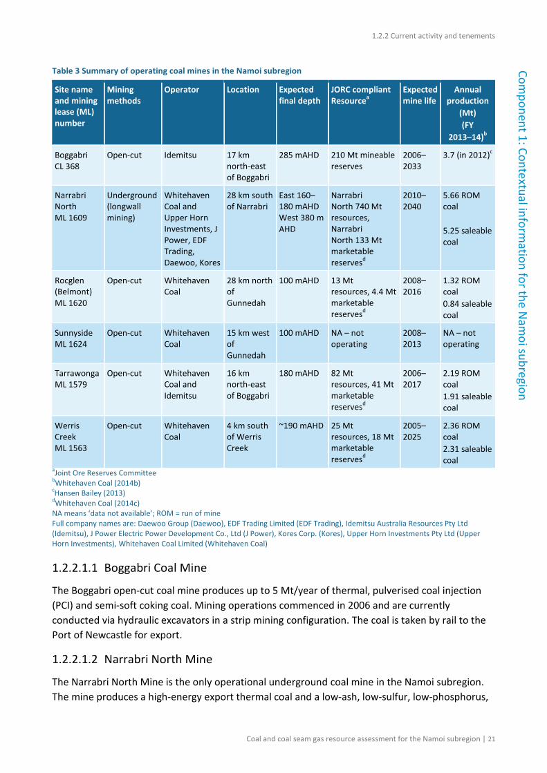
Table 3 provides a list of the active coal mining operations in the Namoi subregion and summarises details about each. The current expected life of the coal mines ranges from 5 to 60 years. At the end of mining, the final voids are expected to reach depths of between 50 and 380 m below surface.
20 | Coal and coal seam gas resource assessment for the Namoi subregion
1.2.2 Current activity and tenements Com
ponent 1: Contextual information for the N
amoi subregion
Table 3 Summary of operating coal mines in the Namoi subregion
aJoint Ore Reserves Committee bWhitehaven Coal (2014b) cHansen Bailey (2013) dWhitehaven Coal (2014c) NA means ‘data not available’; ROM = run of mine Full company names are: Daewoo Group (Daewoo), EDF Trading Limited (EDF Trading), Idemitsu Australia Resources Pty Ltd (Idemitsu), J Power Electric Power Development Co., Ltd (J Power), Kores Corp. (Kores), Upper Horn Investments Pty Ltd (Upper Horn Investments), Whitehaven Coal Limited (Whitehaven Coal)
1.2.2.1.1 Boggabri Coal Mine
The Boggabri open-cut coal mine produces up to 5 Mt/year of thermal, pulverised coal injection (PCI) and semi-soft coking coal. Mining operations commenced in 2006 and are currently conducted via hydraulic excavators in a strip mining configuration. The coal is taken by rail to the Port of Newcastle for export.
1.2.2.1.2 Narrabri North Mine
The Narrabri North Mine is the only operational underground coal mine in the Namoi subregion. The mine produces a high-energy export thermal coal and a low-ash, low-sulfur, low-phosphorus,
Coal and coal seam gas resource assessment for the Namoi subregion | 21
1.2.2 Current activity and tenements Co
mpo
nent
1: C
onte
xtua
l inf
orm
atio
n fo
r the
Nam
oi su
breg
ion mid-volatile PCI coal. Coal was first produced in 2011 and full commercial production from the first
longwall occurred in October 2012. Mining in the second longwall panel was completed in mid-January 2014 (Whitehaven Coal, 2014a).
Production of saleable coal for the 2013–14 financial year was about 5.25 Mt, including about 0.85 Mt of PCI coal. The longwall has been consistently producing coal at above the original design levels since production commenced in the second panel. A number of options including top coal caving or an increase in the width of the longwall face are being considered to increase production (Whitehaven Coal, 2014a).
1.2.2.1.3 Rocglen Mine
Production at the Rocglen open-cut coal mine commenced in November 2008. The mine has an average run-of-mine1 (ROM) coal production rate of approximately 1.2 Mt/year (permitted to 1.5 Mt/year) and produces medium- to high-ash, low-sulfur, low-phosphorus, medium- to high-volatile export thermal coal. Following a review of the mine plan in early 2013, Rocglen has reserves in place to support a mine life until approximately 2016 (Whitehaven Coal, 2014a).
1.2.2.1.4 Sunnyside Mine
The Sunnyside open-cut coal mine was given approval to commence production in 2008 and historically has produced around 1 Mt/year of raw coal for the export market. In late November 2012 mining operations at the site were suspended indefinitely and the mine is currently under ‘care and maintenance’. The suspension in production was attributed to a decline in global coal prices, which made this small, relatively high-cost mine uneconomic (Whitehaven Coal, 2012). The mine has approval to operate until September 2015. The reduced output from the Sunnyside Mine is expected to be offset by increasing production at the Werris Creek Mine (Whitehaven Coal, 2014a).
1.2.2.1.5 Tarrawonga Mine
Production at the Tarrawonga open-cut coal mine commenced in June 2006. The mine produces a mix of low-ash, low-sulfur, low-phosphorus, medium- to high-volatile PCI and semi-soft coking coal and export thermal coal. Resources currently support a mine life of 20 years at a ROM production rate of 2 Mt/year. Approval has been granted to increase ROM production to 3 Mt/year, however, in the short term production is approximately 2 Mt/year (Whitehaven Coal, 2014a). An extension of the Tarrawonga Mine was approved in March 2013 and so is discussed in Section 1.2.3.
1.2.2.1.6 Werris Creek Mine
The Werris Creek Mine commenced production of low- to medium-ash, low-sulfur, low-phosphorus and medium- to high-volatile PCI and thermal coal in 2005. In mid-2011 an
1 Run-of-mine coal is the raw coal delivered from the mine to the coal processing plant.
22 | Coal and coal seam gas resource assessment for the Namoi subregion
1.2.2 Current activity and tenements Com
ponent 1: Contextual information for the N
amoi subregion
extension of the Werris Creek Mine was approved, allowing production of up to 2.5 Mt/year for 20 years. The recently expanded Werris Creek open-cut mine is capable of producing 2.5 Mt/year of raw coal for the export market. The coal is transported directly by rail from Werris Creek to the Port of Newcastle (Whitehaven Coal, 2014a).
Table 4 Mining leases granted and under application in the Namoi subregion
ML 1662 Whitehaven Coal 9 Jan 2012 9 Jan 2033 93.09
ML 1671 Werris Creek Coal 9 Mar2012 9 Mar 2033 96.15
ML 1672 Werris Creek Coal 9 Mar 2012 9 Mar 2033 130.50
ML 1685 Boggabri Coal 18 Dec 2013 14 Nov 2032 158.40
ML 1693 Whitehaven Coal 14 Oct 2013 14 Oct 2034 409.80
MLA 0404 Aston Coal 2 30 May 2011 NA 405.50
MLA 0447 Whitehaven Coal 20 Dec 2012 NA NA
MLA 0453 Aston Coal 2 30 May 2013 NA NA
MLA 0464 Boggabri Coal 28 Nov 2013 NA NA Source data: NSW Department of Trade and Investment, Resource and Energy (2014). Coal titles and applications current as at 1 April 2014. aApplication date for a mining lease application (MLA) NA – not available Full company names are: Aston Coal 2 Pty Ltd (Aston Coal 2), Boggabri Coal Pty Limited (Boggabri Coal), Curlewis Coal and Coke Pty Limited (Curlewis Coal and Coke), Namoi Mining Pty Ltd (Namoi Mining), Werris Creek Coal Pty Ltd (Werris Creek Coal), Whitehaven Coal Limited (Whitehaven Coal)
1.2.2.1.7 Mining leases and mining lease applications
As shown on Figure 8, there are number of coal leases (CLs) and consolidated coal leases (CCLs), mining leases (MLs) and mining lease applications (MLAs) in the Namoi subregion. Details of these leases are shown in Table 4. There are no active coal mines currently located on these leases.
1.2.2.2 Coal seam gas
There is currently no CSG production for commercial purposes in the Namoi subregion. Some CSG production is occurring for appraisal and pilot testing and this information is included in Section 1.2.3.2.
Coal and coal seam gas resource assessment for the Namoi subregion | 23
NSW Department of Mineral Resources (2002) Mineral and petroleum resources and potential: NSW western regional assessments: Brigalow Belt South Bioregion (stage 2). Geological Survey of NSW. Viewed 6 August 2014, <http://www.epa.nsw.gov.au/resources/forestagreements/wra20.pdf>.
NSW Department of Trade and Investment, Resources and Energy (2014) Coal titles. Viewed 6 August 2014, <http://www.resourcesandenergy.nsw.gov.au/miners-and-explorers/applications-and-approvals/title-status-reports/CoalMonthly-TitlesCurrent-2014-07.pdf>.
Whitehaven Coal (2012) Whitehaven Coal quarterly report, December 2012. Viewed 8 October 2014, <http://www.whitehavencoal.com.au/investors/documents/DEC2012Qtr.pdf>.
1.2.4 Catalogue of potential resource developments
1.2.3 Proposals and exploration
Summary
There are three coal developments that have recently been approved by the NSW and Australian Governments (Maules Creek, Boggabri Extension and Tarrawonga Extension) and one development, the Vickery Project, has recently received NSW Government approval (Australian Government approval was not required). Two developments in the Namoi subregion are seeking approval to operate (Watermark and Caroona). Two other potential developments that are in the exploration phase are the Vickery South Coal Project and the Goonbri Exploration Project.
There are six coal seam gas (CSG) developments in various stages of exploration, pre-development and pilot testing (Narrabri Gas Project, the Bibblewindi and Dewhurst gas exploration pilots, the Narrabri Coal Seam Gas Utilisation project and the Kahlua and Glasserton pilots). Current coal and CSG development and exploration are primarily in the central and eastern parts of the subregion.
1.2.3.1 Coal
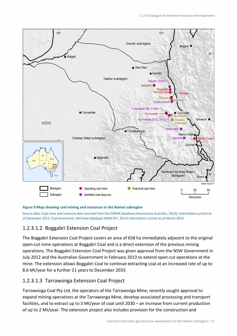
Current coal exploration tenements are concentrated around areas of current coal mining in the central eastern part of the subregion, between Narrabri and Quirindi (see Figure 9). Figure 9 shows identified coal deposits and operating mines in the subregion. Some of the projects marked as coal deposits in Figure 9 have recently received NSW and Australian Government approval: the Maules Creek Project, the Tarrawonga and Boggabri extensions and the Vickery Coal Project (Table 5).
The Maules Creek Project is one of the most recent and largest coal mining operations in NSW to have received approval from the NSW and Australian Governments to extract coal from the Maules Creek Formation via open-cut methods. Extensions of the Tarrawonga and Boggabri mines have also recently been given approval from the NSW and Australian Governments. The Vickery Coal Project received approval to operate from the NSW Government in September 2014. Coal exploration prospects are concentrated around areas of current large coal mining, with the Watermark, Caroona, Vickery South and Goonbri deposits being considered for potential development at present.
Coal and coal seam gas resource assessment for the Namoi subregion | 25
1.2.3 Proposals and exploration
Com
pone
nt 1
: Con
text
ual i
nfor
mat
ion
for t
he N
amoi
subr
egio
n Table 5 Summary of recently approved coal mines in the Namoi subregion
Site name and mining lease (ML) number
Mining methods
Operator Location Expected final depth
Allowed maximum extraction
Expected mine life
Maules Creek CL 375 and (A) 346a
Open-cut Whitehaven Coal, ICRA, J Power
18 km north-east of Boggabri
250 mAHD 13 Mt/year Mid-2013 to 2034
Boggabri Extension CL 368
Open-cut Idemitsu 17 km north-east of Boggabri
285 mAHD 5 Mt/year 2013–2053
Tarrawonga Extension ML 1579
Open-cut Whitehaven Coal and Idemitsu
16 km north-east of Boggabri
180 mAHD 3 Mt/year 2013–2030
Vickery Coal Project CL 316, ML 1471, MLA areas 1, 2 and 3
Open-cut Whitehaven Coal
18 km south-east of Boggabri
70–190 mAHD
4.5 Mt/year 2014–2044
Source data: adapted from SWS (2011) A = authorisation; CL = coal lease; ML = mining lease; MLA = mining lease application aProponent has indicated it may seek to continue mining in this area beyond the currently proposed 21-year mine plan Full company names are: ICRA Limited (ICRA), Idemitsu Australia Resources Pty Ltd (Idemitsu), J Power Electric Power Development Co., Ltd (J Power), Whitehaven Coal Limited (Whitehaven Coal)
1.2.3.1.1 Maules Creek Project
The Maules Creek Project, operated by Whitehaven Coal, is approximately 20 km north-east of Boggabri and adjacent to the Boggabri mining lease. The target coal seams are within the Maules Creek Formation. The resource is expected to sustain a project life in excess of 30 years with the expected base of the pit at approximately 300 m below surface (AGE, 2011). The project has an estimated Joint Ore Reserves Committee (JORC) Code resource of 650 Mt and recoverable reserves of 362 Mt (Whitehaven Coal, 2014a). The Maules Creek Project will produce high quality, low-ash, low-sulfur and low-phosphorus semi-soft coking coal and low-ash, low-sulfur, high-energy thermal coal (Whitehaven Coal, 2014b). The Maules Creek Project was given approval from the NSW Government to operate an open-cut mine in October 2012 and Australian Government approval in February 2013. When construction of the project is completed in mid-2015, Maules Creek will have installed capacity to produce 13 Mt/year run of mine (ROM) coal and 12 Mt/year of high quality low-ash thermal and metallurgical coal. The increase to full production will take about three years.
Construction at the Maules Creek Project site commenced in January 2014, following the completion of the Stage One salvage works under the Aboriginal Archaeology and Cultural Heritage Management Plan. Construction of the rail line for the Maules Creek Project and the Boggabri Coal Mine commenced in early January 2014 and construction of the pipeline to bring in water for the construction activity and the mine began in late December 2013. The first coal is expected to be railed from project in March 2015 (Whitehaven Coal, 2014b).
26 | Coal and coal seam gas resource assessment for the Namoi subregion
1.2.4 Catalogue of potential resource developments
Figure 9 Map showing coal mining and resources in the Namoi subregion Source data: Coal mine and resource data sourced from the OZMIN database (Geoscience Australia, 2013), information current as of December 2012. Coal tenements, MinView database (NSW DTI, 2014) information current as of March 2014
1.2.3.1.2 Boggabri Extension Coal Project
The Boggabri Extension Coal Project covers an area of 658 ha immediately adjacent to the original open-cut mine operations at Boggabri Coal and is a direct extension of the previous mining operations. The Boggabri Extension Coal Project was given approval from the NSW Government in July 2012 and the Australian Government in February 2013 to extend open-cut operations at the mine. The extension allows Boggabri Coal to continue extracting coal at an increased rate of up to 8.6 Mt/year for a further 21 years to December 2033.
1.2.3.1.3 Tarrawonga Extension Coal Project
Tarrawonga Coal Pty Ltd, the operators of the Tarrawonga Mine, recently sought approval to expand mining operations at the Tarrawonga Mine, develop associated processing and transport facilities, and to extract up to 3 Mt/year of coal until 2030 – an increase from current production of up to 2 Mt/year. The extension project also includes provision for the construction and
Coal and coal seam gas resource assessment for the Namoi subregion | 27
1.2.3 Proposals and exploration
Com
pone
nt 1
: Con
text
ual i
nfor
mat
ion
for t
he N
amoi
subr
egio
n operation of a service corridor (including a haul road) linking it to the Boggabri Coal Mine infrastructure facilities.
The Tarrawonga Extension Coal Project was given approval from the NSW Government in January 2013 and the Australian Government in March 2013 to extend open-cut operations at the mine. Under the new approval, the Tarrawonga Mine can expand the mine to the east of the existing mining area and extract a total of 50.5 Mt of coal at a rate of 3 Mt/year, until 2030 (Whitehaven Coal, 2013).
1.2.3.1.4 Watermark Coal Project
Shenhua Watermark currently holds the Watermark Exploration Licence (EL) 7223 covering an area of 195 km2, approximately 25 km south-east of Gunnedah. The Watermark deposit contains shallow resources of domestic and export quality thermal coal contained in the Hoskissons Coal and Melvilles Coal Member, with additional coal in seams overlying the Hoskissons Coal and in the Maules Creek Formation at depth. Shenhua Watermark proposes to extract up to 10 Mt/year of ROM coal from the Hoskissons and Melville seams for a 30-year period using a standard open-cut mining fleet of excavators and shovels, along with haul trucks, dozers, graders, drill rigs and water carts (Shenua Watermark Coal, 2013). An environmental impact statement (EIS) for the project has been lodged and the project is currently being assessed by the NSW Department of Planning and Infrastructure (as of September 2014). The project is also being assessed under the Commonwealth’s Environment Protection and Biodiversity Conservation Act 1999 (the EPBC Act) due to the presence of listed threatened species and communities, listed migratory species, and impacts on water resources.
If the mine is approved, coal extraction will take place from three mining areas as shown in Figure 10. ROM coal reserves are estimated to be approximately 268 Mt. As mining progresses all disturbed areas will be progressively rehabilitated while tailings and coarse rejects will be co-disposed of in overburden emplacement areas (Shenhua Watermark Coal, 2013).
The proposed development includes the construction and operation of a mine access road; administration, workshop and related facilities; a coal handling and preparation plant; and a rail spur, rail loop, Kamilaroi Highway rail overpass and associated train load facility and connection to the Werris Creek to Moree railway line. Communication and electricity infrastructure would be required. If approved, the operation is anticipated to employ a peak of approximately 600 full-time equivalent employees and associated contractors during operation at full production, with a peak of approximately 600 contractors during construction. Project activities are planned to take place within a disturbance boundary, requiring approximately 4084 ha of land disturbance, although some water, power and communications infrastructure may be located outside the disturbance boundary and the project boundary (Shenhua Watermark Coal, 2013).
Produced coal is proposed to be transported to the Port of Newcastle via the Werris Creek to Moree railway line and the Main Northern railway line. Construction and operation of surface and groundwater management and reticulation infrastructure is discussed in Shenhua Watermark Coal (2013), as well as impacts on and management of groundwater.
28 | Coal and coal seam gas resource assessment for the Namoi subregion
1.2.4 Catalogue of potential resource developments
Figure 10 Location of the proposed mining areas for the Watermark Coal Project in the Namoi subregion Source: Figure 9 in Shenhua Watermark Coal (2013). This figure is not covered by a Creative Commons licence. It has been reproduced with the permission of Shenhua Watermark Coal.
The Rehabilitation and Mine Closure Strategy for Watermark proposes that final land use will be a mixture of native vegetation communities and a mixture of pasture species for agricultural purposes. Shenhua Watermark aims to achieve a majority of post-mining land capability Class III through the creation of gentle topography (to minimise erosion) and using excess topsoil and subsoil resources available (Shenhua Watermark Coal, 2013).
With the exception of the Western Mining Area (the final void), it is planned that mining areas will be progressively rehabilitated as mining advances or concludes, and the rehabilitation programme will include backfilling final voids, soil management and translocation, implementation of erosion and sediment controls, revegetation, and relevant maintenance and monitoring to achieve a successful and self-sustaining landscape. The final void is anticipated to cover approximately 100 ha with a maximum depth of approximately 80 m below the natural ground surface. A mine closure plan would be developed within five years of closure (Shenhua Watermark Coal, 2013).
1.2.3.1.5 Caroona Coal Project
In April 2006, BHP Billiton commenced exploration activities in the Caroona Exploration Licence Area (ELA) 6505, located approximately 40 km south-east of Gunnedah and 14 km west of Quirindi. The Caroona deposit is estimated to contain more than 500 Mt of in situ potentially mineable underground coal that may produce a high quality exportable thermal coal (SWS, 2011).
Coal and coal seam gas resource assessment for the Namoi subregion | 29
1.2.3 Proposals and exploration
Com
pone
nt 1
: Con
text
ual i
nfor
mat
ion
for t
he N
amoi
subr
egio
n Within the 344 square kilometre area of EL 6505, BHP Billiton has identified three targeted exploration areas at Doona Ridge, Nicholas Ridge and Georges Island. Although there are significant coal deposits outside of these areas, BHP Billiton has focused exploration on the targeted areas because of the potential for longwall mining subsidence to adversely impact the alluvial plains which characterise the lands outside of the targeted areas (BHP Billiton, 2014).
BHP Billiton is seeking consent to develop an underground coal mining operation within the Doona Ridge and Nicholas Ridge targeted exploration areas (BHP Billiton, 2014). BHP Billiton was granted a Gateway Certificate for the Caroona Coal Project on 7 July 2014 and the NSW Director General’s Requirements (DGRs) for the Caroona Coal EIS were issued on 11 July 2014. A referral for Commonwealth assessment under the EPBC Act has also been made and the proposed action was considered a controlled action due to the presence of listed threatened species and communities and impacts on water resources. The EIS for the Caroona Coal Project is currently being written and is due for submission in 2015 (BHP Billiton, 2014).
1.2.3.1.6 Vickery Coal Project (including Vickery South Coal Project)
The Vickery Coal Project involves open-cut mining within Coal Lease (CL) 316 and the adjoining Mining Lease (ML) 1471, as well as mining related activities in Mining Lease Application (MLA) areas 1, 2 and 3 (designated MLA 447). The Vickery Coal Project is approximately 22 km north of Gunnedah and about 18 km south-east of Boggabri. The marketable reserves of the Vickery Coal Project are 180 Mt, sufficient for a 30-year mine life or more. Mine planning for the Vickery Coal Project includes a pit design that produces 164 Mt of ROM coal with coal quality assessed as consistent with both Tarrawonga and Maules Creek coals (Whitehaven Coal, 2013). The Vickery Coal Project was approved with conditions by the NSW Department of Planning and Infrastructure in September 2014. The Vickery Coal Project did not require approval under the EPBC Act as the proposed action was considered not likely to be significant if undertaken in a particular manner. The Vickery Project was referred for assessment under the EPBC Act prior to the ‘water trigger’ amendment.
In March 2013 Whitehaven Coal acquired Itochu Corporation’s interest in the Vickery South Coal Project. As a result, Whitehaven Coal now owns 100% of the Vickery South Project. The Vickery South Coal Project area is adjacent to Whitehaven Coal’s existing Vickery Coal Project. The combined area has an open-cut JORC Code resource of 507.9 Mt. However, the Vickery South deposit is not included in the current Vickery Coal Project approval (Whitehaven Coal, 2013).
1.2.3.1.7 Goonbri Exploration Project
Exploration Licence (EL) 7435, which is held by Goonbri Coal Company Pty Limited, covers an area of 984 ha, 18 km north-east of Boggabri. It is possible that an open-cut or underground coal mine could be developed within EL 7435 in the future, subject to approval. A Review of Environmental Factors for the project has been submitted to the NSW Department of Trade and Investment (Resource and Energy), which proposes to develop a series of exploration boreholes (Hansen Bailey, 2012). Although it is possible that an open-cut or underground coal mine could be developed in future, according to the NSW Department of Planning, no submissions have been made for development of the coal resources on EL 7435 as of September 2014. The Goonbri
30 | Coal and coal seam gas resource assessment for the Namoi subregion
1.2.4 Catalogue of potential resource developments
EL 7435 is close to the Maules Creek and Boggabri mines and adjacent to the Tarrawonga coal
mine.
1.2.3.2 Coal seam gas
The geological Gunnedah Basin is the subject of six current CSG developments in various stages of exploration and appraisal. The principal seams for CSG exploration in the Gunnedah Basin are the Hoskissons Coal, which lies within the Late Permian Black Jack Group, and the Early Permian coal seams of the Maules Creek Formation, located towards the base of the Bohena Trough. Santos Ltd is the main operator of CSG projects, holding the largest proportion of petroleum tenements in the Namoi subregion. Eastern Star Gas operated the Narrabri Gas Project until they were acquired by Santos in 2011.
Despite coals in the geological Surat Basin being the target for CSG extraction in Queensland, no commercial oil or gas discoveries have been made in the NSW part of the Surat Basin (Ransley et al., 2012). Consequently, the Surat Basin in the Namoi subregion is not currently a target for CSG exploration.
Exploration activities for CSG in NSW fall under the NSW Petroleum (Onshore) Act 1991. There are three main types of permits issued under the Act: a petroleum exploration licence (PEL), a petroleum assessment lease (PAL) and a petroleum production lease (PPL). A PPL allows commercial extraction or production of petroleum resources.
Figure 11 shows the location of petroleum tenements in the Namoi subregion. Most of the Namoi subregion is underlain by PELs, with the exception of one tenement at the western extent of the subregion. Although this may suggest that CSG extraction could become widespread in the area, current CSG exploration developments are concentrated in the Gunnedah Basin, which is only present in the central eastern part of the Namoi subregion. There is only one petroleum production licence identified: PPL 3, which was granted to Eastern Star Gas (now Santos) to develop the Coonarah conventional gas field, located about 20 km west of Narrabri (see Figure 11).
Figure 11 shows the location of CSG wells in the Namoi subregion, as recorded in the MinView database (NSW DTI, 2014). According to MinView, 175 CSG-related wells have been drilled in the Namoi subregion. The majority of wells are located to the south and south-west of Narrabri. With the exception of the Narrabri Gas Project owned by Santos, the CSG projects are still at an exploration stage.
Coal and coal seam gas resource assessment for the Namoi subregion | 31
1.2.3 Proposals and exploration
Com
pone
nt 1
: Con
text
ual i
nfor
mat
ion
for t
he N
amoi
subr
egio
n
Figure 11 Location of petroleum permits (including coal seam gas) and coal seam gas wells in the Namoi subregion Source data: Coal seam gas tenements and wells, MinView database (NSW DTI, 2014) information current as of March 2014 PAL = petroleum assessment lease; PEL = petroleum exploration licence; PELA = petroleum exploration licence application; PPL = petroleum production lease; PSPAPP = petroleum special prospecting authority
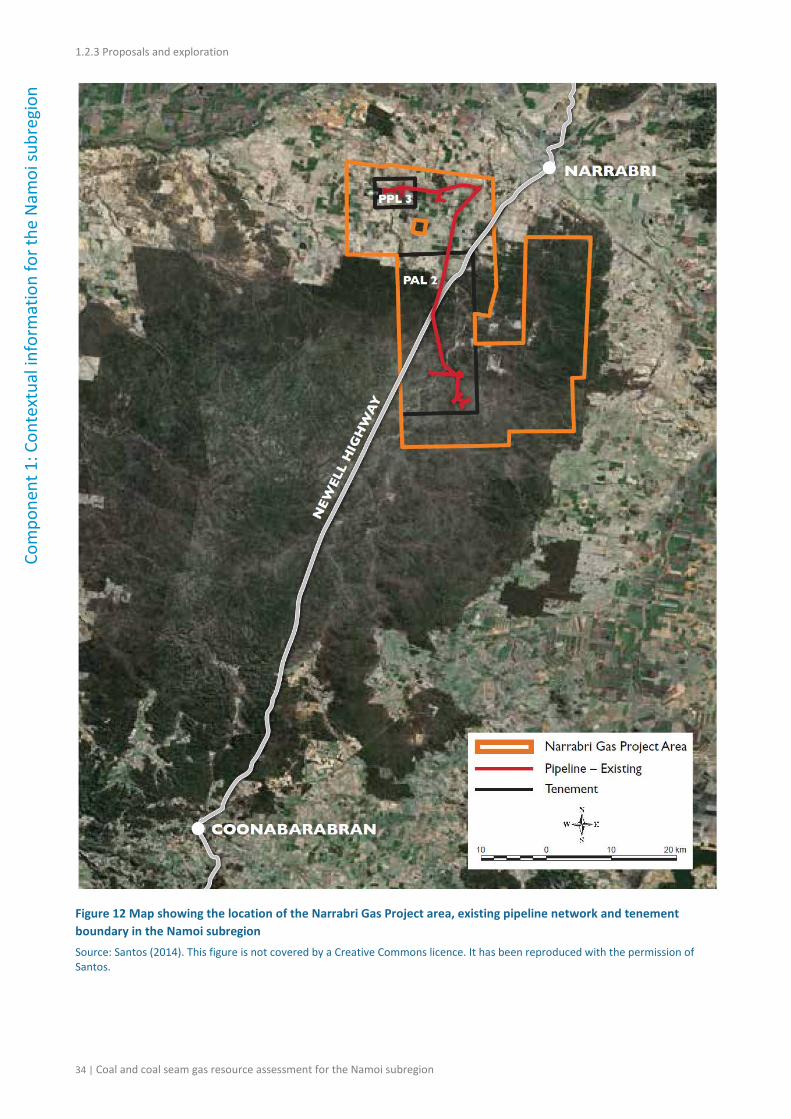
1.2.3.2.1 Narrabri Gas Project
Santos holds PAL 2 for the development of the Bohena gas field, also known as the Narrabri Gas Project, located about 21 km south-west of Narrabri. PAL 2 represents a small portion of PEL 238 which covers most of the Pilliga Forest (Figure 12). Santos has submitted a Preliminary Environmental Assessment (PEA) to the NSW Department of Planning and Infrastructure
32 | Coal and coal seam gas resource assessment for the Namoi subregion
1.2.4 Catalogue of potential resource developments
(GHD, 2014), which proposes to develop its CSG reserves in the Narrabri area. It is likely the
project will also require assessment under the Commonwealth’s EPBC Act.
The proposal is to develop a gas field with production and appraisal wells, gas and water gathering systems, and supporting infrastructure. The targeted coal seams for the project are primarily in the Maules Creek Formation (Eastern Star Gas, 2006).
The Narrabri Gas Project area covers about 98,000 ha in the Pilliga Forest and on private land, and seeks to avoid strategic agricultural land (Figure 12). It excludes the Conservation Area and Nature Reserve sections of the Pilliga woodlands. The proposed field operations will take up approximately 900 ha mostly in the Pilliga Forest. The Narrabri Gas Project could produce 200 TJ (terajoules) of natural gas per day, which would be transported via a new pipeline connection running south from Narrabri (Santos, 2014a). If approved, gas will be produced from up to 850 individual production wells or up to 425 pairs of well sets. The proposed project would include a central water management and treatment facility, located outside the Pilliga Forest, to store and treat the produced water for reuse; a central gas processing unit at the water treatment facility, to treat and compress the natural gas to Australian pipeline requirements; a small gas processing unit and water pumping station to transfer the gas and water extracted from the coal seams to the central processing facility; and supporting infrastructure including the upgrade of the Narrabri Operations Centre, workers’ accommodation, power generation and distribution networks (GHD, 2014).
The proposal includes a pipeline running south, to connect into existing infrastructure, that would be buried at least 750 mm below ground and avoid prime agricultural land to the maximum extent possible. Temporary construction facilities and other facilities located along the pipeline route would be rehabilitated after use. Santos currently has no plans to use hydraulic fracture stimulation on future wells drilled as part of the Narrabri Gas Project area, as geological data indicates that fraccing would not increase gas flows in the coal seams (Santos, 2014a).
For the Narrabri Gas Project, estimated peak water production is approximately 8 ML/day, which is forecast to stabilise at around 4 ML/day (Santos, 2012). The produced water and brine is intended to be first stored in ponds and then treated – typically by desalination using reverse osmosis or through amendment by altering the chemical balance of the water. The selection of the treatment process will depend on the original water quality and the intended use of the treated water (Santos, 2012).
Subject to project approval, Santos anticipates construction to commence in mid-2015 with first gas scheduled for late 2017–18. CSG wells would be progressively drilled from mid-2015 over the life of the development. Mobilisation and construction of the gas processing facility and water treatment facility would occur over two years, between 2016 and 2017 (GHD, 2014).
Coal and coal seam gas resource assessment for the Namoi subregion | 33
1.2.3 Proposals and exploration
Com
pone
nt 1
: Con
text
ual i
nfor
mat
ion
for t
he N
amoi
subr
egio
n
Figure 12 Map showing the location of the Narrabri Gas Project area, existing pipeline network and tenement boundary in the Namoi subregion Source: Santos (2014). This figure is not covered by a Creative Commons licence. It has been reproduced with the permission of Santos.
34 | Coal and coal seam gas resource assessment for the Namoi subregion
1.2.4 Catalogue of potential resource developments
1.2.3.2.2 Bibblewindi Gas Exploration Pilot wells
Santos was granted approval from the NSW Government in July 2014 to expand its Bibblewindi Gas Exploration Pilot under the Energy NSW CSG Exploration and Appraisal Program (RPS Australia East, 2013a). The Bibblewindi CSG wells are shown on Figure 11. As part of the Bibblewindi Gas Exploration Pilot Expansion two additional pilot wells (Bibblewindi 31 and 32) are approved to be drilled within the existing Bibblewindi Multi-Lateral Pilot, which is located in the Bibblewindi State Forest, approximately 40 km south of Narrabri. The expanded pilot has approval to operate for up to three years, after which post-operation decommissioning and rehabilitation would be carried out. Any proposal to convert the pilot wells into production wells will be included in the Narrabri Gas Project discussed in Section 1.2.3.2.1 (GHD, 2014). The Bibblewindi Gas Exploration pilot wells did not require approval under the EPBC Act as the proposed action was not considered likely to be significant if undertaken in a particular manner. The activities that have been approved for the expansion include site preparation at existing well leases, and establishment of necessary equipment, temporary structures and facilities to enable the drilling of one vertical pilot well and one lateral pilot well that would be connected to the Bibblewindi Multi-Lateral Pilot (RPS Australia East, 2013a).
1.2.3.2.3 Dewhurst Gas Exploration Pilot wells
Santos was granted approval from the NSW Government in July 2014 to expand its Dewhurst Gas Exploration Pilot under the Energy NSW CSG Exploration and Appraisal Program (RPS Australia East, 2013b). The Dewhurst CSG wells are shown on Figure 11. The recently approved activity within PEL 238 involves drilling two new horizontal wells at each of the Dewhurst 16H, 17H and 18H pilot wells to target additional coal seams at the existing Dewhurst 13–18H pilot well set. Two additional vertical-triple-stacked wells (Dewhurst 30 and 31) have also been approved to be added to the previously approved Dewhurst 26–29 pilot well set. The Dewhurst 30 and 31 well pair is scheduled to be drilled in the second or third quarter of 2014 (RPS Australia East, 2013b). The Dewhurst Gas Exploration pilot wells did not require approval under the EPBC Act as the proposed action was not considered likely to be significant if undertaken in a particular manner. Any proposal to convert the pilot wells into production wells will be included in the Narrabri Gas Project discussed in Section 1.2.3.2.1 (GHD, 2014).
The tri-stacked wells are expected to be pumping and producing from three different coals seams. The total well depth is estimated to reach approximately 1000 m while the total length of the directional wells is about 2000 m (inclusive of vertical depth). The lateral wells would be operated by electric submersible pumps; for the vertical wells progressive cavity pumps are proposed. Maximum gas flow rates of 1000 million standard cubic feet per day are expected at an estimated operating wellhead pressure of 275 kPa (gauge pressure). Mean water production is predicted to be approximately 250 m3/d (RPS Australia East, 2013c).
1.2.3.2.4 Narrabri Coal Seam Gas Utilisation Project
The NSW Department of Planning is assessing an application for a proposed modification to the Narrabri Coal Seam Gas Utilisation Project, which is also proposed under the Energy NSW CSG Exploration and Appraisal Program (Santos, 2013). The Narrabri CSG Utilisation Project is located
Coal and coal seam gas resource assessment for the Namoi subregion | 35
1.2.3 Proposals and exploration
Com
pone
nt 1
: Con
text
ual i
nfor
mat
ion
for t
he N
amoi
subr
egio
n within PAL 2 and at the Wilga Park Power Station in the Narrabri region, both operated by Santos. Modification 1 (MP 07_0023 MOD 1) to the Narrabri CSG Utilisation Project was approved in February 2011 and Modification 2 (MP 07_0023 MOD 2) in March 2012. Under Modification 3 (MP 07_0023 MOD 3), Santos proposes to install a riser on the existing 32 km buried gas flow line that would allow gas and liquids to be diverted to the Leewood Produced Water Facility. The gas flow line could be used to transfer liquids (including fresh water, produced water and brine) between the Tintsfield ponds and the Bibblewindi Water Transfer Facility and to the Leewood Produced Water Facility. It would also allow CSG from existing or future wells to be used within PAL 2 or PPL 3 at the Wilga Park Power Station (Santos, 2013).
1.2.3.2.5 Glasserton and Kahlua pilot wells
Santos completed a Review of Environmental Factors for the Glasserton and Kahlua pilot wells in the south of the Namoi subregion (Figure 11) near the township of Gunnedah.
The Kahlua pilot test site is located on an outcrop of the Triassic Napperby Formation (Gunnedah Basin sequence). The project involved an exploration test on the Kahlua 2 well. In this location, the Gunnedah Basin sequence dips to the south-west and outcrops are observed to the north-east. The full Triassic sequence of the Gunnedah Basin was logged at this location, with the target coal measure, the Black Jack Group, intersected at a depth of 159 m below surface at Kahlua 1 (Santos, 2008). The Kahlua pilot test was stopped after 30 days due to operational requirements. The target seam for the Glasserton pilot was the Hoskissons Coal in the Black Jack Group (Golder Associates, 2011), however the pilot test was not undertaken. Currently, the Narrabri Gas Project has priority and no further activities have been proposed by Santos for its Glasserton and Kahlua pilot well sites.
References
AGE (2011) Report on Maules Creek Coal Project groundwater impact assessment. Prepared for Aston Resources Limited, project no. G1508. Australasian Groundwater and Environmental Consultants Pty Ltd, Bowen Hills, Queensland.
BHP Billiton (2014) Preliminary Environmental Assessment, April 2014 - NSW Energy Coal. BHP Billiton, Australia. Viewed 6 August 2014, <http://www.bhpbilliton.com/home/society/regulatory/Documents/_coal/nswec/caroona/140430_coal_nswec_caroona_ProjectDescriptionandPreliminaryEnvironmentalAssessment.pdf>.
Eastern Star Gas (2006) The Bohena Coal Seam Gas Project: review of environmental factors Water Treatment and Disposal Project, PEL 238. Eastern Star Gas, Sydney. Viewed 17 May 2013, <http://www.dpi.nsw.gov.au/__data/assets/pdf_file/0014/119003/20061201-PEL238-REF-Bohena-Gas-Project---Narrabri.pdf>.
Geoscience Australia (2013) OZMIN Mineral Deposits Database, Canberra.
GHD (2014) Narrabri Gas Project Preliminary Environmental Assessment for Santos NSW (Eastern) Pty Ltd. Viewed 5 June 2014,
36 | Coal and coal seam gas resource assessment for the Namoi subregion
Hansen Bailey (2012) Goonbri EL7435 exploration project. Review of environmental factors for Bloomfield Collieries Pty Ltd. Hansen Bailey, Australia. Viewed 17 May 2013, <http://www.resources.nsw.gov.au/__data/assets/pdf_file/0019/431605/4.-EL-7435-Goonbri-Exploration-Project-REF-April-2012.pdf>.
NSW DTI (2014) Coal Tenements, MinView Database. NSW Department of Trade and Investment. Viewed 6 August 2014, <http://minview.minerals.nsw.gov.au/mv2web/mv2>.
Ransley TR, Radke BM and Kellett JR (2012) Chapter 3: Jurassic-Cretaceous geology. In: Ransley TR and Smerdon BD (eds) Hydrostratigraphy, hydrogeology and system conceptualisation of the Great Artesian Basin. A technical report to the Australian Government from the CSIRO Great Artesian Basin Water Resource Assessment. CSIRO Water for a Healthy Country Flagship, Australia.
RPS Australia East (2013a) Bibblewindi Gas Exploration Pilot Expansion, Environmental Impact Statement, Main Report.
RPS Australia East (2013b) Dewhurst Gas Exploration Pilot Expansion, Environmental Impact Statement, Main Report.
RPS Australia East (2013c) Dewhurst 26–29 petroleum wells PEL 238, Gunnedah Basin, NSW – Review of environmental factors, Report No PR113570, Sydney.
Santos (2008) Review of environmental factors, core hole drilling in Maules Creek Sub-basin – PEL 1, Gunnedah Basin. Santos, Australia.
Santos (2012) Surface water management, Santos Community Committee – Narrabri. Viewed 13 June 2013, <http://www.santos.com/library/SantosCCC_Narrabri_minutes_9Oct2012_presentation.pdf>.
n SWS (2011) Namoi Catchment water study independent expert phase 2 report. Schlumberger Water Services, Brisbane. Viewed 1 May 2013, <http://www.namoicatchmentwaterstudy.com.au/client_images/1009911.PDF>.
Whitehaven Coal (2013) Whitehaven Coal Quarterly Report. March FY2013 Quarterly Production Report. Viewed 5 June 2014, <http://www.whitehavencoal.com.au/investors/docs/29182601-march-quarterly-report-2013.pdf>.
Whitehaven Coal (2014a) Whitehaven Coal ASX Announcement, 1 October 2014. Viewed 8 October 2014, <http://www.whitehavencoal.com.au/investors/docs/coal-resources-and-reserves-update.pdf>.
Whitehaven Coal (2014b) Whitehaven Coal: Maules Creek Project. Viewed 5 June 2014, <http://www.whitehavencoal.com.au/operations/maules_creek.cfm>.
38 | Coal and coal seam gas resource assessment for the Namoi subregion
1.2.4 Catalogue of potential resource developments
1.2.4 Catalogue of potential resource developments
Summary
Potential coal resource developments in the Namoi subregion are concentrated around areas of current coal mining in the central part of the subregion.
Proposed development of coal seam gas (CSG) resources is concentrated in the Narrabri area and includes the Narrabri Gas Project, which may incorporate the Bibblewindi and Dewhurst pilot testing wells, and the Kahlua and Glasserton pilot testing wells.
There are five potential new mines (Maules Creek, Vickery, Watermark, Caroona and Goonbri) and two expansion projects (Tarrawonga and Boggabri). Of these projects, four have recently been given approval to operate (Maules Creek, Vickery, Tarrawonga Extension and Boggabri Extension), one is in the late stage of assessment (Watermark) and one is at an early stage of assessment (Caroona). Goonbri is currently in the exploration stage. The larger proposed developments (Watermark and Caroona) are located in the south-east of the subregion, to the west of the Werris Creek Mine (see Figure 9). There are a number of designated mining leases and consolidated coal leases in the Namoi subregion (see Table 6) and while there is little information available for these leases, they are also included as potential developments given their lease status.
Proposed development of CSG resources is concentrated in the Narrabri area where Santos Ltd has recently submitted a Preliminary Environmental Assessment (PEA). In preparation for developing the Narrabri CSG reserves, Santos has also proposed expansions to its Bibblewindi and Dewhurst gas exploration pilots, as well as a third modification to the Narrabri Coal Seam Gas Utilisation Project under the Energy NSW CSG Exploration and Appraisal Program.
Table 6 and Table 7 list potential developments with locations, resource figures and development status. Locations of the projects in relation to current coal mines are shown in Figure 9. Resources for coal are consistent (where possible) with the Joint Ore Reserve Committee (JORC) Code and include measured, indicated and inferred resources (inclusive of any reserves). CSG resources are reported as proved plus probable reserves (2P) using the Petroleum Resource Management System (PRMS).
Information in the tables is derived from the OZMIN National Mineral Deposits Database (Geoscience Australia, 2013). Resource figures presented in Table 7 have been updated using information available from Santos (2014b).
Coal and coal seam gas resource assessment for the Namoi subregion | 39
1.2.4 Catalogue of potential resource developments Co
mpo
nent
1: C
onte
xtua
l inf
orm
atio
n fo
r the
Nam
oi su
breg
ion Table 6 Catalogue of potential coal resource developments in the Namoi subregion (see Figure 9)
Project name Company Longitude Latitude Record datea Materialb Total coal resources
(Mt)c
Status of EISd Notes
Boggabri Extension
Idemitsu 150.08° (approx.)
–30.37° (approx.)
Thermal coal 90 EIS submitted Project has been approved. Deposit includes ML 1685 and MLA 0464
Caroona BHP Billiton 150.4346° –31.3985° Thermal Coal 260e EIS in preparation BHP Billiton (2012)
CCL 711 Curlewis Coal and Coke
150.2143° -31.0933° Pre-EIS Part of the Preston Extended deposit
Goonbri EL 7435
Goonbri Coal 150.12° (approx.)
–30.37° (approx.)
Pre-EIS Goonbri deposit is not in OZMIN database
Gunnedah CCL 701
Whitehaven Coal 150.141° –31.0187° 24 Aug 2012 Coking and Thermal Coal 153 Pre-EIS
Gunnedah EL 5183
Whitehaven Coal 150.0838° –30.9779° 24 Aug 2012 Coking and Thermal Coal 39.4 Pre-EIS
Maules Creek CL 375 and (A) 346a
Whitehaven Coal, ICRA, J Power
150.02° (approx.)
–30.35° (approx.)
Coking and thermal coal 610 EIS submitted Project has been approved. Deposit includes CL 375, MLA 0404 and MLA 0453
ML 1471 Whitehaven Coal 150.1729° -30.7385° Pre-EIS Part of the Canyon deposit
ML 1662 Whitehaven Coal 150.2758° -30.7415° Pre-EIS Part of the Rocglen deposit
ML 1671 and ML 1672
Werris Creek Coal
150.62° (approx.)
-31.38° (approx.)
Pre-EIS Part of the Werris Creek deposit
Tarrawonga Extension ML 1579
Whitehaven Coal and Idemitsu
150.10° (approx.)
–30.38° (approx.)
Thermal coal 78 EIS submitted Project has been approved. Deposit includes ML 1693
40 | Coal and coal seam gas resource assessment for the Namoi subregion
1.2.4 Catalogue of potential resource developments
Com
pone
nt 1
: Con
text
ual i
nfor
mat
ion
for t
he N
amoi
subr
egio
n Project name Company Longitude Latitude Record datea Materialb Total coal resources
(Mt)c
Status of EISd Notes
Vickery Whitehaven Coal 150.12° (approx.)
–30.46° (approx.)
Coking and Thermal Coal 507 EIS submitted Resource Strategies (2012). Deposit includes CL 316 and MLA 0447
Vickery South Whitehaven Coal 150.194° –30.794° 24 Aug 2012 Coking and Thermal Coal 111.15 Pre-EIS Whitehaven Coal (2014a)
Watermark Shenhua Watermark
150.375° –31.247°
Coking and Thermal Coal 268e EIS submitted Shenhua Watermark Coal (2013)
A = authorisation; CL = coal lease; CCL = consolidated coal lease; EL = exploration licence; ML = mining lease; MLA = mining lease application aThe record date is the most recent date for updated coal resource numbers. bMaterials fall into one of the following four classes: thermal coal, coking coal, pulverised coal injection (PCI) and unspecified. cThis is calculated by summing the resources with Joint Ore Reserves Committee (JORC) codes of measured, indicated and inferred. dThe status of the project within an environmental impact statement (EIS): pre-EIS, EIS in preparation, EIS submitted, EIS closed, supplementary EIS and EIS approved. eFrom EIS, see Notes column for relevant reference Full company names are: Curlewis Coal and Coke Pty Limited (Curlewis Coal and Coke), Goonbri Coal Company Pty Limited (Goonbri Coal), ICRA Limited (ICRA), Idemitsu Australia Resources Pty Ltd (Idemitsu), J Power Electric Power Development Co., Ltd (J Power), Werris Creek Coal Pty Limited (Werris Creek Coal), Whitehaven Coal Limited (Whitehaven Coal)
Coal and coal seam gas resource assessment for the Namoi subregion | 41
1.2.4 Catalogue of potential resource developments Co
mpo
nent
1: C
onte
xtua
l inf
orm
atio
n fo
r the
Nam
oi su
breg
ion Table 7 Catalogue of potential coal seam gas resource developments in the Namoi subregion
Project name Company Longitude Latitude Record datea 2P coal seam gas reservesb
(PJ)
Status of EISc
Notes
Bibblewindi Gas Exploration Pilot wells
Santos Ltd 149.62° to 149.64° (approx.)
–30.62° to –30.66° (approx.)
Pilot testing Any proposal to convert the pilot wells into production wells will be included in the Narrabri Gas Project
Dewhurst Gas Exploration Pilot wells
Santos Ltd 149.65° to 149.75° (approx.)
–30.54° to –30.70° (approx.)
Pilot testing Any proposal to convert the pilot wells into production wells will be included in the Narrabri Gas Project
Kahlua and Glasserton
Santos Ltd 150.19° to 150.00 ° (approx.)
–31.21° to –30.58° (approx.)
Pilot testing No further activities proposed
Narrabri Gas Project Santos Ltd 149.85° to 149.47° (approx.)
–30.3° to –30.7° (approx.)
31 Dec 2013 196 Pre-EIS Preliminary Environmental Assessment submitted (GHD, 2014), Santos awaiting Director Generals Requirements for EIS
EIS = environmental impact statement aThe record date is the most recent date for updated coal seam gas resource numbers. bThe Petroleum Resource Management System of the Society of Petroleum Engineers (PRMS-SPE) code 2P refers to estimated quantities of proved reserves plus probable reserves. cThe status of the project within an environmental impact statement (EIS): pre-EIS, EIS in preparation, EIS submitted, EIS closed, supplementary EIS and EIS approved.
42 | Coal and coal seam gas resource assessment for the Namoi subregion
1.2.4 Catalogue of potential resource developments
Com
ponent 1: Contextual information for the N
amoi subregion
References
BHP Billiton (2012) NSW approval process for Caroona Coal Project. Caroona CCC presentation by Sarah Bailey, Manager Approvals – NSW Energy Coal. BHP Billiton, Australia. Viewed 17 May 2013, <http://www.bhpbilliton.com/home/aboutus/regulatory/Documents/Caroona%20Coal/Caroona%20CCC%20presentation%20-%20NSW%20Approvals%20Process%20-%20December%202012.pdf>.
Geoscience Australia (2013) OZMIN Mineral Deposits Database, Canberra.
GHD (2014) Narrabri Gas Project Preliminary Environmental Assessment for Santos NSW (Eastern) Pty Ltd. Viewed 5 June 2014, <http://www.santos.com/library/Narrabri%20Gas%20Project%20request%20for%20DGRs.pdf>.