Institut für Physikalische Geodäsie INTERGEO 07 1 Integrated use of GRACE, Altimetry and Models for the Assessment of Interannual Mass Variation in the Mediterranean Sea and Black Sea L. Fenoglio, M. Becker Institut für Physikalische Geodäsie, TU Darmstadt J. Kusche, R. Rietbroek GeoForschungsZentrum Potsdam S. Grayek, E. Stanev ICBM Universität Oldenburg
Transcript
Institut für Physikalische Geodäsie INTERGEO 07
1
Integrated use of GRACE, Altimetry and Models for the Assessment
of Interannual Mass Variation in the Mediterranean Sea and Black Sea
L. Fenoglio, M. Becker Institut für Physikalische Geodäsie, TU Darmstadt
J. Kusche, R. RietbroekGeoForschungsZentrum Potsdam
S. Grayek, E. StanevICBM Universität Oldenburg
2
• Motivation
• Basin-averaged watermass change from
Grace & steric-corrected altimetry (BAMV)
• Accuracy of annual & inter-annual BAMV estimation
• Closing the Water Budget
• Black Sea: Water balance & numerical modelling of 3D circulation
• Conclusion
OUTLINE
3
MED (2.5 106 km2)
WEST-MED (0.5 106 km2)
EAST-MED (2.0 106 km2)
BLACK SEA(0.48 106 km2)
Motivation Data Method Results Conclusions
STREMP PROJECT AREA
seawater mass GRACE .NE. a-s (in coastal oceans(in coastal oceans) ) h! h! a – s = G – h (both terms filtered)a – s = G – h (both terms filtered)
• Center of mass correction to compare with altimetry: annual model from GPS loading inversion (Jansen et al., 2006, see JIGOG Presentation)Annual amplitude eq. Water height= 2 cm
G: GRACE
Motivation Data Method Results Conclusions
Example: annual Sine/Cosine
6
A: ALTIMETRY / O: OCEANOGRAPHY
Motivation Data Method Results Conclusions
• Single-mission, multi-mission, objective analysed grids• IBC to be applied in agreement to GRACE processing and ocean modelling (DUACS grids, in Black Sea MOG2D correction not available)
• Correction of atmospheric forcing effects is an issue in semi-closed basins !
Med Sea: MFSTEP / steric component
Black Sea: 3-D modelling with the “best” water balance terms
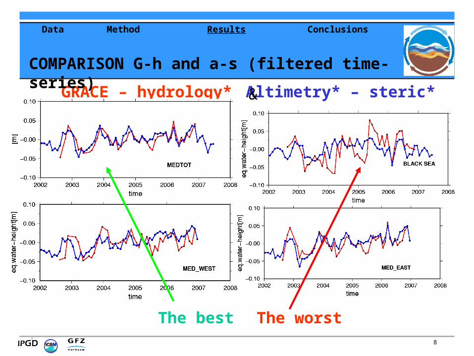
MED BASIN AVERAGE:G-h ~ a-s with : GRACE, LAD, J1, ECCO
rms=14 mm, corr=0.8, N=475.4 +/- 2.6 mm/yr
3.2 +/- 2.2 mm/yr2002.6-2006.7
Motivation Data Method Results Conclusions
11
Error estimates for monthly means, annual component and trend (from RMS and Error Propagation) in 2002.6 – 2004.6
1 cm (*1-2)!
--1013Grace – h_filt
-
-
-
10
10
2
Annual Phase error(d)
3715WM from a-s
-715WM GRACE
-310GRACE_filt
-911Hydrology
5613Steric
148altimetry
Trend
(mm/yr)
Annual Amplitude
error (mm)
Eq. water
Monthly
error(mm)
Field
1-2 cm (*2-4)
ACCURACY OF ESTIMATION FOR MED BASIN AVERAGE
** (Fenoglio et al. GRL2006, JGR in press)
Motivation Data Method Results Conclusions
12
ACCURACY of ESTIMATION: BASIN DETAILS
Motivation Data Method Results Conclusions
13
WATER BUDGET IN THE MEDITERRANEAN SEA
Hydrological cycle: water thickness change (mm/mon)
MED
EP
RE-P-R
E-P
FG = (E-P-R-B) + dm/dt
P-E(mm/mon)
R(mm/mon)
FG (a-s)(mm/mon)
FG (G-h) (mm/mon)
16-30 5 39+/-7 60+/-7
48 +/-7
R~ B
Motivation Data Method Results Conclusions
dm/dt = P-E+R+FG+B (MED)
Annual Amplitude
14
BS: A DIFFICULT REGION?
-H: huge contribution to GRACE -A: strong interannual, ibc not realistic- S: small ~ constant- large water fluxes
Motivation Data Method Results Conclusions
15
Seasonal Range 2002-2007 [m]river run-off precipitation evaporation strait heat flux
0,05 0,06 0,13 0,14 0,07
Interannual Range 2002-2007 [m]total water flux heat flux
0,07 0,01
Mean yearly water fluxes
Motivation Data Method Results Conclusions
Contribution of individual terms to BS level change
- P: from atmospheric analyses (large errors).
- E: computed by model using bulk formulas (big errors)
- R: for some rivers only, input statistically generated
- B: Bosporus transports reconstructed (linearly from R)
FOR BS NUMERICAL MODELLING of 3D CIRCULATION
16
Problem in reconstructing BS Water balance: SENSITIVITY TO STRAIT TRANSPORTS (ST)
Still problems with theoretical/statistical reconstruction
Constraining the balance by altimetry (0D) –> consistently close water balance
a) ST Statistically reconstructed from R
b) ST Computed as a residual (use of satellite data)
Motivation Data Method Results Conclusions
17
COMPARING RESULTS
Motivation Data Method Results Conclusions
Integrated P-E+R-B watermass change from a-s
dm/dt = P-E+R-FB (BS)
18
Simulated Mean Sea Level 0D/3D
Linear equation of state0D (mean area) forcing fields
Unesco eq. of state (non linear)2D forcing fields
BEST (Presently) FIT OF SEA LEVEL TO DIFFERENT DATA
Motivation Data Method Results Conclusions
Model captures well the vertical structure of thermohaline fields (known from observations)
19
• In MED the water-mass signal could be recovered (both seasonal and long-term variations), in the BS it is more difficult.
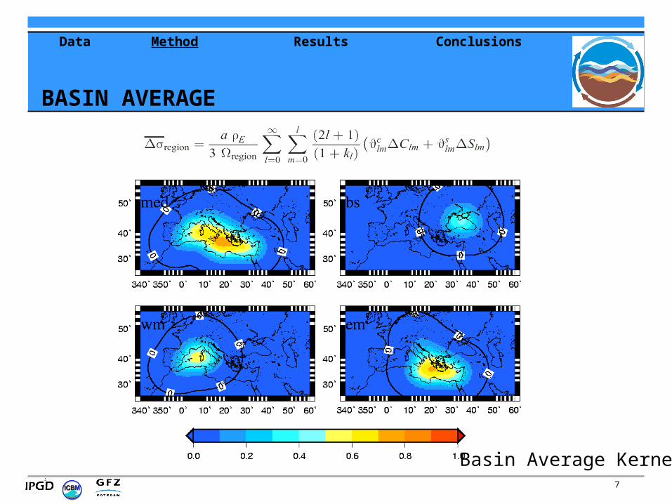
•Basin averages: smoothed spatial averaging kernel (isotropic and anisotropic), small improvement with anisotropic
•MED : Basin average a-s and G-h with comparable error estimates (15 mm monthly, 1 cm Annual Ampl., 2 mm/yr)
•Land hydrology contamination to be considered, dominant in Black Sea
•Closing the water balance in MED (Gibraltar estimation ~ observations)
•Closing the water balance in BS is necessary for realistic modelisation. BS is complex system (LARGE sensitivity to water fluxes & errors in WF components, straits flows inaccurate, numerical parameterizations of straits transport not solved).
Motivation Data Method Results Conclusions
CONCLUSION
20
Oceanography:
Improve modeling :
• Physical (not by residuals) closing of water budgets,
• More appropriate assimilation scheme, focus on absolute sea level analysing its role for the evolution of baroclinic structure and circulation
Geodesy:
• Improve filtering of GRACE data
• reduce leakage of hydrology in watermass estimation