:1 1 ' . j 11 ., rl ! ] 1 { 1 '1 f1 1..,:'1'- 1 bl" f1 ,f] I 1 , I J ....... 4"' m , . .... -\. VASHON COORDINATED : WATER SYSTEM PLAN REGIONAL SUPPLEMENT PREPARED BY: HORTON DENNIS & ASSOCIATES KIRKLAND, WASHINGTON .. ... ,.
Transcript
:1 1 ' . j
11 ., rl ! ~
] 1
{
1 '1 f1
1..,:'1'-
1 bl" f1 ,f]
I 1 , I J
....... 4"' ~ m , .
.... -\.
VASHON COORDINATED
: WATER SYSTEM PLAN
REGIONAL SUPPLEMENT
PREPARED BY: HORTON DENNIS & ASSOCIATES KIRKLAND, WASHINGTON
.. ...
,.
Horton Dennis & Associates, Inc.
HI}\. Consulting Engineers & Surveyors
June 1, 1990
Vashon Water Utility Coordinating Committee Richard Rodriguez, King County Coordinator King County Building and Land Development 3600 - 136th Place Southeast Bellevue, Washington, 98009
SUBJECT: VASHON COORDINA TED WATER SYSTEM PLAN
Dear Richard:
We are pleased to submit this final report for the Vashon Coordinated Water System Plan and express our thanks for your support and assistance in bringing this project to a close.
This report has been prepared in accordance with the requirements of the State Public Water System Coordination Act of 1977 and is a regional supplement to the Vashon/Maury Critical Water Supply Service Area. This document, together with the declaration of the Critical Water Supply Service Area and the comprehensive water system plans of the Island's water purveyors, constitutes the complete Coordinated Water System Plan.
The conclusions and recommendations presented in this report represent the consensus of the Vashon Water Utility Coordinating Committee and are in direct response to unique issues and concerns facing the water purveyors of this area of unincorporated King County. We sincerely appreciate the opportunity to provide this framework for water system development and purveyor coordination on Vashon/Maury Isla.'1d.
If we can be of any further assistance, please let us know.
Sincerely, HORTON DENN~ ~SSOCIA TES, INC.
~~~. Susan E. Washburn Project Planner
320 Second Avenue South, Kirkland, Washington 98033-6687 • Phone 822-2525 • FAX: (206) 822-8758
.)
.~
, "
VASHON
COORDINATED WATER SYSTEM PLAN
REGIONAL SUPPLEMENT
JUNE 1,1990
PREPARED BY:
Horton Dennis & Associates, Inc. Consulting Engineers and Surveyors
Kirkland, Washington
In Association With: CH2M Hill
Bellevue, Washington
VASHON
COORDINATED WATER SYSTEM PLAN
The technical material and data contained in this document were prepared under the supervision and direction of the undersigned, whose seal as a professional engineer licensed to practice as such in the State of Washington is affixed below."
Robert D. Stanton, P .E. Associate
Horton Dennis & Associates, Inc.
i
, '-
l -
l _
rL
ACKNOWLEDGEMENTS
We wish to express our appreciation to the members of the Vashon Water Utility Coordinating Committee and other participants, all of whom have contributed to the development and success of this study.
Jack Dolstad, Westside Water Association, Committee Chairman
Roy Wilkerson, King County Water District No. 19
Ken Duncan, Heights Water Association
Jim Garrison, Burton Water Company
Charles Saul, Maury Mutual Water Company
Bob Moore, Docton Water Association
Dom Spano, Gold Beach Water
Moe Batra, State Department of Health (DSHS)
Carole Richmond, State Department of Health (DSHS)
Holly Keen, King County Council Staff
Ralph Colby, King County Building and Land Development
Richard Rodriguez, King County Building and Land Development
Carolyn Boatsman, Seattle-King County Department of Health
ii
,( "
i L
I ,"
, ..
VASHON COORDINATED WATER SYSTEM PLAN TABLE OF CONTENTS
PARTI-ThITRODUCTIONANDS~Y A. BACKGROUND. . . . . . . . . . . . . . . . . . . . . . . . . . . . . . 1-1 B. AUTHORITY ................................ 1-1 C. INfENT PLAN .................... '.......... 1-1 D. LIST OF PARTICIPANTS ........................ 1-2 E. APPROACH. . . . . . . . . . . . . . . . . . . . . . . . . . . . . . . . . 1-2 F. SUMMARY OF RECOMMENDATIONS .............. 1-2
PART II - BASIC PLANNING DATA A. GENERAL .................................. 11-1 B. PHYSICAL FEATURES ......................... 11-1
1. Topography ............................. 11-1 2. Geology and Soils ......................... 11-1 3. Surface Water and Drainage ................... 11-2 4. Erosion Hazards .......................... 11-2 5. Climate ................................ 11-6
C. LAND USE AND ZONING . . . . . . . . . . . . . . . . . . . . . . . 11-6 D. POPULATION ............................... 11-6 E. WATER CONSUMPTION . . . . . . . . . . . . . . . . . . . . . . . . 11-7 F. RELATED PLANS AND POUCIES ................. 11-7
PART ill - EXISTING WATER SYSTEMS A. GEN'ER.AL .•.•••....••.•••••...•.•...••.•.. • ill-I B. PRIMARY WATER SYSTEMS - EXISTING FACILITIES ... ill-1
1. Heights Water Association . . . . . . . . . . . . . . . . . . . . ill-1 2. Westside Water Association ................... ill-2 3. King County Water District No. 19 .............. I11-4 4. Burton Water Company ...................... I11-7 5. Maury Mutual Water Company ................. I11-8 6. Dockton Water Association ................... I11-9 7. Gold Beach Water System .................... ill-ll
C. OTHER WATER SYSTEMS ...................... ill-11 D. HYDRAULIC ANALYSIS ........................ ID-ll
1. Source and Storage Requirements .............. .ID-12 2. Fire Flow Requirements .................... .ill-12
111
PART IV - MINIMUM DESIGN STANDARDS AND SPECIFICATIONS A. INTRODUCTION ............................. IV-I B. APPLICATION OF STANDARDS ................... IV-I
1. Utility Plans and King County Comprehensive Plan .... IV-I 2. Phased Development of Water Systems ............ IV-3 3. Design Standards . . . . . . . . . . . . . . . . . . . . . . . . . . IV-4 4. Conditions to Exceed Minimum Standards .......... IV-4
C. GENERAL PROVISIONS ........................ IV-5
D.
E. F.
1. Source Development and Protection ..... . . . . . . . . . IV -5 2. Water Rights ............................ IV-5 3. Water Quality ............................ IV-5 4. General Design Specifications .................. IV-5 5. General Material Specifications
PART V - SERVICE AREAS A. IN1'RODUCTION ............................. V-I B. ESTABLISHING SERVICE AREAS .................. V-I
1. Primary Water Systems ...................... V-2 2. Other Public Water Systems ................... V-2 3. Unresolved Service Area Conflict ............... V-3
C. SERVICE AREA AGREEMENT .................... V-3 D. SERVICE AREA CHANGES ...................... V-3
IV
j -
1 >
1 -
, "
PART VI - REVIEW PROCEDURES AND SATELlITE MANAGEMENT A. UTllJTY SERVICE REVIEW PROCEDURES ........... VI-I
B. SATELLITE SYSTEM MANAGEMENT ............... VI-9 1. Introduction ............................. VI-9 2. Goals of the Satellite System Management Program .... VI-9 3. Satellite System Management Agency (SSMA) ....... VI-tO 4. Implementation ........................... VI-ll 5. Support Services by Utilities and Agencies .......... VI-I2 6. Prequalification of Satellite
System Management ........................ VI-I2
PART VII - REGIONAL ISSUES A. INTRODUCTION ............................. VII-I B. WATER QUANTITY ........................... VII-I
, ' and System Improvements . . . . . . . . . . . . . . . . . . . .VIII -2 4. Future Sources and Groundwater Management ....... VIII-2 5. Protection of Groundwater Quality ............... VIII-3 6. Water Conservation ........................ VIII-3 7. Water Shortage Response Planning ............... VIII-4
, ! 8. Plan Updates ............................ VIII-4 9. WUCC to Remain in Effect ................... VIII-4
. (
v
PART IX - IMPLEMENTATION A. PLAN APPROVAL ............................ IX-I B. APPEA:LS PROCESS . . . . . . . . . . . . . . . . . . . . . . . . . . . IX -2
1. Issues Subject to Review ..................... IX-2 2. Step I Review ........................... IX-2 3. Step 2 Review ........................... IX-3 4. Binding Arbitration ........................ IX -3
C. STATE AND COUNTY LEGISLATION ............... IX-5 1. Sta.te ................................. IX-5 2. King County ............................ IX-5
D. INDIVIDUAL PLAN UPDATES .................... IX-5 E. WUCC TO REMAIN IN EFFECT . . . . . . . . . . . . • . . . . . . IX-6
APPENDICES A. CWSP APPROVAL B. RELATED PLANS, REPORTS AND POLICIES C. HYDRAULIC ANALYSIS D. FIRE FLOW PLANNING CRITERIA E. EXISTING SMALL WATER SYSTEMS F. FUTURE SOURCE PLANS G. WATER CONSERVATION H. ENVIRONMENTAL CHECKLIST 1. SUPPORTING DOCUMENTATION
I...ocation Map . . . . . . . . . . . . . . . . . . . . . . . . . . . . . . . . IT -3 Topography ................................. IT-5 Existing Water Facilities of Primary Systems ...........•. III-3 Simulated Flows ..•........................... III-14 Primary Water Systems Existing Boundaries ...........•• Y-5 Alternate I-Primary Water Systems Potential Boundaries ..•.. Y-6 Primary Water Systems Recommended Service Areas ••..••• Y-7 Small System Location Map ....................... Y -8 -Proposed Small System Expansion ................... Y-9 Water Service Area Conflict . . . . . . . . . . . . . . . . . . . . . . . V-1O Appeals Process ............................... IX-4
vi
1 -
, '.
.,
. !
(' , - .!
, !
/ .
, -
< .
J. ~.
GWSSARY OF ABBREVIATIONS AND TERMS
The following definitions are presented for interpretation of this document. Additional definitions may be found in Chapter 248-54 WAC, "Rules and Regulations of the State Board of Health Regarding Public Water Systems", revised February, 1988; available from the Department of Social and Health Services, Water Supply and Waste Section, LD-ll, Olympia, WA, 98504.
ABBREVIATIONS:
APWA
AWWA
BALD
ccf
cfs
CIP
CWSP
CWSSA
DOT/APWA
DSHS
Ecology
EPA
The American Public Works Association.
The American Waterworks Association.
King County Department of Parks, Planning and Resources -Building and Land Development Division.
One hundred cubic feet.
Cubic feet per second.
Capital Improvement Program.
Coordinated Water System Plan (Chapter 70.116 RCW).
Critical Water Supply Service Area (Chapter 70.116 RCW and Chapter 248-56 WAC) .
Combined standards for public works construction practices of the Department of Transportation and the American Public Works Association, 1984 Edition.
Department of Social and Health Services, State of Washington. NOTE: EffectiveJuly 1, 1989,responsibilityfortheCWSP transferred from the Department of Social and Health Services to the Department of Health. Approval and implementation of the CWSP as defined in this document will be by the Department of Health.
Department of Ecology, State of Washington.
United States Department of Ecology.
vii
gpcd Gallons per capita per day.
gpd Gallons per day
gpm Gallons per minute.
GWMP Vashon Groundwater Management Plan, being prepared for Vashon-Maury Island.
KCC King County Code.
MGD Million gallons per day.
PSCOG Puget Sound Council of Governments.
RCW Revised Code of Washington.
SKCHD Seattle-King County Health Department.
SSMA Satellite System Management Agency, An organization, in-dividual, or other entity that is prequalified, as provided in the CWSP, to render services such as operation, maintenance, development or management of water systems in King County. ' ,
. ~
SSM]> Satellite System Management Program. A program established to provide for technical assistance, contract services, and other resources to meet management needs of satellite systems.
ULID Utility Local Improvement District.
USRP Utility Service Review Procedures. An administrative pro-'If- .,.
cedure set up under local agency jurisdiction to identify the water purveyor best able to serve an area where new public water service is requested. (See Designated Purveyor).
UTRC King County Utility Technical Review Committee. , -
WAC Washington Administrative Code. i :'
WUCC Vashon Water Utility Coordinating Committee. ~ -
L
viii , -,
; . L _
, _ J
, :1
, t~
I '
, -
i _
TERMS:
Aquifer , A geologic formation or part of such a fonnation that contains sufficient saturated material to yield significant quantities of water to springs and wells.
Aquitard A formation or part of a formation which, because of low permeability, allows no flow of water through it.
Classes of Public Water Systems Class 1 - A public Water System having 100 or more permanent service connections.
Designated Purveyor or Designated Utility
Development Classification System
Expanding Water System
Class 2 - A public water system having 10 through 99 pennanent service connections.
Class 3 - A public water system serving a transitory population
o(2?br more in one day. ----'
Class 4 - A public water system which is not a Class 1, 2, or 3 system. L_ - 9
A water purveyor (utility) identified to provide water service to a given area. When willing to provide the service in a timely and reasonable manner, the designated purveyor is assigned an exclusive right to provide the water service- to the area and is required to include the area in its approved Water System Plan or King County Water Comprehensive Plan.
Specific geographical areas within the existing and future service area of a public water system, identified for the purpose of determining the appropriate level of fire protection (WAC 248-57-100). In King County, development classifications are used for determining required fire flow for water system planning purposes, while existing King County Codes regulate actual fire flow required for any particular land use and/or structure type.
Those public water systems installing additions, extensions, changes, or alterations to their existing source, transmission, storage or distribution facilities which will enable the system to increase in size its existing service area. New individual retail or direct service connections onto an existing distribution system shall not be considered an expansion of the public system.
ix
Fire Flow
Franchise Area
Groundwater
Hydrogeologic
Interlocal Agreement
Intertie
King County Water Comprehensive Plan
Land Use Designation
Level of Service
New Construction
The rate of water delivery needed for the sole purpose of fighting fires. The fire flow volume is in addition to the requirements of the water system for domestic demand.
Non-exclusive area in which a utility is permitted by the County to extend facilities in public rights-of-way. A franchise are is not equivalent to a service area, although the two may correspond.
All waters beneath the land surface or beneath the bed of any stream, lake or reservoir, or other body of surface water, whatever may be the geologic formation or structure in which such water stands or flows, percolates or otherwise moves. (WAC 173-100-4(0).
Factors which deal with subsurface waters and related geologic aspects of surface waters.
See Service Area Agreement.
A physical connection between individual water system facilities.
King County Code 13.24 requires, as a prerequisite for granting right-of-way franchises and construction permits, that a comprehensive plan be prepared by utilities providing water service in unincorporated areas of the County. The plans are reviewed by the King CountY Utilities Technical Review Committee (UTRC) prior to submittal to the King County Council for approval.
The land use(s) allowed in a geographical area by right or permit, as provided in the King County Comprehensive Plan and Zoning Ordinance.
Operational features, such as pressure, flow, reliability, etc. provided to the customer by the water system.
Any addition of supply, transmission, distribution or storage facilities, either in a new or expanding water system, which provides a capability to expand into areas previously unserved, or which upgrade systems to permit them to serve more customers than the number of connections authorized by the system's approved comprehensive plan.
x
J _
, -
! -
, -
;:r!i '":t ±
l'" ,
· l
, {
· j
< I
C' · I
, .1
• .1 •
, ,( .
-...,;.;
Public Water System
Remote System
Rural
Satellite System
Service Area
Any water system intended or used for human consumption or other domestic uses, including source, treatment, storage, transmission, and distribution facilities where water is furnished to any community or group of individuals, or is made available to the public for human consumption or domestic use, but excluding all water supply systems serving one single family residence. It also does not include water systems meeting all of the following requirements:
1. Purchase their entire supply of water from another public water system subject to these regulations;
2. Do not treat the water (other than softening or corrosion control); and;
3. Do not sell water. Businesses or systems merely storing and distributing water providing water by others are exempt unless that system sells water as a separate item or bills separately for the water provided.
A water system located within the service area of a designated utility that is detached and is not served by a direct connection from the designated utility.
For determining the appropriate level of water service required in an area, rural is defined as an area where average residential densities do not exceed one unit per acre.
A water system not served by direct connection to an existing water utility. A satellite system may be located within or outside the service area of a designated purveyor. A satellite system may be owned and/or managed by an approved Satellite System Management Agency.
A geographical area assigned to a water purveyor for the purpose of providing both current and future public water service. Boundaries are defined by agreements among adjacent utilities and are recorded on a set of maps on file with BALD and SKCHD. Water service provided within the designated service area must be consistent with local land use plans.
xi
Service Area Agreement
Service Connection
Surface Water
Transmissivity
Water System Plan
An agreement signed by water utilities which identifies the service area for which the utility has retail water service responsibility .
A physical connection through which water may be delivered to a customer for discretionary use. Unless otherwise indicated, all such connections, whether currently in use or not, shall be considered as a service connection. The service connection defines the limit of the water utility's responsibility for system design and operation unless otherwise provided for in the water utility's condition of service policies.
Utility customers such as mobile home parks, planned unit developments, condominiums, apartment buildings, industrial, commercial sites, or other similar complexes are generally considered exterior to the water system. In such cases the purveyor shall be required to meet design standards up to the point of service to the customer; and beyond that point, the applicable plumbing and building codes, fire codes, County health regulations, and local ordinanCes are deemed to be sufficient to protect the public health and to ensure adequate water service. These customers are not themselves considered herein as water purveyors unless specifically designated as such by DSHS.
All water open to the atmosphere and subject to and subject to surface runoff (e.g. rivers, lakes, reservoirs, impoundments), and all springs, infiltration galleries, wells, or other collectors that are directly influenced by surface water. (Federal Register Vol. 52, No. 212, 11/3/87).
The rate at which water travels through an aquifer.
A written plan prepared for a particular water system and service area which identifies a schedule of needed improvements, a financial program, and an operations program. A water system which is expanding within a designated service area may be required to include other elements in its plan. Details of Water System Plan Requirements can be found in WAC 248-54-065.
A. BACKGROUND The Public Water System Coordination Act of 1977 (RCW 70.116) establishes procedures for adjacent water utilities and local governmental agencies to coorQinate the planning and development of water facilities. These procedures are intended as guidelines for providing future water service in the most efficient manner possible, with the objectives of coordinating development by geographical areas and integrating water system development with current land use plans.
The procedures outlined in this Act allow either the State of Washington Department of Social and Health Services (DSHS) or a county to declare an area as a Critical Water Supply Service Area based on a preliminary assessment identifying problems associated with water quality, unreliable service or absence of coordinated planning. Pursuant to this provision, the King County Council passed motion No. 6407 on December 16, 1985. In doing so, the Council adopted the "Preliminary Assessment of Water Supply and Fire Protection" , declared Vashon/Maury Island a Critical Water Supply Service Area (CWSSA) and initiated the coordinated water system planning process.
B. AUTHORITY The Vashon Coordinated Water System Plan has been prepared in accordance with the contract signed by King County and Horton Dennis & Associates, Inc. on October 14, 1987, the scope of work put forth by King County, RCW 70.116 and the guidelines established in the DSHS "Public Water System Coordination Handbook" .
C. INTENT OF PLAN The intent of this effort is generally described in the project "Scope of Work" as follows:
1.
2.
3.
4.
5.
6.
7.
8.
9.
Establish service areas for existing water purveyors;
Establish minimum design standards for new water facilities;
Review and analyze existing water systems and purveyor plans;
Coordinate water system development with land use plans/policies;
Determine the most efficient means of providing adequate water service throughout the CWSSA;
Identify options for cooperative development of water facilities;
Develop an area-wide emergency response plan;
Develop criteria for the creation of new water systems within the CWSSA;
Develop alternatives for the management of public water systems by satellite system management agencies (SSMA's) and/or existing purveyors.
1-1
D. LIST OF PARTICIPANTS Participants in developing this Plan include various agency representatives and the water systems listed below. In addition, a variety of Class 2,3, and 4 water purveyors and citizens have participated in development of this Plan on an occasional basis.
- Washington Department of Social and Health Services (DSHS)
- King County Building and Land Development
- King County Council Staff
- Seattle King County Health Department (SKCHD)
- Heights Water Association
- Westside Water Association
- King County Water District No. 19
- Burton Water Company
- Maury Mutual Water Company
- Dockton Water Association
- Gold Beach Water System
E. APPROACH The first step in developing this Plan was King County's "Preliminary Assessment of Water Supply and Fire Protection" which identified Vashon/Maury Island as a Critical Water Supply Service Area (CWSSA) and recommended preparation of this Coordinated Water System Plan (CWSP).
In accordance with State regulations, a Water Utility Coordinating Committee (WUCC), including representatives from water systems within the CWSSA which have more than 50 connections and appropriate government representatives, was formed. After public solicitation for proposals, Horton Dennis & Associates, Inc. was selected as consultants to assist the Committee in preparing this Plan. The WUCC has held regular meetings throughout the planning process to discuss the individual and collective needs and concerns of the participating purveyors. The coordination efforts between the WUCC, the King County staff, DSHS and the consultant have helped assure that this Coordinated Water System Plan will be a valuable planning tool for all purveyors within the study area. 1 •
F. SUMMARY OF RECOMMENDATIONS Part VIII of this Report contains the detailed recommendations of this Plan. The following is a summary of those recommendations:
1-2
1 _
,'1 '-
i,
< .
t"
~- :-
r
< t .
1. The service areas arrived at during this planning process should be maintained in accordance with the Interlocal Service Area Agreement contained in Appendix A. In future updates of this Plan, purveyors should consider further expansion of the service areas agreed to herein.
2. Proliferation of new public water systems within the Vashon CWSSA should be restricted by King County policy, DSHS support and by existing purveyors utilizing their options for satellite management of areas within and adjacent to their existing service areas which can not be readily served by existing facilities.
3. King County implementation of the Utility Service Review Procedures and New and Small System Management Plan is critical to the desired limitation of new public water systems (two or more connections) within the Vashon CWSSA.
4. Alternatives for restriction of new private water systems (one connection) should be examined by the Vashon Groundwater Management Program, King County and the State of Washington.
5.
6.
7.
8.
9.
Purveyors are required to construct all new water facilities in accordance with the Minimum Design Standards established in Part IV of this Plan. It is further recommended that purveyors consider upgrading existing facilities which do not meet the criteria established in the Minimum Design Standards portion of this document when developing their individual Capital Improvement Programs.
To analyze the existing capabilities of existing groundwater sources and determine viable options for future groundwater supply and protection, all purveyors are encouraged to provide whatever support and assistance necessary for the development and implementation of the Vashon Groundwater Management Program.
Additional information is required to assess the future potential of groundwater supplies on Vashon. The Vashon Groundwater Management Program should address the items listed in Part VIII B.4. in its data collection and analysis.
A strong program for the protection of groundwater quality should be developed. Some of the items to be addressed in such a program are contained in Part VII. These items should be the addressed by the Groundwater Management Plan and implemented by DSHS, King County, Island purveyors and citizens:
Emergency response planning is discussed in Part VII of this document. Purveyors are required to develop such plans as part of their water comprehensive plans and are encouraged to coordinate and cooperate with each other to determine interties and other options in the event of an emergency.
1-3
10. DSHS planning guidelines stipulate that purveyors include a conservation element in their comprehensive plans. It is recommended that purveyors consider the conservation measures presented in Appendix G of this Plan when developing their individual programs, and that the WUCC consider development and monitoring of an Island-wide conservation program as part of their ongoing activities.
11. Water shortage response planning should be accomplished by each purveyor in accordance with DSHS guidelines.
12. Each purveyor is required to update their Water Comprehensive Plan to include the requirements and recommendations of this Regional Supplement. Plan updates are to be completed within 12 months of the approval of this document.
13. The Vashon Water Utility Coordinating Committee is to remain in effect after the completion of this Plan. To insure the effectiveness of this Plan, the implementation must be monitored and reviewed periodically. The Committee should therefore meet periodically to discuss progress and possible amendments to the Plan as stated in Part IX. Additionally, the WUCC will review and comment on the Vashon Groundwater Management Plan when it becomes available for review.
14. In accordance with the Coordination Act, this Plan is to be updated at least every five years. Future updates of this Plan should consider infonnation from the Groundwater Management Plan. If information from the groundwater plan necessitates changes to· the CWSP prior to the mandated five year update, the WUCC will consider an amendment to this CWSP in order to insure coordination between the plans.
1-4
I.
< .
j.
1_"-,,
, ,
. ...i
, , ,
I
I i
~ , .
.J
,J ,ct ,J.
: ~L ':c
PART II BASIC PLANNING DATA
~ A. GENERAL
B.
The Vashon Island Critical Water Supply Service Area (CWSSA) actually consists of two islands (Vashon and Maury) which are connected by a narrow isthmus. As illustrated on Plate IT-I, this study area is located in the Puget Sound, southwest of Seattle, north of Tacoma, and east of Bremerton, Washington. The Island covers an area approximately 12 miles long and 4 miles wide.
As King County's only unincorporated island community, Vashon is unique in many aspects. Despite its close proximity to urban areas, the Island remains isolated both physically and socio-economically. Primary access is provided by Washington State Ferry Service to two terminals, from Southworth and Fauntleroy to the north terminal and from Tacoma to the south terminal. An airfield provides access for privately owned aircraft.
Approximately 47 miles of saltwater shoreline offer magnificent views and exceptional opportunity for recreation, although steep terrain prohibits development in many shoreline areas. The rolling topography of the upland plateaus supports the majority of development on the Island, which is rural-residential in nature. The population of Vashon is a mixture of full time residents engaged in a rural lifestyle, people who commute by ferry to jobs in Seattle and Tacoma, and second home owners that use Vashon for weekend and summer vacations.
PHYSICAL FEATURES 1. TOj)omphy _
2.
As shown on Plate TI-2, the topography of the study area is characterized by steep slopes rising from the shoreline to elevations of 300 to 400 feet and higher. At the upper elevations, the topography levels to gently rolling plateaus. Exceptions to the rolling terrain of the upland plateaus occur only in a few deeply cut stream ravines.
The Island is virtually ringed by slopes exceeding 25 %. Although in some places there is relatively 'flat land between the water and the toe of steep slopes, this land is generally not suitable for development due to unsuitable soil conditions.
Geology and Soils The geology and soils of Vashon/Maury Island are best described in "Vashon/Maury Island Water Resources Study" prepared by J.R. Carr/ Associates in 1983. Carr defines three primary hydrogeologic units which are summarized as follows:
II - 1
a. Unit I - This is the uppermost or surface layer of most of the uplands of the Island. This layer is predominantly lodgement till with some discontinuous sand lenses that yield small quantities of water to shallow dug wells. Many of the Islands drainfields are located in Unit I. The thickness of Unit I ranges from 0 to 50 feet.
b. Unit n - Unit II is a sand and/or sand and gravel unit that is typically 50 to 100 feet thick but reaches thicknesses of several hundred feet on the southeastern shore of Maury Island and the west side of Vashon Island. This unit contains the principal aquifer and supplies water to most of the Island's wells and to all of the hillside springs.
c. Unit ill - This is a homogeneous blue to brown silt or clay layer that generally acts as an aquitard to impede groundwater flow from Unit II. Springs are common where the two layers meet and are exposed along the Island perimeter. Discontinuous sand layers at 100 to 300 feet below sea level yield water to approximately 13 domestic wells. These isolated pockets are referred to as the deep aquifer.
3. Surface Water Drainage
4.
Twenty seven drainage basins have been identified on the Island. The largest of these are Judd Creek, which covers much of the central Vashon uplands and drains southwesterly into Quartermaster Harbor (north of Burton Peninsula); and Needle or Shingle Mill Creek Basin which drains from the Vashon uplands to the northwest and forms the ravine from which the Westside Water Association draws its water supply. Maury Island's principal drainage basin is referred to as Mileta and drains westerly into Quartermaster Harbor. Other surface water drainage basins are relatively small and many of the resulting streams have measurable flow only during the rainy winter months.
Erosion Hazards Steep slopes, geology, soil types and groundwater conditions combine to create Class 2 and/or 3 erosion hazards conditions along much of the Island's shoreline and main drainage courses. Class 2, or moderate erosion hazard, indicates that slopes are generally stable in natural state but are subject to slides when changes such as excavation and vegetation removal occur. Class 3 designation indicates severe landslide potential which may be triggered by man made causes. Special design considerations and techniques must be employed in Class 2 and 3 erosion hazard areas to ensure slope stability and in many cases, such areas are unsuitable for development.
n - 2
, -i
" ,
ij
L
1 .
L
_ J
-,{ .
l ( I \,
I I I I I I I I I
-J<ING " COUNTY
" "-" '\
'\ '\
'\
VASHON CWSSA
PLATE 11-1
LOCATION MAP
11-3
ll-4
.f -I , , I ! '
, -
1.-' .,
I c.n
41/ 7 ;
~;
/ "T:/
I "'J i
",.
!
/ I
I
!
~'-'~ . / . '- Pol., ! . -, - ~ J
~:~ . l !
~o" / ~o" I
/ I
e/ c," lie .,., .. ~'1 ,"
/ .. "," / / (,,,,"
/ I
,I 6'6
li /
........... ............
..........
1/1'110-00_1., __ ... 1'<1[1_1_., U.'U III _(I
.. ? ... ..
+
o
+
PLATE 11-2 TOPOGRAPHY,
1M" ... , CO.'~Il' III'IIM III.IIO",U III" ACCUIIACY ,1"lIbAllot roII .... U ty U.'.OIOLOGICA~ ItIWVtY.CIlNYtIl.COlOtLlDO IDI".~ ,IUTON.YIROJIiI'.!:.on
5. Climate Vashon's climate is classified as ,Marine West Coast and is characterized by cool dry summers, mild and rainy winters and a relatively small range in temperature. The prevailing wind direction is north in the mid-summer and south or southwest for the remainder of the year. Approximately 40 inches of rain falls annually on Vashon/Maury Island, with the majority of that occurring in the winter months.
C. LAND USE AND ZONING
D.
Existing land use on Vashon is primarily low density rural residential, although most of the area remains undeveloped and covered with second and third growth forests and open fields. Single family homes are concentrated along the shoreline and vistas while commercial and industrial uses are primarily in the Town of Vashon. Agricultural uses are scattered along the upland plateaus in the form of orchards and pasture land.
The King County 1985 Comprehensive Plan designated Vashon Island as a Rural Area, with the exception of the Town of Vashon, which is considered a Rural Activity Center. Vashon clearly meets the planning criteria for rural designation by the physical barrier to providing urban services at a reasonable cost and the environmental constraints associated with potential development at more intensive levels.
The Vashon Community Plan (1986) supports the rural designation by assigning low density residential zoning over much of the Island in an attempt to preserve the rural character of the area. The Community Plan specifically cites the ISland's low population and density, limited accessibility, poor soil characteristics for on-site sewage disposal and limited groundwater resources as reasons for the limited development potential of the Island. The Vashon Community Plan generally establishes 5 and 10 acre zoning for the upland plateaus and 2.5 acre single family zoning along the shoreline of the Island. Commercial and industrial uses are primarily restricted to the area around the Town of Vashon. Mining is allowed in the existing quarry area on Maury Island and a few neighborhood type businesses are permitted in population clusters. Readers are encouraged to refer to the Vashon Community Plan for additional information and maps on the land use and zoning on Vashon.
Because of the unique rural character of Vashon in relation to other areas of King County, a "Vashon Island Rural" classification is established for determining level of water service. This classification applies to areas outside of the Rural Activity Center where average densities are not expected to exceed two single family residences on two contiguous acres in any direction.
POPULATION Table IT-Ion (page IT-8) is intended to profile the historical, existing and projected population of the study area. The information presented was complied from data provided by the Puget Sound Council of Governments (pSCOG) in 1989, for U.S. Census Tracts 277.01 and 277.02. Census Tract 277.01 consists of the northern one-half of Vashon
II - 6
Island and Census Tract 277.02 covers the south half of Vashon and all of Maury Island. While census tract boundaries are used for gathering existing population data, the PSCOG uses Forecast Analysis Zones (FAZ's). for making population projections. FAZ's are a combination of Census Tracts into logical geographical areas with common characteristics. The two census tracts of the study area make up all of F AZ 6930 -Vashon Island.
The total population of Vashon/Maury Island is expected to increase by 42.6% from the year 1970 to 2000. This is considerably lower than the anticipated regional increase of 55.4% for the same period. The slower growth rate can be attributed to the remote and rural character of the Island, limited access provided by ferry service and stringent zoning designations. However, if the area were developed to its maximum potential under existing zoning and at the 1980 average household size of 2.53 people per household, an additional 13,923 people could be added to the 1980 population. Under maximum development conditions, the total population of the study area would therefore be 21,300 (Vashon Community Plan; 1986).
The information on Table 11-1 indicates that the increased population will not change much with respect to economic status, although there will be a slight shift of household in the lower mid-income bracket to the upper mid-income bracket. Total employment on the Island is expected to increase significantly over the next 30 years. In 1980 there were onIsland jobs for approximately 16 % of the population and projections indicate that in the year 2020 this will increase to approximately 25 %. The majority of the new jobs created are projected for the retail trade and services category, suggesting that Vashon will become less dependent on the mainland in the years to come.
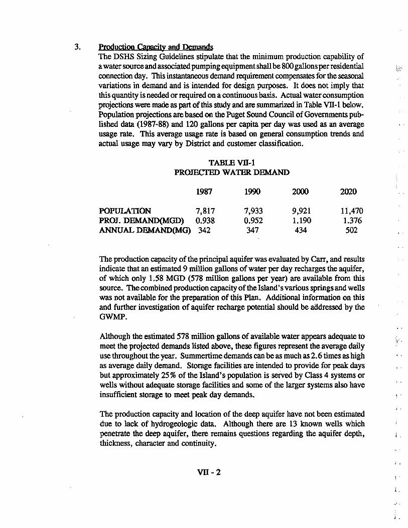
E. WATER CONSUMPTION Projected water consumption figures shown on Table 11-2 (page 11-8) are based on an assumed average usage of 120 gallons per person per day and the population projections previously discussed in this Section. Average usage is based on conservative regional consumption trends and actual consumption may be higher or lower in each District. Additional information regarding water consumption and sources of supply can be found in Part VIII of this document.
F. RELATED PLANS AND POLICIES Related plans and policies which are critical to development of this Plan are summarized in Appendix B of this document.
n -7
I -
L L , -1 _
TABLE 11-1 POPULATION, HOUSING AND EMPLOYMENT
r - - 1970 1980 1987 1990 2000 2020
TOTAL POPULATION 6,516 7,377 7,817 7,933 9,921 11,470
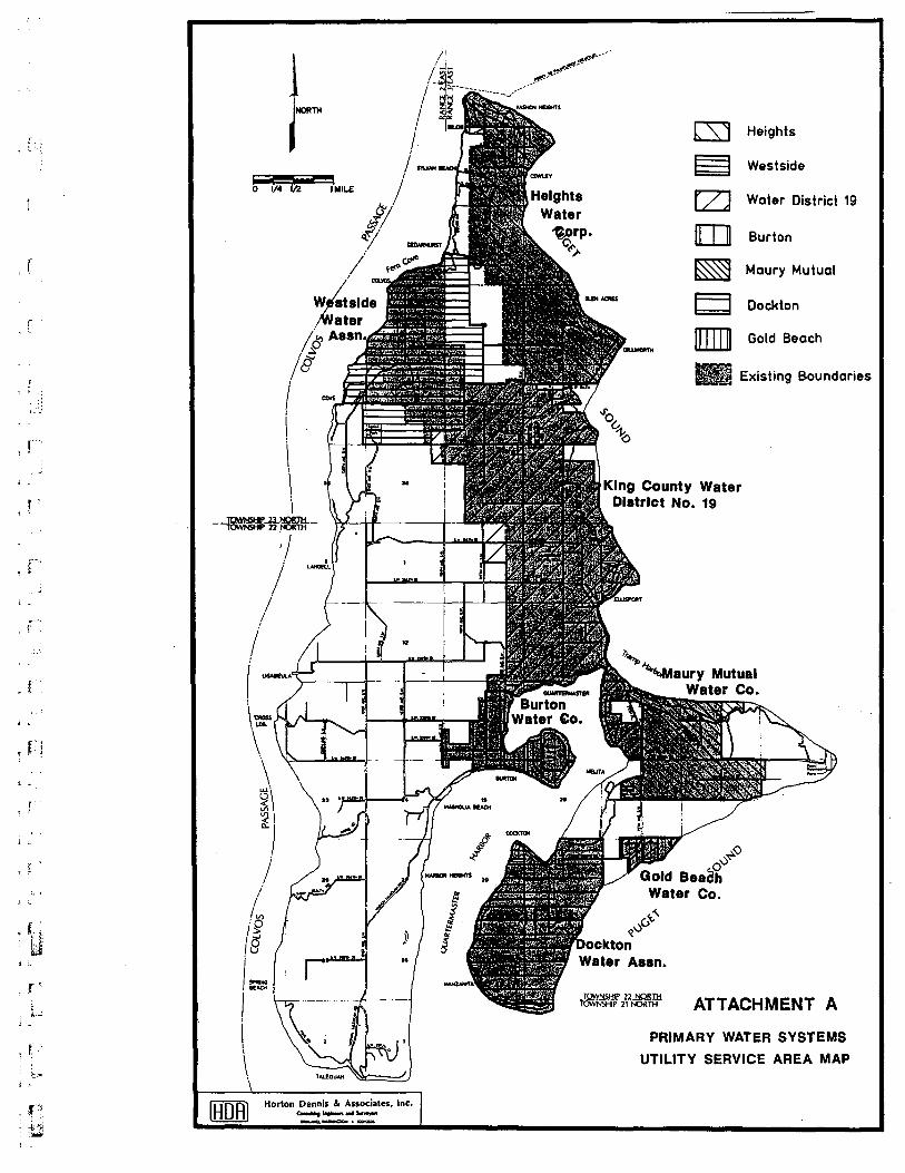
This Part of the Coordinated Water System Plan is intended to generally describe the existing facilities of the primary water systems within the study area. Information on the primary systems was obtained from existing comprehensive plans, purveyor records, interviews with purveyor personnel, and field investigations. Hydraulic profiling was accomplished by computer modelling and an associated hydraulic analysis was performed. Plate ill-I illustrates the general characteristics of primary water systems within the Vashon CWSSA.
PRIMARY WATER SYSTEMS - EXISTING FACILITIES 1. Hei&hts Water Association
a. General- The Heights Water Association is located on the northern end of Vashon. The Association was organized as a private non-profit corporation in 1931 and has since then grown from 22 connections to approximately 455 connections. Most of its services are single family homes, with the major exceptions of the Vashon Nursing Home, Washington State Ferry facilities, and Vashon Elementary School. The Heights Water Association is not currently accepting new water share applications.
b. Sources - Heights maintains a watershed area of nearly 17 acres located in the northeast quarter of the northeast quarter of Section 18, Township 23 North, Range 3 East, W.M. Two unnamed springs located at the base of a steep ravine provide a water supply of approximately 150 gpm. An additional supply of approximately 125 gpm is obtained from two wells located on higher ground west of the springs. Two 4-inch pipes originating at the springs transport water to the Heights storage and distribution system.
c. Pumping Facilities - The Heights pumping facilities include pumps located at both the springs and well sources which carry water to the main (northern) storage tanks. Additional pumps are located at the north storage facilities to supply the south tank and boost pressure in the northern distribution system. Table ill-1 details the Heights pumping system. Auxiliary gas engines are available at both the spring source pump station and the storage site pump station for backup in the event of an emergency.
ill-I
2.
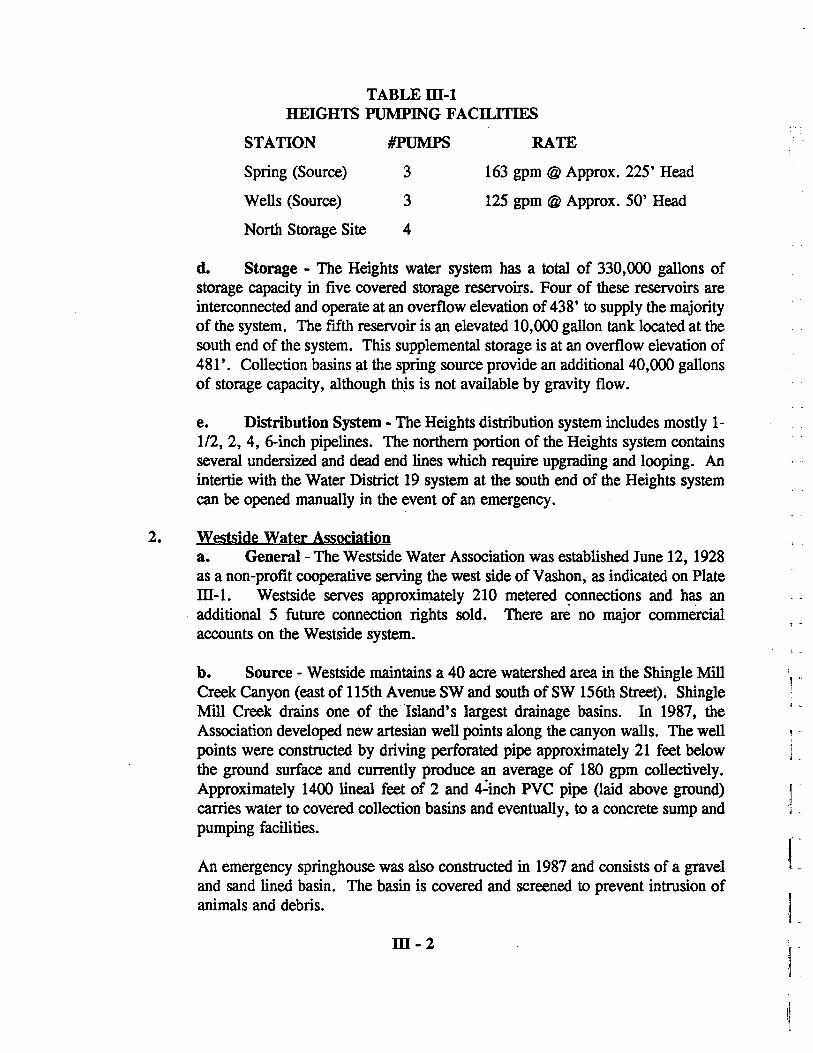
TABLEID-l HEIGHTS PUMPING FACILITIES
STATION #PUMPS RATE
Spring (Source) 3 163 gpm @ Approx. 225' Head
Wells (Source) 3 125 gpm @ Approx. 50' Head
North Storage Site 4
d. Storage - The Heights water system has a total of 330,000 gallons of storage capacity in five covered storage reservoirs. Four of these reservoirs are interconnected and operate at an overflow elevation of 438' to supply the majority of the system. The fifth reservoir is an elevated 10,000 gallon tank located at the south end of the system. This supplemental storage is at an overflow elevation of 481'. Collection basins at the spring source provide an additional 40,000 gallons of storage capacity, although this is not available by gravity flow.
e. Distribution System - The Heights distribution system includes mostly 1-112, 2, 4, 6-inch pipelines. The northern portion of the Heights system contains several undersized and dead end lines which require upgrading and looping. An intertie with the Water District 19 system at the south end of the Heights system can be opened manually in the event of an emergency.
Westside Water Association a. General- The Westside Water Association was established June 12, 1928 as a non-profit cooperative serving the west side of Vashon, as indicated on Plate ill-I. Westside serves approximately 210 metered ~nnections and has an additional 5 future connection rights sold. There are no major commercial accounts on the Westside system.
b. Source - Westside maintains a 40 acre watershed area in the Shingle Mill Creek Canyon (east of 115th Avenue SW and south of SW 156th Street). Shingle Mill Creek drains one of the' Island's largest drainage basins. In 1987, the Association developed new artesian well points along the canyon walls. The well points were constructed by driving perforated pipe approximately 21 feet below the ground surface and currently produce an average of 180 gpm collectively. Approximately 1400 lineal feet of 2 and 4~inch PVC pipe Oaid above ground) carries water to covered collection basins and eventually, to a concrete sump and pumping facilities.
An emergency springhouse was also constructed in 1987 and consists of a gravel and sand lined basin. The basin is covered and screened to prevent intrusion of animals and debris.
ID-2
, . . -
I L
L L L L
---I Co)
NORTH
- -- -o 1/4 lIZ IMILE
/ /
l ,v)
I'E 8 ,
I, SPRINO
BEACH
I \
\.
r s,W
•
Horton Dennis & Associates, Inc. CcIIN~ r......,. WId s.ne,an
......... ~.eu-..
18
S.,.I.']II.ST. • --, 4. J. U ---
--.! ITH sr.
TOWNSHIP 22 NORTH -IOWNSAip-if-NORTf.r
o <> o
HElOHT' 1. SOURCE: 283 OPM 2. STORAOE: 0.32 MO; OF 438' 3. STORAOE: 0.01 MO; OF 481'
WE8T1IDE 4. SOURCE: 1800PM 6. STORAOE: 0.163 MO; OF 440' 8. STORAOE: 0.1 MO; OF 440'
WATER DISTRICT NO. 19 7. SOURCE: 200 OPM 8. SOURCE: 1600PM 9. STORAOE: 1.826 MO; OF 494' 10. SOURCE: 2310PM 11. STORAOE: 0.1 MO; OF 306'
IURTON 12. SOURCE: 1600PM 13. STORAOE: 0.17 MO; OF 276'
MAURY MUTUAL 14. STORAOE: 0.68 MO; OF 306' 16. SOURCE: 360PM 18. STORAOE: 0.72 MO; OF 600'
4·· AND SMALLI!R L:tNES e·· AND B·· L:tNES LARDER THAN B·· L:tNES SURFACE WATi!R SOURCE WELLS/WELLPO:tNTB STORAGE FAC:tL:tT:tI!S PURVEYOR BOUNDARV
PLATE 111-1
EXISTING WATER FACILITIES OF PRIMARY SYSTEMS
, L
, , .
:; r~
, t
, t
, t
, t
j .~.
3.
c. Pumping Facilities - Water is pumped up from the source to the distribution system by the two pumps described in Table ill-2. These pumps operate intermittently with a jockey pump used to maintain pressure at the system's higher elevations along 115th Ave SW and the Cove Road.
TABLEID-2 WESTSIDE PUMPING FACILITIFS
STATION #PUMPS RATE
Canyon (Source)
Jockey
2
1
50 gpm @ Static Head
d. Storage - A total of 253,000 gallons of storage is contained in two above ground tanks in the Westside system. A 100,000 gallon tank is located at the top of Cove Road. This tank has an overflow elevation of 440' and serves the majority of the service area by gravity. The exceptions to this are along 115th Ave SW and Cove Road, where a jockey pump is required to maintain pressure when the source pumps are turned off.
A 153,000 gallon bolted steel tank was recently constructed on the site of an abandoned reservoir on SW 156th Street. The overflow elevation of this tank is also 440'.
e. Distribution System - A 4-inch PVC supply force main climbs 310 feet from the source to the 100,000 gallon storage tank. The distribution system is primarily 4-inch pipelines, although some 8, 2 and-3 inch pipes are in service. An 8-inch line connects the two storage facilities.
King County Water District No. 19 a. General- King County Water District No. 19 is the Island's only public water district and was established in 1925. With approximately 1,000 connections, it is the largest water system on the Island. The service area encompasses about six square miles in the east central portion Vashon Island and ranges from low density residential areas to the businesses and industry clustered around the Town of Vashon.
b. Sources - Plant No. 1 is a surface water source utilizing flow from Beall Creek, which extends upstream approximately 1000 feet in a southwesterly direction from the plant. Dry weather flow is maintained in the creek from seams of colvos sand which are exposed along the creek banks and up the sides of the canyon. Plant No. 1 consists of a bypass and inlet structure, mixture and sedimentation basin, raw water well and pump, rapid sand filter, a 3,300 gallon clear well, chemical feed pump, chlorinators, turbidimeter, flow meter and two finished water pumps, along with a building to house the pumps and equipment. Plant No. 1 has an average net supply of approximately 200 gallons per minute.
ID-4
Plant No.2 is the former "Island Mutual" water source and was obtained when the Island Mutual Water Corporation annexed to Water District No. 19 in 1969. This source has a developed spring in addition to surface water source facilities. The spring facilities consist of a concrete inlet structure with a metal roof and a pumphouse containing two pumps and a chlorinator. A 1,300 gallon clearwell is located below the pumps. The net supply from the spring source is approximately 50 gpm.
The surface water treatment facilities at Plant No. 2 consist of a by-pass and inlet structure, mixing chamber, sedimentation basin, raw water well and pump, rapid sand filter, 12,000 gallon clearwell, chemical feed pump, chlorinator, turbidimeter, flow meter, two finished water pumps and a pumphouse. The average net supply from Plant No.2 is 235 gpm.
Well No.1 is a 6-inch, 628 feet deep well located at the site of the storage tanks on 103rd Avenue SW. The well facilities consist of a deep well submersible pump set at a depth of 549 feet, flow meter, chlorinator, water level recorder and a small pumphouse. The average yield from Well No.1 is 150 gpm.
An additional deep well is planned for completion in 1990 and will be located adjacent to the existing Well No. 1 facility, on 103rd Avenue SW. The new well is expected to yield approximately the same amount as Well No.1 and when it is complete, Well No.1 will be used as a backup source.
c. Pumping Facilities - Water District No. 19 pumping facilities are as shown on Table III-3.
TABLEill-3 WATER DISTRICT NO. 19 PUMPING FACILITIES
STATION
Plant No.1 (Surface Supply)
Plant No.2 (Spring Supply)
Plant No.2 (Surface Supply)
Well No.1
Booster Station
#PUMPS
2
2
2
1
2
ill-5
RATE
150 gpm @ 350' Head 200 gpm @ 400' Head
55 gpm @ 280' Head (each)
150 gpm @ 350' Head 200 gpm @ 400' Head
150 gp~ @ 565' Head
100 gpm @ 225' Head 150 gpm @ 293' Head
, L
1 ..
, '
I· L
I'
T -=
I _ l
T C.
r , -
, ( ,
, , L
j "
, c
f " , ":j' - : ~
• ...i i _.
t " 1 '
, '" j ;...
Pumps at the Plant No. 1 source discharge into a 8-inch line to the Pressure Zone 1 distribution system and storage facilities. Water from Well No.1 is pumped directly into the Pressure Zone 1 storage tanks.
Plant No.2 supplies the Pressure Zone 2 system via 8 and 6-inch pipes to the Zone 2 storage tank.
A booster is required to transfer water from Zone 2 to Zone 1. The station is controlled automatically by a time clock and only one pump may run at a time.
d. Storage - The Water District 19 system operates under two pressure zones, with storage for each zone as described below.
Pressure Zone 1 storage facilities consist of 625,000 gallon and 1,000,000 gallon steel tanks with overflow elevations at 464' and 495' respectively. The 1,000,000 gallon tank and an associated booster station were constructed in 1988. Under normal operating conditions, water from Well No.1 is pumped directly into the 625,000 gallon tank, then through the booster station and into the 1,000,000 gallon tank before being discharged into the Zone 1 distribution system. Pressure Zone 1 has approximately 740 connections.
Pressure Zone 2 has a 100,000 gallon reservoir located on S.W. 216th Street near the intersection with 99th Avenue S.W. The overflow elevation of this tank is 305' and it generally supplies that portion of the District which is, generally, south of Ellisport and east of 91 st Avenue S. W. Pressure Zone 2 has approximately 260 connections.
The two pressure zones are intertied so that water from either may be transferred to the other. A pressure reducing valve (PRY) near the 100,000 gallon tank will allow water flow from Zone 1 to Zone 2 by gravity. In order to transfer water from Zone 2 to Zone 1, the booster station at the 100,000 gallon tank site must be operated. '
e. Distribution System - The Water District 19 distribution system consists of a network of pipe ranging in size from 3/4-inch to 16-inches in diameter.
Much of the pipe that is 4-inch in diameter and smaller was installed prior to 1965 and is dipped and wrapped wrought iron pipe of approximately 10 gauge. Through ULID's the District has maintained an aggressive replacement program for these pipes which have exceeded expected useful life and, in some areas, have caused maintenance and reliability problems. Since 1965, all of the new piping installed has been made of cast iron, ductile iron or asbestos cement. These materials have a much longer life expectancy and better flow characteristics.
ill-6
4. Burton Water Company a. General' - The Burton Water Company provides water service to the Burton Peninsula of Vashon Island and the surrounding areas. This service area includes single family homes, a small neighborhood center and an elementary school. The system has been in various stages of operation since the early 1900's. Present ownership and operation as a private water utility has been in effect since 1950. An estimated 350 customers currently receive water from the Burton Water Company.
b. Source - The Burton water system is supplied by a combination of wells and well points located on 5 acres of land near the intersection of SW 232nd Street and 115th Avenue SW. Supply facilities on the site include two 54-inch diameter concrete wells, 8 and 100inch diameter steel cased wells, and twelve 1.5-inch diameter well points. All of these extend to approximately 18 feet below the ground surface elevation of 250 feet. Collectively these facilities produce approximately 150 gpm in the summer months. In the late summer this drops to about 125 gpm and during the winter there is considerable runoff from the site into a natural drainage course to the Sound.
c. Storage - There are three storage tanks in the Burton system, all of which are located at the supply site. Two concrete tanks, each with a capacity of 40,000 gallons, have overflow elevations matching the ground elevation of 250 feet. In addition, there is a 90,000 gallon redwood storage tank on the site. This facility has an overflow elevation of approximately 275 feet.
d. Pumping Facilities - Four pumps are used during the peak demand period to pump from the sources into the storage facilities. Total pumping capacity is 150 gpm and is limited by the sources. During the winter months there is considerable flow from the wells and the pumps only operate occasionally.
A booster pump is located on 1 07th Avenue SW to supplement the pressure in the line going north from SW 238th Street. This facility raises the pressure along that line 40 psi.
e. Distn1)Ution System - The Burton distribution system consists of 6 and 8-inch pipe from the storage tank to the Burton peninsula. The remainder of the system is 1.5, 2, and 3-inch pipes which are dead end lines. With the exception of the 6 and 2-inch line along 107th Avenue SW, the system operates by gravity flow.
m-7
, .
,. -
, ..
j.
, -
1·'
J,
, -
1 -
.---T -
· c·
.. · ' ..
· (
_ c
- [
J.
, t '
, {
I,,;
_ t ..
, -
, ' 1
i _~
~ r·l. I:
: :J
5.
6.
MauD' Mutual Water Company a. General - Although the first pipes of the Maury Mutual Water System were installed as early 1911, the water cooperative was actually formed in 1952. The system now includes 89 single family residences and one commercial connection, and facilities as described below. No new memberships to the Maury Mutual cooperative are currently available. Although Maury Mutual is a Class 2 System by DSHS criteria, it has been included in this study because of it has more than 50 connections.
b. Source _. Approximately 35 gpm is obtained from the Maury source located north of SW 232nd St, in the PortagelPt. Robinson Drainage Basin.· The source facilities consist of a series· of eight shallow driven well points and two springs which flow by gravity into a pump and treatment house.
c. Storage and Pumping Facilities - Water is pumped from the source and lower system to a mid-system level storage facility which provides 58,000 gallons of storage with an overflow of elevation of 305'. Two upper level reservoirs have a combined capacity of 72,000 gallons and operate at an overflow elevation of 495'. The upper level reservoirs are supplied by pumping from the mid-level system.
d. Distribution System - The Maury Mutual distribution system consists primarily of 4-inch and smaller piping. Materials vary from cast iron and asbestos cement to PVC. There are few existing fire hydrants in the system, although plans indicate hydrants are proposed throughout the system. Additional lines to connect the numerous dead ends are also indicated in the Maury Mutual comprehensive plan.
Dockton Water Association a. General - The Dockton Water Association is a private non-profit organization which serves approximately 244 residential and one commercial customer on the southern portion of Maury Island. An additional 71 reserve memberships entitle landowners to service at an unspecified future date.
b. Sources - The Dockton Water System has three separate sources of supply: Park Springs, Hake Springs and the Sandy Shores Well. The Park Springs source is located directly across the Portage-Dockton Road from the Dockton King County Park. This source was originally developed in the 1880's and currently yields an average of 80-100 gpm. Water is collected from a series of shallow well points driven into spring outcroppings scattered over 10 acres of watershed. The well points run to one of two covered concrete sumps. The Dockton sump has a capacity of 25,000 gallons and overflows through a 6-inch PVC pipe into the Harborview sump. The Harborview sump has a 10,000
m-8
gallon capacity and overflows into a small stream. Turbine booster pumps are located in the Harborview sump house and are discussed later in this Section.
The net supply from the Park Springs source is generally 100 gpm. It has been estimated that as much as 50 gpm of additional water might be available if additional well point collectors are installed and existing well points are redeveloped when they exhibit reduced flow.
The Hake Springs source is located on 25 acres of system owned property abutting S. W. 268th Street. This source was developed in the 1950's and produces 30-40 gpm. Springs that reach the surface are intercepted prior to surfacing using well points and plastic pipe. The collected water is piped over the ground to a 35,000 gallon covered concrete sump.
The Sandy Shores supply is from a deep drilled well located on "94th Avenue S.W. The well has a 415 feet deep casing with a well" screen at the bottom and was drilled in 1963. The bottom of the well appears to be below sea level, however, the static water level is at 270 feet which is above sea level.
A 15 hp submersible pump is set at 335 feet in the Sandy Shores Well and is capable of pumping more than 100 gpm with no more than 10 feet drawdown. Water is pumped into an 8,000 gallon setting tank before entering the distribution system via a booster pump.
c. Pumping Facilities - The Dockton water system pumping facilities are as shown in Table i11-4.
TABLEm-4 DOCKTON PUMPING FACILITIES
STATION #PUMPS RATE
Park Springs #1 2 60 gpm Each
Park Springs #2 2 50 gpm Each
Hake Springs 2 50 gpm Each
Sandy Shores 1 100 gpm @ 134' Head
268th Street Booster 1 100 gpm @ 150' Head
Park Springs Pump Stations 1 and 2 deliver water from that source to the low level storage reservoirs. These stations operate alternately, with Station No. 1 considered as the standby. The 100 gpm pump in Station No.2 is intended as the primary supply pump from the Park Springs source.
m-9
," ,
1-
, -j -
, -I ::
f -
, i
. I
_ r
- {
, I
, l
, .
,l)
j
, [ '.
, t
j -
."
.' - --
The Hake Springs Pump Station consists of a concrete block building 10-15 feet below the water level in the pump. Piping from the sump is divided, with one line going to each of the two pumps. No flow meter is installed and normally only one pump operates at a time. The Hake Springs Pump Station delivers water from the source to the low level reservoirs via a 2-inch discharge line to a 4-inch supply line.
The Sandy Shores Pump Station pumps water from the 10,000 gallon well settling tank, through a 2-inch discharge pipe, to the upper level distribution system and reservoirs. Piping is in place for a 3 hp booster pump to be installed at this station but is not in use at this time.
The 268th Street Booster Pump permits water to be pumped from the low level reservoirs to supply the upper level reservoirs. This station operates alternately with the Sandy Shores Pump Station and an automatic valve allows Sandy Shores water to feed back from the upper level system in an emergency.
d. Storage - The Dockton system operates under two main pressure zones, with additional PRY zones in isolated areas. of low elevation. Each of the main pressure zones has storage facilities as described below .
The low level reservoirs consist of three ground level concrete tanks and are located on S.W. 268th Street, one block east of 99th Avenue S.W. The three tanks are interconnected but can be isolated for maintenance. Total combined capacity is approximately 65,000 gallons and the overflow elevation is 317 feet. The lower level tanks are supplied by the spring sources via a 6-inch line along 99th Avenue S.W. and a 4-inch line along S.W. 268th Street.
The 268th Street Booster Station feeds the upper level reservoirs and an automatic float valve allows the 317 reservoirs to receive water back from the upper system if necessary.
The upper level reservoirs were constructed in 1983 and are located on a one acre easement one quarter mile north of S.W. 280th Street and west of 99th Avenue S.W. Each of the two concrete standpipe tanks is 26 feet in diameter by 40 feet high and have a combined capacity of 316,000 gallons. The maximum water surface elevation of the upper level tanks is 486 feet and overflow is to a protected ditch and subsequent natural drainage channel.
The 486 Reservoirs are fed by the Sandy Shores Well Pump Stations and the 317 Reservoirs via the 268th Street Booster Station. Although this configuration provides protection in the event that either source fails, both pump stations feed the same 8-inch supply line to the tanks.
ID-IO
e. Distribution System - The Dockton water distribution system is almost 100 years old and has a wide variety of pipe materials. For the most part all pipes greater than 2 inches are relatively new and all piping in the upper level system was installed in 1983.
7. Gold Beach Water System a. General - The Gold Beach Water System is a privately owned and operated company serving approximately 109 homes within Section 28, Township 22 North, Range 3 East, W.M., on the southeastern shore of Maury Island.
b. Source - The Gold Beach source is two wells approximately 110 feet deep and producing approximately 250 gallons per minute.
c. Pumping Facilities and Storage - The Gold Beach System operates under two separate pressure zones, with storage provided for each. 50,000 gallons are provided to the lower zone. The upper zone storage reservoir has a capacity of approximately 35,000 gallons. Two 15 horsepower pumps intertie the two pressure zone, with one typically on standby. Pumping capacity is approximately 75 gpm.
' .. ". , "
d. Distribution System - The distribution system consists of 4 and 6-inch f •
PVC lines looped throughout the service area. Hydrants are provided throughout the Gold Beach water system.
c. OTHER WATER SYSTEMS -There are more than 100 Class 2, 3, and 4 water systems on Vashon/Maury Island. Most of these systems are limited in capacity and service area and are designed to provide domestic· flows to small clusters of residential lots in outlying areas. For the purpose of this study, these small system were identified in the service area determination process as documented in Part V of this Plan. Part V also presents a map with general locations of small and references Appendix E for a list of small systems identified.
D. HYDRAULIC ANALYSIS A computer model of the primary water systems within the Vashon CWSSA was prepared in order to analyze the capabilities of existing facilities, determine deficiencies and consider alternatives for upgrading facilities to meet the minimum design standards arrived at in this planning process (see Part IV for the Minimum ,Design Standards) and regulations of various ag~ncies. Additional information on the modelling process and system deficiencies is contained in Appendix C - Hydraulic Analysis.
m-ll
J c
1·
I.
· J
I 1:: ~~:
\
! !
r '[
[
!
-t' I t l.
, "
·n - ,
I ..
-L L ..
I t~ I -
U I -= - ~~ - ; ~
: c
1.
2.
Source and Stora&e Reguirements Minimum source and storage requirements are established by the State DSHS and are put forth in "Sizing Guidelines for Public Water Supplies". Table ill-5 illustrates these minimum requirements for each system and indicates existing conditions.
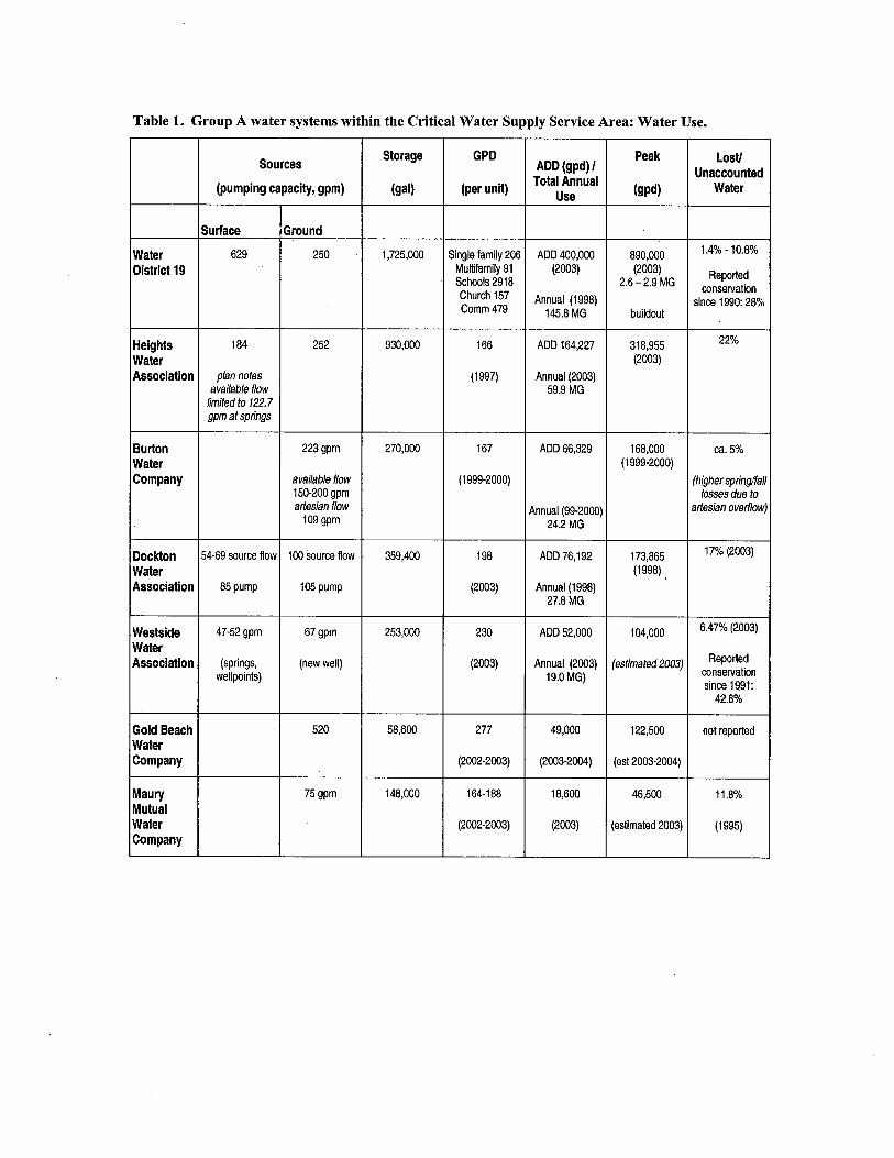
Source capacity is directly tied to the Island's groundwater supply addressed in the Regional Issues Part of this Plan (part Vll) and additional information on available supply source and future options are expected form the upcoming Vashon Groundwater Supply Management Program.
Additional storage required should be included in individual purveyors plans for system improvements. A potential mitigating measure to deficient storage is the construction of system interties which would provide additional flow and storage in the event of an emergency. Mechanical interties may also be considered in the calculation of available and required storage if water is' available on a demand basis. This is, however, dependent on each systems available source and storage capacity and the excess available for use by others. In addition, for interties to be considered in calculating available source, specific DSHS approval is required and purveyors must demonstrate actual water use and that water conservation programs are in effect.
Fire Flow Reguirements Fire flow requirements vary according to land use and construction types and are ultimately determined on an individual basis by the King County Fire Marshall at the time of building permit application based on such statutes, codes, regulations, ordinances, established standards and criteria as he shall deem pertinent. For purveyor planning purposes King County has established Fire Flow Planning Criteria, which is contained in Appendix D of this document. This criteria is to be used for appropriate and logical purveyor planning by a development classification system (in accordance with WAC 248- . 57).
To determine the available flows in select locations of the primary systems, emergency fire flow conditions were simulated by computer. The results of these simulations are shown on Plate ill-2. The results shown are initial flows only and do not reflect drawdown in storage facilities. They are intended to illustrate areas of low flow to be further examined. In addition, Plate ill-2 lists computer simulated improvements to existing facilities and the resulting flows. These simulated improvements are shown as examples of the kinds of options available to purveyors for increasing flows if necessary to meet fire flow requirements.
m-12
NUMBER OF SYSTEM CONNECT/RE'S
Heights 445
Westside 210
Water District 19 1000/1100
Burton 350
Maury Mutual 90
Dockton 245
Gold Beach 109
TABLE III-5 SOURCE/STORAGE REQUIREMENTS
SOURCE (GPO) MINIMUM STORAGE REQUIREMENTS (GAL)
REQ'D(1) AVAILABLE STANDBY (2) EQUALIZ(3) FIRE (4) TOTAL (5)
356,000 396,000 196,245 18,075 120,000 214,320
168,000 259,200 168,000 17 ,475 120,000 185,475
880,000 842,400 376,000 41,700 360,000 417,700
280,000 216,000 280,000 26,700 120,000 306,700
72,000 50,400 54,000 16,200 120,000 136,200
196,000 345,000 49,000 2,175 120,000 122,175
87,200 360,000 51,300 -0- 120,000 120,000
R.E. - Residential Equivalent based on actual water used and an assumed average use rate.
AVAILABLE STORAGE
330,000
253,000
1,725,000
170,000
130,000
381,000
85,000
(1) Required Source Calculated based on DSHS Requirement of 800 gallons per day per connection.
STORAGE DEFICIENCY
+ 115,680
+ 67,525
+1,307,300
- 136,700
- 6,200
+258,825
+ 33,700
(2) Required Standby Storage is based on DSHS Requirement of BOO gallons per residential equivalent for single source systems with more than 99 connections. Standby Storage requirement for Single Source systems with less than 100 connections (Maury Mutual) is based on DSHS requirement of 600 gallons per residential equivalent. Reduction of Standby Storage requirement for multiple source systems is calculated according to the requirements and formula presented in the DSHS "Sizing Guidelines for Public Water Supplies".
(3) Equalizing storage is based on the formula put forth in the DSHS "Sizing Guidelines for Public Water Supplies".
(4) Fire Storage is calculated based on the general requirement of 1000 gpm for a duration of 2 hours in residential areas (1000 gpm x 2 Hours = 120,000 gallons). For commercial areas a general requirement of 3,000 gpm for a duration of 2 hours was used (3000 gpm x 2 Hours = 360,000 gallons). Although some specific areas may be exempt from fire flow requirements, all purveyors are subject to fire flow storage requirements.
(5) Total Required Storage is based on Equalizing Storage plus the larger of Fire or Standby Storage.
~ -- . '·-'-I~
---I .... 0l:Io
~
l
,
t:,"":"::"~;
NORTH
- -I - - I IMILE o 1/4 ill
NODE 1100 - SIHULATED FLOW: <180 GPH WI 8" PIPE ALONG 106T8 .. 103RD: 280 GPH WI 8" PIPB FROH 103RD TO NIiID8'f 610 GPH WI 12" PIPE 106T8 .. 10~11: <1000 GPH
I! : I
/ ~~ ,~~~
/1 -~f---------~/::: ""on,
I I BILOXI NODE 1015 -
I SIHULATED FLOW: <225 CPH WI 8" PIPE PROH TANK
/ TO NODE: 100 GPH
.1 JlI 12" PIPE PROH TANK
TO NODE: 1150 GPH
/ ~I
HEIGHTS 1. . SOURCE: 283 GPM 2. STORAGE: 0.32 MG: OF 438' 3. STORAGE: 0.01 MG: OF 481'
WESTSIDE 4. SOURCE: 1"80 GPM 5. STORAOE: 0.153 MG: OF 440' e. STORAOE: 0.1 MO: OF 440'
WATER DISTRICT NO. 19 7. SOURCE: 200 OPM 8. SOURCE: 150 OPM 9. STORAOE: 1.825 MG: OF 494' 10. SOURCE: 235 OPM 11. STORAGE: 0.1 MO: OF 305'
• SYSTEMS PROPOSING EXPANSION IN NUMBER OF 8ERVICES CONNECTIONS ONLY
TOWNSHIP 22 NORTH TOWNSHIP 21'NORTf-i
.,
PLATE V-5
PROPOSED
SMALL SYSTEM
EXPANSION
lew
- f ;
l .
- l..._
'---
· -1'1
iii
r '. I;
· I: · 'L
, .; 1 : ;.
,J
I "-
"'..-,.. .
1. ./.
i .. <C!:'
PART IV MINIMUM DESIGN STANDARDS AND SPECIFICATIONS
A. INTRODUCTION
B.
This Section of the Coordinated Water System Plan (CWSP) provides a set of design standards and performance specifications which are adopted as minimum standards for all public water systems within the Vashon CWSP boundary. Subsection B details the application of the minimum design standards for water utility planning and construction. The design standards are included in Subsection C and D entitled: General Proyisions, which identify laws, regulations, and standard specifications which are applicable unless otherwise superceded; and Specific Provisions, which detail specific design guidelines adopted by the Water Utility Coordinating Committee (WUCC) of Vashon/Maury Island and King County. These standards do not supercede any other legally constituted and applicable standards that are more stringent.
Although the Minimum Design Standards established herein are generally consistent with those in effect for other Critical Water Supply Service Areas (CWSSA's) within King County, some differences do occur and standards are not interchangeable between CWSSA's. Additional requirements, reduced minimum pipe sizes and other differing standards are in response to projected land use and densities and the specific needs and concerns of the purveyors within the Vashon CWSSA.
APPLICATION OF STANDARDS 1. Utility Plans and Kine County Comprehensive Plan
Within the designated service area of a utility, new facilities shall be designed and installed to at least meet the minimum design standards adopted by the utility. The utility may adopt the minimum standards described herein, or may adopt more stringent standards. The design standards are intended to establish minimum levels of service, especially fire flow, required for different land use designations. Land use designations shall be those identified in the adopted King County Comprehensive Plan, Community Plan, Zoning Code, and any related Interlocal Agreements entered thereto.
New and expanding utilities shall meet water system planning requirements using land use designations for their service area as prescribed in the King County land use documents described above. Approved land use activities in the service area shall be designated by the King County Parks, Planning, and Resources Department -Building and Land Development Division (BALD). Such designations shall beidentified in the utility's comprehensive plan, and shall be used to establish design requirements.
Utilities are required to prepare Water System Plans in accordance with WAC 248-54-065. They are also required to prepare Water Comprehensive Plans in accordance
IV -1
with King County Code 13.24 to apply for a franchise. In most cases the Water System Plan may also be used to meet the Comprehensive Plan requirement. In all cases, the plans shall include a program of capital improvements required to .,' -provide the anticipated level of service in each land use area. When the utility is requested to provide water service, it will identify that portion of planned capital facilities as well as other installations, which are necessary to provide the service requested. As growth occurs, the full level of water service will eventually be pro-vided throughout the service area of the utility in a planned, phased program which meets County requirements and minimizes overall cost to the customers.
"New" facilities are defined as those which extend service into areas not previously served, or which upgrade systems to permit them to serve more customers than the number of service connections authorized by the system's County approved Comprehensive Plan at the time that these standards were adopted. Modification of existing facilities to meet these standards is not required except for serving new areas or as necessary to meet applicable health standards. All water purveyors shall, however, consider achievement of these standards as a long-term goal and incorporate their provisions into existing systems at the time of their repair, but only to an extent which is within their fiscal capabilities.
The King County Comprehensive Plan identifies a group of major land use designations and subcategories which help define the growth and development pattern in King County. The Plan distinguishes between Urban Areas, Urban Activity Centers, Transitional Areas, Open Space, Rural Areas, Rural Activity Centers, and Resource Lands. The Plan places emphasis for growth in areas where public services and facilities can be provided in an orderly and economic manner.
Vashon/Maury Island has been identified as a Rural Area with one Rural Activity Center. A Rural Area is defined as an area "to remain rural in land uses, where rural public facility and service standards will apply." Rural Activity Centers are identified as "Concentrations of employment, shopping and higher density housing in Rural Areas, including incorporated and unincorporated rural towns" (King County Comprehensive Plan; 1985). Rural Activity Centers are community centers with a combination of residential, commercial and industrial development but with limited rural public facilities. Open areas are existing public park and recreation areas and natural features protected by environmental regulations. Resource Areas are either forest or agriculture production districts. Maps showing the location of these concept areas are available at the BALD.
Because of the unique rural character of Vashon Island in relation to other areas of King County, a "Vashon Island Rural" classification is established for determining level of water service. This classification applies to areas outside of the Rural Activity Center, (Vashon) where average densities are not expected to exceed one single family residence per acre. This classification is based on land use documents which put forth policies directed at preserving the rural qualities of Vashon Island.
IV - 2
i _
L:
2.
~ - \
~ ;0 . ~.
The lack of development potential in "Vashon Island Rural" areas is due to existing zoning, unsuitable soil types for on-site sewage disposal systems, steep slopes which prohibit development, and the need to protect the Island's limited groundwater supply.
Planning for public water system improvements, and the application of the minimum design standards discussed in this document, shall be in accordance with the major land use designation areas discussed in the King County Comprehensive Plan.
The various utilities may adopt higher levels of standards provided that such levels are not inconsistent with the Comprehensive Plan and the provision of domestic and fire protection service required to support those land use policies.
Phased Deyelqpment of Water Systems In situations where water service is requested of a utility that does not currently have adequate facilities for the ultimate growth potential, the utility and the developer may reach an agreement to provide the desired service through a schedule of improvements over a reasonable period of time. This phased development plan must be approved by the SeattlelKing County Health Department (SKCHD), DSHS, and the King County Fire Marshall, UTRC and BALD for service in unincorporated areas. It must be consistent with the proposed comprehensive plan of the utility.
A phased development plan shall be applicable when the following conditions are met:
(a) The written development plan sha1l be submitted and approved prior to approval of subdivisions and plats proposing phased utility development. The plan must identify the water service level to be provided initially, projected growth expected in the new service area, additional capital facilities required, a schedule of construction, and eventual level of service to be provided. The phased construction schedule provides the utility and developer the option to gradually complete capital facilities for a large development while at all times being in compliance with applicable regulations.
(b) If the proposed new service is within the utility's designated service area, the utility shall have an approved comprehensive plan. If the new service is proposed outside of a designated service area, or if it is to be operated by a Satellite System Management Agency (SSMA), the utility or SSMA shall submit an amendment to its comprehensive plan which addresses the needs of the new service area.
IV - 3
(c) All water mains, booster stations, reservoirs, and other permanent facilities installed during the phased development period shall be in accordance with the eventual system design identified in the utility's plan.
-If land use changes occur, or if growth does not occur as anticipated, the utility may submit a revised plan to DSHS, SKCHD, the UTRC and BALD which identifies the reasons for relief from the original plan and a fixed date for compliance to be achieved.
3. DesiO Standards Water utility planning and facility design in rural areas must seek a minimum level of service which is consistent with appropriate land use documents. In many areas, a density of development which justifies large scale facilities may not be likely.
The minimum design requirements in rural areas are such that a greater burden of water supply planning is site-specific. Public water utilities serving low density rural residential areas are expected to plan only for domestic water service and the applicable fire protection standard as presented in Paragraph D. 12. - Fire Flow Requirements. An individual or developer who proposes other land uses in these areas is responsible for identifying additional water needs for the proposed development, obtaining necessary approvals, and shall then enter into an agreement with a utility or SSMA if some or all of those needs ~ met by the public water system.
4. Conditions to Exceed Minimum Desim Standards In recognition of circumstances that occasionally require increased levels of service, water systems will be allowed to exceed the minimum design standards in the following situations:
(a) When it is necessary to adequately serve rural activity centers, rural neighbor-hood centers; .
(b) When it is necessary to provide transmission between a water source or storage facility to a distribution system of a utility and/or a Satellite System;
(c)
(d)
(e)
When it is necessary to address existing quantity or quality problems within any area currently authorized to receive water service;
When it is necessary to meet health and safety guidelines of the County's applicable fire protection ordinances or another minimum design standard;
The utility may adopt higher levels of standards provided that such levels are consistent with the Comprehensive Plan and the provision of domestic and fire protection service required to support those land use policies.
(t) Other special cases requested by the water purveyor and approved by King County.
IV - 4
1 -
L
t _
i _
! -
l _
c.
r.
,I .
t .
, t
J::
J ;0
\;
j
--
GENERAL PROVISIONS 1. Source Development and Protection
2.
3.
4.
New sources must be designed to meet the Department of Ecology (DOE), the Department of Social and Health Services (DSHS), and the SKCHD regulations and design guidelines. These i~clude: WAC 173-160, Minimum Standards for Construction and Maintenance of Water Wells, as administered by DOE; WAC 248-54, "Rules and Regulations of the State Board of Health Regarding Public Water System", as administered· by DSHS; and, "King County Public Water System Rules and Regulations" (or "Title 12 of the King County Board of Health") as administered by the SKCHD.
All test and production wells must be drilled in accordance with detailed drilling and testing specifications, which have either been prepared by, or received prior approval of the utility. These specifications may not be less stringent than those identified in the references cited in the above paragraph.
Source protection measures are to be maintained in accordance with the requirements of the Department of Ecology, DSHS and King County Health Department and as recommended by the Vashon Groundwater Management Study. A minimum protection radius of 100 feet is to be maintained around all wells and a 200 feet protection radius is required for springs. A larger sanitary control radius may be required if geological and hydrological data supports such a decision. The purveyor is responsible for obtaining adequate protection.
Any selection of a new source of water supply must be reviewed and approved by DSHS and SKCHD prior to development and/or withdrawal of water for potable use.
Water Riehts Water rights, if applicable, must be obtained in accordance with Ecology regulations and procedures. Copies of water rights documents, correspondence, and other records are to be maintained on file with the purveyor and in the name of the purveyor with DOE.
Water Ouality Water quality must be proven to conform with DSHS criteria specified in WAC 248-54 and/or any additional requirements contained in King County Board Public Water System Rules and Regulations, SKCHD. Each utility may reserve the right to reject any source whose raw water quality does not meet these criteria.
General Desip Specifications Except as otherwise superceded in these standards, water system design, installation, modification, and operation, is subject to the "Rules and Regulations of the State
IV - 5
Board of Health Regarding Public Water Systems," WAC 248-54, as administered by DSHS andlor "King County Public Water System Rules and Regulations," as administered by SKCHD. J.,
5. General Material Specifications and Construction Standards
6.
Except as provided in approved plans and specifications, or in these minimum standards, selection of materials and construction of water system facilities in King County shall conform to the following:
(a) Applicable standards of the participating utilities that meet or exceed these requirements.
(b) Applicable County ordinance;
(c) "Standard Specifications for Road, Bridge, and Municipal Construction", Washington State Department of Transportation! American Public Works Association, (DOTI APWA) Latest Edition;
(d) Standards of the American Water Works Association (A WW A);
(e) Recommended Standards for Water Works, Great Lakes - Upper Mississippi River Board of Sanitary Engineers (10 State Standards); and
(t) King County Code 17.08, Fire Hydrants and Water Mains.
Along County road rights-of-way in unincorporated areas, a County right-of-way permit must be applied and approved by the County prior to construction. All requirements of the permit shall become part of these speCifications.
All new facilities shall be inspected by a qualified inspector under the directiO~~ the purveyor. If the new improvements require certification by DSHS, thei the inspection must also be under the direction of a professional engineer (Except'U provided for in WAC 248-54-035). Detailed as-built drawing shall be prepared and maintained on file for all new system improvements, including system improvements and upgrades.
Hydrostatic Pressure Test A hydrostatic pressure leakage test will be conducted on all newly constructed water mains, fire lines, :fire hydrant leads and stubouts in accordance with DOTI APWA Section 7-11.3(11) and A WW A C-600 specifications, unless specified otherwise by the designated utility and approved by DSHS.
IV - 6
; -
F.
, -
, '.
1. _
f " : ~ .
; '.
f " , ! ,J
: ','
J ~
· ( :
t . , .
j •
· " "
· " . i _
f:l c '1)
W
7.
8.
Disinfection and BacterioloKical Testine All pipe, reservoirs, and appurtenances shall be flushed and disinfected in accordance with the standards of the DSHS, A WW A C601 and D 105, and DOTI APW A Section 7-11.3(12), unless specified otherwise by the designated utility.
Power Consideration Reduction in the amount of standby storage required because of multiple sources is permissible only if adequate standby power is available or the power supply is shown to be reliable by meeting hmh of the following criteria:
-Freguency: Outages shall average three or less per year based on data for the three previous years with no more than six outages in a single year. Power must be lost for a minimum of 30 minutes to qualify as an "outage. "
-Duration: Outage duration shall average less than four hours based on data for the three previous years. Not more than one outage during the three previous year period shall have exceeded eight hours.
Where standby power is provided, all source and booster pumping facilities required for primary supply in an emergency should be equipped with auxiliary power or with power pigtail outlets and at least manual transfer switching devices. If the pigtail outlet power approach is taken, the purveyor must either own and maintain a portable power unit or have an acceptable rental agreement assuring the use of a unit when needed.
9. Utility Interties Specific locations, size and alignment of major water lines should consider emergency interties with adjacent water utilities. '
10. Flow Measurement Unless otherwise directed by the designated utility, all service lines shall be installed so that each residential, commercial, and industrial structure will have a separate metered service for domestic water received from the designated utility.
If approved by the designated utility, domestic water consumption may be measured . by a master meter for service to a complex, under single ownership, and where water utility line subdivision is impractical. Service lines providing fire flow may be required by the utility to be equipped with fire detection check.
Wherever possible, new groundwater wells shall be provided with access for measurement devices. All new sources shall be provided with flow measurement in accordance with DSHS policy.
IV -7
11. Cross Connection Control Where the possibility of contamination of the supply exists, water services shall be equipped with appropriate cross connection control devices in accordance with WAC 248-54. Utilities are required to adopt and maintain a cross-connection _ control program in accordance with State requirements. This is especially important where systems are intertied to prevent contamination transfer.
D. SPECIFIC PROVISIONS 1. Pressure Requirement
Water systems shall be designed to maintain a minimum residual pressure of 30 psi in water mains under maximum demand flow conditions, excluding fire demand. For water systems requiring fire flow capability, the design shall be adequate to maintain, under fire flow conditions, positive pressure throughout the system and a 20 psi residual pressure in mains supplying fire hydrants in use (c.f. WAC 248-54). Maximum pressure of water used by domestic customers shall not exceed 85 psi (measured at the purveyor's side of meter). Individual PRY's are required for customers in PRY zones to protect against damage in the event of main line PRY failure.
2. Pipe Sizin& and Materials Water main size shall be adequate to deliver required fire flow as defined in paragraph D. 12. - Fire Flow Requirements and to maintain pressure requirement defined above. All water mains shall meet applicable engineering and health standards adapted by the State of Washington or the water purveyor, including WAC Chapters 248-54 and 248-57.
8 inches
6 inches
-4 inches
Less than 4 inches
Minimum Pipe Sizes Required
IV - 8
All dead end mains subject to King County Code 17.08
All circulating mains subject to King County Code 17.08 and hydrant leads less than 50 feet.
Mains exempt from King County Code 17.08 and areas where average density does not exceed two single-family homes on two contiguous acres in any direction.
Short extensions off the basic system. Must be hydraulically justified.
, -
,- -
, . , -
l _
· r
· I
, (
r"
· !
· J 3.
, ! : , '
U
f .
j.
, I'
[1:
All water mains subject to King County Code 17.08, which serve fire hydrants, shall be a minimum of 8 inches of nominal diameter for dead end mains and 6 inches nominal diameter for circulating mains. Hydrant leads less than 50 feet in length may be 6 inches in diameter. In a dead-end cul-de-sac, mains sized for only domestic flow may be installed from the last hydrant to remaining residences.
In areas exempted from waterflow and hydrant requirements by K.C.C. 17.08 the minimum pipe size required is 4 inches in diameter. Exemptions under this code generally include:
Subdivisions where no lot is less than 35,000 square feet;
Building permits for detached single family and mobile homes provided the lot size is greater than 35,000 square feet;
Building permits for structures which do not exceed 2,500 square feet floor area and which are served by a class 4 water system; and,
Building permits and mobile home permits for detached single family dwellings and accessory structures in subdivisions which approved preliminary approval prior to July 5, 1977 and short subdivisions which received preliminary approval prior to January 24, 1982 and which do not exceed 2,500 square feet in size.
Where average densities exceed two single family homes on two contiguous acres, however, fire flows are required by DSHS and pipes must be sized accordingly. For short extensions off the basic system such as cul-de-sacs or outlying services, pipe sizes less than 4 inches in diameter may be used if hydraulically justified· in accordance with DSHS criteria.
All pipe material for new water system shall be constructed with "lead-free" materials. The lead content for joint compound materials (solder and flux) used for pipe installation shall be less than 0.2 percent to be considered "lead-free". The lead content for all installed pipe shall be less than 8 percent in order to be considered "lead-free".
Isolation Valvin& Valving shall be installed in a configuration which permits isolation of lines. A valve is not generally required for short block lines of less than 100 feet. Valves should be installed at intersections with normal maximum spacing at 500 feet in commercial, industrial, and multiple-family districts, 800 feet in residential districts, and 114 mile in transmission mains. Where systems serve widely scattered customers and where future development is not expected, valve spacing shall not exceed one mile. ("to State Stds." - 1987).
IV - 9
4. Air and Vacuum-Relief Valves In order to minimize problems associated with air entrainment, the purveyor shall provide for installation of air or combined air-vacuum relief valves at appropriate points of high elevation in the system. All piping shall be sloped to permit escape of any .entrained air. Combination of air release/air vacuum valves shall have a maximum operating pressure of 300 psi.
S. Blow-Off Assembly A blow-off assembly shall be installed on all dead end runs and at designated points of low elevation within the distribution .system. Fire hydrants may be used as blow-offs on 6-inch and larger mains. The blow-off assembly shall be installed in the utility right-of-way except where an access and construction easement is provided for in writing to the water utility. In no case shall the location be such that there is a possibility of back-siphonage into the distribution system.
The following table of minimum blow-off assembly sizes shall be utilized in accordance with the following distribution main sizes:
Distribution Main Size
less than 12 inch
greater than 12-inch
Minimum Blow-Off Assembly Size
Required
2-inch
determined upon review on a case-by-case basis
6. Storaee Storage requirements are based upon three components:-
(a) Equalizing Storage, required to supplement production from water sources during high demand periods,
(b) Standby Storage, required as backup supply in case the largest source is out of service, and
(c) Fire Storage, required in order to deliver the level of fire flow service identified in the utility's approved plan (see "Fire Flow Requirements" below) for the required duration.
As a minimum, sizing of storage facilities shall be adequate to provide for equalizing storage, plus the larger of standby or fire storage requirements. Equalizing and standby storage volume shall be determined using "Sizing Guidelines" for Public Water Supplies" ,DSHS. Minimum fire storage volumes shall be determined using
IV -10
1 -
, .
r -
, r
, ) .
- ( -
, J -
1_
, 'y': . -:. - ~"
r.' :' . -, L
7.
the fire flow and duration requirements of King County, or the minimum design standards prescribed herein. Siting of storage facilities should consider locations which provide gravity flow. In some cases, the system hydraulics may require additional storage.
General Facility Placement Utilities within the County right-of-way on new roads or in roadways where existing topography, utilities, or storm drains are not in conflict, shall be located as indicated below. Where existing utilities or storm drains are in place, new utilities shall conform to these standards as nearly as practicable and yet be compatible with the existing installations. Where practical, there shall be at least 3 feet horizontal separation from other utilities. In addition, utilities are required to adhere to the following criteria.
(a)
(b)
Shoulder-and-Ditch Section (1) If practical: Outside of Ditch Line (2) Otherwise: In shoulder three feet from edge of travelled lane.
Curb and Gutter Section (1) Preferable: 1.5 feet back of curb, or at a distance which will clear
root masses of street trees if these are present or anticipated.
(2) Otherwise: In the street as close to the curb as practical without con-flicting with storm drain placement. Mains and service connections
. to all lots shall be completed prior to placement of surface materials.
(c) Designated Side of Centerline: North and East sides of the street are preferable.
(d) Individual Water Service Lines.
(1)
(2)
Shall use road right-of-way only as necessary to make side connections.
Anyone connection can not extend more than 60 feet along or through the right-of-way, or the minimum width of the existing right-of-way.
In addition, all piping, pumping, source, storage and other facilities shall be located on public right-of-way or dedicated utility easements. Utility easements must be a minimum of 15 feet in width, and piping shall be installed no closer than 5 feet from the easement's edge. Exceptions to this minimum easement may be approved by the operating water utility .
Public agencies and utilities shall obtain easements for unrestricted access (as dictated by such easements) to all public water system lines and appurtenances and public fire hydrants that are maintained by public agencies or utilities.
IV-ll
8. Pipe Cover The depth of trenching, installation of pipe, and backfill shall be such as to give a minimum cover of 18 inches over service pipes and 30 inches over the top of all other pipes from finished grade. Backfilling up to 12 inches over the top of the pipe shall be evenly and carefully placed. Remaining depth of trench to be filled in accordance with applicable construction standards identified in the General Provisions. Within the Vashon/Maury Island CWSSA, compaction requirements shall adhere to the King County Administrative Rule on "Utility Trench Compaction" , dated December 12, 1983 or as amended. Materials capable of damaging the pipe or its coating shall be removed from the backfill material.
9. Separation Distances Transmission and distribution water piping shall be laid at least 10 feet horizontally from any existing or proposed onsite water disposal piping, drain field, and/or wastewater gravity or force mains. The distance shall be measured edge to edge. In cases where it is not practical to maintain a ten foot separation, the health agency with review responsibility may allow deviation on a case-by-case basis, if supported by data from the design engineer.
Closer spacing may be permissible where the sewer piping is constructed to water main standards and has been pressure tested to insure water tightness prior to backfilling.
As allowed in the D.O.E. "Criteria for Sewer Works Design" manual, 18 inches of vertical separation shall be maintained between the top of a sewer main and the bottom of a water line. Where possible, the water line shall pass over the sewer line. Exceptions to this shall meet D.O.E. requirements.
10. Fire Hydrants Fire hydrants shall comply with the minimum design criteria set forth in King County Code 17.08.
11. Fire Hydrant LocationlInstallation Criteria Fire hydrants shall comply with the minimum location/installation criteria set forth in the King County Code 17.08. In all circumstances, these standards shall not be less stringent than the placement requirements prescribed by WAC 248-57-900.
12. Fire Flow Reguirements New facilities installed by a water purveyor shall be designed to provide a level of service consistent with established land use designations. The actual fire flow to be provided at a proposed development will be determined by the King County Fire Marshall based on such statutes, codes regulations, ordinances, established standards and criteria as he shall deem pertinent.
IV -12
! -1
J l ~
, ';.
, .-
.. '
, . .::
:]. T. O't:' . ~:.~~
!;; . .,j"
11~ 1 ° I
'I L _L
No minimum fire flow is required for detached single family homes which are exempt from King County Code 17.08 and are on lots which exceed one acre in size or in areas where the average density is not greater than two homes on two contiguous acres in any direction. This is based on exemptions listed in King County Code 17.08.030 (see paragraph D. 2. - Pipe Sizing and Materials) and State requirements listed in WAC 248-57-400. Where exemptions to fire flow are granted, the fire marshal has the authority to require other protective measures such as increased setbacks, fire retardant materials, drafting ponds, etc. In addition covenants running with the land which acknowledge absence of fire flow may be required.
A minimum fire flow of500 gpm is required for detached single family homes which are exempt from water flow and hydrant requirements under K.C.C. 17.08 but do not meet the average density criteria for no fire flow listed above. This generally applies to lots between 35,000 and 43,560 square feet and is based in state requirements put forth in WAC 248-57-500, Minimum Standards for Fire Flow.
The minimum fire flow for detached single family homes subject to the requirements ofK.C.C. 17.08 (Lot sizes less than 35,000 square feet) shall be 1,000 gpm. The water system providing water for fire flow requirements shall be capable of providing such flow for the following duration of time:
No. of Dwellings
2-9
10-50
51-75
Over -75
Duration of Time
112 hour
1 hour
1-112 hour
2 hours
For all normal uses of the system, the water system providing fire flow shall be capable of providing such flow for a duration of 2 hours. King County Fire Flow Standards are more stringent than those prescribed by WAC 248-57-500 and are not tied directly to land use designations.
Fire flow requirements for single family homes greater than 2,500 square feet and structures other than single family homes shall be determined on an individual basis by the King County Fire Marshall.
Alternative frre protection measures can be in lieu of requirements or to supplement available flows. Such variances are subject to the criteria and approval of the King County Fire Marshall.
IV -13
13. Maintenance of FIre Protection Facilities A written operational agreement which identifies responsibilities for maintenance and testing of fire protection facilities should be negotiated between the fire department or district and the water utility.
E. STANDARDS REVIEW SUBCOMMI'ITEE The Standards Review Subcommittee shall be established by the WUCC and shall convene at least annually to review these standards and their implementation. The subcommittee shall include representatives from the King County Fire Marshal's office and/or the appropriate Fire Protection District.
Recommendations of the Standards Review Subcommittee shall be submitted to the WUCC and, if revisions are approved, they shall be forwarded to the County Council for review within 60 days and/or adoption.
F. SEVERABILITY If any provision of these standards or their application is found to be invalid, the remainder of the standards and their implementation are not affected.
IV -14
l _
1-:
~ -
1,
,1 -
1 '
,-.~ L
1 -
i,
L_
~ ~',-..
'~,
; -1
:J
-f i
1 -[:
'-I
i "
, -L',' i :.:
" -[: " , '
,~
L •
,fl -=1j
,A.
B.
INTRODUCTION
PART V SERVICE AREAS
The Public Water System Coordination Act requires that the public water systems within a Critical Water Supply Service Area (CWSSA) determine service area boundaries by written agreement. Criteria for determining boundaries includes topography, readiness and ability to provide water, local franchise areas, legal water system boundaries, city linUts, future population, land use projections, and sewer service areas. Service areas must also be consistent with adopted land use plans, ordinances and growth policies of cities, towns, and counties located within the future service area boundaries.
By establishing an exclusive service area under the provisions of the Coordination Act, a utility accepts responsibility for planning and implementing water system development and for proper utility management within that service area. In turn, after service areas are determined the State and County governments are obliged to recognize an identified utility as the responsible agency for providing water service within a designated area. The service areas agreed to in this Plan do not, however, imply that a utility is authorized to provide service in any area which is not addressed in that utility's approved water system plan. There is no implication or presumption that utilities will expand into any given area until a need for such expansion has been demonstrated in accordance with the Utility Service Review Procedures put forth in Part VI of this Plan and such expansion is approved by DSHS.
From King County's perspective, designated service areas will mean that a specific utility has accepted responsibility for development of cost effective and efficient service to accommodate the future growth that" these areas will experience. Growth management objectives established by the King County Comprehensive Plan and Vashon Community Plan must be accounted for in each utility's approved plan and actual improvements.
For areas which remain "unclaimed" as existing utility service areas, the Utility Service Review Procedures and Satellite Management Guidelines presented in Part VI of this document shall apply.
ESTABLISHING SERVICE AREAS All of the existing public water systems within the Critical Water Supply Service Area were asked to participate in the development of service areas. Larger water systems were included by association with the WUCC, while other Class 2, 3 and 4 systems were identified by the Seattle King County Health Department and notified by letter of the service area determination process. All utilities were asked to indicate the area they currently serve and the area they intend to serve within the next ten years.
V-I
1.
2.
Primary Water Systems Primary water systems are defined as those with more than 50 existing service connections which, in accordance with WAC 248-56-500, were represented on the Water Utility Coordinating Committee (WUCC). The existing service areas of the primary water systems are indicated on Plate V-I.
Plate V-2 shows the possible expansion of the existing water utilities which was considered by the WUCC. These areas were suggested to purveyors as logical service areas based on land use designations, topography and engineering analysis. These expanded service areas were, for the most part, rejected by the individual purveyors. Purveyors did indicate that they will consider expansion of service as requests for water service are made.
After further consideration, the WUCC arrived at the recommended service areas shown on Plate V-3. These areas have been identified as the areas each of the primary purveyors has determined it can logically serve within a ten year planning time frame. Existing private wells and small water systems are not affected by these recommended service areas.
Other Public Water Systems The Seattle-King County Department of Health identified 104 small public water systems within the CWSSA. The generaIlocations of these systems are indicated on Plate V -4. Each of the small water systems was contacted and asked to define any plans for expansion of their service area. Of the 104 systems contacted, only eleven indicated an interest in expanding their existing service area. Subsequent questionnaires were sent to these eleven systems to determine the boundaries of their proposed expanded service areas. The below listed four systems responded to the secOnd questionnaire:
- Island Spring Water Company - Mountain View Community Club - Forever Yours Water System - Marine View Estates Mutual Water System
The results of the second questionnaire are shown on Plate V-5. As indicated, only the Island Spring Water. System has proposed an increase in the actual size of its service area. The remaining three systems are considering an increase only in the number of water service connections within their existing service areas. Additional information on the proposed expansion of the Island Spring service area is contained Paragraph 3 - Unresolved Service Area Conflict of this Section.
V-2
I :
! -
f -
! -
, .
, ' , .
[ .
C.
. J
D.
, [-
,f'
:~ <
I "
...JJ
3. Unresolved Service Area Conflict As indicated on Plate V-6, there is an unresolved service area conflict on the west side of the Island. This area is considered a potential service area by both the Westside Water Association and the Island Spring Water Company. The Westside Water Association has expressed the desire to expand its service area to the west shore of the Island. Island Spring is an approved Class 4 water system which, through the Coordinating Water System planning process has expressed an interest in serving the area so indicated on Plate V -6. The northern portion of the proposed Island Spring service area overlaps the proposed Westside service area, creating a conflict which must be resolved prior to either party signing the Service Area Agreement described below. Proposed service to the area applies to new services only and existing water service by private well or by other small utilities within the conflict area are not affected by either utility's proposal to provide service to the area.
If the two purveyors can not resolve this conflict, it will be referred to DSHS for resolution pursuant to RCW 70.116.
SERVICE AREA AGREEMENT Appendix A contains the Interlocal Service Area Agreement which legally formalizes the service areas arrived at through this planning process. Additional interlocal agreements which may be recommended in other parts of this document, such as intertie agreements, are to be separate documents facilitated by the individual utilities involved .
SERVICE AREA CHANGES Future changes to service areas, like other changes to the CWSP, may require the approval of the WUCC and amendments to the Plan and Interlocal S'ervice Area Agreement. Procedures for modifications to the Plan are and the future authority of the WUCC are outlined in Part IX of this document.
The service areas designated in this Plan will take precedence over other utility's application for expansion at a future date, unless both parties agree to an exchange of service areas which is accordance with applicable rules, regulations and policies. Further, utilities may pursue expansion into areas which are not already part of another utilities service area.
v - 3
-....J
" '1
j~
'1 , ! 'u
.f. ~!
ItJ
"J'" " -, '
. f .
r , !
, T ~
, [
, C
_ r
, t
, (
1 l
j •
j -
[ ,
'j J :..
, , .. i ;...-
I ~
... 1
A.
PART VI REVIEW PROCEDURES AND SATELLITE MANAGEMENT
UTILITY SERVICE REVIEW PROCEDURES 1. Introduction
This Coordinated Water System Plan (CWSP) establishes a set of procedures, water resource policies, and growth objectives for VashonlMaury Island water utilities. The procedures are to guide local officials, citizens, developers and state and federal regulatory agencies in identifying the necessary facilities for providing adequate water service.
Provisions of the Public Water System Coordination Act require that no new public water system be established within the Vashon Critical Water Supply Service Area unless it is determined that existing purveyors are unable to provide the service in a timely and reasonable manner. This section presents the administrative procedures for reviewing development proposals and associated requests for water service in order to identify existing purveyors who are willing and able to extend this new water service. The procedures are based upon regulations (Chapter 248-56 WAC) of the Washington Department of Social and Health Services (DSHS) and King County procedures necessary to comply with the Coordination Act. Implementation of these procedures may require legislative support by the King County Council and/or the State of Washington.
A general philosophy of the CWSP is that water service should not dictate growth patterns. On the contrary, land use policies should establish growth trends within the water utility service area to permit the water utility management program to be responsive to, and provide service commensurate with applicable land use policies.
Water System Plans must address the water system facilities required to accommodate growth. This growth is projected to occur within each utilities service area, based upon the King County Comprehensive Plan and the Vashon Community Plan. Capital improvements are planned and constructed to conform with the anticipated service requirements associated with those Plans.
In addition, if an applicant for water service is proposing a land use change, such a change could incur a significant financial burden on the provider of water service. Because water utilities must, of necessity, develop their systems to conform with applicable land use plans, any major change in land use may require substantial system improvements to serve the proposed development. Therefore, special review procedures will apply to applications which propose a land use change.
VI -1
Utility Service Review Procedures (Cont'd)
2. Utility Service Review Procedures The Utility Service Review Procedure (USRP) identifies the utility in whose designated service area a proposed development lies. It then describes the available prioritized water service options. It also describes options for water service to proposed developments lying outside of designated service areas.
Within the USRP process, reference to "service area(s)" means the specific geographical area described in the written agreement required by RCW 90.116.070(1) and WAC 24S-56-730(1). The service area boundary will be identified by a map attached to the agreement. The boundary will include the area within which direct service or retail service connection to customers is currently available (existing service area) and the area for which water service is planned (future service area) by the designated utility.
The USRP applies to all development proposals and associated requests for water service requiring approval by the County. These include: New plat or subdivision development; Short plats; Land use permits, changes or approvals; Issuance of residential and commercial building permits; Creation of new water systems; Resolution of health emergencies arising out of existing public water systems; Source site inspections; and other activities. At the time an application is submitted for permits or approvals, or upon request, the King County Building and Land Development Division (BALD) will initiate and finalize the review procedure. They will coordinate the review with the Seattle King County Health Department (SKCHD) prior to the issuance of any approvals. A flow chart of the steps to be followed in the USRP is provided in Exhibit VI-1 on page VI-S.
The USRP procedures are intended to identify an existing water purveyor willing and able to provide water supply facilities and to include the new development within its service area. In effect, the result of the USRP is to assign the proposed new development or land use to the service area of a designated water utility. In the event a designated utility is unable or unwilling to provide service, the prioritized referral process referenced in the subsequent paragraphs should be followed.
Pursuant to State law, water service requests occurring within a contested service area of a utility that has not completed either its individual Water System Plan (WSP) or its Service Area Agreement may be denied until these issues are resolved.
VI- 2
, "
, f ..
, .
f ;,
1 •
! . .
! .
r ,1
, I .
· J
I .
· f .
, 1
I::'
· I '
· ~.
'-. , -
Utility Service Review Procedures (Cont'd)
a. Development Proposals or Water Service ReQuests in Conformance with Awlicable Land Use PlanS When development and associated water service applications conform with land use plans and zoning ordinances, the USRP will generally follow the sequential steps outlined in Exhibit VI-I. This procedure is described by the following:
1)
2)
The King County Parks, Planning and Resources Department, BALD, will coordinate review of all development proposals within the unincorporated area of King County. BALD will be responsible for ensuring conformance with the applicable comprehensive land use plans, Community Plan, Zoning Code, service area agreements, and utilities' Water System Plans. Upon determination of appropriate land use designation, BALD will review building requests for conformance with the appropriate building and fire codes throughout the County.
The review of development applications which propose to use a private well or spring source to serve a single service will be coordinated by the SKCHD in the following manner.
First, if the proposed development is outside the designated service areas of existing purveyors, the application will be referred to the SKCHD for direct action. The SKCHD will develop guidelines for source development which will be available to applicants. In cases where the SKCHD determines that use of a private system will entail a health hazard, construction will be denied. This would require the applicant to contact an appropriate existing adjacent system.
Second, where the proposed development is within the designated service area of an existing utility, BALD will refer the applicant to that utility. The intent of the referral is to bring the applicant and utility together for an examination of the alternatives of connecting to the existing public system. Should the utility not be willing or able to provide timely service or the applicant considers the conditions of service to be unreasonable, the applicant will be referred to the SKCHD for action as described in the first instance above.
VI- 3
Utility Service Review Procedures (Cont'd)
3) Where two or more service connections are proposed, the applicant must coordinate his supply needs with an existing utility, as assigned. The BALD will review the proposed water service request and refer the applicant to a designated utility, adjacent utilities, SSMA' s, or allow the creation of a new utility, as outlined in the steps below.
(a) Proposed Development within Designated Service AreasThe applicant will be referred to the designated utility.. In response to a request for water service, the utility will give the Notice of its intent to exercise one of the following options, in order of priority:
The designated utility provides direct service by extending existing mains and supply; or
- The designated utility approves design of a detached remote system and then owns or operates the system. A contract establishes responsibilities for operation, management, and financial obligations until the two systems are connected; or
- The designated utility approves design of a detached remote system and enters into an agreemeIlt specifying the operation and financial requirements of the remote system. The remote system may be operated by an adjacent utility, an SSMA, or the developer/homeowner association. The designated utility retains contractual responsibility for monitoring operation and for water quality. The remote system owners are responsible for financing and for proper operation. Where the remote system consists of four or fewer connections that require no fire flow, the designated utility may allow facilities which meet DSHS standards but are less stringent than the CWSP minimum design standards. It is anticipated that these more lenient standards will be utilized primarily when the proximity of a small system will benefit from larger nearby facilities planned for future installation by the designated utility.
- The designated utility denies the provision of service, relinquishes that portion of its service area, and a new system may be created.
VI - 4
i 0
L
I _
: . ~
, ,
, J ' , \ .'
I _
J ,_
,t I "
,,f L
l _
1 ..
Utility Service Review Procedures (Cont'd)
4)
5)
(b) Proposed development of relinquished Service Areas or NonDesignated Areas - If a designated utility is unwilling or unable to provide service or the development is in an undesignated areas, the following will occur:
- BALD identifies adjacent purveyors with an approved water system plan that provides for expansion and gives them first option to serve the new development. If responsibility is accepted, service area boundaries are changed; or
- If an existing purveyor is unwilling to assume responsibility for service under reasonable terms, BALD will refer the developer to an approved SSMA list; or
- If no SSMA is willing to assume responsibility for service under reasonable terms, the developer may create a new system. The new purveyor will be required to submit a service area agreement and prepare a water system plan with. all applicable financial and operating planning information.
The proposed project must be reviewed with the assigned utility to identify the engineering, design standards, financial, managerial and other requirements of service. Fire flow requirements for the proposed project will be determined by the appropriate Fire Marshal and reviewed by the utility prior to its signature of a Certificate of Water Availability. Review by the assigned utilities will ensure the applicant and purveyor have discussed the requirements of both parties.
The utility will provide to the applicant a signed Certificate of Water Availability listing conditions of service prior to King County's issuance of the required approval/permit. A joint committee composed of representatives of the various King County WUCCs and the King County staff have developed a Certificate of Water Availability to be uniformly used in all CWSP areas.
After a preliminary plat or other land use permits are approved, a written contract should be developed and executed between the utility and applicant . to formalize the conditions of service responsibilities. Although each utility may have special
VI - 5
Utility Service Review Procedures (Cont'd)
3.
considerations to be included, all contracts should specify the relationships and responsibilities of the utility and applicant. A model contract may be obtained from the SKCHD. This same contract is applicable to Satellite System Management, which is described later in this Part.
Prior to approval of final plat or building permits, the water facilities are to be installed to meet the utility's minimum standards, or bonded for ·completion.
b. Development Proposals or Water Service Regyests Not in Conformance With the Applicable Land Uses PlanS If a development proposal requires a zoning change or alteration of applicable land use plans, then each affected utility shall be contacted by the BALD and allowed to comment on the proposal prior to approval of the change. By identifying new or additional utility costs associated with changes in land use or zoning, these costs of development can be integrated into the decision making process. This will allow assignment of these costs to customers benefitting from the land use change.
c. Appeals Process Rules adopted by DSHS provide that no new public water systems is to be approved within the external boundaries of a Critical Water Supply Service Area (CWSSA) unless specifically authorized by DSHS. Such authorization may be granted under certain conditions. A key determinant is whether existing purveyors can provide service in a timely and reasonable mariner (WAC 248-567-620). For purposes of reviewing and resolving such issues, BALD will coordinate a two-step appeals process as described in Part IX of this document (Implementation).
Special Review Considerations In the review of development proposals and associated requests for water service, the BALD shall be guided by the special considerations provided below:
a. Applications for Service to Non-Residential Properties Commercial and industrial properties represent a fire flow responsibility that may greatly exceed flows for residential housing. These flow requirements are critical to the sizing of storage, pumping and piping facilities. For these reasons, BALD shall also use the referral process described herein for all proposed commercial and industrial developments.
VI - 6
,. :.'!'" -
I.
r 1,
j •
/1. \~ .
· .'
1 .
r , -\
I
r . · -I
l .
l _
;
i. ..
· ~ 1.
,r · L_
, ,
1 J .... L
, ~ I .....
i "
Utility Service Review Procedures (Cont'd)
b. Expansion of Existing Class 3 and 4 Water Systems The SKCHD identified four out of over 100 Class 3 and 4 water systems within the Vashon Critical Water Supply Service Area which anticipate future expansion. Expansion of these systems is being tracked by SKCHD with respect to the number of active service verses the initially approved services. Expansion beyond the initial approval will not be allowed without further review of system capabilities by SKCHD or DSHS.
Special consideration is required for the expansion of small systems both inside and outside designated service areas. These issues are addressed below:
1) Expansion Outside Designated Service Areas
2)
Expanding Class 3 and 4 systems located outside of designated service areas of existing utilities will be referred by BALD to adjacent utilities with approved water system plans or SSMAs. This will allow expanding Class 3 or 4 systems to discuss and evaluate utility service proposals by an adjacent utility or SSMA versus expansion. If the decision is made to pursue expansion, the system owner must submit to BALD a completed Service Area Agreement and a Water System Plan commensurate with the planned system expansion.
Expansion within Designated Service Areas
Expansion beyond initially approved service connections for an existing smaller utility located within a designated utility service area will not be allowed without the approval of the larger utility. The CWSP places responsibility on the review agencies to recognize a specific utility's service area. In turn, the utility is responsible for effective management within that service area.
VI -7
~ .-'.-.-
PLATE VI-l UTILITY SERVICE REVIEW PROCEDURE
FLOW CHART
· .................. . • • •
• • •
• •
APPLICATIONS INVOLVING PRIVATE SUPPLY
~-4 • .NO. • • • • • • •
• •
REFERRED TO SKCHD
• • • • • • • • • • • • • • • • • • • • • •
APPROVED DENIED • • • • • .._----1...--., I
DEVELOPMENT APPLICATION FILED WITH BAlD
YES
NO
NO---' PURVEYOR APPROVAl PROCESS
• PROJECT STOPPED : : PURVEYOR APPROVAL PROCESS I. CONDITION OF SERVICE DETERMINED
• •
OR SEEK PUBL I C SUPPLY • •
• • • •
• • • • • • • • • • • • • • • • • • • • ~. -NO- •
I. CONDITIONS OF SERVICE DETERMINED
NOTES: DOTTED LINES ARE PROCESS RELATED TO DEVELOPMENT OF SINGlE SERVICE/pRIVATE SUPPLY.
SEE DOCl.IMENT FOR APPEALABLE ISSUES
2. COND I T I ONS ACCEPTED
YES NO I
CERTI F I CATE OF WATER SERVI CE AVAILABILITY
ISSUED I
PROJECT DEVELOPMENT
OR BUILDING PERMIT
2. OOND III ONS ACCEPTED
YES NO I
CERTIFICATE OF WATER SERV I CE AVAIlABILITY
ISSUED 1"
PROJECT DEVELOPMENT
OR BUILDING PERMIT
r
J'
" I j
( I
( ~l
l ..
f !
·f l
r ,
< J ! I.
f ~ t '.
~ t ..
I
i c ..... j -
·1 , •
L; :':;:
\
.\
I .,
.\ t
'L'
B. SATELLITE SYSTEM MANAGEMENT PROGRAM 1. Introduction
As described in previously in this Part, the Utility Service Review Procedures (USRP) is a process to be implemented by King County whereby proposed developments requiring a public water supply will be referred to existing utilities as a first step in obtaining water service. This process applies to developments proposed both within and outside of the designated service areas of existing utilities. The goal of this process is to minimize the creation of new public water systems.
During the plan development process, the Water Utility Coordinating Committee (WUCC) recognized that many utilities would not be able to immediately serve new developments within their service by direct connection. Also, a portion of the study area remains undesignated in a sense that no existing utility plans to serve that area at the present time. The WUCC also recognized that many existing small utilities need technical and financial assistance to properly operate and maintain their systems under increasing requirements at the local, state and federal level.
Given the circumstances, a program has been developed which is designed to provide operational and/or support services to new and existing public water systems. This program is the Satellite System Management Program (SSMP) which is described below. Implementation of the Satellite System Management Program may require legislative support by the King County Council and/or the State of Washington.
2. Goals of the Satellite System Manaeement Promm a. For the Customer
1) ASsure that the homeowner/final user is entitled to: A safe drinking water supply.
- An economic supply, both in the short- and long-term. A voice in the operation and financing of the system.
2) Assure that responsibility for operation, maintenance and repair of the system is defined with respect to:
Financial ability to repair the system when it is needed (shortand long-term).
- Timely response (24 hour availability). Water quality.
- Competent and qualified staff or contract personnel.
VI - 9
Satellite Management Program (Cont'd)
3.
b. For the Regulator
c.
1) Provide a program structure which: - Minimizes new systems. - Identifies a 24 hour contact/focal point. - Results in systems managed by knowledgeable owners and
operators. Assures financial responsibility.
- Assures compliance with water quality requirements. - Assures system reliability and compliance with design standards.
For the Owner 1) Results in a water system that:
- Has financial stability. - Is long term. - Has responsibilities and contact persons well identified.
Satellite System Manaa=ement Aa=ency (SSMA) To achieve the goals listed above, an SSMA concept has been adopted. Under this concept, qualified public or private entities may provide water system operation and management services to a number of utilities. Through the resulting economies of scale, skilled personnel may be employed and water rates maintained as low at the lowest possible level.
For purposes of the CWSP, an SSMA is defined as an entity, public or private, that is certified to be qualified to properly operate and maintain a public water supply system either through direct ownership or on a contract basis. The WUCC concluded that a uniform, state-wide approach is needed to define the responsibilities of SSMAs and specifically, what level of reporting requirements and financial qualifications are needed by an SSMA. Therefore, it is recommended that the Department of Social and Health Services (DSHS) establish certification procedures through regulations.
It is intended that all classes of public water systems may seek certification under this program. -. Once certified, an SSMA may:
Provide service to new systems within the undesignated area of the CWSSA where neighboring, existing systems cannot provide service in a timely and reasonable manner. Services may be provided by direct ownership of the system or through contract with the developers.
VI -10
1-
, -
. -, -
f -
1 -
j -
; -
1 -
d _
, -i. "
[
f I
,., i
t .
r
f '. 1 "!...
i _.
,. , , .. . 'J j :...
{ .
! •
Satellite System Management Program (Cont'd)
4.
Provide services to new developments within the service area of an existing utility, at the request of and through contractual arrangements with the designated utility. It is intended that this is a temporary arrangement which terminates when the designated utility assumes direct responsibility for water service to the development.
Provide services to existing utilities if either within or outside of designated service areas through ownership or contractual relationship.
Implementation The program adopted by the WUCC is to be implemented in the following manner:
a.
b.
New S~stems Within Designated Ar~s Designated purveyor determines method of providing "public water service" in the following or relinquishes portions of designated service area:
1) Purveyor extends service; or,
2) Purveyor approves design of remote system and then owns and operates system; or,
3) Purveyor approves design of remote system and enters into an agreement for operation of system by property owners or a contract operator. (See 4c. below regarding the recommended form and content of the agreement). The purveyor retains contractual responsibility for quantity and quality, is responsible-for monitoring operation, and property owners are responsible for financing and operation; or,
4) Purveyor relinquishes service area and a new system is created.
New S~stem/Non-Designated Area
1)
2)
County identifies adjacent purveyors with an approved water system plan that provides for expansion and given' them first option to service the new development as a remote system. If responsibility is accepted, boundaries are changed; or,
If a new system is created due to absence of a willing existing purveyor to assume ownership or operational responsibility, the County will refer the developer to an approved SSMA list. The SSMA assumes ownership and/or operational responsibility through agreement with the developer or property owners; or,
VI-ll
Satellite System Management Program (Cont'd)
3) If no SSMA is willing to assume responsibility for service under reasonable terms, the developer may create a new system, and the new purveyor will be required to demonstrate the ability to ensure compliance with the items included in the agreement referred to in paragraph 4.c. below, and have an approved fmancial plan. The financial plan and its use must be filed with the County annually.
c. The responsibilities of the developer and operator should be clearly delineated in an agreement. Items to be addressed in such a water service agreement include ownership and operation of facilities, rates and charges, operation and maintenance charges, reserve accounts, delinquent payments and liens, covenants, and the term and duration of the agreement. A sample water service agreement is available from the SKCHD.
5. Support Services by Utilities and Agencies
6.
In order to assist in identifying which systems are in need of SSMA of other forms of utility support, it is recommended that DSHS and Seattle-King County Health Department (SKCHD) provide the following assistance for all systems:
- Regularly survey to verify compliance with routine bacteriological and chemical analysis, as well as system design and operation necessary to protect public health, as provided in Chapter 248-54 WAC, and King County Title 12, or as amended;
- Water quality monitoring and laboratory assistance;
- Coordinate and inventory records; and
- Coordinate list of qualified SSMAs.
Following completion of the surveys and the filing of findings, DSHS and SKCHD will implement an'aggressive monitoring and enforcement program.
Prequalification of Satellite System Management Agencies In order to assure that non-municipal SSMAs providing the above services have adequate resources to meet both the current and future needs of King County, a prequalification process is recommended. This process does no apply to City, County or special district municipal water utilities.
The WUCC determined that an SSMA program is valuable to the area and to the State. However, it was also concluded that a uniform State-wide approach is needed to deal with the responsibilities of SSMAs and specifically, what level of reporting and financial qualifications are needed by an SSMA. Therefore, it is
VI -12
1 -,
':..'1
.1 -
j -
.L ,
i •
l "
l "
! ...
Satellite System Management Program (Cont'd)
recommended that the that DSHS establish qualification procedures for an SSMA. It is also recommended that SKCHD and BALD maintain a list of approved SSMAs for use in the Utility Service Review Procedures.
It is also recommended that structured financial criteria be developed for SSMAs. The WUCC suggested that all new water systems, unless municipally owned or regulated by the State Utility and Transportation Commission, should be required to establish a dedicated ReplacementIRenewal Account and a financial plan/program, with dollar amounts to be based on the new system's needs for reserves and major repairs. The account should be pledged to the water system's customers/properties to be used exclusively for renewing, replacing, or upgrading public water facilities, including direct service connection to another system.
It is further recommended that the SSMAs and new water systems submit and annual financial report to SKCHD for review. All parcels included within the designated service area of a water purveyor may be subject to a minimum monthly assessment necessary to pay their proportionate share of the operating and maintenance costs and funding for a reserve account of the financial plan .
VI -13
· .. .)
· ~. , -t',
j ':.'.
, ;;,l
r \' , ,)
· .sal
/
, . '.
1 ('
1. _
, ~-
t
! '
PARTVll REGIONAL ISSUES
A. INTRODUCTION
B.
The purpose of this coordinated water system planning effort is to provide a mechanism for utilities and governmental agencies to collectively address the regional needs and concerns of the entire Critical Water Supply Service Area (CWSSA). In addition to developing minimum design standards, establishing designated service areas and considering utility service review procedures as discussed in previous sections, the WUCC and consultants have addressed the issues of water quality, water quality and water system coordination.
WATER QUANTITY 1. General - Backeround
2.
When this project began it was anticipated that the Vashon Groundwater Management Plan (VGWMP) would be Underway and would provide background data and information for this CWSP. Unfortunately, at the time of this writing, the VGWMP is in the data collection phase and will not be complete until 1990. Therefore, the primary source of data for this topic is the report prepared by J .R. Carrl Associates in 1983 entitled "Vashon/Maury Island Water Resources Study" ("Carr Report"). The Carr Report is the most comprehensive and recent reference regarding the groundwater resources of the study area.
HydroKeoloKic Description The hydrogeologic units on Vashon have been divided into three groups by Carr. Most of the Island is covered with a top layer of Unit I, which is identified as V ash~n Till and is composed of relatively low- permeability till with some discontinuous sand lenses that yield small quantities of water to shallow wells.
Unit II, the principal aquifer, is a sand andlor a sand and graYel unit that generally is uniformly graded and typically 50-100 feet thick. This unit contains the principal aquifer and supplies water to most of the Island wells and to all hillside springs.
Unit ill consists of a homogeneous blue to brown silt or clay that generally acts as an aquitard to impede groundwater flow. However, discontinuous sand layers at 100 to 300 feet below the land surface (the deep aquifer) yield water to approximately 13 domestic wells.
Additional information on the hydrogeologic profile can be found in Part II - Basic Planning Data and in Appendix F - Future Source Plans.
Vll-l
3. Production Capacity and Demands The DSHS Sizing Guidelines stipulate that the minimum production capability of a water source and associated pumping equipment shall be 800 gallons per residential connection day. This instantaneous demand requirement compensates for the seasonal variations in demand and is intended for design purposes. It does not imply that this quantity is needed or required on a continuous basis. Actual water consumption projections were made as part of this study and are summarized in Table Vll-l below. Population projections are based on the Puget Sound Council of Governments published data (1987-88) and 120 gallons per capita per day was used as an average usage rate. This average usage rate is based on general consumption trends and actual usage may vary by District and customer classification.
TABLE VD-l PROJECTED WATER DEMAND
1987
POPULATION 7,817 PROI. DEMAND(MGD) 0.938 ANNUAL DEMAND(MG) 342
1990
7,933 0.952 347
2000
9,921 1.190 434
2020
11,470 1.376 502
The production capacity of the principal aquifer was evaluated by Carr, and results indicate that an estimated 9 million gallons of water per day recharges the aquifer, of which only 1.58 MGD (578 million gallons per year) are available from this source. The combined production capacity of the Island' s various springs and wells was not available for the preparation of this Plan. Additional information on this and further investigation of aquifer recharge potential should be addressed by the GWMP.
Although the estimated 578 million gallons of available water appears adequate to meet the projected demands listed above, these figures represent the average daily use throughout the year. Summertime demands can be as much as 2.6 times as high as average daily demand. Storage facilities are intended to provide for peak days but approximately 25 % of the Island's population is served by Class 4 systems or wells without adequate storage facilities and some of the larger systems also have insufficient storage to meet peak day demands.
The production capacity and location of the deep aquifer have not been estimated due to lack of hydrogeologic data. Although there are 13 known wells which
,,",
;~: ~.
penetrate the deep aquifer, there remains questions regarding the aquifer depth, 1 _
thickness, character and continuity.
VD-2 1 -
l _
" -
! -
,.' 1
, .r i
r . l
. -1 ,
, t. " ,
. " :i tJj 1 ~
c( ,
L j,
, '1 ' , ...
c.
4.
In order to adequately assess the water supply potential of the deep aquifer, and to improve the estimates of the primary aquifer's potential yield, the following information is needed:
- Pumping test data from the principal aquifer, which should be evaluated for aquifer parameters of transmissivity, specific capacity, arid specific yield and/or storage coefficients.
- Flow rates and flow volumes of springs, streams, and wells monitored on a monthly basis.
Groundwater elevations monitored monthly at selected locations.
- Additional hydrogeological data (Le. production rates, water levels) collected from wells in the deep aquifer.
Future Sources Additional development of the principal aquifer is possible in areas where the saturated thickness of Unit IT is greatest and the groundwater has not been fully exploited. The west-central portion of Vashon Island meets these criteria and recharge in this area is relatively high. Hydrogeologic data gathered from the groundwater Management Program will assist in the location of additional water in the production aquifer.
Installation of horizontal wells or inftltration galleries adjacent to springs may be feasible and would greatly increase the capacity of existing springs. Such facilities could also be installed in areas where surface water drainage has eroded through the sand and gravel principal aquifer (Unit ll). These wells could yield groundwater which is perched above the aquitard (Unit llI).
Although the deep aquifer appears to be discontinuous, there remains a potential for additional sources of water below the sand and silts of Unit IT. It is recommended that the Vashon GWMP consider drilling a deep test well at the southwestern end of Vashon Island to explore the possibility of groundwater deeper than 300 feet below sea level.
Pending EPA legislation concerning the treatment of surface waters is expected to significantly increase the cost of operating such facilities, placing a greater importance on future groundwater sources .
WATER QUALITY J .R. Carr and Associates (1983) identified the following parameters for use in characterizing the quality of groundwater for the VashonlMaury Island Study:
VII - 3
- Specific Conductance as an indicator of dissolved solids content.
- Chloride as an indicator of potential seawater intrusion.
- Nitrate as nitrogen as an indicator of nitrate and presumed result of septic tank drainfields, fertilizer, animal wastes or decaying vegetation.
Specific conductance is a measure of waters ability to transmit electrical current and an indicator of dissolved solids in water. A correlation was found between specific conductance and the vertical elevation (with respect to sea-level datum) of the sampled source. Samples collected from deeper wells indicated a higher specific conductance. Generally, the specific conductance of groundwater is low in the principal aquifer and slightly higher in the deep aquifer. The variation in specific conductance is due to natural mineral dissolution. Increasing specific conductance with depth is indicative of longer groundwater residence times. Elevated specific conductance due to impacts from the Vashon Island landfill has been observed and is discussed later in this Section.
The concentration of chloride as an indicator of seawater intrusion was generally found to be greater in near-shore wells at the north end of Vashon Island and the east end of Maury Island.
Measured nitrate concentrations were found generally elevated in the principal aquifer on the east end of Maury Island. Although the majority of the samples taken were within the DSHS limit of 10 mg/liter, tests of the U. S. Coast Guard well at Point Robinson indicated nitrate levels as high as 27 mg/liter.
1. Potential Sources of Groundwater Contamination a. Landtill Leachate - Impacts to water quality from the Vashon Landfill were
assessed in 1986 for the King County Solid Waste Division by the SeattleKing County Department of Health. Elevated levels of several parameters were found in landfill leachate as described in Appendix F.
b.
Laboratory analysis of adjacent springs and surface water did not indicate the presence of volatile organic compounds. These compounds were, however, detected in perched groundwater beneath the landfill and this perched water is likely to be hydraulically connected to the principal aquifer. The impacts of the landftlileachate on the aquifer were not fully evaluated in the 1986 study and the SKCHD continues monitoring test wells near the landfill. Additional information and recommendations on landfill leachate are anticipated in the GWMP.
Seawater Intrusion - Increased groundwater withdrawal from wells near the shoreline can cause the boundary between seawater and freshwater to retreat inland. Intrusion of seawater into domestic supply wells causes
Vll-4
! '
. -
..
!I. L
i .
J I
f - . ~
, .- .).
f i'
c.
d.
irreversible contamination. The potential for seawater intrusion appears greater at the northern end of Vashon Island and the eastern tip of Maury Island.
Sewage Disposal- Groundwater and surface water quality can be degraded by on-site sewage disposal systems. Groundwater degradation from system failure occurs when the absorption rate of the soils is exceeded and bacteria and nitrates infiltrate groundwater supplies. Common inorganic contaminants in sewage effluent are Nitrate, Arsenic, Lead and Phosphorus. The following contaminants are also associated with septic tank and infiltration systems: Cleaning Solvents and their degradation products; Pesticides; and, Herbicides.
In addition, bacterial contamination of groundwater and surface water is quite common. Prevention of groundwater contamination is discussed in the groundwater protection section of this Chapter.
Petroleum Products - Groundwater contamination by petroleum products can occur from leaking underground storage tanks, discharge of waste liquids into dry wells and storm drains, and by disposal of hazardous substances and petroleum products directly on the ground. Common potential contaminants in this category include fuels, waste oils and solvents which originate from facilities such as service stations, engine repair shops and manufacturing plants. Although contamination from these source has not been linked to groundwater contamination on Vashon, monitoring and other appropriate precautionary measures should be employed as discussed later in this Part.
Fertilizers - Fertilizers are a potential source of contamination of shallow groundwater and often appear as elevated levels of nitrate and phosphorous contamination. Contamination by fertilizers initially affect shallow aquifer and surface water quality. Elevated levels of phosphorous in streams and lakes can result in a rapid increase in algae growth.
Pesticides and Herbicides - Pesticides and herbicides used in both commercial and domestic agriCUltural activities, as in the case of fertilizers, can impact all sources.
Accidental SpillS - The most common accidental spills occur during the transportation of petroleum fuel products. Gasoline spills can cause widespread impacts to groundwater and surface water. Serious impacts can be mitigated by developing proper emergency response plans.
Vll-5
D.
h. Other Potential Sources of ContBmination - The GWMP will address other potential sources of groundwater contamination, such as sludge application, small hazardous waste generators and household hazardous waste disposal, forestry practices, improperly abandoned wells, etc.
2. Groundwater Protection The above paragraphs detail the potential for groundwater contamination. The following recommendations summarize possible planning measures which would facilitate future groundwater resource protection:
Monitoring of individual septic systems to detect overloading of soil adsorption capacity and educating owners of on-site sewage disposal and proper maintenance procedures ..
Continued water quality monitoring downgradient of the municipal landfill.
Educating the public as to safe disposal practices of household solvents, pesticides. herbicides, paints, solvents and waste oils.
Monitoring of groundwater adjacent to commercial agricultural facilities for contamination by degradation products such as fertilizers, herbicides and pesticides.
Monitoring and/ or replacement of underground storage tanks and site assessments in accordance with EPA Underground Storage Tank Regulations (40 CFR 280).
It is recommended that the Vashon Groundwater Management Plan further address these and other options for the continued protection of groundwater quality within the CWSSA.
WATER SYSTEM COORDINATION 1. Interties
In that many areas of the Island have inadequate flows for fire protection and several of the primary systems are deficient in storage, the below listed interties should be considered as an option for increasing flows and drawing on stored water in other systems in the event of an emergency. Such interties should operate on a demand basis but be set at an appropriate pressure setting so as to activate only under severe demand conditions such as a fire emergency or water main br~.
Vll-6
1 '
. ~ -
! .
! '
:1 . .q I,
1 ,
{', . ri."
" {..,
. ) 2 •
, C'
1 •
f ' , -
Recommended interties include:
Heights Water Association - Water District No. 19 Westside Water Association - Water District No. 19 Burton Water Company - Water District No. 19 Maury Mutual - Water District No. 19.
Additional interties may be possible as existing systems expand or other conditions warrant. These include:
Heights Water Association - Westside Water Association Westside Water Association - Other Class 4 Water Systems Maury Mutual - Dockton.
Water Shorta&e and Emeaency Response Plannin& Emergency response planning is a DSHS requirement for water system plans. In accordance with DSHS "Emergency Planning Instructional Guide" (April 1982) emergency plans should include a vulnerability analysis identifying the emergencies most likely to occur and a list of procedures in the event of emergency.
Items developed as part of a systems emergency response plan such as emergency telephone numbers, priority service list, and emergency and 'support call-up list should be distributed to all utilities with which a system has interties and to adjacent purveyors. Coordination of emergency response plans between Island purveyors is recommended as a means of enhancing overall response procedures on the Island.
Vll-7
'-."'
I
rI:J '. Z
, .'.-"~ 0 ~
, ;;-.
.J " -
~
~ , ---=-~ Z . ~
-'. ~ I
!.2...,J .~ .... "':'; '0
, " "~ U ; .: ~
.\.-i
~,
==' ~ .- ..
! I i/:.)
t--4 = 1J ;.1
~ t--4
> . i'
,J t= I -.. ~
j l ~J ~ , ~~
. [
{ .
1 - '.
j '"
l '
~ c'-: :i)
. ..Ji
i. ,
t'
L,
f [ '
I ~
,/. ':
PARTvm RECOMMENDATIONS
A. GOALS AND OBJECTIVFS
B.
The goals for developing a successful and useful plan for the Vashon Critical Water Supply Service Area are generally defined as follows:
1. Identify public water systems which desire to expand their service areas and define all public water system service area boundaries.
2. Determine a means for limiting the creation of new water systems within the CWSSA by developing criteria for the creation of new water systems and a program for satellite management of new facilities which can not be readily served by existing systems.
3 . Establish logical Minimum Design Standards for the area and identify area-wide· deficiencies to be addressed in individual water system comprehensive plans.
4. Determine regional deficiencies associated with water supply and consider possible remedial measures.
RECOMMENDATIONS 1. Service Areas
2.
The water purveyors represented on the Vashon Water Utility Coordinating Committee (WUCC) have agreed to the water service area boundaries and conditions contained in the Interlocal Service Area Agreement (Appendix A). It is recommended that the individual purveyors continue to work together in maintaining logical service area boundaries and in upholding the terms of the Agreement. In addition, purveyors are encouraged to consider further expansion of service areas in future updates of this Plan.
New Water Systems and Utility Service Review Procedures The proliferation of new water systems has been determined undesirable in King County. In response to this King County, DSHS and the water purveyors of King County have arrived at Utility Service Review Procedures and a Satellite System ManagementProgram. Existing purveyors are encouraged to give strong consideration to satellite management of areas within and adjacent to their designated service areas which can not readily be served by connection to existing facilities.
In areas which are not included in any existing Class 1 purveyor's service area (as documented in the Agreement) potential developers are required to consider the options of connecting to nearby existing water systems and/or satellite management
vm-l
by an authorized Satellite System Management Agency (SSMA). Part VI of this Plan documents the Utility Service Review Procedures and Satellite Management Program which is in effect for the Critical Water Supply Service Areas of King County.
Because this Coordinated Water System Plan is limited to authority over ~ water systems, it does not address the continued proliferation of private water sources (those with only one connection). It is therefore recommended that the Vashon Groundwater Management Program address options for limiting the proliferation of private wells in areas which could be served by existing water systems.
3. DesiO Standards. Plannin& Criteria and System Improvements
4.
Part IV of this document contains the Minimum Design Standards approved for the Vashon/Maury Island CWSSA. Purveyors are required to construct all future facilities in accordance with these standards. It is also recommended that any existing facilities which are not in compliance with these standards be included in the purveyor's individual capital improvement programs for upgrading, repair or replacement.
In many areas of the existing water systems analyzed in this Plan, available water flow does not meet the requirements of King County regulations or Insurance Services Office (I. S. 0.) for fire flow in commercial and residential areas. It is recommended that each purveyor assess their system in relation to these requirements, the anticipated levels of development put forth in the King County Comprehensive Plan and Vashon Community Plan, and in accordance with the Fire Flow Planning Criteria (Appendix I) and Minimum Design Standards established in this document.
The storage capacities of some of the Island's primary water systems do not meet the minimum requirements established by the DSHS "Sizing Guidelines for Public Water Systems". Each system should carefully analyze options for reducing the amount of storage required or construction of new facilities. Reduction of requirement amounts may be possible through the development of additional sources or by system interties.
Future Sources and Groundwater Mana&ement The availability of source water has been identified as a major concern for the Vashon/Maury CWSSA. The Vashon Groundwater Management Program is an ongoing effort, funded by the Department of Ecology , which is intended to identify and assess the capabilities of the area's aquifers. As a result of this Program, a Groundwater Management Plan will be developed. There is also a surface water study.entitled "Vashon and Maury Island: Water and Community". which commences in early 1990. This study, also funded by the Department of Ecology , is being done in conjunction with the groundwater study. The purpose of the second study is the
VIII - 2
'. ~
..
, '
! •
,-
i ..i.
- ( ..
. L
r , '
! .!
( ,
I'
, f '
{
, .
L, ;l ;..
. J
s.
characterization of the quantity and quality of surface water on Vashon and its interaction with groundwater. The water purveyors and citizens of Vashon are encouraged to lend support and assistance to these resource protection efforts
In order to adequately assess the future potential of groundwater sources within the study area, additional information is needed. It is recommended that the Groundwater Management Plan address these items in its data collection and analysis:
- Pumping test data from the principal aquifer, which should be evaluated for aquifer parameters of transmissivity, specific capacity, and specific yield and/or storage coefficients.
- Monitoring of flow rates and volumes of springs, streams and wells on a monthly basis.
- Monitoring of groundwater elevations at selected locations on a monthly basis.
- Collection of additional hydrogeologic data (production rates and water levels) from the deep aquifer.
Protection of Groundwater Ouality The following recommendations summarize possible planning measures which would facilitate future groundwater resource protection and should be addressed further by the Groundwater Management Plan:
Monitoring of individual septic systems to detect overloading of soil adsorption capacity and educating owners of on-site sewage disposal of proper maintenance procedures.
Continued water quality monitoring downgradient of the municipal landfill.
Education of the public as to safe disposal of household solvents, pesticides, herbicides paints, solvents and waste oils.
Monitoring of groundwater adjacent to commercial agricultural facilities for contamination by degradation products such as fertilizers, herbicides and pesticides.
Monitoring, removal and/or replacement of underground chemical and fuel storage tanks in accordance with EPA Underground Storage Tank Regulations (40 CFR 280).
VIll-3
6. Water Conservation Development of a strong water conservation program is recommended for all purveyors and citizens of Vashon/Maury Island. Each purveyor's comprehensive Water System Plan should address the elements outlined in ~gen~ and include measures for water conservation such as installation of source and service meters where they are not already installed, repair of leaking mains and facilities, close monitoring of water use records, etc.
In addition, it is recommended that the purveyors and other interested citizens develop an Island-wide program for water conservation. Such a program should include extensive public education and monitoring of progress.
7. Water Shortal:'e Response Planninl:' Purveyors are encouraged to prepare Water Shortage Response Plans in accordance with the DSHS Publication No. 22-647 and to develop Emergency Response Plans in accordance with "Emergency Planning Instructional Guide" (April 1982) published by DSHS. Emergency response plans should include further analysis and consideration of the potential system interties discussed previously in this Plan.
8. Plan Updates
9.
This document satisfies the requirements of the regional supplement to the Coordinated Water System Plan. A complete Coordinated Water System Plan includes the current comprehensive water plans of the purveyors within the Critical Water Supply Service Area. Purveyors are required to update their comprehensive plans within 12 months of the approval of this regional supplement to include the provisions contained herein. In accordance with DSHS and King County requirements, both the regional supplement and individual purveyor comprehensive plans are to be updated at least every five years.
wuCC to Remain in Effect In order to be effective, implementation of this Plan must be monitored by the participating purveyors and agencies. For this reason, the WUCC is to remain in effect until June 30, 1992, or longer, if extended by the King County Council. The Committee will be responsible for approving any changes or amendments to the Plan, and for meeting periodically, at least annually, to review the progress of implementation. It is also recommended that the WUCC remain in effect for the purpose of developing and/or coordinating emergency response plans, proposed system interties and for review and comment on the Vashon Groundwater Management Plan. If information from the Groundwater Management Plan necessitates a change in the CWSP prior to the mandated five year update, the WUCC will consider an amendment to the CWSP.
vm-4
.; "
; .
; ,
i
1 •
! -
;~ :l ,
, ,
A.
L '
[ ;
j"
j -
.I _
1_
.0 :d
PLAN APPROVAL
PART IX IMPLEMENTATION
As discussed throughout this document, this Plan was developed under the authority of the Public Water System Coordination Act to address the items identified in the King County "Preliminary Assessment of Water Supply and Fire Protection" and is a regional supplement to the individual water comprehensive plans of water purveyors within the Vashon CWSSA. Preparation of this Plan has been in accordance with the "Scope of Work" detailed by DSHS, King County and the Water Utility Coordinating Committee.
Approval of the Vashon Coordinated Water System Plan will be accomplished in the following steps:
1. Public Involvement. 2. Approval by the Water Utility Coordinating Committee. 3. Approval by Each Participating Purveyor by Signature of the Interlocal
Service Area Agreement and Individual Purveyor Resolution as Required. 4. King County Approval. 5. DSHS Approval of Vashon CWSP. 6. King County and DSHS Approval of Individual Purveyor Comprehensive
Plan Updates.
The Vashon Coordinated Water System Plan approval process began with a Preliminary Draft issued to all WUCC members and other interested parties in June, 1989. The "first draft" was prepared for comment and discussion by the WUCC and as an aid in developing a subsequent Draft Plan (issued December 1989).
This Final Vashon Coordinated Water System Plan was prepared based on participant comments on the Preliminary Draft and Draft Plan issued to the WUCC, Vashon Groundwater Advisory Committee, State Department of Ecology and other interested parties. A public hearing was held on January 16, 1990 to solicit comments and address concerns of the public. To meet State Environmental Policy Act procedural regulations, the Draft Plan also served as forum for review of the Environmental Checklist (See Appendix H).
This Plan is issued for review and approval by the participating purveyors, King County and ultimately, DSHS. Purveyor approval will be by signature of the Interlocal Service Area Agreement (Appendix A) and by whatever resolutions required by each purveyor. King County review and approval of the Plan will be coordinated by the Building and Land Development Division of the Parks Planning and Resources Department with final approval by the King County Council. After approval by the purveyors and King County, the DSHS review and approval process is carried out in accordance with WAC 248-56-800.
IX -1
B. APPEALS PROCESS Appeals and interpretation requests pertaining to this Plan will be coordinated by the King County and Building and Land Development Division (BALD). The process outlined below is for the purpose of reviewing issues of protest/interpretation to facilitate mediation and resolution. The Appeals process is outlined in Figure IX-Ion page IX-4.
1. Issues Subject to Review Only water service related issues are subject to appeal and review under this process. In most instances such issues will be identified when the applicant requests the Certificate of Water Service Availability from a water utility. Issues subject to review include:
a. Interpretation and application of water utility service area boundaries.
b. Proposed schedule for providing service.
c. Conditions of service, excluding published rates and fees.
d. Established Minimum Design Standards under the conditions specified in Part IV.
2. Step 1 Review If the applicant and utility are unable to agree on conditions of service, a written request may be made to BALD by either party for review of the issues.
BALD will initiate the review process by sending a copy of the request to the Water Utility Coordinating Committee to provide an opportunity for resolution of the issues by the Committee. At the same time, BALD will notify the King County Utility Technical Review Committee (UTRC) of the request for review for filing purposes.
The WUCC will establish a process for review which achieves the following objectives:
a. Provides a forum for negotiation of the issues between the parties.
b.
c.
Facilitates the negotiations.
Where parties choose not to participate in negotiations, identifies and evaluates the facts associated with the issues.
IX - 2
, .
j •
, "
. . T C
"
i _
1 •
j,
[ .
, l .
I"
,c: Ji
.r ..
I.
I •
, . {
3.
4.
d. Within 45 days of receipt of the request for review, provides a written report to BALD which states the conditions of the agreement reached by the parties, or where no agreement was reached, a statement of fmdings and recommendations for disposition of the issues.
Stm 2 Review After the required waiting period or upon receipt of a report of findings and recommendations regarding unresolved appeals from the WUCC, BALD will coordinate further review of the appeal with the UTRC.
The UTRC is empowered under Chapter 13.24 of the King County Code to " ... review and make recommendations to the King County Executive and King County Council on the adequacy of all sewer and water comprehensive plans and related matters, and determination of their consistency with the King County Comprehensive Plan; provided, further, that the committee shall have the authority to approve additions and betterments to the Council approved sewer and water plans without referral to the Council in order to serve developments which have received preliminary approval from the King County Council." A legal determination should be made as to whether the amendment of the UTRC authority is required to include review of appeals coordinated by the BALD.
Within 45 days of receipt of the report of the WUC~, the UTRC shall render its decision on the appeal. The findings and recommendations of the WUCC will be fully considered in arriving at this decision. The decision of the UTRC shall be binding on all parties, subject to any further appeal rights granted by County ordinance or State statute.
Bindina: Arbitration At any point in the appeals process, the parties may mutually agree to submit to binding arbitration. The process and time schedule to be followed will be stipulated through written agreement. When such agreement is reached, the appeal will be removed from the process described herein, and the results are be reported to the BALD.
IX - 3
FIGURE IX-I APPEALS PROCESS
WRITTEN APPEAL FILED WITH BALD
I BALD MAKES DETERMINATION AS TO APPEALABLE ISSUES
I WUCC FOR ACTION I
45 DAY REVIEW PERIOD FOR FACT FINDING AND
TO FACIUTATE AGREEMENT
WUCC FOR ACTION FINDINGS/RECOMMENDATIONS
PREPARED
RESOLVED/APPEAL WITHDRAWN
I FINDINGS/RECOMMENDATIONS
FILED WITH BALD
* THE FINDINGS OF THE WUCC FULLY CONSIDERED BY THE IN . ITS DETERMINATION
I I APPEAlABLE I
I I BALD NOTIFIES I
I
I NOT RESOLVED
1 FINDINGS/RECOMMENDATIONS
FILED WITH BALD
SHALL BE UTRC AND APPLIED
IX-4
I NOT APPEALABLE I I
I I UTRC FOR FlUNG I
-
J _
I,
--- UTRC INITIATES ACTION
I 1-
REVIEW/DECISION. J, WITHIN 45 DAYS OF
WUCC .1' RECOMMENDATIONS L
I OPPORTUNITY FOR FURTHER APPEAL
AS PER ORDINANCE OR STATUTE 1·
.. c.
, [
. (
l
r
,t
T f :
j --,.
l!} .
i =.J
. , ..... ,
I,. L.<>
~ .. ' , .
C.
D.
STATE AND COUNTY LEGISLATION Legislative action by the State of Washington and by King County may be required for the proper implementation of this Plan. Specific areas which may require additional legislation are as listed below. Further interpretation of the Plan by State and County legal staffs will determine the necessity for and extent of any legislative actions.
1.
2.
~ a) The Satellite System Management Program outlined in Part VI of this Plan
includes a recommendation that DSHS establish a State-wide program for the certification of Satellite System Management Associations (SSMA's). It is the intent of DSHS to determine if additional legislation is required to develop and implement this program, and, if so, to submit a proposal to the 1990 legislature.
King County a) Adoption of an ordinance for implementation of the Minimum Design
Standards described in Section N.
b)
c)
d)
e)
Review of the King County Code (KCC), and appropriate action thereafter, with respect to the authority of the UTRC to process appeals as described in this Section.
Amendment to the KCC may be necessary to achieve recognition of those service area boundaries supported by the signed Agreements, in Boundary Review Board and King CountY franchise activities.
Adopt procedures, by ordinance or other appropriate means, that require a signed Service Area Agreement as a prerequisite to granting approval to a utility for service area expansion.
Following DSHS determination of the elements of a State-wide SSMA program, adopt an appropriate ordinance for County implementation.
INDIVIDUAL PLAN 'UPDATES Each purveyor represented on the Water Utility Coordinating Committee is required to prepare an update of their water comprehensive plan which addresses the requirements and recommendations of this regional supplement. Individual plan updates are to be prepared within 12 months of final approval of this document.
Like individual water comprehensive plans, this Coordinated Water System Plan must be updated at least every five years.
IX - 5
E. WUCC TO REMAIN IN EFFECT If this Plan is to be effective, implementation of the recommendations and requirements herein must be monitored by the participating purveyors, DSHS, King County. For this reason, the Water Utility Coordinating Committee is to remain in effect until June 30th, 1992, or longer, if extended by the King County Council. The Committee will be responsible for approving any proposed changes and/or amendments to the Plan and will meet periodically, at least annually to review the progress of implementation.
Proposed changes to the recommendations and! or service areas adopted herein shall be submitted to the King County Building and Land Development Division, Utilities Section. If the proposed change warrants, the WUCC members will be notified and the appropriate approval meetings held. Appeals and requests for interpretation will be handled as specified in paragraph B of this Section.
It is also recommended that the WUCC remain in effect for the purpose of developing and/or coordinating emergency response plans, proposed system interties and for review and comment on the Vashon Groundwater Management Plan when draft copies of that document become available.
IX - 6
j,
T '
I,
1 '
L T -
L
T -
L
L i:
, -' ...
i .. J
. ..:.:1
J j
. r
.t.
r ! 1 -
I. : ;-j .. 1.
1 ..
j J.
AGREEMENT FOR ESTABLISHING WATER UTILITY SERVICE AREA BOUNDARIES
AS IDENTIFIED BY THE VASHON COORDINATED WATER SYSTEM PLAN
This agreement for water utility service area boundaries identifies the external boundaries of the service areas for which the designated water purveyors will assume direct water service responsibility. The responsibilities accepted by the water purveyor are outlined in the Vashon Coordinated Water System Plan (CWSP), and as defined by the adopted rules and regulations of the Washington State Department of Social and Health Services (DSHS).
This agreement dQes not give new authorities to the water purveyor or to the County or State regulatory agencies, but rather acknowledges the geographical area for these designated service responsibilities.
The terms used within this agreement shall be as identified in the implementing regulations of Chapter 70.116 RCW, except as identified below.
1. VASHON OVERALL WATER SERVICE AREA MAP shall mean the map referenced in the Agreement as Attachment A, which represents the overall water service areas for the Vashon Critical Water Supply Service Area, except as may be amended in accordance with the CWSP procedures and with the concurrence of the affected water purveyors.
2.
3.
WATER SERVICE AREA shall mean the designated geographical area in which a water utility shall· supply water, as identified in Attachment A.
LEAD AGENCY for administering the Vashon Water Utility service area agreements and service area maps shall be the King County Building and Land Development (BALD) Division; Parks, Planning and Resources Department, unless otherwise established by amendment to the CWSP.
The authority for this agreement is granted by the Public Water System Coordination Act of 1977, Chapter 70.116 RCW.
WHEREAS, Such an agreement is required in accordance with WAC 248-56-730, "Service Area Agreements-Requirements", and
WHEREAS, The designation of water service areas, together with the cooperation of utilities, will help assure that time, effort, and money are best used by avoiding unnecessary duplication of service; and
WHEREAS, Definite service areas will facilitate efficient planning for, and provision of, water system improvements to accommodate future development;
NOW, THEREFORE, the undersigned utility, having entered into this Agreement by the signature of its authorized representative, concurs with and will abide by the following provisions:
SECTION 1. Service Area Boundaries. The undersigned utility acknowledges that the Vashon Primary Water Systems Utility Service Area Map, included as Attachment A to this Agreement, identifies the utility's proposed new water service area. The undersigned further acknowledges that there are no service area conflicts with adjacent utilities or with existing Class 4 utilities within its service area boundaries, or, where such conflicts exist, that no water service will be expanded within disputed areas until such conflicts are resolved.
SECTION 2. Boundary Streets. Unless separate agreements exist with adjacent utilities, the undersigned agrees that the centerline of public streets, roads or highways shall not be used to define any part of a service area boundary. Depth of service on boundary streets shall be limited to one platted lot or as otherwise agreed upon by the utilities. Existing services on boundary streets shall remain as connected unless transfer of service is agreed to in writing by both parties. Nothing in this Agreement shall prohibit the placement of facilities in the same street by adjacent water utilities where geographic or economic constraints require such placement for the hydraulic benefit of both utilities.
SECTION 3. Boundaty Adjustments. If, at some time in the future it is in the best interest of the undersigned party to make service area boundary adjustments, such modifications must be by written concurrence of all involved utilities and the proper legislative authorities. These written modifications must be noted and filled with the designated King County lead agency and DSHS. It is understood by the undersigned utility that it may decline to provide service within its designated service area boundary, but in this case, an applicant may be referred to other adjacent utilities, to a pre-qualified Satellite System Management Agency (SSMA), or that a new utility may be created and the original service area boundary adjusted accordingly.
SECTION 4. Service Extension Policies. The undersigned utility agrees that in order to expand its water service area, other than by addition of retail customers to existing water mains, or to serve in the capacity of a pre-qualified SSMA, it shall have adopted design standards and Utility Service extension policies. The design standards shall meet or exceed the Vashon Minimum Design Standards and Specifications established in the CWSP.
This agreement by reference includes Attachment A - Primary Water Systems Utility Service Area Map.
IN WITNESS WHEREOF, the undersigned party has executed this Agreement as of
Water Utility
Representative
Title Receipt Acknowledged:
King County Parks, Planning & Resources Date
(:
, '
j.
t .
j.
.. T'
i l'
:-, c
I
1 "
,r
r' ~ ;.
, r
f'" l:-1 If ... ~
l.
, f
, f'
, t: ,"
~,.
i ~
, C~ . ~.;~ ,-
o 1/4 11111.£
Horton Dennis & Associates, Inc. -_ ... ...,.,.. -.....~.a»-_
[SJ Heights
~ Westside
o Water District 19
m Burton
~ Maury Mutual
Ed Dockton
([[IJI Gold Beach
• Existing Boundaries
King County Water District No. 19
1;, ~aury Mutual
Water Co.
~<:> 0'0
Gold aeaah Water Co.
ATTACHMENT A
PRIMARY WATER SYSTEMS
UTILITY SERVICE AREA MAP
, . ..
. t
T L·
1 _
, (
! (
--~
NORTH
o 1/4 {12 I WILE
PROPOSED SERVICE AREAS
~ Westside
~ Island Springs
m Conflict Ared
WATER SERVICE AREA
CONFLICT ~==:::::~ •. Dr ....... W'Vt'C .. FI , .",., ................
King County Comprehensive Plan; King County Planning Division; 1985
King County Water District No. 19 Comprehensive Plan; R.L. Wilkerson; April 1982.
Maury Mutual Comprehensive Water System Plan; 1981
Vashon Community Plan and Area Zoning; King County Planning Division; 1986
Vashon Community Plan ProfIle; King County Planning Division; October 1978
Westside Water Association Comprehensive Plan; Jack Dolstad; December 1987
OTHER REPORTS King County Water DIstrict 19 Water Supply Development AlternativesPhase 1 Report; October 20, 1988; Carrl Associates .
Population and Employment Forecasts, 1988; Puget Sound Council of Governments.
Population and Housing Estimates, April 1987; Puget Sound Council of Governments.
Quaternary Geology and Stratigraphy of Kitsap County, Washington; Master of Science Thesis, University of Washington; J.D. Deeter; 1979.
Technical Memorandum Vashon LandfIll Leachate Control, Task IB: Geotechnical and Water Quality Investigations, King County Department of Public Works, Solid Waste Division; Harper-Owes and Golder Associates, Inc.; 1986.
VasbonlMaury Island Water Resources Study, "Carr Report"; King County Planning Division; J.R. Carr Associates; December 1983.
B-1
C. RELATED POLICIES The below listed policies were taken form the Vashon Community Plan and Area Zoning (as referenced above) and are considered some of the more important policies relating to ~'; public water supply and service affecting the development of this document.
POLICY V-52
POLICY V-53
OOl\1ESTIC WATER
Island water resources should continue to be the sole water-supply source in the future. The plan discourages importing water for domestic uses from off the island.
Land uses and development densities should be planned so that demands on the Island's groundwater resources do not exceed its capacity to provide adequate supplies without deterioration of quality. In order to achieve this ongoing research and monitoring as recommended in The Vashon/Maury Island Water Resources Study should be conducted.
The plan concentrates development where it is least likely to have an adverse impact on ground water resources (sewered areas) and minimizes development where this is most likely to occur (upper plateau areas).
The plan calls for a 5-acre density limitation on most of the upland portions of the Island with a 10-acre limitation in high recharge areas.
POLICY V-54 Protection of the groundwater aquifer is of primary importance to the island. Further water quality degradation which would interfere with or become injurious to existing or planned uses should not be allowed.
POLICY V-55 Use existing domestic water supplies and water systems efficiently.
POLICY V-56 All of Vashon Island is designated a water service area.
Class 1, 2, 3 and 4 water systems are permitted on Vashon Island and no areas will be limited to private systems.
POllCY V-57 To protect domestic water resources, high groundwater recharge areas and watersheds should be maintained in residential or similarly non-intensive uses at low densities.
POLICY V-58 Intensive development, including multifamily housing. High density single family housing, commercial and industrial development should be served by a public water district or by existing class I water systems.
Encourages intensive growth to occur where the Island's larger and more fully developed water systems are established.
B-2
T -
l •
1 c
i .
; -
1 "
i " i I "
· r:,
, I
,~ i L .
· f
"f I .
· I
3 ...
, .! . i
I •
I' TI . I I .
1. 1.
i .L
POLICY V-59
'POLICY V-60
POLICY V-61
As an additional requirement for the comprehensive plans of public water systems on vashon island, the county shall ask that information be included assessing the ability of existing' and potential water sources to meet anticipated population growth. Planned expansion of the water system should be prohibited if the analysis reveals a risk to the adequacy of service including quality of water being provided to current users.
King County should give special attention when reviewing building permits, short plats, subdivisions, planned unit developments and rezones. To ensure that extension of water service to new customers will not reduce service to existing customers below minimum State and County standards.
Special consideration should be given to the impacts of new development on the Island's groundwater resources. This should apply to major developments, development in high ground water recharge areas,or development near public water supplies.
POLICY V-62 The Seattle-King County Health Department should give special attention when establishing setbacks for septic systems and other potential sources to protect domestic water supplies.
The Health Department and property owners should be alerted in advance of areas where the installation of septic systems could cause contamination of a water source.
POllCY V-63 Permit development of new public water sources only if it can be demonstrated that development of these sources will not adversely affect exisitng water sources.
1.
Protect the existing water sources from depletion resulting from development of new wells.
SPECIAL RECOMMENDATIONS
Continued monitoring of Vashon Island as recommended by the Vashon/Maury Island Water Resource Study should be conducted. The items to be monitored are the following:
- Monitor ground water levels from 20 wells - monUlly. - Sample and analyze water from 20 wells and six springs - quarterly. - Collect precipitation data from nine stations - daily. - Install and operate stream measuring stations at three locations -
continuously. - Monitor spring discharge at six locations - monthly.
B-3
- Drill and geologically log six to ten monitoring wells. - Monitor water levels in the new monitoring wells. - Meter all major water production. - Make new estimates of Island population for winter/summer. - Perform site-specific evaluation of water quality problems. - Perform site-specific evaluation to delineate Recharge Potential Level
area boundaries. - Investigate impact of drought on aquifer water levels. - Investigate the pollutant factor (Pf) for each Recharge Potential
Level area. - Prepare annual evaluation of collected water resource data.
2. The King County Board of Health should pass a resolution requiring the following:
A. That a water right be obtained for all public water sources developed on Vashon Island; and
B. That a pump test be made before a water right is granted on a water source that will be supplying the equivalent of five houses or more. The pump test should be used to assess the impacts of drawing water from the new source on the aquifer and adjacent water sources. It should be the responsibility of the developer to furnish evidence that D.O.E. Has evaluated a pump test as part of issuing a water right.
3. Ground water recharge areas or watersheds that are identified by a qualified professional as being significant to the quality or quantity of domestic water supplies should be recognized as sensitive areas and restricted from development or carefully managed.
4.
5.
The policy of State and County health agencies should be to prevent any degradation of Vashon ground water.
A water resource management program for Vashon Island should be developed. The program would involve various state and local agencies and would include the following elements:
- Monitoring and research - Public education and involvement - Possible corrective actions - Administration/implementation
B-4
, -
, -
J •
L r r -I
,j
1,
"::.-~.
~ ~
~ ~ < z
< < ~,Ji u
~ - .. ~ ~
~ .-",
.,
~ :i "..:._ . .J
; -1 ~ j ~ =
j~ I '. U
l~
~ ;3 2S i~~ , .
Z J. L.. g:
~ j "--- < - . - -- -
I 1 ..:-.........J
_ J
; 1
, J I ,
l .
M E M 0 RAN DUM III ClfMHILl.
TO: Susan Washburn/HDA
FROM: Dave Jochim/CH2M HILL
DATE: August 31, 1988
RE: Vashon Island water Distribution System Analysis - Initial Phase
PROJECT: SEA26230.AO
INTRODUCTION
Purpose
The purpose of this memorandum is to summarize the results of the initial phase of the water distribution system analysis performed for the Vashon Island Consolidated Water System Plan (CWSP).
As we briefly discussed on the phone;' the results, specifically the available fire flows calculated from the model, will need to be evaluated with respect to zoning. This is due to the fact that the "Vashon CWSP Minimum Design Standards and Specifications" (Preliminary) defines fire flow requirements in terms of lot sizes. Additionally, the King county Fire Marshall can establish requirements for large homes and other structures. Diagrams of the various systems are attached. Locations at which fire flows were calculated are marked for your information and evaluation. Please notify me if there are specific locations at which additional analyses are required.
The distribution system analysis is typically accomplished in two distinct phases. The initial phase evaluates the existing distribution system to identify deficiencies. The information obtained is then used to make recommended improvements to enhance the hydraulic characteristics of the system. In the case of Vashon Island, with its several isolated systems, it is anticipated that interties between systems will not only improve the hydraulic characteristics, but will also improve overall system reliability.
The initial phase of the analysis consisted of modeling the existing distribution systems; verifying the model; start-up and troubleshooting; and conducting the analyses by applying the calculated maximum daily demand (MOD) and determining fire flow availability at select points within the various systems. '
System Modeling
The Vashon Island water distribution systems were modeled using maps prepared by the various purveyors for Horton Dennls & Associates, Inc. (HDA). By necessity, the model required certain assumptions and
M E M 0 RAN D 0 M III Page 2 8/31/88 SEA26230.AO
approximations. Generally, the model included 4-inch and larger piping considered significant to the evaluation. For some of the smaller systems, piping less than four inches in diameter comprised a significant portion of the system and was therefore modeled. Dynamic simulation of the various water systems was beyond the scope of the current study and would require additional information pertaining to the normal operation of storage facilities. This method of modeling is not typically used for evaluating distribution system requirements for sma,ll systems. The modeling accomplished for this study assumed a reserVoir water surface elevation below the full reservoir level.
A Hazen-Williams coefficient of roughness of 110 was assumed for all piping.
The estimated MDO was obtained from available without available water use data, the MOD was average water use data for adjacent systems. pertinent water use data by system.
Table 1. Estimated Water Osage
records. For systems approximated using Table 1 contains the
0.35 ======================================================== * gallons per minute per connection
The MOD's listed above represent the best estimate of current maximum day water usage. No attempt was made to estimate future water use trends as part of this initial phase of the analysis.
The estimated MDO was equally distributed between the "nodes" (pipe intersections) used to model the system. While this may not
! '
I" 1 i ,.
. -i
f ,. 1
i 1,
. ··r" " ""
:.::
1
[ 1 ,.
·f l
J.
l.
l -[ •
. . t ~
o ;l; U
t f.
: ct. . ~ J;.
"U· . - .. . - ,
M E M 0 RAN D U Mill Page 3 8/31/88 SEA26230.AO
precisely match the actual demand distribution, it does typically assign more demand to areas with greater pipe density, and, presumably greater demand. This is a common modeling practice. As a conservative measure, the system is evaluated by simultaneously imposing a simulated fire flow on top of this "baseline" MOD.
Minimum Design standards
Fire flow. The available fire flow was defined as the maximum flow available while maintaining a 20 pound per square inch (psi) residual pressure in the adjacent pipeline, and while maintaining positive pressures elsewhere in the distribution system.
As discussed above, the available fire flows determined from the model will need to be evaluated in terms of the current zoning to determine if sufficient flow exists at a location.
system Analyses
The first step was to run the distribution system analysis with the MOD only. with few exceptions, the existing distribution systems were adequately sized to supply the estimated MOD while maintaining sufficient line pressure, 30 to 85 psi. A notable exception occured in the Heights distribution system. This was due to the long pipeline between the reservoir in the south and the bulk of the pipeline grid (demand) to the north. Other isolated low pressures appear due to demands on small diameter (less-than 4-inch)piping~ Observed isolated high pressures are most likely due to incorrect ground elevations and/or pressure reducing valves (PRVS) that were not modeled.
As mentioned above, fire flows were imposed on top of the MOD. Locations for evaluating the fire flow availability were selected by two criteria:
1. Locations with higher population densities as determined from the topographical map (buildings depicted) .
2. Locations distant from existing reservoirs .
No attempt was made to impose simulated fire flows at existing fire hydrant locations. Additionally, to provide a meaningful ev~luation, fire flows were not imposed at the end of "undersized" pipelines.
Table 2. contains the results of the fire flow analysis. Locations are described in terms of nodes used in the model, refer to attached diagrams.
M E M 0 RAN D U Mill Page 4 8/31/88 SEA26230.AO
Table 2. Fire Flow Analyses ---- -------------Distribution system
Burton
Heights
westside
WD 19
Maury Mutual
Dockton
Gold Beach
Node NO.
525
535
1100
1075
880
877
730
680
700
755
200
235
100
400
430
154
Available FF (gpm)
<400
<300
<100
<140
1,050
<125
3,280
<650
<550
175
100
<130
200
700
245
470 ==================================--=======
NOTE: Nodes are shown on Plate 111-2 - Simulated Flows on page 111-14.
, '
T'
f .
. ,
I ' I
l _
with few exceptions, the available fire flows appear low for .the J systems as modeled. Where the fire flow is indicated as less than 'i «), the analysis resulted in negative pressures at certain locations within the distribution system. A brief discussion of the results r' obtained for each system follows. Potential interties betweeni. systems will be evaluated during the next phase of the analysis.
r , 'r
r ;1: '-
r .
1 _
.I _
r . 1 ~"
1 _
,L·
MEMORANDUM/Il Page 5 8/31/88 SEA26230.AO
Burton. Fire flows limited to between 300 and 400 gpm primarily due to the friction losses within the extensive 6- inch piping from the reservoir site. Additional looping should enhance the hydraulic characteristics of this system.
Heights. Fire flows limited due to 6-inch piping between reservoir and greatest demand to the north. Pipeline upsizing or the addition of booster pump are possible solutions for this long and narrow system.
westside. A relatively high fire flow of 1,050 gpm at node 880 is due to the 8-inch piping connecting reservoir and this location. Node 877 is connected with a majority of 4- inch piping and, thus, a greatly restricted flow. Additional looping should increase fire flows for this system which is characterized by several dead ends.
WD 19. The analyses resulted in a wide range of available fire flows. High flow was evident at node 730 due to its proximity to the reservoir and the looping of large diameter piping (8 to 16-inch) in the vicinity. Nodes 680 and 700 are located at dead ends of 6 and 8-inch piping and fire flows on the order of 500 to 600 gpm are available. Flow to node 755 is restricted by 4-inch piping. While the main pipeline grid appears substantial, some additional looping to eliminate dead ends should imiprove fire flow characteristics.
Maury Mutual. This system is characterized by several dead ends and relatively small diameter piping. Looping and pipe upsizing is required to increase fire flows.
Dockton. System contains alot of 2 and 4-inch piping which restricts flows. Looping in the north portion of distribution system results in 700 gpm available fire flow at node 400. By contrast, node 430 is a 4-inch dead end.
Gold Beach. Will need better information on reservoir over flow elevations to verify the 470 gpm estimated available fire flow. Due to compactness of system and looping, available fire flows should be adequate.
(
[
-L
, -I'
, -r,
, -1. 1 -
, 'f: LJ
I. ;
:i L
1 cL , .
U" 1 - ::.' ,
MEMORANDUM#2 ClfMHILL
TO: Susan Washburn/HDA
FROM: Dave Jochim/CH2M HILL
DATE: June 7, 1989
RE: Vashon Island water Distribution System Analysis - CWSP
PROJECT: SEA26230.AO
INTRODUCTION
Purpose
The purpose of this memorandum is to summarize the results of the "second phase" of the water distribution system analysis conducted for the Vashon Island Consolidated water System Plan (CWSP). The analyses evaluate distribution system improvements necessary to provide increased fire protection to the individual districts.
summary
In general, the available fire flow can be dramatically increased by upsizing existing 4-inch and smaller diameter piping. Interties between WD 19 and adjacent districts also provided increased fire flow for two of the districts. Fire pumps appear to be a viable alternative to pipeline upsizing for some of the systems with long, undersized transmission mains between the existing reservoirs and the areas of greatest demand. The steps taken in the analyses for each system are briefly discussed below.
Modeling procedures/Minimum Design standards
The modeling procedures and minimum design standards used in the analyses were discussed in Memorandum No.1, dated August 31, 1988. The distribution system model has been updated to incorporate recently obtained supply and distribution system information.
Existing System (Memorandum No.1) Results
The existing system analyses are presented as a "baseline" against which proposed improvements can be evaluated. Table 1. contains the results of the fire flow analyses conducted on the existing distribution systems (without improvements). Locations are gescribed in terms of nodes used in the model, refer to diagrams submitted with Memorandum No.1. *
* NOTE: Nodes are shown on Plate III-2 - Simulated Flows on page III-14.
M E M 0 RAN DUM 112 Page 2 June 7, 1989 SEA26230.AO
WD 19 730 3,280 680 <650 700 <550 960 upsize to 6-inch min 755 175 600 600* 700
Maury Mutual 200 100 220 w/upsizing to 6"
450 w/some 8" upsize
225* 75 115 w/WD 19 tie only 470 w/6" upsizing
' .
., .
f •
J _
'- ~
,\ -
~. :...
,1
1
f l.
, "!
; , L
"u: "" .. ~
"L
"L j •
U
M E M 0 RAN DUM 112 Page 3 June 7, 1989 SEA26230.AO
235*
100
Dockton 340* 400 420* 430
Gold Beach 154
<130
200
920 700 730 245
470
200 520 760
550
840 1,300
5~5
w/WD 19 intertie w/6" min size w/upsizing & WD 19 tie
=========================================================== * Fire flows not reported in Memorandum No.1.
As reported in Memorandum No.1, the model predicts low available fire flow for certain portions of the systems. The distribution system improvements required to provide adequate fire protection are briefly discussed below.
SYSTEM IMPROVEMENTS
Approach
The general approach taken was to first evaluate the various districts as isolated systems, without interties. The obvious "bottlenecks" to flow resulting from undersized pipelines and/or deadends were eliminated and fire flows were again evaluated.
The second step in the analysis·looked at any obvious interties with water District 19' (WD 19). The effect of the intertie on fire flow availability was evaluated without any other system improvements to determine if the intertie alone would satisfy the fire flow requirements.' In all cases additional improvements were also required to substantially increase the available fire flow. For the intertie between Westside and WD 19, upsizing the WD 19, main was necessary to achieve a SUbstantial improvement in fire flow. Once it was ~emonstrated that the intertie alone was not SUfficient, additional system improvements (upsizing and looping) were modeled and the system again analyzed.
The results are found in Table 1. A brief description of the modeling and evaluation for the individual districts follows:
MEMORANDUM#2 Page 4 June 7, 1989 SEA26230.AO
WESTSIDE
The existing Westside system has several deadends, some of which are undersized (less than 6-inch diameter). By upsizing the 4- inch pipeline feeding the northernmost portion of the system, and by providing a partial loop between nodes 880 and 875, the available fire flow is increased substantially. Because of the relative elevations of node 845 (EI. 400) and the reservoir overflow, elevation 440, no fire flow (meeting the 20 psi residual pressure requirement) is available at node 845.
A proposed intertie with WD 19 (between nodes 826 and 830)* is of benefit only if the undersized WD 19 pipelines are assumed upsized to 6-inch diameter. An intertie with the Heights District is possible with the Heights "south" storage reservoir at overflow EI. 481. This was not modeled.
BURTON
An intertie with WD 19 alone does not substantially increase the estimated FF's. Upsizing to 6-inch minimum diameter and a loop between nodes 500 and 511 greatly improves fire fighting capability.
MAURY MUTUAL
The Maury Mutual system deficiencies are related to undersized p1p1ng and deadends. Upsizing all 4-inch and smaller piping to 6-inch . diameter piping resulted in an approximate doubling in the estimated available fire flow at nodes 100 and 200. Available FF can be further increased with further upsizing. Tests at nodes 225 and 235 within the low zone were also substantially improved with upsizing. Available FF to the Maury Mutual low pressure zone was increased with an intertie to WS 19. This could be improved further by upsizing WD 19 pipeline [650).
DOCKTON
As discussed during our September 23rd meeting, two additional fire flow analyses were conducted on the existing system to better assess fire flow requirements in the south and west branches of the Dockton system. Estimated available fire flow at nodes 340 and 420 are 920 gpm and 730 gpm, respectively. opening the valve at node 420 (normally closed) did not substantially increase the available fire flow due to the restrictions in the 2-inch piping connecting from the north. No fire flows were simulated off of the 2-inch piping due to obvious deficiencies.
* Near the intersection of SW 168th St. and 115th Ave. SW.
I·
f -
j.
_ J
:. =.
. r -
, -
\.,.
M E M 0 RAN DUM 112 Page 5 June 7, 1989 SEA26230.AO
No interties were attempted with adjacent systems. Upsizing all 4-inch and smaller piping to 6-inch, resulted in substantially increased fire flows (refer to Table 2.). The fire flow at node 430 was increased from 245 gpm to 515 gpm and higher fire flows, if required, could be achieved with looping.
HEIGHTS
The Heights system is a split system with the north portion fed off ofa reservoir at overflow elevation 438 ft and the south portion fed off a reservoir at elevation 481 ft. The long 6-inch pipeline feeding the northern distribution grid is restrictive and requires upsizing. Estimated fire flows exceed 500 gpm when 8-inch mains are assumed.
The available FF for the southern system is greatly increased with selected upsizing.
WD 19
Upsizing the few undersized pipes to 6-inch mlnlmum size provides FP's greater than 500 gpm to all locations tested.
GOLD BEACH
Adequate fire flows assumed available with upsizing. 'Reservoir overflow elevations required to complete model.
< ~
~ ~ E-4. ~ ~-u ~
• ~ .. ..l Z ~
_., z z <
....... ~ ~ ~ -
.J
~ 1 ~d ~
~ -'·-::;:31
~ ,
== , ~-''''; ~
~
-' -I
~ - - ~ ,J a . z .
"J ~ ~
... ~ ~ <
- ... : .. j
-, -" I
- "
APPENDIX D FIRE FLOW PLANNING CRITERIA
IN CRITICAL WATER SUPPLY SERVICE AREAS
The following "Fire Flow Planning Criteria in Critical Water Supply Service Areas" was adopted by the King County Land Use Committee (November 1989) For use within all Critical Water Supply Service Areas in the County.
Problem:
Development of water purveyor comprehensive plans consistent with the Public Water System Coordination Act requires purveyors to address fire flow standards based on a development classification system. The King County Code (KCC) contains flow standards which exceed State minimums, but are not based on a classification system. Adoption of classification system will
- ': guide purveyors to plan for necessary flows, and will meet the standards of WAC 248:"57-400.
Critical Water Supply Service Areas
Over the past three years, the Council has invoked the Public Water System Coordination Act by designating four Critical Water Supply Service Areas within the County. Most of the developing part of the County is included in the four areas (East King County, South King County, Skyway and Vashon).
Following designation, the County created four Water Utility Coordinating Committees. The Committees must prepare four Coordinated Water System Plans (CWSPs). The plans will serve as "regional" plans for all purveyors in each Plan area. Individual purveyor plans must be consistent with the relevant regional plan. Invoking the statute severely limits the creation of new water systems in the County by taking a preference for service by existing purveyors.
In designating the four areas, the Council found that proliferation of small water systems in the County can create numerous management difficulties from both planning and health perspectives. Also, the random construction of wells in area aquifers was determined to be problematic in the overall scheme of water supply planning. The four individual plans underway, with adoption expected to be complete in 1989.
Upon full implementation of the plans, new development will be expected to be served in most cases by existing purveyors. A "hierarchy" of service possibilities requires that direct service from an existing purveyor, or satellite management b a an existing purveyor or qualified management agency be preferred before a new public water can be authorized.
Practically speaking, this planning effort will result in fewer community wells in outlying areas. Existing water purveyors, if not able to provide direct service will provide management of well systems. Such systems would be built to purveyor standards so that direct connection would be possible in the future.
D - 1
Design Standards/Planning Criteria
Development of minimum design standards by participating purveyors is a major element of plan preparation (WAC 248-56-720). Development of standards includes fire flow performance standards. WAC 248-57 requires that purveyors within the boundaries of a Critical Water Supply
· I
Service Area address fire flow standards and regulations. The Chapter outlines required :i'
minimum flows and requires that they be based on a "development classification" system.
Fire flows in King County are regulated by King County 17.08, and accompanying rules and regulations promulgated pursuant to the ordinance .. Adopted required flows in King County exceed those minimums outlined in WAC 248-57. The "development classification" system, also required by the WAC, is not addressed by King County standards.
The King County approach uses a lot-size, number of houses and house size based system for detached single-family residences. Flows required for other uses are calculated according to a formula included in the Rules and RegUlations.
As previously stated, the CWSP process requires purveyors to address fire flow requirements. Addressing flow planning requirements based on lot size in a random pattern in a geographic area does not provide clear guidance to the purveyors. Facilities and service should be planned in a logical area-wide manner.
Although King County standards imply that certain areas have no flow requirement (Le., those lots exceeding 35,000 square feet), the fact is that certain ~ within Rural designated areas require minimum flows for protection. For example, churches, schools other institutional uses, and commercial uses in the Rural area all require fire flows of some kind. This situation creates a dilemma for purveyors who must plan to provide necessary flows where required. The existing Rules and Regulations imply that areas that contain residential lots exceeding 35,000 square feet require no flow, however, the system is actually based on use and ~ in any particular land use classification. The result can be chaotic and confusing for purveyors who must plan to serve in a logical manner.
A land use designation or "development classification" system for fire protection planning purposes, as required by WAC 248-57, would facilitate appropriate and logical purveyor planning.
King County Comprehensive Plan (KCep)
The KCCP directs purveyors to plan facilities and services appropriate for particular land use designations. Facilities and services are directed to be concentrated in Urban areas, with those in Rural areas meant to serve low densities and provide fire flow only where required.
D - 2
· i
· l
. ,
. ,
The KCCP directs King County to adopt service level standards consistent with adopted land use designations. Preparation of the four CWSPs by the four WUCCs is the primary regional comprehensive planning effort underway at this time.
Adoption of land use designation or "development classification" based on criteria for fire protection planning purposes would be consistent with the KCCP, and would meet the requirements of WAC 248-57.
Proposed Designation System
Urban Designated Areas (NOTE: This designation is provided for information only - there are no Urban area within Vashon CWSSA)
Water purveyors should be directed to plan for meeting fire flow requirements throu2hout all Urban designated areas. Necessary flows would be those required by KCC 17.08. Hydrants and mains in single family detached residential areas would have the same level of service provided regardless of lot or house size. In multi-family, commercial and industrial areas, required flows would be based according to the formula outlined in the Rules and Regulations promulgated pursuant to Ordinance 5828. Purveyors would be directed to plan for facilities and services capable of meeting required flows throughout the entire area. Hydrant main standards would be consistent with those minimums outlined in KCC 17.08. Purveyors would be able to exceed those standards as part of their own procedural regulations.
Transitional Designated Areas (NOTE: THis designation is provided for information only -there are no Transitional areas within the Vashon CWSSA)
Purveyors would be directed to plan for facilities and services capable of meeting fire flows in the same manner as in Rural designated areas.
When and if any transitional area is designated Urban by a new Community Plan, purveyors would be directed to plan for facilities and services as described above (for Urban designated areas).
Rural Designated Areas
Purveyors would be directed to plan for a 6" main distribution system, that in many situations would be able to provide those minimum flows required by KCC 17.08. Requests to exceed the adopted 6" main size in Rural areas, for the purpose of providing required fire flows, would be accompanied by a land use based demonstration that such capacity is required. Hydrants and storage necessary for fire flow would not be required, unless necessary to serve a particular use as detennined by the Manger of the Building and Land Development Division (BALD).
D - 3
The distribution system, hydrants and storage necessary to meet required flows in Rural areas would be financed solely by the development needing services and facilities. Purveyor plans would be required by the KCC to outline a developer financed system construction process.
Purveyors that could demonstrate that no uses served by the system or system segment would need fire protection as required by KCC 17.08 would not be required to plan for fire flows in that particular area. Purveyors would be required to demonstrate that, based on hydraulic and engineering principles, fire protection would not be required of the ~ystem. Such a demonstration would use land use plans and existing land uses as a basis. In such a case, main sizes, or the distribution system, would not have to be capable of providing fire protection.
SlImmarylRecommendation
King County should direct water purveyors to plan for meeting KCC fire flow requirements based on a land use designation or "development classification system" as required by WAC I . 248-57. '
Adoption of the proposal would be consistent with the KCCP direction to plan for facilities and j . services appropriate to the particular land use designation. Requiring a distribution system (without hydrants or storage) in the Rural as a whole, would assure that the necessary infrastructure would be in place should protection be required. Allowing exemptions in Rural areas where flows would not be required, and providing for developer-financed systems where flows are required, would assure that funds for facilities would be spent where necessary.
D-4
rI':J
~ ~ ~ rI':J ~ 00
~ ~
~ ~ ~ ~
.:;~ < .~
J rI':J
~ -z ..... - -.- ~
rI':J ..... ~ ~ I ~ .
.. -
1 ~
JLj' a z ~ ~ ~ <
1
WATER SYSTEM
Alderosa Water System
Armstrong-Scott Water System
Arrakis Water System
Atlas Water Corporation
Bachelor Water System
Beulah Park Water System
Billings
Biloxi Community System
Both Water System
Boulch Water System
Burton Baptist Assembly
Calvary Full Gospel Church
Camp Sealth
Clam Cove Water System
Cooper-Ibsen Duntley Water System
Cove Beach Water System
Crecelius Water System
R.L. Davis Water System
Davis, Randy Water System
.,-.. ,,-.... - '. '~
APPENDIX E EXISTING SMALL WATER SYSTEMS
(CLASS 2, 3, AND 4)
SECTION-TOWNSHIP-RANGE(W.M.)
NE1I4, NE1I4 11-22-02
16-22-{)3
02-21-{)2
04-22-{)3
01-21-{)2
26-23-{)2
18-23-{)3
01-23-{)3
24-22-{)2
11-23-{)3
20-22-{)3
SE1I4, SW1I4 12-22-{)2
26-22-{)2
NE1I4, SWl/4 02-21-{)2
35-22-{)2
26-23-02
NE1I4, SE1I4 26-23-{)2
31-23-{)3
25-22-{)2
E -I
CONNECflONSINOTES
2 Connect., Well Source, Wants to Expand
Approved for 4 Connections, Not in Service Yet, Wants to Expand
3 Connect., Well Source
3 Connect., Spring Source
11 Connections, Spring Collection
18 Connections
4 Connect., Spring Source
Class 4, Spring Source
2 Connections
Well Site Only
22 Connections, Well Source
2 Connections, Well Source
Class 3
Approved for 9 Connections
Class 4
22 Connections Spring Source
3 Connections
3 Connections
3 Connections
WATER SYSTEM
Deignan, M.
Dump Road Water System
Edge City
Eighty-five Acres
Forest View Water System
Forever Yours Water System
Glen Acres Community System
Goetz Water System
Goforth Water System
Grady Water System
Green Water System
Hamilton Water .System
Hansen, A.
Harbor Heights Community System
Hartmann Water System(?fff"::..()j·
Henrickson Water System
Heubner Water System
Highbank Water System
Hillcrest Water System
Hillside Water System
Hollymere Water System
APPENDIX E (CONT'D) EXISTING SMALL WATER SYSTEMS
(CLASS 2, 3, AND 4)
SECTION-TOWNSHIP-RANGE(W.M.)
, . j\ n'-./:.> f )
NW1I4, SE1I4 23-22-02
36-23-02
35-23-02
01-22-02
SW1I4, NE 11432-23-03
SW1I4 11-22-02
20-23-3
SW1I435-22-02
29-23-03
7-23-03
26-23-02
20-22-03
23-22-02
25-22-02
25-23-02
SE1I4 35-23-02
NE1I4, NW1I4 36-23-02
31-22-03
20-23--03
21-22-03
CONNECTIONSINOTES
Class 4
2 Connections, Well Source
3 Connections, Spring Source
12 Connections
4 Connections
2 Connections
8 Connections
?
6 Connections, Spring Source
4 Connections, Spring Source
Class 4, Spring Source
Class 4, 5 Connections
Class 4
Class 4
4 Connections, Spring Source
Class 4
Approved for 2 Connections
Class 4
7 Connections, Well Source
Class 4
6 Connections, Well Source
. ....., c· .....
WATER SYSTEM
Holmes, E. W.
Holmes-Glickenstein
Hoover
Ireland, R.
Island Spring Water
Jensen, J.
Katica Water Supply
Klahanie Beach Water System
Laver Water
Luana Water Association
MKR Water System
Madrona West
Magnolia Beach Addition Supply
Marine View Estates
McIntyre Water System
Mckinney Water System
McLeod Water System
Miles
APPENDIX E (CONT'D) EXISTING SMALL WATER SYSTEMS
(CLASS 2, 3, AND 4)
SECDON-TOWNSHIP-RANGE(W.M.)
21-23-03
18-23-03
29-23-03
24-22-02
25-23-02
31-21-02
20-23-03
04-22-03
35-23-02
14-22-03
23-21-03
11-22-02
24-22-02
NW1I4, NW1I4 23-22-03
NW1I4, SW1I4 01-21-02
14-22-03
20-23-03
35-23-02
E-3
CONNECTIONSINOTES
6 Connections, Spring Source
2 Connections
2 Connections, Surface Source
2 Connections, Surface Source
Approved for 9 Connections, Wants to Expand
3 Connections, Spring Source
4 Connections
3 Connect. Presently, 12 when in full use
4 Connections, 3 Springs
33 Connections, Well Source
3 Connections
4 Connections
8 Connections
25 Connections, Approved for 53 Connections
18 Connections, 2 Wells, Approved for 30 Connections
Summary of Hydrogeology Geologic Setting Hydrostratigraphy Groundwater Source Capacity
Groundwater Quality
Potential Sources of Groundwater Contamination Vashon- Island Landfill Seawater Intrusion Sewage Disposal Petroleum Products Fertilizers Pesticides and Herbicides Accidental Spills
Location of Future Groundwater Source Areas Principal Aquifer Deep Aquifer
Recommendations for Groundwater Quality Protection
References
FIGURES
1 Generalized Map of Surficial Geology
2 Geological Cross Sections
Page
1 1 2
-3
4
5 5 6 6 7 7 8 8
8 8 8
9
10
1 -
J ..:.
f i I
( ",
.. J
'"
, ..
\ L
"
! :..
TECHNICAL MEMORANDUM
INTRODUCTION
Since Vashon/Maury Island is dependent upon a sole-source aquifer, additional water supply sources must be identified in addition to management and protection of the groundwater resource. Future sources of water are a key issue in the coordinated water system planning process. Current water supplies have been deemed adequate until about 1990 (J. R. Carr and Associates, 1983).
The objectives of this task of the Vashon Coordinated Water System Plan (VCWSP) are to:
o
o
Describe the location, quality, and susceptibility to contamination of the existing groundwater resource
Evaluate the potential for additional development groundwater sources
At the time that this task was proposed, the vashon Groundwater Management Program (GWMP) was to be completed prior to completion of the VCWSP, and was expected to provide key data to the VCWSP. Currently, the data collection phase of the GWMP is ongoing and will not be completed until 1990. Therefore, the primary source of information for this report has been the vashon/Maury Island Water Resources Study (J. R. Carr and Associates, 1983), the most comprehensive and recent reference regarding groundwater resources of Vashon/Maury Island •
SUMMARY OF HYDROGEOLOGY
GEOLOGIC SETTING
The following discussion of the geology of the vashon/Maury Island area is based on information found in Deeter (1979) and J. R. Carr and Associates (1983).
The occurrence and movement of groundwater on Vashon/Maury Island are directly related to the geologic conditions that are the result of the latest glacial period, which occurred between 13,000 and 15,000 years ago. During this glacial period, which is known as the Vashon Stade of the Frasier Glaciation, a large proglacial lake deposited lacustrine sediments. The lacustrine deposits became progressively finer grained further from the advancing ice front, resulting in a silt and clay member known as the Lawton Clay.
As the glacier advanced, sand and gravel (Esperance Sand) were deposited upon the Lawton Clay. The Esperance Sand locally becomes coarser grained near its top, grading into
TECHNICAL MEMORANDUM Page 2 May 31, 198~ SEA26230.AO
poorly sorted outwash deposits of sand and gravel. The south-advancing glacier overrode these sediments, and a lodgment till, the Vashon Till, was deposited directly beneath the ice. The Vashon Till typically consists of a very dense, nonsorted, nonstratified, concrete-like mixture of silt, sand, and gravel.
The Vashon Till mantles nearly all of the upland surface of Vashon Island. As the glacier retreated northward, meltwater streams deposited local accumulations of recessional outwash consisting of sand and gravel. The surficial geology, as mapped by J. R. Carr and Associates (1983), is shown in Figure 1.
HYDROSTRATIGRAPHY
The hydrogeologic units on Vashon/Maury Island have been divided into the following three units by J. R. Carr and Associates (1983):
o Unit I--Lodgment till composed of relatively lowpermeability till with some discontinuous sand lenses that yield small quantities of water to shallow wells.
o Unit II--A sand and/or sand and gravel unit that generally is uniformly graded and typically 50 to 100 feet thick. This unit contains the principal aquifer and supplies water to most of the island wells and to all springs that flow from local hillsides.
o Unit III--A homogeneous blue to brown silt or clay that generally acts as an aquitard to impede groundwater flow. However, discontinuous sand layers at 100 to 300 feet below land surface yield water to approximately 13 domestic wells. These water-bearing layers comprise the deep aquifer identified by J. R. Carr and Associates (1983).
Geologic cross sections of the three hydrogeologic units are shown in Figure 2. Hydrogeologic data for the deep aquifer in Unit III are limited, and the extent of the deep aquifer has not been fully assessed. J. R. Carr and Associates (1983) concluded that recharge to the deep aquifer occcurs only from the principal aquifer beneath Vashon/Maury Island only. A hydraulic connection between the deep aquifer on Vashon/Maury Island and the deep aquifer in the vicinity of Gig Harbor was discounted.
I .
I -
1 .
-1.
f. 1 -
, -
, . L
f
['
['
Figure 1
Generalized Map of Surficial Geology·
D
n L~J
Unit I Vashon Drift {includes till or related deposits
Unit" Principal Aquifer
Unit 1/1 Predominantly silt and clay
~ Landslide Deposits
Text contains detailed descriptions of units
Miles
o 2
From: Vashon-Maury Water Resources Inventory
J. R. Carr and Associates (1983)
A 18 67 64 61 52
,,\ . .. ~:.'::'. :; .
..... '':::'.; ~'/";:""
). > .... :.;~'. ; . =-
(,)
8 I 100 98
'" C '" 113 I M.S.5 • 116 99 98
E 125
Cw c ...
I 131 121
EI 148 147
o I
97
44
88
Mean Sea Level ~~---------------------=~~.
From: Vashonfoiaury Water Resources Inventory J.R. Ca" & Assoc. (1983)
40 37
80 74 ~ 82 ., ~
c l
85
M.S.L
III ... AI
22 120 119 117 141 140 M.S. 2 M.S. 1
M.S.L
c ... I 132 120 150 77 8 1
" '::;!" .," 7 Well Locations as Docwnented in • Carr Report·
·c
C
0 I 93 52 59 4Q 94
54 53 " 58
M. S. L
:; .2
.",
III
0 1
i
80 74 : 73 c3
Geological Cross Sections
o [J
Unot I VasllOn On" lincludes lin or relaled depoSits I
Unot II Principal Aquller
Uno! III PredomlnanUy SIlt and clay
Scale
'" ~ 100
0 0 2
Miles
F'
· J
f :
· of
, .
· 'If-',
i ....
TECHNICAL MEMORANDUM Page 3 May 31, 1989 SEA26230.AO
Groundwater in the principal aquifer appears to flow from recharge areas (such as west-central Vashon Island) outward toward the island margins. Groundwater flow in the deep aquifer is uncertain due to the lack of water-level data. J. R. Carr and Associates (1983) concluded that groundwater flows downward from the principal aquifer to the deep aquifer. On the basis of available data, groundwater in the deep aquifer appears to flow from west-central Vashon Island to the margins of Vashon/Maury Island (J. R. Carr and Associates, 1983).
GROUNDWATER SOURCE CAPACITY
The production capacity of the principal aquifer has been evaluated by J. R. Carr and Associates (1983), who applied a semi-quantitative method to arrive at an estimated production capacity. Results indicated that an estimated 9 million gallons of water per day rech~rge the principal aquifer and that approximately 578 million gallons per year of water are available from the principal aquifer. The production capacities of the various springs and wells owned by the Island's water purveyors were not available for preparation of the Vashon Coordinated Water System Plan.
The production capacity of the deep aquifer was not estimated in the Carr report because of the scarcity of hydrologic data available. The Carr study had a limited amount -of funding to acquire hydrologic data; therefore, the results were commensurate with the level of effort.
In order to improve the estimates of available groundwater from present sources, the following information would be required:
o Pumping test data from the principal aquifer, which should be evaluated for aquifer parameters of transmissivity, specific capacity, and specific yield and/or storage coefficients.
o
o
Flow rates and flow volumes of the following groundwater discharges monitored on a monthly basis:
Springs Streams Wells
Groundwater elevations monitored weekly at selected locations.
TECHNICAL MEMORANDUM Page 4 May 31, 1989 SEA26230.AO
o Additional hydrogeologic data (production rates, water levels) collected from wells in the deep aquifer.
GROUNDWATER QUALITY
J. R. Carr and Associates (1983) identified the following indicator parameters for use in characterizing the quality of groundwater for the Vashon/Maury Island study:
o Specific conductance o Chloride o Nitrate as nitrogen
Specific conductance is used as an indicator of dissolved solids. This is a nonspecific analysis that is proportional to the dissolved solids content. Specific conductance ( mhos/cm) on Vashon/Maury Island has been found to be about 1.5 times the dissolved solids content in milligrams per liter (mg/l)(J. R. Carr and Associates, 1983). Results of sampling 72 wells indicated a range of specific conductance from 42 to 720 mhos/cm. The specific conductance of 23 spring samples ranged from 48 to 390 mhos/cm.
J. R. Carr and Associates (1983) noted a correlation between specific conductance and the vertical elevation (with respect to sea-level datum) of the sampled source. Samples collected from deeper wells indicated higher specific conductance. Generally, the specific conductance of groundwater is low in the principal aquifer and slightly higher in the deep aquifer. The variation in specific conductance is due to natural mineral dissolution. Increasing specific conductance with depth is indicative of longer groundwater residence times. Elevated specific conductance due to impacts from the Vashon Island landfill has been observed and is discussed in the following section of this report.
The concentration of chloride serves as an indicator of potential seawater intrusion. J. R. Carr and Associates (1983) found that generally elevated concentrations (greater than 10 mg/l) of chloride were found in near-shore wells at the north end of Vashon Island and near the east end of. Maury Island. The Carr report concluded that incipient seawater intrusion was occurring at the north end of Vashon Island.
Nitrate as nitrogen was adopted as a water quality indicator source of nitrate on Vashon/Maury Island {J. R. Carr and
, .
1 .
.i •
r
_ r
_ r -
I -
. r-'
. r
_ i
TECHNICAL MEMORANDUM Page 5 May 31, 1989 SEA26230.AO
Associates, 1983). The measured nitrate concentrations were presumed to be a result of the following sources:
o o o o
Septic tank drain fields Fertilizer Animal wastes Decaying vegetation
Nitrate as nitrogen analyses revealed that nitrate ranged from 0 to 5.3 mg/l, and analyses from spring samples indicated a range from 0 to 3.0 mg/l. Generally, elevated nitrate concentrations in the principal aquifer were observed on the east end of Maury Island.
POTENTIAL SOURCES OF GROUNDWATER CONTAMINATION
Groundwater quality in the principal aquifer could be impacted from the following sources:
o Landfill leachate
o Seawater intrusion
o Sewage disposal
o Petroleum products
o Fertilizers
o Pesticides and Herbicides
o Accidental Spills
These potential contamination sources are discussed in the following sections.
VASHON ISLAND LANDFILL
Landfill leachate water quality impacts from the Vashon Island landfill have been assessed by Harper-Owes and Golder Associates for King County, Solid Waste Division of the Department of Public Works (1986). Elevated levels above background concentrations of the following parameters were observed in the landfill leachate:
o o o
Specific conductance Total phenol Volatile organic constituents
TECHNICAL MEMORANDUM Page 6 May 31, 1989 SEA26230.AO
Laboratory analyses of adjacent springs and surface water did not indicate the presence of volatile organic compounds. However, these compounds were detected in the perched groundwater beneath the landfill. The Harper Owes/Golder Associates report indicates that this perched water is likely hydraulically connected to the principal aquifer. The impacts of the landfill leachate on groundwater of the principal aquifer were not fully evaluated in the 1986 study.
SEAWATER INTRUSION
Increased groundwater withdrawals from near-shore wells can cause the boundary between saltwater and freshwater to retreat inland. The potential for increased seawater intrusion is most likely to occur at the north end of Vashon Island and the eastern tip of Maury Island.
SEWAGE DISPOSAL
Groundwater and surface water quality can be degraded by sewage disposal from septic tanks or infiltration trenches. Typfcally, groundwater becomes contaminated when the capacity of the soil to adsorb effluent has been exceeded. Effluent leaches through the unsaturated zone or spreads laterally, discharging to nearby streams.
Several common inorganic contaminants in sewage effluent are:
o o o o
Nitrate Arsenic Lead Phosphorus
The following organic contaminants are also associated with septic tank and infiltration systems:
o Cleaning solvents and their degradation products
I _
I "
r." J
r·
f l.
r' , '1 l.
. ·i 1
, ,[ :
tJ ; '"
L . . t
L 1.
L·:.~· -, .'
:.' . ~:
TECHNICAL MEMORANDUM Page 7 May 31, 1989 SEA26230.AO
In addition, bacterial contamination of groundwater and surface water is quite common. The transport and fate of septic effluent is controlled by adsorption, precipitation, and fixation. Prevention of groundwater contamination by septic tank systems is discussed in the section entitled Recommendations for Groundwater Quality Protection.
PETROLEUM PRODUCTS
Potential sources of groundwater contamination by petroleum product~ and hazardouss substances include the following:
o Leaking underground storage tanks
o
o
Discharge of waste liquids into dry wells and storm drains
Disposal of hazardous substances and petroleum products directly on the ground.
Common potential contaminants in this category include fuels, waste oils, and solvents. These contaminant sources originate from facilities such as service stations, dry cleaners, engine repair shops, and manufacturing plants. These potential sources have not been linked to groundwater contamination on Vashon/Maury Island at this time •
FERTILIZERS
Fertilizers are a potential source of shallow groundwater contamination. Elevated levels of nitrate and phosphorus are typical of contamination by fertilizers. Potential impacts of contamination by fertilizers initially affect impact the shallow aquifer and surface water quality. Elevated levels of phosphorus in streams and lakes can result in a rapid increase in algae growth •
TECHNICAL MEMORANDUM Page 8 May 31, 1989 SEA26230.AO
PESTICIDES AND HERBICIDES
Pesticides and herbicides are used in both commercial and domestic agricultural activities. As in the case of impacts due to fertilizers, these organic compounds can impact the shallow groundwater system and nearby surface water or springs. The fate of pesticides and herbicides are dependent on the adsorptive capacity of the soils.
ACCIDENTAL SPILLS
The most common accidental spill occurs during the transportation of petroleum fuel products. Gasoline spills from trucks can cause widespread impacts to groundwater and surface water. Serious impacts can be mitigated by developing proper emergency response plans.
LOCATION OF FUTURE GROUNDWATER SOURCE AREAS
PRINCIPAL AQUIFER
Additional development of the principal aquifer is possible in areas where the saturated thickness of Unit II is greatest and the groundwater has not been fully exploited. The west-central portion of Vashon Island meets these criteria. In addition, recharge in this area is relatively high. Hydrogeologic data gained from the Groundwater Management Program will assist in location of additional water wells in the principal aquifer.
Installation of horizontal wells or infiltration galleries adjacent to springs may be feasible. These wells would greatly increase the capacity of existing springs. Horizontal wells or infiltration galleries also could be installed in areas where a surface water drainage has eroded through the sand and gravel aquifer (Unit II). These wells could yield groundwater that is perched above the aquitard (Unit III).
Additional withdrawals from the principal aquifer should be accompanied by extensive monitoring of water levels and production rates, to allow· evaluatioln of pumping impacts on. the aquifer.
DEEP AQUIFER
The deep aquifer has not been fully assessed. Although this
! -
, ,
! .
J . -
, -
" -
f
r i i l.
J
r ....
, J '
. J !
, .
TECHNICAL MEMORANDUM Page 9 May 31, 1989 SEA26230.AO
aquifer appears to be discontinuous, there remains a potential for additional sources of groundwater below the sand and silts of Unit III. J. R. Carr and Associates (1983) discounted the existence of a hydraulic connection between the Kitsap Peninsula and Vashon/Maury Island. However, there remains a potential for groundwater resources at elevations lower than the present deep aquifer.
It is recommended that a deep test well be drilled at the southwestern end of Vashon Island. This deep well would explore the possibility of groundwater deeper than 300 feet below sea level. A deep exploratory well has been drilled to a depth of 600 feet below sea level in central Vashon Island. This well did not encounter additional aquifers below 300 feet. However, there remains a possibility that a well drilled at the southwestern tip of Vashon Island would encounter an aquifer in the Salmon Springs or pre-Salmon Springs deposits.
It is hoped that the exploratory drilling program during the groundwater management program will provide new hydrogeologic data for future source planning.
RECOMMENDATIONS FOR GROUNDWATER QUALITY PROTECTION
The potential for groundwater quality degradation has been presented. The following items summarize possible planning measures which would facilitate future groundwater resource protection:
o
o
Monitoring of individual septic tank systems to detect overloading of soil adsorption capacity.
Limiting the number of septic systems in any given area based on infiltration capacity of soils and proximity to springs and wells.
o Continued water quality monitoring downgradient of the municipal landfill.
o
o
Educating the public as to safe disposal practices of household cleaning. solvents, pesticides, herbicides, paints, and solvents.
Monitoring of groundwater adjacent to commercial agricultural facilities for contamination by the degradation products of fertilizers, herbicides, and pesticides.
TECHNICAL MEMORANDUM Page 10 May 31, 1989 SEA26230.AO
o Developing a program for long-term monitoring of selected streams and springs for the presence of contaminants.
o Monitoring groundwater for seawater intrusion at the north end of Vashon Island and the eastern tip of Maury Island.
o Insuring that all underground storage tanks containing petroleum products or hazardous materials are not leaking and are monitored for potential leaks.
o Developing emergency response plans for accidental spills of hazardous substances such as fuels and solvents.
REFERENCES
Harper-Owes and Golder Associates, Inc. Technical Memorandum Vashon Landfill Leachate Control, Task lB: Geotechnical and Water Quality Investigations, King County Department of Public Works, Solid Waste Division. 1986.
J. R. Carr and Associates. vashon/Maury Island Water Resource Study, King County Department of Planning. December 1983.
Deeter, J. D., Maste~ of Science Thesis, University of Washington. Quarternary Geology and Stratigraphy of Kitsap County, Washington. 1979.
, -
, -
\ .
l :
. I
l._.J
f'
, LJ
, i..J
f' 1....:
! '
-u
. -[1 - . 'I LJ
. r
,.
r
l ~ "U' . ~;
-:j ,.
l
,
APPENDIX G WATER CONSERVATION PROGRAM
The following items have been identified as elements of the water conservation program developed for implementation by the Island purveyors and residents, with support from the State DSHS and King County. These elements should be considered as each purveyor develops their own conservation plan in accordance with DSHS requirements. In addition, it is suggested that a regional association, such as the WUCC, would be beneficial for the development and monitoring of an Island-wide conservation program. This is especially important for elements 1 a-d and element 2a below.
1. Public Education
2.
Increasing public awareness is a crucial element of any water conservation program which can result in significant water savings. A successful public education program will consist of:
a. School Outreach Programs designed to teach young people about the importance of the Vashon groundwater supply and methods of water conservation and protection.
b.
c.
d.
Public Speakers should be made available to address water resource protection and conservation. .
Program Promotion should be achieved by utility bill inserts, public service announcements and newspaper articles.
Educational Materials such as DSHS brochures and other information should be made available to the general public at the Vashon library and other key public places.
Technical Assistance
a.
b .
Customer Assistance - Technical assistance on water conservation measures should be available to water customers through their purveyor. This assistance might include informational literature and inexpensive water saving devices such as shower flow restrictors, toilet tank water displacement bags and/or leak detection dye tablets.
Purveyor Assistance - Technical assistance should be provided by the State DSHS and/or Seattle-King County Health Department to purveyors needing help in developing and implementing water conservation programs tailored to their specific needs.
G -1
c. Technical Studies - Purveyors should make every attempt to keep up to date on the latest technology regarding water conservation and water saving devices. In addition, purveyors and agencies are encouraged to perform data collection and research on the effectiveness of various conservation measures and devices.
d. Leak Detection Programs - All purveyors are encouraged to conduct leak detection tests and repair failing facilities in an attempt to limit unaccounted water. Similarly, purveyors should investigate instances of abnormally high usage.
e. Agricultural Conservation -Current technology should be applied to the water use practices of agricultural/irrigation practices. Purveyors should encourage the use of moisture sensors, flow timers, low volume sprinklers and other water saving devices in such operations.
f. Billing - To increase customer awareness, purveyors should cons~der billing forms which indicate historical water consumption.
3. Policy Recommendations The following policies are recommended for inclusion in each purveyors individual water conservation plan and/or adoption by the appropriate agency, as applicable:
a. Meters - Require the installation of individual or master source meters (atthe discretion of the utility) for all water use, including public facilities. Maintain a periodic meter testing and maintenance program.
b.
c.
Plumbing Code - Purveyors and/or WUCC develop recommendations for Plumbing Code Revisions which require water efficient fixtures for new construction and extensively remodeled buildings, and work with the State and County for adoption of such revisions.
Seasonal PricinglInverted Rates - Implement rate structures which provide economic incentives to conserve water. Under seasonal pricing, the unit price of water would be increased during high seasonal use period. Under an inverted rate structure, the customer pays a specific rate for an initial amount of water and a greater charge for seceding quantities.
4. Items for Consideration The following items are presented as water potential water conservation measures which merit further consideration by purveyors, high use customers and agencies, as applicable:
G - 2
1-
! -
j>
, -
J _
, !
- f
. ·1 1
t'
. ·u l _
L
_·u:: - - -.' - - ,.
a. Mandatory Seasonal Restriction - Implement and enforce restrictions on water use during peak demand periods, in accordance with an adopted strategy plan.
b. Recycling/Reuse - Examine opportunities for the reuse of "grey" water in industrial uses.
c. Pressure Reduction - In service areas with excessive pressure (as determined by the utility) require pressure reduction devices on service connections.
G - 3
{':",
I'
f '
Part Ele~en--a..pter 197-11 SEPA Rules
PART ELEVEN - FORMS
RCW 197-11-960 En~ironmental checklist.
ENVIRONMENTAL CHECKUST
Purpose of ChecJcJist:
, The State Environmental Policy Act (SEPA), chapter 43.21 C RCW, requires all governmental agencies to consider the environmental impacts of a proposal before making decisions. An environmental impact statement (EIS) must be prepared for all proposals with probable significant adverse impacts on the quality of the environment. The purpose of this checklist is to provide information to help you and the agency identify impacts from your proposal (and to reduce or avoid impacts from the proposal, if it can be done) and to help the agency decide whether an EIS is required.
Instructions for Applicants:
This environmental checklist asks you to describe some basic information about your proposal. Governmental agencies use this checklist to determine whether the environmental impacts of your proposal arc significant, requiring preparation of an EIS. Answer the questions briefly, with the most precise information known, or give the best description you can.
You must answer each question accurately and carefully, to the best of your knowledge. In most cases, you should be able to answer the questions from your own observations or project plans without the need to hire experts. If you really do not know the answer, or if a question does not apply to your proposal, write ·do not know· or "does not apply·. Complete answers to the questions now may avoid unnecessary delays later.
Some questions ask about governmental regulations, such as zoning, shoreline, and landmark designations. Answer these questions if you can. If you have problems, the governmental agencies can assist you.
The checklist questions apply to all parts of your proposal, even if you plan to do them over a period of time or on different parcels of land. Attach any additional information that will help describe your proposal or its environmental effects. The agency to which you submit this checklist may ask you to explain your answers or provide additional in-formation reasonably related to determining if there may be significant adverse impact.' -
Use of checklist for nonproject proposals:
Complete this checklist for nonproject proposals, even though questions may be answered "does not apply.· IN ADDITION, complete the SUPPLEMENTAL SHEET FOR NONPROJECT ACTIONS (part D).
For nonproject actions, the references in the checklist to the words "project," "applicant," and "property or site" should be read as "proposal," "proposer," and "affected geographic area,· respectively.
A. BACKGROUND
1. Name of proposed project, if applicable:
Vashon Island - Coordinated Water System Plan
2. Name of applicant: King County Parks, Planning and Resources Department 3. Address and phone number of applicant and contact person:
Richard Rodriguez, Building and Land Development Division 3600 - 136th Place Southeast, Suite A
_R ell e v lJ e W A 9 80 0 6, ( 2 0 6) 2 9 6 - 6 6 6 6 4. Ua[ecbeckJJst prepared: '
s. Agency requesting checklist: King County Parks, Planning and Resources Department 6: Proposed timing or schedule (including phasing, if applicable):
Update Every Five Years
7. Do you have any plans for future additions, expansion, or further activity related to or connected with this proposal? If yes, explain. YES ...
Participating Districts will update.their respectIve compr~hensive plans every five years_ District plans WIll be updated, for conSIstency with this plan.
lOa. 197-11 RCW--p 40) (1983 Laws)
SEPA Rules Part Eleven-197-ll-960
8. List any environmental information you know about that has been prepared, or will be prepared, directly related to this proposal.
Vashon Island Groundwater Management Program
9. Do you know whether applications are pending for governmental approvals of other proposals directly affecting the property covered by-your proposal? If yes, explain.
No
10. List any government approvals or permits that will be needed for your proposal, if known.
Final approval by Department of Social and Health Services
11. Give brief, complete description of your proposal, including the proposed uses and the size of the project and site. There are several questions later in this checklist that ask you to describe certain aspects of your proposal. You do not need to repeat those answers on this page. (Lead agencies may modify this form to include additional specific infor· mation on project description.)
This is a non-project action. King County has designated Vashon Island as a Critical Water Supply Service Area, primarily due to potential water quantity and quality problems and lack of coordinated system planning
12. Location of the proposal. Give sufficient information for a person to understand the precise location of your proposed project, including a street address, if any, and section, township, and range, if known. If a proposal would occur over a range of area, provide the range or boundaries of the site(s). Provide a legal description, site plan, vicinity map, and topographic map, if reasonably available. While you should submit any plans required by the agency, you are not required to duplicate maps or detailed plans submitted with any permit applications related to this checklist.
The area is generally described as: all of Vashon/Maury Island
See attached Map
TO BE COMPLETED BY APPUCANT
B. ENVIRONMENTAL ELEMENTS
1. Earth
a. General description of the site (circle one): Aat, rolling, hilly, steep slopes, mountainous, other N / A
b. What is the steepest slope on the site (approximate percent slope)? N/A .
(1983 Laws)
EVALUATION FOR
AGENCY USE ONLY
lOa. 197-1 i RCW-p 41)
, -
;1 -
tj ! -
1 -
1 '~ .:...
· J
Part Eleven-l 97-1 1-960 SEPA Rules
TO BE COMPLETED BY APPLICANT
c. What general types of soils are found on the site (for example, clay, sand. gravel. peat, muck)? If you know the classification of agricultural soils, specify them and note any prime farmland.
N/A
d. Are there surface indications or history of unstable soils in the immediate vicinity? If so, describe.
N/A
e. Describe the purpose, type, and approximate quantities of any filling or grading proposed. Indicate source of fill.
N/A
f. Could erosion occur as a result of clearing. construction, or use? If so, generally describe.
N/A
g. About what percent of the site will be covered with impervious surfaces after project construction (for example, asphalt or buildings)?
N/A
f h. Proposed measures to reduce or control erosion, or other impacts to the earth, if any:
L • __
-r L
, -
N/A
2. Air
a. What types of emissions to the air would result from the proposal (i.e., dust, automobile, odors, industrial wood smoke) during construction and when the project is completed? If any, generally describe and give approximate quantities if known.
N/A
b. Are there any off-site sources of emissions or odor that may affect your proposal? If so, generally describe.
N/A c. Proposed measures to reduce or control emissions or other impacts to air, if any:
N/A
fG. 197-1 J RCW-p 421
EVALUATION FOR
AGENCY USE ONLY
(1983 Laws)
SEPA Rules Part Eleven-197-11-960
TO BE COMPLETED BY APPLICANT
3. Water a. Surface:
I) Is there any surface water body on or in the immediate vicinity of the site (including year-round and seasonal streams, saltwater. lakes, ponds, wetlands)? If yes, describe type and provide names. If appropriate, state what stream or river it flows into.
N/A
2) Will the project require any work over, in, or adjacent to (within 200 feet) the described waters'? If yes, please describe and attach available plans.
N/A
3) Estimate the amount of fill and dredge material that would be placed in or removed from surface water or wetlands and indicate the area of the site that would be affected. Indicate the source of fill material.
N/A
4) Will the proposal require surface water withdrawals or diversions? Give general description, purpose, and approximate quantities if known.
N/A
5) Does the proposal lie within a 100-year floodplain? If so, note location on the site plan.
N/A
6) Does the proposal involve any discharges of waste materials to surface waters? If so, describe the type of waste and anticipated volume of discharge.
N/A
b. Ground: I
I) Will ground water be withdrawn, or will water be discharged to ground water? Give general description. purpose, and approximate quantities if known.
EVALUATION FOR
AGENCY USE ONLY
So file ex i s tin 9 pur v e yo r s cur r en t 1 Y wit h d raw 9 r 0 u n d w ate r in' the area. As need increases, withdrawls may increase.
2) Describe waste material that will be discharged into the ground from septic tanks or other sources. if any (for example: Domestic sewage; industrial. containing the following chemicals . . .; agricultural; etc.). Describe the general size of the system, the number of such systems. the number of houses to be served (if applicable), or the number of animals or humans the system(s) are expected to serve.
N/A
(1983 Laws) 4 (CIa. 197-11 RCW-p 43)
, -
, -
f -I
l
.J l.
, -
Part EJefen-197-lJ-960 SEPA Rules
TO BE COMPLETED BY APPLICANT
c. Water Runoff (including storm water):
]) Describe the source of runoff (including storm water) and method of collection and disposal, if any (include quantities, if known). Where will this water flow? Will this water flow into other waters? If so, describe.
N/A
2) Could waste materials enter ground or surface waters? If so, generally describe.
N/A
d. Proposed measures to reduce or control surface, ground, and runoff water impacts, if any:
N/A
.4. Plants
a. Check or circle types of vegetation found on the site: N / A _ deciduous tree: alder, maple, aspen, other _ evergreen tree: fir, cedar, pine, other
shrubs _ grass _ pasture _ crop or grain _ wet soil plants: cattail, buttercup, bull rush, skunk cabbage, other _ water plants: water lily, eelgrass, mil foil, other _ other types of vegetation
b. What kind and amount of vegetation will be removed or altered?
N/A c. List threatened or endangered species known to be on or near the site.
N/A d. Proposed landscaping, use of native plants, or other measures to preserve or enhance vegetation on the site, if any:
N/A
5. Animals
a. Circle any birds and animals which have been' observed on or near the site or are known to be on or near the site: N / A
b. List any threatened or endangered species known to be on or near the site.
N/A lOa. 197-11 RCW-p 441
EVALUATION FOR AGENCY USE ONLY
(1983 Laws)
SEPA Rules
TO BE COMPLETED BY APPUCANT
c. Is the site part of a migration route? If so, explain.
N/A d. Proposed measures to preserve or enhance wildlife, if any:
N/A
6. Energy and Natural Resources
a. What kinds of energy (electric, natural gas, oil, wood stove, solar) will be used to meet the completed project's energy needs? Describe whether it will be used for heating, manufacturing, etc.
N/A
b. Would your project affect the potential use of solar energy by adjacent properties? If so, generally describe.
N/A
c. What kinds of energy conservation features are included in the plans of this proposal? List other proposed measures to reduce or control energy impacts, if any:
N/A
7. Environmental Health .. a. Are there any environmental health hazards, including exposure to toxic chemicals, risk of fire and explosion, spill, or hazardous waste, that could occur as a result of this proposal? If so, describe.
N/A
1) Describe special emergency services that might be required.
N/A
2) Proposed measures to reduce or control environmental health hazards. if any:
N/A
b. Noise
1) What types of noise exist in the area which may affect your project (for example: traffic, equipment, operation, other)?
N/A
2) What types and levels of noise would be Created by or associated with the project on a short-term or a long-term basis (for example: traffic, construction, operation, other)? Indicate what hours noise would come from the site.
N/A (1983 Laws)
Part Ele~en--197-11-960
EV ALUA nON FOR AGENCY USE ONLY
1Cb. J97-)] RCW-p 45)
1·
, -
1 _
J _
r": . '. ' ~
r
i ,".
~.
, i
r: • -f
. -
L
! L
[" .
Part Eleven-197-11-960 SEPA Rules
TO BE COMPLETED BY APPLICANT
3) Proposed measures to reduce or control noise impacts, if any:
N/A
8. lAnd and Shoreline Use
a. What is the current use of the site and adjacent properties?
N/A
b. Has the site been used for agriculture? If so, describe.
N/A
c. Describe any structures on the site.
N/A
d. Will any structures be demolished? If so, what?
N/A
e. What is the current zoning classification of the site?
f. What is th~ ~:rrent comprehensive plan designation of the site?
N/A g. If applicable, what is the current shoreline master program designation of the site?
N/A h. Has any pan of the site been classified as an -environmentally sensitive- area? If so, specify.
N/A
i. Approximately how many people would reside or work in the completed project?
N/A
j. Approximately how many people would the completed projcct displace?
N/A k. Proposed measures to avoid or reduce displacement impacts. if any:
N/A I. Proposed measures to ensure the proposal is compatible with existing and projected land uses and plans, if any:
N/A
, 1Ch. 197-11 RCW-p 461
EVALUATION FOR
AGENCY USE ONLY
(1983 Laws)
SEPA Rules
TO BE COMPLETED BY APPUCANT
9. Housing
a. Approximately how many units would be provided, if any? Indicate whether high, middle, or low-income nousing.
N/A b. Approximately how many units, if any, would be eliminated? Indicate whether high, middle, or low-income housing.
N/A c. Proposed measures to reduce or control housing impacts, if any:
N/A
J O. Aesthetics
a. What is the tallest height of any proposed structure(s), not including antennas; what is the principal exterior building material(s) proposed?
N/A
b. What views in the immediate vicinity would be altered or obstructed?
N/A c. Proposed measures to reduce or control aesthetic impacts, if any:
N/A
11. Light and Glare
a. What type of light or glare will the proposal produce? What time of day would it mainly occur? N / A
b. Could light or glare from the finished project be a safety hazard or interfere with views?
c. What ~fi~ing off-site sources of light or glare may affect your proposal?
N/A d. Proposed measures to reduce or control light and glare impacts, if any:
N/A
12. Recreation
a. What designated and informal recreational opportunities are in the immediate vicinity?
N/A
b. Would the proposed project displace any existing recreational uses? If so, describe.
N/A
(1983 Laws)
Part Eleven-197-11-960
EVALUATION FOR
AGENCY USE ONLY
ICh. 197-1 I RCW-p "7]
, .
, .
, .
~ .
I· I !
, .
r'
f .
t'
. (
['
. r o
'
f'
, -
Part Eleven-197-J 1-960 SEPA Rules
TO BE COMPLETED BY APPUCANT
c. Proposed measures to reduce or control impacts on recreation, including recreation opportunities to be provided by the project or applicant, if any:
N/A
13. Historic and Cultural Presenation
a. Are there any places or objects listed on, or proposed for, national, state, or local preservation registers known to be on or next to the site? If so, generally describe.
N/A
b. Generally describe any landmarks or evidence of historic, archaeological, scientific, or cultural importance known to be on or next to the site.
N/A
c. Proposed measures to reduce or control impacts, if any:
N/A
14. Transportation
a. Identify public streets and highways serving the site, and describe proposed access to the existing street system. Show on site plans, if any.
N/A
b. Is site currently served by public transit? If not, what is the approximate distance to the nearest transit stop?
N/A Co How many parking spaces would the completed project have? How many would the project eliminate?
N/A d. Will the proposal require any new roads or streets, or improvements to existing roads or streets, not including driveways? If so, generally describe (indicate whether public or private).
N/A
c. Will the project use (or occur in the immediate vicinity of) water, rail, or air transportation? If so, generally describe.
N/A
f. How many vehicular trips per day would be generated by the completed project? If known, indicate when peak volumes would occur.
lOa. 197-11 RCW-p 48)
N/A
EVALUATION FOR AGENCY USE ONLY
(1983 Laws)
SEPA Rules
TO BE COMPLETED BY APPLICANT
g. Proposed measures to reduce or control transportation impacts, if any:
N/A
15. Public Services
a. Would the project result in an increased need for public services (for example: fire pr~ tection, police protection, health care, schools, other)? If so, generally describe.
N/A
b. Proposed measures to reduce or control direct impacts on public services, if any.
N/A
) 6. Utilities
Part Ele\'en-197-lJ-960
EV ALUA TION FOR
AGENCY USE ONLY
a. Circle utilities currently available at the site: electricity, natural gas, water, refuse .sery- . ice, telephone, sanitary sewer, septic system, other. All of the above utillties are
available in the area_ b. Describe the utilities that are proposed for the project. the utility providing the service, and the general construction activities on the site or in the immediate vicinity which might be needed.
N/A
C. SJGNATURE
The above answers are true and complete to the best of my knowledge. I understand that
Date Submitted: .fF:e.~~.Pr~ Y •... ~. ~ .1'., !.~9 ............................ .
(1983 Laws) 1Ch. 197-11 RCW-p "9)
r -
(,':
Part ~en--197-11-960 SEPA Rules
TO BE COMPLETED BY APPLICANT
D. SUPPLEMENTAL SHEET FOR NONPROJECT ACTIONS
(do not use this sheet for project actions)
Because these questions are very general, it may be helpful to read them in conjunction with the list of the elements of the environment.
When answering these questions, be aware of the extent the proposal, or the .types of activities likely to result from the proposal, would affect the item at a greater intensity or at a faster rate than if the proposal were not implemented. Respond briefly and in general terms.
, r-- 1. How would the proposal be likely to increase discharge to water; emissions to air; production. storage, or release of toxic or hazardous substances; or production of noise?
N/A
Proposed measures to avoid or reduce such increases are:
NONE
2. How.would the proposal be likely to affect plants, animals, fish, or marine life?
N/A
Proposed measures to protect or conserve plants, animals, fish" or marine life are:
NONE
3. How would the proposal be likely to deplete energy or natural resources?
NONE
Proposed measures to protect or conserve energy and natural resources are:
NONE
4. How would the proposal be likely to use or affect environmentally sensitive areas or ar-r ' eas designated (or eligible or under study) for governmental protection; such as parks. wil
derness, wild and scenic rivers. threatened or endangered species habitat. historic or cultural sites. wetlands. floodplains. or prime farmlands?
. ! . N/A
r , Proposed measures to protect such resources or to avoid or reduce impacts are:
_ r .,
, ,
NONE
5. How would the proposal be likely to affect land and shoreline use, including whether it would allow or encourage land or shoreline uses incompatible with existing plans?
lOa. 197-1 J RCW-p 50) N/A
EVALUATION FOR
AGENCY USE ONLY
(1983 Laws)
SEPA Rules
TO BE COMPLETED BY APPLICANT
Proposed measures to avoid or reduce shoreline and land use impacts are:
NONE
6. How would the proposal be likely to increase demands on transportation or public services and utilities?
Part Eleven-197-11-960
EVALUATION FOR
AGENCY USE ONLY
Plan will alow planned growth to proceed in an orderly manner consistent with existing zoning and land use plans.
Proposed measures to reduce or respond to such demand(s) are:
See Above
7. Identify, if possible, whether the proposal may conflict with local, state, or federal laws or requirements for the protection of the environment.
No conflict expected, as plan and all development must be approved by local and state regulators.
® King County Building & Land Development Division Parks. Planning and Resources Department 3600 . 136th Place Southeast Bellevue. Washington 98006·1400
Determination of Non-Significance
Effective Determination Date: February 20, 1990
FILE: NPA900213 Vashon Is. Coor d. Water System Proponent: Richard Rodriguez/KC BALD 296-6666
3600 - 136th Place SE, suite A Bellevue, WA 98006
! Proposal Description: I, The Plan designates Vashon/Maury Island as a Critical Water Supply Service
Area and requires water service purveyors to establish and coordinate service areas, adopt minimum design standards and defines water conservation programs.
~ "
1.
Location: All Vashon/Maury Island. COMMUNITY PLAN: Vashon DRAINAGE SUBBASIN:
. -f'
The Building and Land Development Division has determined. that the above proposal does not have a probable significant adverse impact on the environment. An environmental Impact Statement (EIS) is not required under RWC 43 • 21C.030(2) (c). This decision was made after review of a completed environmental checklist and other information on file at the Division's office. L
[- Any interested party may submit writt~n comments on this proposal. written
" comments or appeals must be received in the BALD office before 4:30 pm on ' ,March 7, 1990
. t~ r.' , 'L
"l
'1,. J '
Any appeal shall state with specificity the reasons why the determination should be reversed. ALL APPEALS MUST BE ACCOMPANIED BY A NON-REFUNDABLE $70.00 FILING FEE.
Comments or appeals should be addressed to:
King County Building and Land Development Division 3600 - 136th Place SE Bellevue, WA 98006 ATTN: SEPA Center Phone: (206) 296-6662
PLEASE REFERENCE FILE NUMBERS WHEN CORRESPONDING. Responsible Official
· r
® King County Planning and Community DeVelopment Division Parks, Planning and Resources Department 707 Smith Thwer Building 506 Second Avenue Seattle, Washington 98104 (206) 296-8650
April 17, 1990 , c':,.:.,;, ~r- ',-. of.\,Ji'
TO: Irv Berteig, Manager, Building and Land Development Division f:ti '!; ::It j";l ~...r:_
· r Thank you for the opportunity to review and comment on the draft Vashon Coordinated Water System Plan (VCWSP). We appreciate the complexity of applying the Public Water System Coordination Act of 1977 to this unique island, and hope our Division can help sort out the unresolved issues within the plan.
· r .
r'
· .!
l.,
, I .
J ..
( ! ! ' L
While the general purpose of the Coordination Act is to IImaximize efficient and effective development of the state's public water supply systems" to insure water systems meet regional needs while minimizing waste, the Act does not specifically address areas with a truly limited supply of water. It is important that the water purveyors of Vashon Island agree upon fut4re service areas and design standards, however, establishing the proper tools to allow purveyors to provide efficient and cost-effective service is essential to protect the Island's water resourc~s. Fdr example, design standards should be such that public water service is attractive and affordable to property owners. Standards which dramatically increase water customer rates may encourage new customers to use private wells instead'of existing public systems, undermining the intent of the Coordination Act. In addition, design standards which result in a greater consumption of water may result in hastening the depletion Of the I~land's aquifers. The VCWSP provides the tools which allow Island purveyors to provide efficient, cost-effective water services; the key to protection of Vashon's water resources is how King County implements the plan.
The 1985 King County Comprehensive Plan (KCCP) and 1986 Vashon Community Plan are the land use plans whic1 apply to Vashon Island. Vashon C::',ilffiun1ty Plan polices V-59 and V-60 require proof that ~xpansion of water service will not adversely impact water service to eX~$ting customers.
V-59 As an additional requirement for the comprehensive plans of public water systems on Vashon Island, the County shall c.:::k. that information be included assessing the ability of existins and potential water sour;.. ces to meet. anticipated population growth. Planned expansior: of the
Irv Berteig April 17, 1990 Page 2
water system should be prohibited if the analysis reveals a risk to the adequacy of service including quality of water being provided to current users.
V-60 King County should give special attention· when reviewing building permits, short plats, subdivision, planned unit developments and rezones to ensure that extens10n of water service to new customers will not reduce service to existing customers below minimum state and County standards.
The King County ordinance approving the VCWSP should clearly state that King County approvals of water service areas through water comprehensive plans or developer extensions will be based upon consistency with V-59 and V-60.
KCCP policies F-lll, F-305, F-309 and F-310 call for different levels of service for Urban, Rural and Transitional areas.
F-lll
F-309
F-310
Public facility and service standards should be defined in functional plans, based on the following:
a. Different needs of Urban and Rural Areas;
b. Applicable federal and state laws;
c. Nationally accepted standards;
d. Cost effectiveness;
e. Availability and stability of funding; and
f. Residents' desires.
Service level standards for water supplies should assure water quality, adequate domestic supplies and urban fire flow levels in Urban Areas, urban portions of Transitional Areas and in Rural Activity Centers. Rural Area service level standards must assure water quality and domestic supply and fire flow consistent w~th low rural residential densities.
Water districts should design system improvements and plan future annexations based on the following factors:
a. In Urban Areas, appropriate portions of Transitional Areas, and Rural Activity Centers, adequate capacity to accommodate planned land use intensities;
b. In Rural Areas outside Rural Activity Centers, the planned areawide low residential densities and rural uses; and
, .
4 1 .
l .
1 .
i.
, r' L~
,x i ; , . J ..
'r '1
:L 'l L"
~ =. . '.: . -
Irv Berteig April 17, 1990 Page 3
c. In all cases, coordination with cities and Rural Activity Centers which provide water service.
F-305 In Rural Areas and Resource Lands, standards and plans for ut 11 i ty servic;:e 'should be consistent with'long-term low-density development and resource industries. Utility facilities that serve Urban Areas but must be located in Rural Areas (for example, a pipeline from a munici-
. pal watershed) should be designed and scaled to serve the Urban Areas primarily.
The 1985 KCCP designates all of Vashon Island as Rural, and the 1986 Vashon Community Plan implements the KCCP by applying very low density residential zoning to most of the land outside the Town of Vashon. The VCWSP includes rural minimum design standards which will apply to new water facilities as well as replacement facilities, and provides for exemptions from the minimum design standards when fire flow is not necessary. In essence, fire flow requirements will ultimately dictate the design standard. While State Code (WAC 248-54 and 248-57) exempts rural areas from fire flow requirements, King County Code (KCC 17.08) applies fire flow requirements based on use, lot size and str.~tu~a ~tze as opposed to land use designation. As a result, some uses and properties on Vashon in Rural-designated areas will require fire flow.
The King County Code also includes a number of exemptions from fire flow requirements which limit the number of properties affected, however, a clear interpretation of when the King County Fire Marshall can require a higher design standard is necessary. The enclosed February 23, 1990 memorandum from Ralph Colby, Manager of BALD Technical Services to JacK Dolstad, Chair of the Vashon Water Utilities Coordinating Committee describes allowed exemptions from the fire flow standards. Several other sections of KCC 17.08 give the King County Fire Marshell the discretion to require higher standards as well as to grant additional exemptions. Because of the unique situation on Vashon, th~ ordinance approving the VCWSP should define the extent of the Fire Mashall's discretion on the Island. For example, KCC 17.08.020.E exempts new or replacement water mains from fire flow requirements as long as the main will serve exempt uses only. A strict interpretation of this language must be applied, and should not be construed to allow upsizing of mains placed in the general vicinity of existing uses which are not exempt, or which may potentially serve an existing or future nonexempt use .
. Section 17.08.030.B allows the Fire Marshall to "impose conditions, including but not limited to increased setbacKs, use of fire retardent materials or drafting ponds or permits exempt pursuant to subsection A where necessary to mitigate identified fire hazards." It should be clearly stated that the upsizing of mains is not a condition the Fire Examiner can impose on exempt uses.
Sections 17.08.030A.4 and A.5 allow the Fire Marshall to exempt structures greater than 2500 square feet from fire flow requirements if he determines they "will not create a substantial fire hazard." The Fire Marshall should be
Irv Berteig April 17, 1990 Page 4
required to make every possible effort to exempt all r~sidential or assessory residential structures on lots larger than 35,000 square feet from fire flow standards on Vashon Island. If fire protection measures are warranted, sprinkler systems, on-site water storage facilities or other measures should be proven unworkable before requiring fire flow to the site.
The Planning and Community Development Division fully supports providing fire protection to all King County residents, provided such service is consistent with KCCP policy F-111. To the best of our knowledge, water is a scarce resource on Vashon Island, and must be used wisely and conservatively.
The land use designations applied through the KCCP and Vashon Community Plan and the zoning tools applied to implement these plans severely restrict future development on the Island. It is doubtful that conservative water planning will result in many situations where otherwise-allowed uses-will be blocked because of inadequate fire flow. In other words, the planned uses on Vashon are, for the most part, exempt. We find no conflicts between County plans and policies and the VCWSP as long as King County's ordinance approving the VCWSP clearly describes how King County will implement the VCWSP.
Thank you again for the opportunity to comment. Please contact me at 296-8658 if you have questions.
MG:LG:mm C:MEM06
Enclosures
cc: Paul Reitenbach, Acting Chief, Community Planning Section ATTN: Lori Grant, Community Planner
, i
J ..
, -,
J _,
, ..
f;' - ~; ..
<' ~
r y
!T
~ :.': 'I ..l
l
® King County Building & Land Development Division Parks, Planning and Resources Department 3600 . 136th Place Southeast Bellevue, Washington 98006·1400
May 2, 1990
A. TO:
~FM: Jack Dolstad, Chair Vashon island WUCC
Ralph Colby, Chair utilities Technical Review Committee
RE: Vashon Fire Flow
This letter provides a summary of a series of written correspondence and verbal conversations with the King County Fire Marshal concerning fire flow and water main size requ~rements for new and replacement water mains as they apply to minimum design standards for water systems in the Vashon CWSP.
The Fire Marshal's position is that water mains which serve only uses and conditions exempt pursuant to KCC 17.08.030 are exempt from the six and eight-inch pipe size requirement for new and replacement applications. If there exists any nonexempt condition or use on a planned section of pipe, the entire section of pipe must comply with KCC 17.08.
Based on the later position, the existing zoning for new uses and the fact that the majority of existing lots on Vashon Island were recorded prior to the exe~ption dates specified in KCC 17.08, it is my opinion that purveyors not providing service in town centers do not , in the vast majority of cases, have to provide fire flow and therefore are not required to plan for six and eight-inch water main applications unless there is an existing building on the route which requires fire flow.
If you have questions, please call me at 296-6660.
RC:RR:thy
cc: Tom McDonald, Fire Marshal Richar Rodriquez, Utility Coordinator
Figure 1. Public Water Systems of Vashon-Maury Island. Seven water district service areas, Burton, Dockton, Gold Beach, Heights, Maury Mutual, Water District 19, and Westside, cover over 50% of the Island. The sources for all public systems are shown as Group A or Group B. VashonMaury Island's four sewer district are also shown in the stippled areas
:$ Group A sources 1, Group 8 sources
DWRIA A/Roads _ Se\Wr District
IPubIlC~~.fO~Slems
COCKTON GOLD BEACH HEIGHTS
. MAURY MUTUAL WD19 WESTSIDE
Water . ".;. " Rivers and Lakes (~f Wetland NStreams CoUnties
I KING KlTSAP PIERCE
s 10000 o 10000 20000 Feet
Table 1. Group A water systems within the Critical Water Supply Service Area: Water Use.