63
Appendix L Non Aboriginal Cultural Heritage Assessment

Appendix
L Non Aboriginal
Cultural
Heritage
Assessment
Archaeology Australia –Continuation of Boggabri Coal Mine - Nov. 2009 1
CONTINUATION OF BOGGABRI COAL MINE
NON-ABORIGINAL
CULTURAL HERITAGE ASSESSMENT
Prepared by: Archaeology Australia Australian National University LPO Box 8089 Canberra ACT 2601 November 2009 for: HANSEN BAILEY 6/127-129 John Street SINGLETON NSW 2330
Archaeology Australia –Continuation of Boggabri Coal Mine - Nov. 2009 2
EXECUTIVE SUMMARY Boggabri Coal Pty Limited (Boggabri Coal), which is a wholly owned subsidiary of Idemitsu Australia Resources Pty Ltd (IAR), operates the Boggabri Coal Mine. Boggabri Coal is seeking approval to continue its open cut coal mining and associated activities largely consistent with the existing operation for a further 21 years (the Project) The aim of this report is to assess the significance of any non-indigenous heritage items located within the Project Boundary or within two kilometres of its boundary (the study area); assess the impact that the development may have on those items; outline statutory requirements relating to heritage and to recommend how best to manage any identified items while complying with all relevant legislation. This assessment has found that there are several heritage items within the study area that are afforded protection under the (NSW) Heritage Act 1977. Construction work is likely to disturb or damage four items, as defined under the Heritage Act 1977. These items are of local significance, in particular, ‘Heathcliffe’ has been assessed as being of high significance within a local context. It is recommended that these sites be fully recorded and initial stages of construction work (demolition, earthworks) be monitored by a qualified archaeologist and appropriate action taken if any further relics are discovered. The location and description of these items are detailed in the body of the report. Recommendations and more detailed management strategies contained in this report address these issues more fully.

Archaeology Australia –Continuation of Boggabri Coal Mine - Nov. 2009 3
TABLE OF CONTENTS
EXECUTIVE SUMMARY ...................................................................................................................... 2
1. INTRODUCTION ............................................................................................................................ 5
2. SITE DESCRIPTION ....................................................................................................................... 6 2.1 Location & General Description ............................................................................................... 6 2.2 Project Description .................................................................................................................... 6 2.3 Development Impact ................................................................................................................. 7
3. METHODOLOGY............................................................................................................................ 9
3. METHODOLOGY............................................................................................................................ 9
4. HISTORICAL BACKGROUND ...................................................................................................... 9 4.1 Regional & Local History ......................................................................................................... 9 4.2 Industry ................................................................................................................................... 11 4.3 Transport ................................................................................................................................. 12 4.4 Summary & Predictive Model ................................................................................................ 12
5. STATUTORY OBLIGATIONS ..................................................................................................... 14 5.1 Legislation ............................................................................................................................... 14 5.2 Listed Items ............................................................................................................................. 22
6. SITE INVESTIGATION ................................................................................................................ 23 6.1 Previous Investigations ........................................................................................................... 23 6.2 Physical Inspection ................................................................................................................. 23 6.3 Site Descriptions ..................................................................................................................... 26
7. SIGNIFICANCE ASSESSMENT .................................................................................................. 54 7.1 Criteria .................................................................................................................................... 54 7.2 Significance Assessment ......................................................................................................... 55 7.3 Overall Significance ................................................................................................................ 57
8. MITIGATION AND MANAGEMENT STRATEGIES ................................................................ 58 8.1 Nagero Residence ................................................................................................................... 58 8.2 Nagero 3 Shearing Shed .......................................................................................................... 58 8.3 Daisymede 3 - Piggery ............................................................................................................ 58 8.4 Heathcliffe ............................................................................................................................... 58 8.5 The Rock 2 - ‘The Rock’ / ‘Gin’s Leap’ ................................................................................. 59 8.6 Harvesters 1& 2 ...................................................................................................................... 59 8.7 Unidentified Heritage Items .................................................................................................... 59
9. CONCLUSIONS AND RECOMMENDATIONS ......................................................................... 61 9.1 Conclusions ............................................................................................................................. 61 9.2 Recommendations ................................................................................................................... 61
REFERENCES........................................................................................................................................ 62
ACKNOWLEDGEMENTS .................................................................................................................... 62
Archaeology Australia –Continuation of Boggabri Coal Mine - Nov. 2009 4
TABLE OF TABLES
Table 1 Potential for Heritage Items to occur within the study area. ..................................................... 13 Table 2 Summary of heritage items located within or in close proximity of study area ....................... 24 Table 3 Heritage Significance Grading ................................................................................................... 55 Table 4 Significance Assessment ............................................................................................................ 56
TABLE OF FIGURES
Figure 1 Map Showing Location of the Study Area ................................................................................. 8 Figure 2 – Aerial Photograph of Study Area and known sites................................................................ 25 Figure 3 – Excerpt from 1883 (1st ed.) Parish of Leard Map. ................................................................. 26 Figure 4 – Leard State Forest. Further Evidence of Forestry Activities. ............................................... 27 Figure 5 – Leard State Forest. Evidence of Forestry Activities. ............................................................ 27 Figure 6 – Excerpt from 1893 (2nd ed.) Parish of Leard. ....................................................................... 28 Figure 7 – Nagero 2. View from north-west. ......................................................................................... 30 Figure 8 – Nagero 2. Southern wall showing timber cladding. ............................................................. 30 Figure 9 – Nagero 2 – Plan and Elevations ............................................................................................. 31 Figure 10 – Nagero 3. View from north east. ........................................................................................ 32 Figure 12 – Nagero 3 - Interior View ..................................................................................................... 33 Figure 11 –Nagero 3 – Interior showing degradation of timber ............................................................. 33 Figure 13 – Nagero 3 – Plan & Elevations ............................................................................................. 34 Figure 14 – Merriown. View from north from the Boggabri Coal haul road. ....................................... 35 Figure 15 – Merriown. View to front of main house. ............................................................................. 36 Figure 16 – Excerpt from 1905 (3rd ed.) parish of Therribri Map. ......................................................... 37 Figure 17 – Daisymede 1. View of rear of house. Note alterations. ....................................................... 38 Figure 18 – Daisymede 2. Interior view. ................................................................................................ 40 Figure 19 – Daisymede 2. View from north-east. .................................................................................. 40 Figure 20 – Daisymede 2. Plan and elevations of Shearing Shed.......................................................... 41 Figure 21 – Daisymede 2. View from south. ......................................................................................... 42 Figure 22 – Daisymede 3. Remains of farrowing shed. View from east. ............................................. 43 Figure 23 – Daisymede 3. Remains of piggery. View from east. .......................................................... 43 Figure 24 – Daisymede 3. View to east across fattening shed floor. ..................................................... 44 Figure 25 – Daisymede 3. View to east across farrowing shed floor. ................................................... 44 Figure 26 – Daisymede 3 - Plan of Remains of Piggery. ........................................................................ 45 Figure 27 – Excerpt from 1899 (3rd ed.) Parish of Baan Baa Map. ........................................................ 46 Figure 28 – Heathcliffe. View from north, from Kamilaroi Highway. .................................................. 48 Figure 29 - Heathcliffe. View from south. Main residence to left, kitchen to right. ............................. 48 Figure 30 – Heathcliffe. Exterior of main residence. Note original slabs. ............................................ 49 Figure 31 – Heathcliffe. Detail of exterior showing original slabs beneath weatherboards. .................. 49 Figure 32 – Excerpt from 1899 (3rd ed.) Parish of Boggabri Map .......................................................... 50 Figure 33 – The Rock. View from south-east, from Kamilaroi Highway. ............................................ 51 Figure 34 – Cemetery at ‘Gin’s Leap’ .................................................................................................... 52 Figure 35 – Harvester 1. .......................................................................................................................... 53
Archaeology Australia –Continuation of Boggabri Coal Mine - Nov. 2009 5
1. INTRODUCTION Boggabri Coal Pty Limited (Boggabri Coal), which is a wholly owned subsidiary of Idemitsu Australia Resources Pty Ltd (IAR), operates the Boggabri Coal Mine. Boggabri Coal is seeking approval to continue its open cut coal mining and associated activities largely consistent with the existing operation for a further 21 years (the Project). Archaeology Australia has been commissioned by Hansen Bailey to undertake a non-indigenous heritage impact assessment to form part of the Environmental Assessment for the Project. The Project is located approximately 15 kilometres north-east of the township of Boggabri, NSW. The study area for this assessment is comprised of the Project Boundary and 2 km surrounding (see Figure 1). The investigation proceeded by recourse to the historical and environmental background of the area associated with the proposed works and included: A search of data-bases that may contain listed heritage items including those held by the Australian
Heritage Council, NSW Heritage Office, National Trust of Australia (NSW); and local council holdings;
A review of available literature including local histories, heritage studies and a search of holdings
of the National Library of Australia, NSW State Library (Mitchell Collection), NSW State Archives and local libraries;
Identify heritage items within or in close proximity to the study area; Provide a predictive model to identify the potential extent and nature of previously unrecorded
heritage items that may be located within the study area; Assess the potential impacts of the proposed development upon any identified heritage items; Outline the statutory requirements relating to heritage items that may be impacted upon by the
proposed works; Identify areas requiring further investigation; and Present recommendations to assist in the development of management and mitigation strategies for
any potential impact on heritage items.
Archaeology Australia –Continuation of Boggabri Coal Mine - Nov. 2009 6
2. SITE DESCRIPTION 2.1 Location & General Description The project boundary covers an area of approximately 3,400ha. The study area encompasses two zones – an area where the current open-cut mining operations will be extended and an area including the improvements to be made to the existing private haul road. The Boggabri Coal Mine is located 15 km north-east of the town of Boggabri. Figure 1 contains a map showing the location of the study area. The study area comprises undulating to hilly land with ephemeral creek lines between spurs and ridges draining toward the Namoi River to the west. Much of the study area is covered with woodland comprising a range of Eucalypt and Cypress species and an understorey of native shrubs and grasses. Low lying river flats flank the Namoi River. The majority of the land away from the Leard State Forest has been cleared for agriculture and grazing. Existing mining operations include the Boggabri Coal Mine located within the Project Boundary and Tarrawonga Mine located to the south of the Project Boundary. 2.2 Project Description Boggabri Coal is seeking approval to continue its open cut coal mining and associated activities largely consistent with the existing operation for a further 21 years. In seeking a Project Approval, Boggabri Coal also seeks to maximise operational flexibilities through staged additions and upgrades to infrastructure and an increase in approved coal production to enable it to be in a position to take advantage of any favourable market opportunities going forward. The Project generally comprises the following: Continuation of mining operations via open cut methods up to 7 Million tonnes per annum (Mtpa)
product coal to the Merriown seam;
Open cut mining fleet including excavators and fleet of haul trucks, dozers, graders, water carts and other equipment with the flexibility to introduce a dragline as required utilising up to 500 employees;
Modifications to existing and continuation of approved (but not yet constructed) infrastructure including:
o Coal Handling and Preparation Plant (CHPP);
o Modifications to existing site infrastructure capacities;
o Rail loop and 17 km rail line;
o Widening of the existing private haul road;
o Upgrading and relocating site facilities including offices, car parking and maintenance sheds
as and when required.
Archaeology Australia –Continuation of Boggabri Coal Mine - Nov. 2009 7
Closing a section of Leard Forest Road; and
Upgrading the power supply capacity to 132 kilovolt (kV) high voltage lines suitable for dragline operations.
2.3 Development Impact The continuation of mining would result in the destruction of any heritage items located within the area designated for open-cut mining. The alteration of the existing private haul road would have little impact on heritage items as the increased width will be contained within the corridor of the current road. The construction of a railway line along the route of the existing private haul road would have major impacts within a confined corridor, particularly at the crossing of the Namoi River where a bridge will be constructed.
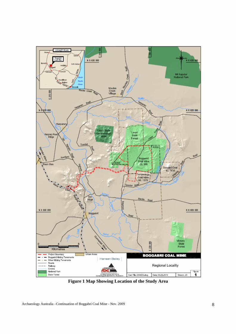
Archaeology Australia –Continuation of Boggabri Coal Mine - Nov. 2009 8
Figure 1 Map Showing Location of the Study Area
Archaeology Australia –Continuation of Boggabri Coal Mine - Nov. 2009 9
3. METHODOLOGY The investigation commenced with historical and archival research and searches of various heritage registers and planning instruments to ascertain whether any heritage sites had previously been recorded within or adjacent to the study area. Registers, databases and plans of the Australian Heritage Council (National Heritage List and Commonwealth Heritage List), Australian Heritage Commission (Register of the National Estate), National Trust (NSW), Heritage Council of NSW (State Heritage Register) and Narrabri Shire Council Local Environmental Plan were searched. Historical records retained by the National Library of Australia, State Library of NSW, Boggabri Historical Society and NSW Mines were also searched. A historical background of the region and study area is included to provide context and understanding of the processes of settlement and land use development within the area. This will assist with the production of a basic predictive model to assess the potential for heritage items to occur within the study area. The study area was not physically inspected in its entirety. Physical inspections were based on information from historical and archival research. Local residents were also consulted as to their knowledge of the study area and previously known sites. Areas with the potential to contain evidence of any items of interest were more closely examined and several sites were recorded in some detail. No sub-surface testing was undertaken. The report contains a description and discussion of each site located followed by an assessment of significance using the criteria developed in the Burra Charter and adopted by the Heritage Council of NSW. Distances and areas mentioned in this report may include imperial measures as they were described in historical records. This report concludes with a summary and recommendations relating to the potential impact of the proposed works and mitigation and management strategies. 4. HISTORICAL BACKGROUND 4.1 Regional & Local History The original inhabitants of this region were the Kamilaroi people (Horton, 1994: 530). The name ‘Boggabri’ is a word taken from the local Aboriginal people and is believed the mean a ‘place of many creeks’ (Reed, 1969: 19). Following the period of European exploration and settlement 200 years ago, the Aboriginal population in the region was rapidly decimated by introduced diseases and disintegration of their traditional social structure. However, Aboriginal people remain living in the region today and take an active interest in their heritage.
Archaeology Australia –Continuation of Boggabri Coal Mine - Nov. 2009 10
The first European to visit the area around Boggabri was the explorer, John Oxley, who crossed the Liverpool Plains in 1817 and had reached the Nandewar Range in 1818 (Smith, 2006: 1). In 1823 Cunningham passed through the area and the first settler followed shortly thereafter. The first settler in the area was George Clarke better known as the ‘Barber’ (Boyce, 1970). He was an escaped convict and he took up residence in 1825 just to the north of where Boggabri stands today. He assimilated with the local Aborigines - darkening his skin, undergoing initiation via scarring and taking two Aboriginal wives. He was eventually captured by police and gave a great account of his life in the area but was eventually hanged for his crimes. Barber’s Lagoon and Barber’s Pinnacle are two local landmarks that bear his name. One of Clarke’s stories related to his following a great river, the ‘Kindur’, to the sea. The Acting Governor, on hearing this story, dispatched the Surveyor General, Major Thomas Mitchell, to see if the story was true (Boggabri Adult Education Committee (BAEC), 1957: 4). Mitchell left Sydney in 1831 and arrived at the Namoi late that year. There he located what was believed to be Clarke’s camp which was associated with a number of Aboriginal ‘gunyas’ (Boyce, 1970: 25). Before exploring further down the Namoi, Mitchell spent some days exploring an area to the north-east. He describes cutting his way through scrub of forest oak and the description he gives is that of what is now known as Leard’s Forest. He returned to the Namoi River after a few days and made camp near the river where he prepared for his journey downstream. Mitchell failed to find evidence to support Clarke’s claims of an inland sea. He returned to Sydney via Clarke’s camp passing through that area in late February 1832. The area had no European settlers when he passed through in 1831, however Mitchell met a Mr Brown on his return trip. Brown, who had a station to the south (Wallamoul), was following in Mitchell’s tracks, no doubt scouting for land suitable for settlement. Despite Governor Darling placing a geographic limit on the spread of settlement, it was impossible to keep settlers from going beyond the ‘Nineteen Counties – the Limits of Location’. In the decade following Mitchell’s exploration of the area, favourable reports came out and sparked a strong interest in the area. The first known squatter in the vicinity of the study area was Edward Cox who took up ‘Namoi Hut’ in 1835 (BAEC, 1957: 5). This site was later to become the township of Boggabri. The original township was established about 20km to the south on the Namoi River however severe flooding destroyed this settlement in the 1850s. The new site was that of Namoi Hut, around the confluence of the Namoi River and Cox's Creek, an area that was not inundated during the big floods. By 1847, the number of squatters in the area had increased. The following are some of those who are recorded as having taken up land in the area (but not necessarily living there): WC Wentworth at Burburgate; Sir John Jamieson at Baan Baa; Thomas Eather at Muggarie; H. Eather at Henriendi; Alfred Denison at Melvile Plains and Gullendaddy; and John Cox at Therrabri. These holdings were all large areas of land (eg in 1866 Gullendaddy Station occupied 162,560 acres and Namoi Hut was about 70,000 acres (Balliere’s Gazeteer, 1866). Thomas Mort held Boggabrie Station during the 1860s but this passed into the hands of Ebenezer Vickery in 1870 (BAEC, 1957: 11).
Archaeology Australia –Continuation of Boggabri Coal Mine - Nov. 2009 11
Development was aided by the intersection of major south and west overland routes at this point. Initially surveyed by C. Filde in 1859, the township of Boggabri was gazetted in August 1860. By 1866 Boggabri was described as a ‘... newly proclaimed township on Cox’s Creek within the electoral district of Liverpool Plains...’ (Bailliere’s Gazeteer, 1866). It had a population of 50 and had ‘good agricultural land on the banks of a creek’ and it was suggested that free selection would increase the population. Free selection began in 1861 with the passing of the Crown Land Alienation Act and the Crown Lands Occupation Act. These acts were an attempt to open up the land and to introduce closer settlement. There was no immediate effect in the Boggabri area however by 1878 the postal directory showed eleven squatters in the area but also had the names of 24 selectors. Selection broke up the large tracts of land originally controlled by the squatters although various practices adopted by the wealthier land-holders (dummying, peacocking etc) often enabled them maintain control over the better areas of land. Further attempts at closer settlement were attempted in the 20th century following the wars under the Returned Soldier Settlement Act 1916. Crown Land was targeted for such settlement but land acquisition was also undertaken to obtain the desired amount of land. Settlement attempts often failed but the footprint of these activities remain, both within the cadastral landscape and the houses and sheds that are spread across the land. 4.2 Industry The original European settlers took up land to graze their stock (cattle and sheep) and to grow crops once the land was cleared. Land had to be cleared in all but a few areas and the timber cut during this process was used for construction of yards and buildings. In some cases, the timber itself became a source of income and supplied early mills. Wool was an early important resource and the Gullendaddy woolshed is testament of those activities. Over 40,000 sheep were annually shorn in that shed during the 1860s (Journal of Boggabri Historical Society, 2006: 9). The reduction in size of these properties resulted in fewer sheep per property, thus reducing the need for substantial shearing sheds. Crops were raised from the period of early settlement but much of the produce would have been for local consumption. The first commercial crops were planted around the 1890 and the area under cultivation increased over time; in 1907, 18,436 bushels1 of wheat were harvested in the Boggabri district and by 1939 this had increased to 1,804,073 bushels (Journal of Boggabri Historical Society, 2006: 6). A flour mill began operations in 1910 and grain silos were opened at Boggabri in 1944. During the 20th century, intensive irrigation schemes were introduced in the area and cotton became a major income producer in this and surrounding areas. Logging has been carried out in the local forests since the time of settlement however it has never been a major industry in this area. Pilliga Forest was the principal forest in the region although Leard State Forest was dedicated as a forest reserve in 1878 (declared then as the Back Creek Forest Reserve).
1 One bushel of wheat = approx. 60lbs or 27.3kg A bushel is a cubic measure around 1.25 cubic feet.
Archaeology Australia –Continuation of Boggabri Coal Mine - Nov. 2009 12
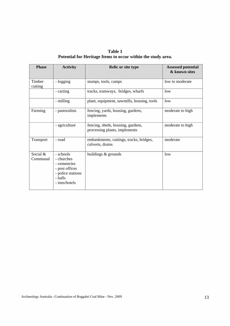
However the native pine and ironbark forest were not of sufficient quality or quantity to attract major industry. The Willowdale Mill operated for some years and locals often cut logs in the Leard State Forest to supplement their income (T. Cassidy, pers. comm.; R. Eather, pers. comm.). Tobacco was grown on the river (Namoi) flats, however little is known of the history of this activity (J. Smart, pers. comm.). The remains of tobacco drying sheds still stand on the Namoi River floodplain in the vicinity of Boggabri. 4.3 Transport Nowlands had a coach run from Boggabri to Narrabri in the latter half of the 19th century (Journal of Boggabri Historical Society, 2006: 19). They had a way-station at the Rock and the Rock Inn became a famous landmark of the time (BAEC, 1957: 13). This area is better known today as ‘Gin’s Leap’, after an Aboriginal story about a young girl who leapt from the cliff. The railway reached Boggabri in 1882. 4.4 Summary & Predictive Model While the Boggabri area is located in an area that has a significant and interesting rural history, there are no particular heritage items that were identified within the study area during the historical research. However, the local histories of the study area indicate that previously unidentified heritage items may be present within or in close proximity to the study area and may be impacted upon by the Project. While some items may be of low heritage significance, all relics are protected by the Heritage Act 1977 and must be recorded and assessed prior to being disturbed, collected and/or destroyed. Table 2 contains a predictive model that highlights the nature of material that may exist within or in the vicinity of the study area. It is based on the regional history and a preliminary study of former land-use and settlement patterns. This table highlights the potential for sites to occur within or adjacent to the study area but does not indicate the significance of any items that may be located. Such issues are addressed later in the report. Historical and archival research has indicated that the study area was not a focus of settlement during the initial phases of regional occupation. The study area was incorporated within large properties whose head stations and homesteads lie beyond its boundaries. Later phases of closer settlement resulted in the erection of dwellings and attendant features (sheds and yards) on smaller properties as the large stations were broken up. Timber extraction was an early industry in the region, including the study area, and there may be some evidence of these activities within the study area.
Archaeology Australia –Continuation of Boggabri Coal Mine - Nov. 2009 13
Table 1
Potential for Heritage Items to occur within the study area.
Phase Activity Relic or site type
Assessed potential & known sites
Timber cutting
- logging stumps, tools, camps
low to moderate
- carting tracks, tramways, bridges, wharfs
low
- milling plant, equipment, sawmills, housing, tools
low
Farming - pastoralists fencing, yards, housing, gardens, implements
moderate to high
- agriculture fencing, sheds, housing, gardens, processing plants, implements
moderate to high
Transport - road embankments, cuttings, tracks, bridges, culverts, drains
moderate
Social & Communal
- schools - churches - cemeteries - post offices - police stations - halls - inns/hotels
buildings & grounds low
Archaeology Australia –Continuation of Boggabri Coal Mine - Nov. 2009 14
5. STATUTORY OBLIGATIONS Best practice principles and procedures for heritage conservation and assessing significance are set out in the ’Burra Charter’. It was developed by Australia ICOMOS (International Council for Monuments and Sites) at a meeting in 1979 in the South Australian historic mining town of Burra and adopted as an Australian charter for the conservation of places of cultural significance. The Burra Charter can be applied to a wide range of places - an archaeological site, a town, building or landscape. The Burra Charter defines various terms and identifies principles and procedures that must be observed in conservation work. The Burra Charter embodies the following concepts: the place itself is important;
understand the significance of the place; understand the fabric; significance should guide decisions; do as much as is necessary, as little as possible; keep records; do everything in logical order. The Burra Charter is not cited officially in any act however it is nationally recognised and underpins heritage management in New South Wales. The policies and guidelines of the Heritage Council of NSW and the NSW Heritage Office are consistent with and guided by the Burra Charter.
5.1 Legislation 5.1.1 National A new national heritage system commenced on 1 January 2004. Its main features include: A National Heritage List of places of national heritage significance;
A Commonwealth Heritage List of heritage places owned or managed by the Commonwealth;
The creation of the Australian Heritage Council – an independent expert body to advise the
Minister on the listing and protection of heritage places; and
Continued management of the Register of the National Estate.
National Heritage List:
Archaeology Australia –Continuation of Boggabri Coal Mine - Nov. 2009 15
The National Heritage List records the natural, indigenous and historic places with outstanding heritage value to our nation. These places will have values or characteristics that have special meaning for all Australians. They show important aspects of the history of the continent on which we live, and reflect the diverse experience of its human occupation. Places on the National Heritage List are protected under Section 15B of the Environment Protection and Biodiversity Conservation Act 1999 (EPBC Act).
Commonwealth Heritage List: The Commonwealth Heritage List will include places or groups of places that are in Commonwealth lands and waters or under the control of the Australian Government. Anyone, including the Minister and the Australian Heritage Council, can nominate a place to the Commonwealth Heritage List through a public nomination process. The Australian Heritage Council assesses nominations after receiving the Council's advice, the Minister decides whether or not a place warrants listing using criteria prescribed in the EPBC Act and may invite public comments on the inclusion of the place in the Commonwealth Heritage List. It then advises the Minister of its findings.
Register of the National Estate: The Register of the National Estate is a list of more than 13,000 heritage places around Australia that has been compiled by the former Australian Heritage Commission since 1976. It will continue as an evolving record of Australia's natural, cultural and indigenous heritage places that are worth keeping for the future. Members of the public can nominate places to the Register. The Australian Heritage Council will then assess nominations and will list places meeting relevant criteria. It will maintain information about places on the Register in a publicly accessible database that will be used for public education and to promote heritage conservation in general. Places on the Register are protected under the EPBC Act by the same provisions that protect Commonwealth Heritage places. 5.1.2 State
National Trust of NSW: The National Trust of Australia (NSW) (the Trust) is a Non-government Community Organisation which promotes the conservation of both the built and natural heritage (eg. buildings, bushland, cemeteries, scenic landscapes, rare and endangered flora and fauna, and steam engines may all have heritage value). The Trust has approximately 30,000 members in NSW. Following its survey and assessment of the natural and cultural environment, the Trust maintains a Register of landscapes, townscapes, buildings, industrial sites, cemeteries and other items or places which the Trust determines to have heritage significance and are worthy of conservation. Currently there are some 11,000 items listed on the Trust’s Register. They are referred to as ‘Classified’ items.
Archaeology Australia –Continuation of Boggabri Coal Mine - Nov. 2009 16
The Trust’s Register is intended to perform an advisory and educational role (the listing in the Register has no legal force). However, it is widely recognised as an authoritative statement of the heritage significance of a place. The Trust does not have any control over the development or demolition of the Classified Places or Items in its Register. While the National Trust Register does not provide any statutory obligations for protection of a site as such, the acknowledgment of a place being listed on the Register as a significant site lends weight to its heritage value. Also, the fact that the actual data for sites may be minimal does not diminish the significance of a place. In fact, many sites were listed with only basic data added, especially in the early developmental stages of the Register.
NSW Heritage Act (1977): Overview: The purpose of the NSW Heritage Act 1977 (Heritage Act) is to ensure that the heritage of NSW is adequately identified and conserved. In practice, the Heritage Act has focused on items and places of non-indigenous heritage to avoid overlap with the NSW National Parks & Wildlife Act, 1974, which has primary responsibilities for nature conservation and the protection of Aboriginal objects and places in NSW. In recent years however, the Heritage Council of NSW has targeted these other areas, working with relevant state agencies such as DECCW to identify gaps in the protection of Aboriginal and natural heritage places. The Heritage Amendment Act 1998 came into effect in April 1999. This Act instigated changes to the NSW heritage system, which were the result of a substantial review begun in 1992. A central feature of the amendments was the clarification and strengthening of shared responsibility for heritage management between Local Government Authorities, responsible for items of local significance, and the Heritage Council of NSW. The Council retained its consent powers for alterations to heritage items of state significance. The Heritage Act is concerned with all aspects of conservation ranging from the most basic protection against damage and demolition, to restoration and enhancement. It recognises two levels of heritage significance, State significance and Local significance, across a broad range of values. Some key provisions of the Heritage Act are: The establishment and functions of the Heritage Council of NSW (Part 2);
Interim heritage orders (Part 3);
The State Heritage Register (Part 3A);
Heritage Agreements (Part 3B);
Archaeology Australia –Continuation of Boggabri Coal Mine - Nov. 2009 17
The protection of archaeological deposits and relics (Part 6); and
The management of State government owned and managed items (Part 8). Generally the Heritage Act provides protection to items that have been identified, assessed and listed on various registers including State government Section 170 registers, local government Local Environment Plans (LEPs) and the State Heritage Register. The only ‘blanket’ protection provisions in the Heritage Act relate to the protection of archaeological deposits and relics greater than 50 years of age.
The Heritage Council of NSW: The role of the Heritage Council of NSW is to provide the Minister with advice on a broad range of matters relating to the conservation of the heritage of NSW. It also has a role in promoting heritage conservation through research, seminars and publications. The membership of the Heritage Council of NSW is designed to reflect a broad range of interests and areas of expertise.
The State Heritage Register: Changes to the Heritage Act in the 1998 amendments established the State Heritage Register which includes all places previously protected by Permanent Conservation Orders (PCOs) and items identified as being of state significance in heritage and conservation registers prepared by State Government instrumentalities. Sites or places which are found to have a state level of heritage significance should be formally identified to the Heritage Council and considered for inclusion on the State Heritage Register.
Protection of Archaeological Relics and Deposits: Section 139 of the Heritage Act specifically provides protection for any item classed as a relic. A relic is defined as “... any deposit, object or material evidence –
a) which relates to the settlement of the area that comprises New South Wales, not being Aboriginal settlement; and
b) which is 50 or more years old.”
(Heritage Act, Part 1, Section 4). Section 139 of the Act disallows disturbance of a relic unless in accordance with an 'excavation permit' from the Heritage Council of NSW. In practice, excavation permits are required only for relics that, according to their assessed heritage significance, warrant this form of documentation and control.
Archaeology Australia –Continuation of Boggabri Coal Mine - Nov. 2009 18
Section 139(4) of the Act provides exceptions to be granted when an excavation permit is required. Standard exception #4 (Excavation, as amended 18 June 2004) is relevant to the present assessment (NSW Heritage Office 2004:12):
1. Excavation or disturbance of land of the kind specified below does not require approval under s.57(1) of the Act, provided that the Director is satisfied that the criteria in (a), (b) or (c) have been met and the person proposing to undertake the excavation or disturbance of land has received a notice advising that the Director is satisfied:
a) where an archaeological assessment has been prepared in accordance with guidelines
published by the Heritage Council of NSW which indicates that any relics in the land are unlikely to have State or local heritage significance; or
b) where the excavation or disturbance of land will have a minor impact on
archaeological relics; or
c) where the excavation or disturbance of land involves only the removal of unstratified fill which has been deposited on the land.
A person proposing to excavate or disturb land in the manner described in paragraph 1 above must write to the Director and describe the proposed excavation or disturbance of land and set out why it satisfies the criteria set out in paragraph 1. If the Director is satisfied that the proposed development meets the criteria set out in paragraph (a), (b) or (c) the Director shall notify the applicant. (1) A person must not disturb or excavate any land knowing or having reasonable cause to suspect that the disturbance or excavation will or is likely to result in a relic being discovered, exposed, moved, damaged or destroyed unless the disturbance or excavation is carried out in accordance with an excavation permit.
(2) A person must not disturb or excavate any land on which the person has discovered or exposed a relic except in accordance with an excavation permit.
(3) This section does not apply to a relic that is subject to an interim heritage order made by the Minister or a listing on the State Heritage Register.
(4) The Heritage Council may by order published in the Gazette create exceptions to this section, either unconditionally or subject to conditions, in respect of any of the following:
(a) any relic of a specified kind or description, (b) any disturbance or excavation of a specified kind or description, (c) any disturbance or excavation of land in a specified location or having specified features or attributes,
Archaeology Australia –Continuation of Boggabri Coal Mine - Nov. 2009 19
(d) any disturbance or excavation of land in respect of which an archaeological assessment approved by the Heritage Council indicates: (i) that there is little likelihood of there being any relics in the land, or
(ii) that any relics in the land are unlikely to have State or local heritage significance.
(5) This section does not prevent a person from disturbing or excavating land in which a historic shipwreck is situated in accordance with a historic shipwrecks permit in force in respect of that shipwreck. Section 146 of the Heritage Act requires that the discovery of a previously unknown relic be reported to the Heritage Council of NSW within a reasonable time of its discovery.
Heritage and Conservation Registers: Section 170 of the Act requires all State government instrumentalities to establish and maintain a Heritage and Conservation Register that lists items of environmental heritage. The register is to include items which are, or could potentially be, the subject of a conservation instrument, and which are owned, occupied or otherwise under the control of that instrumentality.
Environmental Planning and Assessment Act (1979): The Environmental Planning & Assessment Act 1979 (EP&A Act) and its regulations, schedules and associated guidelines require that environmental impacts be considered in land use planning and decision-making. Environmental impacts include those to cultural heritage. The Minister administering the EP&A Act may determine various planning instruments such as LEPs (section 53). The Minister may direct a public authority, such as a Local Council, to exercise certain actions within a specified time, including the preparation of draft LEPs and appropriate provisions to achieve the principles and aims of the EP&A Act (section 117). These planning instruments may identify places and features of cultural heritage significance and define various statutory requirements regarding the potential development, modification and conservation of these items. In general, places of identified significance, or places requiring further assessment, are listed in various heritage schedules that may form part of a LEP. Listed heritage items are then protected from certain defined activities, normally including demolition, renovation, excavation, subdivision, and other forms or damage, unless consent has been gained from an identified consent authority. The consent authority under a LEP is normally the Local Government Authority.
Archaeology Australia –Continuation of Boggabri Coal Mine - Nov. 2009 20
In determining a Development Application (DA), a consent authority must take into consideration any of the following that are relevant to the subject application (section 79C(1) Matters for Consideration – general): The provisions of any environmental planning instrument;
The likely impacts of that development, including environmental impacts on both the natural and
built environments, and social and economic impacts in the locality ;
The suitability of the site for the development;
Any submissions made in accordance with the Act or the regulations; and
The public interest. The EP&A Act, as amended, provides for the listing of heritage items and conservation areas and for the protection of these items or areas through environmental planning instruments (like LEPs) at the local government and State planning levels. These statutory planning instruments usually contain provisions for the conservation of these items and areas as well as an assessment process to reduce the impacts of new development on the heritage significance of a place, building or conservation area. The Project is one to which Part 3A of the EP&A Act applies and therefore exemptions for additional approvals under Section 75U apply. Relevant exemptions to non-Indigenous Heritage include: “75U Approvals etc legislation that does not apply (1) The following authorisations are not required for an approved project (and accordingly the provisions of any Act that prohibit an activity without such an authority do not apply): …
(c) an approval under Part 4, or an excavation permit under section 139, of the Heritage Act 1977, …
(2) Division 8 of Part 6 of the Heritage Act 1977 does not apply to prevent or interfere with the carrying out of an approved project.”
Narrabri Local Environmental Plan No. 2 (2008)
This document sets the framework for the land use structure of the Narrabri Shire. The plan includes a new set of land use zones and provides detailed requirements for development. It also establishes what types of development may be permitted on a particular parcel of land with development consent. The objective of the following division is to protect and conserve archaeological sites and places of Aboriginal, natural or European cultural significance. It does this by making provisions that conserve the remaining fabric, relics, settings and views, and evidence of the cultural significance of heritage items and the environment of heritage conservation areas.
Archaeology Australia –Continuation of Boggabri Coal Mine - Nov. 2009 21
Division 5 - Heritage conservation 24 Items of the environmental heritage
(1) A person shall not in respect of a building, work, relic or place that is an item of the environmental heritage:
(a) demolish, renovate or extend the building or work, (b) damage or despoil the relic or any part of the relic, (c) excavate any land for the purpose of exposing or removing the relic, (d) erect a building on the land on which that building, work or relic is situated or the land which comprises that place, (e) subdivide the land on which that building, work or relic is situated or the land which comprises that place,
except with the consent of the Council. (2) The Council shall not grant consent to a development application in respect of an item of the environmental heritage unless it has made an assessment of:
(a) the significance of the item as an item of the environmental heritage of the Shire of Narrabri, (b) the extent to which the carrying out of the development in accordance with the consent would affect the historic, scientific, cultural, social, archaeological, architectural, natural or aesthetic significance of the item and its site, (c) whether the setting of the item, and in particular, whether any stylistic, horticultural or archaeological features of the setting, should be retained, and (d) where the item is a building:
(i) whether the building constitutes a danger to the users or occupiers of that building or to the public, (ii) the colour, texture, style, size and type of finish of any materials to be used on the exterior of the building, the effect which the use of those materials will have on the appearance of the exterior of the building and the similarity of the materials to be used to materials used in other existing buildings in its vicinity, (iii) the style, size, proportion and position of openings for any windows and doors which will result from, or be affected by, the carrying out of the development, and (iv) the pitch and form of the roof, if any.
28 Development in the vicinity of an item of the environmental heritage
The Council shall not consent to the carrying out of development in the vicinity of an item of the environmental heritage unless it has made an assessment of the effect which the carrying out of that development will have on the historic, scientific, cultural, social, archaeological, architectural, natural or aesthetic significance of the item of environmental heritage and its settings.
Archaeology Australia –Continuation of Boggabri Coal Mine - Nov. 2009 22
Section 5 Definitions
In this plan, except in so far as the context or subject-matter otherwise indicates or requires: Item of the environmental heritage means a building, work, relic or place described in Schedule 1. Schedule 1 does not contain any items located within or in the vicinity of the study area.
Narrabri Local Environmental Plan No 5 (Township of Boggabri) Schedule 1 Aims, objectives etc
1. The aims, objectives, policies and strategies of this plan are, with respect to the land to which this plan applies, the following:
(a) generally: (i) to provide a high quality living environment for the residents of Boggabri, reflecting the needs and aspirations of present and future residents and the physical capacity of the land, (ii) to plan for realistic future growth of Boggabri in the provision of zoned land areas, (iii) to protect the town of Boggabri through appropriate development control provisions in respect of flood-prone lands, thereby reducing the risk of life and damage to property as a result of flooding, (iv) to maintain Boggabri’s role as a service centre to surrounding rural areas and as a supplier of the needs of its townspeople, (v) to guide the Council in land use decisions, (vi) to provide a clear indication to property owners and developers on the future pattern of land use, (vii) to give the Council the statutory power to control land use, and (viii) to facilitate the application of appropriate development controls to encourage and enable orderly and attractive urban development, control plans and relevant codes.”
This particular LEP relates to the township of Boggabri and does not impact on the study area, however its intent has been considered in this assessment as practical.
5.2 Listed Items A search of relevant heritage databases and records was conducted on 1 August 2009. No items within the study area were listed on any registers.
Archaeology Australia –Continuation of Boggabri Coal Mine - Nov. 2009 23
6. SITE INVESTIGATION 6.1 Previous Investigations In 1987, the BHP-AGIP-Idemitsu Joint Venture completed an Environmental Impact Statement for the Boggabri Coal Project (BHP-AGIP-Idemitsu Joint Venture, 1987). While non-Indigenous heritage was considered in this report, no heritage items were located within the project’s boundary. 6.2 Physical Inspection The study area was inspected on 20 and 21 July 2009. General survey was conducted by vehicle traversing tracks within the study area. Several areas were closely examined on foot to try and locate features recorded in historical records or indicated through community consultation. A review of aerial photography was also undertaken. The following table summarises heritage items located during the survey and includes items situated within the study area or in the immediate vicinity.
Archaeology Australia –Continuation of Boggabri Coal Mine - Nov. 2009 24
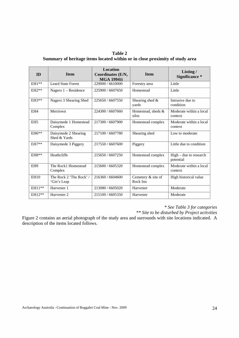
Table 2
Summary of heritage items located within or in close proximity of study area
ID Item
Location Coordinates (E/N,
MGA 1994))Item
Listing / Significance *
EH1** Leard State Forest 229000 / 6610000 Forestry area Little
EH2** Nagero 1 – Residence 225900 / 6607650 Homestead Little
EH3** Nagero 3 Shearing Shed 225650 / 6607550 Shearing shed & yards
Intrusive due to condition
EH4 Merriown 224300 / 6607660 Homestead, sheds & silos
Moderate within a local context
EH5 Daisymede 1 Homestead Complex
217300 / 6607900 Homestead complex Moderate within a local context
EH6** Daisymede 2 Shearing Shed & Yards
217100 / 6607780 Shearing shed Low to moderate
EH7** Daisymede 3 Piggery 217550 / 6607600 Piggery Little due to condition
EH8** Heathcliffe 215650 / 6607250 Homestead complex High – due to research potential
EH9 The Rock1 Homestead Complex
215600 / 6605320 Homestead complex Moderate within a local context
EH10 The Rock 2 ‘The Rock’ / ‘Gin’s Leap
216360 / 6604600 Cemetery & site of Rock Inn
High historical value
EH11** Harvester 1 213080 / 6605020 Harvester Moderate
EH12** Harvester 2 215100 / 6605350 Harvester Moderate
* See Table 3 for categories
** Site to be disturbed by Project activities Figure 2 contains an aerial photograph of the study area and surrounds with site locations indicated. A description of the items located follows.
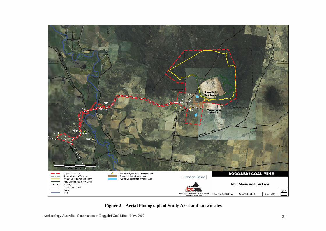
Archaeology Australia –Continuation of Boggabri Coal Mine - Nov. 2009 25
Figure 2 – Aerial Photograph of Study Area and known sites
Archaeology Australia –Continuation of Boggabri Coal Mine - Nov. 2009 26
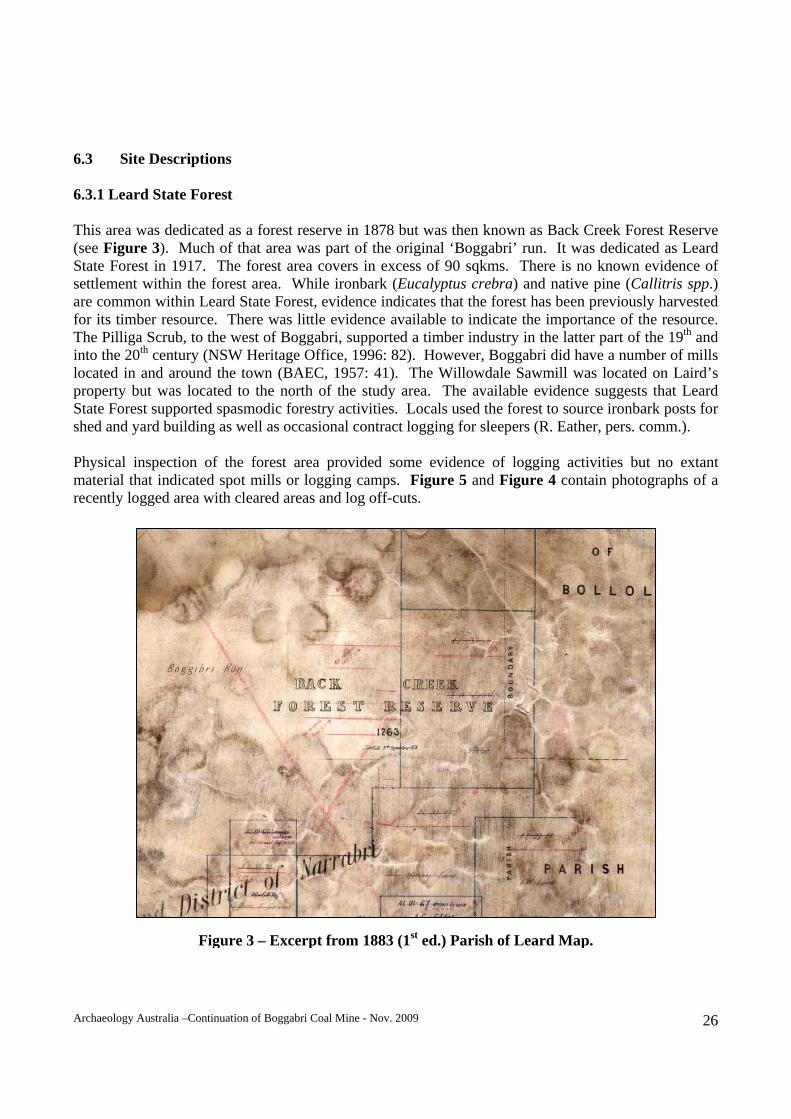
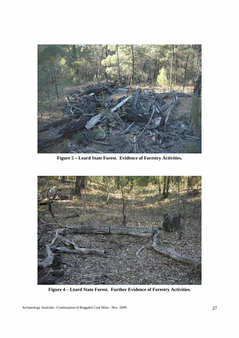
6.3 Site Descriptions 6.3.1 Leard State Forest This area was dedicated as a forest reserve in 1878 but was then known as Back Creek Forest Reserve (see Figure 3). Much of that area was part of the original ‘Boggabri’ run. It was dedicated as Leard State Forest in 1917. The forest area covers in excess of 90 sqkms. There is no known evidence of settlement within the forest area. While ironbark (Eucalyptus crebra) and native pine (Callitris spp.) are common within Leard State Forest, evidence indicates that the forest has been previously harvested for its timber resource. There was little evidence available to indicate the importance of the resource. The Pilliga Scrub, to the west of Boggabri, supported a timber industry in the latter part of the 19th and into the 20th century (NSW Heritage Office, 1996: 82). However, Boggabri did have a number of mills located in and around the town (BAEC, 1957: 41). The Willowdale Sawmill was located on Laird’s property but was located to the north of the study area. The available evidence suggests that Leard State Forest supported spasmodic forestry activities. Locals used the forest to source ironbark posts for shed and yard building as well as occasional contract logging for sleepers (R. Eather, pers. comm.). Physical inspection of the forest area provided some evidence of logging activities but no extant material that indicated spot mills or logging camps. Figure 5 and Figure 4 contain photographs of a recently logged area with cleared areas and log off-cuts.
Figure 3 – Excerpt from 1883 (1st ed.) Parish of Leard Map.
Archaeology Australia –Continuation of Boggabri Coal Mine - Nov. 2009 27
Figure 5 – Leard State Forest. Evidence of Forestry Activities.
Figure 4 – Leard State Forest. Further Evidence of Forestry Activities.
Archaeology Australia –Continuation of Boggabri Coal Mine - Nov. 2009 28
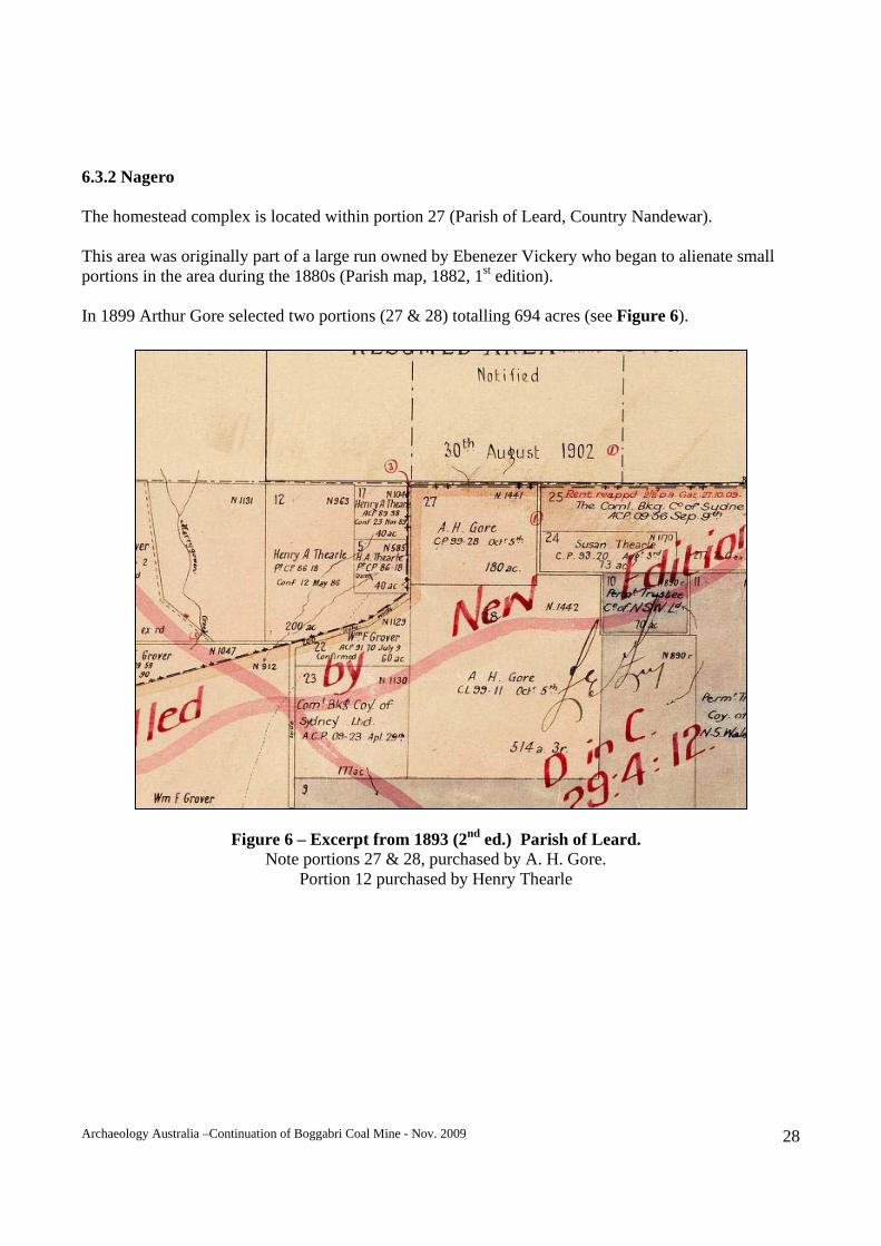
6.3.2 Nagero The homestead complex is located within portion 27 (Parish of Leard, Country Nandewar). This area was originally part of a large run owned by Ebenezer Vickery who began to alienate small portions in the area during the 1880s (Parish map, 1882, 1st edition). In 1899 Arthur Gore selected two portions (27 & 28) totalling 694 acres (see Figure 6).
Figure 6 – Excerpt from 1893 (2nd ed.) Parish of Leard. Note portions 27 & 28, purchased by A. H. Gore.
Portion 12 purchased by Henry Thearle
Archaeology Australia –Continuation of Boggabri Coal Mine - Nov. 2009 29
Nagero 1 – Residence/offices The main building (former residence) is currently used as the mine office by Boggabri Coal. The existing house has been significantly modified for this purpose and a large proportion of its original fabric has been removed and/or remodelled. The original construction style (weatherboard on timber frame) suggests early 20th century construction. Condition: Good condition although heritage values have been diminished due to
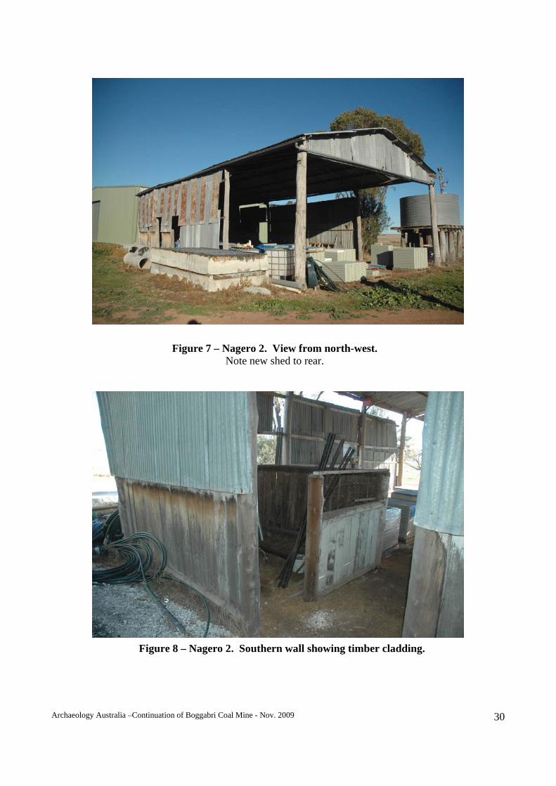
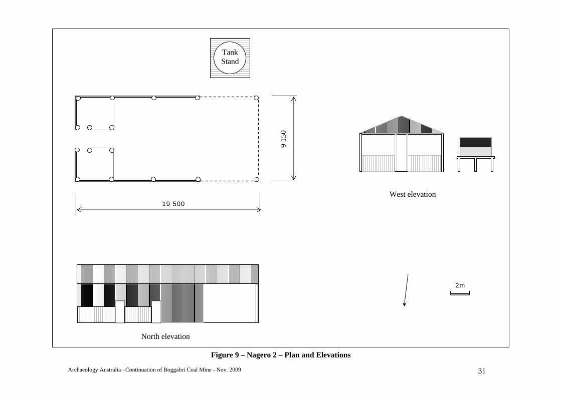
unsympathetic renovation. Archaeological potential: Low, due to previous works and ground disturbance. Impact: Low, this site is located in the central area of mine infrastructure. Nagero 2 - Woolshed A shed that formed part of the original homestead complex was located 50m to the south-west of the Nagero 1 item. This building was constructed using a log frame with steel truss roof frames and clad in corrugated steel. A portion of the original timber wall cladding remains. The shed had been modified through time. The original roof may have been framed with timber but had been replaced with open-web steel trusses. The shed measures 19.5m x 9.15m. A modern shed has been constructed next to the site of this shed. A tank stand was located to the south of the shed. A rolled corrugated steel tank stood on a timber frame supported by timber posts. Figure 7 to Figure 9 contain photographs and a plan of this item. Archaeological potential: Low. Impact: This site is located adjacent to proposed infrastructure development
works for the Project The Woolshed has since been demolished and removed from the site in accordance with existing approvals.
Archaeology Australia –Continuation of Boggabri Coal Mine - Nov. 2009 30
Figure 7 – Nagero 2. View from north-west. Note new shed to rear.
Figure 8 – Nagero 2. Southern wall showing timber cladding.
Archaeology Australia –Continuation of Boggabri Coal Mine - Nov. 2009 31
West elevation
North elevation
2m
19 500
9 15
0
Tank Stand
Figure 9 – Nagero 2 – Plan and Elevations
Archaeology Australia –Continuation of Boggabri Coal Mine - Nov. 2009 32
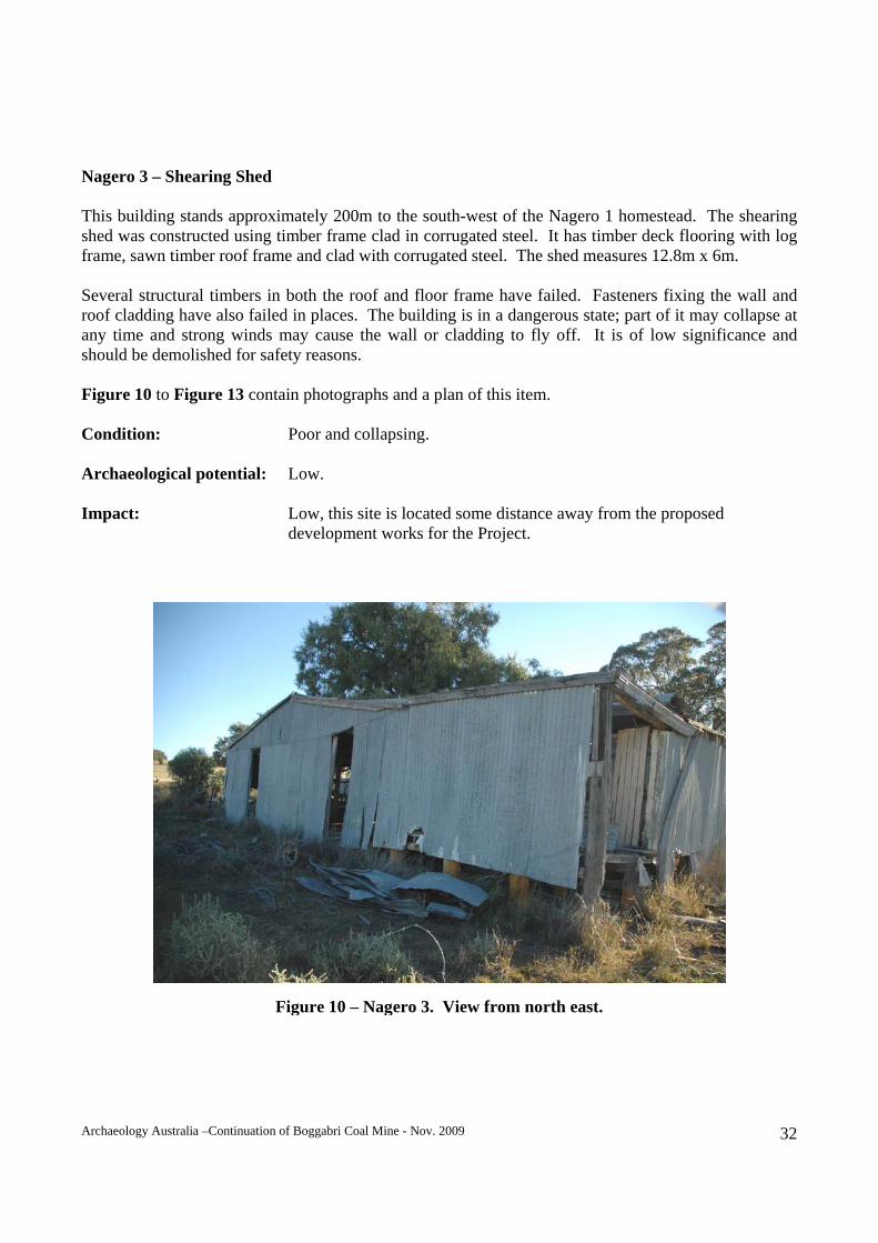
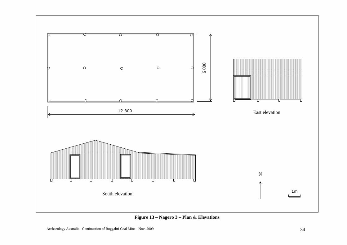
Nagero 3 – Shearing Shed This building stands approximately 200m to the south-west of the Nagero 1 homestead. The shearing shed was constructed using timber frame clad in corrugated steel. It has timber deck flooring with log frame, sawn timber roof frame and clad with corrugated steel. The shed measures 12.8m x 6m. Several structural timbers in both the roof and floor frame have failed. Fasteners fixing the wall and roof cladding have also failed in places. The building is in a dangerous state; part of it may collapse at any time and strong winds may cause the wall or cladding to fly off. It is of low significance and should be demolished for safety reasons. Figure 10 to Figure 13 contain photographs and a plan of this item. Condition: Poor and collapsing. Archaeological potential: Low. Impact: Low, this site is located some distance away from the proposed development works for the Project.
Figure 10 – Nagero 3. View from north east.
Archaeology Australia –Continuation of Boggabri Coal Mine - Nov. 2009 33
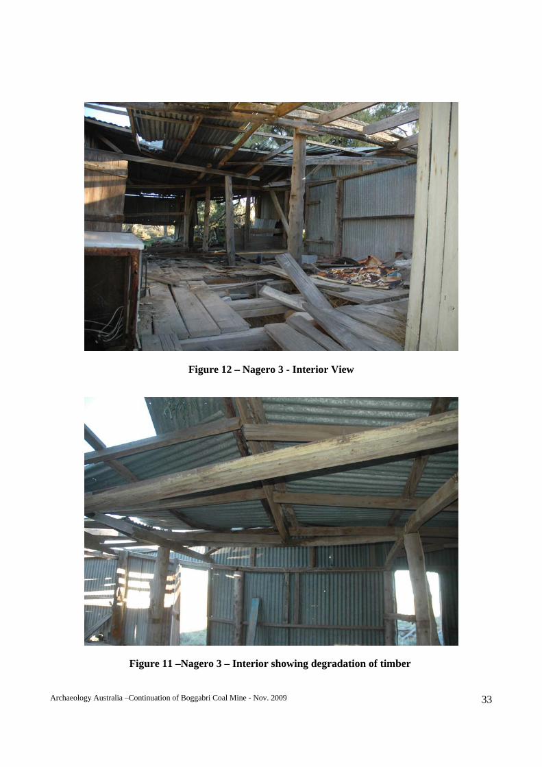
Figure 12 – Nagero 3 - Interior View
Figure 11 –Nagero 3 – Interior showing degradation of timber
Archaeology Australia –Continuation of Boggabri Coal Mine - Nov. 2009 34
East elevation
South elevation 1m
6 00
0
12 800
N
Figure 13 – Nagero 3 – Plan & Elevations
Archaeology Australia –Continuation of Boggabri Coal Mine - Nov. 2009 35
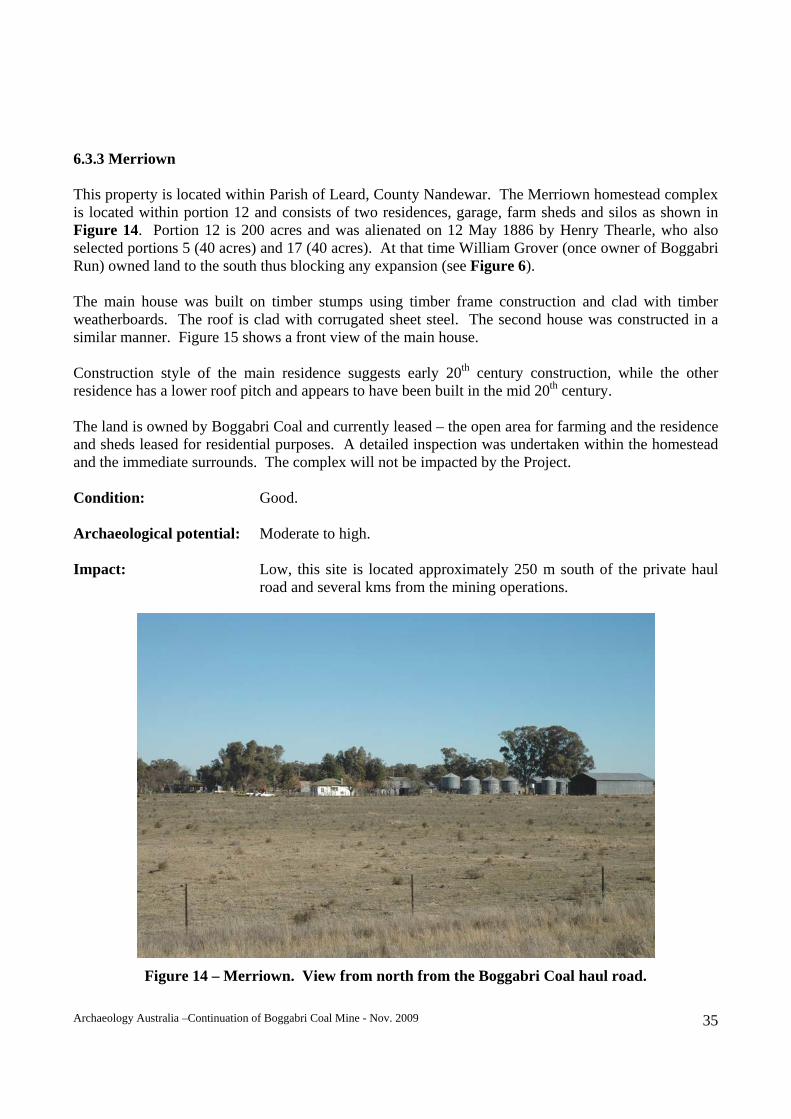
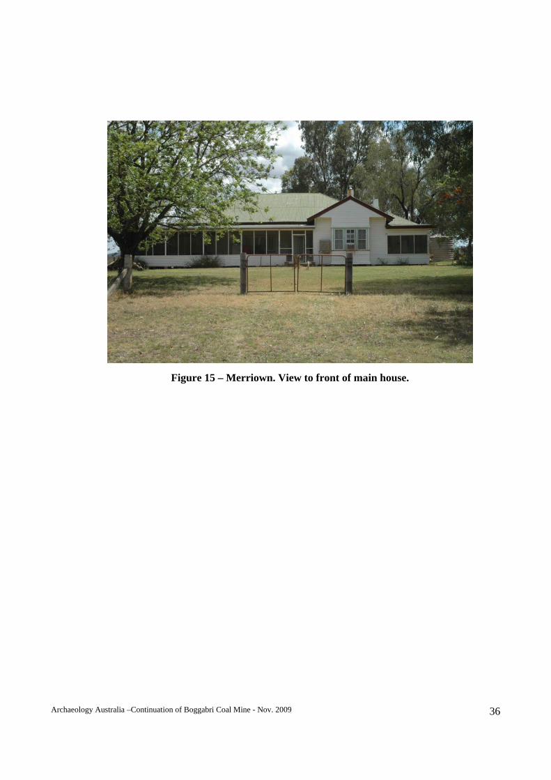
6.3.3 Merriown This property is located within Parish of Leard, County Nandewar. The Merriown homestead complex is located within portion 12 and consists of two residences, garage, farm sheds and silos as shown in Figure 14. Portion 12 is 200 acres and was alienated on 12 May 1886 by Henry Thearle, who also selected portions 5 (40 acres) and 17 (40 acres). At that time William Grover (once owner of Boggabri Run) owned land to the south thus blocking any expansion (see Figure 6). The main house was built on timber stumps using timber frame construction and clad with timber weatherboards. The roof is clad with corrugated sheet steel. The second house was constructed in a similar manner. Figure 15 shows a front view of the main house. Construction style of the main residence suggests early 20th century construction, while the other residence has a lower roof pitch and appears to have been built in the mid 20th century. The land is owned by Boggabri Coal and currently leased – the open area for farming and the residence and sheds leased for residential purposes. A detailed inspection was undertaken within the homestead and the immediate surrounds. The complex will not be impacted by the Project. Condition: Good. Archaeological potential: Moderate to high. Impact: Low, this site is located approximately 250 m south of the private haul road and several kms from the mining operations.
Figure 14 – Merriown. View from north from the Boggabri Coal haul road.
Archaeology Australia –Continuation of Boggabri Coal Mine - Nov. 2009 36
Figure 15 – Merriown. View to front of main house.
Archaeology Australia –Continuation of Boggabri Coal Mine - Nov. 2009 37
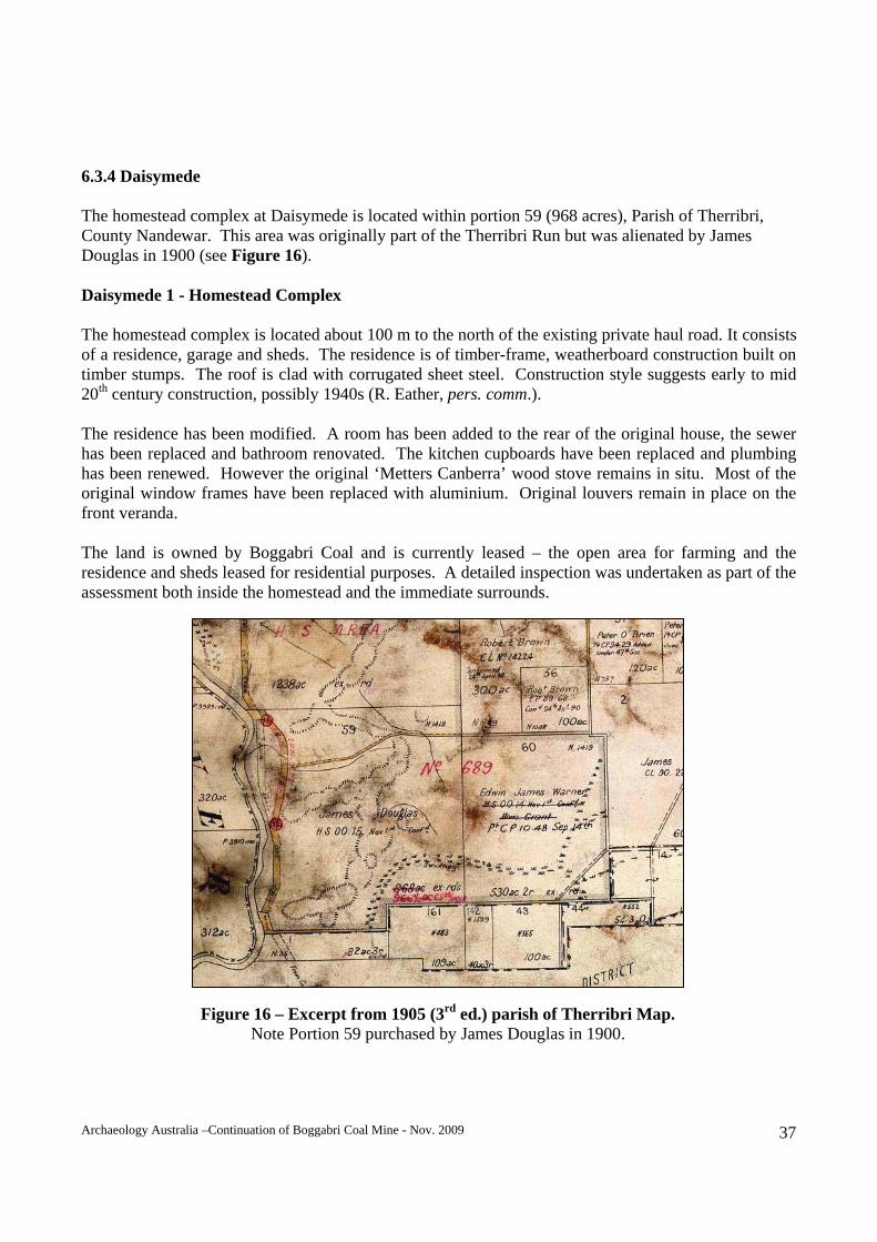
6.3.4 Daisymede The homestead complex at Daisymede is located within portion 59 (968 acres), Parish of Therribri, County Nandewar. This area was originally part of the Therribri Run but was alienated by James Douglas in 1900 (see Figure 16). Daisymede 1 - Homestead Complex The homestead complex is located about 100 m to the north of the existing private haul road. It consists of a residence, garage and sheds. The residence is of timber-frame, weatherboard construction built on timber stumps. The roof is clad with corrugated sheet steel. Construction style suggests early to mid 20th century construction, possibly 1940s (R. Eather, pers. comm.). The residence has been modified. A room has been added to the rear of the original house, the sewer has been replaced and bathroom renovated. The kitchen cupboards have been replaced and plumbing has been renewed. However the original ‘Metters Canberra’ wood stove remains in situ. Most of the original window frames have been replaced with aluminium. Original louvers remain in place on the front veranda. The land is owned by Boggabri Coal and is currently leased – the open area for farming and the residence and sheds leased for residential purposes. A detailed inspection was undertaken as part of the assessment both inside the homestead and the immediate surrounds.
Figure 16 – Excerpt from 1905 (3rd ed.) parish of Therribri Map. Note Portion 59 purchased by James Douglas in 1900.
Archaeology Australia –Continuation of Boggabri Coal Mine - Nov. 2009 38
Condition: Good. Archaeological potential: Moderate potential for sub-surface evidence to be located within the curtilage of this property. Impact: Low, this site is located approximately 100 m away from the private haul road and several km from the mine itself.
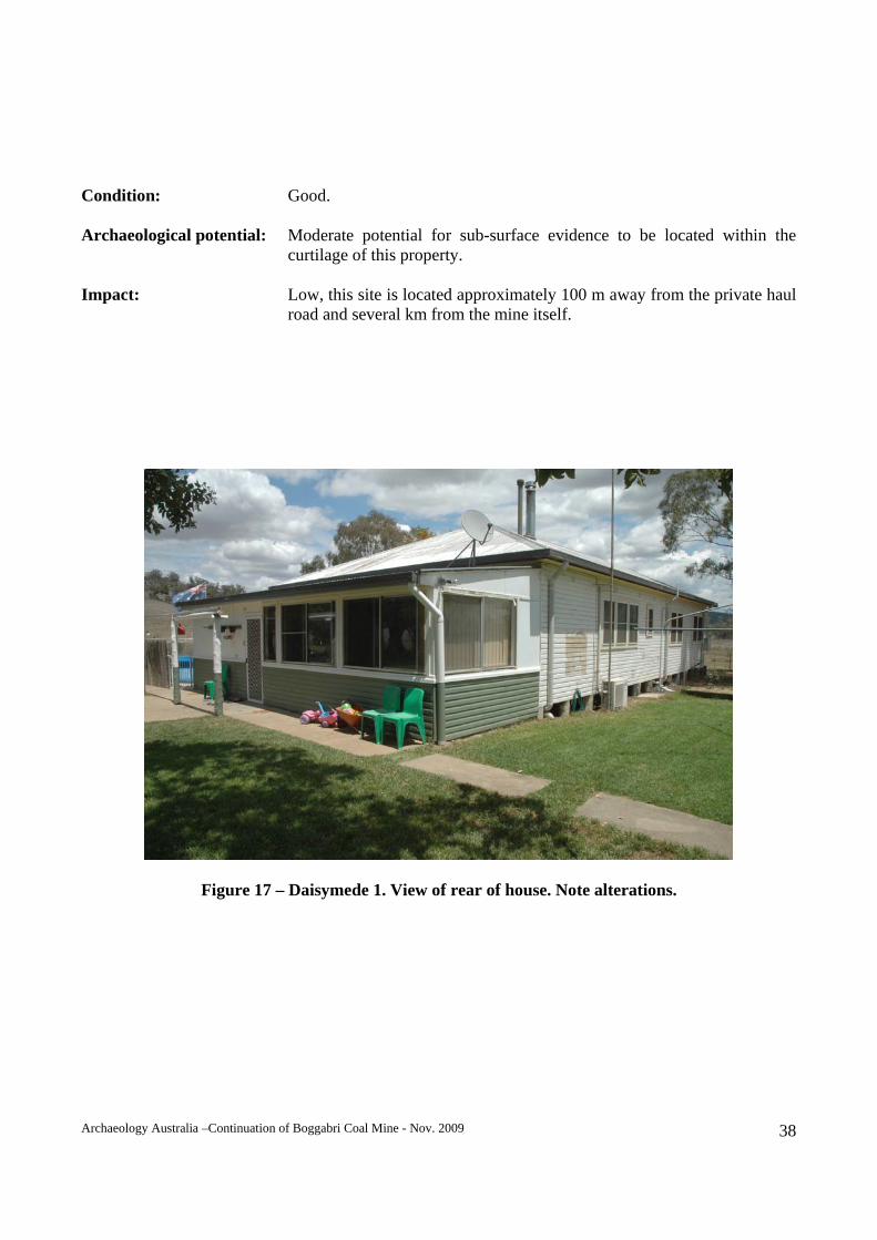
Figure 17 – Daisymede 1. View of rear of house. Note alterations.
Archaeology Australia –Continuation of Boggabri Coal Mine - Nov. 2009 39
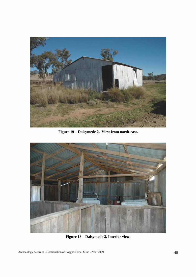
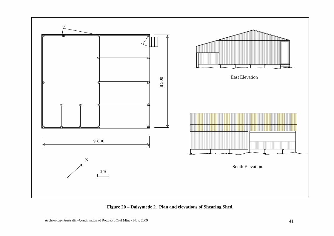
Daisymede 2 – Shearing Shed & Yards A shearing shed and yards are located opposite the homestead and on the southern side of the private haul road. The shed is constructed using log pole frame clad with corrugated steel. While no shearing plant remains in the shed, there is little work required to be able to use the shed for its intended purpose. The shed measures 9.8 m x 6.5 m, has three wool bins and had two shearing stands. It is currently utilised for vehicle storage. A set of stock yards are located to the rear (south of the shed). The yards are in very poor condition and appear to have been repaired for temporary use in more recent times. Figure 19 to Figure 21 contain photographs and a plan of this item. Condition: Shed – good; yards - poor. Archaeological potential: Moderate – may contain sub-surface evidence of activities associated with shearing. Impact: High, this site is located within or adjacent to the proposed railway corridor.
Archaeology Australia –Continuation of Boggabri Coal Mine - Nov. 2009 40
Figure 19 – Daisymede 2. View from north-east.
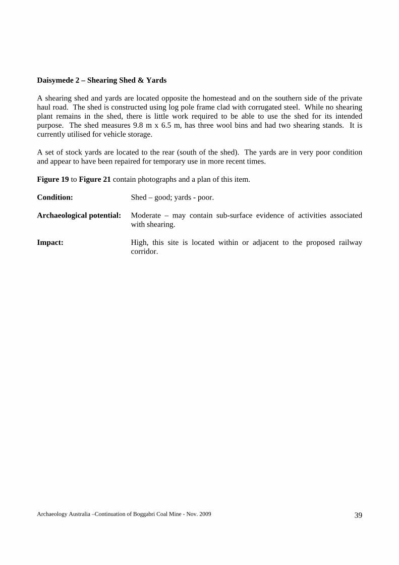
Figure 18 – Daisymede 2. Interior view.
Archaeology Australia –Continuation of Boggabri Coal Mine - Nov. 2009 41
1m
9 800
8 50
0 N
South Elevation
East Elevation
Figure 20 – Daisymede 2. Plan and elevations of Shearing Shed.
Archaeology Australia –Continuation of Boggabri Coal Mine - Nov. 2009 42
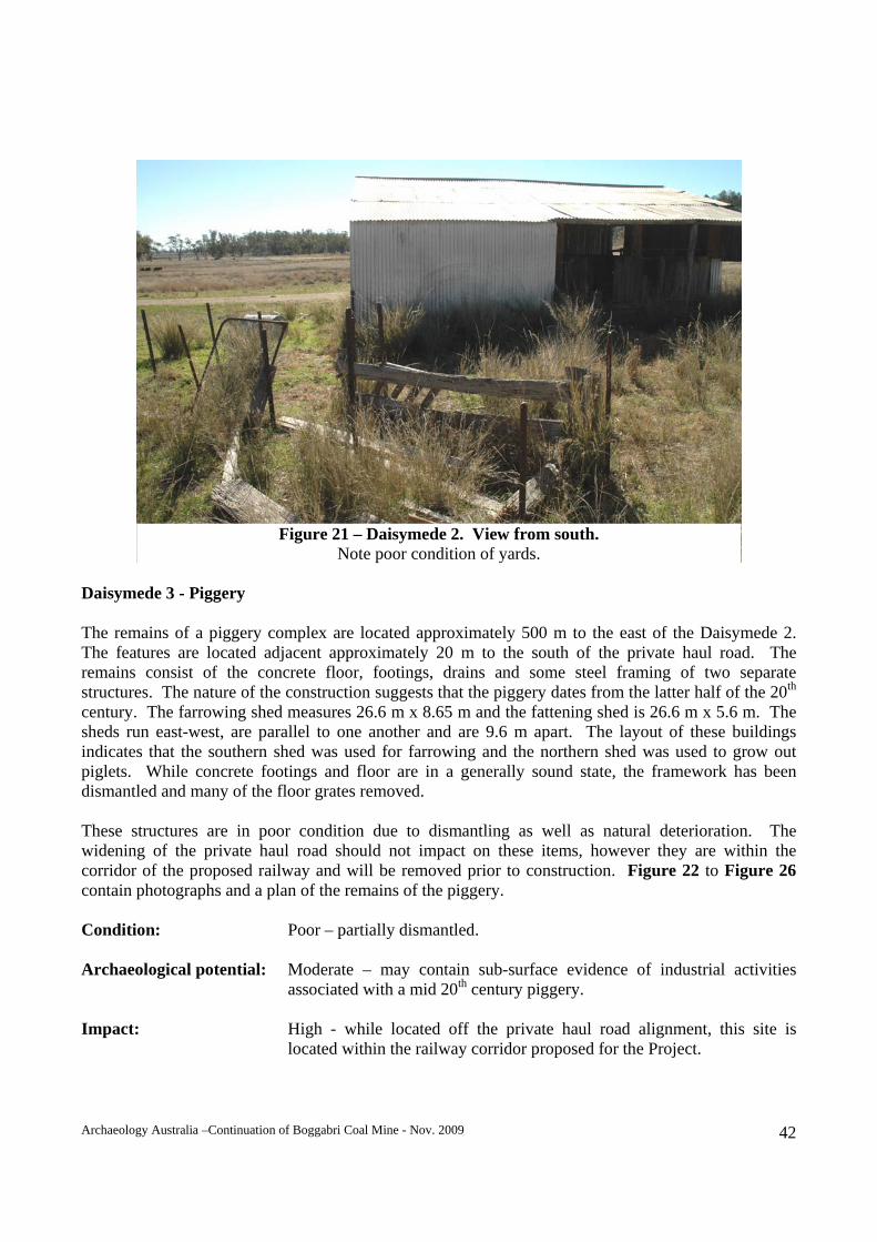
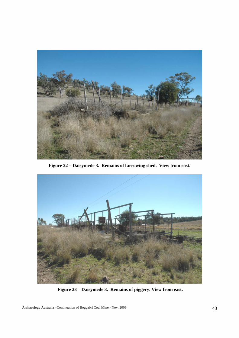
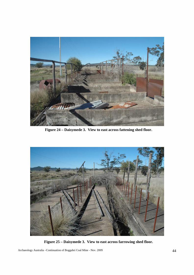
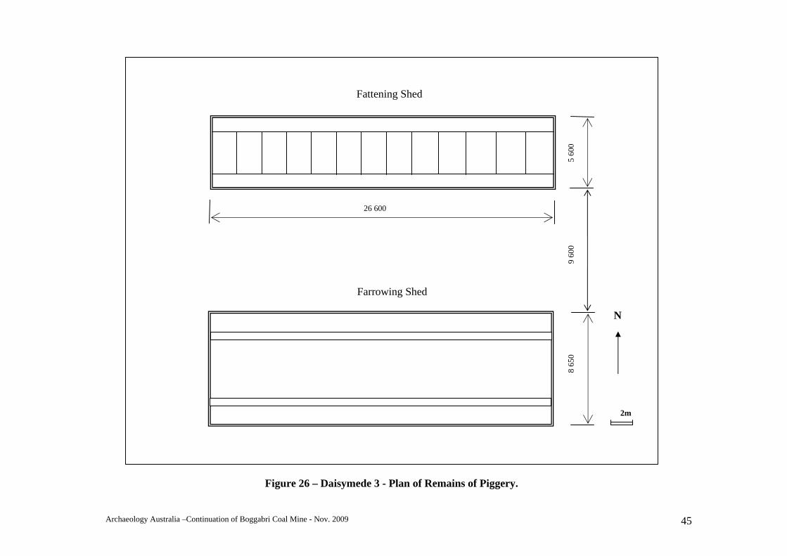
Daisymede 3 - Piggery The remains of a piggery complex are located approximately 500 m to the east of the Daisymede 2. The features are located adjacent approximately 20 m to the south of the private haul road. The remains consist of the concrete floor, footings, drains and some steel framing of two separate structures. The nature of the construction suggests that the piggery dates from the latter half of the 20th century. The farrowing shed measures 26.6 m x 8.65 m and the fattening shed is 26.6 m x 5.6 m. The sheds run east-west, are parallel to one another and are 9.6 m apart. The layout of these buildings indicates that the southern shed was used for farrowing and the northern shed was used to grow out piglets. While concrete footings and floor are in a generally sound state, the framework has been dismantled and many of the floor grates removed. These structures are in poor condition due to dismantling as well as natural deterioration. The widening of the private haul road should not impact on these items, however they are within the corridor of the proposed railway and will be removed prior to construction. Figure 22 to Figure 26 contain photographs and a plan of the remains of the piggery. Condition: Poor – partially dismantled. Archaeological potential: Moderate – may contain sub-surface evidence of industrial activities associated with a mid 20th century piggery. Impact: High - while located off the private haul road alignment, this site is located within the railway corridor proposed for the Project.
Figure 21 – Daisymede 2. View from south. Note poor condition of yards.
Archaeology Australia –Continuation of Boggabri Coal Mine - Nov. 2009 43
Figure 23 – Daisymede 3. Remains of piggery. View from east.
Figure 22 – Daisymede 3. Remains of farrowing shed. View from east.
Archaeology Australia –Continuation of Boggabri Coal Mine - Nov. 2009 44
Figure 25 – Daisymede 3. View to east across farrowing shed floor.
Figure 24 – Daisymede 3. View to east across fattening shed floor.
Archaeology Australia –Continuation of Boggabri Coal Mine - Nov. 2009 45
2m
N
26 600
5 60
0 9
600
8 65
0
Farrowing Shed
Fattening Shed
Figure 26 – Daisymede 3 - Plan of Remains of Piggery.
Archaeology Australia –Continuation of Boggabri Coal Mine - Nov. 2009 46
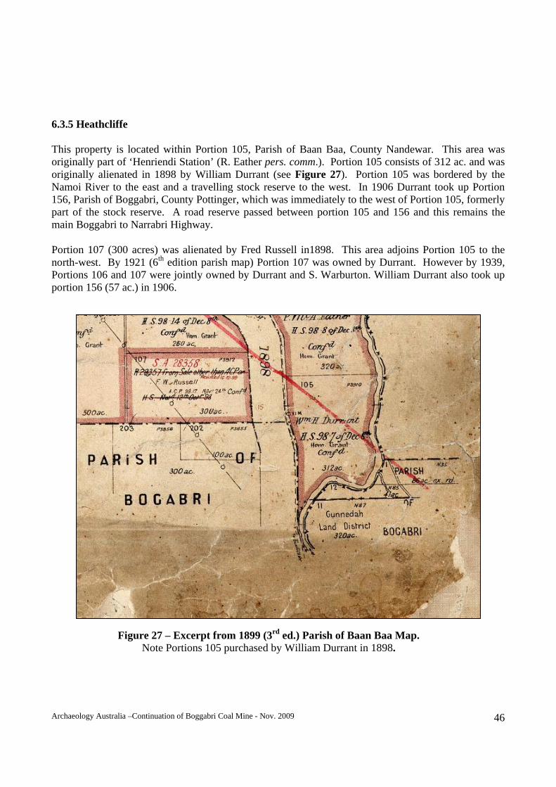
6.3.5 Heathcliffe This property is located within Portion 105, Parish of Baan Baa, County Nandewar. This area was originally part of ‘Henriendi Station’ (R. Eather pers. comm.). Portion 105 consists of 312 ac. and was originally alienated in 1898 by William Durrant (see Figure 27). Portion 105 was bordered by the Namoi River to the east and a travelling stock reserve to the west. In 1906 Durrant took up Portion 156, Parish of Boggabri, County Pottinger, which was immediately to the west of Portion 105, formerly part of the stock reserve. A road reserve passed between portion 105 and 156 and this remains the main Boggabri to Narrabri Highway. Portion 107 (300 acres) was alienated by Fred Russell in1898. This area adjoins Portion 105 to the north-west. By 1921 (6th edition parish map) Portion 107 was owned by Durrant. However by 1939, Portions 106 and 107 were jointly owned by Durrant and S. Warburton. William Durrant also took up portion 156 (57 ac.) in 1906.
Figure 27 – Excerpt from 1899 (3rd ed.) Parish of Baan Baa Map. Note Portions 105 purchased by William Durrant in 1898.
Archaeology Australia –Continuation of Boggabri Coal Mine - Nov. 2009 47
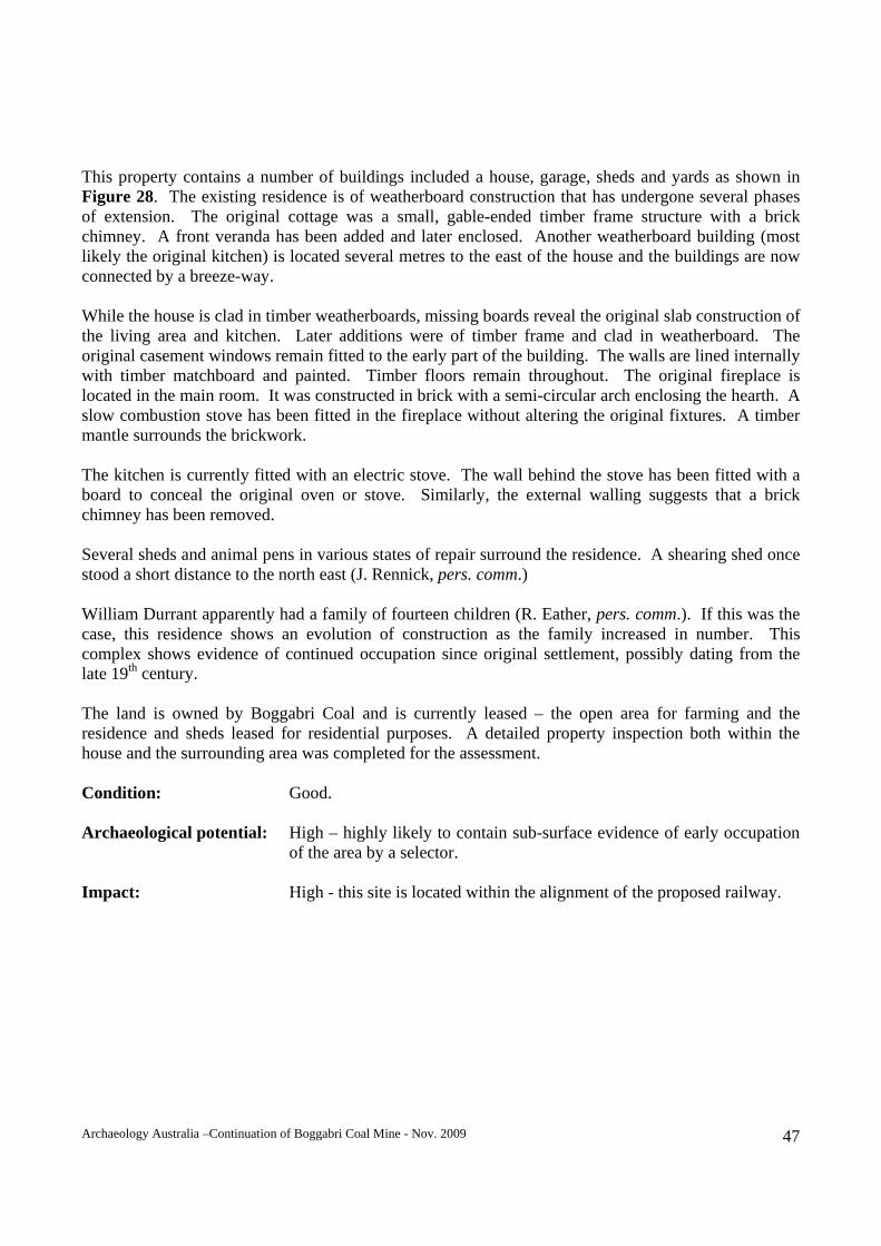
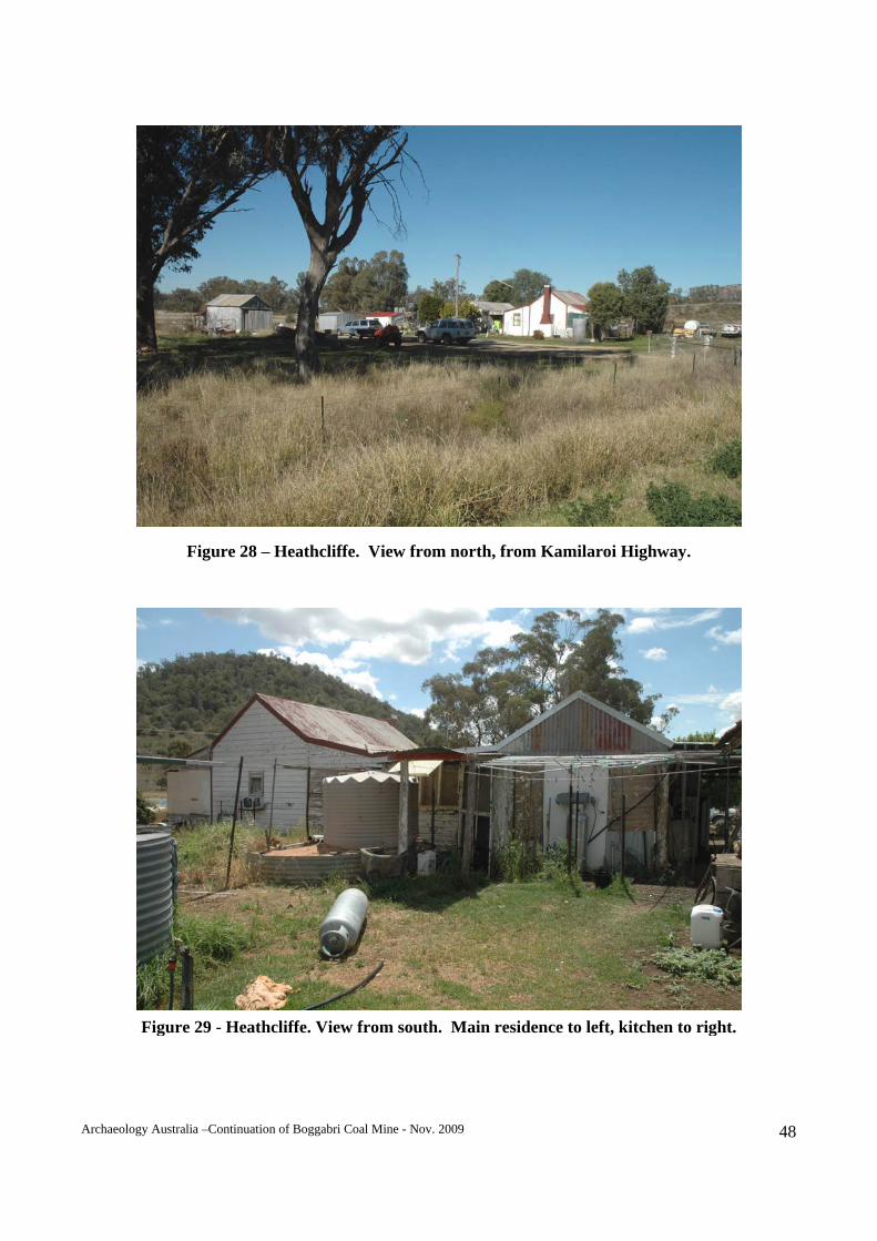
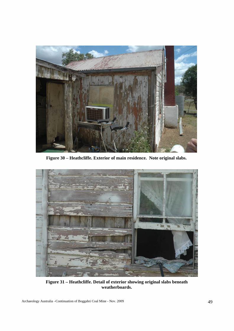
This property contains a number of buildings included a house, garage, sheds and yards as shown in Figure 28. The existing residence is of weatherboard construction that has undergone several phases of extension. The original cottage was a small, gable-ended timber frame structure with a brick chimney. A front veranda has been added and later enclosed. Another weatherboard building (most likely the original kitchen) is located several metres to the east of the house and the buildings are now connected by a breeze-way. While the house is clad in timber weatherboards, missing boards reveal the original slab construction of the living area and kitchen. Later additions were of timber frame and clad in weatherboard. The original casement windows remain fitted to the early part of the building. The walls are lined internally with timber matchboard and painted. Timber floors remain throughout. The original fireplace is located in the main room. It was constructed in brick with a semi-circular arch enclosing the hearth. A slow combustion stove has been fitted in the fireplace without altering the original fixtures. A timber mantle surrounds the brickwork. The kitchen is currently fitted with an electric stove. The wall behind the stove has been fitted with a board to conceal the original oven or stove. Similarly, the external walling suggests that a brick chimney has been removed. Several sheds and animal pens in various states of repair surround the residence. A shearing shed once stood a short distance to the north east (J. Rennick, pers. comm.) William Durrant apparently had a family of fourteen children (R. Eather, pers. comm.). If this was the case, this residence shows an evolution of construction as the family increased in number. This complex shows evidence of continued occupation since original settlement, possibly dating from the late 19th century. The land is owned by Boggabri Coal and is currently leased – the open area for farming and the residence and sheds leased for residential purposes. A detailed property inspection both within the house and the surrounding area was completed for the assessment. Condition: Good. Archaeological potential: High – highly likely to contain sub-surface evidence of early occupation
of the area by a selector. Impact: High - this site is located within the alignment of the proposed railway.
Archaeology Australia –Continuation of Boggabri Coal Mine - Nov. 2009 48
Figure 28 – Heathcliffe. View from north, from Kamilaroi Highway.
Figure 29 - Heathcliffe. View from south. Main residence to left, kitchen to right.
Archaeology Australia –Continuation of Boggabri Coal Mine - Nov. 2009 49
Figure 30 – Heathcliffe. Exterior of main residence. Note original slabs.
Figure 31 – Heathcliffe. Detail of exterior showing original slabs beneath weatherboards.
Archaeology Australia –Continuation of Boggabri Coal Mine - Nov. 2009 50
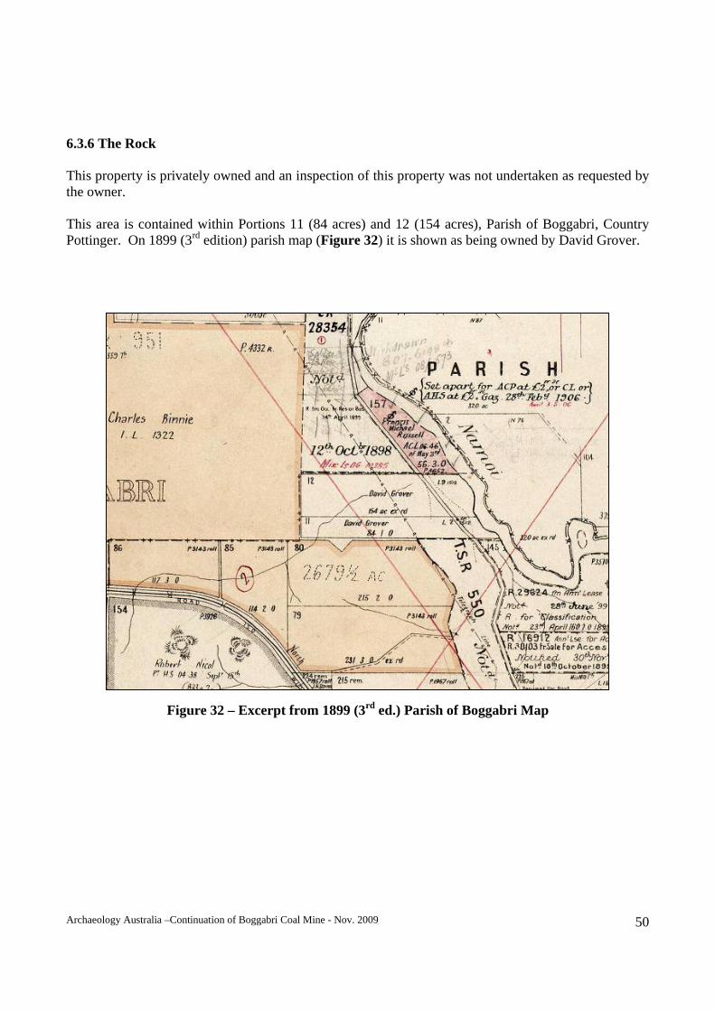
6.3.6 The Rock This property is privately owned and an inspection of this property was not undertaken as requested by the owner. This area is contained within Portions 11 (84 acres) and 12 (154 acres), Parish of Boggabri, Country Pottinger. On 1899 (3rd edition) parish map (Figure 32) it is shown as being owned by David Grover.
Figure 32 – Excerpt from 1899 (3rd ed.) Parish of Boggabri Map
Archaeology Australia –Continuation of Boggabri Coal Mine - Nov. 2009 51
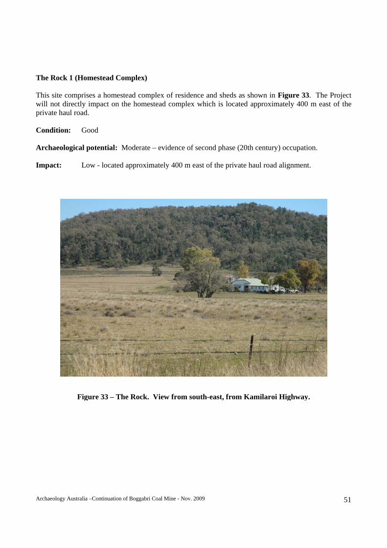
The Rock 1 (Homestead Complex) This site comprises a homestead complex of residence and sheds as shown in Figure 33. The Project will not directly impact on the homestead complex which is located approximately 400 m east of the private haul road. Condition: Good Archaeological potential: Moderate – evidence of second phase (20th century) occupation. Impact: Low - located approximately 400 m east of the private haul road alignment.
Figure 33 – The Rock. View from south-east, from Kamilaroi Highway.
Archaeology Australia –Continuation of Boggabri Coal Mine - Nov. 2009 52
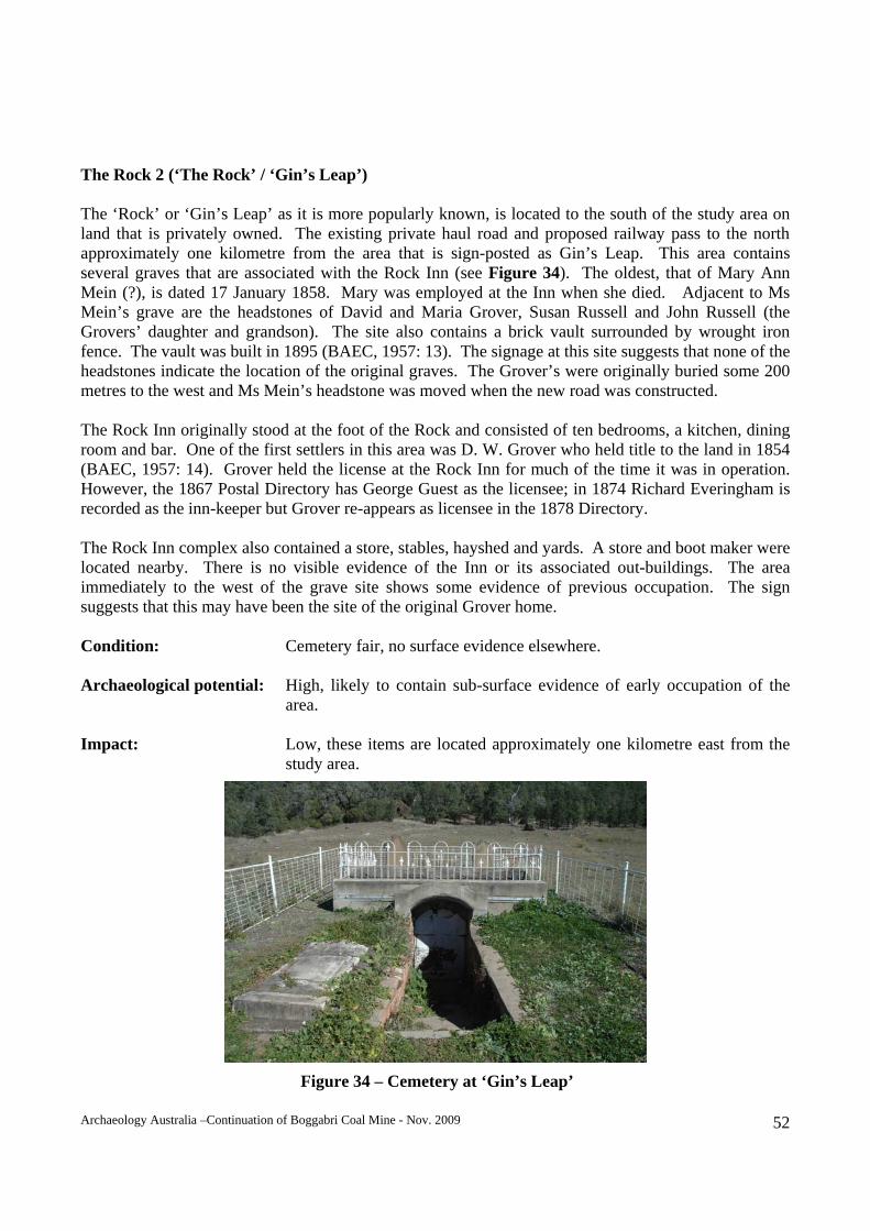
The Rock 2 (‘The Rock’ / ‘Gin’s Leap’) The ‘Rock’ or ‘Gin’s Leap’ as it is more popularly known, is located to the south of the study area on land that is privately owned. The existing private haul road and proposed railway pass to the north approximately one kilometre from the area that is sign-posted as Gin’s Leap. This area contains several graves that are associated with the Rock Inn (see Figure 34). The oldest, that of Mary Ann Mein (?), is dated 17 January 1858. Mary was employed at the Inn when she died. Adjacent to Ms Mein’s grave are the headstones of David and Maria Grover, Susan Russell and John Russell (the Grovers’ daughter and grandson). The site also contains a brick vault surrounded by wrought iron fence. The vault was built in 1895 (BAEC, 1957: 13). The signage at this site suggests that none of the headstones indicate the location of the original graves. The Grover’s were originally buried some 200 metres to the west and Ms Mein’s headstone was moved when the new road was constructed. The Rock Inn originally stood at the foot of the Rock and consisted of ten bedrooms, a kitchen, dining room and bar. One of the first settlers in this area was D. W. Grover who held title to the land in 1854 (BAEC, 1957: 14). Grover held the license at the Rock Inn for much of the time it was in operation. However, the 1867 Postal Directory has George Guest as the licensee; in 1874 Richard Everingham is recorded as the inn-keeper but Grover re-appears as licensee in the 1878 Directory. The Rock Inn complex also contained a store, stables, hayshed and yards. A store and boot maker were located nearby. There is no visible evidence of the Inn or its associated out-buildings. The area immediately to the west of the grave site shows some evidence of previous occupation. The sign suggests that this may have been the site of the original Grover home. Condition: Cemetery fair, no surface evidence elsewhere. Archaeological potential: High, likely to contain sub-surface evidence of early occupation of the area. Impact: Low, these items are located approximately one kilometre east from the study area.
Figure 34 – Cemetery at ‘Gin’s Leap’
Archaeology Australia –Continuation of Boggabri Coal Mine - Nov. 2009 53
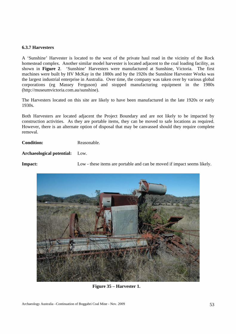
6.3.7 Harvesters A ‘Sunshine’ Harvester is located to the west of the private haul road in the vicinity of the Rock homestead complex. Another similar model harvester is located adjacent to the coal loading facility, as shown in Figure 2. ‘Sunshine’ Harvesters were manufactured at Sunshine, Victoria. The first machines were built by HV McKay in the 1880s and by the 1920s the Sunshine Harvester Works was the largest industrial enterprise in Australia. Over time, the company was taken over by various global corporations (eg Massey Ferguson) and stopped manufacturing equipment in the 1980s (http://museumvictoria.com.au/sunshine). The Harvesters located on this site are likely to have been manufactured in the late 1920s or early 1930s. Both Harvesters are located adjacent the Project Boundary and are not likely to be impacted by construction activities. As they are portable items, they can be moved to safe locations as required. However, there is an alternate option of disposal that may be canvassed should they require complete removal. Condition: Reasonable. Archaeological potential: Low. Impact: Low - these items are portable and can be moved if impact seems likely.
Figure 35 – Harvester 1.
Archaeology Australia –Continuation of Boggabri Coal Mine - Nov. 2009 54
7. SIGNIFICANCE ASSESSMENT 7.1 Criteria The Heritage Council of NSW and Department of Planning have defined a set of criteria and methodology for the assessment of cultural heritage significance for items and places, where these do not include Aboriginal heritage from the pre-contact period (NSW Heritage Office & DUAP 1996, NSW Heritage Office 2000). The assessments provided in this report follow the Heritage Office methodology. The following heritage assessment criteria are those set out for Listing on the State Heritage Register. In many cases items will be significant under only one or two criteria. The State Heritage Register was established under Part 3A of the Heritage Act (as amended in 1999) for listing of items of environmental heritage which are of state heritage significance. Environmental heritage means those places, buildings, works, relics, moveable objects, and precincts, of state or local heritage significance (Section 4, Heritage Act). An item will be considered to be of State (or local) heritage significance if, in the opinion of the Heritage Council of NSW, it meets one or more of the following criteria: 1) An item is important in the course, or pattern, of NSW’s cultural or natural history (or the cultural
or natural history of the local area); 2) An item has a strong or special association with the life or works of a person, or group of persons,
of importance in NSW’s cultural or natural history (or the cultural or natural history of the local area);
3) An item is important in demonstrating aesthetic characteristics and/or a high degree of creative or
technical achievement in NSW (or the local area); 4) An item has a strong or special association with a particular community or cultural group in NSW
(or the local area) for social, cultural or spiritual reasons; 5) An item has potential to yield information that will contribute to an understanding of NSW’s
cultural or natural history (or the cultural or natural history of the local area); 6) An item possesses uncommon, rare or endangered aspects of NSW’s cultural or natural history (or
the cultural or natural history of the local area); 7) An item is important in demonstrating the principal characteristics of a class of NSW’s cultural or
natural places; or cultural or natural environments (or a class of the local area’s cultural or natural places; or cultural or natural environments).
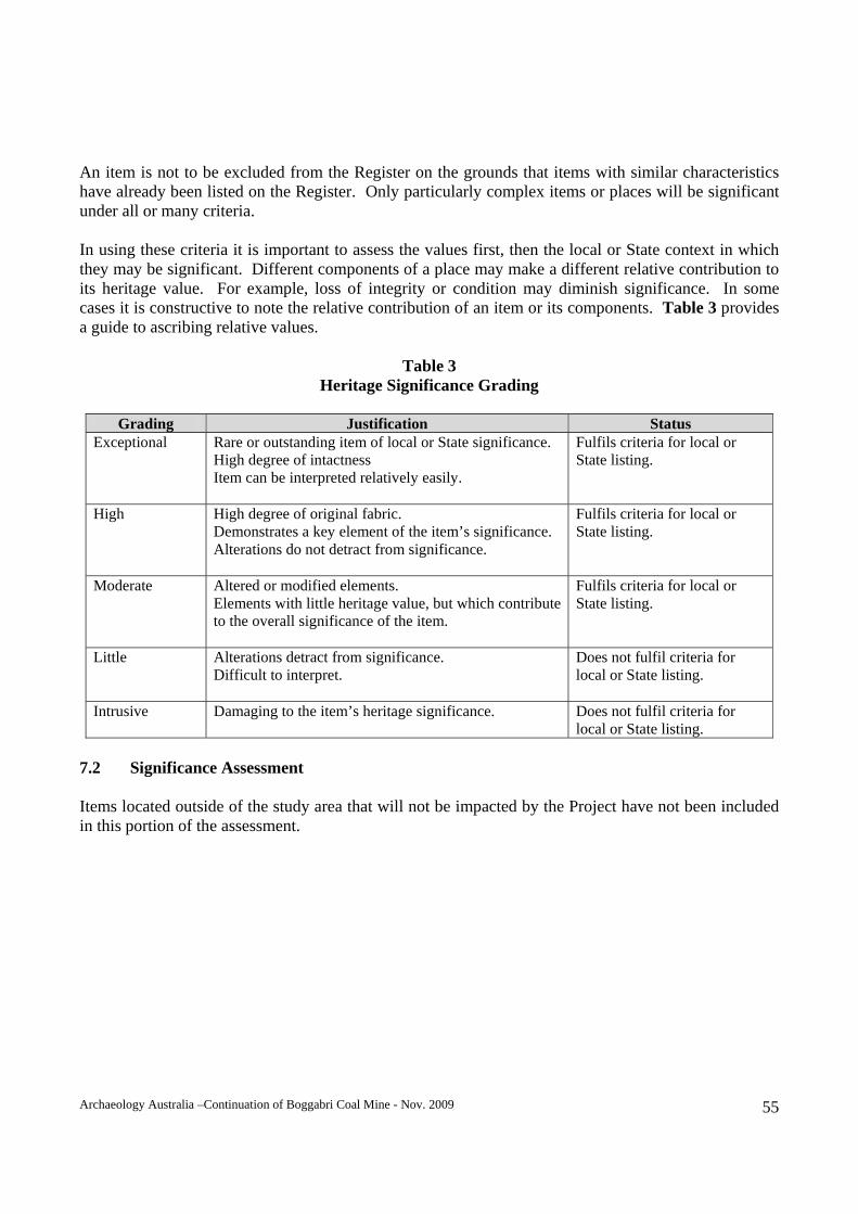
Archaeology Australia –Continuation of Boggabri Coal Mine - Nov. 2009 55
An item is not to be excluded from the Register on the grounds that items with similar characteristics have already been listed on the Register. Only particularly complex items or places will be significant under all or many criteria. In using these criteria it is important to assess the values first, then the local or State context in which they may be significant. Different components of a place may make a different relative contribution to its heritage value. For example, loss of integrity or condition may diminish significance. In some cases it is constructive to note the relative contribution of an item or its components. Table 3 provides a guide to ascribing relative values.
Table 3
Heritage Significance Grading
Grading Justification Status Exceptional Rare or outstanding item of local or State significance.
High degree of intactness Item can be interpreted relatively easily.
Fulfils criteria for local or State listing.
High High degree of original fabric. Demonstrates a key element of the item’s significance. Alterations do not detract from significance.
Fulfils criteria for local or State listing.
Moderate Altered or modified elements. Elements with little heritage value, but which contribute to the overall significance of the item.
Fulfils criteria for local or State listing.
Little Alterations detract from significance. Difficult to interpret.
Does not fulfil criteria for local or State listing.
Intrusive Damaging to the item’s heritage significance.
Does not fulfil criteria for local or State listing.
7.2 Significance Assessment Items located outside of the study area that will not be impacted by the Project have not been included in this portion of the assessment.
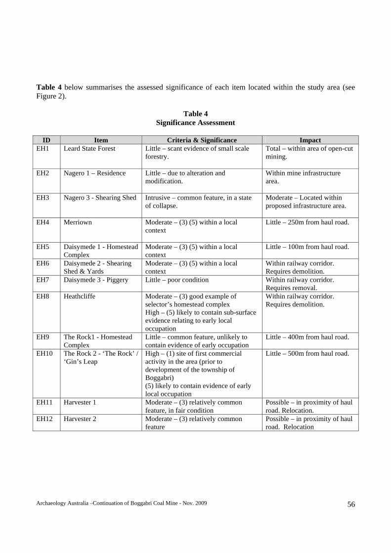
Archaeology Australia –Continuation of Boggabri Coal Mine - Nov. 2009 56
Table 4 below summarises the assessed significance of each item located within the study area (see Figure 2).
Table 4 Significance Assessment
ID Item Criteria & Significance Impact
EH1 Leard State Forest Little – scant evidence of small scale forestry.
Total – within area of open-cut mining.
EH2 Nagero 1 – Residence Little – due to alteration and modification.
Within mine infrastructure area.
EH3 Nagero 3 - Shearing Shed Intrusive – common feature, in a state of collapse.
Moderate – Located within proposed infrastructure area.
EH4 Merriown Moderate – (3) (5) within a local context
Little – 250m from haul road.
EH5 Daisymede 1 - Homestead Complex
Moderate – (3) (5) within a local context
Little – 100m from haul road.
EH6 Daisymede 2 - Shearing Shed & Yards
Moderate – (3) (5) within a local context
Within railway corridor. Requires demolition.
EH7 Daisymede 3 - Piggery Little – poor condition Within railway corridor. Requires removal.
EH8 Heathcliffe
Moderate – (3) good example of selector’s homestead complex High – (5) likely to contain sub-surface evidence relating to early local occupation
Within railway corridor. Requires demolition.
EH9 The Rock1 - Homestead Complex
Little – common feature, unlikely to contain evidence of early occupation
Little – 400m from haul road.
EH10 The Rock 2 - ‘The Rock’ / ‘Gin’s Leap
High – (1) site of first commercial activity in the area (prior to development of the township of Boggabri) (5) likely to contain evidence of early local occupation
Little – 500m from haul road.
EH11 Harvester 1 Moderate – (3) relatively common feature, in fair condition
Possible – in proximity of haul road. Relocation.
EH12 Harvester 2 Moderate – (3) relatively common feature
Possible – in proximity of haul road. Relocation
Archaeology Australia –Continuation of Boggabri Coal Mine - Nov. 2009 57
7.3 Overall Significance Overall, analysis of the evidence indicates that the heritage items located within or in the vicinity of the study area are generally of low to moderate local significance. While much of the study area was once held by squatters, no evidence of their homesteads or outstations was located. The homestead complexes that are located within the study area are those of later phases of occupation as the large runs were broken up – via selection and soldier settlement. The majority of houses and sheds located in the vicinity of the study area are relatively common features within the rural landscape of NSW and are of little significance. Heathcliffe does not necessarily qualify as being of high significance due to its aesthetic appeal. The heritage value of this site rests with its collection of buildings and residence that has undergone several phases of construction. It is not a grand homestead but is representative of a group of settlers that followed the squatting era, that of the ‘selector’. William Durrant selected a relatively small area of land and built a home on the property that satisfied his needs and that of his growing family. Many selections failed and often there is little that remains of their settlement of an area. Heathcliffe provides an example of continued occupation for over a century and is highly likely to contain archaeological evidence of all phases of that occupation. The research potential for this site is high. The site of the original Rock Inn and its associated cemetery are of high significance within a local context. The location itself has cultural significance to the local Aboriginal population as ‘Gin’s Leap’ was the site where an Aboriginal couple leapt to their death while being pursued by members of their tribe. This activity is not related to European occupation of the site and is outside of the scope of this assessment. This area is flanked by sheer cliff to the west and the Namoi River to the east. With all northerly traffic having to pass through this corridor, this was an ideal location for an inn and way-station. This landmark location is well known to the local community and promoted as a tourist site. It has adequate parking and interpretive signage. Despite its significance, it is not listed on the Narrabri Shire Council LEP. The Grover family were early settlers in this region and it is highly likely that archaeological evidence of their residence and early commercial enterprise exists in this area.
Archaeology Australia –Continuation of Boggabri Coal Mine - Nov. 2009 58
8. MITIGATION AND MANAGEMENT STRATEGIES As outlined in Section 4.1.2, the Heritage Act provides the legislative framework for protecting and maintaining the historic heritage of NSW. The Heritage Act is concerned with all aspects of the protection and conservation of environmental heritage, including buildings, works, places or relics that are over 50 years of age and are of historic, scientific, cultural, social, archaeological, architectural, natural or aesthetic significance to the State of NSW (but not being related to Aboriginal settlement). Section 4(1) of the Heritage Act defines a ‘relic’ as ‘any deposit, object or material evidence relating to the settlement of the area that comprises New South Wales, not being Aboriginal settlement and which is fifty or more years old’. Heritage items have been identified either within or in close proximity to the study area, however not all of these items will be directly impacted upon by the Project. The following items are likely to be impacted upon by the Project and have been assessed to be of local significance. Management strategies are included below for each item. 8.1 Nagero Residence The Nagero residence is currently been used and maintained as an office building. The building will continue to be used for this purpose for the Project. Maintenance to the building will be carried out and changes to the surrounding area including additional buildings will be located near to the house. 8.2 Nagero 3 Shearing Shed The Shearing Shed is located in the area proposed for the construction of a contractor camp and housing complex and demolition will be required. Prior to demolition, further work will be required, including an archival recording of the site, including measured drawings and photographs in accordance with relevant heritage guidelines. 8.3 Daisymede 3 - Piggery This site lies within the railway corridor and demolition will be required. Prior to demolition, further work will be required, including an archival recording of the site, including measured drawings and photographs in accordance with relevant heritage guidelines. Archaeological evidence of activities relating to pig farming may also exist in the vicinity of the site. As such, monitoring of the site by an appropriately qualified person must be undertaken as demolition proceeds. Should relics be uncovered during monitoring, further archaeological investigation would be undertaken to determine the significance of items located and the extent of further works. 8.4 Heathcliffe This site lies within the proposed railway corridor and construction will require demolition of existing buildings. As this site is of local significance, further work is required prior to works commencing and includes:
Archaeology Australia –Continuation of Boggabri Coal Mine - Nov. 2009 59
Archival recording of the Heathcliffe site including a site plan, measured drawings of each building
and photographic record;
Archaeological assessment;
Archaeological investigation including excavation, should evidence of sub-surface relics be located or inferred;
Monitored demolition, with allowances for further archaeological investigation, should further
relics be discovered; and Prior to demolition of the site, Narrabri Shire Council and the Boggabri Historical Society will be
consulted regarding the management and interpretation of any relics that will be removed from the site.
8.5 The Rock 2 - ‘The Rock’ / ‘Gin’s Leap’ Should Boggabri Coal acquire this property, an archaeological assessment of the area surrounding the cemetery at the Rock should be undertaken. This area is likely to contain archaeological evidence of the original Rock Inn and associated buildings. While there are no known plans to carry out works in the vicinity of these items, the property owners are responsible for their care and protection. Any areas identified as significant can then be cordoned off to prevent damage or further deterioration. 8.6 Harvesters 1& 2 While these items are of relatively low significance, impact can be limited via their removal to either a location outside of the Project area or relocation to the Boggabri Coal Mine site for display purposes. 8.7 Unidentified Heritage Items It is likely that previously unidentified sites or relics of heritage significance could be located within the study area. The predictive model outlined in this report highlights the potential of some of those items. Section 146 of the Heritage Act requires that the discovery of a previously unknown relic be reported to the Heritage Council of NSW within a reasonable time of its discovery. As such, there is a need for Boggabri Coal personnel involved in the planning and development of the Project to be made aware of: The location and nature of known items of heritage significance; Measures to manage and minimise impacts on known items; The potential of the existence of previously unknown heritage items; The nature of such items;
Archaeology Australia –Continuation of Boggabri Coal Mine - Nov. 2009 60
Protection afforded these items by the Heritage Act; and
Appropriate action if any items of potential heritage value are located.
Archaeology Australia –Continuation of Boggabri Coal Mine - Nov. 2009 61
9. CONCLUSIONS AND RECOMMENDATIONS In consideration of the results of the survey of the area of the Project, historical research and investigation documented above, the following conclusions and recommendations are presented. 9.1 Conclusions It is concluded that there are heritage items located within the Project Boundary that are of local heritage significance. Items of local heritage significance are also located outside of the Project Boundary but within its general vicinity. All relics (as defined by the Heritage Act) are afforded some protection. While there are items of significance located within the Project Boundary and likely to be impacted by the proposed works, as long as the mitigations and management strategies are implemented work may be able to proceed (subject to approval by the consent authority). The Rock 2 site, including the Rock Inn and also that known as ‘Gin’s Leap’, is not likely to be impacted by the Project. However, should Boggabri Coal acquire this land, in the future, steps should be taken to reduce the likelihood of damage or disturbance to this particular site as it is of high local significance. 9.2 Recommendations It is recommended that:
Mitigation and management strategies as set out in this report are implemented;
All employees and contractors associated with the Project works should be made aware of the
nature of potential heritage evidence, including the definition of a relic, the provisions of the Heritage Act, when to request the assistance of a qualified archaeologist and other issues as relevant.
Archaeology Australia –Continuation of Boggabri Coal Mine - Nov. 2009 62
REFERENCES Australian Heritage Council Register of the National Estate Database. Australian Heritage Council – Australian Heritage Places Inventory. BHP-AGIP-Idemitsu Joint Venture, 1987, Environmental Impact Statement BHP-AGIP-Idemitsu Joint Venture Boggabri Coal Project. Boggabri Adult Education Committee, 1957, Boggabri: The Story of Our Town Boyce, D., 1970, Clarke of the Kindur: Convict, bushranger, explorer, MUP. Horton, D. (ed.), 1994, The Encyclopaedia of Aboriginal Australia, Aboriginal Studies Press, Canberra. National Trust Register (NSW) 1998. New South Wales Heritage Office, State Heritage Register and Inventory. NSW Heritage Office, 1996a, NSW Heritage Manual,
1996b, Regional Histories of New South Wales, NSW Government Printer. R.W. Corkery Pty Ltd, 2005, Transport Route Management Plan, report to East Boggabri Coal Mine. Reed, A. W. 1969, Place Names of New South Wales: Their Origins and Meanings, Sydney. Smith, M. 2006, The Kamilaroi Nation, in Boggabri – Our Heritage, Journal of the Boggabri & Districts Historical Society Inc. Vol.1 , No.1, pp 1-2. Whitworth, R. (ed.), 1866, The New South Wales Gazetteer, Baillieres, Sydney. ACKNOWLEDGEMENTS Archaeology Australia gratefully acknowledges the assistance of:
Joe Rennick, Boggabri Coal; Judy Smart, Boggabri Historical Society; Dick Eather, Baan Baa; Tom Cassidy, Boggabri.


